sentisr senetir r cap sentiers marins cap taillat cap
TRANSCRIPT
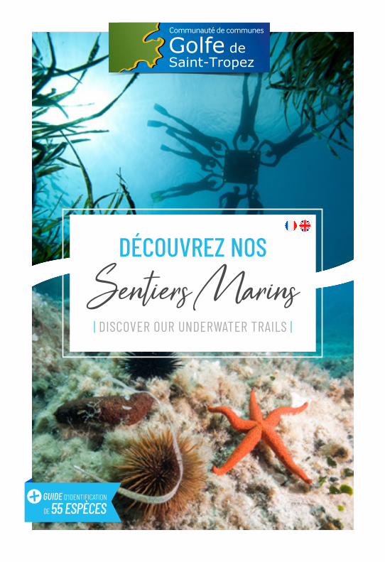
DÉCOUVREZ NOS
Sentiers Marins| DISCOVER OUR UNDERWATER TRAILS |
POUR LES PLUS CURIEUX | FOR THE CURIOUS VISITOR |
Cap Camarat
Cap Lardier
Cap Taillat
Baie de Cavalaire
Sentier marin du Domaine du Rayol
Pointe des Sardinaux
Plage de Pampelonne
Plage de l’Escalet
Plage de la Nartelle
Plage de Gigaro
Pointe de la Moutte
Plage de Bonne Terrasse
LA GARDE-FREINET
1
D 9
3
D 6
1
D55
9
D 5
58
D 44
D 559
D 75
D 44
D 74
D 2
5
D 25
D 98
D 48
D 48
D 558
D 558
D 98
D 98
D 2
7
D 559
D 559
D 55
9
D 93D 93
D 559
D93
SAINTE-MAXIME
LE PLAN DE LA TOUR
GRIMAUD
COGOLINGASSIN
LA MOLE
CAVALAIRE
RAYOL-CANADEL
RAMATUELLE
SAINT-TROPEZ
Golfe deSaint-Tropez
2
LA CROIX VALMER
3
Ne
pas j
eter
sur l
a vo
ie p
ubliq
ue -
Do n
ot th
row
away
on
publ
ic hi
ghwa
y. | ©
Pho
tos :
Flo
rent
Bea
u | R
éalis
atio
n et
con
cept
ion
: Age
nce
| Ju
illet 2
019
GUIDE D’IDENTIFICATION
DE 55 ESPÈCES

Trois sentiers marins ont été aménagés par la Communauté� de� communes� du� Golfe� de� Saint-Tropez.� Les sites retenus ont été choisis pour leur accessibilité ainsi que pour leur intérêt au niveau des paysages et des espèces présentes. Les bouées localisant les stations d’observation et les panneaux explicatifs ont été réalisés en partenariat avec les communes concernées.
| The Community of Communes of the Gulf of Saint-Tropez has created three underwater trails. The sites were chosen in terms of their accessibility, the seascapes and the species present on the sites. The buoys indicating the observation stations and the information boards were set up in partnership with the affected communes. |
OÙ SONT-ILS SITUÉS ? | WHERE ARE THEY LOCATED? |
Cap Camarat
Cap Lardier
Cap Taillat
Baie de Cavalaire
Sentier marin du Domaine du Rayol
Pointe des Sardinaux
Plage de Pampelonne
Plage de l’Escalet
Plage de la Nartelle
Plage de Gigaro
Pointe de la Moutte
Plage de Bonne Terrasse
LA GARDE-FREINET
1
D 9
3
D 6
1
D55
9
D 5
58
D 44
D 559
D 75
D 44
D 74
D 2
5D 25
D 98
D 48
D 48
D 558
D 558
D 98
D 98
D 2
7
D 559
D 559
D 55
9
D 93D 93
D 559
D93
SAINTE-MAXIME
LE PLAN DE LA TOUR
GRIMAUD
COGOLINGASSIN
LA MOLE
CAVALAIRE
RAYOL-CANADEL
RAMATUELLE
SAINT-TROPEZ
Golfe deSaint-Tropez
2
LA CROIX VALMER
3
Ces sentiers marins sont aménagés chaque année de juin à septembre.
These underwater trails are laid out every year from
June to September.

SENTIER MARIN DE LA POINTE DES SARDINAUX
| THE UNDERWATER TRAIL OF SARDINAUX POINT |
SAINTE-MAXIME
Lieu : Espace Naturel Sensible des Sardinaux Accessibilité : à pied depuis la D559 (5 à 10 min) Mise à l’eau : depuis la plage au pied de l’ancien bunker Intérêt : paysages rocheux éclairés et un bel herbier de posidonie avec de nombreuses grandes nacres Durée estimée : 1h à 1h30
Site exposé au vent d’Est
Place: Sensitive Natural Area of SardinauxAccessibility: walk from D559 (5 to 10 minutes)Start: from the beach near the ancient bunkerInterest: lighted rocky sea beds and beautiful posidonia meadows with a large number of Pinna Nobilis (fan mussels)Estimated length: 1.30 hourExposed to the east wind
SENTIER MARIN
DE PAMPELONNE | THE UNDERWATER TRAIL OF
PAMPELONNE |
RAMATUELLE
Lieu : Plage de Pampelonne
Accessibilité : par la route de Bonne Terrasse, à pied depuis l’aire de camping-cars (5 mn) Mise à l’eau : depuis la plage au début du sentier littoral
Intérêt : fonds rocheux variés avec de beaux reliefs couverts de différentes algues et de jolis�herbiers�de�posidonie Durée estimée : 40 à 50 min
Site exposé au vent d’Est
Place: Beach of PampelonneAccessibility: via the road of Bonne Terrasse, walk from the camper area (5 minutes)Start: from the beach near the beginning of the coastal footpathInterest: rocky sea beds with beautiful relief covered by different alga and posidonia leaves Estimated length: 40 to 50 minutesExposed to the east wind
SENTIER MARIN DE L’ÎLOT DU CROCODILE À JOVAT
| THE UNDERWATER TRAIL OF THE ISLET « ÎLOT DU CROCODILE », BEACH OF JOVAT |
LA CROIX VALMER
Lieu : Site naturel protégé du Cap Lardier
Accessibilité : à pied depuis la plage de Gigaro (20 min)
Mise à l’eau : depuis la plage de Jovat
Intérêt : diversité des fonds marins autour de l’îlot avec une riche�faune�fixée
Durée estimée : 30 à 40 min
Site exposé au vent Mistral et Ponant
Place: Protected Natural Site of Cap Lardier Accessibility: walk from the beach of Gigaro (20 minutes)Start: from the beach of JovatInterest: diversity of the sea beds and marine life around the islet Estimated length: 30 to 40 minutesExposed to Mistral and Ponant winds
COMMENT S’Y RENDRE ? | HOW TO GET THERE? |
Notre littoral regorge de nombreux autres sites propices à la randonnée palmée.
Privilégiez les zones rocheuses…
Our coast presents many other sites conducive to the discovery of the seascape by flippers. Give priority to the
rocky areas…
1 2 3
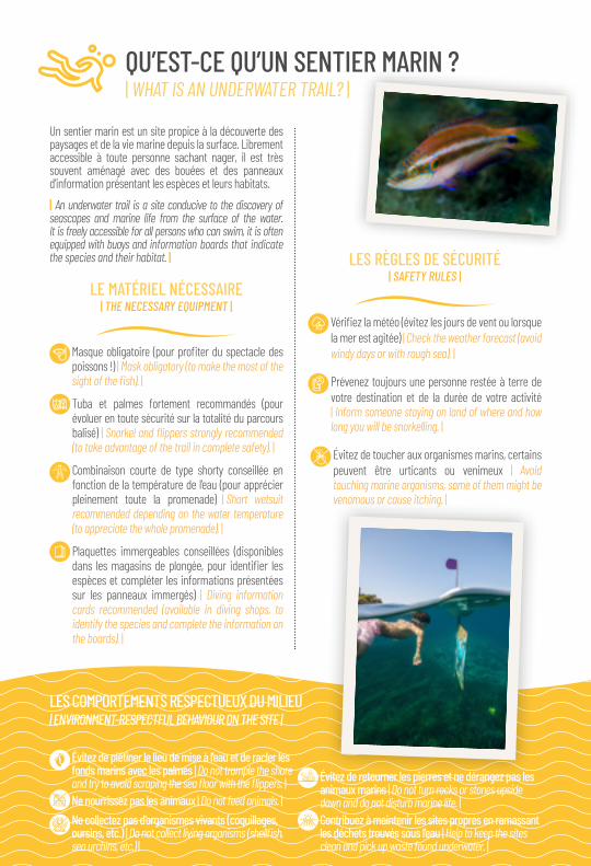
Un sentier marin est un site propice à la découverte des paysages et de la vie marine depuis la surface. Librement accessible à toute personne sachant nager, il est très souvent aménagé avec des bouées et des panneaux d’information présentant les espèces et leurs habitats.
| An underwater trail is a site conducive to the discovery of seascapes and marine life from the surface of the water. It is freely accessible for all persons who can swim, it is often equipped with buoys and information boards that indicate the species and their habitat. |
LE MATÉRIEL NÉCESSAIRE | THE NECESSARY EQUIPMENT |
�Masque�obligatoire�(pour�profiter�du�spectacle�des�poissons !) | Mask obligatory (to make the most of the sight of the fish). |
Tuba et palmes fortement recommandés (pour évoluer en toute sécurité sur la totalité du parcours balisé) | Snorkel and flippers strongly recommended (to take advantage of the trail in complete safety). |
Combinaison courte de type shorty conseillée en fonction de la température de l’eau (pour apprécier pleinement toute la promenade) | Short wetsuit recommended depending on the water temperature (to appreciate the whole promenade). |
Plaquettes immergeables conseillées (disponibles dans� les�magasins�de�plongée,�pour� identifier� les�espèces et compléter les informations présentées sur les panneaux immergés) | Diving information cards recommended (available in diving shops, to identify the species and complete the information on the boards). |
LES RÈGLES DE SÉCURITÉ | SAFETY RULES |
��Vérifiez�la�météo�(évitez�les�jours�de�vent�ou�lorsque�la mer est agitée) | Check the weather forecast (avoid windy days or with rough sea). |
��Prévenez�toujours�une�personne�restée�à�terre�de�votre destination et de la durée de votre activité | Inform someone staying on land of where and how long you will be snorkelling. |
��Évitez�de�toucher�aux�organismes�marins,�certains�peuvent être urticants ou venimeux | Avoid touching marine organisms, some of them might be venomous or cause itching. |
QU’EST-CE QU’UN SENTIER MARIN ? | WHAT IS AN UNDERWATER TRAIL? |
Évitez de piétiner le lieu de mise à l’eau et de racler les fonds marins avec les palmes | Do not trample the shore and try to avoid scraping the sea floor with the flippers. |
Ne nourrissez pas les animaux | Do not feed animals. | Ne collectez pas d’organismes vivants (coquillages, oursins, etc.) | Do not collect living organisms (shellfish, sea urchins, etc.) |
Évitez de retourner les pierres et ne dérangez pas les animaux marins | Do not turn rocks or stones upside down and do not disturb marine life. | Contribuez à maintenir les sites propres en ramassant les déchets trouvés sous l’eau | Help to keep the sites clean and pick up waste found underwater. |
LES COMPORTEMENTS RESPECTUEUX DU MILIEU | ENVIRONMENT-RESPECTFUL BEHAVIOUR ON THE SITE |

Le domaine pélagique, qui s’étend au large de nos côtes, présente une biodiversité moins importante que celle du littoral. Cependant, c’est dans ce milieu que se trouvent de grandes quantités de plancton, organismes de tailles variées qui dérivent indépendamment de leur volonté, et constituent la base de la chaîne alimentaire.Réceptacle de la matière organique (composée de débris d’êtres vivants morts et d’excréments), les fonds sableux apparaissent souvent stériles. Ils recèlent pourtant de nombreuses espèces qui ont su mettre en œuvre des adaptations leur permettant de subsister au sein de cet habitat.
| The pelagic domain which extends off our coasts has a lower biodiversity than that of the coastline. Yet, it is in this environment that large quantities of plankton can be found, organisms of various sizes that drift independently of their will and form the basis of the food chain. As a receptacle for organic matter (composed of debris of dead organisms and of excrements) the sandy bottom often seems to be sterile. However it contains many species that have been able to implement adaptations that allow them to survive within this habitat. |
1
3
6
14
8
9
10
12
11
4
5
13
2
7
1 Vélelle | By the wind sailor
2 Athérines | Big-scale sand melt
3 Mulet | Grey mullet
4 Oblade | Saddle bream
5 Mendole | Big picarel
6 Étoile peigne | Spiny star fish
7 Cérianthe | Tube anemone
8 ��Poisson�lézard�| Lizard fish
9 Grande vive | Greater weever
10 Rouget | Red mullet
11 Pélagie | Pink jelly fish
12 Spirographe | Spiral tube-worm
13 Castagnoles | Damsel fish
14 Rombou | Wide-eyed flounder
FONDS SABLEUX ET PLEINE EAU | SANDY BOTTOM AND OPEN WATERS |

La posidonie (Posidonia oceanica) est une plante marine endémique à la Méditerranée, qui forme de véritables forêts sous-marines. Ces herbiers remplissent de nombreuses fonctions essentielles dans le milieu marin : production d’oxygène, source de nourriture, lieu d’abri et de frayère, maintien des sédiments, etc. La posidonie est une espèce protégée.
| Posidonia (Posidonia oceanica) is a plant endemic to the Mediterranean Sea which creates real underwater forests. This plant has many essential functions in the marine environment: the production of oxygen, it is food source, a place of shelter and spawning, it retains sediments, etc. Posidonia is a protected species. |
HERBIERS DE POSIDONIE | POSIDONIA MEADOWS |
1 Saupes | Salemas
2 Girelle femelle | Rainbow wrasse female
3 Dorade royale | Gilthead seabream
4 Sar commun | White seabream
5 Sublet | Long-snout wrasse
6 Sar à tête noire | Two bended seabream
7 Ascidie rouge | Red seasquirt
8 Posidonies | Posidonia sea grass
9 Grande nacre | Fan mussel
10 Oursin brun | Sea urchin
11 Serran chevrette | Comber
12 Girelle mâle | Rainbow wrasse male
13 Serran écriture | Painted comber
14 Sar à museau pointu | Sharpsnout seabream
15 Seiche | Cuttle fish
16 Labre merle | Brown wrasse
17 Concombre de mer | Sea cucumber
18 Étoile rouge | Red starfish
12
4
14
13
12
1517
18109
11
87
6
35
16

Les fonds rocheux offrent des supports de choix pour les�êtres�vivants�(animaux�et�végétaux)�qui�y�vivent�fixés.� Les éboulis présentent quant à eux de nombreuses cavités dans lesquels se réfugient et se nourrissent les animaux.
| The rocky bottom offers an ideal support for living organisms (animals and plants) fixed to them. The scree for its part has numerous cavities serving as hiding, refuge and food places for animals. |
FONDS ROCHEUX ET ÉBOULIS | ROCKY BOTTOM AND SCREES |
1 Girelle paon | Ornate wrasse
2 Crénilabre | Wrasse
3 Chapon | Large scaled scorpionfish
4 Éponge orange encroûtante | Orange-red encrusting sponge
5 Ormeau | Common ormer
6 Éponge rognon | Kidney sponge
7 Ophiure | Brittel star
8 Anémone verte | Snakelocks anemone
9 Murène | Moray eel
10 Rascasse brune | Brown scorpionfish
11 Poulpe | Octopus
12 Apogon | Cardinal fish
13 Mérou | Grouper
14 Triptérygion | Blackfaced blenny
15 Bernard l’ermite | Hermit crab
16 Éponge pierre | Stony sponge
17 Crabe vert | Marble rock crab
18 Balanes | Bernacles
19 Patelle | Common limpet
20 Tomate de mer | Beadlet anemone
21 Codium en boule | Bull alga
22 Algues brunes | Brown alga
23 ���Anémone�jaune�encroûtante�| Yellow anemone
1
2
3
45
6
7 8 9
14
12
13
11
16
17
1918
2021
22
23
15
10

POUR LES PLUS CURIEUX | FOR THE CURIOUS VISITOR |
Ne
pas j
eter
sur l
a vo
ie p
ubliq
ue -
Do n
ot th
row
away
on
publ
ic hi
ghwa
y. | ©
Pho
tos :
Flo
rent
Bea
u | R
éalis
atio
n et
con
cept
ion
: Age
nce
| Ju
illet 2
019
DEVENEZ OBSERVATEURS DE LA MER| BECOME A SEA OBSERVER |
�•��Notez�le�jour,�l’heure�et�le�lieu�de�vos�observations.�Prenez�une�photo�(si�possible).
• | Mention the day, hour, place of your observations. Take a picture (if possible). |
��•��Envoyez� vos� observations� à� la� Communauté�de communes (tél. : 04 94 00 46 25 - email : [email protected])
• | Share your observations with the Community of Communes (tél. : 04 94 00 46 25 - e-mail : [email protected] |
���•��Participez� à� BioLit� (programme� national� de�sciences participatives sur la biodiversité littorale) : www.biolit.fr/a-vos-observations
• | Participate in BioLit (French program of participative science on coastal biodiversity): www.biolit.fr/?language=en |
Téléchargez notre appli mobile « Golfe de Saint-Tropez » et restez informés en temps réel sur la
qualité des eaux de baignade, l’état des cours d’eau, et les possibilités d’accès aux massifs forestiers !
| Download our App « Golfe de Saint-Tropez » and keep being informed real-time on the quality of the
water, the condition of the watercourses and the possibilities of access to the
forest areas of the region. |
Si�la�randonnée�palmée�vous�plait,�essayez�la�plon-gée sous-marine. De nombreux clubs de plongée proposent différentes formules pour vous initier ou vous perfectionner à la plongée en bouteille. | If you like snorkelling try scuba diving. Many diving clubs offer different options to start and advance in scuba diving. |
LA PLONGÉE EN BOUTEILLE | SCUBA DIVING |
Décryptez�les�richesses�de�la�vie�marine�et�com-prenez�le�fonctionnement�de�ces�milieux�de�vie�exceptionnels aux côtés de guides passionnés ! | Discover the beauty of marine life and learn to understand this exceptional environment with the help of enthusiastic guides! |
LES SENTIERS MARINS EN VISITES GUIDÉES | THE UNDERWATER TRAILS AS A GUIDED TOUR |
RENSEIGNEZ-VOUS AUPRÈS DES OFFICES DE TOURISME ET DES CLUBS DE PLONGÉE.| FIND OUT MORE AT THE TOURIST OFFICES AND AT THE DIVING CLUBS. |