senior book final
TRANSCRIPT

The Wilderness Battlefi eldPreservation Through Appreciation
Erin Lubeshkoff

cover image: confederate trenches at Saunder’s Field

This senior project is submitted in partial fulfi llment of the requirements for the Bachelor of Landscape Architecture Degree in the College of Architecture and Urban Studies at Virginia Polytechnic Institute and State University.
Patrick Miller
Mintai Kim
Brian Katen
Senior Advisor:
Senior Project Coordinator:
Program Chairperson:
Erin Lubeshkoff

Tab
le o
f C
onte
nts
Preface:
The controversy that occurred over the preservation of the Wilderness Battlefi eld over the past couple of years informed the decision to focus this project on the preservation of a historic landscape. I have lived, quite literally, in the battlefi eld for over 11 years yet I had never really gained a proper appreciation for it. To me, and many people I know, it is just another battlefi eld in a county chock full of them. When I became aware of the “Wilderness Wal-Mart” and the fi ght to preserve the character of the battlefi eld, I became interested primarily because it dealt with the land surrounding my home. I found myself asking why preserve more? It was with
this question in mind that I began my project.This document represents much of my research into this battlefi eld and different ways that it might be preserved, as well as ideas to try to build appreciation for the
battlefi eld in the local community.
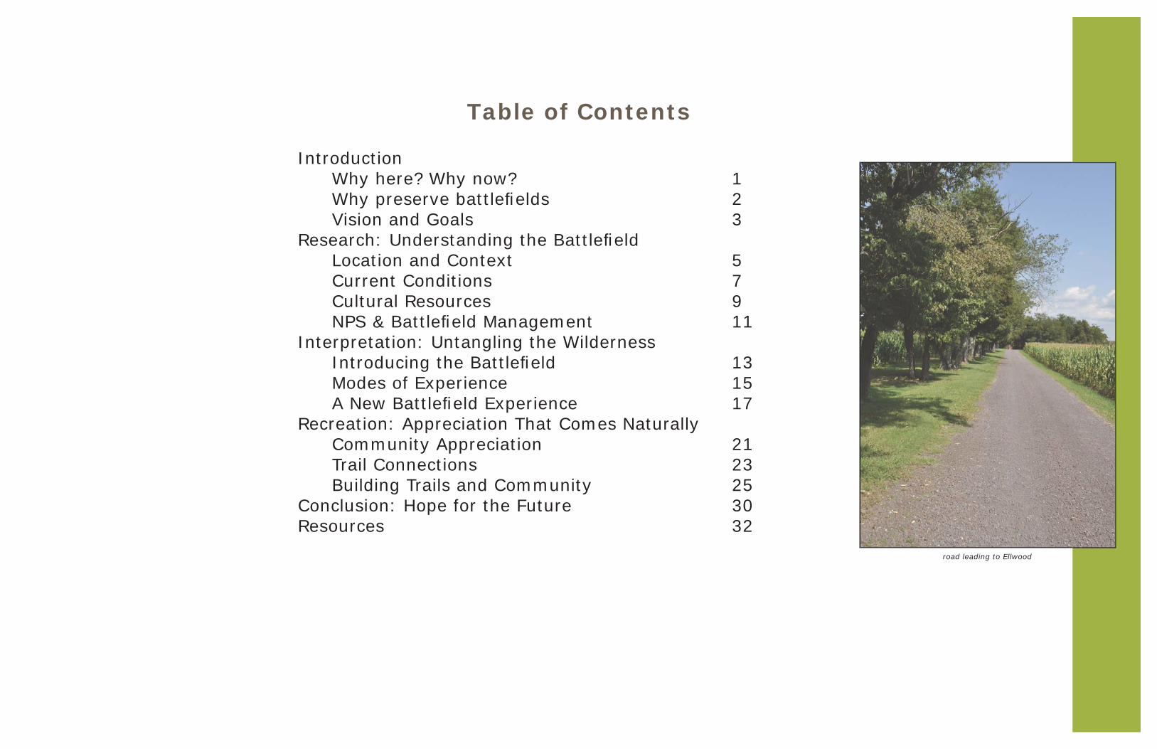
Table of Contents
Introduction Why here? Why now? Why preserve battlefi elds Vision and GoalsResearch: Understanding the Battlefi eld Location and Context Current Conditions Cultural Resources NPS & Battlefi eld ManagementInterpretation: Untangling the Wilderness Introducing the Battlefi eld Modes of Experience A New Battlefi eld ExperienceRecreation: Appreciation That Comes Naturally Community Appreciation Trail Connections Building Trails and CommunityConclusion: Hope for the FutureResources
road leading to Ellwood
123
57911
131517
2123253032


Introduction
Higgerson fi elds seen from surrounding woods

Intr
odu
ctio
nWhy This Battlefi eld
Page 1
Transportation - Existing Conditions - Challenges and Opportunities - Constraints - Next Steps
Wilderness Battlefield Vision Plan Wilderness Gateway Visioning Study
Public Meeting – 3 October 2011
To try to encourage more battlefi eld friendly development plans in Orange County, the Wilderness Battlefi eld Coalition hired Hill Studio from Roanoke, VA to produce a study of the area and development options. The design options presented focus on the area where Wal-Mart originally planned to develop, as well as traffi c issues with route 20 and route 3. More information is available at wildernessgateway.org
In 2008, the Wilderness Battlefi eld became the center of a national debate on the impact adjacent development can have on historic property. When Wal-Mart proposed a new super center next to the Wilderness Battlefi eld, the county welcomed it and the tax dollars it would bring. When Orange County granted Wal-Mart a special use permit that would allow them to build, preservation groups began a legal battle to stop Wal-Mart. In 2011, Wal-Mart abandoned its plans to build next to the battlefi eld. The question is how long will the battlefi eld be safe from development? It left many wondering, “Why preserve battlefi elds?”and “How can you preserve them?”
These two images represent the huge uproar that occurred when Wal-Mart proposed their new store. The image on the left was from a local Culpeper newspaper showing a rendering of the “Wilderness Wal-Mart”. The image on the right was on the Civil War Trust page asking for help in saving the battlefi eld.

Page 2
Tourism generated by battlefi elds represents an ECONOMIC OPPORTUNITY that cannot be outsourced.
Tourism can indirectly generate huge amounts of money throughout a region because tourists buy food, stay in hotels, shop, etc. Battlefi elds draw thousands of tourists every year, and can become the dominant economy in a region (Gettysburg). Battlefi elds do not have to be interpreted at all to bring in tourists however; most people look to that interpretation to form their experience. Developing battlefi elds into destinations brings in more tourists and can stimulate the economy. Rather than a quick fi x for the economy such as a Wal-Mart (which can decide to up and leave at any time), income generated by battlefi eld tourism cannot be taken away.
The events that took place on battlefi elds shaped our CULTURE and defi ned our HERITAGE as a nation.
Many people do not realize how much more can be learned about this nation by visiting battlefi elds in addition to reading about them in books. There is great value in having a resource to learn from rather than learn about. People remember experiences because they happened to them. Visiting a battlefi eld can help link individuals to their history in a more intimate way. Issues that were prevalent during the Civil War are still very prevalent in today’s culture. By refl ecting on the experience of the soldiers and why they felt strongly enough to go to war, visitors can refl ect on how these issues are being dealt with today.
Battlefi elds often represent the largest PUBLIC GREEN SPACE in urban and suburban areas.
Battles often occurred near populated places, because of transportation and supply networks. When the war ended, these populated places were not told to stop growing because they were surrounded by a battlefi eld. Some stunted their growth by choice, such as Gettysburg and Sharpsburg (Antietam) however, many welcomed the increase in capital (especially in battle worn southern towns). Battlefi elds were quickly threatened by development, and when it was preserved, it often became surrounded by development. Kennesaw Mountain National Battlefi eld Park is an example where a preserved battlefi eld became engulfed in development, which then turned to the battlefi eld for recreation. The Manassas battlefi eld has similarly become a green island in a sea of development. Manassas has a history as a well-loved regional park, something that has
helped preserve it as development pressed in.
Gettysburg National Battlefi eldYou can gain knowledge about Gettysburg through history books. Walking the ground of Pickett’s charge, you can gain understanding.
Spotsylvania Courthouse Battlefi eldOn a personal visit to the battlefi eld one afternoon I discovered that it was full of people just walking. People with dogs, kids, friends, family. When we left we passed no fewer than 10 people jogging, several bicyclists, and more dog walkers. This battlefi eld is minutes from major commercial development and surrounded by residential development.
Chattanooga and Chickamauga National Battlefi eldBicycle tours of the battlefi eld directly generate money from tourism.The hotel where the tourists stayed indirectly generated money from tourism. Both represent money being spent in the region around the battlefi eld.
Why Preserve Battlefi elds?

The vision of this project is to promote preservation of the Wilderness Battlefi eld by increasing appreciation for this resource through improved interpretation and new recreational opportunities.
Interpretation
design an interpretive plan that encourages visitors to experience the battlefi eld on foot
design new interpretive trails that form loops and begin at every auto tour stop
develop ideas for interpretive experiences and education opportunities to use in addition to wayside exhibits
suggest a location and design for a visitors center
Recreation
determine compatible recreation uses
design recreational trails that do not interfere with the interpretation of the battlefi eld or harm the cultural resources
connect with proposed Spotsylvania greenway
suggest location and design for recreational parking
connect entire battlefi eld with hiking trails
A new way to preserve
Intr
odu
ctio
n
Page 3
The end goal of this project is to provide information for the National Park Service to reference when making future park planning decisions, and to offer suggestions for improving the experience of the battlefi eld.

Research:Understanding the Battlefi eld
Map of Wilderness Battlefi eld made in 1867 source: Library of Congress

Washington D.C.Washington D.C.
RichmondRichmond
SpotsylvaniaSpotsylvania
WV
MD
KY VA
NC
SCGA
TN
DE
PA
NJOH
Perhaps the bloodiest landscape in the country sits halfway between Washington D.C. and Richmond, VA in the county of Spotsylvania. The Wilderness Battlefi eld is one of four major battlefi elds in the area, which saw 100,000+ casualties over the entire war. These four battlefi elds make up the second largest military park in the world, the Fredericksburg and Spotsylvania National Military Park (7,000+ acres). The preserved portion of the Wilderness Battlefi eld is over 2,700 acres in size and spreads across the counties of Spotsylvania and Orange. It represents the “beginning of the end” of the Civil War. It was the fi rst time General Grant and General Lee met on the battlefi eld. Being at the beginning of Grant’s Overland Campaign, it introduced the world to modern warfare. Rather than taking time to recover after a battle as was common and expected at the time, Grant immediately pursued the confederate army after each battle. This strategy was hard on the union soldiers, but even harder on the outnumbered confederates. This “war of exhaustion” eventually pushed Lee to surrender at Appomattox courthouse, and end the war.
Map showing location of Spotsylvania, VA in relation to the capitals of the union and the confederacy. Also shows the union, confederate and border states (blue, gray, and tan).
Map showing Fredericksburg and Spotsylvania Battlefi elds National Military Park. (source: http://www.visitfred.com/sites/default/fi les/pdfs/VC_Battlefi eld_Brochure.pdf)
Grant’s Overland Campaign (source: http://www.civilwaralbum.com/
cwa_map68.htm)
Loca
tion
an
d C
onte
xt
Page 5
To understand this battlefi eld it is important to fi rst identify where it is located physically and within history.

The battle itself took place on May 5-6, 1864. The union army was planning to cut through the wilderness and surprise the confederates who were stationed at Mine Run, southwest of the wilderness. Lee was unable to fi gure out the union plan and was forced to leave Longstreet and half the army behind in case they needed to rush to Richmond. Lee planned to occupy the union in the wilderness where their almost 2:1 manpower advantage would be useless. This plan was successful in that it did occupy the union, but unlike previous generals, Grant did not order a retreat, leaving Lee and the confederates desperate to fi gure out Grant’s plans. The result of the battle was a draw, an inconclusive ending that came at a heavy cost. The battle produced nearly 30,000 casualties in two days of fi ghting, 18,400 union and 11,400 confederate (CWSAC).
Page 6
This drawing by Edwin Forbes represents the jubilee when General Grant announced to the soldiers that they would pursue the confederates despite the undecided outcome of the battle. Unlike previous generals, Grant did not retreat to recover from battle and prepare for the next one. Instead, he introduced continuous battle, pursuing the confederates about 10 miles down the road and starting the Battle of Spotsylvania Courthouse a few days after the end of the Battle of the Wilderness.
(drawing source: Library of Congress online collection)
This drawing by Alfred Waud represents the true horror of the Wilderness: fi re. As many men were wounded in battle, many more were burned alive with the forest caught fi re and engulfed dead and living alike and obscured battle lines. (drawing source: Library of Congress online collection)
These pictures were taken of the battlefi eld a year after the battle. They show the dense second growth that made passage through the wilderness so diffi cult. They also show the skeletons of men who were left behind. The soldiers have since been relocated to cemeteries, but their sacrifi ce and courage serve as reminders of what this country represents: freedom. (photo source: Library of Congress online collection)
This image represents one of the most famous episodes of the entire war, the “Lee to the rear!” incident. On the second day of battle, the confederates were nearly crushed by the union forces along Orange Plank Road. As they were about to retreat from Widow Tapp farm, Longstreet arrived with reinforcements. Lee was so excited by the arrival of Longstreet’s men that he tried to lead them into battle. The Texans refused to go forward until Lee was ushered to the back of the soldiers. They then rushed into battle, where they lost nearly half their men. (photo source: http://www.nps.gov/
frsp/photosmultimedia/tappf.htm)
General Grant General Lee

Cu
rren
t C
ond
itio
ns
Page 7
What makes up the battlefi eld ?
topography
habitat types
adjacent uses
Forest:trees subcanopy shrubs
oak dogwood blackberry hickory red cedar poison ivy red maple tupelo American hazelnut sweetgum mountain laurel lowbush blueberry yellow poplar sassafras deerberry Virginia pine shortleaf pine
Field:cultivated uncultivated
corn, soybeans, hay grasses hay grasses, native grasses fertilized and tilled mown once or twice a year
Swamp:Whether in a fi eld or the woods, swamps in this area are typically the result of poor draining
soils in stream fl oodplains. The swamp by Higgerson was fl ooded by a now abandoned beaver dam.
single family single family subdivisionssubdivisions
timbertimberharvestingharvesting
gatedgatedcommunitycommunity
gatedgatedcommunitycommunity
large and large and small farmssmall farms
generalgeneralcommercialcommercial
mostly small mostly small separate homes separate homes and farmsand farms
Determining how this battlefi eld sits in the topography, the ecology, and the region will help with planning and management decisions. Understanding how preservation works within NPS is necessary to understand why the preserved portion of the battlefi eld is the odd shape that it is, and why it continues to be a threatened resource.
cultivated fi elds by Ellwood swamp with beaver dam large tree near Brock Road unmown Saunder’s Field
Rt 20Rt 20
Rt 3Rt 3
Rt 20Rt 20
Rt 3Rt 3
Brock RdBrock Rd
Co Rd 621Co Rd 621
Co Rd 621Co Rd 621
Brock RdBrock Rd
10 ft contour interval

Page 8
Preservation Challenges
LAND IS EXPENSIVE: The “Antietam Plan” was developed to preserve battlefi elds without buying huge tracts of land. It involved buying just the pieces of land with monuments or battle lines. A very shortsighted plan, it did not expect the surrounding land to change in a way that did not respect the battlefi eld. The legislation authorizing land acquisition for the Fredericksburg and Spotsylvania National Military Park specifi ed that they follow the Antietam plan (the Wilderness land acquired is highlighted in pink on map at right).
DEVELOPMENT IS OUTSIDE NPS CONTROL: The military park was established in 1931-34, shortly before development spread to the area. Permanent loss of core battlefi eld between NPS holdings occurred when that land was developed into suburbs. Once land became the target of developers, there was little that NPS could do to stop the developments because of the increased value of the land was out of budget.
THERE ARE SO MANY BATTLEFIELDS: Because NPS owns signifi cant portions of a battlefi eld, many people assume that it is “preserved”. Even county governments may fall into this mind trap and authorize incompatible development near these “preserved” battlefi elds. The Wal-Mart fi asco is one example of such short-sighted government planning.
CONTEXT, CHARACTER, EXPERIENCE: The context in which a battlefi eld sits can signifi cantly add or subtract from the character of the place and the experience of the visitor. Looking outside the boundaries of the park allows the park to plan for potential changes. Proper planning can help establish the battlefi eld as a fi xture of the local identity, and a popular place for tourists. The increased appreciation can help preserve the battlefi eld. An example is Manassas Battlefi eld, which was saved largely because of its place in the community.
This zoning map represents the zoning plans of both Orange and Spotsylvania counties. The majority of the land is deceivingly labeled agricultural, however residential developments can easily still be built within the lenient zoning defi nitions.
This map represents the land NPS owns (in darker green) as part of the battlefi eld park and land that NPS should try to acquire (in lighter green) either outright or through easement. Acquiring this land will help NPS get ahead of development in areas where it would detrimentally effect the
experience of the battlefi eld.
agriculture and agriculture and residentialresidential
planned residentialplanned residential
planned planned residentialresidential
general residentialgeneral residential
general general commercialcommercial
Oran
ge C
ount
y
Oran
ge C
ount
y
Spot
sylva
nia C
ount
y
Spot
sylva
nia C
ount
y
agricultureagriculture
Rt 20Rt 20
Rt 3Rt 3
Co Rd 621Co Rd 621
Brock RdBrock Rd
Rt 3Rt 3
Rt 20Rt 20
Co Rd 621Co Rd 621
Brock RdBrock Rd
Oran
ge C
ount
y
Oran
ge C
ount
y
Spot
sylva
nia C
ount
y
Spot
sylva
nia C
ount
y
Oran
ge C
ount
y
Oran
ge C
ount
y
Spot
sylva
nia C
ount
y
Spot
sylva
nia C
ount
y
Rt 20Rt 20
Co Rd 621Co Rd 621
Brock RdBrock Rd
Rt 3Rt 3

Cu
ltu
ral R
esou
rces
Ellwood Manor (circa 1790):The only structure on the battlefi eld today that witnessed the Civil War. It was the headquarters of the Union army during the battle of the Wilderness and has signifi cance relating to other battles and campaigns. It is also famous for being the fi nal resting place of Stonewall Jackson’s amputated arm. Recently restored, the home currently serves as a pseudo visitor’s center for the battlefi eld. The Friends of Wilderness Battlefi eld, a volunteer organization, staffs the manor and maintains the grounds. They are also responsible for the completed restoration, and wish to contribute more to the battlefi eld.
Saunder’s Field:The fi rst shots of the battle and some of the heaviest fi ghting took place in this clearing. Trenches criss-cross through the woods north of the fi eld and are in excellent shape considering they were hastily dug and almost 150 years old. The existing interpretive trail following the trenches tells the story of how they became so entangled. In the fi eld, there is a monument to the 140th New York, who lost nearly half their men while leading the fi rst charge. A cannon in the fi eld represents the cannon that sat in the middle of the fi eld during the battle, the unattainable prize.
Widow Tapp’s farm:The clearing that was the farm of Widow Tapp became the headquarters for General Lee during the battle. It was also at this clearing that the confederates almost crumbled, saved just in time by General Longstreet’s men. When the Texas soldiers came running to the rescue, Lee was so excited he tried to lead the men into battle, to which they cried “Lee to the rear!” There is a monument dedicated to this event, as well as a monument to the Texans who were slaughtered in that charge but managed to save the army and their general. There is also a cannon on the site, one of the few places where cannons were useful. (photo source: http://www.nps.gov/frsp/photosmultimedia/tappf.htm)
Brock Road intersection:Fighting in this area was some of the most brutal experienced in the whole war. The trenches lining Brock Rd are poorly preserved, however the trenches along Jackson Trail West are in excellent condition. There is a fairly new interpretive trail, highlighting the horrors of war as well as the monument to Vermont’s “Old Brigade” who suffered heavily defending the intersection. Alongside Orange Plank Rd is a small monument to the 12th Regiment New Jersey Volunteers who also fought to defend the intersection at a heavy cost.Page 9
Primary Cultural Resources:high importance; adequately interpreted
Cultural resources are those parts of the landscape that speak to the history of that landscape. They can be both physically visible and emotionally felt. It is for the purpose of protecting these resources that the battlefi eld was originally preserved, so it is necessary to know both what they are and where they are.
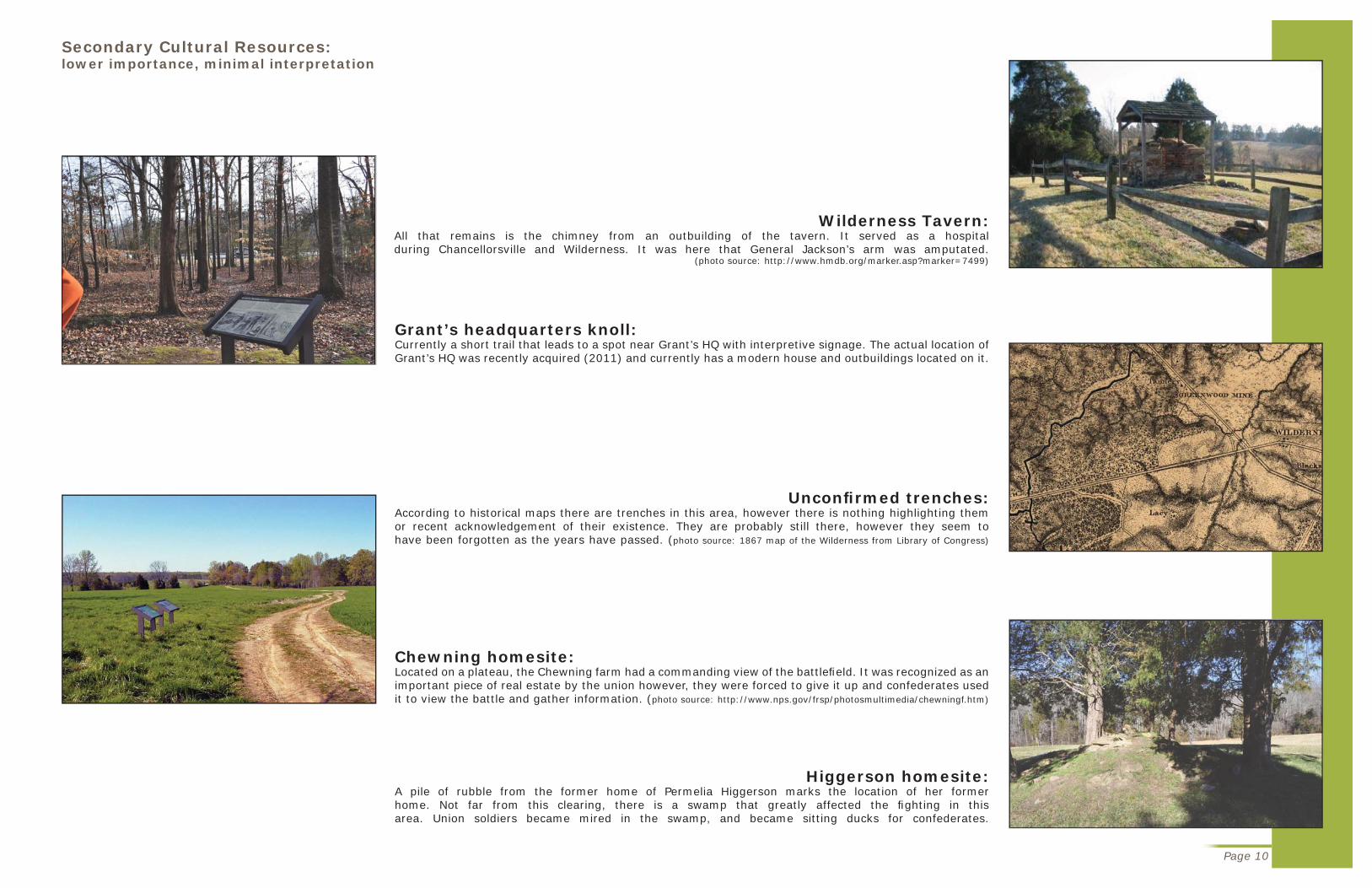
Wilderness Tavern:All that remains is the chimney from an outbuilding of the tavern. It served as a hospital during Chancellorsville and Wilderness. It was here that General Jackson’s arm was amputated.
(photo source: http://www.hmdb.org/marker.asp?marker=7499)
Grant’s headquarters knoll:Currently a short trail that leads to a spot near Grant’s HQ with interpretive signage. The actual location of Grant’s HQ was recently acquired (2011) and currently has a modern house and outbuildings located on it.
Unconfi rmed trenches:According to historical maps there are trenches in this area, however there is nothing highlighting them or recent acknowledgement of their existence. They are probably still there, however they seem to have been forgotten as the years have passed. (photo source: 1867 map of the Wilderness from Library of Congress)
Higgerson homesite:A pile of rubble from the former home of Permelia Higgerson marks the location of her former home. Not far from this clearing, there is a swamp that greatly affected the fi ghting in this area. Union soldiers became mired in the swamp, and became sitting ducks for confederates.
Chewning homesite:Located on a plateau, the Chewning farm had a commanding view of the battlefi eld. It was recognized as an important piece of real estate by the union however, they were forced to give it up and confederates used it to view the battle and gather information. (photo source: http://www.nps.gov/frsp/photosmultimedia/chewningf.htm)
Page 10
Secondary Cultural Resources:lower importance, minimal interpretation

NP
S &
Bat
tlefi
eld
Man
agem
ent
Page 11
The Fredericksburg and Spotsylvania National Military ParkPark Purpose:
The purpose of the park is to preserve, maintain, protect and provide access to the cultural and natural resources of the Civil War battlefi elds of Fredericksburg, Chancellorsville, Wilderness and Spotsylvania Court House and associated sites and to interpret and commemorate them in the larger context of the Civil War and American History for the benefi t and education of visitors and the general public.
Park Priorities:
Priority 1: Protect Cultural and Natural Resources: Protect, maintain and improve the condition of core cultural and natural resources, including buildings, landscapes, and archeological sites.
Priority 2: Prevent encroachment and protect the park from external development and traffi c: Through cooperative planning, diligent monitoring, negotiation, partnerships, advocacy, and acquisition, protect the park from physical encroachment, increasing traffi c, the negative impact of adjacent or nearby development, and incompatible recreational uses.
Priority 3: Improve and upgrade interpretive facilities and media: Replace or upgrade outdated media (A-V programs, waysides, exhibits, website, and publications) parkwide and ensure that visitor facilities, including roadsides and trails, enhance the visitors’ experience.
Priority 4: Safety: Ensure a safe environment for both employees and visitors.
Priority 5: Ensure orderly succession at adequate staffi ng levels: Plan for personnel succession and organizational change due to retirements and constrained budgets.
Priority 6: Improve visitor services: Expand the nature and reach of interpretive programs, educational programs, and special events to increase visitation and support for the park, better serve children, and illustrate the park’s relevance to 21st-Century visitors.
Park Purpose defi ned by NPS(http://www.nps.gov/frsp/parkmgmt/purpose.htm)
The Fredericksburg and Spotsylvania National Military Park (FRSP) contains four battlefi elds, a little over 7,000 acres of land, yet it is all under one management entity. This means that unlike other parks, which can focus on one battle with both their research and their funding, FRSP must divide everything between 4 very signifi cant battlefi elds. The Civil War Sites Advisory Commission (CWSAC) ranks all four battlefi elds in FRSP as class A battlefi elds, meaning they had a decisive impact on a campaign and a direct impact on the course of the war. Only 12% of battlefi elds are class A battlefi elds. They each deserve to be treated with equal importance, something NPS knows, but cannot fund.

Interpretation:Untangling the Wilderness
swampy area in the forest near Brock Road

Page 13
Intr
odu
cin
g t
he
Bat
tlefi
eld
Visitor’s Center: Gateway to the battlefi eld
The battle of the Wilderness took place not in open fi elds but in dense woods. It was plagued by confusion and lost soldiers. Now it is plagued by neighborhoods and busy roads. A visitor’s center would greatly enhance visitor understanding of the battlefi eld and could host events that increase appreciation for and awareness of battlefi elds.
This is a sketch of a proposed visitor’s center. It is designed to cater more towards children/school trips and special events. It would serve as an introduction to the battlefi eld before visitors enter the battlefi eld and are able to become confused. The idea is that it will be on top of a hill, but slightly behind another. Something such as a fl ag in front of the building could draw attention to the building, which would be barely visible from the route 20/route 3 intersection. By drawing attention from the busy roads, the battlefi eld can gain more recognition.
courtyard for outdoor exhibits
covered porch for grouping tours
lobby, info desk, gift shop
intro to the war before Wilderness
Battle of the Wilderness
the war after the battle
natural grasslands with wildfl owers
soldier life camp demonstration area
special event space ex: traveling living history exhibits
picnic area
Rt. 20
old Rt. 20trail to Ellwood manor
trail to Wilderness Tavern ruins
suggested interpretive layout Because this battle was so tangled, introducing its place in the Civil War in a linear format can help visitors better understand what this battlefi eld represents.
Sketch up model of suggested outdoor exhibits. A simulated forest, trench and plank road allows children in particular to understand what trenches are for without degrading actual trenches. A mural could be on the surrounding walls.

Page 14
active farmland
wooded areas
Ellwood Ellwood ManorManor
Wilderness Wilderness TavernTavern
Rt. 20
Rt. 3
Connections
The location of the visitor’s center would be easy to fi nd and it would be able to link Ellwood and Wilderness Tavern through trails and interpretation. As suggested by the NPS interpretive plan, a small strip of forest could be maintained in a second growth state, such as it was during the battle. This location is suggested along the trail from the visitor’s center and Ellwood. Connecting Ellwood and Wilderness Tavern visually as they once were would require cooperation with adjacent landowners to thin trees currently blocking the view.
Ellwood Ellwood ManorManor
Wilderness Wilderness TavernTavern
visitor’s visitor’s centercenter
active farmland
wooded areas
grassland
second growth
Rt. 20
Rt. 3
Before and after plan views of the area around the proposed visitor’s center. The left image shows the land use and current conditions. The right image shows the proposed visitor’s center and parking. It also shows proposed trails linking the visitor’s center to the tavern and manor (pink lines on the map). The viewshed that could be restored between Ellwood and the tavern site is marked with yellow, as well as the view from the visitors center and the road.
Current view from Ellwood, looking to the east. The view towards the Wilderness Tavern is similar. Some trees on the Ellwood property would need to be removed in addition to some on adjacent properties to restore the view between the two historic sites.
View from proposed visitor’s center location looking north. The intersection can be seen at the bottom of the hills, in the right-center of the image.
View from the proposed visitor’s center location looking south. This visual connection to the pastoral fi elds around Ellwood can help connect visitors to a different time and place.

Page 15
Mod
es o
f Ex
per
ien
ce
Visitor’s CenterIntroduction to the battlefi eld and it’s importance in the larger picture of the war and the country. Linked with Ellwood and Wilderness Tavern by footpath.
Wilderness TavernAccessible from the visitors center via 1/4 mile trail, all that remains is the chimney from the tavern. It is more important to the Battle of Chancellorsville, and as the location where Stonewall Jackson’s arm was amputated.
Grant’s HeadquartersThe knoll where Grant stationed his headquarters during the battle. A short trail highlights the issues experienced due to a tangled chain of command.
Ellwood ManorThe restored manor with exhibits on life during the war for civilians and slaves. There is a 3/4 mile trail about the role Ellwood played in the battle as both headquarters and safe haven for the Union. Also linked to visitor’s center by 1/2 mile trail.
Saunder’s FieldSite of intense fi ghting throughout the battle, there is a 2 mile trail that tells the story of the soldiers who fought along the Orange Turnpike and a confederate fl ank attack that was the fi nal straw.
Higgerson HomesiteOne of few clearings in the Wilderness, Union troops used it to regroup before diving into the darkness of the woods in search of rebels. A 1 mile trail tells the story of how the topography and a swamp trapped some solders from Pennsylvania.
Chewning FarmOn top of commanding topography, the Chewning home and surrounding cleared land represented the best opportunity the union had of ending the battle before it became too intense. A 1/2 mile trail leads to the Chewning homesite.
Widow Tapp FieldThis clearing was the site of General Lee’s headquarters and the home of Widow Tapp. A 1/2 mile trail tells the story of what almost became the south’s last stand.
Brock Road IntersectionThis intersection became the site of some of the heaviest fi ghting of the battle. A short 1/2 mile trail tells the story of fi ghting in this location and leads into the Battle of Spotsylvania Courthouse. An additional 1 3/4 mile trail gives visitors the opportunity to experience the battlefi eld topography and challenges.
Battlefi eld Tour Stops
Tour by car and on foot
The size of this battlefi eld means that it is easiest to tour by vehicle. The most emphasis is therefore on this mode of travel, and appropriate interpretation is provided for the roadside visitor. For those who have more time or inclination, there are trails leading from each vehicular tour stop that give the visitors a unique experience.
Map of Existing TrailsThe existing trail leading from Saunder’s Field will remain, as well as the trail in Widow Tapp fi eld. The trails at Chewning farm and Brock Road will remain but with additions. The trail in the center is no longer interpreted and is maintained by a local organization. The resources along the center trail have lost their value as the sights and sounds of suburbia are diffi cult to escape.

OrOOrOrOrOrOrOrOrOrOO anananananananaaananaa gegegegeegegegegegegegegeeeeg PP PP PPPP PPPPPPPlalalalalaalaaaalalalalaaaaalallaalanknknknknkk R RR RRRRRRRRRRRRoaoaoaaaaoaoaoaoaoaoaoaoaoaoaoaoaooad d d d d d d ddd d dddd dddddddd ddd CCCCoCoCoCoCoCoCoCoCoCoCoCoCoCoCoCoCooC ..... . . RdRdRdRdRdRdRRdRdRdRdRdRddRdRdRdRdRdRdRdRRR . . . 6266262626262222662626266266262662626 1111
OrOrOrOrOrOrrananananananangegegegegegege T TTTTururururnpnpnpnnpnppnpppppppnpppppikikikikikikikkikkikikikikikikkkkkkkee e ee e eeee e e eeeeeeee RoRoRoRoRoRoRoRoRoRooRoRoooRoRooRoRoRoRoRooRoRooutututututututututututututututuuuuu e e e e e eeeeeeeeeee 2020202020200020202020020200002
GeGeGeGGeGeGeGGGeGeGG rmrmrmrmrmrmrmrmrmrmmananananananannananannananananananananananaa PP P PPPPP P PPPP PP PPPPPPPPPPlalalallallllalalalaalalaalaaaalaaaalanknknnnknknknknknknknknnknknknknknknn R R R R RRRRR RR RRRRR RRRRoaoaoaoaoaoaoaoaooaooaoaoaoad d dd dd dd ddddd RtRtRtRtRtRtRtRttRRttttt. .. ... .. 333333333
BrBrBrBrBrBrBrBrBrBrBrBrBrBB ocococococooooco k kk k k kkk RoRoRoRoRoRoRoadadaddadad
LELLELELELEGEGEGEGEGENNNNNDNDNDNND
iinnii teteeeeerprprprprprererereretitititittiveveveveveveve t tttrarar ililll
babababababababatttttttttttlllelelefififi eeeldldldld t t tt touououour rrrr stststopopopopfififi
tototopopooopop grgrgrrgrrgrgrapapapapapapapapaphihihhh c cccc rerereresosososoururururrrrcecececec
cucucucultltltltururururalalall rr r reseseeeeee ououououuouuurcrcrcr eeee
trtrennchchc esese
ininteteteeteeensnseee fifi gghthtthttinininingggggfifi
rororororooaadadaa sssss

Page 17
A N
ew B
attl
efi e
ld E
xper
ien
ceGetting people out of their carsInterpretation “experiences” can be placed along the trails leading from each auto tour stop, which will guide visitors through the battlefi eld. When they get to each stop, the promise of a unique experience can encourage them to get out of their cars and walk through the battlefi eld.
“Brave men are falling like autumn leaves, and death holds high carnival in our ranks.”Rendering of interpretation experience idea for trails north of Saunder’s fi eld. Life size statues of soldiers could be placed at the locations of opposing lines to show how close soldiers were and still could not see each other. It would help visitors understand why the trenches are so tangled.
Rendering of interpretation experience idea for trails near the Brock Road intersection. Large “windows” made of a shatterproof translucent material such as acrylic or resin with images of what the area behind the “window” might have looked like during the battle can help visitors connect with the site and what happened there. Quotes from soldiers who fought in the battle add another level of connection. The quote on the “window” below reads “Brave men are falling like autumn leaves, and death holds high carnival in our ranks.” and the image is from a sketch by Alfred Waud showing fi ghting by the Brock Road intersection.
Interpretive trail section: trail should be easily accessible to most, with a level pathway and sturdy surfacing. Wayside signage should signal a wider pathway.
Rendering of boardwalk over the swamp by the Higgerson homestead. The trail tells the story of soldiers who stumbled into the swamp from a steep, wooded hillside by taking visitors from the hill to the swamp.
Although the peak season for battlefi eld visitation is during the summertime, tailoring experiences that change with the four seasons might entice visitors to come year round. Other ideas include tactile interpretive panels along the trail near Ellwood telling the story of it as a farm. Tactile panels could give visitors the opportunity to feel the texture of different crops, for instance. There could be small installations showing how crops were actually farmed before the Civil War, and how the whole farm changed because of the war (no slaves). The use of temporary interpretation experiences can encourage visitors to visit more than once.
4’ tread4’ viewing1-2’ corridor each side of trail

Page 18
The sheer number of men who fell during this battle is very diffi cult to comprehend. It is diffi cult to comprehend the fact that over 170,000 men fought in these woods, let alone that almost 30,000 of them never left. It is easy to forget these sobering facts. This rendering shows an idea to put stones as a reminder of those who fell. They would be unobtrusive, yet obvious to those who look. Larger stones could represent groups of soldiers, while smaller ones could represent individuals. Soldiers from many states fought in this battle, and those states could be represented by the stones of their fallen. Using native rock from each state would emphasize that this was a war between all the
states, not just a select few.
The topography of the battlefi eld tells an important part of the story about the battle. The soldiers called this “washboard topography” because the many hills and streams. Walking through this topography gives visitors the opportunity to experience the battlefi eld the way the soldiers did. This rendered section represents the varied topography near the Higgerson home.
While no trail design can be fully designed without walking the design in the fi eld, all of the interpretive trails were designed to accommodate people of most abilities. The slope of the trail is rarely steeper than 5% and when steeper it is for a short distance. It is important that all people be able to experience battlefi elds and gain an appreciation for the heritage of this nation.
The elevation profi le tool in Google Earth was used to alter designed trails to better fi t the topography. While this is not totally accurate (the 18.8% slope listed as the max slope on the screenshot is the result of a stream crossing), it helped with the design of the Higgerson trail (above) which has the steepest topography. This is an easy and affordable method of evaluating a design.


Recreation:Appreciation That Comes Naturally
fi eld between Higgerson and Chewning

Com
mu
nit
y A
pp
reci
atio
n
U.S
.1
Bike Route
Eas
tCoa
stG
reen
way
Virginia CentralTrail Corridor
U.S. Route1 Trail
ChancellorsvilleVisitorCenter Trail
JacksonTrailEast
JacksonTrailWest
Hill-EwellDrive
Ni River Trail
HancockRoad
FurnaceRoad
BurnsideDrive
GrantDrive West
Bullock Road
Stuart DriveSlocum Drive
SicklesDrive
AndersonDrive
McLawsDrive
GordonDrive
Hooker Drive
Longstreet'sWoundingTrail
Lee HillInterpretive
Trail
BloodyAngle
3
ChancellorsvilleBattlefield
Interpretive Trail
Tapp FieldInterpretive Trail
208
17
95
2
208
1
3
208BYP
1
208
17
3
1
Lee HillTrail
BUS 1
208
CAROLINECOUNTY
CITY OFFREDERICKSBURG
ORANGECOUNTY
STAFFORDCOUNTY
StonewallJacksonShrine
Legend
Stonewall Jackson Shrine
Historic Points
VDOT Historic Marker
National and State Historic Register Parcels
Trail Corridors
Public TrailsTrail Type
Multi-Use Paths
National Park Service Trails
National Park Service Roads
State Park Trails
Completed Trail
Virginia Central Trail Corridor
Parks and Recreation Trails
Date: July 29, 20100 1 2 3 4 50.5
Miles
The Spotsylvania Battlefields Loop
1 inch equals 1.5 miles
MAP 4
WILDERNESSCHANCELLORSVILLE
SPOTSYLVANIA COURTHOUSE
FREDERICKSBURG/ SLAUGHTER PEN
Page 21
Community gems...
The county of Spotsylvania recently completed a trailways master plan that evaluated what recreation was available, what was needed, and how these recreation needs might be met. One of the major components of this plan is the Virginia Central Trail, which will be built on an old railroad bed. The trail will be a multi-use trail combining pedestrians, bicyclists and equestrians. The map below is from the study and illustrates the county’s desire to connect all the battlefi elds via greenways.
Undeveloped rail bed and developed section of the Virginia Central Trail. This is the greenway that the Wilderness Battlefi eld will connect with. (photo and map source: Spotsylvania County Trailways Master Plan http://www.spotsylvania.va.us/content/2614/147/2740/169/205/8539.aspx)

Page 22
...throughout the country
Manassas National Battlefi eldSurrounded by sprawling development, Manassas Battlefi eld is an oasis of natural beauty and history among a sea of pavement in Northern Virginia. People who grew up in or live in the area talk about how much they love walking through the park, or riding on the equestrian trails. Many use the park for their morning run, or for walking their dog in the afternoon. There are photographers that specialize in taking family portraits in Manassas Battlefi eld. Manassas Battlefi eld has had to learn how to mitigate the impacts of such use and can serve as an example from which to learn.
The equestrian trails at Manassas Battle-fi eld were carefully planned to avoid im-portant cultural and historic resources, making them purely recreational. Pe-destrians also frequent these trails. (photo source: http://www.nps.gov/mana/
planyourvisit/horseback-riding.htm)
Man running on a trail in Kennesaw Mountain National Battlefi eld Park. (photo source: www.
freeyourfeet.org)
Kennesaw Mountain National Battlefi eldOnce separate from the city of Atlanta, Georgia the Kennesaw Mountain Battlefi eld has become enveloped by Atlanta suburbs. The result is that the battlefi eld has become the crown jewel of the area, an oasis of natural beauty. This has caused some problems for the National Park Service, which is charged to protect and preserve this site of cultural heritage. Increasing use by the surrounding population has led the park service to look into alternatives for mitigating the effects. One such issue is dealing with the increased volume of vehicular, pedestrian, and bicyclist traffi c on one of the park roads. An assessment was drafted in 2010 to evaluate alternatives.
Third Winchester Battlefi eldOn the opposite side of interstate highway 81 from the city of Winchester, Virginia sits the Battlefi eld of Third Winchester. Owned by Shenandoah Valley Battlefi elds Foundation and the Civil War Preservation Trust, this recently preserved battlefi eld (2009) quickly gained a place in the heart of locals as a quiet place to enjoy nature. A local organization called the Winchester Wheelmen Bicycle Club maintains and monitors the trails in the battlefi eld. The club has been recognized by national preservationists for its outstanding work in the battlefi eld.
Child riding on mountain bike trails on the Third Winchester Battlefi eld. (photo source: https://lowspeedhighdrag.wordpress.com/)

Trai
l Con
nec
tion
s
Page 23
Orange Plank Road Co. Rd. 621
Orange Turnpike Route 20
Germanna Plank Road Rt. 3
Brock Road
LEGEND
interpretive trail
10 ft topography
hiking trail
multi-use trail
roads
Spotsylvania Greenway

above: example of “pegasus” style crosswalk in the UKA pegasus crosswalk has user controlled traffi c lights with two button heights, one for pedestrians and one for equestrians. It also incorporates a fenced holding area for equestrian safety. (photo source: http://homepages.which.net/~phil.wadey/pgbt/promotion/shenley21x.htm) plan drawing of a proposed pegasus crosswalk on rt 20.
Page 24
trail head
pegasus crossing
water
hitching rails
rt 20
trail head
trail head
trail head
water
hitching rails
holding area 25’x15’
crosswalk button
stoplight
culverts
Safe and courteous recreation
The trail master plan for the battlefi eld incorporates recreation and interpretation in a benefi cial way for both. The interpretive trails maintain their primary purpose and avoid overcrowding, while the recreational trails offer trails free of tourists for the daily runner. The trails are not separate entities however, as they have a hiking trail connecting each interpretive trail with the larger recreational trail system. This gives those on the recreational trail the opportunity to experience the battlefi eld’s history and those on the interpretational trail to experience the battlefi eld’s natural beauty.
Example of educational signage. source: h t t p : / / c o r bamtb . c om/news / t ag /mu l t i - u s e /
EducationSignage reminding users of the proper etiquette for a multi-use trail makes the experience safer and more enjoyable for all.
Parking & facilitiesSeparate parking areas for recreational users can prevent overcrowding of interpretational parking areas. Designed to accommodate horse trailers, the elongated stalls can be used for two vehicles. Bathrooms (and possibly water for horses) are provided beside the parking lot. Multi-use trails lead from each lot, and begin at a trail head with trail information such as estimated travel time, miles, terrain, trail etiquette, etc.
Safe CrossingIn order to connect the entire battlefi eld with trails it is necessary to cross busy route 20. The location for the proposed crosswalk is easily seen from both directions of traffi c. To improve safety, a user controlled crosswalk would allow hikers, bicyclists and equestrians to stop traffi c via a stoplight and cross the road. The crossings on 621 would be much simpler with only crosswalk signage. This is because although heavily traveled, this section of 621 rarely exceeds speeds of 45 mph and is much narrower than route 20, making it easier to cross safely.
Rendering of proposed parking areas along route 20 and near Chewning farm, as indicated on map pg 23.

Bu
ildin
g T
rails
an
d C
omm
un
ity
Page 25
Community experience
Not only would recreational trails in the battlefi eld increase the community appreciation it would also increase community participation. The hiking trail in the center of the battlefi eld, bordered on each side by neighborhoods, is an existing trail. Formerly an interpreted and NPS maintained trail, it was recently reopened as a hiking trail that is maintained by a local organization. This is one example of how eager the community is to help create hiking trails. By using the eagerness of the community, there is the potential to build and maintain the recreational trail system entirely with volunteer support. Not only would the community benefi t from working together, but the battlefi eld would also benefi t because dedicated recreational trails would help protect historic resources.
F r e d e r i c k s b u r g Area Mountain Bike Enthusiasts is a local organization that maps, maintains, and builds mountain bike trails. The reluctance of many organizations to include mountain bikes in their park planning has resulted in a strong emphasis on stewardship and support within the mountain biking community.
rendering of multi-use trail section
CRITERIA for selection of recreational trail locations- minimal historic resources- connection to other trails- semi-challenging topography
GUIDELINES for designing trail system- trail surface should be fi rm and dry- maintain a cross slope of at least 2% but no more than 5%- sustainable trail construction suggests 5% slope acceptable for any distance 8.33% slope for up to 200ft 10% slope for 30ft 12% slope for 10ft 14% slope for 5ft or when required in the bottom of a drainage structure- steep slopes are acceptable if properly stabilizedcan use rocks and logs to create very shallow stairs, if needed
4ft tread
7ft corridor
2ft tread
4ft corridor
Hiking trails serve as connectors throughout the entire battlefi eld. It is important to put sig-nage at the intersections of hiking only and multi-use trails to prevent accidental misuse.

Page 26
This section illustrates the varied topography along the trail south of route 20 and Saunder’s Field. The forests of the Wilderness hide topographical variation not seen from the outside. The recreational trails give users the opportunity to experience the shape of the land.
The elevation profi le tool in google earth was used to ensure slopes were challenging but sustainable. The trail above was designed using a combination of this tool and personal experience.
Building trails can be a community experience that can leave a lasting impression. It is also an opportunity to teach the community about proper trail construction and maintenance. This increased education can help the greater community improve trails in other areas and promote stewardship. In addition to human workers, pack animals could be used to haul materials, minimizing impact.left image source: http://atfi les.org/fi les/pdf/TNpathways.pdf above image source: http://www.americantrails.org/resources/horse/Sheltowee-mules-volunteer-trail-work.html


cannon and marker at Saunder’s Field
Conclusion:Hope for the Future

Con
clu
sion
Page 29

Hope for Battlefi elds
The future of battlefi elds is going to be decided in the next few years as the economy slowly returns to its normal land consuming self. It is largely up to the American public to protect these pieces of hallowed ground through support and donations. It is therefore more important than ever to encourage battlefi eld appreciation and community participation. Battlefi elds cannot be saved by the government alone. Buying land does not preserve the memory of those who died to build this country. This document presented ideas meant to encourage the American public to treasure
and preserve their heritage.
Page 30

Res
ourc
es
Page 31

Page 32
Resources
Civil War Trust. The Wilderness. n.d. website. <http://www.civilwar.org/battlefi elds/the-wilderness.html>.
Dinkelaker, Jacob and John Rudy. Interpreting the Civil War. n.d. blog. 29 September 2011. <http://www.civilwarconnect.com/>.
Friends of Wilderness Battlefi eld. n.d. web site. 12 September 2011. <fowb.org>.
International Mapping. “Wilderness National Battlefi eld Map Movie.” n.d. <http://internationalmapping.com/us-national-park-service-wilderness-national-battlefi eld>.
Jorgensen, Kathryn. “Key Part of Third Winchester Battlefi eld to be Preserved.” December 2008. Civil War News. online periodical article. 18 April 2012. <http://www.civilwarnews.com/archive/articles/08/dec/winchester_120802.htm>.
Levin, Kevin. Battlefi eld Interpretation. n.d. website. 7 October 2011. <http://cwmemory.com/category/battlefi eld-interpretation/>.
Lowe, David. “Defi ning ‘Core’.” Civil War News September 2006. online periodical. 14 September 2011. <http://www.civilwarnews.com/preservation/corelowe.htm>.
Mysteries and Conundrums. n.d. blog. <http://npsfrsp.wordpress.com/>.
National Park Service. n.d. website. <www.nps.gov>.
National Park Service. American Battlefi eld Protection Program. n.d. website. 13 September 2011. <http://www.nps.gov/history/hps/abpp/civil.htm>.
—. Fredericksburg & Spotsylvania. n.d. website. <http://www.nps.gov/frsp/index.htm>.
National Trails Training Partnership. n.d. web site. 23 January 2012. <http://www.americantrails.org/resources/index.html>.
Randy. Preserving our Civil War Battlefi elds. 12 November 2006. 29 September 2011. <http://gettysburg-acw.blogspot.com/2006/11/preserving-our-civil-war-battlefi elds.html>.
Rhea, Gordon C. The Battle of the Wilderness May 5-6, 1864. Louisiana State University Press, 1994. book.
Spotsylvania County Planning Department. “Spotsylvania County Trailways Master Plan.” 2010. online planning document. 3 February 2012. <http://www.spotsylvania.va.us/ fi lestorage/2614/147/2740/169/205/Spotsylvania_Trailways_Master_Plan_02-22-2011.pdf>.
Stonewall, Sean. “Manassas Battlefi eld Park The Battle for Preservation.” n.d. Landscape Online. online article. 7 October 2011. <http://www.landscapeonline.com/research/ article.php?id=7360>.
Strack, Julie A. “Running Uphill: Urbanization, Confl ict, and Visitor Use at Kennesaw Mountain National Battlefi eld Park.” Proceedings of the 2007 Northeastern Recreation Research Symposium. Newton Square: U.S. Department of Agriculture, 2008. 48-53. online document. <http://nrs.fs.fed.us/pubs/3829>.
The Conservation Fund. Civil War Battlefi eld Campaign. n.d. website. 14 September 2011. <http://www.conservationfund.org/cwbc>.
Todd R. Lookingbill, Shawn L. Carter, Bryan Gorsira, Clayton Kingdon. “Using Landscape Analysis to Evaluate Ecological Impacts of Battlefi eld Restoration.” Park Science 21 February 2012. periodical online. 7 October 2011. <http://www.nature.nps.gov/parkscience/index.cfm?ArticleID=217>.
Veverka, John. Interpretation Flypaper. n.d. blog. 22 February 2012. <http://interpretationfl ypaper.blogspot.com/>.
Wilderness Battlefi eld Gateway Study. n.d. website. 12 September 2011. <wildernessgateway.org>.