satellite radar altimetry for monitoring caspian sea level changes
TRANSCRIPT

NATO ARW Ferrara December 2-4 1
Presented by
Consiglio Nazionale delle Ricerche, Italy
Lyard F., Roblou L., Cretaux F., Testut L., Calzas F. (LEGOS, France),Cipollini P., Snaith H., Venuti F. (National Oceanography Centre Southampton, UK) Kostianoy A., Sheremet N., Ginzburg A., Kuzmina E. (Shirshov Institute of Oceanology, Russia)Lebedev S., Sirota A., Medvedev D., Khlebnikova S. (Geophysical Institute, Russia)Mamedov R., Ismatova K., Alyev A., Nabiyev T. (Institute of Geography, Azerbaijan)
Contributors:
Stefano Vignudelli
Satellite ALTImetry for COastal REgions
Satellite radar altimetry for monitoring Caspiansea level changes
Lessons learned from the EU/INTAS ALTICORE project

NATO ARW Ferrara December 2-4 2
Outline of my talk
Satellite Altimetry in few wordsOpen oceanCoastal zone
ALTICORE Project in a nutshellWho, what, where, how
Lesson learned in the Caspian SeaChallenges with sea level dataSome examplesPreliminary results from a pilot sea level station
Beyond ALTICOREInitiatives Summary – a personal view

NATO ARW Ferrara December 2-4 3
R = ½ ct
S
η
GeoidG
Orbit
SSH
ReferenceEllipsoid
Satellite
Open OceanRadar Return Signal
Individual return signals are averaged on board (e.g. by 100 in Envisat)then trasmitted on ground at a rate, e.g. for Envisat of 18 hz (1/18 second of flight) which means measurements every 350 m along track but usually available (in open ocean) as averages over 1 second of flight, i.e. 7 km along track The Altimeter has low revisit (10 days and more)
How does satellite altimetry work ?
Satellite altimetry is success story in open ocean and next step is …
The Altimeter is nadir-poiting radar
Not Images but points along a track!
What are we measuring?

NATO ARW Ferrara December 2-4 4
Coastal ZoneCoastal Zone, Inland Seas, Rivers, Sea Ice Areas
17 yrs multi-mission archiveNot fully exploitedNormally flagged as bad in the official products
Common technical issuesContamination of radar footprints Inadequacy of even failure of some auxiliary correctionsRe-thinking the quality control strategy
Meeting challenges in other areas
There is much interest in bring altimetry to the coastline
Not only for using in synergy with modelling tools and other data sources, but also to understand the error budget in global sea level rise when altimeters are tied to coastal tide gauges for calibration.
A hope at horizon: progresses in technology promise better resolution capability
New techniques (Delay-Doppler, Interferometry, Reflectometry) New concepts (Constellations)
Source: COASTALTEnvisat data
A good thing is that future sensors (AltiKa, WSOA, SIRAL on Cryosat, Sentinel-3 altimeter…) are being
designed with an eye to coastal zone

NATO ARW Ferrara December 2-4 5
Some seminal papersCrout 1998 - could recover data when coastal topography is flatAnzenhofer et al. 1999 – retracking waveformsVignudelli et al. 2000 - Signal recovered consistent with in situ data
Started first program in 2001ALBICOCCA - ALtimeter-Based Investigations in COrsica, Capraia and Contiguous Area
NW Mediterranean proposed as the “operational lab” for coastal altimetryBackward reanalysis of standard products (1HZ i.e. 7 km)A revised post-processing strategy
Precursor of other projectsALTICORE (2007-2008)
to replicate in Caspian, Black, White, Barents, India and AfricaCOASTALT (2008 – now)
Focus on Envisat mission at 18 Hz (350 m)NW Med, Iberian and West Britain are the pilot sites
PISTACH (2007-2008)Focus on Jason missionGlobal coasts & inland waters
NASA OST ST call (2008-now)3 projects on “Coastal Ocean” and other three ones coastal-related
… & at centre of the communityRegular workshops
Silver Spring 2007, Pisa 2008, Frascati 2009, suggested Porto 2009) – see at www.coastalt.euSpringer Book
20 chapters, 70 people involved – see at www.alticore.eu/bookOne of the chapters is about Caspian Sea
Coastal Altimetry – a bit of story
More here today

NATO ARW Ferrara December 2-4 6
Funded by EU under INTAS ProgramStarted on December 2006 for for a period of two years
Coordinating partner: Consiglio Nazionale delle Ricerche (Italy)
EU partners involved: National Oceanography Centre Southampton (UK) Laboratoire d'Etudes en Géophysique et Océanographie Spatiales (France)
Three Eastern partners took part:P. P. Shirshov Institute of Oceanology (Russia) Geophysical Center (Russia)Institute of Geography (Azerbaijan)
Aiming atproviding altimeter data – more, better, closer coastsenhancing the capacity of Eastern partners to exploit data
This is done in a number of regional seasMediterranean, Black, Caspian, White, Barents
Three priority topics for action in the Caspian Sea:Getting the local information (e.g., in situ data, knowledge of metocean conditions, etc.)Improving the processing (editing, corrections, etc.)Making access to altimeter data easier
ALTICORE - Cooperation

NATO ARW Ferrara December 2-4 7
Teams met in two occasionsProgress Meeting 10-12 Sept 2007 hosted at Institute of Geography (Baku, Azerbaijan)Final Meeting 24-26 Sept 2008 held at Castiglioncello (Livorno, Italy)
Project supported exchange visits of team members to cooperate on specific topics, e.g.:
White and Barents seas (NOCS & GC) –Development of a new local tidal correctionCaspian Sea (CNR & LEGOS & IG) –Validation of the altimetric products
ALTICORE - running

NATO ARW Ferrara December 2-4 8
Concerns:Where are data located? In what quantity? Of what quality?Who owns data? How to access?
What we have seen:Different samplingManual recordingOften gappy or collection stoppedJust tables (no metadata)Language differences
Jiloy, Zhiloy, Chilov – same station!!!
Caspian Sea – in situ sea level infrastructure
BUT ….the quality and usability of the altimeter-derived observations is dependent upon good calibration/validation
of the satellite sensors with in situ observations.
Source:Caspian Env Programme
1999
Notsurprised !!!
We liaised with scientists, whoplay with numbers.They are not data producers!

NATO ARW Ferrara December 2-4 9
Caspian Sea – Water level variability from in situ data
Longest record at Baku (since 1837)Shows a rising of more than 2 metres between 1977 and 1995Now stabilized near the −27 m levelUnderstanding variability at all scales – a complicated puzzleCombination of factors: climatic (atmospheric variations), anthropogenic (e.g. river drainage and water use, especially Volga), geologic (e.g. subsidence)The question - Will the Caspian sea level rise again ?
Baku

NATO ARW Ferrara December 2-4 10
Caspian Sea – Comparison at different stations Makhachkala - Krasnovodsk
-0.2-0.1
00.10.20.30.40.50.60.7
1976 1978 1980 1982 1984 1986 1988 1990 1992 1994
Date (year)
diffe
renc
e (m
)
Makhachkala - Ogurchinsky
-0.2-0.1
00.10.20.30.40.50.60.7
1976 1978 1980 1982 1984 1986 1988 1990 1992 1994
date (year)di
ffere
nce
(m)
Makhachkala-Kulaly
-0.2-0.1
00.10.20.30.40.50.60.7
1976 1978 1980 1982 1984 1986 1988 1990 1992 1994
Date (year)
diffe
renc
e (m
)
Makhachkala
OgurchinskyIsland
Kulaly Island
Assumed Makhachkala as referenceGood agreement with observations at Krasnvodsk and OgurchinskySome discrepances at Kulaly island
To be noted: The Northern Caspian presents peculiar metocean dynamics with strong storm surges over shallow waters (averaging just 4 meters)
Krasnovodsk

NATO ARW Ferrara December 2-4 11
Caspian Sea – Multi-Mission Altimetry Ground Track Coverage
Fixed issues:Radar Altimeter – land contamination of footprint (0-10 km)Wet Tropo correction (radiometer) – land contamination of footprint (0-50 km)Dry and Wet Tropo corrections (from ECMWF/NCEP fields) – erroneous altitude in the algorithm (e.g. T/P) Mean Sea Surface (CLS01) not usable to compute SLAsAliasing of high-frequency variability (weather) - mis-modeled or un-modeled
Varying features (Northern Caspian):Uncertainties in the retrieval (surge or spike)Sea waters frozen for around 4-5 months (from November to March)
Unknown features:Land/sea transition (high res DEM and Bathymetry)

NATO ARW Ferrara December 2-4 12
42°
43°
44°
45°
46°
47°
Nor
th la
titud
e
46° 48° 50° 52° 54° 56°East longitude
p92
Tyuleniy Is.
Chistaya Banka Is.
Backscatter Coefficient
Black dots – Ice Edges from AMSR-E/Aqua data
(available since 2004)
Jason-1 pass 92
Wet Troposphere from satellite radiometer
White band - Island effects ?
Chistaya Banka Island
Caspian Sea – Ice in altimeter and radiometer footprints

NATO ARW Ferrara December 2-4 13
-28.
5-2
8-2
7.5
-27
-26.
5-2
6Se
a le
vel (
m)
1986 1988 1990 1992 1994 1996 1998 2000Time (year)
CSR95
OSU95
GSFC00
CLS_SHOM98
CLS01
MSS Model:
Starting computing local MSS(GCRAS06)
Where & Why ?Time intervals used to construct different MSS
Sea Level Anomaly computed from standard MSS is goodfor deep basins but not for shelves and slopes
Caspian Sea – Mean Sea Surface (MSS)

NATO ARW Ferrara December 2-4 14
Based on 1 Hz dataReferred to Baltic Sea level reference frameShows seasonal variations probably due to climatological (evaporation & precipitation) and hydrological (river runoff, discharge to Kara Bogaz Gol) cycle Inter-annual tendencies might be interpreted in the light of decadal climate variability and amplification of irrigation in the Volga river basin
Caspian Sea – Water level variability from multi-mission altimetry

NATO ARW Ferrara December 2-4 15
Agree well with “ground truth” at basin scale, but still some local « mysteries » (e.g. 70 mm in 1995)Errors in altimetry ~15 mm/yrPossible uncertainty in the global lake level deduced from in situ stations
Need of a permanent Cal/Val site for satellite altimetry
-27,2-27,1
-27-26,9-26,8-26,7-26,6-26,5
1992 1993 1994 1995 1996 1997 1998 1999 2000 2001 2002
Time (year)
Sea
leve
l (m
)Caspian Sea – Comparison of TOPEX/Poseidon altimetry (red) and in situ stations (black)
?

NATO ARW Ferrara December 2-4 16
Sea level pilot station operating at Absheron Port (Baku)
Satellite altimetry ground tracks Jason (red), Envisat (white), GFO (green), T/P 2002-2005 (yellow)
NATO ARW Ferrara December 2-4 17
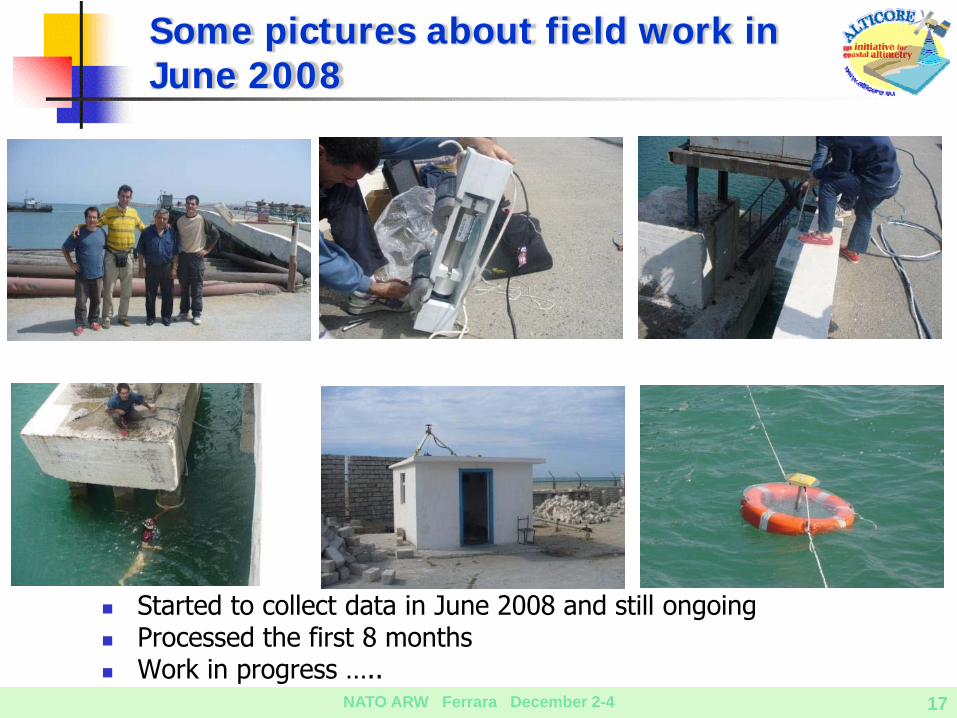
Started to collect data in June 2008 and still ongoingProcessed the first 8 monthsWork in progress …..
Some pictures about field work in June 2008

NATO ARW Ferrara December 2-4 18
During the observational period, the sea level at Port Absheron exhibits a large high frequency variability apparently more pronounced during summer timeThere are also other oscillations superimposed that need careful investigation
Sea level variability at Absheron Port
The spectrum analysis shows the existence of a little tidal contribution to the sea levelThe large contribution is observed in the 3-30 day band, possibly linked to the meteorological forcing

NATO ARW Ferrara December 2-4 19
New EU/FP7 Coordination Action CASPINFO - (started on Sep 2008)Fostering improved co-operation between research institutes, oil & gas industries, and international bodies in the Caspian SeaMARIS (Netherlands) is the coordinatorBrings together partners from riparian countries (Russia, Azerbaijan and Kazakhstan) + EU ( Greece, Italy) + IOC-IODE, CEP and BSCS More at www.caspinfo.net
Raising funding (jointly with LEGOS)to make the pilot station GLOSS-compliant, including near real time transmission, permanent GPS Station to control the vertical motion of the sea level sensor and regular offshore leveling along the altimetry ground tracksRecommendation to ESA for Sentinel-3
Caspian Sea - Beyond ALTICORE
Caspian Sea is currently the best natural target for calibration over continental water bodies being a big lake with favorable location of
satellite tracks and cross-over pointsCaspian Sea be used as testbed for developing a cal/val site for lakes. No similar optimality of any existing cal/val site in Europe would satisfy these requirements.

NATO ARW Ferrara December 2-4 20
Sea level in the Caspian SeaTopic of growing concern to all five surrounding countries (Azerbaijan, Republic of Iran, Kazakhstan, Russian Federation and Turkmenistan) Several low-lying and densed-populated coastal areas
Satellite altimetry in the Caspian SeaConceptually simple, but challenged by specific processing Measuring sea level changes beyond political barriers
In situ sea level measurements in the Caspian SeaCritical for the generation of accurate altimeter-derived estimatesNot only “numbers” but also knowing how they were generated
Additional in situ resources in the Caspian SeaKey role to support analysis of the various met-ocean-hydro contributionsOil & Gas sector interested - it would be an important player
Data are only one piece of the puzzleWe know the sea level storyWe don’t know “What-if”
Summary
Remote Sensing in the Caspian Sea would be an important factor of integration and a valuable opportunity for data sharing