ridot’s statewide roadway and accent image here … 20170405-swhite-ridot_dts_mire_gist_… ·...
TRANSCRIPT

Accent image here
Primary Image here
RIDOT’S Statewide Roadway and
Asset Data Collection ProjectGIS-T Conference 2017
Shane White Rhode Island DOT; Daniel Behnke DTS

RIDOT’S Statewide Roadway and Asset Data Collection Project
RDIP Technical Assistance
• Started with Update to RI Strategic Highway Safety Plan (SHSP)
• SHSP Update Process Identified ‘Lack of Data Integration’ as Major
Factor Contributing to a ‘Incomplete Picture on Traffic Safety’ in RI
• Built upon CDIP that RIDOT participated in 2013
• Workshop and Roundtables conducted June 2014
• Workshop included Statewide and RIDOT Planning (Asset
Management and GIS), Infrastructure Development, and Several
Municipalities
RIDOT’S Statewide Roadway and Asset Data Collection Project
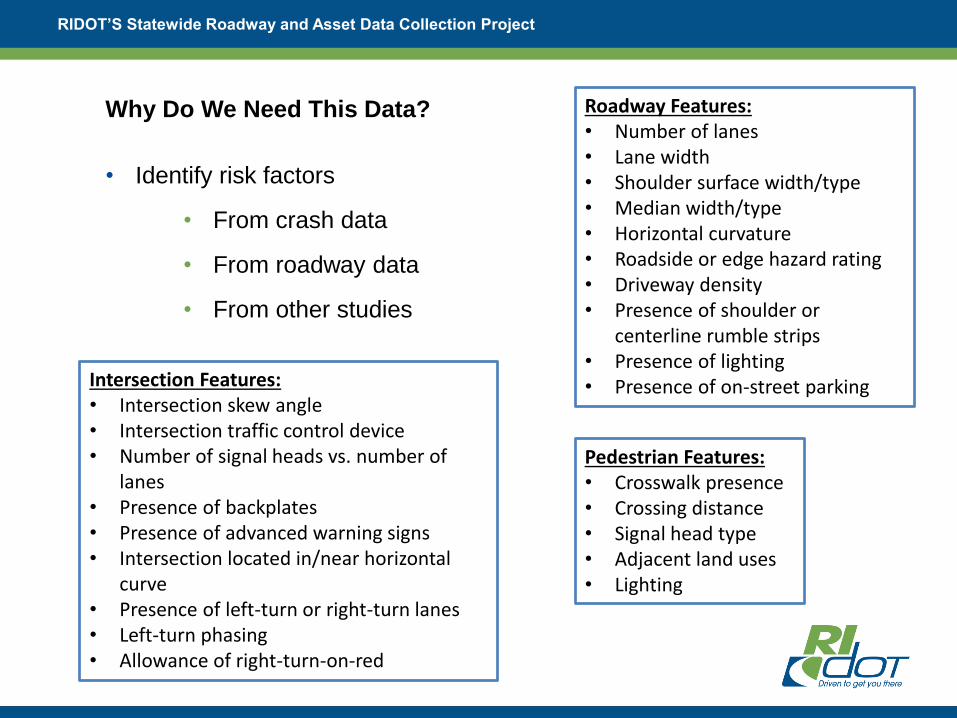
Roadway Features:• Number of lanes• Lane width• Shoulder surface width/type• Median width/type• Horizontal curvature• Roadside or edge hazard rating• Driveway density• Presence of shoulder or
centerline rumble strips• Presence of lighting• Presence of on-street parkingIntersection Features:
• Intersection skew angle• Intersection traffic control device• Number of signal heads vs. number of
lanes• Presence of backplates• Presence of advanced warning signs• Intersection located in/near horizontal
curve• Presence of left-turn or right-turn lanes• Left-turn phasing• Allowance of right-turn-on-red
Pedestrian Features:• Crosswalk presence• Crossing distance• Signal head type• Adjacent land uses• Lighting
Why Do We Need This Data?
• Identify risk factors
• From crash data
• From roadway data
• From other studies

RIDOT’S Statewide Roadway and Asset Data Collection Project
• Allocate funding annually for local safety improvement projects
• Proposal forms reviewed on quarterly basis
• Proposals scored and ranked based on safety benefit, alignment with
RIDOT’s goals and objectives, and cost.
• For state roads, RIDOT will fund and administer design and construction,
depending of resources.
• For local roads, funding will be distributed to municipality to administer
design and construction.
RIDOT developing local safety program

RIDOT’S Statewide Roadway and Asset Data Collection Project
• Safety Benefit/Cost Ratio Analysis
• Fatality/Serious Injury Reduction
• Systemic versus Spot
• RSA performed during diagnosis
(multi-disciplinary team)
• Implementation of Enforcement
and Education countermeasures
• Participation in Roadway Data
Program
HSIP Proposal Scoring

RIDOT’S Statewide Roadway and Asset Data Collection Project
RDIP – Current Data Management and Practices

RIDOT’S Statewide Roadway and Asset Data Collection Project
RDIP – Moving Forward/Recommendations
RIDOT Key Business Systems Integrated

RIDOT’S Statewide Roadway and Asset Data Collection Project
RDIP – Moving Forward/Recommendations (Cont’d)
Kudos
“RIDOT is setting a significant benchmark across the nation with its planned
effort to not just collect the FDEs, but nearly all MIRE elements including FDEs
for all public roadways”
• Enable RIDOT to Perform Advanced Safety Analyses Across Entire Public
Road System:
• 2,050 Miles (32%) State Roads
• 4,450 Miles (68%) Local Roads
• 16,200 Intersections
• 445 Ramps
• Key Recommendations
1. Develop Centralized Process for Updating Roadway Data Elements for
State Maintained System
2. Assess Needs of the Asset Management Unit to Manage Data
3. Develop Process for Maintaining Data Elements for Local System

RIDOT’S Statewide Roadway and Asset Data Collection Project
What is MIRE?
Recommended Listing of Roadway and Traffic Inventory Elements
• Guideline for Agencies
• Critical to Safety Management
• Helps Move Agencies Towards Use of Performance Measures
Benefits Beyond Safety
• Decision Makers
• Asset Management
• Infrastructure
• Operations
• Maintenance

MIRE Across Datasets
RIDOT’S Statewide Roadway and Asset Data Collection Project
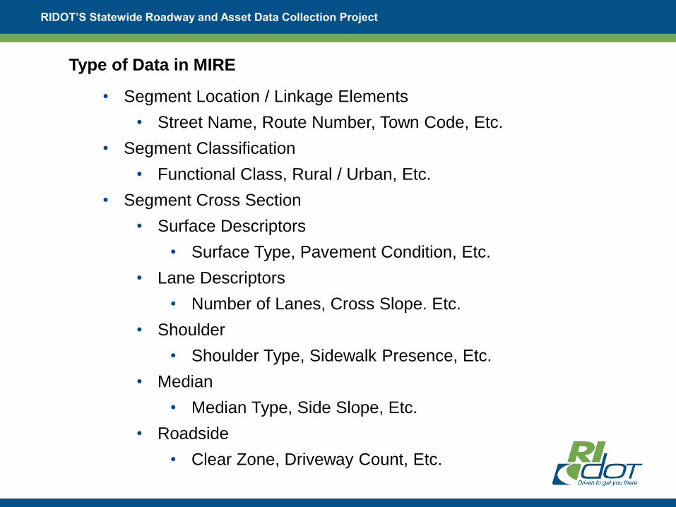
Type of Data in MIRE
• Segment Location / Linkage Elements
• Street Name, Route Number, Town Code, Etc.
• Segment Classification
• Functional Class, Rural / Urban, Etc.
• Segment Cross Section
• Surface Descriptors
• Surface Type, Pavement Condition, Etc.
• Lane Descriptors
• Number of Lanes, Cross Slope. Etc.
• Shoulder
• Shoulder Type, Sidewalk Presence, Etc.
• Median
• Median Type, Side Slope, Etc.
• Roadside
• Clear Zone, Driveway Count, Etc.

RIDOT’S Statewide Roadway and Asset Data Collection Project
Type of Data in MIRE
• Segment Traffic Operations / Control Data
• One/Two Way, Speed Limit, Roadway Lighting, Etc.
• Horizontal Curve Data
• Curve Degrees, Curve Length
• Vertical Grade
• Roadway Junction Descriptors (Intersections)
• General Descriptors
• Type of Intersection, Number of Legs, Signal Presence, Etc
• Each Approach
• Through Lanes, Median Type, Crosswalk Presence, Etc.
• Interchange and Ramps Descriptors
• Interchange Type, Number of Lanes, Speed

RIDOT’S Statewide Roadway and Asset Data Collection Project
MIRE Data Collection Effort
Timeline
• Scope of Work June 2013
• RFP Completed May 2014
• NTP September 2014
• Data Collection Completed December 2015
• Completing QA/QC Process Now
• Beginning to use the data to perform predictive safety analysis,
particularly on corridors
Scope of Work
• Collect 180 of 202 MIRE Elements
• Traffic Volume Related Elements Not Collected (79-90, 140-141,
160, 163-166, 184, 191-192)
• Also Responsible for Collecting ROW Imagery, Pavement
Roughness & Distress Data, LIDAR, and Additional Asset Data

RIDOT’S Statewide Roadway and Asset Data Collection Project
Asset Data Collected
• Pavement
• Roughness, Rutting, Patching, Bleeding
• Collected on State, NHS, Numbered Routes, Ramp, Municipal
Federal Aid
• Mobile LiDAR for 1300 Miles of State Road and Some Ramps
• ROW Imagery for State Roads
• Asset Features
• Statewide
• Road Inventory
• Signs
• State Roads
• Guardrail
• Walls
• Catch Basins and Manholes
• Striping
• Bridge Vertical Clearance

RIDOT’S Statewide Roadway and Asset Data Collection Project
MIRE Data Collection Effort (Cont’d)
Actual Cost
• $750,000 – MIRE
• $100,000 - ROW Imagery
• $350,000 – Pavement Data Collection
Cost Estimation
• 38 FDE’s Required by MAP-21 - $750,000
• High Priority Elements (FDE’s Plus Elements Deemed “High Priority”) -
$1,200,000
• All MIRE Elements - $3,600,000 (Does Not Include Traffic Data
Collection)
• Costs Assumed Combination of Remote Imagery (e.g. Google Earth,
RIGIS), and Instrumented Van Technology
RIDOT’S Statewide Roadway and Asset Data Collection Project
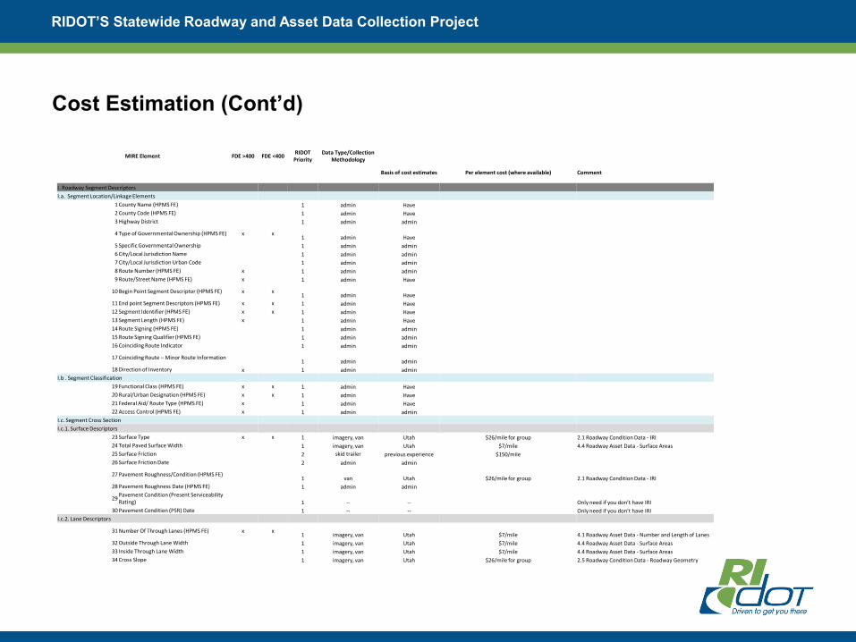
Cost Estimation (Cont’d)
MIRE Element FDE >400 FDE <400 RIDOT
PriorityData Type/Collection
Methodology
Basis of cost estimates Per element cost (where available) Comment
I. Roadway Segment Descriptors
I.a. Segment Location/Linkage Elements
1 County Name (HPMS FE) 1 admin Have
2 County Code (HPMS FE) 1 admin Have
3 Highway District 1 admin admin
4 Type of Governmental Ownership (HPMS FE) x x1 admin Have
5 Specific Governmental Ownership 1 admin admin
6 City/Local Jurisdiction Name 1 admin admin
7 City/Local Jurisdiction Urban Code 1 admin admin
8 Route Number (HPMS FE) x 1 admin admin
9 Route/Street Name (HPMS FE) x 1 admin Have
10 Begin Point Segment Descriptor (HPMS FE) x x1 admin Have
11 End point Segment Descriptors (HPMS FE) x x 1 admin Have
12 Segment Identifier (HPMS FE) x x 1 admin Have
13 Segment Length (HPMS FE) x 1 admin Have
14 Route Signing (HPMS FE) 1 admin admin
15 Route Signing Qualifier (HPMS FE) 1 admin admin
16 Coinciding Route Indicator 1 admin admin
17 Coinciding Route – Minor Route Information1 admin admin
18 Direction of Inventory x 1 admin admin
I.b . Segment Classification
19 Functional Class (HPMS FE) x x 1 admin Have
20 Rural/Urban Designation (HPMS FE) x x 1 admin Have
21 Federal Aid/ Route Type (HPMS FE) x 1 admin Have
22 Access Control (HPMS FE) x 1 admin admin
I.c. Segment Cross Section
I.c.1. Surface Descriptors
23 Surface Type x x 1 imagery, van Utah $26/mile for group 2.1 Roadway Condition Data - IRI
24 Total Paved Surface Width 1 imagery, van Utah $7/mile 4.4 Roadway Asset Data - Surface Areas
25 Surface Friction 2 skid trailer previous experience $150/mile
26 Surface Friction Date 2 admin admin
27 Pavement Roughness/Condition (HPMS FE)1 van Utah $26/mile for group 2.1 Roadway Condition Data - IRI
28 Pavement Roughness Date (HPMS FE) 1 admin admin
29Pavement Condition (Present Serviceability Rating) 1 -- -- Only need if you don’t have IRI
30 Pavement Condition (PSR) Date 1 -- -- Only need if you don’t have IRI
I.c.2. Lane Descriptors
31 Number Of Through Lanes (HPMS FE) x x1 imagery, van Utah $7/mile 4.1 Roadway Asset Data - Number and Length of Lanes
32 Outside Through Lane Width 1 imagery, van Utah $7/mile 4.4 Roadway Asset Data - Surface Areas
33 Inside Through Lane Width 1 imagery, van Utah $7/mile 4.4 Roadway Asset Data - Surface Areas
34 Cross Slope 1 imagery, van Utah $26/mile for group 2.5 Roadway Condition Data - Roadway Geometry

RIDOT’S Statewide Roadway and Asset Data Collection Project
Data Integration and Governance
Data Integration Through ESRI Roads & Highway Implementation
• Conversion From Multiple LRSs Supporting Various Business Systems to a
Unified LRS Platform (While Supporting Multiple LRMS)
• Supporting Bi-Directional Data Flow and Consistent Location Referencing
Across Business Systems
Rhode Island Local/State Data Integration For Asset Management and Safety
Analysis – In Progress
• Develop processes and identify staffing and resources needed to guarantee the
ongoing maintenance and utility of the roadway location and MIRE inventory
data
• Manage data integration and assist the RIDOT in developing processes for
integration of the new MIRE data into ESRI Roads and Highways
• Support use of advanced analytic tools/methodologies through example
analyses and training on data extraction/integration processes

RIDOT’S Statewide Roadway and Asset Data Collection Project
Geodatabase
Business systems
Rules define how
events are updated
LRS Editor
LRS Change
Web services
communicate the last
synchronization date
Web services
communicate route and
measure changes to
business records
All edit activities
are time stamped
and stored
Automated Sync’ing of Business
Systems with LRS
Web Service Connections
extend access to data inside/
outside the organization,
providing access to local &
regional government
Local & regional government can
participate in the maintenance
of the database
RIDOT’S Statewide Roadway and Asset Data Collection Project
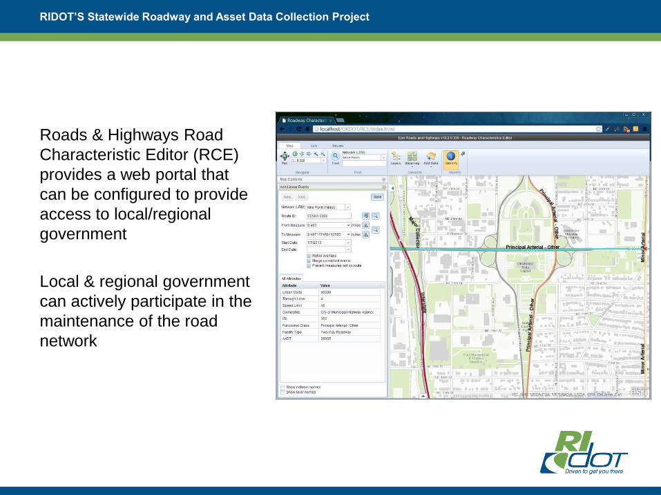
Roads & Highways Road
Characteristic Editor (RCE)
provides a web portal that
can be configured to provide
access to local/regional
government
Local & regional government
can actively participate in the
maintenance of the road
network
Roadway Characteristics Editor (RCE)

Data Model
• MIRE has no standardized data model, only guidance
• Wanted something basic that could be improved upon
• Needed something that could easily be edited and moved to various formats

Data Collection
• MAC vehicles collect data
along predefined routes
• Directionality important
consideration
• Mutliple datasets with
differing priority levels
• GPS tracks used to track
collection
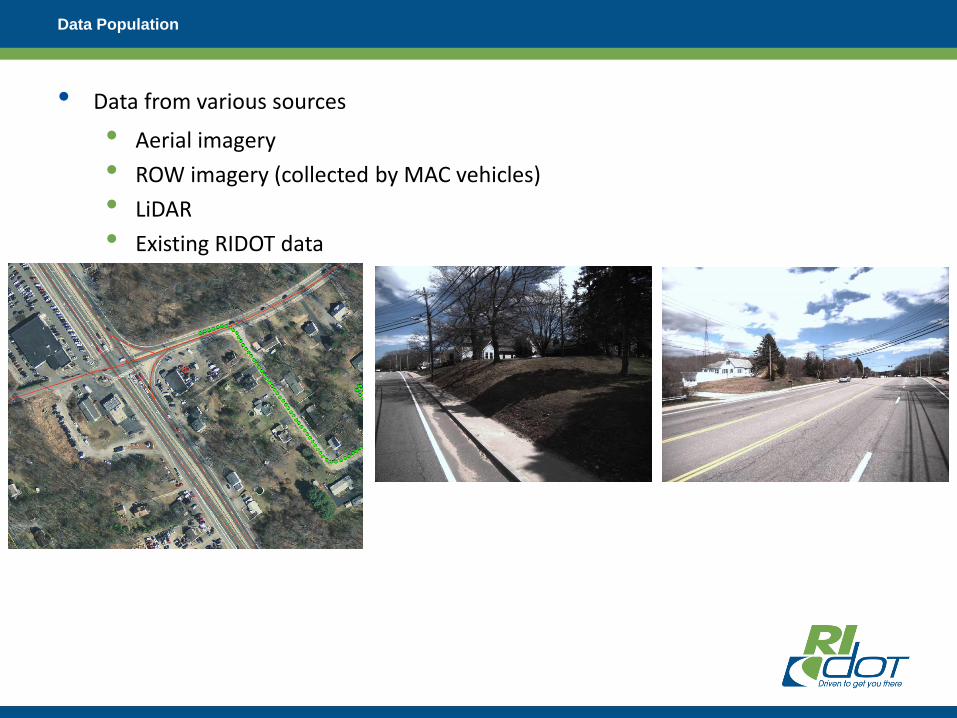
Data Population
• Data from various sources
• Aerial imagery
• ROW imagery (collected by MAC vehicles)
• LiDAR
• Existing RIDOT data

Data Population

Data Population
• Data populated at 1/10th of a mile segments
• Coded domain values used
• Populated specifically based on type of roadway elements

Curves
• Biggest hurdle with data
• New process that seemed to have never been done before.
• Developed Python scripts to detect curves
• Scripts use point data created from LRS to determine curve start/end measures, length, and radius of curve

QC Before Delivery to RIDOT
• Initial QC performed by Michael Baker
• Manual and Automated QC performed
• Mainline
• 86,522 segments, 6,932 miles, 120 MIRE Elements
• Intersections
• 16,215 intersections, 49,337 intersections approaches, 57 Elements
• Ramps
• 444 ramps, 25 Elements
QC Before Delivery to RIDOT
• Manual processes used to QC data using symbology
• Find areas where symbology differs, and could potentially be errors
• Applied to attributes such as speed limit, sidewalk presence, median information, etc.
• Reports delivered in the form of word documents describing issue with screen captures for specific Segment IDs
• Automated processes
• Scripts built for cross attribute validation and domain validation
• Applied to all datasets
• Validation rules developed based on MIRE guidelines
• 80 cross attribute validations
• 90 domain validations
• Reports delivered to DTS in the form of CSV files with issues listed by Segment ID

RIDOT’S Statewide Roadway and Asset Data Collection Project
Lessons Learned/Challenges
• No standard data model for MIRE
• Had to develop data model
• Numerous iterations to work out best geometric and attribute representations
• Built GDB with domains for all MIRE Elements that could be coded
• DOTs vs Consulting
• Managing expectations
• Keeping all participants up-to-date on project status
• LRS updates during project

RIDOT’S Statewide Roadway and Asset Data Collection Project
Lessons Learned/Challenges (Cont’d)
• FHWA should develop a geospatial data model for use by any agency interested in
implementing MIRE. The data model should template GIS feature classes, attribute
domains within each feature class, and necessary relationship classes between
features.
• A substantial amount of time was spent by the MIRE Contractor developing a
GIS data model to house the MIRE data collection.
• MIRE Contractor identified the need for additional details for each MIRE element to
be located in a single reference document.
• Although safety engineers are the primarily consumers of the MIRE data, data
collection Contractors are more likely to be experts in GIS or mobile data
collection technology, without in-depth knowledge of each MIRE element.

RIDOT’S Statewide Roadway and Asset Data Collection Project
Lessons Learned/Challenges (Cont’d)
• Require Contractors to document and submit their data collection
methodology prior to collecting data. For each MIRE element:
• Define the element and the attribute type (alpha-numeric, string, integer,
double)
• Identify the source data (Existing GIS, Aerial Photography, ROW
Imaging, LiDAR, etc.)
• Define the process used to extract the element (field calculation, on-
screen measurement/count, automated from mobile data collection
vehicle)
• Expected accuracy

RIDOT’S Statewide Roadway and Asset Data Collection Project
Lessons Learned/Challenges (Cont’d)
• MIRE junction elements are split between two types of geometry: A point
feature with attributes describing the intersection; 3 or more linear features
representing the intersection approaches.
• Each intersection represented as a point with attributes describing the
intersection.
• Intersection approach elements stored in a Related Table and linked to
the intersection point based on the intersection identifier.
• MIRE does not require the intersection approach to be linked to the road
segment ID, only the intersection ID.
• Poses a problem when implementing Safety Analyst and linking crash
data to segments and approaches.

RIDOT’S Statewide Roadway and Asset Data Collection Project
Moving Forward
• MIRE Road Inventory to be Imported into Esri Roads & Highways and Managed as
part of RIDOT’s LRS
• MIRE elements will be dissolved from 1/10 mile centerline segments into LRS
routes with event tables
• Develop Geoprocessing Tools to Extract Data from Esri Roads & Highways for import
into Safety Analyst
• Safety Analyst will not work with the Esri Roads & Highways event tables
• Additional data fields (processed from existing attributes) required for import to
Safety Analyst
• MIRE Element Attribute Definitions differ from Safety Analyst Requirements
• Two Options:
• Manually attribute map the MIRE attribute definitions within Safety Analyst
as part of the data import process
• Translate MIRE attributes to Safety Analyst definitions through scripting
outside of Safety Analyst

• Street name
• Pavement Surface Type/Width/Condition
• Lane & Shoulder Type/Width
• Number of through/left turn/right turn/aux lanes
• Bike facility (shard lane, bike lane, bike path)
• Sidewalk Type/Presence
• Curb Type/Presence
• Median Type/Presence/Width
• Driveway (residential and commercial) Count
• Intersection Control (signalized, stop, uncontrolled, pedestrian)
• Speed Limits
• On-Street Parking
• School Zones
• Crosswalk
• Lighting
• Pavement Markings
• Rumble Strips
• Passing Zones
Sample list of common data elements that may need updating
RIDOT’S Statewide Roadway and Asset Data Collection Project

RIDOT’S Statewide Roadway and Asset Data Collection Project
Comments & Questions