revised environmental hazard evaluation
TRANSCRIPT
Prepared by:
BUREAU VERITAS NORTH AMERICA, INC. Health, Safety, and Environmental Services
841 Bishop Street, Suite 1100 Honolulu, Hawaii 96813
808.531.6708 www.us.bureauveritas.com
Revised Environmental Hazard Evaluation
1025 Waimanu Street(TMK Number: [1] 2-3-003: Parcel 040)
Honolulu, Oahu, Hawaii
May 29, 2014
Project No. 17012-012090.00
Prepared for:
ARTSPACE847 Hiawatha Place South Seattle, Washington 99144
Project No. 17012-012090.00 ii
CONTENTS Section Page List of Acronyms ........................................................................................................................................ iv Executive Summary .................................................................................................................................... v
1.0 INTRODUCTION, BACKGROUND, AND PURPOSE ....................................................................... 1 1.1 BACKGROUND .................................................................................................................................. 1 1.2 PURPOSE .......................................................................................................................................... 1
2.0 SITE DESCRIPTION .......................................................................................................................... 1 2.1 PHYSICAL SETTING ......................................................................................................................... 1 2.1.1 Soils/Geology ................................................................................................................................ 2 2.1.2 Groundwater .................................................................................................................................. 2 2.1.3 Surface Water ................................................................................................................................ 3 2.2 HISTORIC LAND USE ....................................................................................................................... 3 2.3 CURRENT AND FUTURE LAND USE ............................................................................................... 3 2.4 APPLICABLE ACTION LEVELS ........................................................................................................ 4
3.0 INVESTIGATION HISTORY ............................................................................................................... 4 3.1 PHASE I ENVIRONMENTAL SITE ASSESSMENT (2010) ............................................................... 4 3.2 PHASE II ENVIRONMENTAL INVESTIGATION (2012) .................................................................... 4
4.0 NATURE AND EXTENT OF CONTAMINATION ............................................................................... 7
5.0 DESCRIPTION OF THE ENVIRONMENTAL HAZARD EVALUATION PROCESS ........................ 7
6.0 IDENTIFICATION OF CHEMICALS OF POTENTIAL CONCERN ................................................... 8 6.1 SOIL .................................................................................................................................................... 8 6.2 GROUNDWATER ............................................................................................................................... 9
7.0 POTENTIAL ENVIRONMENTAL HAZARDS .................................................................................. 10 7.1 CONCEPTUAL SITE MODEL .......................................................................................................... 11 7.2 POTENTIAL RECEPTORS .............................................................................................................. 11 7.3 POTENTIAL EXPOSURE PATHWAYS ........................................................................................... 11 7.4 TARGETED ENVIRONMENTAL HAZARDS .................................................................................... 12
8.0 TARGETED SCREENING LEVELS AND COMPARISION TO SITE DATA .................................. 12 8.1 ENVIRONMENTAL HAZARDS FOR SOIL ...................................................................................... 13 8.2 GROUNDWATER ENVIRONMENTAL HAZARDS .......................................................................... 13
9.0 CONCLUSIONS ............................................................................................................................... 14
10.0 RECOMMENDATIONS .................................................................................................................... 15
11.0 LIMITATIONS ................................................................................................................................... 15

CONTENTS (Continued)
Project No. 17012-012090.00 iii
References Figures
1 Site Location Map 2 Site Vicinity Map 3 Concentrations Exceeding Tier 1 EALs 4 Known Areas of Residual Impacts (Based on Screening-Level Investigation) 5 Known Environmental Hazards (Based on Screening-Level Investigation) Tables
1 Summary of Preliminary Soil Analytical Results (Shallow Decision Unit and Boreholes MW-1 and MW-2)
2 Summary of Preliminary Soil Analytical Results (Borehole MW-3 and MW-4) 3 Summary of Preliminary Groundwater Analytical Results (Wells MW-1 and MW-2) 4 Summary of Preliminary Groundwater Analytical Results (Wells MW-3 and MW-4) 5 Conceptual Site Model 6 HDOH EALs for Specific Environmental Hazards for Soil 7 HDOH EALs for Specific Environmental Hazards for Groundwater
Project No. 17012-012090.00 iv
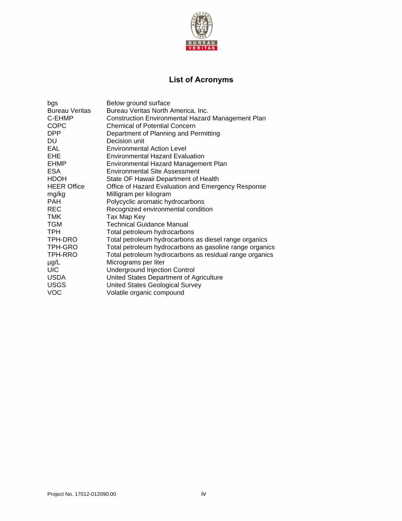
List of Acronyms bgs Below ground surface Bureau Veritas Bureau Veritas North America, Inc. C-EHMP Construction Environmental Hazard Management Plan COPC Chemical of Potential Concern DPP Department of Planning and Permitting DU Decision unit EAL Environmental Action Level EHE Environmental Hazard Evaluation EHMP Environmental Hazard Management Plan ESA Environmental Site Assessment HDOH State OF Hawaii Department of Health HEER Office Office of Hazard Evaluation and Emergency Response mg/kg Milligram per kilogram PAH Polycyclic aromatic hydrocarbons REC Recognized environmental condition TMK Tax Map Key TGM Technical Guidance Manual TPH Total petroleum hydrocarbons TPH-DRO Total petroleum hydrocarbons as diesel range organics TPH-GRO Total petroleum hydrocarbons as gasoline range organics TPH-RRO Total petroleum hydrocarbons as residual range organics µg/L Micrograms per liter UIC Underground Injection Control USDA United States Department of Agriculture USGS United States Geological Survey VOC Volatile organic compound
Project No. 17012-012090.00 v
Executive Summary Artspace retained Bureau Veritas North America, Inc. (Bureau Veritas) to conduct an Environmental Hazard Evaluation (EHE) of the Artspace project site (Tax Map Key [TMK] Number: [1] 2-3-003: Parcel 040), located at 1025 Waimanu Street, Honolulu, Oahu, Hawaii (hereafter referred to as the “site”). Bureau Veritas previously prepared both a Phase I Environmental Site Assessment (ESA) at the site for Hawaii Community Development Program (Bureau Veritas, 2010) and a limited Phase II Environmental Investigation (Bureau Veritas, 2014a). The Phase I ESA identified one Recognized Environmental Condition (REC) and one potential REC both related to potential impacts from historical and adjacent site use. The limited Phase II Environmental Investigation identified limited soil and groundwater impacts at the site, although the investigation was not comprehensive. During the Phase II Environmental Investigation, the soil and groundwater data were compared to the State of Hawaii Department of Health (HDOH) unrestricted Tier 1 Environmental Action Levels (EAL) for sites where groundwater is not a current or potential drinking water resource and a surface water body is not located within 150 meters of the site. Because it is unknown if the site groundwater is infiltrating into the City and County of Honolulu storm drain system, the Phase II Environmental Investigation recommended evaluating the use of the HDOH Tier 1 EALs for site where groundwater is not a current or potential drinking water resource and a surface water body is located within 150 meters of the site. The site is the location of a proposed future residential condominium building with first floor retail space. The purpose of the EHE is to document and assess the potential environmental hazards at the site posed by the impacted soil and groundwater. The potential environmental hazards will be used to develop the appropriate soil and groundwater management measures during future construction activities (i.e., the Construction-Environmental Hazard Management Plan [C-EHMP] prepared under separate cover). In addition, following the proposed construction activities, the potential environmental hazards will be used to determine the necessary site use restrictions and institutional controls, which will be identified and managed in the Environmental Hazard Management Plan (EHMP) to be prepared under separate cover. The EHE is based on the soil and groundwater data collected during the Phase II Environmental Investigation. The Phase II samples were collected to determine presence or absence and did not fully characterize or delineate the contamination at the site. Without additional sampling, site workers should not assume soil and/or groundwater are uncontaminated. Based on the analytical results of the limited Phase II Environmental Investigation (Bureau Veritas, 2014a), site soils and groundwater are impacted with petroleum and related constituents. Shallow soils at two site locations, the southeastern half of the site (0.5 to 3.0 feet below ground surface [bgs]) and the western edge of the site (0.5 to 2.5 feet bgs), are impacted with Total Petroleum Hydrocarbons as Residual Range Organics (TPH-RRO) at concentrations exceeding the Hawaii Department of Health Tier 1 Environmental Action Level (EAL). Groundwater from one of the four monitoring wells, MW-1, located on the western edge of the site is impacted with two polycyclic aromatic hydrocarbons (PAHs), indeno(1,2,3-cd)pyrene and benzo(g,h,i)perylene, at concentrations exceeding their respective HDOH Tier 1 EALs. An EHE consists of a multi-step process to assess potential environmental hazards at sites impacted with environmental contaminants. Following this process, several tasks were completed including defining the nature and extent of contamination, identifying Chemicals of Potential Concern (COPCs), identifying applicable HDOH screening levels for comparison to site data (i.e., targeted HDOH screening levels), and identifying potential environmental hazards.
Project No. 17012-012090.00 vi
Following the HDOH guidance for the preparation of EHEs, the soil and groundwater data collected during the Phase II investigation (Bureau Veritas, 2014a) were compared to the HDOH Tier 1 EALs to identify COPCs (HDOH, 2013 & 2012). One COPC, TPH-RRO, was identified for site soils. Two COPCs, indeno(1,2,3-cd)pyrene and benzo(g,h,i)perylene, were identified for site groundwater. Based on the current and anticipated future land uses of the site, the following potential receptors were identified for the site:
Future Residents Future Indoor Workers Future Outdoor Workers Future Construction Workers Aquatic Ecological Receptors (for the specific case in which groundwater would be discharged to
surface water after being pumped during potential future construction de-watering activities) Because it is unknown if the site groundwater is connected to the storm drain system, the groundwater analytical results were also compared to the unrestricted Tier 1 EALs for sites where groundwater is not a current or potential source of drinking water and the nearest surface water body is less than 150 meters from the site. The measured concentrations of the following contaminants exceeded the chronic aquatic toxicity EALs: TPH-RRO, benzo(a)anthracene, chrysene, benzo(a)pyrene, and benzo(g,h,i)perylene. However, the measured groundwater concentrations did not exceed the acute aquatic toxicity EALs. It was determined that site groundwater was unlikely to impact aquatic receptors through potential migration to surface water via the storm drain system considering the low contaminant concentrations (i.e., do not exceed acute aquatic toxicity EALs) and the distance to surface water (i.e., expected significant dilution during storm events). One potential environmental hazard, gross contamination, may exist at the site (or may be posed by site soil if transferred off-site), as described below. Soil Potential gross contamination hazards in shallow soils for residential receptors may exist if impacted near surface site soil is excavated and used as uncovered surface soil at this site or another residential site. Re-development plans for the site indicate the entire surface of the site will be covered with the proposed future structure. Potential gross contamination hazards for residential receptors are posed by concentrations of TPH-RRO soil. The HDOH (2012) describes gross contamination as soils having offensive odors, unaesthetic appearance and general resource degradation. Groundwater Potential gross contamination hazards may exist in groundwater that is not a current source of drinking water. Potential gross contamination hazards are posed by two PAH analytes, indeno(1,2,3-cd)pyrene and benzo(g,h,i)perylene. It is unlikely site groundwater would impact aquatic receptors through potential migration to surface water via the storm drain system. Soil Vapor Soil vapor hazards were not identified. However, if additional contamination is encountered during construction activities, soil vapor hazards may need to be reevaluated.
Project No. 17012-012090.00 vii
It should be noted that the site has not been fully characterized or delineated. Therefore, sample results may indicated greater or fewer environmental hazards than are present at the site. Recommendations Based on the results of the EHE, Bureau Veritas recommends the preparation of a C-EHMP to document the requirements and appropriate methods for the proper management, handling, and disposal of impacted soil and groundwater that may be encountered during the proposed development/construction activities at site (Bureau Veritas, 2014c). Once the development/construction activities at site are completed, Bureau Veritas recommends that an Environmental Hazard Management Plan (EHMP) be prepared to document the requirements and appropriate methods to manage the potential environmental hazards at the site over the long-term. Bureau Veritas also recommends that HDOH be notified immediately if field observations during construction indicate the magnitude or extent of contamination is greater than expected.
Project No. 17012-012090.00 1
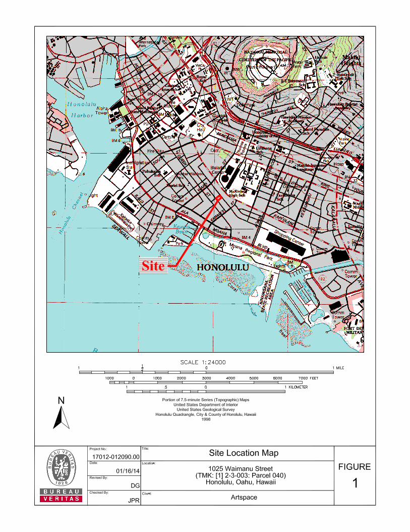
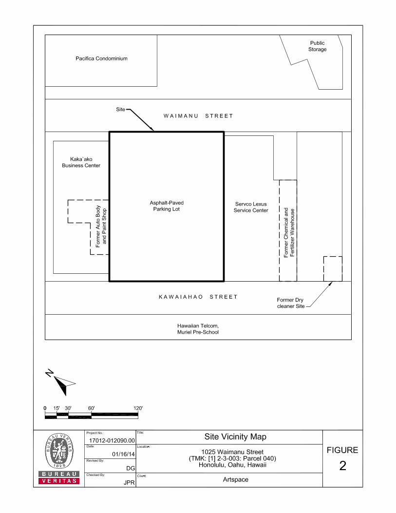
1.0 INTRODUCTION, BACKGROUND, AND PURPOSE Artspace retained Bureau Veritas North America, Inc. (Bureau Veritas) to conduct an Environmental Hazard Evaluation (EHE) of the Artspace project site (Tax Map Key [TMK] Number: [1] 2-3-003: Parcel 040), located at 1025 Waimanu Street, Honolulu, Oahu, Hawaii (hereafter referred to as the “site”). A Site Location Map showing the general location of the site is presented on Figure 1. 1.1 BACKGROUND Bureau Veritas previously prepared both a Phase I Environmental Site Assessment (ESA) at the site for Hawaii Community Development Program (Bureau Veritas, 2010) and a limited Phase II Environmental Investigation (Bureau Veritas, 2014a). The Phase I ESA identified one Recognized Environmental Condition (REC) and one potential REC both related to potential impacts from historical site use and adjacent site use. The limited Phase II Environmental Investigation identified limited soil and groundwater impacts at the site, although the investigation was not comprehensive. 1.2 PURPOSE The purpose of the EHE is to document and assess the potential environmental hazards at the site posed by the impacted soil and groundwater. The potential environmental hazards will be used to develop the appropriate soil and groundwater management measures during future construction activities (i.e., the Construction-Environmental Hazard Management Plan [C-EHMP] prepared under separate cover). In addition, following the proposed construction activities, the potential environmental hazards will be used to determine the necessary site use restrictions and institutional controls, which will be identified and managed in the Environmental Hazard Management Plan (EHMP) to be prepared under separate cover. The EHE is based on the soil and groundwater data collected during the Phase II Environmental Investigation. The Phase II samples were collected to determine presence or absence and did not fully characterize or delineate the contamination at the site. Without additional sampling, site workers should not assume soil and/or groundwater are uncontaminated. 2.0 SITE DESCRIPTION The site consists of a 30,000 square foot rectangular parcel of land located at 1025 Waimanu Street, in Honolulu, Oahu, Hawaii, in an industrial business district (Figures 1 and 2, Figures Tab). The site is further described as the parcel of land designated as TMK Number: (1) 2-3-003: Parcel 040. According to the City and County of Honolulu Department of Planning and Permitting (DPP), the site is located within the “Kakaako Commercial Development District”. 2.1 PHYSICAL SETTING The site lies in the western portion of the Honolulu Plain physiographic division, on the central southern coast of the island of Oahu. The approximate latitude and longitude of the site are 21° 17’ 45.86”N and 157° 51’ 06.12” W, respectively. According to the United States Geological Survey (USGS) 7.5-Minute Honolulu, Oahu, Topographic Quadrangle Map (1998), the elevation at the site is between 5 and 10 feet above mean sea level. The general topography of the site and surrounding region slopes down to the south, toward Kewalo Basin and the Pacific Ocean.
Project No. 17012-012090.00 2
2.1.1 Soils/Geology According to the United States Department of Agriculture’s (USDA) report entitled “Soil Survey of Islands of Kauai, Oahu, Maui, Molokai, and Lanai” (Foote, D.E. et. al., 1972) the soil type beneath the site is classified as Fill Land soil. Fill Land soil (mapping unit FL) consists of material dredged from the ocean or hauled from nearby areas, garbage, and general material from other sources. This land type is used for developments including airports, housing areas, and industrial facilities. During drilling and sampling activities conducted at the site, the soil encountered immediately beneath the surface consisted of silty clay with varying percentages of basalt and coral gravel clasts, and coral and coral sand. Beneath the silty clay, near the groundwater table a one to two foot thick layer of grey saturated silty clay was observed. Groundwater was present at a depth of approximately 6.5 to 7.5 feet below ground surface (bgs). A hard coral shelf was encountered at approximately one to two feet below the water table. 2.1.2 Groundwater Bureau Veritas reviewed the Aquifer Identification and Classification for Oahu: Groundwater Protection Strategy for Hawaii, Technical Report No. 179, (Mink, J.F. and Lau, L.S. 1990), published by the Water Resources Research Center at the University of Hawaii, for information on groundwater conditions below the site. The report describes two aquifers below the site as part of the Nuuanu aquifer system of the Honolulu sector on the island of Oahu. The upper aquifer is an unconfined basal aquifer of the sedimentary type, occurring in non-volcanic lithology. The status is described as a replaceable, moderate salinity water supply, not used for drinking water or of ecological importance, which has a potential for use. This aquifer has a high vulnerability to contamination. The lower aquifer is a confined basal aquifer of the flank type, occurring in horizontally extensive lavas. Its status is described as an irreplaceable, fresh drinking water supply that is currently in use. This aquifer has a low vulnerability to contamination. The site is located below the State of Hawaii Department of Health (HDOH) defined Underground Injection Control (UIC) line. Areas above the UIC line denote potential underground drinking water aquifers. Areas below the UIC line generally denote groundwater that is unsuitable for drinking water purposes. Consequently, the groundwater below the site is considered non-drinking water. The regional groundwater flow direction is inferred to the southwest toward the Pacific Ocean, based on the surface topography. However, topography is not always a reliable basis for predicting groundwater flow direction. The local gradient and flow direction under the site may be influenced naturally by tidal fluctuations, zones of higher or lower permeability, or artificially by nearby pumping or recharge, and may deviate from the regional trend. During the Phase II Investigation (Bureau Veritas, 2014a), depth to groundwater measured from approximately six to 7.5 feet bgs. According to the 1983 U.S. Department of the Interior Geological Survey 7.5 Minute Topographic Map of the Honolulu Quadrangle with the Hawaii Department of Land and Natural Resources Division of Water and Land Development Underground Injection Well Overlay, no drinking water wells or other commercial or municipal wells lie with ¼ mile of the site (USGS, 1983). Groundwater at the site is located at a depth of approximately 6.5 to 7.5 feet bgs. It is unknown if groundwater is infiltrating into the City and County of Honolulu storm drain system.
Project No. 17012-012090.00 3
2.1.3 Surface Water The nearest surface water body is the Kewalo Basin harbor, approximately 1,500 feet to the southwest of the site. The Kewalo Basin is connected to the Pacific Ocean near Honolulu Harbor. The storm water runoff from the site flows via sheet flow both northeast towards Waimanu Street and southwest towards Kawaiahao Street. The storm water then discharges into the City and County of Honolulu storm drain system. 2.2 HISTORIC LAND USE According to the Bureau Veritas Phase I ESA report (Bureau Veritas, 2010), Sanborn Fire Insurance maps indicated the site was previously used as a contractor’s storage yard from at least 1955 until 2008. The contractor storage yard was unpaved and aerial photographs indicated heavy equipment was stored on site. Historical usage as a contractor’s storage yard indicates the potential use and storage of petroleum products and other hazardous materials. From 2008 to the present, the site has been a paved parking lot. Reportedly, prior to paving in 2008, fill material was brought onto the site to increase the slope of site and help control surface runoff. The fill material was reportedly brought in from the adjacent Pacifica Condominium site, which is located across Waimanu Street (TMK [1] 2-3-003: Parcel 105). The fill material appears to have been used to increase the grade in the central portion of the site (in the northwest to southeast direction). The site slopes downward from the central area toward Waimanu Street on the northeast and toward Kawaiahao Street on the southwest. It should be noted that the fill material is believed to have been brought onto the site, prior to paving in 2008, when the site was owned by Evershine X. The current owner, Hawaii Community Development Authority purchased the property on or about May 20, 2010 according to the City and County of Honolulu DPP’s website. The Sanborn Fire Insurance maps also indicated the following historical uses on several nearby properties:
The property (TMK [1] 2-3-003: Parcel 043) located adjacent and northwest of the site was labeled as an auto body and paint facility and also showed a paint booth on the 1962, 1972 and 1977 maps.
The property (TMK [1] 2-3-003: Parcel 037) located southeast of the site was labeled on the 1962 map as a chemical and fertilizer warehouse.
The property (TMK [1] 2-3-003: Parcel 059) located south-southeast of the site was labeled Honolulu Laundry and had a dry cleaning facility on the 1955, 1962, 1972, 1977, and 1986 maps. The 1991 and 1993 maps did not show the presence of the laundry, although the dry cleaning facility remained.
2.3 CURRENT AND FUTURE LAND USE The site is currently owned by Hawaii Community Development Authority and is currently paved with asphalt demarcated with parking spaces. The site is enclosed by a chain-link fence and gates, and is currently used for public parking.
Project No. 17012-012090.00 4
The site is the proposed, future location of a residential condominium building with first floor retail space. Specifically, the site is the proposed, future location of a nine level mixed use property that will include commercial, residential, parking, and community use areas. This mixed-use development project is intended to serve the broader Hawaiian Community by developing a traditional Hawaiian Cultural Center with classroom space, space for teaching and performing Hula, music, and other traditional practices, as well as 72 units of affordable multi-ethnic artist housing for Hawaiian artists and their families. 2.4 APPLICABLE ACTION LEVELS The HDOH Tier 1 Environmental Action Levels are published by the HDOH’s Office of Hazard Evaluation and Emergency Response (HEER Office). The Environmental Action Level (EAL) applicable to this site are the unrestricted Tier 1 EALs where groundwater is not a current or potential source of drinking water and the nearest surface water body is greater than 150 meters from the site (HDOH, 2012). It is unknown if the groundwater at the site, located at approximately 6.5 to 7.5 feet bgs, is infiltrating into the City and County of Honolulu storm drain system. If the groundwater is connected to the storm drain system, it may be appropriate to compare to the unrestricted Tier 1 EALs where groundwater is not a current or potential source of drinking water and the nearest surface water body is less than 150 meters from the site. (Please see Section 6.2 Groundwater for further evaluation and discussion). 3.0 INVESTIGATION HISTORY 3.1 PHASE I ENVIRONMENTAL SITE ASSESSMENT (2010) In 2010, Bureau Veritas prepared a Phase I ESA at the site for Hawaii Community Development Program (Bureau Veritas, 2010). The Phase I ESA identified one Recognized Environmental Condition (REC) that was related to historical use of the site, which was located on the site, and one potential REC related to potential impacts from historical uses at an adjacent and nearby properties in the vicinity of the site (Bureau Veritas, 2010). The Phase I ESA revealed the following evidence of RECs, as defined by ASTM, in connection with the site:
Historical research indicated that the site was previously used as a contractor’s storage yard from at least 1955 until 2008. The storage yard was unpaved and aerial photographs indicated heavy equipment was stored on site. Historical use as a contractor’s storage yard indicates the potential use and storage of petroleum products and other hazardous materials. Additionally, vicinity properties identified in fire insurance maps included a drycleaner, chemical and fertilizer warehouse, and auto body and paint shop. These types of facilities are typically associated with the storage and/or usage of hazardous chemicals and materials, with the potential for releases of such materials.
Bureau Veritas recommended conducting a subsurface investigation to assess the presence or absence of impacts from potential releases associated with the findings of the Phase I ESA. 3.2 PHASE II ENVIRONMENTAL INVESTIGATION (2012) In July 2012, Bureau Veritas conducted a limited Phase II Environmental Investigation of the site. The purpose of the Phase II Environmental Investigation was to assess the presence or absence of impacts from historical releases that may have occurred on or around the site. The site was not fully characterized during the limited Phase II Environmental Investigation. A direct push drilling rig was used to (1) advance 16 boreholes for the collection of shallow multi-increment soil samples, and (2) advance four boreholes for the collection of multi-increment soil samples and groundwater grab samples (from
Project No. 17012-012090.00 5
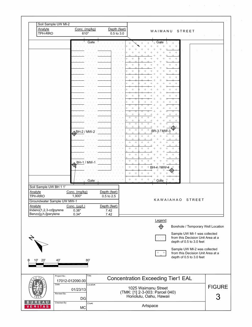
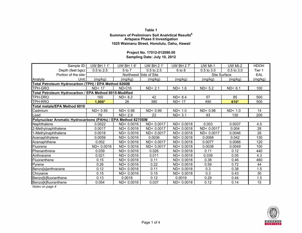
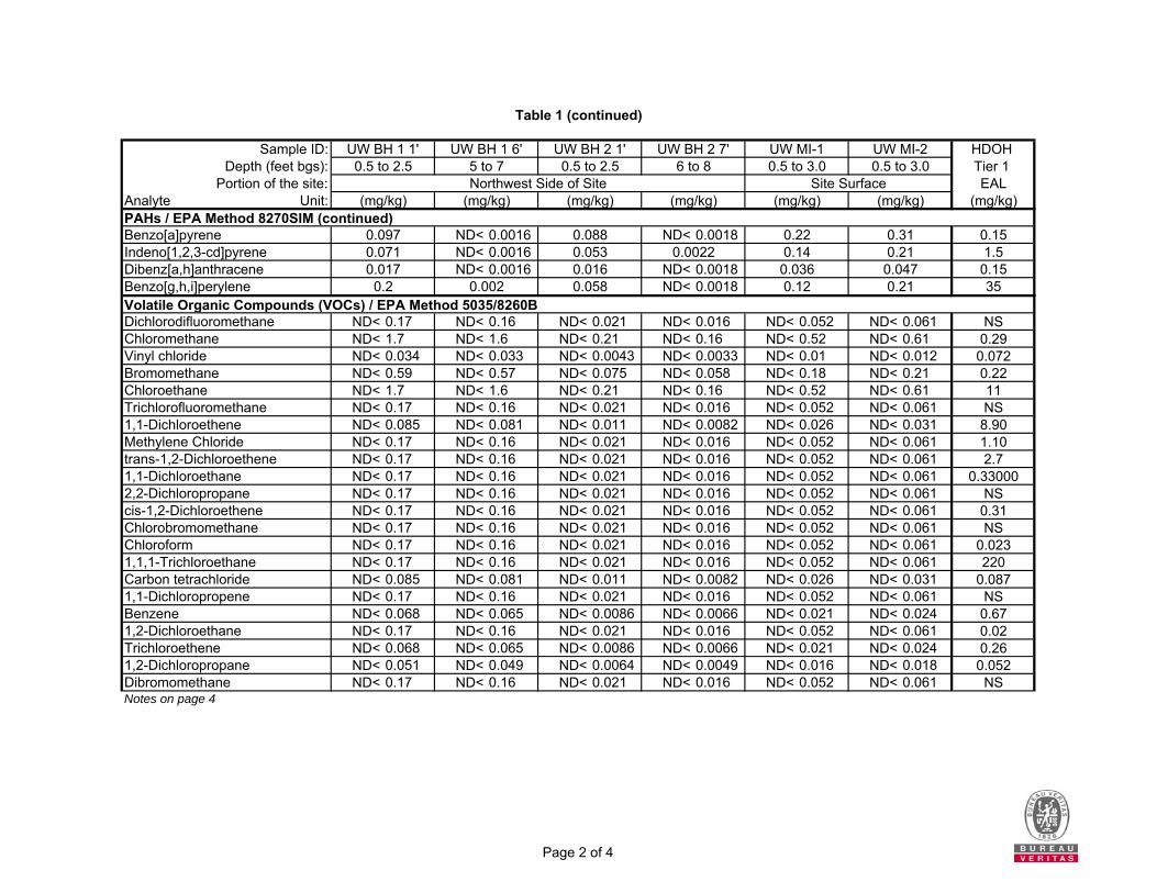
temporary monitoring wells set within the four boreholes). The boreholes are depicted in Figure 3, located behind the Figures tab. Two decision units (DU) were established on the site to investigate the shallow soils for impacts related to the on-site contractor storage yard. The area of each DU measured approximately 15,000 square feet in size. One of the DU areas was established on the northwestern half of the site and the soil sample was designated as sample number UW MI-1. A second DU area was established on the southeastern half of the site and a soil sample was designated as sample number UW MI-2. Samples UW MI-1 and UW MI-2 were multi-increment soil samples comprised of at least 30 soil increments that were collected from the 0.5 to 3.0 feet bgs interval from eight shallow boreholes collected from within each of the established DU areas. No staining or odors were observed within any of the soil samples retrieved from the two DU areas. Two boreholes with temporary groundwater monitoring wells (MW-1 and MW-2) were positioned along the northwest side of the site to assess potential impacts from the former off-site auto body and paint area. Two additional boreholes with temporary groundwater monitoring wells (MW-3 and MW-4) were positioned along the southeast of the site to assess potential impacts from the former off-site chemical and fertilizer warehouse and off-site dry cleaning facility. No staining or odors were observed within any of the soil boreholes. Six multi-increment soil samples were collected from select soil intervals within the four boreholes. Samples were analyzed for TPH, PAHs and VOCs to assess potential impacts from the former off-site auto body shop. Samples were analyzed for VOCs to assess potential impacts from the former paint area. Samples were analyzed for VOCs and PAHs to assess potential impacts from the former off-site chemical and fertilizer warehouse. Lastly, samples were analyzed for VOCs to assess potential impacts from the off-site dry cleaning facility. Temporary well casings were installed in the four soil boreholes to facilitate the collection of a groundwater grab sample from each borehole. Boreholes BH-1, BH-2, BH-3, and BH-4 were converted to groundwater monitoring wells MW-1, MW-2, MW-3, and MW-4, respectively. The soil and groundwater results were compared to the unrestricted Tier 1 EALs for sites where groundwater is not a current or potential drinking water resource and a surface water body is not located within 150 meters of the site. Analytical results for the multi-increment soil samples are presented in Tables 1 and 2, located behind the Tables tab. Analytical results for the groundwater grab samples are presented in Tables 3 and 4. It should be noted these conclusions are based on preliminary samples, not a full site characterization. Phase II samples were collected to determine presence or absence and did not fully characterize or delineate the contamination at the site. Without additional sampling, site workers should not assume soil and/or groundwater are uncontaminated. Multi-Increment Samples - Shallow Soils in DU1 and DU2 Soil samples UW MI-1 and UW MI-2 were multi-increment samples from the shallow soils of the two DUs established at the site (i.e., 0.5 to 3.0 feet bgs). Total petroleum hydrocarbons as residual range organics (TPH-RRO) was detected at concentrations of 490 milligrams per kilogram (mg/kg) and 610 mg/kg. The TPH-RRO concentrations of 610 mg/kg detected in soils sample UW MI-2 (i.e., southeastern side of site) exceeded the HDOH Tier 1 EAL of 500 mg/kg for TPH-RRO. Total petroleum hydrocarbons as diesel range organics (TPH-DRO), total lead, and several polycyclic aromatic hydrocarbons (PAH) analytes were detected; however, the concentrations were below the applicable HDOH Tier 1 EALs. Concentrations of total petroleum hydrocarbons as gasoline range organics (TPH -GRO), total cadmium
Project No. 17012-012090.00 6
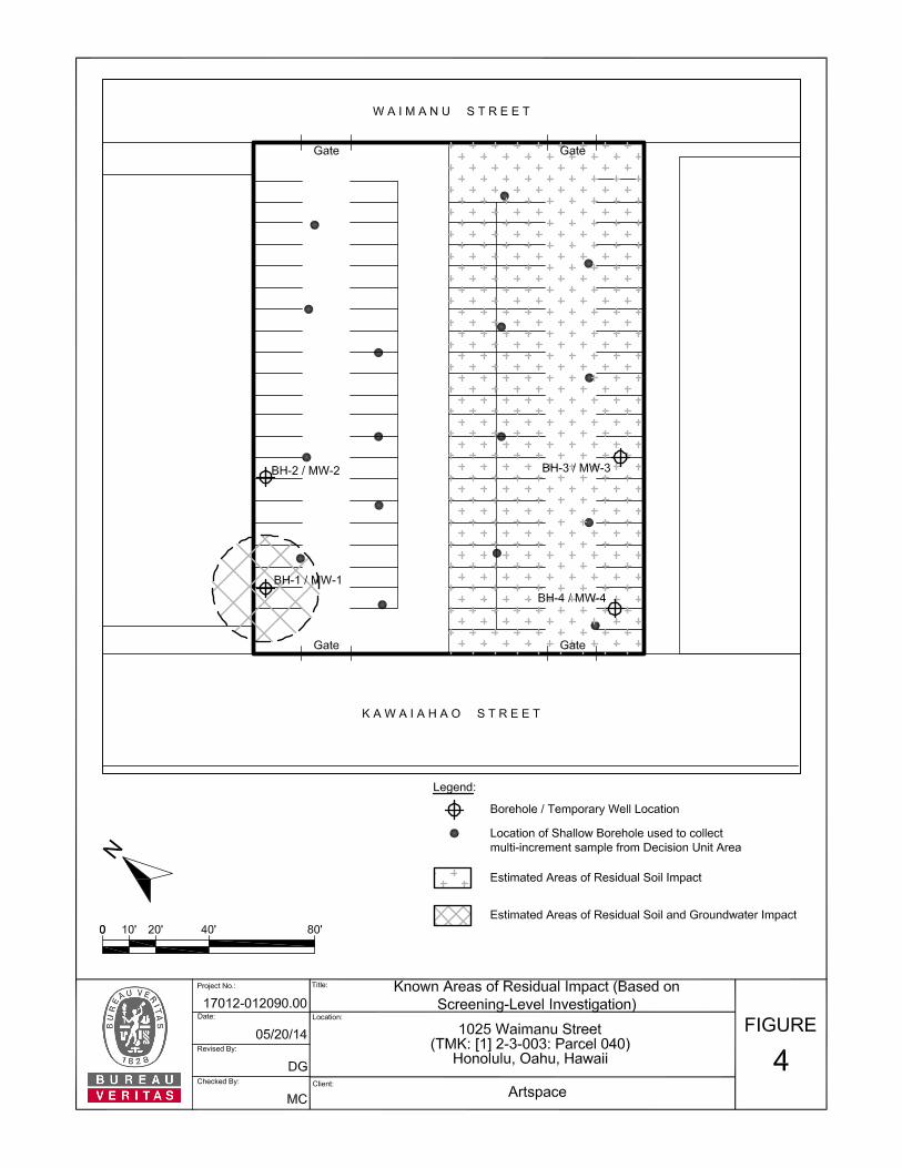
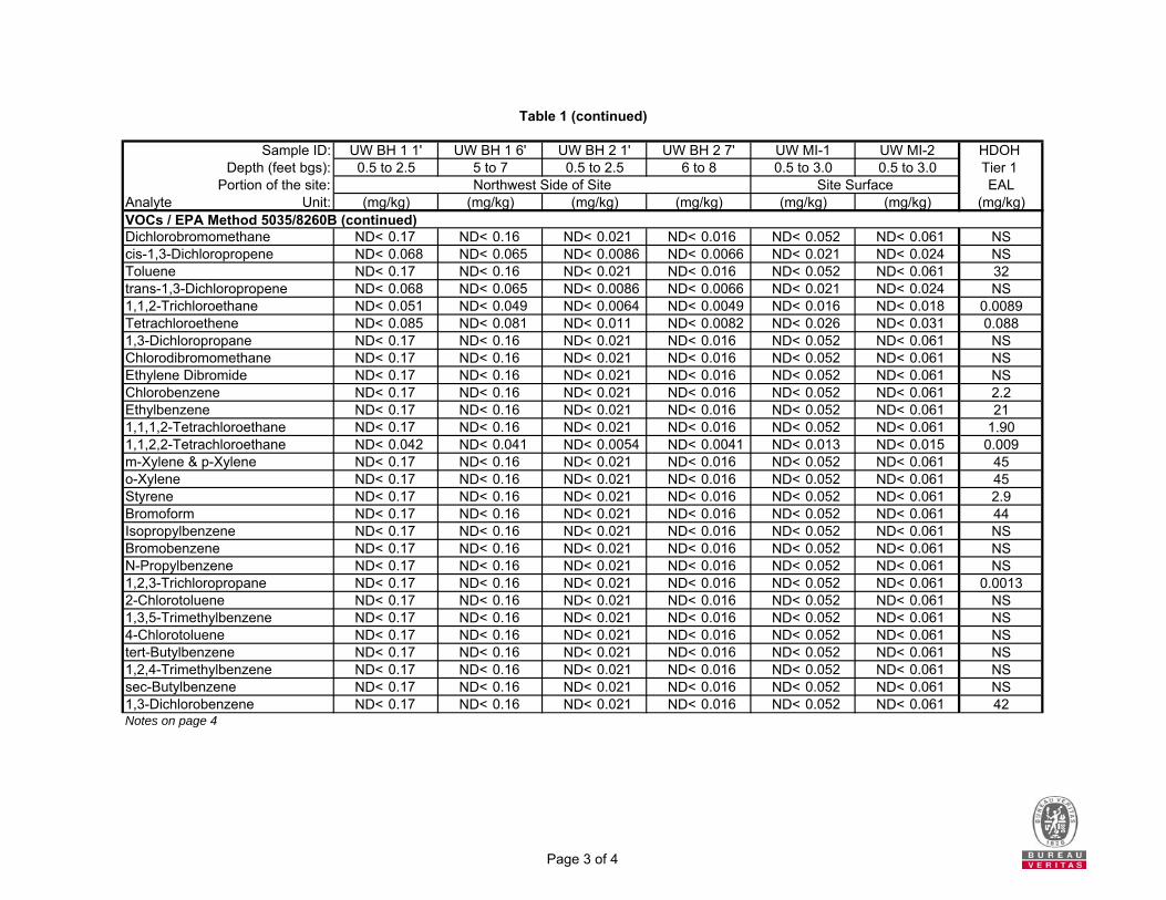
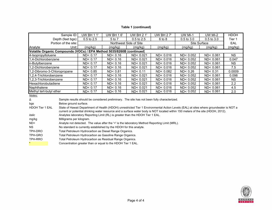
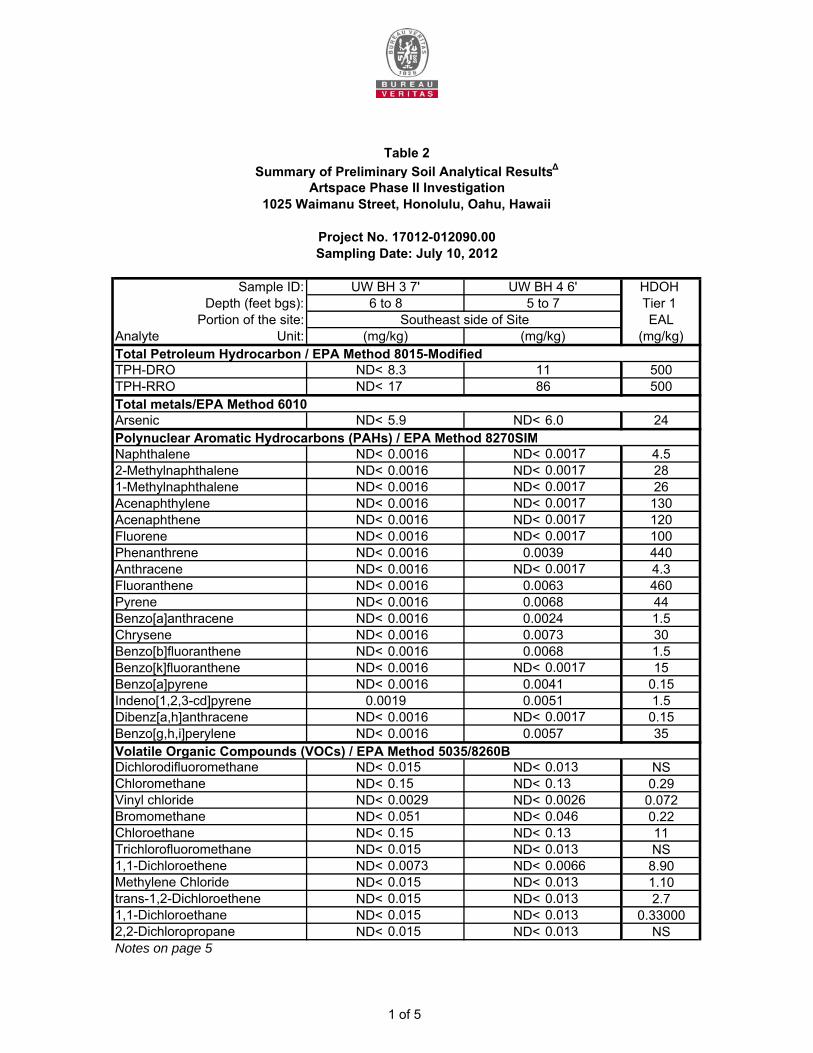
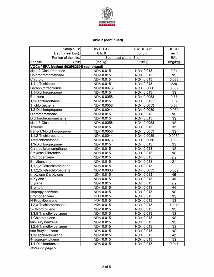
and volatile organic compounds (VOC) were not detected at concentrations above the laboratory reporting limits in either of the samples. Boreholes BH-1 and BH-2 (Soil and Groundwater) Four multi-increment soil samples collected from select soil intervals (i.e., UW BH1 1’, UW BH1 6’, UW BH2 1’, and UW BH2 7’) were collected from boreholes BH-1 and BH-2, which were positioned along the northwest side of the site to assess potential impacts from the former off-site auto body and paint area. TPH-RRO was detected at concentrations ranging from not detectable up to 1,900 mg/kg. Only the TPH-RRO concentration of 1,900 mg/kg, which was detected in soil sample UW BH1-1’, exceeded the HDOH Tier 1 EAL of 500 mg/kg for TPH-RRO. TPH-DRO, total lead, and several PAH analytes were detected; however, the concentrations were below the applicable HDOH Tier 1 EALs. Concentrations of TPH-GRO, total cadmium, and VOCs were not detected at concentrations above the laboratory reporting limits in either of the samples. Boreholes BH-1 and BH-2 were converted to temporary groundwater monitoring wells MW-1 and MW-2, respectively. Two groundwater grab samples (i.e., UW MW-1 and UW MW-2) were collected from these two temporary monitoring wells. TPH-RRO was detected at a concentration of 1,400 micrograms per liter (µg/L) in groundwater sample UW MW-1, which was below the HDOH Tier 1 EAL of 2,500 µg/L for TPH-RRO. Two of the PAH analytes were reported at concentrations that exceeded the HDOH Tier 1 EALs in sample UW MW-1. The PAH analyte indeno(1,2,3-cd)pyrene was detected at a concentration of 0.38 µg/L, which exceeded the HDOH Tier 1 EAL of 0.095 µg/L. The PAH analyte benzo[g,h,i]perylene was detected at a concentration of 0.34 µg/L, which exceeded the HDOH Tier 1 EAL of 0.13 µg/L. Concentrations of TPH-GRO, TPH-DRO, total cadmium, total lead, and VOCs were not detected at concentrations above the laboratory reporting limits in either of the samples. Boreholes BH-3 and BH-4 (Soil and Groundwater) Two multi-increment soil samples collected from select soil intervals (i.e., UW BH3 7’ and UW BH4 6’) were collected from boreholes BH-3 and BH-4, which were positioned along the southeast of the site to assess potential impacts from the former off-site chemical and fertilizer warehouse and off-site dry cleaning facility. TPH-RRO, TPH-DRO, several PAH analytes, and two of the organochlorine pesticide analytes were detected; however, the concentrations were below the applicable HDOH unrestricted Tier 1 EAL, or the HDOH has not established a Tier 1 EAL. Concentrations of total arsenic, VOCs, and pesticide screen analytes were not detected in either of the samples at levels of that exceeded the laboratory reporting limits. Boreholes BH-3 and BH-4 were converted to temporary groundwater monitoring wells MW-3 and MW-4, respectively. Two groundwater grab samples (i.e., UW MW-3 and UW MW-4) were collected from these two temporary monitoring wells. TPH-RRO was reported at concentrations of not detectable and 980 µg/L; however, these concentrations were below the HDOH Tier 1 EAL of 2,500 µg/L for TPH-RRO. Concentrations of TPH-DRO, total arsenic, PAHs, VOCs, organochlorine pesticide analytes, and pesticide screen analytes were not detected at concentrations above the laboratory reporting limits in either of the samples. In summary, the investigation identified the following:
TPH-RRO impacted soil, having a concentration of 610 mg/kg, was identified in the shallow soils (i.e. 0.5 to 3.0 feet bgs) at the DU located on the southeastern half of the site.
TPH-RRO impacted soil, having a concentration of 1,900 mg/kg, was identified in a shallow soil sample (i.e. 0.5 to 2.5 feet bgs) collected from BH-1/MW-1.
Project No. 17012-012090.00 7
The PAH analytes indeno[1,2,3-cd]pyrene and benzo[g,h,i]perylene that were detected at concentrations that exceed the HDOH Tier 1 EALs in the groundwater sample collected from well MW-1.
Bureau Veritas recommended that an EHE be conducted to evaluate potential environmental hazards associated with the identified soil and groundwater impacts, including the potential use of Tier 1 EALs for sites located less than 150 meters from surface water (i.e, potential groundwater and storm drain water comingling). In addition, Bureau Veritas recommended that documents be prepared to guide the handling and management of the impacted soil and groundwater during future construction (i.e., a Construction-Environmental Hazard Management Plan [C-EHMP]). It should be noted that the site has not been fully characterized or delineated. Therefore, sample results may indicated greater or fewer hazards than are present at the site. 4.0 NATURE AND EXTENT OF CONTAMINATION Based on the analytical results of the Phase II Environmental Investigation (Bureau Veritas, 2014a), site soils and groundwater are impacted with petroleum and related constituents, although the investigation was not comprehensive. The soil and groundwater data were compared to the unrestricted Tier 1 EALs for sites where groundwater is not a current or potential drinking water resource and a surface water body is not located within 150 meters of the site. Shallow soils in two site locations, the southeastern half of the site (0.5 to 3.0 feet bgs) and the western edge of the site (0.5 to 2.5 feet bgs), are impacted with TPH-RRO at concentrations exceeding the HDOH Tier 1 EAL. Groundwater from one of the four monitoring wells, MW-1, located on the western edge of the site is impacted with two PAHs, indeno(1,2,3-cd)pyrene and benzo(g,h,i)perylene, at concentrations exceeding their respective HDOH Tier 1 EALs. Figure 4 depicts locations where the shallow soil and groundwater concentrations exceeding the HDOH Tier 1 EALs were discovered during the limited 2012 Phase II Investigation. These areas are not delineated and all soil at the site should be managed as contaminated unless additional sampling indicates results are below Tier 1 EALs. 5.0 DESCRIPTION OF THE ENVIRONMENTAL HAZARD EVALUATION PROCESS The HDOH Hazard Evaluation and Emergency Response (HEER) Office has devised a methodology for preparing Environmental Hazard Evaluations (EHEs) to assess potential environmental concerns at sites where releases of hazardous substances have occurred (HDOH, 2012 & 2013). To aid in the EHE process, the HEER Office has developed Tier 1 EALs1 and provided guidance for their use (Evaluation of Environmental Concerns at Sites With Contaminated Soil and Groundwater) (HDOH, 2012). The Tier 1 EALs are available for over 150 contaminants commonly detected in soil and groundwater at sites where releases of hazardous substances have occurred. EHEs consolidate potential human health and ecological hazards, along with other types of environmental hazards, to comprehensively evaluate a broad range of potential concerns.
1 The term “Tier 1 EALs” refers to the individual screening levels developed by the HDOH that are relevant to specific media (i.e., soil, groundwater, or soil vapor).
Project No. 17012-012090.00 8
The HDOH has developed a multi-step framework for conducting EHEs that includes the following major tasks:
1. Summarize Past, Current and Anticipated Future Site Activities and Uses 2. Summarize the Site Investigation (and Identify the Chemicals of Potential Concern [COPCs]) 3. Summarize the Appropriateness of the Use of the Look-up Tables and EALs 4. Determine the Groundwater Categorization 5. Determine Representative Contaminant Concentrations 6. Select the Appropriate Screening Levels and Compare to Site Data 7. Present Conclusions and Recommendations
The EHE presented within this document follows the approach developed by the HDOH. 6.0 IDENTIFICATION OF CHEMICALS OF POTENTIAL CONCERN Following the HDOH guidance for the preparation of EHEs, the soil and groundwater data collected during the Phase II Environmental Investigation (Bureau Veritas, 2014a) were compared to the unrestricted Tier 1 EALs (for sites where groundwater is not a current or potential drinking water resource and a surface water body is not located within 150 meters of the site) to identify COPCs (HDOH, 2012 & 2013). Because it is unknown if groundwater is infiltrating into the storm drain system, the data were also compared to the Tier 1 EALs for sites where groundwater is not a current or potential drinking water resource and a surface water body is located within 150 meters of the site (see Section 6.2). 6.1 SOIL One contaminant, TPH-RRO, was detected at concentrations exceeding the HDOH Tier 1 EALs in near surface soil samples collected during the Phase II Environmental Investigation (Bureau Veritas, 2014a). During the Phase II Environmental Investigation, two DUs were established from which near surface multi-increment soil samples were collected. One of the DUs (i.e., UW MI-2) contained a soil concentration of TPH-RRO that exceeded the HDOH Tier 1 EAL, as shown in Table 6-1 below. Multi-increment soil samples were also collected from the four boreholes drilled on site that were subsequently converted to temporary monitoring wells. One of the soil samples collected from one of the boreholes (BH-1), also contained a near surface soil concentration of TPH-RRO that exceeded the HDOH Tier 1 EAL, as shown in Table 6-1 below. Contaminants exceeding the HDOH Tier 1 EALs are also depicted in Figure 4, located behind the Figures tab.
Table 6-1 Near Surface Soil COPCs
COPC Concentration in UW MI-2
(0.5 to 3 feet bgs) (mg/kg)
Concentration in BH-1 (0.5 to 2.5 bgs)
(mg/kg)
HDOH Tier 1 EAL
(mg/kg)
TPH-RRO 610 1,900 500
Notes: COPC Chemical of Potential Concern HDOH Tier 1 EAL Hawaii Department of Health Tier 1 Environmental Action Level TPH-RRO Total Petroleum Hydrocarbons as Residual Range Organics mg/kg Milligrams per kilogram

Project No. 17012-012090.00 9
6.2 GROUNDWATER Two PAH analytes, indeno(1,2,3-cd)pyrene and benzo(g,h,i)perylene, were detected at concentrations exceeding the HDOH Tier 1 EALs in groundwater samples collected from one of the four on-site monitoring wells, MW-1, during the Phase II Environmental Investigation (Bureau Veritas, 2014a), as shown in Table 6-2 below. Contaminants exceeding the HDOH Tier 1 EALs are also depicted in Figure 4, located behind the Figures tab.
Table 6-2 Groundwater COPCs
COPC Concentration in MW-1
(µg/L) HDOH Tier 1 EAL
(µg/L)
Indeno(1,2,3-cd)pyrene 0.38 0.095
Benzo(g,h,i)perylene 0.34 0.13
Notes: COPC Chemical of Potential Concern HDOH Tier 1 EAL Hawaii Department of Health Tier 1 Environmental Action Level µg/L Micrograms per liter
Because it is unknown if the site groundwater is connected to the storm drain system, the groundwater analytical results were also compared to the unrestricted Tier 1 EALs for sites where groundwater is not a current or potential source of drinking water and the nearest surface water body is less than 150 meters from the site. This comparison was performed to determine if additional groundwater COPCs should be identified other than those presented in Table 6-2. Groundwater contaminants were not detected at concentrations greater than the laboratory method reporting limits in the grab samples collected from two of the monitoring wells (i.e., MW-2 and MW-4). Several groundwater contaminants, TPH-RRO and numerous PAHs, were detected in the sample collected from MW-1. One contaminant, TPH-RRO, was detected in the sample collected from MW-3. Table 6-3 below presents a comparison of the COPC concentrations measured in groundwater samples collected from MW-1 and MW-3 to the HDOH Tier 1 EALs.
Table 6-3 Comparison of COPC Groundwater Concentrations to the HDOH Tier 1 EALs
COPC Concentration
in MW-1 (µg/L)
HDOH Tier 1 EAL
> 150m to surface water
(µg/L)
HDOH Tier 1 EAL
< 150m to surface water
(µg/L)
Chronic Aquatic Toxicity
EAL (µg/L)
Acute Aquatic Toxicity
EAL (µg/L)
TPH-RRO 1,400∆ 2,500 640 640 2,500
Naphthalene 0.12 210 24 24 780 Phenanthrene 0.49 300 4.6 4.6 300 Anthracene 0.15 22 0.73 0.73 300 Fluoranthene 1.0 130 8.0 8.0 300 Pyrene 0.87 68 2.0 2.0 300 Benzo(a)anthracene 0.47∆ 4.7 0.027 0.027 300 Chrysene 0.46∆ 1.0 0.35 0.35 300
Project No. 17012-012090.00 10
COPC Concentration
in MW-1 (µg/L)
HDOH Tier 1 EAL
> 150m to surface water
(µg/L)
HDOH Tier 1 EAL
< 150m to surface water
(µg/L)
Chronic Aquatic Toxicity
EAL (µg/L)
Acute Aquatic Toxicity
EAL (µg/L)
Benzo(b)fluoranthene 0.50 0.75 0.75 9.1 300 Benzo(k)fluoranthene 0.21 0.4 0.4 3.7 300 Benzo(a)pyrene 0.43*∆ 0.81 0.014 0.014 300 Indeno(1,2,3-cd)pyrene 0.38* 0.095 0.095 4.3 300 Benzo(g,h,i)perylene 0.34*∆ 0.13 0.1 0.1 300
TPH-RRO 980∆ 2,500 640 640 2,500
Notes: Bold Concentration exceeds HDOH Tier 1 EAL where groundwater is not a current or potential source of drinking
water and the nearest surface water body is less than 150 meters from the site. Bold* Concentration exceeds HDOH Tier 1 EAL where groundwater is not a current or potential source of drinking
water and the nearest surface water body is greater than 150 meters from the site. Bold∆ Concentration exceeds Chronic Aquatic Toxicity EAL.
The measured concentrations of the following contaminants exceeded the chronic aquatic toxicity EALs: TPH-RRO, benzo(a)anthracene, chrysene, benzo(a)pyrene, and benzo(g,h,i)perylene. However, the measured groundwater concentrations did not exceed the acute aquatic toxicity EALs. Site groundwater does not appear to be a risk to aquatic receptors through potential migration to surface water via the storm drain system for the following reasons:
Separate phase hydrocarbon (i.e., free product) was not observed in the four site monitoring wells.
The contaminants detected in groundwater samples from MW-1 and MW-3 are heavier hydrocarbons that are not very mobile.
The concentrations of the contaminants detected in groundwater samples from MW-1 and MW-3 do not exceed acute aquatic toxicity EALs.
The site is located a significant distance from surface water (1,500 feet). Considering this distance and anticipated storm water volumes, groundwater that may be infiltrating into the storm drain system would be greatly diluted during a storm event prior to reaching surface water.
Based on the above analysis, additional groundwater COPCs were not identified. 7.0 POTENTIAL ENVIRONMENTAL HAZARDS Several potential environmental hazards may exist at sites with identified environmental contaminants (HDOH, 2012 & 2013). In general, potential environmental hazards associated with contaminated soil may include human health (direct exposure and vapor intrusion into indoor air), leaching to groundwater, impacts to terrestrial ecological receptors, and gross contamination. Similarly, potential environmental hazards associated with contaminated groundwater may include human health (ingestion, dermal contact, and vapor intrusion into indoor air), impacts to aquatic ecological receptors, and gross contamination. Potential environmental hazards specific to this site are discussed and identified in the following sections.
Project No. 17012-012090.00 11
7.1 CONCEPTUAL SITE MODEL A conceptual site model was developed for the site to aid in the identification of potential environmental hazards at this site. The conceptual site model is presented as Table 5, located behind the Tables tab, and identifies suspected sources, types of contamination, potential migration pathways, potential exposure pathways, and potential receptors. 7.2 POTENTIAL RECEPTORS The site consists of a 30,000 square foot rectangular parcel of land located in an industrial business district. It is presently paved and marked with parking spaces. The site is the proposed future location of a residential condominium building with first floor retail space. Potential human receptors at this site include future residents, future indoor workers, future outdoor workers, and future construction workers. Terrestrial ecological receptors are improbable as the site is located in a highly developed area of Honolulu. The closest surface water to the site is Kewalo Basin, which is located approximately 1,500 feet to the southwest of the site. It is unknown if site groundwater is infiltrating into the City and County of Honolulu storm drain system. However, it is unlikely site groundwater would impact aquatic receptors considering their low concentrations (i.e., do not exceed acute aquatic toxicity EALs) and the distance to surface water (i.e., expected significant dilution during storm events). The groundwater beneath the site is not considered a source of drinking water. The following potential receptors were identified for the site:
Future Residents Future Indoor Workers Future Outdoor Workers Future Construction Workers Aquatic Ecological Receptors (for the specific case in which groundwater would be discharged to
surface water after being pumped during potential future construction de-watering activities) 7.3 POTENTIAL EXPOSURE PATHWAYS An exposure pathway describes the course that a chemical takes from a source to a receptor. Potential exposures are evaluated by considering the following four factors:
A source of potentially toxic chemicals; A contaminated media, such as soil or groundwater; An exposure or contact point with the contaminated medium; and An exposure route for chemical intake by a receptor.
An exposure pathway is considered complete when it has all four factors. Designation of an exposure pathway as complete indicates that human exposure is possible, but does not necessarily mean that exposures will occur, nor that exposures will occur at the levels estimated in this report. When any one of the factors is missing, the pathway is considered incomplete.
Project No. 17012-012090.00 12
Potentially complete exposure pathways were identified and are presented in the Conceptual Site Model presented as Table 5, located behind the Tables tab. The following potentially complete exposure pathways were identified for the site: Surface Soil
Incidental ingestion Dermal contact Inhalation (fugitive dust generated during construction)
Subsurface Soil
Incidental ingestion Dermal contact Inhalation (fugitive dust generated during construction) Inhalation (volatile emissions, if additional subsurface soil impacts are encountered during future
construction activities) Groundwater
Dermal contact Inhalation (volatile emissions, if additional subsurface soil impacts are encountered during future
construction activities) The results of the Limited Phase II Investigation indicate the site is not impacted with volatile contaminants. As such, a vapor intrusion risk does not appear to be present. However, in the event additional contamination is discovered during construction, this pathway must be reevaluated. 7.4 TARGETED ENVIRONMENTAL HAZARDS Based on the nature and extent of contamination at the site, the identified potential receptors, and the exposure pathways, the following potential environmental hazards were targeted for the site for further evaluation:
Human Health (direct exposure) Vapor Emissions to Indoor Air Gross Contamination Leaching to Groundwater Aquatic Ecotoxicity (for the specific case, in which groundwater would be discharged to surface
water after being pumped during potential future construction de-watering activities) 8.0 TARGETED SCREENING LEVELS AND COMPARISION TO SITE DATA In general, the HDOH Tier 1 EALs applicable to the site are those for sites in which groundwater is not a current or potential source of drinking water and are located greater than 150 meters from a surface water body. Individual HDOH screening levels were selected specific to the conditions of this site and were compared to the site data (HDOH, 2012 & 2013).
Project No. 17012-012090.00 13
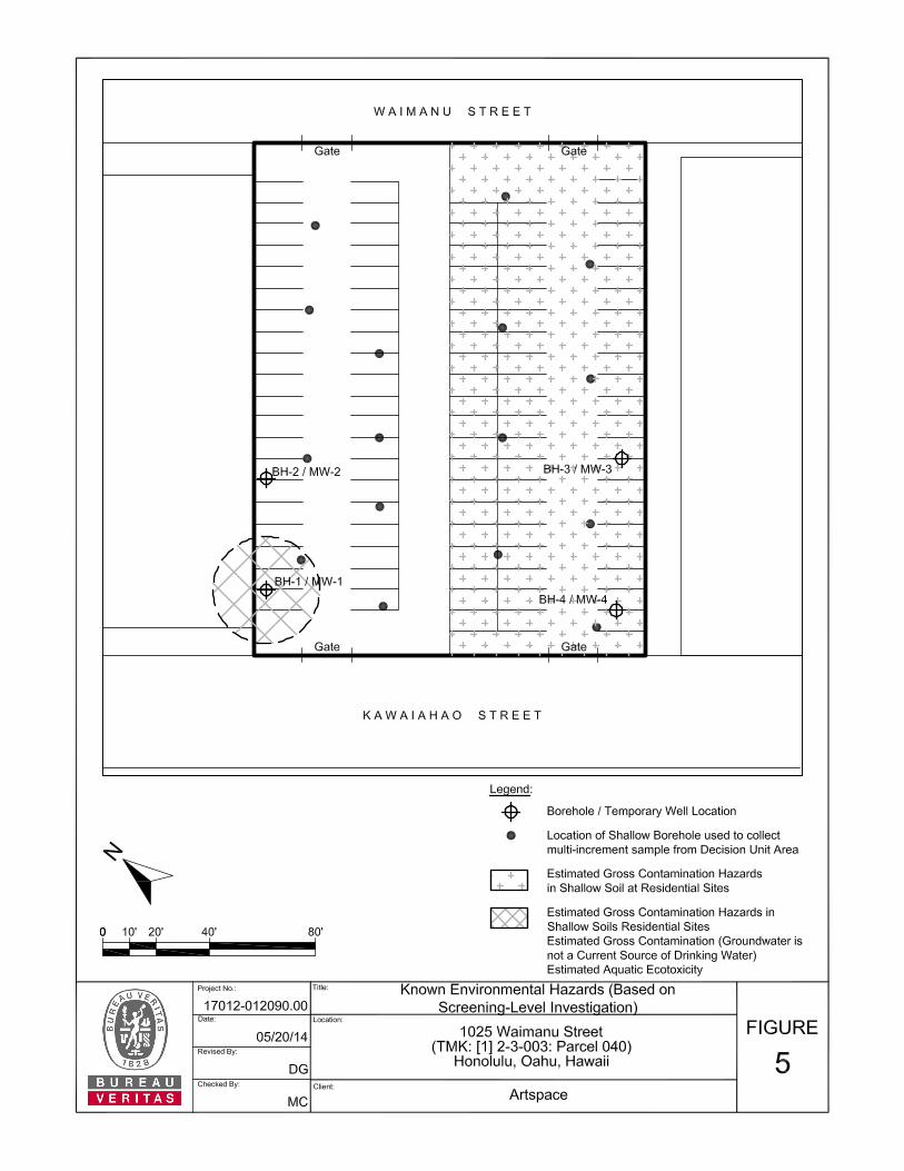
8.1 ENVIRONMENTAL HAZARDS FOR SOIL One COPC, TPH-RRO, was identified in soil. TPH-RRO concentrations in soil were compared to the identified targeted HDOH EALs, or screening levels, as shown in Table 6, located behind the Tables tab. Specifically, TPH-RRO concentrations in soil were compared to the individual EALs associated with specific potential environmental concerns related to (1) Direct Exposure, (2) Vapor Emission to Indoor Air, (3) Gross Contamination, and (4) Leaching (groundwater protection concerns). One potential environmental hazard was identified for the TPH-RRO concentrations in soil, as described below. Environmental hazards potentially posed by near surface soils are depicted in Figure 5, located behind the Figures tab.
Gross Contamination Hazards in Shallow Soils at Residential Sites –The TPH-RRO concentrations, 610 mg/kg in UW MI-2 and 1,900 mg/kg in BH-1, both exceeded the gross contamination EAL for TPH-RRO in shallow soils at residential sites of 500 mg/kg. The HDOH defines shallow soils as less than three meters at residential sites for the purposes of identifying gross contamination hazards. As such, TPH-RRO concentrations in soil may pose gross contamination hazards in shallow soils if the near surface soils are excavated and used as uncovered surface soil at this site or another residential site. Re-development plans for the site indicate the entire surface of the site will be covered with the proposed future structure. The HDOH (2012) describes gross contamination as soils having offensive odors, unaesthetic appearance and general resource degradation.
8.2 GROUNDWATER ENVIRONMENTAL HAZARDS Two PAH analytes, indeno(1,2,3-cd)pyrene and benzo(g,h,i)perylene, were identified as COPCs in groundwater. COPC concentrations in groundwater were compared to the identified targeted HDOH EALs, or screening levels, as shown in Table 7, located behind the Tables tab. Specifically, concentrations of the groundwater COPCs were compared to the individual EALs associated with specific potential environmental concerns related to (1) Vapor Emission to Indoor Air, (2) Aquatic Ecotoxicity, and (3) Gross Contamination. Two potential environmental hazards were identified for the COPC concentrations in groundwater and discussed below. Environmental hazards potentially posed by groundwater are depicted in Figure 5, located behind the Figures tab.
Chronic Aquatic Ecotoxicity in Estuarine, Freshwater, and Marine Environments – The benzo(g,h,i)perylene concentration of 0.34 µg/L measured in MW-1 exceeded the Chronic Aquatic Ecotoxicity EAL for benzo(g,h,i)perylene of 0.1 µg/L for estuarine, freshwater, and marine environments, although the Acute Aquatic Ecotoxicity EAL for benzo(g,h,i)perylene of 300 µg/L was not exceeded. Because it is unknown if the site groundwater is connected to the storm drain system, the groundwater analytical results were also compared to the unrestricted Tier 1 EALs for sites where groundwater is not a current or potential source of drinking water and the nearest surface water body is less than 150 meters from the site (see Table in Section 6.2). Several groundwater contaminants, TPH-RRO and numerous PAHs, were detected in the sample collected from MW-1. One contaminant, TPH-RRO, was detected in the sample collected from MW-3. The measured concentrations of the following contaminants exceeded the chronic aquatic toxicity EALs: TPH-RRO, benzo(a)anthracene, chrysene, benzo(a)pyrene, and benzo(g,h,i)perylene. However, the measured groundwater concentrations did not exceed the acute aquatic toxicity EALs.
Project No. 17012-012090.00 14
It is unlikely site groundwater would impact aquatic receptors considering their low concentrations (i.e., do not exceed acute aquatic toxicity EALs) and the distance to surface water of 1,500 feet (i.e., expected significant dilution during storm events). However, if groundwater is to be pumped during potential future de-watering activities and if the water is to be discharged to surface water or storm sewers, the concentration of contaminants should not exceed the HDOH’s EALs based on Ecotoxicity for either acute or chronic toxicity. Gross Contamination Hazards (at sites where groundwater is not a current source of drinking water) – The groundwater concentration of indeno(1,2,3-cd)pyrene of 0.38 µg/L measured in MW-1 exceeded the gross contamination EAL for sites where groundwater is not a current source of drinking water for indeno(1,2,3-cd)pyrene of 0.095 µg/L. Similarly, the groundwater concentration of benzo(g,h,i)perylene of 0.34 µg/L measured in MW-1 exceeded the gross contamination EAL for sites where groundwater is not a current source of drinking water for benzo(g,h,i)perylene of 0.13 µg/L. As such, COPC concentrations in groundwater may pose gross contamination hazards. The HDOH (2012) describes gross contamination as having offensive odors, unaesthetic appearance and general resource degradation.
It should be noted that the site has not been fully characterized or delineated. Therefore, sample results may indicated greater or fewer hazards than are present at the site. 9.0 CONCLUSIONS An EHE consists of a multi-step process to assess potential environmental hazards at sites impacted with environmental contaminants. Following this process, several tasks were completed including defining the nature and extent of contamination, identifying COPCs, identifying applicable HDOH screening levels for comparison to site data (i.e., targeted HDOH screening levels), and identifying potential environmental hazards. One potential environmental hazard, gross contamination, may exist at the site (or may be posed by site soil if transferred off-site), as described below. Soil
Potential gross contamination hazards in shallow soils for residential receptors if impacted near surface site soil is excavated and used as uncovered surface soil at this site or another residential site. Re-development plans for the site indicate the entire surface of the site will be covered with the proposed future structure. Potential gross contamination hazards for residential receptors are posed by concentrations of TPH-RRO soil. The HDOH (2012) describes gross contamination as soils having offensive odors, unaesthetic appearance and general resource degradation.
Groundwater
Potential gross contamination hazards in groundwater that is not a current source of drinking water. Potential gross contamination hazards are posed by two PAH analytes, indeno(1,2,3-cd)pyrene and benzo(g,h,i)perylene. It is unlikely site groundwater would impact aquatic receptors through potential migration to surface water via the storm drain system considering the low contaminant concentrations (i.e., do not exceed acute aquatic toxicity EALs) and the distance to surface water (i.e., expected significant dilution during storm events).

Project No. 17012-012090.00 15
Soil Vapor
Soil vapor hazards were not identified. However, if additional contamination is encountered during construction activities, soil vapor hazards may need to be reevaluated.
10.0 RECOMMENDATIONS Based on the results of this EHE, Bureau Veritas recommends the preparation of a Construction Environmental Hazard Management Plan (C-EHMP) to document the requirements and appropriate methods for the proper management, handling, and disposal of impacted soil and groundwater that may be encountered during the proposed development/construction activities at site (Bureau Veritas, 2014c). Once the development/construction activities at site are completed, Bureau Veritas recommends that an Environmental Hazard Management Plan (EHMP) be prepared to document the requirements and appropriate methods to manage the potential environmental hazards at the site over the long-term. Bureau Veritas also recommends that HDOH be notified immediately if field observations during construction indicate the magnitude or extent of contamination is greater than expected. 11.0 LIMITATIONS This report is for the exclusive use of Artspace. and no other party shall have any right to rely on any service provided by Bureau Veritas without prior written consent. The information and opinions expressed in this report are given in response to a limited assignment and should be considered and implemented only in light of that assignment. The services provided by Bureau Veritas in completing this project were consistent with normal standards of the profession. No other warranty, expressed or implied, is made. Bureau Veritas will not distribute or publish this report without consent except as required by law or court order.
This report prepared by: Marietta C. Canty, M.S. Senior Environmental Engineer Health, Safety, and Environmental Services
This report reviewed by: Daniel P. Ford, P.G Regional Vice President Health, Safety, and Environmental Services
REFERENCES
Project No. 17012-012090.00
REFERENCES Bureau Veritas North America, Inc. (Bureau Veritas), 2010. Phase I Environmental Site Assessment of the Property Located at 1025 Waimanu Street (TMK Number: [1] 2-3-003: Parcel 040), Honolulu, Oahu, Hawaii. Bureau Veritas Project No. 17009-009188.00. February 15. Bureau Veritas, 2014a. Phase II Environmental Investigation, 1025 Waimanu Street (TMK: [1] 2-3-003: Parcel 040), Honolulu, Oahu, Hawaii. Bureau Veritas Project No. 17012-012090.00. Revised May 29, 2014. Bureau Veritas, 2014c. Construction Environmental Hazard Management Plan, 1025 Waimanu Street (TMK: [1] 2-3-003: Parcel 040), Honolulu, Oahu, Hawaii. Bureau Veritas Project No. 17012-012090.00. May 29, 2014. Foote, D.E., et al., 1972. United States Department of Agriculture Soil Conservation Service in cooperation with the University of Hawaii Agricultural Experiment Station. Soil Survey of the Islands of Kauai, Oahu, Maui, Molokai, and Lanai, State of Hawaii. Hawaii State Department of Land and Natural Resources (HDLNR), 2006. Ground Water Index and Summary. Prepared by the Division of Water Resource Management. Hawaii State Department of Health (HDOH), 2012. Evaluation of Environmental Hazards at Sites with Contaminated Soil and Groundwater, Volumes I and II, prepared by the Hazard Evaluation & Emergency Response (HEER) Office. Fall 2011 (Revised January 2012). HDOH, 2013. Technical Guidance Manual for the Implementation of the Hawaii State Contingency Plan (Interim Final), prepared by the HEER Office. March. Mink, J.F. and L.S. Lau, 1990. Aquifer Identification and Classification for Oahu: Groundwater Protection Strategy for Hawaii. Technical Report No. 179. Honolulu: Water Resources Research Center, University of Hawaii at Manoa. United States Department of the Interior Geological Survey (USGS). 1998. 7.5 Minute Topographic Map, Honolulu Quadrangle. USGS. 1983. 7.5 Minute Topographic Map, Honolulu Quadrangle with Hawaii Department of Land and Natural Resources, Division of Water and Land Development Underground Injection Well Overlay (1983). University of Hawaii (UH), 1983. Atlas of Hawaii (Second Edition). UH Department of Geography, University of Hawaii Press, Honolulu, Hawaii.

FIGURES

TABLES
Sample ID: HDOH Depth (feet bgs): Tier 1
Portion of the site: EALAnalyte Unit: (mg/kg)Total Petroleum Hydrocarbon (TPH) / EPA Method 8260BTPH-GRO ND< 17 ND< 16 ND< 2.1 ND< 1.6 ND< 5.2 ND< 6.1 100Total Petroleum Hydrocarbon / EPA Method 8015-ModifiedTPH-DRO ND< 8.2 ND< 8.4 500TPH-RRO ND< 17 500Total metals/EPA Method 6010Cadmium ND< 0.95 ND< 0.98 ND< 0.99 ND< 1.0 ND< 0.98 ND< 1.0 14Lead ND< 2.9 ND< 3.1 200Polynuclear Aromatic Hydrocarbons (PAHs) / EPA Method 8270SIMNaphthalene ND< 0.0016 ND< 0.0017 ND< 0.0018 4.52-Methylnaphthalene ND< 0.0016 ND< 0.0017 ND< 0.0018 ND< 0.0017 281-Methylnaphthalene ND< 0.0016 ND< 0.0017 ND< 0.0018 ND< 0.0017 26Acenaphthylene ND< 0.0016 ND< 0.0018 130Acenaphthene ND< 0.0016 ND< 0.0017 ND< 0.0018 120Fluorene ND< 0.0016 ND< 0.0016 ND< 0.0017 ND< 0.0018 100Phenanthrene ND< 0.0016 ND< 0.0018 440Anthracene ND< 0.0016 ND< 0.0018 4.3Fluoranthene ND< 0.0016 ND< 0.0018 460Pyrene ND< 0.0016 ND< 0.0018 44Benzo[a]anthracene ND< 0.0016 ND< 0.0018 1.5Chrysene ND< 0.0016 ND< 0.0018 30Benzo[b]fluoranthene 1.5Benzo[k]fluoranthene ND< 0.0016 ND< 0.0018 15Notes on page 4
0.00180.0370.054
0.12
1601,900*
79
0.002
0.0017
0.00590.0018
0.38
0.026
0.11
26
0.0036
380
23
0.220.11
130
0.042
0.440.43
0.14
93
0.0077
0.05
0.00490.0066
0.0040.0046
0.00370.003
0.00380.12
0.460.590.38
0.72
Table 1
Sampling Date: July 10, 2012Project No. 17012-012090.00
1025 Waimanu Street, Honolulu, Oahu, Hawaii
Summary of Preliminary Soil Analytical Results∆
Artspace Phase II Investigation
UW MI-1
(mg/kg)
6 to 8
0.0068
610*
0.011
57490
85
0.0022
42
(mg/kg)(mg/kg)(mg/kg)
0.5 to 2.5UW BH 1 6'
Site Surface0.5 to 3.0UW MI-2UW BH 2 1'
(mg/kg)
UW BH 2 7'5 to 7
UW BH 1 1'
0.15
0.150.0210.039
0.26
0.0390.11
0.13
0.3
0.120.15
0.00190.120.290.3
0.5 to 3.0
(mg/kg)Northwest Side of Site
0.5 to 2.5
Page 1 of 4
Sample ID: HDOH Depth (feet bgs): Tier 1
Portion of the site: EALAnalyte Unit: (mg/kg)PAHs / EPA Method 8270SIM (continued)Benzo[a]pyrene ND< 0.0016 ND< 0.0018 0.15Indeno[1,2,3-cd]pyrene ND< 0.0016 1.5Dibenz[a,h]anthracene ND< 0.0016 ND< 0.0018 0.15Benzo[g,h,i]perylene ND< 0.0018 35Volatile Organic Compounds (VOCs) / EPA Method 5035/8260BDichlorodifluoromethane ND< 0.17 ND< 0.16 ND< 0.021 ND< 0.016 ND< 0.052 ND< 0.061 NSChloromethane ND< 1.7 ND< 1.6 ND< 0.21 ND< 0.16 ND< 0.52 ND< 0.61 0.29Vinyl chloride ND< 0.034 ND< 0.033 ND< 0.0043 ND< 0.0033 ND< 0.01 ND< 0.012 0.072Bromomethane ND< 0.59 ND< 0.57 ND< 0.075 ND< 0.058 ND< 0.18 ND< 0.21 0.22Chloroethane ND< 1.7 ND< 1.6 ND< 0.21 ND< 0.16 ND< 0.52 ND< 0.61 11Trichlorofluoromethane ND< 0.17 ND< 0.16 ND< 0.021 ND< 0.016 ND< 0.052 ND< 0.061 NS1,1-Dichloroethene ND< 0.085 ND< 0.081 ND< 0.011 ND< 0.0082 ND< 0.026 ND< 0.031 8.90Methylene Chloride ND< 0.17 ND< 0.16 ND< 0.021 ND< 0.016 ND< 0.052 ND< 0.061 1.10trans-1,2-Dichloroethene ND< 0.17 ND< 0.16 ND< 0.021 ND< 0.016 ND< 0.052 ND< 0.061 2.71,1-Dichloroethane ND< 0.17 ND< 0.16 ND< 0.021 ND< 0.016 ND< 0.052 ND< 0.061 0.330002,2-Dichloropropane ND< 0.17 ND< 0.16 ND< 0.021 ND< 0.016 ND< 0.052 ND< 0.061 NScis-1,2-Dichloroethene ND< 0.17 ND< 0.16 ND< 0.021 ND< 0.016 ND< 0.052 ND< 0.061 0.31Chlorobromomethane ND< 0.17 ND< 0.16 ND< 0.021 ND< 0.016 ND< 0.052 ND< 0.061 NSChloroform ND< 0.17 ND< 0.16 ND< 0.021 ND< 0.016 ND< 0.052 ND< 0.061 0.0231,1,1-Trichloroethane ND< 0.17 ND< 0.16 ND< 0.021 ND< 0.016 ND< 0.052 ND< 0.061 220Carbon tetrachloride ND< 0.085 ND< 0.081 ND< 0.011 ND< 0.0082 ND< 0.026 ND< 0.031 0.0871,1-Dichloropropene ND< 0.17 ND< 0.16 ND< 0.021 ND< 0.016 ND< 0.052 ND< 0.061 NSBenzene ND< 0.068 ND< 0.065 ND< 0.0086 ND< 0.0066 ND< 0.021 ND< 0.024 0.671,2-Dichloroethane ND< 0.17 ND< 0.16 ND< 0.021 ND< 0.016 ND< 0.052 ND< 0.061 0.02Trichloroethene ND< 0.068 ND< 0.065 ND< 0.0086 ND< 0.0066 ND< 0.021 ND< 0.024 0.261,2-Dichloropropane ND< 0.051 ND< 0.049 ND< 0.0064 ND< 0.0049 ND< 0.016 ND< 0.018 0.052Dibromomethane ND< 0.17 ND< 0.16 ND< 0.021 ND< 0.016 ND< 0.052 ND< 0.061 NSNotes on page 4
0.0170.120.002
UW MI-20.5 to 3.0 0.5 to 3.0
0.310.097 0.088
0.0470.210.14
0.220.071
0.0360.053
0.0580.016
0.210.2
0.0022
(mg/kg)
0.5 to 2.5 5 to 7 0.5 to 2.5UW BH 1 6'
(mg/kg) (mg/kg)
UW BH 1 1'
Northwest Side of Site(mg/kg)
6 to 8UW BH 2 7'
(mg/kg)Site Surface
(mg/kg)
UW MI-1UW BH 2 1'
Table 1 (continued)
Page 2 of 4
Sample ID: HDOH Depth (feet bgs): Tier 1
Portion of the site: EALAnalyte Unit: (mg/kg)VOCs / EPA Method 5035/8260B (continued)Dichlorobromomethane ND< 0.17 ND< 0.16 ND< 0.021 ND< 0.016 ND< 0.052 ND< 0.061 NScis-1,3-Dichloropropene ND< 0.068 ND< 0.065 ND< 0.0086 ND< 0.0066 ND< 0.021 ND< 0.024 NSToluene ND< 0.17 ND< 0.16 ND< 0.021 ND< 0.016 ND< 0.052 ND< 0.061 32trans-1,3-Dichloropropene ND< 0.068 ND< 0.065 ND< 0.0086 ND< 0.0066 ND< 0.021 ND< 0.024 NS1,1,2-Trichloroethane ND< 0.051 ND< 0.049 ND< 0.0064 ND< 0.0049 ND< 0.016 ND< 0.018 0.0089Tetrachloroethene ND< 0.085 ND< 0.081 ND< 0.011 ND< 0.0082 ND< 0.026 ND< 0.031 0.0881,3-Dichloropropane ND< 0.17 ND< 0.16 ND< 0.021 ND< 0.016 ND< 0.052 ND< 0.061 NSChlorodibromomethane ND< 0.17 ND< 0.16 ND< 0.021 ND< 0.016 ND< 0.052 ND< 0.061 NSEthylene Dibromide ND< 0.17 ND< 0.16 ND< 0.021 ND< 0.016 ND< 0.052 ND< 0.061 NSChlorobenzene ND< 0.17 ND< 0.16 ND< 0.021 ND< 0.016 ND< 0.052 ND< 0.061 2.2Ethylbenzene ND< 0.17 ND< 0.16 ND< 0.021 ND< 0.016 ND< 0.052 ND< 0.061 211,1,1,2-Tetrachloroethane ND< 0.17 ND< 0.16 ND< 0.021 ND< 0.016 ND< 0.052 ND< 0.061 1.901,1,2,2-Tetrachloroethane ND< 0.042 ND< 0.041 ND< 0.0054 ND< 0.0041 ND< 0.013 ND< 0.015 0.009m-Xylene & p-Xylene ND< 0.17 ND< 0.16 ND< 0.021 ND< 0.016 ND< 0.052 ND< 0.061 45o-Xylene ND< 0.17 ND< 0.16 ND< 0.021 ND< 0.016 ND< 0.052 ND< 0.061 45Styrene ND< 0.17 ND< 0.16 ND< 0.021 ND< 0.016 ND< 0.052 ND< 0.061 2.9Bromoform ND< 0.17 ND< 0.16 ND< 0.021 ND< 0.016 ND< 0.052 ND< 0.061 44Isopropylbenzene ND< 0.17 ND< 0.16 ND< 0.021 ND< 0.016 ND< 0.052 ND< 0.061 NSBromobenzene ND< 0.17 ND< 0.16 ND< 0.021 ND< 0.016 ND< 0.052 ND< 0.061 NSN-Propylbenzene ND< 0.17 ND< 0.16 ND< 0.021 ND< 0.016 ND< 0.052 ND< 0.061 NS1,2,3-Trichloropropane ND< 0.17 ND< 0.16 ND< 0.021 ND< 0.016 ND< 0.052 ND< 0.061 0.00132-Chlorotoluene ND< 0.17 ND< 0.16 ND< 0.021 ND< 0.016 ND< 0.052 ND< 0.061 NS1,3,5-Trimethylbenzene ND< 0.17 ND< 0.16 ND< 0.021 ND< 0.016 ND< 0.052 ND< 0.061 NS4-Chlorotoluene ND< 0.17 ND< 0.16 ND< 0.021 ND< 0.016 ND< 0.052 ND< 0.061 NStert-Butylbenzene ND< 0.17 ND< 0.16 ND< 0.021 ND< 0.016 ND< 0.052 ND< 0.061 NS1,2,4-Trimethylbenzene ND< 0.17 ND< 0.16 ND< 0.021 ND< 0.016 ND< 0.052 ND< 0.061 NSsec-Butylbenzene ND< 0.17 ND< 0.16 ND< 0.021 ND< 0.016 ND< 0.052 ND< 0.061 NS1,3-Dichlorobenzene ND< 0.17 ND< 0.16 ND< 0.021 ND< 0.016 ND< 0.052 ND< 0.061 42Notes on page 4
UW MI-20.5 to 3.0
UW BH 2 7'UW BH 1 1' UW BH 1 6'0.5 to 2.5 5 to 7 6 to 80.5 to 2.5
(mg/kg) (mg/kg)
UW MI-1
(mg/kg)
UW BH 2 1'
(mg/kg)
0.5 to 3.0Northwest Side of Site Site Surface
(mg/kg) (mg/kg)
Table 1 (continued)
Page 3 of 4
Sample ID: HDOH Depth (feet bgs): Tier 1
Portion of the site: EALAnalyte Unit: (mg/kg)Volatile Organic Compounds (VOCs) / EPA Method 5035/8260B (continued)4-Isopropyltoluene ND< 0.17 ND< 0.16 ND< 0.021 ND< 0.016 ND< 0.052 ND< 0.061 NS1,4-Dichlorobenzene ND< 0.17 ND< 0.16 ND< 0.021 ND< 0.016 ND< 0.052 ND< 0.061 0.047n-Butylbenzene ND< 0.17 ND< 0.16 ND< 0.021 ND< 0.016 ND< 0.052 ND< 0.061 NS1,2-Dichlorobenzene ND< 0.17 ND< 0.16 ND< 0.021 ND< 0.016 ND< 0.052 ND< 0.061 7.51,2-Dibromo-3-Chloropropane ND< 0.85 ND< 0.81 ND< 0.11 ND< 0.082 ND< 0.26 ND< 0.31 0.00091,2,4-Trichlorobenzene ND< 0.17 ND< 0.16 ND< 0.021 ND< 0.016 ND< 0.052 ND< 0.061 0.0981,2,3-Trichlorobenzene ND< 0.17 ND< 0.16 ND< 0.021 ND< 0.016 ND< 0.052 ND< 0.061 NSHexachlorobutadiene ND< 0.17 ND< 0.16 ND< 0.021 ND< 0.016 ND< 0.052 ND< 0.061 2.2Naphthalene ND< 0.17 ND< 0.16 ND< 0.021 ND< 0.016 ND< 0.052 ND< 0.061 4.5Methyl tert-butyl ether ND< 0.17 ND< 0.16 ND< 0.021 ND< 0.016 ND< 0.052 ND< 0.061 2.0Notes:∆bgs Below ground surface.HDOH Tier 1 EAL
italic Analytes laboratory Reporting Limit (RL) is greater than the HDOH Tier 1 EAL.mg/kg Milligrams per kilogram.ND< Analyte not detected. The value after the '<' is the laboratory Method Reporting Limit (MRL).NS No standard is currently established by the HDOH for this analyte.TPH-DRO Total Petroleum Hydrocarbon as Diesel Range Organics.TPH-GRO Total Petroleum Hydrocarbon as Gasoline Range Organics.TPH-RRO Total Petroleum Hydrocarbon as Residual Range Organics.* Concentration greater than or equal to the HDOH Tier 1 EAL.
Sample results should be considered preliminary. The site has not been fully characterized.
State of Hawaii Department of Health (HDOH) unrestricted Tier 1 Environmental Action Levels (EAL) at sites where groundwater is NOT a current or potential drinking water resource and a surface water body is NOT located within 150 meters of the site (HDOH, 2012).
Table 1 (continued)
(mg/kg)
0.5 to 3.0UW MI-2
(mg/kg)
0.5 to 3.0Northwest Side of Site
UW BH 1 6'5 to 7
(mg/kg)
6 to 8UW BH 1 1'
(mg/kg) (mg/kg)
0.5 to 2.5
(mg/kg)
0.5 to 2.5UW BH 2 7' UW MI-1UW BH 2 1'
Site Surface
Page 4 of 4
Sample ID: HDOH Depth (feet bgs): Tier 1
Portion of the site: EALAnalyte Unit: (mg/kg)Total Petroleum Hydrocarbon / EPA Method 8015-ModifiedTPH-DRO ND< 8.3 500TPH-RRO ND< 17 500Total metals/EPA Method 6010Arsenic ND< 5.9 ND< 6.0 24Polynuclear Aromatic Hydrocarbons (PAHs) / EPA Method 8270SIMNaphthalene ND< 0.0016 ND< 0.0017 4.52-Methylnaphthalene ND< 0.0016 ND< 0.0017 281-Methylnaphthalene ND< 0.0016 ND< 0.0017 26Acenaphthylene ND< 0.0016 ND< 0.0017 130Acenaphthene ND< 0.0016 ND< 0.0017 120Fluorene ND< 0.0016 ND< 0.0017 100Phenanthrene ND< 0.0016 440Anthracene ND< 0.0016 ND< 0.0017 4.3Fluoranthene ND< 0.0016 460Pyrene ND< 0.0016 44Benzo[a]anthracene ND< 0.0016 1.5Chrysene ND< 0.0016 30Benzo[b]fluoranthene ND< 0.0016 1.5Benzo[k]fluoranthene ND< 0.0016 ND< 0.0017 15Benzo[a]pyrene ND< 0.0016 0.15Indeno[1,2,3-cd]pyrene 1.5Dibenz[a,h]anthracene ND< 0.0016 ND< 0.0017 0.15Benzo[g,h,i]perylene ND< 0.0016 35Volatile Organic Compounds (VOCs) / EPA Method 5035/8260BDichlorodifluoromethane ND< 0.015 ND< 0.013 NSChloromethane ND< 0.15 ND< 0.13 0.29Vinyl chloride ND< 0.0029 ND< 0.0026 0.072Bromomethane ND< 0.051 ND< 0.046 0.22Chloroethane ND< 0.15 ND< 0.13 11Trichlorofluoromethane ND< 0.015 ND< 0.013 NS1,1-Dichloroethene ND< 0.0073 ND< 0.0066 8.90Methylene Chloride ND< 0.015 ND< 0.013 1.10trans-1,2-Dichloroethene ND< 0.015 ND< 0.013 2.71,1-Dichloroethane ND< 0.015 ND< 0.013 0.330002,2-Dichloropropane ND< 0.015 ND< 0.013 NSNotes on page 5
0.0057
(mg/kg)Southeast side of Site
0.0019
UW BH 3 7'6 to 8
UW BH 4 6'
0.0051
5 to 7
Table 2
Summary of Preliminary Soil Analytical Results∆
0.0041
Sampling Date: July 10, 2012
0.0063
0.0039
0.0068
0.0068
1186
Artspace Phase II Investigation
Project No. 17012-012090.00
0.00730.0024
1025 Waimanu Street, Honolulu, Oahu, Hawaii
(mg/kg)
1 of 5
Sample ID: HDOH Depth (feet bgs): Tier 1
Portion of the site: EALAnalyte Unit: (mg/kg)VOCs / EPA Method 5035/8260B (continued)cis-1,2-Dichloroethene ND< 0.015 ND< 0.013 0.31Chlorobromomethane ND< 0.015 ND< 0.013 NSChloroform ND< 0.015 ND< 0.013 0.0231,1,1-Trichloroethane ND< 0.015 ND< 0.013 220Carbon tetrachloride ND< 0.0073 ND< 0.0066 0.0871,1-Dichloropropene ND< 0.015 ND< 0.013 NSBenzene ND< 0.0058 ND< 0.0053 0.671,2-Dichloroethane ND< 0.015 ND< 0.013 0.02Trichloroethene ND< 0.0058 ND< 0.0053 0.261,2-Dichloropropane ND< 0.0044 ND< 0.0039 0.052Dibromomethane ND< 0.015 ND< 0.013 NSDichlorobromomethane ND< 0.015 ND< 0.013 NScis-1,3-Dichloropropene ND< 0.0058 ND< 0.0053 NSToluene ND< 0.015 ND< 0.013 32trans-1,3-Dichloropropene ND< 0.0058 ND< 0.0053 NS1,1,2-Trichloroethane ND< 0.0044 ND< 0.0039 0.0089Tetrachloroethene ND< 0.0073 ND< 0.0066 0.0881,3-Dichloropropane ND< 0.015 ND< 0.013 NSChlorodibromomethane ND< 0.015 ND< 0.013 NSEthylene Dibromide ND< 0.015 ND< 0.013 NSChlorobenzene ND< 0.015 ND< 0.013 2.2Ethylbenzene ND< 0.015 ND< 0.013 211,1,1,2-Tetrachloroethane ND< 0.015 ND< 0.013 1.901,1,2,2-Tetrachloroethane ND< 0.0036 ND< 0.0033 0.009m-Xylene & p-Xylene ND< 0.015 ND< 0.013 45o-Xylene ND< 0.015 ND< 0.013 45Styrene ND< 0.015 ND< 0.013 2.9Bromoform ND< 0.015 ND< 0.013 44Isopropylbenzene ND< 0.015 ND< 0.013 NSBromobenzene ND< 0.015 ND< 0.013 NSN-Propylbenzene ND< 0.015 ND< 0.013 NS1,2,3-Trichloropropane ND< 0.015 ND< 0.013 0.00132-Chlorotoluene ND< 0.015 ND< 0.013 NS1,3,5-Trimethylbenzene ND< 0.015 ND< 0.013 NS4-Chlorotoluene ND< 0.015 ND< 0.013 NStert-Butylbenzene ND< 0.015 ND< 0.013 NS1,2,4-Trimethylbenzene ND< 0.015 ND< 0.013 NSsec-Butylbenzene ND< 0.015 ND< 0.013 NS1,3-Dichlorobenzene ND< 0.015 ND< 0.013 424-Isopropyltoluene ND< 0.015 ND< 0.013 NS1,4-Dichlorobenzene ND< 0.015 ND< 0.013 0.047Notes on page 5
Southeast side of Site5 to 7
Table 2 (continued)
UW BH 3 7' UW BH 4 6'
(mg/kg) (mg/kg)
6 to 8
2 of 5
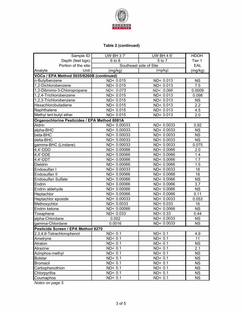
Sample ID: HDOH Depth (feet bgs): Tier 1
Portion of the site: EALAnalyte Unit: (mg/kg)VOCs / EPA Method 5035/8260B (continued)n-Butylbenzene ND< 0.015 ND< 0.013 NS1,2-Dichlorobenzene ND< 0.015 ND< 0.013 7.51,2-Dibromo-3-Chloropropane ND< 0.073 ND< 0.066 0.00091,2,4-Trichlorobenzene ND< 0.015 ND< 0.013 0.0981,2,3-Trichlorobenzene ND< 0.015 ND< 0.013 NSHexachlorobutadiene ND< 0.015 ND< 0.013 2.2Naphthalene ND< 0.015 ND< 0.013 4.5Methyl tert-butyl ether ND< 0.015 ND< 0.013 2.0
Aldrin ND< 0.00033 ND< 0.0033 0.92alpha-BHC ND< 0.00033 ND< 0.0033 NSbeta-BHC ND< 0.00033 ND< 0.0033 NSdelta-BHC ND< 0.00033 ND< 0.0033 NSgamma-BHC (Lindane) ND< 0.00033 ND< 0.0033 0.0754,4'-DDD ND< 0.00066 ND< 0.0066 2.04,4'-DDE ND< 0.00066 ND< 0.0066 1.44,4'-DDT ND< 0.00066 ND< 0.0066 1.7Dieldrin ND< 0.00066 ND< 0.0066 1.5Endosulfan I ND< 0.00033 ND< 0.0033 18Endosulfan II ND< 0.00066 ND< 0.0066 18Endosulfan Sulfate ND< 0.00066 ND< 0.0066 NSEndrin ND< 0.00066 ND< 0.0066 3.7Endrin aldehyde ND< 0.00066 ND< 0.0066 NSHeptachlor ND< 0.00066 ND< 0.0066 0.11Heptachlor epoxide ND< 0.00033 ND< 0.0033 0.053Methoxychlor ND< 0.0033 ND< 0.033 16Endrin ketone ND< 0.00066 ND< 0.0066 NSToxaphene ND< 0.033 ND< 0.33 0.44alpha-Chlordane ND< 0.0033 NSgamma-Chlordane ND< 0.0033 NS
2,3,4,6-Tetrachlorophenol ND< 0.1 ND< 0.1 4.9Ametryne ND< 0.1 ND< 0.1 11Atraton ND< 0.1 ND< 0.1 NSAtrazine ND< 0.1 ND< 0.1 2.1Azinphos-methyl ND< 0.1 ND< 0.1 NSBolstar ND< 0.1 ND< 0.1 NSBromacil ND< 0.1 ND< 0.1 NSCarbophenothion ND< 0.1 ND< 0.1 NSChlorpyrifos ND< 0.1 ND< 0.1 NSCoumaphos ND< 0.1 ND< 0.1 NSNotes on page 5
Organochlorine Pesticides / EPA Method 8081A
5 to 7Southeast side of Site
(mg/kg) (mg/kg)
0.0020.0016
Table 2 (continued)
Pesticide Screen / EPA Method 8270
UW BH 3 7' UW BH 4 6'6 to 8
3 of 5
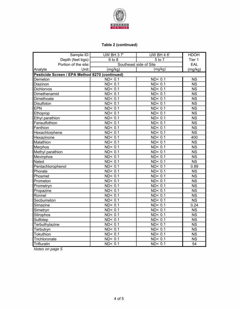
Sample ID: HDOH Depth (feet bgs): Tier 1
Portion of the site: EALAnalyte Unit: (mg/kg)
Demeton ND< 0.1 ND< 0.1 NSDiazinon ND< 0.1 ND< 0.1 NSDichlorvos ND< 0.1 ND< 0.1 NSDimethenamid ND< 0.1 ND< 0.1 NSDimethoate ND< 0.1 ND< 0.1 NSDisulfoton ND< 0.1 ND< 0.1 NSEPN ND< 0.1 ND< 0.1 NSEthoprop ND< 0.1 ND< 0.1 NSEthyl parathion ND< 0.1 ND< 0.1 NSFensulfothion ND< 0.1 ND< 0.1 NSFenthion ND< 0.1 ND< 0.1 NSHexachlorphene ND< 0.1 ND< 0.1 NSHexazinone ND< 0.1 ND< 0.1 400Malathion ND< 0.1 ND< 0.1 NSMerphos ND< 0.1 ND< 0.1 NSMethyl parathion ND< 0.1 ND< 0.1 NSMevinphos ND< 0.1 ND< 0.1 NSNaled ND< 0.1 ND< 0.1 NSPentachlorophenol ND< 0.1 ND< 0.1 0.89Phorate ND< 0.1 ND< 0.1 NSPhosmet ND< 0.1 ND< 0.1 NSPrometon ND< 0.1 ND< 0.1 NSPrometryn ND< 0.1 ND< 0.1 NSPropazine ND< 0.1 ND< 0.1 NSRonnel ND< 0.1 ND< 0.1 NSSecbumeton ND< 0.1 ND< 0.1 NSSimazine ND< 0.1 ND< 0.1 0.24Simetryn ND< 0.1 ND< 0.1 NSStirophos ND< 0.1 ND< 0.1 NSSulfotep ND< 0.1 ND< 0.1 NSTerbuthylazine ND< 0.1 ND< 0.1 NSTerbutryn ND< 0.1 ND< 0.1 NSTokuthion ND< 0.1 ND< 0.1 NSTrichloronate ND< 0.1 ND< 0.1 NSTrifluralin ND< 0.1 ND< 0.1 54Notes on page 5
(mg/kg)Pesticide Screen / EPA Method 8270 (continued)
6 to 8Southeast side of Site
Table 2 (continued)
UW BH 3 7' UW BH 4 6'5 to 7
(mg/kg)
4 of 5
Notes:∆
bgs Below ground surface.HDOH Tier 1 EAL
italic Analytes laboratory Reporting Limit (RL) is greater than the HDOH Tier 1 EAL.mg/kg Milligrams per kilogram.ND<
NS No standard is currently established by the HDOH for this analyte.TPH-DRO Total Petroleum Hydrocarbon as Diesel Range Organics.TPH-RRO Total Petroleum Hydrocarbon as Residual Range Organics.
Sample results should be considered preliminary. The site has not been fully characterized.
Analyte not detected. The value after the '<' is the laboratory Method Reporting Limit (MRL).
Table 2 (continued)
State of Hawaii Department of Health (HDOH) unrestricted Tier 1 Environmental Action Levels (EAL) at sites where groundwater is NOT a current or potential drinking water resource and a surface water body is NOT located within 150 meters of the site (HDOH, 2012).
5 of 5
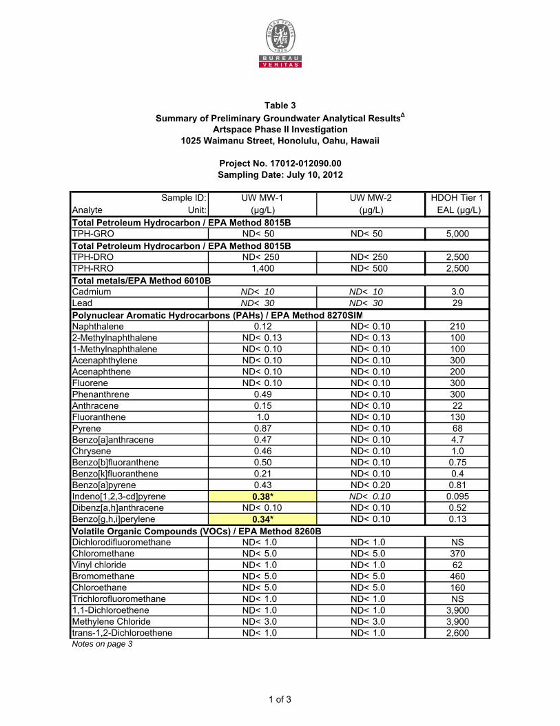
Sample ID: HDOH Tier 1Analyte Unit: EAL (µg/L)Total Petroleum Hydrocarbon / EPA Method 8015BTPH-GRO ND< 50 ND< 50 5,000Total Petroleum Hydrocarbon / EPA Method 8015BTPH-DRO ND< 250 ND< 250 2,500TPH-RRO ND< 500 2,500Total metals/EPA Method 6010BCadmium ND< 10 ND< 10 3.0Lead ND< 30 ND< 30 29Polynuclear Aromatic Hydrocarbons (PAHs) / EPA Method 8270SIMNaphthalene ND< 0.10 2102-Methylnaphthalene ND< 0.13 ND< 0.13 1001-Methylnaphthalene ND< 0.10 ND< 0.10 100Acenaphthylene ND< 0.10 ND< 0.10 300Acenaphthene ND< 0.10 ND< 0.10 200Fluorene ND< 0.10 ND< 0.10 300Phenanthrene ND< 0.10 300Anthracene ND< 0.10 22Fluoranthene ND< 0.10 130Pyrene ND< 0.10 68Benzo[a]anthracene ND< 0.10 4.7Chrysene ND< 0.10 1.0Benzo[b]fluoranthene ND< 0.10 0.75Benzo[k]fluoranthene ND< 0.10 0.4Benzo[a]pyrene ND< 0.20 0.81Indeno[1,2,3-cd]pyrene ND< 0.10 0.095Dibenz[a,h]anthracene ND< 0.10 ND< 0.10 0.52Benzo[g,h,i]perylene ND< 0.10 0.13Volatile Organic Compounds (VOCs) / EPA Method 8260BDichlorodifluoromethane ND< 1.0 ND< 1.0 NSChloromethane ND< 5.0 ND< 5.0 370Vinyl chloride ND< 1.0 ND< 1.0 62Bromomethane ND< 5.0 ND< 5.0 460Chloroethane ND< 5.0 ND< 5.0 160Trichlorofluoromethane ND< 1.0 ND< 1.0 NS1,1-Dichloroethene ND< 1.0 ND< 1.0 3,900Methylene Chloride ND< 3.0 ND< 3.0 3,900trans-1,2-Dichloroethene ND< 1.0 ND< 1.0 2,600Notes on page 3
Summary of Preliminary Groundwater Analytical Results∆Table 3
1,400
1025 Waimanu Street, Honolulu, Oahu, Hawaii
UW MW-2(µg/L)
0.12
UW MW-1
Sampling Date: July 10, 2012Project No. 17012-012090.00
0.50
Artspace Phase II Investigation
(µg/L)
0.151.0
0.49
0.46
0.34*
0.38*0.43
0.870.47
0.21
1 of 3
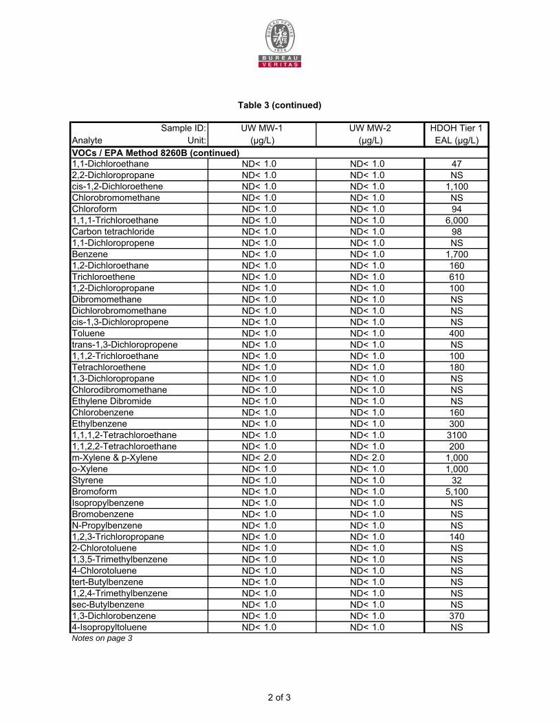
Sample ID: HDOH Tier 1Analyte Unit: EAL (µg/L)VOCs / EPA Method 8260B (continued)1,1-Dichloroethane ND< 1.0 ND< 1.0 472,2-Dichloropropane ND< 1.0 ND< 1.0 NScis-1,2-Dichloroethene ND< 1.0 ND< 1.0 1,100Chlorobromomethane ND< 1.0 ND< 1.0 NSChloroform ND< 1.0 ND< 1.0 941,1,1-Trichloroethane ND< 1.0 ND< 1.0 6,000Carbon tetrachloride ND< 1.0 ND< 1.0 981,1-Dichloropropene ND< 1.0 ND< 1.0 NSBenzene ND< 1.0 ND< 1.0 1,7001,2-Dichloroethane ND< 1.0 ND< 1.0 160Trichloroethene ND< 1.0 ND< 1.0 6101,2-Dichloropropane ND< 1.0 ND< 1.0 100Dibromomethane ND< 1.0 ND< 1.0 NSDichlorobromomethane ND< 1.0 ND< 1.0 NScis-1,3-Dichloropropene ND< 1.0 ND< 1.0 NSToluene ND< 1.0 ND< 1.0 400trans-1,3-Dichloropropene ND< 1.0 ND< 1.0 NS1,1,2-Trichloroethane ND< 1.0 ND< 1.0 100Tetrachloroethene ND< 1.0 ND< 1.0 1801,3-Dichloropropane ND< 1.0 ND< 1.0 NSChlorodibromomethane ND< 1.0 ND< 1.0 NSEthylene Dibromide ND< 1.0 ND< 1.0 NSChlorobenzene ND< 1.0 ND< 1.0 160Ethylbenzene ND< 1.0 ND< 1.0 3001,1,1,2-Tetrachloroethane ND< 1.0 ND< 1.0 31001,1,2,2-Tetrachloroethane ND< 1.0 ND< 1.0 200m-Xylene & p-Xylene ND< 2.0 ND< 2.0 1,000o-Xylene ND< 1.0 ND< 1.0 1,000Styrene ND< 1.0 ND< 1.0 32Bromoform ND< 1.0 ND< 1.0 5,100Isopropylbenzene ND< 1.0 ND< 1.0 NSBromobenzene ND< 1.0 ND< 1.0 NSN-Propylbenzene ND< 1.0 ND< 1.0 NS1,2,3-Trichloropropane ND< 1.0 ND< 1.0 1402-Chlorotoluene ND< 1.0 ND< 1.0 NS1,3,5-Trimethylbenzene ND< 1.0 ND< 1.0 NS4-Chlorotoluene ND< 1.0 ND< 1.0 NStert-Butylbenzene ND< 1.0 ND< 1.0 NS1,2,4-Trimethylbenzene ND< 1.0 ND< 1.0 NSsec-Butylbenzene ND< 1.0 ND< 1.0 NS1,3-Dichlorobenzene ND< 1.0 ND< 1.0 3704-Isopropyltoluene ND< 1.0 ND< 1.0 NSNotes on page 3
UW MW-2
Table 3 (continued)
(µg/L) (µg/L)UW MW-1
2 of 3

Sample ID: HDOH Tier 1Analyte Unit: EAL (µg/L)VOCs / EPA Method 8260B (continued)1,4-Dichlorobenzene ND< 1.0 ND< 1.0 110n-Butylbenzene ND< 1.0 ND< 1.0 NS1,2-Dichlorobenzene ND< 1.0 ND< 1.0 1001,2-Dibromo-3-Chloropropane ND< 2.0 ND< 2.0 0.041,2,4-Trichlorobenzene ND< 1.0 ND< 1.0 1601,2,3-Trichlorobenzene ND< 1.0 ND< 1.0 NSHexachlorobutadiene ND< 1.0 ND< 1.0 11Naphthalene ND< 1.0 ND< 1.0 210Methyl tert-butyl ether ND< 1.0 ND< 1.0 1800Notes:∆
bgs Below ground surface.
italic Analytes laboratory MRL is greater than the HDOH Tier 1 Action Level.µg/L Microigrams per LiterND<
NS No standard is currently established by the HDOH for this analyte.TPH-DRO Total Petroleum Hydrocarbon as Diesel Range Organics.TPH-GRO Total Petroleum Hydrocarbon as Gasoline Range Organics.TPH-RRO Total Petroleum Hydrocarbon as Residual Range Organics.* Concentration greater than or equal to the HDOH Tier 1 EAL.
Analyte not detected. The value after the '<' is the laboratory Method Reporting Limit (MRL).
UW MW-1 UW MW-2(µg/L) (µg/L)
Sample results should be considered preliminary. The site has not been fully characterized.
HDOH Tier 1 EAL State of Hawaii Department of Health (HDOH) unrestricted Tier 1 Environmental Action Levels (EAL) at sites where groundwater is NOT a current or potential drinking water resource and a surface water body is NOT located within 150 meters of the site (HDOH, 2012).
Table 3 (continued)
3 of 3

Sample ID:Analyte Unit:Total Petroleum Hydrocarbon / EPA Method 8015BTPH-DRO ND< 250 ND< 250 2,500TPH-RRO ND< 500 2,500Total metals/EPA Method 6010BArsenic ND< 60 ND< 60 69Polynuclear Aromatic Hydrocarbons (PAHs) / EPA Method 8270SIMNaphthalene ND< 0.10 ND< 0.10 2102-Methylnaphthalene ND< 0.13 ND< 0.13 1001-Methylnaphthalene ND< 0.10 ND< 0.10 100Acenaphthylene ND< 0.10 ND< 0.10 300Acenaphthene ND< 0.10 ND< 0.10 200Fluorene ND< 0.10 ND< 0.10 300Phenanthrene ND< 0.10 ND< 0.10 300Anthracene ND< 0.10 ND< 0.10 22Fluoranthene ND< 0.10 ND< 0.10 130Pyrene ND< 0.10 ND< 0.10 68Benzo[a]anthracene ND< 0.10 ND< 0.10 4.7Chrysene ND< 0.10 ND< 0.10 1.0Benzo[b]fluoranthene ND< 0.10 ND< 0.10 0.75Benzo[k]fluoranthene ND< 0.10 ND< 0.10 0.4Benzo[a]pyrene ND< 0.20 ND< 0.20 0.81Indeno[1,2,3-cd]pyrene ND< 0.10 ND< 0.10 0.095Dibenz[a,h]anthracene ND< 0.10 ND< 0.10 0.52Benzo[g,h,i]perylene ND< 0.10 ND< 0.10 0.13Volatile Organic Compounds (VOCs) / EPA Method 8260BDichlorodifluoromethane ND< 1.0 ND< 1.0 NSChloromethane ND< 5.0 ND< 5.0 370Vinyl chloride ND< 1.0 ND< 1.0 62Bromomethane ND< 5.0 ND< 5.0 460Chloroethane ND< 5.0 ND< 5.0 160Trichlorofluoromethane ND< 1.0 ND< 1.0 NS1,1-Dichloroethene ND< 1.0 ND< 1.0 3,900Methylene Chloride ND< 3.0 ND< 3.0 3,900trans-1,2-Dichloroethene ND< 1.0 ND< 1.0 2,6001,1-Dichloroethane ND< 1.0 ND< 1.0 472,2-Dichloropropane ND< 1.0 ND< 1.0 NScis-1,2-Dichloroethene ND< 1.0 ND< 1.0 1,100Chlorobromomethane ND< 1.0 ND< 1.0 NSNotes on page 4
Project No. 17012-012090.00Sampling Date: July 10, 2012
HDOH Tier 1 EAL (µg/L)(µg/L)
UW MW-3 UW MW-4(µg/L)
980
Table 4
Summary of Preliminary Groundwater Analytical Results∆
Artspace Phase II Investigation1025 Waimanu Street, Honolulu, Oahu, Hawaii
1 of 4
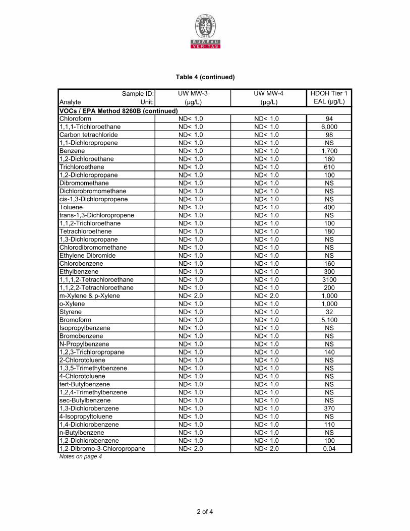
Sample ID:Analyte Unit:VOCs / EPA Method 8260B (continued)Chloroform ND< 1.0 ND< 1.0 941,1,1-Trichloroethane ND< 1.0 ND< 1.0 6,000Carbon tetrachloride ND< 1.0 ND< 1.0 981,1-Dichloropropene ND< 1.0 ND< 1.0 NSBenzene ND< 1.0 ND< 1.0 1,7001,2-Dichloroethane ND< 1.0 ND< 1.0 160Trichloroethene ND< 1.0 ND< 1.0 6101,2-Dichloropropane ND< 1.0 ND< 1.0 100Dibromomethane ND< 1.0 ND< 1.0 NSDichlorobromomethane ND< 1.0 ND< 1.0 NScis-1,3-Dichloropropene ND< 1.0 ND< 1.0 NSToluene ND< 1.0 ND< 1.0 400trans-1,3-Dichloropropene ND< 1.0 ND< 1.0 NS1,1,2-Trichloroethane ND< 1.0 ND< 1.0 100Tetrachloroethene ND< 1.0 ND< 1.0 1801,3-Dichloropropane ND< 1.0 ND< 1.0 NSChlorodibromomethane ND< 1.0 ND< 1.0 NSEthylene Dibromide ND< 1.0 ND< 1.0 NSChlorobenzene ND< 1.0 ND< 1.0 160Ethylbenzene ND< 1.0 ND< 1.0 3001,1,1,2-Tetrachloroethane ND< 1.0 ND< 1.0 31001,1,2,2-Tetrachloroethane ND< 1.0 ND< 1.0 200m-Xylene & p-Xylene ND< 2.0 ND< 2.0 1,000o-Xylene ND< 1.0 ND< 1.0 1,000Styrene ND< 1.0 ND< 1.0 32Bromoform ND< 1.0 ND< 1.0 5,100Isopropylbenzene ND< 1.0 ND< 1.0 NSBromobenzene ND< 1.0 ND< 1.0 NSN-Propylbenzene ND< 1.0 ND< 1.0 NS1,2,3-Trichloropropane ND< 1.0 ND< 1.0 1402-Chlorotoluene ND< 1.0 ND< 1.0 NS1,3,5-Trimethylbenzene ND< 1.0 ND< 1.0 NS4-Chlorotoluene ND< 1.0 ND< 1.0 NStert-Butylbenzene ND< 1.0 ND< 1.0 NS1,2,4-Trimethylbenzene ND< 1.0 ND< 1.0 NSsec-Butylbenzene ND< 1.0 ND< 1.0 NS1,3-Dichlorobenzene ND< 1.0 ND< 1.0 3704-Isopropyltoluene ND< 1.0 ND< 1.0 NS1,4-Dichlorobenzene ND< 1.0 ND< 1.0 110n-Butylbenzene ND< 1.0 ND< 1.0 NS1,2-Dichlorobenzene ND< 1.0 ND< 1.0 1001,2-Dibromo-3-Chloropropane ND< 2.0 ND< 2.0 0.04Notes on page 4
Table 4 (continued)
UW MW-3 UW MW-4(µg/L) (µg/L)
HDOH Tier 1 EAL (µg/L)
2 of 4
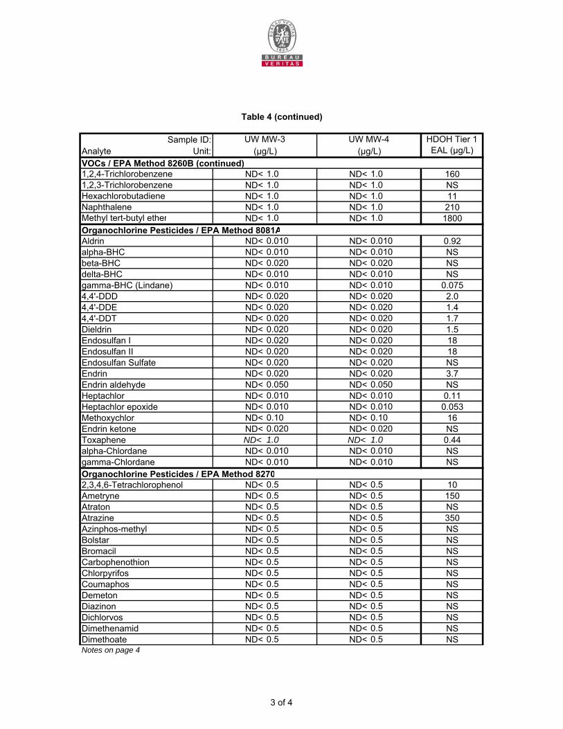
Sample ID:Analyte Unit:VOCs / EPA Method 8260B (continued)1,2,4-Trichlorobenzene ND< 1.0 ND< 1.0 1601,2,3-Trichlorobenzene ND< 1.0 ND< 1.0 NSHexachlorobutadiene ND< 1.0 ND< 1.0 11Naphthalene ND< 1.0 ND< 1.0 210Methyl tert-butyl ether ND< 1.0 ND< 1.0 1800Organochlorine Pesticides / EPA Method 8081A
ND< 0.010 ND< 0.010 0.92ND< 0.010 ND< 0.010 NSND< 0.020 ND< 0.020 NSND< 0.010 ND< 0.010 NSND< 0.010 ND< 0.010 0.075ND< 0.020 ND< 0.020 2.0ND< 0.020 ND< 0.020 1.4ND< 0.020 ND< 0.020 1.7ND< 0.020 ND< 0.020 1.5ND< 0.020 ND< 0.020 18ND< 0.020 ND< 0.020 18ND< 0.020 ND< 0.020 NSND< 0.020 ND< 0.020 3.7ND< 0.050 ND< 0.050 NSND< 0.010 ND< 0.010 0.11ND< 0.010 ND< 0.010 0.053ND< 0.10 ND< 0.10 16ND< 0.020 ND< 0.020 NSND< 1.0 ND< 1.0 0.44ND< 0.010 ND< 0.010 NSND< 0.010 ND< 0.010 NS
Organochlorine Pesticides / EPA Method 8270ND< 0.5 ND< 0.5 10ND< 0.5 ND< 0.5 150ND< 0.5 ND< 0.5 NSND< 0.5 ND< 0.5 350ND< 0.5 ND< 0.5 NSND< 0.5 ND< 0.5 NSND< 0.5 ND< 0.5 NSND< 0.5 ND< 0.5 NSND< 0.5 ND< 0.5 NSND< 0.5 ND< 0.5 NSND< 0.5 ND< 0.5 NSND< 0.5 ND< 0.5 NSND< 0.5 ND< 0.5 NSND< 0.5 ND< 0.5 NSND< 0.5 ND< 0.5 NS
Notes on page 4Dimethoate
ChlorpyrifosCoumaphos
Endrin ketoneMethoxychlor
gamma-Chlordanealpha-ChlordaneToxaphene
4,4'-DDD
Table 4 (continued)
UW MW-3 UW MW-4(µg/L) (µg/L)
HDOH Tier 1 EAL (µg/L)
Aldrin
delta-BHCbeta-BHCalpha-BHC
4,4'-DDE
Endrin
4,4'-DDTDieldrin
Endosulfan SulfateEndosulfan IIEndosulfan I
Dimethenamid
gamma-BHC (Lindane)
HeptachlorEndrin aldehyde
Heptachlor epoxide
Dichlorvos
2,3,4,6-TetrachlorophenolAmetryneAtratonAtrazineAzinphos-methylBolstarBromacil
Demeton
Carbophenothion
Diazinon
3 of 4
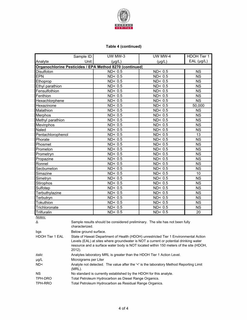
Sample ID:Analyte Unit:Organochlorine Pesticides / EPA Method 8270 (continued)
ND< 0.5 ND< 0.5 NSND< 0.5 ND< 0.5 NSND< 0.5 ND< 0.5 NSND< 0.5 ND< 0.5 NSND< 0.5 ND< 0.5 NSND< 0.5 ND< 0.5 NSND< 0.5 ND< 0.5 NSND< 0.5 ND< 0.5 50,000ND< 0.5 ND< 0.5 NSND< 0.5 ND< 0.5 NSND< 0.5 ND< 0.5 NSND< 0.5 ND< 0.5 NSND< 0.5 ND< 0.5 NSND< 0.5 ND< 0.5 13ND< 0.5 ND< 0.5 NSND< 0.5 ND< 0.5 NSND< 0.5 ND< 0.5 NSND< 0.5 ND< 0.5 NSND< 0.5 ND< 0.5 NSND< 0.5 ND< 0.5 NSND< 0.5 ND< 0.5 NSND< 0.5 ND< 0.5 10ND< 0.5 ND< 0.5 NSND< 0.5 ND< 0.5 NSND< 0.5 ND< 0.5 NSND< 0.5 ND< 0.5 NSND< 0.5 ND< 0.5 NSND< 0.5 ND< 0.5 NSND< 0.5 ND< 0.5 NSND< 0.5 ND< 0.5 20
Notes:∆
bgs Below ground surface.HDOH Tier 1 EAL
italic Analytes laboratory MRL is greater than the HDOH Tier 1 Action Level.µg/L Microigrams per LiterND<
NS No standard is currently established by the HDOH for this analyte.TPH-DRO Total Petroleum Hydrocarbon as Diesel Range Organics.TPH-RRO Total Petroleum Hydrocarbon as Residual Range Organics.
Simazine
PrometonPrometrynPropazineRonnel
Ethyl parathionFensulfothionFenthion
NaledMevinphos
MerphosMethyl parathion
DisulfotonEPNEthoprop
Table 4 (continued)
UW MW-3 UW MW-4
State of Hawaii Department of Health (HDOH) unrestricted Tier 1 Environmental Action Levels (EAL) at sites where groundwater is NOT a current or potential drinking water resource and a surface water body is NOT located within 150 meters of the site (HDOH, 2012).
Hexachlorphene
HDOH Tier 1 EAL (µg/L)(µg/L) (µg/L)
Analyte not detected. The value after the '<' is the laboratory Method Reporting Limit (MRL).
Hexazinone
Pentachlorophenol
Malathion
Sample results should be considered preliminary. The site has not been fully characterized.
PhoratePhosmet
TrichloronateTrilfuralin
SimetrynStirophos
TerbutrynTokuthion
SulfotepTerbuthylazine
Secbumeton
4 of 4
Res
iden
ts
On-
Site
Indo
or
Wor
kers
On-
Site
Out
door
W
orke
rs
Con
stru
ctio
n W
orke
rs
Terr
estri
al
Ecol
ogic
al
Aqua
tic
Ecol
ogic
al
Ingestion ● ● ● ● X X
Dermal ● ● ● ● X X
Inhalation (fugitive dust) X X X ● X X
Ingestion X X X ● X X
Dermal X X X ● X X
Inhalation (fugitive dust) X X X ● X X
Ambient Indoor Air Inhalation X X X X X X
Ambient Outdoor Air Inhalation X X X X X X
Ingestion X X X X X X
Dermal X X X X X X
X
Dermal X X X X X X
Ingestion X X X ● X X
Dermal X X X ● X X
Inhalation (fugitive dust) X X X ● X X
Ingestion X X X X X X
Dermal X X X ● X X
Surface Water and Sediments
Ingestion X
1025 Waimanu Street, Honolulu, Oahu, Hawaii
Project Number 17012-012090.00
Prim
ary
Sour
ces
Seco
ndar
y R
elea
se
Mec
hani
sm
Receptors
Prim
ary
Rel
ease
M
echa
nism
Expo
sure
Pat
hway Current/Future Land Use
Notes on Page 2
Volatile Emissions
Seco
ndar
y So
urce
s
X
Soil Movement During
ConstructionSurface Soil
None Surface Soil
Near Surface Soil
Subsurface Soil
Med
ia
X X XSurface Water Runoff
(Migration via Storm Drains)
Table 5Conceptual Site Model
Groundwater
Leaching
Surface Sources
Existing Contamination from Unknown
Primary Release Mechanism(s)
Artspace
Ecological
Surface Water Runoff
(Surface Sheet Flow)
Surface Water and Sediments
1 of 2
Res
iden
ts
On-
Site
Indo
or
Wor
kers
On-
Site
Out
door
W
orke
rs
Con
stru
ctio
n W
orke
rs
Terr
estri
al
Ecol
ogic
al
Aqua
tic
Ecol
ogic
al
Ingestion X X X ● X X
Dermal X X X ● X X
Inhalation (fugitive dust) X X X ● X X
Ingestion X X X ● X X
Dermal X X X ● X X
Inhalation (fugitive dust) X X X ● X X
Ambient Indoor Air Inhalation X X X X X X
Ambient Outdoor Air Inhalation X X X X X X
Ingestion X X X X X X
Dermal X X X ● X X
Ingestion X X X X X X
Dermal X X X X X X
Ambient Indoor Air Inhalation X X X X X X
Ambient Outdoor Air Inhalation X X X X X X
Notes:
• Potentially complete exposure pathwayX Incomplete exposure pathway
Table 5 (Continued)
Subsurface SoilNone
Subsurface Sources
Existing Contamination from Unknown
Primary Release Mechanism(s)
Groundwater
None
Subsurface Soil
Volatile Emissions
Volatile Emissions
Migration via Storm Drains Groundwater
Soil Movement During
ConstructionSubsurface Soil
Expo
sure
Pat
hway
ReceptorsCurrent/Future Land Use Ecological
GroundwaterPr
imar
y So
urce
s
Prim
ary
Rel
ease
M
echa
nism
Seco
ndar
y So
urce
s
Seco
ndar
y R
elea
se
Mec
hani
sm
Med
ia
2 of 2
Res
iden
tial
Com
mer
cial
/ In
dust
rial
Con
stru
ctio
n/
Tre
nch
Wor
ker
Res
iden
tial
Com
mer
cial
/ In
dust
rial
Res
iden
tial
Com
mer
cial
/ In
dust
rial
Res
iden
tial
Com
mer
cial
/ In
dust
rial
610 - 1,900 500 9,400 120,000 250,000 NV NV 500 2,500 5,000 5,000 5,000
Referenced Table 1 B-2 I-1 I-2 I-3 E
NOTES:COPC Chemical of Potential Concern
The HDOH defines isolated soils as greater than 3 meters for residential sites and greater than 1 meter for commercial/industrial sites.mg/kg milligrams per kilogramNV Not VolatileShallow Soils The HDOH defines shallow soils as 0-3 meters for residential sites and 0-1 meter for commercial/industrial sites.TPH-DRO Total petroleum hydrocarbons as Diesel Range OrganicsTPH-RRO Total petroleum hydrocarbons as Residual Range Organics
BOLD Representative concentration exceeds specified EAL1 Referenced table presented in HDOH guidance document entitled "Evaluation of Environmental Hazards at Sites with Contaminated Soil and Groundwater,
Volume II", dated Summer 2011 (Updated January 2012).
COPCRepresentative Concentration
(mg/kg)
Direct Exposure Vapor Emission toIndoor Air
Gross Contamination(Shallow Soils) (Isolated Soils)
HDOH EALs for Specific Environmental Hazards (mg/kg)
Leaching - Groundwater
Protection Concerns
Isolated Soils
TPH-RRO
HDOH Final Tier 1 EAL State of Hawaii Department of Health (HDOH) unrestricted Tier 1 Environmental Action Levels (EAL) at sites where groundwater is NOT a current or potential drinking water resource and a surface water body is NOT located within 150 meters of the site (HDOH, 2012).
F2C-1b F3
Project No.: 17012-012090.00
Table 6HDOH EALs for Specific Environmental Hazards for Soils
Artspace1025 Waimanu Street, Honolulu, Oahu, Hawaii
HDOH Final Tier 1
EAL (mg/kg)
Project No. 17011-011062.03 Page 1 of 1
Table 7HDOH EALs for Specific Environmental Hazards for Groundwater
1025 Waimanu Street, Honolulu, Oahu, Hawaii
RepresentativeConcentration
(µg/L)
Aquatic Ecotoxicity (Marine)
Project No.: 17012-012090.00
Artspace
Gross Contamination (groundwater is
not a current source of
drinking water)
HDOH EALs for Specific Environmental Hazards (µg/L)
COPC
Vapor Emission to Indoor AirHDOH Final Tier 1 EAL
(µg/L)
Aquatic Ecotoxicity (Freshwater)
Aquatic Ecotoxicity(Estuarine)
Res
iden
tial
Com
mer
cial
/ Ind
ustr
ial
Chr
onic
A
quat
ic
Tox
icity
Acu
te
Aqu
atic
T
oxic
ity
Chr
onic
A
quat
ic
Tox
icity
Acu
te
Aqu
atic
T
oxic
ity
Chr
onic
A
quat
ic
Tox
icity
Acu
te
Aqu
atic
T
oxic
ity
RepresentativeConcentration
(µg/L)
Aquatic Ecotoxicity (Marine)
Gross Contamination (groundwater is
not a current source of
drinking water)
COPC
Vapor Emission to Indoor AirHDOH Final Tier 1 EAL
(µg/L)
Aquatic Ecotoxicity (Freshwater)
Aquatic Ecotoxicity(Estuarine)
Indeno(1,2,3-cd)pyrene 0.38 0.095 NV NV 4.3 300 4.3 300 4.3 300 0.0950.34 0.13 NV NV 0.1 300 0.1 300 0.1 300 0.13
D-1c G-2Notes:COPC Chemical of Potential Concern
NV Not VolatileTPH- DRO Total petroleum hydrocarbons as diesel range organicµg/L micrograms per LiterBOLD Concentration exceeds the specified EAL
Indeno(1,2,3-cd)pyrene
HDOH Final Tier 1 EAL
State of Hawaii Department of Health (HDOH) unrestricted Tier 1 Environmental Action Levels (EAL) at sites where groundwater is NOT a current or potential drinking water resource and a surface water body is NOT located within 150 meters of the site (HDOH, 2012).
D-4aReferenced Table 1Benzo(g,h,i)perylene
C-1a
Project No. 17011-011062.03 Page 1 of 1