“replacing some interesting gates” · city of sugar land –amil gates “replacing some...
TRANSCRIPT

9/12/2014
1
1
City of Sugar Land – AMIL Gates
“Replacing some Interesting Gates”
TFMA Fall Conference
September 4, 2014
• Constructed in 1970’s by Fort Bend County LID No. 2
• City took ownership in Feb. 2007
• Gates are hydraulically activated (open from bottom)
• Main purpose is Flood Protection (not watertight)
• Partner w/ Gulf Coast Water Authority (GCWA) 2
9/12/2014
2
3
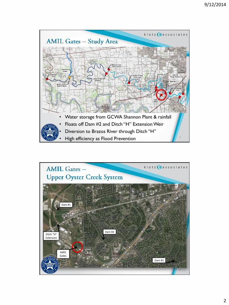
• Water storage from GCWA Shannon Plant & rainfall
• Floats off Dam #2 and Ditch “H” Extension Weir
• Diversion to Brazos River through Ditch “H”
• High efficiency as Flood Prevention
4
Ditch “H” Extension
Dam #2
Dam #3
Dam #1
AMIL Gates
9/12/2014
3
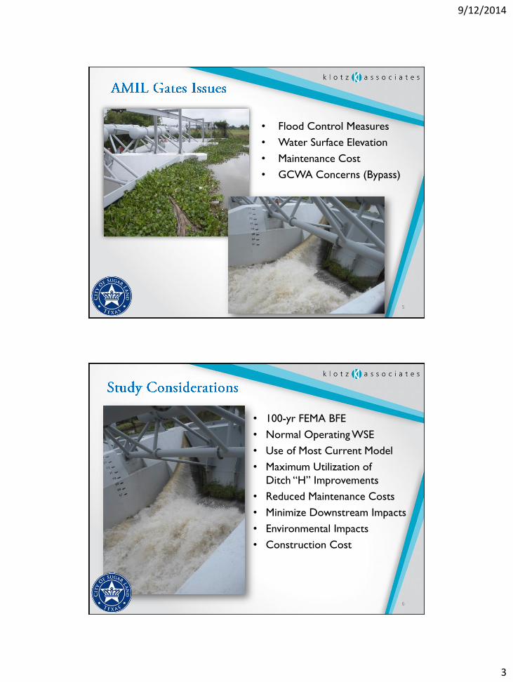
• Flood Control Measures
• Water Surface Elevation
• Maintenance Cost
• GCWA Concerns (Bypass)
5
6
• 100-yr FEMA BFE
• Normal Operating WSE
• Use of Most Current Model
• Maximum Utilization of
Ditch “H” Improvements
• Reduced Maintenance Costs
• Minimize Downstream Impacts
• Environmental Impacts
• Construction Cost

9/12/2014
4
7
• Unsteady HEC-RAS Model
(Originally prepared in 2011)
• Control Flows thru Brooks Lake Diversion (AMIL Gates)
• Minimize impacts to Oyster Creek (D/S)
8
• Evaluate Multiple
Tailwater conditions
along Brazos (Ditch H)
– 100-yr in Oyster w/
10-yr Brazos
– 10-yr in Oyster w/
100-yr in Brazos
BLD
4896
4780
4480
4250
4140
3850
3664
3505
30562767246021491889
175015551270972
900
881
770
470412
400
313
128
Bro
ok
s L
ak
e D
ive
1405.1
1262.74*
1120.38*
978.02*
835.66*
693.3
653.42*
613.54*
573.66*
533.78*
493.9*
454.02*
414.139*
374.259*
334.379*
294.499*
254.619*
214.739*
21990
21498
20968
20872.6*
20777.3*
20682.*
20586.6*
20491.3*
20396
20331
20222
20153
19926
19726
89900

9/12/2014
5
• Non-Mechanical System
• Labyrinth Weir
– Length vs. Capacity
– Concrete vs. Steel
• Slide Gate (Future Flexibility)
• Existing Structure Footprint
• Amenity Features
– Pedestrian Bridge
• Constructability / Phasing
• WSE Impacts Downstream
9
10
• Evaluated potential modifications to:
– Ditch H Overflow
– Dam’s 1, 2, & 3
– Various Bridge Structures / Restrictors
– 100-ft Weir within Existing AMIL Gate Structure
0 50 100 150 20066
68
70
72
74
76
78
BR_OC_BHB 2012(FT ) P lan: OC100-BRLOW 10/22/2012 Geom: BR_OC_BHB_PrePrj Flow:
River = Ditch H Reach = US-BLD RS = 24951.2 Just D/S of Weir
Station (ft)
Ele
va
tion
(ft)
Legend
Ground
Bank Sta
9/12/2014
6
11
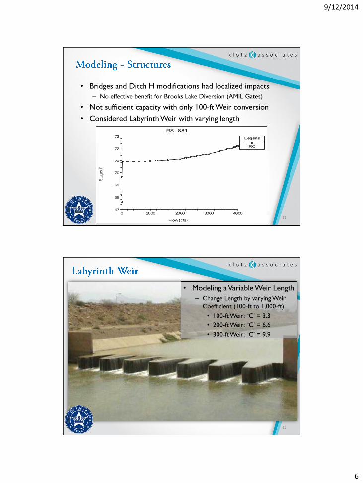
• Bridges and Ditch H modifications had localized impacts
– No effective benefit for Brooks Lake Diversion (AMIL Gates)
• Not sufficient capacity with only 100-ft Weir conversion
• Considered Labyrinth Weir with varying length
0 1000 2000 3000 400067
68
69
70
71
72
73
RS: 881
Flow (cfs)
Sta
ge
(ft)
Legend
RC
12
• Modeling a Variable Weir Length
– Change Length by varying Weir
Coefficient (100-ft to 1,000-ft)
• 100-ft Weir: ‘C’ = 3.3
• 200-ft Weir: ‘C’ = 6.6
• 300-ft Weir: ‘C’ = 9.9

9/12/2014
7
13
• Add Vertical Slide Gate
– Increase “Factor of Safety”
– Adjustable WSE Control
14

9/12/2014
8
15
Labyrinth Weir
Pedestrian Bridge
Slide Gate
16
Labyrinth Weir
Pedestrian Bridge
Slide Gate

9/12/2014
9
17
Constructability / Cost
• Utilize Existing Structure
• Phased Construction
• Maintain Flow
• Within Current ROW
• Faster Nationwide Permitting
Pedestrian Bridge
2 ~ 15-ft x 4-ft Gates(Automated Controls &
Downward Opening)
2 ~ 65-ft Long x 20-ft Wide Weirs(12-ft Tall Structural ConcreteRetaining Walls w/ Depressed
Inside Edge for Low-Flow)
18
Impacts noted along Oyster Creek approx. 5 mi. D/S & 3 mi. U/S

9/12/2014
10
19
Contained within Banks on City Owned Property
20
Constructability / Cost
• Utilize Existing Structure
• Phased Construction
• Maintain Flow
• Within Current ROW
• Faster Nationwide Permitting

9/12/2014
11
21
Option Effective
Weir Length
Total Width of
4’ High Gates
Rise above
FEMA BFE1
Effectiveness Cost
Rating
(Low = Best)
Type of
Construction
Approx Cost, in
$1,000s2
1-conc. 200 0 0.32 3.68 Concrete $1,151
1-steel 200 0 0.32 4.93 Steel Piling $1,541
2-conc. 200 30 0.21 3.01 Concrete $1,434
2-steel 200 30 0.21 3.74 Steel Piling $1,779
3-conc. 300 0 0.24 3.44 Concrete $1,433
3-steel 300 0 0.24 4.70 Steel Piling $1,958
4-conc. 300 30 0.16 2.74 Concrete $1,715
4-steel 300 30 0.16 3.53 Steel Piling $2,204
22