realising development orientated transit rail mc final 15 8 12.pdf · evan jones for the ....
TRANSCRIPT

EVAN JONES for the
AUSTRALIAN COUNCIL FOR NEW URBANISMPLANNING INSTITUTE OF AUSTRALIA (W.A.)
REALISING DEVELOPMENT ORIENTATED TRANSIT
PERTH LIGHT RAIL MASTERCLASS
23–25 SEPTEMBER, 2011


ContentsExecutive Summary 3
Introduction 5
The Case for LRT 6
LRT in Perth 8
Masterclass Transit Oriented Development Principles 9
1. Transit-Led Land Use 92. Multi-Purpose Arterial Streets and Boulevards 103. Route Choice 114. LRT Spacing and Stops 125. Station Design 136. Land Values for Redevelopment 137. Community Support 13
Perth LRT North 15
Northern Corridor Context 15Route Choices 17Northern LRT Route Characteristics 17Redevelopment Opportunities 18Edith Cowan University 18North Perth 19Dianella Plaza 22Mirrabooka Centre 23Road Design Standards and Tram Route Amenity 24
Perth LRT South East 27
Existing Conditions 27LRT Route Options 28Albany Highway – Curtin University Route 30Duncan Street Redevelopment 33Proposed Gresham Street Station 34Residential Redevelopment opportunities 36Curtin University 38
Perth LRT South West 41
Introduction 41Route Analysis 42QEII Hospital 48UWA Urban Village/West End 49Actions, Strategies, Priorities 51
Architecture of Place 53
An Approach to Built Form 53Urban Typologies 54Urban Coding 55
1

2

THE PERTH LIGHT RAIL
MASTERCLASS brought
together key built environment
professionals in September
2011 under the guidance of
internationally acclaimed urban
designers Stef Polyzoides and
Wendy Morris. The Masterclass
investigated transit oriented
development opportunities along
the first three proposed LRT routes
in the draft Public Transport Plan for
Perth, 2031; an LRT spine proposed
through Perth’s Northern Suburbs
to the city, and proposed links from
the City to Curtin University and the
University of Western Australia -
also known as the Knowledge Arc.
Peter Newman and Jan Scheurer
of Curtin University Sustainability
Policy (CUSP) Institute see Perth as
needing to create another cross-city
rail network which can be a new
light-rail technology, integrated
with land development and
involving a private operator that
can establish a new kind of public
transport system in Perth1.
All proposed light rail routes were
found to have opportunities to
integrate with land development
and support the aim of achieving a
more compact urban form proposed
in Directions 2031.
LRT NorthKey origins and destinations and
redevelopment opportunities
for the Northern LRT route are
Edith Cowan University, and the
Mirrabooka and Dianella Plaza
centres. The Masterclass considered
that the heavily-engineered LRT
system as currently proposed by
the Government would result in
considerable negative impacts
on urban place-making and
regeneration along Fitzgerald
Street. An alternative fit-for-purpose
LRT was proposed for the Northern
Corridor so that it can run fast down
sections of track where priority is
Executive Summary
1The Knowledge Arc Light Rail: A Concept for Delivering the Next Phase of Public Transport in Perth. Peter Newman and Jan Scheurer, Curtin University Sustainability Policy (CUSP) Institute
3

assigned to meet regional transit
demands, and go more slowly when
passing through activity centres
along Fitzgerald Street to stimulate
urban regeneration at key locations.
LRT South-EastAn overall corridor redevelopment
plan was developed for the
proposed link to Curtin University,
commencing with the Albany
Highway redevelopment
opportunities and envisaging
comprehensive plans for the
Technology Park and Curtin
University.
It was estimated that some 9,500
residential dwelling units and
163,000 square metres of retail,
mixed use and commercial could be
added along the proposed LRT line.
LRT South-WestThe South West Light Rail between
the CBD, the QEII Hospital and the
University of Western Australia
would facilitate an increase in the
density and intensity of use around
these destinations. In particular, a
Light Rail Line would catalyse an
opportunity for an Urban Village
between UWA and its neighbouring
district to the QEII Hospital,
offering real potential for dense
development on and off campus, and
providing student/worker housing,
affordable and market housing.
ConclusionLight rail works best as part of an
integrated strategy that assimilates
transit, land-use and development
and fit-for-purpose governance
arrangements2. Land-use and
development aspects of the Perth
Light Rail proposals should be
better developed in unison
with transport proposals so that
transit design does not preclude
Transit Oriented Development
opportunities and the ability of the
new LRT system to underpin urban
consolidation.
2An Introduction to Transit-Oriented Development, Hank Ditmar with Dena Belzer and Gerald Autler. In The New Transit Town: Best practices in Transit Oriented Development, Dittmar, H and Ohland G, Island Press 2004
4

THIS BOOKLET is an edited
summary of outcomes
of a three day Transit Oriented
Development (TOD) Masterclass held
for industry professionals in Perth in
September 2011 by the Australian
Council for New Urbanism and the
Planning Institute of Australia (W.A.)
Division.
The new Public Transport Plan for
Perth in 2031 introduces Light Rail
Transit (LRT) as a new rapid transit
system. The Masterclass brought
together urban planners, transit
planners, architects and others into a
design process to test proposals for
LRT in Perth and develop an urban
design response for transit oriented
development opportunities arising
from the proposed LRT.
The Masterclass was limited
to considering three proposed
elements; an LRT spine proposed
through Perth’s Northern Suburbs
and proposed links from the city to
Curtin University and the University
of Western Australia - also known as
the Knowledge Arc. Other important
light rail proposals such as a line
to Stirling City Centre were not
investigated and may be of equal
or greater importance for early
implementation.
INTRODUCTION
Figure 1: Masterclass Light Rail Routes for Investigation
5

The Masterclass was led by
internationally acclaimed urban
designers Stef Polyzoides and
Wendy Morris and this report
draws heavily from their generous
advice in describing the principles
and practices of transit oriented
development. Professor Peter
Newman from Infrastructure Australia
and co-author of The Knowledge Arc
Light Rail offered the Masterclass
the benefit of his international
knowledge of LRT and how to
position LRT as an Infrastructure
Australia project for Perth.
Transport experts Jim Higgs and Chris
Stapleton gave input on key design
challenges for the light rail facilities.
Facilitators and participants are noted
in relevant sections of the report.
The Case for LRTTHE CASE FOR LIGHT
RAIL as the next phase of
city development in Perth
to ease congestion and contribute
to sustainability and liveability
is compelling. According to Peter
Newman and Jeff Kenworthy, cities
with modern streetcars have:
• 41% lower energy use per passenger/km than bus cities
• 18% lower automobile passenger kms per capita
• 23 % lower transport emissions per capita
• 38% fewer transport deaths
Peter Newman and Jan Scheurer
of Curtin University Sustainability
Policy (CUSP) Institute prepared a
Knowledge Arc Light Rail Transit
proposal that sets out a substantial
rationale for LRT (see http://
sustainability.curtin.edu.au/research_
publications/publications.cfm).
They argue that Perth has done well
in its public transport development
since rail electrification and
extensions of the heavy rail to each
major corridor. Public transport is now
faster than traffic down each major
corridor. The passenger load on rail
has increased from 7 million a year in
1991 to 55 million a year in 2009.
It is a global success story that is
told around the world and has led to
other Australian cities finally moving
to expand their rail systems – with
Federal Government assistance
through Infrastructure Australia.
Newman and Scheurer reason
that the Perth metropolitan region
is growing fast and its traffic is a
problem with an increase in car
6

ownership and the freeways are all
full at peak time even with the rail
system down the centre carrying the
equivalent of 8 lanes of traffic.
They see Perth as needing to create
another cross-city rail network which
can be a new light-rail technology,
integrated with land development
and involving a private operator that
can establish a new kind of public
transport system in Perth. The many
advantages include:
• Light rail - a modern tram can fit into street medians or replace or share a lane and can carry up to 20 times more people than a lane of traffic.
• It can run fast down sections of track where priority is assigned and can go slow when near pedestrians.
• It can provide the means for funding the infrastructure through value capture associated with planned land developments at stations.
• LRT is attractive to developers as it gives the boost that is needed to genuinely get people out of their cars and thus enables much less parking and much more productive and attractive development to be placed on nearby sites.
The Knowledge Arc Light Rail Transit
proposal identifies development now
planned along the route as including:
• The doubling of Curtin University (including six 20 storey towers of residential activity);
• The doubling of Technology Park;
• The large increase in residences on the western side of Victoria Park as
well as commercial development along Albany Highway;
• The Riverside Development by the Metropolitan Redevelopment Authority on the river adjacent to the WACA and Trinity College which are also building extensive high rise and medium rise residences and commercial premises;
• The eastern end of Central Perth where most of the new high rise has been happening and more is expected;
• The Northbridge link or Hub is the largest urban regeneration in Central Perth directly above the Central rail station and the new underground bus terminal. If linked by the Knowledge Arc LRT it would create the biggest interchange point in the whole metropolitan public transport system - now easily linking the whole metropolitan area to Curtin and UWA as well as the rest of the Knowledge Arc centres;
• The redevelopment of the Princess Margaret Hospital (PMH) site on Thomas Street;
• The largest health complex in Perth with the new PMH and Sir Charles Gardiner Hospitals which are seriously compromised in their growth and functionality by traffic and parking issues; and
• The University of Western Australia complex, the State’s premier knowledge hub which is set to double in size and has little ability to increase its parking.
The Masterclass reviewed current
plans for LRT and tested the proposed
LRT routes before they are fully fixed.
GB Arrington of PB Placemaking
suggests that successful TOD starts
with the earliest decisions on the
shape and design of the transit
system3 and the Masterclass looked at
the key aspects of:
• Critiquing the existing plans for the LRT – by testing the proposed operational approach, stops, spacings and design
• Exploring the different scales of TOD - regional, 400m radius nodes; station stop precincts
• Testing opportunities and constraints for TOD along the routes
• Testing transit facility design – for TOD-friendliness and transit performance
• Exploring architecture for TODs, including architecture of its place/context
• Exploring and progressing funding and implementation concepts
.... a tram can fit into street medians or replace or share
a lane which can carry up to 20 times more people than a lane of traffic.
LRT is attractive to developers as it gives the boost that is needed to genuinely get people out of their car
3Transportation: Being An Alternative To The Car Is Not Enough: Making Transit More Sustainable. G.B. Arrington, Network Sustainable Development November 2004 • Issue No. 59 • Volume XIX • Number 3
7

LRT in Perth
22 DePArTmenT oF TrAnSPorT – PublIc TrAnSPorT For PerTh In 2031
KEY
Railways *
Please Note:* Only new train stations and stations linking with the proposed rapid transit network are shown.** Some of these Bus Rapid Transit routes could be Light Rail in the long term, subject to further detailed master planning.
Light Rail
Bus Rapid Transit**
Light Rail or Ferry
Maddington
Byford
Mundijong
Armadale
Belmont
BurswoodClaisebrook
Fremantle
Rockingham
Mandurah Station
Yanchep
Clarkson
Alkimos
Butler
Two Rocks
Balcatta
Glendalough
Morley
Mirrabooka
Mt. Lawley ECU
Ellenbrook
Midland
Airport West
Shenton Park
Esplanade
Claremont
Rockingham City
WarnbroBaldivis
KeralupKarnup
Nambeelup
LakelandsMandurah
Airport Terminal
Oats St
Cannington
Canning Vale
Curtin
Victoria ParkQEII
UWA
Canning Bridge
Murdoch
Cockburn Central
Success / Mandogalup
Guildford
Karrinyup
Joondalup
Eglinton
Whitfords City
Scarborough
Riverton
Thornlie
Southlands
Subiaco
PERTH
Hillarys
Warwick
Stirling
Booragoon
Bassendean
Bayswater
RApID TRANSIT INFRASTRUCTURe ultiMate network for city of 3.5 Million
Figure 2: LRT routes for Perth, in the latest Public Transport Plan for Perth, 2031
PERTH’S ELECTRIC TRAM
SYSTEM was inaugurated in
1899 and covered a street mileage
of over 50 km the 1930s, but was
wound down from 1949, and closed
in 1958 as all growth became auto-
oriented. The original tram system
both connected the suburbs to Perth
and generated a walkable urbanism
with mixed use development
occuring around multiple stops that
supported local retail.
Figure 3: Perth and suburban districts showing original tramway routes
8

Masterclass Transit Oriented
Development Principles
1. Transit-Led Land Use
THE INTEGRATION of transit and
land use through Transit Oriented
Developments (TOD) to create more
liveable and sustainable communities
is an important model of sustainable
urbanism and a key tool for urban
redevelopment.
TOD is defined as moderate to
higher density development, located
within an easy walk of a major
transit stop, generally with a mix
of residential, employment and
shopping opportunities designed for
pedestrians without excluding cars4.
Transit’s ability to facilitate
sustainable development is
dependent on designing facilities that
support development by integrating
pedestrian access from the local
street network and foster more
diverse and more intense land-uses.
Otherwise, transit can exclude urban
redevelopment where independent
facilities are designed separately
from neighbourhoods. Common
problems include the exclusive use of
streets for LRT stations which stifles
vehicular access to neighbouring
land uses; pedestrian-hostile drop-off
and bus interchanges immediately
adjacent to stations; and provision of
large parking areas around stations.
To be sustainable, shifts in both land
use and transit are required. To effect
regional land use change, local transit
facilities need to be designed to
support both transit performance and
redevelopment. Where provided this
way, Development Oriented Transit
can catalyse the redevelopment
of under utilised urban land and
intensify the building fabric of areas
along a light rail route. Station sites
and the neighbourhoods, district
and corridors surrounding them
become accessible to metropolitan
populations as living, working, retail
and entertainment destinations.
Their economic potential and physical
form can be transformed5.
4Caltrans TOD Study5Stefanos Polyzoides, Notes on Transit Oriented Development. First published in Banerjee, Loukaitou- Sideris: A Routledge Companion to Urban Design, Routledge, London, 2009
9

Transit-Oriented Design
Automobile-Oriented Design
Park & Ride Park & Ride
Park & Ride
Bus
Bus
Figure 4: Auto or Development Oriented Transit?
6Great Streets Allan B Jacobs7Movement Economy Dependent on Urban Design. Mehmet Topçu, Kadriye Deniz Topçu, Ayse Sema Kubat, Proceedings, 6th International Space Syntax Symposium, İstanbul, 20078Main Street Handbook- A User’s Guide to Main Street, Portland Metro, March 1996
2. Multi-Purpose Arterial Streets and Boulevards
Streets have multiple roles in urban
life and are more than public utilities
or linear physical spaces that permit
carriage of people and goods. They
are places to live and to do business
and facilitate the interplay of human
activity. Streets moderate the form
and structure and comfort of urban
communities and play a vital role in
the vibrancy of communities6.
Movement-seeking land-uses
migrate to movement-rich lines,
producing multiplier effects on
movement which then attract more
retail, greater density and mix of
uses. This dynamic process is called
the “movement economy”7.
Good arterial streets are a busy and
animated part of a city’s movement
economy. The land uses - retail and
commercial enterprises, residential
and public services (such as a
school, library or post office) that
locate in the street are critical to the
area’s vitality and prosperity8. Easy
accessibility and clear way-finding
for both pedestrians and traffic are
important to capture passing trade
as well as service local catchments.
It is crucial to activate streets by
addressing them with ground level
uses with many windows and
doors for an active, vital, safe and
stimulating environment. Circulating
pedestrians and traffic with on-
street parking sustain this type of
street frontage development.
Figure 5: Westgarth Street/High Street, Melbourne – Integrating land-use with cars and trams to maintain a vital local centre
9Stefanos Polyzoides, Notes on Transit Oriented Development. First published in Banerjee, Loukaitou- Sideris: A Routledge Companion to Urban Design, Routledge, London, 2009
Source: G.B. Arrington, PB Placemaking, Understanding the Fundamentals of TOD
10

Figure 6: Auckland Waitakere Transit Investigation – Ecologically Sustainable Design
9Stefanos Polyzoides, Notes on Transit Oriented Development. First published in Banerjee, Loukaitou- Sideris: A Routledge Companion to Urban Design, Routledge, London, 2009
3. Route Choice
Successful TOD starts with the
earliest decisions on the location
and design of the transit system.
The choice of a light rail route to
link key destinations determines
the viability of a transit system and
establishes the redevelopment
opportunities along the route.
The location of stops determines
the ability of transit to catalyse
redevelopment. The aim is to build
places as well as a transit project.
Stops should be tested to ensure
that they are located at places that
have the potential to be further
intensified by an appropriate mix
of uses that encourage pedestrian
activity and transit ridership9.
Principles to enhance the
opportunity for TOD:
• Stations must be located in areas with development potential
• Transit facilities must be designed in a compact, pedestrian-friendly manner
• The design of station facilities must allow for direct pedestrian connections to adjacent communities
• TOD must be appropriately incorporated into the transit facility design including bus route interchange opportunities
• Any designated park-and-ride area must be designed in a manner that does not separate the station from the community it is intended to serve.
The location of stops
determines the ability of transit to catalyse redevelopment. The aim is to build places as well as a transit project.
11

Figure 7: Albert Park TOD, Melbourne, Ground Floor Land-Use, Ecologically Sustainable Design, 2006
Figure 8: New Lynn, Auckland, New Zealand, TOD Concept Plan, Ecologically Sustainable Design
4. LRT Spacing and Stops
LRT stops depend on what
opportunities the urbanism of
the light rail route offers when
balancing the objectives of
mobility and improved access.
From a transit perspective, wide
stops for rapid operation makes
light rail useful for longer trips for
moving passengers along a corridor.
Lower operational speeds and
close station stops at around 800
metres serve denser suburbs and
best support walkability and urban
regeneration. In practice light rail
can respond to both, with faster
speeds and wider stops in outer
suburban areas, and slower speeds
and more frequent stops in inner
suburbs and the inner city.
By better serving exiting
suburbs with easy access and
creating opportunities for urban
redevelopment, the whole city
becomes less dependent on
longer-distance twice-daily trips.
Important stops and TOD precincts
should be located where significant
intensification is required at key
development or redevelopment
opportunities along the route.
These stations should also
host key bus route interchange
opportunities along LRT corridors.
Pedsheds should be prepared for
each proposed stops to identify
how connected the stop will be
with the local neighbourhood. Any
significant missing streets/walkable
connectivity gaps should be
identified and new streets should be
located, or pedestrian links added
where a street is not practical.
Relative urban densities along the
corridor (within 500m of route or
800m of likely stops) should also
10Jeremy Edge, “The impact of transport schemes on land values: what is the evidence?” Self-financing Transport Projects Through Land Value Gains: Too Good to be True?” Conference, London, 20 May200311Matthew Doherty, “Funding public transport development through land value capture programs”.12Transportation: Being An Alternative To The Car Is Not Enough: Making Transit More Sustainable. G.B. Arrington, Network Sustainable Development November 2004 • Issue No. 59 • Volume XIX • Number 3
12

be considered to help prioritise
station location. Small-scale
intensification options for typical
single dwelling residential areas
should be investigated along the
LRT route, especially near stops.
5. Station Design
Transit stops have dual roles as
stops in the transport network and
as a local place in a neighbourhood
and need to balance transport and
urban development issues.
Station design is characterised
as to whether the station is
predominantly for trip origins or
trip destinations. This informs the
type of uses and development that
the station may support including
housing, shops and employment.
It establishes the framework for
station design, and establishes
the structure of places around
the station, and by extension,
the building and development
strategies that are unique to the
profile of each station.
Buildings, open space, landscape
and infrastructure should assume
a particular character depending
on where they are located. For
example, small, low rise, detached,
mixed-use buildings would be
expected in lower intensity urban
settings. Attached, mid-rise, mixed
use buildings and large, high-
rise, vertical mixed-use buildings
would be common in middle and
high intensity urban locations
respectively.
Station access should be
interconnected and multi modal.
Buildings should define a realm of
public space of thoroughfares, parks
and plazas, whilst parking should
be hidden, wherever possible. The
density of the particular buildings
deployed should vary by the degree
of their closeness to the transit
station; the closer the station, the
denser the building.
6. Land Values for Redevelopment
By improving urban accessibility
light rail transit can increase
land values and be a catalyst
for opportunities in the vicinity
of stations, on vacant sites
along the LRT route and through
intensification of existing
development. Some of the value
created by the transit link can be
used to assist with the funding of
LRT projects. By this relationship of
mutual benefit, transit can catalyse
development10.
The development of transport
infrastructure, although often
necessary to propel urban
regeneration, may not in itself be
sufficient to generate development.
Compared to the US where urban
arterials are often blighted or
occupied by low-value land uses, a
particular condition of the proposed
Perth LRT routes is intact and
relatively valuable residential and
commercial development. As values
are already relatively high, the value
adjustment may be marginal for
many years after the transit is built.
Comprehensive redevelopment
may not be catalysed, and sufficient
additional value may not be
generated to materially assist with
infrastructure funding. It could also
inhibit the desired redevelopment11 .
The high land-value condition
of Perth emphasises the need to
ensure that all opportunities for
new development on available
sites along the proposed LRT lines
be identified and facilitated. Also,
to catalyse urban intensification,
changes in development standards
may be required, such as increasing
densities in the vicinity of stations
and reducing parking to building
ratios. Consideration also needs to
be given to expeditious approval
processes.
7. Community Support
LRT has the potential for
transformative community change,
but it requires community support.
New transit systems typically raise
community concerns about impacts
from the construction, changes to
movement patterns and worries
over the effects of additional
development along the transit
system. It is essential that a case for
more than transit is argued. To gain
local and wider community support
LRT proposals need to be part of
community’s vision for growth12.
The development of proposals
related to a transit system should
be linked through a community
participatory process such as an
Urban Design Charrette. Using
this method, the community of
neighbours living in proximity
to stations can raise issues of
local concern or sensitivity and
discern the mobility, economic
development and physical design
benefits that a station design may
produce for them .
Figure 9: New Urbanist Enquiry-by-Design approach to interactive public design processes. Perth LRT Masterclass
13

14

Northern Corridor Context
PERTH’S NORTHERN CORRIDOR
is located between the Perth-
Joondalup and Perth-Midland Rail
lines. Buses along the Alexander
Drive route to Perth City are
approaching overload. The
projected patronage is equivalent
to the Fremantle, Armadale and
Midland lines. LRT is proposed to
move the current and projected
large volumes efficiently.
Key destinations and redevelopment
opportunities for the Northern
LRT are Perth City, Edith Cowan
University, and Mirrabooka centre.
PERTH LRT NORTH
EXPERTISE/ROLE PARTICIPANT
Facilitators/Urban Designers Clive Alcock
Ben De Marchi
Transport specialist Jim Higgs
Urban designer or architect Sonny Embleton
Bret White
Transport focus Maireed Cantwell
Andrew Foreman
Donald Yates
Planning focus Catherine Evans
Tayne Evershed
Daniel Heymans
Rosy Serventy
Engineering focus Danya Alexander
John White
AUDRC Julian Bolleter
15

Figure 11: Northern LRT Corridor Growth Potential
Figure 10: Northern Corridor LRT Context
16

Route Choices
Alternative route choices to the Department of Transport’s proposed Perth – Mt
Lawley ECU – Mirrabooka route were investigated. These included Mirrabooka/
Nollamara Avenues to Wanneroo Road and then either continuing to Perth City
via Charles St or to Perth City via Walcott Street/Fitzgerald Street .
The alternative routes add additional time, but increase potential catchment
areas for redevelopment and the likely intensity of redevelopment as follows:
Time Catchment Area Number (in comparison (in comparison Route Length of Stops with Route A) with Route A) (km) (mins) (ha)
A 7.4 10 - -
B 7.6 11 +1 +20
C 6.7 10 +2 +16
Figure 12: Perth – Mt Lawley ECU – Mirrabooka as currently proposed by State Government (Route A)
Figure 13: Alternative Route Options along Wanneroo Road (Route C - via Charles St, Route B - via Walcot/Fitzgerald St)
This high level analysis indicates
that alternative routes should be
considered if more priority is to be
given to catalysing redevelopment.
Northern LRT Route Characteristics
The current Perth – Mt Lawley
ECU – Mirrabooka route has two
distinguishing characteristics. The
northern half of the proposed route
from Mirrabooka to North Perth has
wide road alignments to run along,
such as Alexander Drive allowing
fast running.
The walkable catchment along this
part of the route is limited because
of current low densities along the
route, poor interconnectivity of
the road network from Alexander
Drive northwards and large areas of
public open space and recreational
areas along the route, particularly
the Yokine reserve and the Mount
Lawley Golf Club.
The southern half along Fitzgerald
Street from Walcott Street into
the City will be relatively slow in
comparison, unless as proposed,
significant priority is given to
the LRT by removing cars, adding
intersection underpasses and
providing few stops.
Fitzgerald Street is unsuited to
traffic removal as there is no parallel
local street behind it to enable easy
access to business. Fitzgerald Street
is one of Perth’s few lively inner-
city localities with strong traditional
urbanism and its shops and
businesses require frontage access
and parking to maintain viability.
Build Places Not Projects
The workshop considered that
the Government’s proposed LRT
system would result in considerable
impacts on urban place-making and
regeneration potential along key
areas of the proposed route.
The current transit proposals include
diverting all traffic from Fitzgerald
Street, closing or converting some
local streets into culs-de-sac at
station locations and sinking a $25
million tunnel under Walcott Street
17

with a 130 metre entry and exit. The
proposed tunnel at Walcott Street
is unnecessary as the intersection
is already light-controlled; it will
be ugly and it will deny a key stop
at the Walcott Street junction,
preventing local patronage.
If these anti-urban transit proposals
remained unaltered, land-uses
along Fitzgerald Street will
downgrade and the opportunity for
comprehensive redevelopment will
be mostly lost.
Re-development along Fitzgerald
Street would be important as
revenue-generation to help fund the
new LRT. It is also noteworthy that
expensive engineering proposals
are planned such as tunnels, making
the funding task more difficult.
Practical engineering alternatives
were therefore generated at the
workshop to sustain both transit
and land-use. An affordable fit-
for-purpose LRT is proposed that
can run fast down sections of track
where priority is assigned to meet
regional transit demands, and can
go slow in existing activity centres
to stimulate urban regeneration at
key locations.
The objective for Fitzgerald Street
is to keep traffic and add trams
with priority, similar to many of
Melbourne’s 20 metre streets. In
that way efficient service can be
delivered whilst sustaining urban
development and revitalisation.
Low land value and denser corridor
development along the Alexander
Drive/Mirrabooka Avenue route
with apartment development is
improbable in the immediate
future as land values are relatively
high already.
Redevelopment Opportunities
Edith Cowan University
A key development opportunity
along the route is student housing
at Edith Cowan University which
will help contain travel and utilise
the proposed light rail, but could
not generate any infrastructure
revenues, as the land is in public
ownership.
An expensive underground link
to the Edith Cowan University is
proposed by Government to the
east, whereas an at-grade crossing
is proposed to retirement housing
to the west. It would seem that
light-controlled crossings both east
and west would be the most cost-
effective solution.
Figure 14: Cross section of State Government proposed underpass on Alexander Drive at Edith Cowan University showing potential development at the University. The need for an underground crossing was questioned at the masterclass.
18

Figure 15: Masterclass proposed dumbbell stops at Grosvenor Avenue and Angove Street.
North Perth
North Perth is an opportunity
for intensification based on a
new light rail line. However, the
redevelopment sites are small and
the Melbourne experience would
indicate that redevelopment of
these older 19th Century centres
will be slow.
The workshop explored two
LRT stations sites in a bar-bell
configuration to maximise walkable
pedestrian catchments and anchor
redevelopment. An alternative single
stop at the North Perth Plaza also
merits consideration from an urban
revitalisation perspective.
This arrangement would provide
for 3 and 4 story unified mixed-use
redevelopment between Grosvenor
Avenue and Angove Street, with
North Perth Plaza as the heart. In
time the existing shopping centre
could be reconfigured to an urban
model, burying the supermarket and
wrapping commercial and residential
land uses around the frontage.
North Perth is an opportunity for
intensification based on a new light rail line.
19

Figure 16a: Portal or gateway development proposed, corner Grosvenor Avenue and Fitzgerald Street – Plan View
Figure 16b: Portal or gateway development proposed, corner Grosvenor Avenue and Fitzgerald Street – Section
20

Figure 17a: Portal or gateway development proposed, corner Angove Street and Fitzgerald Street – Plan View
Figure 17b: Portal or gateway development proposed, corner Angove Street and Fitzgerald Street – Section
21

Figure 19: Redevelopment proposal for Dianella Plaza on Alexander Drive – Axonometric View
Dianella Plaza
There is an opportunity to build a
TOD at the Dianella Plaza. Current
DoT plans only include a 1.2 ha bus
interchange to circulate on to deliver
and pick up LRT passengers. The
workshop proposes to move the LRT
stop to facilitate a transit-oriented
development proposal at Dianella
Plaza.
A new ‘main street’ link is proposed to
provide for a mixed use development
to the frontage of the functional
Dianella Plaza Mall. The parking will
be left through the back to service the
mall. Buses are proposed to circulate
and lay over with 6 bus stops and 3
layover bays allowing easy access to
a tram stop on Alexander Drive. An
alternative to buses entering and
exiting this new Dianella main street is
to have a ‘U’ shaped circulation using
Waverley Street and the new main
street access points to allow buses
to stop on both sides of Main Street,
but not have to turn around on Main
Street. An investigation of traffic lights
and turning arrangements would be
needed to resolve appropriate access
from Alexander Drive.
Urban development would comprise
5 stories to the street, and 3 stories
facing existing residential streets.
Ground floor retail and business is
proposed with residential use above.
This proposal could completely
reinvent Dianella Plaza and promote
adjacent urban redevelopment,
transforming a single-use monolithic
retail-box into an appealing urban
environment that is mutually
supportive of light rail.
Figure 18: Redevelopment proposal for Dianella Plaza on Alexander Drive – Plan View
22

Mirrabooka Centre
The LRT terminates at Mirrabooka
and it plays a key role in transferring
bus passengers to the CBD. There
has been debate on the location of
the LRT stop at Mirrabooka; either at
the front (east) or rear (west) of the
existing bus station. These options
were considered at the workshop
looking at both operational and
urban benefits of each location.
From an urban perspective, the
stop location at the proposed
town square at the front of the
bus station is strongly preferred
to ensure that the square is fed
with passengers embarking and
disembarking, ensuing a more lively
and functional space – which in turn
will catalyse further redevelopment
of the centre. Turning movements
for the light rail were considered to
be acceptable on the street system
in this configuration.
The option of urbanising the area
around a Light Rail stop on the
rear (westward side) of the bus
station was also investigated, but
was generally agreed as an inferior
outcome that would have less
synergy with the urban renewal of
the Mirrabooka Centre.
Renewal of the Mirrabooka Centre
has been extensively investigated
by the City of Stirling and the
workshop followed these proposals.
An initial stage of development in
an area under State Government
ownership is recommended via the
extension of Milldale Way to the
proposed main street and town
square.
Figure 20: Mirrabooka - LRT stop at Town Square Proposal
23

Road Design Standards and Tram Route Amenity
To integrate land use and
development with LRT stops
and alignments, the key design
challenges for the light rail
facilities are to keep them as
space-efficient as possible and to
facilitate integration with foot and
vehicular traffic.
This requires all LRT facilities to
be kept as tight as possible and
requires reasonable compromises
between development objectives
and engineering standards. Context
is essential, with development
objectives prevailing where transit
oriented development can be
supported, and the ability to have
a sharper engineering focus where
transit is the clear priority.
Current Government draft design
standards indicate 3 distinct forms
of on-street LRT:-
1. Integrated On-Street Tramways: the tracks are in the roadway and can be used by other vehicles and pedestrians
2. Segregated On-Street Tramways: where tracks can be crossed or used sometimes
3. Protected On-Street Tramways: physical barrier “protects” the tracks from other vehicles
Figure 21: Whitehorse Road, Balwyn, Victoria – a similar condition to Fitzgerald Street Perth
24

To achieve the Masterclass
objective of retaining the amenity
in the urban streets, especially
the “one-chain” (20 metre) width
streets, the design response is to
have integrated on-street tramways
with cars sharing tracks, to keep
(and maximize) car parking, and to
offset the inbound and outbound
stops so everything can fit.
Jim Higgs -We need to think “TRAM” NOT “TRAIN” to protect the local activity centres!
Figure 22: One Chain (20 metre) street with central tram
Figure 23: Offset tram stops to facilitate adjacent car parking and support mixed use development
25

26

EXPERTISE/ROLE PARTICIPANT
Facilitators/Urban Designers Peter Richards
Malcolm Mackay
John Stimson
Transport specialist Chris Stapleton
Urban designer or architect Oliver Penman
Felicity Dowling
Suzanne Barker
Ben Fereday
Phil Slater
Transport focus Gary Merritt
Frank Lindsay
Donald Veal
Planning focus Denise Morgan
Andrew Patterson
Karen Wright
Rochelle Lavery
Engineering focus Jamie Mullins
John Wong
AUDRC Paul Verity
PERTH LRT SOUTH EAST
Existing Conditions
THE JOURNEY from the CBD to
Curtin University has a range of
townscape elements. A new significant
office development has been located
in the causeway precinct, giving way
to large car yards into Victoria Park.
The original low-scale 19th century
development of the Victoria Park
shops is interrupted with more car
yards before the East Victoria Park
shopping precinct. Single-family
housing occupies Kent Street before
the expansive Technology Park and
Curtin Universities.
LRT South-East presents significant
urban renewal opportunities at the
Causeway, Technology Park and
Curtin University, with redevelopment
opportunities through Albany
Highway and Kent Street.
27
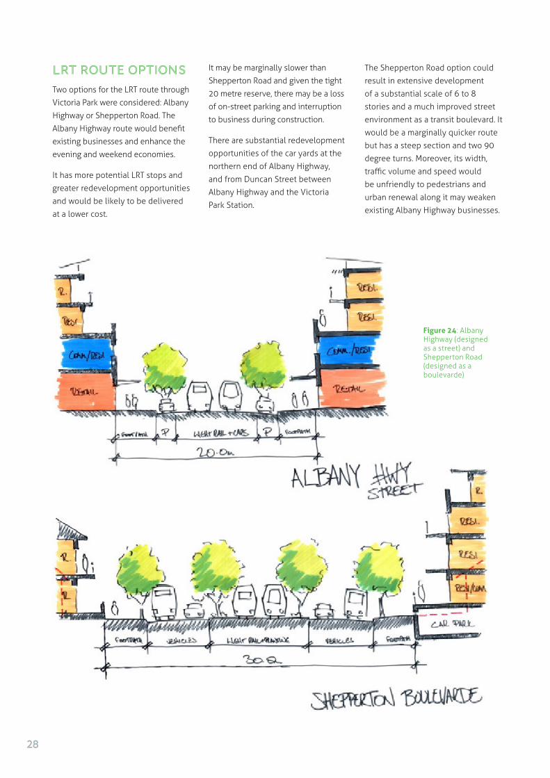
LRT Route Options
Two options for the LRT route through
Victoria Park were considered: Albany
Highway or Shepperton Road. The
Albany Highway route would benefit
existing businesses and enhance the
evening and weekend economies.
It has more potential LRT stops and
greater redevelopment opportunities
and would be likely to be delivered
at a lower cost.
It may be marginally slower than
Shepperton Road and given the tight
20 metre reserve, there may be a loss
of on-street parking and interruption
to business during construction.
There are substantial redevelopment
opportunities of the car yards at the
northern end of Albany Highway,
and from Duncan Street between
Albany Highway and the Victoria
Park Station.
The Shepperton Road option could
result in extensive development
of a substantial scale of 6 to 8
stories and a much improved street
environment as a transit boulevard. It
would be a marginally quicker route
but has a steep section and two 90
degree turns. Moreover, its width,
traffic volume and speed would
be unfriendly to pedestrians and
urban renewal along it may weaken
existing Albany Highway businesses.
Figure 24: Albany Highway (designed as a street) and Shepperton Road (designed as a boulevarde)
28

Figure 25: Shepparton Road designed as a boulevarde with flanking commercial and residential development
Figure 26: Mixed use building proposal with Shepparton Road with boulevarde treatment
29

Albany Highway – Curtin University Route
Albany Highway was chosen as the
preferred route for investigation.
A pedestrian oriented corridor
plan was prepared that includes
LRT stops at approximately 400m
spacings with 11 stops in all, and
3 at Curtin University. Stops were
adjusted to respond to pedestrian-
shed walkability and to respond
to redevelopment opportunities
generated by the pattern of the
surrounding urban development.
Albany Highway was chosen as the preferred route for investigation.
Figure 27: The rhythmic journey from the CBD to Curtin University
Figure 28: Pedestrian sheds around proposed LRT Stops - Albany Highway route - Causeway to Curtin University
30

An overall corridor redevelopment
plan was developed by the South-
east team, commencing with the
Albany Highway redevelopment
opportunities and then envisaging
comprehensive plans for the
Technology Park and Curtin
University.
It was estimated that some 9,500
residential dwelling units and
163,000 square metres of retail,
mixed use and commercial could be
added along the proposed LRT line.
Figure 29: Potential development sites near proposed LRT stops - Causeway to Curtin University
31

Figure 30: Perth LRT South East Causeway Precinct Redevelopment Plan
32

Figure 31: Perth LRT South East Causeway Precinct Sketch
Figure 32: Perth LRT South East Duncan Street Redevelopment Section
33

Figure 33: Perth LRT South East Duncan Street Redevelopment Sketch
Figure 34: Gresham Street Station Plan as a catalyst for car yard redevelopment
34
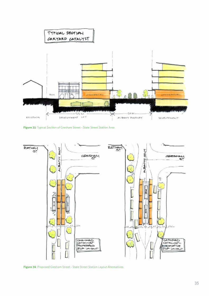
Figure 35: Typical Section of Gresham Street - State Street Station Area
Figure 36: Proposed Gresham Street - State Street Station Layout Alternatives
35

Figure 37: Albany Highway redevelopment opportunities - single lot redevelopment typology
36

Figure 38: Albany Highway redevelopment opportunities - double lot redevelopment typologies
37

Figure 39: ‘Curtilona’ Curtin University site compared with the Barcelona urban grid at the same scale, to indicate its size and scope for development
Figure 40: Curtin University site redevelopment using an urban grid
Curtin University
The large size and consequent substantial
development opportunities at Curtin University
can be revealed by digitally overlaying a
section of Barcelona, Spain over the campus
site – ‘Curtilona’. The gives rise to the potential
of an urban grid based on the new LRT line to
support mixed uses, including education.
38

Figure 41: Curtin University site redevelopment - urban grid sketch
Figure 42a: Curtin University site redevelopment – interface with the technology park
Figure 42b: Curtin University site redevelopment – proposed Dumas Road section
Figure 43a: Curtin University site redevelopment – Curtin Avenue with boulevarde treatment
Figure 43b: Curtin University site redevelopment – Dumas Road LRT stop section
39

40

EXPERTISE/ROLE PARTICIPANT
Facilitators/Urban Designers Steve Thorne
Peter Annand Chris Hair
Transport specialist Chris Stapleton
Urban designer or architect Jeff Thierfelder Naomi Kavanagh
Transport focus Simon Cox Louise Howells Michael Somerville-Brown
Planning focus Mark Bancroft Robina Crook Jeremy Holland Lucian Iocob Michael Murphy Michael Willcock
Engineering focus Christie McKinnon Eamonn O’Lionnain
AUDRC Doina Olarv (UWA)
THE SOUTH WEST LRT is
proposed to enhance travel
options between Perth, the
University of Western Australia and the
major QEII Hospital. The Masterclass
looked at both the transport task in terms
of making LRT an attractive and preferred
choice for commuters and increasing the
density and intensity of land use along
the route.
The objectives for the South West Light
Rail developed by the Masterclass are to:
• Enhance travel options between Perth CBD and UWA, QEII and Kings Park
• Increase the density and intensity of use around these destinations
• Integrate and reconnect the park with the CBD (and with QEII and UWA)
• Make LRT an attractive and preferred choice for commuters
PERTH LRT SOUTH WEST
41

Figure 44: Option 1: Thomas Street Route A and Option 2: Thomas Street Route B via Subiaco
After preliminary investigations,
it was also evident that LRT
could provide an opportunity for
connecting Kings Park with the
city and this was explored through
design.
The State Government’s draft
Transport Plan includes an
Indicative route for the Perth LRT
South West route - through West
Perth then via Thomas Street to QEII
and UWA.
There are several key travel reasons
and destinations along the route:
• UWA/Perth CBD – Academia/business
• QEII/UWA – Teaching hospital synergies
• QEII/Perth CBD – Accessibility to health services
• Perth CBD/Kings Park – 6 million
visitors annually, ready access to CBD
• Metrorail/LRT/Perth Underground CBD and Esplanade
• Kings Park/QEII/UWA – Access hospital and new knowledge village
• Perth visitors/residents/park – improved access
• Perth Waterfront/QEII/UWA – Improved connection and development along the Swan
The UWA (60%) and QEII (30%)
represent the large majority of AM
peak attractions (excluding CBD).
Route AnalysisThe Masterclass tested alternative
route options:
Option: 1
Thomas Street Route which is
the proposed State Government
alignment of locating the LRT
through West Perth and along
Thomas St.
Option 2
Thomas Street Route with LRT
diverting through Subiaco to pick
up additional worker patronage
Option 3
Mounts Bay Road Route to test
a shorter route to UWA and the
QEII and continuing west and
terminating at the Shenton Park
Station to provide rail-LRT transfers
Option 4
Kings Park Route – the possibility
of an alignment through Kings Park
to shorten travel distances and
provide a recreation function for
the proposed LRT
42

Figure 45 : Option 3: Mounts Bay Road Route
Figure 46: Option 4: Kings Park Route
43

Options 1/2: Thomas Street Route
would provide a coherent and
permanent connection between
the CBD, the QEII hospital and the
University of Western Australia. It
would catalyse the formation of
the structure of UWA into an Urban
Village, and provides a substantial
increase in urban residential
accommodation supporting
Directions 2031.
UWA and its neighbouring district
up to the QEII Hospital offer real
potential for dense development on
and off campus, providing student/
worker housing and affordable
housing.
Additionally, middle income people
may be attracted by socio-economic-
demographics of the area and may
well commute to CBD.
Urban Renewal opportunities are
considerable for a variety of mixed-
uses – academic, creative, scientific,
service, leisure, entertainment and
related activities. The development
of a key “centre” or “Creative/
Academic” node at Broadway could
have major social/economic/ place-
making benefits for Perth.
There is moderate growth potential
in West Perth and only a one-sided
catchment along Thomas Street and
high land and development values
indicating limited redevelopment
opportunities in the short and
medium terms.
This route also connects to the
Princess Margaret Hospital site
and will support its possible future
redevelopment.
Option 3: Perth Station/Esplanade
- Mounts Bay Rd - UWA/QEII
integrates with the Esplanade
Station and replaces busses along
Mounts Bay Road.
Option 4: Kings Park Route would
provide a direct connection and
opportunities for non-commuter
use (e.g. tourist and recreation).
The route proposed through Kings
Park is along an already excavated
line to QEII and then UWA and to a
possible new Ferry stop at Crawley.
The number of visitors to Kings Park
is in the millions and the use of
the South West LRT by a fraction of
those visitors would substantially
assist with viability.
Route Option Analysis
The routes were analysed for travel
time, development opportunities,
station walkability and related
factors as follows (Subiaco was
excluded from the second table due
to it’s slow travel time):
Route Travel Times (mins)
1. West Perth 23.5
2. Subiaco 30.5
3. Esplanade/Mounts Bay Rd/UWA-QEII/Shenton Park 24.9
4. Kings Park/St..George’s Terrace 23.9
Travel Legibility Impact Times Development and on other Route (mins) Trips Opportunities Connectivity Transport Total
1. West Perth +1 +1 +1 +1 -1 +3
3. Esplanade/Mounts
Bay Rd/Shenton Park +2 -1 0 +2 -2 +1
4. Kings Park/
St..George’s +1 0 +2 +2 0 +3
Terrace
(+2 excellent to -2 poor)
44

Figure 47: Pedestrian Catchment Analysis Option 1: Thomas Street
45

Figure 48: Pedestrian Catchment Analysis Option 3: Esplanade / Mounts Bay Rd
The analysis indicated:
• In terms of patronage, the West Perth and Subiaco options provide 2-way patronage during peak hours, whereas the Mounts Bay Road and King’s Park options have significant one way ‘tidal’ peak demand.
• Subiaco, whilst not as direct as the other routes, could still work as a connection simply between Subiaco Station and the QEII hospital and the University of Western Australia based on the socio-demographic compatibility. The further connection into the CBD from Subiaco duplicates the railway.
• The Thomas Street route proposed by the State Government is indirect between QEII and UWA with many right-angle turns, resulting in longer travel times. Winthrop Avenue is proposed as an alternative by the Masterclass for fast connection between QEII and UWA. Adjustments were proposed by the Masterclass to improve directness and better support the proposed UWA Urban Village.
• The University would attract morning/evening tidal flows, the QEII Hospital will attract riders all day, as would Kings Park. The residential catchments are one-sided and have limited
redevelopment potential, with stable low density housing which is unlikely to change in the foreseeable future. Consequently the stops on Thomas St can be more widely spaced to assist the speed and timeliness of LRT.
Based on criteria of travel
times, patronage, development
opportunities, legibility and
connectivity and impact on other
transport, the proposed West Perth
Route and Kings Park would be
preferred. The Mounts Bay Rd Route
is already well served by an existing
bus service that provides fast and
direct connection to UWA/QEII
along the waterfront.
46

Figure 49: Pedestrian Catchment Analysis Route 4: Kings Park Route
47

QEII Hospital
Rather than run the light rail within the hospital campus as currently proposed by the Government, it is suggested to
continue the light rail down Winthrop Avenue. This creates an opportunity to create a civic forecourt with sheltered
walkways that connect the light rail station with the hospital.
The redevelopment of key surrounding properties to the south would assist to build up the local population base,
provide diversity of housing and medical related uses in this area, as shown in the following diagrams.
Figure 50: QEII Hospital Plan with LRT stop on Winthrop Avenue
48

UWA Urban Village/West End
The urban village should be
considered as both on and off
campus and as providing for
student housing, worker housing,
and staff housing for the university
and hospital. This will build
self-containment and feed the
LRT system in both directions.
The Urban Village Core around
Broadway can be very significant
as a medium density, mixed-use
precinct (both on and off campus).
Three LRT stops are proposed on
and around the university, starting
with Winthrop Avenue (south
end) which creates urban renewal
prospects for north-east and north-
west of Winthrop Avenue.
The proposal retains the UWA
heritage buildings and spaces. A
‘green-finger’ connection is made
to Kings Park, and taller buildings
are proposed around the tram stop
to frame the view towards the
University and Winthrop Hall. These
proposals to formalise both sides
of Stirling Highway are to have
the effect of providing significant
housing for the University and
breaking the barrier of Stirling
Highway to link the University with
its northern neighbouring areas.
Recognising local sensitivities
to both height and building
typologies, buildings are proposed
to be graduated from 2-3 storeys,
4-6 storeys and some 8 storeys.
The Perth Circle Bus Route too
can gain efficiencies as instead
of having to go up Hampden Rd
and turning around and coming
all the way back out again, it now
has the opportunity of using
newly established street blocks
established by the proposal.
The second LRT stop is proposed on
Clark Street to link into the central
east-west access that currently
defines the heart of the University.
Clark Street between Broadway and
Fairway could become a revitalised
centre for student life as well
as the neighbourhood centre of
this part of Nedlands. In turn this
would support the retail, business
and entertainment uses already
established along Broadway.
The LRT is proposed to be taken
through Myers Street to terminate
at a stop at Hackett Drive so that
it can reach the southern part of
the campus and one day connect
to a Swan River Ferry. Connection
to a ferry further integrates the
transport system. It would also
allow for an alternative route by LRT
from river to ferry terminal to the
university and hospital.
Figure 51: QEII Hospital Forecourt with LRT stop on Winthrop Avenue
49

Figure 52: Plan for University + Density Residential + Mixed-Use Village Centre
50

The estimated development yield
of the UWA Village and surrounds
plans are:
• Residential units – 7,000 units (5,000 university)
• Retail – 5,000m2
• Commercial – 5,000m2
• University – 10,000m2
This provides an opportunity
for a major mixed-use node fed
by university knowledge-based
industries, leisure and hospital/
medical industries to form a partly
self-contained, well connected
Transit Oriented Village.
Figure 54: UWA Urban Village cross sections through Kings Park to Mounts Bay Road
Figure 53: UWA Urban Village with compatible buildings for sensitive residential areas.
Actions, Strategies, Priorities
The Masterclass recommended the
following:
1. Ensure capacity of Perth/Esplanade transport hub for future connection/integration
2. Prepare community engagement strategy
3. Construct LRT via Route 1 or 4 to QEII and UWA
4. Reduce proposed parking station at QEII and direct $90 million to LRT
5. Negotiate funding transfer for bus replacement to bring forward the timing of the LRT
6. Create integrated village/Campus Masterplan to foster delivery of the transit-oriented knowledge based village at UWA.
51

52

ARCHITECTURE OF PLACE
An Approach to Built Form
BUILT FORM is a key consideration
in urban renewal projects within
existing communities. There were
a range of views on approaches
to the inclusion of new buildings
into existing communities along
the proposed LRT lines. Stefanos
Polyzoides outlined that The New
Urbanism perspective is that new
TOD projects should contribute
to complementing existing street
and city block form and local built
character to generate authentic
places.
EXPERTISE/ROLE PARTICIPANT
Facilitators/Urban Designers Chip Kaufman Crystal Olin Xiaojian
Urban designer or architect Mark Johnston Anna Evangelisti
Planning focus Melanie Bradley
AUDRC Patrick Hubble
53

Complexity and variety are key:
• TOD projects should be fitted into existing contexts authentically to ensure continuity of the history of towns and cities;
• New buildings should be designed in conjunction with adjacent existing buildings to generate characterful and distinctive public spaces;
• Diverse types of buildings can include variety of dwelling
units by type and size, and be expressed in an assortment of vernacular and contemporary styles.
Stefanos Polyzoides further advised
that the essential building-scale
design ingredient of TOD is a ‘space-
first strategy’ so that new buildings
embrace the station and LRT right
of ways, and frame them into a
coherent realm of defined public
space:
• Street design should be people friendly including on-street parking, drop off lanes, and slow moving traffic to provide for maximum pedestrian connectivity;
• Buildings in a transit station context should be designed to accommodate a variety of uses over time.
• Ground floors should be activated continuously, with commercial frontages predominating.
• Parking should be placed behind and under buildings, with car entrances located discreetly, to have the least disruption to pedestrian-dominant urban public space.
Urban Typologies
A key concern in urban renewal
is the unpredictable built form
outcome of the R Codes (WA’s
residential development controls).
There is little predictability in
what sort of structures may
emerge. The workshop looked
at building typologies for urban
renewal to generate a wide range
of appropriate building types for
use and re-use in development
and redevelopment along the
transit lines. The concept is for the
generated building types to be
applied and mixed, as appropriate
to each location, to generate the
fabric of street blocks and define
the public realm14.
Figure 55a: Townhouse typology exploration - plan
14The Language of Towns and Cities: A Visual Dictionary; Dhiru A. Thadani : Typology-Architectural by Stefanos Polyzoides
54

Urban Coding
Building types – for living such as
single houses and apartments, for
working such as commercial office
and recreation as well as mixed use
buildings can be coded for building
form rather than metrics such as
setbacks, lot coverage and density.
Form-based codes can regulate
buildings by controlling their
configuration and disposition on
their lot15 and locating appropriate
building types in the right locations,
such as bigger buildings in urban
areas of highest intensity.
Urban coding offers predictability
by establishing the building,
open space, landscape, and
street configurations that deliver
an orderly urban form, by many
development interests, over time.
In order to make codes authentic
and place-specific, they must be
based on existing subdivision
patterns and lot configurations. So
rather than producing a generic set
of building typologies, typologies
should be based on the site
dimensions and characteristics
commonly found in Perth.
In that way they will be responsive
to the essential character of Perth,
and responsive to their relative
place within the overall urban
structure.
Figure 55b: Townhouse typology exploration – vernacular expression
15The Smart Growth Manual; Andres Duany and Jeff Speck with Mike Lyndon
Urban coding offers predictability by establishing the building, open space, landscape, and street configurations that deliver an orderly urban form, by many development interests, over time.
55

Figure 56: Form Based Code – Example of an approach to building types in relation to intensity of location (Stef Polyzoides)
Figure 57: Metro Rail, Del Mar Station, Pasadena. Photo: Stefanos Polyzoides
56

For enquiries please contact the Australian Council for New Urbanism at [email protected]

For enquiries please contact the Australian Council for New Urbanism at [email protected]