public domain lidar: entry-level network system to … events captured at umbc, ... pbl height is...
TRANSCRIPT
Public Domain Lidar: entry-level network system to enable boundary layer studies for the lower troposphere
T. Berkoff1, R. Delgado1, J. Compton1, P. Sawamura1, E. Welton2, and R. Hoff1
1. University of Maryland Baltimore County, Baltimore, Maryland, USA2. NASA Goddard Space Flight Center, Greenbelt, MD, USA
Acknowledgments: Larry Belcher, Seb Stewart, Sonia Cyrus for MPLNET operations. This work would not have been possible without help from UMBC's Monitoring of Atmospheric Pollution (UMAP – NASA NNX08A093G) project, NASA's Micro-Pulse Lidar Network, and UMBC's GEST operating budget. Data source credits: EPA AIRNow, NASA MODIS-Giovanni, UMBC's Air Quality Web Log, NOAA NESDIS GOES Aerosol Smoke Product (GASP), and NOAA HYSPLIT-READY trajectory model.

OUTLINE●Lidar Background
●Tropospheric profiling needs
●Micro-Pulse Lidar Network – Description & Data examples
●Public Domain Lidar (PDL) concept
●Example data from “mini” receiver
●Future Plans & Summary

Lidar (Light Detection and Ranging)
outgoinglightpulses
AtmosphereSmoke, Haze, Dust,
Clouds, Aerosols
backscatter
As each outbound pulse travels through the atmosphere, the resultant scatter is captured by the receiver/detector
The time delay between pulse emission to scatter signal is converted to distance
This allows for a range profile of backscatter to be obtained
Example vertical profile
2.0x10 -31.51.00.50.0Atten. Backscatter, 1/(km*sr)
12
10
8
6
4
2
Altitu
de, k
m
WFOV 1 min. avg. Model Rayleigh
Lidar backscatter image is formedby a series of profiles over time
aerosol
no aerosol
cirrus

Both provide atmospheric profiles of particulate bacskcatter continuously 24-7 providing multi-year records
CALIPSO: global coverage, 16-day repeat cycle can make local studies of short-term dynamics a challenge
MPL: provides profile evolution over time, but at only at specific location
Profiles from both systems enable examination of vertical structure of particulate matter
NASA aerosol lidars big and small ...CALIPSO satellite: $223 million Ground-based MPL: $0.1 million
Image credit:NASA LARC Photo credit: Michael Ives

The National Research Council
NRC report: “As a high infrastructure priority, federal agencies and their partners should deploy lidars and radio frequency profilers nationwide at approximately 400 sites to continually monitor lower tropospheric conditions.”
Need for lower troposphere profiling is widely recognized .....
In the U.S.!
Bosenberg & Hoff WMO report # 178GALIONThe Global Atmosphere Watch Aerosol Lidar Observation Network
2010 workshop participantshttp://alg.umbc.edu/galion/
“Network of networks”
GALION sites

MPLNET Sites: 2000 - currentMicro Pulse Lidar
Photo credit: Michael Ives
Micro-Pulse Lidar Network (see: mplnet.gsfc.nasa.gov)
Five sitesIn the U.S.:2 in MD1 in NH1 in MT1 in CA
* Global network run by NASA-GSFC with site partners around the world* Portable eye-safe lidars operating at 532 nm* Currently 18 active sites, standardized instrument & data processing* Provides continuous (24-7) multi-year records of vertical profiles* Satellite & model validation, direct and indirect climate effects * Aerosol climate and air quality model validation

Micro-Pulse Lidar Network (MPLNET)MPLNET Data Products
Example of MPLNET Level 1 Data: Atmospheric Structure
Alti
tude
(km
)
Time UTC
Publicly accessible data-base with calendar based selection, custom display, and file downloads
Data display & download tool
Daily lidar profiles & images
Layer heights & feature mask
Higher-level aerosol opticalproperties
Cirrus Clouds
Transported Aerosol
Boundary layer & near surface aerosols
All data are publicly available in netcdf format. Errors included for all data products.
For detailed information of data products: mplnet.gsfc.nasa.gov
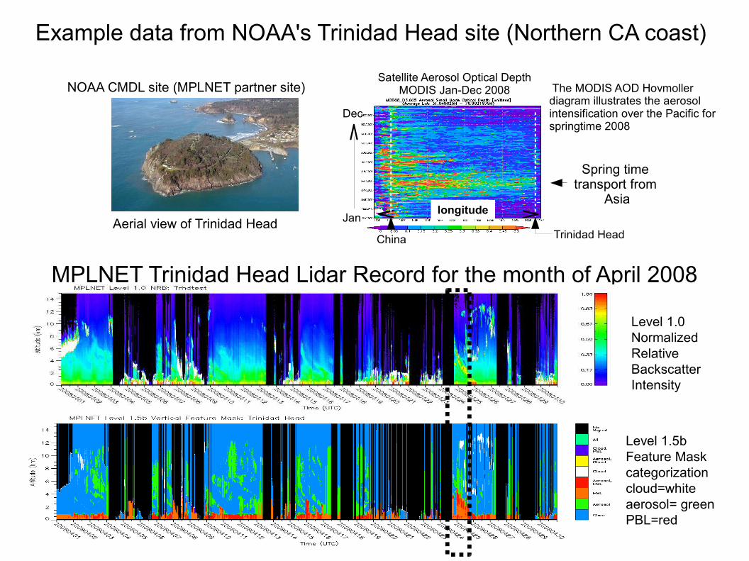
MPLNET Trinidad Head Lidar Record for the month of April 2008
Level 1.0Normalized RelativeBackscatter Intensity
Level 1.5bFeature Maskcategorizationcloud=whiteaerosol= greenPBL=red
Aerial view of Trinidad Head
Example data from NOAA's Trinidad Head site (Northern CA coast)
NOAA CMDL site (MPLNET partner site)
Spring time transport from
Asia
The MODIS AOD Hovmoller diagram illustrates the aerosol intensification over the Pacific for springtime 2008
longitude
Satellite Aerosol Optical DepthMODIS Jan-Dec 2008
Trinidad HeadJan
Dec
China

Lidar can provide the link between satellite and surface observationsIntercontinental transport case: April 25, 2008 Trinidad Head data
NOAA GASP imageHigh column AOD levels April 24
April 26-27
MODIS True Color Image
MPLNET profile image
NOAA CMDL Surface measurements
Satellite
April 24, 2008
CN# conc
Lightabsorption
Angstromexponent
Lightscattering
Data courtesy Andrews, NOAA

MPL + site equipment = ~$150,000 per site
400 sites x 0.15 = $60 million of equipment
Micro-Pulse Lidar not originally designed specifically for lower troposphere and near surface measurements
Near-surface calibrations are problematic, generating quality-assured data is labor intensive
“Mini”receiver
MPL
Side View Top View
MPLNET has been using a “wide-field” small diameter receiver to recover near-range signals
Significantly reduces near-range complexities by using wide-field optics, but at the expense of increased noise during daytime
If only lower troposphere is needed, mini-receiver type approach is suitable for use as a stand-alone lidar system, much simpler and lower cost than MPL
The MPL is useful however ....

“Public Domain” Lidar
Approach:● A new, simple lidar system● Can be replicated by groups new to lidar● Ease of construction, alignment & calibration
(i.e. “Heathkit” approach)● Low cost ( less than $35K parts cost)● Suitable for autonomous operations (i.e. eye-safe
output)●
Broad-base benefits:● A public-domain design benefits everyone ● Increases # sites for air quality and atmospheric
studies● Compliments commercial systems (near-IR
ceilometers, MPLs)● Additional source for validation of forecasting
models● Provides more direct technology education for
future scientists in the field
Public Domain Designhardware & software
Universities& Researchcommunity
Federal & State Agencies
CommercialSector
Open-source software benefits broad-based community, open-source hardware can too ...

UMBC's Monitoring of Atmospheric Pollution (UMAP)Air quality analysis and testbed facility(See Delgado et al., Thursday Remote Sensing Session)
●Recently augmented by a major NASA grant
●Five lidar systems●MPLNET & AERONET site●Radiosonde●Surface measurements:
NephelometerBAMSTEOMPartisol
The “Mini-receiver” has been in operation at UMBC for calibration and automated day/night data collection for past 6 months
Pollution events captured at UMBC, Mini-receiver data on subsequent slides used to illustrate what can be done (30 min. temporal, 30 meter vertical resolutions)
However, signal was attenuated by a factor of ~ 10 to avoid daytime detector saturation
A “Pubic Domain” lidar would be designed to avoid this extra attenuation and significantly improve performance over examples shown
http://alg.umbc.edu/umap/

“Mini” receiver measurement during July 2010 air quality event @ Baltimore
July 1 to July 14, 2010”mini” NRB lidar image (30 m vert., 30 min. temporal resolution),
July 2, 00:00 UTC July 7, 00:00 UTC
July 5 PM2.5AQI
View of BaltimoreFrom UMBC
pollution events
Multiple “Code Orange” AQI events
View of BaltimoreFrom UMBC
AERONETSize distribution
Airnow mapBaltimore Baltimore?

6.5
6.0
5.5
5.0
x10-3
06:007/3/2010
12:00 18:00 00:007/4/2010
dat
The “mini” receiver measurement on July 3, 2010 ●Intrusion of Canadian forest fire smoke contributing to pollution event●Near-range “mini” receiver signals can more easily be related to surface measurements
“mini” receiver
Back-trajectories*
smoke
Near-range backscatter
NephelometerSurface meas*
Surfacesignal
*From Sawamura et al., MDE report, 2011

Signal above PBL can be used as a proxy for PBL optical thickness“Mini-receiver” measurement July 5, 2010
Derived AOD from free-troposphere (molecular) backscatter signal
MPLNET-MPL derived AOD
mini-receiver
If free troposphere signal above aerosol can be obtained, aerosol optical depth determination and other inversion techniques can be applied to help determine aerosol type (Dust v. smoke, etc.)

“Mini” receiver data: automated retrieval of aerosol layer top
Mini-receiver data 11-14 June 2010 with UMBC's “PBL” retrieval appliedCompton et al., 2011
PBL height is important for improved air quality assessment and forecasting.

The “mini-receiver” data used here is a very conservative demonstration, the “public domain” system would yield even better daytime S/N performance
With modest design changes,30 minute time average can approach same performance for an MPL at a 1 minute time average
Daytime measurements of high altitude weak aerosols & very thin cirrus will remain a challenge, but system is still well suited for lower troposphere studies Low B
Low AODHigh B
High AOD
Altit
ude,
km
Performance study from Sept 22, 2010 dataand model prediction, comparison between:
MPL at 1 min. average (Blue)Mini Receiver 30 min. average (Green)Public Domain 30 min. average (Red)
Public Domain
Nighttime
DaytimeHigh backgroundHigh AOD (0.46)
“Public Domain” Lidar
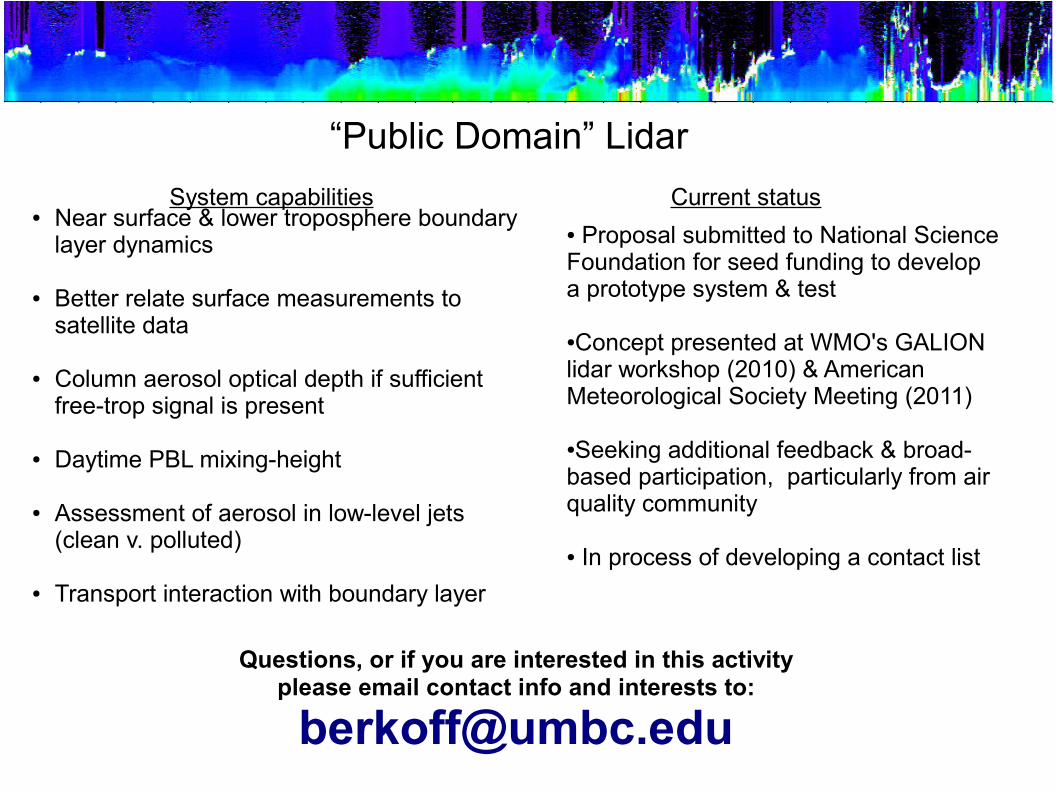
● Proposal submitted to National Science Foundation for seed funding to develop a prototype system & test
●Concept presented at WMO's GALION lidar workshop (2010) & American Meteorological Society Meeting (2011)
●Seeking additional feedback & broad-based participation, particularly from air quality community
● In process of developing a contact list
“Public Domain” Lidar
Questions, or if you are interested in this activity please email contact info and interests to:
● Near surface & lower troposphere boundary layer dynamics
● Better relate surface measurements to satellite data
● Column aerosol optical depth if sufficient free-trop signal is present
● Daytime PBL mixing-height
● Assessment of aerosol in low-level jets (clean v. polluted)
● Transport interaction with boundary layer
System capabilities Current status
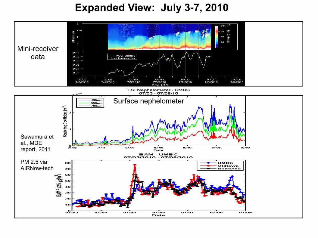
Expanded View: July 3-7, 2010
Sawamura et al., MDE report, 2011
PM 2.5 via AIRNow-tech
Surface nephelometer
Mini-receiverdata