preliminary site investigation · report shall provide a preliminary assessment of any site...
TRANSCRIPT

31st July 2013 Preliminary Site Investigation, Ref: ES5550 Property: 77 Ridge Street, Gordon NSW Page 1 of 29
© Aargus Pty Ltd
PRELIMINARY SITE INVESTIGATION
13 Mount Street, Mount Druitt NSW
Prepared for
Blue Fountain Trust C/- Marchese Partners International Pty Ltd
9th July 2019 Report No: ES7665/2

9th July 2019 Preliminary Site Investigation, Ref: ES7665/2 Property: 13 Mount Street, Mount Druitt NSW Page 2 of 29
© Aargus Pty Ltd
CONTROLLED DOCUMENT DISTRIBUTION AND REVISION REGISTER
DISTRIBUTION LIST
Copy No. Custodian Location ___________________________________________________________________________ 1 Nick Kariotoglou Aargus Pty Ltd (Library) 2 Blue Fountain Trust C/- Marchese Partners International Pty Ltd
Note: This distribution list identifies the current custodians of controlled copies of the subject document. It is expected that these custodians would be responsible for:
• the storage of the document • ensuring prompt incorporation of amendments • making the document available to pertinent personnel within the organization • encouraging observance of the document by such personnel • making the document available for audit
DOCUMENT HISTORY
Document No. Revision No. Issue Date Description ___________________________________________________________________________ ES7665/2 0 09/07/2019 Initial Issue
Approved for release by:
Mark Kelly Environmental Manager
Date: 9th July 2019

9th July 2019 Preliminary Site Investigation, Ref: ES7665/2 Property: 13 Mount Street, Mount Druitt NSW Page 3 of 29
© Aargus Pty Ltd
TABLE OF CONTENTS
TABLE OF CONTENTS ................................................................................................................................... 3
LIST OF TABLES .............................................................................................................................................. 4
LIST OF FIGURES ............................................................................................................................................ 4
LIST OF APPENDICES .................................................................................................................................... 5
ABBREVIATION ............................................................................................................................................... 6
EXECUTIVE SUMMARY ................................................................................................................................ 7
1 INTRODUCTION ................................................................................................................................... 9
1.1 BACKGROUND .................................................................................................................................... 9
1.2 OBJECTIVE........................................................................................................................................... 9
1.3 SCOPE OF WORKS ............................................................................................................................ 10
2 SITE IDENTIFICATION AND DESCRIPTION ............................................................................... 11
2.1 SITE IDENTIFICATION ..................................................................................................................... 11
2.2 SITE INSPECTION ............................................................................................................................. 12
2.3 TOPOGRAPHY AND SURFACE WATER DRAINAGE .................................................................. 13
2.4 SURROUNDING LAND USES .......................................................................................................... 13
3 SITE HISTORY ..................................................................................................................................... 14
3.1 LAND TITLES .................................................................................................................................... 14
3.2 AERIAL PHOTOGRAPHS ................................................................................................................. 16
3.3 EPA RECORDS ................................................................................................................................... 16
3.4 SECTION 149 CERTIFICATES ......................................................................................................... 17
3.5 FORMER INDUSTRIAL PROCESSES AND PRODUCTS MANUFACTURED ............................ 17
3.6 FORMER & CURRENT CHEMICAL STORAGE AND TRANSFER AREAS ................................ 17
3.7 PRODUCT SPILL & LOSS HISTORY ............................................................................................... 18
3.8 DISCHARGES TO LAND, WATER AND AIR ................................................................................. 18
3.9 COMPLAINTS HISTORY .................................................................................................................. 18
3.10 HISTORICAL USE OF ADJACENT LAND ...................................................................................... 18
4 ENVIRONMENTAL SETTING .......................................................................................................... 19
4.1 SENSITIVE ENVIRONMENTAL RECEPTORS ............................................................................... 19
4.2 SOIL ..................................................................................................................................................... 19
4.3 GEOLOGY .......................................................................................................................................... 19
4.4 ACID SULFATE SOILS...................................................................................................................... 20
4.5 HYDROGEOLOGY ............................................................................................................................ 20
4.6 LOCAL METEOROLOGY ................................................................................................................. 21
5 AREAS OF POTENTIAL ENVIRONMENTAL CONCERN ........................................................... 22
6 PRELIMINARY CONCEPTUAL SITE MODEL .............................................................................. 23
6.1 CONCEPTUAL SITE MODEL ........................................................................................................... 23
7 CONCLUSIONS AND RECOMMENDATIONS ............................................................................... 26
LIMITATIONS ................................................................................................................................................. 27
REFERENCES ................................................................................................................................................. 29

9th July 2019 Preliminary Site Investigation, Ref: ES7665/2 Property: 13 Mount Street, Mount Druitt NSW Page 4 of 29
© Aargus Pty Ltd
LIST OF TABLES
Table 1: Site Identification.................................................................................................11
Table 2: Surrounding Land Uses .......................................................................................13
Table 3: Land Title Information ........................................................................................14
Table 4: Summary of Historical Aerial Photos ..................................................................16
Table 5: Summary of Groundwater Monitoring Bores ......................................................20
Table 6: Summary of Potential Areas and Contaminants of Concern ...............................22
Table 7: Conceptual Site Model ........................................................................................24
LIST OF FIGURES
Figure 1: Site Locality
Figure 2: Site Lot and DP Numbers
Figure 3: Site Features
Figure 4: Construction Layout
Figure 5: Expected Groundwater Flow Direction
9th July 2019 Preliminary Site Investigation, Ref: ES7665/2 Property: 13 Mount Street, Mount Druitt NSW Page 5 of 29
© Aargus Pty Ltd
LIST OF APPENDICES
APPENDIX A: SITE PLANS
APPENDIX B: PROPOSED DEVELOPMENT PLANS
APPENDIX C: SITE PHOTOGRAPHS
APPENDIX D: LAND TITLES
APPENDIX E: AERIAL PHOTOGRAPHS
APPENDIX F: NSW EPA RECORDS
APPENDIX G: GROUNDWATER BORE SEARCH
APPENDIX H: LOCAL METEOROLOGY
APPENDIX I: IMPORTANT INFORMATION ABOUT YOUR REPORT
9th July 2019 Preliminary Site Investigation, Ref: ES7665/2 Property: 13 Mount Street, Mount Druitt NSW Page 6 of 29
© Aargus Pty Ltd
ABBREVIATION
ADWG Australian Drinking Water Guidelines ANZECC Australian and New Zealand Environment and Conservation Council AST Aboveground Storage Tank BGL Below Ground Level BTEX Benzene, Toluene, Ethyl benzene and Xylene COC Contaminants of Concern DLWC Department of Land & Water Conservation DNR Department of Natural Resources DQOs Data Quality Objectives POEO Protection of the Environment Operations DSI Detailed Site Investigation EPA Environment Protection Authority ESA Environmental Site Assessment HIL Health-Based Soil Investigation Level LGA Local Government Area NEHF National Environmental Health Forum NEPC National Environmental Protection Council NEPM National Environmental Protection Measure NHMRC National Health and Medical Research Council OCP Organochlorine Pesticides OPP Organophosphate Pesticides PAH Polycyclic Aromatic Hydrocarbon PCB Polychlorinated Biphenyl PID Photo Ionisation Detector PQL Practical Quantitation Limit PSH Phase Separated Hydrocarbon PSI Preliminary Site Investigation QA/QC Quality Assurance / Quality Control RAC Remediation Acceptance Criteria RAP Site Remediation Plan RPD Relative Percentage Difference SAC Site Assessment Criteria SCID Stored Chemical Information Database SEPP State Environment Planning Policy SMP Site Management Plan SVC Site Validation Criteria TCLP Toxicity Characteristics Leaching Procedure TPH Total Petroleum Hydrocarbons TRH Total Recoverable Hydrocarbons UCL Upper Confidence Limit UST Underground Storage Tank VOC Volatile Organic Compounds VHC Volatile Halogenated Compounds

9th July 2019 Preliminary Site Investigation, Ref: ES7665/2 Property: 13 Mount Street, Mount Druitt NSW Page 7 of 29
© Aargus Pty Ltd
EXECUTIVE SUMMARY
Aargus Pty Ltd (‘Aargus’) was appointed by Blue Fountain Trust C/- Marchese Partners
International Pty Ltd (the ‘client’) to undertake a Preliminary Site Investigation (PSI) within
the property located at 13 Mount Street, Mount Druitt NSW (the ‘site’). The eastern portion
of the site is proposed to be partially redeveloped into a six-storey commercial building with
three levels of basement car parking, whilst the western portion of the site is to be retained for
existing commercial uses.
A PSI was requested by the Council to determine the potential for onsite contamination. This
report shall provide a preliminary assessment of any site contamination and, if required,
provide a basis for a more detailed investigation.
At the time of the inspection (26th June 2019), the majority of the site was occupied by one
large building across the northern half of the site, whilst a concrete/bitumen driveway/car
parking area occupied the southern half of the site.
The land title information provided suggested that the site was owned by various government
agencies from 1970 to 1989, then private owners between 1989 and 2005. The site was
owned by to ING Management Ltd from 2005 to 2009, Blacktown City Council between
2009 and 2012, AET Structured Finance Services Pty Limited from 2012 to 2017, and finally
acquired by Angel Buck Investments Pty Ltd from 2017 to the current date.
The findings of the assessment indicated the following areas of potential environmental
concern those being importation of uncontrolled fill; car park areas; the adjoining service
station operations; and asbestos based building materials.
The contaminants that may be present in some of these areas were considered to be of low to
moderate significance in terms of risk to the human and environmental receptors identified.
Therefore, a Detailed Site Investigation (DSI) is required to confirm the presence and extent
of contamination in order to determine the suitability of the site for the proposed development
application and to address the data gaps identified. It is also recommended that a hazardous
material assessment be undertaken followed by an asbestos clearance certificate.

9th July 2019 Preliminary Site Investigation, Ref: ES7665/2 Property: 13 Mount Street, Mount Druitt NSW Page 8 of 29
© Aargus Pty Ltd
Based on the information collected during this investigation and in reference to Clause 7 (DA
development of SEPP 55), the site will be suitable subject to the completion of a Detailed
Site Investigation (and after remediation and validation, if required) for the proposed
commercial development.

9th July 2019 Preliminary Site Investigation, Ref: ES7665/2 Property: 13 Mount Street, Mount Druitt NSW Page 9 of 29
© Aargus Pty Ltd
1 INTRODUCTION
1.1 Background
Aargus Pty Ltd (‘Aargus’) was appointed by Blue Fountain Trust C/- Marchese Partners
International Pty Ltd (the ‘client’) to undertake a Preliminary Site Investigation (PSI) within
the property located at 13 Mount Street, Mount Druitt NSW (the ‘site’). The location of the
property is presented in Figure 1 of Appendix A.
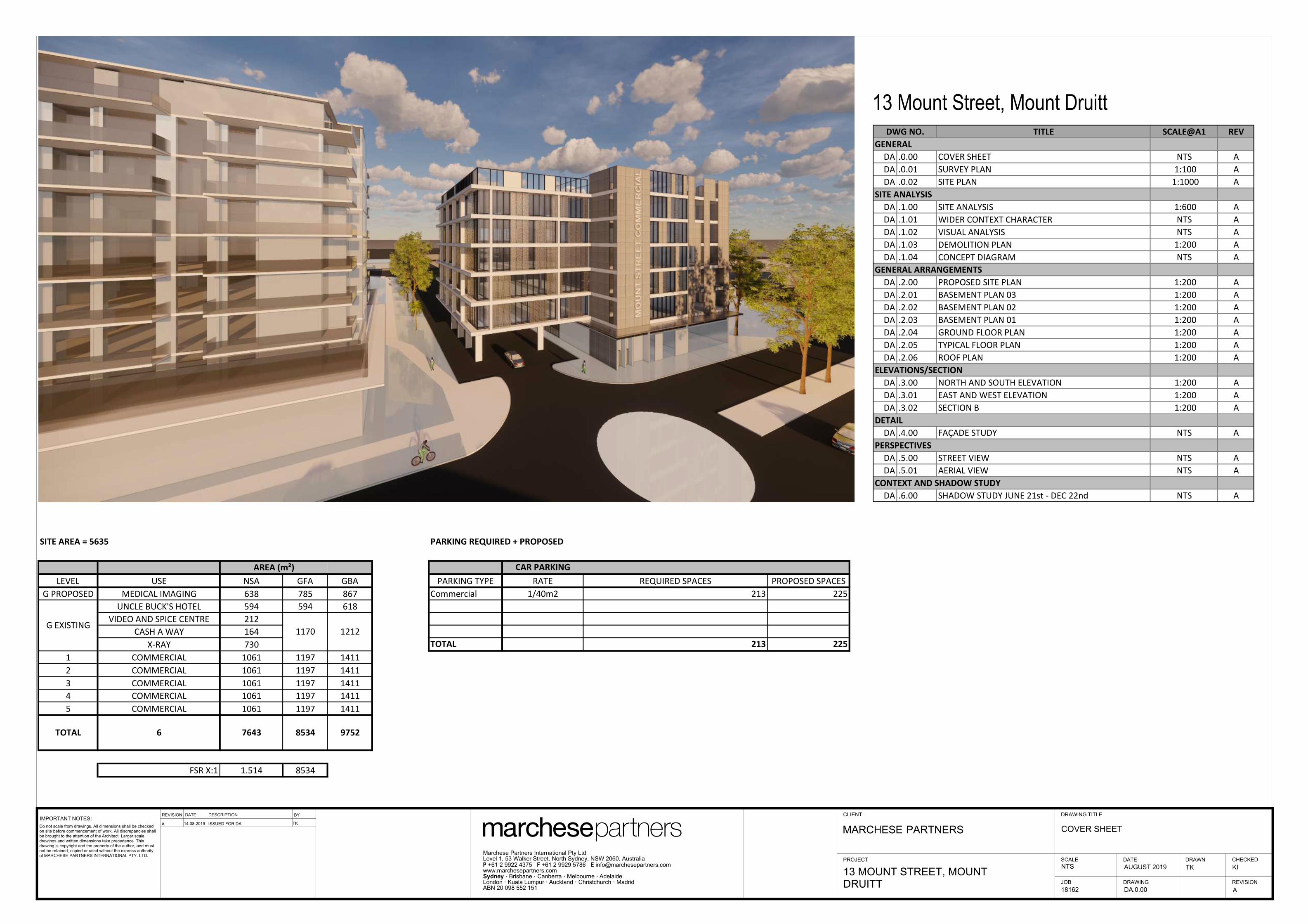
It is understood that the site is proposed for the partial demolition of the eastern most portion
of the existing building and redeveloped into a six-storey commercial building with three
levels of basement car parking, whilst the western portion of the site is to be retained for
existing commercial uses. The proposed development plans can be found in Appendix B and
the proposed construction layout is shown in Figure 4 of Appendix A.
A site investigation was requested by Council to determine the potential for onsite
contamination as part of the Development Application (DA).
1.2 Objective
The primary objectives of this PSI are as follows:
• Identify potential areas where contamination may have occurred from current and
historical activities;
• Identify potential contaminants associated with potentially contaminating activities;
• Assess the potential for soils and groundwater to have been impacted by current and
historical activities; and
• Assess the suitability of the site for redevelopment into a six-storey commercial
building with three levels of basement car parking, based on its current condition and
the findings of this investigation.

9th July 2019 Preliminary Site Investigation, Ref: ES7665/2 Property: 13 Mount Street, Mount Druitt NSW Page 10 of 29
© Aargus Pty Ltd
1.3 Scope of Works
The scope of works for this PSI includes:
• Review of the physical site setting and site conditions based on a site inspection,
including research of the location of sewers, drains, holding tanks and pits, spills,
patches of discoloured vegetation, etc. (where applicable);
• Research and review of the information available, including current and historical
titles information, review of aerial photographs, groundwater bore searches, EPA
notices, anecdotal evidence, site survey and site records on waste management
practices;
• Development of a preliminary Conceptual Site Model (CSM) to demonstrate the
interactions between potential sources of contamination, exposure pathways and
human/ecological receptors identified; and
• Recommendations for additional investigations should any data gaps be identified or
possible strategies for the management of the site, where relevant.
This report was prepared with reference to the NSW Environment Protection Authority
(EPA) "Guidelines for Consultants Reporting on Contaminated Sites" (2011).

9th July 2019 Preliminary Site Investigation, Ref: ES7665/2 Property: 13 Mount Street, Mount Druitt NSW Page 11 of 29
© Aargus Pty Ltd
2 SITE IDENTIFICATION AND DESCRIPTION
2.1 Site Identification
Site identification information and land use is summarised in the table below.
Table 1: Site Identification
Lot and DP Number
(Address) 1Lot 1 in DP1119915 (13 Mount Street, Mount Druitt NSW)
Coordinates 1
NE: Latitude: -33.765946, Longitude: 150.824739
NW: Latitude: --33.765765, Longitude: 150.823394
SE: Latitude: -33.766334, Longitude: 150.824605
SW: Latitude: -33.766164, Longitude: 150.823318
Approx. Site Area 1 5,631m2
Approx. Construction Area 2,277m2
Local Government Area City of Blacktown
Parish Rooty Hill
County Cumberland
Current Land Zoning 2 B4 Mixed Use
Site End Users Workers, Visitors
Notes: 1 https://maps.six.nsw.gov.au/
2 http://maps.blacktown.nsw.gov.au/
The site boundary and Lot and DP numbers are presented in Figure 2 of Appendix A, whilst
the construction layout of the site is presented in Figure 4 of Appendix A.

9th July 2019 Preliminary Site Investigation, Ref: ES7665/2 Property: 13 Mount Street, Mount Druitt NSW Page 12 of 29
© Aargus Pty Ltd
2.2 Site Inspection
A site visit was carried out on Wednesday 26th June 2019 by an Aargus field scientist to
inspect the site for any potential sources of contamination and document any observations
made regarding the current site conditions. At the time of the site inspection, the following
observations were made:
• The site is almost rectangular in shape.
• The majority of the site was occupied by one large building across the northern half of
the site, whilst a concrete/bitumen driveway/car parking area occupied the southern
half of the site.
• The building was utilised as a Hotel, medical centre, cash loans office, employment
service offices, and fast food restaurants.
• The driveway / car parking area was concrete/bitumen sealed, generally in a good
condition with minor cracks and oil staining.
• A concrete drive accessway was located in the centre of the building.
• A Caltex service station was located on the adjoining north eastern property.
• Entrance to the site was from the concrete/bitumen driveway along Mount Street on
the eastern side and a car park on the western side.
• The site boundaries were defined by the building to the north and a grass area and
construction site to the south. The eastern and western boundaries were defined by the
building and open access ways.
• No surface standing water was noticed at the site, with multiple drainage pits observed
in the car park / drive way areas.
• No USTs were observed on the site.
The site features are presented in Figure 3 of Appendix A. Site photographs are included in
Appendix C.

9th July 2019 Preliminary Site Investigation, Ref: ES7665/2 Property: 13 Mount Street, Mount Druitt NSW Page 13 of 29
© Aargus Pty Ltd
2.3 Topography and Surface Water Drainage
The following observations were made during the site inspection carried out on Wednesday
26th June 2019:
• The site is slightly sloping from the western and eastern boundaries towards the centre
of the site.
• Stormwater runoff from the site is expected to flow towards the stormwater drainage
at the centre of the site.
• According to the topographic map of Mount Druitt, the general slope of the area is
towards the south west of the site with the site at a higher elevation.
2.4 Surrounding Land Uses
The surrounding land uses identified are described in the table below:
Table 2: Surrounding Land Uses
Orientation Description
North West Bitumen car park of a commercial office property
North East Caltex service station
South West Grassed area then Mission Australia
South Central Grassed area then a childcare centre
South East Grassed area then a construction site
East Mount Street then a construction site
West Bitumen car park of a commercial property

9th July 2019 Preliminary Site Investigation, Ref: ES7665/2 Property: 13 Mount Street, Mount Druitt NSW Page 14 of 29
© Aargus Pty Ltd
3 SITE HISTORY
3.1 Land Titles
A review of historical documents held at the NSW Department of Lands offices was
undertaken to identify the current and previous land owners, and potential land uses. The
results of the title search are summarised in the following table.
Table 3: Land Title Information
Year Lot 1 in DP1119915
2017-Current Angel Buck Investments Pty Ltd
2012-2017 AET Structured Finance Services Pty Limited
2009-2012 Blacktown City Council
2007-2009 ING Management Ltd
Year Lot 334 in DP866350
2005-2007 ING Management Ltd
1997-2005 Antonio Falcone and Mario Falcone
Year Lot 332 in DP771684
1993-1997 Antonio Falcone and Mario Falcone
1989-1993 Antonio Falcone, Mario Falcone, Raymond Nasso and Mario
Nasso
1987-1989 Minister Administering The Environmental Planning and
Assessment Act 1974
Year Lot 333 in DP771684
1993-1997 Antonio Falcone and Mario Falcone
1990-1993 Antonio Falcone, Mario Falcone, Raymond Nasso and Mario
Nasso
1987-1990 Minister Administering The Environmental Planning and
Assessment Act 1974
Prior Titles: Vol 13555 Fol 176
1978-1987 New South Wales Planning and Environment Commission
Prior Titles: Vol 12928 Fol 43
1975-1978 New South Wales Planning and Environment Commission
Prior Titles: Vol 12115 Fol 241
1975-1975 New South Wales Planning and Environment Commission
1973-1975 The State Planning Authority of NSW
Prior Titles: Vol 11903 Fol 216
1972-1973 The State Planning Authority of NSW

9th July 2019 Preliminary Site Investigation, Ref: ES7665/2 Property: 13 Mount Street, Mount Druitt NSW Page 15 of 29
© Aargus Pty Ltd
Prior Titles: Vol 11255 Fol 92
1970-1972 The State Planning Authority of NSW
Year Lot 34 in DP250595
1987-1987 Minister Administering The Environmental Planning and
Assessment Act 1974
Prior Titles: Vol 12928 Fol 44
1975-1978 New South Wales Planning and Environment Commission
Prior Titles: Vol 12115 Fol 241
1975-1975 New South Wales Planning and Environment Commission
1973-1975 The State Planning Authority of NSW
Prior Titles: Vol 11903 Fol 216
1972-1973 The State Planning Authority of NSW
Prior Titles: Vol 11255 Fol 92
1970-1972 The State Planning Authority of NSW
In summary, the land title information provided suggested that the site was owned by various
government agencies from 1970 to 1989. Antonio Falcone, Mario Falcone, Raymond Nasso
and Mario Nasso owned the site between 1989 and 1993. The site was owned by Antonio
Falcone, Mario Falcone 1993 to 2005. The site was owned by to ING Management Ltd from
2005 to 2009. Blacktown City Council owned the site between 2009 and 2012. The site was
owned by AET Structured Finance Services Pty Limited from 2012 to 2017.The site was
acquired by Angel Buck Investments Pty Ltd from 2017 to the current date. Based on Aerial
Photographs from 1977 the land appears to be vacant. Hence, land title information prior to
1970 was not researched.
A copy of the land titles information obtained by Aargus can be found in Appendix D.
9th July 2019 Preliminary Site Investigation, Ref: ES7665/2 Property: 13 Mount Street, Mount Druitt NSW Page 16 of 29
© Aargus Pty Ltd
3.2 Aerial Photographs
Selected aerial photographs obtained from the NSW Department of Lands were reviewed to
describe the site features and surrounding areas at various timelines. A summary of the
review is presented in the table below.
Table 4: Summary of Historical Aerial Photos
Year Site Surrounding areas
1977 The site is a vacant tree covered block of land. N: A road, then vacant tree covered land
S: A road, then vacant tree covered land
E: A road, then vacant tree covered land
W: A road, Commercial buildings and tree
covered land
2004 The northern portion of the site is occupied by a
commercial building, whilst the southern
portion by a concrete/bitumen driveway and car
park.
N: A road, then industrial/commercial buildings
S: A vacant site with grass bed, then a road
E: A road, then industrial/commercial building
W: An commercial site with car park
In summary, land use of the site and the adjoining properties appeared to have been initially
vacant land till at least 1977 and then redeveloped into industrial/commercial land uses.
Copies of current and historical aerial photographs are presented in Appendix E.
3.3 EPA Records
3.3.1 CLM Act 1997
The NSW EPA publishes records of contaminated sites under Section 58 of the Contaminated
Land Management (CLM) Act 1997. The notices relate to investigation and/or remediation
of site contamination considered to pose a significant risk of harm under the definition in the
CLM Act. However, it should be noted that the EPA record of Notices for Contaminated
Land does not provide a record of all contaminated land in NSW.

9th July 2019 Preliminary Site Investigation, Ref: ES7665/2 Property: 13 Mount Street, Mount Druitt NSW Page 17 of 29
© Aargus Pty Ltd
The subject site, that being 13 Mount Street, Mount Druitt NSW, is not recorded on the list of
NSW contaminated sites notified to the NSW EPA.
Copies of the EPA records are included in Appendix F.
3.3.2 POEO Register
A search of the POEO Register revealed that the site was not listed. However, there is a
record of 75 Railway Street, Mount Druitt NSW (Mount Druitt Hospital) located more than
half a kilometre away from the site.
A copy of the POEO register search and the Licence Numbers is included in Appendix F.
3.4 Section 149 Certificates
Section 149 Certificates were not available at the time of writing this report.
3.5 Former Industrial Processes and Products Manufactured
Based on the site inspection, it is unlikely that any industrial processes and activity would
have previously occurred on site.
3.6 Former & Current Chemical Storage and Transfer Areas
No major chemical storage and transfer areas were identified based on the historical searches
and site inspection.

9th July 2019 Preliminary Site Investigation, Ref: ES7665/2 Property: 13 Mount Street, Mount Druitt NSW Page 18 of 29
© Aargus Pty Ltd
3.7 Product Spill & Loss History
The majority of the site is currently occupied by commercial stores and sealed with
concrete/bitumen. At the time of the inspection, the sealed surfaces were generally in good
condition with minor cracking and some oil staining noted.
3.8 Discharges to Land, Water and Air
No discharges to the land, water and air were observed.
3.9 Complaints History
There was no information obtained or provided indicating any relevant complaint history
pertaining to the site.
3.10 Historical Use of Adjacent Land
Aerial photography indicated the adjoining properties appeared to have been vacant in 1977
and developed into a commercial site to the current date.

9th July 2019 Preliminary Site Investigation, Ref: ES7665/2 Property: 13 Mount Street, Mount Druitt NSW Page 19 of 29
© Aargus Pty Ltd
4 ENVIRONMENTAL SETTING
4.1 Sensitive Environmental Receptors
The nearest watercourse is South Creek located approximately 5.4km to the west of the site.
There is a TAFE college located south east of the site and a hospital located north east of the
site.
4.2 Soil
The Soil Landscape Map of Penrith (soil Landscape Series Sheet 9030, Scale 1:100,000,
1989), prepared by the Soil Conservation Service of NSW, indicates that the site is located
within the Blacktown landscape area and typically consists of highly plastic and relatively
impermeable residual soil.
4.3 Geology
The Geological Map of Penrith (Geological Series Sheet 9030, Scale 1:100,000, Edition 1,
1991), published by the Department of Minerals and Energy indicates the residual soils
within the site to be underlain by Triassic Age Shale of the Wianamatta Group, comprising
shale, carbonaceous claystone, claystone, laminite, fine to medium grained lithic sandstone,
rare coal and tuff.
Aargus Chameleon undertook a Geotechnical investigation for the site on the 27th and 28th
June 2019 (Chameleon Geoscience, Geotechnical Investigation Report, 13 Mount St, Mount
Druitt NSW, Ref: GS7665), with the following profile observed:
• Residual Soil - CLAY to Silty CLAY, high plasticity, orange to red brown + grey
shale gravel
• Bedrock - SHALE, grey, extremely weathered, extremely low strength, with clay
seams.

9th July 2019 Preliminary Site Investigation, Ref: ES7665/2 Property: 13 Mount Street, Mount Druitt NSW Page 20 of 29
© Aargus Pty Ltd
4.4 Acid Sulfate Soils
To determine whether there is a potential for acid sulphate soils to be present within a site,
reference was made to the NSW Department of Land & Water Conservation (DLWC) but no
Acid Sulfate Soil Risk Map was available.
The NSW Government Planning & Environment website has no information regarding the
occurrence of acid sulfate soil material within the soil profile of the site
(https://www.planningportal.nsw.gov.au/spatialviewer/#/find-a-property/address).
4.5 Hydrogeology
Based on the desktop search the nearest watercourse is South Creek located approximately
5.4km to the west of the site. The site is located near a higher elevation of around 61m, hence
the groundwater flows south west of the site and discharges into the South Creek.
A search of the Department of Primary Industries borehole database information revealed
three bores within a 500m radius of the site. A summary of the three (3) closest groundwater
bores provided by the registered groundwater bore record search is provided in the following
table:
Table 5: Summary of Groundwater Monitoring Bores
GW Bore ID Approximate Location
Intended Purpose
Depth (m bgl)
Standing Water Level
(m bgl)
Water Bearing Zones
Salinity (µS/cm)
GW114802 500m Monitoring Bore 8.5 - - -
GW114800 500m Monitoring Bore 8.0 - - -
GW114799 500m Monitoring Bore 7.5 - - -
A copy of the groundwater bore search records can be found in Appendix G.

9th July 2019 Preliminary Site Investigation, Ref: ES7665/2 Property: 13 Mount Street, Mount Druitt NSW Page 21 of 29
© Aargus Pty Ltd
Aargus Chameleon undertook a Geotechnical investigation for the site on the 27th and 28th
June 2019 (Chameleon Geoscience, Geotechnical Investigation Report, 13 Mount St, Mount
Druitt NSW, Ref: GS7665), with groundwater noted in borehole BH101 at 4.20m bgl
(approximate RL 52.7m AHD), and the groundwater level in BH102 at 5.40m bgl
(approximate RL 51.5m AHD). Based on maximum basement excavation depths of
approximately 9.6m to achieve a basement level of RL47.3m AHD, it is considered that
groundwater levels may be up to 5.4m below the lowest basement floor level, and would be
within the underlying weathered bedrock.
4.6 Local Meteorology
The monthly rainfall of the local area can be represented by the data collected by Bureau of
Meteorology (BOM) from the rainfall gauge located in the Erskine Park Reservoir, which is
located approximately 9.5km south west of the site. Records indicate that the annual rainfall
from 2013 to 2019 ranges from 572mm to 789.0mm. No mean annual rainfall data is
available for this station.
Reference can be made to Appendix H – Local Meteorology.

9th July 2019 Preliminary Site Investigation, Ref: ES7665/2 Property: 13 Mount Street, Mount Druitt NSW Page 22 of 29
© Aargus Pty Ltd
5 AREAS OF POTENTIAL ENVIRONMENTAL CONCERN
Based on the site inspection, site history, previous reports and review of available
information from the desktop study, the potential Areas of Environmental Concern (AEC)
and their associated Contaminants of Concern (CoC) for the site were identified. These are
summarised in the following table.
Table 6: Summary of Potential Areas and Contaminants of Concern
Potential AEC Potentially
contaminating
activity
Potential
CoCs
Likelihood
of Site
Impact
Justification
Entire Site Importation of fill
material from
unknown origin
Metals, TPH,
BTEX, PAH,
OCP, PCB,
Phenols,
Cyanides,
Asbestos
Low Based on the site observations, the
presence of imported fill material in or
around the site is expected to be
minimal.
Concrete
driveway
Leaks from
vehicles
Metals, TPH,
BTEX, PAH
Low Sealed surfaces were noted across the majority of the site, therefore if contamination did occur it would likely be restricted to the near surface only.
Building Potential Asbestos/Fibro Features
Asbestos, Low If present, these will be removed by
licensed contractors.
USTs and
Associated
infrastructure
in the Caltex
station to the
north of the site
Leaks from the tanks
Metals, TPH,
BTEX, PAH
Low to
Moderate
The Caltex station is located
hydraulically upgradient, any leakage
from the USTs and associated
infrastructures would potentially
migrate to the site through surface
water/groundwater run-off

9th July 2019 Preliminary Site Investigation, Ref: ES7665/2 Property: 13 Mount Street, Mount Druitt NSW Page 23 of 29
© Aargus Pty Ltd
6 PRELIMINARY CONCEPTUAL SITE MODEL
6.1 Conceptual Site Model
The Preliminary Conceptual Site Model (CSM) presented in the table below provides a
representation of the potential risks associated with the linkages between the following
elements:
• Potential contamination sources and their associated contaminants of concern
identified in Section 5. Only potential areas of concern with a significance rating of
low to high were included;
• Potential human receptors that may be impacted by site contamination are current and
future end-users, construction workers and the general public within the immediate
vicinity;
• Potential environmental receptors identified in Section 4;
• Potential exposure pathways; and
• Whether each source-pathway-receptor pollution linkage are complete, limited or not
present, based on current and future site conditions.

9th July 2019 Preliminary Site Investigation, Ref: ES7665/2 Property: 13 Mount Street, Mount Druitt NSW Page 24 of 29
© Aargus Pty Ltd
Table 7: Conceptual Site Model
Potential Sources
Potential Receptor
Potential Exposure Pathways
Complete Linkages
Risk Justification
Fill materials
Hydrocarbon spills and leakages from vehicles in the driveway area
Site users or the general public
Dermal contact, inhalation or ingestion of exposed impacted soils
Limited (Current)
Low The entire site is completely sealed with concrete. Direct contact with impacted soil is limited to the grass areas along northern boundary.
No (Future)
Negligible If present, contaminated soils are likely to be remediated and removed.
The aquatic ecosystems at South Creek
Migration of impacted groundwater and surface water run-off
Yes (Current)
Low Migration off site with surface water run off towards the storm water drains.
No (Future)
Negligible Any source of contamination will be removed.
Underlying Bedrock Aquifer
Leaching and migration of contaminants through groundwater infiltration
Limited (Current)
Low The site is predominantly sealed with no standing water observed. Groundwater is likely to be present in the underlying bedrock. Leachability of metals and organic compound and vertical migration of contaminants may be limited.
No (Future)
Negligible If present, contaminated soils and groundwater is likely to be remediated and any remaining residual contamination would likely be at acceptable concentrations upon reaching the underlying aquifer
Building structures
Site users or the general public
Inhalation of airborne particles
Yes Low No fibro-cement fragments were observed on site.
No (Future)
Negligible If present, contaminated soils are likely to be remediated and removed.
Offsite-migration from Caltex station to the north of the site
Site users or the general public
Migration of impacted groundwater and surface water run-off
Limted (Current)
Low Groundwater is expected to be in a confined condition, direct contact with contaminated groundwater is unlikely.
No (Future)
Negligible Any source of contamination will be removed.

9th July 2019 Preliminary Site Investigation, Ref: ES7665/2 Property: 13 Mount Street, Mount Druitt NSW Page 25 of 29
© Aargus Pty Ltd
6.1.1 Data Gaps
Based on the CSM, the following data gaps were identified with respect to the pollution
linkages identified:
• Confirmation if contamination has occurred from current and historical site activities
through collection and laboratory analysis of soil.
• The presence and quality of groundwater is currently unknown and may be impacted
by historical site activities and the adjacent service station.

9th July 2019 Preliminary Site Investigation, Ref: ES7665/2 Property: 13 Mount Street, Mount Druitt NSW Page 26 of 29
© Aargus Pty Ltd
7 CONCLUSIONS AND RECOMMENDATIONS
The findings of the assessment indicated the following areas of potential environmental
concern those being importation of uncontrolled fill; car park areas; the adjoining service
station operations; and asbestos based building materials.
The contaminants that may be present in some of these areas were considered to be of low to
moderate significance in terms of risk to the human and environmental receptors identified.
Therefore, a Detailed Site Investigation (DSI) is required to confirm the presence and extent
of contamination in order to determine the suitability of the site for the proposed development
application and to address the data gaps identified. It is also recommended that a hazardous
material assessment be undertaken followed by an asbestos clearance certificate.
Based on the information collected during this investigation and in reference to Clause 7 (DA
development of SEPP 55), the site will be suitable subject to the completion of a Detailed
Site Investigation (and after remediation and validation, if required) for the proposed
commercial development.
Thank you for the opportunity to undertake this work. We would be pleased to provide
further information on any aspects of this report.
For and on behalf of
Aargus Pty Ltd
Written by: Reviewed By:
Ningye Zhang Mark Kelly
Environmental Engineer Environmental Manager

9th July 2019 Preliminary Site Investigation, Ref: ES7665/2 Property: 13 Mount Street, Mount Druitt NSW Page 27 of 29
© Aargus Pty Ltd
LIMITATIONS
The Aargus assessment is based on the result of limited site investigations and sample testing.
Neither Aargus, nor any other reputable consultant, can provide unqualified warranties nor
does Aargus assume any liability for site conditions not observed or accessible during the
time of the investigations.
Despite all reasonable care and diligence, the materials encountered and concentrations of
contaminants measured may not be representative of conditions between the locations
sampled and investigated. There is always some disparity in subsurface conditions across a
site that cannot be fully defined by investigation. Hence it is unlikely that measurements and
values obtained from sampling and testing during environmental works carried out at a site
will characterise the extremes of conditions that exist within the site. In addition, site
characteristics may change at any time in response to variations in natural conditions,
chemical reactions, truck movement or contractor movement of soils and other events, e.g.
groundwater movement and or spillages of contaminating substances. These changes may
occur subsequent to Aargus investigations and assessment.
This report and associated documentation and the information herein have been prepared
solely for the use of the client at the time or writing the report and is valid (for the purposes
of management or transport of material) for a period of one month only from the date of
issue. Any other reliance assumed by third parties on this report shall be at such parties’ own
risk. Any ensuing liability resulting from use of the report by third parties cannot be
transferred to Aargus.
Whilst this report provides a review of site conditions encountered at sampling locations
within the investigation, it should be noted that if materials are proposed to moved from site -
Part 5.6, Section 143 of the Protection of the Environment Operations (POEO) Act 1997
states that is an offence for waste to be transported to a place that cannot lawfully be used as
a facility to accept that waste. It is the duty of the owner and transporter of the waste to
ensure that all material removed from a site must be accompanied by an appropriate waste
classification report and materials are disposed of appropriately. An environmental or
validation report does not constitute a waste classification report and results are treated

9th July 2019 Preliminary Site Investigation, Ref: ES7665/2 Property: 13 Mount Street, Mount Druitt NSW Page 28 of 29
© Aargus Pty Ltd
differently. Aargus accepts no liability for the unlawful disposal of waste materials from any
site. Aargus does not accept any responsibility for the material tracking, loading,
management, transport or disposal of waste from the site. If material is to be removed from a
site, before disposal of any material to a licensed landfill is undertaken, the site owner must
ensure an appropriate waste classification exists for all materials on the site planning to be
removed, the waste producer will need to obtain prior consent from the licensed
landfill/recycler. The receiving site should check to ensure that the material received matches
the description provided in the report.
Opinions are judgements, which are based on our understanding and interpretation of current
regulatory standards, and should not be construed as legal opinions.
Appendix I – Important information about your environmental site report should also be read
in conjunction with this report.

9th July 2019 Preliminary Site Investigation, Ref: ES7665/2 Property: 13 Mount Street, Mount Druitt NSW Page 29 of 29
© Aargus Pty Ltd
REFERENCES
This report was prepared with reference to the following guiding documents:
• ANZECC/NHMRC (1992) – “Australian and New Zealand Guidelines for the
Assessment and Management of Contaminated Sites”. Australian and New Zealand
Environment and Conservation Council and the National Health and Medical Research
Council, Canberra.
• Department of Urban Affairs and Planning – EPA (1998) “Managing Land
Contamination – Planning Guidelines – SEPP 55 – Remediation of Land”.
• National Environment Protection (Assessment of Site Contamination) Amendment
Measure 2013 (No.1).
• NSW DEC “Guidelines for the NSW Site Auditor Scheme” (20176, 3rd edition). NSW
Environment Protection Authority, Sydney.
• NSW EPA (2014) – “Waste Classification Guidelines, Part 1: Classifying Waste”.
• NSW EPA “Guidelines for Consultants Reporting on Contaminated Sites” (2011). NSW
Environment Protection Authority, Sydney.

APPENDIX A
_____________________________ SITE PLANS

ABN 75 050 212 710 Aargus Pty Limited Environment – Remediation – Geotechnical Engineering
PROJECT DETAILS DRAWING DETAILS
Project Title Preliminary Site Investigation Figure No. 1 Rev No. 0
Project No. ES7665/2 Scale As above Size A4
Client Blue Fountain Trust C/- Marchese Partners International Pty Ltd
Drawn by GB Date 25.06.2019
Site Address 13 Mount Street, Mount Druitt NSW Approved by MK Date 09.07.2019
SITE LOCALITY MAP

ABN 75 050 212 710 Aargus Pty Limited Environment – Remediation – Geotechnical Engineering
PROJECT DETAILS DRAWING DETAILS
Project Title Preliminary Site Investigation Figure No. 2 Rev No. 0
Project No. ES7665/2 Scale As above Size A4
Client Blue Fountain Trust C/- Marchese Partners International Pty Ltd
Drawn by GB Date 25.06.2019
Site Address 13 Mount Street, Mount Druitt NSW Approved by MK Date 09.07.2019
SITE PLAN – LOT & DEPOSITED PLAN
1 DP 1119915

ABN 75 050 212 710 Aargus Pty Limited Environment – Remediation – Geotechnical Engineering
PROJECT DETAILS DRAWING DETAILS
Project Title Preliminary Site Investigation Figure No. 3 Rev No. 0
Project No. ES7665/2 Scale As above Size A4
Client Blue Fountain Trust C/- Marchese Partners International Pty Ltd Drawn by GB Date 25.06.2019
Site Address 13 Mount Street, Mount Druitt NSW Approved by MK Date 09.07.2019
SITE FEATURES - LEGEND
1. Medical imaging centre with metal roof
2. Cash loans store with metal roof
3. Employment services store with metal roof
4. Concrete driveway & footpath with metal roofing
5. Uncle Bucks Hotel with metal roofing
6. a - Pizza Hut
b – Body Beyond
c – Medical and dental surgery
7. Concrete/Bitumen driveway and car parking
8. Caltex Petrol Station
9. Construction site
10. Grass covered area
11. Site Drainage
12. Mission Australia
13. Child Care
1 2 3
6a
SITE FEATURES
7
4
7
8
9
9
5
10
13
10
10
12
11
11
6b
6c

ABN 75 050 212 710 Aargus Pty Limited Environment – Remediation – Geotechnical Engineering
PROJECT DETAILS DRAWING DETAILS
Project Title Preliminary Site Investigation Figure No. 4 Rev No. 0
Project No. ES7665/2 Scale As above Size A4
Client Blue Fountain Trust C/- Marchese Partners International Pty Ltd Drawn by GB Date 25.06.2019
Site Address 13 Mount Street, Mount Druitt NSW Approved by MK Date 09.07.2019
SITE FEATURES - LEGEND
1. To be demolished and constructed for the proposed building
2. New basement portion below and new car park at ground level
3. New basement portion below and existing car park at ground level
4. Existing Uncle Bucks Hotel to be retained
5. Existing shops to be retained
6. Existing car park to be retained
1
CONSTRUCTION LAYOUT
3
2
4
6
5
1
3
5
4
6
2

ABN 75 050 212 710 Aargus Pty Limited Environment – Remediation – Geotechnical Engineering
PROJECT DETAILS DRAWING DETAILS
Project Title
Preliminary Site Investigation Figure No. 5 Rev No. 0
Project No.
ES7665/2 Scale As above Size A4
Client Blue Fountain Trust C/- Marchese Partners International Pty Ltd Drawn by GB Date 25.06.2019
Site Address
13 Mount Street, Mount Druitt NSW Approved by MK Date 09.07.2019
SITE FEATURES - LEGEND
Inferred Groundwater Flow Direction
INFERRED GROUNDWATER FLOW DIRECTION

APPENDIX B
______________________________PROPOSED DEVELOPMENT PLANS
IMPORTANT NOTES:DESCRIPTIONREVISION DATE BY
PROJECT
CLIENT
CHECKEDDRAWNSCALE DATE
DRAWINGJOB REVISION
DRAWING TITLE
Marchese Partners International Pty LtdLevel 1, 53 Walker Street. North Sydney, NSW 2060. AustraliaP +61 2 9922 4375 F +61 2 9929 5786 E [email protected] · Brisbane · Canberra · Melbourne · AdelaideLondon · Kuala Lumpur · Auckland · Christchurch · Madrid ABN 20 098 552 151
KI13 MOUNT STREET, MOUNTDRUITT
@A1
A 14.08.2019 ISSUED FOR DA TK
A
TKAUGUST 2019
18162
MARCHESE PARTNERSDo not scale from drawings. All dimensions shall be checkedon site before commencement of work. All discrepancies shallbe brought to the attention of the Architect. Larger scaledrawings and written dimensions take precedence. Thisdrawing is copyright and the property of the author, and mustnot be retained, copied or used without the express authorityof MARCHESE PARTNERS INTERNATIONAL PTY. LTD.
TITLE SCALE@A1 REV
DA .0.00 COVER SHEET NTS A
DA .0.01 SURVEY PLAN 1:100 A
DA .0.02 SITE PLAN 1:1000 A
DA .1.00 SITE ANALYSIS 1:600 A
DA .1.01 WIDER CONTEXT CHARACTER NTS A
DA .1.02 VISUAL ANALYSIS NTS A
DA .1.03 DEMOLITION PLAN 1:200 A
DA .1.04 CONCEPT DIAGRAM NTS A
DA .2.00 PROPOSED SITE PLAN 1:200 A
DA .2.01 BASEMENT PLAN 03 1:200 A
DA .2.02 BASEMENT PLAN 02 1:200 A
DA .2.03 BASEMENT PLAN 01 1:200 A
DA .2.04 GROUND FLOOR PLAN 1:200 A
DA .2.05 TYPICAL FLOOR PLAN 1:200 A
DA .2.06 ROOF PLAN 1:200 A
DA .3.00 NORTH AND SOUTH ELEVATION 1:200 A
DA .3.01 EAST AND WEST ELEVATION 1:200 A
DA .3.02 SECTION B 1:200 A
DA .4.00 FAÇADE STUDY NTS A
DA .5.00 STREET VIEW NTS A
DA .5.01 AERIAL VIEW NTS A
DA .6.00 SHADOW STUDY JUNE 21st ‐ DEC 22nd NTS A
CONTEXT AND SHADOW STUDY
DETAIL
PERSPECTIVES
DWG NO.
GENERAL
SITE ANALYSIS
GENERAL ARRANGEMENTS
ELEVATIONS/SECTION
13 Mount Street, Mount Druitt
DA.0.00
NTS
COVER SHEET
13 Mount Street, Mount Druitt 07.02.19
Area Perm FSR Perm GFAPerm Height
5635 FSR 3:1 16890 32m
SITE AREA = 5635 PARKING REQUIRED + PROPOSED
CAR PARKINGLEVEL USE NSA GFA GBA PARKING TYPE RATE REQUIRED SPACES PROPOSED SPACES
G PROPOSED MEDICAL IMAGING 638 785 867 Commercial 1/40m2 213 225UNCLE BUCK'S HOTEL 594 594 618
VIDEO AND SPICE CENTRE 212CASH A WAY 164
X‐RAY 730 TOTAL 213 2251 COMMERCIAL 1061 1197 14112 COMMERCIAL 1061 1197 14113 COMMERCIAL 1061 1197 14114 COMMERCIAL 1061 1197 14115 COMMERCIAL 1061 1197 1411
FSR X:1 1.514 8534
6 Storey Height Option + 2 Basements Levels
AREA (m²)
1170 1212G EXISTING
7643 8534 97526TOTAL

IMPORTANT NOTES:DESCRIPTIONREVISION DATE BY
PROJECT
CLIENT
CHECKEDDRAWNSCALE DATE
DRAWINGJOB REVISION
DRAWING TITLE
Marchese Partners International Pty LtdLevel 1, 53 Walker Street. North Sydney, NSW 2060. AustraliaP +61 2 9922 4375 F +61 2 9929 5786 E [email protected] · Brisbane · Canberra · Melbourne · AdelaideLondon · Kuala Lumpur · Auckland · Christchurch · Madrid ABN 20 098 552 151
KI13 MOUNT STREET, MOUNTDRUITT
1:100 @A1
A 14.08.2019 ISSUED FOR DA TK
A
TKAUGUST 2019
18162
MARCHESE PARTNERSDo not scale from drawings. All dimensions shall be checkedon site before commencement of work. All discrepancies shallbe brought to the attention of the Architect. Larger scaledrawings and written dimensions take precedence. Thisdrawing is copyright and the property of the author, and mustnot be retained, copied or used without the express authorityof MARCHESE PARTNERS INTERNATIONAL PTY. LTD.
57.26 57
.3357
.3457
.18 57.17
57.17
56.21
55.57
55.52
54.84
55.27
56.57
56.24 57.36
56.64
57.00
57.16
56.36
56.88
56.85 57
.90
56.43
56.55
57.74
57.35
56.00
56.93
56.91
57.64
56.67
56.54
56.52
56.46
57.45
57.07
57.18
56.38
56.89
56.96
55.25
56.96
57.96
57.64
57.52
56.91
57.23
57.49
57.41
57.13
58.16
58.31
58.43
58.35
58.38
58.26
57.94
58.33
58.2858
.21
58.41
58.25
58.42
58.33
58.23
56.82
57.07
57.14 57
.26
56.78
58.08
56.80
57.25 57
.1257
.13
57.3457.20
56.72
57.65
57.34
57.22 57
.22
57.44
57.13
57.74
56.74
57.61
58.2058.33
58.41
58.46
58.51
57.36
57.54
57.65
56.82
57.55
57.68
54.66
55.83
54.87
56.33
56.24
55.09
55.83
54.96
56.25
54.58
55.13
56.35
56.16
55.20
56.25
55.08
55.6755.66
55.65 55.64
57.01
56.27
56.95
56.66 57
.1156
.83
56.12
56.26
57.87
55.97
55.99
57.09
57.7
4
55.68
56.04
57.38
55.83
56.22
57.90
56.58
56.01
56.00
56.02
55.37
57.66
56.02
56.24
56.16
57.4555
.90
56.05
55.26
56.51
56.02
56.44
57.70
55.56
56.20
58.37
57.49
57.62
56.49
56.67
56.26
55.84
56.33
55.27
55.28
56.37
55.13
Grate RL 55.98 Grate
RL 56.0
1
Grate
RL 54.4
5
54.94
54.95
57.12
57.00
57.79
57.81
57.57
57.59
56.49
56.65
56.43 56
.9156
.46
57.25
57.7956
.17
57.82
57.34
56.17
57.81
56.70
57.49
57.69
56.41
56.91
57.14
56.84
57.20
56.52
56.98
56.62
56.60 56
.5056
.52 56.48
54.87
54.74
54.79
54.82
56.37
55.01
56.17
56.17
56.17
57.5057.69
56.43
57.29
57.66
56.87 57
.33
56.14
56.22
55.21
57.31
56.44
56.91
57.29
56.07
57.04
56.34
57.61
56.87 56
.9457
.32
57.23
55.22
55.03
54.99
57.75
56.18
57.70
56.78
57.19
57.31
57.88
57.42
56.45
57.83
57.66
57.37
56.94
57.0156
.76
57.53
57.50
57.99
56.14 57.28
57.87
57.15
57.10
57.84
56.51
56.78
57.97
58.40
58.34
56.50
56.48
54.83
54.74
54.97 55.08
55.07
55.17
54.87
55.00
54.77
55.07
54.61
54.62
54.62
54.62
55.08
54.56
54.69
56.18
56.17
56.17
56.16
56.17
56.21
54.97
56.55
56.34
56.6856.89
57.25
58.11
57.89
56.07
56.74
56.02
56.21
57.09
56.02
56.60
56.03
56.58
56.32
56.27
54.84
54.9755.11 54
.97
54.61
56.36
55.05
55.10
56.22
54.9354
.68
54.82
54.95
54.92
55.02
54.47
54.62
54.72
54.85
54.92
54.46
55.23
56.57
56.59
56.86
56.92
58.14
58.13
58.24
57.37
57.35
57.7257.69
55.96 56.01
56.01
55.94
55.17
55.24
56.15
55.99
55.71
55.90
56.19
56.06
56.46
58.02
57.86
58.13
58.29
58.23
55.01
54.59
55.04
54.46
54.99
57.63
57.42
57.62
56.83
57.04
54.64
55.13
Bitumen Road
ConcreteTrafficIsland
Bitu
men
Roa
dM
ount
Stre
et
ConcreteTrafficIsland
Concrete
Concrete
Path
57.30
ConcreteRoundabout
ConcreteTrafficIsland
ConcreteTrafficIsland
Awning(Stencilecrete Under)
Aw
ning
(Pav
ers U
nder
)
Floor Level 57.31
Floor Level 57.74
Floor Level 57.72
Path
PramCrossing
&
Gut
ter
Lip
Lip
PramCrossing
PramCrossing
Concrete
Car Parking Spaces(Painted Lines)
Car Parking Spaces(Painted Lines)
Car Parking Spaces(Painted Lines)
Grated D
rain
Top of Bank
58
56.91
Floor L
evel
56.96
Floor L
evel
56.55
Floor L
evel
56.54
Floor L
evel
56.10
Awning(Concrete Under)
56.26
Floor L
evel
56.28
Floor L
evel
Car Parking Spaces(Painted Lines)
Misc Pits
Boom G
ate
Grate
RL 55.0
6
Top
ofBank
Con
cret
e
Con
cret
e St
rip
Con
cret
e St
rip
Concrete Strip
Met
al
Secu
rity
56
56
Car Parking Spaces(Painted Lines)
Pebblecrete Car Park
55
Concrete Building
Concrete Building
Concrete Building"Uncle Bucks Hotel"
Car Parking Spaces(Painted Lines)
Pebblecrete Car Park
Kerb
Kerb
55 55
55
55
55
Metal Storage Area
CoveredVehicleAccess
CoveredVehicleAccess
Ease
men
t For
Ele
ctric
ity P
urpo
ses (
E985
882)
Garden
Veh
icle
Cro
ssin
g
Tiled Ramp
No
Park
ing
Are
a
Cen
trelin
e
Lip
Lip
Met
al S
ecur
ity F
ence
StorageArea
Kerb
Area Inaccessible
Concrete
Masonry Block & MetalBuilding
Kerb
Kerb
Kerb
Kerb
Kerb
Concrete
Concrete Building"Uncle Bucks Hotel"
Concrete
Path
Nature Strip
Kerb
&G
utte
r
LipLip
Lip
PramCrossing
BitumenRoad
CoveredArea
Awning
Awning(Concrete Under)
Con
cret
eTr
affi
c Isl
and
Bitumen
Bitumen
Awning(Concrete Under)
Car Parking Spaces(Painted Lines)
Car Parking Spaces(Painted Lines)
57
ShopTenancySign
ShopTenancySign
Con
crte
te S
trip
Kerb
Kerb
Kerb Kerb
56 56
Concrete Path
Kerb
Kerb
Con
cret
e Pa
th
Concrete Concrete
Concrete Building
Change Gradeof
Con
cret
e
Metal FenceSecurity
Gar
den
57
Concrete Building
Easement For Electricity Purposes (E985882)
Car Parking Spaces(Painted Lines)
Car Parking Spaces(Painted Lines)
Car Parking Spaces(Painted Lines)
Car Parking Spaces(Painted Lines)
Concrete Path
FenceSecurityMetal FenceSecurityMetal
Met
al
Sec
urity
Fe
nce
Met
al
Sec
urity
Fe
nce
Awning(Concrete Under)
Awning(Stencilecrete Under)
Concrete
57
57
57
56
Gua
rd R
ail
Guard Rail
Gua
rd R
ail
Metal Covered Area"Yummy Charcoal Chicken"
Elec
trica
lSu
bsta
tion
Concrete Building"Uncle Bucks Hotel"
58
Shop TenancySign
2DP 1119915
1DP 11199155640m² (Title)
37
D P 2 5 0 5 9 5
37
D P 2 5 0 5 9 5
1DP 11199155640m² (Title)
1DP 11199155640m² (Title)
1
D P 5 9 2 5 2 9
1DP 11199155640m² (Title)
1DP 11199155640m² (Title)
55
56
57
Concrete Building"Uncle Bucks Hotel"
1DP 11199155640m² (Title)
"Medical & DentalSurgery"
"Muscle Factory"
"Pizza Hut"
"Yummy Charcoal Chicken""C.M.J Video & Spice Centre""Cash a Way""Medical Imaging Mount Druitt"
Met
al
Secu
rity
Fenc
e
PVC
Pip
e
Concrete
SITE SURVEY
DA.0.01

IMPORTANT NOTES:DESCRIPTIONREVISION DATE BY
PROJECT
CLIENT
CHECKEDDRAWNSCALE DATE
DRAWINGJOB REVISION
DRAWING TITLE
Marchese Partners International Pty LtdLevel 1, 53 Walker Street. North Sydney, NSW 2060. AustraliaP +61 2 9922 4375 F +61 2 9929 5786 E [email protected] · Brisbane · Canberra · Melbourne · AdelaideLondon · Kuala Lumpur · Auckland · Christchurch · Madrid ABN 20 098 552 151
KI13 MOUNT STREET, MOUNTDRUITT
1:1000 @A1
A 14.08.2019 ISSUED FOR DA TK
A
TKAUGUST 2019
18162
MARCHESE PARTNERSDo not scale from drawings. All dimensions shall be checkedon site before commencement of work. All discrepancies shallbe brought to the attention of the Architect. Larger scaledrawings and written dimensions take precedence. Thisdrawing is copyright and the property of the author, and mustnot be retained, copied or used without the express authorityof MARCHESE PARTNERS INTERNATIONAL PTY. LTD.
WESTFIELDMT DRUITT
LUXFORD ROAD
PROPOSEDDEVELOPMENTSUBJECT SITE
MO
UN
T ST
REE
T
SITE PLAN
DA.0.02

IMPORTANT NOTES:DESCRIPTIONREVISION DATE BY
PROJECT
CLIENT
CHECKEDDRAWNSCALE DATE
DRAWINGJOB REVISION
DRAWING TITLE
Marchese Partners International Pty LtdLevel 1, 53 Walker Street. North Sydney, NSW 2060. AustraliaP +61 2 9922 4375 F +61 2 9929 5786 E [email protected] · Brisbane · Canberra · Melbourne · AdelaideLondon · Kuala Lumpur · Auckland · Christchurch · Madrid ABN 20 098 552 151
KI13 MOUNT STREET, MOUNTDRUITT
1:600 @A1
A 14.08.2019 ISSUED FOR DA TK
A
TKAUGUST 2019
18162
MARCHESE PARTNERSDo not scale from drawings. All dimensions shall be checkedon site before commencement of work. All discrepancies shallbe brought to the attention of the Architect. Larger scaledrawings and written dimensions take precedence. Thisdrawing is copyright and the property of the author, and mustnot be retained, copied or used without the express authorityof MARCHESE PARTNERS INTERNATIONAL PTY. LTD.
APPROX.LOCATION OFNEWRESIDENTIALDEVELOPMENT
EXISTING BUILDING NOT IN SCOPE
L U X F O R D R O A D
K E
L L
Y
C L
O S
E
B U R A N C L
A Y R E S G R O V E
Z O E P L A C E
MOUNT DRUITTSWIMMING CENTRE
THE MOUNT DRUITTHUB LIBRARY
MOUNT DRUITTTOWN CENTRE
RESERVE
M
O
U
N
T
S
T
R
E
E
T
Z O E P L A C E
TOWESTFIELD
MT DRUITTPOLICE STATION PROPOSED
BUILDING
PASCOE WALK
11,35
611
,356
11,35
611
,356
8:00AM12:00PM
12:00PM
8:00AM
SUMMER
AFTERNOON SEA
BREEZE
COLD WINTER WIND
SUMMER AFTERNOON
COOL CHANGE
WARM WINDS
12:00PM
12:00PM
SITE ANALYSIS
DA.1.00