poinsett bridge
TRANSCRIPT

GREENVILLE COUNTY, SOUTH CAROLINA


Poinsett Bridge:A Historic Context and Archaeological Survey,
Greenville County, South Carolina
Report submitted to:
South Carolina Department of Natural Resources • 1000 Assembly Street • Columbia, South Carolina 29208
Report prepared by:
New South Associates • 6150 East Ponce de Leon Avenue • Stone Mountain, Georgia 30083
___________________________________________________________Mary Beth Reed – Principal Investigator
Mark Swanson – Historian and Co-AuthorBrad Botwick – Archaeologist and Co-Author
J. W. Joseph, PhD – Project Manager and Co-Author
July 7, 2004 - FINALNew South Associates Technical Report #1171


POINSETT BRIDGE: A HISTORIC CONTEXT AND ARCHAEOLOGICAL SURVEY, GREENVILLECOUNTY, SOUTH CAROLINA
i
ABSTRACT
Poinsett Bridge, located in Greenville County, South Carolina, is the oldest surviving bridge in the state andmay be the oldest in the southeastern United States. Constructed of stone in 1820, Poinsett Bridge was oneof the first completed elements of the State Road, which would ultimately connect Charleston to Columbiaand South Carolina to western North Carolina and eastern Tennessee. While Poinsett Bridge’s date ofconstruction is known, recorded in the key stone of the Gothic arch which forms the passage for Little GapCreek, less is known about its history and architect. This report provides a historic overview of the bridge,its role in the State Road and later transportation, and the men associated with its building. This researchsuggests that the bridge may have been designed by noted architect and South Carolinian Robert Mills,although an absolute attribution to Mills cannot be made as the architectural plans for the bridge haveapparently not survived. Due to the details of its construction, the bridge was almost certainly designed byan architect and hence is likely to be the work of Mills or his predecessor with the South Carolina Board ofPublic Works, William Jay.
Archaeological survey of the land immediately associated with Poinsett Bridge was also completed as partof this project. This survey identified intact segments of the State Road as well as a stone culvert whichhave been incorporated into the archaeological site form for Poinsett Bridge. Also identified by this surveywere the wooden remains of another, later bridge. This report provides the history of Poinsett Bridge, andthe archaeological findings, and discusses interpretive elements of the site which can be incorporated intothe future presentation of the bridge as a heritage preserve. It is also recommended that the existingNational Register eligible boundary be revised to include additional elements.
ACKNOWLEDGEMENTS
A significant amount of historical research on the Poinsett Bridge has already been accomplished by areahistorian Anne McCuen. Chair of the Committee for the Preservation of the Poinsett Bridge, which led to thecurrent efforts to preserve, stabilize, and interpret this important piece of South Carolina’s history, Ms.McCuen graciously allowed New South Associates’ access to her files, which included a chain-of-title of thePoinsett Bridge property as well as various articles and publications concerning the bridge. We areindebted to her for providing us with the use of these materials, and recognize Ms. McCuen as the spiritualco-author of the Poinsett Bridge history presented herein.
Elsewhere, the staffs of the South Caroliniana Library, the South Carolina State Library, the South CarolinaDepartment of Archives and History, the Greenville County Library, and the Tulane University Library are allthanked for the assistance they provided during our research. Historian John Bryan, biographer of RobertMills, is thanked for answering our questions about Robert Mills’ association with Poinsett Bridge. WayneRoberts, Chief Archaeologist for the South Carolina Department of Transportation, is thanked for sharing hisknowledge of regional resources and in particular for introducing us to Ms. McCuen. Area resident WesleyBreedlove provided information on archaeological sites in the project area, including the location of a stoneculvert associated with the State Road, and his assistance and interest in the project are gratefullyacknowledged.
The Poinsett Bridge project was overseen by Chris Judge of the South Carolina Department of NaturalResources Heritage Trust Program. Chris’s interest in the project, knowledge of source materials, andpatience were all greatly appreciated and we hope that the resulting study goes some of the distance as anexpression of thanks.

POINSETT BRIDGE: A HISTORIC CONTEXT AND ARCHAEOLOGICAL SURVEY, GREENVILLECOUNTY, SOUTH CAROLINA
iii
TABLE OF CONTENTS
ABSTRACT............................................................................................................................................... i
ACKNOWLEDGEMENTS ........................................................................................................................ ii
TABLE OF CONTENTS ............................................................................................................................iii
LIST OF FIGURES .....................................................................................................................................v
LIST OF TABLES........................................................................................................................................v
I. INTRODUCTION ................................................................................................................................ 1
II. A HISTORY OF THE POINSETT BRIDGE................................................................................................ 5RESEARCH OVERVIEW .............................................................................................................. 5LOCAL GEOGRAPHY ................................................................................................................. 8EARLY HISTORY OF GREENVILLE COUNTY AREA ....................................................................... 9GROWING INTEREST IN INTERNAL IMPROVEMENTS ..............................................................11SOUTH CAROLINA’S PUBLIC WORKS PROGRAM AND ITS LEADERS, 1817-1820 ....................12
Background on Joel Poinsett and Abram Blanding .........................................................13Organization of the Board of Public Works, early 1820 ................................................13Construction Program of 1820......................................................................................14Construction of the Saluda Mountain Road....................................................................14
THE BRIDGES OF THE SALUDA MOUNTAIN ROAD ..................................................................19POINSETT BRIDGE AND ITS FEATURES .....................................................................................20
Poinsett’s Contribution to the Road and Bridge...............................................................24Robert Mills’ Early Life and Connection to the Poinsett Bridge .........................................24
COMPLETION OF THE STATE ROAD AND ITS MAINTENANCE, 1820s ....................................31DECLINE OF THE PUBLIC WORKS PROGRAM, LATE 1820s.......................................................37THE LATER YEARS OF MILLS, BLANDING, AND POINSETT ........................................................38LATER YEARS OF THE SALUDA MOUNTAIN ROAD, 1830s-1950s ............................................39RECENT HISTORY OF THE POINSETT BRIDGE AND THE CREATION OF THE HERITAGE PRESERVE
.........................................................................................................................................42
III. ARCHAEOLOGICAL METHODS AND RESULTS .................................................................................47ARCHAEOLOGICAL RESOURCE POTENTIAL.............................................................................47METHODS ...............................................................................................................................48RESULTS...................................................................................................................................48
Conditions in the Survey Area ......................................................................................48Shovel Test results ........................................................................................................50Resource Descriptions...................................................................................................52
IV. CONCLUSIONS AND RECOMMENDATIONS..................................................................................57

HISTORIC CONTEXT SUMMARY ..............................................................................................57POINSETT BRIDGE RECOMMENDATIONS................................................................................58ARCHAEOLOGICAL RESULTS AND RECOMMENDATIONS.......................................................59RECOMMENDATIONS FOR SITE INTERPRETATION ..................................................................60
REFERENCES CITED..............................................................................................................................63
APPENDIX A: CHAIN-OF-TITLE
APPENDIX B: SITE FORMS
APPENDIX C: HAER FILE (SC-14)

POINSETT BRIDGE: A HISTORIC CONTEXT AND ARCHAEOLOGICAL SURVEY, GREENVILLECOUNTY, SOUTH CAROLINA
v
LIST OF FIGURES
Figure 1. Project Location ......................................................................................................................................... 2Figure 2. John Hodge’s State Grant, 1831, Showing Three Bridges on the Saluda Mountain Road.................................. 21Figure 3. Photograph of Gothic Arch on Poinsett Bridge (from Marsh 1970)................................................................. 22Figure 4. Mills Atlas, 1825, Showing the State Road and Three Bridges Below Saluda Gap ........................................... 23Figure 5. Robert Mills’ Watercolor of the Bridge over Little Gap Creek (Poinsett Bridge), ca. 1821 .................................. 29Figure 6. Robert Mills’ Watercolor of the North Saluda River Bridge, ca. 1821............................................................. 30Figure 7. Robert Mills’ Watercolor of the Toll Gate on Saluda Mountain Road, ca. 1821 ............................................... 32Figure 8. Robert Mills’ Watercolor of the South Carolina Mountains from Saluda Mountain Road, ca. 1821 .................... 33Figure 9. Robert Mills’ Watercolor of Glassy and Hogback Mountains from the Saluda Mountain Road, ca. 1821............ 34Figure 10. Area of Poinsett Bridge Showing Old Road Alignment and New (1955) Alignment ....................................... 43Figure 11. 1937 Photograph of Poinsett Bridge Showing Intact Parapet ....................................................................... 45Figure 12. Conditions in the Project Area ................................................................................................................. 49Figure 13. Archaeological Survey Coverage and Results ............................................................................................ 51Figure 14. Cultural Resources Identified in the Project Area ........................................................................................ 53Figure 15. Plan View and Profile of Historic Culvert, Site 38GR24............................................................................... 54Figure 16. Plan of Site 38GR316 ............................................................................................................................ 55
LIST OF TABLES
Table 1. Basic Chronology of Poinsett Bridge and Saluda Mountain Road ...................................................................... 6


POINSETT BRIDGE: A HISTORIC CONTEXT AND ARCHAEOLOGICAL SURVEY, GREENVILLECOUNTY, SOUTH CAROLINA
1
I. INTRODUCTION
Poinsett Bridge spans Little Gap Creek, a small tributary of the North Fork of the Saluda River, also knownas the North Saluda River. The bridge is about 4.5 miles northwest of the intersection of US Route 25 andState Route 11, and is located immediately north of County Road 42, often known locally as DividingWater Road (Figure 1). It has a distinctive Gothic or pointed arch, and it was one of three bridgesconstructed along the Saluda Mountain Road in 1820 as part of the construction of the State Road. Todayit is the only one of the three still extant. Little Gap Creek flows basically from east to west, and the bridgecrosses the stream roughly north and south.
Up until the 1950s, this portion of the Saluda Mountain Road (including the bridge) was a commonproperty line. As a result, for many years the bridge has been split right down the middle between twoproperty owners (Anne McCuen, personal communication, March 1, 2004). In recent years, the twoowners have been the Boy Scouts of America, Blue Ridge Council, on the east and north sides, and JackParkhurst of Cary, North Carolina, on the west and south (Hyndman 2002; Greenville, South Carolina,Realty Atlas 2003; see Appendix A for the chain-of-title for the bridge).
In recent years, there has been growing interest in preserving the bridge. One of the first bodies created todo that was the Commission for the Preservation of the Poinsett Bridge, chaired by local historian AnneMcCuen. Formed in 2000 and dissolved two years later, the commission was appointed by the GreenvilleCounty Council. The commission was instrumental in gathering information about the bridge, and inconvincing the Heritage Trust Program of the South Carolina Department of Natural Resources (SCDNR-HTP)to assume the task of protecting the bridge (Hyndman 2002; Anne McCuen, personal communication,March 1, 2004). In 2002, the South Carolina Department of Transportation awarded funds to GreenvilleCounty for further study of the bridge and its eventual stabilization (Hyndman 2002). In 2003, theParkhurst Tract was acquired by the SCDNR-HTP to develop a heritage preserve for the bridge and theimmediate area (Zacher 2003; 2004). Similar arrangements were made with the Boy Scouts to acquireland on their side of the bridge. At present, the preserve contains 122 acres, and, in addition to the bridgeand adjacent road bed, will include a number of proposed improvements, such as trails, viewing decks,and information kiosks. In December of 2003, a Phase I archaeological project was conducted on a five-acre area around the bridge to determine the presence or absence of significant cultural resources. At thattime, it was determined that stone culverts and a possible quarry site were associated with the bridge andthe roadbed, and those results are discussed herein.
The creation of a heritage preserve has only highlighted the importance of Poinsett Bridge to both local andstate history. The bridge has been a noted historic landmark since at least the 1920s, and was listed in theNational Register of Historic Places (NRHP) in 1970. At that time, it was noted that the bridge, one of theoldest in the state, was named in honor of Joel R. Poinsett. Poinsett, a prominent South Carolina politicianand diplomat, was also president of the state’s Board of Public Works in the late 1810s and early 1820s.Other prominent persons associated with the bridge were Abram Blanding and Robert Mills. The

Figure 1Project Location Map
Source: USGS Topographic Quadrangle; Zirconia, NC and SC.
0 4000 Feet
SC
Possible Quarry
Boundary of DNR Property
Poinsett Bridge
Stone Culvert
5-Acre Survey Area
Wooden Bridge
NC
CHAPTER IINTRODUCTION
2

POINSETT BRIDGE: A HISTORIC CONTEXT AND ARCHAEOLOGICAL SURVEY, GREENVILLECOUNTY, SOUTH CAROLINA
3
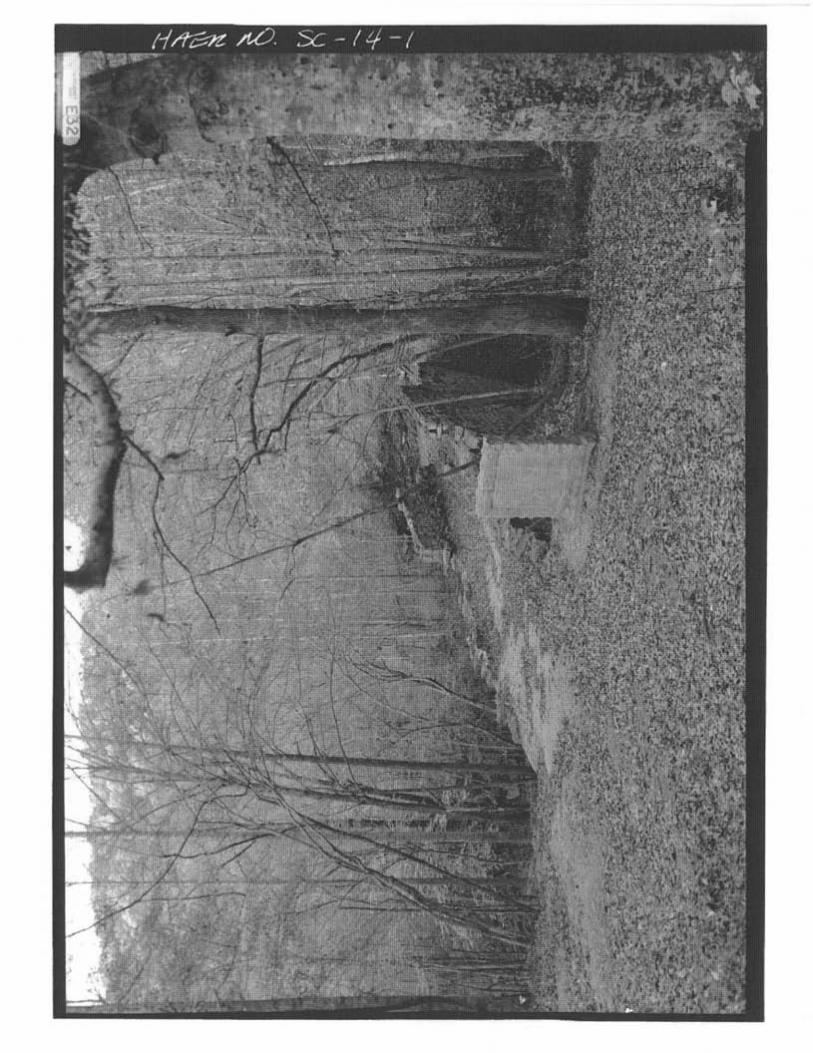
NRHP form noted that Mills executed a brush and pen drawing of the bridge that is currently located inTulane University’s Special Collections. Mills was considered the most likely candidate for the designer ofthe bridge (Schuette 1970). In addition, South Carolina Department of Archives and History staff memberH. Thomas Shaw recorded Poinsett Bridge in 1988 for the Historic American Engineering Record with largeformat photography by Jack Boucher (Appendix C). No measured drawings were completed for the studythat was given Record Number SC-14 in the Library of Congress collection.
Poinsett Bridge is also featured in Donald Jackson’s Great American Bridges and Dams (1988). Accordingto this source, the bridge was constructed by the South Carolina Board of Public Works, headed by JoelPoinsett, and was possibly designed by Robert Mills, thought to have been serving as state architect andengineer at the time of construction. It is also believed to be the oldest surviving bridge, not just in SouthCarolina, but in the entire southeastern United States (Jackson 1988:184).
A number of years ago, the Nathaniel Greene Chapter of the Daughters of the American Revolution placeda stone marker on the south side of the bridge that reads, “This bridge on the state road from Greenville toAsheville was built in 1820 by Abram Blanding, Acting Commissioner, Board of Public Works, Joel R.Poinsett, President.” Not mentioned on the marker is Robert Mills, perhaps because it has been difficult todetermine his exact relationship to the bridge. It is one of the main research agendas of this project to tryand determine just what that relationship was.
The SCDNR-HTP has recently acquired the Poinsett Bridge and is in the process of completing engineeringassessments to stabilize the bridge for interpretation as well as developing interpretive plans for the areaimmediately surrounding the bridge. As a result of those plans, the SCDNR-HTP contracted with New SouthAssociates, Inc. (NSA) to develop a historical context of the bridge and conduct an archaeological surveyof the surrounding lands. The archaeological survey area consists of tracts adjacent to Poinsett Bridge andalong associated historic road segments in Greenville County. This 5-acre survey area excludes portions ofthe larger 122-acre parcel acquired by the SCDNR-HTP, most of which is steeply sloping uplands. Asindicated by Mr. Christopher Judge of SCDNR-HTP, areas included in the survey are those that will or mightbe affected by upgrades to the property designed to enhance its accessibility and usefulness to visitors.
This report presents the results of these investigations, and is divided into four chapters. Chapter I is theintroduction to the project and report. Chapter II presents the history of the bridge and also discusses thesources consulted in developing this history. Chapter III presents the archaeological methods and findings.Chapter IV provides summary conclusions and offers recommendations for the interpretive display of thebridge. The historical research was conducted and authored by Mark Swanson. Brad Botwick completedand wrote the results of the archaeological survey. Mary Beth Reed served as the project’s PrincipalInvestigator. Dr. J.W. Joseph served as Project Manager and the author of Chapter IV. Graphics presentedin this report were developed by Tracey Fedor. Report editing was provided by Dr. Joseph and Ms. Reed.


POINSETT BRIDGE: A HISTORIC CONTEXT AND ARCHAEOLOGICAL SURVEY, GREENVILLECOUNTY, SOUTH CAROLINA
5
II. A HISTORY OF THE POINSETT BRIDGE
RESEARCH OVERVIEW
This chapter covers the history of the bridge and its place in the history of South Carolina and the region. Itwill also document the lives of those believed to be responsible for the design and construction of thebridge. Three men are generally associated with this work: Joel R. Poinsett, for whom the bridge is named;Abram Blanding, associated with the construction of the bridge; and Robert Mills, who is commonlysupposed to have supplied the design. All three men, and their contributions, will be the subject of furtheranalysis and description.
To help determine the relationship of Abram Blanding, Joel Poinsett, and Robert Mills to the Poinsett Bridge,the research efforts for this project have been directed toward a number of different sources. Anne McCuenprovided most of the chain-of-title information, and many of the maps pertinent to the project area. Herinformation on the first property owner of the bridge, John Hodges, was extremely valuable. The rest of thechain-of-title, essential to the creation of the preserve but rather peripheral to our story, is presented in anappendix to this report (see Appendix A).
Another important source of information were the papers of the Board of Public Works (sometimes given asthe Department of Public Works), housed at the South Carolina Department of Archives and History. Mostof the 12 categories of items in this collection were physically examined, with the exception of a couple thatwere clearly too late to contain information about the construction of the bridge. Even though there wasmore information on contemporary canal work than there was on the construction of the state road, therewas still a great amount of information about the road and its construction. This information clearlyindicated that Abram Blanding, not Joel Poinsett, was in charge of the day-to-day construction of the SaludaMountain Road, including the three bridges that were part of that road.
Much more difficult to pin down was the role of Robert Mills, believed by many to have been the designerof the bridge. In order to help determine the connection, examination was made of various Robert Millscollections in the Southeast. Mills, a native son of South Carolina and later famous as the designer of theWashington Monument, was not only the nation’s first American-born professional architect, but was anengineer as well. His interests spanned many topics, and he was prominent in his own day as well as inours. His papers have been collected in a number of places.
One such collection, in the South Carolina State Library, was compiled in 1980 by the South CarolinaHistorical Society. Preserved in microform, this collection contained all known Mills manuscripts preservedby his descendents. No information about the bridge was found in these materials. A much largercollection of Mills papers was organized in 1984 by Robert Alexander, John Bryan, Pamela Scott, andDouglas Evelyn, under the auspices of the Smithsonian Institute. A microfilm copy of this collection is on fileat the South Caroliniana Library, and comes with a comprehensive guide and index (Scott 1990). Eventhough there were a few sketches of bridges in this collection, they were clearly not associated with theSaluda Mountain Road.

CHAPTER IIA HISTORY OF THE POINSETT BRIDGE
6
Last but not least was the Mills Collection at the Southeastern Architectural Archive, housed at TulaneUniversity’s Special Collections. As part of this project, a trip was made to New Orleans to view thesematerials, which included letters, notebooks, and around 20 different sketches that Mills made along theSaluda Mountain Road in the fall of 1821. The Tulane collection proved to be the most productive of thethree for this project, resulting in the recovery of sketches of the Poinsett Bridge, the bridge over the NorthSaluda River, and other views of the area. None, however, produced direct evidence that Mills designedthe Poinsett Bridge, even though, for reasons that will be explained below, it would seem likely that he didso.
In order to follow the development of the Poinsett Bridge and the Saluda Mountain Road, we have puttogether a bulleted chronology of the events discussed in greater detail in the body of the report. Amongthe highlights of both the chronology and the report are the events that led to the creation of the SouthCarolina Board of Public Works in the late 1810s; the work of the board in constructing the SaludaMountain Road; the involvement of Robert Mills and others; and the slow decline of the state road andother “internal improvements” that occurred in the wake of the Nullification Controversy.
Table 1. Basic Chronology of Poinsett Bridge and Saluda Mountain Road
1794-97 First formal road over Saluda Gap.
1807 Petitions to improve road over Saluda Gap.
1812-1815 War of 1812. American control of Southeastern territories secured. Westward expansioncontinues. South Carolina becomes interested in improving the state’s transportation system(“internal improvements”) to maintain connections with the West.
1817 Robert Mills, prominent architect and native son of South Carolina, visited Charleston andsought government position back in his home state, apparently without success. Mills wasthen a resident of Baltimore. Mills then became involved in a Baltimore housing project thatturned into a financial disaster (1817-19).
1817 Dec. South Carolina legislature created Office of Civil and Military Engineer to begin program ofinternal improvements.
1818 early John L. Wilson appointed Civil and Military Engineer.
1818 Wilson recommends road to connect Charleston and upland South Carolina. One of thefirst ideas of a state road with connections to western North Carolina and Tennessee.
1818 Dec. Legislature appropriated $1 million for internal improvements, to be spread out evenly overfour years. Work would entail construction of roads, canals, and public buildings.
1819 Dec. Wilson dismissed as Civil and Military Engineer. Office of Civil and Military Engineerabolished, replaced by Board of Public Works, with five members: Abram Blanding,Thomas Baker, Joel Poinsett, William Jay, and Robert G. Mills—no relation to architectRobert Mills. Poinsett was president of the board (1819-21).
1820 Jan. Board of Public Works organized. William Jay worked up standard plans for courthousesand jails. Poinsett sought skilled laborers from North, including stone masons, for work oncanals and roads.
1820 Jan.-Apr. Skilled workers arrived in Charleston; began work on canals, roads in lowcountry.

POINSETT BRIDGE: A HISTORIC CONTEXT AND ARCHAEOLOGICAL SURVEY, GREENVILLECOUNTY, SOUTH CAROLINA
7
1820 May-June Abram Blanding reconnoitered route for Saluda Mountain Road.
1820 June Advertisements placed for local labor on the Saluda Mountain Road.
1820 July 9 Poinsett arrived at Saluda Mountain, probably for reconnaissance trip. By the end of thatmonth, he was already out of the area. According to his diary, he never returned to SaludaMountain during the bridge construction period.
1820 July Workers shifted from lowcountry to mountains to begin work on Saluda Mountain Road.
1820 July 17 Work formally began on Saluda Mountain Road, including the road’s three bridges: overLittle Gap Creek (later known as Poinsett Bridge), North Saluda River, and Hodge’s Creek.
1820 July-Oct. Construction of Saluda Mountain Road and bridges. Abram Blanding supervisor.
1820 Oct. Work on the Saluda Mountain Road neared completion. One-third of work force dismissedon the 15th; another third on the 22nd. By the 28th, there was only a small crew left to finishthe North Saluda River bridge.
1820 Oct. 30 Architect Robert Mills decided to leave Baltimore due to financial problems and lack ofwork.
1820 Nov. 1 Collection of tolls began on Saluda Mountain Road. Col. Marony was first toll gate keeper.
1820 Nov. Blanding submitted progress report to the legislature.
1820 Dec. 20 Legislature appointed new Board of Public Works. Most previous members remained.Architect William Jay replaced by architect Robert Mills. Mills, still in Baltimore at the time,quickly moved to South Carolina. Mills and Blanding were the only paid members of theboard: Mills served as superintendent of public buildings; Blanding, as superintendent ofpublic works.
1821 early Mills began work in South Carolina, where he replaced or modified Jay’s work.
1821 Sept. Mills’s trip to Saluda Mountain Road, where he sketched two of the bridges.
1822 Dec. 31 Legislature abolished Board of Public Works. Existing projects split between the two paidmembers of the former board, or acting commissioners: Blanding and Mills. Blandingwould serve as superintendent of public works until 1827.
1823 Dec. 31 Mills lost position as superintendent of public buildings to Roderick Evander McIver. For thenext year, Mills operated as consultant to McIver and began his career as private architectin South Carolina.
1824 Dec. McIver’s position, superintendent of public buildings, abolished by legislature
1825 Mills published Atlas of the State of South Carolina.
1826 Mills published Statistics of South Carolina.
mid-late 1820s Completion of state road; road connected to western North Carolina and Tennessee.Decline of South Carolina’s public works program. Rise of Nullification Controversy.

CHAPTER IIA HISTORY OF THE POINSETT BRIDGE
8
1830 Mills moved back to Baltimore and Washington, D.C. Later became a federal architect(1836-53) and was responsible for the initial design of the Washington Monument. Died in1855.
1830s-1850s Decline in state road revenues. State turns toll collection over to Greenville District. Sale ofstate lands along the road in 1844. In later years, the main traffic was lowcountry plantersgoing to summer retreats in the mountains.
1910-12 Partial collapse of the North Saluda River bridge.
1914-16 First alterations to the route of the Saluda Mountain Road, due to automobile traffic.
1920s Boy Scout camp established near “Poinsett Bridge.”
1955-56 Poinsett Bridge abandoned with realignment of County Road 42.
Late 1950s-
early 1960s North Saluda Reservoir established; two bridge sites lost. Poinsett Bridge remained as the only survivor.
LOCAL GEOGRAPHY
The Poinsett Bridge is located almost due north of Greenville, South Carolina, just four or five miles from theNorth Carolina line. This area is also located in the Blue Ridge Mountain physiographic province of SouthCarolina, a rather small portion of the state located in the extreme northwest corner, adjacent to westernNorth Carolina and northeastern Georgia. This is the only mountainous part of the state, with elevationsranging from 1100 to just over 3000 feet above sea level.
A portion of the South Carolina border, in the northwest corner of Greenville County, lies along the BlueRidge itself, which forms the Eastern Continental Divide, separating waters that flow to the East Coast fromthose that flow to the Mississippi River. The Blue Ridge, however, leaves the South Carolina border in thevicinity of Jones Gap and continues northwestward into North Carolina. Flat Rock, for example, about fivemiles north of the South Carolina line, is located on the Blue Ridge. After Jones Gap, the South Carolina-North Carolina border still follows a ridge line for another 17 miles before it veers eastward in a straightline to form the state’s northern boundary. This ridge is generally known as Saluda Mountain. Watersnorth of this ridge flow into the Green River or the North Pacolet River, both of which eventually find theirway into the Broad River. Waters south of Saluda Mountain form the Middle Saluda and the North Saludarivers. These eventually form the Saluda River, which also flows into the Broad much further to the south toform the Congaree River at Columbia (Kovacik and Winberry 1987:26-27). Even though Saluda Mountainis a dividing ridge, it is crossed by a number of gaps, and these have been used ever since people havesettled in the area.
South of the Blue Ridge and Saluda Mountain are a number of isolated mountains or peaks, known asmonadnocks (Huff 1995:1-2). Some of the highest of these in South Carolina are located in the projectarea. These include the peaks known as Glassy Mountain (2760 ft.) and Hogback Mountain (3240 ft.).Waters on the north and west sides of this monadnock flow into the North Saluda. Waters to the east andsouth flow into the South Pacolet or into the Middle or South Tyger rivers. The stream that is spanned byPoinsett Bridge drains the west side of Glassy Mountain. The stream then continues westward, between

POINSETT BRIDGE: A HISTORIC CONTEXT AND ARCHAEOLOGICAL SURVEY, GREENVILLECOUNTY, SOUTH CAROLINA
9
Old Indian Mountain (2280 ft.) to the north and Callahan Mountain (1880 ft.) to the south. The PoinsettBridge is located in the area between these two peaks, about one-third of a mile north of CallahanMountain.
The stream that flows under Poinsett Bridge is now called Callahan Branch, at least on modern topographicmaps. The name came from Gresham Callahan, whose family owned much of the land on both sides of thestream in the later 1800s (McCuen 2000:18). In earlier years it was often called Gap Creek, but it shouldbe called Little Gap Creek. This was the name favored on the earliest maps, and it distinguishes this streamfrom another, much larger, Gap Creek located further west. The larger Gap Creek, one of the tributaries ofthe Middle Saluda River, would later be prominent as one of the ways across the Saluda Mountain ridge.Little Gap Creek, a much smaller stream, flows westward into the North Saluda River.
In 1820, the Saluda Mountain Road was selected as the best way to get across the South Carolinamountains into western North Carolina. Approaching the mountains from the south, the route went east ofCallahan Mountain and then turned west, down the south side of Little Gap Creek to the Poinsett Bridge.The road then continued on the north side of the creek to the North Saluda, which was crossed by anotherbridge. The route then continued northward, crossing yet another stream by means of a third bridge. Asthe road approached the North Carolina line, the route veered westward, across the Saluda Gap, locatedbetween Vance Mountain (2440 ft.) to the north, and Corbin Mountain (or Posey Mountain) (3025 ft.) tothe south. Poinsett Bridge is all that is left of the three bridges that united the Saluda Mountain Road. Theother two bridge sites have been obscured by the North Saluda Reservoir, part of the Greenville WatershedProgram put in place in the 1950s and 1960s.
EARLY HISTORY OF GREENVILLE COUNTY AREA
When Charleston was founded, in 1670, the mountains of the Carolinas, Georgia, and Tennessee werehome to the Cherokee. Within a few decades, British traders were in direct contact with this group, valuedfor their access to furs and deerskins (Huff 1995:7; Richardson 1930:23). By the time of British contact,the Cherokee people were divided into broad geographic categories. The “Lower Towns” were located inwhat is now northwest South Carolina and northeast Georgia; the “Middle Towns” were in western NorthCarolina; while the “Overhill Towns” were in east Tennessee. In South Carolina, the Cherokee LowerTowns were situated west of what is now Greenville County, in modern Oconee and Pickens counties. Thearea of Greenville County was part of the Cherokee hunting grounds, which extended east to the BroadRiver. Even in those days, there were trails that coursed over the mountains, probably based on evenearlier animal trails, blazed by deer and buffalo. There was an Indian trail over the Saluda Gap, eventhough the path does not appear on any of the early maps (Huff 1995:3-7).
The British began to pay more serious attention to the Cherokee in the early 1700s, after the YemasseeWar and after the French established themselves in the Mississippi Valley. In the tug of war between theFrench and British, the Cherokee generally sided with the British, but had cause to regret the choice asBritish settlers began to encroach on their lands, beginning in the 1740s. The first formal treaty betweenthe British and Cherokee was signed in 1753, and ceded much of the northwest third of South Carolina tothe British. It also permitted the British to construct forts on Cherokee lands. After 1753, the only part ofSouth Carolina that still belonged to the Cherokee was what is now Anderson, Greenville, Pickens, andOconee counties, the northwest extreme of the state (Huff 1995:8-9; Richardson 1930:24-26).

CHAPTER IIA HISTORY OF THE POINSETT BRIDGE
10
The Cherokee initially fought with the British in the French and Indian War (1754-1763), but a conflict withlocal white settlers triggered a war between the British and Cherokee in 1760-61. The Cherokee wereeventually defeated (Huff 1995:19; Richardson 1930:28-29). Even though the status quo was restored, theCherokee were now even less able to fend off the white influx, which became a wave in the 1760s. Thiswas the great Southward Migration along the foothills of the Appalachians, a migration of Scots-Irish andGerman settlers that began in Pennsylvania and emptied into the Carolina and Georgia Piedmont(Richardson 1930:25-26; Cooper 2000:15).
This migration into the backcountry of South Carolina led to demands for new administrative districts thatwould bring law and order to the region. As a result, Ninety-Six District was created in 1769. The fort andsettlement at Ninety-Six was established near the Saluda River in what is now Greenwood County (Huff1995:20; Edgar 1998:232). Some settlers also moved into the Cherokee lands as well, and one of thefirst to do so was Richard Pearis (Paris), who settled on the banks of the Reedy River, near what is nowGreenville, in 1768. There he built a grist mill and a trading post, and legitimized his land holdings,almost 10 square miles, through an illegal land grant obtained directly from the Cherokee. Paris Mountain,a monadnock just north of Greenville, still bears his name. Most settlers, however, stayed out of the areauntil the early years of the American Revolution (Huff 1995:14-15; Cooper 2000:15).
The early years of the Revolution saw fighting in the area of Greenville County. In 1775, there was conflictbetween Patriots and Loyalists, and the following year, between Patriots on the one hand, and Cherokeeand Loyalists on the other (Richardson 1930:40-41). The outnumbered Loyalists were either cowed orforced to flee, while the Cherokee had to cede more land. In 1777, they relinquished any claim to the restof South Carolina, even though settlers only began to move into the area in great numbers after the war.Beginning in 1784, veterans of the Continental service were given bounty grants of 200 acres each; thesebounty grants would effect over 6000 acres in Greenville County. Others received title to the land throughstate grants. In one form or another, almost all land in what is now Greenville County was originallyparceled out by the state (Huff 1995:36-39; Richardson 1930: introduction; Anne McCuen, personalcommunication, March 1, 2004). Within the project area, some of the earliest settlers to the area aroundGlassy and Hogback mountains were the families of Gowen, Howard, Fisher, and Dill (Huff 1995:18).
In 1785, Ninety-Six District, which had inherited the 1777 Cherokee cession, was split into six newcounties. The following year, in 1786, Greenville County was formally created between Spartanburg andLaurens counties (South Carolina’s administrative units were usually referred to as “counties” until 1800,after which they were called “districts”; they were again called counties after 1868). Greenville Countywas probably named in honor of Revolutionary War hero Nathaniel Greene, not, as Robert Mills wouldlater assert, because of the area’s green appearance. Regardless of the name’s origin, the area grewquickly, and by 1790, Greenville County had a population of 6503. Most of these were white (5888).The rest (615) were black, and most of these were enslaved (Huff 1995:1, 40-43, 47-48).
By the early 1800s, Greenville County, with the seat of government at the town of Greenville, was takingon a settled appearance, and this was true even in the mountains. Unlike most of South Carolina, however,Greenville County was not yet a servant of King Cotton, at least not before the Civil War. Local agricultureremained diversified, with a considerable emphasis on wheat and corn, as well as some tobacco. Thiscontributed to the development of wagon roads, most of which went east and west, rather than north, overthe mountains (Huff 1995:43-44, 62-63). Even though there was an increasing demand for mountainroads, such routes remained little better than trails and were an effective impediment to any seriouscommercial interaction between South Carolina and its western neighbors.

POINSETT BRIDGE: A HISTORIC CONTEXT AND ARCHAEOLOGICAL SURVEY, GREENVILLECOUNTY, SOUTH CAROLINA
11
GROWING INTEREST IN INTERNAL IMPROVEMENTS
As early as the 1790s, it was proposed that a road be constructed from the North Fork of the Saluda River,over the mountains into North Carolina, to help connect the local area with the settlements then beingopened in east Tennessee. The South Carolina legislature collected $2000 for the construction of this roadand stipulated that it had to be wide enough for four horses to pull a wagonload of one ton. Elias Earleand John William Gowen completed the road between 1794 and 1797. It initially connected Greenvilleand Asheville, but was eventually extended to Knoxville. This road went through the Saluda Gap, but wasso narrow that two wagons could not pass each other at the same time. There were also precipitous dropsof 100 feet right off the edge of the road (Huff 1995:63-64).
As early as 1807, there were petitions to the state legislature to improve the Saluda Gap Road, parts ofwhich were so bad that travelers had to hire locals to help pull the wagons. This served to thwart much ofthe traffic from Tennessee, which tended to go northward, along the Valley of Virginia toward Baltimoreand Philadelphia (Batson 2003:preface, 2). Even so, there was some wagon traffic, and a considerableamount of droving, over local mountain roads. Wagon traffic tended to move in caravans of up to 15 oreven 20 vehicles. The caravans might make 24 miles a day, and the teamsters camped overnight in thewoods. As for the droving, herds of horses, mules, cattle, hogs, and sheep were driven over the roads.There were even flocks of turkeys. The difficulties of all these operations led to increased demands for animproved turnpike over the mountains (Huff 1995:65).
The demand for better mountain roads dovetailed with a rising national interest in better roads and rivertransportation. This interest became particularly acute in the wake of the War of 1812 (1812-1815). TheLouisiana Purchase of 1803 had opened up vast regions of the West to new settlement, but this became aflood only in the wake of the war, which checked the power of the Creek Nation and cemented Americancontrol of New Orleans and the Mississippi Valley. A simultaneous development was the steamboat, whichgreatly improved the efficiency of river transportation. As American settlement expanded into theMississippi Valley, the older ports along the Atlantic became concerned. This led to the demand for new“internal improvements,” such as canals to augment river transportation and roads over the AppalachianMountains. Charleston was certainly one of the Atlantic ports that feared being left behind, and in the late1810s powerful South Carolina politicians, including John C. Calhoun, favored the idea of internalimprovements to correct the matter. As Calhoun stated at the time, “Let us bind the republic together with aperfect system of roads and canals. Let us conquer space” (Huff 1995:76-82; Bryan 1989:75).
Economically, Charleston had been in relative decline since the late 1700s, largely due to the country’swestward expansion. This led to the rise of New Orleans as one of the nation’s premier ports. Charleston,which was not even well connected to the river systems of South Carolina, was even less well suited toattract trade from further west. This led to an interest in both a better canal system within South Carolina,as well as a “state road” that would connect Charleston with the West, which began on the other side ofthe Blue Ridge.
Local interest in canals began as early as the late 1700s. The Santee Canal Company was chartered in1786 to dig a channel between the Santee and Cooper rivers, a task that was not completed until 1800.A more comprehensive system of roads also began during this period, and much of this development wasdriven by the spread of cotton, which was grown throughout the uplands of the state after the invention ofEli Whitney’s cotton gin (Huff 1995:63; Marsh 1970:8-9).

CHAPTER IIA HISTORY OF THE POINSETT BRIDGE
12
SOUTH CAROLINA’S PUBLIC WORKS PROGRAM AND ITS LEADERS, 1817-1820
After the end of the War of 1812, when cotton could again be sold freely to British factories, the state hada surplus of funds to do even more in the way of internal improvements. Beginning in 1817, the statelegislature began to pass programs that specifically included the construction of roads, canals, and publicbuildings (Waddell and Liscombe 1981:1; Marsh 1970:9). In December of 1817, at the urging ofGovernor Andrew Pickens, the state legislature created the Office of Civil and Military Engineer for thepurpose of coordinating the various state programs for internal improvements. The Civil and MilitaryEngineer was to survey the state’s rivers, report on the potential for canals and roads, and supervise theconstruction of public buildings, such as courthouses and jails. The post, to be filled at the discretion of thelegislature, would command a salary of $4000 per year. In early 1818, the legislature appointed John L.Wilson to the post of Civil and Military Engineer (Bryan 1989:75; 2001:151; Waddell and Liscombe1981:1).
In 1818, one of Wilson’s first recommendations called for a road that would better connect Charleston tothe state’s upland area. Some fifty miles outside the port city, the proposed road would split into threebranches: one to Lancaster, one to Saluda Gap, and another to York. The middle branch, to the SaludaGap, would extend out from Columbia and then along the ridge between the Tyger and the Enoree rivers(Huff 1995:87). Of the three branches, the Saluda Gap road was probably the most important. It wouldnot only connect Charleston with Columbia, but also it would connect the state to western North Carolinaand east Tennessee. With this road, Charleston would be in a position to better compete with rival citieslike Savannah (Kohn 1938:77, 90).
To act on this and other projects, the legislature appropriated $1 million dollars for internal improvements inDecember of 1818, to be spread out into $250,000 annually for the next four years. This sum was tocover improvements in local watercourses, navigation channels, canals, and turnpikes. The rationalebehind all of this was to facilitate the movement of goods to market, especially if the market was inCharleston (Statute 1818, No. 2178). This was the first of a number of different appropriations that wereenacted over the next ten years, which in the end totaled some $1.9 million. This sum was soon spreadacross a number of public projects that included canals, roads, and a wide range of public buildings (Huff1995:86; Bryan 2001:149).
John Wilson was a professional engineer and surveyor, not an architect, and he found that managing morethan 40 different projects across the state was beyond his abilities. Unable to fulfill his responsibilities, hewas dismissed from the office in December of 1819, and the legislature chose not to replace him. Instead,the legislature abolished the post of Civil and Military Engineer, and recreated in its place the “Board ofPublic Works,” with five members (Waddell and Liscombe 1981:1; Bryan 1989:75; 2001:151). Asoriginally established, in December of 1819, the five members were Abram Blanding, Thomas Baker, JoelR. Poinsett, William Jay, and Robert G. Mills.
Only two members of the board were paid members, and they were known as “acting commissioners.”These two were Abram Blanding, in charge of roads, rivers, and canals, and de facto head of the publicworks program; and Thomas Baker, a contractor in charge of the construction of public buildings. As forthe other three, William Jay was an English-born and trained architect who was active in the Charlestonand Savannah area from 1817 to 1823. Jay created some of the first designs for the program’scourthouses and jails. Robert G. Mills was a contractor, and no relation to the architect Robert Mills, who

POINSETT BRIDGE: A HISTORIC CONTEXT AND ARCHAEOLOGICAL SURVEY, GREENVILLECOUNTY, SOUTH CAROLINA
13
would later serve on the board. Joel Poinsett was by far the most prestigious member and served aspresident of the board. A prominent politician, Poinsett was a strong believer in the goals of the internalimprovement movement. Even so, his position appears to have been titular. There is little evidence thatPoinsett exercised more than nominal control over the Board of Public Works (Waddell and Liscombe1981:1; Bryan 1989:75; 2001:151).
BACKGROUND ON JOEL POINSETT AND ABRAM BLANDING
Even if his direct involvement was limited, Joel Robert Poinsett (1779-1851) was one of South Carolina’smost prominent politicians in the 1810s, and his involvement with the board insured that it had theimprimatur of the highest circles of state government. Born into a wealthy Charleston family in 1779,Poinsett’s family moved to England in 1782, returning to South Carolina in 1788. He was schooled inConnecticut and at St. Paul’s School in Wandsworth, England. He went on to study medicine at theUniversity of Edinburgh, but was forced to drop out due to poor health. After a stay in Portugal andEngland, Poinsett returned to Charleston in 1800. For the next 10 years, he divided his time betweenCharleston and Europe, during which period he met many heads of state, from Napoleon to the Tsar ofRussia. Poinsett put his international connections to good use. From 1810 to 1815, he served as specialAmerican envoy to Latin America, during which time he engineered commercial treaties with bothArgentina and Chile. After that, he returned to South Carolina to serve in the state House ofRepresentatives. As such, he served as a member of the committee on inland navigation (1816-19) and thecommittee on internal improvements (1817-19), among others. Capitalizing on his interest in internalimprovements, he served as the president of the Board of Public Works from 1819 to 1821 (Bailey et al.1986:1286-1287).
Abraham (Abram) Blanding (1776-1839), one of the two acting commissioners of the Board of PublicWorks, was in charge of the day-to-day work done on the state’s roads, rivers, and canals. Born inMassachusetts and educated at Brown University, Blanding moved to Columbia, South Carolina, around1797-98. There he taught at the Columbia Male Academy while studying law. Moving to Camden in1799, Blanding was admitted to the bar in 1802. In the years that followed, he became well known as abusinessman, attorney, and public servant. Moving back to Columbia in 1819, he was soon afterappointed one of the paid members of the Board of Public Works (Bailey 1984:60-62).
ORGANIZATION OF THE BOARD OF PUBLIC WORKS, EARLY 1820
The Board of Public Works, appointed in December of 1819, had its first organizational meeting in Januaryof 1820. Even with the work split among five members, it is clear that the board had problems with thehuge workload they were expected to tackle (Bryan 1989:75). The board hired one of its non-paidmembers, William Jay, to work up six sets of drawings of courthouses and jails to serve as stock plans.Initial work on a number of county courthouses began on this basis in 1820 (Waddell and Liscombe1981:1). This was the general situation at the Board of Public Works throughout most of 1820, when atremendous amount of work was begun on both the canals and what was called the “state road” fromCharleston to Saluda Gap. It should be noted here, at least in passing, that the architect Robert Mills, laterthe designer of the Washington Monument, was not yet a member of the Board of Public Works. He wasnot appointed to that position until December of 1820. In fact, Mills was not even in the state until the endof 1820. Mills’ involvement with the state road and the Poinsett Bridge will be discussed a little later in thischapter.

CHAPTER IIA HISTORY OF THE POINSETT BRIDGE
14
CONSTRUCTION PROGRAM OF 1820
The Saluda Mountain Road and the Poinsett Bridge were constructed in 1820, but they were only part of anambitious program to augment transportation, both river and road, throughout the state. Both canal workand roadwork were begun in early 1820, and were continued throughout much of the early 1820s. Theentire state road was not finished until later in the 1820s, but the Saluda Mountain Road, that portion of thestate road that was located in upper Greenville County, was started and finished in the first year ofconstruction. This is pretty remarkable since work that year began not on the mountain road, but on thecanal works in the lower part of the state.
Much of this work, both for the canals and the road, required skilled laborers, including stone masons,which were in short supply in South Carolina. In early 1820, if not before, Poinsett sent out agents tovarious Northern cities to acquire much of the skilled labor needed for the construction program. In Januaryof 1820, Poinsett wrote to Burn Frankford of Pennsylvania to request the services of 100 stoneworkers. Asimilar request, for 50 stonemasons, was sent to Jonah Tenny of Boston. All were to book passage forCharleston, and by April of 1820, the laborers began arriving from Philadelphia, Boston, and New York(Batson 2003:9-10). The plan was to employ this mostly white labor force first in the lowlands, where theywould work on both canals and parts of the state road. They would then be relocated to the mountains atthe onset of the malarial season (“the sickly season”), which usually began in early summer (Kohn1938:22).
By April, if not before, work began on a number of projects in the lowcountry. One of the first was work onthe causeway for the state road through the Huckabuck Swamp, below Columbia. Causeway work beganin April with a Mr. Anderson and his white work force. Here, the state road would pass beside theCongaree River on top of an embankment 40 feet wide at the base and 22 feet wide at the top, at anelevation of 7 feet above the river. The embankment was covered with timber, sand or gravel, as availablelocally. Later, in July, this work force would be removed to the Saluda Mountain Road. Work on thecauseway would continue with slave labor under a Col. Myddleton (Blanding 1820; Kohn 1938:47, 76).Another white work party, headed by [Gaius] Kibbe, worked on the canal and locks at Dreher’s Falls, onthe Saluda River, about 15 miles above Columbia. They too would later be moved to the mountains. Byspring, the internal improvements labor force was estimated to have been in excess of 700 men, possiblyas high as 1000 (Kohn 1938:67).
CONSTRUCTION OF THE SALUDA MOUNTAIN ROAD
In the records of the Board of Public Works, housed in the South Carolina Department of Archives andHistory, it is clear that much more planning was devoted to the canal projects, than was devoted to the stateroad. While there are a number of diagrams and plans for the canals and locks constructed in 1820, thereis not a single map or plan of the Saluda Mountain Road or any of its three bridges. From notes left byAbram Blanding, it appears that no such plans or surveys were ever conducted for the road (Blanding1820). This portion of the road, it would appear, was constructed with a minimum of prior thought. It isalso clear that Blanding was in charge of almost all phases of construction of the mountain road. Most ofthe extant documentation left by the Board of Public Works from this project consists of receipts and bills ofgreat variety and detail, and almost all are addressed to Abram Blanding.
In connection with his work on the state road, Blanding stated that the extent of the road was too great toallow for any plans or comprehensive surveys. Blanding was clearly given great latitude in determining thelocation of the route. Certain points were fixed by the legislature, but the rest was to be decided in the
POINSETT BRIDGE: A HISTORIC CONTEXT AND ARCHAEOLOGICAL SURVEY, GREENVILLECOUNTY, SOUTH CAROLINA
15
field. Blanding elected to construct the hardest parts first, and these were tackled in 1820. These includedthe swamps between Charleston and Columbia (Huckabuck, Dean Swamp, Wassamasaw Swamp) and theSaluda Mountain Road (Blanding 1820).
A preliminary examination was made of the mountain road options in May and June of 1820, while thelabor force was still working in the lowlands. In his official report of the work done that year, Blandingnoted that several routes were already in use in the area, and that all were difficult. Furthermore, none tookthe direction desired for the state road. “A new course was therefore determined on, which possesses theadvantages denied to all old routs (sic).” In this way, the Saluda Mountain Road was laid out from thenorthernmost edge of level land to the North Carolina line, a distance of 11 miles (Blanding 1820; Batson2003:3).
Blanding must have been exaggerating a little. Any route through Saluda Gap would have been followingearlier roads for at least part of the distance. This almost surely would have included the road cut by Earlein the 1790s. Even Blanding, in the same official report, said that the old road at Saluda Gap had seriousgrade problems, with some parts as steep as 12 degrees (Blanding 1820; Batson 2003:14). Even so, thisgap was chosen over the other possibilities. Among these other possibilities was Jones Gap, also known asMiddle Gap, adjacent to the Middle Saluda River. A road was later constructed at this gap, and it wasreported that the grade was more accessible than that of the state road (Batson 1995:17; 2003:3-4).Another possibility was Gap Creek Road, which followed the Middle Saluda River and then veeredeastward up Gap Creek, following this line to the North Carolina border (Batson 1995:15-16).
Even if the Saluda Gap route did not present the best grade over the mountains, it was the one that best fitBlanding’s plan, which in turn reflected the wishes of the state legislature. That wish was to direct all trafficon the state road toward Columbia and Charleston. Saluda Gap would have travelers descending themountain road in the right direction to continue on to Columbia. Jones Gap and Gap Creek Gap wouldhave had them heading toward Augusta, which was clearly not the intent of the legislature. The SaludaGap route also had the advantage of intersecting with the Buncombe Road that already went fromGreenville to Asheville. These roads intersected at Hodge Bottoms, a long level area on the North SaludaRiver that belonged to Col. John Hodges (Batson 2003:6). A state road in this location would also intersectwith the road that connected Greenville and Spartanburg, favoring neither one over the other (Kohn1938:77).
Blanding must have been an efficient planner and contractor, for by mid-July the labor crews had beenrelocated from the lowlands to begin work on the Saluda Mountain Road. Work formally began on July17, 1820 with around 500 workers. At that time it was estimated that the work would take three months tocomplete. Instead, it took three and a half months, possibly four. As Blanding detailed in his report, therewere a number of unexpected delays. Malaria had struck the state early that year, and many in the laborforce were already sick when they were brought up into the mountains. Other delays were occasioned byrain and by the availability of the local liquor. Even so, construction of the mountain road began to winddown in October of 1820, as the project neared completion. On October 15th, a third of the work forcewas discharged, followed by another third on the 22nd. Most of the rest were dismissed on October 28th,except for a force retained to finish the bridge over the Saluda River. This task had been delayed byfrequent rises in the river that had delayed the foundation work (Blanding 1820; Kohn 1938:67; Batson2003:10).

CHAPTER IIA HISTORY OF THE POINSETT BRIDGE
16
Little is known about the kind of sickness suffered by the labor force, except that it was probably malaria.Nothing in the official reports contradicts that assumption. During the first three to four weeks of work onthe Saluda Mountain Road, 40 to 50 laborers, mostly “mechanics,” were in the hospital (Blanding 1820;Huff 1995:87). Little is known about the hospital facilities, although it can be assumed that they were fairlyminimal and relatively informal. Hiram Whitted, Peter McQuire, and Wheaton Merritt, three localresidents, provided room, board, and hospital care for sick workers from the project (McCuen 2000:19).There were probably other locals involved as well.
As for the problem with liquor, much of that could have been avoided. Blanding stated that initially it wasto be forbidden to sell spirits to the laborers. The Board of Public Works asked the board of commissionersof roads for Greenville District to refuse all licenses to sell liquor to the workers. Even so, three of the localcommissioners came up to the project area to do just that. The liquor that was then made available had“great adverse effect on the mechanical labor” (Blanding 1820).
As for the labor force, most appear to have been white workers, not slave laborers. Ordinary labor wasplentiful and came from “all parts of the country” (Blanding 1820). Advertisements were placed in the localpapers as early as June of 1820:
For hands to work on Saluda Road for three months, beginning July 15 and endingOctober 16. Wages were $13 per month. Good well cooked provisions would be servedon the table three times a day along with one half pint of whiskey. Good tents would befurnished but the workers would provide blankets and beddings (Batson 2003:9).
Skilled laborers, or “mechanics,” were not as plentiful as ordinary laborers, and most of these had beenrecruited from the North earlier in the year. There were at least eight different companies that worked onthe Saluda Mountain Road, and their relative contribution to the project can at least be surmised by theamounts that each were paid for two months worth of work:
Alexander Bell’s Company $1, 407.67 and 3/4
[Gaius] Kibbe’s Company $1,689.93
Anderson’s Company $845.07
Dyer’s Company $1,181.95
McKenzies’s Company $5,388.71
Roger’s Company $618.40
Thomas’s Company $1,900.52
Benson’s Company $525.62 and 1/2
Source: Department of Public Works 1819-27, S208001, Box 1 of 2, Folder: FY 1820-21, Accounts and Receipts,Saluda Mountain Road).

POINSETT BRIDGE: A HISTORIC CONTEXT AND ARCHAEOLOGICAL SURVEY, GREENVILLECOUNTY, SOUTH CAROLINA
17
Much of the official documentation about the Saluda Mountain Road preserved in the records of the Boardof Public Works consists of receipts and accounts to and from workers who billed their time to the project.Thomas Walker, for example, got a receipt from John Couty, on behalf of the board, for 48 days of labor,from 17 July to 9 September, at $15 per month (Department of Public Works, Superintendent 1819-27; FY1819-20, Saluda Mountain Road). Other notes sent to Blanding were to pay workers like:
Isaac Willey for 34 days, at $20 per month (21 Aug. 1820)
Andrew Billings for 13 days, at $16 per month (22 Aug. 1820)
John Moore, at $30 per month (22 Aug. 1820)
Source: Department of Public Works, Superintendent, Misc. Papers 1819-44, S208006, FY 1819-20 Assignment ofAccounts)
Prominent among the various “mechanics” or skilled workers imported to work on the road, were thestonemasons. They did much, or at least supervised much, of the “heavy masonry that the road required”(Blanding 1820). In the final accounting of the costs of building the road, done in 1821, it was noted thatThomas Harris received $36 wages as a stonemason. It was also noted that Kibbe’s stonemasons received$221. The same sheet also awarded $1,554.84 to Kibbe’s Company, for final work done fromSeptember 4th to October 22nd (Department of Public Works, Superintendent; Misc. Papers 1820-59,S208006, FY 1820-21, Abram Blanding in Account with Saluda Mountain Road).
The Kibbe Company, run by Gaius Kibbe, was one of the several companies that worked on the SaludaMountain Road. Kibbe appears to have been one of the major stonemasons on the project, although thereis little direct evidence for this. It is not even certain where he came from, although it has generally beenassumed that he and his company were imported from the North. The Kibbe family definitely appears tohave New England roots, first coming to the Boston area from England in the 1640s. The Kibbe’s were aparticularly large family, and by the 1800s they were branching into other regions of the nation, as well asNew England. There also appear to have been a number of Gaius Kibbe’s. The first Gaius Kibbe that isrecorded for the family was born in Enfield, Connecticut in 1765, moved to Buffalo, New York, in 1814,and then moved to Louisiana, where he died in 1821. This Gaius Kibbe had a number of children by twowives, including a Gaius Kibbe II (1788-1873) by his first wife. This could quite possibly be the sameGaius Kibbe associated with the Saluda Mountain Road (Kibbe Family 2004)
Gaius Kibbe first appears in the records of the Board of Public Works in January of 1820, when he wasdoing work on the Saluda Canal. Later, in July, he switched to work on the Saluda Mountain Road, wherehe drew wages as a superintendent. At least one of his bills has been preserved: from July 24th to August24th, he billed the board at $75 per month. The total bill presented was $225, although the rest of thisamount is not accounted for (Department of Public Works, Superintendent 1819-27, S208001, FY 1819-20, Receipts 1820). According to local tradition, his company consisted of Irish laborers brought from upNorth, but there is no direct confirmation of this (Anne McCuen, personal communication, March 1, 2004).
In addition to receipts for labor payments, there are other receipts for other types of expenses, and thesegive some indication of the materials required to construct the road. There were expenses for the hospitalcare of the sick men. Money was also expended to purchase provisions, room and board, and wagonservices. Funds were also allocated to purchase land, whenever that was necessary. Among the many

CHAPTER IIA HISTORY OF THE POINSETT BRIDGE
18
items purchased by the board were these items from one invoice dated to July 1820: 8 London blankets, 2gallons of rum, 8 lbs. of sugar, 1 barrel of bread, 22 lbs. of bacon, 8 tea tumblers, 1 iron pot, 8 jackknives, as well as other items, like fry pans, spoons, vinegar, and barrels of pork and beef (Department ofPublic Works, Superintendent, Misc. Papers 1819-44, S208006, FY 1819-20, FY 1820-21, Bills for Boardand Provision).
Local residents along the road certainly received some of this money, since they provided services, roomand board, and were on occasion paid for the land or for crop damages. Col. John Hodges, who had atavern on the North Saluda River, was paid for board. Many others were paid for their service aswagoners, or for providing corn and fodder. Other, more specialized items were purchased in Greenville(McCuen 2000:19).
Many residents made out well in these arrangements: John Hodges was paid at least $4,000 for everythingfrom whiskey and rum, to beef and pork. Others who received comparable sums were John Gowen andSam Thompson. Others who also did well were Alexander and John McKinney, Nipper Hood, HiramWhitted, Wheaton Merritt, and Peter McGuire. All of these received much needed cash for goods andservices (Batson 2003:12; Anne McCuen, personal communication 2004).
The bills continued to come in long after the close of construction. Some were for labor, but most of theselater bills were for damages road construction had done to the land or the previous season’s crop. Mr. H.Izard, for example, billed the Board of Public Works for damages, and the board agreed to pay him$1,500 (Department of Public Works, Superintendent; Misc. Papers 1819-44, S208006, Appraisals andEvaluations 1820). Perhaps for this reason, there are two figures provided as the total cost of theconstruction of the Saluda Mountain Road. One accounting gives the cost as $52,500 (Department ofPublic Works, Superintendent; Misc. Papers 1820-59, S208006, FY 1820-21, Abram Blanding in Accountwith Saluda Mountain Road). Another, probably more accurate, listing gives the figure as $60,223.30(Department of Public Works, Superintendent; List of Expenditures 1820).
Relatively little is known about the various techniques employed in the construction of the Saluda MountainRoad, and much of this comes from Mann Batson’s recent work, The State Road: Poinsett Bridges andCulverts (2003). It would appear that the road was built in the time-honored fashion of removing theexcess from one area and using it to fill in other areas. Many of the tools were basic. Poinsett placedorders with Northern firms for 20 tumbling carts, 12 scrapers, and 4 plows. Given the rocky terrain, it wasalso necessary to use gunpowder, and Poinsett ordered 200 kegs of powder from John Vaughn ofPhiladelphia. Rock that had to be removed from the roadway was blasted away by first drilling holes in therock at close intervals and filling the holes with powder. The holes were drilled by hand, using drills andsledgehammers. The drills required constant sharpening, and blacksmiths were employed for this purpose.Charcoal, iron, and steel were regular deliveries. Lime was also acquired for the production of mortar(Batson 2003:11-12). Mortar was used in the stone walls that were required to support the downhill sideof the road, or in the culverts that helped drain the road, or in the road’s three bridges.
At the end of 1820, Blanding reported that the Saluda Mountain Road was constructed to a width that wasusually 17 feet. On steep sides, where there was a great amount of rock to be removed to make theroadbed, the road might be cut only 10 feet into the solid rock. The materials that were cut away wouldthen be used to make up the rest of the road width, which would be supported by a retaining wall.Wagons could pass each other “on all parts of the road at some point constantly in view.” Blanding wenton to note that there were only four places where the road had even a five degree angle, and each of these
POINSETT BRIDGE: A HISTORIC CONTEXT AND ARCHAEOLOGICAL SURVEY, GREENVILLECOUNTY, SOUTH CAROLINA
19
places were usually not longer than 1.25 miles. All other parts of the road manifested a grade less thanfive degrees (Blanding 1820). To achieve this grade, twists and turns had to be put into the steepestgrades, and these were called “the winds.” There were at least two winds on the Saluda Mountain Road:one at Callahan Mountain, near the Poinsett Bridge, and another at Plumley Mountain, above thecommunity of Merrittsville. In these areas, the downhill side of the road was secured with walls of stonethat were around four feet thick, and could be up to 200 feet in length (Batson 2003:60-61). Similar stonework was used to pass ravines as well, and here the retaining walls could be as high as 23 feet. Inaddition to such walls, there were a total of 44 culverts or small stone bridges “flagged both at top andbottom” to permit the passage of water underneath the road. Where culverts would not do, there werearched bridges, and there were three constructed on the Saluda Mountain Road (Blanding 1820).
THE BRIDGES OF THE SALUDA MOUNTAIN ROAD
Blanding’s report described the three bridges found along the Saluda Mountain Road. The first bridge, thesouthern-most of the three, was constructed at Little Gap Creek. It had a Gothic or pointed arch that was15 feet high and 7 feet wide. The total length of the bridge was 130 feet. Stepped parapet side wallswere constructed on both sides of the bridge. The height of the bridge, from the water to the top of theparapets, was 24 feet. The second bridge spanned the North Saluda River and was comprised of twoelliptical arches, each 15 feet wide. The whole of the stonework was only 60 feet in length, and theelevation from the water level to the parapet walls was 15 feet. The third bridge spanned Hodge’s Creek,and was comprised of a single circular arch. The length of the bridge and its abutments was 50 feet, andthe elevation of the bridge was 12.5 feet (Blanding 1820).
It happens that all three bridges were situated on land that belonged to, or would eventually belong to, Col.John Hodges. Hodges, a veteran of the War of 1812, lived in the project area in the years before theconstruction of the road. Even so, at the time of construction, Poinsett Bridge was located on state land. Itwas not until later that Hodges obtained a state grant for 4,789 acres that covered the entire project area(State Grants, Vol. 81:118). The grant was not platted until 1831. Hodges’s property, astride the NorthSaluda, also sat at the intersection of the Saluda Mountain Road and the “road from the Greenville CourtHouse” (Figure 2; Greenville County Grant Book H, p. 157). As the map shows, Hodges’s house wassituated at the intersection. Poinsett Bridge was constructed on what would later be the eastern edge ofHodges’s property, the bridge over the North Saluda was found in the middle, while the bridge overHodges’s Creek was found at the north end.
These three bridges were the only ones constructed along the Saluda Mountain Road, but they were not theonly bridges built on the state road. One was constructed on the Congaree Creek. The Congaree CreekBridge, 104 feet in length, had just one arch, which spanned the entire stream, and was covered by a lightroof. The bridge was based on the plan of a Mr. Town, who had already constructed two other bridgesbased on this principle. The bridge contractor, a Captain Grafton, examined Town’s bridge in Fayetteville(North Carolina?) before construction. A similar bridge was prepared for Goose Creek (Blanding 1820:Kohn 1938:47-48, 76).
Unfortunately, out of all these bridges, and probably others associated with the state road, only the bridgeover Little Gap Creek still stands today. In recent years, this bridge has taken the name Poinsett Bridge, inhonor of the man who headed up the Board of Public Works.

CHAPTER IIA HISTORY OF THE POINSETT BRIDGE
20
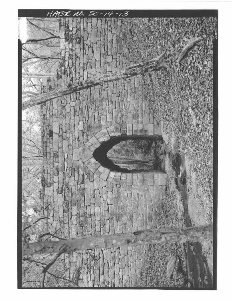
POINSETT BRIDGE AND ITS FEATURES
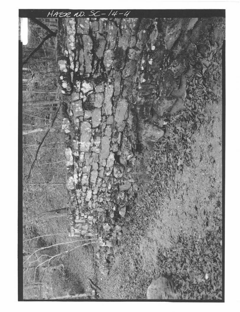
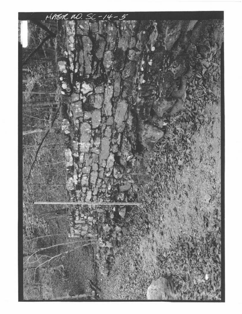
The Poinsett Bridge is the only bridge left of the three originally constructed as part of the Saluda MountainRoad. It still stands in remarkably good shape (Figure 3; Marsh 1970). As was first noted by Blanding, thePoinsett Bridge had a Gothic or pointed arch that was 15 feet high and 7 feet wide. The total length of thebridge was 130 feet. Stepped parapet walls were constructed on both sides of the bridge. The height ofthe bridge, from the water to the top of the parapets, was 24 feet. The bridge has many other features notmentioned by Blanding. The date “1820” was chiseled into the keystone and was clearly visible until fairlyrecently (Simmons 1926; Thomas 1971:46). Not much remains of the old roadbed except that portionadjacent to the bridge. As for the rest, at least in the area around Little Gap Creek, the old roadbed hasbeen masked by the construction of County Road 42. As noted by the archaeological survey of the bridge,there is an original stone culvert 122 m west of the bridge along the old roadbed (see Chapter III for moredetails).
Another original feature of the bridge was a railing or guardrail on either side of the stepped parapets.This would have served to protect travelers along those areas of the bridge, especially around theabutments, not protected by the highest section of the parapets. This railing, presumably made of wood, isdepicted in Robert Mills’s sketch of the bridge, executed in the fall of 1821 (Figure 4). All other aspects ofthis sketch will be treated in greater detail in the discussion about Robert Mills.
Much ink has been spilled concerning the masonry work of the Poinsett Bridge. Batson repeats a commentmade by William P. Center, born near Glassy Mountain in 1875, that “every rock used in the PoinsettBridge was cut to fit exactly before it was put up and they were precise all the way” (Batson 2003:12-13).This is simply not so. Except for the arch—and even there, only along the edges of the arch—the stonesused in the bridge are only roughly hewn. To ensure a good fit, mortar was used throughout. In fact, theonly smooth-faced stones found in the whole bridge, are those that define the outer edges of the arch,technically called the “surround” (Harris 1977:514). The arch, which rests on bedrock in the

POINSETT BRIDGE: A HISTORIC CONTEXT AND ARCHAEOLOGICAL SURVEY, GREENVILLECOUNTY, SOUTH CAROLINA 21
Figu
re 2
John
Hod
ge's
Sta
te G
rant
, 183
1, S
how
ing
Thre
e Br
idge
s on
the
Salu
da M
ount
ain
Road
NO
RTH
SA
LUD
A R
IVER
BRI
DG
E
HO
DG
E'S
CRE
EK B
RID
GE
POIN
SETT
BRI
DG
E

Figure 3Photograph of Gothic Arch on Poinsett Bridge (from Marsh 1970)
CHAPTER IIA HISTORY OF THE POINSETT BRIDGE
22

POINSETT BRIDGE: A HISTORIC CONTEXT AND ARCHAEOLOGICAL SURVEY, GREENVILLECOUNTY, SOUTH CAROLINA 23
Figure 4Mills Atlas, 1825, Showing the State Road and Three Bridges Below Saluda Gap
POINSETT BRIDGE

CHAPTER IIA HISTORY OF THE POINSETT BRIDGE
24
streambed, is formed by rectangular-shaped blocks or voussoirs that are slightly wedge- shaped and cut tofit into the arch. These blocks are laid in an alternating pattern: one stone placed so that the long sidefaces outward; the following stone placed so that its long side faces the inside of the arch. The stonesfacing outward, which already form an alternating pattern, are also slightly raised to create relief. This traitappears to be called “exaggerated voussoirs” (Marsh 1970:146-147). The alternating pattern, the relief,plus the pointed apex of the Gothic arch, give the bridge a medieval look. Overall, the bridge wallscontain roughly coursed stone.
Given the difficulty of transporting stone in the era of animal transportation, it is likely that the stone used inthe bridge was quarried nearby. One likely source was what looks like a quarry site less than a quartermile east of the bridge, on the south side of County Road 42. Here, in a spot opposite the Boy Scoutcamp, is a place where rock has clearly been removed from a cliff face. From this location, uphill from thebridge site, it would have been relatively easy to transport stone to the construction site. Another possibilityfor the source of stone is from the rock walls immediately adjacent to the bridge site, on both sides of LittleGap Creek. Here, the stone outcrops along the roadside appear to have been cut to make room for theroad, and the excess stone from this operation could well have been used in the construction of the bridge.With this sort of rock extraction going on for the construction of the road, it made perfect sense to constructa stone bridge over Little Gap Creek. The raw material was at hand, and a bridge of stone would have alevel of permanence that no timber structure could match.
POINSETT’S CONTRIBUTION TO THE ROAD AND BRIDGE
Because Joel Robert Poinsett was president of the Board of Public Works, and because he was well known,and still is famous today, the bridge has long been associated with his name. Whether this is justifiable ornot is frankly open to question, especially if such an association is made on the basis of his personalinvolvement in the project.
A. V. Huff’s Greenville: The History of the City and County in the South Carolina Piedmont, states thatPoinsett, as president of the Board of Public Works, “personally supervised the construction of the state roadover Saluda Mountain” (Huff 1995:87). This is basically repeated by Mann Batson, who has stated that“Poinsett personally supervised the construction of the road in the mountains and lived on the site,” possiblyin reference to a house that Poinsett later had in the area (Batson 1995:3). Batson has pointed out thatPoinsett’s memorandum book indicates that Poinsett left Columbia on July 5, 1820 and arrived in SaludaMountain on July 9 (Batson 2003:9). Even so, there is no indication that he stayed for any length of time,and his trip to the mountains was probably more a reconnaissance than the move of a supervisor,especially since work had not yet started on the mountain road at that time. By the end of that month,Poinsett was already out of the area, and his diary indicates that he never returned to Saluda Mountainduring the construction period (Anne McCuen, personal communication 2004). Anyway, it is unlikely thatPoinsett, a prominent politician, handled the day-to-day construction of the project. He would not have hadthe time (Anne McCuen, personal communication, March 1, 2004). Poinsett’s contribution to the project,organizing the companies of workmen to come from the North, was great enough as it was. For the day-to-day operations, it is clear that Abram Blanding was the main supervisor.
ROBERT MILLS’ EARLY LIFE AND CONNECTION TO THE POINSETT BRIDGE
A much thornier question concerns the contribution of Robert Mills, a native of South Carolina and one ofthe nation’s first architects. According to local tradition, Robert Mills designed the three bridges on theSaluda Mountain Road, including of course the Poinsett Bridge. Local Greenville historian Anne McCuen
POINSETT BRIDGE: A HISTORIC CONTEXT AND ARCHAEOLOGICAL SURVEY, GREENVILLECOUNTY, SOUTH CAROLINA
25
has stated that Mills “no doubt was responsible for the design of all the bridges” (McCuen 2000:19). Thisassumption is also found in Blanche Marsh’s biography, Robert Mills: Architect in South Carolina. AsMarsh stated, Mills rarely signed his designs or plans, and as a result, many of the plans he prepared whileworking in South Carolina have no official attribution. Unfortunately, no original plans of any sort havebeen found for any of the Saluda Mountain Road bridges. Still, Marsh assumed that the Poinsett Bridgewas associated with Robert Mills. The bridge has a distinctive Gothic arch, which suggests the input of aprofessional architect. It was also constructed in 1820, the year that Robert Mills returned to SouthCarolina. Marsh assumed that Mills designed the bridge as part of his duties as state engineer, “althoughhe was not officially named to the seat on the Board of Public Works until December of 1820” (Marsh1970:4, 16, 144). Donald Jackson, in Great American Bridges and Dams also says that it is possible thatRobert Mills designed the Poinsett Bridge, since according to this source, Mills was serving as state architectand engineer at the time (Jackson 1988:184).
Unfortunately, Robert Mills’ association with the Poinsett Bridge is problematical, and the primary reason forthat is that Mills was not in South Carolina until right around December of 1820, when he was named tothe Board of Public Works. When the Poinsett Bridge was constructed in the summer and fall of 1820,Robert Mills was still in Baltimore. This does not preclude him having designed the bridges of the SaludaMountain Road, but if he did, it was from a distance. He did not leave his situation in Baltimore until afterOctober of 1820.
In hopes of finding plans for Poinsett Bridge, or at least some direct reference to the bridge in the architect’snotes and papers, examination was made of a number of different repositories of Robert Mills’ personalpapers. One was a collection in the South Carolina State Library, compiled in 1980 by the South CarolinaHistorical Society. A large collection of Mills papers, organized in 1984 by Robert Alexander, John Bryan,Pamela Scott, and Douglas Evelyn, under the auspices of the Smithsonian Institute, was examined at theSouth Caroliniana Library. Examination was also made of the Mills Collection at the SoutheasternArchitectural Archive, housed at Tulane University’s Special Collections in New Orleans. Despite thesesearches, no original plans of the Poinsett Bridge, or any of the other bridges associated with the mountainroad, came to light. There were no references about designing the bridges. Mills did a sketch of thePoinsett Bridge and one of the North Saluda River bridge as well as other mountain scenes during a trip hemade to the Saluda Mountain Road, but the date of that trip was the fall of 1821, not the fall of 1820.Even so, these sketches are very important and will be discussed in more detail below.
At this point, it would be useful to examine Robert Mills’ life and work in some detail, for if he can beassociated with the bridge, the case will probably have to be made on the basis of circumstantial evidence.
Robert Mills was born on August 12, 1781 in Charleston, South Carolina, and lived until the middle of thefollowing century (Marsh 1970:4; Bryan 1989:ix). A protégé of Thomas Jefferson, he was the first native-born American to train for an architectural career. He never studied abroad, and actually used this as aselling point with his clients. He reinterpreted classical architecture for an American setting, and he helpedpopularize the Greek Revival movement in the early 1800s. President Andrew Jackson made him a federalarchitect in 1836, and he held that post for the next 16 years. Although he designed the Treasury Buildingand the Patent Office, he is perhaps best known for the design of the Washington Monument inWashington, D.C. In all, he has been accredited with over 160 different projects (Bryan 1989:ix).
Much of Mills’ fame, both then and now, rests on his assumption of the mantle of first “American” architect.Before Mills, American-born architects had been gentlemen-amateurs, with a limited range of experience

CHAPTER IIA HISTORY OF THE POINSETT BRIDGE
26
and training. Other architects, such as Pierre Charles L’Enfant, who laid out Washington, D.C., had beenborn and trained in Europe. Mills was the first to be trained as an architect in the United States, and did soby serving as an apprentice to established architects and by extensive traveling throughout the AmericanNortheast. All architects from that period were deeply influenced by the styles of Classical Greece andRome, but Mills was one of the first to suggest that styles should be made to conform to American needs,rather than simply be imitated (Bryan 1989:1-2).
Mills’ father, William Mills (deceased 1802) was a Scottish tailor who moved to Charleston around 1770.There he married Ann Taylor, who was well connected and had an impeccable South Carolina ancestry.William Mills, a new-comer to South Carolina, was something of a Loyalist in the coming Revolution, butdoes not appear to have suffered later for the association (Bryan 1989:4; 2001:2-3).
Robert Mills, born in 1781, is believed to have been first educated at the College of Charleston. He beganhis architectural training in 1800 when he was sent to Washington, D.C. to work as an apprentice in theoffice of James Hoban. The following year, Mills came to the attention of the new president, ThomasJefferson, and Mills had access to Jefferson’s library. Through Jefferson’s connections, Mills traveledextensively throughout the Northeast, studying the local architecture. Later, Jefferson introduced Mills toHenry Latrobe, a foreign-born architect whose Philadelphia office Mills entered as a student in 1803. Healmost immediately began survey work for the Chesapeake and Delaware Canal (Bryan 1989:2-4).
In 1808, at the age of 27, Mills married Eliza Barnwell Smith, the daughter of General John Smith ofHackwood, near Winchester, Virginia. That same year, he left Latrobe’s office and started his own practicein Philadelphia (Bryan 1989:35-36). Mills was an architect with the soul of an engineer. In addition todesigning churches and other buildings, Mills also liked to design engineering projects (Liscombe 1985:1;Bryan 1989:2-3). Foremost among these were canals and bridges. In fact, one of his most famous earlyworks was a bridge over the Schuykill River, above Philadelphia. Designed and built between 1809 and1812 with the engineering assistance of Lewis Wernwag, the Schuykill Bridge (also known as the UpperFerry or Lancaster Bridge) was a wooden construction that was comprised of a single arch with a span of344 feet. The rise of the arch itself was 20 feet, and the crest of the arch was 30 feet above the water.The entire length of the bridge was 400 feet. At the time that it was constructed, it was believed to havebeen the longest single arch span in the world, and it created quite a sensation. Even though it burned in1818, this bridge helped make Mills’ reputation (Wilson 1919:23-24; Gallagher 1935:128-131).
In 1815, Mills moved to Baltimore, where he soon became the president and chief engineer of theBaltimore Water Company (Bryan 1989:2-3). Much of the work that was promised in Baltimore failed tomaterialize, and Mills was casting around for a new position and situation as early as 1817. It was thatyear that Mills visited Charleston in search of employment opportunities. It was not a coincidence that thiswas also the time when South Carolina became interested in a comprehensive program of internalimprovements (Bryan 1989:75). Even so, the trip did not bring any immediate offers of employment, andMills returned to Baltimore, where he began work on a housing project known as Waterloo Row (1817-19). Mills became deeply involved in this project financially, and the eventual failure of this venture forcedhim into bankruptcy. This problem, plus the residual effects of the Depression of 1819, made it difficult forMills to make a living in Baltimore (Bryan 2001:131-147). In a letter dated June 16, 1820, Mills wrote tohis old benefactor, Thomas Jefferson, telling him about his financial problems and asking for a letter ofrecommendation for a job on a canal in Virginia. Apparently this ploy did not succeed, and on October30, 1820 he told the managers of Baltimore’s Washington Monument, in which Mills was involved, that hewould have to seek work outside the city due to his continuing financial woes (Scott 1990:9-10). Even then

POINSETT BRIDGE: A HISTORIC CONTEXT AND ARCHAEOLOGICAL SURVEY, GREENVILLECOUNTY, SOUTH CAROLINA
27
it seems clear that he was pressing for a job in South Carolina. As part of his growing concern forimprovements in regional transportation, Mills prepared a pamphlet entitled “Inland Navigation,” whichwas put out in 1820 while he was still in Baltimore. In this he discussed a proposed system of canals thatwould greatly expand and interconnect river navigation (Wilson 1919:15). Almost surely this was donewith the hope of South Carolina employment as the end result.
In December of 1820, the new commissioners of the Board of Public Works were selected by the SouthCarolina legislature. Most had been serving the board since the previous year: Abram Blanding, Joel R.Poinsett, and Robert G. Mills. John L. Wilson, the old state civil and military engineer, was elected butdeclined to serve. The only completely new member was Robert Mills (Batson 2003:1).
Robert Mills was still in Baltimore on December 20, 1820, when he was appointed a salaried actingcommissioner for public buildings. This meant that the Board of Public Works was effectively led now byAbram Blanding and Robert Mills, the only two salaried acting commissioners. Mills replaced ThomasBaker. Another casualty of the shake-up was William Jay, who was replaced by Nicholas Herbemont. Thismeant that Mills was now in a position to replace or modify any of Jay’s plans. In 1821, when Mills beganworking in South Carolina, much of Jay’s work was either halted or redesigned (Bryan 2001:151;1989:75; Waddell and Liscombe 1981:1).
Mills was in South Carolina for 10 years, from the end of 1820 to 1830. Before we examine what Millsdid in the state, it might be useful to list the official positions he held. From December 20, 1820 toDecember 31, 1822, Mills was one of the two paid members of the Board of Public Works. As such, hewas an Acting Commissioner in charge of public buildings. In December of 1822, the legislatureabolished the Board of Public Works and divided its authority between the two salaried actingcommissioners. Abram Blanding was made superintendent of public works, while Robert Mills was madesuperintendent of public buildings. Mills held this position for one year, from January 1, 1823 to December31, 1823. After that, Mills lost this position to Roderick Evander McIver, who often referred to Mills forboth advice and designs. This situation lasted until December of 1824, when the position of superintendentof public buildings was abolished altogether. After December 31, 1823, Mills operated as a privatearchitect, even though he was often employed by the state on an ad hoc basis (Waddell and Liscombe1981:2; Bryan 1989:76; 2001:151).
Mills’ position started off grand and was slowly whittled down, as the state legislature lost interest in internalimprovements throughout the 1820s. The nature of his work reflected this shift. Grandiose engineeringprograms in the early 1820s were soon limited to public buildings and even these became few and farbetween by the end of the decade.
Starting out big in 1821, his first year of work on the Board of Public Works, Mills wrote an essay in favorof a proposed Charleston-Columbia Canal. Called “Inland Navigation: Plan for a Great Canal betweenCharleston and Columbia,” the essay proposed a canal of some 110 miles that would not only serve tounite South Carolina’s two main cities, but would also take river commerce to the foot of the Appalachians.From there, it could be connected on the other side of the Eastern Divide to other canals that would servecommerce on the Ohio and Mississippi rivers. It was a rather quixotic attempt to tie Charleston to theburgeoning settlements west of the mountains, and nothing ever came of the plan (Bryan 1989:77;2001:152).

CHAPTER IIA HISTORY OF THE POINSETT BRIDGE
28
During this same period, Mills wrote other pamphlets to popularize internal improvements, and one wasentitled “Plans and Progress of Internal Improvements in South Carolina.” Here, Mills recognized theimportance of inexpensive transportation to the continued spread and development of cotton, whichrequired cheap transportation in order to be profitable. In addition to hawking a series of canals thatwould expand river navigation throughout the state, Mills also favored an intracoastal waterway, manyyears before such a thing was considered feasible. Mills also suggested the drainage of the state’s manyswamps, and the embankment of the larger rivers prone to flooding. He may have stepped on some toeswhen he addressed the issue of slavery, which he said flatly was “an evil.” Although he believed in therepatriation of former slaves back to Africa, rather than anything like full equality, this was still an advancedposition to take in a region where chattel slavery was accepted without question in most levels of whitesociety (Mills 1821:144-148; Bryan 1989:78-79).
Relatively little came of Mills’ engineering schemes. He did much more with architecture. During his 10years in South Carolina, Mills is known to have designed 14 courthouses, 13 jails, the insane asylum inColumbia, as well as the county records office and magazine complex in Charleston (Bryan 1989:76).And these were just the buildings that can definitely be attributed to him. There may well have been others.Mills also made improvements in the use of fire-proof masonry vaulting, while at the same time furtherdeveloping his version of American classicism (Bryan 2001).
Mills did other work, primarily as a means to make money. In South Carolina, he is today bestremembered for his monumental “Atlas of the State of South Carolina,” which included a map of everycounty in the state, the first time such a project had been completed for any state in the Union. Published in1825, it also showed the route of the state road from Charleston to Saluda Gap. The Greenville Countymap clearly showed the Saluda Mountain Road as it went around the east side of Prospect Hill and west ofGlassy Mountain (see Figure 4; Mills 1825). From there, the road went over Little Gap Creek—the site ofthe Poinsett Bridge—and then over the North Saluda River, past the “Hodge House” and the roadextending southwest toward Greenville, across another bridge, past a toll gate and up “State Fall Creek.”Just before the state line, the road veers west over Saluda Gap and into the Green River Valley in NorthCarolina.
Mills had occasion to travel throughout the state of South Carolina in the early 1820s. Unfortunately, thedetails of his 10-year stay in South Carolina are not as numerous as the other periods in Mills’ life. Amongthe letters, diaries, and papers in the Mills Collection at Tulane, there is a noticeable gap in thedocumentary record from 1818 to 1828, roughly the same period that Mills was in South Carolina. Eventhe documents from the late 1820s refer to personal money matters, and virtually nothing of an engineeringor architectural nature. The only exceptions are the series of pencil, pen and ink sketches of various scenesalong the Saluda Mountain Road, and elsewhere, during a trip that Mills made to the mountains in late1821. The sketches, some 20 in number, were made in the back of a bound notebook that Mills used towrite a rough draft of his undated “Manual on Railroads, with Numerous Tables.” Even though thesketches are not dated in the collection catalog, it is almost certain that they were executed in the fall of1821. Some of the individual sketches are dated, and these bear the date of September of 1821. The restof the drawings, some of which are neither labeled nor dated, were almost surely done at the same time.Just as an aside, these are the same sketches listed in H. M. Pierce Gallagher’s 1935 biography of RobertMills.
Many of these sketches depict scenes along the Saluda Mountain Road, including two of the bridges, thePoinsett Bridge and the North Saluda River bridge (Figures 5 and 6-; Mills Collection, Tulane University).
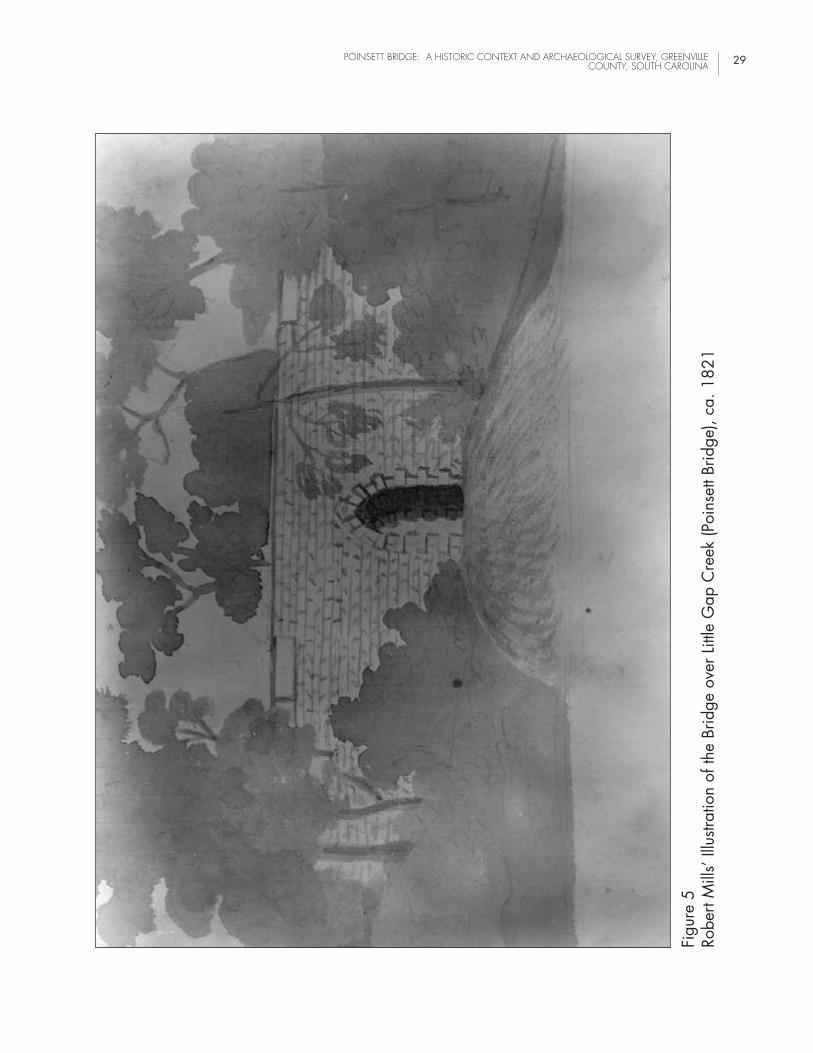
POINSETT BRIDGE: A HISTORIC CONTEXT AND ARCHAEOLOGICAL SURVEY, GREENVILLECOUNTY, SOUTH CAROLINA 29
Figu
re 5
Robe
rt M
ills’
Illu
strat
ion
of th
e Br
idge
ove
r Litt
le G
ap C
reek
(Poi
nset
t Brid
ge),
ca. 1
821
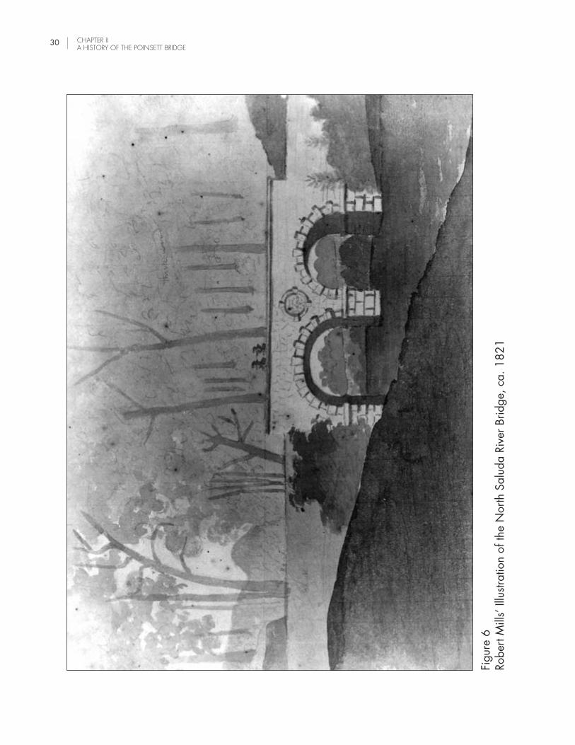
Figu
re 6
Robe
rt M
ills’
Illu
strat
ion
of th
e N
orth
Sal
uda
Rive
r Brid
ge, c
a. 1
821
CHAPTER IIA HISTORY OF THE POINSETT BRIDGE
30

POINSETT BRIDGE: A HISTORIC CONTEXT AND ARCHAEOLOGICAL SURVEY, GREENVILLECOUNTY, SOUTH CAROLINA
31
Even though the Poinsett Bridge sketch is neither labeled nor dated, the subject matter is unmistakable. Thedate of the sketch is almost surely in line with the other sketches, some of which are dated. It is also clearfrom the nature of the sketch, with the trees and vegetation around the bridge, that this was a view of thebridge after construction, not some sort of engineering drawing or plan. All of these sketches were clearlydone after the Saluda Mountain Road had been completed (Figures 7-9; Mills Collection, Tulane University).
What evidence is there that Robert Mills designed the Poinsett Bridge? So far as direct evidence isconcerned, there is virtually nothing. There are no extant plans of the bridge prior to construction, andthere are no letters or other written documentation that suggest that Mills designed the bridge. Tocomplicate the matter, Mills was not made a member of the Board of Public Works until December of1820, which was after the construction of the bridge. He was not even in South Carolina at the time ofconstruction.
Even so, the circumstantial evidence of Mills’ involvement is stronger than it looks at first glance. Mills hadbeen trying to obtain a position in South Carolina since at least 1817, when he returned to the state for thefirst time since his youth. He undoubtedly would have submitted examples of his work, which had alreadymade him well-known, and would probably have promised to help with the state’s comprehensive programof internal improvements, then gearing up for the first time. These might well have included plans forbridges and canals that would be constructed a couple of years later. He could have submitted plans forsuch projects while he was in Baltimore, with the assumption that he would soon acquire a permanentposition in South Carolina. He was interested enough in the area and the bridges to draw them one yearafter their construction. Even so, the greatest evidence of Mills’ involvement can be found in the bridgesthemselves. The bridges could have been built with identical arches, with no frills in the arch work.Instead, both the Poinsett Bridge and the bridge over the North Saluda had arch designs and ornamentalfeatures that only a formal architect would have included, or would have thought to include. Specifically,this entailed the use of three different styles of arches, the Gothic arch for the Poinsett Bridge, two ellipticalarches over the North Saluda, and a single circular arch over Hodge’s Creek. In addition, the arch workitself had a professional look. The arch stones, or voussoirs, were rectangular blocks laid in an alternatingpattern, with one tier of stones facing outward, and another tier exposed to the inside of the arch. Tocomplete the effect, the stones facing outward were raised out an inch or so from the surface of the bridgewall, providing relief. This is what one source refers to as “exaggerated voussoirs” (Marsh 1970:146-147). In all likelihood, only a professional architect would have added this purely decorative touch.
Even so, this leaves the possibility that Blanding and his work crews constructed the bridges with plansprovided by William Jay. Jay was a trained architect who was a member of the Board of Public Works atthe time of construction. Part of his job description was to provide stock plans for buildings as needed bythe board. However, there is no mention that Jay ever worked up plans for bridges, something that RobertMills certainly did. Also, by the time the Saluda Mountain Road bridges were constructed, it is possible thatJay was in disfavor. Jay’s position was not renewed in December of 1820, and after Mills replaced him,work based on Jay’s designs was either halted or modified to suit Mills. With all this in mind, it wouldappear more likely that Mills, not Jay, designed the bridges.
COMPLETION OF THE STATE ROAD AND ITS MAINTENANCE, 1820s
Even though the Saluda Mountain Road was finished in the fall of 1820, most of the rest of the state roadremained to be completed, especially in the middle of the state (Blanding 1820). Much less is known about

Figu
re 7
Robe
rt M
ills’
Illu
strat
ion
of th
e To
ll G
ate
on S
alud
a M
ount
ain
Road
, ca.
182
1
CHAPTER IIA HISTORY OF THE POINSETT BRIDGE
32

POINSETT BRIDGE: A HISTORIC CONTEXT AND ARCHAEOLOGICAL SURVEY, GREENVILLECOUNTY, SOUTH CAROLINA 33
Figu
re 8
Robe
rt M
ills’
Illu
strat
ion
of th
e So
uth
Car
olin
a M
ount
ains
from
Sal
uda
Mou
ntai
n Ro
ad, c
a. 1
821
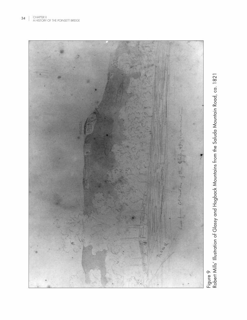
Figu
re 9
Robe
rt M
ills’
Illu
strat
ion
of G
lass
y an
d H
ogba
ck M
ount
ains
from
the
Salu
da M
ount
ain
Road
, ca.
182
1
CHAPTER IIA HISTORY OF THE POINSETT BRIDGE
34

POINSETT BRIDGE: A HISTORIC CONTEXT AND ARCHAEOLOGICAL SURVEY, GREENVILLECOUNTY, SOUTH CAROLINA
35
the construction of this portion of the state road, presumably because it was easier to build. It is not evenknown exactly when the rest of the road was completed, but it appears to have been finished by the mid tolate-1820s. The year 1821 was a construction year just like 1820, but there were a number of changesmade in the labor arrangements. Moving laborers to the mountains during the sickly season wasdetermined to be too expensive and it was decided not to repeat that experiment. With the completion ofthe Saluda Mountain Road, there might not have been much demand for laborers in the uplands anyway.The board decided not to take into service those engaged by the several contractors during the previousautumn, even though this contravened the original directives from the legislature (Kohn 1938:126-127).Presumably, this meant that most of the laborers from 1820 did not return to work on the project in 1821.This would explain the greater length of time it took to finish the road.
Eventually, however, the road was finished, and was linked with North Carolina’s Buncombe Turnpike,which joined up with the Saluda Mountain Road at Saluda Gap. The Buncombe Turnpike, which passedthrough Asheville and then down the French Broad River, was completed in 1828, finally connecting SouthCarolina with east Tennessee (Batson 1995:7-8).
Also completed were the various canal projects that were an integral part of South Carolina’s internalimprovements program. Most of this work was done by the middle of the 1820s, and included Lockhardt’sCanal on the Broad River; the Landsford, Catawba, Rocky Mountain, and Wateree canals on theCatawba/Wateree; the Columbia Canal; the Santee Canal; and the two canals on the Saluda: Lorick’s andDreher’s (Kovacik and Winberry 1987:94; Department of Public Works, Superintendent; Misc. Papers,1819-44, S208006, Titles Extinguished). By 1826, Robert Mills was able to boast that the Saluda Riverwas improved with three canals and was now navigable for 120 miles above Columbia (Mills 1826:156).
As for the Saluda Mountain Road, the biggest problems during this period were those of maintenance andpayment. From the beginning it was planned that the state road would be a toll road, and tolls werecollected shortly after the construction of the road. The first toll gate for the mountain road was establishedbetween the forks of the road at Hodges, and the top of Rocky Hill—between the North Saluda River andSaluda Gap (Batson 2003:16). This location was at the site of a long, narrow plantation that was socompromised by the construction of the road that it was determined more cost-effective to buy the placerather than pay crop and property damages. Tolls were to begin at this location on the first day ofNovember 1820. Blanding negotiated a contract with a Col. Marony to collect the first tolls (Blanding1820:49-50; McCuen 2000:19). As determined by the legislature, the board was to appoint a tollcollector for one year, with tolls used to pay for road maintenance. Any monies left over were to go intothe public treasury. After the first year, the toll leases were to be let for three-year periods (Statutes, vol. 10,Index, p. 546). This time interval does not appear to have been honored, for lease intervals appear tohave varied over time. By 1821, when the toll gate was fully operational, there were believed to havebeen a number of structures related to the toll gate: the toll house, a residence for the toll gate keeper, aswell as other farm buildings. Mills even sketched the toll gate complex in the fall of 1821 (see Figure 7).Years later, it appears that the toll gate was relocated to a slightly different location that was still betweenthe river and the gap (Batson 2003:20, 55-57).
Col. John Hodges was one of the early toll gate lessees. In 1826, bids for the position were held at hishouse, with the post going to the highest bidder for one year. In addition, the highest bidder would haveaccess to “the farm and houses at the top of Rocky Hill” (Batson 2003:16-17). Hodges himself appears tohave been the highest bidder, for he received the lease for one year. Among his duties was to keep the

CHAPTER IIA HISTORY OF THE POINSETT BRIDGE
36
road in good repair for a total of 17 miles, beginning at the edge of the North Carolina line. He was alsoto pay $1,000 for tolls for one year (Greenville Republican, Nov. 4, 1826).
The toll rates appear to have varied over time, but one of the earliest listings charged 75 cents for acarriage pulled by 4 animals (horses, oxen, or mules). A conveyance pulled by 2 animals commanded 62cents. One pulled by 1 animal, 25 cents. Other vehicles, presumably wagons, also had to pay based onthe number of draft animals: for 6 or more, it was 75 cents; for 5, it was 62 cents; for 4 animals, 50 cents;and for 3 or less, it was 37 cents. A cart was charged 25 cents. A rider on horseback, 12.5 cents. A ledanimal cost 5 cents. A herd of animals driven to market were charged per head, depending on the type ofanimal: oxen, 5 cents; cattle, 3 cents; goats, sheep, hogs, or turkeys, 2 cents (McCuen 2000:20). AllSouth Carolina citizens living within 10 miles of the toll gate did not have to pay (Kohn 1938:126). Evenso, they soon had an obligation that may have been more onerous, and that was road repair.
Blanding signed the first contract for road repair in 1820. At that time, the annual funds to repair the roadcame to $1,000, with a possible rise to $1,800 in case of flood or other natural disaster. Funds were tobe dispersed at the discretion of the board (Blanding 1820:50). As early as 1821, however, it was notedthat the drains and culverts had not been maintained as they should have been, which caused greatdamage during the seasonal downpours. So it was proposed that citizens exempt from tolls could be put towork on road repairs (Kohn 1938:126). At this point, the state legislature ordered the Greenville Districtroad commissioners to enforce the contract between the Board of Public Works and Hiram Whitted andJohn Hodges, both of whom had failed to keep the road in shape as their contract stipulated (Batson2003:15).
According to the State Road Act of 1824, all lessees of the toll gate on the Saluda Mountain Road werealso obligated to keep the road in good repair. This included keeping the road free of ruts and holes, andcleaning the culverts that passed underneath the roadbed (Greenville Republican, November 4, 1826).Where a bridge was constructed of brick or stone, damages to the masonry were to be repaired accordingto the original style. The same was to be done for stone walls, culverts, and drains. Lessees were notrequired to repair or replace a bridge if destroyed by flood. Even with this caveat, if commissioners foundthe road in poor repair, they were authorized to suspend toll payments until the lessee finished the repairs(Batson 2003:20-21).
By the mid-1820s, when the state road was completed, it was divided into sections for easier maintenance(Department of Public Works, Superintendent; Misc. Papers, 1819-44, S208006, Certificate of ContractFulfillment 1826). By 1830, the position of toll collector, which was still awarded on a yearly basis, was tohave a salary and the use of the farm attached to the toll gate (Greenville Mountaineer, March 13, 1830).That same year, the superintendent of public works, or any employee thereof, was given the power to callout the local inhabitants, and their slaves, to do repair work on the turnpike (Statutes 1830, No. 2500).
By this time, use of the Saluda Mountain Road had settled into a routine. The road was favored by freightwagons, or heavy wagons that moved in convoy so that if one got stuck, the other teamsters could help pullit out. Many of these wagons were shaped like the “prairie schooners” more often seen out West. Some ofthe most common loads carried by the freight wagons were apples from Buncombe County, NorthCarolina, dried apples, cabbages, and chestnuts. Also seen on the road, but less common than in earlieryears, were items like butter, and bear and deer hams (Batson 2003:37). The established road etiquettewas that descending traffic, especially if it was loaded, kept to the inside or “mountain” side of the road(Batson 2003:14).

POINSETT BRIDGE: A HISTORIC CONTEXT AND ARCHAEOLOGICAL SURVEY, GREENVILLECOUNTY, SOUTH CAROLINA
37
With regular traffic came resting places and watering holes. Joel Poinsett, said by tradition to have had ahouse on the side of the road about one mile below Saluda Gap, is supposed to have created BasinSpring, a stone basin put beside the road for travelers. Water was brought to the basin from adjacentPoinsett Spring by means of a log pipe. Chestnut Springs was a popular campsite on the road just belowthe Poinsett House (Batson 2003:63-64). Other places were taverns and inns. John Hodges had an inn atFlat Rock, just a few miles on the other side of the state line, as well as another closer to his residence onthe road. (Batson 2003:54-55). Other establishments included the Knothole, located on the state road nearthe Callahan Mountain winds. Much further down, on the road to Greenville and Spartanburg, wasHurricane Tavern, as well as the tavern, store, and drovers’ stand of Philip Lister (Batson 2003:25, 52-53).
DECLINE OF THE PUBLIC WORKS PROGRAM, LATE 1820S
Despite the expenditure of over a million dollars, South Carolina’s internal improvements program began topeter out towards the end of the 1820s. The cost of the public works program proved to be greater thanexpected, but the main reason for the decline was that the various canals and the state road failed togenerate revenues sufficient to off-set the expense. What was really at stake was that the state could notoverride the nation’s move westward, a move that affected South Carolinians as well as others on theEastern Seaboard. As increasing numbers of the state’s cotton growers moved to fertile western lands, staterevenues declined (Bryan 1989:76).
By the end of the 1820s, most of the canal works had been abandoned as too costly to maintain. Manyhad been sited poorly due to political considerations. Others were damaged in local floods and neverrepaired (Edgar 1998:282-283; Moore 1987:18). Even the state road went into eclipse for many of thesame reasons, even though the road itself was operational for decades to come. By 1829, publicconstruction in South Carolina had virtually come to an end (Waddell and Liscombe 1981:2). Thedevelopment of railroads put the nails in the coffin. South Carolina was one of the first states to experimentwith the “iron horse,” but it was funded by private groups, not state programs. Robert Mills himselfrecognized that “railroads will supercede entirely the use of canals in our great system of internalimprovements” (Mills n.d.:40).
If railroads killed the state’s internal improvement program on the ground, what killed it philosophically wasthe Nullification Movement. Born of a poor market for cotton and fear of national tariffs that protectedNorthern industry, Nullification gained steam throughout the late 1820s and finally broke across thepolitical landscape in the early 1830s. Proponents of Nullification, foremost of whom was John C.Calhoun, believed that South Carolina had the right to nullify national legislation within the state’s borders.This struck at the heart of the kind of Unionism favored by populist leaders like Andrew Jackson, and it ledto a bitter dispute between Jackson and Calhoun at the national level. Although it eventually died down, itplanted the seeds of disunion. Nullification prepared the way for the secession controversy that woulderupt in 1850 and again in 1860, leading finally to the Civil War. Even though Unionist sentiment wasstrong in the Greenville District, the Nullifiers seized control of the state government in 1830. By that time,if not before, the state government lost all interest in better connections with its western neighbors. Theprogram of internal improvements was dead (Huff 1995:ix, 103-105).

CHAPTER IIA HISTORY OF THE POINSETT BRIDGE
38
THE LATER YEARS OF MILLS, BLANDING, AND POINSETT
The decline in the state’s public works program can also be followed in the decline of Robert Mills’ fortunesin South Carolina. As one of Mills’ biographers commented, Mills’ work for the state was some of the mostexpensive in the whole public works program (Bryan 1989:76). As a result, Mills’ involvement with thestate was constantly cut throughout the 1820s. Mills served as Acting Commissioner of the Board of PublicWorks from December 1820 to December 1822. When the board was abolished in December of 1822,Mills was made superintendent of public buildings. Mills was removed from state office the following year,in December of 1823, when he was replaced by Roderick Evander McIver, a clerk of court and part-timecontractor. From this point on, Mills did piecework, either for the state or for private clients, and waschronically short of money (Bryan 1989:3, 76; 2001:149). As early as 1824, Mills was sending letters toJohn Calhoun, then Secretary of War, seeking a federal position in Washington, D.C. (Glenn 1938:3).
During this period, he continued constructing public buildings on an ad hoc basis. He also worked on oneof his greatest achievements, the Mills “Atlas of the State of South Carolina,” published in 1825. It wasfollowed the next year by “The Statistics of South Carolina” (Bryan 1989:3, 76-77). Mills hoped to supporthimself by selling these publications, but was only marginally successful. In 1830, Mills gave up making aliving in this way and moved back to Baltimore and Washington, D.C. On January 16, he wrote Col.Blanding, apparently from Washington, about the money that he owed Blanding, and whether he could sellhis house in Columbia for $2,000. Later that year, in Baltimore, Mills did plans for the courthouse inSavannah, Georgia, and began design work for the Washington Monument. Mills would go on to designsome of his most famous works, and write a guide to American lighthouses, The American Pharos (1832).He never came back to work in South Carolina (Bryan 1989:3; Mills Papers at Tulane University).
Abram Blanding’s career as state employee continued longer than Mills’ tenure. In addition to serving asActing Commissioner of the Board of Public Works from 1819-1822, he served as chief superintendent ofpublic works for the five years that followed (1822-27). A Federalist and a Unionist, Blanding probablysaw his career go into eclipse during the Nullification era (Bailey 1984:60-62).
This was even true of Joel Poinsett, an ardent Unionist. Poinsett, however, had national connections andwas not limited to state government positions. Elected to the U.S. House of Representatives in 1821,Poinsett served as President Monroe’s personal envoy to newly independent Mexico in 1822. Three yearslater, in 1825, he resigned from Congress to serve as the first official American ambassador to Mexico,appointed by John Quincy Adams. Favoring the liberal factions over the more conservative powers in thatcountry’s internal politics, Poinsett was eventually asked to leave, returning to the United States in 1830.He brought back a new plant, the poinsettia, which was named in his honor. Elected to the South CarolinaGeneral Assembly in 1830, Poinsett served as Andrew Jackson’s “agent” during Nullification, when it wasthought possible he might have to raise a Unionist militia to put down a rebellion.
In 1833, he married Mary Izard and moved to her plantation, “White House,” in the Georgetown District.By this time, he also had a farm on Charleston Neck and a summer residence called “The Homestead,”located in the Greenville District, close to the Saluda Mountain Road. In 1837, President Van Burenappointed him Secretary of War, where he helped reform the military and create a general staff. Heopposed the growing tide of secession, which he thought was wrong, with little chance of success. He diedin Statesburg in 1851, while on his way to Greenville (Bailey et al. 1986:1287-1289; Fant et al.1996:305).

POINSETT BRIDGE: A HISTORIC CONTEXT AND ARCHAEOLOGICAL SURVEY, GREENVILLECOUNTY, SOUTH CAROLINA
39
LATER YEARS OF THE SALUDA MOUNTAIN ROAD, 1830s-1950s
Even though the Saluda Mountain Road, and the state road of which it was a part, was never as successfulas was anticipated, it proved to be extremely long-lived. The Saluda Mountain Road remained in use notonly throughout the antebellum period, but also well up into the 20th century.
As early as 1834, there was a stage route than ran once a week between Greenville and Asheville, adistance of 64 miles. The fare was $5 (Greenville Mountaineer, July 12, 1834). The total tolls taken in forthe month of April of 1841 came to $128.87 and 1/2 (Department of Public Works, Superintendent; Misc.Papers 1819-44, S208006, Travel Book, Unidentified Toll Gate). This represented a considerable amountof traffic, and in 1847 it is recorded that 1200 wagons, 499 carriages, 1536 persons on horseback,3509 horses in droves, 4492 head of cattle, and 40,118 hogs and sheep passed through the toll gate(McCuen 2000:20). During this period, it is clear that repair arrangements were still made on a yearlybasis. Only now it seemed that the responsibility for leasing the road passed from the state to GreenvilleDistrict (Batson 2003:18).
Even so, there was an inexorable decline in the volume of trade that made use of the road, if not of theroad itself. According to one source, the lower portion of the state road was not completed until 1829, andat no point was enough money taken in to make the road profitable (Edgar 1998:282-283). One of thereasons for this was that the toll roads offered few real advantages over free roads, and many travelersavoided them as a result (Moore 1987:16).
As a result of this general decline, the state began to divest itself of responsibility for the road, beginning inthe 1830s. At that time, the Saluda Mountain Road effectively became a county road, with GreenvilleDistrict commissioners taking over the leasing of the toll gate and the repair work. This was soon followedby the sale of state lands that had been purchased or claimed by the state since the inception of the road(Anne McCuen, personal communication, March 1, 2004). By the Act of 1819, the state had beengranted the authority to either purchase or lay claim to any desirable lands within 10 miles of the stateroad. Most of these lands, around 14,000 acres, were sold by 1844. John Hodges appears to havepurchased some of this land that same year (Greenville Mountaineer, June 21, 1844). It is interesting thatJohn Hodges, whose land included the three bridges of the Saluda Mountain Road, also appears to haveowned the bridges. There is no mention of state ownership, even at the beginning of road construction,and subsequent deeds make no mention of exemptions for state ownership, as would normally be done ifthe state had purchased or acquired the land.
By the 1850s, there was competition from the railroads, even though this was indirect at first, since norailroads were able to penetrate the mountains until after the Civil War. As early as 1833, the SouthCarolina Railroad had been built to Hamburg, opposite Augusta, and 20 years later, there was a railroadto Greenville (Huff 1995:120-121; Richardson 1930:103). Perhaps a more immediate threat was posedby other local roads, which began to proliferate in the 1850s. A plank road was proposed from Greenvilleto Asheville, even though it was never built (Batson 1993:49; 1995:12-13). A more serious threat wasGap Creek Road, which approached the mountains from the Middle Saluda River, and then followed GapCreek to the North Carolina line (Batson 1993:42-44).
While economic activity declined on the state road, and many avoided it in favor of free roads, there wasone category of traveler that clearly favored the route. During the years before the Civil War, there wasincreasing numbers of lowcountry planters and their families who headed for the mountains to escape the

CHAPTER IIA HISTORY OF THE POINSETT BRIDGE
40
heat of summer, as well as the dangers of the “sickly season.” In previous years, many of these planterswould have traveled to the South Carolina Sand Hills, where communities like Stateburg sprang up to caterto this seasonal traffic. The state road made it easier to go further, up into the mountains, where it waseven cooler. Most planters usually traveled in their own carriages, although some used publicconveyances. Often six or more families traveled together for safety. These lowcountry “caravans” wereaccompanied by baggage and provision wagons, personal slaves, as well as mounted attendants whorode beside the convoy. In this fashion, it would often take up to 10 days to make the journey across thestate (Batson 2003:77-78).
Some of the more popular destinations for these lowcountry travelers were Caesar’s Head, Raven Cliff Falls,and Table Rock, but the most popular of all was the area around Flat Rock, North Carolina. Located on thecrest of the Blue Ridge, Flat Rock was about 12 miles north of the Poinsett Bridge. For those approachingthe mountains from either Charleston or Columbia, the best way to get to Flat Rock was by way of the stateroad (Cooper 2000; Huff 1995:89-92).
This sort of attention gave the Saluda Mountain Road an upper-crust veneer and even a little upper crustnotoriety. According to local tradition, Joel Poinsett kept a summer residence just inside the South Carolinaline. Further up the road, just over the North Carolina line, there was a duel that occurred on November 5,1827 between Dr. Robert B. Vance, a former North Carolina Congressman, and Samuel P. Carson.Carson’s second was Davy Crockett. Dr. Vance was mortally wounded and died at John Davis’ tavern inNorth Carolina. Both Carson and Crockett eventually moved on to Texas. Crockett died at the Alamo andCarson became Secretary of State in the new Texas Republic (Batson 2003:64-65).
Small settlements sprang up along the Saluda Mountain Road. Merrittsville, located close to the toll gate,became a small community as a result of this traffic. The settlement coalesced around the farm of BenjaminMerritt, who settled on the North Saluda at the base of the mountains in the late 1700s. At first just the siteof Merritt’s mill, this community grew to contain a general store, blacksmith shop, tannery, drover’s stand,saw mill and a post office, first established by John Hodges in 1821 (Batson 2003:55, 58). Hodges andhis family lived south of Merrittsville.
Living to the northeast of John Hodges, further up Little Gap Creek, was Jordan Holcombe. To the southeastwas William Lynch, Jr. Both men had their land as a result of state grants, and much of this land would fallinto the possession of Gresham Callahan, for which the Callahan Mountain would later be named. Furtherupstream, near the headwaters of Little Gap Creek, were Tim Pitman and William Howard, both of whomhad land grants. Their lands would later be in the possession of John and Charles Gosnell, and Jacob andJoshua Pruitt (See Appendix A). This area, located on the west flank of Glassy Mountain, was on the edgeof what became known as the “Dark Corner.”
Lowcountry visitors were exposed to the regionalisms of this mountainous part of the state. One of the mostinteresting was the story of the Dark Corner, another name for the area around Glassy and Hogbackmountains, which formed the headwaters for the Pacolet, South Pacolet, Middle Tyger, South Tyger, andNorth Saluda rivers. During the Nullification Controversy, lowcountry people described the local residents,almost all Unionists, as being “in the dark,” or living in a “dark corner.” Many of these locals also madetheir own whiskey, an activity that became illegal after the Civil War. In the era of moonshine, the name“Dark Corner” took on yet another meaning (Batson 2003:66).

POINSETT BRIDGE: A HISTORIC CONTEXT AND ARCHAEOLOGICAL SURVEY, GREENVILLECOUNTY, SOUTH CAROLINA
41
It would appear that the Saluda Mountain Road was still being leased out right up to the time of the CivilWar (Batson 2003:18-19). This system, however, fell apart in the later years of the war, when desertersoften congregated in the mountainous areas of the state and across the border in North Carolina. Caesar’sHead, Pott’s Cove, Saluda Gap, and the Dark Corner, all became known as areas where deserters couldgather (Batson 2003:65). In the years that followed the war, with the state’s economy in tatters and withwidespread poverty, the Saluda Mountain Road became just another road, one of many that providedaccess to the mountains.
After the war, it appears that the state attempted to reinstate the collection of tolls on the Saluda MountainRoad. In a message dated to October 24, 1865, the governor said that no tolls had been collected orwork done on the road for the previous two to three years (Batson 2003:19). The implication was that thatsituation would change. Whether it did is not clear. Some years later, around 1872, it was announcedthat the Saluda Gap Turnpike was to be leased by authority of the Sinking Fund Commission for a term offive years, with the lease to be paid in advance (Batson 2003:19).
Cartographic sources from the late nineteenth century typically show the road with few changes. The 1873Stoeber map shows the mountain road as just one of many in the area (Stoeber 1873). Even so, it stillappears that the Saluda Mountain Road and the Gap Creek Road were the main routes over the mountains.
The road appeared again on the 1882 Kyzer map with basically the same configuration (Kyzer 1882).The toll house appears, as does Merrittsville. The creek spanned by the upper-most of the three bridges,originally called Hodge’s Creek, and later Mill Creek, appears on this map at least as State Falls Creek. J.H. Goodwin and J. F. Hightower were among the local residents listed in the vicinity of the road on thismap. Closer to Little Gap Creek, there were W. I. Hart, A. D. Hart, and John Gosnell.
By the time of the 1904 Edens map, the road toll was no longer collected. The tollgate was abandoned,and the road does not appear to be any different from the other roads in the area (Edens 1904).
A few years later, around 1910-1912, one of the stone arches of the North Saluda River bridge collapsedand was replaced by a wooden span. This was the situation when traveler Thomas Robinson Dawley spentthe night with Arthur Hodges and his family before crossing the half ruined bridge (Batson 2003:14, 22,77).
There were other changes to the road about this time. The coming of the automobile led to a few stretchesbeing widened and straightened, beginning around 1914-1916. The village of Merrittsville began its slowdecline with the growing popularity of the auto (Batson 2003:22; 55-58).
Other forces were at work in the depopulation of Merrittsville and the surrounding area. The phenomenalspread of cotton mills throughout the South Carolina piedmont in the early 1900s, drew South Carolinamountain folk to the cities of Greenville and Spartanburg. The same Thomas Robinson Dawley who crossedthe Saluda River bridge, reported that much of the South Carolina mountains were almost abandoned aspeople moved off to the mills, leaving houses and cabins unattended (Batson 2003:75-77).
In the wake of this depopulation came the lumber industry, which clear-cut much of the mountain areas ofSouth Carolina and adjacent parts of North Carolina in the early years of the 20th Century. This activity ledHoward Wiswald to work up a property map of the region between 1918 and 1921 for the Saluda Landand Lumber Company (Greenville County Plat Book Y:118). The scale of this map is such that it is not

CHAPTER IIA HISTORY OF THE POINSETT BRIDGE
42
suitable for reproduction in this report, but, with the aid of a magnifying glass, it is an incomparableresource for determining property ownership in the area.
One of the more unusual additions to the local area was a Boy Scout camp, which was established in thearea as early as the 1920s (Simmons 1926). This establishment came to be called Camp Old Indian, andwas located on the slopes of Old Indian Mountain on the Saluda Mountain Road, just about a quarter mileabove Poinsett Bridge (Batson 2003:54). The Boy Scout camp inaugurated a period when the PoinsettBridge was more frequently exposed to visitors. From this point on, the bridge begins to appear in the localnewspapers as a historical curiosity.
One of the few plat maps showing the bridge area dates to 1937 (Dalton and Neves 1937). It shows theH. P. McGee Land, also known as the Callahan Mountain Tract, some 116 acres on the south side of theold State Road. It shows the “Old Stone Bridge,” the Boy Scout land to the east, Jesse Watson’s land to thenorth, and Saluda Lumber Company land to the west. Since the property line in this area ran along theroad, the property line ran over the bridge as well. It is for this reason that the bridge in recent years hasalways been split between two different owners.
As unlikely as it seems now, the Saluda Mountain Road (the old State Road) and the Poinsett Bridge,remained in use until at least 1955 (Batson 1955). In the year or so that followed, the road was realignedso that the Poinsett Bridge and the sharp turns associated with it were cut off by a new road bed, locatedimmediately south of the old bridge (Figure 10; Williams 2002).
Another, even bigger change occurred about the same time. The North Saluda Reservoir, planned andconstructed from the middle 1950s to the early 1960s, was an integral part of the Greenville WatershedArea, an upland area set aside as the water supply for the growing city of Greenville and surrounding area(Greenville Piedmont 1955). The reservoir had a direct impact on many of the local historic resources. Thesite of the North Saluda River bridge was impacted by the reservoir’s dam. The uppermost of the threebridges, as well as the site of Merrittsville, were covered by the waters of the reservoir (Batson 2003:14,22, 55-58). Only the Poinsett Bridge and isolated segments of the old roadbed remain to remind modernvisitors of the Saluda Mountain Road, once the pride of South Carolina’s Board of Public Works. As thebridge became the sole symbol of the old road system and an era long gone, it became increasingly thesubject of local newspaper articles that repeated and even fabricated local lore about the bridge.
RECENT HISTORY OF THE POINSETT BRIDGE AND THE CREATION OF THE HERITAGEPRESERVE
By the time of the Boy Scout camp, in the 1920s, the Poinsett Bridge over Little Gap Creek was becoming acuriosity piece. One of the first known newspaper articles dealing with the bridge is dated to 1926, a littleover one hundred years after the bridge was built. At that time, the construction date of 1820 was stillclearly visible on the keystone of the arch. Already called “Poinsett Bridge,” it was considered built by JoelPoinsett and Col. Abram Blanding. It was also thought to have been constructed by two Irish stonemasons,surnamed Denny or Danny (Simmons 1926).

POINSETT BRIDGE: A HISTORIC CONTEXT AND ARCHAEOLOGICAL SURVEY, GREENVILLECOUNTY, SOUTH CAROLINA 43
Figure 10Area of Poinsett Bridge Showing Old Road Alignment and New (1955) Alignment
0 400 Feet

CHAPTER IIA HISTORY OF THE POINSETT BRIDGE
44
By this point, it seems clear that Poinsett’s association with the bridge had risen over the years, while that ofAbram Blanding and Robert Mills had slipped. Another source dated to about this time claimed thatPoinsett himself designed and built the bridge (Richardson 1930:64). This bit of misinformation was atleast partly offset by David Kohn’s Internal Improvements in South Carolina, 1817-1828. Here, AbramBlanding’s pivotal role in the construction of the Saluda Mountain Road and its bridges was wellestablished (Kohn 1938). This work also contained a photograph of the Poinsett Bridge, showing thedownstream face, the Gothic arch, and the parapet (Figure 11; Kohn 1938:16). This is one of the firstknown images of the bridge since the Robert Mills’ sketch of 1821.
The bridge and the area around it again received attention in the mid-1950s, when the road was realignedand the North Saluda Reservoir was constructed. According to a newspaper article dated to 1955, thebridge was haunted, and the Irish masons, Denny and Danny, were so pleased with their work that theycame back to haunt the bridge at night. Another story making the rounds was that a man was killed duringthe construction of the bridge and was then buried in the abutments. He too came back at night (Batson1955). In another story, a small cabin that stood nearby was the home of Poinsett’s foreman during theconstruction of the State Road (Greenville Piedmont 1955). A much less savory development seems to havebeen vandalism. Possibly because it was no longer in use after 1955, people began hauling off stonesfrom the top levels of the bridge (Greenville News 1956).
In 1971, a newspaper article about the bridge mentioned that the plans were believed to have come fromRobert Mills. According to local tradition, the bridge was built by a stonemason named Mr. McDevit, whoused Indian and slave labor in the construction (Thomas 1971:46).
Beginning around 1970, when Poinsett Bridge was put on the National Register of Historic Places (Schuette1970), there was growing interest in the history of the bridge. Ways were also examined to preserve thestructure, which was still in private hands. A 1998 drawing of the bridge by Dr. William McCuen wasincluded in Anne McCuen’s article that summarized the bridge’s known history (McCuen 2000:18). By thistime, the structure was thought to be the oldest extant bridge in South Carolina, if not the entire SoutheastUnited States. It was listed in Donald Jackson’s Great American Bridges and Dams, and was included inan international database of structures (Structurae 1998-2003). Even so, it was still not certain whodesigned the bridge. Many modern sources have enlisted Robert Mills as the architect responsible for thedesign, but others, like Nancy Cooper, still say that Poinsett “supervised the building of the state road” and“may have designed the arched stone bridges in Greenville County” (Cooper 2000:47).
In early 2000, a committee for the preservation of the Poinsett Bridge, appointed by the Greenville CountyCouncil and chaired by Anne McCuen, began a study of the bridge and the various means available topreserve the bridge and adjacent road remnant. Based on the work of that committee, before the end ofthat year, the South Carolina Heritage Trust decided to assume the project, with the goal of turning it into aHeritage Trust Preserve (Hyndman 2002). At that time, the preserve was to include a six-acre tract to beobtained from the Boy Scouts, as well as other lands obtained from the south and west side of the bridge(Project Area c.2000).

POINSETT BRIDGE: A HISTORIC CONTEXT AND ARCHAEOLOGICAL SURVEY, GREENVILLECOUNTY, SOUTH CAROLINA 45
Figu
re 1
119
37 P
hoto
grap
h of
Poi
nset
t Brid
ge S
how
ing
Inta
ct P
arap
et

CHAPTER IIA HISTORY OF THE POINSETT BRIDGE
46
In 2002, the South Carolina Department of Transportation awarded funds to Greenville County for furtherstudy of the bridge and its restoration (Hyndman 2002). In 2003, the Parkhurst Tract was acquired bySCDNR-HTP to develop a heritage preserve for the bridge and the immediate area (Zacher 2003; 2004;Botwick 2004:1). Arrangements were made with the Boy Scouts to acquire land on their side of thebridge. At present, the preserve contains 122 acres, and will include the bridge, the adjacent roadbed,and a number of proposed improvements, such as trails, viewing decks, and information kiosks.
This report was compiled to complement the establishment of the preserve. One of our goals was to bringtogether what is currently known about the Poinsett Bridge and the Saluda Mountain Road. Another was toidentify, if possible, the individual responsible for the design of the Poinsett Bridge and the other bridgesassociated with the road. In particular, we wanted to determine whether or not Robert Mills, a native sonof South Carolina and famous as the original designer of the Washington Monument, had a hand in thisdesign. Unfortunately, we were not able to prove or disprove this association. The best we could do withthe evidence was to suggest that Mills was the designer, but the evidence is at best circumstantial. Theevidence of the bridges themselves strongly suggests that a professional architect was involved with thiswork, and this would rule out Poinsett as a possible designer, and almost surely Abram Blanding as well.There is still the possibility of William Jay, who was the architect on the Board of Public Works at the timethe bridge was constructed, in the summer and fall of 1820. There would appear to be no evidence,however, that Jay ever worked up any plans for bridges, something that Mills is known to have done.Since Mills had been actively seeking a position with the board or its predecessors since 1817, andactually became a paid member of the board in December of 1820, his involvement with the bridge in thefall of 1820 is not as far-fetched as it might appear at first glance.

POINSETT BRIDGE: A HISTORIC CONTEXT AND ARCHAEOLOGICAL SURVEY, GREENVILLECOUNTY, SOUTH CAROLINA
47
III. ARCHAEOLOGICAL METHODS ANDRESULTS
The objective of archaeological survey for this project was to identify resources associated with PoinsettBridge and the extant historic road segments in the SCDNR-HTP property. Background research andreviews of site file data provided a basis for developing predictions regarding archaeological resourcepotential. Fieldwork for this survey entailed surface reconnaissance and shovel testing of areas alongsidethe historic road and bridge. Fieldwork took place on December 18 and 19, 2003. The following sectionsdescribe the methods used for this survey and the results.
ARCHAEOLOGICAL RESOURCE POTENTIAL
Reviews of previously recorded locations and prior studies of prehistoric and historic settlement provide abasis for evaluating archaeological resource potential. Review of the archaeological site files at the SouthCarolina Institute of Archaeology and Anthropology indicated that one site (38GR24) has been recorded inthe project area while two additional sites (38GR3 and 38GR104) are within one mile of the project area.
Site 38GR24 is Poinsett Bridge. The site file, dating to 1972, describes the site as a “massive stone bridgewith pointed arches. Constructed without concrete in 1820.” No related features (e.g., the historic roadbed) are noted on the site form.
Two other sites within one mile of the project area are both prehistoric. Site 38GR3 (“Camp Old Indian”) isdescribed as a Native American burial site containing mounds and stone box burials. The presence ofpottery sherds indicated a Woodland period component. The site was recorded in the early 1970s basedon information in the files of the Charleston Museum and no further information was available. Similarly,38GR104 was recorded on the basis of informant data. This site contained evidence of multiplecomponents dating from the Middle Archaic to the Woodland and Mississippian periods. No informationon site function was provided.
The two prehistoric sites utilize different landforms. Site 38GR3, the burial site, appears to lie at the foot ofOld Indian Mountain and at the margin of the Callahan Branch Valley. This site represents a specialfunction, though, and its location probably is not typical of the majority of prehistoric sites in the region.Site 38GR104 lies on a small bottomland ringed on three sides by steep ridge slopes. This positionsuggests a smaller type of site, probably a transient occupation or seasonal camp. The site file data alsoindicates that this site lies along Barton Creek, a stream of roughly the same size as Callahan Branch. Italso appears to lie on Cartecay and Toccoa soils. This setting is similar to the Poinsett Bridge survey area.Due to the paucity of recorded sites in the project vicinity, it is difficult to generate expectations regardingthe project area. However, the conditions at Site 38GR104 indicate that prehistoric Native Americanswould have utilized settings such as the project area. Based on this assumption, the project area wasjudged to have a moderate potential for prehistoric archaeological resources. Any such resources wouldlikely reflect brief occupations (no more than seasonal camps) and might represent any prehistoric period.
CHAPTER IIIARCHAEOLOGICAL METHODS AND RESULTS
48
For historic archaeological research potential, historic maps provide one means for projecting pastoccupation. Historic maps that show structures and land use include Mills (1825) and Kyzer (1882). Thesemaps each show the intersection of the historic road and Callahan Branch (known as Little Gap Creekduring the 19th century), and indicate the presence of a bridge by the 1820s. No other occupation of anykind is shown in the project area. However, because historic settlement tends to follow transportationroutes, and because the road dates to 1820, NSA characterized the project area as having a moderatepotential for historic archaeological resources.
METHODS
The fieldwork included surface reconnaissance and subsurface survey. Reconnaissance consisted ofinspecting the project area to identify surface features and archaeological deposits and to note conditions.It also served to identify areas that could be omitted from further survey due to slope, poor drainage, ordisturbance.
Subsurface survey consisted of shovel testing in level, well-drained locations. Conditions in the project areawere best suited for discontinuous transects where slope and drainage permitted. Shovel tests were placedat 15-m (50-ft) intervals in all surveyed areas. In addition, NSA placed shovel tests at 7.5-m (25-ft) intervalsin the projected location of a 19th century farmhouse to look for archaeological evidence of this occupation.
Shovel tests measured 30cm (1ft) in diameter and were excavated by hand until culturally sterile soils wereencountered. Screening excavated soils through 1/4-in mesh hardware cloth ensured systematic artifactrecovery. Notes on all shovel test locations were recorded on standardized forms and information collectedon each shovel test included depths of individual natural strata, soil color and texture, location with respectto natural landforms, and cultural materials recovered. Shovel test locations were plotted on maps of theproject area and survey transects were tied to reference points shown on the project maps. Conditions inthe project area were also indicated on these maps and further documented with color photographs. Noartifacts were recovered during the survey and therefore, no laboratory analysis was conducted.
RESULTS
CONDITIONS IN THE SURVEY AREA
An initial walkover of the project area indicated that it contained rugged terrain along Callahan Branch.The stream valley was generally narrow within the project area and was flanked by slopes in excess of 20percent, particularly in the area of Poinsett Bridge. The area around the bridge contained only narrow andmostly low stream terraces (Figure 12a).
Immediately downstream from the bridge, the valley became narrower, and for a distance of approximately300m (1000 ft), was not surveyable. Downstream from this area and near the western portions of thesurvey area, however, the valley became wider and exhibited a relatively level floodplain flanked by lowerterraces to the south (Figure 12b). Examination of portions of the floodplain along the stream indicatedthese were poorly drained. Other portions of this floodplain were well drained, although subsequent shoveltesting revealed that they consisted of historic alluvial deposits.

POINSETT BRIDGE: A HISTORIC CONTEXT AND ARCHAEOLOGICAL SURVEY, GREENVILLECOUNTY, SOUTH CAROLINA 49
Figure 12Conditions in the Project Area
A Setting of Poinsett Bridge showing the narrow valley and steep valley walls. Looking upstream (east).
B: Wide segment of Callahan Branch Valley showing level floodplain and adjacent terraces. The projected19th century house was on the high terrace at left. Looking southeast.
CHAPTER IIIARCHAEOLOGICAL METHODS AND RESULTS
50
Vegetation in the project area was primarily forest with a light under story of vegetation. A section offloodplain and higher terraces located about 485m (1600 ft) west of Poinsett Bridge was an open field thatwas covered in dead kudzu. Ground cover was heavy throughout the project area and surface visibilitywas poor.
The project area contains several historic structures and sites, all of which have been previously identifiedbut not recorded as archaeological sites. The most prominent of these is Poinsett Bridge, a gothic stylestone structure crossing Callahan Branch. Associated with this feature in the project area are sections of ahistoric road, which according to local resident Wesley Breedlove, was used until the 1950s. A historicstone culvert crossed below the roadbed 122m (400 ft) downstream from the bridge. Mr. Breedlove alsopointed out a possible stone quarry or borrow pit just upstream from Poinsett Bridge and remains of awooden bridge located about 0.8km (0.5mi) downstream from the stone bridge. Mr. Breedlove alsoindicated that a late 19th century farmhouse was present, although archaeological remains of it had notbeen identified.
SHOVEL TEST RESULTS
In all, NSA excavated 35 shovel tests for this survey. Specific locations that NSA tested included lowterraces of Callahan Branch immediately downstream from Poinsett Bridge, including the area for aproposed new parking lot on the south side of Callahan Mountain Road (State Highway 42); a high terraceimmediately upstream from the creek; and high and low stream terraces in the western portion of the DNRproperty. In addition, NSA surveyed the projected location of the historic farmhouse, which consisted of ahigh terrace or bench overlooking the stream (Figure 13).
Shovel tests on the lower stream terraces and floodplains encountered soils that appeared to reflect historicflood deposits. Examples of these shovel tests included STP7, located on a terrace of the stream and STP23situated on a low floodplain section. STP7 encountered a 34-cm (1.1ft) thick layer of very dark grayishbrown (10YR3/2) sandy silt loam that represented topsoil above dark gray (10YR4/1) coarse sand withbands of red (2.5YR4/8) clayey sand that extended to the base of excavation at 88 cm (2.9ft) belowsurface.
STP23 exposed a deposit of olive brown (2.5Y4/3) fine silt with mica to 44cm (1.4ft) deep. These soils layabove dark gray (2.5Y4/1) compact sand that resembled stream channel deposits. Soil profiles such asthese were interpreted as evidence that floods had scoured the valley bottom and low terraces. Much ofthe reworking of these landforms probably occurred during the historic period as clearing led to intensifiederosion and high-energy floods.
Soil profiles on higher terraces included shallow topsoil above clayey subsoil. STP17, for example,revealed a 13-cm (0.4-ft) thick topsoil of dark brown (10YR3/3) sandy loam with mottles of yellowish red(5YR4/6) silt and clay. This material lay above reddish brown (10YR 4/4) clay that graded to red(2.5YR4/6) clay. The presence of angular gravel and cobbles in some of the shovel tests on higherlandforms suggested that colluvial deposition had occurred.
None of the shovel tests produced cultural materials. The bottoms and low terraces surveyed probablywere not stable enough for long-term settlement and any evidence of prehistoric or early historic occupationhas probably eroded.

POINSETT BRIDGE: A HISTORIC CONTEXT AND ARCHAEOLOGICAL SURVEY, GREENVILLECOUNTY, SOUTH CAROLINA 51
Figu
re 1
3A
rcha
eolo
gica
l Sur
vey
Cov
erag
e an
d Re
sults
1718
19
2021
22
WO
OD
EN B
RID
GE
2021
22SE
E IN
SET
67
89 10
11
12
1314
16
15
STO
NE
CULV
ERT PO
INSE
TT B
RID
GE
QU
ARR
Y
610
15
43
21
Prop
osed
New
Park
ing
Lot L
ocat
ion
Nor
th040
0 Fe
et
INSE
T
� ����T
ire R
uts
Hist
oric
Roa
d Se
gmen
t
050
Fee
tSh
ovel
Tes
t Loc
atio
nH
isto
ric R
oad
Segm
ents
Are
a Ex
clud
ed fr
om S
hove
l Tes
ting
Due
to S
lope
or P
oor D
rain
age
Revi
sed
NRH
P Bo
undr
y

CHAPTER IIIARCHAEOLOGICAL METHODS AND RESULTS
52
Survey of the reported 19th century farmhouse site also failed to produce any cultural remains. Accordingto Wesley Breedlove, this structure was located on a high terrace south of the creek at roughly the mid-pointof the study area and dated to the late 19th and early 20th centuries. At the time of the present survey, thissite area was covered in kudzu that had succumbed to cold and frost to create a dense ground cover. Thelandform on which the house sat was raised about 5m (16 ft) above the floodplain and was bounded onthe north, east, and west by steep slopes. To the south, the landform sloped upward. The resulting levelarea measured approximately 35-40m (115-130 ft) long and 15m (50 ft) wide. This landform alsoexhibited several deep ruts that suggested some disturbance by heavy machinery. Examination of the areafailed to identify any surface features (e.g., foundation or chimney remains) while shovel testing at 7.5-m(25-ft) intervals did not yield any artifacts. Based on the observed disturbance, it seems likely that remainsof this house were removed.
RESOURCE DESCRIPTIONS
Sites observed during the survey consisted of surface features associated with the historic bridge androadway and were pointed out by Wesley Breedlove, who had previously surveyed the property. Identifiedfeatures included a historic stone culvert, a possible quarry or borrow pit, and a wooden and stone bridge.
The culvert and possible quarry relate to Poinsett Bridge, previously recorded as archaeological site38GR24. Because of this relationship, the archaeological site boundary was expanded to include thesefeatures. Changes to the site boundary and description were recorded on a revised Archaeological SiteInventory Form (Appendix B).
Stone Culvert
The stone culvert lies 122m (400 ft) west of the Poinsett Bridge and permitted a 5th-order tributary to flowunder the historic roadbed and into Callahan Branch. The feature consists of a conduit with dry-laid stonesides and roof measuring 70cm (2.3 ft) high (above the extant stream bed) and about 1.5m (5ft) wide(Figure 14a). The length of the feature is about 3m (10 ft). Given that the road remained in use into the20th century, and probably saw periodic repair, the age of this feature cannot be determined at present.
Historic Borrow Pit/Quarry
The possible borrow pit lies immediately northeast of Poinsett Bridge on the north bank of Callahan Branch.This feature consists of an apparently excavated section of the ridge slope measuring approximately 20m(65 ft) across and 15m (50 ft) high (Figure 14b). Remnants of a rock ledge are exposed within theexcavated area. Wesley Breedlove noted (personal communication, 2003) that this feature might havebeen used to quarry stone for Poinsett Bridge.
It is worth mentioning that a rather expansive rock outcrop located downstream from the bridge andadjacent to the old road has an exposed face that was apparently flattened to clear the road and/or toacquire stone for the bridge. Also, large stones are strewn in the area between this outcrop and thestream, while the slope above the outcrop does not contain loose stones. This circumstance suggests thatthe stones reflect quarrying debris.

POINSETT BRIDGE: A HISTORIC CONTEXT AND ARCHAEOLOGICAL SURVEY, GREENVILLECOUNTY, SOUTH CAROLINA 53
Figure 14Cultural Resources Identified in the Project Area
A. Stone Culvert. Looking North.
B. Historic Borrow Pit/Quarry. Looking North.
C. Wood Bridge Remains (Site38GR316). Looking Southwest.

Figure 15Plan View and Profile of Historic Culvert, Site 38GR24
Historic Road Trace
Culvert
Historic Road Trace
Ground Surface
Culvert Elevation, Downstream (South End)
Meters0 1 2
Plan View of Stone Culvert
North
CHAPTER IIIARCHAEOLOGICAL METHODS AND RESULTS54

POINSETT BRIDGE: A HISTORIC CONTEXT AND ARCHAEOLOGICAL SURVEY, GREENVILLECOUNTY, SOUTH CAROLINA 55
Figure 16Plan of Site 38GR316
Historic RoadTrace
Cal
ahan
Bra
nch
Stone Pier Stone PierWooden Beam
Historic RoadTrace
0 10 20Meters
North

CHAPTER IIIARCHAEOLOGICAL METHODS AND RESULTS
56
The stone culvert and the evidence for quarrying contribute to the significance of the complex representedby the bridge and extant road sections. Both features have good integrity and clearly convey a sense oftheir functions. Moreover, they have good integrity of context in that they can be viewed with respect totheir historical associations to the bridge and road. While the chronologies of these features are not clearand they do not appear to possess significant research potential, they contribute to the historic feeling of thePoinsett Bridge site and so are recommended as contributing elements of it.
Wood Bridge (Site 38GR316)
The final archaeological resource recorded during this survey is a wooden bridge remnant—designated38GR316—that formerly carried the historic road over Callahan Branch. This site is 0.8km (0.5mi) west ofPoinsett Bridge. Remains of the structure consist of a 4.9m (16ft) long square wooden beam at the waterline of the east stream bank (Figure 14c). Piles of fieldstone lie at either end of the beam and are probablyremnants of the bridge abutments. Some large stones are on the opposite bank but no other woodenstructural remains were noted. Presumably the bridge consisted of a relatively basic wooden deckspanning the stream and resting on stone footings. Examination of the beam indicated it is a squaredtimber although no saw marks are visible. Several modern galvanized wire nails are embedded in it,indicating relatively new construction or repairs.
The apparent recent age of this feature and its poor overall condition suggest that it does not possessqualities of significance as defined by the National Register of Historic Places (NRHP). While this feature isclearly associated with the historic roadbed, it lacks sufficient integrity to clearly convey a sense of itsoriginal function. Also, these remains almost certainly represent a late replacement for any earlier structurethat might have been present. Therefore site 38GR316 does not likely comprise a significant culturalresource.

POINSETT BRIDGE: A HISTORIC CONTEXT AND ARCHAEOLOGICAL SURVEY, GREENVILLECOUNTY, SOUTH CAROLINA
57
IV. CONCLUSIONS ANDRECOMMENDATIONS
HISTORIC CONTEXT SUMMARY
Poinsett Bridge was constructed in 1820 as one of three bridges built along the Saluda Mountain Road.These bridges were built under the direction of the South Carolina Board of Public Works and were some ofthe earliest elements of the State Road, one of the Board’s most significant transportation projects, whichwould ultimately connect Charleston to Columbia and South Carolina to western North Carolina andeastern Tennessee. The actual construction of the bridges and other work on the Saluda Mountain Road,including the construction of stone culverts and retaining walls and the grading and clearing of the roaditself, was largely completed by stone masons and mechanics brought to South Carolina from northernstates.
Work on the Saluda Mountain Road was completed between July and October of 1820 and this work wasconducted during the summer months to provide the northern workers with a respite from construction in thecoastal plain during the malarial season. The three bridges built for the Saluda Mountain Road were allconstructed of stone and all expressed architectural elements, such as the Gothic arch incorporated into thedesign of the Poinsett Bridge, which suggest that they were designed by an architect. No plans or designsfor these bridges have been found, however. Poinsett Bridge is the only one of these three bridges tosurvive, and is the oldest surviving bridge in South Carolina as well as one of the oldest in the southeast.
At the time of its construction, the Board of Public Works was composed of five members: Abram Blanding,Thomas Baker, Joel R. Poinsett, William Jay, and Robert G. Mills. Only two of these were paid and theseappear to have done much of the Board’s work as “acting commissioners.” These two were AbramBlanding, who was in charge of roads, rivers, and canals, and who was the de facto head of the publicworks program; and Thomas Baker, a contractor in charge of the construction of public buildings. Of theother three, William Jay was a prominent English-born and trained architect who created some of the firstdesigns for the program’s courthouses and jails. Robert G. Mills was a contractor, and no relation to thearchitect Robert Mills, who would later serve on the board. Joel Poinsett was a politician, the president ofthe Board, and by far the Board’s most prestigious member. Poinsett traveled to the Saluda Mountain Roadarea in July of 1820 and would later own property near the completed road, however, there is no evidencethat he was involved in the physical design and construction of the bridge itself. Poinsett Bridge is namedfor him, in recognition of the role he played in the building of the State Road.
The identity of the architect who designed the Poinsett Bridge may never be known, as no plans of thebridge or the other bridges built for the Saluda Mountain Road have been found. However, the design ofthese bridges, which feature various architectural and engineering elements not known in the southeasternUS nor common in northeastern bridge architecture of the era, suggests these bridges were the work of anaccomplished architect. Two candidates emerge from the historical literature who may be associated withthese designs, both of whom were associated with the Board of Public Works. The first of these is William

CHAPTER IVCONCLUSIONS AND RECOMMENDATIONS
58
Jay. Jay was an architect who trained in Europe. While he designed a number of the public buildingswhich were planned by the Board of Public Works, there is no evidence that he designed any bridges orhad experience with bridge design. Jay was replaced on the Board near the end of 1820 by Robert Mills.Mills would subsequently redesign many of the building plans Jay had developed. While Jay was thearchitect on the Board of Public Works when the Poinsett Bridge was designed, there is nothing in hiscatalog to suggest he was capable of executing three different complicated bridge designs, particularlywhile working on a number of other building plans for the Board.
The other architect is Robert Mills. Mills would not be hired by the Board of Public Works until December,1820, after the Poinsett Bridge had been completed. However, he was actively seeking work in his nativestate of South Carolina as early as 1817 and thus may have been in touch with Joel Poinsett and other ofthe state’s politicians advertising his services. The Board of Public Works had embarked on an ambitiousbuilding program following its establishment, with everything from courthouses and public buildings tocanals, roads and bridges on its slate, and it is likely that the Board would have sought additionalarchitectural services to augment the plans that William Jay was able to produce. Trained architects werenot easily found at that time, and Mills was a South Carolinian with political connections who was activelypromoting himself in the state as one of the first American-trained architects. It thus seems likely that theBoard would have called upon Mills for assistance. The fact that he was brought on to replace William Jayat the end of 1820 suggests that the Board was familiar with his work and had already decided they wouldbe better served by Mills than by Jay. Mills also had experience with the design of bridges, having createdthe design for the Schuykill Bridge in Philadelphia which was the largest single span bridge in the worldwhen completed in 1812. There are also aspects of the design of the Saluda Mountain bridges whichsuggest the hand of Robert Mills. Rather than utilizing comparable designs and plans, each of the threebridges employed a unique architectural vocabulary. This suggests the work of an architect who wasfamiliar with bridge engineering and design, as well as the work of an expressive architect anxious todisplay his abilities and style. All of these elements suggest the hand of Robert Mills. Perhaps the strongestassociation between Mills and the Saluda Mountain Bridges, including Poinsett, was his tour of the SaludaMountain Road in 1821 and his preparation of detailed pen and ink drawings of the road and each of thebridges. These drawings suggest that Mills had a strong interest in the bridges, an interest that would bedifficult to understand unless he was their designer.
Following its completion, Poinsett Bridge became part of the State Road with tolls collected for travelthrough this section of the road. The flurry of transportation work and planning, and the Board of PublicWorks, had already come to an end, however. Population migration west, coupled with the introduction ofthe railroad in the early 1830s and the Nullification Controversy diminished the grand schemes of the1810s which called for both roads and canals to facilitate travel in the state. Passage over Poinsett Bridgewould continue at a slower pace, primarily reflecting the travel of planters and others to the mountainsduring the summer season. With the introduction of the automobile, the movement to bypass PoinsettBridge could be predicted, and by the mid 1950s the bridge was no longer in use. Its preservation to thisdate is testimony to its remarkable architecture and a reminder of the dreams and aspirations of the state inthe early 19th century.
POINSETT BRIDGE RECOMMENDATIONS
The context research has provided more information on this historic bridge and has brought togethervarious images of the bridge over time as well as themes for future interpretation. The Mills’ sketch,although stylized, gives some sense of how the bridge looked after construction. The simple railings used
POINSETT BRIDGE: A HISTORIC CONTEXT AND ARCHAEOLOGICAL SURVEY, GREENVILLECOUNTY, SOUTH CAROLINA
59
as a guard rail indicate that the sidewalls on the bridge entries were fairly low. The 1938 photograph isextremely useful and the large format photography completed for the 1988 HAER study contributes greatlyto our knowledge of this significant historic resource. However, very little primary information was foundthat would benefit or guide future bridge restoration. The original gross dimensions are known but detailsare still missing such as the height of the entry sidewalls that are now in poor condition.
The details may be in the bridge itself. To date there has been no thorough study of the bridge by a historicarchitect that fully describes its appearance and its construction. The HAER study was confined to largeformat photography and a summary form with no description. A full architectural description and measureddrawings of the bridge today would provide a permanent record as well as baseline information asplanning begins for bridge stabilization and possible restoration. It is recommended that SCDNR-HTP andthe Greenville County Recreation District require the drafting of measured drawings and the completion of ahistoric structures report for the bridge to provide a record of its condition prior to or as part of anystabilization work. We also recommend that notices or advertisements be posted in local areas such ascommunity centers and libraries asking for old photographs of the bridge. Views from the 1920s throughthe 1950s in private collections would be of great value for future work and this call would allow theinterested public an avenue to contribute to the bridge’s preservation. A press release on the results of thishistoric context could be provided and could include a call for historic images. Similarly, a public meetingcould be held to present the results of this research and attendees could be asked to bring historicphotographs with them for scanning and documentation. Finally, we recommend that the organizationselected for the stabilization effort include a historic architect given the significance of the bridge.
ARCHAEOLOGICAL RESULTS AND RECOMMENDATIONS
Archaeological survey focused on areas adjacent to the bridge and roadway, which included bottomlandalong Callahan Branch. The survey found that much of the bottomland contained soils deposited by historicfloods and no prehistoric or early historic sites were identified during the shovel testing.
The survey resulted in the recordation of three surface features in addition to Poinsett Bridge and the historicroad. These features include a stone culvert under the historic road, a possible quarry or borrow pit used toobtain building material for the bridge, and wooden bridge remains located downstream from PoinsettBridge. The culvert and possible quarry possess integrity and convey a sense of their functions andassociation with Poinsett Bridge and the historic road. They have been included in archaeological site38GR24, which previously included Poinsett Bridge and contiguous historic road segments. The newlyrecorded features are recommended as contributing to the historic significance of the Poinsett Bridge Site,which is listed on the NRHP.
Based on this recommendation, the boundaries of 38GR24 should be expanded to include these newlyrecorded features. Included in the boundaries are the bridge, the quarry located east of the bridge, thestone culvert, located northwest of the bridge, and the extant road trace in the site area, which ties togetherelements of the site (see Figure 13). The boundaries are drawn to include a roughly 200x60-m (650x200-ft) area that includes a discrete section of Callahan Branch terraces bounded by steep slopes on all sidesand containing extant portions of the historic road trace and other features. Although segments of thehistoric road exist in other parts the survey area, these no longer connect to the NRHP site and do notstrongly contribute to its historic character. The revised site boundaries therefore include a discrete andrepresentative sample of features associated with the construction and operation of Poinsett Bridge.

CHAPTER IVCONCLUSIONS AND RECOMMENDATIONS
60
The wooden bridge, designated Site 38GR316, apparently represents a 20th century span of the creek at apoint along the historic road. This resource lacks integrity and does not convey a sense of its function. Thisresource is therefore recommended not eligible for the NRHP.
RECOMMENDATIONS FOR SITE INTERPRETATION
The Poinsett Bridge is a historically significant site with the ability to address a number of aspects of SouthCarolina’s history. Ultimate development of the interpretive plans and displays at Poinsett Bridge will bedeveloped by the SCDNR-HTP and the Greenville County Recreation District. This section provides asummary overview of possible themes and topics for site interpretation suggested by the historical andarchaeological research.
Who Was the Bridge’s Architect?
Perhaps the most fascinating element of the history of Poinsett Bridge is the fact that its architect is notknown but may have been the famous Robert Mills, the self-styled first American architect who would go onto design the Washington Monument as well as many public buildings in South Carolina, Washington DC,and Philadelphia. This interpretive theme should examine the men associated with the building of thebridge, most notably Blanding, Poinsett, Jay and Mills, and should present the evidence which suggests thebridge was built by Mills. This theme may also look at various newspaper articles and other publicationsover time which have credited the construction of Poinsett Bridge to various individuals, most notably Millsand Poinsett, and use these observations to note that history is often detective work requiring the analysis offacts and observations, rather than the simple reading and reporting of the past.
What Is the Bridge’s Style and How Was It Built?
The Poinsett Bridge was constructed of stone that appears to have been locally quarried; a quarry site wasidentified by the archaeological survey. Local history contends that the bridge was built without mortar.The stones used in the construction of the bridge were rough-hewn, with the exception of the arch, wherethe stones were finished. The arch, which rests on bedrock in the streambed, is formed by voussoirs thatare slightly wedge-shaped and cut to fit. These blocks are laid in an alternating pattern: one stone placedso that the long side faces outward; the following stone placed so that its long side faces the inside of thearch. The stones facing outward, which already form an alternating pattern, are also slightly raised tocreate relief. The alternating pattern, the relief, plus the pointed apex of the Gothic arch, give the bridge amedieval look. Mills’ sketches of the bridge show what appear to be wooden guardrails along the deck.The use of stone in the bridge’s construction, as well as its formal style and appearance, speak to theimportance of the State Road and the Board of Public Work’s desire to build both a durable and attractivestructure.
The exuberance of the bridge styles and their harkening to classic elements and styles was purposeful andhad cultural meaning. They showed that the young nation even in its backcountry shared an educatedarchitectural vocabulary on par with Europe. On a more personal level it also showed that the designer, beit Jay or Mills, was no backwoods architect/engineer. With bridges of this caliber, South Carolina“arrived” on the forefront of a developing American discipline and profession.
Why Was the State Road Built in Segments?

POINSETT BRIDGE: A HISTORIC CONTEXT AND ARCHAEOLOGICAL SURVEY, GREENVILLECOUNTY, SOUTH CAROLINA
61
Poinsett Bridge and the other bridges on the Saluda Mountain Road as well as the roadway itself were oneof the first elements of the State Road to be constructed. Work in 1820 started on two portions of the road,a causeway through the Huckabuck Swamp, below Columbia, and the Saluda Mountain Road inGreenville. While it does not seem logical that the Board of Public Works would begin building the road indifferent areas of the state at the same time, this construction schedule reflected two aspects of constructionin the south: the need to import skilled workers from the northeast, and the prevalence of malaria in thecoastal plain and lower piedmont during the summer, which was known as the “sickly season”. SouthCarolina’s work force was largely comprised of enslaved African-Americans who labored on theplantations. The state lacked skilled stonemasons and other mechanics needed for the construction of theState Road, although African-Americans were skilled builders and would accomplish some of this work.Workers, many of whom were Irish immigrants, were thus brought to South Carolina from northeasterncities such as Philadelphia, Boston, and New York, to work on the road. However, European-Americanswere susceptible to malaria which was carried by mosquitoes and which was a life threatening disease ofthat era (it should be noted that many African-Americans were immune to the disease due to geneticswhich, however, led to sickle cell anemia). Many planters and their families left the coast and moved totowns in the Sand Hills, Piedmont and Mountains to avoid the threat of disease during the summer. TheBoard of Public Works could not afford to have their imported work force stricken by malaria, and so theyshifted these workers to the Saluda Mountain Road during the summer months.
What Happened to the Board of Public Works and the Transportation Plans of the Early 19 th Century?
South Carolina had ambitious plans for improving the state’s system of transportation which were begun bythe Board of Public Works. These plans had several objectives: improve the movement of crops and goodsfrom the upcountry to Charleston to enhance that city’s importance as a port, improve the movement ofgoods and crops, primarily rice, along the coast to Charleston, which would require the construction ofcanals linking the major rivers of the state; and connect South Carolina to the mountainous region ofwestern North Carolina and eastern Tennessee to link those areas with port facilities in Charleston. Workbegan on both road and canal projects during the Board of Public Works operation. The State Road wasthe largest, and most significant transportation project completed. While some canals were built withprivate funds, several events of the 1820s and 1830s lessened the need for these transportationimprovements as well as the funding to complete them. First, the expansion of the country to the westresulted in a loss of planters and slaves, and the agricultural productivity of much of the state was no longeras vigorous as a result. Second, the decline in agricultural production also affected taxes and resulted inless money being available for public projects. Third, the railroad would be introduced in the state in 1830and railroads would replace the roles of canals and roads in moving crops and would also diminish theimportance of Charleston as a port. Finally, the Nullification Controversy of the late 1820s and 1830swould result in a change in political outlook in South Carolina and would lessen the desire to connect thestate to its neighbors.
Who Traveled Over Poinsett Bridge and What Did They Pay?
The Saluda Mountain Road and Poinsett Bridge connected northern South Carolina with the mountains ofwestern North Carolina. Many of the travelers on the road were farmers and merchants conveying crops tomarket. Early on, convoys of wagons moving crops, in particular apples, from North Carolina south, werecommon along the road. Later, a number of summer resorts would develop in the mountains which werefavored by South Carolina planters and their families, and the road became known for the caravans ofcarriages and wagons that passed as a group of planters would move their families together up to the

CHAPTER IVCONCLUSIONS AND RECOMMENDATIONS
62
mountains to avoid the sickly season. Livestock was also herded along the road. Tolls were charged by thetypes of carriage, by the number of animals which moved it, or by the type of animal being herded alongthe road. A carriage pulled by 2 animals was charged 62 cents, while one pulled by 1 animal was onlycharged 25 cents. Other vehicles, presumably wagons, also had to pay based on the number of draftanimals pulling the vehicle: for 6 or more animals it was 75 cents; for 5 it was 62 cents; for 4 animals, 50cents; and for 3 or less, it was 37 cents. A cart was charged 25 cents. A rider on horseback was charged12.5 cents, while a led animal (such as a cow) cost 5 cents. A herd of animals driven to market werecharged per head, depending on the type of animal: oxen, 5 cents; cattle, 3 cents; and goats, sheep, hogs,or turkeys, 2 cents.
How Do Historic Sites and Local Oral Tradition Interact?
Poinsett Bridge’s historic sense of place and atmosphere has fueled oral tradition, producing a number offolk stories or local legends. The ability of historic places to transport visitors to another time and to conjureup factual, “kernel of truth,” or fictional narratives that stimulate imagination and enrich that sense of placecan be interpreted. Folklore about Poinsett Bridge can be presented as well as the historical evidence forsuch folklore. For example, folklore maintains that the bridge is haunted and some contend that a workerwas buried in the bridge during its construction. Where do folktales come from, and why are theyassociated with historic sites?

POINSETT BRIDGE: A HISTORIC CONTEXT AND ARCHAEOLOGICAL SURVEY, GREENVILLECOUNTY, SOUTH CAROLINA
63
REFERENCES CITED
Bailey, N. Louise
1984 Biographical Directory of the South Carolina House of Representatives, Vol. IV, 1791-1815.University of South Carolina Press, Columbia. On file, South Carolina Department of Archives andHistory.
Bailey, N. Louise, Mary L. Morgan, and Carolyn R. Taylor
1986 Biographical Directory of the South Carolina Senate, 1776-1985, Vol. II, Hines-Singleton. Universityof South Carolina Press, Columbia. On file, South Carolina Department of Archives and History.
Batson, W. Mann
1955 “Poinsett Left Imprint on Greenville Section,” Greenville News, 26 Sept. 1955. On file, GreenvilleCounty Library.
1993 A History of the Upper Part of Greenville County, South Carolina. Faith Printing Company, Taylors,South Carolina. On file, Greenville County Library.
1995 Early Travel and Accommodations Along the Roads of the Upper Part of Greenville County, SouthCarolina, and Surrounding Areas: Taverns, Inns, Houses of Entertainment, Stands for Drovers,Camps, and Hotels. Faith Printing Company, Taylors, South Carolina. On file, Greenville CountyLibrary.
2003 The State Road: Poinsett Bridges and Culverts. Mann Batson. On file, Greenville County Library.
Blanding, Abram
1820 “Report of the Acting Commissioner for the Department of Roads, Rivers, and Canals on the StateRoad.” Nov. 25, 1820. In Internal Improvements in South Carolina, 1817-1828, by David Kohn,compiler and editor, with Bess Glenn, co-editor. Privately printed, 1938, Washington, D.C., pp. 47-50. On file, South Carolina Department of Archives and History.
Bryan, John Morrill, ed.
1989 Robert Mills, Architect. American Institute of Architects Press, Washington, D.C. On file, SouthCarolina Department of Archives and History.
2001 America’s First Architect: Robert Mills. Princeton Architectural Press, New York. On file, SouthCarolina Department of Archives and History.
Cooper, Nancy Vance Ashmore
2000 Greenville: Woven from the Past. American Historical Press, Sun Valley, California. On file,Greenville County Library.

REFERENCES CITED64
Dalton and Neves
1937 Plat of H. P. McGee Land, Callahan Mountain Tract, Greenville County, South Carolina. March1937. Dalton and Neves, Engineers. On file, Anne McCuen.
Department of Public Works, Superintendent
1818-1859 Public Buildings Construction File, 1818-23 (S208012); Accounts and Receipts, 1819-27(S208001); Misc. Papers, 1819-44 (S208006); Misc. Papers, 1820-59 (S208006);Correspondence, 1820-22 (S208004); Conveyances of Real Property for Public Works Projects,1820-41 (S208008); River, Road, and Canal Projects, 1820-45 (208009). On file, South CarolinaDepartment of Archives and History.
Edens, A. W.
1904 Map of Greenville County, South Carolina. A. W. Edens, C. E. Copy on file, Anne McCuen.
Edgar, Walter
1998 South Carolina: A History. University of South Carolina Press, Columbia.
Edgar, Walter B., and N. Louise Bailey
1977 Biographical Directory of the South Carolina House of Representatives, Vol. II, the Commons Houseof Assembly, 1692-1775. University of South Carolina Press, Columbia. On file, South CarolinaDepartment of Archives and History.
Fant, Christie Zimmerman, Margaret Belser Hollis, and Virginia Gurley Meynard, eds.
1996 South Carolina Portraits: A Collection of Portraits of South Carolinians and Portraits in SouthCarolina. Compiled by National Society of the Colonial Dames of America in the State of SouthCarolina. State Printing Company, Columbia, South Carolina. On file, South Carolina Departmentof Archives and History.
Flynn, Jean Martin
1992 Campbell’s Covered Bridge, Greenville County, South Carolina. Greer Citizen Press, Greer, SouthCarolina. On file, South Carolina State Library.
Gallagher, H. M. Pierce
1935 Robert Mills: Architect of the Washington Monument, 1781-1855. Columbia University Press, NewYork. On file, Anne McCuen and Tulane University.
Glenn, Bess, ed.
1938 Some Letters of Robert Mills, Engineer and Architect. Introduction by Bess Glenn of the NationalArchives, and Notes by A. S. Salley, Secretary of the Historical Commission of South Carolina. StateCompany, Columbia, South Carolina. On file, South Carolina Department of Archives and History.
Greenville County, South Carolina, Realty Atlas
2003 Greenville County, South Carolina, 35th Edition, Realty Atlas/Directory. First American Real EstateSolutions, Anaheim, California. On file, Greenville County Library.
Greenville Mountaineer
1830-1844 Greenville Mountaineer, 13 Mar. 1830; 12 July 1834; and 21 June 1844. Copies on file,Anne McCuen.

POINSETT BRIDGE: A HISTORIC CONTEXT AND ARCHAEOLOGICAL SURVEY, GREENVILLECOUNTY, SOUTH CAROLINA
65
Greenville News
1956 “[Vandals] Walk off with the Bridge,” Greenville News, 11 Mar. 1956. On file, Greenville CountyLibrary.
Greenville Piedmont
1955 “Traces of Poinsett to be Lost,” Greenville Piedmont, 14 Oct. 1955. On file, Greenville CountyLibrary.
Greenville Republican
1826 Greenville Republican, 4 Nov. 1826. Copy on file, Anne McCuen.
Harris, Cyril M., ed.
1977 Illustrated Dictionary of Historic Architecture. Dover Publications, New York.
Huff, Archie Vernon, Jr.
1995 Greenville: The History of the City and County in the South Carolina Piedmont. University of SouthCarolina Press, Columbia.
Hyndman, Gary
2002 “County Receives $160,000 for Poinsett Bridge,” Greenville Journal, 13-16 Sept. 2002. On file,Greenville County Library.
Jackson, Donald C.
1988 Great American Bridges and Dams. Foreword by David McCullough. Great American PlacesSeries. Preservation Press, Washington, D. C. On file, South Carolina State Library.
Kibbe Family History
www.txdirect.net/users/kibbe/kibbe.html .
www.iroots.net/family/kibbe/isaac_kibbe.htm .
Kibbe, Gaius
www.txdirect.net/users/kibbe/Gaius.html .
Kohn, David, compiler and editor
1938 Internal Improvements in South Carolina, 1817-1828. Bess Glenn, co-editor. From reports of theSuperintendent of Public Works and from Contemporary Pamphlets, Newspaper Clippings, Letters,Petitions, and Maps. Privately printed, Washington, D.C. On file, South Carolina Department ofArchives and History.
Kovacik, Charles F., and John J. Winberry
1987 South Carolina: A Geography. Westview Press, Boulder, Colorado. On file, South CarolinaDepartment of Archives and History.
Kyzer, Paul B.
1882 Full Descriptive Map and Sketch of Greenville County. Copyright by Paul B. Kyzer. Map on file,Greenville County Library.
Liscombe, Rhodri Windsor
1985 The Church Architecture of Robert Mills. Southern Historical Press, Easley, South Carolina. On file,South Carolina Department of Archives and History.

REFERENCES CITED66
Marsh, Blanche
1970 Robert Mills: Architect in South Carolina. R. L. Bryan Company, Columbia, South Carolina. On file,South Carolina Department of Archives and History.
McCuen, Anne
2000 “The Poinsett Bridge,” Greenville Magazine, Sept. 2000, pp. 18-20. On file, Greenville CountyLibrary.
Mills, Robert
1821 “Plans and Progress of Internal Improvements in South Carolina, with Observations on theAdvantages Resulting therefrom, to the Agricultural and Commercial Interests of the State,” TheAmerican Review, Vol. IV, No. 1, July 1821. On file, South Caroliniana Library.
1825 Mills Atlas: Atlas of the State of South Carolina. New Material Copyright 1980 by Silas EmmettLucas, Jr. Southern Historical Press, Greenville, South Carolina.
1826 Statistics of South Carolina, Including a View of its Natural, Civil, and Military History, General andParticular. Hurlburt and Lloyd, Charleston, South Carolina. (Reprinted 1972, Reprint Company,Spartanburg, South Carolina). On file, South Carolina Department of Archives and History.
n.d. Manuel (sic) on Rail Roads with Numerous Tables (containing the theory and practice of these roads)under all circumstances, whether connected with their plan of construction, operation of the carriagesrunning upon them, or motive powers used. (Possibly dated to late 1820s or early 1830s).Unpublished ms. on file, Tulane University.
1980 Papers of Robert Mills: Correspondence, Etc., Kept by His Descendents. South Carolina HistoricalSociety, Charleston. Microfiche on file, South Carolina State Library.
Moore, John Hammond
1987 The South Carolina Highway Department, 1917-1987. University of South Carolina Press,Columbia.
Project Area
c.2000 Unnamed Map of Poinsett Bridge Project Area, showing 112-Acre Callahan Tract and an 8.13-AcreTract Around the Bridge. On file, Anne McCuen.
Richardson, James M.
1930 History of Greenville County, South Carolina: Narrative and Biographical. A. H. Cawston, Atlanta,Georgia. On file, Greenville County Library.
Schuette, Mary
1970 Poinsett Bridge: National Register of Historic Places Inventory Nomination Form. 22 Oct. 1970.Form prepared by Mary Schuette, Historic Resources Division, South Carolina Department of Archivesand History, Columbia, South Carolina.

POINSETT BRIDGE: A HISTORIC CONTEXT AND ARCHAEOLOGICAL SURVEY, GREENVILLECOUNTY, SOUTH CAROLINA
67
Scott, Pamela, ed.
1990 Guide and Index to the Scholarly Resources Microfilm Edition of the Papers of Robert Mills, 1781-1855. Scholarly Resources, Inc., Wilmington, Delaware. Microfilm Publication Produced by theRobert Mills Papers Project; Robert L. Alexander, Senior Editor; John M. Bryan, Associate Editor;Pamela Scott, Associate Editor; Douglas E. Evelyn, Project Director. On file, South CarolinianaLibrary.
Simmons, Paul
1926 “After 106 Years Poinsett Bridge on Old State Road Still Stands in Mountains: Monument toBuilder—Road Was Once Great Highway to Sea,” Greenville News, 28 Mar. 1926. On file,Greenville County Library.
Statutes
1820s-1830s Statutes at Large of South Carolina. Volumes 6-10. Copies on file, Anne McCuen.
Stoeber, E. M.
1873 Greenville County, State of South Carolina, Geological and Agricultural Map, Compiled fromRailroad, Coast, and State Surveys. Map on file, South Carolina Department of Archives andHistory.
Structurae
1998-2003 International Database and Gallery of Structures. www.structurae.net .
Thomas, Charles E.
1971 “Poinsett Bridge: The Oldest Standing Bridge in South Carolina,” Sandlapper, Oct. 1971, pp. 44-47. On file, Greenville County Library.
Waddell, Gene, and Rhodri Windsor Liscombe
1981 Robert Mills’s Courthouses and Jails. Southern Historical Press, Easley, South Carolina. On file,South Carolina Department of Archives and History.
Williams, W. R., Jr.
2002 Survey for South Carolina Department of Natural Resources, Near Poinsett Reservoir, GreenvilleCounty, South Carolina, Nov. 12, 2002. W. R. Williams, Jr., Engineer/Surveyor, Inc., Traveler’sRest, South Carolina. On file, Anne McCuen.
Wilson, Charles C.
1919 “Robert Mills, Architect,” Bulletin of the University of South Carolina, No. 77, Feb. 1919. UniversityPress, Columbia, South Carolina. On file, South Carolina State Library.
Wilson, John
1822 A Map of South Carolina, Constructed and Drawn from the District Surveys Ordered by theLegislature. By John Wilson, late Civil and Military Engineer of South Carolina. Engraved by H. S.Tanner. On file, South Caroliniana Library
Zacher, Jason
2003 “Rock Bridge No Longer in Troubled Waters,” Greenville News, 27 Oct. 2003. On file, GreenvilleCounty Library.

REFERENCES CITED68
2004 “Old Bridge Keystone of Preservation Buy,” Greenville News, 4 Jan. 2004. On file, GreenvilleCounty Library.

APPENDIX A: CHAIN-OF-TITLE


Chain of Title for Poinsett Bridge, from Earliest to Latest Owners.
Transactions after the state grant recorded in Greenville County Deed Books, shown with book and page inparentheses. This information provided courtesy of Anne McCuen of Greenville, South Carolina.
John Hodges Recipient of South Carolina state grant (1831-33)
Davis W. Hodges, son
Bridge ownership split down the middle after 1860. Each half followed separately below.
East half of bridge (north side of the old road):
John Lynch from Davis W. Hodges, 1860 (Y:875)
John M. Brady (or McBreaty) from Lynch, 1860 (Y:867)
M. D. Dickey from Brady, 1861, recorded 1879 (JJ:511)
John Gosnell from Dickey, 1863, recorded 1864 (Z:760)
John Gosnell from Brady, 1863 (land close to the bridge) (Z:761)
East or north half of bridge stays in Gosnell family from 1863 to 1925
Farmers Loan and Trust Company from P. D. Gosnell, 1925 (107:268)
Trust to People’s National Bank, for Boy Scouts of America
From Farmers Loan and Trust, 1936 (185:16)
(NOTE: It appears that the Boy Scouts had a camp in the area as earlier as 1926, even though they did not formallyown the land at that time)
Quit claim: Trusteeship to Boy Scouts of America, Blue Ridge Council
Transfer from People’s National Bank, 1995 (1626:1549)
West half of bridge (south side of the old road):
Elisha Pruitt from Davis W. Hodges, 1876 (HH:559)
Gunter Allen from Elisha Pruitt, by way of family relation?
George Murry or Murray from Pruitt, 1876 (HH:620)
(other transactions) from Gunter Allen, 1868, recorded 1904 (MMM:59)

From Gunter Allen, 1869, recorded 1872 (DD:724)
From Gunter Allen, 1870, recorded 1871 (DD:28)
To sheriff for taxes from Murry, 1895 (ZZ:564)
S. J. Dickey and G. H. Hunt from sheriff, 1895 (ZZ:564)
S. J. Dickey from Hunt, 1903 (JJJ:402)
Henry P. McGee from Dickey, 1915 (26:549) see also Book 59, p. 80
Charles McGee, Jr. from H. P. McGee, 1936 (188:24)
Charles Jackson Parkhurst from Charles M. McGee, Jr., 1986 (1258:441)

APPENDIX B: SITE FORMS

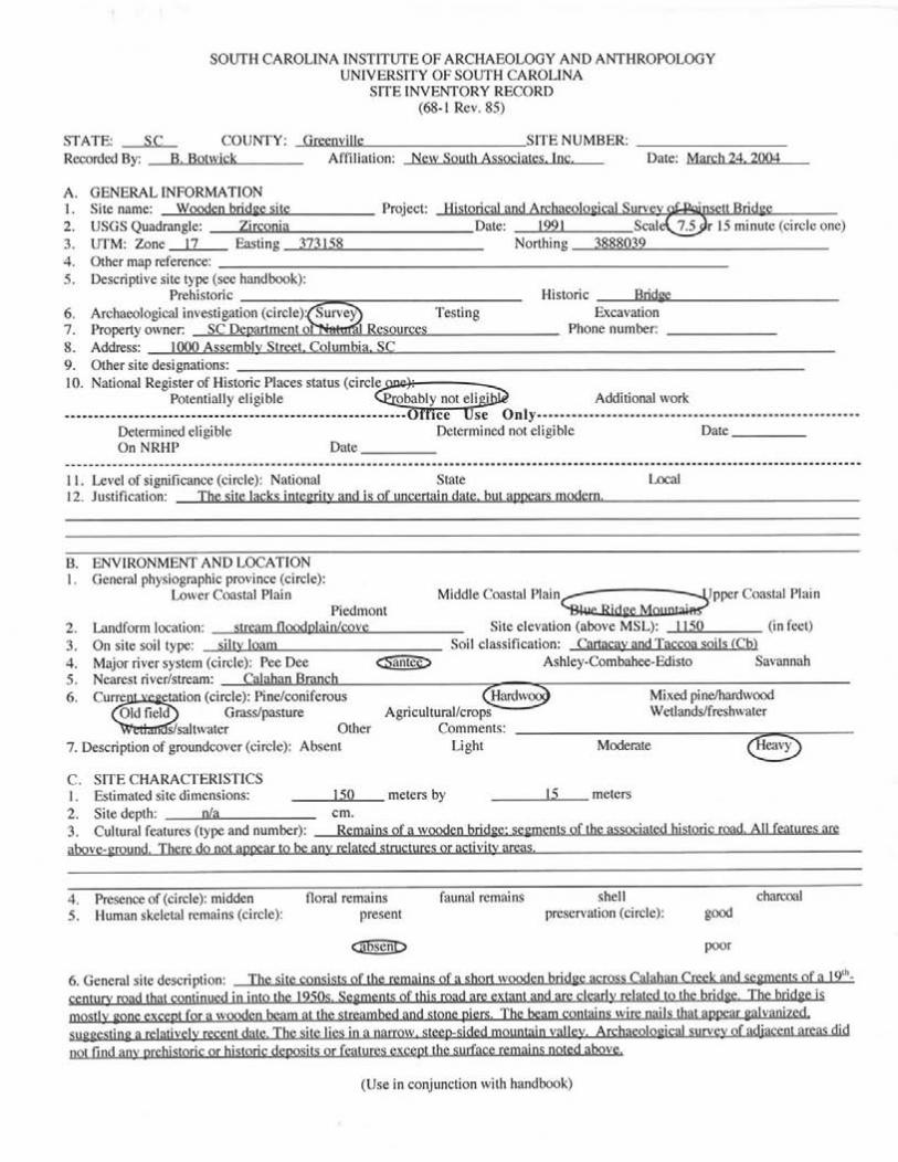


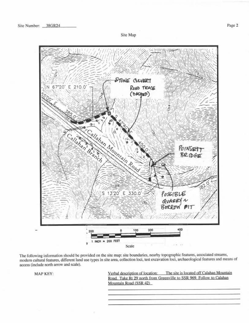


APPENDIX C: HAER FILE (SC-14)