pleiades-hr innovative techniques for radiometric image quality
TRANSCRIPT

PLEIADES-HR INNOVATIVE TECHNIQUES FOR RADIOMETRIC IMAGE QUALITY COMMISSIONING
Gwendoline BLANCHET, Laurent LEBEGUE, Sébastien FOUREST, Christophe LATRY, Florence POREZ-NADAL, Sophie LACHERADE, Carole THIEBAUT
CNES 18, avenue Edouard Belin, 31401 TOULOUSE CEDEX 4 France
Phone: 33.(0)5.61.27.48.59 Fax: 33.(0)5.61.27.31.67 E-mail: [email protected]
ISPRS and IAA : Pléiades Inflight Calibration and Performance Assessment KEY WORDS: Image Quality, Radiometry, Calibration ABSTRACT: The first Pleiades-HR satellite, part of a constellation of two, has been launched on December 17, 2011. This satellite produces high resolution optical images. In order to achieve good image quality, Pleiades-HR should first undergo an important 6 month commissioning phase period. This phase consists in calibrating and assessing the radiometric and geometric image quality to offer the best images to end users. This new satellite has benefited from technology improvements in various fields which make it stand out from other Earth observation satellites. In particular, its best-in-class agility performance enables new calibration and assessment techniques. This paper is dedicated to presenting these innovative techniques that have been tested for the first time for the Pleiades-HR radiometric commissioning. Radiometric activities concern compression, absolute calibration, detector normalization, and refocusing operations, MTF (Modulation Transfer Function) assessment, signal-to-noise ratio (SNR) estimation, and tuning of the ground processing parameters. The radiometric performances of each activity are summarized in this paper.
1. INTRODUCTION TO PLEIADES-HR SATELLITE
The PLEIADES program is a space Earth Observation system led by France, under the leadership of the French Space Agency (CNES). It will operate in 2012 two agile satellites designed to provide optical images to civilian and defence users.
Figure 1. Pleiades-HR image of Melbourne downtown, © CNES Copyright 2012
Since it was successfully launched on December 17, 2011, Pleiades 1A high resolution optical satellite has been thoroughly tested and validated during the commissioning phase led by CNES [1]. One of the major improvements of this satellite is its platform agility. It allows the satellite to move quickly from one attitude to another, enabling rapid collection of separated point targets and an increase of imaging capacity. Thanks to this agility, several guidance strategies have been defined in order to
facilitate both the radiometric and geometric satellite commissioning. They offer new possibilities of measuring the performance and lower operational costs by avoiding some specific image campaigns. This paper is dedicated to the radiometric part. For more information about the geometric part, please refer to [2]. Images are simultaneously acquired in Panchromatic (PA) and multi-spectral (XS) mode, which allows, in nadir acquisition condition, to deliver 20 km wide, false or natural coloured scenes with a 70 cm ground sampling distance after PA+XS fusion [3]. The scan-line is comprised of 5 detector Charge-Coupled Device (CCD) arrays for PA and XS bands with overlapping Inter-Array-Zone (IAZ) to ensure line continuity. These arrays are located in the focal plane of the telescope and acquire a scan-line over an integration time (push-broom principle) [4]. Because of distortion and PA TDI (Time Delay Integration) tilts, the on-ground projections of PA and XS lines of sight are not straight lines. Consequently, some guidances are adapted to the considered band (PA or XS). For the PA band, the TDI enables to achieve five different exposure levels.
Figure 2. Pleiades-HR focal plane
Distortion centre
PA (TDI)
XS
68 mm
19 mm
390 mm
3 mm
1 mm
0.3°0.6°
B2 : RedB3 : NIRB0 : BlueB1 : Green
AB
C D
E
International Archives of the Photogrammetry, Remote Sensing and Spatial Information Sciences, Volume XXXIX-B1, 2012 XXII ISPRS Congress, 25 August – 01 September 2012, Melbourne, Australia
513
2. RADIOMETRIC ACTIVITIES
2.1 Inter-detector normalization and compression
Because of the non uniform detector sensitivity along the array, the raw image of a uniform landscape is striped vertically. Inter-detector normalization consists in applying a pixel-to-pixel gain and offset so that the output image is uniform.
Figure 3. Raw PA Pleiades-HR image of Antarctic, vertical streaks are visible, © CNES Copyright 2012
A pre-launch full calibration has showed that the detector response has a bilinear response as a function of the input radiance L, unlike most satellites which have a linear response (Quickbird, WorldView-1 [5], Spot5, …). The bilinear model is:
{ } otherwisebnCbnLbngbbnLLbngbAbnX
bnLLifbnCLbngbAbnX
ss
s
),(),().,().()],().[,().(.),(
),(),().,().(.),(
1122
11
++−=≤+=
γγγ
for each detector n of register b, where
- A is the absolute calibration factor linking radiance measurement to the pixel bit-count;
- C are the dark currents classically estimated on ocean images acquired on night orbits (ascending). Thanks to Pleiades agility, these dedicated images can be replaced by star images (intrinsically mainly dark) already available with the MTF theme;
- γ and g are the relative offsets estimated either with uniform landscape image acquisition campaign (classical method, images of well-known uniform landscapes such as Antarctic and Greenland are acquired routinely during the first six months in orbit) or with dedicated AMETHIST images (new method).
Radiance
X : digital count
Dark current
slope Aγ1g1 slope Aγ2g2
Ls
Figure 4. Bilinear radiometric model The values of inter-detector normalization coefficients depend on the number of integration lines used in the TDI. This number has been set to 13 during the first commissioning months. The possible values are [7, 10, 13, 16, 20]. Some tests will be run until the end of the commissioning to select the best number of
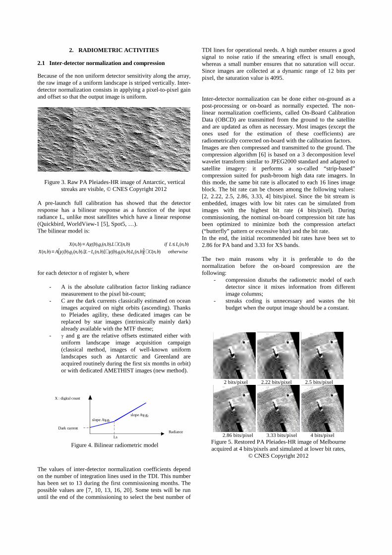
TDI lines for operational needs. A high number ensures a good signal to noise ratio if the smearing effect is small enough, whereas a small number ensures that no saturation will occur. Since images are collected at a dynamic range of 12 bits per pixel, the saturation value is 4095. Inter-detector normalization can be done either on-ground as a post-processing or on-board as normally expected. The non-linear normalization coefficients, called On-Board Calibration Data (OBCD) are transmitted from the ground to the satellite and are updated as often as necessary. Most images (except the ones used for the estimation of these coefficients) are radiometrically corrected on-board with the calibration factors. Images are then compressed and transmitted to the ground. The compression algorithm [6] is based on a 3 decomposition level wavelet transform similar to JPEG2000 standard and adapted to satellite imagery: it performs a so-called “strip-based” compression suited for push-broom high data rate imagers. In this mode, the same bit rate is allocated to each 16 lines image block. The bit rate can be chosen among the following values: [2, 2.22, 2.5, 2.86, 3.33, 4] bits/pixel. Since the bit stream is embedded, images with low bit rates can be simulated from images with the highest bit rate (4 bits/pixel). During commissioning, the nominal on-board compression bit rate has been optimized to minimize both the compression artefact (“butterfly” pattern or excessive blur) and the bit rate. In the end, the initial recommended bit rates have been set to 2.86 for PA band and 3.33 for XS bands. The two main reasons why it is preferable to do the normalization before the on-board compression are the following:
- compression disturbs the radiometric model of each detector since it mixes information from different image columns;
- streaks coding is unnecessary and wastes the bit budget when the output image should be a constant.
2 bits/pixel 2.22 bits/pixel 2.5 bits/pixel
2.86 bits/pixel 3.33 bits/pixel 4 bits/pixel
Figure 5. Restored PA Pleiades-HR image of Melbourne acquired at 4 bits/pixels and simulated at lower bit rates,
© CNES Copyright 2012
International Archives of the Photogrammetry, Remote Sensing and Spatial Information Sciences, Volume XXXIX-B1, 2012 XXII ISPRS Congress, 25 August – 01 September 2012, Melbourne, Australia
514

Figure 6. (a) Raw Antarctic image collected on orbit, high (HF) and low (LF) frequency vertical streaks are visible (b) Raw image radiometrically corrected with the pre-launch calibration factors: some streaks are still visible, especially LF ones (c) Raw image radiometrically corrected with on-orbit updated calibration factors. Here the streaks are no longer visible.
© CNES Copyright 2012 To estimate the inter-detector gains, each detector must receive the same radiance. The classical way uses uniform images acquired at the reference radiances (L1, L2, L3) [7]. PA B0 B1 B2 B3
L2 100 130 115 100 90 Table 1. Reference L2 radiance (W/m²/µm/sr)
But this approach is limited since pure uniform images do not exist on Earth (landscape residue may remain and clouds may degrade the image). The AMETHIST method [7] has been tested for the first time on Pleiades. This efficient method avoids the uniformity constraint. A special guidance has been designed to ensure that each detector sees the same target landscape line: the ground projection of the scan-line is aligned to the ground velocity. The push-broom principle has been diverted from its original goal to produce 20 km swath images by creating very narrow (few meters) swath striped images. The AMETHIST images are made of diagonal stripes, each stripe is associated with the same ground point and its length indicates the number of detectors that have seen the point. The geometric constraint (the detector must see the same landscape area) cannot be achieved simultaneously for both the PA and XS bands due to the focal plane configuration. Hence, those bands have different curved attitude guidance.
90°yawsteering90°yawsteering
Figure 7. AMETHIST acquisition principle
(in red: target landscape line)
After a pre-processing that globally shifts each column of the raw image, we get an image that contains all needed information. This means that every row contains the set of detector responses to the same landscape. Thus, non-linear
normalization coefficients can be computed by a histogram matching method.
Figure 8. Example of AMETHIST PA and XS images
© CNES Copyright 2012
Figure 9. Example of rectified AMETHIST PA image
(central array, IAZ are visible on both sides)
This method requires few acquisitions (typically 30 images) to fulfil the normalization coefficient estimation without weather and site constraints. It is however recommended to perform several acquisition on various sites to cover a large grey level dynamics with flat relief. The coefficients update frequency is expected to be 6 months. The temporal evolution of the detector response has been analysed on-ground since 2009. It showed noticeable changes that should be monitored after launch. The NeDLI measures the residual non-uniformity after radiometric correction (a high NeDLI value indicates that vertical streaks are visible), so this is how the detector evolution is detected. On-ground measurements allowed to recommend a coefficient update every 6 months. The first four months showed that the NeDLI evolved slowly enough to maintain the 6 months prediction.
PA B0 B1 B2 B3
+0.08 +0.15 +0.2 +0.3 +0.3
Table 2. NeDLI evolution during the first 3 months (estimation is done outside IAZ) (assessed April 5, 2012). 2.2 Absolute calibration
The estimation of the absolute calibration coefficients for every spectral band is done on various types of landscapes to achieve cross method comparison and temporal monitoring [8]. Input images are radiometrically corrected with inter-detector normalization. Those landscapes have been defined over the years thanks to previous satellite commissioning. They are now fully characterized and are still used by other CNES in-orbit satellites which allows inter-calibration as well.
International Archives of the Photogrammetry, Remote Sensing and Spatial Information Sciences, Volume XXXIX-B1, 2012 XXII ISPRS Congress, 25 August – 01 September 2012, Melbourne, Australia
515


