planning and natural resources department …
TRANSCRIPT
Lorelei H. Oviatt, AICP, Director 2700 "M" Street, Suite 100 Bakersfield, CA 93301-2323 Phone: (661) 862-8600 Fax: (661) 862-8601 TTY Relay 1-800-735-2929
Email: [email protected] Web Address: http:1/kernplanning.com/
DATE: June 3, 2021
TO: See Attached Mailing List
PLANNING AND NATURAL
RESOURCES DEPARTMENT
Planning
Community Development
Administrative Operations
FROM: Kem County Planning and Natural Resources Department Attn: Terrance Smalls2700 "M" Street, Suite 100 Bakersfield, CA 93301 ( 661 )862-8607; [email protected]
SUBJECT: NOTICE OF PREPARATION (NOP) OF A DRAFT ENVIRONMENTAL IMPACT REPORT (EIR) FOR THE ROSAMOND SOUTH SOLAR PROJECT 2.0 BY GOLDEN FIELDS SOLAR, LLC
The Kern County Planning and Natural Resources Department as Lead Agency (per CEQA Guidelines Section 15062) has determined that preparation of an Environmental Impact Report (per CEQA Guidelines 15161) is necessary for the proposed project identified below. The Planning and Natural Resources Department solicits the views of your agency as to the scope and content of the environmental information which is germane to your agency's statutory responsibilities in connection with the proposed project. Your agency may need to use the EIR prepared by our agency when considering your permit or other approval of the project.
You are invited to view the NOP and submit written comments regarding the scope and content of the environmental information in connection with the proposed project should you wish to do so. Due to the limits mandated by State law, your response must be received by July 3, 2021 at 5:00 p.m. Comments can be submitted to the Kern County Planning and Natural Resources Department at the address shown above or to [email protected] . A Scoping meeting will be held on Friday, June 25, 2021 at 1:30 p.m.
PROJECT TITLE: Rosamond South Solar Project by Golden Fields Solar IV, LLC (PP 19151 ); SP A 40, Map #231; SPA 33, Map #232; ZCC 157, Map #231; ZCC 43, Map #232; ZCC 18, Map #233; CUP 120, Map #231; CUP 40, Map #232; CUP 46, Map #232; CUP 44, Map #232; CUP 16, Map #233; and SPA 31, Map#232.
PROJECT LOCATION: The proposed project site is located in the Mojave Desert within unincorporated
Kern County, bounded by Rosamond Boulevard to the north, 90th Street West to the east, West A venue A
to the south and 170th Street West to the west. Access to the site would be from Rosamond Boulevard,
Avenue A, Avenue D, Astoria Avenue, Gaskell Road, Holiday Avenue, Willow Avenue, Kingbird
Avenue, 100th Street West, 140th Street West, 13o 11 Street West and 170th Street West.
The site is located within Section 24 Township 9 North, Range 15 West and Sections 20, 21, 27, and 28,
Township 9 North, Range 14 West, and Sections 30 and 31 Township 9 N Range 13W, San Bernardino
Base and Meridian.

[This Page Intentionally Left Blank]
Rosamond South Solar Project - EIR (ZC #157; CUP #120, Map #231) WO #PP19151 I:\Planning\WORKGRPS\WP\LABELS\eir-rosamond south solar.nop.docx.doc Sc 05/26/21
Jo Ellen Alexander P.O. Box 2000 Rosamond, CA 93560
Bakersfield City Planning Dept 1715 Chester Avenue Bakersfield, CA 93301
Bakersfield City Public Works Dept 1501 Truxtun Avenue Bakersfield, CA 93301
Delano City Planning Dept P.O. Box 3010 Delano, CA 93216
City of Maricopa P.O. Box 548 Maricopa, CA 93252
City of McFarland 401 West Kern Avenue McFarland, CA 93250
City of Ridgecrest 100 West California Avenue Ridgecrest, CA 93555
City of Shafter 336 Pacific Avenue Shafter, CA 93263
City of Taft Planning & Building 209 East Kern Street Taft, CA 93268
City of Tehachapi Attn: John Schlosser 115 South Robinson Street Tehachapi, CA 93561-1722
City of Wasco 764 E Street Wasco, CA 93280
Inyo County Planning Dept P.O. Drawer "L" Independence, CA 93526
Kings County Planning Agency 1400 West Lacey Blvd, Bldg 6 Hanford, CA 93230
Los Angeles Co Reg Planning Dept 320 West Temple Street Los Angeles, CA 90012
San Bernardino Co Planning Dept 385 North Arrowhead Avenue, 1st Floor San Bernardino, CA 92415-0182
San Luis Obispo Co Planning Dept Planning and Building 976 Osos Street San Luis Obispo, CA 93408
Santa Barbara Co Resource Mgt Dept 123 East Anapamu Street Santa Barbara, CA 93101
Tulare County Planning & Dev Dept 5961 South Mooney Boulevard Visalia, CA 93291
Ventura County RMA Planning Div 800 South Victoria Avenue, L1740 Ventura, CA 93009-1740
U.S. Bureau of Land Management Ridgecrest Field Office 300 South Richmond Road Ridgecrest, CA 93555
China Lake Naval Weapons Center Tim Fox, RLA - Comm Plans & Liaison 429 E Bowen, Building 981 Mail Stop 4001 China Lake, CA 93555
Edwards AFB, Mission Sustainability Liaison 412 TW, Bldg 2750, Ste 117-14 195 East Popson Avenue Edwards AFB, CA 93524
U.S. Fish & Wildlife Service 777 East Tahquitz Canyon Way, Suite 208 Palm Springs, CA 92262
U.S. Dept of Agriculture/NRCS 5080 California Avenue, Ste 150 Bakersfield, CA 93309-0711
State Air Resources Board Stationary Resource Division P.O. Box 2815 Sacramento, CA 95812
So. San Joaquin Valley Arch Info Ctr California State University of Bkfd 9001 Stockdale Highway Bakersfield, CA 93311
Caltrans/Dist 6 Planning/Land Bank Bldg. P.O. Box 12616 Fresno, CA 93778
Caltrans/Dist 9 Planning Department 500 South Main Street Bishop, CA 93514
State Dept of Conservation Director's Office 801 "K" Street, MS 24-01 Sacramento, CA 95814-3528
State Dept of Conservation Geologic Energy Management Division 4800 Stockdale Highway, Ste 108 Bakersfield, CA 93309
California Energy Commission James W. Reed, Jr. 1516 Ninth Street Mail Stop 17 Sacramento, CA 95814
California Fish & Wildlife 1234 East Shaw Avenue Fresno, CA 93710
California Highway Patrol Planning & Analysis Division P.O. Box 942898 Sacramento, CA 94298-0001
Public Utilities Comm Energy Div 505 Van Ness Avenue San Francisco, CA 94102
California Regional Water Quality Control Board/Lahontan Region 15095 Amargosa Road - Bld 2, Suite 210 Victorville, CA 92392
State Dept of Water Resources San Joaquin Dist. 3374 East Shields Avenue, Room A-7 Fresno, CA 93726
Kern County Agriculture Department Kern County Administrative Officer
Kern County Public Works Department/ Building & Development/Floodplain
Kern County Public Works Department/ Building & Development/Survey
Kern County Env Health Services Department
Kern County Fire Dept David Witt, Fire Chief
Kern County Fire Dept Cary Wright, Fire Marshall
Kern County Library/Beale Local History Room
Kern County Library/Beale Andie Sullivan
Kern County Library Wanda Kirk/Rosamond Branch 3611 Rosamond Boulevard Rosamond, CA 93560
Kern County Parks & Recreation
Kern County Sheriff's Dept Administration
Kern County Public Works Department/ Building & Development/Development Review
Rosamond Municipal Advisory Council P.O. Box 626 Rosamond, CA 93560
Mojave Town Council Bill Deaver, President P.O. Box 1113 Mojave, CA 93502-1113
Southern Kern Unified School Dist P.O. Box CC Rosamond, CA 93560
Kern County Superintendent of Schools Attention School District Facility Services 1300 - 17th Street Bakersfield, CA 93301
KernCOG 1401 19th Street - Suite 300 Bakersfield, CA 93301
Antelope Valley-East Kern Water Agency 6500 West Avenue N Palmdale, CA 93551
Kern County Water Agency P.O. Box 58 Bakersfield, CA 93302-0058
East Kern Air Pollution Control District
Adams, Broadwell, Joseph & Cardozo Attention: Janet M. Laurain 601 Gateway Boulevard, Suite 1000 South San Francisco, CA 94080
Kern Audubon Society Attn: Frank Bedard, Chairman 4124 Chardonnay Drive Bakersfield, CA 93306
Los Angeles Audubon 926 Citrus Avenue Los Angeles, CA 90036-4929
Center on Race, Poverty & the Environment Attn: Marissa Alexander 1999 Harrison Street – Suite 650 San Francisco, CA 94612
Center on Race, Poverty & the Environmental/ CA Rural Legal Assistance Foundation 1012 Jefferson Street Delano, CA 93215
Defenders of Wildlife/ Kim Delfino, California Dir 980 - 9th Street, Suite 1730 Sacramento, CA 95814
Native American Heritage Council of Kern County Attn: Gene Albitre 3401 Aslin Street Bakersfield, CA 93312
Beth Boyst Pacific Crest Trail Program Manager 1323 Club Drive Vallejo, CA 94592
Anitra Kass Pacific Crest Trail Association 41860 Saint Annes Bay Drive Bermuda Dunes, CA 92203
Sierra Club/Kern Kaweah Chapter P.O. Box 3357 Bakersfield, CA 93385
Southern California Edison Planning Dept. 421 West "J" Street Tehachapi, CA 93561
Southern California Edison 2244 W l G A GO 1 Q d 2C
Kern Valley Indian Council Attn: Robert Robinson, Chairperson P.O. Box 401 Weldon, CA 93283
Kern Valley Indian Council Historic Preservation Office P.O. Box 401 Weldon, CA 93283
Matthew Gorman The Gorman Law Firm 1346 E. Walnut Street, Suite 220 Pasadena, CA 91106
Fairmont Town Council Attn: Barbara Rogers P.O. Box 2320 Rosamond, CA 93560
Leadership Counsel for Justice & Accountability 1527 - 19th Street, Suite 212 Bakersfield, CA 93301
LIUNA Attn: Danny Zaragoza 2201 "H" Street Bakersfield, CA 93301
Vestas 1417 NW Everett Street Portland, OR 97209
City of Arvin P.O. Box 548 Arvin, CA 93203
U.S. Army Attn: Philip Crosbie, Chief Strategic Plans, S3, NTC P.O. Box 10172 Fort Irwin, CA 92310
U.S. Navy Attn: Steve Chung Regional Community & Liaison Officer 1220 Pacific Highway San Diego, CA 92132-5190
U.S. Air Force Attn: David Bell/AFCEC CZPW Western Regional/Leg Branch 510 Hickman Ave., Bld 250-A Travis AFB, CA 94535-2729
U.S. Marine Corps Attn: Patrick Christman Western Regional Environmental Officer Building 1164/Box 555246 Camp Pendleton, CA 92055-5246
U.S. Army Attn: Tim Kilgannon, Region 9 Coordinator Office of Strategic Integration 721 - 19th Street, Room 427 Denver, CO 80202
Terra-Gen Randy Hoyle, Sr. Vice Pres 11512 El Camino Real, Suite 370 San Diego, CA 92130
Renewal Resources Group Holding Company
Rupal Patel 113 South La Brea Avenue, 3rd Floor Los Angeles, CA 90036
Congentrix Sunshine, LLC Rick Neff 9405 Arrowpoint Blvd Charlotte, NC 28273
Fotowatio Renewable Ventures Sean Kiernan 44 Montgomery Street, Suite 2200 San Francisco, CA 94104
EDP Renewables Company 53 SW Yamhill Street Portland, OR 97204
Wind Stream, LLC Albert Davies 1275 - 4th Street, No. 107 Santa Rosa, CA 95404
Darren Kelly, Sr. Business Mgr Terra-Gen Power, LLC 1095 Avenue of the Americas, 25th Floor, Ste A New York, NY 10036-6797
Bill Barnes, Dir of Asset Mgt AES Midwest Wind Gen P.O. Box 2190 Palm Springs, CA 92263-2190
PG&E Steven Ng, Manager Renewal Dev, T&D Intercon 77 Beal Street, Room 5361 San Francisco, CA 94105
Wayne Mayes, Dir Tech Serv Iberdrola Renewables 1125 NW Couch St, Ste 700, 7th Fl Portland, OR 97209
Michael Strickler, Sr Project Mgr Iberdrola Renewables 1125 NW Couch St, Ste 700, 7th Fl Portland, OR 97209
Recurrent Energy Seth Israel 300 California Street, 8th Floor San Francisco, CA 92109
Tehachapi Area Assoc of Realtors Carol Lawhon, Assoc Exe, IOM 803 Tucker Road Tehachapi, CA 93561
Kelly Group Kate Kelly P.O. Box 868 Winters, CA 95694
Beyond Coal Campaign/Sierra Club Sarah K. Friedman 1417 Calumet Avenue Los Angeles, CA 90026
Robert Burgett 9261 - 60th Street, West Mojave, CA 93501
Structure Cast Larry Turpin, Sales Mgr 8261 McCutchen Road Bakersfield, CA 93311
.
DATE: June 3, 2021
TO: Surrounding Property Owners within FROM: Kern County Planning and Natural 1,000 Feet of Project Boundary; and, Resources Department Interested Parties 2700 “M” Street, Suite 100 Bakersfield, CA 93301
SUBJECT: Notice of Preparation of an Environmental Impact Report – Rosamond South Solar Project by Golden Fields Solar IV, LLC (PP19151)
Dear Sir or Madam:
The Kern County Planning and Natural Resources Department has determined that preparation of an Environmental Impact Report (EIR) is necessary for the proposed project identified below. The purpose of this letter is to notify interested parties and surrounding property owners within 1,000 feet of the project boundaries of this determination. A copy of the Initial Study/Notice of Preparation (IS/NOP) prepared for this proposed project is available for viewing at the following Kern County website: https://kernplanning.com/planning/notices-of-preparation/
The purpose of the IS/NOP is to describe the proposed project, specify the project location, and to identify the potential environmental impacts of the project so that Responsible Agencies and interested persons can provide a meaningful response related to potential environmental concerns that should be analyzed in the Environmental Impact Report.
You are invited to view the IS/NOP and submit written comments regarding this proposed project should you wish to do so. Due to the limits mandated by State law, your response must be received by July 3, 2021 at 5:00 p.m. Comments can be submitted to the Kern County Planning and Natural Resources Department, Attn: Terrance Smalls, at the address shown above or to [email protected]. Your comments can also be submitted at a scoping meeting that will be held on Friday, June 25, 2021. Please be advised that any comments received after the dates listed above will still be included in the public record for this project and made available to decision makers when this project is scheduled for consideration at a public hearing. Please also be advised that you will receive an additional notice in the mail once a public hearing date is scheduled for this project. You will also be provided additional opportunities to submit comments at that time. PROJECT TITLE: Rosamond South Solar Project by Golden Fields Solar IV, LLC (PP19151); SPA 40, Map #231; SPA 33, Map #232; ZCC 157, Map #231; ZCC 43, Map #232; ZCC 18, Map #233; CUP 120, Map #231; CUP 40, Map #232; CUP 46, Map #232; CUP 44, Map #232; CUP 16, Map #233; and SPA 31, Map #232.
PROJECT LOCATION: The proposed project site is located in the Mojave Desert within unincorporated Kern County, bounded by Rosamond Boulevard to the north, 90th Street West to the east, West Avenue A to the south and 170th Street West to the west. Access to the site would be from Rosamond Boulevard,
Lorelei H. Oviatt, AICP, Director 2700 “M” Street, Suite 100 Bakersfield, CA 93301-2323 Phone: (661) 862-8600 Fax: (661) 862-8601 TTY Relay 1-800-735-2929 Email: [email protected] Web Address: http://kernplanning.com/
PLANNING AND NATURAL RESOURCES DEPARTMENT
Planning
Community Development
Administrative Operations

Avenue A, Avenue D, Astoria Avenue, Gaskell Road, Holiday Avenue, Willow Avenue, Kingbird Avenue, 100th Street West, 140th Street West, 130th Street West and 170th Street West.
The site is located within Section 24 Township 9 North, Range 15 West and Sections 20, 21, 27, and 28, Township 9 North, Range 14 West, and Sections 30 and 31 Township 9 N Range 13W, San Bernardino Base and Meridian.
PROJECT DESCRIPTION: Notice of Preparation/Initial Study reflects the modified project, titled the Rosamond South Solar Project.
The Rosamond South Solar Project, as proposed by Golden Fields Solar IV, LLC would develop a photovoltaic solar facility and associated infrastructure necessary to generate up to 154 megawatt-alternating current (MW-AC) of renewable energy, including up to 200 megawatts of energy storage, on approximately 1,292 acres of privately-owned land. The project site consists of 4 sites (Sites 1 through 4) located on 64 parcels. The project would be supported by a 230-kilovolt (kV) gen-tie overhead and/or underground electrical transmission line(s) originating from one or more on-site substations and terminating at either the Teddy Substation or the Southern California Edison's Whirlwind Substation. The project’s permanent facilities would include, but are not limited to, service roads, a power collection system, inverter stations, transformer systems, transmission lines, electrical switchyards, project substations, energy (battery) storage system, and operations and maintenance facilities.
Implementation of the project as proposed includes the following requests: a) Amendments to the Willow Springs Specific Plan as follows:
Specific Plan Amendment No. 40, Map No. 231 from map code designation 7.1/4.4 (Light Industrial, Comprehensive Planning Area) to 7.1 (Light Industrial) on approximately 247 acres and from map code designation 7.2/4.4 (Service Industrial, Comprehensive Planning Area) to 7.2 (Service Industrial) on approximately 118 acres
Specific Plan Amendment No. 33, Map No. 232 from map code designation 5.3/4.4 (Residential Maximum 10 Units per Net Acre/Comprehensive Planning Area) to 5.3 (Residential, Maximum 10 Units per Net Acre) on approximately 80 acres and from map code designation 5.3/4.4/2.6 (Residential Maximum 10 Units per Net Acre/Comprehensive Planning Area/Erosion Hazard) to 5.3/2.6 (Residential Maximum 10 units per Net Acre/Erosion Hazard) on approximately 80 acres
b) Changes in zone classifications as follows:
Zone Change Case No. 157, Map No. 231 – From E(2 ½) RS FPS to A FPS on approximately 607 acres
Zone Change Case No. 43, Map No. 232 – From E(5) RS FPS to A FPS on approximately 330 acres
Zone Change Case No. 18, Map No. 233 – From E(2 ½) RS FPS to A FPS on approximately 96 acres
c) Conditional Use Permits to allow for the construction and operation of three (3) solar facilities with a total generating capacity of approximately 154 megawatts-alternating current (MW-AC) of renewable energy (broken down by site, below), including up to 200 megawatts of energy storage (for all sites), within the A (Exclusive Agriculture) Zone Districts (in Zone Maps 231, 232, and 233) pursuant to Sections 19.12.030.G and 19.36.30.G, respectively, of the Kern County Zoning Ordinance:
CUP Area 1 (solar and energy storage)
o Conditional Use Permit No. 120, Map No. 231 for 70.99 acres
CUP Area 2 (solar and energy storage)
o Conditional Use Permit No. 40, Map No. 232 for 240.58 acres
CUP Area 3 (solar and energy storage)
o Conditional Use Permit No. 46, Map No. 232 for 541.16 acres
CUP Area 4 (solar and energy storage)
o Conditional Use Permit No. 16, Map No. 233 for 439.26 acres
Telecommunication Tower
o Conditional Use Permit No. 44, Map No. 232
d) General Plan Amendments to the Circulation Element of the Kern County General Plan to remove future road reservations on the section and mid-section lines within the project boundaries:
Specific Plan Amendment No. 31, Map No. 232
Should you have any questions regarding this project, or the Initial Study/Notice of Preparation, please feel free to contact me at (661) 862-8607 or [email protected]
Sincerely, Terrance Smalls, Supervising Planner Advanced Planning Division
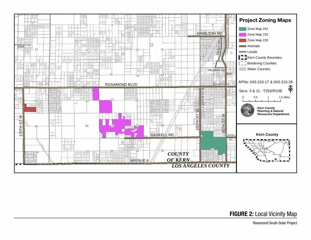
Attachments: Figure 1 -Vicinity Map 00 Figure 2 – Project Site Boundaries

[This Page Intentionally Left Blank]
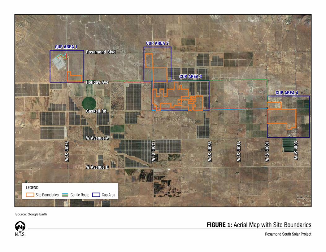
FIGURE 1: Aerial Map with Site BoundariesRosamond South Solar ProjectN.T.S.
Source: Google Earth
LEGEND
Site Boundaries Cup AreaGentie Route
CUP AREA 1CUP AREA 1CUP AREA 2CUP AREA 2
CUP AREA 3CUP AREA 3
CUP AREA 4CUP AREA 4
W Avenue AW Avenue A
Gaskell RdGaskell Rd
Holiday AveHoliday Ave
Rosamond BlvdRosamond Blvd
W Avenue DW Avenue D
170th St W170th St W
110th St W110th St W
140th St W140th St W
100th St W100th St W
90th St W90th St W
120th St W120th St W
HAMILTON RD
ROSAMOND BLVD
170T
H S
T W
90TH
ST
W
100T
H S
T W
100T
H S
T W
AVENUE A
TEH
AC
HA
PIW
ILLO
WS
PR
ING
SR
D
GASKELL
RD
GASKELL RD
TRUMAN RD
MA
NLY
RD
STARBUCK AVE
Rosamond
COUNTYOF KERN
623451
711109812
181415161713
192322212024
302627282925
313534333236
LOS ANGELES COUNTY
y
Zone Map 231
Zone Map 232
Zone Map 233
ArterialsLocalsKern County BoundarBordering CountiesWater Courses
Kern County
^
Secs. 3 & 11 - T25S/R19E F0 0.5 1 1.5 Miles
Kern CountyPlanning & NaturalResources Department
APNs: 043-210-17 & 043-210-28
Project Zoning Maps
FIGURE 2: Local Vicinity MapRosamond South Solar Project
Rosamond South Solar Project - EIR (ZC #157; CUP #120, Map #231) WO #PP19151 I:\Planning\WORKGRPS\WP\LABELS\eir-rosamond south solar.noa.docx Sc 05/26/21
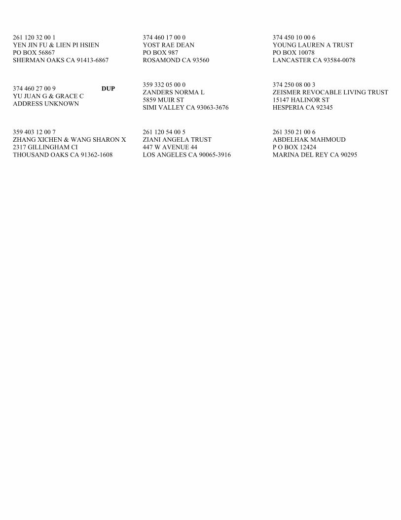
359 032 37 00 6 ALLYN HENRY GREGORY III & COTT CYNTHIA 42130 22ND ST WEST QUARTZ HILL CA 93536
374 311 03 00 2 ALPHA LP P O BOX 280188 NORTHRIDGE CA 91328-0188
359 403 07 00 3 ALVAREZ CELIA ISABEL GARCIA PO BOX 56867 SHERMAN OAKS CA 91413-6867
374 321 09 00 3 ANDERSON MAXINE R REV TR 11414 SERRA RD SP 49 APPLE VALLEY CA 92308-7750
358 330 18 00 7 ANGELOPOULOS FMLY TR 9131 GAINFORD ST DOWNEY CA 90240
359 031 22 00 5 DUP ANTELOPE VALLEY E KERN WTR AG P O BOX 3176 QUARTZ HILL CA 93534
359 174 14 00 4 ANTELOPE VALLEY E KERN WTR AG P O BOX 3176 QUARTZ HILL CA 93536
359 175 06 00 8 ANTELOPE VALLEY E KERN WTR AG 554 W LANCASTER BL LANCASTER CA 93534
374 011 13 00 4 ANTELOPE VALLEY EAST KERN WATER AGENCY 6500 WEST AVENUE E 15 PALMDALE CA 93551
359 401 18 00 1 AYALA BALTAZAR & BLANCA 5541 LAUREL CANYON BL # 1 VALLEY VILLAGE CA 91607
261 120 18 00 1 BALONZO MARIE D 1275 LUNDY AV SAN JOSE CA 95131-2979
374 400 08 00 6 BALUN ANTHONY G TR 101 EASTGATE CT U 107 ALGONQUIN IL 60102-3078
261 120 59 00 0 BALUYUT REVOCABLE LIVING TRUST PO BOX 56867 SHERMAN OAKS CA 91413-1867
374 460 20 00 8 BANUELOS REYES JUAN & LIDIA MARIBEL PO BOX 2477 ROSAMOND CA 93560
261 120 58 00 7 BARRY W & E TRUST 8124 NE SIGUARD CT ALBUQUERQUE NM 87109
374 400 01 00 5 BAUER DENNIS JAMES 14420 CARLSBAD ST SYLMAR CA 91342-5112
359 331 16 00 5 BEDOY MARIA G 7517 BRETT AV LAMONT CA 93241
359 401 10 00 7 BENITO RAYMUNDO S & LIRA C PO BOX 56867 SHERMAN OAKS CA 91413-6867
261 120 42 00 0 BERKOWITZ VERNON H & ANN G TR 661 PARKVIEW CT PACIFICA CA 94044-1531
359 401 13 00 6 BKH INTERNET INC 10150 LITTLE LEAF LN SANTEE CA 92071
359 100 38 00 5 BLACKLOCK WAYNE L & GLENDA L LIV TR P O BOX 2160 GAINESVILLE TX 76241
374 311 01 00 6 BODTKE KERRY W & DEBRA F TR 5143 N EVENING STAR DR ST. GEORGE UT 84770-7365
359 402 06 00 3 BOWDEN JAMES JR & ANN L 4878 BROOKDALE DR MUSKEGON MI 49441-5212
374 313 03 00 6 BRANCH WILLIAM O & OPAL W TR 18 SAGAMORE PL HILLSBOROUGH NC 27278-9742
358 330 10 00 3 BRITTAN R E & M B TR & TRS ET AL 8862 SATTERFIELD HUNTINGTN BCH CA 92646
359 100 11 00 6 BURLEY DAVID RICHARD REVOCABLE TRUST 2720 CENTERVILLE RD ANDERSON SC 29625-6205
359 324 06 00 4 BURNSIDE TRUST 1311 S TREMAINE AV LOS ANGELES CA 90019-1725
359 100 28 00 6 CAIN JOSEPH 6481 ATLANTIC AV N213 LONG BEACH CA 90805
359 402 04 00 7 CALIFORNIA CHRISTIAN SCHOOLS 78640 CASTLE PINES DR LA QUINTA CA 92253-5816
374 312 06 00 8 CAPUANO FAMILY TR 1925 MIRADOR DR AZUSA CA 91702
358 330 13 00 2 CARAS CHRIS W & JOAN TRUST 1901 PASEO DEL MAR PALOS VERDES ES CA 90274-2657
261 120 10 00 7 CARDENAS ANA PO BOX 56867 SHERMAN OAKS CA 91413-1867
374 304 06 00 9 CARREON FREDRIC ANTHONY 2413 W LINCOLN AV MONTEBELLO CA 90640-2329
374 460 10 00 9 CASHBAUGH TRUST 1290 100TH ST WEST ROSAMOND CA 93560
374 460 08 00 4 CASTILLO PANFILO 1358 W 100TH ST ROSAMOND CA 93560
359 332 20 00 3 CASTRO MONTOYA ALEJANDRO & ROBLES CASTRO A D PO BOX 56867 SHERMAN OAKS CA 91413-1867
359 020 49 00 4 CHANG DANA TUNG 18010 SUMMER AV ARTESIA CA 90701
374 460 09 00 7 CHAPPELL TEAM ADVANTAGE INC 332 GOLDEN SHORE DR LAS VEGAS NV 89123
374 460 22 00 4 CHAVEZ WILLIAM & SHALLEN PO BOX 1165 ROSAMOND CA 93560
359 100 20 00 2 CHAVEZ ZENAIDA DE JESUS 1415 CALLE LOZANO CAMARILLO CA 93012-4104
374 150 05 00 5 CHULALUXSIRIBOON BIRAYUDH & SIRIWONG 4334 RIO HONDO AV ROSEMEAD CA 91770
359 100 05 00 9 COLEMAN RANIESHA 14154 W ROSAMOND BL ROSAMOND CA 93560-7195
261 120 39 00 2 COLLINS BARBARA ALICE P O BOX 96 LINCOLN AR 72744
374 460 11 00 2 COLMENARES JUAN JR 1268 W 100TH ST ROSAMOND CA 93560-7266
359 100 03 00 3 COMMUNITY HOSP OF MONTEREY PENINSULA P O BOX HH MONTEREY CA 93942
359 332 09 00 2 COOLEY FAMILY TRUST 790 JONIVE RD SEBASTOPOL CA 95472-9298
261 120 51 00 6 CORADO VICTORIA LETICIA V 7772 BIRCHLEAF AV PICO RIVERA CA 90660
374 313 08 00 1 CORN C & FRANCES TR & TRS ET AL 6537 OLYMPIC PL LOS ANGELES CA 90035-2526
374 312 03 00 9 COSTA LARRY L P O BOX 3144 SEAL BEACH CA 90740
374 240 09 00 3 COSTELLO MARY C TRUST 8 AZULADO DR RMV CA 92694-2435
359 401 20 00 6 COTTRELL WILLIAM F & BRENDA J 2257 W AVENUE N8 PALMDALE CA 93551-2372
359 100 39 00 8 COYLE GEORGE D & BIRT JOHN W 81372 AVENIDA SOMBRA INDIO CA 92203-7553
359 100 31 00 4 CUETO DANILO C & DELMA D 14638 4TH AV SEATTLE WA 98168
261 120 01 00 1 CULLA VIRGINIA A PO BOX 27295 LOS ANGELES CA 90027-0295
374 311 04 00 5 DAHMEN HANS & HANNELORE LIVING TRUST 26501 AVENIDA VERONICA MISSON VIEJO CA 92691
374 400 13 00 0 DAMON TRUST 10373 HAWTHORNE AV HESPERIA CA 92345
358 330 19 00 0 DAVIES DONALD G 10353 FLORALITA AV SUNLAND CA 91040
359 332 21 00 6 DUP DAVIS JOHN K ADDRESS UNKNOWN
261 120 56 00 1 DE GUZMAN MENANDRO G & MARITES M 5604 TWILIGHT CHASE ST LAS VEGAS NV 89130
261 120 52 00 9 DEL SOL PROPERTIES INC 12121 WILSHIRE BL STE 600 LOS ANGELES CA 90025
374 304 01 00 4 DILLOW GEORGE S JR 5815 ROBIN LN TROY MO 63379-5013
359 100 21 00 5 DUGAN EUGENE ALLEN & PAULINE MARIE TR 1165 RHINE ST SAN DIEGO CA 92154-3071
359 332 22 00 9 ELHATOUM MOHAMMED N 43714 E 16TH ST LANCASTER CA 93535-4349
359 331 08 00 2 EMERY DURANT & LINDA 499 MINOA PASADENA CA 91107
359 332 15 00 9 ENCARNACION VIRGINIA R 2621 DUHALLOW WY S SAN FRANCISCO CA 94080
359 401 06 00 6 ENRIQUEZ VICTOR A 12715 BOBTAIL LN ROSAMOND CA 93560-7059
374 400 22 00 6 EQUITY TR CO CUSTDN PO BOX 56867 SHERMAN OAKS CA 91413
359 032 15 00 2 EQUITY TR CO CUSTDN FBO REITZELL JEANIE PO BOX 187 PLEASANTON CA 94566
374 400 26 00 8 EQUITY TRUST CO FBO DIANE R NELSON ROTH IRA PO BOX 56867 SHERMAN OAKS CA 91413-1867
359 403 06 00 0 DUP EQUITY TRUST COMPANY PO BOX 56867 SHERMAN OAKS CA 91413-6867
359 324 01 00 9 DUP EQUITY TRUST COMPANY CUSTODIAN FBO PO BOX 56867 SHERMAN OAKS CA 91413-1867
359 332 10 00 4 ESTRADA MICHAEL J & NANCY P 11762 AVENIDA DEL SOL NORTHRIDGE CA 91326-1240
359 331 14 00 9 FALVO JAY 3755 SHADOW GROVE RD PASADENA CA 91107-2238
374 321 08 00 0 FARNER BETTY L 245 CHAFFIN RD ROSWELL GA 30075-2429
359 332 35 00 7 FELDER JENNIFER JO 5686 KNIGHT RD BELLINGHAM WA 98226-7521
359 332 16 00 2 FLETCHER JOANNE 2550 CLARK ST BAKER CITY OR 97814-2234
359 323 02 00 5 FRANG KE MEI 12882 GASKELL RD ROSAMOND CA 93560
374 313 07 00 8 FRIESEN MARGARET A 1259 COLFAX CT MOUNT PLEASANT SC 29466-7971
359 324 17 00 6 FRISCH JONATHAN M PO BOX 50001 SAN DIEGO CA 92165-0001
374 301 08 00 4 FUJIMOTO FMLY TR 2439 W 229TH PL TORRANCE CA 90501-5239
359 100 32 00 7 FULCHER KARI L 3701 CLAYSFORD CT ARLINGTON TX 76015
261 120 63 00 1 FUNG CONNIE YUK YIN FAMILY TRUST PO BOX 56867 SHERMAN OAKS CA 91413-1867
359 331 09 00 5 GARY BRUCE W P O BOX 580 ROSAMOND CA 93560
374 311 08 00 7 GAUTHIER MICHAEL C FAM TR 1642 9TH ST MANHATTAN BEACH CA 90266-6129
359 324 16 00 3 GENG XIUMEI PO BOX 56867 SHERMAN OAKS CA 91413-1867
359 401 16 00 5 GILES THOMAS F 3765 S HIGHWAY 145 WAYNESBORO MS 39367
359 323 10 00 8 GLASBY FAMILY TR 15971 RANCH HOUSE RD CHINO HILLS CA 91709-2375
374 302 04 00 9 GODDE GARY M TRUST 1793 BITTERBRUSH CT GARDNERVILLE NV 89410-6655
359 332 13 00 3 GODDE JEFFREY & RUTH REV TR 13104 BUCKHORN AV ROSAMOND CA 93560-7014
359 332 14 00 6 DUP GODDE JEFFREY & RUTH REV TRUST 13104 BUCKHORN AV ROSAMOND CA 93560-7014
374 450 02 00 3 GODDE MAX C 212 W SIERRA VIEW DR JACKSON CA 95642-2232
359 332 36 00 0 GOLDEN FIELDS SOLAR III LLC PO BOX 4900 SCOTTSDALE AZ 85261
359 332 12 00 0 GOLDEN FIELDS SOLAR IV 5780 FLEET ST STE 130 CARLSBAD CA 92008
359 331 06 00 6 GOLDEN FIELDS SOLAR IV L 100 CALIFORNIA ST STE 400 SAN FRANCISCO CA 94111-4509
359 331 23 00 5 DUP GOLDEN FIELDS SOLAR IV L 100 CALIFORNIA AV STE 400 SAN FRANCISCO CA 94111-4509
261 120 05 00 3 DUP GOLDEN FIELDS SOLAR IV LLC 100 CALIFORNIA ST # 400 SAN FRANCISCO CA 94111-4509
374 460 15 00 4 GOMEZ MARTIN GIL & ESTHER 1332 W 99TH ST ROSAMOND CA 93560
359 332 02 00 1 GORBY FMLY TR 10566 GROVE OAK DR SANTA ANA CA 92705-2588
374 312 05 00 5 H O E INVS INC 23905 CLINTON KEITH RD STE 114 WILDOMAR CA 92595-7899
358 040 04 00 2 HA NORTH ROSAMOND LLC 1906 TOWNE CENTRE BL STE 370 ANNAPOLIS MD 21401
359 020 07 00 2 DUP HA ROSAMOND LLC 1906 TOWNE CENTRE BL U 370 ANNAPOLIS MD 21401-3685
359 323 13 00 7 HADDAD JOBE 41619 W 70TH ST PALMDALE CA 93551
359 323 09 00 6 HALL DAVE N & LESLIE L TRUST 3690 CHERRYWOOD DR REDDING CA 96002-4877
374 400 23 00 9 HALLIS SIDNEY N & FRANCIS G 1328 S CAMINO REAL PALM SPRINGS CA 92264-8464
359 401 17 00 8 HAMMEL BECKY L 44248 W 10TH ST LANCASTER CA 93534-4134
374 302 03 00 6 HANSON ETHEL M TR 4150 JEFFERSON ST NAPA CA 94558
374 311 06 00 1 HERRON STEVEN R 1915 N MOUNTAIN VISTA LN STAR ID 83669-5167
374 460 18 00 3 HOLLISTER JOHN R & COBB TERI L 1012 E AVENUE J # 127 LANCASTER CA 93535-3803
261 120 40 00 4 HOME EQUITY OPTIONS LLC 10401 VENICE BL # 283 LOS ANGELES CA 90034
374 301 02 00 6 DUP HOME EQUITY OPTIONS LLC 10401 VENICE BL 283 LOS ANGELES CA 90034
374 311 10 00 2 DUP HOME EQUITY OPTIONS LLC 10401 VENICE BL STE 283 LOS ANGELES CA 90034-6466
261 120 62 00 8 HUANG ALEXANDER ETHAN PO BOX 56867 SHERMAN OAKS CA 91413-1867
374 301 05 00 5 HUBER STEVEN 1841 KNOLL DR VENTURA CA 93003-7389
359 100 25 00 7 HUMANE SOCIETY OF U S 700 PROFESSIONAL DR GAITHERSBURG MD 20879
374 312 02 00 6 HURST JAMES M & BONNIE J 2400 E RED CEDAR LN BOISE ID 83716
374 460 26 00 6 HUSTON RYAN C 1401 W 99TH ST ROSAMOND CA 93560
374 450 09 00 4 ILIC VICKY SLAVICA & DON SLAVICA 2010 W AVENUE K5 LANCASTER CA 93536-5236
359 401 08 00 2 IWASA YOSHIMI & LORETTA 1715 168TH ST. WEST GARDENA CA 90247
374 302 05 00 2 JARVIS JENNIFER 313 E 14TH ST EDMOND OK 73034-4719
359 323 47 00 6 JARVIS KATHERINE C 33902 DESERT RD ACTON CA 93510-2819
359 401 11 01 9 JIBILIAN ALBERT 8117 W MANCHESTER AV PLAYA DEL REY CA 90293
261 120 49 00 1 JONES NAN TR 3613 DESERT FOX DR SPARKS NV 89436-8719
359 332 18 00 8 KAKUDA DOUGLAS & JEAN P O BOX 173 WAIMEA HI 96796
359 324 19 00 2 KAM ANNETTE F PO BOX 10808 OAKLAND CA 94610-0808
359 323 07 00 0 KAO SHEN YANG & ROSE DIEP REV TR 2616 GLADE DR SANTA CLARA CA 95051-1149
374 020 41 00 1 KAONA RANOVAC TRUST 44816 RUTHRON ST LANCASTER CA 93536-8413
358 330 11 00 6 KATHARY KYLE 14271 ROSAMOND BL ROSAMOND CA 93560
359 100 23 00 1 KAY FAMILY TRUST 3859 VIA VERDE THOUSAND OAKS CA 91360-6933
359 403 10 00 1 KEPKE WILLIAM F 1670 GREEN ASH RD RENO NV 89511-2700
359 332 01 00 8 KIM KAZUMI TRUST 7534 WEST 88TH ST LOS ANGELES CA 90045
359 323 14 00 0 KLECANSKY MILDRED FRANCES TR 14517 W HERITAGE DR SUN CITY WEST AZ 85375-5969
374 312 04 00 2 KNAPP FMLY TR 4420 LONGWORTHE SQ ALEXANDRIA VA 22309-1226
374 450 03 00 6 KOCHEL EMILY 50508 W 90TH ST LANCASTER CA 93536-9405
374 450 04 00 9 KOEPSEL AUDRA L 9101 SPUR RANCH RD ROSAMOND CA 93560-7017
359 323 01 00 2 KOIVISTO ROLAND B & GLADYCE E 4327 EDENBURY DR SANTA MARIA CA 93455-3514
374 400 07 00 3 KUZNITSKY GERALD 3 HASTINGS ON OXFORD ROLLING MEADOWS IL 60008-1914
374 321 03 00 5 LA VELLE JOHN D & DARLENE J 9 SOMBRERO BL APT 104 MARATHON FL 33050
374 313 05 00 2 LAMPL WILLIAM J & CLIFFORD KATHLEEN M TRUST 248 SYCAMORE AV MILL VALLEY CA 94941-2848
359 332 04 00 7 LAND INVS NETWORK 3142 PACIFIC COAST HW STE 200 TORRANCE CA 90505-6750
359 324 05 00 1 LANE TR 340 OLD MILL RD # 15 SANTA BARBARA CA 93110
359 331 18 00 1 LEE FAMILY TR 317 ANDERSON RD ALAMEDA CA 94502-7777
261 120 50 00 3 LEON GLORIA M 4710 TURF RD # 12 EL PASO TX 79938
359 332 07 00 6 LIAO JOANNA C 2518 S 3RD AV ARCADIA CA 91006-5307
359 403 11 00 4 LIN PATRICIA GRACE 325 W 5TH ST SAN DIMAS CA 91773-2013
359 175 05 00 5 DUP LIU WILLIAM C ADDRESS UNKNOWN
374 460 24 00 0 LORI AGUSTO & MICHELE LYNN 1461 W 99TH ST ROSAMOND CA 93560-7090
374 311 02 00 9 LUCCI WILLIAM L JR 817-A EL REDONDO REDONDO BEACH CA 90277
359 401 07 00 9 LUNOG DEBRA 12737 BOBTAIL LN ROSAMOND CA 93560-7059
359 403 01 00 5 LY MINH T PO BOX 56867 SHERMAN OAKS CA 91413-6867
374 304 05 00 6 MAGNUSON DENNIS L & SHARON A 22075 RICHFORD DR EL TORO CA 92630-7302
359 401 19 00 4 MAHOOD NYLA A ET AL 12042 NE 51ST CI OXFORD FL 34484-2401
261 120 31 00 8 MARCHBANKS KATHERINE NATALIE I R A PO BOX 56867 SHERMAN OAKS CA 91413-1867
374 460 23 00 7 MARTINEAU JEFFREY L 1460 100TH ST W ROSAMOND CA 93560
374 313 01 00 0 MASNADA DANTE ANGELO FAMILY TRUST 24672 BRIGHTON DR # A VALENCIA CA 91355
374 301 03 00 9 MATTISON L & J & BROWN DENNIS 22666 RAVEN WY GRAND TERRACE CA 92324
261 120 38 00 9 MATYI DANIEL JOHN IRA 6012 CLIFTON AV JACKSONVILLE FL 32211
374 313 02 00 3 MAXWELL DAVID K & SUSAN A 9611 S 25TH LN PHOENIX AZ 85041-9527
374 020 16 00 9 MAYER JOSEPHINE 230 PARK AV FLR 21 NEW YORK NY 10169-2403
359 401 11 02 8 MC CABE THOMAS JOHN 10815 OVERLAND AV CULVER CITY CA 90230-5477
359 323 45 00 0 MC GEHEE BETTY J TRUST 8731 CALVA ST LEONA VALLEY CA 93551-7231
374 020 02 00 8 MEYER HANS PETER TRUST 14116 SE 44TH ST BELLEVUE WA 98006-2334
374 020 15 00 6 MEYER HANS PETER TRUST 3855 W 181ST ST TORRANCE CA 90504-3813
374 301 01 00 3 MICKELSON KEVIN A 5079 GREGG WY AUBURN CA 95602-9697
374 301 04 00 2 MILES RICHARD & SUSAN 9967 OWL AV ROSAMOND CA 93560-7859
374 460 21 00 1 MITRANY IRA 9709 BUCKHORN AV ROSAMOND CA 93560
359 332 19 00 1 MOHAMMED KHADER & SIDDIQUI SAIKA S 4 CORBIN DR EXTON PA 19341
374 311 07 00 4 MORRIS CECILIA MARTINEZ REVOCABLE TRUST 3530 DAMIEN AV 242 LAVERNE CA 91750
374 321 02 00 2 MOYER THOMAS C 226 DORADO ST GEORGETOWN TX 78628-2022
374 450 07 00 8 MULLINS VERNON & DEANA PO BOX 1896 ROSAMOND CA 93560-1896
374 460 16 00 7 MUNOZ RAQUEL 1849 E LINGARD ST LANCASTER CA 93535
374 321 01 00 9 NADWODNY LAWRENCE & MARY 2017 TRUST 6141 SAN RAFAEL DR BUENA PARK CA 90620-2834
374 150 02 00 6 NEAL ROBERT H & MARY R 1166 NE EAST LAKE GENEVA RD ALEXANDRIA MN 56308
374 250 09 00 6 NEARY DIANE S TRUST 43 BUCHANAN AV VENTURA CA 93003
358 330 14 00 5 NG DICKSON 568 18TH AV SAN FRANCISCO CA 94121
374 400 25 00 5 NISHIMURA ISAMU S & NAMIKO F 7142 LYRIC AV LANCASTER CA 93536-7428
359 403 03 00 1 NOTARMUZI CARON PO BOX 56867 SHERMAN OAKS CA 91413-6867
359 100 17 00 4 O LEARY DONNA M 7962 LA MIRADA CI BUENA PARK CA 90620
359 331 22 00 2 OMWANGHE AUSTIN & JUSTINA PO BOX 2151 UPLAND CA 91785-2151
359 331 20 00 6 OPULENT INV LLC II 3411 GLENMARK DR HACIENDA HEIGHT CA 91745-6442
374 400 16 00 9 ORTEGA JOSE ANTONIO & PENA FRANCESCA 3820 SENECA AV LOS ANGELES CA 90039
374 450 06 00 5 OSSIO RAFAEL & LAPA NIEVES 211 W 90TH ST ROSAMOND CA 93560
359 402 13 00 3 PATEL GHANSHYAM D & JIGNASA G TRS 2112 N STOCKTON ST STOCKTON CA 95204-6218
374 312 08 00 4 PAULING ADRIAN LEE 4821 NW ASHRAM LN OLYMPIA WA 98502
359 402 19 00 1 PEDERSEN FAMILY TR 3640 CALLE ESTRADA LANCASTER CA 93536-6618
359 403 04 00 4 PENA ELIZABETH PO BOX 56867 SHERMAN OAKS CA 91413-6867
359 100 18 00 7 PENA HENRY A P O BOX 687 LA MADERA NM 87539
359 401 04 00 0 PENDLEY DIANE J 12649 BOBTAIL LN ROSAMOND CA 93560
359 100 26 00 0 PETERSON LIVING TRUST 1701 POSO FLAT RD BAKERSFIELD CA 93308
261 120 44 00 6 PICCININI REV LIV TR 3149 LA MESA SAN CARLOS CA 94070
261 120 55 00 8 PILIGIAN SHIRLEY I TRUST 6221 FAIRFAX WY NORTH HIGHLANDS CA 95660
359 402 15 00 9 PINO LARRY P 5250 WEST AVENUE L-6 QUARTZ HILL CA 93534
374 311 05 00 8 PREGLER FAMILY TRUST 11809 SIERRA HW SANTA CLARITA CA 91390-5015
374 180 03 00 8 QUAN ROBERT B 8745 MISSION DR ROSEMEAD CA 91770-1139
374 250 06 00 7 RAMSAY SELWYN P P O BOX 814 YORBA LINDA CA 92885
261 194 42 00 9 RE ASTORIA LANDCO LLC 3000 OAK RD STE 300 WALNUT CREEK CA 94597-7775
261 120 41 00 7 REDMAN INVESTMENT CO 12121 WILSHIRE BL STE 600 LOS ANGELES CA 90025
359 401 02 00 4 REEMTSMA PHILIP DAVID & EILEEN MARIE 1304 KAKNU WY KENAI AK 99611
374 250 07 00 0 REID WILLIAM A HC 68 BOX 315 CLAYTON ID 83227
261 120 57 00 4 REYNOLDS GEORGE E 45180 FERN AV APT B10 LANCASTER CA 93534
261 120 61 00 5 RICHARD MARIA G ROTH IRA PO BOX 494 LARKSPUR CO 80118-0494
374 313 06 00 5 RISSE SAYOKO JEAN 1991 CABRILLO MESA CT CAMARILLO CA 93010-9287
374 312 01 00 3 ROBINSON FAMILY TRUST PO BOX 56867 SHERMAN OAKS CA 91413-1867
359 323 11 00 1 ROMANO FMLY TR 10445 WILSHIRE BL # 1401 LOS ANGELES CA 90024
374 400 35 00 4 RONQUILLO BARTOLOME L 3714 BRILLIANT PL LOS ANGELES CA 90065-3514
359 020 05 00 6 ROSIE LAND HOLDINGS LLC 100 CALIFORNIA ST STE 400 SAN FRANCISCO CA 94111
359 100 14 00 5 ROULETTE JOHN A & MARY C TRUST 17442 MIRA LOMA CI HUNTINGTN BCH CA 92647
374 304 02 00 7 RUNKLE DEWEY R TR 1344 EL MONTE DR SIMI VALLEY CA 93065-4230
359 402 09 00 2 SABINO CESAR R IRA 12036 186TH ST ARTESIA CA 90701-5778
374 400 05 00 7 SAIDI GHOLAM R & MEIMAN LAI 735 PLATEAU AV MONTEREY PARK CA 91755
374 400 24 00 2 SALAZAR MOISES 1418 E 70TH ST LOS ANGELES CA 90001
359 332 17 00 5 SALZ CHRISTINA KUUIPO KUULEIKAHALEWEHIONALAN 85-755 KANAPAU PL WAIANAE HI 96792
358 330 16 00 1 SANTANA JOSE ANTONIO 3210 INEZ ST LOS ANGELES CA 90023-1633
359 100 34 00 3 SARAIYA JAYANT N & JAYASHREE J FAMILY TRUST 2245 N GRANDVIEW RD ORANGE CA 92867
359 323 03 00 8 SAUCY TR 3122 TERANIMAR DR ANAHEIM CA 92804
374 150 06 00 8 SCHEFFING CHARLES REED ET AL 2001 GLADE RD FARMINGTON NM 87401
374 312 07 00 1 SCHERMERHORN FAMILY TRUST 6740 NORTHRIM LN COLORADO SPRING CO 80919-3401
359 403 02 00 8 SCHRADER GENE & NERISSA FAMILY TRUST 5 TURTLE BAY DR NEWPORT BEACH CA 92660
359 401 01 00 1 SCHRIEBER KRISTIAN KORY PO BOX 56867 SHERMAN OAKS CA 91413-1867
359 100 22 00 8 SCHWARTZ FAMILY TR 4133 WEST WILSON SP 162 BANNING CA 92220-1315
374 460 19 00 6 SERMON SANJUANITA T & DAVID 1340 97TH STREET WEST ROSAMOND CA 93560
359 403 13 00 0 SHIAO CHI LIN 3902 CAPRI AV IRVINE CA 92606-1855
359 323 06 00 7 SLATES HERITAGE L P 523 W 6TH ST STE 502 LOS ANGELES CA 90014-1225
261 196 22 00 5 SOLAR STAR CALIFORNIA LLC PO BOX 657 (DMR8) DES MOINES IA 50306-0657
261 134 10 00 8 SOU CAL EDISON CO 14799 CHESTNUT ST WESTMINSTER CA 92683-5240
261 350 12 00 0 DUP SOU CAL EDISON CO 2244 WALNUT GROVE AV ROSEMEAD CA 91770-3714
261 350 16 00 2 SOU CAL EDISON CO 2131 WALNUT GROVE AV ROSEMEAD CA 91770-3769
261 350 33 00 1 SOUTHERN CALIF EDISON CO 2244 WALNUT GROVE AV ROSEMEAD CA 91770-3714
359 402 11 00 7 SOUTHWEST CONSERVANCY III LLC PO BOX 1413 BEND OR 97709-1413
374 321 10 00 5 SPEITEL WILLIAM A & PAMELA B 862 VICTORA AV VENTURA CA 93003
359 100 33 00 0 STEPHENS JOHN & JARVIS KATHERINE 33902 DESERT RD ACTON CA 93510-2819
359 324 02 00 2 STONE DANIEL T PO BOX 56867 SHERMAN OAKS CA 91413-1867
359 323 05 00 4 SU KUO CHANG 1410 CANDLEWOOD LN HOFFMAN ESTATES IL 60169-2367
374 150 01 00 3 SUNDQUIST CATALINA LIVING TRUST 81 PASEO DE TONER BREA CA 92821-4962
374 150 04 00 2 SWENSON GARY S & JULIE A 300 S GLENWOOD AV GLENDORA CA 91741-3543
374 150 03 00 9 TANEGA ARDON M & RUDY 2017 SPRUCE BROOK DR HENDERSON NV 89014-1530
374 460 05 00 5 TAPIA CHARLES & CARMEN REVOCABLE TRUST 8118 WEST AVENUE E LANCASTER CA 93536
374 460 03 00 9 TAPIA FELIX A 6400 GOBI AV ROSAMOND CA 93560
374 460 04 00 2 TAPIA PRIMO JR FAMILY TRUST 21722 GREENSLEEVES CT SANTA CLARITA CA 91350-1770
359 100 29 00 9 TATE RICHARD WILLARD & JANICE 6538 CAMINO VENTUROSO GOLETA CA 93117-1527
359 323 44 00 7 TAVELLA THOMAS R 5022 W AVENUE N 102150 PALMDALE CA 93551
359 402 08 00 9 TEG PROP INC PO BOX 3366 GLENDALE CA 91221-0366
374 400 11 00 4 THOMAS JOHN W 920 TERI AV TORRANCE CA 90503
374 290 01 00 4 TIVENS DONALD 21250 CALIFA ST STE 113 WOODLAND HILLS CA 91367-5025
374 301 06 00 8 TONG ABEL SOU-PING 32 SILVEROAK IRVINE CA 92620-1296
359 323 08 00 3 TONG NHIEM & LY HUONG P PO BOX 2411 LA HABRA CA 90632-2411
359 403 09 00 9 TOYOFUKU TOICHI & SACHIKO M 99210 HAILIMANU PL AIEA HI 96701-2937
374 460 25 00 3 TRENOUTH FAMILY TRUST 8716 WEST AV D6 LANCASTER CA 93536
359 100 13 00 2 TREZZA FAMILY TRUST 16851 ALCROSS ST COVINA CA 91722
359 403 08 00 6 TRIN MARVALLIE M 8801 GARFIELD ST BETHESDA MD 20817-6707
359 402 10 00 4 TRUDREAM PROP L L C 6200 N ROCKSIDE WOODS BL STE 215 INDEPENDENCE OH 44131-2373
261 120 08 00 2 US SOLAR ASSETS LLC 135 MAIN ST FLR 6 SAN FRANCISCO CA 94105
374 450 05 00 2 VANNICE CORY 251 SPUR RANCH RD ROSAMOND CA 93560-7247
359 403 05 00 7 VELASCO MARCUS C FERNANDEZ & ALETH DE GUZMAN PO BOX 56867 SHERMAN OAKS CA 91413-6867
374 020 47 00 9 VINAM WORLD INV & DEV 16631 MT ERIN CI FOUNTAIN VALLEY CA 92708
374 301 07 00 1 VINCENT RICHARD M & ETHEL C 959 W ROSEWOOD CT ONTARIO CA 91762
359 100 35 00 6 WALLER EMILY JANE LIVING TRUST 6308 NE COLLEEN AV ALBUQUERQUE NM 87109
261 120 45 00 9 WEISSMAN RICHARD RECEIVER 12121 WILSHIRE BL STE 600 LOS ANGELES CA 90025
374 313 04 00 9 WHITE PAUL T & MARIE H 240 E HUNTER LN CENTRAL UT 84722-3221
261 120 21 00 9 WILBURN KIMBERLY K 12309 SW 1ST ST CORAL SPRINGS FL 33071-8056
374 302 06 00 5 WILEY DOROTHY E 147 PINEBROOK RD COLCHESTER CT 06415-2412
374 311 09 00 0 WILEY R SCOTT 8262 NORTON AV APT 208 WEST HOLLYWOOD CA 90046-5951
374 450 13 00 5 WILLIAMS JEFFREY R & MC ARDLE SEANEEN T 9241 WEST AVENUE A ROSAMOND CA 93560-7083
261 260 23 00 6 WILLOW SPRINGS INVESTMENTS 701 N PARKCENTER DR SANTA ANA CA 92705
359 031 06 00 9 WILLOW SPRINGS SOLAR 3 LLC 135 MAIN ST FLR 6 SAN FRANCISCO CA 94105-8113
359 401 14 00 9 WILSON PAUL L JR 14752 CRENSHAW BL U 259 GARDENA CA 90249-3694
359 100 36 00 9 WONG LIVING TR 705 IRVING ST ALAMBRA CA 91801
374 180 01 00 2 WONG TSE CHING 1528 S CANFIELD AV LOS ANGELES CA 90035-3218
359 332 03 00 4 YANG CHENGHUA 1855 SE TROSSACHS BL U 2505 SAMMAMISH WA 98075-5929
359 100 16 00 1 YANG YANYANG & ZHANG BO PO BOX 56867 SHERMAN OAKS CA 91413
261 120 32 00 1 YEN JIN FU & LIEN PI HSIEN PO BOX 56867 SHERMAN OAKS CA 91413-6867
374 460 17 00 0 YOST RAE DEAN PO BOX 987 ROSAMOND CA 93560
374 450 10 00 6 YOUNG LAUREN A TRUST PO BOX 10078 LANCASTER CA 93584-0078
374 460 27 00 9 DUP YU JUAN G & GRACE C ADDRESS UNKNOWN
359 332 05 00 0 ZANDERS NORMA L 5859 MUIR ST SIMI VALLEY CA 93063-3676
374 250 08 00 3 ZEISMER REVOCABLE LIVING TRUST 15147 HALINOR ST HESPERIA CA 92345
359 403 12 00 7 ZHANG XICHEN & WANG SHARON X 2317 GILLINGHAM CI THOUSAND OAKS CA 91362-1608
261 120 54 00 5 ZIANI ANGELA TRUST 447 W AVENUE 44 LOS ANGELES CA 90065-3916
261 350 21 00 6 ABDELHAK MAHMOUD P O BOX 12424 MARINA DEL REY CA 90295
Notice of Completion & Environmental Document Transmittal Mail to: State Clearinghouse, P. O. Box 3044, Sacramento, CA 95812-3044 (916) 445-0613 For Hand Delivery/Street Address: 1400 Tenth Street, Sacramento, CA 95814 Project Title: Rosamond South Solar Project by Golden Fields Solar IV, LLC Lead Agency: Kern County Planning and Natural Resources Department Contact Person: Terrance Smalls Mailing Address: 2700 "M" Street Suite 100 Phone: (661) 862-8607 City: Bakersfield Zip: 93301 County: Kern
Project Location: County: Kern City/Nearest Community: Rosamond Cross Streets: Rosamond Blvd & 90th Street West Zip Code: 93501 Lat. / Long.: 34° 50' 16.84" N, 118° 21' 31.39" W Total Acres: 1,292 Assessor's Parcel No.: Multiple Section: Multiple Twp.: Multiple Range: Multiple Base: SBB&M Within 2 Miles: State Hwy #: Waterways: N/A
Airports: N/A Railways: N/A Schools: Tropico Middle School
Document Type: CEQA: NOP Draft EIR NEPA: NOI Other: Joint Document Early Cons Supplement/Subsequent EIR EA Final Document Neg Dec (Prior SCH No.) Draft EIS Other Mit Neg Dec Other FONSI
Local Action Type: General Plan Update Specific Plan Rezone Annexation General Plan Amendment Master Plan Prezone Redevelopment General Plan Element Planned Unit Development Use Permit Coastal Permit Community Plan Site Plan Land Division (Subdivision, etc.) Other
Development Type: Residential: Units Acres Water Facilities: Type MGD Office: Sq.ft. Acres Employees Transportation: Type Commercial: Sq.ft. Acres Employees Mining: Mineral Industrial: Sq.ft. Acres Employees Power: Type Solar PV MW 154 Educational Waste Treatment: Type MGD Recreational Hazardous Waste: Type
Other: Battery Energy Storage up to 200 MW
Project Issues Discussed in Document: Aesthetic/Visual Fiscal Recreation/Parks Vegetation Agricultural Land Flood Plain/Flooding Schools/Universities Water Quality Air Quality Forest Land/Fire Hazard Septic Systems Water Supply/Groundwater Archeological/Historical Geologic/Seismic Sewer Capacity Wetland/Riparian Biological Resources Minerals Soil Erosion/Compaction/Grading Wildlife Coastal Zone Noise Solid Waste Growth Inducing Drainage/Absorption Population/Housing Balance Toxic/Hazardous Land Use Economic/Jobs Public Services/Facilities Traffic/Circulation Cumulative Effects Other GHG, Wildfire, Tribal Cultural Resources, Energy
Present Land Use/Zoning/General Plan Designation: Undeveloped Land. Zoning: A (Exclusive Agriculture), E (Estate) Kern County General Plan: 5.6 (Residential Minimum 2.5 Gross Acres per Unit); 5.7(Residential Minimum 5 Gross Acres per Unit); 7.1 (Light Industrial); 7.2 (Service Industrial); 8.1 = Intensive Agriculture (Min. 20 Acre Parcel Size)
Project Description:
The Rosamond South Solar Project, as proposed by Golden Fields Solar IV, LLC would develop a photovoltaic solar facility and associated infrastructure necessary to generate up to 154 megawatt-alternating current (MW-AC) of renewable energy, including up to 200 megawatts of energy storage, on approximately 1,292 acres of privately-owned land. The project site consists of 4 sites (Sites 1 through 4) located on 64 parcels. The project would be supported by a 230-kilovolt (kV) gen-tie overhead and/or underground electrical transmission line(s) originating from one or more on-site substations and terminating at either the Teddy Substation or the Southern California Edison's Whirlwind Substation. The project’s permanent facilities would include, but are not limited to, service roads, a power
SCH #

collection system, inverter stations, transformer systems, transmission lines, electrical switchyards, project substations, energy (battery) storage system, and operations and maintenance facilities.
Implementation of the project as proposed would require: SPA 40, Map #231; SPA 33, Map #232; ZCC 157, Map #231; ZCC 43, Map #232; ZCC 18, Map #233; CUP 120, Map #231; CUP 40, Map #232; CUP 46, Map #232; CUP 44, Map #232; CUP 16, Map #233; and SPA 31, Map #232.
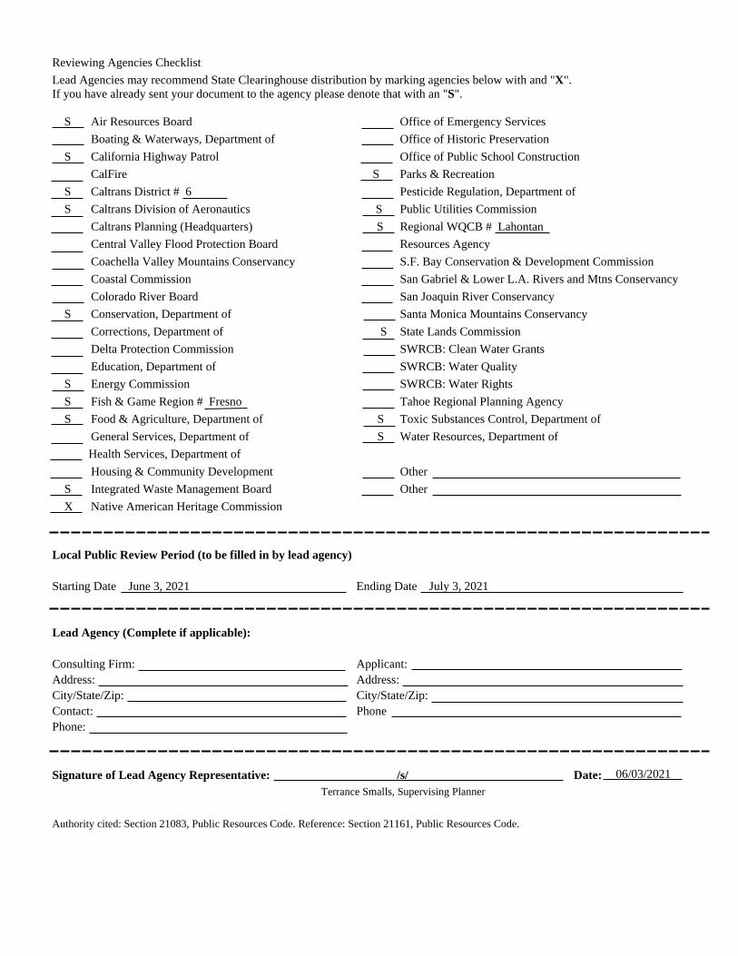
Reviewing Agencies Checklist Lead Agencies may recommend State Clearinghouse distribution by marking agencies below with and "X". If you have already sent your document to the agency please denote that with an "S". S Air Resources Board Office of Emergency Services Boating & Waterways, Department of Office of Historic Preservation S California Highway Patrol Office of Public School Construction CalFire S Parks & Recreation S Caltrans District # 6 Pesticide Regulation, Department of S Caltrans Division of Aeronautics S Public Utilities Commission Caltrans Planning (Headquarters) S Regional WQCB # Lahontan Central Valley Flood Protection Board Resources Agency Coachella Valley Mountains Conservancy S.F. Bay Conservation & Development Commission Coastal Commission San Gabriel & Lower L.A. Rivers and Mtns Conservancy Colorado River Board San Joaquin River Conservancy S Conservation, Department of Santa Monica Mountains Conservancy Corrections, Department of S State Lands Commission Delta Protection Commission SWRCB: Clean Water Grants Education, Department of SWRCB: Water Quality S Energy Commission SWRCB: Water Rights S Fish & Game Region # Fresno Tahoe Regional Planning Agency S Food & Agriculture, Department of S Toxic Substances Control, Department of General Services, Department of S Water Resources, Department of Health Services, Department of Housing & Community Development Other S Integrated Waste Management Board Other X Native American Heritage Commission Local Public Review Period (to be filled in by lead agency) Starting Date June 3, 2021 Ending Date July 3, 2021 Lead Agency (Complete if applicable): Consulting Firm: Applicant: Address: Address: City/State/Zip: City/State/Zip: Contact: Phone Phone: Signature of Lead Agency Representative: /s/ Date: Terrance Smalls, Supervising Planner Authority cited: Section 21083, Public Resources Code. Reference: Section 21161, Public Resources Code.
06/03/2021

[This Page Intentionally Left Blank]
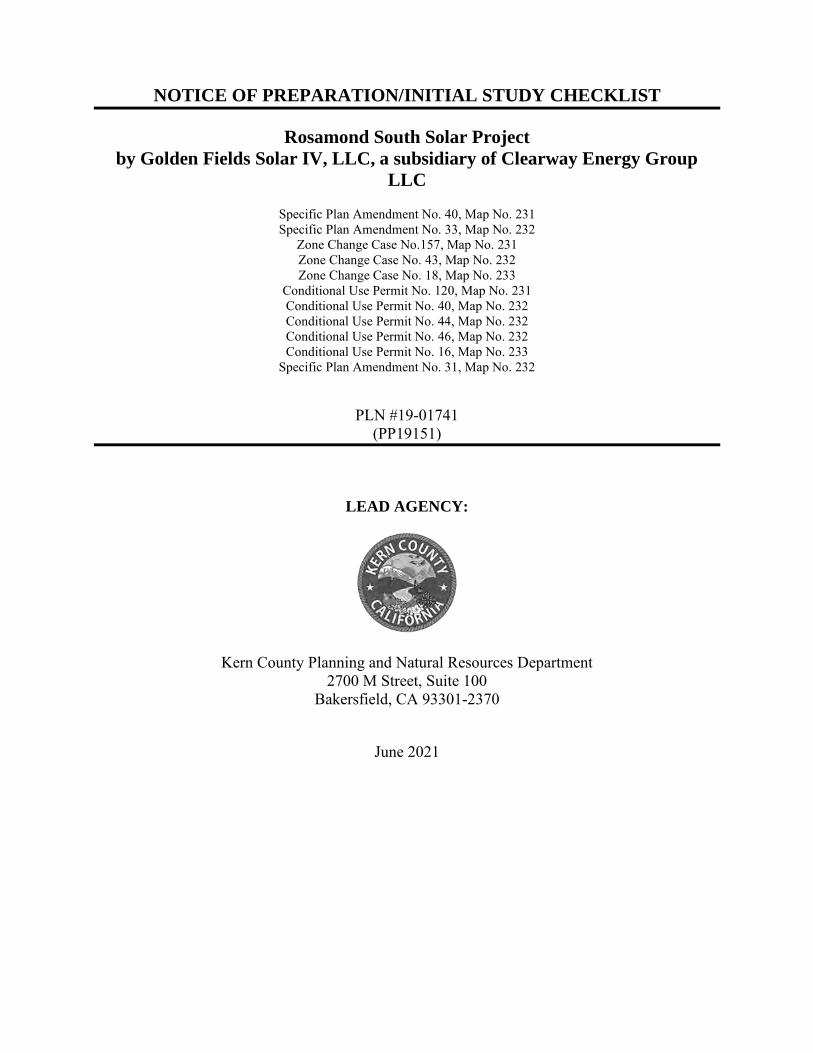
NOTICE OF PREPARATION/INITIAL STUDY CHECKLIST
Rosamond South Solar Project
by Golden Fields Solar IV, LLC, a subsidiary of Clearway Energy Group
LLC
Specific Plan Amendment No. 40, Map No. 231 Specific Plan Amendment No. 33, Map No. 232
Zone Change Case No.157, Map No. 231 Zone Change Case No. 43, Map No. 232 Zone Change Case No. 18, Map No. 233
Conditional Use Permit No. 120, Map No. 231 Conditional Use Permit No. 40, Map No. 232 Conditional Use Permit No. 44, Map No. 232 Conditional Use Permit No. 46, Map No. 232 Conditional Use Permit No. 16, Map No. 233
Specific Plan Amendment No. 31, Map No. 232
PLN #19-01741 (PP19151)
LEAD AGENCY:
Kern County Planning and Natural Resources Department 2700 M Street, Suite 100
Bakersfield, CA 93301-2370
June 2021

This page intentionally left blank.
KERN COUNTY PLANNING AND NATURAL RESOURCES DEPARTMENT Rosamond South Solar Project
Initial Study/Notice of Preparation i June 2021
TABLE OF CONTENTS
Initial Study Checklist
INTRODUCTION ....................................................................................................................................... 1 BACKGROUND INFORMATION........................................................................................................... 1 1. Project Description ............................................................................................................................... 1
1.1. Project Location ........................................................................................................................ 1 1.2. Environmental Setting ............................................................................................................. 13
Surrounding Land Uses ........................................................................................................... 14 1.3. Project Description .................................................................................................................. 17
Project Overview ..................................................................................................................... 17 1.4. Project Facilities, Construction, and Operations ..................................................................... 19
Project Facilities ...................................................................................................................... 19 Construction Activities ............................................................................................................ 22 Project Operation and Maintenance Activities ........................................................................ 25 Project Features and Best Management Practices ................................................................... 25
1.5. Project Objectives.................................................................................................................... 27 1.6. Proposed Discretionary Actions/Required Approvals ............................................................. 28
2. Kern County Environmental Checklist Form ................................................................................. 35 2.1. Environmental Factors Potentially Affected ........................................................................... 35 2.2. Determination .......................................................................................................................... 35
3. Evaluation of Environmental Impacts .............................................................................................. 36 I. Aesthetics ................................................................................................................................ 38 II. Agriculture and Forest Resources ........................................................................................... 40 III. Air Quality ............................................................................................................................... 42 IV. Biological Resources ............................................................................................................... 45 V. Cultural Resources .................................................................................................................. 48 VI. Energy ..................................................................................................................................... 49 VII. Geology and Soils ................................................................................................................... 50 VIII. Greenhouse Gas Emissions ..................................................................................................... 53 IX. Hazards and Hazardous Materials ........................................................................................... 55 X. Hydrology and Water Quality ................................................................................................. 59 XI. Land Use and Planning ............................................................................................................ 62 XII. Mineral Resources ................................................................................................................... 64 XIII. Noise ........................................................................................................................................ 65 XIV. Population and Housing .......................................................................................................... 67 XV. Public Services ........................................................................................................................ 68 XVI. Recreation ................................................................................................................................ 70 XVII. Transportation and Traffic ....................................................................................................... 71 XVIII. Tribal Cultural Resources ........................................................................................................ 74 XIX. Utilities and Service Systems .................................................................................................. 75 XX. Wildfire ................................................................................................................................... 78 XXI. Mandatory Findings of Significance ....................................................................................... 80
KERN COUNTY PLANNING AND NATURAL RESOURCES DEPARTMENT Rosamond South Solar Project
Initial Study/Notice of Preparation ii June 2021
4. REFERENCES ................................................................................................................................... 82
List of Figures
Figure 1, Regional Vicinity Map .................................................................................................................. 3 Figure 2, Local Vicinity Map ........................................................................................................................ 4 Figure 3, Aerial Photograph with Project Site Boundaries ........................................................................... 5 Figure 4: Existing General Plan Designations – Zoning Map 231 ............................................................... 6 Figure 5: Existing General Plan Designations – Zoning Map 232 ............................................................... 7 Figure 6: Existing General Plan Designations – Zoning Map 233 ............................................................... 8 Figure 7: Existing Zone Classification – Zoning Map 231 ........................................................................... 9 Figure 8: Existing Zone Classification – Zoning Map 232 ......................................................................... 10 Figure 9: Existing Zone Classification – Zoning Map 233 ......................................................................... 11 Figure 10: FEMA Floodplain Map ............................................................................................................. 12 Figure 11: Proposed Amendment to Willow Springs Specific Plan Circulation Element (to Eliminate
Future Road Reservations) ...................................................................................................... 30 Figure 12: CUP 1 Site Plan ......................................................................................................................... 31 Figure 13: CUP 2 Site Plan ......................................................................................................................... 32 Figure 14: CUP 3 Site Plan ......................................................................................................................... 33 Figure 15: CUP 4 Site Plan ......................................................................................................................... 34
List of Tables
Table 1, Project Assessor Parcel Numbers, Existing Map Codes, Existing and Proposed Zoning, and Acreage ...................................................................................................................................... 2
Table 2, Existing Project Site and Surrounding Properties, Existing Land Use, General Plan Map Code
Designations, and Zoning ........................................................................................................ 22
KERN COUNTY PLANNING AND NATURAL RESOURCES DEPARTMENT
Rosamond South Solar Project
Initial Study/Notice of Preparation 1 June 2021
INTRODUCTION Pursuant to the California Environmental Quality Act (CEQA), the Kern County Planning and Natural Resources Department will initiate the preparation of an Environmental Impact Report (EIR) for the Rosamond South Solar Project in the unincorporated area of southeastern Kern County, California.
BACKGROUND INFORMATION The project proponent, Golden Fields Solar IV, LLC, a subsidiary of Clearway Energy Group LLC, submitted an application for the Rosamond South Solar Project to the County that was deemed complete on October 16, 2020.
1. Project Description
1.1. Project Location
The proposed Rosamond South Solar Project (proposed project or project) is a proposal by Golden Fields Solar IV, LLC, a subsidiary of Clearway Energy Group, LLC (Clearway) (project proponent) to construct and operate a photovoltaic (PV) solar facility and associated infrastructure to generate up to 154 megawatts (MW) of renewable electrical energy and up to 200 MW of energy storage on approximately 1,292 acres of privately-owned land. The proposed project site is located in the Mojave Desert within unincorporated Kern County, bounded by Rosamond Boulevard to the north, 90th Street West to the east, West Avenue A to the south and 170th Street West to the west. (Figure 1, Regional Vicinity Map). Access to the site would be from Rosamond Boulevard, Avenue A, Avenue D, Astoria Avenue, Gaskell Road, Holiday Avenue, Willow Avenue, Kingbird Avenue,100th Street West, 140th Street West, 130th Street West and 170th Street West.
The site is located within Section 24 Township 9 North, Range 15 West and Sections 20, 21, 27, and 28, Township 9 North, Range 14 West, and Sections 30 and 31 Township 9 N Range 13W, San Bernardino Base and Meridian. The project site is located approximately 11 miles west of the community of Rosamond in the western Antelope Valley, in the far western Mojave Desert and approximately 50 miles southeast of the city of Bakersfield within the jurisdiction of the Willow Springs Specific Plan. The closest airport is Rosamond Skypark, which is located approximately nine miles east of the project site. The closest military base is Edwards Air Force Base, approximately 30 miles to the east of the project site.
The project boundaries are shown on Figure 2, Local Vicinity Map, which also shows the proposed transmission line alignments being considered. Electricity produced by the proposed project would be collected and routed to the existing Teddy Substation, where it would be stepped up in voltage. From the substation, power would be transmitted to the Southern California Edison (SCE) Whirlwind substation via existing 230 kV transmission line.
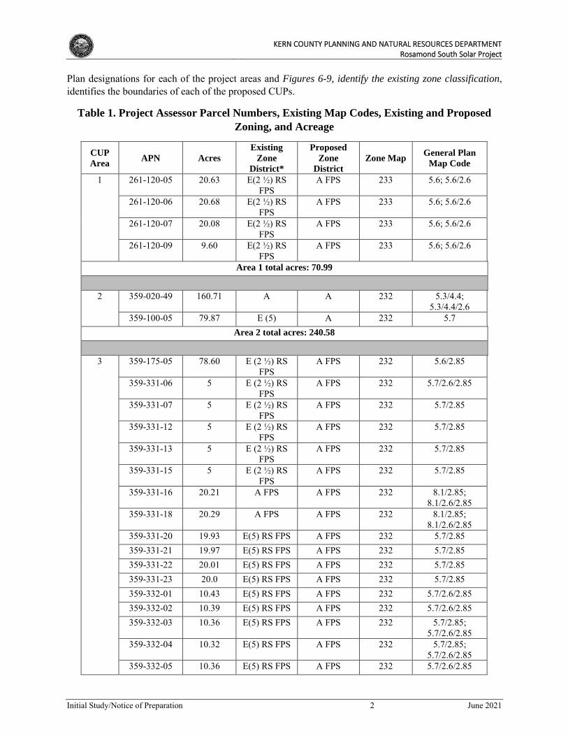
As shown on Figure 3, Aerial Photograph With Site Boundaries the project area is divided into three Conditional Use Permit (CUP) areas (Areas 1 through 3) and is comprised of 64 privately owned parcels. Table 1, Project Assessor Parcel Numbers, Existing Map Codes, Existing and Proposed Zoning, and
Acreage, below identifies the 64 individual parcels by site, their respective Assessor’s Parcel Number (APN), acreages, and existing and proposed zoning designations. Figures 4-6, identify the existing General
KERN COUNTY PLANNING AND NATURAL RESOURCES DEPARTMENT
Rosamond South Solar Project
Initial Study/Notice of Preparation 2 June 2021
Plan designations for each of the project areas and Figures 6-9, identify the existing zone classification, identifies the boundaries of each of the proposed CUPs.
Table 1. Project Assessor Parcel Numbers, Existing Map Codes, Existing and Proposed
Zoning, and Acreage
CUP
Area APN Acres
Existing
Zone
District*
Proposed
Zone
District
Zone Map General Plan
Map Code
1 261-120-05 20.63 E(2 ½) RS FPS
A FPS 233 5.6; 5.6/2.6
261-120-06 20.68 E(2 ½) RS FPS
A FPS 233 5.6; 5.6/2.6
261-120-07 20.08 E(2 ½) RS FPS
A FPS 233 5.6; 5.6/2.6
261-120-09 9.60 E(2 ½) RS FPS
A FPS 233 5.6; 5.6/2.6
Area 1 total acres: 70.99
2 359-020-49 160.71 A A 232 5.3/4.4; 5.3/4.4/2.6
359-100-05 79.87 E (5) A 232 5.7 Area 2 total acres: 240.58
3 359-175-05 78.60 E (2 ½) RS FPS
A FPS 232 5.6/2.85
359-331-06 5 E (2 ½) RS FPS
A FPS 232 5.7/2.6/2.85
359-331-07 5 E (2 ½) RS FPS
A FPS 232 5.7/2.85
359-331-12 5 E (2 ½) RS FPS
A FPS 232 5.7/2.85
359-331-13 5 E (2 ½) RS FPS
A FPS 232 5.7/2.85
359-331-15 5 E (2 ½) RS FPS
A FPS 232 5.7/2.85
359-331-16 20.21 A FPS A FPS 232 8.1/2.85; 8.1/2.6/2.85
359-331-18 20.29 A FPS A FPS 232 8.1/2.85; 8.1/2.6/2.85
359-331-20 19.93 E(5) RS FPS A FPS 232 5.7/2.85 359-331-21 19.97 E(5) RS FPS A FPS 232 5.7/2.85 359-331-22 20.01 E(5) RS FPS A FPS 232 5.7/2.85 359-331-23 20.0 E(5) RS FPS A FPS 232 5.7/2.85 359-332-01 10.43 E(5) RS FPS A FPS 232 5.7/2.6/2.85 359-332-02 10.39 E(5) RS FPS A FPS 232 5.7/2.6/2.85 359-332-03 10.36 E(5) RS FPS A FPS 232 5.7/2.85;
5.7/2.6/2.85 359-332-04 10.32 E(5) RS FPS A FPS 232 5.7/2.85;
5.7/2.6/2.85 359-332-05 10.36 E(5) RS FPS A FPS 232 5.7/2.6/2.85
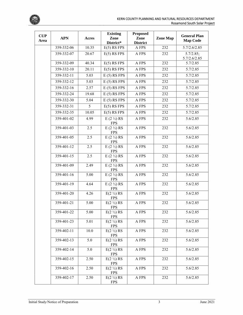
KERN COUNTY PLANNING AND NATURAL RESOURCES DEPARTMENT
Rosamond South Solar Project
Initial Study/Notice of Preparation 3 June 2021
CUP
Area APN Acres
Existing
Zone
District*
Proposed
Zone
District
Zone Map General Plan
Map Code
359-332-06 10.35 E(5) RS FPS A FPS 232 5.7/2.6/2.85 359-332-07 20.67 E(5) RS FPS A FPS 232 5.7/2.85;
5.7/2.6/2.85 359-332-09 40.34 E(5) RS FPS A FPS 232 5.7/2.85 359-332-10 20.11 E(5) RS FPS A FPS 232 5.7/2.85 359-332-11 5.03 E (5) RS FPS A FPS 232 5.7/2.85 359-332-12 5.03 E (5) RS FPS A FPS 232 5.7/2.85 359-332-16 2.57 E (5) RS FPS A FPS 232 5.7/2.85 359-332-24 19.68 E (5) RS FPS A FPS 232 5.7/2.85 359-332-30 5.04 E (5) RS FPS A FPS 232 5.7/2.85 359-332-31 5 E(5) RS FPS A FPS 232 5.7/2.85 359-332-35 10.05 E(5) RS FPS A FPS 232 5.7/2.85 359-401-02 4.99 E (2 ½) RS
FPS A FPS 232 5.6/2.85
359-401-03 2.5 E (2 ½) RS FPS
A FPS 232 5.6/2.85
359-401-05 2.5 E (2 ½) RS FPS
A FPS 232 5.6/2.85
359-401-12 2.5 E (2 ½) RS FPS
A FPS 232 5.6/2.85
359-401-15 2.5 E (2 ½) RS FPS
A FPS 232 5.6/2.85
359-401-09 2.49 E (2 ½) RS FPS
A FPS 232 5.6/2.85
359-401-16 5.00 E (2 ½) RS FPS
A FPS 232 5.6/2.85
359-401-19 4.64 E (2 ½) RS FPS
A FPS 232 5.6/2.85
359-401-20 4.26 E(2 ½) RS FPS
A FPS 232 5.6/2.85
359-401-21 5.00 E(2 ½) RS FPS
A FPS 232 5.6/2.85
359-401-22 5.00 E(2 ½) RS FPS
A FPS 232 5.6/2.85
359-401-23 5.01 E(2 ½) RS FPS
A FPS 232 5.6/2.85
359-402-11 10.0 E(2 ½) RS FPS
A FPS 232 5.6/2.85
359-402-13 5.0 E(2 ½) RS FPS
A FPS 232 5.6/2.85
359-402-14 5.0 E(2 ½) RS FPS
A FPS 232 5.6/2.85
359-402-15 2.50 E(2 ½) RS FPS
A FPS 232 5.6/2.85
359-402-16 2.50 E(2 ½) RS FPS
A FPS 232 5.6/2.85
359-402-17 2.50 E(2 ½) RS FPS
A FPS 232 5.6/2.85
KERN COUNTY PLANNING AND NATURAL RESOURCES DEPARTMENT
Rosamond South Solar Project
Initial Study/Notice of Preparation 4 June 2021
CUP
Area APN Acres
Existing
Zone
District*
Proposed
Zone
District
Zone Map General Plan
Map Code
359-402-18 2.50 E(2 ½) RS FPS
A FPS 232 5.6/2.85
359-402-19 2.50 E(2 ½) RS FPS
A FPS 232 5.6/2.85
359-402-20 2.50 E(2 ½) RS FPS
A FPS 232 5.6/2.85
359-402-21 2.50 E(2 ½) RS FPS
A FPS 232 5.6/2.85
359-402-22 2.50 E(2 ½) RS FPS
A FPS 232 5.6/2.85
359-403-08 20.01 E (2 ½) RS FPS
A FPS 232 5.6/2.85
359-403-09 20.02 E (2 ½) RS FPS
A FPS 232 5.6/2.85
Area 3 total acres: 541.16
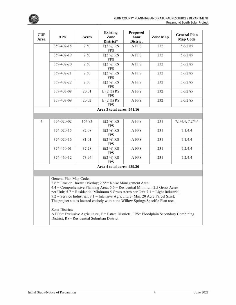
4 374-020-02 164.93 E(2 ½) RS FPS
A FPS 231 7.1/4.4; 7.2/4.4
374-020-15 82.08 E(2 ½) RS FPS
A FPS 231 7.1/4.4
374-020-16 81.01 E(2 ½) RS FPS
A FPS 231 7.1/4.4
374-450-01 37.28 E(2 ½) RS FPS
A FPS 231 7.2/4.4
374-460-12 73.96 E(2 ½) RS FPS
A FPS 231 7.2/4.4
Area 4 total acres: 439.26
General Plan Map Code: 2.6 = Erosion Hazard Overlay; 2.85= Noise Management Area; 4.4 = Comprehensive Planning Area; 5.6 = Residential Minimum 2.5 Gross Acres per Unit; 5.7 = Residential Minimum 5 Gross Acres per Unit 7.1 = Light Industrial; 7.2 = Service Industrial; 8.1 = Intensive Agriculture (Min. 20 Acre Parcel Size); The project site is located entirely within the Willow Springs Specific Plan area.
Zone District: A FPS= Exclusive Agriculture, E = Estate Districts, FPS= Floodplain Secondary Combining District, RS= Residential Suburban District

FIGURE 3: Aerial Map with Site BoundariesRosamond South Solar ProjectN.T.S.
Source: Google Earth, REVAMP Engineering, 2021
LEGEND
Site Boundaries CUP AreaGentie Route
CUP AREA 1CUP AREA 1CUP AREA 2CUP AREA 2
CUP AREA 3CUP AREA 3
CUP AREA 4CUP AREA 4
W Avenue AW Avenue A
Gaskell RdGaskell Rd
Holiday AveHoliday Ave
Rosamond BlvdRosamond Blvd
W Avenue DW Avenue D
170th St W170th St W
110th St W110th St W
140th St W140th St W
100th St W100th St W
90th St W90th St W
120th St W120th St W
GASKELL RD
W TS HT09
AVENUE A
W TS
HT001GASKELL RD
JOYCE AVE
LON
GSP
UR
ST
99TH
ST
W
SUE AVE
97TH
ST
W
96TH
ST
W
95TH
ST
WW TS
HT59
BUCKHORN AVE
BOBTAIL LN
HAWK AVE
OWL AVE
W TS HT49 92
ND
ST
WW TS
DN29
91S
T ST
WW TS TS19
W TS HT49
W TS HT99
97TH
ST
W
WILLOW AVE
CHARAN RD
SUE AVE
HAWKEYE AVE
YOLANDA AVE
KINGBIRD AVE
YOLANDA AVE
KINGBIRD AVE
SPUR RANCH RD
W TS HT48
ELDER AVE
W TS HT501
EVA REE
DLLIK
GASKELL RD
SOLEDAD AVE
W TS HT801
W TS HT58
GEORGE AVE
KINGBIRD AVE
COUNTYOF KERN
29
30
25
323136
6.2
6.2
6.2
7.1/4.4
7.1/4.4
7.2/4.4
5.6/2.8
6.2/2.8
8.1/2.8
8.1/2.85
5.6/2.85
4.1 Willow Springs SP
LOS ANGELES COUNTY
Project SiteArterialsDirt RoadsKern County BoundaryBordering CountiesSpecific Plans
GENERAL PLAN BOUNDARIES4.1 - ACCEPTED COUNTY PLAN AREAS
SPECIFIC PLAN DESIGNATIONS5.6 - MINIMUM 2.5 GROSS ACRES/UNIT6.2 - GENERAL COMMERCIAL7.1/4.4 - LIGHT INDUSTRIAL7.2/4.4 - SERVICE INDUSTRIAL8.1 - INTENSIVE AGRICULTURE (MIN. 20-ACRE PARCEL SIZE)
HAZARD DESIGNATIONS2.85 - Military Flight Operations (60db)2.8 - Military Flight Operations (65db)Township/RangeSections
11/2/2020 F0 610 1,220 1,830 2,440 Feet
Kern CountyPlanning & NaturalResources Department
Kern County
^
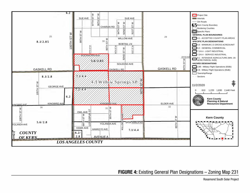
FIGURE 4: Existing General Plan Designations – Zoning Map 231Rosamond South Solar Project
GASKELL RD
ROSAMOND BLVD
145T
H S
TW
HOLIDAY AVE
WILLOW AVE
GASKELL RD
140T
HST
W
132N
D S
T W
130T
HST
W13
0TH
ST
W
BRABHAM AVE
BUCKHORN AVE
ASTORIA AVE
CHARAN RD
SUE AVE
DINKEY AVE
120T
H S
T W12
0TH
ST
W
BUCKHORN AVE
BOBTAIL LN
120T
H S
T W
132N
D S
T W
130T
H S
T W
127T
H S
T W
127T
H S
T W
126T
H S
T W
125T
H S
T W
140T
H S
T W
120T
H S
T W
SOLEDAD AVE
DINKEY AVE
MOJAVE AVE
GOBI AVE
SAHARA AVE
BOBTAIL LN
BUCKHORN AVE
140T
H S
T W
145T
H S
TW
135T
H S
T W
KOO
KABU
RR
A ST
127T
H S
T W
126T
H S
T W
125T
H S
T W
BOZI
GIA
N R
ANC
H R
D
BUCKHORN AVE
SUE AVE
GEORGE AVE
14151617
23
222120
26272829
353433
32
3.1
3.2
6.2
6.2
6.2
8.1
5.3/2.8
8.1/2.85
8.1/2.6
5.6/2.8
5.6/2.85
5.6/2.6
5.6
/2.6
5.6/2.6/2.8
5.7/2.6
5.7/2.855.7/2.6/
2.85
8.1/2.6
6.2/2.8
8.1/2.858.1/2.6/2.85
8.1
/2.
6
8.1/2.6
5.3/
4.4
/2.
6
5.3/
4.4
/2.
68.1/4.4/2.6
8.1/2.85
8.1
/2.
6/
2.8
5
5.6
5.6
5.6
8.1
5.3/4.4/2.85
5.7
5.3
5.3/4.4
8.1
8.1
8.1/4.4
5.35.3
8.1/2.8
8.1
5.35.3
4.1 Willow Springs SP
11/2/2020 F0 610 1,220 1,830 2,440 Feet
Kern CountyPlanning & NaturalResources Department
Project SiteArterialsDirt RoadsKern County BoundarySpecific Plans
GENERAL PLAN BOUNDARIES4.1 - ACCEPTED COUNTY PLAN AREAS
SPECIFIC PLAN DESIGNATIONS3.1 - PARKS AND RECREATION AREAS3.2 - EDUCATIONAL FACILITIES5.3 - MAXIMUM 10 UNITS/NET ACRE (4356SQ. FT. SITE AREA/UNIT)5.3/4.4 - MAXIMUM 10 UNITS/NET ACRE(4356 SQ. FT. SITE AREA/UNIT)5.6 - MINIMUM 2.5 GROSS ACRES/UNIT5.7 - MINIMUM 5 GROSS ACRES/UNIT6.2 - GENERAL COMMERCIAL8.1 - INTENSIVE AGRICULTURE (MIN. 20-ACRE PARCEL SIZE)8.1/4.4 - INTENSIVE AGRICULTURE (MIN.20- ACRE PARCEL SIZE)
HAZARD DESIGNATIONS2.6 - Erosion Hazard2.6/2.85 - Erosion Hazard/Military FlightOperations (60db)2.6/2.8 - Erosion Hazard/Military FlightOperations (65db)2.85 - Military Flight Operations (60db)2.8 - Military Flight Operations (65db)Township/RangeSections
Kern County
^
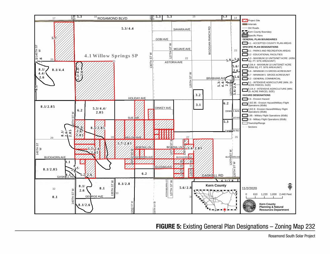
FIGURE 5: Existing General Plan Designations – Zoning Map 232Rosamond South Solar Project
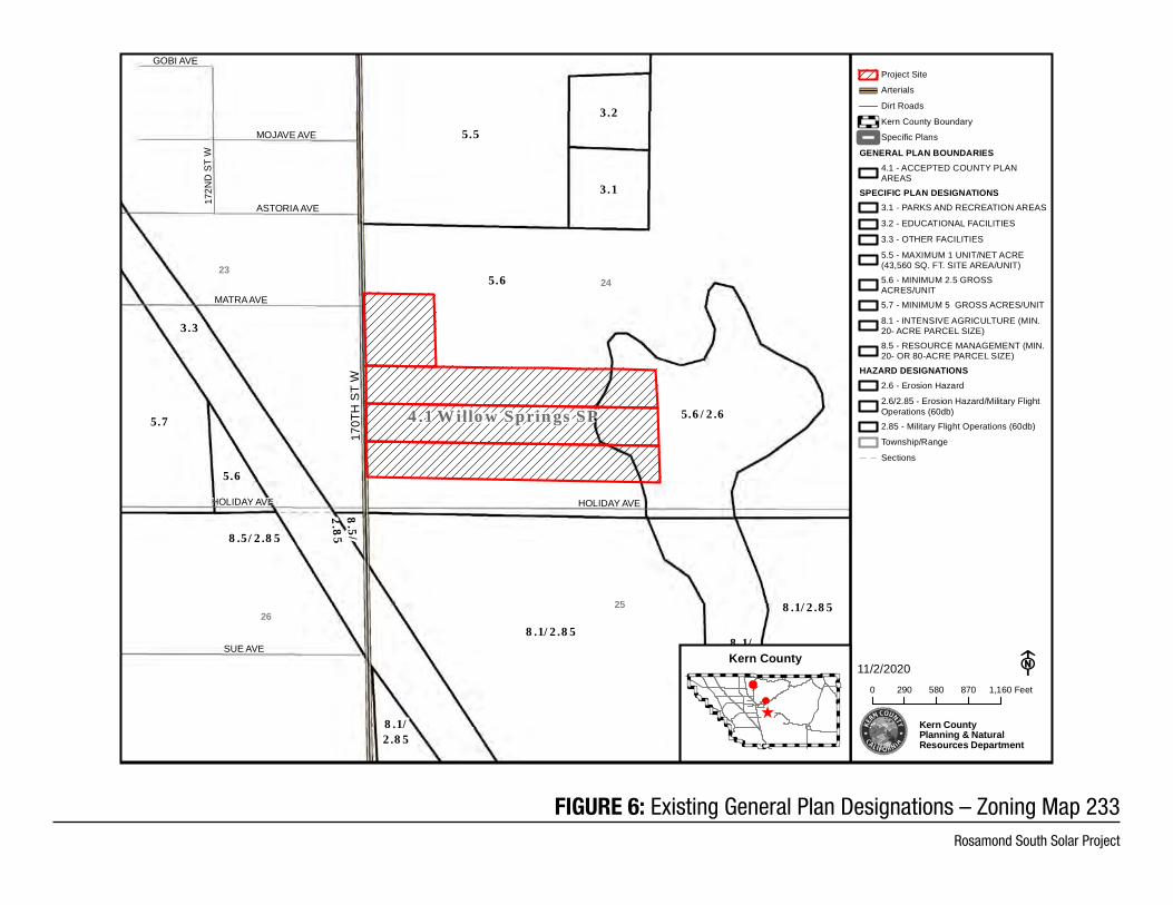
FIGURE 6: Existing General Plan Designations – Zoning Map 233Rosamond South Solar Project
170T
H S
T W
MOJAVE AVE
GOBI AVE
172N
D S
T W
ASTORIA AVE
MATRA AVE
HOLIDAY AVE
SUE AVE
HOLIDAY AVE
2423
2526
3.1
3.2
5.5
5.6
5.6
5.7 5.6/2.6
8.5/2.85
8.5/
2.85
8.1/2.85
8.1/2.85
8.1/2.858.1/2.6/2.85
3.3
4.1 Willow Springs SP
11/2/2020 F0 290 580 870 1,160 Feet
Kern CountyPlanning & NaturalResources Department
Project Site
Arterials
Dirt Roads
Kern County Boundary
Specific Plans
GENERAL PLAN BOUNDARIES4.1 - ACCEPTED COUNTY PLANAREAS
SPECIFIC PLAN DESIGNATIONS3.1 - PARKS AND RECREATION AREAS
3.2 - EDUCATIONAL FACILITIES
3.3 - OTHER FACILITIES
5.5 - MAXIMUM 1 UNIT/NET ACRE(43,560 SQ. FT. SITE AREA/UNIT)5.6 - MINIMUM 2.5 GROSSACRES/UNIT5.7 - MINIMUM 5 GROSS ACRES/UNIT
8.1 - INTENSIVE AGRICULTURE (MIN.20- ACRE PARCEL SIZE)8.5 - RESOURCE MANAGEMENT (MIN.20- OR 80-ACRE PARCEL SIZE)
HAZARD DESIGNATIONS2.6 - Erosion Hazard
2.6/2.85 - Erosion Hazard/Military FlightOperations (60db)2.85 - Military Flight Operations (60db)
Township/Range
Sections
Kern County
^
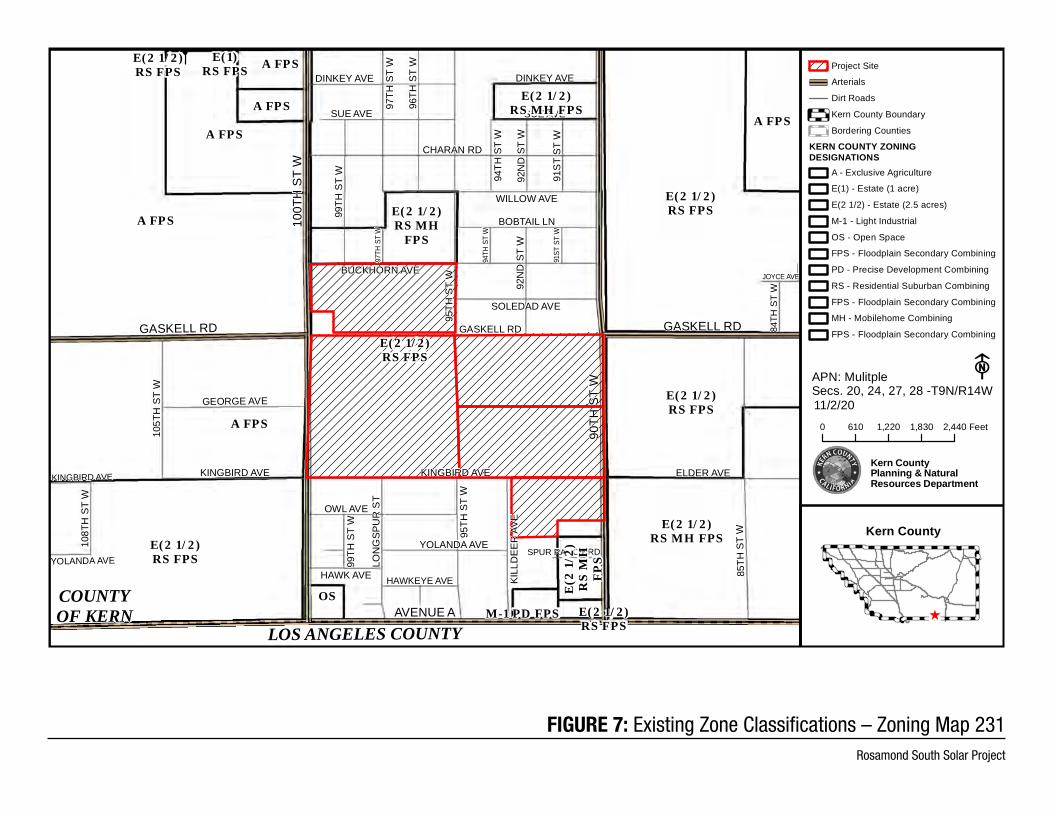
FIGURE 7: Existing Zone Classifications – Zoning Map 231 Rosamond South Solar Project
GASKELL RD
100T
H S
T W
90TH
ST
WAVENUE A
GASKELL RD
JOYCE AVE
LON
GSP
UR
ST
99TH
ST
W
SUE AVE
95TH
ST
W
96TH
ST
W
97TH
ST
W
95TH
ST
W
BUCKHORN AVE
BOBTAIL LN
HAWK AVE
OWL AVE94
TH S
T W
92N
D S
T W
92N
D S
T W
91S
T ST
W91
ST S
T W
94TH
ST
W
99TH
ST
W
97TH
ST
W
WILLOW AVE
CHARAN RD
DINKEY AVE
SUE AVE
HAWKEYE AVE
YOLANDA AVE
KINGBIRD AVE
YOLANDA AVE
KINGBIRD AVE
SPUR RANCH RD
84TH
ST
W
ELDER AVE
105T
H S
T W
KILL
DEE
R A
VE
GASKELL RD
SOLEDAD AVE
108T
H S
T W
DINKEY AVE
85TH
ST
W
GEORGE AVE
KINGBIRD AVE
COUNTYOF KERN
A FPS
A FPS
A FPS
A FPSE(1)RS FPS
A FPS
E(2 1/2)RS FPS
E(2 1/2)RS FPS
E(2 1/2)RS FPS
E(2 1/2)RS FPS
E(2 1/2)RS FPS
E(2 1/2)RS FPS
A FPS
E(2
1/2
)R
S M
HF
PS
E(2 1/2)RS MH FPS
E(2 1/2)RS MH
FPS
E(2 1/2)RS MH FPS
OSM-1 PD FPS
LOS ANGELES COUNTY
Project Site
Arterials
Dirt Roads
Kern County Boundary
Bordering Counties
KERN COUNTY ZONINGDESIGNATIONS
A - Exclusive Agriculture
E(1) - Estate (1 acre)
E(2 1/2) - Estate (2.5 acres)
M-1 - Light Industrial
OS - Open Space
FPS - Floodplain Secondary Combining
PD - Precise Development Combining
RS - Residential Suburban Combining
FPS - Floodplain Secondary Combining
MH - Mobilehome Combining
FPS - Floodplain Secondary Combining
Kern County
^
Secs. 20, 24, 27, 28 -T9N/R14W11/2/20
F
0 610 1,220 1,830 2,440 Feet
Kern CountyPlanning & NaturalResources Department
APN: Mulitple
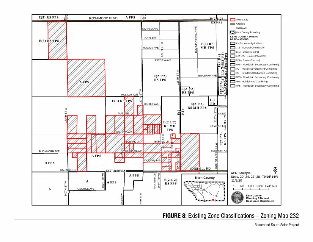
FIGURE 8: Existing Zone Classifications – Zoning Map 232 Rosamond South Solar Project
GASKELL RD
ROSAMOND BLVD
DINKEY AVE
HOLIDAY AVE
MATRA AVE
ASTORIA AVE
119T
H S
T W
132N
D S
T W
130T
H S
T W
140T
HST
W
130T
HST
W
BRABHAM AVE
120T
H S
T W12
0TH
ST
W
BUCKHORN AVE
BOBTAIL LN
WILLOW AVE
CHARAN RD
SUE AVE
120T
H S
T W
132N
D S
T W
130T
HS
TW
127T
H S
T W
127T
H S
T W
126T
H S
T W
119T
H S
T W
125T
H S
T W
BUCKHORN AVE
140T
H S
T W
120T
H S
T W
SOLEDAD AVE
DINKEY AVE
MOJAVE AVE
GOBI AVE
SAHARA AVE
BOBTAIL LN
BUCKHORN AVE
140T
H S
T W
135T
H S
T W
KOO
KAB
UR
RA
ST
127T
H S
T W
126T
H S
T W
125T
H S
T W
BOZI
GIA
N R
ANC
H R
D
BUCKHORN AVE
GASKELL RD
SUE AVE
GEORGE AVE
A FPS
A FPS
C-2PD
E(1) RSMH FPS
E(2
1/2
)E(2 1/2)RS FPS
E(2
1/2
)R
S F
PS
E(2 1/2)RS FPS
E(2
1/2
)R
S F
PS
E(2
1/2
)R
S F
PS
E(2
1/2
)R
S F
PS
E(2
1/2
)R
S F
PS
E(2
1/2
)R
S F
PS
E(2 1/2)RS FPS
E(2 1/2)RS FPS
E(2 1/2)RS MH
FPS
E(2 1/2)RS MH
FPS
E(2 1/2)RS MH FPS
E(5) RS FPS
E(5) RS FPS
E(5) RS FPS
E(5) RS FPS
AFPSA
A
A FPS
A FPS
A FPS
A FPS
Secs. 20, 24, 27, 28 -T9N/R14W11/2/20
F
0 610 1,220 1,830 2,440 Feet
Kern CountyPlanning & NaturalResources Department
Project Site
Arterials
Dirt Roads
Kern County Boundary
KERN COUNTY ZONINGDESIGNATIONS
A - Exclusive Agriculture
C-2 - General Commercial
E(1) - Estate (1 acre)
E(2 1/2) - Estate (2.5 acres)
E(5) - Estate (5 acres)
FPS - Floodplain Secondary Combining
PD - Precise Development Combining
RS - Residential Suburban Combining
FPS - Floodplain Secondary Combining
MH - Mobilehome Combining
FPS - Floodplain Secondary Combining
APN: MulitpleKern County
^
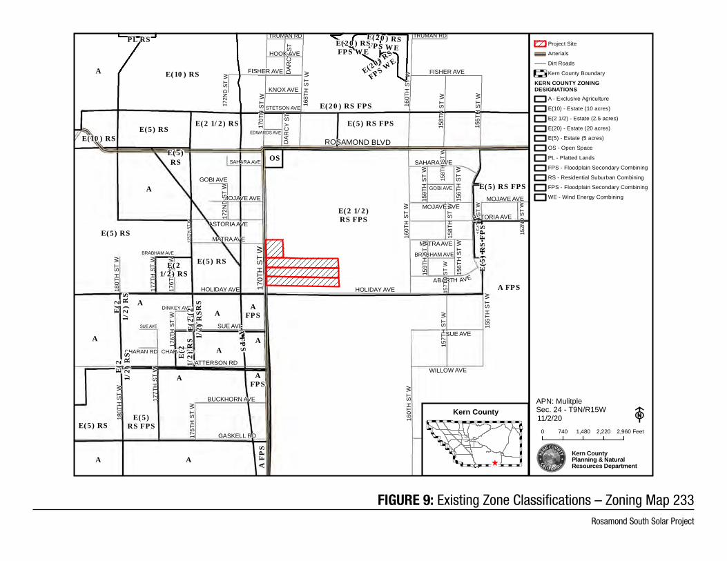
FIGURE 9: Existing Zone Classifications – Zoning Map 233 Rosamond South Solar Project
LITTLE
OAK CA
NYON R
D
ROSAMOND BLVD
170T
H S
T W
HOLIDAY AVE
155T
H S
T W
ABARTH AVE
160T
H S
T W
168T
H S
T WD
ARC
Y ST
170T
H S
T W
SAHARA AVE
MATRA AVE
MOJAVE AVE
ASTORIA AVE
155T
H S
T W
MOJAVE AVE
160T
H S
T W
157T
H S
T W
158T
H S
T W
DAR
CY
ST
172N
D S
T W
GASKELL RD
EDWARDS AVE
STETSON AVE
FISHER AVE
HOOK AVE
TRUMAN RD
CHARAN RDCHARAN RD
154T
H S
T W
SUE AVE SUE AVE
BRABHAM AVE
152N
D S
T W
DINKEY AVE
HOLIDAY AVE
154T
H S
T W
MOJAVE AVE
GOBI AVE
172N
D S
T W
175T
H S
T W
176T
H S
T W
177T
H S
T W
158T
H S
T W
159T
H S
T W
156T
H S
T W
159T
H S
T W
156T
H S
T W17
5TH
ST W
BRABHAM AVE
GOBI AVE
TRUMAN RD
FISHER AVE
WILLOW AVE
SUE AVE
GASKELL RD
PATTERSON RD
KNOX AVE
157T
H S
T W
160T
H S
T W
ASTORIA AVE
SAHARA AVE
175T
H S
T W
176T
H S
T W
177T
H S
T W
180T
H S
T W
GEORGE AVE
BUCKHORN AVE
155T
H S
T W
158T
H S
T W
MATRA AVE
180T
H S
T W
A
A
A
AFPS
A FPS
E(10) RS
E(10) RS
E(2
1/2
) R
S
E(2
1/2
) R
S
E(2
1/2
) R
S
E(2
1/2
) R
S E(2
1/2
) R
S
E(21/2) RS
E(2 1/2) RS
A
E(2 1/2)RS FPS
E(20) RS FPS
A
E(5) RS
E(5) RS
E(5)RS
E(5) RS
E(5) RS
A F
PS
E(5)RS FPS
E(5
) R
S F
PS
E(5) RS FPS
E(5) RS FPS
OS
PL RS
E(20) RS
FPS WE
E(20) RSFPS WEE(20) RS
FPS WE
A
A
A
A
A F
PS
AFPS
A
Sec. 24 - T9N/R15W11/2/20 F
0 740 1,480 2,220 2,960 Feet
Kern CountyPlanning & NaturalResources Department
Project Site
Arterials
Dirt Roads
Kern County Boundary
KERN COUNTY ZONINGDESIGNATIONS
A - Exclusive Agriculture
E(10) - Estate (10 acres)
E(2 1/2) - Estate (2.5 acres)
E(20) - Estate (20 acres)
E(5) - Estate (5 acres)
OS - Open Space
PL - Platted Lands
FPS - Floodplain Secondary Combining
RS - Residential Suburban Combining
FPS - Floodplain Secondary Combining
WE - Wind Energy Combining
APN: MulitpleKern County
^
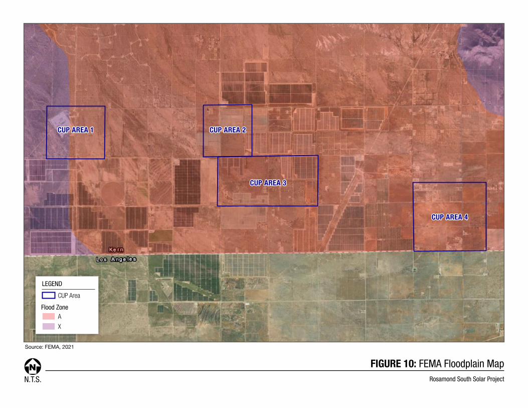
N.T.S.
FIGURE 10: FEMA Floodplain MapRosamond South Solar Project
Source: FEMA, 2021
LEGEND
Flood Zone
CUP Area
A
X
CUP AREA 1CUP AREA 1 CUP AREA 2CUP AREA 2
CUP AREA 3CUP AREA 3
CUP AREA 4CUP AREA 4
KERN COUNTY PLANNING AND NATURAL RESOURCES DEPARTMENT
Rosamond South Solar Project
Initial Study/Notice of Preparation 13 June 2021
1.2. Environmental Setting
The project site is located approximately 11 miles west of the community of Rosamond in the western Antelope Valley, in the far western Mojave Desert. The project site is located on the Fairmont Butte and Little Butte 7.5-minute USGS Quadrangles. CUP Areas 1, 2, and part of 3 are located within the Fairmont Butte USGS Quadrangle; the balance of CUP area 3 and CUP area 4 are located within the Little Butte USGS Quadrangle (USGS 2018a; USGS 2018b). The major north-south route in the region is State Route (SR) 14, a four-lane highway located east of the project site. The major east-west route near the Project site is SR 138, which is a two-lane road intersecting with SR 14 approximately 11.5 miles east of the project site. Refer to Figure 2, Project Site Boundaries.
The proposed project would be served by the Kern County Sheriff’s Office (KCSO) for law enforcement and public safety services. The closest sheriff station is the Rosamond Substation, located approximately 6 miles north of the project site. The Kern County Fire Department (KCFD) provides fire protection and emergency medical and rescue services for the project area. Rosamond Station is located approximately 6 miles to the east of the project site.
The Kern County Airport Land Use Compatibility Plan (ALUCP) covers operations at the Edwards Air Force Base, located approximately 30 miles to the east of the project site. The project site is not within the area covered by the ALCUP. The nearest airports to the project site are the privately owned Rosamond Skypark approximately 9 miles to the north east, the Mojave Air and Space Port approximately 25 miles to the northeast, and the Mountain Valley Airport approximately 25 miles to the north. The nearest public airport to the project site is Palmdale Regional Airport located approximately 18 miles southeast of the project site. The project site is not located within any safety or noise zones for the Palmdale Regional Airport (Las Angeles County, 2003).
The Federal Emergency Management Agency (FEMA) delineates flood hazard areas on its Flood Insurance Rate Maps (FIRMs). According to the FIRMs for the project site, the project site is located in a 100-year flood area (Zone A Without Base Flood Elevation,; refer to Figure 10, FEMA Floodplain Map (FEMA, 2008a and 2008b).
The project site is not designated by the California Department of Conservation (DOC) as Prime Farmland, Farmland of Statewide Importance, or Unique Farmland. CUP Areas 1, 2 and 3 are designated as Nonagricultural and Natural Vegetation and CUP Area 4 is designated Grazing Land, Nonagricultural or Natural Vegetation and Semi-agricultural and Rural Commercial Land on the Farmland Mapping and Monitoring Program (FMMP) 2016 Important Farmland map (DOC 2016). There are no lands designated as important farmland located within the project site. Additionally, no lands affected by the project are subject to a Williamson Act Land Use contract. Portions of the project site are located within Kern County Agricultural Preserve No. 24 (County of Kern Planning Department, 2006).
The project site is not within a mineral recovery area or within a designated mineral and petroleum resource site designated by the Willow Springs Specific Plan, nor is it identified as a mineral resource zone by the Department of Conservation’s State Mining and Geology Board, nor designated by the California Geologic Energy Management Division (formerly known as the Department of Oil, Gas and Geothermal Resources (DOGGR)) as a recognized oil field.
The proposed project would be located within unincorporated Kern County and within the jurisdiction of the Willow Springs Specific Plan. The existing designations are listed in Table 1, Project Assessor Parcel
KERN COUNTY PLANNING AND NATURAL RESOURCES DEPARTMENT
Rosamond South Solar Project
Initial Study/Notice of Preparation 14 June 2021
Numbers, Existing Map Codes, Existing and Proposed Zoning, and Acreage, above, and depicted in Figures
4-6. The proposed project would be subject to the provisions of the Kern County Zoning Ordinance and is zoned as specified in Table 1, above, and depicted in Figures 6-9.
Surrounding Land Uses
Table 2, Existing Project Site and Surrounding Properties, Existing Land Use, General Plan Map Code
Designations, and Zoning, identifies the existing land use, the existing general plan land use designation, and the existing zoning for each of the four CUP Areas. Additionally, such conditions are described for adjacent lands to the north, east, south, and west of each of the sites.
Existing land use in the project area generally includes undeveloped desert lands, scattered rural residential uses, access roadways, transmission corridors and other wind and solar energy projects that are currently in various stages of planning, construction, or operation. Other development in the area includes Willow Springs International Raceway. Rural residential uses are found in the unincorporated community of Rosamond to the east of the project site, located along Rosamond Boulevard.
The sensitive receptors closest to the project site are single family residences located adjacent to the south of CUP Area 4 along Spur Ranch Road. Additional single-family residences are located approximately 1 mile east of the east side of CUP Area 4 along 80th Street W and adjacent to CUP Areas 2 and 3. Rosamond Park, a local park, is located approximately 7.2 miles northeast of the easternmost portion of the project site. The closest school to the project site is Tropico Middle School, located approximately 4 miles northeast of the project site.
There are several existing, planned, and permitted solar energy and transmission projects adjacent to the project site. These projects include AVEP, Antelope Valley Solar, Big Beau Solar Project, Kingbird Photovoltaic Project, RE Astoria Solar Project, Raceway Solar Project, Rosamond Solar Array, Antelope Valley Phases 1 & 2, Willow Springs Solar Array, and Clearway’s Rosamond Central Solar Project.
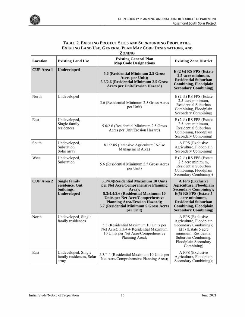
KERN COUNTY PLANNING AND NATURAL RESOURCES DEPARTMENT
Rosamond South Solar Project
Initial Study/Notice of Preparation 15 June 2021
TABLE 2. EXISTING PROJECT SITES AND SURROUNDING PROPERTIES,
EXISTING LAND USE, GENERAL PLAN MAP CODE DESIGNATIONS, AND
ZONING
Location Existing Land Use Existing General Plan
Map Code Designations Existing Zone District
CUP Area 1 Undeveloped 5.6 (Residential Minimum 2.5 Gross
Acres per Unit); 5.6/2.6 (Residential Minimum 2.5 Gross
Acres per Unit/Erosion Hazard)
E (2 ½) RS FPS (Estate 2.5-acre minimum,
Residential Suburban Combining, Floodplain Secondary Combining)
North Undeveloped 5.6 (Residential Minimum 2.5 Gross Acres
per Unit)
E (2 ½) RS FPS (Estate 2.5-acre minimum,
Residential Suburban Combining, Floodplain Secondary Combining)
East Undeveloped, Single family residences 5.6/2.6 (Residential Minimum 2.5 Gross
Acres per Unit/Erosion Hazard)
E (2 ½) RS FPS (Estate 2.5-acre minimum,
Residential Suburban Combining, Floodplain Secondary Combining)
South Undeveloped, Substation, Solar array.
8.1/2.85 (Intensive Agriculture/ Noise Management Area)
A FPS (Exclusive Agriculture, Floodplain Secondary Combining)
West Undeveloped, Substation 5.6 (Residential Minimum 2.5 Gross Acres
per Unit)
E (2 ½) RS FPS (Estate 2.5 acre minimum,
Residential Suburban Combining, Floodplain Secondary Combining))
CUP Area 2 Single family residence, Out buildings, Undeveloped
5.3/4.4(Residential Maximum 10 Units per Net Acre/Comprehensive Planning
Area); 5.3/4.4/2.6 (Residential Maximum 10 Units per Net Acre/Comprehensive
Planning Area/Erosion Hazard); 5.7 (Residential Minimum 5 Gross Acres
per Unit)
A FPS (Exclusive Agriculture, Floodplain Secondary Combining); E(5) RS FPS (Estate 5
acre minimum, Residential Suburban
Combining, Floodplain Secondary Combining)
North Undeveloped, Single family residences
5.3 (Residential Maximum 10 Units per Net Acre); 5.3/4.4(Residential Maximum
10 Units per Net Acre/Comprehensive Planning Area);
A FPS (Exclusive Agriculture, Floodplain Secondary Combining);
E(5) (Estate 5 acre minimum, Residential Suburban Combining, Floodplain Secondary
Combining)
East Undeveloped, Single family residences, Solar array
5.3/4.4 (Residential Maximum 10 Units per Net Acre/Comprehensive Planning Area);
A FPS (Exclusive Agriculture, Floodplain Secondary Combining);
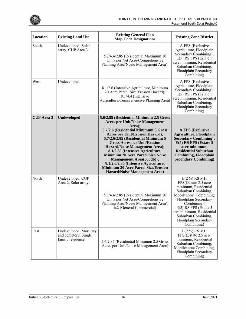
KERN COUNTY PLANNING AND NATURAL RESOURCES DEPARTMENT
Rosamond South Solar Project0
Initial Study/Notice of Preparation 16 June 2021
Location Existing Land Use Existing General Plan
Map Code Designations Existing Zone District
South Undeveloped, Solar array, CUP Area 3
5.3/4.4/2.85 (Residential Maximum 10 Units per Net Acre/Comprehensive
Planning Area/Noise Management Area);
A FPS (Exclusive Agriculture, Floodplain Secondary Combining); E(5) RS FPS (Estate 5
acre minimum, Residential Suburban Combining, Floodplain Secondary
Combining)
West Undeveloped 8.1/2.6 (Intensive Agriculture, Minimum
20 Acre Parcel Size/Erosion Hazard); 8.1/4.4 (Intensive
Agriculture/Comprehensive Planning Area)
A FPS (Exclusive Agriculture, Floodplain Secondary Combining); E(5) RS FPS (Estate 5
acre minimum, Residential Suburban Combining, Floodplain Secondary
Combining)
CUP Area 3 Undeveloped 5.6/2.85 (Residential Minimum 2.5 Gross Acres per Unit/Noise Management
Area); 5.7/2.6 (Residential Minimum 5 Gross
Acres per Unit/Erosion Hazard); 5.7/2.6/2.85 (Residential Minimum 5
Gross Acres per Unit/Erosion Hazard/Noise Management Area);
8.1/2.85 (Intensive Agriculture, Minimum 20 Acre Parcel Size/Noise
Management Area(606db)); 8.1/2.6/2.85 (Intensive Agriculture,
Minimum 20 Acre Parcel Size/Erosion Hazard/Noise Management Area)
A FPS (Exclusive Agriculture, Floodplain Secondary Combining); E(5) RS FPS (Estate 5
acre minimum, Residential Suburban
Combining, Floodplain Secondary Combining)
North Undeveloped, CUP Area 2, Solar array
5.3/4.4/2.85 (Residential Maximum 10 Units per Net Acre/Comprehensive
Planning Area/Noise Management Area); 6.2 (General Commercial)
E(2 ½) RS MH FPS((Estate 2.5 acre
minimum, Residential Suburban Combining,
Mobilehome Combining, Floodplain Secondary
Combining); E(5) RS FPS (Estate 5
acre minimum, Residential Suburban Combining, Floodplain Secondary
Combining)
East Undeveloped, Mortuary and cemetery, Single family residence 5.6/2.85 (Residential Minimum 2.5 Gross
Acres per Unit/Noise Management Area)
E(2 ½) RS MH FPS((Estate 2.5 acre
minimum, Residential Suburban Combining,
Mobilehome Combining, Floodplain Secondary
Combining)
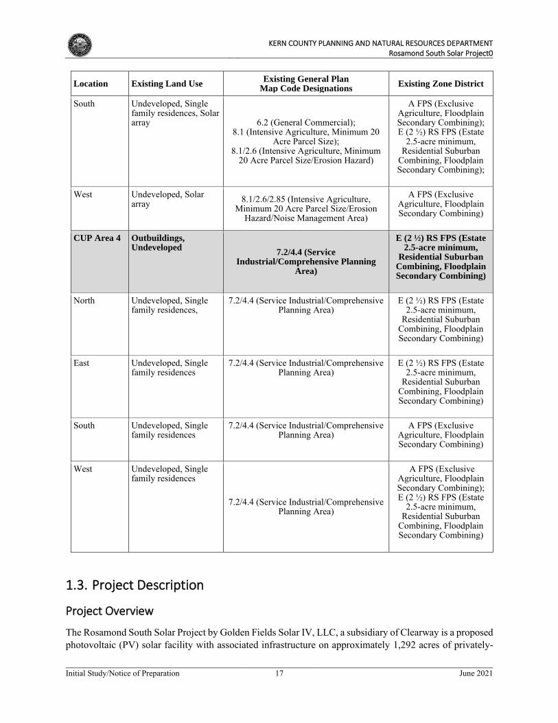
KERN COUNTY PLANNING AND NATURAL RESOURCES DEPARTMENT
Rosamond South Solar Project0
Initial Study/Notice of Preparation 17 June 2021
Location Existing Land Use Existing General Plan
Map Code Designations Existing Zone District
South Undeveloped, Single family residences, Solar array 6.2 (General Commercial);
8.1 (Intensive Agriculture, Minimum 20 Acre Parcel Size);
8.1/2.6 (Intensive Agriculture, Minimum 20 Acre Parcel Size/Erosion Hazard)
A FPS (Exclusive Agriculture, Floodplain Secondary Combining); E (2 ½) RS FPS (Estate
2.5-acre minimum, Residential Suburban
Combining, Floodplain Secondary Combining);
West Undeveloped, Solar array 8.1/2.6/2.85 (Intensive Agriculture,
Minimum 20 Acre Parcel Size/Erosion Hazard/Noise Management Area)
A FPS (Exclusive Agriculture, Floodplain Secondary Combining)
CUP Area 4 Outbuildings, Undeveloped
7.2/4.4 (Service Industrial/Comprehensive Planning
Area)
E (2 ½) RS FPS (Estate 2.5-acre minimum,
Residential Suburban Combining, Floodplain Secondary Combining)
North Undeveloped, Single family residences,
7.2/4.4 (Service Industrial/Comprehensive Planning Area)
E (2 ½) RS FPS (Estate 2.5-acre minimum,
Residential Suburban Combining, Floodplain Secondary Combining)
East Undeveloped, Single family residences
7.2/4.4 (Service Industrial/Comprehensive Planning Area)
E (2 ½) RS FPS (Estate 2.5-acre minimum,
Residential Suburban Combining, Floodplain Secondary Combining)
South Undeveloped, Single family residences
7.2/4.4 (Service Industrial/Comprehensive Planning Area)
A FPS (Exclusive Agriculture, Floodplain Secondary Combining)
West Undeveloped, Single family residences
7.2/4.4 (Service Industrial/Comprehensive Planning Area)
A FPS (Exclusive Agriculture, Floodplain Secondary Combining); E (2 ½) RS FPS (Estate
2.5-acre minimum, Residential Suburban
Combining, Floodplain Secondary Combining)
1.3. Project Description
Project Overview
The Rosamond South Solar Project by Golden Fields Solar IV, LLC, a subsidiary of Clearway is a proposed photovoltaic (PV) solar facility with associated infrastructure on approximately 1,292 acres of privately-
KERN COUNTY PLANNING AND NATURAL RESOURCES DEPARTMENT
Rosamond South Solar Project0
Initial Study/Notice of Preparation 18 June 2021
owned land in southeastern Kern County (Figure 1, Regional Vicinity Map). As stated above, the facility would consist of 4 areas (CUP Areas 1 to 4) to generate a combined (up to) 154 MW of renewable electrical energy. The project also includes the installation of (up to) 200 MW energy storage (battery) facilities. The project’s permanent facilities would include, but are not limited to, service roads, a power collection system, combiners, inverter stations, transformer systems, overhead and buried conductors, transmission lines, generation tie (gen-tie) lines, electrical switchyards, substations, energy (battery) storage system, telecommunications tower, security fencing, and operations and maintenance facilities.
The proposed project would include two Specific Plan Amendments to the Willow Springs Specific Plan as follows:
• Specific Plan Amendment No. 40, Map No. 231 from map code designation 7.1/4.4 (Light Industrial, Comprehensive Planning Area) to 7.1 (Light Industrial) on approximately 247 acres and from map code designation 7.2/4.4 (Service Industrial, Comprehensive Planning Area) to 7.2 (Service Industrial) on approximately 118 acres
• Specific Plan Amendment No. 33, Map No. 232 from map code designation 5.3/4.4 (Residential Maximum 10 Units per Net Acre/Comprehensive Planning Area) to 5.3 (Residential, Maximum 10 Units per Net Acre) on approximately 80 acres and from map code designation 5.3/4.4/2.6 (Residential Maximum 10 Units per Net Acre/Comprehensive Planning Area/Erosion Hazard) to 5.3/2.6 (Residential Maximum 10 units per Net Acre/Erosion Hazard) on approximately 80 acres
The proposed project would also include three Changes in zone classifications as follows:
• Zone Change Case No. 157, Map No. 231 from the existing zone district E(2 ½ ) RS FPS to A FPS on approximately 440 acres
• Zone Change Case No. 43, Map No. 232 from the existing zone district E(5) RS FPS to A FPS on approximately 330 acres and from existing zone district E(2 ½) RS FPS to A FPS on approximately 96
• Zone Change Case No. 18, Map No. 233 from the existing zone district (E5) RS FPS to A FPS on approximately 71 acres
Four Conditional Use Permits to allow for the construction and operation of four solar facilities with a total generating capacity of approximately 154 MW of renewable energy, including up to 200 MW of energy storage (for all sites)and one CUP for a communication tower, within the A (Exclusive Agriculture) zone district (in Zone Maps 231, 232, and 233) pursuant to Section 19.12.030.G of the Kern County Zoning Ordinance would be required for the proposed project as follows:
• CUP Area 1 (solar and energy storage)
o Conditional Use Permit No. 120, Map No. 231 for 70.99 acres
• CUP Area 2 (solar and energy storage)
o Conditional Use Permit No. 40, Map No. 232 for 240.58 acres
• CUP Area 3 (solar and energy storage)
o Conditional Use Permit No. 46, Map No. 232 for 541.16 acres
KERN COUNTY PLANNING AND NATURAL RESOURCES DEPARTMENT
Rosamond South Solar Project0
Initial Study/Notice of Preparation 19 June 2021
• CUP Area 4 (solar and energy storage)
o Conditional Use Permit No. 16, Map No. 233 for 439.26 acres
• Telecommunication Tower
o Conditional Use Permit No. 44, Map No. 232
The project proposes to remove future road reservations shown in the Willow Springs Specific Plan Circulation Element along a portion of the East/West and North/South midsection line of Section 21, T9N R14W within the project boundaries. The proposed Circulation Element future road reservations to be removed are shown in Figure 11: Proposed Future Road Reservations to be Removed from the Willow
Springs Specific Plan Circulation Element. The project includes a Specific Plan Amendment to the Circulation Element of the Willow Springs Specific Plan as follows:
• Specific Plan Amendment No. 31, Map No. 232
Figure 2, Project Site Boundaries, shows the boundaries of the proposed project. With the requested zone change, the project would be zoned A FPS (Exclusive Agriculture, Flood Plain Secondary) within Zone Maps 231, 232, and 233. Therefore, pursuant to Chapter 19.12.030.G, CUPs are required to allow for the construction and operation of the PV solar facility under this zoning.
The power generated on the project site would assist the State in complying with the Renewables Portfolio Standard under Senate Bill 350, which requires that by December 31, 2030, 50 percent of all electricity sold in the State shall be generated from renewable energy sources. The power generated on the project site would be sold to California investor-owned utilities, municipalities, community choice aggregators, or other purchasers in furtherance of the goals of the California Renewable Energy Portfolio Standard. The proposed project has an anticipated operational life of over 30 years. At the end of the project’s operational term, the project proponent would determine whether the project site should be decommissioned and deconstructed or if they would seek an extension of the project’s CUPs. If any portion of the project site is decommissioned, it would be converted to other uses in accordance with the applicable land use regulations in effect at that time.
1.4. Project Facilities, Construction, and Operations
Project Facilities
The combined project facilities would include the following components, which are described in greater detail thereafter:
• Solar PV panels;
• Inverters, combiners, and transformers;
• Battery Energy Storage System (BESS) facility;
• Up to 4 substations;
• Overhead and buried conductors;
• Onsite medium-voltage collection lines;

KERN COUNTY PLANNING AND NATURAL RESOURCES DEPARTMENT
Rosamond South Solar Project0
Initial Study/Notice of Preparation 20 June 2021
• Generation tie (gen-tie) line;
• Permanent, onsite, unpaved access roads;
• Telecommunications system and tower;
• Operations and Maintenance (O&M) Building facility;
• Security fencing;
• Stormwater retention basins;
• Temporary construction laydown areas, equipment, and structures.
Solar Array
The proposed project would utilize PV solar panels on mounting frameworks to convert sunlight directly into electricity. Individual panels would be installed on either fixed-tilt or tracker mount systems. If the panels are configured for fixed-tilt, the panels would be oriented toward the south. For tracking configurations, the panels would rotate to follow the sun over the course of the day. Maximum panel height is anticipated to be up to 14 feet high, depending on the mounting system selected and on County building codes.
The solar array fields would be arranged in groups called “blocks” with inverter stations generally located centrally within the blocks. Blocks would produce direct electrical current (DC), which is converted to alternating electrical current (AC) at the inverter stations.
Each PV module would be placed on a fixed-tilt or tracker mounting structure. The foundations for the mounting structures can extend up to 10 feet below ground, depending on the structure, soil conditions, and wind loads, and may be encased in concrete or utilize small concrete footings. A light-colored ground cover or palliative may be used to increase electricity production. Final solar panel layout and spacing would be optimized for project area characteristics and the desired energy production profile. Figures 12 to 15, Site
Plans, show the proposed layout of the solar panels within the respective CUP Areas.
Collection, Inverter, and Transformer Systems
Photovoltaic energy is delivered via cable to inverter stations, generally located near the center of each block. Inverter stations are typically comprised of one or more inverter modules with a rated power of up to 5 MW each, a unit transformer, and voltage switch gear. The unit transformer and voltage switch gear are housed in steel enclosures, while the inverter module(s) are housed in cabinets. Depending on the vendor selected, the inverter stations may lie within an enclosed or canopied metal structure, typically on a skid or concrete mounted pad.
Energy Storage System
The proposed project would include a Battery Energy Storage system (BESS) component. The approximately 200 MW BESS would consist of a series of batteries housed within the inverter pads or in separate storage containers. If the BESS is centrally located, it would be contained within an outdoor-rated steel enclosure. If distributed throughout the solar array, the BESS would be contained within metal housings at each of the equipment pads and electrically connected to the inverters. The containers would
KERN COUNTY PLANNING AND NATURAL RESOURCES DEPARTMENT
Rosamond South Solar Project0
Initial Study/Notice of Preparation 21 June 2021
be set on a concrete or steel pile foundation and would be approximately 8 feet wide by 10 feet long by 10 feet high. Collectively, the battery storage component would have a total footprint of a maximum 20 acres. The BESS and associated infrastructure would be located on one of the parcels within the project site.
The BESS would use one of several commercially available lithium ion (Li-ion) technologies, though alternatives may be considered (such as flow batteries) due to the rapidly changing technology in the battery industry. In general, a Li-ion battery is a rechargeable type of battery consisting of three major functional components: a positive electrode made from metal oxide, a negative electrode made from carbon, and an electrolyte made from lithium salt. Lithium ions move from negative to positive electrodes during discharging and in the opposite direction when charging. There are five major Li-ion battery sub chemistries that are commercially available, including: lithium nickel cobalt aluminum, lithium nickel manganese cobalt, lithium manganese oxide, lithium titanate oxide, and lithium-iron phosphate. Selection of the Li-ion subchemistry for the Project would take into consideration various technical factors, including safety, life span, energy performance, and cost.
The proposed BESS would be designed, constructed, operated, and maintained in accordance with applicable industry best practices and regulatory requirements, including compliance with the latest National Fire Protection Association (NFPA) fire safety codes and fire rating in conformance with Kern county standards.
Substation(s)
Up to four substations across the CUP Areas could be constructed to support the 154MW project. The substations (which contain high-voltage equipment) would be unenclosed, occupy an area of approximately 250 feet by 250 feet each, and be protected with security fences. The electrical equipment inside the substation fence would have a maximum height of approximately 100 feet. A small one-story, rectangular control building, housing the communication and supervisory control and data acquisition (SCADA) equipment, would also be located in the substation footprint. For substations located in CUP Areas 2, 3, and 4, an underground or overhead gen-tie line would be constructed to connect each solar area to the existing central Teddy substation. For the substation located in CUP Area 1, a dedicated overhead gen-tie line connecting the substation to the Whirlwind substation would be constructed. The final location(s) of the substations within the CUP Areas would be determined before issuance of building permits.
Generation Tie Line
From the proposed project’s substation(s), power could be transmitted to the existing privately-owned Teddy substation and/or the SCE Whirlwind Substation via up to 230 kV overhead and/or underground line(s); refer to Figure 2, Project Site Boundaries, which shows the possible gen-tie line alignments. If aboveground, the overhead lines would be mounted on either tubular steel monopoles or lattice structures up to 140 feet in height. Alternatively, the proposed project could transmit its power to the Teddy or SCE Whirlwind Substation via an existing 230-kV line as a result of a shared facilities agreement the project proponent is exploring. A franchise and/or encroachment agreement with Kern County along affected County roadways may ultimately be required for portions of the transmission line.
Operations and Maintenance Facilities
The proposed project would include an O&M building measuring approximately 100 feet by 50 feet, a communications building measuring approximately 20 feet x 30 feet, and a parking area. The O&M
KERN COUNTY PLANNING AND NATURAL RESOURCES DEPARTMENT
Rosamond South Solar Project0
Initial Study/Notice of Preparation 22 June 2021
building would include office and storage space for spare parts and materials for the day-to-day operations and maintenance of the facility.
Onsite Meteorological Station
The project would include an on-site solar meteorological station located near the O&M building, which would consist of solar energy (irradiance) meters, as well as an air temperature sensor and wind anemometer. Wind anemometer towers may be located within the array at strategic locations or near the fence line. The wind anemometer would have an estimated height of approximately 30 feet, the maximum proposed equipment height.
Site Access and Security
The project site would be accessed from various existing area roadways. Construction traffic would access the project site from Avenue A. Other roads used during construction include Rosamond Boulevard, Avenue D, Astoria Avenue, Gaskell Road, Holiday Avenue, Willow Avenue, Kingbird Avenue,100th Street West, 130th Street West, 140th Street West, and 170th Street West. Improvements to off-site access roads would be completed as required by County standards.
Chain link fencing with three-strand barbed wire strung one foot from the top of the fence would be installed along the perimeter of the project site. Access gates would be installed at each project site entry point and may be motorized. Additional security may be provided through remote controlled cameras. For each of the sites, interior roadway alignments would be finalized once placement of the solar panels is determined and would be influenced by topographical, biological, or cultural resource determinations, or other site conditions. Where on-site access roads may cross streambed areas under the jurisdiction of the California Department of Fish and Wildlife, crossings would be designed to minimize or avoid any impacts to such jurisdictional resources and in compliance with California Fish and Game Code requirements, including authorization through a Streambed Alteration Agreement as appropriate.
Stormwater Management
To control surface runoff, a series of retention and or infiltration basins, berms or channels may be constructed. These retention features would be designed to retain storm water on site to infiltrate into the soil within a reasonable amount of time. The design of the retention basins would meet all Kern County codes.
Project Site Lighting
Manual, timed, and/or motion sensor lights would be installed at equipment pads for maintenance and security purposes. Nighttime lighting would provide O&M personnel with illumination for both normal and emergency operating conditions. The minimum illumination needed to ensure worker safety and security on-site would be provided. All nighttime lighting installed would be shielded and directed downward to minimize the potential for glare or spillover onto adjacent properties as required by Kern County Ordinance (Chapter 19.81) - Outdoor Lighting-Dark Skies requirements.
Construction Activities
The construction period for the proposed project is anticipated to commence in the 3rd quarter of 2022 and last for approximately 12 months.
KERN COUNTY PLANNING AND NATURAL RESOURCES DEPARTMENT
Rosamond South Solar Project0
Initial Study/Notice of Preparation 23 June 2021
Construction of the proposed project would include the following activities:
• Site preparation
• Access and internal circulation roads
• Grading and earthwork
• Panel installation
• Concrete foundations
• Structural steel work
• Electrical/instrumentation work
• Collector line installation
• Stormwater management facilities
• Architecture and landscaping
Schedule and Workforce
Construction traffic would access the project site from Avenue A. Other roads used during construction include Rosamond Boulevard, Avenue D, Astoria Avenue, Gaskell Road, Holiday Avenue, Willow Avenue, Kingbird Avenue,100th Street West, 130th Street West, 140th Street West and 170th Street West. An average of 120 workers per day is anticipated to be required during construction of the proposed project. During the peak construction period up to approximately 630 workers may be on the project site. Peak construction is anticipated to last for approximately 3 months.
Construction is generally anticipated to occur between during daylight hours, roughly between 6:00 am and 5:00 pm, Monday through Friday. Additional hours, as permitted by the County, may be necessary to make up schedule deficiencies or to complete critical construction activities.
Construction materials and supplies would be delivered to the project site by truck. Truck deliveries would normally occur during daylight hours. It is anticipated that all materials and supplies will be stored on-site within the fenced project site boundaries. Storage containers may be used to house tools and other construction equipment. In addition, a temporary construction trailer would be located onsite during the course of construction.
Site Preparation, Earthwork and Construction Control Measures
Project construction for each CUP Area is expected to consist of two major stages: site preparation and array construction. The first stage would include light grading and establishing staging areas and on site access routes. The project site would be cleared and graded as needed to allow for the installation of the solar arrays, energy storage facilities, related infrastructure, access driveways, and temporary construction staging areas. Sediment and erosion controls would be installed in accordance with an approved Storm Water Pollution Prevention Plan (SWPPP). Site preparation would also be consistent with Kern County Best Management Practices (BMPs) and Eastern Kern Air Pollution Control District rules for dust control.
KERN COUNTY PLANNING AND NATURAL RESOURCES DEPARTMENT
Rosamond South Solar Project0
Initial Study/Notice of Preparation 24 June 2021
Earthmoving activities are expected to be limited to the construction of the internal access roads, solar panel arrays, the O&M building(s), substations, energy storage systems, gen-tie lines, and for storm water protection or storage (detention) facilities. Final grading may include revegetation with low lying grass or applying earth-binding materials to disturbed areas. However, as the project site is relatively flat, minimal if any grading is anticipated.
Dust-minimizing techniques, such as maintaining natural vegetation where possible, use of mow-and-roll vegetation clearing, placement of wind control fencing, application of water, and/or application of dust suppressants would be implemented as needed. Project grading would be minimized to the extent feasible to reduce unnecessary soil movement that may result in dust generation. Water trucks, bulldozers, front end loaders, graders, roller compactors, backhoes, and excavators may all be used in site preparation. On site roads would be constructed with a scarified and compacted subgrade. Roads may be additionally compacted to 90 percent or greater, as required, to support construction and emergency vehicles. Certain access roads may also require the use of aggregate to meet emergency access requirements. No importing or exporting of materials would be necessary. Grading includes approximately 273,600 CY of cut / 267,600 CY fill. Additionally, on-site trenching for the placement of underground electrical and communication lines would occur.
Noise-generating construction activities would be limited to construction hours allowed by the County’s noise ordinance. All stationary construction equipment that may result in excessive noise or vibration levels would be operated away from sensitive noise receptors to the extent feasible. Construction activities would occur such that maximum noise levels at affected sensitive noise receptors (i.e., rural residential uses) would not exceed the County’s adopted noise threshold levels.
Applicable local, state, and federal requirements and best management practices (BMPs) would be implemented during the construction phase. Consistent with the County zoning ordinance and with guidelines provided in the California Stormwater Quality Association’s Construction Best Management Practice Handbook, BMPs would be implemented, including preparation of a Stormwater Pollution and Prevention Plan (SWPPP) and a soil erosion and sedimentation control plan to reduce the potential for erosion and to minimize effects on stormwater quality. Stabilized construction entrances and exits would be installed at the entrances to each site to reduce the tracking of sediment onto adjacent public roadways.
Additionally, site preparation would occur in conformance with County BMPs and Eastern Kern Air Pollution Control District rules for dust control.
Construction Water Use
Water would be required during the construction phase for such activities as dust suppression, soil compaction, and grading. Smaller quantities would be required for preparation of the concrete required for foundations and other minor uses. Water usage during construction, primarily for dust-suppression purposes, is not expected to exceed 450 acre-feet over the 12 month construction phase. Bottled water would be provided to the construction workers. Additionally, on-site restroom facilities for the construction workers would be provided by portable units to be serviced by licensed providers; no connection to a public sewer system is required for project construction, and therefore, water for such purposes is not required.
It is anticipated that water would be delivered via truck from an off-site source within the project vicinity. RMR Water has provided a will-serve letter indicating their ability to provide sufficient water during the construction of the project.
KERN COUNTY PLANNING AND NATURAL RESOURCES DEPARTMENT
Rosamond South Solar Project0
Initial Study/Notice of Preparation 25 June 2021
Electrical Supply
The method of temporary power for construction is expected to be provided by mobile diesel-driven generator sets, batteries, by temporary electrical service from a local provider, or a combination of all three methods.
Project Operation and Maintenance Activities
Once the proposed project is constructed, maintenance would generally be limited to the following:
• Cleaning of PV panels
• Monitoring electricity generation
• Providing site security
• Facility maintenance – replacing or repairing inverters, wiring, and PV modules
Schedule and Workforce
During the operational phase, the proposed project would employ up to two full-time equivalent (FTE) personnel (or personnel hours totaling two FTE positions) who would commute to the site.
The facility would operate seven days a week, 24 hours a day, generating electricity during normal daylight hours when the solar energy is available. Maintenance activities may occur seven days a week, 24 hours a day to ensure PV panel output when solar energy is available.
Water Usage
Water demand for panel washing and O&M domestic use (sinks, lavatories, landscape irrigation, drinking) is not expected to exceed 18 acre-feet per year. It is estimated that the panels could be washed on average up to four times per year. Water is anticipated to delivered via truck or pipeline from an off-site source within the project vicinity. A Will Serve letter has been obtained from a private local water purveyor, indicating his capacity and willingness to provide water for construction and operation of the proposed project.
Electrical Supply
Power for plant auxiliaries would be provided by the project’s electrical generation or supplied by the local power provider. The proposed project would require power for the O&M facilities, electrical enclosures, tracker motors, associated structures, and for plant lighting and security.
Project Features and Best Management Practices
The following sections describe standard project features and best management practices that would be applied during construction and long-term operation of the project to maintain safety and minimize or avoid environmental impacts.
KERN COUNTY PLANNING AND NATURAL RESOURCES DEPARTMENT
Rosamond South Solar Project0
Initial Study/Notice of Preparation 26 June 2021
Waste and Hazardous Materials Management
The proposed project would have minimal levels of materials on-site that have been defined as hazardous under 40 CFR, Part 261. The following materials are expected to be used during the construction, operation, and long-term maintenance of the proposed project:
• Diesel fuel, gasoline and motor oil – used for vehicles
• Mineral oil - to be sealed within the transformers
• Various solvents/detergents – equipment cleaning
• Lead acid-based and/or lithium ion batteries – used for emergency backup
Hazardous materials and wastes will be managed, used, handled, stored, and transported in accordance with applicable local and State regulations. All hazardous wastes will be maintained at quantities below the threshold requiring a Hazardous Material Management Program (HMMP) (one 55 gallon drum). Though not expected, should any on-site storage of hazardous materials exceed one 55-gallon drum, an HMMP would be prepared and implemented.
Spill Prevention and Containment
Spill prevention and containment for construction and operation of the proposed project will adhere to the Environmental Protection Agency’s (EPA) guidance on Spill Prevention Control and Countermeasures (SPCC).
Wastewater/Septic System
A standard on-site septic tank and leach field would be used at the O&M building(s) to dispose of sanitary wastewater from sinks and lavatories, designed to meet operation and maintenance guidelines required by Kern County laws, ordinances, regulations, and standards.
Inert Solids
Inert solid wastes resulting from construction activities may include recyclable items such as paper, cardboard, solid concrete and block, metals, wire, glass, type 1-4 plastics, drywall, wood, and lubricating oils. Non-recyclable items include insulation, other plastics, food waste, vinyl flooring and base, carpeting, paint containers, packing materials, and other construction wastes. A Construction Waste Management Plan will be prepared for review by the County. Consistent with local regulations and the California Green Building Code, the Plan would provide for diversion of a minimum of 50 percent of construction waste from landfills.
Chemical storage tanks (if any) would be designed and installed to meet applicable local and state regulations. Any wastes classified as hazardous such as solvents, degreasing agents, concrete curing compounds, paints, adhesives, chemicals, or chemical containers will be stored (in an approved storage facility/shed/structure) and disposed of as required by local and state regulations. Material quantities of hazardous wastes are not expected.
KERN COUNTY PLANNING AND NATURAL RESOURCES DEPARTMENT
Rosamond South Solar Project0
Initial Study/Notice of Preparation 27 June 2021
Health and Safety
Safety precautions and emergency systems will be implemented as part of the design and construction of the proposed project to ensure safe and reliable operation. Administrative controls will include classroom and hands-on training in operating and maintenance procedures, general safety items, and a planned maintenance program. These will work with the system design and monitoring features to enhance safety and reliability.
The proposed project will have an Emergency Response Plan (ERP). The ERP will address potential emergencies including chemical releases, fires, and injuries. All employees will be provided with communication devices, cell phones, or walkie-talkies, to provide aid in the event of an emergency.
Decommissioning
Solar equipment typically has a lifespan of over 30 years. The proposed project expects to sell the renewable energy produced by the project under the terms of a long-term Power Purchase Agreement (PPA) with a utility or other power off taker. Upon completion of the PPA term, the project operator may, at its discretion, choose to enter into a subsequent PPA or decommission and remove the system and its components. Upon decommissioning, the solar facility could be converted to other uses in accordance with applicable land use regulations in effect at that time.
It is anticipated that, during project decommissioning, project structures that would not be needed for subsequent use would be removed from the project site. Above-ground equipment that may be removed would include module posts and support structures, on-site transmission poles that are not shared with third parties and the overhead collection system within the project site, inverters, transformers, electrical wiring, equipment on the inverter pads, and related equipment and concrete pads.
Project roads would be restored to their pre-construction condition unless the landowner elects to retain the improved roads for access throughout that landowner's property. The project site would be thoroughly cleaned and all debris removed. Most materials would be recycled to the extent feasible, with minimal disposal to occur in landfills in compliance with all applicable laws. A collection and recycling program would be executed to promote recycling of project components and minimize disposal of project components in landfills. All decommissioning and restoration activities would adhere to the requirements of the appropriate governing authorities and in accordance with all applicable federal, State, and County regulations. The project proponent expects a secondary market for PV modules to develop over time. Although energy output may diminish, PV modules are expected to continue to have a productive life and can be decommissioned from a prime location or re-commissioned in another location.
1.5. Project Objectives
The project proponent has defined the following objectives for the project:
• Assist the State of California in achieving or exceeding its Renewable Portfolio Standard (RPS), Senate Bill 350, Senate Bill 100, and the California Global Warming Solutions Act (Assembly Bill 32) and greenhouse gas emissions reduction objectives by developing and constructing new California RPS-qualified, solar power generation facilities producing approximately 154 MW.
KERN COUNTY PLANNING AND NATURAL RESOURCES DEPARTMENT
Rosamond South Solar Project0
Initial Study/Notice of Preparation 28 June 2021
• Develop a commercially viable solar power generation and battery storage facility that would support the economy by investing in the local community, creating local construction jobs, and increase tax and fee revenue to the County.
• Assist California in reducing its greenhouse gas (GHG) emissions as required by the California Global Warming Solutions Act.
• Provide a new source of energy storage that assists the state in achieving or exceeding its energy storage mandate (Assembly Bill 2514).
• Produce and transmit electricity at a competitive cost.
• Assist the County in achieving the goal in the Energy Element of its General Plan to develop large-scale solar energy development as a major energy source in the County.
1.6. Proposed Discretionary Actions/Required Approvals
The anticipated approvals needed for the project include changes in zone classification, adoption of conditional use permits, and a specific plan amendment to the Circulation Element of the Willow Springs Specific Plan. Construction and operation of the proposed solar energy facility may require additional local, State, and Federal entitlements; as well as discretionary and ministerial actions and approvals including, but not limited to, below:
County of Kern
• Consideration and certification of Final EIR
• Adoption of 15091 Findings of Fact and 15093 Statement of Overriding Considerations
• Adoption of proposed Mitigation Measure Monitoring Program
• Approval by the Kern County Board of Supervisors for proposed changes in zone classification
• Approval by the Kern County Board of Supervisors for proposed conditional use permits for the project site
• Approval by the Kern County Board of Supervisors for proposed Specific Plan Amendments to the Circulation Element
• Kern County grading and building permits
• Kern County encroachment permits
• Kern County Franchise Agreements
• Kern County public road(s) and easement(s) vacation(s) (if required)
• Kern County Fire Safety Plan
Other Responsible Agency Approvals
• U.S. Fish and Wildlife Service Habitat Conservation Plan (if required)
KERN COUNTY PLANNING AND NATURAL RESOURCES DEPARTMENT
Rosamond South Solar Project0
Initial Study/Notice of Preparation 29 June 2021
• California Department of Fish and Wildlife (CDFW), Lake and Streambed Alteration Agreement or Incidental Take Permit or Habitat Conservation Plan (if required)
• State Water Resources Control Board – National Pollutant Discharge Elimination System Construction General Permit
• California Department of Transportation Right-of-Way Encroachment Permit, and Permit for Transport of Oversized Loads
• Eastern Kern County Air Pollution Control District Authority to Construct/Permit to Operate/Fugitive Dust Control Plan
The preceding discretionary actions/approvals are potentially required and do not necessarily represent a comprehensive list of all possible discretionary permits/approvals required. Other additional permits or approvals from responsible agencies may be required for the proposed project.
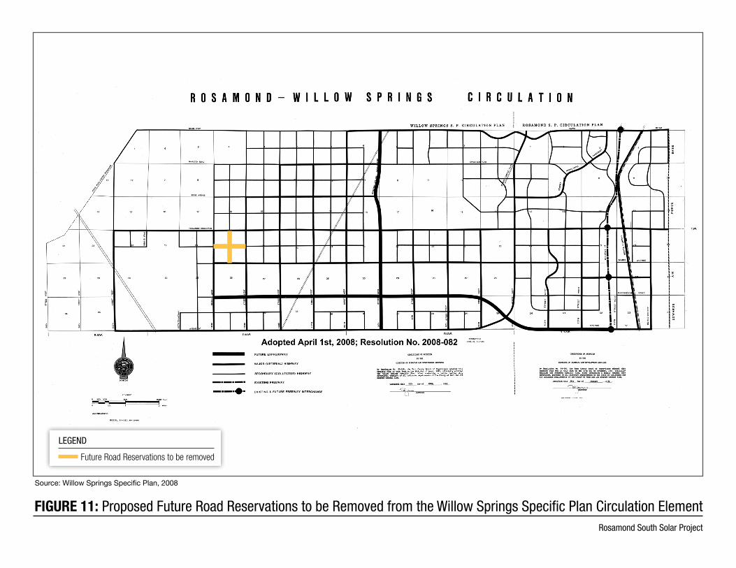
FIGURE 11: Proposed Future Road Reservations to be Removed from the Willow Springs Specific Plan Circulation ElementRosamond South Solar Project
Source: Willow Springs Specific Plan, 2008
LEGEND
Future Road Reservations to be removed
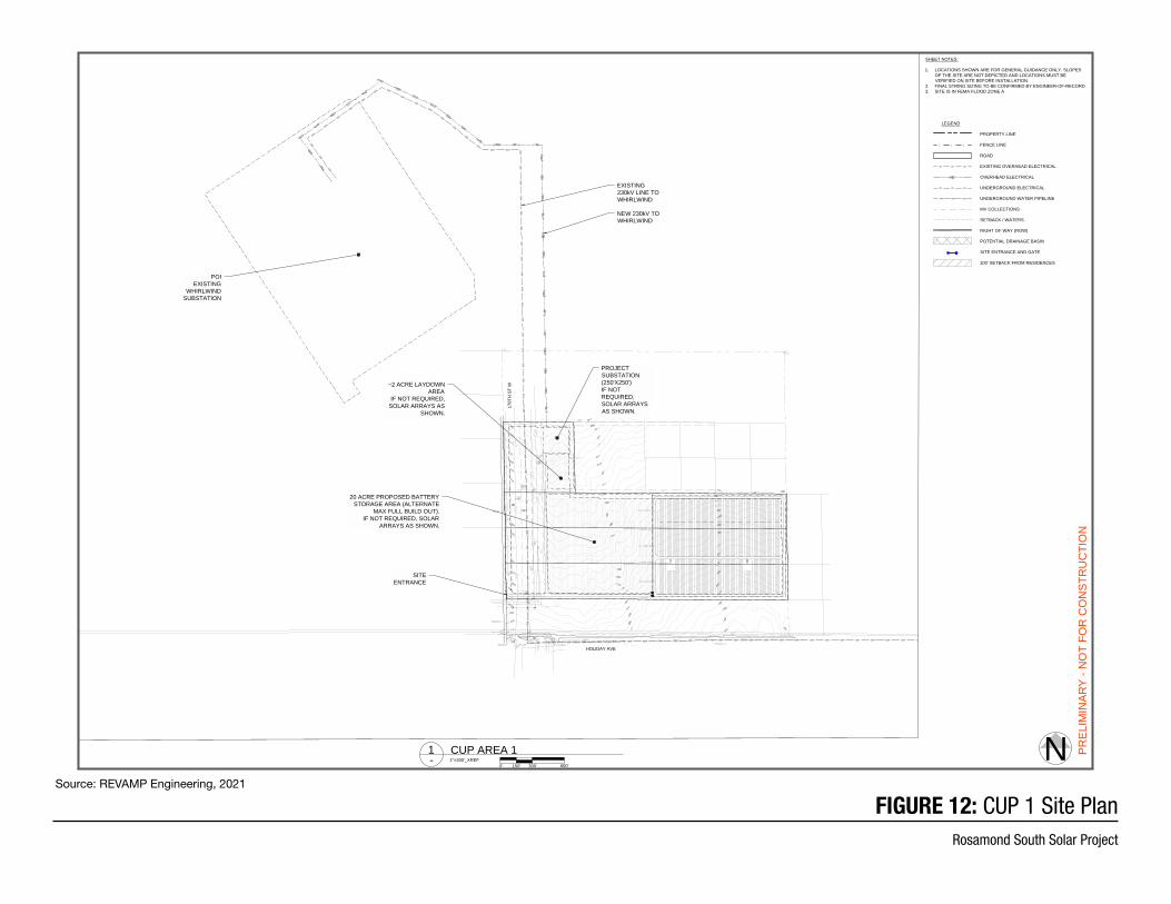
XX
XX
XXXXX
XX
XX
X X X X X
XX
XX
XX
XX
XX
XX
XX
X
X
XXXXXXXXXXXXXXXX
X
XX
XX
XX
XX
XX
XX
XX
X
X X X X X X X X X X X X X X X X X X
XX
XX
XX
XX
XX
XX
XX
XX
XXXXXXXXXXXXXXXXXXXXXX
XX
XX
XX
XX
XX
XX
XX
XX
X
X X X X X X X X X X X X X X X X X X X X X X
XX
XX
X
XXXXX
XX
XX
X
X X X X X
O/HO/HO/HO/HO/HO/HO/HO/HO/HO/HO/HO/HO/HO/HO/HO/HO/HO/HO/HO/HO/HO/HO/HO/HO/HO/H
O/H
O/H
O/H
O/H
O/H
O/H
O/H
O/H
O/H
O/H
O/H
O/H
O/H
O/H
O/H
O/H
O/H
O/H
O/H
O/H
O/H
O/H
O/H
O/H
O/H
O/H
O/H
O/H
O/H
O/H
O/H
O/H
O/H
O/HO/H
O/H
O/H
O/H
O/H
O/H
O/H
O/H
O/HO/H
O/H
O/H
O/H
O/H
O/H
O/H
O/H
O/H
X X
X
X
X
X
X
X
X
X
X
X
X
X
X
X
X
X
X
X
X
X
X
X
X
X
X
X
X
X
X
X
X
X
X
X
XX
XX
X
X
X
X
X
X
X
X
X
X
X
X
X
X
X
X
X
X
X
X
X
X
X
X
X
X
X
X
X
X
X
X
X
X
X
X
X
X
X
X
X
X
X
X
X
X
X
X
X
X
X
X
X
X
X
X
X
X
X
X
X
X
X
X
X
X
X
X
X
X
X
X
X
X
X
X
X
X
X
X
X
X
X
X
X
X
X
X
X
X
X
X
X
X
X
X
X
X
X
X
170T
H S
T W
HOLIDAY AVE
SITEENTRANCE
20 ACRE PROPOSED BATTERYSTORAGE AREA (ALTERNATE
MAX FULL BUILD OUT). IF NOT REQUIRED, SOLAR
ARRAYS AS SHOWN.
POIEXISTING
WHIRLWINDSUBSTATION
~2 ACRE LAYDOWNAREA
IF NOT REQUIRED,SOLAR ARRAYS AS
SHOWN.
PROJECTSUBSTATION(250'X250')IF NOTREQUIRED,SOLAR ARRAYSAS SHOWN.
NEW 230kV TOWHIRLWIND
EXISTING230kV LINE TOWHIRLWIND
CLIENT
PREL
IMIN
ARY
- NO
T FO
R C
ON
STR
UC
TIO
N
THIS DOCUMENT IS THE PROPERTY OFREVAMP ENGINEERING, INC., AND
CONTAINS CONFIDENTIAL INFORMATION.ITS RECEIPT OR POSSESSION DOES NOT
CONVEY ANY RIGHTS TO REPRODUCE,MANUFACTURE, USE, OR SELL ANYTHING IT
MAY DESCRIBE. NO PART IS TO BEDISCLOSED WITHOUT WRITTEN PERMISSION
FROM REVAMP ENGINEERING, INC.
DRAWING TITLE
DRAWN BY: CHECKED BY:
DRAWING NUMBER
DRAWING ISSUE
SITE
LO
CA
TIO
N
19139 - ROSAMOND SOUTH - TRACKER - E200 - LAYOUTS.DWG1/25/2021 11:21 AM
ENGINEER'S STAMP
555 12th St, 5th FloorOakland, CA 94607
www.revamp-eng.com
PROJECT NO.:
PRO
JEC
T N
AM
E
REVISION ISSUE
RO
SAM
ON
D S
OU
TH
SO
LAR
19139
RO
SAM
ON
D, K
ERN
CO
, CA
1 09/09/2019PRELIMINARY
10 12/8/2020FILL IN SITE, NEW OHD LINE
1101/12/2021REDLINES AND NEW LAND
12 01/15/2021FILL IN BESS & LAYDOWN
13 01/25/2021NOTES AND ROAD
ET MH
E201
CUP AREA 1
34.8
344°
, -11
8.30
03°
N0' 600'300'150'
1"=300'_XREF-CUP AREA 11
LEGEND
PROPERTY LINE
FENCE LINE
ROAD
EXISTING OVERHEAD ELECTRICAL
OVERHEAD ELECTRICAL
UNDERGROUND ELECTRICAL
UNDERGROUND WATER PIPELINE
MV COLLECTIONS
SETBACK / WATERS
RIGHT OF WAY (ROW)
POTENTIAL DRAINAGE BASIN
SITE ENTRANCE AND GATE
100' SETBACK FROM RESIDENCES
X X X
O/H O/H O/H
U/G U/G U/G
WW WW WW
SHEET NOTES:
1. LOCATIONS SHOWN ARE FOR GENERAL GUIDANCE ONLY. SLOPESOF THE SITE ARE NOT DEPICTED AND LOCATIONS MUST BEVERIFIED ON SITE BEFORE INSTALLATION.
2. FINAL STRING SIZING TO BE CONFIRMED BY ENGINEER-OF-RECORD.3. SITE IS IN FEMA FLOOD ZONE A
FIGURE 12: CUP 1 Site PlanRosamond South Solar Project
Source: REVAMP Engineering, 2021
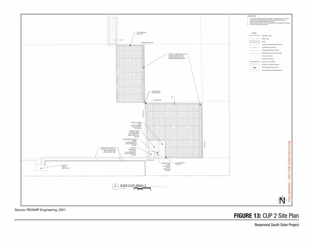
X X
XX
XX
XX
XX
X
XXXXXX
XX
XX
XX
X
X X X X X X
X X X X
XX
XX
XX
XX
X
XXXX
XX
XX
XX
XX
XX
XX
X
XXXXX
XX
X X X
XXXXXXXXXXXXXXXXXXXXXXXXXXXXXXXX
XX
XX
XX
XX
XX
XX
XX
XX
XX
XX
XX
X
X X X X X X X X X X X
XX
XX
XX
XX
XX
X
X X X X X X X X X X X X X X X X X X X X X X X
XX
XX
XX
XX
XX
XX
XX
XX
XX
XX
XX
XX
XX
XX
XX
XX
X
XX
XXXXXXXXXXXXXXXX
XX
XX
XX
XX
XX
XX
XX
XX
XX
XX
XX
XX
XX
XX
XX
XX
XX
X
X X X X X X X X X X X X X X X X
X XX
XX
XX
XX
XX
XX
XX
XX
XX
XX
XX
XX
XX
XX
XX
XX
XX
X
X
O/H
O/HO/HO/HO/H
XX
XX
XXXXXXX
XX
XX
X X X X X X X
50'
100'
HOLIDAY AVE
135T
H S
T W
W ROSAMOND BLVD
PROPOSED HV 230kV ORMV 34.5kV OH OR UG TO
TEDDY SUBSTATION(EXACT ROUTE TBD)
EXISTINGTEDDYSUBSTATION
5 ACRE BATTERYSTORAGE AREA.
IF NOT REQUIRED,SOLAR ARRAYS AS
SHOWN.
SITE ENTRANCEAND GATE
SITE ENTRANCEAND GATE
PROJECTSUBSTATION
(250'X250') IF NOT REQUIRED,SOLAR ARRAYS AS
SHOWN.
5 ACRE LAYDOWNAREA.
IF NOT REQUIRED,SOLAR ARRAYS
AS SHOWN.
O&M BUILDING IF NOT
REQUIRED,SOLAR
ARRAYS ASSHOWN.
TELECOMMUNICATIONSTOWER
IF NOT REQUIRED,SOLAR ARRAYS AS
SHOWN.
POTENTIAL DRAINAGE BASINSITE WILL MEET COUNTYCODE ON DRAINAGE ANDRETENTION REQUIREMENTS
140T
H S
T W
ASTORIA AVE
EGRESS FROMASTORIA AVE
CLIENT
PREL
IMIN
ARY
- NO
T FO
R C
ON
STR
UC
TIO
N
THIS DOCUMENT IS THE PROPERTY OFREVAMP ENGINEERING, INC., AND
CONTAINS CONFIDENTIAL INFORMATION.ITS RECEIPT OR POSSESSION DOES NOT
CONVEY ANY RIGHTS TO REPRODUCE,MANUFACTURE, USE, OR SELL ANYTHING IT
MAY DESCRIBE. NO PART IS TO BEDISCLOSED WITHOUT WRITTEN PERMISSION
FROM REVAMP ENGINEERING, INC.
DRAWING TITLE
DRAWN BY: CHECKED BY:
DRAWING NUMBER
DRAWING ISSUE
SITE
LO
CA
TIO
N
19139 - ROSAMOND SOUTH - TRACKER - E200 - LAYOUTS.DWG1/25/2021 11:21 AM
ENGINEER'S STAMP
555 12th St, 5th FloorOakland, CA 94607
www.revamp-eng.com
PROJECT NO.:
PRO
JEC
T N
AM
E
REVISION ISSUE
RO
SAM
ON
D S
OU
TH
SO
LAR
19139
RO
SAM
ON
D, K
ERN
CO
, CA
1 09/09/2019PRELIMINARY
10 12/8/2020FILL IN SITE, NEW OHD LINE
1101/12/2021REDLINES AND NEW LAND
12 01/15/2021FILL IN BESS & LAYDOWN
13 01/25/2021NOTES AND ROAD
ET MH
E202
CUP AREA 2
34.8
344°
, -11
8.30
03°
N0' 800'400'200'
1" = 400'-E202 CUP AREA 21
LEGEND
PROPERTY LINE
FENCE LINE
ROAD
EXISTING OVERHEAD ELECTRICAL
OVERHEAD ELECTRICAL
UNDERGROUND ELECTRICAL
UNDERGROUND WATER PIPELINE
MV COLLECTIONS
SETBACK / WATERS
RIGHT OF WAY (ROW)
POTENTIAL DRAINAGE BASIN
SITE ENTRANCE AND GATE
100' SETBACK FROM RESIDENCES
X X X
O/H O/H O/H
U/G U/G U/G
WW WW WW
SHEET NOTES:
1. LOCATIONS SHOWN ARE FOR GENERAL GUIDANCE ONLY. SLOPESOF THE SITE ARE NOT DEPICTED AND LOCATIONS MUST BEVERIFIED ON SITE BEFORE INSTALLATION.
2. FINAL STRING SIZING TO BE CONFIRMED BY ENGINEER-OF-RECORD.3. SITE IS IN FEMA FLOOD ZONE A
FIGURE 13: CUP 2 Site PlanRosamond South Solar Project
Source: REVAMP Engineering, 2021
359-183-01
XX
X
XX
XXX
XX
X X X
X
X
XX
X
X
X
X
XX
XX
X
XXXXXXX
XX
XX
X X XX
X X X X X
XX
XX
XX
X
X
X
X
X XX X
X
X
X
X
X X
X X X
XX
X
XXXX
XX
X
X
X
X
X X
X
X
X
X
X
X
X
X
X
XX
XXXX
XX
X X X X
XX
X
XX
XX
X X X XX
XX
XX
X
XXX
X
XX
XX
X
XX
X
X X
XXXXX
XX
X
X X X X
X
X X
XX
X
X
X
X
XX
X
XXX
XX
XX
XX
X
X X X X
XX
XX
XX
X
XX
XX
XXX
XX
XX
X
X X X X X X X X X X X X X X XX
XX
XX
X
XXXXXXXXXXXX
XX
X X X
X X XX
XXXXX
XXXXX
X
X
XX
X X X X X X X
XX
XX
X
O/HO/HO/HO/HO/HO/HO/HO/HO/HO/HO/H
O/H
O/H
O/H
O/H
O/H
O/H
O/H
O/H
XX
X X
X
X
X
X
X
X
X
X
X
XX
X
X
X
X
X
X
X
X
X
X
WW WW WW WW WW WW WW WW WW WW WW WW WW WW WW WW WW WW WW WW WW WW WW WW WW WW WW WW WW
XX
X
X X
XX
XX
X
XX
XX
X X X
XX
XX
X XX
XX
X
XX X
XX
XX
XX
XX
X
X X
X
XXX
X
X
XX
XXXXX
XX
XXX
XX
X
X
X
XX
X
X
XX
X
X XX
XX
X X
HOLIDAY AVE
ASTORIA AVE
130T
H S
T W
140T
H S
T W
135T
H S
T W
W ROSAMOND BLVD
100T
H S
T W
90TH
ST
W
94TH
ST
W
95TH
ST
W
GASKELL RD
BUCKHORN AVE
W AVENUE A
KINGBIRD AVE
105T
H S
T W
110T
H S
T W
115T
H S
T W
125T
H S
T W
120T
H S
T W
WILLOW AVE
170T
H S
T W
CUP AREA 1SHEET E201
CUP AREA 2SHEET E202
CUP AREA 3SHEET E203
CUP AREA 4SHEET E204
EXISTING 230kVLINE TO
WHIRLWIND
EXISTINGTEDDYSUBSTATION
PROPOSED HV 230kVOR MV 34.5kV OH OR
UG TO TEDDYSUBSTATION (EXACT
ROUTE TBD)
PROPERTY BOUNDARY(TYP)
POIEXISTING
WHIRLWINDSUBSTATION
AREA 1SUBSTATION(250'X250')IF NOT REQUIRED,SOLAR ARRAYS ASSHOWN.
AREA 2SUBSTATION
(250'X250')IF NOT REQUIRED,
SOLAR ARRAYS ASSHOWN.
AREA 3SUBSTATION
(250'X250') IF NOT REQUIRED,SOLAR ARRAYS AS
SHOWN.
AREA 4 SUBSTATION(250'X250')
IF NOT REQUIRED,SOLAR ARRAYS AS
SHOWN.
CLIENT
PREL
IMIN
ARY
- NO
T FO
R C
ON
STR
UC
TIO
N
THIS DOCUMENT IS THE PROPERTY OFREVAMP ENGINEERING, INC., AND
CONTAINS CONFIDENTIAL INFORMATION.ITS RECEIPT OR POSSESSION DOES NOT
CONVEY ANY RIGHTS TO REPRODUCE,MANUFACTURE, USE, OR SELL ANYTHING IT
MAY DESCRIBE. NO PART IS TO BEDISCLOSED WITHOUT WRITTEN PERMISSION
FROM REVAMP ENGINEERING, INC.
DRAWING TITLE
DRAWN BY: CHECKED BY:
DRAWING NUMBER
DRAWING ISSUE
SITE
LO
CA
TIO
N
19139 - ROSAMOND SOUTH - TRACKER - E200 - LAYOUTS.DWG5/19/2021 11:08 AM
ENGINEER'S STAMP
555 12th St, 5th FloorOakland, CA 94607
www.revamp-eng.com
PROJECT NO.:
PRO
JEC
T N
AM
E
REVISION ISSUE
RO
SAM
ON
D S
OU
TH
SO
LAR
19139
RO
SAM
ON
D, K
ERN
CO
, CA
1 09/09/2019PRELIMINARY
10 12/8/2020FILL IN SITE, NEW OHD LINE
1101/12/2021REDLINES AND NEW LAND
12 01/15/2021FILL IN BESS & LAYDOWN
13 01/25/2021NOTES AND ROAD
ET MH
E200
OVERALL SITELAYOUT
34.8
344°
, -11
8.30
03°
N0' 4000'2000'1000'
1" = 2000'-OVERALL SITE LAYOUT1
LEGEND
PROPERTY LINE
FENCE LINE
ROAD
EXISTING OVERHEAD ELECTRICAL
OVERHEAD ELECTRICAL
UNDERGROUND ELECTRICAL
UNDERGROUND WATER PIPELINE
MV COLLECTIONS
SETBACK / WATERS
RIGHT OF WAY (ROW)
POTENTIAL DRAINAGE BASIN
SITE ENTRANCE AND GATE
100' SETBACK FROM RESIDENCES
X X X
O/H O/H O/H
U/G U/G U/G
WW WW WW
SHEET NOTES:
1. LOCATIONS SHOWN ARE FOR GENERAL GUIDANCE ONLY. SLOPESOF THE SITE ARE NOT DEPICTED AND LOCATIONS MUST BEVERIFIED ON SITE BEFORE INSTALLATION.
2. FINAL STRING SIZING TO BE CONFIRMED BY ENGINEER-OF-RECORD.3. SITE IS IN FEMA FLOOD ZONE A
FIGURE 14: CUP Site PlanRosamond South Solar Project
Source: REVAMP Engineering, 2021
O/HO/HO/HO/HO/HO/HO/HO/HO/HO/HO/HO/HO/HO/HO/HO/HO/HO/H
O/H
O/H
O/H
O/H
O/H
O/H
O/H
O/H
O/H
O/H
O/H
O/H
O/H
O/H
O/H
O/H
O/H
O/H
O/H
O/H
O/H
O/H
O/H
O/H
O/H
O/H
O/H
O/H
O/H
O/H
O/H
O/H
O/H
O/H
O/H
O/H
O/H
O/H
O/H
O/H
O/H
O/H
O/H
O/H O/H O/H O/H O/H O/H O/H O/H O/H O/H O/H O/H O/H O/H O/H O/H O/H O/H O/H
O/H
O/H
O/H
O/H
O/H
O/H
O/H
O/H
O/H
O/H
O/H
O/H
O/H
O/H
O/H
O/H
O/H
O/H
O/H O/H O/H O/H O/H O/H O/H O/H O/H O/H O/H O/H O/H O/H O/H O/H O/H O/H O/H O/H O/H O/H O/H O/H O/H O/H O/H O/H O/H O/H O/H O/H O/H O/H O/H O/H O/H O/H O/H O/H O/H O/H O/H O/H O/H O/H O/H O/H O/H O/H O/H O/H O/H O/H O/H O/H O/H O/H O/H O/H O/H O/H O/H O/H
X X X X
XX
XX
XX
XX
X
XXX
XX
X
X X X X
XX
X
XX
XX
X
X X X X X
X X X
XX
XX
XXXXXXXXXXXX
XX
XX
XX
XX
X
XX
XX
XX
XX
X
XX
XX
XX
XX
XX
XX
XX
XX
XX
XX
XX
XX
XX
XX
XX
XX
XX
X X X X X X X X X X X X X X X X X X X X X X X X X X X X X X X X X X X X X X X X X X X X X X X X X X X X X X X X X X X X X X X X X X
X X X X X
XX
XX
XX
XX
XX
XX
XX
XX
XX
XX
XX
XX
XX
XX
XX
XX
XX
XXXXXXXXXXXXXXXXXXXXXXXXXXXXXXXXXXXXXXXXXXXXXXXXXXXXXXXXXX
XX
XX
XX
XX
XX
XX
X X X X X X X X X X X
XX
X
X X X X X X X
X X X X
XX
XX
XX
XX
XX
XXXXXXXXXXXXXXXXXXXXX
XXXXXXXXXXXXXXXXXXXXXXXXX
XX
XX
X
XXXXXX
XX
XX
XX
XX
X
X X X X X X X X X X X X X X X X X X X X X X X X X X X X X X X X X
X
X X XX
XX
XX
XX
XX
XX
XX
XX
X
XXXXX
WW WW WW WW WW WW WW WW WW WW WW WW WW WW WW WW WW WW WW WW WW WW WW WW WW WW WW WW WW WW WW WW WW WW WW WW WW WW WW WW WW WW WW WW WW WW WW WW WW WW WW WW
100'
100T
H S
T W
90TH
ST
W94TH
ST
W
95TH
ST
W
GASKELL RD
BUCKHORN AVE
KINGBIRD AVE
105T
H S
T W
PROPOSED HV 230kV ORMV 34.5kV OH OR UG TO
TEDDY SUBSTATION(EXACT ROUTE TBD)
PROPERTY BOUNDARY(TYP)
SITE ENTRANCEAND GATE
5 ACRE BATTERYSTORAGE AREA
IF NOT REQUIRED,SOLAR ARRAYS AS
SHOWN.
PROJECT SUBSTATION(250'X250')
IF NOT REQUIRED,SOLAR ARRAYS AS
SHOWN.
5 ACRE LAYDOWNAREA. IF NOT
REQUIRED, SOLARARRAYS AS SHOWN.
SITE ENTRANCEAND GATE
ANTELOPE VALLEY-EASTKERN WATER PIPELINE
POTENTIAL BASIN LOCATIONS(SITE WILL MEET COUNTYCODE ON DRAINAGE ANDRETENTION REQUIREMENTS)
85'
GASKELL RD
CLIENT
PREL
IMIN
ARY
- NO
T FO
R C
ON
STR
UC
TIO
N
THIS DOCUMENT IS THE PROPERTY OFREVAMP ENGINEERING, INC., AND
CONTAINS CONFIDENTIAL INFORMATION.ITS RECEIPT OR POSSESSION DOES NOT
CONVEY ANY RIGHTS TO REPRODUCE,MANUFACTURE, USE, OR SELL ANYTHING IT
MAY DESCRIBE. NO PART IS TO BEDISCLOSED WITHOUT WRITTEN PERMISSION
FROM REVAMP ENGINEERING, INC.
DRAWING TITLE
DRAWN BY: CHECKED BY:
DRAWING NUMBER
DRAWING ISSUE
SITE
LO
CA
TIO
N
19139 - ROSAMOND SOUTH - TRACKER - E200 - LAYOUTS.DWG1/25/2021 11:22 AM
ENGINEER'S STAMP
555 12th St, 5th FloorOakland, CA 94607
www.revamp-eng.com
PROJECT NO.:
PRO
JEC
T N
AM
E
REVISION ISSUE
RO
SAM
ON
D S
OU
TH
SO
LAR
19139
RO
SAM
ON
D, K
ERN
CO
, CA
1 09/09/2019PRELIMINARY
10 12/8/2020FILL IN SITE, NEW OHD LINE
1101/12/2021REDLINES AND NEW LAND
12 01/15/2021FILL IN BESS & LAYDOWN
13 01/25/2021NOTES AND ROAD
ET MH
E204
CUP AREA 4
34.8
344°
, -11
8.30
03°
N0' 800'400'200'
1" = 400'-CUP AREA 41
LEGEND
PROPERTY LINE
FENCE LINE
ROAD
EXISTING OVERHEAD ELECTRICAL
OVERHEAD ELECTRICAL
UNDERGROUND ELECTRICAL
UNDERGROUND WATER PIPELINE
MV COLLECTIONS
SETBACK / WATERS
RIGHT OF WAY (ROW)
POTENTIAL DRAINAGE BASIN
SITE ENTRANCE AND GATE
100' SETBACK FROM RESIDENCES
X X X
O/H O/H O/H
U/G U/G U/G
WW WW WW
SHEET NOTES:
1. LOCATIONS SHOWN ARE FOR GENERAL GUIDANCE ONLY. SLOPESOF THE SITE ARE NOT DEPICTED AND LOCATIONS MUST BEVERIFIED ON SITE BEFORE INSTALLATION.
2. FINAL STRING SIZING TO BE CONFIRMED BY ENGINEER-OF-RECORD.3. SITE IS IN FEMA FLOOD ZONE A
FIGURE 15: CUP Site PlanRosamond South Solar Project
Source: REVAMP Engineering, 2021
KERN COUNTY PLANNING AND NATURAL RESOURCES DEPARTMENT
Rosamond South Solar Project0
Initial Study/Notice of Preparation 35 June 2021
2. Kern County Environmental Checklist Form
2.1. Environmental Factors Potentially Affected
The environmental factors checked below would be potentially affected by this project, involving at least one impact that is a “potentially significant impact” as indicated by the Kern County Environmental Checklist on the following pages.
Aesthetics Agricultural and Forestry Resources
Air Quality
Biological Resources Cultural Resources Energy Geology and Soils Greenhouse Gas Emissions Hazards and Hazardous
Materials Hydrology and Water
Quality Land Use and Planning Mineral Resources
Noise Population and Housing Public Services Recreation Transportation and Traffic Tribal Cultural Resources Utilities/Service Systems Wildfire Mandatory Findings of
Significance
2.2. Determination (To be completed by the Lead Agency)
On the basis of this initial evaluation:
I find that the proposed project COULD NOT have a significant effect on the environment, and a NEGATIVE DECLARATION will be prepared.
I find that although the proposed project could have a significant effect on the environment, there will not be a significant effect in this case because revisions in the project have been made by or agreed to by the project proponent. A MITIGATED NEGATIVE DECLARATION will be prepared.
I find that the proposed project MAY have a significant effect on the environment, and an ENVIRONMENTAL IMPACT REPORT is required.
I find that the proposed project MAY have a “potentially significant impact” or “potentially significant unless mitigated” impact on the environment, but at least one effect (a) has been adequately analyzed in an earlier document pursuant to applicable legal standards, and (b) has been addressed by mitigation measures based on the earlier analysis as described on attached sheets. An ENVIRONMENT IMPACT REPORT is required, but it must analyze only the effects that remain to be addressed.
I find that although the proposed project could have a significant effect on the environment, because all potentially significant effects (a) have been analyzed adequately in an earlier EIR or NEGATIVE DECLARATION pursuant to applicable standards, and (b) have been avoided or mitigated pursuant to that earlier EIR or NEGATIVE DECLARATION, including revisions or mitigation measures that are imposed upon the proposed project, nothing further is required.
Signature:
Date:
Printed Name:
Title:
KERN COUNTY PLANNING AND NATURAL RESOURCES DEPARTMENT
Rosamond South Solar Project0
Initial Study/Notice of Preparation 36 June 2021
3. Evaluation of Environmental Impacts 1. A brief explanation is required for all answers except “No Impact” answers that are adequately
supported by the information sources a lead agency cites in the parentheses following each question. A “No Impact” answer is adequately supported if the referenced information sources show that the impact simply does not apply to projects like the one involved (e.g., the project falls outside a fault rupture zone). A “No Impact” answer should be explained where it is based on project-specific factors as well as general standards (e.g., the project will not expose sensitive receptors to pollutants, based on a project-specific screening analysis).
2. All answers must take account of the whole action involved, including off-site as well as on-site, cumulative as well as project-level, indirect as well as direct, and construction as well as operational impacts.
3. Once the lead agency has determined that a particular physical impact may occur, then the checklist answers must indicate whether the impact is potentially significant, less than significant with mitigation, or less than significant. “Potentially Significant Impact” is appropriate if there is substantial evidence that an effect may be significant. If there are one or more “Potentially Significant Impact” entries when the determination is made, an EIR is required.
4. Negative Declaration: “Less than Significant with Mitigation Incorporated” applies where the incorporation of mitigation measures has reduced an effect from “Potentially Significant Impact” to a “Less-than-Significant Impact.” The lead agency must describe the mitigation measure and briefly explain how they reduce the effect to a less than significant level (mitigation measures from Section XVII, “Earlier Analyses,” may be cross-referenced).
5. Earlier analyses may be used where, pursuant to the tiering, program EIR, or other CEQA process, an effect has been adequately analyzed in an earlier EIR or negative declaration, Section 15063(c)(3)(D). In this case, a brief discussion should identify the following:
a. Earlier Analysis Used. Identify and state where they are available for review.
b. Impacts Adequately Addressed. Identify which effects from the above checklist where within the scope of and adequately analyzed in an earlier document pursuant to applicable legal standards, and state whether such effects were addressed by mitigation measures based on the earlier analysis.
c. Mitigation Measures. For effects that are “Less than Significant with Mitigation Incorporated,” describe the mitigation measures that were incorporated or refined from the earlier document and the extent to which they address site-specific conditions for the project.
6. Lead agencies are encouraged to incorporate into the checklist references to information sources for potential impacts (e.g., general plans, zoning ordinances). Reference to a previously prepared or outside document should, where appropriate, include a reference to the page or pages where the statement is substantiated.
7. Supporting Information Sources: A source list should be attached, and other sources used or individuals contacted should be cited in the discussion.
KERN COUNTY PLANNING AND NATURAL RESOURCES DEPARTMENT
Rosamond South Solar Project0
Initial Study/Notice of Preparation 37 June 2021
8. This is only a suggested form, and lead agencies are free to use different formats; however, lead agencies should normally address the questions from this checklist that are relevant to a project’s environmental effects in whatever format is selected.
9. The explanation of each issue should identify:
a. The significance criteria or threshold, if any, used to evaluate each question; and
b. The mitigation measure identified, if any, to reduce the impact to a less than significant level.
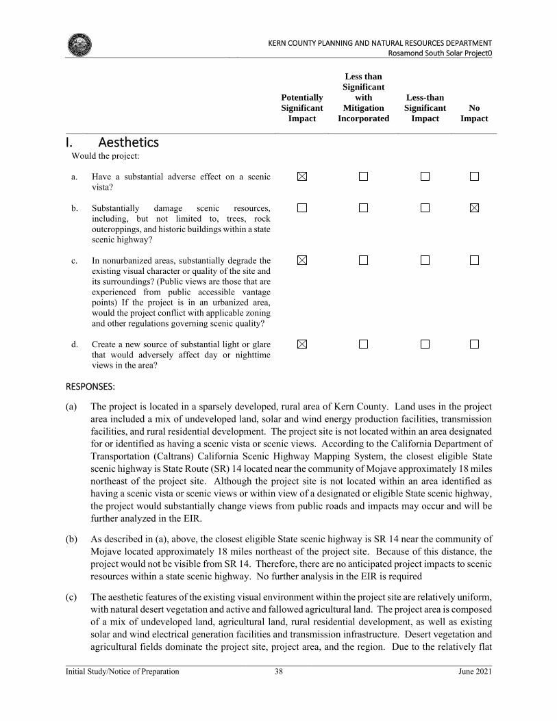
KERN COUNTY PLANNING AND NATURAL RESOURCES DEPARTMENT
Rosamond South Solar Project0
Initial Study/Notice of Preparation 38 June 2021
Potentially
Significant
Impact
Less than
Significant
with
Mitigation
Incorporated
Less-than
Significant
Impact
No
Impact
I. Aesthetics
Would the project: a. Have a substantial adverse effect on a scenic
vista?
b. Substantially damage scenic resources,
including, but not limited to, trees, rock outcroppings, and historic buildings within a state scenic highway?
c. In nonurbanized areas, substantially degrade the
existing visual character or quality of the site and its surroundings? (Public views are those that are experienced from public accessible vantage points) If the project is in an urbanized area, would the project conflict with applicable zoning and other regulations governing scenic quality?
d. Create a new source of substantial light or glare
that would adversely affect day or nighttime views in the area?
RESPONSES:
(a) The project is located in a sparsely developed, rural area of Kern County. Land uses in the project area included a mix of undeveloped land, solar and wind energy production facilities, transmission facilities, and rural residential development. The project site is not located within an area designated for or identified as having a scenic vista or scenic views. According to the California Department of Transportation (Caltrans) California Scenic Highway Mapping System, the closest eligible State scenic highway is State Route (SR) 14 located near the community of Mojave approximately 18 miles northeast of the project site. Although the project site is not located within an area identified as having a scenic vista or scenic views or within view of a designated or eligible State scenic highway, the project would substantially change views from public roads and impacts may occur and will be further analyzed in the EIR.
(b) As described in (a), above, the closest eligible State scenic highway is SR 14 near the community of Mojave located approximately 18 miles northeast of the project site. Because of this distance, the project would not be visible from SR 14. Therefore, there are no anticipated project impacts to scenic resources within a state scenic highway. No further analysis in the EIR is required
(c) The aesthetic features of the existing visual environment within the project site are relatively uniform, with natural desert vegetation and active and fallowed agricultural land. The project area is composed of a mix of undeveloped land, agricultural land, rural residential development, as well as existing solar and wind electrical generation facilities and transmission infrastructure. Desert vegetation and agricultural fields dominate the project site, project area, and the region. Due to the relatively flat
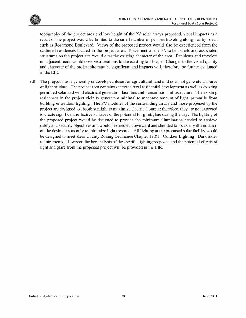
KERN COUNTY PLANNING AND NATURAL RESOURCES DEPARTMENT
Rosamond South Solar Project0
Initial Study/Notice of Preparation 39 June 2021
topography of the project area and low height of the PV solar arrays proposed, visual impacts as a result of the project would be limited to the small number of persons traveling along nearby roads such as Rosamond Boulevard. Views of the proposed project would also be experienced from the scattered residences located in the project area. Placement of the PV solar panels and associated structures on the project site would alter the existing character of the area. Residents and travelers on adjacent roads would observe alterations to the existing landscape. Changes to the visual quality and character of the project site may be significant and impacts will, therefore, be further evaluated in the EIR.
(d) The project site is generally undeveloped desert or agricultural land and does not generate a source of light or glare. The project area contains scattered rural residential development as well as existing permitted solar and wind electrical generation facilities and transmission infrastructure. The existing residences in the project vicinity generate a minimal to moderate amount of light, primarily from building or outdoor lighting. The PV modules of the surrounding arrays and those proposed by the project are designed to absorb sunlight to maximize electrical output; therefore, they are not expected to create significant reflective surfaces or the potential for glint/glare during the day. The lighting of the proposed project would be designed to provide the minimum illumination needed to achieve safety and security objectives and would be directed downward and shielded to focus any illumination on the desired areas only to minimize light trespass. All lighting at the proposed solar facility would be designed to meet Kern County Zoning Ordinance Chapter 19.81 - Outdoor Lighting - Dark Skies requirements. However, further analysis of the specific lighting proposed and the potential effects of light and glare from the proposed project will be provided in the EIR.
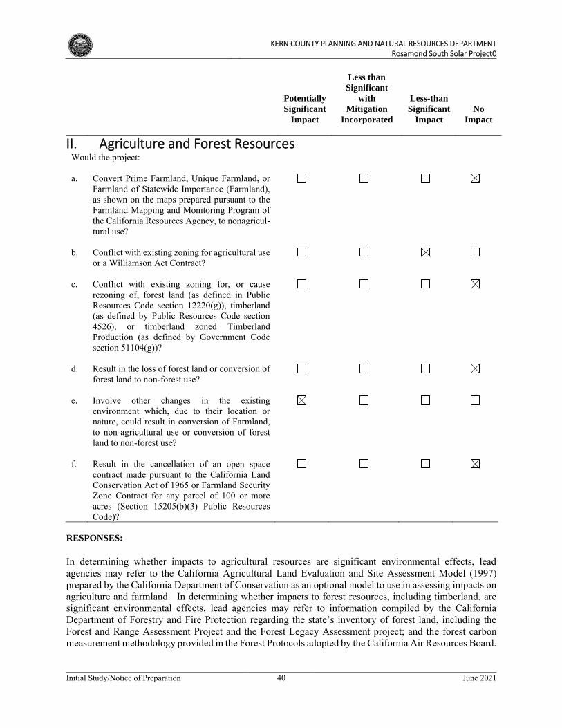
KERN COUNTY PLANNING AND NATURAL RESOURCES DEPARTMENT
Rosamond South Solar Project0
Initial Study/Notice of Preparation 40 June 2021
Potentially
Significant
Impact
Less than
Significant
with
Mitigation
Incorporated
Less-than
Significant
Impact
No
Impact
II. Agriculture and Forest Resources
Would the project: a. Convert Prime Farmland, Unique Farmland, or
Farmland of Statewide Importance (Farmland), as shown on the maps prepared pursuant to the Farmland Mapping and Monitoring Program of the California Resources Agency, to nonagricul-tural use?
b. Conflict with existing zoning for agricultural use
or a Williamson Act Contract?
c. Conflict with existing zoning for, or cause
rezoning of, forest land (as defined in Public Resources Code section 12220(g)), timberland (as defined by Public Resources Code section 4526), or timberland zoned Timberland Production (as defined by Government Code section 51104(g))?
d. Result in the loss of forest land or conversion of
forest land to non-forest use?
e. Involve other changes in the existing
environment which, due to their location or nature, could result in conversion of Farmland, to non-agricultural use or conversion of forest land to non-forest use?
f. Result in the cancellation of an open space
contract made pursuant to the California Land Conservation Act of 1965 or Farmland Security Zone Contract for any parcel of 100 or more acres (Section 15205(b)(3) Public Resources Code)?
RESPONSES:
In determining whether impacts to agricultural resources are significant environmental effects, lead agencies may refer to the California Agricultural Land Evaluation and Site Assessment Model (1997) prepared by the California Department of Conservation as an optional model to use in assessing impacts on agriculture and farmland. In determining whether impacts to forest resources, including timberland, are significant environmental effects, lead agencies may refer to information compiled by the California Department of Forestry and Fire Protection regarding the state’s inventory of forest land, including the Forest and Range Assessment Project and the Forest Legacy Assessment project; and the forest carbon measurement methodology provided in the Forest Protocols adopted by the California Air Resources Board.
KERN COUNTY PLANNING AND NATURAL RESOURCES DEPARTMENT
Rosamond South Solar Project0
Initial Study/Notice of Preparation 41 June 2021
(a) According to the California Department of Conservation (DOC) Farmland Mapping and Monitoring Program (FMMP) 2018 Important Farmland map for east Kern County, there are no agricultural lands designated as Prime Farmland, Unique Farmland, Unique Farmland, or Farmland of Statewide Importance located within the project site. CUP Areas 1, 2, and 3 are designated as Nonagricultural and Natural Vegetation and CUP Area 4 is designated as Grazing Land, Nonagricultural or Natural Vegetation, and Semi-Agricultural and Rural Commercial Land (DOC 2018). There are no lands designated as important farmland located within the project site (DOC, 2018). Therefore, construction and operation of the proposed project would not result in the conversion of designated farmland to a nonagricultural use and there would be no impact. No further analysis in the EIR is required.
(b) Zone changes are proposed to apply the AFPS zone district to parcels within the project site located on Zone Maps 231, 232, and 233, as detailed in Table 1, Project Assessor Parcel Numbers, Existing
Map Codes, Existing and Proposed Zoning, and Acreage. According to the Kern County Zoning Ordinance, a commercial solar facility is a compatible use within the A zone district with a CUP. The construction and operation of a solar energy generating facility on the site would require the approval of multiple CUPs. Portions of the project site are located within Kern County Agricultural Preserve No. 24, however, these properties are currently classified as being in the E (Estate) zone district. The project site does not contain lands that are subject to Williamson Act contracts, either in active on in nonrenewal status. There are no lands under Williamson Act contracts adjacent to the project site or in the project area. As such, there would be no impacts to Williamson Act lands. Nevertheless, this issue will be further evaluated in the EIR.
(c) No lands that would be affected by the proposed project are zoned as forest land or timberland, or are used for timberland production. Therefore, the project would not conflict with the existing zoning for, or cause the rezoning of, forest land, timberland, or timberland zoned for timberland production. Therefore, there would be no impact and further analysis in the EIR is not required.
(d) The project site is not situated on forest or timberland and is not located adjacent to any such areas that are currently under production. There is no land in the vicinity of the project site that is zoned as forest land, timberland, or lands zoned for timberland production. Therefore, there would be no impact related to the loss of forest land or conversion of forest land to non-forest use. No further analysis is warranted in the EIR.
(e) As noted in response (a) above, the project site does not include lands that are in agricultural production. As discussed in responses (c) and (d) above, the project site does not contain any forest land nor is any forest land or timberland located within the project area. However, though commercial solar facilities are permitted in the A zone district with approval of a CUP, the project would install approximately 201 acres of solar arrays, thereby converting the use of the land to a non-agricultural use, on land zoned for agricultural use. Therefore, this issue will be further analyzed in the EIR.
(f) The project site is not subject to an open space contract made pursuant to the California Land Conservation Act of 1965 or the Farmland Security Zone Contract. As stated in response (a) above, the project site is not under a Williamson Act Contract. The project would, therefore, not result in the cancellation of an open space contract made pursuant to the California Land Conservation Act of 1965 or Farmland Security Zone Contract for any parcel of 100 or more acres (Section 15205(b)(3) Public Resources Code). No impact would occur, and no further evaluation is required in the EIR.
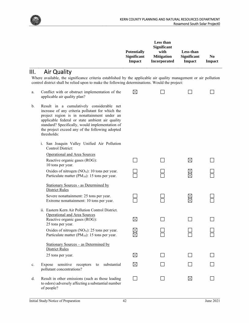
KERN COUNTY PLANNING AND NATURAL RESOURCES DEPARTMENT
Rosamond South Solar Project0
Initial Study/Notice of Preparation 42 June 2021
Potentially
Significant
Impact
Less than
Significant
with
Mitigation
Incorporated
Less-than
Significant
Impact
No
Impact
III. Air Quality
Where available, the significance criteria established by the applicable air quality management or air pollution control district shall be relied upon to make the following determinations. Would the project: a. Conflict with or obstruct implementation of the
applicable air quality plan?
b. Result in a cumulatively considerable net
increase of any criteria pollutant for which the project region is in nonattainment under an applicable federal or state ambient air quality standard? Specifically, would implementation of the project exceed any of the following adopted thresholds:
i. San Joaquin Valley Unified Air Pollution
Control District:
Operational and Area Sources
Reactive organic gases (ROG): 10 tons per year.
Oxides of nitrogen (NOX): 10 tons per year. Particulate matter (PM10): 15 tons per year.
Stationary Sources - as Determined by
District Rules Severe nonattainment: 25 tons per year.
Extreme nonattainment: 10 tons per year. ii. Eastern Kern Air Pollution Control District. Operational and Area Sources
Reactive organic gases (ROG): 25 tons per year.
Oxides of nitrogen (NOX): 25 tons per year. Particulate matter (PM10): 15 tons per year.
Stationary Sources – as Determined by
District Rules 25 tons per year. c. Expose sensitive receptors to substantial
pollutant concentrations?
d. Result in other emissions (such as those leading
to odors) adversely affecting a substantial number of people?
KERN COUNTY PLANNING AND NATURAL RESOURCES DEPARTMENT
Rosamond South Solar Project0
Initial Study/Notice of Preparation 43 June 2021
RESPONSES:
(a) The project site is located entirely within the jurisdiction of the Eastern Kern Air Pollution Control District (EKAPCD), in the Mojave Desert Air Basin (MDAB). The MDAB is designated as a nonattainment area for both the State and federal ozone standards and the state particulate matter (PM10) standard. Project construction would generate emissions of reactive organic gases (ROG) and oxides of nitrogen (NOX), both of which are known as ozone precursors, and PM10 that could result in significant impacts to air quality in the area.
EKAPCD’s most recently adopted air quality management plan is its Ozone Air Quality Attainment Plan (AQAP). As the proposed project would generate emissions of ozone precursors (along with PM10) during construction, the project could potentially conflict with EKAPCD’s Ozone AQAP. Thus, further analysis of the project’s air quality impacts is warranted to determine whether the project would conflict with or obstruct implementation of EKAPCD’s applicable air quality plan for attainment and, if so, to determine the reasonable and feasible mitigation measures that could be imposed. These issues will be evaluated in the EIR.
(b) The proposed project is not located within the San Joaquin Valley Unified Air Pollution Control District and, therefore, its adopted thresholds do not apply. However, as noted in response (a) above, the project is located within the EKAPCD in the MDAB, which is designated as a nonattainment area for the State and federal ozone standards and the State PM10 standard. As such, the emissions of ozone precursors (ROG and NOx) and PM10 during construction and operation of the project could result in a cumulatively considerable net increase of these criteria pollutants in the MDAB. Thus, the project’s contribution to cumulative air quality impacts in the MDAB could be potentially significant. The project’s contribution of construction and operational emissions to the MDAB will be analyzed in the EIR.
(c) Sensitive receptors located in the project area are rural residential dwellings located at varying distances from the project site. The nearest sensitive receptors to the project site are single family residences located adjacent to the south of CUP Area 4 along Spur Ranch Road. Additional single-family residences are located approximately 1 mile east of the east side of CUP Area 4 along 80th Street W and adjacent to CUP Areas 2 and 3. Rosamond Park, a local park, is located approximately 7.2 miles northeast of the easternmost portion of the project site. The closest school to the project site is Tropico Middle School, located approximately 4 miles northeast of the project site. Nearby sensitive receptors could be exposed to pollutant emissions during construction of the proposed project. The proposed project’s construction-related activities would result in diesel exhaust emissions and dust (also known as PM10) that could adversely affect air quality for the nearest sensitive receptors.
Additionally, exposure to Valley Fever from fugitive dust generated during project construction is a potentially significant impact. There is the potential that cocci spores could be stirred up during excavation, grading, and earth-moving activities, exposing construction workers and nearby sensitive receptors to these spores and thereby to the possibility of contracting Valley Fever. Thus, impacts to sensitive receptors via exposure to substantial pollutant concentrations are considered potentially significant and will be evaluated further in the EIR.
KERN COUNTY PLANNING AND NATURAL RESOURCES DEPARTMENT
Rosamond South Solar Project0
Initial Study/Notice of Preparation 44 June 2021
(d) The project would not have any stationary sources or equipment located on-site that would generate objectionable odors. During construction activities, only short-term, temporary odors from vehicle exhaust and construction equipment engines would occur. These odors would be temporary and would be dispersed rapidly. Therefore, project impacts are expected to be less than significant; however, this issue will be further evaluated in the EIR.
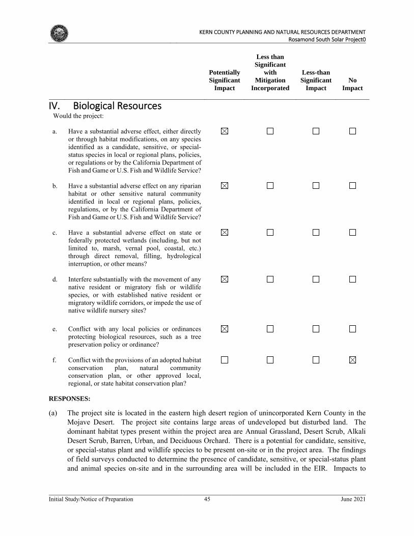
KERN COUNTY PLANNING AND NATURAL RESOURCES DEPARTMENT
Rosamond South Solar Project0
Initial Study/Notice of Preparation 45 June 2021
Potentially
Significant
Impact
Less than
Significant
with
Mitigation
Incorporated
Less-than
Significant
Impact
No
Impact
IV. Biological Resources
Would the project: a. Have a substantial adverse effect, either directly
or through habitat modifications, on any species identified as a candidate, sensitive, or special-status species in local or regional plans, policies, or regulations or by the California Department of Fish and Game or U.S. Fish and Wildlife Service?
b. Have a substantial adverse effect on any riparian
habitat or other sensitive natural community identified in local or regional plans, policies, regulations, or by the California Department of Fish and Game or U.S. Fish and Wildlife Service?
c. Have a substantial adverse effect on state or
federally protected wetlands (including, but not limited to, marsh, vernal pool, coastal, etc.) through direct removal, filling, hydrological interruption, or other means?
d. Interfere substantially with the movement of any
native resident or migratory fish or wildlife species, or with established native resident or migratory wildlife corridors, or impede the use of native wildlife nursery sites?
e. Conflict with any local policies or ordinances
protecting biological resources, such as a tree preservation policy or ordinance?
f. Conflict with the provisions of an adopted habitat
conservation plan, natural community conservation plan, or other approved local, regional, or state habitat conservation plan?
RESPONSES:
(a) The project site is located in the eastern high desert region of unincorporated Kern County in the Mojave Desert. The project site contains large areas of undeveloped but disturbed land. The dominant habitat types present within the project area are Annual Grassland, Desert Scrub, Alkali Desert Scrub, Barren, Urban, and Deciduous Orchard. There is a potential for candidate, sensitive, or special-status plant and wildlife species to be present on-site or in the project area. The findings of field surveys conducted to determine the presence of candidate, sensitive, or special-status plant and animal species on-site and in the surrounding area will be included in the EIR. Impacts to
KERN COUNTY PLANNING AND NATURAL RESOURCES DEPARTMENT
Rosamond South Solar Project0
Initial Study/Notice of Preparation 46 June 2021
biological resources and sensitive plant communities are considered potentially significant and will be analyzed in the EIR.
(b) The project site is undeveloped and comprised of desert scrub vegetation communities and active and fallow agricultural land. The USFWS does not identify any critical habitats within or adjacent to the project site. The nearest critical habitat is located approximately 14 miles west of the project site in the Tehachapi Mountains. This habitat is for the California condor (Gymnogyps californianus). Field surveys for riparian and other sensitive natural communities, including a biological assessment and jurisdictional delineation, will be completed for the proposed project and the results will be incorporated into the EIR. Additionally, protocol surveys, soils characterization, and hydrologic analysis will be prepared for the project. Impacts to riparian or other sensitive natural communities as a result of the proposed project are considered potentially significant and will be further analyzed in the EIR.
(c) The project site is highly unlikely to contain any federally protected wetlands, marshes or vernal pools, or other protected waterways because the project site is located in the Mojave Desert Basin in the Great Basin within which local waters do not drain to a traditionally navigable water of the United States. Therefore, project implementation is unlikely to result in impacts to wetlands. However, the project does have several drainages and identified other water features that may be considered jurisdictional waters of the State. Further analysis to identify potentially jurisdictional waters and any impacts to such waters will be included in the EIR.
(d) While the project site is located outside of known habitat linkages in the region, the site may be used for more local wildlife movement and likely provides stopover and wintering habitat for birds. Project construction and operation could also remove both foraging and nesting/denning habitat for wildlife species. No known established wildlife corridors or native wildlife nursery sites are located within the project site; however, impacts to wildlife habitat and movement are potentially significant and will be evaluated in the EIR.
(e) The CDFW has considered Joshua tree (Yucca brevifolia) to be a candidate species protected under California Endangered Species Act (CESA) since October 9, 2020. As a candidate species, Joshua tree now has full protection under CESA and any take of the species would require authorization under CESA. For projects where “take” is incidental to carrying out an otherwise lawful activity, an Incidental Take Permit (ITP) may be obtained from the CDFW. Additionally, sensitive natural plant community and compliance with the California Desert Native Plants Act of the California Food and Agricultural Code, Division 23, is required for the removal of Joshua trees. Scattered, widely spaced Joshua trees occur throughout portions of the proposed project site; however, they do not occur at a density high enough to consider them a distinct woodland community. Potential impacts to Joshua tree will be analyzed in the EIR.
(f) The project site is located within the U.S. Bureau of Land Management’s (BLM) West Mojave Plan (WMP) planning areas. However, the WMP applies only to federal public lands managed by the BLM and is not an adopted Habitat Conservation Plan (HCP) or Natural Community Conservation Plan (NCCP). The project site is also located within a BLM-designated Development Focus Area pursuant to BLM’s Desert Renewable Energy Conservation Plan (DRECP). Development Focus Areas have been identified because of their potential for energy generation and minimal conflict with sensitive biological resources and are therefore more likely to be appropriate for renewable energy development. However, at this time the DRECP applies only to federal public lands managed by the
KERN COUNTY PLANNING AND NATURAL RESOURCES DEPARTMENT
Rosamond South Solar Project0
Initial Study/Notice of Preparation 47 June 2021
BLM and is not an adopted HCP or NCCP. There are no anticipated impacts to these designated areas or plans because the project would not conflict with the provisions of an adopted HCP or NCCP.
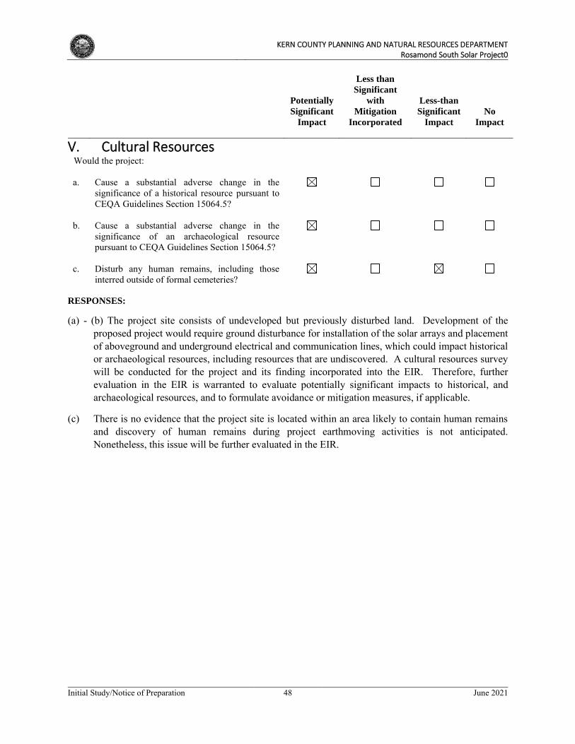
KERN COUNTY PLANNING AND NATURAL RESOURCES DEPARTMENT
Rosamond South Solar Project0
Initial Study/Notice of Preparation 48 June 2021
Potentially
Significant
Impact
Less than
Significant
with
Mitigation
Incorporated
Less-than
Significant
Impact
No
Impact
V. Cultural Resources
Would the project: a. Cause a substantial adverse change in the
significance of a historical resource pursuant to CEQA Guidelines Section 15064.5?
b. Cause a substantial adverse change in the
significance of an archaeological resource pursuant to CEQA Guidelines Section 15064.5?
c. Disturb any human remains, including those
interred outside of formal cemeteries?
RESPONSES:
(a) - (b) The project site consists of undeveloped but previously disturbed land. Development of the proposed project would require ground disturbance for installation of the solar arrays and placement of aboveground and underground electrical and communication lines, which could impact historical or archaeological resources, including resources that are undiscovered. A cultural resources survey will be conducted for the project and its finding incorporated into the EIR. Therefore, further evaluation in the EIR is warranted to evaluate potentially significant impacts to historical, and archaeological resources, and to formulate avoidance or mitigation measures, if applicable.
(c) There is no evidence that the project site is located within an area likely to contain human remains and discovery of human remains during project earthmoving activities is not anticipated. Nonetheless, this issue will be further evaluated in the EIR.
KERN COUNTY PLANNING AND NATURAL RESOURCES DEPARTMENT
Rosamond South Solar Project0
Initial Study/Notice of Preparation 49 June 2021
Potentially
Significant
Impact
Less than
Significant
with
Mitigation
Incorporated
Less-than
Significant
Impact
No
Impact
VI. Energy
Would the project: a. Result in potentially significant environmental
impact due to wasteful, inefficient, or unnecessary consumption of energy resources, during project construction or operation?
b. Conflict with or obstruct a state or local plan for
renewable energy or energy efficiency?
RESPONSES:
(a) Construction of the proposed project would involve on-site energy demand and consumption related to use of oil in the form of gasoline and diesel fuel for construction worker vehicle trips, hauling and materials delivery truck trips, and operation of off-road construction equipment. In addition, diesel-fueled portable generators may be necessary to provide additional electricity demands for temporary on-site lighting, welding, and for supplying energy to areas of the sites where energy supply cannot be met via a hookup to the existing electricity grid.
Following implementation of the proposed project, energy would switch from consumption to production. Energy use associated with operation of the proposed project would be typical of a solar facility. Operation and maintenance facilities associated with the project would require electricity for interior and exterior building lighting, heating, ventilation, and air conditioning (HVAC), electronic equipment, machinery, appliances, security systems, etc. Maintenance activities during operations, such as landscape maintenance, could involve the use of electric or gas-powered equipment. In addition to on-site energy use, the proposed project would result in transportation energy use associated with employee vehicle trips generated by the proposed project. Further analysis in the EIR is warranted.
(b) Due to the increased on-site consumption of energy during construction, the proposed project has the potential to conflict with or obstruct a state or local plan for energy efficiency. However, following implementation of the proposed project, site energy demand would switch to energy production. Operation of the proposed project would lead to an overall increase in the County’s Renewable Portfolio and would align with the stated General Plan policy to encourage the development of renewable energy within Kern County. Impacts are considered to be less than significant; however, further analysis is warranted in the EIR.
KERN COUNTY PLANNING AND NATURAL RESOURCES DEPARTMENT
Rosamond South Solar Project0
Initial Study/Notice of Preparation 50 June 2021
Potentially
Significant
Impact
Less than
Significant
with
Mitigation
Incorporated
Less-than
Significant
Impact
No
Impact
VII. Geology and Soils
Would the project: a. Directly or indirectly cause potential substantial
adverse effects, including the risk of loss, injury, or death involving:
i. Rupture of a known earthquake fault, as
delineated on the most recent Alquist-Priolo Earthquake Fault Zoning Map issued by the State Geologist for the area or based on other substantial evidence of a known fault? Refer to Division of Mines and Geology Special Publication 42.
ii. Strong seismic ground shaking? iii. Seismic-related ground failure, including
liquefaction?
iv. Landslides? b. Result in substantial soil erosion or the loss of
topsoil?
c. Be located on a geologic unit or soil that is
unstable, or that would become unstable as a result of the project, and potentially result in on- or off-site landslide, lateral spreading, subsidence, liquefaction, or collapse?
d. Be located on expansive soil, as defined in Table
18-1-B of the Uniform Building Code (1994), creating substantial direct or indirect risks to life or property?
e. Have soils incapable of adequately supporting
the use of septic tanks or alternative wastewater disposal systems in areas where sewers are not available for the disposal of wastewater?
f. Directly or indirectly destroy a unique
paleontological resource or site or unique geologic feature?
KERN COUNTY PLANNING AND NATURAL RESOURCES DEPARTMENT
Rosamond South Solar Project0
Initial Study/Notice of Preparation 51 June 2021
RESPONSES:
(a)(i) The project site is not located within any earthquake fault zone or seismic hazard zone as established pursuant to the Alquist-Priolo Earthquake Fault Zoning Act. The nearest fault to the project site is the Garlock-South Branch fault, located approximately 10 miles northwest of the project site. In addition, although the project does not include any habitable structures, construction of the project would be subject to all applicable ordinances of the Kern County Building Code (Chapter 17.08), including standards related to seismic hazards. Kern County has adopted the California Building Standards Code (CBC) 2019 Edition (CCR Title 24) effective January 1, 2020, which imposes substantially the same requirements as the International Building Code (IBC), 2020 Edition, with some modifications and amendments. Adherence to applicable building code standards would mitigate any potential impacts associated with the project. Impacts would be less than significant; however, further analysis in the EIR is warranted.
(a)(ii) Due to the location of active faults in the general region, strong seismic ground shaking could occur at the project site resulting in damage to above and below ground structures and other site improvements if not properly designed to withstand strong ground shaking. Should strong seismic ground shaking occur at the project site, damage to the PV modules and other ancillary facilities (e.g., O&M buildings) could result. However, construction of the proposed project would be subject to all applicable ordinances of the Kern County Building Code (Chapter 17.08) and IBC and CBC earthquake construction standards, including those relating to soil characteristics. Adherence to applicable regulations would minimize the potential impacts associated with ground shaking at the project site. Although potential impacts are anticipated to be less than significant, further analysis in the EIR is warranted.
(a)(iii) Seismically induced liquefaction occurs when loose, water-saturated sediments of relatively low density are subjected to cyclic shaking that causes soils to lose strength or stiffness because of increased pore water pressure. Liquefaction generally occurs when the depth to groundwater is less than 50 feet. Based on review of available groundwater data in the project area, groundwater is expected to be more than 50 feet below ground surface. Thus, the potential for liquefaction at the surface is low. Furthermore, the project site is not located within a current, mapped California Liquefaction Hazard Zone. Structures constructed as part of the project would be required by State law to be constructed in accordance with all applicable IBC and CBC earthquake construction standards, including those relating to soil characteristics. Nonetheless, the potential for substantial adverse effects to the project due to seismic-related ground failure, including liquefaction, will be examined in the EIR.
(a)(iv) The project site is located in a relatively flat-lying plain that does not contain in steep slopes; landslides are not likely. Therefore, impacts related to landslides are not anticipated to occur or pose a hazard to the project or surrounding area. However, the potential for substantial adverse effects to the project due to landslides will be examined in the EIR.
(b) The project would employ a combination of mowing, “disk-and-roll” techniques and, where necessary, conventional grading. Disk-and-roll site preparation uses tractors pulling disking equipment to till under vegetation. As a result, project construction would have the potential to result in erosion, sedimentation, and discharge of construction debris from the site. Vegetation clearing and grading activities, for example, could lead to exposed or stockpiled soils susceptible to peak stormwater runoff flows and wind forces. The compaction of soils by heavy equipment may minimally reduce the infiltration capacity of soils (exposed during construction) and increase runoff
KERN COUNTY PLANNING AND NATURAL RESOURCES DEPARTMENT
Rosamond South Solar Project0
Initial Study/Notice of Preparation 52 June 2021
or erosion potential. An erosion and sediment control plan would be prepared that specifies best management practices (BMPs) to prevent construction pollutants, including eroded soils (such as topsoil), from moving off the site. Additionally, the project proponent would be required to obtain coverage under the National Pollution Discharge Elimination System (NPDES) Construction General Permit (CGP) because the proposed project would disturb greater than one acre of land. In order to conform to the requirements of the CGP, a storm water pollution prevention plan (SWPPP) would need to be prepared that outlines specific best management practices (BMPs) to prevent construction pollutants, including eroded soils, from moving off-site. Impacts are anticipated to be less than significant with implementation of the above requirements; however, this issue will be further evaluated in the EIR.
(c) The project lies in a relatively flat-lying plain where landslides, lateral spreading, subsidence, liquefaction, and collapse are not expected to occur. Based on review of available groundwater data in the project area, groundwater is expected to be more than 50 feet below ground surface. Therefore, liquefaction is unlikely because the ground water levels are relatively deep. Seismic settlement, lateral spreading, and collapse are not expected to result in significant impacts. Nevertheless, the potential for substantial adverse effects to the project due to geologic instability and liquefaction will be examined in the EIR.
(d) Expansive soils are fine-grained soils (generally high plasticity clays) that can undergo a significant increase in volume with an increase in water content and a significant decrease in volume with a decrease in water content. Changes in the water content of a highly expansive soil can result in severe distress to structures constructed on or against the soil. The expansion potential of on-site soils may be classified as very low to low, and special design is not necessary. The project would be designed to comply with applicable building codes and structural improvement requirements to withstand the effects of expansive soils. The implementation of Kern County Building Code requirements, as applicable, would minimize the potential impact of expansive soils. The EIR will confirm the presence or absence of expansive soils within the project area. Therefore, this issue will be further evaluated in the EIR.
(e) A sanitary water supply would not be required during construction as restroom facilities would be provided by portable units to be serviced by licensed providers. The project would include the construction of one O&M building measuring approximately 100 feet x 50 feet and a communications building measuring approximately 20 feet x 30 feet that would support one to two full-time employees. The employee use of on-site restrooms would generate wastewater that would require disposal. Impacts from facilities that support the full-time employees during project operation warrants further evaluation in the EIR.
(f) Kern County is rich in paleontological resources. If sensitive paleontological formations are located underground on the project site, ground disturbance could result in impacts to paleontological resources. A paleontological study will be conducted to determine the underlying formations and potential for fossil discoveries throughout the project site. This analysis will be provided in the EIR to identify potential impacts and to formulate avoidance or mitigation measures, if applicable. Therefore, further evaluation in the EIR is warranted
KERN COUNTY PLANNING AND NATURAL RESOURCES DEPARTMENT
Rosamond South Solar Project0
Initial Study/Notice of Preparation 53 June 2021
Potentially
Significant
Impact
Less than
Significant
with
Mitigation
Incorporated
Less-than
Significant
Impact
No
Impact
VIII. Greenhouse Gas Emissions
Would the project:
a. Generate greenhouse gas emissions, either directly or indirectly, that may have a significant impact on the environment?
b. Conflict with any applicable plan, policy, or
regulation adopted for the purpose of reducing the emissions of greenhouse gases?
RESPONSES:
(a) Greenhouse gas (GHG) emissions emitted by human activity are implicated in global climate change or global warming. The principal GHGs are CO2, methane (CH4), NOX, ozone, water vapor, and fluorinated gases. The temporary construction activities associated with the proposed project, which would involve operation of heavy off-road equipment, on-road trucks (for deliveries and hauling), and construction worker commute trips, would generate GHGs through exhaust emissions. However, as a solar facility, the proposed project is expected to displace traditional electricity production that involves combustion energy sources (e.g., burning coal, fuel oil, or natural gas). As such, the provision of solar energy by the proposed project would produce GHG-free electricity that is anticipated to offset GHGs that would otherwise be generated by traditional fuel combustion electricity production. The potential impacts associated with GHG emissions generated during construction of the proposed project and the potential GHG offsets resulting from operation of the proposed project will be further evaluated in the EIR.
(b) California has passed several bills and the governor has signed at least three executive orders regarding GHGs. Assembly Bill (AB) 32 (the Global Warming Solutions Act) was passed by the California legislature on August 31, 2006 and requires preparing a Climate Change Scoping Plan for achieving the maximum technologically feasible and cost-effective GHG emission reduction by 2020 (HSC Section 38561(h)). As a result, the California Air Resources Board (CARB) developed a Climate Change Scoping Plan that contains strategies to achieve the 2020 emissions cap.
In 2002, California established its Renewable Portfolio Standards (RPS) Program, with the goal of increasing the percentage of renewable energy in the state’s electricity mix to 20 percent renewable energy by 2017. In 2006, under SB 107, the RPS Program codified the 20 percent goal. The RPS Program requires electric utilities and providers to increase procurement from eligible renewable energy resources by at least one percent of their retail sales annually until they reach 20 percent by 2017. On November 17, 2008, the governor signed Executive Order S-14-08, requiring California utilities to reach the 33 percent renewable goal by 2020. In 2015, SB 350 was enacted to increase the RPS to 50 percent and reduce greenhouse gas emissions by 40 percent below 1990 levels by the year 2030 and to 80 percent below 1990 levels by 2050.
KERN COUNTY PLANNING AND NATURAL RESOURCES DEPARTMENT
Rosamond South Solar Project0
Initial Study/Notice of Preparation 54 June 2021
The proposed project is intended to: (1) reduce importation of power from fossil fuel power plants and (2) contribute to a reduction in GHGs. Heavy equipment operation, truck deliveries, and construction worker commute trips associated with construction of the proposed project would temporarily generate GHGs; however, operation of the project would offset GHGs generated by traditional fuel combustion sources of electricity. The project’s potential GHG impacts and the potential GHG offsets resulting from operation of the project will be examined in the EIR with respect to the objectives of statewide programs to reduce GHGs associated with energy generation.
KERN COUNTY PLANNING AND NATURAL RESOURCES DEPARTMENT
Rosamond South Solar Project0
Initial Study/Notice of Preparation 55 June 2021
Potentially
Significant
Impact
Less than
Significant
with
Mitigation
Incorporated
Less-than
Significant
Impact
No
Impact
IX. Hazards and Hazardous Materials
Would the project: a. Create a significant hazard to the public or the
environment through the routine transport, use, or disposal of hazardous materials?
b. Create a significant hazard to the public or the
environment through reasonably foreseeable upset and accident conditions involving the release of hazardous materials into the environment?
c. Emit hazardous emissions or involve handling
hazardous or acutely hazardous materials, substances, or waste within one-quarter mile of an existing or proposed school?
d. Be located on a site that is included on a list of
hazardous materials sites compiled pursuant to Government Code Section 65962.5 and, as a result, would it create a significant hazard to the public or the environment?
e. For a project located within the adopted Kern
County Airport Land Use Compatibility Plan, would the project result in a safety hazard or excessive noise for people residing or working in the project area?
f. Impair implementation of, or physically interfere
with, an adopted emergency response plan or emergency evacuation plan?
g. Expose people or structures, directly or indirectly,
to a significant risk of loss, injury, or death involving wildland fires?
h. Would implementation of the project generate
vectors (flies, mosquitoes, rodents, etc.) or have a component that includes agricultural waste? Specifically, would the project exceed the following qualitative threshold: The presence of domestic flies, mosquitoes, cockroaches, rodents, and/or any other vectors associated with the project is significant when the applicable enforcement agency determines that any of the vectors:
KERN COUNTY PLANNING AND NATURAL RESOURCES DEPARTMENT
Rosamond South Solar Project0
Initial Study/Notice of Preparation 56 June 2021
Potentially
Significant
Impact
Less than
Significant
with
Mitigation
Incorporated
Less-than
Significant
Impact
No
Impact
i. Occur as immature stages and adults in
numbers considerably in excess of those found in the surrounding environment; and
ii. Are associated with design, layout, and
management of project operations; and
iii. Disseminate widely from the property; and iv. Cause detrimental effects on the public health
or well-being of the majority of the surrounding population.
RESPONSES:
(a) The project would not involve the routine transport, use, or disposal of hazardous materials as defined by the Hazardous Materials Transportation Uniform Safety Act and is not expected to create a significant hazard to the public or the environment. During construction, the project would include the transport of general construction materials (i.e., concrete, wood, metal, fuel, etc.) as well as materials necessary to construct the proposed PV arrays. Project-related infrastructure would not emit hazardous materials or be constructed of acutely hazardous materials or substances that could adversely impact the public or on-site workers. Wastes generated during construction of the project would also be non-hazardous, and would consist of cardboard, wood pallets, copper wire, scrap steel, common trash, and wood wire spools. Although field equipment used during construction activities could contain various hazardous materials (i.e., hydraulic oil, diesel fuel, grease, lubricants, solvents, adhesives, paints, etc.), these materials are not considered to be acutely hazardous and would be used in accordance with the manufacturers’ specifications and all applicable regulations.
The project would be subject to all local, State, and federal laws pertaining to the use of hazardous materials on the site and would be subject to review by the Kern County Public Health Services Department/Environmental Health Services Division. The PV panels include semiconductor materials, such as cadmium telluride or crystalline or amorphous silicon, which are encapsulated within the PV panels. The chemical properties of the semiconductor materials and the construction of the PV panels minimize risk of exposure to human health or the environment. Broken PV panels would be replaced and disposed of off-site in compliance with local, State, and federal laws, and would therefore not be a source of pollution or threat to human health or the environment. Impacts resulting from the transport, use, or disposal of hazardous materials during construction and operation of the proposed project will be evaluated further in the EIR.
(b) The proposed project would be subject to all local, State, and federal laws pertaining to the use, storage, and disposal of hazardous and non-hazardous materials on the project site and would be subject to review by the Kern County Environmental Health Services Division. However, construction and operation of the proposed project may include the accidental release of storage materials, such as cleaning fluids and petroleum products including lubricants, fuels, and solvents.
KERN COUNTY PLANNING AND NATURAL RESOURCES DEPARTMENT
Rosamond South Solar Project0
Initial Study/Notice of Preparation 57 June 2021
Electrical transformer equipment that would be installed as part of the proposed project may include various hazardous substances, including polychlorinated biphenyls. The toxicity and potential release of these materials would depend on the quantity, type of storage container, safety protocols used on the site, location and/or proximity to schools and residences, frequency and duration of spills or storage leaks, and the reactivity of hazardous substances with other materials.
In addition, the proposed project would also include a BESS on each of the facilities. Each BESS would consist of self-contained battery storage modules placed in racks, converters, switchboards, inverters, transformers, controls, and integrated heating, ventilation, and air conditioning (HVAC) units, all enclosed in one or more buildings or in prefabricated metal containers. If the BESSs use prefabricated metal containers, each container will be a 40-foot-long by 8-foot-wide battery container. Potential hazards associated with BESS include increased potential for electrical shock and chemical release associated with the batteries used. The BESS would have a fire rating in conformance with County standards and specialized fire suppression systems would be installed. Also, implementation of established construction controls and safety procedures would reduce the risk of hazardous materials spills and releases.
The proposed project would be subject to all local, state, and federal laws pertaining to the use of hazardous materials on-site and would be subject to review by the Kern County Environmental Health Services Division. Through the review process, the project proponent would be required to submit a complete list of all materials used on-site, how the materials would be transported and stored, and in what form they would be used. This would be recorded to maintain safety and prevent possible environmental contamination or worker exposure and would include submission of MSDS for all applicable materials present at the site. Additionally, implementation of BMPs would ensure that hazardous materials used on site during operation would neither be released into the environment nor expose operational personnel to hazardous materials. It is anticipated that adherence to regulations and standard protocols during the storage, transportation, and usage of any hazardous materials would avoid significant impacts; nonetheless, potential impacts will be evaluated in the EIR.
(c) The closest school to the project site is Tropico Middle School, located approximately 4 miles northeast of the project site. The proposed project is a solar energy generation facility that involves using photovoltaic solar panels to generate electricity. Project-related infrastructure would not emit hazardous materials or involve handling hazardous or acutely hazardous materials, substances, or waste within one-quarter mile of an existing or proposed school. However, this impact will be further evaluated in the EIR.
(d) No known hazardous materials/facilities are located within the project site. However, a Phase I Environmental Site Assessment (ESA) will be prepared pursuant to Government Code Section 65962.5. The Phase I ESA will include a search of the subject parcels in the California Environmental Protection Agency (CalEPA) Cortese List, the California Department of Toxic Substances and Control (DTSC) Envirostor database of hazardous substances release sites, and the California Water Boards’ Geotracker database. Although no significant impacts are anticipated, there is the potential for the discovery of unknown hazardous materials. Therefore, the impacts from hazardous material sites are considered potentially significant and will be further analyzed in the EIR.
(e) The project site is not located within an area covered by the Kern County Airport Land Use Compatibility Plan (ALUCP). The nearest airports to the project site are the privately owned Rosamond Skypark located approximately 9 miles to the northeast, the Mojave Air and Space Port
KERN COUNTY PLANNING AND NATURAL RESOURCES DEPARTMENT
Rosamond South Solar Project0
Initial Study/Notice of Preparation 58 June 2021
located approximately 25 miles to the northeast, and the Mountain Valley Airport located approximately 25 miles to the north. Safety hazards are not anticipated for people working in the project site with respect to the project’s proximity to an airport. Therefore, there would be no anticipated impacts related to proximity to an airport and no further analysis in the EIR is warranted.
(f) The project would not interfere with any existing emergency response plans, emergency vehicle access, or personnel access to the project site. The project site is located in a remote area with several alternative access roads allowing access to the project site in the event of an emergency. Access would be maintained throughout construction, and appropriate detours would be provided in the event of potential road closures. Therefore, no impacts related to impairment of the implementation of or physical interference with an adopted emergency response plan or emergency evacuation plan are anticipated and no further analysis in the EIR is warranted.
(g) Construction and operation of the proposed project would not result in increased risk of wildfires in the project area. The California Department of Forestry and Fire Protection (CalFire) publishes Fire Hazards Severity Zone Maps for the State Responsibility Areas (SRA), however the project site is not located within a State Responsibility Area. The project site is located in a local responsibility area (LRA) for which the County of Kern is responsible for providing fire protection. The CalFire LRA maps show the project within two LRA Fire Severity Zones: (a) LRA moderate and (b) LRA unzoned. The project would comply with all applicable wildland fire management plans and policies established by CalFire and the Kern County Fire Department (KCFD). Accordingly, the project is not expected to expose people or structures to a significant risk of loss, injury, or death involving wildland fires. Although impacts are anticipated to be less than significant, further analysis of this issue will be discussed in the EIR.
(h) Project-related facilities would not result in features or conditions that could potentially provide habitat for vectors such as mosquitoes, flies, cockroaches, or rodents. During construction and operation, workers would generate small quantities of solid waste (i.e., trash, food containers, etc.) that would be stored in enclosed containers then transported to and disposed of at approved disposal facilities. Construction and operation of the proposed solar arrays and associated facilities would not produce uncontrolled wastes that could support vectors and would not generate any standing water or other features that would attract nuisance pests or vectors. Therefore, impacts are considered to be negligible and further analysis is not required.
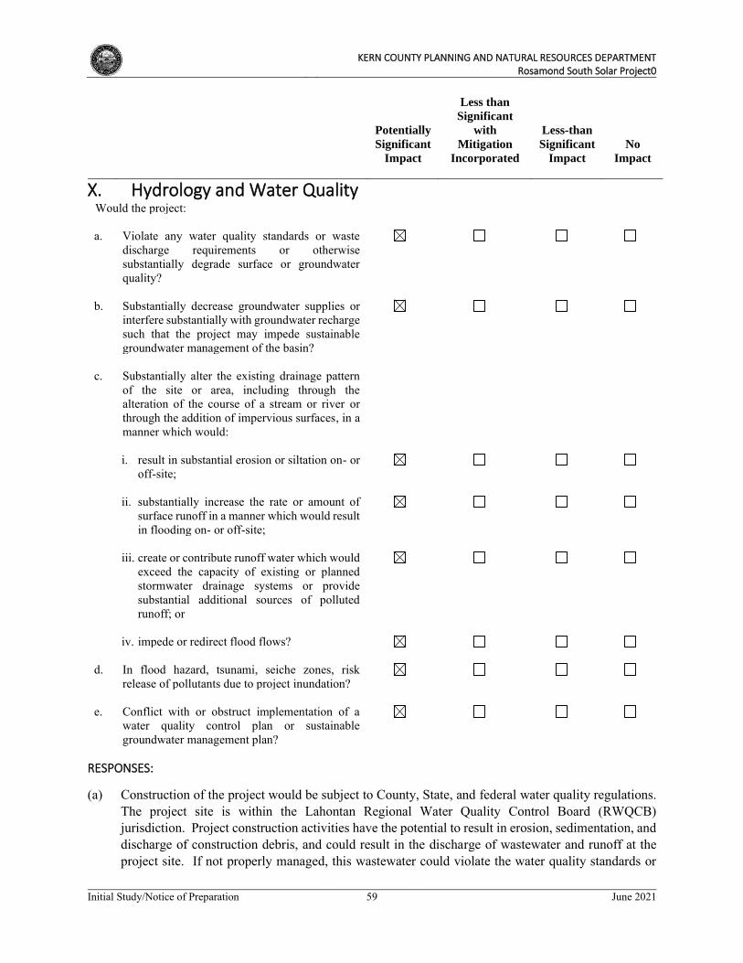
KERN COUNTY PLANNING AND NATURAL RESOURCES DEPARTMENT
Rosamond South Solar Project0
Initial Study/Notice of Preparation 59 June 2021
Potentially
Significant
Impact
Less than
Significant
with
Mitigation
Incorporated
Less-than
Significant
Impact
No
Impact
X. Hydrology and Water Quality
Would the project: a. Violate any water quality standards or waste
discharge requirements or otherwise substantially degrade surface or groundwater quality?
b. Substantially decrease groundwater supplies or
interfere substantially with groundwater recharge such that the project may impede sustainable groundwater management of the basin?
c. Substantially alter the existing drainage pattern
of the site or area, including through the alteration of the course of a stream or river or through the addition of impervious surfaces, in a manner which would:
i. result in substantial erosion or siltation on- or
off-site;
ii. substantially increase the rate or amount of
surface runoff in a manner which would result in flooding on- or off-site;
iii. create or contribute runoff water which would
exceed the capacity of existing or planned stormwater drainage systems or provide substantial additional sources of polluted runoff; or
iv. impede or redirect flood flows? d. In flood hazard, tsunami, seiche zones, risk
release of pollutants due to project inundation?
e. Conflict with or obstruct implementation of a
water quality control plan or sustainable groundwater management plan?
RESPONSES:
(a) Construction of the project would be subject to County, State, and federal water quality regulations. The project site is within the Lahontan Regional Water Quality Control Board (RWQCB) jurisdiction. Project construction activities have the potential to result in erosion, sedimentation, and discharge of construction debris, and could result in the discharge of wastewater and runoff at the project site. If not properly managed, this wastewater could violate the water quality standards or
KERN COUNTY PLANNING AND NATURAL RESOURCES DEPARTMENT
Rosamond South Solar Project0
Initial Study/Notice of Preparation 60 June 2021
waste discharge requirements of the RWQCB, or otherwise degrade surface or ground water quality. To reduce sediment production and storm water pollution, the project proponent would prepare and implement a project-specific drainage control plan, if necessary, which would include applicable BMPs to reduce the potential for erosion and sedimentation that could result from construction of the project. It is anticipated that appropriate best management practices (BMPs) and compliance with applicable regulations, including the NPDES Construction General Permit, would reduce potential water quality impacts to a less than significant level. Additionally, the proposed project contractor(s) would apply for coverage under the state’s General Construction Permit for stormwater discharges from construction activities and would prepare a SWPPP that would include implementation of BMP erosion-control measures to control stormwater runoff. Site-specific BMPs would be designed by the contractor in compliance with regulations and permit conditions. Finally, further review is required to determine the post-construction water quality measures that would be implemented in compliance with RWQCB standards. Although significant impacts related to water quality are not anticipated during construction, a comprehensive hydrology and water quality impact analysis will be prepared, and the findings will be further analyzed in the EIR.
(b) During the construction, operational, and decommissioning phases of the proposed project, water would be obtained from an offsite source. During construction of the proposed project, non-potable water would be initially required for site preparation and grading activities. During earthwork for grading of access road foundations, equipment pads and project components, the main use of water (non-potable) would be for compaction and dust control. Smaller quantities would be required for preparation of the concrete required for foundations and other minor uses. The overall construction water usage for dust control and site preparation is anticipated during construction is approximately 450 AF per year during the 12-month construction period.
An estimated 18 acre feet per year of water would be necessary for use in the O&M building and routine panel washing. It is anticipated that panels would be washed up to four times a year, using small water trucks. A Will Serve letter has been obtained from a private local water purveyor, indicating his capacity and willingness to provide water for construction and operation of the project. A water supply assessment will be completed for the project to analyze potential impacts to groundwater. These impacts will be addressed further in the EIR. (c)(i) Construction of the proposed project, including but not limited to, construction of concrete pads for the switchyard, inverters, transformers, and O&M buildings as well as foundational supports for panel installation, soil compaction, and any grading may alter the existing drainage pattern of the project site. A hydrologic study would be prepared for the project in accordance with Kern County requirements, and potentially significant impacts to existing drainage patterns and flooding conditions on the project site will be analyzed in the EIR.
(c)(ii) Construction and operational activities associated with the proposed project would alter existing drainage conditions and create impervious surfaces that would have the potential to result in an increase in the rate or amount of surface runoff during storm events. A hydrologic study will be prepared for the project in accordance with Kern County requirements, and potentially significant impacts will be analyzed in the EIR.
(c)(iii) During construction and following installation of the solar arrays, the majority of the site would remain pervious. The design of the solar arrays is such that storm water infiltration would occur similar to existing conditions. No discharges to or alterations of any municipal stormwater drainage systems are proposed. Similarly, no component of the project would generate a substantial source of
KERN COUNTY PLANNING AND NATURAL RESOURCES DEPARTMENT
Rosamond South Solar Project0
Initial Study/Notice of Preparation 61 June 2021
polluted runoff. The construction period SWPPP and the operational period Water Quality Management Plan would ensure the proper control and treatment, if necessary, of any storm water prior to discharge. With adherence to site-specific BMPs, potential pollutants would be minimized to the extent practicable; nonetheless, this impact will be further discussed in the EIR.
(c)(iv) The Federal Emergency Management Agency (FEMA) delineates flood hazard areas on its Flood Insurance Rate Maps (FIRMs). According to the FIRMs for the project area, the entire project site is located in a 100-year flood area (Zone A, 1% annual chance of flooding; see Figure 10, FEMA
Floodplain Map. The proposed project would be reviewed by the Kern County Public Works Department-Floodplain for adherence to all floodplain management standards. Further analysis is required to identify appropriate mitigation/design measures to reduce potentially significant impacts from potential flooding and this analysis will be provided in the EIR.
(d) The project is not located near an ocean or enclosed body of water, and therefore would not be subject to inundation by seiche or tsunami. Mudflows are a type of mass wasting or landslide, where earth and surface materials are rapidly transported downhill under the force of gravity, and are often triggered by heavy rainfall and soil that is not able to sufficiently drain or absorb water and the super-saturation results in soil and rock materials to become unstable and slide away. Due to the relatively flat topography of the project and surrounding area, the potential to be inundated by mudflow is considered remote.
As discussed above, the entire project site is located in a 100-year flood area (Zone A, 1% annual chance of flooding); refer to Figure 10, FEMA Floodplain Map. The project would be reviewed by the Kern County Public Works Department for adherence to all applicable floodplain management standards. Because of the potential for flood hazards to occur, and related risk of release of pollutants due to project inundation, further analysis of this is required in the EIR.
(e) The project site is located within the Antelope Valley Groundwater Basin, which is an adjudicated basin, with all water rights having been previously prescribed. Ongoing management of this basin is governed by the Integrated Regional Water Management Plan (IRWMP). As such, all water usage for the project will conform to existing adjudication plans. A water supply assessment will be completed for the project to analyze potential impacts to groundwater resources, including any potential conflicts with the IRWMP. This impact will be further analyzed in the EIR.
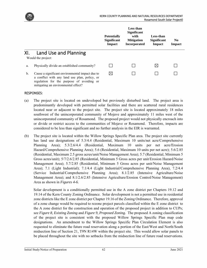
KERN COUNTY PLANNING AND NATURAL RESOURCES DEPARTMENT
Rosamond South Solar Project0
Initial Study/Notice of Preparation 62 June 2021
Potentially
Significant
Impact
Less than
Significant
with
Mitigation
Incorporated
Less-than
Significant
Impact
No
Impact
XI. Land Use and Planning
Would the project: a. Physically divide an established community? b. Cause a significant environmental impact due to
a conflict with any land use plan, policy, or regulation for the purpose of avoiding or mitigating an environmental effect?
RESPONSES:
(a) The project site is located on undeveloped but previously disturbed land. The project area is predominantly developed with permitted solar facilities and there are scattered rural residences located near or adjacent to the project site. The project site is located approximately 18 miles southwest of the unincorporated community of Mojave and approximately 11 miles west of the unincorporated community of Rosamond. The proposed project would not physically encroach into or divide or restrict access to the communities of Mojave or Rosamond. Therefore, impacts are considered to be less than significant and no further analysis in the EIR is warranted.
(b) The project site is located within the Willow Springs Specific Plan area. The project site currently has land use designations of 5.3/4.4 (Residential, Maximum 10 units/net acre/Comprehensive Planning Area); 5.3/2.6/4.4 (Residential, Maximum 10 units per net acre/Erosion Hazard/Comprehensive Planning Area); 5.6 (Residential, Maximum 10 units per net acre); 5.6/2.85 (Residential, Maximum 2.5 gross acres/unit/Noise Management Area); 5.7 (Residential, Minimum 5 Gross acres/unit); 5/7/2.6/2.85 (Residential, Minimum 5 Gross acres per unit/Erosion Hazard/Noise Management Area); 5.7/2.85 (Residential, Minimum 5 Gross acres per unit/Noise Management Area); 7.1 (Light Industrial); 7.1/4.4 (Light Industrial/Comprehensive Planning Area), 7.2/4.4 (Service Industrial/Comprehensive Planning Area); 8.1/2.85 (Intensive Agriculture/Noise Management Area); and 8.1/2.6/2.85 (Intensive Agriculture/Erosion Control/Noise Management) Area as shown in Figures 4-6.
Solar development is a conditionally permitted use in the A zone district per Chapters 19.12 and 19.14 of the Kern County Zoning Ordinance. Solar development is not a permitted use in residential zone districts like the E zone district per Chapter 19.16 of the Zoning Ordinance. Therefore, approval of a zone change would be required to rezone project parcels classified within the E zone district to the A zone district for the construction and operation of the proposed project in addition to CUPs; see Figure 8, Existing Zoning and Figure 9, Proposed Zoning. The proposed A zoning classification of the project site is consistent with the proposed Willow Springs Specific Plan map code designations. An amendment to the Willow Springs Specific Plan Circulation Element is also requested to eliminate the future road reservation along a portion of the East/West and North/South midsection line of Section 21, T9N R14W within the project site. This would allow solar panels to be placed throughout the site with no setbacks from the midsection line of future road reservations.
KERN COUNTY PLANNING AND NATURAL RESOURCES DEPARTMENT
Rosamond South Solar Project0
Initial Study/Notice of Preparation 63 June 2021
However, the proposed project would not affect property owner access to any other surrounding properties.
The project proponent is requesting four CUPs to allow for the construction and operation of the proposed project (refer to Figure 3, Aerial Map with Site Boundaries). With approval of the zone change classification and CUPs, the proposed project would be an allowable use within the A zone district. At the end of the project’s operational term, the project proponent would determine whether the project site should be decommissioned and deconstructed or if it would seek an extension of its CUPs. If any portion of the project site is decommissioned, it would be converted to other uses in accordance with the applicable land use regulations in effect at that time.
With approval of the requested CUPs and zone change classifications, the proposed project is not anticipated to have the potential to conflict with any applicable land use plan, policy, or regulation of an agency with jurisdiction over the project adopted for the purpose of avoiding or mitigating an environmental effect. However, further assessment will be provided in the EIR.
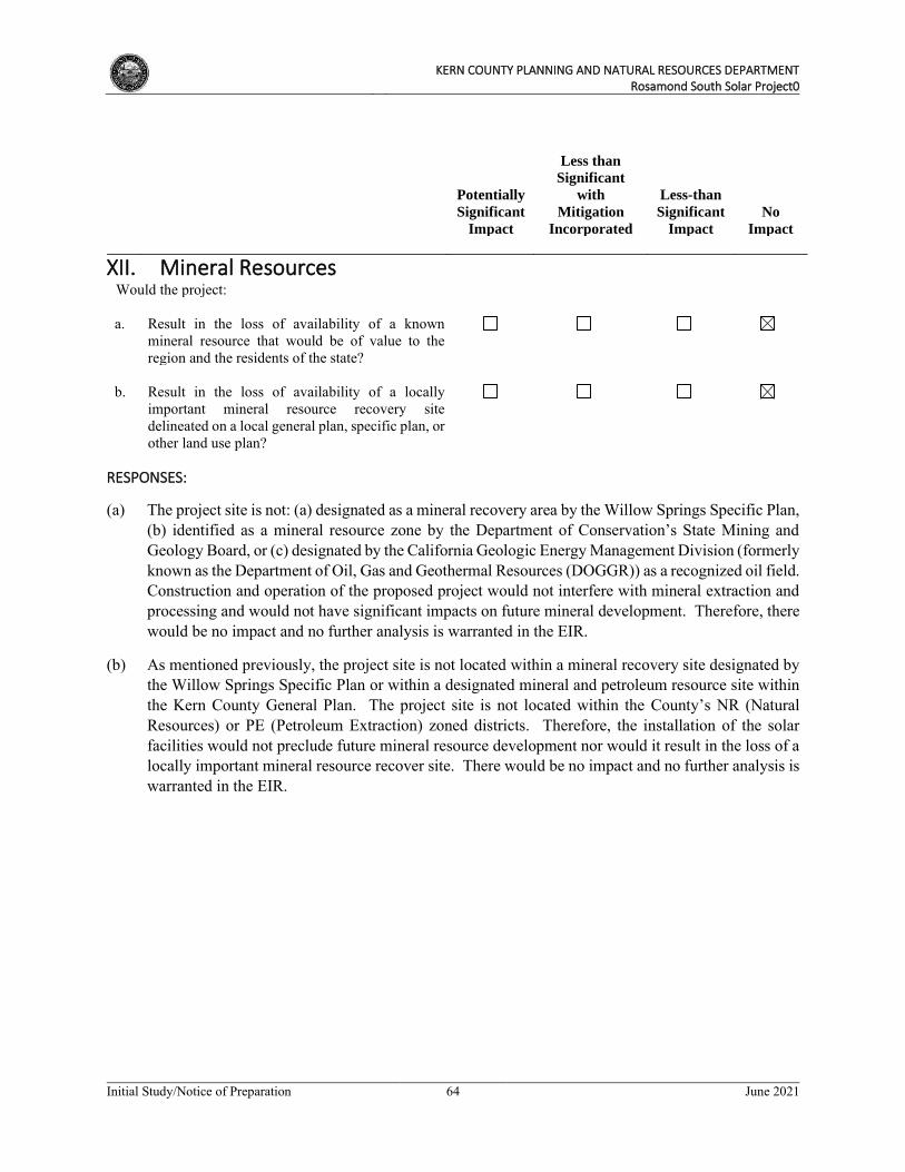
KERN COUNTY PLANNING AND NATURAL RESOURCES DEPARTMENT
Rosamond South Solar Project0
Initial Study/Notice of Preparation 64 June 2021
Potentially
Significant
Impact
Less than
Significant
with
Mitigation
Incorporated
Less-than
Significant
Impact
No
Impact
XII. Mineral Resources
Would the project: a. Result in the loss of availability of a known
mineral resource that would be of value to the region and the residents of the state?
b. Result in the loss of availability of a locally
important mineral resource recovery site delineated on a local general plan, specific plan, or other land use plan?
RESPONSES:
(a) The project site is not: (a) designated as a mineral recovery area by the Willow Springs Specific Plan, (b) identified as a mineral resource zone by the Department of Conservation’s State Mining and Geology Board, or (c) designated by the California Geologic Energy Management Division (formerly known as the Department of Oil, Gas and Geothermal Resources (DOGGR)) as a recognized oil field. Construction and operation of the proposed project would not interfere with mineral extraction and processing and would not have significant impacts on future mineral development. Therefore, there would be no impact and no further analysis is warranted in the EIR.
(b) As mentioned previously, the project site is not located within a mineral recovery site designated by the Willow Springs Specific Plan or within a designated mineral and petroleum resource site within the Kern County General Plan. The project site is not located within the County’s NR (Natural Resources) or PE (Petroleum Extraction) zoned districts. Therefore, the installation of the solar facilities would not preclude future mineral resource development nor would it result in the loss of a locally important mineral resource recover site. There would be no impact and no further analysis is warranted in the EIR.
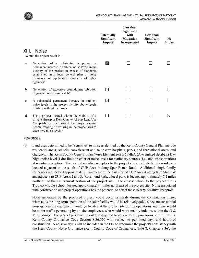
KERN COUNTY PLANNING AND NATURAL RESOURCES DEPARTMENT
Rosamond South Solar Project0
Initial Study/Notice of Preparation 65 June 2021
Potentially
Significant
Impact
Less than
Significant
with
Mitigation
Incorporated
Less-than
Significant
Impact
No
Impact
XIII. Noise
Would the project result in: a. Generation of a substantial temporary or
permanent increase in ambient noise levels in the vicinity of the project in excess of standards established in a local general plan or noise ordinance or applicable standards of other agencies?
b. Generation of excessive groundborne vibration
or groundborne noise levels?
c. A substantial permanent increase in ambient
noise levels in the project vicinity above levels existing without the project
d. For a project located within the vicinity of a
private airstrip or Kern County Airport Land Use Compatibility Plan, would the project expose people residing or working in the project area to excessive noise levels?
RESPONSES:
(a) Land uses determined to be “sensitive” to noise as defined by the Kern County General Plan include residential areas, schools, convalescent and acute care hospitals, parks, and recreational areas, and churches. The Kern County General Plan Noise Element sets a 65 dBA (A-weighted decibels) Day Night noise level (Ldn) limit on exterior noise levels for stationary sources (i.e., non-transportation) at sensitive receptors. The nearest sensitive receptors to the project site are single family residences located adjacent to the south of CUP Area 4 along Spur Ranch Road. Additional single-family residences are located approximately 1 mile east of the east side of CUP Area 4 along 80th Street W and adjacent to CUP Areas 2 and 3. Rosamond Park, a local park, is located approximately 7.2 miles northeast of the easternmost portion of the project site. The closest school to the project site is Tropico Middle School, located approximately 4 miles northeast of the project site. Noise associated with construction and project operations has the potential to affect these nearby sensitive receptors.
Noise generated by the proposed project would occur primarily during the construction phase; whereas as the long-term operation of the solar facility would be relatively quiet, since. no substantial noise-generating equipment would be located at the project site during operations and there would be minor traffic generating by on-site employees, who would work mainly indoors, within the O & M buildings. The project proponent would be required to adhere to the provisions set forth in the Kern County Ordinance Code Section 8.36.020 with respect to permitted days and hours of construction. A noise analysis will be included in the EIR to determine the project's consistency with the Kern County Noise Ordinance (Kern County Code of Ordinances, Title 8, Chapter 8.36), the
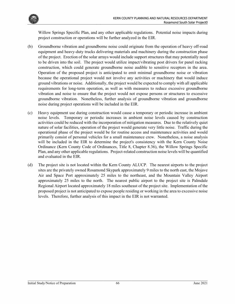
KERN COUNTY PLANNING AND NATURAL RESOURCES DEPARTMENT
Rosamond South Solar Project0
Initial Study/Notice of Preparation 66 June 2021
Willow Springs Specific Plan, and any other applicable regulations. Potential noise impacts during project construction or operations will be further analyzed in the EIR.
(b) Groundborne vibration and groundborne noise could originate from the operation of heavy off-road equipment and heavy-duty trucks delivering materials and machinery during the construction phase of the project. Erection of the solar arrays would include support structures that may potentially need to be driven into the soil. The project would utilize impact/vibrating post drivers for panel racking construction, which could generate groundborne noise audible to sensitive receptors in the area. Operation of the proposed project is anticipated to emit minimal groundborne noise or vibration because the operational project would not involve any activities or machinery that would induce ground vibrations or noise. Additionally, the project would be expected to comply with all applicable requirements for long-term operation, as well as with measures to reduce excessive groundborne vibration and noise to ensure that the project would not expose persons or structures to excessive groundborne vibration. Nonetheless, further analysis of groundborne vibration and groundborne noise during project operations will be included in the EIR.
(c) Heavy equipment use during construction would cause a temporary or periodic increase in ambient noise levels. Temporary or periodic increases in ambient noise levels caused by construction activities could be reduced with the incorporation of mitigation measures. Due to the relatively quiet nature of solar facilities, operation of the project would generate very little noise. Traffic during the operational phase of the project would be for routine access and maintenance activities and would primarily consist of personal vehicles for a small maintenance crew. Nonetheless, a noise analysis will be included in the EIR to determine the project's consistency with the Kern County Noise Ordinance (Kern County Code of Ordinances, Title 8, Chapter 8.36), the Willow Springs Specific Plan, and any other applicable regulations. Project-related construction noise levels will be quantified and evaluated in the EIR.
(d) The project site is not located within the Kern County ALUCP. The nearest airports to the project sites are the privately owned Rosamond Skypark approximately 9 miles to the north east, the Mojave Air and Space Port approximately 25 miles to the northeast, and the Mountain Valley Airport approximately 25 miles to the north. The nearest public airport to the project site is Palmdale Regional Airport located approximately 18 miles southeast of the project site. Implementation of the proposed project is not anticipated to expose people residing or working in the area to excessive noise levels. Therefore, further analysis of this impact in the EIR is not warranted.
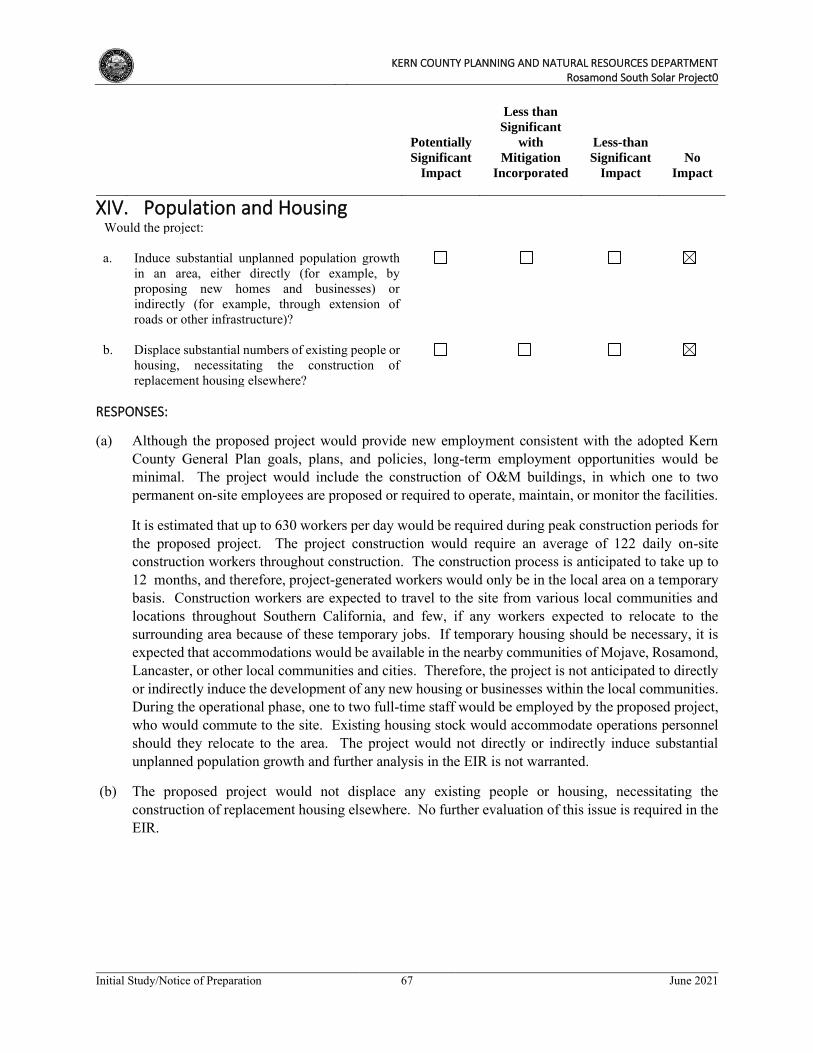
KERN COUNTY PLANNING AND NATURAL RESOURCES DEPARTMENT
Rosamond South Solar Project0
Initial Study/Notice of Preparation 67 June 2021
Potentially
Significant
Impact
Less than
Significant
with
Mitigation
Incorporated
Less-than
Significant
Impact
No
Impact
XIV. Population and Housing
Would the project: a. Induce substantial unplanned population growth
in an area, either directly (for example, by proposing new homes and businesses) or indirectly (for example, through extension of roads or other infrastructure)?
b. Displace substantial numbers of existing people or
housing, necessitating the construction of replacement housing elsewhere?
RESPONSES:
(a) Although the proposed project would provide new employment consistent with the adopted Kern County General Plan goals, plans, and policies, long-term employment opportunities would be minimal. The project would include the construction of O&M buildings, in which one to two permanent on-site employees are proposed or required to operate, maintain, or monitor the facilities.
It is estimated that up to 630 workers per day would be required during peak construction periods for the proposed project. The project construction would require an average of 122 daily on-site construction workers throughout construction. The construction process is anticipated to take up to 12 months, and therefore, project-generated workers would only be in the local area on a temporary basis. Construction workers are expected to travel to the site from various local communities and locations throughout Southern California, and few, if any workers expected to relocate to the surrounding area because of these temporary jobs. If temporary housing should be necessary, it is expected that accommodations would be available in the nearby communities of Mojave, Rosamond, Lancaster, or other local communities and cities. Therefore, the project is not anticipated to directly or indirectly induce the development of any new housing or businesses within the local communities. During the operational phase, one to two full-time staff would be employed by the proposed project, who would commute to the site. Existing housing stock would accommodate operations personnel should they relocate to the area. The project would not directly or indirectly induce substantial unplanned population growth and further analysis in the EIR is not warranted.
(b) The proposed project would not displace any existing people or housing, necessitating the construction of replacement housing elsewhere. No further evaluation of this issue is required in the EIR.
KERN COUNTY PLANNING AND NATURAL RESOURCES DEPARTMENT
Rosamond South Solar Project0
Initial Study/Notice of Preparation 68 June 2021
Potentially
Significant
Impact
Less than
Significant
with
Mitigation
Incorporated
Less-than
Significant
Impact
No
Impact
XV. Public Services
Would the project: a. Result in substantial adverse physical impacts
associated with the provision of new or physically altered governmental facilities, need for new or physically altered governmental facilities, the construction of which could cause significant environmental impacts, in order to maintain acceptable service ratios, response times, or to other performance objectives for any of the public services:
i. Fire protection? ii. Police protection? iii. Schools? iv. Parks? v. Other public facilities?
RESPONSES:
(a)(i) The Kern County Fire Department (KCFD) provides fire suppression and emergency medical services to the project area. The project site would be served by Fire Station #15, located at 3219 35th West Street in Rosamond. Adherence to all applicable regulations would reduce wildfire ignitions and prevent the spread of wildfires. However, construction and operation activities may result in increased demand for firefighting services in the area. Therefore, the potential impact on fire services from construction and operation of the project is considered potentially significant and will be further evaluated in the EIR.
(a)(ii) Law enforcement and public safety services in the project area are provided by the Kern County Sheriff’s Office (KCSO). The project site would be served by the Rosamond Substation at 3179 35th Street West. Although the potential is low, the proposed project may attract vandals or other security risks, and construction activities would result in increases in traffic volumes along surrounding roads, which could increase demand on law enforcement services. On-site security measures (i.e., on-site monitoring equipment, gated access, motion sensor lighting) would be provided and access to the project site during construction and operation would be restricted, thereby minimizing the need for police services. Nonetheless, project impacts on local sheriff services could be potentially significant. This issue will be evaluated in the EIR.
(a)(iii) During project construction, a relatively small number of construction workers would be required. It is expected that most of these workers would live in the broader region and commute to the project site from surrounding communities where their children are already enrolled in school and where
KERN COUNTY PLANNING AND NATURAL RESOURCES DEPARTMENT
Rosamond South Solar Project0
Initial Study/Notice of Preparation 69 June 2021
their contribution to local taxes, including funds for schools, is assessed locally. The proposed project would not require employees or their children to relocate to the project area. Therefore, substantial temporary increases in population that would adversely affect local school populations are not expected. Likewise, the operational workforce is small (approximately two full-time positions) and not expected to generate a permanent increase in population that would impact school populations. Therefore, no significant impacts to schools are anticipated to occur and further analysis is not warranted in the EIR.
(a)(iv) The population increase that would be experienced during the construction phase of the proposed project would be temporary and limited to construction workers at the project site. Such conditions would not result in a substantial new demand for parks or recreational facilities. The number of employees required for project operations would be minimal and they would not likely frequent any public parks during, before, or after their work shifts. The two full-time equivalent (FTE) employees would not result in construction of numerous new housing units that could significantly increase the local population and related demand for public parkland. Therefore, no significant impacts to parks are anticipated to occur, and further analysis of this issue is not warranted in the EIR.
(a)(v) Implementation of the proposed project may have impacts on the ability of the County to provide adequate county-wide comprehensive public facility services. Unlike other businesses in California, large scale solar has an exclusion from property taxes on their equipment. This property tax exclusion results in the project not providing the revenue needed to provide services and facilities for both the project and the communities that prevent decline of the physical neighborhoods in unincorporated Kern County. This is a direct impact from the project structure and the land if built with another type of land use would produce property tax revenue to provide necessary services and facilities and prevent physical decline of homes and businesses due to vacancy and inability for response for all services, including code enforcement to law enforcement, fire, roads and health and safety issues such as elderly care and child protection services. The cumulative impacts of this active solar tax exclusion over the life of the over 36,000 acres of projects has resulted in a loss to the General Fund over the last 10 years of over $103 million and deepened the on-going fiscal emergency of the County. Public policies in the Kern County General Plan and Mojave Specific Plan require development to address economic deficiencies in public services and facilities costs. Therefore, the proposed project’s impacts on public facilities are potentially significant and will be evaluated in the EIR.
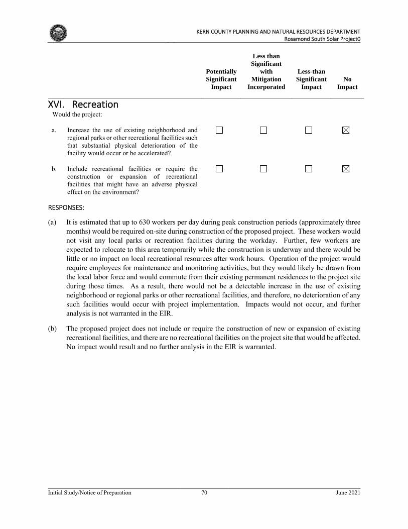
KERN COUNTY PLANNING AND NATURAL RESOURCES DEPARTMENT
Rosamond South Solar Project0
Initial Study/Notice of Preparation 70 June 2021
Potentially
Significant
Impact
Less than
Significant
with
Mitigation
Incorporated
Less-than
Significant
Impact
No
Impact
XVI. Recreation
Would the project: a. Increase the use of existing neighborhood and
regional parks or other recreational facilities such that substantial physical deterioration of the facility would occur or be accelerated?
b. Include recreational facilities or require the
construction or expansion of recreational facilities that might have an adverse physical effect on the environment?
RESPONSES:
(a) It is estimated that up to 630 workers per day during peak construction periods (approximately three months) would be required on-site during construction of the proposed project. These workers would not visit any local parks or recreation facilities during the workday. Further, few workers are expected to relocate to this area temporarily while the construction is underway and there would be little or no impact on local recreational resources after work hours. Operation of the project would require employees for maintenance and monitoring activities, but they would likely be drawn from the local labor force and would commute from their existing permanent residences to the project site during those times. As a result, there would not be a detectable increase in the use of existing neighborhood or regional parks or other recreational facilities, and therefore, no deterioration of any such facilities would occur with project implementation. Impacts would not occur, and further analysis is not warranted in the EIR.
(b) The proposed project does not include or require the construction of new or expansion of existing recreational facilities, and there are no recreational facilities on the project site that would be affected. No impact would result and no further analysis in the EIR is warranted.
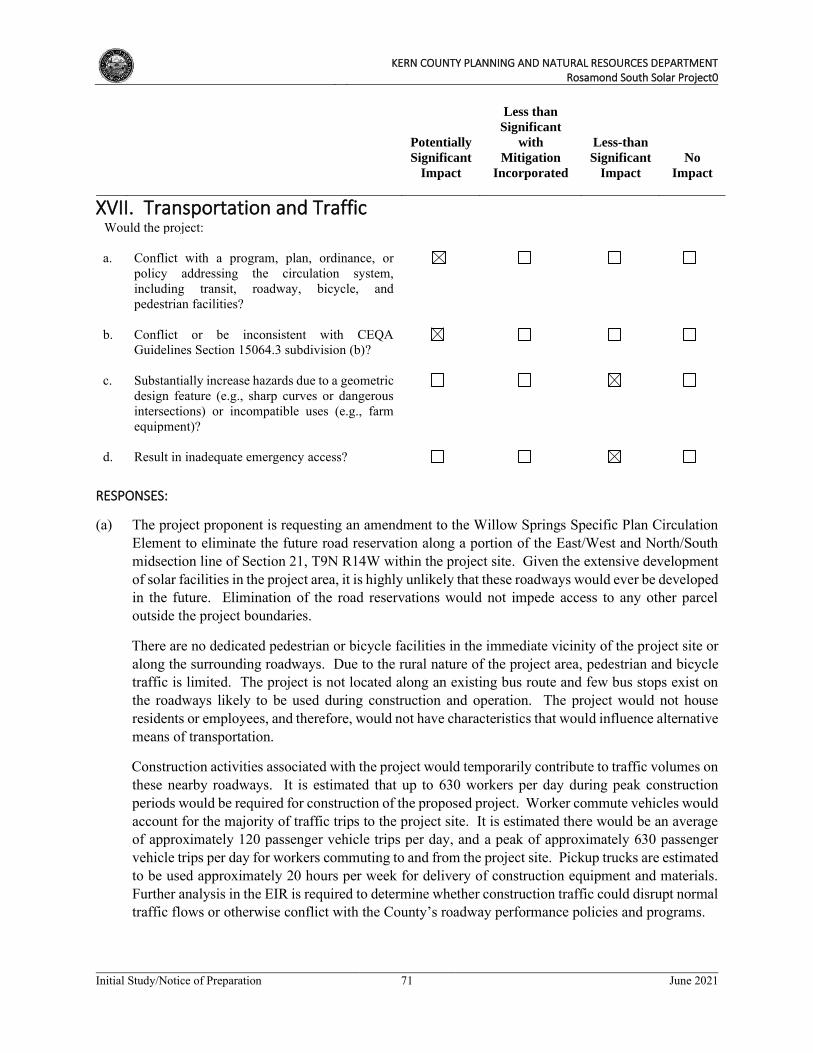
KERN COUNTY PLANNING AND NATURAL RESOURCES DEPARTMENT
Rosamond South Solar Project0
Initial Study/Notice of Preparation 71 June 2021
Potentially
Significant
Impact
Less than
Significant
with
Mitigation
Incorporated
Less-than
Significant
Impact
No
Impact
XVII. Transportation and Traffic
Would the project: a. Conflict with a program, plan, ordinance, or
policy addressing the circulation system, including transit, roadway, bicycle, and pedestrian facilities?
b. Conflict or be inconsistent with CEQA
Guidelines Section 15064.3 subdivision (b)?
c. Substantially increase hazards due to a geometric
design feature (e.g., sharp curves or dangerous intersections) or incompatible uses (e.g., farm equipment)?
d. Result in inadequate emergency access?
RESPONSES:
(a) The project proponent is requesting an amendment to the Willow Springs Specific Plan Circulation Element to eliminate the future road reservation along a portion of the East/West and North/South midsection line of Section 21, T9N R14W within the project site. Given the extensive development of solar facilities in the project area, it is highly unlikely that these roadways would ever be developed in the future. Elimination of the road reservations would not impede access to any other parcel outside the project boundaries.
There are no dedicated pedestrian or bicycle facilities in the immediate vicinity of the project site or along the surrounding roadways. Due to the rural nature of the project area, pedestrian and bicycle traffic is limited. The project is not located along an existing bus route and few bus stops exist on the roadways likely to be used during construction and operation. The project would not house residents or employees, and therefore, would not have characteristics that would influence alternative means of transportation.
Construction activities associated with the project would temporarily contribute to traffic volumes on these nearby roadways. It is estimated that up to 630 workers per day during peak construction periods would be required for construction of the proposed project. Worker commute vehicles would account for the majority of traffic trips to the project site. It is estimated there would be an average of approximately 120 passenger vehicle trips per day, and a peak of approximately 630 passenger vehicle trips per day for workers commuting to and from the project site. Pickup trucks are estimated to be used approximately 20 hours per week for delivery of construction equipment and materials. Further analysis in the EIR is required to determine whether construction traffic could disrupt normal traffic flows or otherwise conflict with the County’s roadway performance policies and programs.
KERN COUNTY PLANNING AND NATURAL RESOURCES DEPARTMENT
Rosamond South Solar Project0
Initial Study/Notice of Preparation 72 June 2021
Operation of the project would require up to 2 FTE employees, who would commute to the project site. Trip generation during the operational phase, which also includes occasional truck deliveries during maintenance activities, would not likely result in a substantial increase in traffic in relation to the existing roadway capacity nor congestion at intersections. The potential impacts on the local roadway system from construction related vehicle trips and the project’s operational traffic on the area roadway system will be further evaluated in the EIR.
(b) CEQA Guidelines section 15064.3, subdivision (b) was adopted in December 2018 by the California Natural Resources Agency. These revisions to the CEQA Guidelines criteria for determining the significance of transportation impacts are primarily focused on projects within transit priority areas, and shifts the focus from driver delay to reduction of vehicular greenhouse gas emissions through creation of multimodal networks, and creation of a mix of land uses that can facilitate fewer and shorter vehicle trips. Vehicle miles traveled (VMT) is a measure of the total number of miles driven for various purposes and is sometimes expressed as an average per trip or per person. Construction traffic would be temporary and would not permanently affect VMT characteristics in this part of Kern County or elsewhere. Long-term, operational traffic would be limited, with a small work force of approximately two FTE employees. It is not known where the employees would live or how long their commuting trips would be. According to technical guidance issued by the Office of Planning and Research, projects generating less than 110 or fewer daily vehicle trips may be presumed to have a less than significant impact involving VMT. Further analysis of the operational VMT characteristics of the project is required to determine whether the project is considered a “low-VMT” project due to small daily traffic volumes alone, or whether more extensive analysis is warranted. An assessment of the project’s VMT characteristics will be provided in the EIR, to ensure consistency with state and local guidance.
(c) The project proposes access from existing roads including Rosamond Boulevard, Avenue A, Avenue D, Astoria Avenue, Gaskell Road, Holiday Avenue, 100th Street West, 130th Street West, 140th Street West and 170th Street West. During construction, especially during peak periods of heavy truck traffic and peak levels of construction workers, there is a potential for conflicts between construction traffic and normal traffic flows, especially at intersections where queuing could occur. This requires further analysis in the EIR.
No new roadway design or features (i.e., sharp curves, dangerous intersections, or other hazardous features) would be required that could result in transportation-related hazards or safety concerns. All new driveways connecting to existing adjacent streets must be designed in accordance with the County’s street standards that assure safe ingress/egress. The project buildings and other structures would be set back from adjacent access roadways as required by the Kern County Zoning Ordinance. Given these considerations, significant impacts related to increased hazards are not anticipated to occur; however, additional analysis will be included in the EIR.
(d) The project site and project area are accessible via a number of existing roads, with alternative access roads allowing easy access in the event of an emergency. Emergency vehicle access must be maintained at all times throughout construction activities, in accordance with the County’s routine/standard construction specifications. County building inspectors would conduct periodic site inspections to confirm there are adequate provisions in place to maintain emergency access for fire, emergency medical and Sheriff response units. Further, construction activities would not be permitted to impede emergency access to any local roadways or surrounding properties. Construction period impacts are considered less than significant but will be further analyzed in the EIR.
KERN COUNTY PLANNING AND NATURAL RESOURCES DEPARTMENT
Rosamond South Solar Project0
Initial Study/Notice of Preparation 73 June 2021
Operations of the project would not affect emergency access as the number of daily trips would have a minimal effect on traffic volumes and overrides of project site access gates for emergency access to the facility would be installed. Although no significant operational impacts related to emergency access are anticipated to occur, further analysis of this issue will be provided in the EIR.
KERN COUNTY PLANNING AND NATURAL RESOURCES DEPARTMENT
Rosamond South Solar Project0
Initial Study/Notice of Preparation 74 June 2021
Potentially
Significant
Impact
Less than
Significant
with
Mitigation
Incorporated
Less-than
Significant
Impact
No
Impact
XVIII. Tribal Cultural Resources
Would the project: a. Would the project cause a substantial adverse
change in the significance of a tribal cultural resource, defined in Public Resources Code section 21074 as either a site, feature, place, cultural landscape that is geographically defined in terms of the size and scope of the landscape, sacred place, or object with cultural value to a California Native American tribe, and that is:
i. Listed or eligible for listing in the
California Register of Historical Resources, or in a local register or historical resources as defined in Public Resources Code section 5020.1(k), or
ii. A resource determined by the lead
agency in its discretion and supported by substantial evidence, to be significant pursuant to criteria set forth in subdivision (c) of Public Resources Code Section 5024.1. In applying the criteria set forth in subdivision (c) of Public Resources Code Section 5024.1, the lead agency shall consider the significance of the resource to a California Native American tribe.
RESPONSES:
(ai,aii) As there are known archaeological resources associated with Native American tribes in the project area, there is the potential for tribal cultural resources to also exist either on-site or on surrounding lands. Therefore, the proposed project has the potential to impact tribal cultural resources during site clearance and earthmoving activities. All tribes with possible cultural affiliation and interest within the project area will be notified pursuant to the requirements of Assembly Bill 52, and consultation with the potentially affected tribes will occur, as appropriate, between the County and the tribes. Further evaluation in the EIR is warranted to identify potential impacts to tribal cultural resources and to formulate avoidance or mitigation measures, if applicable.
KERN COUNTY PLANNING AND NATURAL RESOURCES DEPARTMENT
Rosamond South Solar Project0
Initial Study/Notice of Preparation 75 June 2021
Potentially
Significant
Impact
Less than
Significant
with
Mitigation
Incorporated
Less-than
Significant
Impact
No
Impact
XIX. Utilities and Service Systems
Would the project: a. Require or result in the relocation or
construction of new or expanded water, wastewater treatment or storm water drainage, electric power, natural gas, or telecommunications facilities, the construction or relocation of which could cause significant environmental effects?
b. Have sufficient water supplies available to serve
the project and reasonably foreseeable future development during normal, dry and multiple dry years?
c. Result in a determination by the wastewater
treatment provider that serves or may serve the project that it has adequate capacity to serve the project’s projected demand in addition to the provider’s existing commitments?
d. Generate solid waste in excess of State or local
standards, or in excess of the capacity of local infrastructure, or otherwise impair the attainment of solid waste reduction goals?
e. Comply with federal, state, and local
management and reduction statutes and regula-tions related to solid waste?
RESPONSES:
(a) The project would generate a minimal volume of wastewater during construction. During construction activities, wastewater would be contained within portable toilet facilities and disposed of off-site at an approved facility. During operations, wastewater generated by the project would be disposed of on-site by septic system(s). Soil suitability for a septic tank leach field and any related environmental impacts will be addressed in the response to the topic of Geology and Soils, threshold (e). The proposed project would not require or result in the relocation or construction of new or expanded municipal wastewater facilities, and no connection to a public wastewater system is required or proposed. Impacts would be less than significant in this regard; however, further analysis in the EIR will be provided.
The proposed project does not require expanded or new storm drainage facilities because the proposed solar facility would not generate a significant increase in the amount of impervious surfaces that would increase runoff during storm events. Water from solar panel washing and from dust
KERN COUNTY PLANNING AND NATURAL RESOURCES DEPARTMENT
Rosamond South Solar Project0
Initial Study/Notice of Preparation 76 June 2021
suppression activities would continue to percolate through the ground, as a majority of the surfaces within the project site would remain pervious. These activities would not substantially increase the amount of storm water runoff from the site. Impacts are considered to be less than significant; however, further analysis in the EIR will be provided.
The proposed project is not anticipated to result in a significant increase in water demand/use; however, water will be needed for solar panel washing and dust suppression. Water is anticipated to be delivered via truck from an off-site source(s). Potential impacts to groundwater resources will be addressed in the response to the topic of Hydrology and Water Quality, threshold (b). Impacts are not anticipated to be potentially significant, however, further analysis in the EIR is warranted.
The proposed project would involve construction of a PV solar facility that would generate electrical energy that would be transmitted to the regional electrical energy supply grid. Analyses of various environmental effects associated with construction and operation of these facilities will be provided throughout the EIR, with respect to numerous topics. The project would include on-site telecommunications facilities to facilitate collection and transmission of meteorological data and data regarding performance of the solar arrays. Impacts associated with construction of the telecommunications and transmission line facilities will be evaluated in the EIR. The proposed project would not use natural gas. The proposed project would not otherwise generate the demand for or require or result in the relocation or construction of new or expanded off-site electric power, natural gas, or telecommunications facilities that would in turn, result in a significant impact to the environment. Impacts are considered to be less than significant; however, further analysis in the EIR will be provided.
(b) Water demand for O&M domestic use is not expected to exceed 18 acre-feet per year. Water usage during construction, primarily for dust-suppression purposes, is not expected to exceed 450 acre-feet over the 12-month construction phase. Water is anticipated to be delivered via truck from an off-site source(s). A Will Serve letter has been obtained from a private local water purveyor, indicating their capacity and willingness to provide water for construction and operation of the project. The project is not anticipated to impact water supplies and new or expanded entitlements would not be required. However, this impact will be addressed further in the EIR.
(c) As stated above, portable toilets would provide for wastewater disposal during project construction and no connection to a public system for wastewater treatment would be required. Due to the limited number of employees for project operations, the project would not generate a substantial amount of wastewater. = Therefore, the project would not adversely affect any existing wastewater treatment facilities. Impacts would be less than significant and further analysis of this issue is not warranted in the EIR.
(d) The proposed project is not expected to generate a significant amount of solid wastes because of the small number of workers and the absence of activities that would generate wastes on an ongoing basis. Materials brought to the project site would be used to construct facilities, and few residual waste materials are expected. Non-hazardous construction refuse and solid waste would be either collected and recycled per the Construction Waste Management Plan or disposed of at a local Class III landfill, while any hazardous waste generated during construction would be disposed of at an approved off-site location. The closest Class III municipal landfill is the Ridgecrest Recycling and Sanitary Landfill (RSLF) which is located approximately 5.5 miles southeast of the project site. Solid waste from the site would therefore be transported to this landfill for disposal. The RSLF has a
KERN COUNTY PLANNING AND NATURAL RESOURCES DEPARTMENT
Rosamond South Solar Project0
Initial Study/Notice of Preparation 77 June 2021
remining capacity of 5,037,428 cubic yards, with an anticipated closure date of 2045 (CalRecycle, 2021). Therefore, the landfill has capacity to accommodate solid waste generated by project construction and operation. It is not anticipated that the amount of solid waste generated by the proposed project would exceed the capacity of local landfills needed to accommodate the waste. Impacts are anticipated to be less than significant and no further analysis in the EIR is warranted.
(e) The proposed project would generate solid waste during construction, operation, and decommissioning, thus requiring the consideration of waste reduction and recycling measures. The 1989 California Integrated Waste Management Act (AB 939) requires Kern County to attain specific waste diversion goals. In addition, the California Solid Waste Reuse and Recycling Access Act of 1991, as amended, requires expanded or new development projects to incorporate storage areas for recycling bins into the proposed project design. The proposed project would be required to comply with the 1989 California Integrated Waste Management Act and the 1991 California Solid Waste Reuse and Recycling Access Act of 1991. Though impacts are anticipated to be less than significant, further analysis of the pertinent solid waste reduction and management regulations applicable to this project will be included in the EIR.
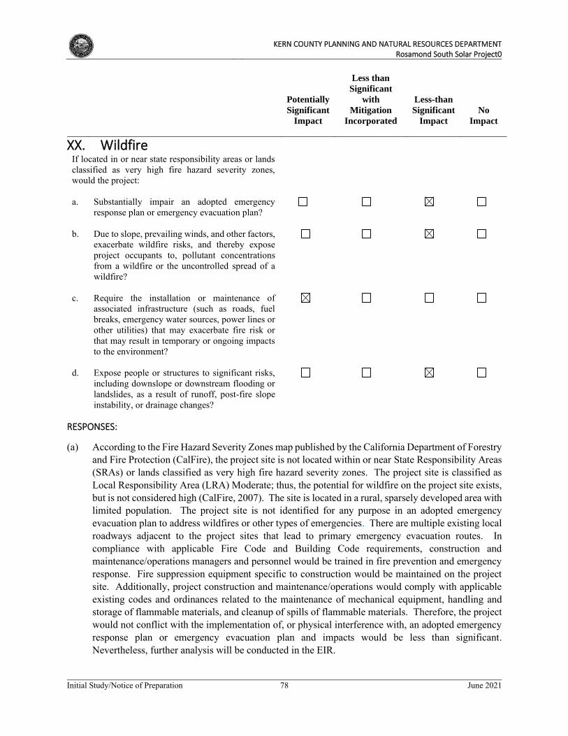
KERN COUNTY PLANNING AND NATURAL RESOURCES DEPARTMENT
Rosamond South Solar Project0
Initial Study/Notice of Preparation 78 June 2021
Potentially
Significant
Impact
Less than
Significant
with
Mitigation
Incorporated
Less-than
Significant
Impact
No
Impact
XX. Wildfire
If located in or near state responsibility areas or lands classified as very high fire hazard severity zones, would the project:
a. Substantially impair an adopted emergency
response plan or emergency evacuation plan?
b. Due to slope, prevailing winds, and other factors,
exacerbate wildfire risks, and thereby expose project occupants to, pollutant concentrations from a wildfire or the uncontrolled spread of a wildfire?
c. Require the installation or maintenance of
associated infrastructure (such as roads, fuel breaks, emergency water sources, power lines or other utilities) that may exacerbate fire risk or that may result in temporary or ongoing impacts to the environment?
d. Expose people or structures to significant risks,
including downslope or downstream flooding or landslides, as a result of runoff, post-fire slope instability, or drainage changes?
RESPONSES:
(a) According to the Fire Hazard Severity Zones map published by the California Department of Forestry and Fire Protection (CalFire), the project site is not located within or near State Responsibility Areas (SRAs) or lands classified as very high fire hazard severity zones. The project site is classified as Local Responsibility Area (LRA) Moderate; thus, the potential for wildfire on the project site exists, but is not considered high (CalFire, 2007). The site is located in a rural, sparsely developed area with limited population. The project site is not identified for any purpose in an adopted emergency evacuation plan to address wildfires or other types of emergencies. There are multiple existing local roadways adjacent to the project sites that lead to primary emergency evacuation routes. In compliance with applicable Fire Code and Building Code requirements, construction and maintenance/operations managers and personnel would be trained in fire prevention and emergency response. Fire suppression equipment specific to construction would be maintained on the project site. Additionally, project construction and maintenance/operations would comply with applicable existing codes and ordinances related to the maintenance of mechanical equipment, handling and storage of flammable materials, and cleanup of spills of flammable materials. Therefore, the project would not conflict with the implementation of, or physical interference with, an adopted emergency response plan or emergency evacuation plan and impacts would be less than significant. Nevertheless, further analysis will be conducted in the EIR.
KERN COUNTY PLANNING AND NATURAL RESOURCES DEPARTMENT
Rosamond South Solar Project0
Initial Study/Notice of Preparation 79 June 2021
(b) Slope and wind can influence the rate at which wildfire spreads. Given the project site’s generally flat topography, the proposed project is not anticipated to expose project occupants to pollutant concentrations from a wildfire or the uncontrolled spread of a wildfire due to sloping topography. Adherence to applicable regulations would reduce wildfire ignitions and prevent the spread of wildfires. The project proponent/operator would be required to develop and implement a Fire Safety Plan that contains notification procedures and emergency fire precautions consistent with the 2019 California Fire Code and Kern County Fire Code for use during construction, operation and decommissioning. However, as the project would have the potential to expose occupants (i.e., at the O&M facilities) to pollutant concentrations from a wildfire or the uncontrolled spread of wildfire due to prevailing winds or other factors, further analysis will be conducted in the EIR.
(c) The project would construct infrastructure that requires fire protection and, as a result, will include fire prevention and suppression measures and equipment. The proposed project involves the development of a solar energy generation and storage facility. The proposed project would include the construction of power transmission lines, inverters, roads, and an energy storage facility. Due to the presence of electrical equipment on site, the proposed project has the potential to exacerbate wildfire risk and will be further evaluated in the EIR.
(d) The project site is not considered to be a high risk area for landslides as it is relatively flat; therefore, there would be no impacts involving landslides or other slope failures, or other drainage changes that would expose people or structures to significant risks in a post-wildfire burned landscape condition. No further analysis is warranted in the EIR relative to this issue.
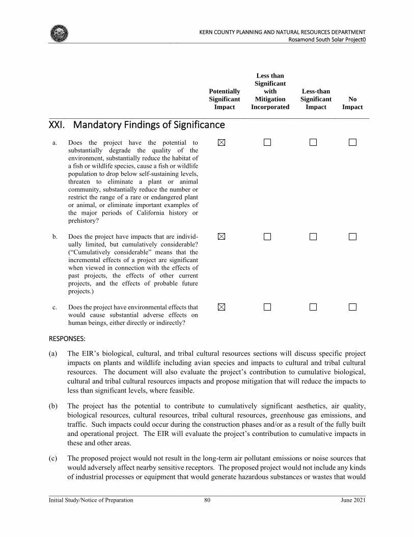
KERN COUNTY PLANNING AND NATURAL RESOURCES DEPARTMENT
Rosamond South Solar Project0
Initial Study/Notice of Preparation 80 June 2021
Potentially
Significant
Impact
Less than
Significant
with
Mitigation
Incorporated
Less-than
Significant
Impact
No
Impact
XXI. Mandatory Findings of Significance
a. Does the project have the potential to
substantially degrade the quality of the environment, substantially reduce the habitat of a fish or wildlife species, cause a fish or wildlife population to drop below self-sustaining levels, threaten to eliminate a plant or animal community, substantially reduce the number or restrict the range of a rare or endangered plant or animal, or eliminate important examples of the major periods of California history or prehistory?
b. Does the project have impacts that are individ-
ually limited, but cumulatively considerable? (“Cumulatively considerable” means that the incremental effects of a project are significant when viewed in connection with the effects of past projects, the effects of other current projects, and the effects of probable future projects.)
c. Does the project have environmental effects that
would cause substantial adverse effects on human beings, either directly or indirectly?
RESPONSES:
(a) The EIR’s biological, cultural, and tribal cultural resources sections will discuss specific project impacts on plants and wildlife including avian species and impacts to cultural and tribal cultural resources. The document will also evaluate the project’s contribution to cumulative biological, cultural and tribal cultural resources impacts and propose mitigation that will reduce the impacts to less than significant levels, where feasible.
(b) The project has the potential to contribute to cumulatively significant aesthetics, air quality, biological resources, cultural resources, tribal cultural resources, greenhouse gas emissions, and traffic. Such impacts could occur during the construction phases and/or as a result of the fully built and operational project. The EIR will evaluate the project’s contribution to cumulative impacts in these and other areas.
(c) The proposed project would not result in the long-term air pollutant emissions or noise sources that would adversely affect nearby sensitive receptors. The proposed project would not include any kinds of industrial processes or equipment that would generate hazardous substances or wastes that would
KERN COUNTY PLANNING AND NATURAL RESOURCES DEPARTMENT
Rosamond South Solar Project0
Initial Study/Notice of Preparation 81 June 2021
threaten the well-being of people on- or off-site. However, short-term construction activities could result in temporary increases in pollutant concentrations and off-site noise impacts. Pollutants of primary concern commonly associated with construction-related activities include toxic air contaminants gaseous emissions of criteria pollutants, and fugitive dust. Within the project area, the potential for increased occurrences of Valley Fever is also of concern. Human health impacts from the short-term cumulative contribution to air quality impacts from project construction will be further evaluated in the EIR.
KERN COUNTY PLANNING AND NATURAL RESOURCES DEPARTMENT
Rosamond South Solar Project0
Initial Study/Notice of Preparation 82 June 2021
4. REFERENCES
____. 1999. Mineral Land Classification of Southeastern Kern County Map. file:///C:/Users/nmarotz/Downloads/OFR_99-15_Plate2A%20(2).pdf.
CalFire (California Department of Forestry and Fire Protection). Fire Hazard Severity Zone Maps. 2007. https://osfm.fire.ca.gov/media/6686/fhszl06_1_map15.pdf.
CalRecycle. SWIS Facility Detail, Ridgecrest Recycling & Sanitary Landfill (15-AA-0059). 2021. https://www2.calrecycle.ca.gov/SolidWaste/SiteActivity/Details/3893?siteID=707. Caltrans (California Department of Transportation). Scenic Highways – List of Officially Designated State Scenic Highways. 2021. https://dot.ca.gov/programs/design/lap-landscape-architecture-and-community-livability/lap-liv-i-scenic-highways
DOC(California Department of Conservation), Kern County Important Farmland 2018. 2018. https://www.conservation.ca.gov/dlrp/fmmp/Pages/Kern.aspx.
County of Kern Planning Department, Agricultural Preserve map. 2006. https://drecp.databasin.org/datasets/9c84704f1e564efe87ba22849e94eb3f/
CGS (California Geological Survey), Earthquake Zones of Required Investigation. 2021. https://maps.conservation.ca.gov/cgs/EQZApp/
FEMA (Federal Emergency Management Agency). Map 06029C4000E. 2008a
FEMA (Federal Emergency Management Agency). Map 06029C3975E. 2008a
Geotracker. 2021. https://geotracker.waterboards.ca.gov/.
Kern County General Plan. 2009. https://www.sandiegocounty.gov/content/sdc/pds/generalplan.html.
Las Angeles County. Palmdale Airport Influence Area map. 2003.USGS (United States Geological Survey).Fairmont Butte, California Quadrangle.2018a
USGS (United States Geological Survey).Little Buttes, California Quadrangle. 2018b