placemaking in waterfront communities vibrant coastal communities techniques, tools and resources to...
TRANSCRIPT

Creating Vibrant Coastal CommunitiesTechniques, Tools and Resources to Advance Placemaking in
Muskegon, MIJuly 11, 2013
Elizabeth DurfeeNOAA Coastal Management Fellow
Placemaking in Waterfront Communities

2
Outline
• Placemaking review• Waterfront planning• Placemaking in waterfront communities -Marquette -Sault Ste. Marie -Port Huron -Fishtown -Charlevoix -Manistique• Tools• Resources

3
Placemaking
• Quality places• Coordinated• Regional approach• Leveraging assets• Creating more options• Connectivity• Form• ‘P’ vs ‘p’ placemaking
economic development + higher quality places + improved overall quality of life
Marriott

4
Waterfront Planning
Sea Grant
Fishtown, Leland, MI

5
Placemaking in Waterfront Communities
opportunity

6
Placemaking in Waterfront Communities
need

7
Planning in Coastal Communities
sustainability planning

8
Marquette
USACE

9
• Harbor study• Property acquisition• Conversion of rail yard and tracks to trail• Community engagement and visioning• Form-based code• Marina studies and improvements• Mixed use redevelopment• Recreation plan• SGRAT workshop• Master plan updates
Marquette Community Master Plan
circa 1938
2004
Superior View
Mattson Lower Harbor Park
Marquette Dock Company Coal Dock
Actions

10
Goals
• Increase access to waterfront• Physical connectivity between downtown and waterfront• Promote redevelopment in an environmentally sound manner• Reuse of underutilized waterfront • New downtown housing options• Maintain a working waterfront • Preserve and increase greenery

11
Marquette Community Master Plan
circa 1938
2004
Superior View
Mattson Lower Harbor Park
Marquette Dock Company Coal Dock
Actions
• Harbor study• Property acquisition• Conversion of rail yard and tracks to trail• Community engagement and visioning• Form-based code• Marina studies and improvements• Mixed use redevelopment• Recreation plan• SGRAT workshop• Master plan updates

12
Workshop FlexNorth LakeshoreGeneral FiveFounders FiveGeneral 3Working Waterfront ZoneParking Setback LineFuture ROWPublic Use Area
Waterfront Form-Based CodeForm-based code: an alternative to conventional zoning that uses physical form, rather than separation of uses, to regulate and establish standards for the built environment.

13
HEIGHT SITING
ELEMENTS USE

14

15
Traditional Neighborhood-Residential CommercialTraditional Neighborhood-Residential Gateway Corridor-Mixed UseWaterfront-Mixed UseWaterfront-Recreation ConservationPowerplant-Special District

16
Marquette Community Master Plan
circa 1938
2004
Superior View
Mattson Lower Harbor Park
Marquette Dock Company Coal Dock
Actions
• Harbor study• Property acquisition• Conversion of rail yard and tracks to trail• Community engagement and visioning• Form-based code• Marina studies and improvements• Mixed use redevelopment• Recreation plan• SGRAT workshop• Master plan updates

17
Waterfront Smart Growth
Smart Growth Principles
• Mix land uses• Take advantage of compact design• Provide a range of housing choices• Create walkable communities• Foster distinctive, attractive communities• Preserve open space + critical environmental areas• Direct development toward existing communities• Provide a variety of transportation options• Make development decisions predictable + fair• Encourage community + stakeholder collaboration
I
SM
AR
T G
RO
WT
H
FOR COASTAL
AND
COMMUNITIES
WATERFRONT

18
MICHIGAN
the waterfront. The waterfront may be dominated by oneor two types of uses that are spread out, instead of a mix of uses placed close together that draw many people. Or it mayhave transitioned from water-dependent uses, like fisheries,to non-water-dependent uses such as condo constructionthat block scenic views or access to natural resources.
ONE CITY’S EXPERIENCE
The City of Alpena and its surrounding township are located in northeastern Michigan along LakeHuron’s Thunder Bay and Thunder Bay River.
“When we took the self-assessment, we were quitepleased to see our successes,” says Greg Sundin, thecity’s director of planning and development. Alpena’swaterfront area includes a picturesque downtown withcommercial, recreational, and tourism sectors; an 18.5-mile loop for biking, walking, and inline skating; and easyaccess to Thunder Bay National Marine Sanctuary.
Moreover, in 2010 a new zoning ordinance adopted by theCity of Alpena included a mixed-use waterfront developmentdistrict that encourages property ownership and water-relatedland uses while opening up public access to the waterfront.
“One thing the assessment made clear is that we neededa better working knowledge of how our local waterfrontregulation process related to state and federal regulations,” says Sundin. “As a result, we are strengthening this weak information link so we can better assist our riverfront propertyowners in understanding the permits they need, whichagencies have to be involved, and how to start the process.”
ONWARD AND UPWARD
With results in on the pilot, the project partners are nowconsidering a few adjustments that could make the tooland webpage more accessible and user friendly. A secondwave of self-assessment workshops is also planned.
One of the best experiences for Breederland is seeinghow communities use self-assessment to build smartgrowth momentum. “At the end of one workshop,people volunteered to stay afterward, and they decided
For more information on the Waterfront Smart Growth Readiness Assessment Tool, contact Wayne R. Beyea, extension specialist and instructor for Michigan State University’sd
School of Planning, Design, and Construction at [email protected] or (517) 432-7600. You can also learn more by visiting www.landpolicy.msu.edu/sgrat/pages/about.html.ll
The potential of Michigan’s waterfront communities toattract people for work, living, and play is hampered when waterfronts lack public access, walkability, or a mix of scenic and civic uses. Now a self-assessment tool and workshop can help communities support their waterfronts to besustainable and economically vibrant centers for public life.
“It’s exciting to see different parts of a community cometogether with a vision for their waterfront—seeing where they are right now and where they might wantto be,” says Mark Breederland, an extension educatorand workshop facilitator for Michigan Sea Grant.
Michigan’s Waterfront Smart Growth Readiness Assessment Tool is a voluntary self-audit that is undertaken by officials and stakeholders in waterfrontcommunities during facilitated workshops.
In 2010 and 2011, eight communities piloted the tool, and more communities will participate in the coming months. The online tool asks the community to rate its performance on waterfront smart growth principles such as compactcommunity design, the preservation of open space and natural beauty, community collaboration, and other factors (see “Smart Growth Coastal and Waterfront Elements”).
Each community later receives an objective score and writtensummary outlining its smart growth successes, benchmarking its progress, and suggesting potential areas of improvement.
Michigan’s Coastal Communities Assess Waterfront Smart Growth Success
The Michigan Citizen Planner, Planning and Zoning Center, and Land Policy Institute of Michigan StateUniversity (MSU) developed the waterfront smart growthtool, which was inspired by and adapted from MSU’soriginal Smart Growth Readiness Assessment Tool.
Michigan Sea Grant and MSU’s Greening MichiganInstitute facilitate the workshops and complete finalreports. Tool development was funded by NOAA’s Office of Ocean and Coastal Resource Management through Michigan’s Coastal Zone Management Program.
ASSETS AND CHALLENGES
With 3,288 miles of coast, second in length only to Alaska, Michigan has many waterfront assets.
The state’s coastal communities front four Great Lakes and provide homes for 44 percent of Michigan’s population.Moreover, an estimated 804,381 state jobs relate tothe Great Lakes and translate into $54 billion in annualemployee compensation, according to “Michigan’s GreatLakes Jobs,” a 2009 report by Michigan Sea Grant.
“Waterfront communities have a competitive advantagebecause people want to work and play there,” saysBreederland. “Many of our towns want to strengthentheir waterfront economy by preserving character andpublic access, but challenges may be in the way. This tool was developed to help them understand both their success and their problems, so they can succeed.”
Michigan’s challenges are shared by many other U.S. waterfront communities. For instance, the departure of big industry may have left brownfields and structural eyesores along
“It’s exciting to see different parts of acommunity come together with a vision for their waterfront—seeing where they are right now and where they might want to be.”
Mark Breederland,Michigan Sea Grant
Smart Growth Coastal and Waterfront Elements
Mix land uses, including water-dependent uses.
Take advantage of compact community design that enhances,
preserves, and provides access to waterfront resources.
Provide a range of housing opportunities and choices to
meet the needs of both seasonal and permanent residents.
Create walkable communities with physical and visual
access to and along the waterfront for public use.
Foster distinctive, attractive communities with a strong
senssense ofe of plaplace tce thathat capicapitalitalizeszes on ton the whe wateraterfronfront’st s heriheritagetage.
Preserve open space, farmland, natural beauty, and
the critical environmental areas that characterize and
support coastal and waterfront communities.
Strengthen and direct development toward existing
communities and encourage waterfront revitalization.
Provide a variety of land- and water-
based transportation options.
Make development decisions predictable, fair,
and cost-effective througgh consistent polp icies
and coordinated permitting processes.
Encourage community and stakeholder collaboration in
development decisions, ensuring that public interests in and
rights of access to the waterfront and coastal waters are upheld.
From Smart Growth for Coastal and Waterfront Communities at
www.coastalsmartgrowth.noaa.gov/smartgrowth_fullreport.pdf.
to meet twice a year from then on to track their progress with waterfront smart growth,” he says.
The self-assessment is designed so it can be repeated. “We have hopes,” Breederland says, “of going back to these communities a few years from now and watching them congratulatethemselves when their smart growth scores go up.”
Accessible walkways and scenic views are key elements for waterfront smart growth.
PHOTO COURTESY OF MICHIGAN SEA GRANT
8 | SEPTEMBER/OCTOBER 2012 | COASTAL SERVICES COASTAL SERVICES | SEPTEMBER/OCTOBER 2012 | 9
Waterfront SGRAT
NOAA Coastal Services Center Magazine FeatureSeptember | October 2012
“One thing the assessment made clear is that we needed a better working knowledge of how our local waterfront regulation process related to state and federal regulations...
As a result, we are strengthening this weak information link so we can better assist our riverfront property owners in understanding the permits they need, which agencies have to be involved, and how to start the process.”
Greg SundinDirector of Planning and Development, City of Alpena

19Lower Harbor and Downtown
Lake Superior

20

21

22

23

24

25
26
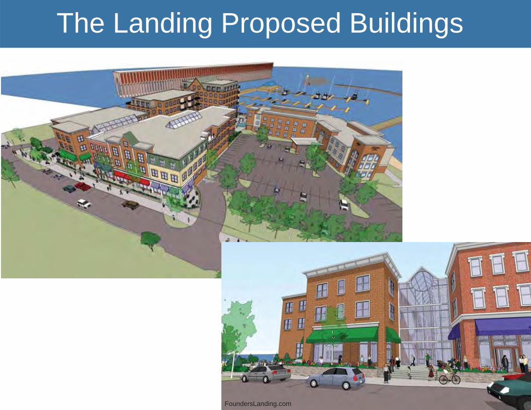
The Landing Proposed Buildings
FoundersLanding.com

27

28

29

30

31

32
Sault Ste. Marie
USACE

33
Flickr
Water Street
• Final design and reconstruction plan for historic Water Street
• CZMP grant funded• Leveraged history as a long standing
community• Created coastal walkway that links
natural resources, historical and cultural opportunities, and urban neighborhoods

34
PlacePlan Project
© 2013 Google

35
Goals
• Create transition zone that increases connectivity between downtown and tourist area
• Provide public gathering space • Generate interest and activity• Strengthen local and regional economy• Honor heritage• Leverage existing assets• 4 seasons, indoor-outdoor, fl exible space • Provide mix of uses

36
Context
Image courtesy of the city of Sault Ste. Marie

37
Concept Plan
Image courtesy of the city of Sault Ste. Marie

38
Perspectives
Images courtesy of the city of Sault Ste. Marie

39
Port Huron
PORT HURON SOUTH RIVERFRONT PLANPLAN ENLARGEMENTS - NOVEMBER 2010 0’
N
25’ 50’ 100’ 150’
COMMUNITY PLAZAFOCAL FEATURE -SCULPTURE -EXHIBIT
SHORELINEPROTECTION
FISHING NOTCH
OUTDOOR CLASSROOM/DEMONSTRATION AREA
WATER STREET
WATER STREET
3RD
STR
EET
WALL STREET
4TH
STR
EET
TYPICAL TRAIL NODE
URBAN PLAZA/PERFORMANCE SPACE/FARMER’S MARKET
VERTICAL ELEMENT
PEDESTRIAN BRIDGE
WETLAND HABITAT
SHARED USE PATH
INTERACTIVE/DEMONSTRATION AREA
AMPHITHEATER/OUTDOOR TEACHING AREA
OVERLOOK/INTERPRETATION AREA
SHARED USE TRAIL

40
UniqueAmerica
Goals
• Tie waterfront to downtown• Increase access to waterfront• Increase development opportunities• Establish natural areas and wetlands• Promote water-related use

41
Fishtown, Leland
• Fishtown Preservation Society developed a master plan, historic structure report, and long-term interpretive plan to ensure that Fishtown remains an active fi shery, historic site, and tourist attraction open to all
• FSP continues to create creative signage and interactive displays to educate visitors and contribute to branding
• Leland created a historic district

42
Fishtown, Leland

43
Charlevoix
• Renovated waterfront park to provide better connection between the downtown and marina
• Created space for programmed, recreational, and leisure activities
• Increased visual and physical access to waterfront

44
Manistique

45
Manistique

46
Tools for Waterfront Planning
Tools + resourcesto protect waterdependent uses +public access
Coastal Access SiteCommunity AssetsBuild Out AnalysisEconomic AssessmentNeeds Assessment
Inventory
Land Acquisition + RightsEasementLand BankTransfer / Purchase ofDevelopment Rights
Policy + RegulationVisual AccessDesign StandardsHistoric PreservationCZMPPublic Trust Doctrine
Authority
Port AuthorityHarbor Authority
ZoningForm Based CodeOverlay ZoningShoreland ZoningWater Dependent UseZoning
Tax
IncentivesCurrent Use TaxationExemption/Abatement
Planning
Harbor Management PlanWaterfront Smart GrowthWaterfronts Master Plan
CoalitionConflict ResolutionVisioning ExerciseBrandingStakeholder Analysis
Stakeholder Engagement
2013 National Working Waterfront Network Online Toolkit: www.wateraccessus.com

47
CZMP Placemaking Tools
• Waterfront community planning grants• Water dependent use site planning and
design • Grants for developing and enhancing
amenities• Smart Growth assistance
44477777
DOWNTOWN WATERFRONT FORM-BASED CODE WORKSHOP
With Ferrell Madden Associates
Ken Braband

48
Resources
National Working Waterfront Networkwww.wateraccessus.com
NOAA Coastal and Waterfront Smart Growthwww.coastalsmartgrowth.noaa.gov/
Smart Growth Readiness Assessmenthttp://www.landpolicy.msu.edu/sgrat/pages/about.html
Smart Growth Americawww.smartgrowthamerica.org/
EPA Smart Growth www.epa.gov/dced/about_sg.htm
NOAA Coastal Services Center Digital Coastwww.csc.noaa.gov/digitalcoast
Form-Base Codes - Smart Growth Tacticswww.mml.org/pdf/map_article_issue28.pdf
Form-Based Codes Institutewww.formbasedcodes.org/
Project for Public Spaceswww.pps.org/
Michigan Coastal Zone Management Programwww.mi.gov/coastalmanagement
Michigan Sea Grantwww.miseagrant.umich.edu/
Michigan Municipal Leagueplacemaking.mml.org/

Elizabeth DurfeeNOAA Coastal Management Fellow
Michigan CZMPwww.mi.gov/coastalmanagement
Michigan Sea Granthttp://www.miseagrant.umich.edu/