port, coastal and riverfront communities...
TRANSCRIPT

1 Millier Dickinson Blais: SWOTC Port, Coastal and Riverfront Communities Development and Investment Attraction Strategy
Port, Coastal and Riverfront Communities Development & Investment Attraction Strategy Prepared for the Southwest Ontario Tourism Corporation May 25, 2011

2 Millier Dickinson Blais: SWOTC Port, Coastal and Riverfront Communities Development and Investment Attraction Strategy
This Port, Coastal and Riverfront Communities Development and Investment Attraction Strategy has been developed for
the Southwest Ontario Tourism Corporation. The project team wishes to thank the Corporation for their guidance and support in this effort.
This project has been funded by the Government of Ontario.
Project Team
in association with
3 Millier Dickinson Blais: SWOTC Port, Coastal and Riverfront Communities Development and Investment Attraction Strategy
Contents
1 INTRODUCTION ................................................................................................................................................. 6
1.1 OVERVIEW OF THE SOUTHWEST ONTARIO TOURISM CORPORATION 61.2 OBJECTIVES + OUTCOMES OF THIS PROJECT 61.3 APPROACH 71.4 LAYOUT OF THE REPORT 7
2 REGIONAL OVERVIEW AND KEY FINDINGS ................................................................................................... 9
2.1 PROFILE OF WATER-BASED TOURISM IN REGION 1 92.1.1 VISITOR PROFILE 92.1.2 REGIONAL ASSET ANALYSIS 12
2.2 PUBLIC CONSULTATIONS 152.2.1 INDUSTRY WORKSHOPS 152.2.2 ONLINE BUSINESS + RESIDENT SURVEY 182.2.3 KEY STAKEHOLDER INTERVIEWS 19
2.3 VISITOR INTENTIONS AND MOTIVATIONS 212.4 IMPLICATIONS FOR REGION 1 27
3 PRIORITY NODE EVALUATION .......................................................................................................................29
3.1 OVERVIEW AND APPROACH 293.2 REGIONAL ANALYSIS AND MAJOR THEMES 313.3 DETAILED SITE PROFILES 34
3.3.1 DUNNVILLE 353.3.2 PORT DOVER 413.3.3 PORT STANLEY 483.3.4 LONDON – THAMES RIVER 54

4 Millier Dickinson Blais: SWOTC Port, Coastal and Riverfront Communities Development and Investment Attraction Strategy
3.3.5 WALLACEBURG – SYDENHAM RIVER 613.3.6 LEAMINGTON 673.3.7 SARNIA 73
3.4 IMPLICATIONS FOR REGION 1 80
4 DEVELOPMENT FRAMEWORK .......................................................................................................................82
4.1 CASE STUDIES IN WATERFRONT TOURISM DEVELOPMENT & INVESTMENT 824.1.1 RATIONALE FOR SELECTION 824.1.2 KEY FINDINGS 834.1.3 IMPLICATIONS FOR REGION 1 86
4.2 WATERFRONT DEVELOPMENT REVIEW 894.2.1 WATERFRONT DEVELOPMENT CHECKLIST 894.2.2 BEST PRACTICES IN WATERFRONT LAND USE PLANNING AND DESIGN 914.2.3 TOURISM AND ECONOMIC DEVELOPMENT PROGRAMMING AND INCENTIVES 934.2.4 IMPLICATIONS FOR REGION 1 97
5 STRATEGIC DIRECTIONS .............................................................................................................................100
5.1 STRATEGY DEVELOPMENT PROCESS 1005.2 IMPLEMENTATION CONSIDERATIONS 102
6 TOURISM PRODUCT DEVELOPMENT STRATEGY .....................................................................................104
7 INVESTMENT ATTRACTION STRATEGY .....................................................................................................107

5 Millier Dickinson Blais: SWOTC Port, Coastal and Riverfront Communities Development and Investment Attraction Strategy

6 Millier Dickinson Blais: SWOTC Port, Coastal and Riverfront Communities Development and Investment Attraction Strategy
1 Introduction
1.1 Overview of the Southwest Ontario Tourism Corporation The Southwest Ontario Tourism Corporation (SWOTC) is one of 13 Regional Tourism Organizations (RTOs) established throughout Ontario by the Ministry of Tourism and Culture in March of 2010 to help implement the recommendations of the 2009 Ontario Tourism Competitiveness Study. The study recommended the creation of these regional tourism organizations to, among other things, provide better structure and coordination of marketing, promotion and product development in the province.
Tourism Region 1, over which SWOTC has jurisdiction, includes most of Southwest Ontario and encompasses the following counties and municipalities:
Under the leadership of a Transition Network Team, composed of tourism organization staff and executives from each of the above areas, RTO 1 decided to undertake 7 priority projects to be completed and implemented in 2010-2011. When RTO 1 incorporated in February 2011 as the Southwest Ontario Tourism Corporation (SWOTC), the responsibility for oversight and implementation of these projects was transferred to the new Board of Directors. The Port, Coastal and Riverfront Communities Development and Investment Attraction Strategy is one of these 7 projects.
1.2 Objectives + Outcomes of this Project The Port, Coastal and Riverfront Communities Development and Investment Attraction Strategy is meant to set a course for water-based tourism development and investment in Southwest Ontario. The Region has over 900 km of coastline along Lake Erie, Lake St. Clair and Lake Huron, as well as the Detroit, St. Clair, Sydenham, Thames and other rivers – more than any other tourism region in the province. This strategy looks at the ways to leverage that asset to provide the highest quality tourism experience for visitors and achieve economic development benefits for the many communities along the Region’s waterfront.
Haldimand County Norfolk County Middlesex County
City of London Elgin County Oxford County
Chatham-Kent Windsor-Essex Sarnia-Lambton

7 Millier Dickinson Blais: SWOTC Port, Coastal and Riverfront Communities Development and Investment Attraction Strategy
The primary objectives of this project are:
To identify business, investment and product development opportunities in the region's ports and waterway areas
To develop specific actions to attract investment and grow tourism in these opportunity areas
To develop a community resource toolkit for port, coastal and riverfront communities
1.3 Approach To achieve these goals, a consulting team led by Millier Dickinson Blais Inc. worked with the Southwest Ontario Tourism Corporation and local tourism organizations to undertake a broad-based review and consultation process, which included the following elements:
A background review of all relevant planning, investment, tourism, and promotional materials relevant to waterfront development in Southwest Ontario;
A consultation process, including interviews, industry workshops and an online survey, that included feedback from over 350 people;
A consumer survey, which gathered opinions about Southwest Ontario’s water-based tourism offerings from 750 individuals in primary markets in Ontario and the United States;
A best practice review, which reviewed other regions in Canada and around the world that have successfully undertaken waterfront development and tourism promotion;
In-person site visits and assessments to 34 priority waterfront nodes in the Southwest Ontario region; In-person meetings with key tourism, planning, economic development and conservation area personnel across all
of the Region’s nine geographical areas; A comprehensive waterfront tourism development and investment attraction strategy for the Region, and; An online toolkit which provides overviews of these findings, links to key resources and reports, and provides
contacts and considerations for waterfront-related development and business inquiries.
1.4 Layout of the Report The volume of information collected, reviewed and analyzed for the purposes of developing strategic recommendations for the Southwest Ontario Tourism Corporation results in the division of the final product into two sections.

8 Millier Dickinson Blais: SWOTC Port, Coastal and Riverfront Communities Development and Investment Attraction Strategy
The report itself (this document) provides a high-level review of key findings from the background review, consultation and consumer survey, and priority node site assessments and planning & policy review insofar as they result in strategic implications for the Region. This report then concludes with an overview of the strategy development process, and strategy recommendations for both tourism product development and investment attraction in the Southwest Ontario Region’s waterfront communities.
The detailed background information and findings that support these recommendations are provided under separate cover as Appendices to this report. The information contained in the Appendices is as follows:
A. List of Persons Consulted
B. Industry Workshop Results
C. Online Business + Resident Survey Results
D. Consumer Research Survey Results
E. County Profiles – Site Assessments
F. Detailed Policy and Planning Context

9 Millier Dickinson Blais: SWOTC Port, Coastal and Riverfront Communities Development and Investment Attraction Strategy
1 Regional Overview and Key Findings 1.1 Profile of Water-Based Tourism in Region 1
The following section provides an overview of water-based tourism in Region 1, focused on the water-based activities that
drive the most demand from the Region’s primary markets. While a more detailed and broad based market assessment
and visitor profile is contained in the Market Development Strategy prepared for SWOTC, this review focuses specifically
on tourists who come to Region 1 for water-based activities, and the assets and amenities that support that visitation.
1.1.1 Visitor Profile In 2009, Region 1 received nearly 10.77 million domestic visits, accounting for nearly 13% of all domestic visits to Ontario.
Of those domestic visitors, 99% were from within Ontario. Just over two-thirds (66.8%) of those domestic visits were
same-day visits – a higher proportion than for Ontario as a whole. Figure 2.1.A indicates the primary destinations within
Region 1 for these domestic visitors; Middlesex accounts for the greatest share of Ontario visits, at 41.1%, followed by
Essex, Lambton and Haldimand-Norfolk.
FIGURE 2.1.A: PERCENTAGE OF ALL VISITORS TO REGION 1 BY DESTINATION COUNTY, 2009
Source: Source: Derived from Travel Survey of Residents of Canada (2009) and International Travel Survey (2009) by Millier Dickinson Blais
0.0% 5.0% 10.0% 15.0% 20.0% 25.0% 30.0% 35.0% 40.0% 45.0%
Lambton
Essex
Chatham-Kent
Middlesex
Elgin
Haldimand-Norfolk
Oxford
Lambton EssexChatham-
KentMiddlesex Elgin
Haldimand-Norfolk
Oxford
% Ontario 12.6% 16.1% 6.6% 41.1% 5.7% 10.5% 7.4%
% Canada 15.9% 15.9% 8.5% 35.4% 7.3% 3.7% 13.4%

10 Millier Dickinson Blais: SWOTC Port, Coastal and Riverfront Communities Development and Investment Attraction Strategy
545407
355203
188177
167146141
13012411511510710695
7574
2910
0 100 200 300 400 500 600
Went to a BeachNational, Provincial or Nature Park
CampingHiking or Backpacking
Sports Event as a SpectatorWildlife Viewing or Bird Watching
FishingCasino
Play, Concert, Opera or DanceCyclingGolfing
Canoeing or KayakingMuseum or Art Gallery
BoatingHistoric Site
Festival or FairTheme or Amusement ParkParticipated in Team Sports
Zoo or AquariumAttend Aboriginal Event or …
Overnight Visitors (000s)
FIGURE 2.1.B: DOMESTIC OVERNIGHT VISITS TO REGION 1 BY PRIMARY ACTIVITY, 2009
Figure 2.1.B indicates the primary activities participated in by domestic (Ontario and Canada) overnight visitors to Region 1, who tend to spend more on supporting amenities like accommodation and food than same-day visitors. These visitors prefer to partake in water-based activities (highlighted in red), such as going to the beach, visiting a park, birding, fishing and other outdoor recreational pursuits – a clear indication that water-based activities are a primary demand generator for the region.
Looking at the destination of these visitors in greater detail, the data indicate that Essex and Lambton Counties attract 60% of beach goers, followed by Haldimand-Norfolk. Essex and Lambton also comprise 62% of visitors to a national or provincial park.
Source: Source: Derived from Travel Survey of Residents of Canada (2009) and International Travel Survey (2009) by Millier Dickinson Blais
International visits, on the other hand, accounted for 2.78 million visits in 2009. 75% of these international visitors alone were from the state of Michigan, followed by Ohio at 5.5%, Europe, Illinois and New York State. Based on these trends it is perhaps not surprising that Essex County is the top destination for U.S. visitors in Region 1, accounting for 69% of those visits (followed by Lambton at 24%, and London-Middlesex at 7%).

11 Millier Dickinson Blais: SWOTC Port, Coastal and Riverfront Communities Development and Investment Attraction Strategy
Figure 2.1.C uses data from the Travel Activities and Motivations Survey (TAMS) to examine which water-based activities represent the main reason for overnight travel into Ontario by visitors from three of Region 1’s target U.S. markets: Michigan, Ohio and New York State. Respondents to the TAMS survey are allowed to identify more than one reason for travel. As the table shows, beach-going is the primary reason for travel for all three of these markets, followed by fishing, motor-boating, and more passive recreational pursuits like kayaking and rafting. As will be discussed in the next section, Region 1 has a number of sites, business and assets to attract these visitors.
FIGURE 2.1.C.: U.S. VISITORS TO ONTARIO BY MAIN REASON FOR TRAVEL (2006)
Source: Derived from Travel Activities and Motivations Survey (TAMS) 2006, accessed through the Ontario Ministry of Tourism and Culture by Millier Dickinson Blais Inc.
0 50,000 100,000 150,000 200,000 250,000 300,000 350,000 400,000
Beach
Fishing
Motorboating
Kayaking
Raf ting
Sailing
Water Skiing
Scubadiving/Snorkling
Parasailing
Kite-Surf ing
Number of Participants
Wat
er-B
ased
Act
ivity
Ohio New York Michigan

12 Millier Dickinson Blais: SWOTC Port, Coastal and Riverfront Communities Development and Investment Attraction Strategy
2.1.2 Regional Asset Analysis In an effort to provide a baseline understanding of the Region’s water-based tourism marketplace, we have reviewed the waterfront-related tourism assets in the Region. To gain this understanding, we have relied on a variety of sources, including:
Background documentation and promotional materials provided by Destination Marketing Organizations (DMOs) and County tourism offices.
A tourism business inventory compiled by YFactor Inc. and Millier Dickinson Blais for the purposes of the Market Development Strategy.
Data available through private industry associations and organizations. Individual site visits and assessments, as discussed further in Section 3.
For the purposes of evaluating the tourism development and investment attraction potential in waterfront communities in the Region’s waterfront communities, we have also considered the availability and quality of two tiers of assets and amenities:
Demand Generators: sites and attractions that drive direct visitation, i.e. the ‘tourism product’
o Includes marinas and boating companies, waterfront parks, birding and fishing sites, etc.
Supporting Infrastructure: other services and amenities that encourage extending stays and account for much of visitor spending
o Includes accommodations, food and drink, retail, fuel, etc.
This distinction is not trivial, as the relationship between these two categories of assets is critical to the economic impact of tourism visitation and the prospects for future investment development. Demand generators (which, it should be noted, also include visiting friends and family) are required to bring visitors into the region – where they spend money is on supportive infrastructure. Of over $853 million spent by domestic visitors to Region 1 in 2010, only $66.8 million was spent on entertainment and recreation (demand generators); the remaining 92% was spent on supportive infrastructure such as accommodations, transportation, food and beverage and retail purchases. This fact has a direct bearing on actions and activities of member municipalities in so far as the availability of accommodation in the region (including campsites) and the availability and location of services and amenities for the tourism visitor including the quality of the retail environment in the Region’s priority nodes.
The specific number and quality of assets as it pertains to the identified nodes in Region 1 are discussed in greater detail in Section 3 and Appendix E of this report; what is presented in Table 2.1.D is a high-level overview of all waterfront

13 Millier Dickinson Blais: SWOTC Port, Coastal and Riverfront Communities Development and Investment Attraction Strategy
tourism-related assets (both demand generators and supportive infrastructure) in Region 1 as a whole. This information is drawn from a tourism business inventory completed by YFactor and Millier Dickinson Blais that draws from business directories and membership lists compiled by the Region’s DMOs and County tourism organizations.
TABLE 2.1.A: REGIONAL ASSET OVERVIEW, DEMAND GENERATORS + SUPPORTING INFRASTRUCTURE
Source: Region1 Tourism Business Inventory, compiled by YFactor Inc. for the SWOTC Market Development Strategy.
It should also be recognized that, for the purposes of this project, special consideration should be given to the accessibility of waterfront communities in the Region by water. Marinas are the primary infastrcuture by which boating tourists are able to visit these communities – the quantity and accesisbility of these marinas has important implications for the Region’s ability to grow its water-based tourism markets. There are many publicly and privately operated marinas in the Region; to report an accurate number of those in operation, information has been derived from the Ontario Marine Operators Association (OMOA) to include the number of registered marinas in each of Southwest Ontario’s geographical
Demand Generators: Category # of locations Supporting Infrastructure: Category # of
locations
Boats (Ferries) 3 Car Rental 9
Birding 11 Food and Drink (Grocery) 62
Boating 11 Camping & RV Parks 76
Watersports/Activities 14 Cottages (Rental) 91
Marinas 58 Hotels and Motels 148
Fishing 63 B&Bs & Inns 183
Parks /Conservation Areas 142 Restaurants 886
TOTAL 302 TOTAL 2,341

14 Millier Dickinson Blais: SWOTC Port, Coastal and Riverfront Communities Development and Investment Attraction Strategy
areas, as shown in Table 2.1.B. The names, locations, and number of slips at each of these marinas are provided as part of the detailed site assessments in Appendix E of this report.
TABLE 2.1.B: ONTARIO MARINE OPERATORS ASSOCIATION – REGISTERED MARINAS IN REGION 1
Geographical Area # of OMOA-registered marinas
Elgin County 2
Haldimand County 2
City of London 1
Windsor-Essex County 14
Sarnia-Lambton County 6
Oxford County 2
Chatham-Kent 6
Norfolk County 5
Middlesex County 0
TOTAL 38

15 Millier Dickinson Blais: SWOTC Port, Coastal and Riverfront Communities Development and Investment Attraction Strategy
2.2 Public Consultations An extensive industry consultation effort underpinned the creation of this product development and investment attraction plan. The Regional Tourism Organizations were conceived and created to function as industry-led organizations, and thus gathering input from tourism operators and professionals across the Region – as well as residents likely to be affected by potential waterfront-related development – functions as a necessary and vital component to the strategy development process. To this end, the project team undertook an outreach effort using the following methods:
6 industry workshops
An online business + resident survey
Telephone interviews and in-person meetings with key planning, tourism & economic development staff
In total, over 350 people participated in this strategy development process1
2.2.1 Industry Workshops
– a list of key personnel consulted is provided in Appendix A to this report. The key findings from each consultation phase are reviewed in detail below, with an eye to identifying major themes of relevance to the strategy.
The first step of the consultation process was a series of 6 industry workshops held across Region 1 in March, 2011. Millier Dickinson Blais hosted these workshops in Blenheim, Woodstock, Harrow, Port Dover, Port Stanley, and Wyoming. The sessions were facilitated by the Queen’s University Executive Decision Centre, using innovative group decision support software that allows respondents to input, amalgamate and prioritize responses to a number of key questions. In these workshops, the key questions posed to respondents were structured to identify a vision for port, coastal and riverfront development; the key opportunities to pursue to support that vision in the next 1-2 years; and the primary barriers and obstacles that would get in the way of pursuing that vision. The full results of these workshops, with findings separated by location, are provided in Appendix B to this report.
1) VISION In each community respondents were asked to respond to the question:
“By 2015, if we have achieved all our goals, the following elements would be in place...”
1 Includes ‘duplicates’ where some individuals participated in multiple phases of the consultation.

16 Millier Dickinson Blais: SWOTC Port, Coastal and Riverfront Communities Development and Investment Attraction Strategy
Each group put forth elements of this ‘desired future state’. These ideas were then merged and prioritized. A summary of similar themes across all six sessions is presented here.
Evidence of product development and packages with water-based theme, with mutually supportive water and land activities, venues and experiences across the Region;
Investment partnerships that bring together the public and private sector interests around investment/development opportunities;
Infrastructure, ensuring that foundational elements (docks, boat launches, washrooms, etc.) are in place to support tourism growth
An increase in accommodations, especially those linked to the waterfront and area attractions
Name recognition, so that the Region achieves ‘destination of choice’ status for water-based activities and achieves a level of familiarity at or above Muskoka and Niagara
Easier regulations, especially for cross-border visitation, but also for development
Measurable progress in the above areas, with examples including new accommodations, amount ($) of new investment, seasonality indices, level of tourism-related employment, and visitor data (occupancy, expenditures)
2) OPPORTUNITIES The second question required participants to put forth ideas for key opportunity areas that should be pursued to grow the industry in the next 1-2 years, and then vote to prioritize them. The table below reflects the amalgamated responses from all 6 sessions.
Key opportunities in the next 1-2 years # of votes
Regional marketing plan – positioning, branding, media advertising 81
Research and info sharing – visitation, gap analysis, needs, best practices 61
Development incentives – removal of red tape and zoning obstacles 58

17 Millier Dickinson Blais: SWOTC Port, Coastal and Riverfront Communities Development and Investment Attraction Strategy
Improve visitor amenities – ‘harbour friendly’ shops, parking, other areas 40
Transportation – seamless land-water linkages; trails, inter-urban etc. 31
Hard infrastructure improvements – roads, sewers, docks etc. 25
Others: business primer for potential operators, education programs, relationship building, and waterfront beautification
3) BARRIERS The third question asked participants to identify potential barriers that could impede further development and investment and the community ‘vision’ for the region’s waterfront. The table below reflects the amalgamated responses from all 6 sessions.
Key Barriers to overcome in the next 1-2 years # of votes
Lack of a vision, plan and champion for waterfront 68
Lack of coordination and cooperation regarding regional promotion 62
Regulation and bureaucracy – conflicting government priorities, policies, approvals, jurisdictions 55
Lack of external awareness 49
Resident attitudes – resistance to change, apathy, complacency 29
Lack of appreciation of benefits + ROI – undervaluing what we have 20
Others: lack of existing infrastructure, need for baseline info, municipal borders and turf protection

18 Millier Dickinson Blais: SWOTC Port, Coastal and Riverfront Communities Development and Investment Attraction Strategy
2.2.2 Online Business + Resident Survey The second phase of consultation consisted of a Business and Resident survey, which was hosted online from early April to early May of 2011. The survey was distributed to tourism operators and residents through the DMOs and promoted through the Tourism Region 1 website. The survey was designed to collect background information about tourism operators and stakeholders, and solicit feedback about tourism product and investment development potential in the Region. There were 180 responses to the survey, with the highest volume of responses coming from Norfolk County, Elgin County and Sarnia-Lambton. The full results of this survey are presented in Appendix C; key findings and themes are reviewed here.
RESPONDENT PROFILE
Of those responding to the survey, 45% represented a business (as an owner/manager/employee), 30% were area residents, and 25% came from the public sector or community groups
81% of respondents were familiar in some way with the RTO initiative – 22% had participated directly in planning or consultation efforts
Of the businesses that responded:
• The greatest share were small businesses (30.4% has less than 5 employees) • The accommodation and retail sectors were the best represented • The local area was identified as the primary market for 69.7% of respondents • 63% of businesses have been in operation longer than 10 years.
Implications: These findings suggest the importance of a proactive industry communication role for SWOTC and a strong proactive role in marketing the Region and its businesses to areas outside of the local County and Southwest Ontario, which may be a saturated market and offer limited opportunity for further growth.
PERSPECTIVES ON TOURISM AND INVESTMENT DEVELOPMENT POTENTIAL Survey respondents were also asked to comment on their level of agreement with 10 statements related to the accessibility and quality of tourism areas and services in the region, as well as the area’s development and investment potential.
The following statements received the highest level of agreement from respondents:
Tourism-related investment and development would improve overall quality of life (91% agree or strongly agree)
Over 41% of businesses responding to the survey showed some level of increase in visitation over the last 3 years; a similar amount (37.5%) showed some level of increase in revenue over the same time period.

19 Millier Dickinson Blais: SWOTC Port, Coastal and Riverfront Communities Development and Investment Attraction Strategy
There is a variety of facilities and sites in waterfront communities that would be attractive to potential investors (86.2% agree or strongly agree)
Waterfront areas have known and readily accessible access points for the public, by land or water (76.4% agree or strongly agree)
Conversely, the following statements received the highest level of disagreement from respondents:
The region offers a variety of good-quality accommodations that can be easily accessed from the waterfront (61.3% disagree or strongly disagree)
Ports, waterways and related experiences are currently being effectively marketed and promoted to potential tourists outside Southwest Ontario (53.9% disagree or strongly disagree)
Regulations and legislations do not substantially limit use and development of waterways (52.0% disagree or strongly disagree)
Implications: Collectively there appears to be little opposition to waterfront tourism development, and waterfront areas appear to benefit from a strong degree of local knowledge and use. However, the regulatory environment is seen to be a barrier to that development and more must be done to attract and accommodate both investors and visitors from outside the region.
2.2.3 Key Stakeholder Interviews A third phase of stakeholder consultation involved direct personal interviews with major regional and local stakeholders related to waterfront development, investment and tourism across Southwest Ontario. These stakeholders included:
Waterfront-related organizations and committees (e.g. conservation authorities, harbour committees, chambers of commerce)
Major investors and tourism infrastructure operators (e.g. ferry proposals, marina and bridge operators, museum representatives)
Local tourism, planning, recreation and economic development staff across the Region
These interviews were conducted both over the phone, and through in-person meetings conducted by the project team as part of the site assessment visits in each of the project’s 34 identified nodes (see Section 3). For a complete list of key stakeholders consulted in this process, see Appendix A.
68.4% of survey respondents thought that getaway weekends had the highest potential for tourism product development in the region. This was followed by ecotourism, at 67.2%, events-based tourism, at 65.2%, and recreational tourism (swimming, paddling) at 63.7%.
20 Millier Dickinson Blais: SWOTC Port, Coastal and Riverfront Communities Development and Investment Attraction Strategy
Naturally, those participating in these interviews had a variety of perspectives on the tourism market in Region 1 and the potential for major investment in tourism-related infrastructure, attractions, accommodations or other services in the Region’s waterfront areas. However, some common themes emerged – made more powerful by the diversity of those that expressed them – that are briefly presented below.
There appears to be a conflict between the small size and capacity of some waterfront communities, and the potential they perceive for major tourism development. While many are eager to build new infrastructure or attractions, they do not have either the community support or the infrastructure to support the traffic that would accompany increased development.
The multiple governments and agencies with jurisdiction over waterfront areas and infrastructure make securing funding and advancing development proposals difficult. One respondent raised the notion of an empowered, unified agency (like a Shoreline or Parks Commission) to streamline the development process.
• Specific organizations that were identified as raising barriers to development or visitation included the Ministry of Natural Resources, Department of Oceans and Fisheries, Ministry of Tourism and Culture, Canadian and U.S. Customs (Border Services), local and County councils and politicians
Developing local and regional partnerships for promotion and events is critical. Many respondents suggested that the Region could not hope to have a profile similar to Muskoka, or even Mackinaw Island, without a more coordinated regional approach and greater marketing presence.
Water-based tourism is built upon having an active and supportive community, in order to give boaters and other visitors a reason to ‘stay and spend’. As such, all waterfront communities should have policies to support development and improve their infrastructure, including Community Improvement Plans, Facade Improvement and other beautification and economic development schemes.
Boating and water-based activities should have more profile in regional and provincial marketing. It was suggested that tourists arriving by boat are given little, if any, focus in promotional activities and that the Region should factor that into their own marketing, as well as encouraging the province to include it in their message.
It was noted that visits to the Region are mostly in-market day trips (e.g. to beaches and Provincial Parks). SWOTC needs to strategize to extend the stays and increase the expenditures of visitors to the Region.

21 Millier Dickinson Blais: SWOTC Port, Coastal and Riverfront Communities Development and Investment Attraction Strategy
2.3 Visitor Intentions and Motivations All tourism regions in Ontario have access to high-level visitor data that can give regions an overall profile of the visitors to their market, and the types of activities and services they consume when they visit. However, few locations in Ontario collect systematic research on visitor intentions, motivations and attitudes. Beyond simply reporting on past visitation, survey data on usage and attitudes can give tourism operators and administrators a more complete understanding of the factors that drive visitation to their regions, and the conditions that would improve (or inhibit) the actual visitor experience. This type of consumer research should be undertaken regularly to fully inform any efforts to attract repeat or longer stays to the region regardless of the product development or marketing initiative.
As a component of this project, Millier Dickinson Blais and Foundation Research Group were tasked with designing and administering a survey to 750 consumers to assess the attitudes on the Region’s water-based tourism experiences, both among those that had visited the Region and those who were planning or considering a visit to the Region. These responses were distributed equally (150 each) in 5 of Region 1’s primary markets:
Southwest Ontario (i.e. Region 1) Greater Toronto Area Southern Michigan (coastal counties + Metro Detroit) Northern Ohio (coastal counties + Metro Cleveland) Western New York (coastal counties, Niagara, Metro Buffalo)
The complete questionnaire and results of the survey are provided in Appendix D to this report, and will provide a useful resource to SWOTC and its partners in assessing areas to improve product development, marketing and advertising. The highlights of these results are presented in the remainder of this section.
QUESTIONNAIRE DESIGN Millier Dickinson Blais worked with the Foundation Research Group to design a questionnaire that would assess both the usage of past visitors to the Region who engaged in water-based activities and the attitudes of potential visitors about the Region and its water-based tourism products.
The Southwest Ontario Region was divided into 6 geographical areas to allow for efficient administration of the survey, and to segment the responses by area visited. These areas amalgamated the nodes by geography and/or major water feature, as follows:

22 Millier Dickinson Blais: SWOTC Port, Coastal and Riverfront Communities Development and Investment Attraction Strategy
TABLE 2.3.A:REGION1 GEOGRAPHIC AREAS FOR CONSUMER SURVEY QUESTIONNAIRE
Questions were designed to solicit information in the following categories:
Awareness of identified Southwest Ontario Communities Past and/or intended visitation to identified Southwest Ontario communities Length + purpose of stay in region and activities undertaken Comparison of experience, amenities and attractions to similar trips take outside the Region Issues that would prevent and/or encourage future visits to the region Mode of transportation/travel to the region, boat ownership/rental Demographic information of respondents
Key information for each of these categories is provided below, separating responses by target market and destination within Region 1 (where applicable). As noted above, full results and tables for this survey are provided in Appendix D to this report.
Awareness of Region
Of the 750 people surveyed:
• 52.8% had visited the Region in the last two years; • 55.6% intend to visit in the next two years; • 14.8% were not aware of any of the sites or communities in the Region, with the highest degree of
‘unawareness’ in Northern Ohio (30%) and Western New York (4.6%).
Haldimand + Norfolk
Port Dover, Long Point, Port Rowan, Turkey Point, Dunnville, Caledonia, Cayuga, and Port Maitland
Elgin & Area Port Stanley, Port Burwell, Port Bruce, and Port Glasgow Essex & Area Leamington, Kingsville/Colchester, Lakeshore, and La Salle/River Canard Chatham-Kent
& Area Chatham, Mitchell’s Bay, Wallaceburg, Erieau/Rondeau, Sombra, and Mooretown
Sarnia & Area Sarnia and Grand Bend London &
Area City of London, Thames River, Sydenham River, and Grand River
Of those that responded to the consumer survey:
47.7% were over the age of 55
53.2% were female 37% typically travel
only with a spouse; a further 26% travel with children
Each spends an average of $292 a day when on vacation

23 Millier Dickinson Blais: SWOTC Port, Coastal and Riverfront Communities Development and Investment Attraction Strategy
The survey also determined how respondents became aware of Southwest Ontario as a tourist destination. Respondents were able to identify more than one means of awareness. Local familiarity was the most frequently cited, at 52.4% of all respondents, followed by friends and relatives at 42.9% and advertisements at 13.1%. Looking more specifically by target market:
Local familiarity was most effective among local (SW Ontario) visitors, at 68.0% Knowledge from friends and relatives was most effective among visitors from New York (56.8%) and Ohio (56.7%) Advertising was most effective in New York (14.9%) and SW Ontario (14.1%) Online research was most effective in Ohio (20.0%)
In addition, areas within the Region showed different levels of awareness and familiarity across the target markets:
TABLE 2.3.B: FAMILIARITY WITH REGION 1 AREAS BY TARGET MARKET
Target Market Highest Familiarity Lowest Familiarity
Southwest Ontario London and area (85.1%) Essex and area (76.5%)
GTA London and area (73.8%) Elgin and area (46.9%)
Western New York London and area (59.4%) Chatham-Kent and area (7.6%)
Southern Michigan Sarnia and area (84.5%) Elgin and area (25.2%)
Northern Ohio London and area (42.1%) Chatham-Kent and area (13.1%)

24 Millier Dickinson Blais: SWOTC Port, Coastal and Riverfront Communities Development and Investment Attraction Strategy
21.0%
24.4%
24.5%
30.1%
0.0% 10.0% 20.0% 30.0% 40.0%
Less than once a year
Four or more times a year
Two to three times a year
About once a year
5.7%
5.7%
8.4%
9.2%
14.1%
15.2%
22.8%
23.6%
37.3%
0.0% 10.0% 20.0% 30.0% 40.0%
Bird-watching
Boat Cruises
Fishing or hunting
Boating/Sailing/Paddling
Hiking/Cycling
Other Recreational Activities
Heritage/Arts/Culture
Special event, festival or fair
Shopping
Frequency and Length of Stay Those that do visit Southwest Ontario tend to visit often (see Figure 2.3.A). Communities in Essex County and the London area see the highest level of return visitation, which is predominantly from the local area.
In terms of the length of stay of visits:
37.9% took a day trip on their last visit 48.2% had an overnight/weekend stay 13.9% had an extended stay
The market whose greatest share of visits was overnights or extended stays was Northern Ohio, at 87.5% of all visits. The highest share of day trips, interestingly, belonged to Western New York, at 46.7% of all those visits to the Region.
Activity Participation Respondents were also asked to report which activities they participated in on their most recent trip to Southwest Ontario, selecting from a number of possibilities that related in some way to waterfront communities.
Shopping was the most popular activity undertaken by visitors to Region 1, and was the primary activity for visitors from all target markets. Though visits to a special event, festival or fair were the second most popular activity overall, it was surpassed by heritage, arts & culture activities among travellers from the GTA, New York and Ohio. Water-related activities, such as boating, fishing and boat cruises were less popular overall, but had the highest degree of participation from in-market (Southwest Ontario) visitors.
FIGURE 2.3.A: FREQUENCY OF VISITS TO REGION 1
FIGURE 2.3.B: ACTIVITY PARTICIPATION IN REGION 1

25 Millier Dickinson Blais: SWOTC Port, Coastal and Riverfront Communities Development and Investment Attraction Strategy
1.9%
3.2%
3.4%
3.6%
4.0%
4.1%
5.5%
5.6%
6.0%
6.2%
7.5%
8.9%
9.6%
10.5%
11.1%
0.0% 10.0% 20.0%
Fishing
Camping/Hiking/Outdoor activities
Cleanliness of the area
Casinos/Gaming/Racetrack
The weather/climate
Close to home/Familiar
Beaches/Lake activities (swimming, sailing)
Shopping
Quiet/peaceful/relaxing/quaint
Nature/Parks Being outdoors
Cultural events/Theatre/Concerts
Friendly people/Small town atmosphere
Visiting with family/f riends
Dining/Restaurants
Scenery/Sight-seeing
Respondents were also asked more specifically what they most enjoyed about their trip to the region (see Figure 2.3.C). Scenery and sightseeing was the most popular response overall, and among those from Ohio and the GTA. Dining and restaurants was most popular among those from New York and Michigan, while visiting with family and friends was most popular, not surprisingly, among local/regional tourists.
Comparison of trip Of those that had visited Southwest Ontario, 54.5% had visited another location in Ontario for the same kind of vacation (i.e., undertaking the same activities). This was least common in New York and Michigan, indicating that travellers from those places overwhelmingly come to Southwest Ontario (if they visit Ontario at all). Overall, Southwest Ontario compared favourably to these other destinations; while most respondents (62.5%) enjoyed the area ‘about the same’ as other areas, 27.5% thought the area was either ‘a little better’ or ‘a lot better’ than other similar areas they had travelled to, compared to only 10.4% who thought it was worse.
Visitors from Northern Ohio had the most favourable view of Southwest Ontario compared with other Ontario locations, with 25% seeing it as ‘a lot better’. Western New York followed, with 21.4% responding the same way.
The ‘other locations’ that were visited and compared to the Region were most frequently those in close proximity to Region 1, including Stratford, Kitchener, Goderich, Hamilton & Niagara, but also popular tourist destinations in Central Ontario such as Muskoka and Algonquin Park, as well as areas along Lake Huron & Georgian Bay (Parry Sound, Owen Sound, and Tobermory).
Assessment of tourism product Finally, a series of questions were posed that asked respondents to evaluate the quality of the tourism assets and amenities in the Region, and assess whether or not they would come back to Southwest Ontario for a vacation.
FIGURE 2.3.C: MOST ENJOYED ACTIVITIES IN REGION 1

26 Millier Dickinson Blais: SWOTC Port, Coastal and Riverfront Communities Development and Investment Attraction Strategy
20.2%
10.6%
9.3%
5.6%
3.2%
0.0% 5.0% 10.0% 15.0% 20.0% 25.0%
Finances
Border / Passport issues
Prefer other places
Lack of familiarity with the area
Age
First, it should be noted that 44.9% of respondents were unlikely to visit Region 1 again in the next two years. Haldimand & Norfolk were most likely to be visited again (51.7%), while Chatham-Kent and area was least likely (40.3%). Respondents were then asked what would be likely to prevent them from visiting again. While 51.2% cited no particular reason, 20.2% cited financial reasons, which are largely outside the control of the Region to influence. A further 10.6% cited border and passport issues – most commonly from New York and Michigan. 14.9% simply prefer other locations or are unfamiliar with the area, which may be addressed through improved marketing and product development.
To that end, visitors were also asked to rate the quantity and quality of tourism-related amenities and services in the Region. The following table indicates those that rated excellent or good among survey respondents.
TABLE 2.3.C: EVALUATION OF REGION 1 TOURISM PRODUCT
Availability Quality
Accommodation 88.3% 86.3%
Amenities (restaurants, shopping) 85.7% 87.0%
Attractions -- 81.4%
Boat-related Services -- 81.3%
When those who were likely to visit Southwest Ontario in the future were asked to evaluate the relative importance of various factors in planning their trip, respondents thought that scenery, sightseeing and natural features were the most important, with 92.8% considering it ‘somewhat important’ or ‘very important’. The quality of accommodations came next, at 86.3%, followed by the quantity of accommodations (80.3%) and the quality of attractions (museums, parks etc.) at 75.3%.
FIGURE 2.3.D: REASONS PREVENTING RETURN VISITS TO REGION 1
27 Millier Dickinson Blais: SWOTC Port, Coastal and Riverfront Communities Development and Investment Attraction Strategy
2.4 Implications for Region 1 The consultation process is a vital component to the actions and recommendations that emerge from the strategy, as it takes into consideration not only the perspectives of those with local expertise and knowledge of the tourism market and planning & development context in the Region’s communities, but also who are likely to visit and spend money in the Region. As such, a high value is placed on the input to emerge from this section.
What is clear is that there is a strong appetite for increased waterfront-related tourism development in the Region. The amenities and local character of Southwest Ontario’s waterfront communities are well perceived by locals and visitors alike. However, there is also recognition that the quality and quantity of infrastructure and attractions need to be improved to grow the destination as a tourism market and appeal to markets outside of Southwest Ontario. A number of additional challenges were also identified to achieving an ideal ‘future state’ for waterfront tourism in the Region; the impact of regulations on development and cross-border travel, the region’s limited marketing and promotional efforts, and (in some cases) a lack of appreciation of the benefits of waterfront tourism development
Fortunately, there are avenues for the Southwest Ontario Tourism Corporation to respond to these opportunities and challenges. In each phase of consultation, in addition to the findings reviewed above, respondents and participants were asked to identify the preferred role of the Southwest Ontario Tourism Corporation in furthering the vision, goals and opportunities that they had identified or responded to. The key messages that emerged included the following:
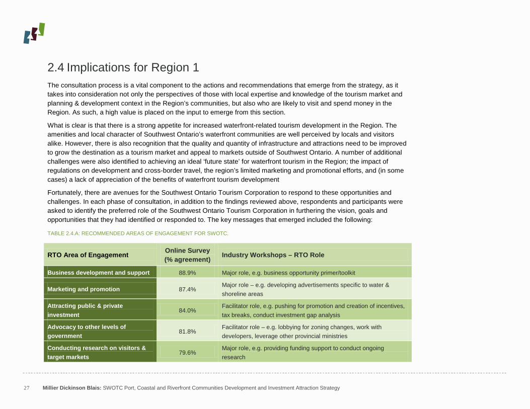
TABLE 2.4.A: RECOMMENDED AREAS OF ENGAGEMENT FOR SWOTC.
RTO Area of Engagement Online Survey (% agreement) Industry Workshops – RTO Role
Business development and support 88.9% Major role, e.g. business opportunity primer/toolkit
Marketing and promotion 87.4% Major role – e.g. developing advertisements specific to water & shoreline areas
Attracting public & private investment
84.0% Facilitator role, e.g. pushing for promotion and creation of incentives, tax breaks, conduct investment gap analysis
Advocacy to other levels of government
81.8% Facilitator role – e.g. lobbying for zoning changes, work with developers, leverage other provincial ministries
Conducting research on visitors & target markets
79.6% Major role, e.g. providing funding support to conduct ongoing research

28 Millier Dickinson Blais: SWOTC Port, Coastal and Riverfront Communities Development and Investment Attraction Strategy
While there are many opportunities to be capitalized on and challenges to address, the central underlying issue identified by the community in promoting tourism product and investment attraction was the need for coordinated and cohesive leadership, planning and vision for the Southwest Ontario waterfront. Many of the challenges facing tourism promotion and development in the Region were seen as solvable, but a lack of regional interaction and coordination related to the waterfront was seen to impede that progress. The ability of the Region to represent its interests as a single voice – be it to developers, provincial and federal agencies and ministries, or the tourism marketplace – will be the keystone that will facilitate progress in all of these other areas.
Having identified the community’s goals and perspectives on tourism development and investment attraction in Southwest Ontario, the following sections establish the ‘current state’ of the identified communities in the Region relating to tourism and development potential ‘on the ground’.

29 Millier Dickinson Blais: SWOTC Port, Coastal and Riverfront Communities Development and Investment Attraction Strategy
3 Priority Node Evaluation 3.1 Overview and Approach As noted previously, a critical element of the strategy development process was the evaluation and assessment of specific nodes and communities within Southwest Ontario. Members of the RTO 1 Transition Network Team, which oversaw the operations of the RTO prior to its incorporation as the Southwest Ontario Tourism Corporation and establishment of a Board of Directors in February 2011, were tasked with identifying up to 4 nodes in each geographical area of the Region. The result was the following 34 nodes, as established in the Request for Proposals, which formed the basis of this evaluation process.
TABLE 3.1.A: REGION 1 PRIORITY NODES
County / Area Nodes (up to 4)
Haldimand County Dunnville, Caledonia, Cayuga, Port Maitland
Middlesex County Thames River, Ausable River, Sydenham River, Lake Whittaker
Norfolk County Port Dover, Port Rowan, Turkey Point, Long Point
Elgin County Port Bruce, Port Burwell, Port Stanley, Port Glasgow
Oxford County Upper Thames (Pittock), Grand River, Long Point, Catfish Creek
City of London Thames River, Fanshawe Lake
Chatham-Kent Erieau/Rondeau, Mitchell’s Bay/Lake St. Clair, Thames River/Chatham, Sydenham River/Wallaceburg
Sarnia-Lambton Sarnia, Sombra, Mooretown, Port Franks
Windsor-Essex Lakeshore, Leamington, Essex (Colchester), River Canard/La Salle

30 Millier Dickinson Blais: SWOTC Port, Coastal and Riverfront Communities Development and Investment Attraction Strategy
In the absence of any formalized criteria, these nodes were initially selected by Transition Network Team members from each County/area on the basis of their ‘high development potential’. The interpretation of this term varied by community within the Region – in some cases it was seen as dense, developed areas with potential for significant investment and product upgrading; in others, it was understood as areas with little to no current tourism infrastructure or assets. The result was the identification of priority ‘nodes’ that ranged from entire river systems (e.g. Sydenham River, Thames River), to small port or park-specific communities (e.g. Port Bruce, Port Franks), to conservation areas (e.g. Upper Thames – Pittock, Fanshawe Lake) to larger municipalities containing multiple waterfront or riverfront sites (e.g. Sarnia, Leamington). Where it was unclear, the project team made efforts to clarify specific development sites with local tourism staff.
Recognizing this diversity of product, the project team developed a list of assessment criteria drawing on our extensive knowledge and background in land use planning, tourism and economic development. These criteria, as established in Table 3.1.B, allowed each of the 34 nodes to be evaluated and ranked on a systematic, comparable basis.
TABLE 3.1.B: SITE ASSESSMENT CRITERIA
Criteria Category Explanation
Site Characteristics Attractions
Heritage sites, museums, fishing, tours, playground/parks, public beach, amphitheatre, scenic areas, etc.
Services & Amenities Marina, public boat launch, retail, restaurants, grocery/liquor stores, accommodations, public restrooms, parking, transportation options etc.
Planning Assessment
Development Potential Quantity and quality of available, developable parcels near waterfront suitable for multiple uses; presence of planning constraints
Developer Interest Demonstrated interest from public/private parties in waterfront redevelopment, existence of area development plans and proposals
Community Interest in Development
Response from public & local political representatives towards development resulting in increased tourism and economic impact
Tourism Assessment
Accessibility and Connectedness
Easily accessed from larger markets; proximity to major traffic routes; water and land-based linkages to other tourism sites, nodes (trails, etc.)
Area Identity & Reputation Status as existing tourism destination, locally & regionally; recognizable local/County brand
Overall Visitor Attractiveness
Well-signed routes/attractions; diversity of experiences; community improvement efforts

31 Millier Dickinson Blais: SWOTC Port, Coastal and Riverfront Communities Development and Investment Attraction Strategy
3.2 Regional Analysis and Major Themes The assessment of these 34 sites revealed a diversity of opportunities, assets and amenities in waterfront areas. Recognizing these differences and variations, it is important to reflect specific assessments, and local contexts, for each area visited. To that end, complete profiles by each of the Southwest Ontario Region’s 9 geographical areas & Counties is provided in Appendix E to this report. These profiles include the results of the individual site visits according to the criteria discussed in Section 3.1, and are supported by a detailed County-level discussion of the planning and policy context (including a list of reviewed documents) to inform future development.
It must be noted, however, that the mandate of SWOTC is regional in nature. As such, its resources are most effectively leveraged to addressing issues of common importance and concern to as much of the Southwest Ontario Region as possible. To that end, a region-wide profile of the strengths, weaknesses, opportunities and threats (SWOT) affecting tourism and investment development in waterfront communities are discussed in this section. While this assessment is not exhaustive, it identifies the key issues to consider for the development and implementation of the strategy.
TABLE 3.2.A: STRENGTHS, OPPORTUNITIES, WEAKNESSES AND THREATS (SWOT) ASSESSMENT OF REGION 1 PRIORITY NODES
STRENGTHS
Diversity of waterfront communities and experiences
Across the Region – and indeed, within each county – there is a diverse mix of waterfront assets and communities, from Great Lakes to small rivers and creeks. As a result, the Region is seen to have tourism experiences that would interest any market – from camping to B&Bs, fishing and birding to diving, canoeing to motor-boating, and more.
Good public access, amenities and use of waterfront
In general, waterfront communities have preserved and maintained access points (with docks, beaches, washrooms and other amenities) to their waterfronts that are easily accessible and signed. The region also has a number of public (and private) marinas and campgrounds that encourage waterfront-related tourism and visitation.
Demonstrated community support for tourism and development
Local community groups were not seen to be a barrier to tourism-related development, and indeed many recognized and supported the tourism industry as critical to local sustainability going to declines in other industry sectors. This is evident through the active participation of chambers of commerce and business organizations in the consultation process, and the active community engagement in recent Official/Secondary Planning processes in many communities.

32 Millier Dickinson Blais: SWOTC Port, Coastal and Riverfront Communities Development and Investment Attraction Strategy
WEAKNESSES
Limited capacity for new development
While the communities in the Region are diverse, the majority are small in size, seasonal in their traffic and residential in their composition. As a result, many are already (realistically) built to capacity and would not be able to accommodate the traffic which accompanies significant increased development.
Uncoordinated planning frameworks
Across the Region, some Counties are single-tier, while some are upper-tier with lower-tier municipalities; many small towns have municipal official plans, secondary plans and community improvement plans, while some Counties have no official plan or planning division. As a result, it is difficult for developers to understand what procedures to follow, or for the Region to coordinate and put forth a single development process.
Limited intra-regional connectivity and promotion
While there are some examples of trail-related development and planning that span multiple communities and Counties (e.g. Thames Valley Corridor/Master Plan, Trans-Canada Trail), there are limited linkages between different parts of the region either by land or water. River-ways are not navigable for long distances, and many trails are local in nature (e.g. Talbot Trail), with little effort evident to enhance connectivity across borders.
OPPORTUNITIES
Increased public control of waterfront assets
Consolidating ownership over waterfront-adjacent area is seen to give municipalities greater flexibility to construct infrastructure and provide public assets, and/or create a development package for potential private investors. Many municipalities are taking steps in this direction, either through provisions in OPs, or advancing divestiture processes of federally-owned assets (e.g. Port Stanley Harbour).
Attracting signature regional attractions and events
Currently, much of the demand-generating assets in the Region are passive use (e.g. provincial parks, beaches); there is seen to be opportunity to advance and support regional ‘flagship’ events both existing (e.g. Port Dover Friday the 13th
Regional waterfront marketing and event promotion
) and proposed (Port Burwell - HMCS Ojibwa).
This strategy effort is seen as a first effort to coordinating regional packaging of similar events and assets, which can be used to increase the marketing profile of the region and lead to information and best-practice sharing. While there have been some limited in-County efforts to this end (e.g. Ports of Elgin, Essex Wine Trail), there are opportunities to expand this.

33 Millier Dickinson Blais: SWOTC Port, Coastal and Riverfront Communities Development and Investment Attraction Strategy
THREATS
Preservation of protection of waterfront areas
Many of the nodes in the region are subject to environmental protection constraints (e.g. flood plains, conservation area jurisdiction), that could impede potential for new development. Conversely, new development could affect the natural beauty of the region which is frequently cited as a tourism draw. Finding the right ‘balance’ is seen as a challenge.
Macroeconomic conditions
A variety of large-scale factors – such as the economic recession, increased border security, and rising fuel prices – have negatively affected tourism visitation to communities in Southwest Ontario in recent years. However, there are now further concerns that regional, provincial and federal infrastructure spending is entering a period of austerity, and there will be fewer funds available for infrastructure development.
Increased competition from other jurisdictions
It is recognized across the region that, with the introduction of Regional Tourism Organizations, there will be many resources devoted to attracting to the same tourism markets (e.g. the GTA), and that it will be difficult for Southwest Ontario and the communities within it to differentiate themselves in a crowded marketplace.

34 Millier Dickinson Blais: SWOTC Port, Coastal and Riverfront Communities Development and Investment Attraction Strategy
3.3 Detailed Site Profiles Upon completion of these site visits, the project team did a comparative evaluation of all 34 nodes/communities to identify those as having the highest tourism and development potential according to the above criteria, with a goal of identifying 6 to 8 communities in which a more detailed market assessment and profile would be conducted. Utilizing this criteria allowed this process to be primarily objective; however, some interpretation and input, based upon meetings with local planning and tourism staff, together with the remainder of the consultation process (discussed in Section 2), also contributed to this effort.
As a result of this process 7 nodes were identified as having the most potential for tourism product development and investment attraction that would generate high value and impact at a regional level. These 7 nodes were:
NODE COUNTY / AREA Dunnville Haldimand County Port Dover Norfolk County Port Stanley Elgin County London – Thames River City of London Wallaceburg – Sydenham River Chatham-Kent Leamington Essex County Sarnia Lambton County
In each of these nodes, a secondary site visit process was undertaken. Project team partners from The Planning Partnership and TCI Management Consultants visited these sites and consulted with local representatives with the following objectives:
An analysis of current and potential development restraints such as land use and legislative policies that could impact public and/or private investment and business development opportunities.
Identification of potential tourism attractions and experiences that could diversify the local community, and recommendations to further enhance the economic development and tourism potential of existing assets (i.e. product development potential).
Mapping of key waterfront areas with sites of interest and potential development parcels identified.
The results of these assessments are presented in the remainder of this section.
35 Millier Dickinson Blais: SWOTC Port, Coastal and Riverfront Communities Development and Investment Attraction Strategy
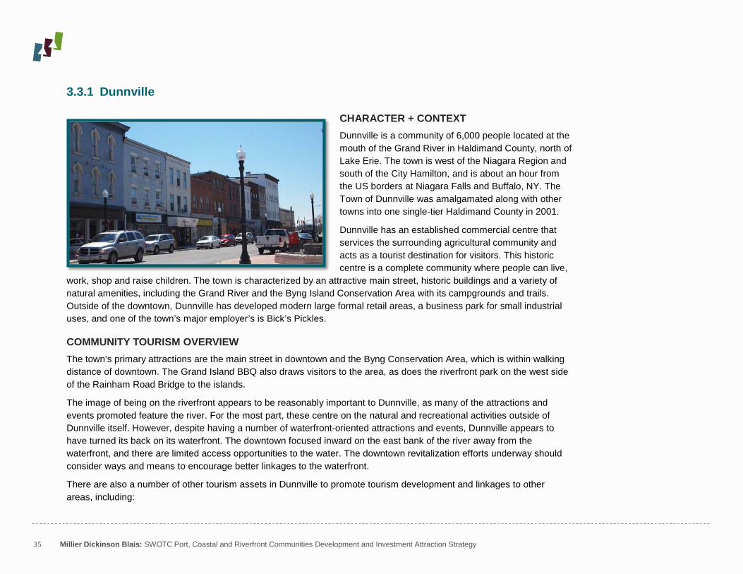
3.3.1 Dunnville
CHARACTER + CONTEXT
Dunnville is a community of 6,000 people located at the mouth of the Grand River in Haldimand County, north of Lake Erie. The town is west of the Niagara Region and south of the City Hamilton, and is about an hour from the US borders at Niagara Falls and Buffalo, NY. The Town of Dunnville was amalgamated along with other towns into one single-tier Haldimand County in 2001.
Dunnville has an established commercial centre that services the surrounding agricultural community and acts as a tourist destination for visitors. This historic centre is a complete community where people can live,
work, shop and raise children. The town is characterized by an attractive main street, historic buildings and a variety of natural amenities, including the Grand River and the Byng Island Conservation Area with its campgrounds and trails. Outside of the downtown, Dunnville has developed modern large formal retail areas, a business park for small industrial uses, and one of the town’s major employer’s is Bick’s Pickles.
COMMUNITY TOURISM OVERVIEW The town’s primary attractions are the main street in downtown and the Byng Conservation Area, which is within walking distance of downtown. The Grand Island BBQ also draws visitors to the area, as does the riverfront park on the west side of the Rainham Road Bridge to the islands.
The image of being on the riverfront appears to be reasonably important to Dunnville, as many of the attractions and events promoted feature the river. For the most part, these centre on the natural and recreational activities outside of Dunnville itself. However, despite having a number of waterfront-oriented attractions and events, Dunnville appears to have turned its back on its waterfront. The downtown focused inward on the east bank of the river away from the waterfront, and there are limited access opportunities to the water. The downtown revitalization efforts underway should consider ways and means to encourage better linkages to the waterfront.
There are also a number of other tourism assets in Dunnville to promote tourism development and linkages to other areas, including:

36 Millier Dickinson Blais: SWOTC Port, Coastal and Riverfront Communities Development and Investment Attraction Strategy
A walking tour along the feeder canal A hiking trail along the Grand River (Grand River Scenic Parkway Tour Route) Boating trips along the Grand River
TABLE 3.3.1.A: DUNNVILLE TOURISM OVERVIEW – SUPPLY SIDE
Estimated Number of Tourism Businesses2 - 130 in Community
3
Main Attractions
(rounded)
- Muddy the Mudcat (50-ft. long sculpture that is the town mascot) - Byng Island Conservation Area (on Grand River) – 250,000 visitors
/ year - Rock Point Provincial Park (11 km. south) - Port Maitland Pier (7 km. to the south) - No. 6 RCAF Museum
Main Events
- Mudcat Festival (4 days in June) - Thunder on the Grand (boat races in August) - Agricultural Fair (August) - Dunnville Farmer’s Market (May – November)
Key Service Facilities
- Riverside Marina - Country Inn Motel - Lollie’s Restaurant Motel Truck Stop - Riverview Motel - 7 B&Bs
2 For remainder of site profiles, ‘Tourism businesses’ are defined by the Ministry of Tourism and Culture to include: accommodation; arts, entertainment and recreation; transportation; travel services; and retail and other services. 3 For remainder of site profiles, this is estimated by pro-rating the tourism-related businesses in the County (from tourist region profile information from the Ministry of Tourism and Recreation) by the community’s share of total population in the County (based upon Statistics Canada 2006 data).

37 Millier Dickinson Blais: SWOTC Port, Coastal and Riverfront Communities Development and Investment Attraction Strategy
TABLE 3.3.3.1.B: DUNNVILLE TOURISM OVERVIEW – DEMAND SIDE4
Estimated Annual Number of Tourists Coming to Community
:
133,000
Estimated Day-Trips to Community 86,000
Estimated Overnight Trips to Community 47,000
Average Nights Spent in Community per Overnight Visitor 3.1 nights
Estimated Visitor-Nights Spent in Community 147,000
Estimated Tourist Expenditure in Community per year $11 million
POLICY CONTEXT Dunnville is one of six Urban Areas designated in the Haldimand County Official Plan (2009). No unifying designation has been applied to the town’s waterfront; instead multiple designations, ranging from riverline hazard lands, residential,
community commercial, and provincially significant wetlands are established through Schedule B.3 – Dunnville Urban Area Land Use Plan. In addition, portions of the waterfront are identified as Special Flood Plan Policy Area 1, 2 and 3.
Section 8.F of the Official Plan provides for a Secondary Plan in Dunnville, which will address a primary piece of public waterfront adjacent to the commercial centre at the heart of town. As of May 2011, an RFP had been issued for the development of the Secondary Plan & Special Flood Plain Policy Update. According to the Official Plan, the Secondary Plan will address a variety of issues, including “the expansion of the historic commercial core of Dunnville to incorporate the Grand River waterfront” and “considerations for brownfield/greyfield redevelopment opportunities”.
4 For the remainder of site profiles, demand-side estimates all calculated by means of a pro-rating procedure that allocates tourism through a three-part methodology: 1) the ‘visiting friends and relatives’ (VFR) and ‘personal’ travelers share was allocated on the basis of population distribution within the County; 2) ‘Business Travel’ allocated on the basis of place of work employment (a reasonable proxy for the distribution of businesses throughout the County); and ‘Pleasure Travel’ allocated on the basis of the distribution of ‘arts, entertainment and recreation’ employment (a reasonable proxy for the distribution of attractions and events) in the County. The resulting demand estimates should be considered as broad and indicative only, not definitive measures.

38 Millier Dickinson Blais: SWOTC Port, Coastal and Riverfront Communities Development and Investment Attraction Strategy
Other sections of the Official Plan include policies that pertain to Dunnville’s waterfront. These include policies in Section 5.A.3 that recognize the Grand River as a transportation route, and provide support for development that enhances the river’s tourism potential. Section 6.D also recognizes the potential to enhance scenic or heritage routes along the Grand River, including the Grand River Scenic Parkway that follows the east side of the river from Dunnville to the Urban Areas of Cayuga and Caledonia. This route is recognized for drawing local residents and tourists to scenic attractions. The cultural and heritage potential of areas like Dunnville’s waterfront is further described in Section 6.F, which provides policies to protect and promote the designation of the Grand River as a Canadian Heritage River, and protect visual access and connections to the waterfront.
In support of tourism, the County of Haldimand has also amended its zoning bylaw to permit and promote the establishment of bed and breakfast accommodations. In general, the County considers itself development and tourism friendly, and has established the set of policies outlined above to promote economic development, tourism, and downtown revitalization.
REDEVELOPMENT/ENHANCEMENT OPPORTUNITIES AND CONSTRAINTS Dunnville’s primary assets are its location on the Grand River, its historic downtown, and its connectivity to the Byng Island Conservation Area. The natural heritage features are major attractions for boaters, campers and bird watchers alike. Although the municipality does not have public marina, there is a private boating club and public boat launches. Boating along the river is a major attraction, since Dunnville is as far north as you can travel from Lake Erie, due to a dam north of the town.
The County is supportive of accommodating change that fosters tourism and economic development. It has recently invested $250,000 in streetscape improvements, and is developing a plan for redeveloping the primary piece of publicly-owned waterfront lands on the east side of the main bridge. This area currently houses an arena (which is being replaced) and a functioning farmers market. This area will be a primary focus for redevelopment, as envisioned on the new Secondary Plan.
There are also challenges limiting the potential to redevelop the waterfront. First and foremost, the majority of the waterfront is privately owned and has already developed in a way that restricts access to the waterfront, often through

39 Millier Dickinson Blais: SWOTC Port, Coastal and Riverfront Communities Development and Investment Attraction Strategy
fencing and other obstacles. The town itself is stable, and has only received one recent application for development along the waterfront (for a single-family style condominium development to the east of downtown on waterfront, outside of the Secondary Plan area). Development along the waterfront is also restricted by flooding, although special policy provisions will soon be prepared to allow some forms of appropriate development.
Finally, the town does not have an adequate supply of roofed accommodations (versus camping on the island). Currently, there is only one motel in town, and it is for sale. The town has expressed a willingness to use public land for hotel accommodation to fill this need.
CONCLUSIONS + RECOMMENDATIONS Based on its location along the Grand River and assets like its historic downtown, Dunnville holds much potential for attracting tourists and redeveloping its waterfront. With the impending Secondary Plan, the timing is ripe to act on this potential by establishing a predictable environment for redevelopment and guiding public investment. The priorities for the Town should be to develop any available properties along the waterfront, explore improving access to the waterfront, and create an adequate supply of roofed accommodations for visitors.
In terms of tourism development, the community should consider ways and means to encourage better linkages to the waterfront through river-oriented events and attractions such as:
A walking tour of scenic and photographic sites on the river A walkway along the riverfront (with linkage to downtown) Development of suggested fishing locations (and guide) on the river More fishing contests throughout the year (like the fishing contest that is part of Mudcat Days) River tours originating from downtown A River Olympics event Greater promotion of Dunnville as a supply depot for day trips to Lake Erie shore, Byng Island, Pock Point Consideration to a riverfront improvement study / plan to incorporate the above improvements

Prepared by The Planning PartnershipMay, 2011
12
3
Port, Coastal + Riverfront Community Site Profiles
DUNNVILLESite Profile Map
Main street
Redevelopment Opportunities
Key Attractions 1. Riverfront Park
2. Farmer’s Market
3. Byng Island
Secondary Plan Area
#
2

41 Millier Dickinson Blais: SWOTC Port, Coastal and Riverfront Communities Development and Investment Attraction Strategy
3.3.2 Port Dover
CHARACTER + CONTEXT Port Dover is an unincorporated community of about 6,000 residents within Norfolk County. Located on the north shore of Lake Erie and the mouth of the Lynn River, Port Dover is about 50 kilometres due south of the City of Brantford and about 70 kilometres southwest of the City of Hamilton.
Evolving around a strong local shipbuilding and fishing industry, Port Dover still retains an active commercial fishery. Port Dover’s industrial roots are evident in its physical character, with some large industrial buildings and shipyards (some abandoned or vacant) along the river’s edge.
Most of Port Dover’s tourism activity is focused in its downtown area (delineated in the County’s Official Plan as the Central Business District and Urban Waterfront Area on Schedule ‘B-16’). The downtown area is comprised of two key sub-areas. The first sub-area, Main Street (between Harbour Street and Nelson Street East), is Port Dover’s historic mixed-use commercial corridor. While largely retaining elements of historic character and built form, some newer developments over the past few decades have offended the consistency of the built form and street wall by introducing front load parking areas. Main Street consists primarily of retail and service commercial uses and also includes some limited residential uses as well as Powell Park, Port Dover’s central public park, which fronts Main Street.
The second sub-area is located on the west side of the Lynn River between Harbour Street, and Walker Street. Harbour Street terminates at the pier, while Walker Street provides primary access to the beach. This area, which is connected to the Main Street corridor, includes restaurants, retail commercial uses, a boat tour operator, the Dover Harbour Museum as well as some vacant industrial buildings along the river’s edge (Misner Fish Plant).
The Port Dover Harbour Marina is another key community focal point. It is located just opposite of the Central Business District on the east side of the river. The marina is a full service facility with 400 slips, including about 15 transient slips for visiting boaters.

42 Millier Dickinson Blais: SWOTC Port, Coastal and Riverfront Communities Development and Investment Attraction Strategy
COMMUNITY TOURISM OVERVIEW Port Dover is perhaps best known outside of the community as a major attraction for motorcycle enthusiasts. Since the 1970s, thousands – and in some recent years hundreds of thousands – of bikers (and onlookers), descend on Port Dover every Friday the 13th
Outside of this sporadic event, it is clear that the connection to the waterfront is primary for Port Dover, and is a central image for the community. Virtually all images of the community feature the beach, the marina, the Lynn River, Lake Erie, the pier, or marine history of one form or another. Moreover, the community seems to have successfully balanced the idea of being on the one hand a working port and commercial fishery with being a major tourism attraction on the other.
for what is essentially a community-wide street party and impromptu motorcycle show. The event takes over the entire community, with the County closing off automobile
access to most of the Town to facilitate the temporary influx of motorcycles.
Port Dover is also well-linked to surrounding attractions through both physical and marketing/promotional connections, including:
A short drive to Simcoe (10km.) with a variety of attractions and events The Lynn Valley Trail, connecting Port Dover and Simcoe (note: Port Dover Enhancement Association working on
developing trail linkage from marina to Lynn Valley Trail) The Norfolk Studio Tour (arts and crafts tour: Port Dover is a major node en route)
TABLE 3.3.2.A: PORT DOVER TOURISM OVERVIEW – SUPPLY SIDE
Estimated Number of Tourism Businesses in Community - 60 (rounded)
Main Attractions
- beach - commercial fishing activity (i.e. watching the boats come in) - River Rider (scenic river tours) - Port Dover Harbour Museum

43 Millier Dickinson Blais: SWOTC Port, Coastal and Riverfront Communities Development and Investment Attraction Strategy
- Lighthouse Festival Theatre
Main Events
- Perch Derby (April-May) - Marine Heritage Festival (June) - Lake Erie Interclub Cruise (June) - Port Dover Summer Arts Festival (August) - Motorcycle gatherings / events (every Friday 13th
- Corvette Fever (June) )
- Sunday evening concerts in Powell Park (July & August)
Key Service Facilities
- Port Dover Harbour Marina (400 slips; 95% seasonal) - Port Dover Yacht Club - Bridge Yachts Ltd. (ship’s store) - Brant Hill Inn - Erie Beach Hotel - Bay Shore Cottages - Wilson Family Cottages - Approximately 20 B&Bs and campground facilities - 7 restaurants featured on website
TABLE 3.3.2.B: PORT DOVER TOURISM OVERVIEW – DEMAND SIDE
Estimated Annual Number of Tourists Coming to Community 66,0005
Estimated Day-Trips to Community
44,000
Estimated Overnight Trips to Community 24,000
Average Nights Spent in Community per Overnight Visitor 3.1 nights
Estimated Visitor-Nights Spent in Community 73,000
Estimated Tourist Expenditure in Community per year $5 million
5 Due to the visitor survey methodology, MTC statistics may not accurately capture the huge spike in visitor numbers as a result of Friday 13th motorcycle events.

44 Millier Dickinson Blais: SWOTC Port, Coastal and Riverfront Communities Development and Investment Attraction Strategy
POLICY CONTEXT
The Norfolk County Official Plan (Council adopted May 9, 2006) identifies Port Dover as one of six Urban Areas within the County. As per Section 3.4 of the County Official Plan, Urban Areas have historically functioned as the centres for growth and development activity within the County and will be planned to continue this role. Accordingly, the County Official Plan articulates a range of planning and development principles allocating and supporting the future growth and enhancement of Urban Areas.
In addition to those broad policy objectives, Section 3.5.2 of the Official Plan establishes a number of policy directives specific to the Port Dover Urban Area and its continued development as a key waterfront community and tourism node:
“The County will support and promote the continued development of Port Dover as a significant urban waterfront community and tourism node in the County. The County will support and promote Port Dover as a sustainable waterfront urban community focused on port and lake-based activities”
Recognizing Port Dover’s historic role as a tourist destination and commercial fishing port, the policies promote a series of planning and development objectives focused on improved public access to the shoreline through the establishment of a boardwalk/waterfront promenade and acquisition of waterfront property through various means; environmental and shoreline protection/enhancement; mixed use development; enhancements to the public realm and parkland/open space system; and, improved urban design and built form.
The Official Plan also identifies Port Dover within the County’s Lakeshore Special Policy Area, which establishes a further layer of specific waterfront development policies and also enables the development of a Lakeshore Secondary Plan to facilitate more comprehensive planning of the lakeshore area.
Completed in September 2009, the Lakeshore Secondary Plan (OPA 28) and supporting Urban Design Guidelines are aimed at establishing a long-term strategy for accommodating “sustainable lakeshore-related growth and development”.

45 Millier Dickinson Blais: SWOTC Port, Coastal and Riverfront Communities Development and Investment Attraction Strategy
Reaffirming the broad policy objectives of the Official Plan, the Secondary Plan promotes infill and intensification within Urban Areas and directs higher density residential development and major tourism/recreational uses to Port Dover’s Central Business District and Urban Waterfront Area (Official Plan Schedule ‘B-16’), with a strong emphasis on high quality urban design (Section 11.3.2.1).
The County also has a Community Improvement Plan that includes a Rehabilitation Tax Increment-based Grant Program to encourage the remediation, rehabilitation and adaptive re-use of downtown and brownfield properties. The CIP also includes a Façade Improvement Program (Policy No. PED-03) component, which provides property owners with up to $10,000 in interest free loans, with up to 15% of the loan forgivable as a grant, to match owner investment in façade improvements within the County’s downtown areas.
Norfolk County is currently undertaking a Zoning By-law Update to harmonize zoning regulations with Official Plan and Secondary Plan policies and land use designations.
REDEVELOPMENT/ENHANCEMENT OPPORTUNITIES AND CONTRAINTS Land ownership is a significant challenge that constrains potential redevelopment and enhancement potential in Port Dover. With the exception of a small area, most of the beach and shoreline is privately owned. As per the Official Plan (Section 3.5.2.2 e), securing and retaining public access to both the river’s edge and lakeshore is a major development objective for the County.
In terms of other land holdings and parking facilities, again, the County has very limited ownership within Port Dover’s downtown area. Notwithstanding the lack of public land ownership, there are ample opportunities for redevelopment within the downtown area. As per conversations with local planning staff, a number of former industrial sites present a major potential opportunity for redevelopment, in particular the former Misner Fish Plant and abandoned shipyard on the west side of the river. However, it should be recognized that possible site contamination could impact developability. Further, the considerable supply of surface parking lots in proximity to the waterfront also offers potential infilling and intensification opportunities.
Recent proposals have been put forward to redevelop the Misner Fish Plant into a mixed-use development. It is foreseeable that such a proposal could include enhancements to the river’s edge by integrating a boardwalk connecting the pier with the new development and the existing Dover Harbour Museum. Further, the County’s recent acquisition of the vacant site neighbouring the Harbour Museum to the north could also be integrated into an overall area plan as a potential park or other community/tourist facility.

46 Millier Dickinson Blais: SWOTC Port, Coastal and Riverfront Communities Development and Investment Attraction Strategy
CONCLUSIONS + RECOMMENDATIONS Given the supply of old industrial sites and surface parking areas, Port Dover’s downtown area has tremendous redevelopment potential. Recognizing this potential and the importance of Port Dover as a tourism node, the County has established an extensive set of planning policies and tools to permit, promote and facilitate tourism-related redevelopment of Port Dover’s downtown waterfront area.
Moving forward, the County should continue initiatives to reacquire/secure public access to the waterfront. Furthermore, the County should continue to invest in
public realm enhancements and public facilities to further signal its commitment to local land owners and development interests to the continued development of Port Dover as a vibrant urban area and tourism node.
Major additional opportunities in terms of waterfront access and development include:
Continuing to ensure a quality beach experience (and possibly seeking Blue Flag status, in the way that Port Stanley has done)
Continuing to ensure public access to the beach Assessing the demand for additional accommodation development in the area, and selectively develop Maintenance of urban design standards for the community Assessing opportunities for longer-term marina expansion, and ensuring that this will be possible at the appropriate
time
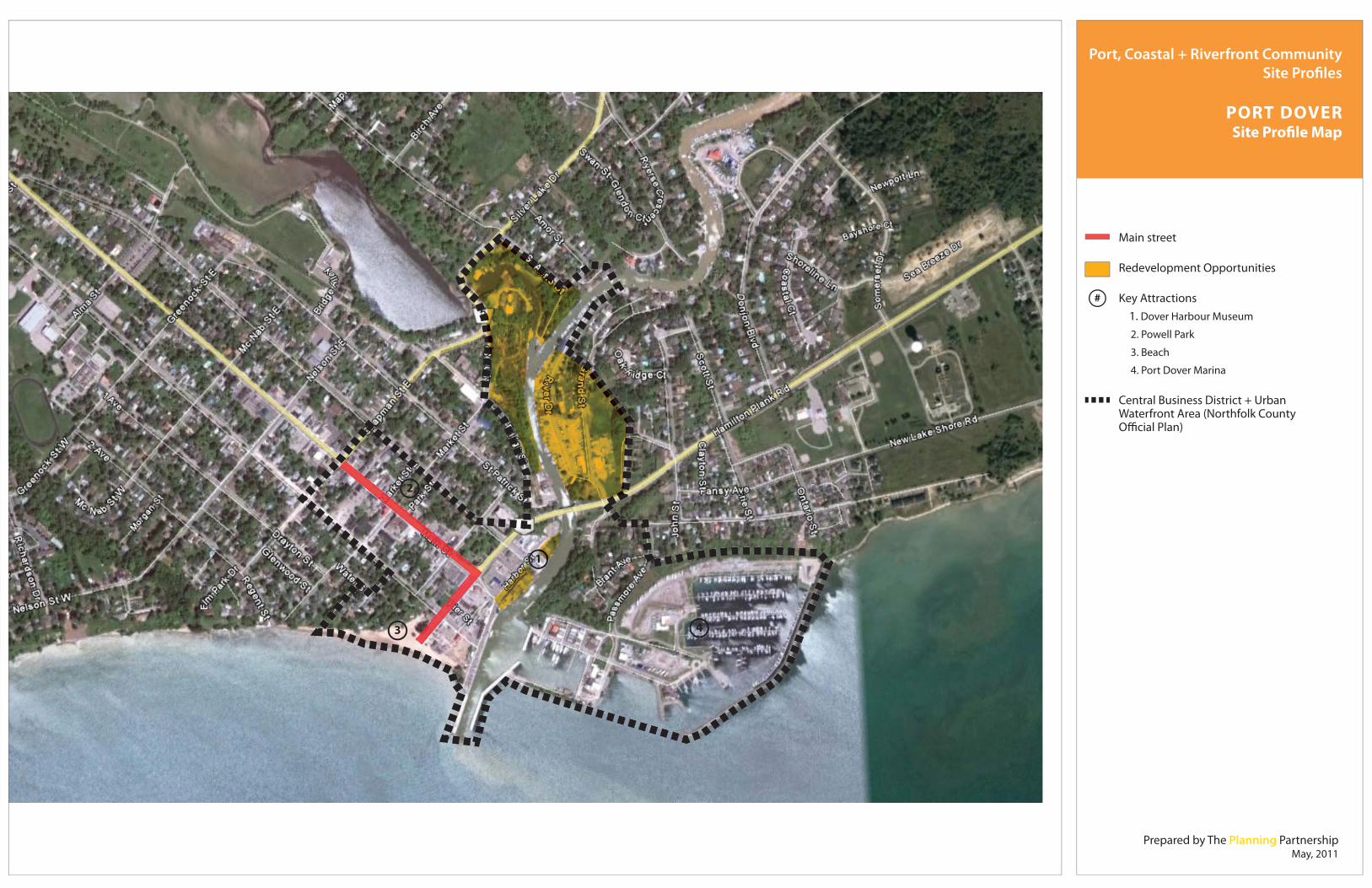
Prepared by The Planning PartnershipMay, 2011
1
2
3 4
Port, Coastal + Riverfront Community Site Profiles
PORT DOVERSite Profile Map
Main street
Redevelopment Opportunities
Key Attractions 1. Dover Harbour Museum
2. Powell Park
3. Beach
4. Port Dover Marina
Central Business District + Urban Waterfront Area (Northfolk County Official Plan)
#

48 Millier Dickinson Blais: SWOTC Port, Coastal and Riverfront Communities Development and Investment Attraction Strategy
3.3.3 Port Stanley
CHARACTER + CONTEXT Port Stanley is a community on the north shore of Lake Erie, located within the Municipality of Central Elgin in Elgin County at the mouth of Kettle Creek. A popular summer tourist destination for almost a century, Port Stanley boasts a stunning beach and a quaint historic downtown area, with many historic buildings remaining intact.
Port Stanley’s waterfront also reflects s industrial past. The former Federal Harbour and its large industrial facilities – now largely inactive – is the dominant feature within the downtown area. The Municipality acquired the
Federal Harbour facilities in 2010 as part of the Federal government’s ongoing divestiture of smaller non-essential Harbours. While local industry has significantly contracted over the past few decades, Port Stanley still retains an active, albeit reduced, commercial fishery.
Port Stanley’s downtown area, which straddles the Port at the mouth of Kettle Creek, has two very distinct main street areas – located on the east and west sides of the creek. The east side of the creek is characterized by a well-preserved historic mixed-use commercial main street area which includes Bridge Street and Main Street. This area includes a number of restaurants, some small hotels and bed and breakfasts, a few small urban green spaces, boutiques and galleries as well as a few small-scale industrial fish plants. In contrast, William Street, the secondary main street, which is located on the west side of the creek, is in noticeably poor condition. While it serves as the primary public access to the beach and is in proximity to a number of new seasonal residential developments, it is characterized by a number of dilapidated houses/cottages, some vacant lots, large municipal parking lots and a few retail establishments and beachfront bars/restaurants. Unlike the Bridge/Main Street area, William Street’s public realm and streetscape also demonstrate considerable neglect.

49 Millier Dickinson Blais: SWOTC Port, Coastal and Riverfront Communities Development and Investment Attraction Strategy
COMMUNITY TOURISM OVERVIEW Port Stanley is already significantly developed as a harbour and beach-oriented waterfront destination. Like Port Dover, continuing demand for accommodation (accelerated by the community’s growing reputation for its excellent beach, which recently obtained Blue Flag status) will imply development of new units over time, as well as the upgrading of existing accommodation. As well, over time there may be potential for marina expansion to accommodate a growing permanent and seasonal resident population. In addition to a popular waterfront and downtown commercial area, Port Stanley’s other main
attractions include the Port Stanley Festival Theatre, the Port Stanley Terminal Rail (a historic tourist train that runs between Port Stanley and St. Thomas). In addition to the Terminal Rail, it has connections inland to St. Thomas via the 41 km. Elgin Hiking Trail.
TABLE 3.3.3.A: PORT STANLEY TOURISM OVERVIEW – SUPPLY SIDE
Estimated Number of Tourism Businesses in Community - 130 (rounded)
Main Attractions
- world class (Blue Flag status) – fist ever on Lake Erie - inland federal harbour - historic lift bridge - Port Stanley Terminal Rail (7 km. between Port Stanley and St.
Thomas) - Kettle Creek Golf Club - The Bluffs of Port Stanley - hawkwatching (Hawk Cliff Foundation)
Main Events - Port Stanley Festival Theatre
Key Service Facilities - Stan’s Marina - Kettle Creek Marina

50 Millier Dickinson Blais: SWOTC Port, Coastal and Riverfront Communities Development and Investment Attraction Strategy
- Kettle Creek Inn - Inn on the Harbour and Little Inn - Windjammer Inn - Alma Villa - The Roxy Restaurant - several cottage rentals and B&Bs - several other restaurants
TABLE 3.3.3.B: PORT STANLEY TOURISM OVERVIEW – DEMAND SIDE
Estimated Annual Number of Tourists Coming to Community 104,000
Estimated Day-Trips to Community 65,000
Estimated Overnight Trips to Community 39,000
Average Nights Spent in Community per Overnight Visitor 2.9 nights
Estimated Visitor-Nights Spent in Community 107,000
Estimated Tourist Expenditure in Community per year $9 million
POLICY CONTEXT In terms of waterfront planning, the Municipality of Central Elgin has been quite active. It is important to note that while the Official Plan for the former Village of Port Stanley remains in force, the new Central Elgin Official Plan (Draft January 18, 2010) is representative of the desired evolution and growth management strategy for the Municipality.
As per the new Central Elgin Official Plan, Port Stanley is one of the Municipality’s primary Urban Settlement Areas (Schedule ‘1’). As an Urban Settlement Area, Port Stanley is planned to continue to be a major focus for future growth and tourism development. The new Official Plan also emphasizes the Municipality’s desire for greater land development, public service and infrastructure efficiencies to be achieve through more compact and mixed-use development.
In addition to broad planning objectives, the new Official Plan sets out a range of detailed policies for the Port Dover Waterfront focused on, among other things, improved public access to the shoreline through acquisition and agreements

51 Millier Dickinson Blais: SWOTC Port, Coastal and Riverfront Communities Development and Investment Attraction Strategy
with property owners, encouraging infill and redevelopment opportunities and support for recreational and tourism-oriented development (Section 4.6.6). Correspondingly, the new Official Plan retains Port Stanley’s existing designation as a Community Improvement Area to stimulate continued community investment and revitalization efforts.
Recognizing the variable nature of shoreline environments, the new Official Plan (Section 3.2.4), building on the findings of the Port Stanley Beach Management Study (March 1996), and also establishes a range of development standards aimed at environmental and shoreline protection and mitigation of potential flooding hazards.
As part of the divestiture of the Federal Harbour, the Municipality undertook the Port Stanley Harbour Feasibility Study and Business Plan to explore, with considerable public input, the best use of the Harbour from economic, environmental and planning perspectives (September 2009). Following the preparation and evaluation of a series of potential land use/development schemes, the final study resulted in a preferred plan which includes a comprehensive redevelopment scheme for the east side of the Harbour, with new a new park, marina, community hall and extension of Main Street to the waterfront, while retaining the industrial uses on the west side of the Harbour.
In response, the new Official Plan (Section 2.8.5.6) establishes policies supporting the redevelopment of the
Federal Harbour facilities in line with the proposed development concepts generated as part of the Harbour Feasibility and Business Plan (September 2009). At the same time, the Official Plan also articulates strong support for Harbour facility improvements to sustain the long-term viability of the Harbour for commercial fishing and recreational boating.
With the Federal government’s divestiture of the Federal Port to the Municipality of Central Elgin, the Municipality has recently established a ‘Harbour Vision Committee’. The purpose of the Committee is to review potential redevelopment concepts for the Harbour facility and adjacent municipally-owned lands and ultimately develop a “strategic economic development action plan” for the Harbour. The Municipality envisions a broad County/region consultation process as part of this effort.

52 Millier Dickinson Blais: SWOTC Port, Coastal and Riverfront Communities Development and Investment Attraction Strategy
REDEVELOPMENT/ENHANCEMENT OPPORTUNITIES AND CONSTRAINTS Undoubtedly, the Municipality’s recent acquisition of the Port Stanley Harbour presents a major opportunity for redevelopment. With considerable planning work already completed, a permissive policy regime in place and the establishment of the Harbour Vision Committee, the Municipality has demonstrated a clear commitment to transforming the Harbour into an active and vibrant community amenity that supports local industry and tourism.
The William Street area, which effectively functions as the primary gateway to Port Stanley’s famed beach, also shows tremendous redevelopment potential. Notwithstanding the current planned retention of industrial uses on the east side of the Harbour, given the existing condition of William Street and a significant inventory of underutilized sites and municipal parking lots, there are considerable opportunities for redevelopment/intensification and public realm enhancements to revitalize this important corridor.
As identified in the Harbour Feasibility Study and Business Plan, soil/groundwater contamination and First Nations Land Claims are two potential constraints that could impact the short term redevelopment of the Harbour. While the Municipality should be financially protected from these risks through indemnity agreements with the Federal Government, the impacts on development timing and feasibility are difficult to protect against.
CONCLUSIONS + RECOMMENDATIONS Building on the quality and vibrancy of the Main and Bridge Street area, the future redevelopment of the Port Stanley Harbour and potential revitalization of the William Street corridor could have a significant positive impact on tourism and facilitate even further investment and redevelopment interest in Port Stanley over the long-term.
Implementing the policy directives established in the new Official Plan, the Municipality of Central Elgin should continue initiatives to secure public access to the waterfront. Furthermore, the Municipality should continue to actively seek out opportunities, and potential partners, for the redevelopment Port Stanley Harbour as envisioned by the Official Plan and in accordance with the preferred plan articulated in Harbour Feasibility Study and Business Plan. This includes the development of additional tourism-related infrastructure, such as accommodations, parking near the beach and harbour, and possible marina expansion.

Prepared by The Planning PartnershipMay, 2011
1
2
3
Port, Coastal + Riverfront Community Site Profiles
PORT STANLEYSite Profile Map
Main street
Redevelopment Opportunities
Key Attractions 1. Public Beach
2. Port Stanley Festival Theatre
3. Port Stanley Terminal Rail
Port Stanley Harbour Boundary
#

54 Millier Dickinson Blais: SWOTC Port, Coastal and Riverfront Communities Development and Investment Attraction Strategy
3.3.4 London – Thames River
CHARACTER + CONTEXT With a population of about 353,000 (2006 Census), London is the largest City in southwest Ontario. London is located approximately halfway between Toronto and Windsor. London is known as “the Forest City”, and has strong associations with the insurance industry and the University of Western Ontario. Also the history of the Labatt family and brewery is inextricably linked to the City.
The Forks of the Thames – where the North and South branches of the Thames River merge – is one of the City of London’s most
important historical sites and in many ways remains the historical and geographic nucleus of the City. Recognized as a Canadian Heritage River, the Forks became one of the first development areas of modern day London when it was selected by a committee of local officials, headed by Colonel Talbot, as the location for the London District’s government buildings in 1826.
COMMUNITY TOURISM OVERVIEW The Forks of the Thames site houses a number of tourism and cultural attractions/amenities such as the Old Court House, now a museum. Situated on the eastern edge of the Downtown, other key attractions/amenities at or near the Forks include Museum London, the Eldon House Museum and Gardens, the John Labatt Centre, Labatt Memorial Park and the Covent Garden Market.
Recreational use is also a key focus of the Forks. The Forks is characterized by its mature and well-maintained parks, which are situated along the river’s edge and connected via a comprehensive multi-use trail system that straddles both sides of the river. Harris Park, located across the river from Labatt Memorial Park, serves as the site for the annual “Rock the Park” music festival, attracting big name rock n’ roll acts and thousands of fans every July.

55 Millier Dickinson Blais: SWOTC Port, Coastal and Riverfront Communities Development and Investment Attraction Strategy
Given its central location within the City and proximity to higher density residential uses, important cultural attractions and downtown business and commercial uses, the recreational amenities at the Forks are heavily used. There is also a sufficient supply of municipal parking serving park and trail users.
The Forks are also highly accessible by public transit, including regional coach bus lines and the VIA Rail network. There are extensive cycling and hiking trail routes throughout the City (supported by a published map), including the Thames Valley Trail, maintained by the Thames Valley Trail Association, which also offers guided hikes.
Despite all of these assets, the Forks is not widely regarded as a tourist attraction for London. The usual opinion seems to be that it is a park and recreational asset for City residents – albeit a very attractive and historically important one. However, it could be that the area is underperforming as a tourism asset, and has much greater potential.
TABLE 3.3.4.A: LONDON TOURISM OVERVIEW – SUPPLY SIDE
Estimated Number of Tourism Businesses in Community - 3,800 (rounded)
Main Attractions
- Museum London - Eldon House - Fanshawe Pioneer Village - Storybook Gardens - Victoria Gardens - Western Fair Sports Centre and Agriplex - Grand Theatre - London Convention Centre - and several more
Main Events - Western Fair (September) - John Labatt Centre events
Key Service Facilities - over 30 hotels, with many of the largest brand names represented (Delta, Four Points Sheraton, Radisson, Ramada, Marriott, etc.)

56 Millier Dickinson Blais: SWOTC Port, Coastal and Riverfront Communities Development and Investment Attraction Strategy
TABLE 3.3.4.B: LONDON TOURISM OVERVIEW – DEMAND SIDE
Estimated Annual Number of Tourists Coming to Community 4.091 million
Estimated Day-Trips to Community 2.778 million
Estimated Overnight Trips to Community 1.313 million
Average Nights Spent in Community per Overnight Visitor 2.5 nights
Estimated Visitor-Nights Spent in Community 3.282 million
Estimated Tourist Expenditure in Community per year $450 million
POLICY CONTEXT Reflecting the broad policy directives of its Official Plan (Section 2.12), London has been particularly proactive in its downtown planning efforts and introduced a number of important policies and strategies to attract investment to and support revitalization of its Downtown Area. These policies include the Downtown Community Improvement Plan and an array of financial incentives for the revitalization of the Dundas Street Corridor.
The City is currently in the process of completing its Downtown Master Plan, which is intended to for the
first time establish an overarching vision for the Downtown and a comprehensive set of policies and directions related to Downtown revitalization and development.
To date, the City has already taken the bold step of pre-zoning and pre-designating the entire Downtown Area to permit maximum development flexibility. Under the City’s as-of-right approach, any development proposal that demonstrates compliance with the height and density limits and Urban Design Guidelines established for the Downtown can advance directly to the Site Plan Approvals process. The permissions set an overall 90 metre height limit and allow residential

57 Millier Dickinson Blais: SWOTC Port, Coastal and Riverfront Communities Development and Investment Attraction Strategy
developments up to a maximum density of 350 units/hectare and non-residential development up to a maximum density of 10 FAR.
The City’s Official Plan also emphasizes the importance of the Thames River, and the Thames Valley Corridor more broadly, as an integral City asset and primary open space resource within the City’s overall urban structure (Section 2.4.1). Accordingly, the Official Plan emphasizes the need to secure public ownership of the Valley Corridor lands to increase accessibility to this resource.
The Official Plan also establishes a number of policies focused on the enhancement of parklands and trails along the Thames, and provides enabling policies for the preparation of the Thames River Valley Corridor Plan, which is currently underway. As per Section 2.9.3 iv):
“The City recognizes the Thames Valley Corridor as its most important natural, cultural, recreational and aesthetic resource. The City shall prepare a Thames River Valley Corridor Plan to optimize the multi-functional role of the river valley system in the City over the long term future.”
Expressing the long-range vision for the development of the Thames Valley Corridor, the Draft Thames Valley Corridor Plan (December 2010) includes a detailed Land Use Plan for the entire extent of the river and its tributaries, as well as a detailed Concept Plan for the Forks, that includes the identification of new access points, trails and valley crossings. In addition, the Draft Plan also provides a range of supporting policies related to protection and enhancement of natural features and functions, enhanced public access and recreation opportunities, the management of corridor-related infrastructure and development, and the ongoing management of the floodplain and related hazards.
Council’s adoption of the Final Thames Valley Corridor Plan is expected in the near term.
REDEVELOPMENT/ENHANCEMENT OPPORTUNITIES + CONTRAINTS As part of its ongoing Thames Valley Corridor and Downtown Master Planning processes, the City has been actively identifying redevelopment and enhancement opportunities for the Forks and the Downtown Area more broadly.

58 Millier Dickinson Blais: SWOTC Port, Coastal and Riverfront Communities Development and Investment Attraction Strategy
The City has recently mapped all ‘soft sites’ (surface parking lots, vacant/underutilized sites) within the Downtown Area. While not publicly circulated, this data is used to communicate to local development interests the wide array of potential redevelopment sites within the Downtown.
A few notable redevelopment/enhancement opportunities that are currently being explored for the Forks and surrounding Downtown Area include the relocation of the City’s Children Museum to the Downtown, the potential development of a Fanshawe College satellite campus in the Downtown, streetscape improvements along the west end of the Dundas Street Corridor (one of the key gateways to the Forks), the planned connection of the river trail network to Fanshawe Lake and the potential future integration of the City’s trail network with the Trans-Canada Trail.
From a tourism perspective, the City could also explore opportunities to further enhance the mix of uses along the edges of the Valley Corridor. Certainly the cultural attractions/amenities are an important draw, but it seems there is potential for a riverfront restaurant and hotel development to further animate the Forks area.
In terms of constraints, flooding is a major concern that limits development potential, particularly on the east side of the river. However, the current and evolving planning documents reflect considerable diligence with respect to planning for and managing this potential hazard.
CONCLUSIONS + RECOMMENDATIONS Overall, the City of London has demonstrated that it is clearly motivated to facilitate the enhancement of the Forks and Downtown revitalization more broadly.
The emerging Downtown Master Plan and Thames Valley Corridor Plan, which together establish a comprehensive vision for this important piece of the City’s structure, is an important step towards the continued enhancement of the Forks and Downtown. Coupled with the City’s efforts to actively identify redevelopment opportunities and support redevelopment efforts through incentives and permissive regulations, the City has put in place the necessary tools to implement its vision. Looking ahead, the City should maintain its current momentum and continue to pursue all potential redevelopment opportunities, with particular focus on further enhancing its tourism infrastructure (hotels, restaurants, cultural amenities, improved signage and way-finding) near the Forks and along the river. From a tourism attractions standpoint, the Forks area has high potential to become an animated community asset for locals and tourists alike, including the following elements:

59 Millier Dickinson Blais: SWOTC Port, Coastal and Riverfront Communities Development and Investment Attraction Strategy
An events space (gathering point for community events; river festival, etc.) An interpretive centre (historical or nature) A focal point for river-oriented activities (e.g. kayak rentals) Possibly some commercial activity on the site at peak times and/or for key events.

Prepared by The Planning PartnershipMay, 2011
1
#2
3
4 56
7
Port, Coastal + Riverfront Community Site Profiles
LONDONSite Profile Map
Main street
Redevelopment Opportunities
Key Attractions 1. Labatt Memorial Park
2. Harris Park
3. Eldon House Museum
4. Museum London
5. John Labatt Centre
6. Covent Garden Market
7. Old Court House
Downtown (City of London Official Plan)

61 Millier Dickinson Blais: SWOTC Port, Coastal and Riverfront Communities Development and Investment Attraction Strategy
3.3.5 Wallaceburg – Sydenham River
CHARACTER + CONTEXT Wallaceburg is a town of about 11,000 people, located on the scenic Sydenham River. It is one hour south of Sarnia, and 30 minutes from downtown Chatham in the Community of Chatham-Kent. The town’s economy peaked in the 1940s to 1960s when major employers became established there, including Waltec Plumbing, Libby's Glass, and the rail industry. Wallaceburg has been and remains a service centre for the surrounding rural/agricultural community, which thrives on high quality soil in the region.
Wallaceburg has an established historic main street that is about 500 metres long on the north side of the Sydenham River, named James Street. Along James Street, visitors will find a variety of retail and service-commercial uses that back onto the Superior Marine Boardwalk, which provides public access to the riverfront. North of James Street, there are several municipal parking lots, and a transition to residential uses. James Street ends in the east at a bridge over to Margaret Avenue, and in the west at a gateway park located at McNaughton Avenue. James Street is connected to the south side of the Sydenham River by a pedestrian bridge in the heart of the main street strip. The south side of the river is lined by vacant lots and buildings that formerly housed a mixture of uses.
COMMUNITY TOURISM OVERVIEW The town's premier event is the annual Wallaceburg Antique Motor and Boat Outing (WAMBO), which is held in August and includes barbeques, boat cruises, display shows, and a variety of other programming along the river. The Sydenham River is a partial element of the overall ‘branding’ of the community: one of the ‘slogans’ of the community is “We are bridging possibilities”. Certainly the visual aspect of the Sydenham River, joined by its tributaries and the bridges crossing the river, makes a unique and very interesting element in the downtown. Yet aside from these events, the waterfront appears primarily a passive aesthetic element, as opposed to an active recreational asset; access directly to the water within the community/downtown is difficult and discouraged.

62 Millier Dickinson Blais: SWOTC Port, Coastal and Riverfront Communities Development and Investment Attraction Strategy
The town is also a destination for visitors on their way (by car, boat or bicycle) to other area waterfront and fishing attractions, such as Mitchell's Bay and Rondeau Provincial Park, Walpole Island, the Dresden Raceway and OLG Slots, and the Uncle Tom's Cabin historic site for the Underground Railroad. In addition, the Wallaceburg Trails Organization is actively developing trails throughout the Wallaceburg area and developing linkages to the Trans-Canada trail.
TABLE 3.3.5.A: WALLACEBURG TOURISM OVERVIEW – SUPPLY SIDE
Estimated Number of Tourism Businesses - 110 (rounded) in Community
Main Attractions
- fishing activity (in the community and nearby) - hunting (duck, deer, rabbits) - Wallaceburg and District Museum - Acorn Dinner Theatre (at Oaks Inn) - Baldoon Golf Club
Main Events - Wallaceburg Antique Motor and Boat Outing (W.A.M.B.O.) - Lord Selkirk Historical Fair
Key Service Facilities - Oaks Inn - Days Inn - Blue Water Shiloh Park
TABLE 3.3.5.B: WALLACEBURG TOURISM OVERVIEW – DEMAND SIDE
Estimated Annual Number of Tourists Coming to Community 84,000
Estimated Day-Trips to Community 52,000
Estimated Overnight Trips to Community 32,000
Average Nights Spent in Community per Overnight Visitor 2.3 nights
Estimated Visitor-Nights Spent in Community 74,000
Estimated Tourist Expenditure in Community per year $8 million

63 Millier Dickinson Blais: SWOTC Port, Coastal and Riverfront Communities Development and Investment Attraction Strategy
POLICY CONTEXT The Chatham-Kent Official Plan (2005, currently under review) identifies Wallaceburg as one of the seven Primary Urban Centres in the municipality. Section B.2 of the Official Plan outlines a set of policies for Urban Centres, which focus on supporting the long-term vitality of Downtown/Main Street Areas by providing a mixture of ground-floor retail, service commercial and residential uses, as well as cultural/entertainment uses to attract tourists. For Downtown/Main Streets located on riverfronts, the Official Plan encourages both land-based and water-based uses, a continuous public open space system, and adequate public parking. The Official Plan also requires development along a riverfront to
provide for public access, visual access, and pedestrian linkages, so that the area remains connected to, and a focus of, the Downtown/Main Street.
In addition to Official Plan policies, development on Wallaceburg's riverfront will soon be guided by a new Secondary Plan (pending funding for an RFP), which stems from Chatham-Kent's Shoreline Study. Following the completion of the Study, the Sustainable Shorelines Secondary Plan was adopted as Official Plan Amendment No. 17 in April 2011. Section 7.1.2.2.1.1.8 of OPA 17 calls for the preparation of a Secondary Plan and/or Community Improvement Plan for revitalizing Wallaceburg's greater downtown area, including the north and south side of the Sydenham River. Complementary polices call on the municipality to promote mixed-use (residential, commercial, employment and recreational) redevelopment in the Wallaceburg downtown area, including former dock areas, and to establish a gateway to the shoreline area. A Community Improvement Plan for Downtowns in Chatham-Kent (2004) already provides a variety of financial incentives (rebates, grants, studies) for beautification, commercial revitalization, downtown housing, and general redevelopment opportunities in Wallaceburg and other Downtowns in Chatham-Kent.
Finally, the vision of Wallaceburg as a healthy and active community, with a range of land and water-based recreational opportunities is solidified in the Trails Master Plan (2009), which outlines the existing and proposed network of cycling trails and water routes that connect Wallaceburg's waterfront to other Primary Urban Centres, the Trans Canada Trail, and the Bluewater Trails Network in Sarnia.

64 Millier Dickinson Blais: SWOTC Port, Coastal and Riverfront Communities Development and Investment Attraction Strategy
REDEVELOPMENT/ENHANCEMENT OPPORTUNITIES AND CONSTRAINTS Wallaceburg has many assets that support redevelopment of its riverfront; these include its location along the scenic Sydenham River (a popular boating route), its pedestrian-scaled and historic downtown, pedestrian bridge, an engaged community, and a significant supply of vacant and underutilized property that is privately and municipally owned and available for purchase (primarily along the south side of the Sydenham River).
The greatest potential for redevelopment is along the south side of the river, primarily at the landing of the pedestrian bridge and heading east along Wallace Street. This area is characterized by vacant lots and buildings, especially along the riverfront side of the street. The Superior Marine Boardwalk remains accessible and intact here, and redevelopment of the area would no doubt bring life to this public space. The pedestrian bridge itself is quite dated and poses an opportunity for reinvestment both in terms of the structure, and the landings on either side of the river. A restaurant has recently opened on the south side of Wallace Street, and there is a glass craft shop, but otherwise the area remains vacant, and no applications for development have been received by the municipality.
The north side of the river along James Street is fully occupied, and investment in this area would best be directed towards its public spaces, primarily the rear lots of buildings along the river, the boardwalk and pedestrian bridge landing, and where the streets terminate along the river. The triangular intersection of James Street and Wellington Street also holds potential to act as an eastern gateway to the main street and could be improved with a safer pedestrian crossing, redevelopment of the existing parking lot that fronts the intersection, and minor enhancements to the adjacent Kinette
Park, which is fenced off from the river.
Beyond its physical opportunities, Wallaceburg's primary asset is its engaged community, which has been active through the Wallaceburg Community Task Force - a 2-year pilot program funded by the municipality and province. The multi-stakeholder Task Force was active from 2008-2010 and achieved a five-point mandate that included completing a SWOT analysis, Community Strategic Plan, and Workforce Development Strategy; establishing an entrepreneurial support program; and actively soliciting companies to locate in their town. The Task Force also partnered with Fanshawe College to sponsor a student planning charette, which produced four detailed

65 Millier Dickinson Blais: SWOTC Port, Coastal and Riverfront Communities Development and Investment Attraction Strategy
land use analyses and potential land use concepts for the waterfront. In addition to the charette, the Task Force completed Project Greenspace (2010), which documents all vacant and underutilized lots along Wallaceburg's riverfront, including their assessed property value and potential redevelopment uses (Le. public riverfront recreational spaces, cultural/entertainment uses, retail/service commercial, and accommodations). The Task Force has worked closely with Chatham-Kent's Economic Development Services, which coordinates with Planning Services.
CONCLUSIONS + RECOMMENDATIONS An extensive set of planning policies are in place to permit and encourage tourism-related redevelopment of the waterfront, and there are number of locations that are prime for redevelopment and available for purchase. Indeed, the Town's own vision for its redevelopment is based on fostering the riverfront as an active tourism destination for boaters, including motorized boats, canoers, and kayakers. These uses should be encouraged and incorporated wherever possible. Other prime attractions and amenities would be a public park with splash pad, shower facilities, gas pump, tack shop, bicycle rentals, accommodations, restaurants, destination-retail and a micro-brewery.
The new Secondary Plan should reflect existing policies and establish a predictable redevelopment framework for the riverfront. To attract tourists and private sector investment to the waterfront, Wallaceburg's community members should continue to be engaged in the economic development and redevelopment process. The City and Town should work together to promote the incentives of the existing Community Improvement Plan, and to attract private sector investment from in and outside of the Town. Finally, public space improvements and seasonal demonstration projects and events should be leveraged to encourage redevelopment and investment, and attract tourists.

#
Prepared by The Planning PartnershipMay, 2011
2
1
1
Port, Coastal + Riverfront Community Site Profiles
WALLACEBURGSite Profile Map
Main street
Redevelopment Opportunities
Key Attractions 1. Superior Marine Boardwalk
2. Pedestrian Bridge
Downtown Wallaceburg Secondary Plan Study Area

67 Millier Dickinson Blais: SWOTC Port, Coastal and Riverfront Communities Development and Investment Attraction Strategy
3.3.6 Leamington
CHARACTER + CONTEXT Leamington has a population of nearly 30,000 people, and is located on Lake Erie near Point Pelee National Park in the County of Essex. The town is one hour southeast of Windsor and the border crossing to Detroit, Michigan. Leamington is a service centre for the surrounding agricultural community, and many residents are also employed at the local Heinz factory, in local business parks and agribusiness.
The waterfront area of Leamington is located at the foot of Erie Street South, two kilometres south of the town’s main street/downtown area, and separated from the downtown by a stretch of large-format retail. The potential waterfront “strip” along Erie Street south of Seacliff Drive leads to the
waterfront with primarily low-density residential, with an aged building stock and poor street condition. The primary waterfront area begins along Erie Street South at Robson Road, and includes a couple of restaurants, a hotel, parking lots, a ferry dock, and a boardwalk leading east to the public marina. This area is separated from Seacliff Park, a major beachfront attraction directly west of the ferry dock, by a quaint cottage/residential area. Along Robson Road, visitors will find several vacant lots, a handful of hotels, and seniors’ residences. Further east of the marina the area tapers off into newer residential neighbourhoods, a golf club, and eventually cottages leading to Point Pelee National Park.
COMMUNITY TOURISM OVERVIEW The main attractions to Leamington’s waterfront are, as mentioned above, the ferry dock (which provides service to Pelee Island, Sandusky, Ohio, and other destinations), Seacliff Park, and the public marina – which is primarily used by local residents but offers slips for visitors as well. However, there is poor integration and connections between these elements of the waterfront; from the ferry dock and marina promenade, Seacliff Park and the public beach are not evident and are only easily accessed by leaving the waterfront area and driving west along Seacliff Drive.

68 Millier Dickinson Blais: SWOTC Port, Coastal and Riverfront Communities Development and Investment Attraction Strategy
The close proximity to Point Pelee National Park also draws many bird watchers and campers to the area, and positions Leamington as a gathering point and supply centre for these activities. The Town is also a centre for dive tourism as there are over 200 wrecks in the surrounding Lake Erie area.
Despite its attractive marina and redeveloped beach park, the waterfront is not a central image in the promotion of the community. The Town’s identity as the “Tomato Capital of Canada” features more prominently in its marketing & signage.
TABLE 3.3.6.A: LEAMINGTON TOURISM OVERVIEW – SUPPLY SIDE
Estimated Number of Tourism Businesses in Community - 290 (rounded)
Main Attractions - Point Pelee National Park - The Arts Centre (located downtown)
Main Events - August Tomato Festival
Key Service Facilities
- Seacliffe Inn - Leamington Municipal Marina - Sturgeon Woods Marina - Howard Johnson - Days Inn - Comfort Inn - approximately 10 B&Bs
TABLE 3.3.6.B: LEAMINGTON TOURISM OVERVIEW –DEMAND SIDE
Estimated Annual Number of Tourists Coming to Community 273,000
Estimated Day-Trips to Community 214,000
Estimated Overnight Trips to Community 59,000
Average Nights Spent in Community per Overnight Visitor 2.7 nights
Estimated Visitor-Nights Spent in Community 158,000
Estimated Tourist Expenditure in Community per year $23 million

69 Millier Dickinson Blais: SWOTC Port, Coastal and Riverfront Communities Development and Investment Attraction Strategy
POLICY CONTEXT Leamington’s Official Plan (2008) designates a portion of the waterfront along Erie Road South and Robson Road/Foster Ave. as “Waterfront Commercial District”, and the rest of the area is open space recreational or residential. As one of the town’s six commercial districts, the goal is to develop and expand the area as a visually and aesthetically pleasing place to shop that attracts people from across the regional market. Policies outlined in Section 3.6.1 of the Official Plan further specify that the “Waterfront Commercial District” is an area where waterfront-based tourism is encouraged in accordance with the Waterfront Study (1987). Permitted uses for the area are outlined in the Zoning Bylaw, and include retail stores, restaurants, taverns, clubs, recreational uses, entertainment uses, accommodations, and waterfront-related commercial uses.
Schedule D of the Official Plan also identifies the waterfront as one of three Community Improvement Areas. The overall goals for these areas are to enhance amenities, municipal services and public utilities; and to encourage private sector investment for rehabilitation. Specific goals for the waterfront reflect elements of the 1987 Waterfront Study, including goals to: improve water quality through separating storm and sewer facilities; create a
visually distinctive gateway and area through urban design controls and street-scaping; create and provide improvements to public parks; provide a continuous public right-of-way along the waterfront; and improve the visibility and organization of parking along the waterfront. Several tools are provided for implementing these goals – such as developing a community improvement plan; permission for municipal acquisition of land; preparation of land for community improvement; grants and loans – however, none have ever been pursued.
Finally, the Official Plan also includes a Floodplain Development Control Overlay (Schedule B/Section 2.20) for a portion of the waterfront south of Foster Avenue, from west of Seacliff Park to the marina. Development within this area is generally prohibited, but may be permitted if hazards are addressed flood proofing is provided, and a permit for the placement of fill is obtained from the Conservation Authority.
As mentioned above, a Waterfront Study was completed in 1987 and continues to apply to the waterfront. The document provides an effective, extensive and detailed plan for land use, transportation and public space improvements along the

70 Millier Dickinson Blais: SWOTC Port, Coastal and Riverfront Communities Development and Investment Attraction Strategy
waterfront. However, the study lacks an implementation timeline. Some recommendations have been implemented over the last 24 years, such as improvements to the boardwalk from the ferry to the marina, however, the majority of recommendations have not come to fruition, including the redevelopment of Erie Street; establishing a public connection from Seacliff Park to the ferry dock and marina; and others.
REDEVELOPMENT/ENHANCEMENT OPPORTUNITIES AND CONSTRAINTS Leamington’s waterfront holds much potential for redevelopment based on its location on Lake Erie and its proximity to Point Pelee National Park. The ferry dock and ferry service to Pelee Island also draw many people to the area, as do Seacliff Park and the very well used public marina. Some recent upgrades to the public realm may also be leveraged. For example, Seacliff Park is currently undergoing renovation and the town also received federal stimulus funding for improvements to the marina and adjacent park after being hit by a tornado in 2010. Another asset is the waterfront’s strong connection to facilities for land and water-based motor vehicles, as well as cyclists who can connect to the waterfront via the trail connection to the Chrysler Canada Greenway.
Opportunities for redevelopment include several privately owned lots that are currently vacant, underutilized or available for sale, particularly along Robson Road, as well as on Erie Street South. Of these sites, the Municipality of Leamington has received only one application for development (for a doctor’s office). Opportunities for municipal acquisition of waterfront land are expected to arise in the future, particularly along Foster Avenue, where the homes are occupied by elderly landowners. The waterfront area in general has been developing
a steady housing base for seniors, which will become increasingly attractive with the greying of the population.
These and other opportunities have been apparent for decades, and are well documented in the 1987 Waterfront Study. Conversations with planning and economic development staff at the town suggest that the primary obstacle to redeveloping the waterfront is a lack of tools, resources and interest from the town. Specifically, the waterfront has not been treated as a priority by municipal council, which has chosen to focus on other areas of town, such as the Uptown
71 Millier Dickinson Blais: SWOTC Port, Coastal and Riverfront Communities Development and Investment Attraction Strategy
Community Improvement area, and omitted the waterfront in the recent Strategic Plan. From the town’s perspective, the waterfront is functioning well enough for local residents, and there is not a strong desire to attract outsiders to that area.
Other constraints to redevelopment may include the fragmented and private property ownership, and potentially inflated property value expectations (suggested by staff). The waterfront’s separation from the downtown main street – and the lack of its own main street – also poses a challenge to the area’s redevelopment. The town’s provision of public infrastructure to adjacent neighbourhoods (such as the provision of sewer facilities to a new town-home development east of the waterfront) also likely draws resources away from the designated waterfront area.
Should the town develop an interest in the waterfront, staff identified the ferry dock as a focus area for redevelopment, similar in concept to Toronto’s Queen’s Quay (with boutique shops, restaurants and entertainment-oriented public spaces and a merry-go-round or ferris wheel). The land is owned and managed by all three levels of government, and the Ontario Ministry of Transportation owns the ferry dock building, which is currently in a state of disrepair. Jurisdictional coordination would likely be a challenge to redeveloping this site. Staff also noted that marine-based retail and commercial services are currently lacking (e.g. tack shop, boating supplies), and present a unique opportunity for reinvestment to serve marina users.
CONCLUSIONS + RECOMMENDATIONS To stimulate redevelopment of the waterfront there first needs to be a catalyst to garner the interest of city hall and the Leamington community. A complementary approach will be to establish a working relationship with private sector interests and government representatives along the waterfront, potentially starting with a consultation to identify constraints/barriers, opportunities and intentions. From a policy perspective, the 1987 Waterfront Study serves as a good basis for planning and design along the waterfront. This document should be renewed and the outstanding items implemented in coordination with the development of a Community Improvement Plan.
As part of this planning and development process, the Town should also look to reinforce the linkages between the waterfront and downtown through improved signage, sidewalks and bike lanes, as well as consistent street-scaping. A shuttle service could be considered for peak seasons.

Prepared by The Planning PartnershipMay, 2011
1
2
3
4
5
ROBSON RD.
ROBSON RD.
ERIE
ST.
S.
GOLD COAST
GOLD COASTFOSTER AVE.
FOST
ER S
T.
FOST
ER S
T.
RICKWAY DRRICKWAY DR
FRANKLIN RDFRANKLIN RD
PARK ST
CONOVER AVECONOVER AVE
FORE
ST A
VE
FORE
ST A
VE
SEACLIFF DR. WSEACLIFF DR. W
LOM
BARD
Y LA
NE
LOM
BARD
Y LA
NE
GRA
ND
VIE
W C
RESC
.G
RAN
DV
IEW
CRE
SC.
Port, Coastal + Riverfront Community Site Profiles
LEAMINGTONSite Profile Map
Main street
Redevelopment Opportunities
Key Attractions 1. Leamington Municipal Marina
2. Seacliff Park
3. Ferry to Pelee Island
4. Point Pelee National Park
5. Multi-Use Trail
Waterfront Improvement Areas
#
STE

73 Millier Dickinson Blais: SWOTC Port, Coastal and Riverfront Communities Development and Investment Attraction Strategy
3.3.7 Sarnia
CHARACTER AND CONTEXT The City of Sarnia is the regional hub of Lambton County in Southwest Ontario. With a population of approximately 70,000 people, Sarnia is located on the south shore of Lake Huron at the headwaters of the St. Clair River, about an hour northeast of Detroit, Michigan and one hour west of London, Ontario. Sarnia’s border crossing to Michigan includes a rail tunnel and the twinned Bluewater Bridge.
Sarnia has functioned as a deep water port since the 1920s, and continues to boast a well-used winter harbour for berthing and the largest grain elevator in Canada. During the 1940s, Sarnia also
became a major centre for the petrochemical industry, which caused an economic and population boom at the time. The City has, however, been experiencing stagnant growth and disinvestment since the late 1960s. Changes in the global economy continue to pose challenges for the city’s success as a thriving centre, as does its aging population – a common trend across Canada, punctuated in Sarnia by the loss of youth who relocate to larger cities. With all its struggles, the City boasts an attractive (though dated) riverfront promenade and park system along the St. Clair River adjacent to downtown, several beachfront parks just north on Lake Huron, and connections to the Bluewater Trails System.
COMMUNITY TOURISM OVERVIEW One of the major attractions along Sarnia’s waterfront is the marina, which includes over 300 slips for local and traveling boaters. In general, Sarnia has done an excellent job of making its waterfront a valued public asset. Centennial Park, well over a kilometre in length, features a variety of playgrounds, gardens, public art, walkways, and appears well-used. Centennial Park also hosts events throughout the summer months, including Bayfest, which is a week-long rock and country music festival that attracts over 40,000 people with musical acts like the Tragically Hip and Kiss. During the warm-weather months, locals and visitors alike can enjoy an evening at the outdoor theatre in the park, or dine on the Duc D’Orleans Cruise Boat (a.k.a. the “Booze Cruise”) – or just take in a bite at the chip trucks located in the waterfront

74 Millier Dickinson Blais: SWOTC Port, Coastal and Riverfront Communities Development and Investment Attraction Strategy
parking lots (which are treated as destinations in and of themselves where residents view the river from the comfort of their cars).
Additional amenities under development include the new Art Gallery of Sarnia (under construction), which is located in the west end of the downtown, essentially adjacent to and overlooking the waterfront.
Sarnia is well-linked to other surrounding destinations and attractions through both physical and promotional linkages, including:
The Bluewater Bridge to the US – daily traffic on the bridge is estimated to be 14,000 vehicles Bluewater Trails (committee of council) – concerned with the development and promotion of a series of hiking,
walking and cycling trails throughout the city and connecting with the surrounding region Howard Watson Trail – hiking trail from Sarnia to Camlachie
TABLE 3.3.7.A: SARNIA TOURISM OVERVIEW – SUPPLY SIDE
Estimated Number of Tourism Businesses in Community
- 660 (rounded)
Main Attractions
- Duc d’Orleans Cruise Ship - Gallery Lambton (currently being expanded and relocated into
a historic building downtown) - Imperial Theatre - Stones n’ Bones Museum - OLG Casino (Point Edward) - crossing point to the US
Main Events - Bayfest (rock festival) (July) - Ribfest (July)
Key Service Facilities
- Sarnia Bay Marina - Howard Johnson’s - Drawbridge Inn - Harbourfront Inn - Holiday Inn - Knights Inn - many smaller hotels, B&Bs, etc.

75 Millier Dickinson Blais: SWOTC Port, Coastal and Riverfront Communities Development and Investment Attraction Strategy
TABLE 3.3.7.B: SARNIA TOURISM OVERVIEW – DEMAND SIDE
Estimated Annual Number of Tourists Coming to Community 1.123 million
Estimated Day-Trips to Community 879,000
Estimated Overnight Trips to Community 244,000
Average Nights Spent in Community per Overnight Visitor 2.6 nights
Estimated Visitor-Nights Spent in Community 634,000
Estimated Tourist Expenditure in Community per year $93 million
POLICY CONTEXT The Sarnia Waterfront Master Plan was approved in 2005, and it identifies three areas for development: the Point Lands, George Street Lot and Former CN Lands. The Point Lands are located at the north end of the downtown waterfront area, adjacent to the grain elevator, Sarnia Bay Marina and a couple of restaurants and hotels. The Waterfront Plan envisions the Point Lands as a northern anchor for the waterfront that will develop with an “arts and cultural facility, architecturally significant building, or similar major tourism related facility”.
The George Street Lot is a municipally-owned parking lot located downtown on the waterfront, across the street from City Hall. The Plan envisions a mix of commercial and high-rise residential uses, with surface and below-grade parking. A key requirement for any development will be to maintain the pedestrian linkage and views between the waterfront and downtown.
Finally, the Former CN Lands are located at the south end of the waterfront. These city-owned lands are currently leased and house a concrete plant; they are also occasionally used for shipping and winter berthage. The Waterfront Master Plan envisions a mix of green space and commercial uses that encourage access to the waterfront for this area. One primary use the city would like to see is a display ship that includes a restaurant, movie theatre, accommodations, and

76 Millier Dickinson Blais: SWOTC Port, Coastal and Riverfront Communities Development and Investment Attraction Strategy
other tourist-oriented facilities. Although the Former CN Lands concept is identified as the city’s “next step” in developing the waterfront, few steps have been taken towards implementing any component of the Plan.
Beyond the Waterfront Master Plan, the City of Sarnia’s Official Plan (2001) includes a “waterfront areas” land use designation, with policies to encourage waterfront access, and protect views and a strong connection to downtown. Waterfront Area policies are outlined in section 2.10 of the Official Plan, and permit a variety of uses related to recreation, tourism and the shipping industry. Sarnia’s Official Plan is currently under review, and is expected to incorporate elements of the Waterfront Master Plan.
At the regional level, the Lambton County Official Plan (1998) recognizes Sarnia’s waterfront and downtown as a tourist destination (section 6). As such, the Plan also supports a variety of tourism and marine-based leisure recreation uses, the promotion of marine history, and recognition of the role of the petrochemical industry. More recently, the County of Lambton has undertaken the development of a Culture Plan that will focus on cultural assets such as libraries, heritage districts, museum and the arts.
REDEVELOPMENT/ENHANCEMENT OPPORTUNITIES AND CONSTRAINTS There are many opportunities for infill and redevelopment on vacant and underutilized sites along Sarnia’s waterfront, as well as opportunities to upgrade the public realm. The City is in an advantageous position by owning the majority of downtown waterfront land along the St. Clair River, as well as having an attractive riverfront park system, a pedestrian-scaled downtown main street, and a successful marina. The Downtown itself is experiencing some cultural reinvestment, while residential development is picking up along the waterfront, where office buildings are being converted into apartments and a handful of new condominiums have been built and/or approved by the Tricar Group.
Planning staff highlighted municipally owned lands such as the Former CN Lands and the George Street Lot as primary locations for redevelopment, as outlined in the Waterfront Master Plan. Secondary sites include a municipal parking lot (located at Front Street and Cromwell Street) that has been identified as the potential location of a future bus terminal, and the Henry T. Ross Sub Station at Maxwell Street and Front Street.

77 Millier Dickinson Blais: SWOTC Port, Coastal and Riverfront Communities Development and Investment Attraction Strategy
Municipally owned venues in Centennial Park, including the vacant H.G. McLean Building (formerly a restaurant) and an outdoor theatre (well used but with needed upgrades) are also potential sites for investment and redevelopment. The riverfront park system as a whole could benefit from upgrades to design and access, particularly in terms of introducing consistent street furniture, way-finding and interpretative signage, reducing the visual dominance of the parking lots and/or introducing pedestrian pathways and refuges through the parking lots. The strong presence of cyclists in the community also presents an opportunity to improve active transportation trails and routes to and along the waterfront.
There are also a handful of underutilized sites along the waterfront that are privately owned and have potential for mixed-use redevelopment in the long run. These sites are primarily located in the north and south ends of the waterfront, and are characterized by low-density commercial development that is out of scale with adjacent higher density uses. Along the central waterfront, there is also an RBC building with a setback that detracts from the streetwall, and holds potential for site reconfiguration.
The primary obstacle cited by staff to moving forward with redevelopment and maintenance of the public realm was funding. Staff stressed that occasional capital funding has been provided, but there is a lack of resources for maintenance and promotion of the riverfront park system and associated amenities. They note that the rising cost of maintaining roads and sewers consistently trumps the need to invest in the waterfront. It is also apparent that coordination between City Planning and Economic Development could be improved, as discussions with planning staff suggested the City has not been active in promoting redevelopment or attracting investment to the waterfront. Finally, the perception of Sarnia as the heart of “Chemical Valley” is undoubtedly a challenge to attracting tourists.

78 Millier Dickinson Blais: SWOTC Port, Coastal and Riverfront Communities Development and Investment Attraction Strategy
CONCLUSIONS + RECOMMENDATIONS The planning policies are in place to permit tourism-related redevelopment of the Sarnia waterfront, and the City owns a number of locations that are primed for redevelopment. To attract tourists and private sector investment to the waterfront, the City of Sarnia should begin by improving internal coordination between the Economic Development & Corporate Planning Department and the Planning and Building Department. Making the waterfront a priority for City Council will also be integral to moving forward. To attract investment, the City could develop a Community Improvement Plan, and leverage public improvements to the riverfront park system. Improving the connection between the downtown waterfront and the beachfront parks on Lake Huron would also contribute to the attractiveness of Sarnia as a waterfront destination, one that provides beachfront recreation and main street amenities.

1
2
3
5
4
Port, Coastal + Riverfront Community Site Profiles
SARNIASite Profile Map
Main street
Redevelopment Opportunities
Key Attractions 1. Marina at the Point Lands
2. Centennial Park
3. Duc D’Orleans Cruise Boat
4. Sarnia Bay Shore Park (Riverfront Promenade)
5. Canatara Park
Waterfront Master Plan Study Area
#
Prepared by The Planning PartnershipMay, 2011

80 Millier Dickinson Blais: SWOTC Port, Coastal and Riverfront Communities Development and Investment Attraction Strategy
3.4 Implications for Region 1 The seven communities selected for a more detailed market assessment and profile share some common characteristics. In general, they comprise the larger, more developed waterfront areas in the Southwest Ontario Region, and have achieved some success in combining former and current industrial and commercial development with passive recreation and tourism uses. While not all large urban areas, they are all supported by a significant local resident population base, and thus have a range of amenities and services (such as parks, restaurants, food and beverage locations, and attractions) that serve both a local marketplace and a potential tourism market. While no two of these communities are alike, together they inform a number of implications for waterfront-related tourism development and investment that SWOTC should consider.
Securing public ownership and administration over prime waterfront areas
The majority of the profiled communities have maintained municipal ownership or control over significant waterfront areas, which has allowed for public sector investment and development (both current and planned). Specific locations that have seen recent investment or redevelopment include Centennial Park in Sarnia; the Forks of the Thames in London; and the Municipal Marina and Seacliff Park in Leamington. In addition, the recent divestiture of the Port Stanley Harbour presents significant opportunities for the community to revitalize those lands for public use. Municipally-owned waterfront assets and lands allow for the undertaking of waterfront-related tourism development that can be more responsive to local community priorities and concerns. In addition, they represent opportunities for lease or sale that can generate municipal revenues, which can then be reinvested into local tourism amenities and infrastructure.
Establishing a local planning context that prioritizes waterfront access, use and development
Almost without exception, the reviewed communities have a local or regional planning context that supports waterfront development related to tourism, recreation, and/or the economic development and diversification of the community. For example, Chatham-Kent’s Sustainable Shoreline Secondary Plan calls for a Community Improvement and/or Secondary Plan for the Wallaceburg area to promote mixed-use development on waterfront-adjacent lands in the downtown. Similarly, the new Norfolk County Official Plan focuses on improved public access to the Port Dover shoreline by prioritizing land and providing support for recreational and tourism-oriented development, and the Haldimand County Official Plan calls for a Secondary Plan for Dunnville to include “the expansion of the historic commercial core of Dunnville to incorporate the Grand River waterfront”. A planning context that establishes a ‘best use’ provision for the waterfront is a key signal of support to investors and developers looking for waterfront opportunities.

81 Millier Dickinson Blais: SWOTC Port, Coastal and Riverfront Communities Development and Investment Attraction Strategy
Integration of passive and active waterfront uses
Each of the communities profiled has (or had) an economic base separate from tourism – be it the petrochemical industry in Sarnia, commercial fishing in Port Stanley, manufacturing in Wallaceburg, or agriculture in Leamington – that is in a state of transition or evolution. Many of these communities have seen success in integrating these uses, including or built-up commercial areas and downtowns, with passive waterfront uses that can support tourism visitation and development. In some cases, in fact, traditional commercial activity has become a tourism attraction in these communities (such as watching large ship traffic, farm/hothouse tours and fishing). While there is certainly still room for improvement in connecting the waterfront to other sites of interest and development, these communities have shown progress in integrating tourism development with other forms of commercial activity.
Community support and engagement in waterfront development
Finally, a key success factor in tourism-related waterfront redevelopment is the support and engagement of the local community. Whether it is through business organizations such as Chambers of Commerce and BIAs, community consultations as part of Official or Secondary Planning processes, or workshops and charettes with local schools and institutions, the participation of the community has been prioritized in many of these communities. This will be an important consideration underlying any product development or investment initiative in the Region, as the local community can play a large role in promoting and supporting (or conversely, inhibiting) waterfront developments.
82 Millier Dickinson Blais: SWOTC Port, Coastal and Riverfront Communities Development and Investment Attraction Strategy
4 Development Framework 4.1 Case Studies in Waterfront Tourism Development & Investment To better inform the development of the strategy, a number of regional tourism case studies have been developed. Similar case study efforts are being provided to SWOTC as a result of other priority projects. As part of the Market Development Strategy, evaluations of the governance and marketing efforts of the Finger Lakes Region of New York, the Lakes Region of New Hampshire, Vancouver Island & the Gulf Islands in British Columbia, and two Ontario RTOs – RTO 4 (Huron – Perth-Waterloo-Wellington) and RTO 9 (South Eastern Ontario) were undertaken. These have also been reviewed.
Notably, each of these examples has prominent water features that drive much of their tourism visitation in these communities. However, for the purposes of this strategy, case studies have focused specifically on the governance, partnerships, operations and investment attraction efforts of established regional organizations that are seen to be successful or prominent in water-based tourism development and investment attraction. As such, four organizations have been selected for further review – two that extend upon case studies already being reviewed (the Finger Lakes Region of New York and Lakes Region Association of New Hampshire), and two new examples (Australia’s Central Coast – New South Wales and the Waterfront Development Corporation – Halifax and area).
4.1.1 Rationale for Selection A broad-based effort was undertaken to identify other tourism regions that could function as useful examples to SWOTC of initiatives to enhance water-based tourism product development and encourage investment attraction. It was important that the regions selected adhered to a number of common criteria so as to make the findings of the review comparable and useful to SWOTC. These criteria included:
Having a diverse range of water-based tourism products Representing a regional geography, between local area tourism organizations and provincial/federal governments Having approximately the same market conditions as Southwest Ontario (i.e. access to a large regional market) Having a mix of urban, small urban and rural communities Having a number of discrete nodes that are nonetheless linked in a cohesive planning or administrative context
The four destinations selected for review adhere to this rationale. Profiles of each organization are provided in the following section, followed by overall implications for SWOTC.

83 Millier Dickinson Blais: SWOTC Port, Coastal and Riverfront Communities Development and Investment Attraction Strategy
4.1.2 Key Findings TABLE 4.1.A: FINDINGS FROM REGIONAL TOURISM ORGANIZATION CASE STUDY REVIEW
Central Coast Tourism
(New South Wales, Australia)
Waterfront Development
Corporation Ltd. (Halifax and area, Nova
Scotia)
Finger Lakes Tourism Alliance (New York,
USA)
Lakes Region Association (New Hampshire, USA)
Background
Rationale for Selection
Water-based region, 625 km of coastline; population of 310,000; located an hour outside of major population centre (Sydney)
Focus on waterfront investment development, including ports/harbours, tourism attractions and infrastructure; Canadian example
Oldest regional DMO in the U.S.; competes with SW Ontario for visitors; significant water-based attractions; similar size (14 counties); 650 km of shoreline
Well-developed water-based product marketing and packaging of attractions; competes with SW Ontario for visitors
Type of Regional Organization
One of 13 Regional Tourism Organizations in New South Wales (NSW)
Provincial Crown development corporation
Regional Destination Marketing Organization
Regional Tourism Promotion Organization
Water-based tourism demand generators
National parks, beaches, adventure (kayaking, whale-watching, surfing), yacht, ferry and river cruise charters; “where five waterways meet”
Halifax Harbour; cruise ship visitation; ferry operation; Tall Ships; Maritime & Fisheries museums; harbour walks
Hiking/biking; tour boats; camping and upscale lakeside B&Bs; boating; wineries
Canoe, kayak and water sports; fishing; marinas and boat rentals; cruises and boat tours; public beaches and parks
Governance
Board Structure 9-member board of management with membership from regional tourism industry, regional and state agencies
10-member Board of Directors from planning, law, engineering, and tourism backgrounds Focused on 3 priority areas: • Waterfront Planning &
Infrastructure Development • Property Management and
Business Development • Community Use of Public
Space
18-member Board of Directors, with representation from each of 14 counties and the private sector 3 Committees: • Marketing • Finance • Partnership
20-member Board of Directors (5 Officers, 15 Directors) with representation from top tourism related businesses including the accommodations, real estate, food and beverage sectors

84 Millier Dickinson Blais: SWOTC Port, Coastal and Riverfront Communities Development and Investment Attraction Strategy
Staff Structure
8 full time staff including CEO, Corporate Svcs. Business Tourism & Events Mgr., Marketing, Business Devt., Projects Coordinator
Permanent staff of 15 in planning and development, marketing and communications, and operations (property/marine)
CEO plus 8 full time staff One full time Director with 7 full time staff
Membership/Constituent Structure
Have 6 membership classes with annual fees from Local ($60) to Corporate($12,000); level of membership corresponds with degree of marketing support (local international), inclusion in promotional materials
No formal membership; work with commercial/retail tenants, marine services providers, tourism businesses on joint marketing and infrastructure efforts
‘Partners’ receive participation on FingerLakes.org, in public relations and social media efforts, and at consumer travel and trade shows.
Offers membership to over 400 private tourism organizations. Members receive local and international advertising.
Partnerships & Funding
Key Funding Sources
Funded mainly through membership system, with project-based grant funding from Tourism NSW and two local councils through levy and general contribution
Coordinates projects with Halifax Regional Municipality and private sector investors/developers Owns and manages real estate portfolio; sale of assets contributes to waterfront investment Receives grant funding from NS Department of Economic and Rural Development and Tourism for development/tourism projects
Funding derived mainly from partners (members), with funding from Counties and grants from NY State
Funding in part by New Hampshire Department of Resources and Economic Development; also have sponsorship at varying levels up to $5,000 packages
Accountable / Supporting Government Body
Supported by Tourism NSW and NSW Industry and Investment Part of ‘Sydney Surrounds’ marketing region of Tourism NSW; work to promote regional flagship events, holiday planning, etc. Also work with Regional Economic Development agency and local councils (Gosford and Wyong Shire)
Nova Scotia Department of Economic and Rural Development and Tourism Have worked with municipalities of Halifax, Dartmouth, Bedford, Lunenberg
Accountable mainly to the 14 partner counties who provide majority of the funding
New Hampshire Department of Resources and Economic Development, as well as the Division of Travel of Tourism Development – also partners with pan-regional Discover New England tourism promotion organization
Performance Measurement

85 Millier Dickinson Blais: SWOTC Port, Coastal and Riverfront Communities Development and Investment Attraction Strategy
Key Information Collected
CCT provides domestic and international visitor statistics through Tourism NSW Tourism NSW also conducts research and produces reports on niche industry trends, e.g. Asian cultures, food and wine, etc.
Variety of measures including: • Community use of
waterfront (# visitations) • Infrastructure devt. (# of
sq. ft.) • Business development (#
of new experiences; # of placements/people trained)
Research Centre with links providing research to information to current & potential partners in tourism industry, e.g. marketing reports, economic impact studies, etc.
Annual report conveys performance on overnight visitation by sub-region
Research and Reporting Outcomes
Have Destination Management Plan (DMP) for 2010-2013;waterfront-related performance measures include identification of precincts for tourism and community development and amount of new investment in products and experiences Produce monthly newsletter for both visitors and locals Host regular business recognition awards
WDCL Business Plan aligns with provincial jobsHere strategy to focus on workforce development Produce annual report and financial statements and report on performance on outcomes (see above)
Produces an annual report focused mainly on activities
Produce an annual report including much of the above information, including target marketing efforts
Investment Development
Initiatives to attract major waterfront-related tourism investment (business plans, etc.)
‘Activate the waterfront’ is a strategic priority in the DMP DMP includes as priority area: enhance the availability, accessibility and quality of waterfront experiences on the Central Coast’, both high and low intensity uses DMP identifies the development of a Regional Infrastructure and Investment Plan as a key goal, focused on review of planning system Tourism NSW has a Tourism Business Toolkit and grant programs, e.g. Tourism Quality Projects (TQUAL) grants NSW Industry and Investment
Key goal in WDCL Business Plan: “Business Development and Engagement” and “Animating the Waterfront with New Experiences” • Accentuate the attributes
of the waterfront to create business opportunities for investment on and beyond the water’s edge”
Multiple investment and business development initiatives including: • Commercial tenancy • Managing marine services • Sponsorship • Parking
Limited to providing research which can be used by developers to prepare business plans No marketing or outreach to local or external investors Have Finger Lakes Regional Development Corporation in order to get State grants for water resource protection - $2-3m/pa Tourism is a target industry of the Finger Lakes Economic Development Center (centred on Yates County)
Tourism promotional materials (i.e. tools) include links to community assets and services, including (for example), legal & insurance, web design and banking services in the Lakes Region to support local business development Association delivers educational training programs (packaging, labour law, familiarization tours) to support regional tourism business development The Association has an extensive sponsorship program at a number of signature events (golf
86 Millier Dickinson Blais: SWOTC Port, Coastal and Riverfront Communities Development and Investment Attraction Strategy
Information on these organizations was derived from a web site review, an analysis of key documents such as annual reports, business plans and membership prospectuses, and other resources.
4.1.3 Implications for Region 1 The case study review reveals a number of key findings for SWOTC’s consideration in developing an approach to tourism development and investment attraction, as follows. It should be noted that collectively, these areas represent a broad range of tourism development and investment models – from organizations that are focused on promoting water-based recreational tourism, to those that have a more direct waterfront development mandate. While in some cases SWOTC will not have the capacity to pursue activities in the same way as the reviewed organization (for example, in direct ownership of waterfront lands), the implications are structured so as to give the organization an idea of the key ‘lessons learned’ from all models. Focus is placed on the elements that are ideal and realistic for what it should pursue to further develop Region 1 as a tourism and investment destination.
targets $20M in industry investment to tourism programs by 2016
tournament, ‘Sweepstakes by the Lake’) in exchange for inclusion in promotional materials and communications International sales missions & marketing at trade shows
Any unique waterfront-related marketing or product packages
Positioning as ‘ideal waterfront destination for short breaks’ In process of attracting HMAS Adelaide (ship) Top 10 Surf beach in the world Legendary Pacific Coast Touring Route Multiple sub-regions within Central Coast that package development are geared around (e.g. Gateway Cities, Beach Villages)
Goal is ‘
Multiple themed packages focused on wine, outdoor fun, gold, spa, getaways, etc.
the creation of waterfronts that drive economic opportunity, enhance tourism, provide experiences, and reflect and protect our marine heritage.’
National Advertising Campaign, International Marketing, Group and Media Programs and 900,000 distributed publications reflecting the Lakes Region’s attractions and opportunities. Advertise sample itineraries and water-based packages on tourism website
Level of investment Investment development geared more towards business development job creation than dollars
Has leveraged $200 million in private development and $60 million in public investment into Halifax waterfront
No metrics reported Spent $75,000 to get their member’s listing nationally.

87 Millier Dickinson Blais: SWOTC Port, Coastal and Riverfront Communities Development and Investment Attraction Strategy
Need to work with partners at multiple levels to promote investment development
The regions reviewed – even those that have been successful in attracting tourism-related investment – have limited resources to be proactive in investment attraction. Rather, their efforts are geared to creating conditions to properly respond (i.e. be reactive) to investment interest. For example, the Finger Lakes region has no specific investment attraction mandate, but rather works with its local county economic development partners – some of which have identified tourism as a target industry – to support tourism potential investors and businesses. Similarly, Central Coast Tourism relies heavily on Tourism NSW and the NSW Department of Industry and Investment, which have specific programs (e.g. a Regional Flagship Events Program, a Tourism Quality Events grant program) to support investment attraction and have more resources to conduct that effort. For SWOTC, this implies that resources should be focused on building investment capacity, including ‘investment prospectuses’ of development-ready sites in the region. These prospectuses can package desirable investment products by categories – such as marinas, accommodations, events – as well as geographic areas, and should include an overview of regulations and plans (drawn from this report) that could inform potential investors.
Advocate to higher levels of government to develop or extend funding programs
Directly related to the above, none of the reviewed organizations provide direct financial support to potential investors or existing businesses. Rather, they provide access to resources in other levels of government (such as the Department of Industry and Investment in NSW), or are given the legislative authority to generate revenues from assets (in the case of the Waterfront Development Corporation), which are then used to assist in developing infrastructure in attracting businesses. Recognizing that other Ontario ministries have business support and incentive programs for investment (see section 4.2), SWOTC should advocate to the Ministry of Tourism and Culture to explore a tourism grant program (similar to the Tourism Quality Projects Grants in NSW) that will drive job creation and visitor expenditures in the Region and the Province.
Need to support investment attraction and development with research tools
In all of these jurisdictions it is recognized that, like visitation, investment attraction relies on a strong evidence-based value proposition for the Region. This includes business climate and market information, marketing brochures, business or project development and feasibility guides, and/r assistance with site identification and selection. For example, Australia’s Central Coast, through Tourism New South Wales, provides access to a Tourism Business Resource Toolkit, reports on niche tourism markets (e.g. Asian consumers), and regular visitation and expenditure data specific to the Central Coast area. SWOTC should work with local operators and DMOs, the Ministry of Tourism and Culture, and the Ontario Tourism Marketing Partnership Corporation to administer visitor and consumer surveys, and to ensure that tourism performance and visitation data is kept up to date and made available in an easily accessible and attractive package to potential investors and visitors.

88 Millier Dickinson Blais: SWOTC Port, Coastal and Riverfront Communities Development and Investment Attraction Strategy
Establish clear investment goals, supported with resources and measurement
The communities reviewed understood investment attraction to support a variety of goals, including community development, job creation, expansion of existing businesses, event sponsorship, and development of flagship attractions. Often, investment attraction is only considered as the last of these examples. The Central Coast, for example, places a greater investment attraction priority on business development and job creation to support population growth; they employ a dedicated Business Development Coordinator to oversee these activities within their membership. The Waterfront Development Corporation has an investment development through large-scale waterfront planning, supporting specific tourism uses as an important but ancillary part of that overall effort. The Lakes Region of New Hampshire does not have specific investment attraction goals but has extensive business development programs and promotional tools, supported by a sponsorship effort. Given the diversity of waterfront communities in the region, SWOTC must be proactive in identifying targets for the kind of investment they want to attract and continuously measure outcomes against those targets.
Explore alternative revenue streams to support infrastructure investment and product development
While all of the regions reviewed receive some funding from local and/or state contributions and grants, they also receive funding from outside sources which is used for destination development and investment attraction efforts. The Waterfront Development Corporation uses revenues from its commercial tenancy, parking and marine services operations to fund infrastructure improvements, which pave the way for public-private investments. The Central Coast, on the other hand, has a tiered membership fee system, where members receive information and promotional benefits proportional to their contribution; these fees support the organizations human resources and promotional efforts. In addition, in both of these cases, sponsorship of local infrastructure and events is seen as a viable revenue stream. While it may be difficult for SWOTC to directly implement a membership fee and/or own or administer waterfront lands or assets, it could work to develop protocols for Counties and member municipalities to better mobilize their waterfront properties (learning from local best practices, such as Leamington) and increase participation and contributions from their membership, looking ahead to the possible introduction of a Regional Tourism Levy.
Establish a consistent standard for product development and product quality
An important consideration for promoting increased investment and visitation in these communities is a strong emphasis on building product and experience lines of a high standard and quality that can be packaged into travel itineraries and packages (e.g. accommodations, boat tours, fishing vacations, etc.). In particular, the Lakes Region of New Hampshire has been successful at developing water-based product packages, and supports the high quality standards of participating businesses in its operation of business education programs related to labour law and media relations, for example. Another means of promoting high-quality tourism operations is through business recognition awards and

89 Millier Dickinson Blais: SWOTC Port, Coastal and Riverfront Communities Development and Investment Attraction Strategy
excellence programs, such as that administered by The Central Coast. SWOTC should consider taking a prominent role in initiatives like these to upgrade the overall quality of the Region’s tourism offering in order to increase both its investment and visitation potential.
4.2 Waterfront Development Review While there may be a range of product development and investment opportunities that could grow Southwest Ontario’s tourism market and increase overall expenditure, the capacity for the region and its communities to facilitate that growth depends directly on the planning and policy context in which they operate. Indeed, the planning framework in Southwest Ontario will have significant and direct bearing on the strategy recommendations provided in this report. This section provides a review of this context, and includes a number of best practices, tools and implications that SWOTC and its communities must consider for the implementation of any tourism-related development in the Region. In addition, as a companion to this report, an Online Resource Toolkit has been developed that will summarize this information about the local planning context, and include links to contact information for key agencies and links to resources that will support business development, infrastructure development and investment in waterfront-related tourism across the Region.
4.2.1 Waterfront Development Checklist The detailed planning and policy review conducted for this report included an analysis of planning documents and policies related to the desired and permitted uses in waterfront areas; a discussion of provincial and regional policy as it pertains to the inter-jurisdictional and inter-ministerial issues surrounding waterfront development; and a more detailed examination of local (County/municipal) plans and development frameworks. This full analysis is contained in Appendix F to this report.
For the purposes of developing this plan, these issues have been summarized in order to highlight the policy initiatives and strategic actions that waterfront communities in the Region can undertake to make sure that they have the necessary pieces in place that will support waterfront development, rather than frustrate it. Included below is a checklist of policy-based or other activities that a municipality can pursue to make sure that potential investors are not subject to undue regulatory and approval processes. Though these initiatives will not be the sole factors that bring external investment to the community, they will assist with encouraging the development of an area that is receptive to external investment.

90 Millier Dickinson Blais: SWOTC Port, Coastal and Riverfront Communities Development and Investment Attraction Strategy
TABLE 4.2.A: WATERFRONT DEVELOPMENT CHECKLIST
CATEGORY CHECKLIST CONSIDERATIONS
General elements
• Contiguous publicly owned lands at the waterfront • Developable area – outside of flood, erosion, dynamic beach hazards • Business Improvement Area
Plans
• Official Plan • Secondary Plan – Downtown/Waterfront • Recreation, Open Space, Trail Master Plan • Community Improvement Plan
• Adaptive re-use • Facade improvement • Brownfield remediation
Official Plan/Secondary Plan Policy
• Downtown revitalization and renewal • Acceptance of Public-Private partnerships • Protection of cultural heritage features • Linkages between downtown/commercial core and waterfront areas • Pedestrian linkages/Walkability • Defined community improvement areas • Possible acquisition of waterfront/riverfront properties as they become available • Possible dedication of open space/public access to waterfront areas through
planning process • Coordination with economic development strategies • Urban design guidelines/Site plan control • Support for home-based businesses
• Galleries/Museums • Retail • Commercial office
• Recognition of natural heritage features and natural hazards • Compatibility with policies of Conservation Authority

91 Millier Dickinson Blais: SWOTC Port, Coastal and Riverfront Communities Development and Investment Attraction Strategy
Designations/Zoning
• Variety of uses in close proximity: • Retail • Commercial/Office • Residential • Entertainment/Cultural/Tourism • Active parkland • Passive Parkland
• Mixed uses, where possible i.e. ground floor commercial with residential above • Linkages between general policies/priorities and location of land designations
4.2.2 Best Practices in Waterfront Land Use Planning and Design In addition to incorporating specific elements into community planning frameworks, in order to develop a vibrant and attractive waterfront, key best practices should be kept on the forefront of decision makers' minds. Building on the work of multiple land use planners and landscape architects, a review of best practices and key lessons in waterfront land use planning is undertaken below pointing to key practices that will help ensure that the waterfront areas of the Southwest Ontario Region communities can remain and improve as key tourist destinations.
Secure the quality of water and the environment
The quality of water in the system of streams, rivers, canals, lakes, bays and the sea is a prerequisite for all waterfront developments. The municipalities should work together with key governance bodies including the Ministry of Natural Resources, the Department of Fisheries and Oceans and the Conservation Authorities to ensure that the environmental assets and quality of the waterways is protected and promoted.
Encourage diversity in terms of land use, activities and built form
Achieving this goal will require balancing the existing uses within the Official Plans with additional uses that the area lacks. Diversity should encourage retail, commercial, office, residential, entertainment, cultural and both active and passive recreational uses. Priority should be given to mixed use facilities that encourage a wide variety of pedestrians to come to and remain by the waterfront.

92 Millier Dickinson Blais: SWOTC Port, Coastal and Riverfront Communities Development and Investment Attraction Strategy
Foster physical continuity and connectivity
Physical continuity speaks to the freedom of movement in pedestrian and vehicular environments, but in waterfront areas it is most important from the pedestrian perspective. It is essential for communities along waterfront to develop and integrate the waterfront area seamlessly into the community. If possible pedestrian walkways, boulevards and pathways should be constructed to enhance the amount of pedestrian traffic from the community to the waterfront. Priority should also be placed on joining waterfront facilities (marina, beach, port, lighthouse, etc.) with one another through accessible promenades, walkways and boardwalks.
Creative Reuse
Creative reuse and integration of existing facilities and resources should be integral to any redevelopment of the waterfront. The revitalization of what we already have is important, including extending the life of buildings and seeking adaptive and creative new uses for existing structures and facilities. The revitalization and reuse of existing built form along the waterway ensures that the historic importance of the waterway is preserved as well as the history of the community.
Develop a community vision
In order to understand the scope and intention of a waterfront redevelopment initiative it is important to develop a clear community vision surrounding the project. Cultural and heritage facilities should have a balance of commercial and community attractions. Cultural communities need to be involved in planning the life of the waterfront. This approach should be built into waterfront revitalization from the beginning. The waterfront should be a place of learning, reflection, commemoration and celebration. The landscape of the waterfront has enormous storytelling power when connected to themes of aboriginal heritage, settlement, industrial development, ecosystem erosion and renewal, entertainment, sports history and friendship.
Initiate year-round activity
It is important to attract visitors and sustain activities all year round on the waterfront. Open space should be modified to encourage winter uses and interior public spaces should be designed to support cultural and artistic programming that builds on their unique waterfront setting.
Encourage the preservation of important view corridors
Within and surrounding the development framework area are several significant views and vistas, including the water, downtown and any other important sites. The preservation of important view corridors and vistas is encouraged.

93 Millier Dickinson Blais: SWOTC Port, Coastal and Riverfront Communities Development and Investment Attraction Strategy
Focus on the public realm and urban design
Development on the waterfront must seem to preserve and protect the public realm. Culture and heritage assets must be accessible to people of all incomes and abilities. Distinct areas that look different and function differently, as well as opportunities for a wide range of cultural and artistic expression should be maintained. The treatment of the public realm is the key to the overall development of waterfront area. It provides important linkages between and through the development, while also providing connections beyond the waterfront area. The scale of blocks, the width of the street, materials used in paving, street furniture, plantings, shelter, lighting and other physical characteristics will ultimately determine the quality of the spaces and how well they collectively create a welcoming, exciting, safe and accessible environment.
The following are guidelines relating to various elements of the public realm, including streets and plazas, signage and public art:
Streets and Plazas: • Encourage a balance between efficient vehicular movement and safe, comfortable and convenient
pedestrian and bicycle circulation on the streets and through private open spaces • Streets should have an urban character that emphasizes the comfort and convenience of pedestrians
and invites visitors to park and explore the communities by foot. The pedestrian environment should radiate from parking facilities to promote pedestrian activity. The public realm should emphasize elements that are pedestrian-oriented, not auto-dominated.
• Promoting active use of streets and public space by providing or encouraging: street furniture; outdoor cafes and dining; venues for festivals and community events. Streets and plazas should provide a public focus and gathering space for the neighbourhood. The integration and accessibility of walking trails should accommodate and encourage healthy lifestyles for walkers, joggers and cyclists.
4.2.3 Tourism and Economic Development Programming and Incentives The tourism industry in Ontario – and by extension, in the Southwest Ontario Region waterfront communities – is hindered in its investment attraction efforts by a lack of tourism-specific funds to support job creation, investment and development. Thus, SWOTC and its local partners may need to look to a number of other economic development programs and incentives that communities can potentially seek out in order to assist them in developing their waterfronts and downtowns to their fullest potential. A list of key programming related to community economic development is

94 Millier Dickinson Blais: SWOTC Port, Coastal and Riverfront Communities Development and Investment Attraction Strategy
included below. This list is by no means exhaustive but gives a comprehensive overview of key programs and incentives that can be capitalized on to increase development potential.
Economic Development Programming and Funding
Rural Economic Development Program
The Rural Economic Development Program is a key part of Ontario's Rural Plan, a vision of building stronger rural communities. It assists with the costs of projects that benefit rural Ontario by providing up to 50% funding support to projects the areas of food processing, community revitalization and improving access to skills training and enhancement.
The Program Guidelines and Grant Application Form are available through the Ontario Ministry of Agriculture, Food and Rural Affairs (OMAFRA) for interested municipalities. Once the application has been received, it is reviewed by an assigned project analyst before being sent to the Project Review Panel. The panel reviews and recommends projects on a case-by-case basis before sending them to the Minister for final approval.
Business Retention and Expansion
In 1997, the Rural Programs branch of OMAFRA took steps to develop business retention and expansion resources for use in rural communities. Business retention and expansion is an ongoing cooperative effort between business, local government, agencies and other organizations and people in the community with the purpose of identifying opportunities and actions to assist local businesses in expansion, the retention and creation of jobs and the diversification of local economic base. Strategies such as business recruitment, strategic alliances and partnerships, entrepreneurship, workforce development, downtown revitalization, tourism development etc. are often implemented as part of an overall economic development strategy.
Almost 100 community BR+E projects have been implemented throughout Ontario since then. There is currently a BR+E web-based application. The program currently funds a maximum of 50% of the business retention and expansion eligible costs.
First Impressions Community Exchange
First Impressions Community Exchange is a structured process that reveals the first impression a community conveys to outsiders, including tourists, potential investors and retirees. It offers a fresh perspective on the community's appearance, services and infrastructure and helps communities learn about their strengths and shortcomings.

95 Millier Dickinson Blais: SWOTC Port, Coastal and Riverfront Communities Development and Investment Attraction Strategy
Volunteer 'visiting teams' from two exchange communities do unannounced, incognito visits, record their observations, and give constructive feedback to their exchange community. The knowledge gained through a First Impressions Community Exchange can be the basis for positive community action, focused on downtown revitalization, tourism development, investment attraction, quality service improvement or broader community strategic planning efforts. Each visiting team is made up of 5-6 community residents with a mix of backgrounds, occupations, ages. etc. They travel together to the exchange community, which may be 2-3 hours away. They spend several hours gathering information individually or in pairs, then return to their own community. The visit may include an overnight stay to assess the community's night life and accommodation services.
This program is offered through the regional economic development offices of OMAFRA. The regional staff provides all the materials, staff to guide the process and assistance in finding and exchange community.
Community Futures Development Corporations
The federal Community Futures program supports Community Futures Development Corporations (CFDCs) in Ontario, which have a mandate to support community economic, diversification and business growth. CFDCs meet this mandate by providing strategic community planning, support for community-based projects, business information and planning services, and access to capital for small and medium-sized businesses and social enterprises. This portfolio of CFDC services, particular its capital assistance program, can be instrumental in supporting business investment and development for tourism enterprises across the Region. There are 9 CFDCs that serve portions of the Southwest Ontario Region.
Brownfields Financial Tax Incentive Program
The Brownfield Tax Incentive Program (BFTIP) is a financing tool that allows municipalities to provide landowners property tax assistance as an incentive for environmental rehabilitation. It provides provincial education property tax assistance to match municipal property tax assistance for cleanup of eligible brownfield properties. Under the program, the province can cancel all, or a portion of the education property taxes of a property for up to three years. Municipalities can apply for an extension prior to the termination of the tax assistance.

96 Millier Dickinson Blais: SWOTC Port, Coastal and Riverfront Communities Development and Investment Attraction Strategy
Tourism Funding and Programming
Celebrate Ontario
Celebrate Ontario is an annual program that supports new and existing festivals and events develop and enhance their activities. This year, $20 million is available for both event hosting and bid preparation, and are available in two categories: Main Stage and Signature, and Blockbuster Bid and Blockbuster Event hositing geared to major one-time events and festivals geared to out-of-province visitors.
Ontario Cultural Attractions Fund
The Ontario Cultural Attractions Fund (OCAF), a Ministry of Tourism and Culture program administered through a non-profit OCAF Corporation, is a $20 million dollar initiative to assist culture and heritage organizations to capitalize on exhibitions, special attractions and events that can increase revenues by attracting tourists. This investment is meant to enhance the marketing and promotional efforts associated with these new attractions and events. It also invests directly in new culture and heritage ventures by administering partially-repayable loans, the repayments of which are used to invest in other events.
Ontario Trillium Foundation
The Ontario Trillium Foundation is an agency of the Government of Ontario that administers grants to help build healthy and vibrant communities. The grants are directed towards-community based initiatives in arts and culture, environment, social services, and sports and recreation, and are meant to help further objectives related to learning and education, health and physical activity, employment, and volunteerism. The program receives applications at three intake points throughout the year – March 1, July 1, and November 1. The Foundation also administers a Community Capital Fund – a one-time $50 million investment that administers capital funding to not-for-profit organizations to deliver public services – which can include performance venues and cultural activity centres.
Ontario Tourism Event Marketing Partnership Program
The Ministry of Tourism and Culture assists select tourism events and festivals that help to grow the Ontario Tourism brand, focused on events that facilitate economic benefit, increased visitor expenditure, and increased length of stay. The program covers costs related to marketing and advertising purchases, and administers funding in three tiers according to the scale of the event, the geographic scope/catchment area of the event, and prior attendance (based on performance of the event/festival in previous years). Applications must be received 4 months prior to the event start date, and events must submit a Post Project Report within 60 days of the completion of the event.

97 Millier Dickinson Blais: SWOTC Port, Coastal and Riverfront Communities Development and Investment Attraction Strategy
Tourism Development Fund
The Tourism Development Fund is administered by the Ontario Ministry of Tourism and Culture and supports investment attraction, product and experience development and industry capacity building. The Tourism Development Fund aims to:
Support the creation or revitalization of tourism attractions, sites and experiences; Support innovative product development for emerging sectors that have demonstrated market potential; Enhance the quality of tourism services, businesses and practices through training; Assist with tourism planning and capacity support to ensure that the tourism industry is well positioned to make future
strategic decisions, address issues and opportunities, and improve its image as an economic driver for the province; Assist communities with investment readiness, investor relations, investment attraction and communications.
Tourism associations, economic development corporations, municipalities, tourism businesses and organizations interested in undertaking tourism-related initiatives which support industry development and increased visitation can apply for assistance in the above areas through this Fund.
4.2.4 Implications for Region 1 The waterfront development context for port, coastal, and riverfront communities in Southwest Ontario is complex. In any specific area, a development may be subject to regulatory approval by a number of different provincial ministries, local conservation authorities, and local planning authorities, as well as perhaps federal ministries depending on type of development and proximity to federally operated harbours. The following summarizes the implications of land use policy on RTO 1 communities.
Public access and conservation often conflicts with development potential
All lands immediately adjacent to the rivers and lakes identified as community nodes through the process are subject to policies focused on open space, conservation, and protection from natural hazards; often under the approval of multiple authorities and agencies. This ensures public access and protection of significant natural heritage features, but it minimizes the opportunity to accommodate tourism related development immediately adjacent to water features. The RTO needs to understand this as it markets waterfront opportunity to potential investors, as well as scopes out the vision of potential development.
Local Official Plans indicate support for waterfront development and use
Though Plans never conclusively implicate the municipality to do so (nor should they), all local Official Plans have general policies that ensure that as lands connected to water features are developed or marketed for sale, the

98 Millier Dickinson Blais: SWOTC Port, Coastal and Riverfront Communities Development and Investment Attraction Strategy
municipality considers purchase, open space dedication, land exchanges, and a range of other initiatives through the planning process to maintain public access or encourage the assembly of land for development purposes. At the policy level, the RTO can be sure that local municipalities have some interest in supporting waterfront development.
Varying levels of waterfront planning and capacity for development exist across the Region
Some municipalities have taken a much more proactive role in developing detailed land use plans and visions for their river and waterfront areas, including policies to encourage the link between their commercial core/downtown areas and waterfront areas, urban design guidelines ensuring that new and infill development is compatible with the cultural heritage features of the existing urban form, and development incentive packages to generate private sector interest. Thus, a number of areas will seem better positioned to accommodate tourism related investments than others, affecting SWOTC’s marketing and advocacy measures.
Passive-use tourism attractions are in areas not conducive to further development
A number of the more significant community nodes throughout the Region, as it relates to support for water-based activities like fishing, swimming, and canoeing/kayaking are contained within Conservation Areas. This limits the potential to attract related tourism investment in immediate proximity to those activities. However, each of these conservation areas are well connected to larger urban areas through a growing network of trails which are generally supported in all Official Plans.
Government economic development support programs are geared towards smaller communities
Though the Region contains large urban areas like London, Sarnia, Windsor, and Woodstock, there are also a number of smaller communities in the Region that hold significant potential for tourism development. These communities are able to draw on government funding for smaller, more rural areas, and SWOTC should provide information on these funding programs to local municipalities and business operators.
A number of external funding programs exist to support tourism events and cultural amenities
Notwithstanding the above, there are also a number of tourism-specific funding and development programs administered by the Government of Ontario that can be better leveraged to support tourism businesses, culture and heritage attractions, and festivals and events with a regional, provincial and national mandate. SWOTC can provide information on these programs and their application deadlines to tourism operators and potential investors in the Region.

99 Millier Dickinson Blais: SWOTC Port, Coastal and Riverfront Communities Development and Investment Attraction Strategy
Need to build a ‘network of destinations’ in order to support a range of uses in the Region
Only the larger, more urban of the community nodes seem to accommodate the largest range of land uses within close proximity to their port, harbour, lakeshore, and riverfront areas. Land use policies in smaller centres tend to accommodate commercial uses and tourism-related uses like accommodations in either residential or recreational designations. Often these are viewed as more ancillary uses and are limited in size. This places a greater emphasis on developing a network of destinations across the Southwest Ontario Region, as certain nodes will only support certain development types.

100 Millier Dickinson Blais: SWOTC Port, Coastal and Riverfront Communities Development and Investment Attraction Strategy
5 Strategic Directions 5.1 Strategy Development Process To this point, a comprehensive amount of information has been gathered, reviewed and analyzed to produce a framework for the construction of a Development and Investment Attraction Strategy for the Southwest Ontario Tourism Corporation. To review, this information has included:
A profile of the water-based tourism market and assets in the Region A three-phase public consultation effort that consulted over 350 people A consumer research survey that received responses from over 750 people in 5 of the Region’s target markets Site visits and meetings in 34 identified nodes across the Region Detailed market and planning assessments and site profiles of 7 ‘short list’ priority communities A case study review of 4 other regional tourism organizations A detailed review of the planning and policy context affecting potential development across the entire Region
By definition, the strategies to follow represent the outcomes of this strategy development process by providing objectives and specific recommendations that SWOTC can pursue to achieve the project’s stated goals of attracting investment and increasing tourism to the Region’s port, coastal and waterfront communities.
In accordance with these goals, this strategy is presented in two parts: a Tourism Product Development Strategy, and an Investment Attraction Strategy. While specific action areas and objectives are established for each, it must be recognized that these strategies are mutually reinforcing and interdependent; most obviously, successful product development will depend upon the region’s ability to leverage investment from public and private sources.
Additionally, both of these strategies are informed by a series of major themes that repeatedly emerged from the consultation process. These themes should be considered as guiding principles for the development and implementation of these strategies, and SWOTC’s efforts overall.

101 Millier Dickinson Blais: SWOTC Port, Coastal and Riverfront Communities Development and Investment Attraction Strategy
Many programs, activities, groups, and individuals will be involved in this effort and it is important that they not overlap or conflict, but rather work together to market, invest and develop product in the Region’s waterfront areas.
As a regional effort, it is important that there be a coordinated, forward-thinking strategy for waterfront tourism investment and development rooted in consensus from all stakeholders on major issues and solutions.
Recognizing that SWOTC and its local tourism stakeholders have limited resources, it is important to identify ways to support the industry by advocating to other public and private sector partners on issues of common concern.
Collecting and disseminating research and information is critical, to inform potential investors and visitors of the opportunities and experiences in the Region, and support local business development.
Attracting tourists and investment to the region’s waterfront communities – and increasing SWOTC’s profile - depends on increasing awareness of the Region through marketing and communications, in both local and external markets.
TOURISM PRODUCT
DEVELOPMENT
INVESTMENT ATTRACTION
A Regional Approach
Leadership and Capacity Building
Advocacy and Support
Information and Knowledge
Awareness and Communication

102 Millier Dickinson Blais: SWOTC Port, Coastal and Riverfront Communities Development and Investment Attraction Strategy
5.2 Implementation Considerations These strategies and their recommendations have the potential to pay significant dividends to the Region as a tourism destination more generally, and to the economic development and diversification of its waterfront communities more specifically. They provide goals that are supported by specific and achievable actions, which represent what need to be done in order to accomplish the objectives for the Region as set out by the Corporation.
However, there will necessarily be a number of intermediate steps to reaching these goals that will require successful implementation on the part of SWOTC and its tourism and development partners throughout the Region. In addition, this project is being considered by the Board of Directors and staff of SWOTC in the context of a number of other priority projects – many of which relate directly to tourism development in or near waterfront communities across the Region. In many cases the goals and objectives of these projects will be complementary – in others, they may conflict.
For that and other reasons, it is critical that SWOTC undertake an organizational strategic planning process, that has as a critical element the coordination and prioritization of the Region’s projects and initiatives to develop a sequenced, logical series of actions. The present lack of a Strategic Plan limits the degree to which an ‘area of best fit’ can be identified for SWOTC. We have provided our recommendations for areas of engagement based on the resources and mandate available to the RTOs as established by the Ministry of Tourism and Culture, and the current operations, responsibilities and capacity of tourism organizations, DMOs, businesses and other private and public sector partners in the Southwest Ontario Region.
To that end, our recommendations are supported by an implementation framework. For each recommendation, consideration has been given to the partners required to advance each initiative, and a prioritization for implementation (High/Medium/Low). In addition, we reflect back on a finding from the consultation process noting that the primary barrier to achieving growth and investment in waterfront tourism was the lack of a vision and a champion for the waterfront. While it is beyond the scope of this project to provide a vision and strategic mandate for SWOTC as a whole, it is suggested that strong consideration be given to where SWOTC can help to fill this leadership void. As such, we have suggested a SWOTC Role for each action, as follows:
Lead: SWOTC should drive the planning and implementation of these recommendations. High-level staff resources and/or the involvement of the Board of Directors, along with committed project funding in the SWOTC budget, should be used to advance the initiative.
Facilitate: SWOTC should coordinate partners and regional stakeholders and work together with them to implement the initiative. This should require mid-level staff resources, and where possible funding should be marshalled from partners (e.g. municipalities, provincial ministries).

103 Millier Dickinson Blais: SWOTC Port, Coastal and Riverfront Communities Development and Investment Attraction Strategy
Support: SWOTC should provide in-kind support, resources and strategic advice to other partners and stakeholders who should lead the initiative. Low-level administrative or support staff resources should be committed to the initiative, and it should not require funds from the SWOTC organization.
Finally, it must be reiterated that the waterfront communities in the Region are of wildly varying scales, and have differing capacities for development and growth. As such, each recommendation will be more applicable to some communities than others. This strategy has identified seven high-value nodes that are seen to have the highest potential for development, and should be a priority in the implementation of these actions; however, SWOTC must make the final determination as to how each initiative is carried out, and maintain the flexibility to respond to opportunities in all the Region’s waterfront communities. Ultimately, these recommendations are provided in order to help SWOTC and the Region to achieve ‘best case’ status for all its communities as it relates to tourism product development and investment attraction.

104 Millier Dickinson Blais: SWOTC Port, Coastal and Riverfront Communities Development and Investment Attraction Strategy
6 Tourism Product Development Strategy
MARKETING + PROMOTION
Required Actions Priority Partners SWOTC Role
1) Incorporate water-based activities and tourism experiences as a signature element of regional marketing and promotional efforts
H Destination Marketing Organizations (DMOs), Ontario Tourism Marketing Partnership Corporation (OTMPC)
Lead
2) Strengthen and promote existing trail networks that connect to the waterfront, and pursue opportunities to link trails across Counties and to existing waterfront tourism sites, incorporate mapping of trails through MDS website
M County/municipal trail councils and planning/recreation departments, Ontario Trails Council
Support
3) Create region-wide packages of themed events (e.g. birding, sportfishing, diving, marinas, Provincial Parks) for promotion to niche markets
M Ministry of National Resources (MNR)/Ontario Parks
Lead
4) Promote major waterfront events/initiatives in a shared calendar and include linkages with other tourism-related activities such as camping, trails, biking etc.
H Website hosting company, DMOs & local operators
Lead
5) Profile major waterfront initiatives that will serve to attract both tourists and further private sector investments, including (for example) the recent recognition of Port Stanley as a Blue Flag Beach
H OTMPC Facilitate

105 Millier Dickinson Blais: SWOTC Port, Coastal and Riverfront Communities Development and Investment Attraction Strategy
TOURISM INFRASTRUCTURE DEVELOPMENT
Required Actions Priority Partners SWOTC Role
1) Explore avenues to assist Counties and municipalities to strengthen signage and way-finding (including the use of technology) to direct visitors to waterfront sites of interest (by land and water)
M Local Counties and municipalities (planning and building departments); Ministry of Transportation (MTO)
Facilitate
2) Support regionally-based or County-led municipalities in conducting a gap analysis for amenities and services that support water-based tourism, focused specifically on small-scale accommodation (B+Bs, campgrounds) in proximity to waterfront areas
H
DMOs, local Counties and municipalities, Federation of Ontario Bed and Breakfasts Association (FOBBA), Ontario Private Campgrounds Association
Lead or support
3) Create and promote a package of current tourism-related business development and funding programs to assist tourism operators in developing infrastructure in identified waterfront communities
H
Ministry of Tourism and Culture (MTC), Ministry of Agriculture, Food and Rural Affairs (OMAFRA), Ministry of Economic Development and Trade (MEDT)
Lead
4) Consult with regional industry/advocacy organizations, e.g. Ontario Marina Operators Association, Ontario Private Campgrounds Association, to identify and support strategic resource/infrastructure needs to support water-based tourism
M Travel Industry Council of Ontario (TICO), Ontario Marine Operators Association (OMOA), OPCA
Facilitate
5) Develop a Waterfront Tourism Excellence recognition program to encourage quality service provision, standards and operations among waterfront tourism businesses
M MTC Lead

106 Millier Dickinson Blais: SWOTC Port, Coastal and Riverfront Communities Development and Investment Attraction Strategy
WATERFRONT COMMUNITY DEVELOPMENT
Required Actions Priority Partners SWOTC Role
1) Support local municipalities in establishing dedicated pedestrian and cycling access corridors from key waterfront sites to downtown commercial and retail areas
M Local municipalities, DMOs Support
2) Encourage waterfront municipalities to pursue tourism-related community development and beautification programs, e.g. Community Improvement Plans, Façade Improvement Programs, Communities in Bloom
L Local chambers of commerce & business improvement associations (BIAs), Communities in Bloom Ontario
Support
3) Work with Ministry of Natural Resources to explore ways to enhance the tourism and economic development potential of waterfront Provincial Parks, to increase the sustainability of waterfront communities
M MNR/Ontario Parks, local municipalities Facilitate

107 Millier Dickinson Blais: SWOTC Port, Coastal and Riverfront Communities Development and Investment Attraction Strategy
7 Investment Attraction Strategy OPPORTUNITY IDENTIFICATION AND PROMOTION
Required Actions Priority Partners SWOTC Role
1) Develop and market ‘investment prospectuses’ of development-ready sites in the Region’s waterfront communities. Where possible, these prospectuses should package desirable investment products by categories – such as marinas, accommodations, events, and residential properties. This should include an overview of regulations and plans (drawn from this report) that could inform potential investors, and focus on initially on the 7 high-value nodes identified herein
H
Local Counties & municipalities (economic development, planning and building departments), Ministry of Municipal Affairs and Housing (MMAH)
Facilitate
2) Develop a protocol to assist DMOs and tourism organizations in pursuing private-sector sponsorship for events and public-private partnerships for investment, focused particularly n high-value, high-impact opportunities in the Region’s waterfront communities
M DMOs, municipalities, TICO Facilitate
3) Identify high-visitation, high-revenue attractions and events in the Southwest Ontario Region, with priority given to the Region’s waterfront communities, that should be profiled in and supported by provincial marketing and promotion campaigns and materials.
M MTC, OTMPC Lead
4) Develop and promote the use of a tourism investment pre-feasibility assessment handbook to support the attraction of new business investment to the Region that supports waterfront development, including:
• An overview of incentives and business development support programs available to operators and investors
• An analysis of local assets and services (e,g, accommodation, meeting space, transportation, servicing costs etc.)
H
MEDT, OMAFRA (development and funding programs), MTC (tourism planning templates/economic impact models)
Lead

108 Millier Dickinson Blais: SWOTC Port, Coastal and Riverfront Communities Development and Investment Attraction Strategy
5) Work with local operators and DMOs, the Ministry of Tourism and Culture, and the Ontario Tourism Marketing Partnership Corporation to administer visitor and consumer surveys, and to ensure that tourism performance and visitation data is kept up to date and made available in an easily accessible and attractive package to potential investors and visitors
H MTC, OTMPC, Canadian Tourism Commission (CTC), consumer research organizations
Facilitate
CLIENT MANAGEMENT
Required Actions Priority Partners SWOTC Role
1) Support existing tourism business and operations by conducting workshops to discuss new product investment and expansion opportunities associated with the Region’s priority tourism segments, focused specifically on those relating to the waterfront (e.g. marinas, fishing operations, campgrounds etc.)
M Local Counties/municipalities, DMOs, Small Business Centres
Facilitate
2) Identify a primary staff or Board contact to regularly liaise with the Ministry of Tourism and Culture’s Investment Office and local municipalities regarding the ways that SWOTC can support potential high-value investment leads in the Region’s waterfront communities
H MTC Investment & Development Office, Tourism Industry Association of Ontario (TIAO)
Lead
3) Organize regular familiarization tours of potential (re)development sites with local businesspeople and investors, and compile site information/prospectuses to support these tours (see Action 1, Opportunity Identification and Promotion)
M Local Counties/municipalities, DMOs Facilitate

109 Millier Dickinson Blais: SWOTC Port, Coastal and Riverfront Communities Development and Investment Attraction Strategy
ADVOCACY AND REGULATION
Required Actions Priority Partners SWOTC Role
1) Develop high-level staff or Board relationships with key agencies and ministries involved in waterfront regulation and development (conservation authorities, MNR, MMAH) to increase transparency in the waterfront development process
H
MNR, MMAH, local Conservation Authorities and planning departments, Department of Oceans and Fisheries, OMOA
Lead
2) Consult and advocate with neighbouring RTOs with waterfront areas on issues of common concern related to waterfront investment attraction and development
L Other RTOs, MTC, TIAO Lead
3) Advocate to the Ministry of Tourism and Culture to explore a tourism grant program (similar to the Tourism Quality Projects Grants in NSW) that will drive job creation and visitor expenditures in the Region and the Province.
M MTC, MEDT, Ministry of Finance Lead