petroeum exploration in ethiopia - mom.gov.et on petroleum potential of ethiopia.pdf · petroeum...
TRANSCRIPT

1 Petroleum Licensing & Administration
Ministry of Mines
Ministry of Mines
PETROEUM EXPLORATION IN ETHIOPIA
INFORMATION AND OPPORTUNITIES


Page 1: - Geotectonic Setting & Evolution of the Sedimentary Basins of Ethiopia Page 3:- The Ogaden Basin
Page 6-: The Abay (Blue Nile) Basin
Page 8:- The Gambela Basin
Page 8:- The Mekele Basin
Page 10:- The Afar Rift (Cenozoic Rift Basins)
Page 11:- The Main Ethiopian Rift
Page 12:- The southern rift Basins
Page 12:- Current Petroleum Exploration Activities
Page 13:- available data
Page 13:- Petroleum Agreement Terms
Page 14:- Submission of Application
Page 12:- Petroleum Exploration and Development blocks in Ethiopia
Back ground :Seismic Section, Ogaden Basin, Genale area Christmas tree (middle right), Calub gas field Derkale Oil Seep (Middle left) , south west Ogaden Basin

4 Petroleum Licensing & Administration
Ministry of Mines
The sedimentary regions of Ethiopia cover a significant portion of the country and comprise five distinct sedimentary basins; namely: the Ogaden, Abay (Blue Nile), Mekele, Gambela and Southern Rift Ba-sins (Fig. 1). The development of most of these basins is related to the extensional tectonic events that have taken place in-termittently since the Late Paleozoic and continued up to Tertiary. The Ogaden, Abay and Mekele basins are presumed to be intracontinental rift basins formed as a result of extensional stresses induced by
the break-up of Gondwanaland in Upper Paleozoic.
The Ogaden Basin, located in the area ex-tending from the east to southeast part of Ethiopia, is constituted of triaxially rifted troughs trending NW-SE, N-S, and ENE-WSW .
The Abay (Blue Nile) Basin is a NW-SE
trending branch of the Ogaden intraconti-nental rift basin (Fig. 2). Thick Permo-Triassic sediments, ranging from conti-nental alluvial fan, fluviatile and deltaic clastics to lacustrine argillaceous types, were deposited in the Ogaden region in the Karoo rifting stage. Equivalent sedi-ments are also represented in the Blue Nile and Mekele basins.
GEOTECTONIC SETTING AND EVOLUTION OF SEDIMENTARY BASINS IN ETHIOPIA
Melut
Basin
Abay Basin
Fig. 1. Prospective Sedimentary Basins of Ethiopia

5 Petroleum Licensing & Administration
Ministry of Mines
A large scale down warping of the entire East African continent took place during Upper Triassic to Lower Jurassic time and consequently fluvio-deltaic sediments de-posited over a large area, extending up to the western and northern regions of Ethio-pia. Further rifting and subsidence of the region, including the Saudi Arabia and Yemeni areas, led to the transgression of the sea from the east and southeast, flooding an extensive area; this event is probably related with the tectonics of separation of Madagascar from the Africa coast and the opening of the Indian Ocean (Fig. 3).
Marine sediments, varying from shelf to deep basin types, deposited over a large area of the east African region and in wide areas of Yemen and Saudi Arabia. More-over, lateral variation of the sedimentary facies had been controlled by sub-basins formed by recurrent faulting and tilting of fault blocks during the Jurassic. The NW-
SE trending basins of Yemen and north-east Somalia are believed to have been formed by the Jurassic rifting and subsi-dence events in the Horn of Africa and southern Arabia.
Fig. 3 The drift of Madagascar from Africa
Fig. 2. Regional setting of the sedimentary basins of Ethiopia

6 Petroleum Licensing & Administration
Ministry of Mines
The regression of the sea from the region began in Late Jurassic as the result of arching and doming of the Arabian-Somalian massif, and sediments of vary-ing facies (restricted marine, lagoonal and supratidal to inter-tidal) were deposited in structurally controlled domains. By Late Cretaceous, the sea completely withdrew leaving behind regressive continental clastics, consisting mainly of sandstones,
with some intercalation of shales.
The Gambela Basin is part of the Central African Rift System. The southern Sudan basins and the Anza Basin of northern Kenya are also failed rift basins of the Central African Rift System. The Gambela Basin is the southeast extension of the Melut Basin (White Nile rift) of South Su-dan (Fig.2). The Sudanese fault-bounded rift basins, with a general NW-SE trend, contain thick fluviatile and lacustrine sedi-ments reaching 6- 10 Km of thickness.
Paleogene rifting, along with volcanism was responsible for formation of the N-S –
trending extensional rift basins in south-ern, central and northern Ethiopia. Rift basins/grabens of significantly large size have also been formed at Neogene in re-lation with or as a consequence of tec-tonic events that contributed to the devel-opment of the East African Rift System. Prominent among the Southern Rift Ba-sins of Ethiopia are the Omo and Chew Bahir basins; the former being more or
less the northward extension of the Tur-kana Graben of north Kenya. The Omo and Chew Bahir are believed to contain fluviatile to lacustrine sedimentary strata not less than 3 to 4 Km thick. The Afar Rift and the Main Ethiopian Rift sectors are believed to contain grabens of vari-able size, some of which have a petro-leum exploration significance.
OGADEN BASIN
The Ogaden Basin is located in the south-eastern part of Ethiopia (Fig. 1), and it oc-
Fig. 4. Stratigraphy and petroleum system of the Ogaden Basin

7 Petroleum Licensing & Administration
Ministry of Mines
cupies an area of about 350,000 sq. Km.
The basin’s formation is related with the Permo-Triassic break-up of the mega con-tinent —Gondwanaland. This Paleozoic- Mesozoic basin covers large area in the southeast Ethiopia (Fig. 1) and the basin geometry is characterized by deep, asym-metrical grabens separated by internal highs.
The sedimentary succession reaches a thickness of over 10,000 m (in the deeper parts), and is comprised of non-marine to deep marine clastics, very thick, shallow-to-deep marine carbonates (in complex association with argillaceous clastics) and evaporites (Fig.4). The succession ranges in age from Late Paleozoic to Early Terti-ary. The Ogaden Basin has been consid-ered prospective for petroleum and there-fore it has had attracted the attention of several companies involved in the oil industry.
SOURCE ROCKS
The Permo-Triassic Bokh Formation of the Karoo System is known to contain mature to over mature shale that has the quality of a good source rock. Gas/ condensate discoveries in the Calub and Adigrat sand-stone reservoirs at Calub and Hilala fields of the central Ogaden owe their origin to the Bokh Shale.
The Uarandab Formation, (Late Jurassic-Upper Oxfordian to Early Kimmerigian ) consisting of dark laminated marl and shale units interbedded with gypsiferous mudstone, is a proven world-class source rock.
The thickness of the unit ranges between 100 and 200 m, and it is proven that ther-mally mature organic rich horizons exist over large area of the Ogaden.
Total organic carbon (TOC) values average 2.3 - 3.0%, as indicated in Magan-1 and
2, and Gherbi-1 wells (Fig. 5). Individual TOC values reaching up to 7.1% have also been recorded in the Uarandab interval.
The Uarandab is composed predominantly of shale units characteristically rich in type II organic matter and the average hy-drocarbon yield is estimated at 10.9 Kg HC per tone of rock.
Other potential source rocks in the Ogaden Basin are contained in the Middle Hamanlei Formation and beds of the Tran-sition Series (Fig.4). In the carbonate (mainly limestone) dominated unit of the Middle Hamanlei, the source intervals are represented by beds of black argillaceous marls and shales that are tested as good potential source rocks. The mature inter-vals of these source beds extend over large areas and exhibit good oil generative potential.
SOURCE ROCKS
The Adigrat Sandstone, consists mainly of quartz-rich and feldspathic sandstones with intercalations of some shale beds and it has porosity ranging between 10% and 20%. The permeability is generally good, in places exceeding 100 mD. Gas shows were observed in six wells in the upper parts of the Adigrat Sandstone at depth interval of 2442m to 3414m. In the gas-condensate fields of Calub and Hilala, with respective estimated reserves of 2.7 Tcf and 1.3 Tcf, the main reservoir unit is the Adigrat Sandstone.
The Calub Formation, composed mainly of medium- to coarse-grained, varicolored sandstones, is the other unit with proven fair to good reservoir quality. The Calub Formation is the other major reservoir of the Calub gas field. The Jurassic carbon-ates, particularly the Middle and Upper Hamanlei Formations, which are com-posed of grainstones, packstones, bio-clastic wackestones and dolomite beds (in varying thicknesses and associations),

8 Petroleum Licensing & Administration
Ministry of Mines
have good reservoir potential. These car-bonates are thought to have analogy with the petroliferous Mesozoic carbonate se-quence of Yemen (Alif field– Marib-Jawaf area).
Porosity in the Upper Hamanlei reservoirs varies from 20% to 23%, with permeability ranging from 10 mD to more than 1000 mD. A 320 API oil, with an inflow rate of 4.7t/20 min, was tested in the Upper Ha-manlei reservoir in Hilala-1 well. The grain-stones have better permeability than the packstone beds, and the dolomitic hori-zons in the lower parts of the Upper Ha-manlei also have good reservoir charac-teristics.
The Middle Hamanlei has porosities rang-ing from 12% to 26%, particularly in the dolomites, which make up the largest
share of the sequence. Numerous lens-shaped reservoirs with good reservoir characteristics are expected in the Middle Hamanlei, and these could result in strati-graphic traps. Several oil and gas shows were encountered in this unit at depth ranges of 1813 m to 2615 m– in six to seven wells. Potential reservoirs in the Middle Hamanlei are better developed mainly in the southwestern part of the ba-sin.
SEAL ROCKS
The Uarandab shale and marl units overly-ing the fairly good Upper Hamanlei reser-voir(s), can serve as a regional seal over large part of the Ogaden Basin.
Sealing to the Calub reservoirs is at best offered by the Bokh Shale which has wide coverage over the Karoo rift basins.
Fig. 5 Ogaden wells: oil shows, test results and related surface oil seeps
9 Petroleum Licensing & Administration
Ministry of Mines
The Lower Hamanlei, mainly composed of limestone but also interbedded with shale in the lower part, can offer a good seal to hydrocarbons reservoired in the Adigrat Sandstone. The anhydrite and shale facies in the upper part of the Middle Ha-manlei are also good sealing beds.
TRAPPING MECHANISM
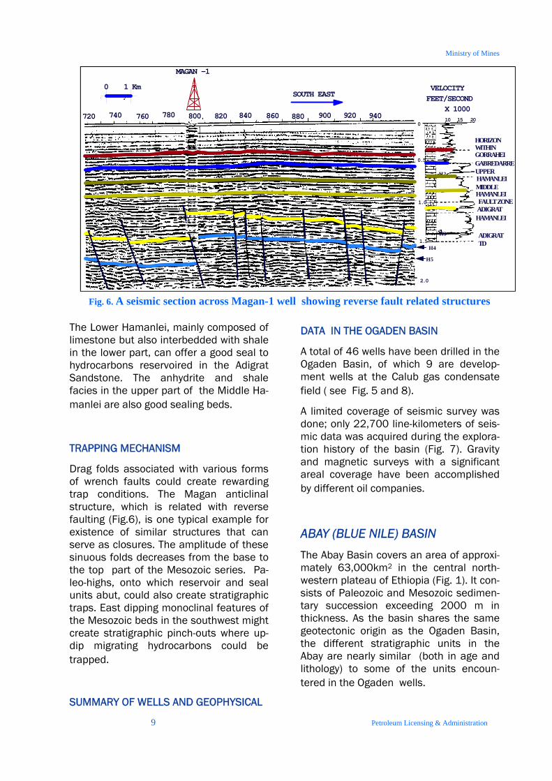
Drag folds associated with various forms of wrench faults could create rewarding trap conditions. The Magan anticlinal structure, which is related with reverse faulting (Fig.6), is one typical example for existence of similar structures that can serve as closures. The amplitude of these sinuous folds decreases from the base to the top part of the Mesozoic series. Pa-leo-highs, onto which reservoir and seal units abut, could also create stratigraphic traps. East dipping monoclinal features of the Mesozoic beds in the southwest might create stratigraphic pinch-outs where up-dip migrating hydrocarbons could be trapped.
SUMMARY OF WELLS AND GEOPHYSICAL
DATA IN THE OGADEN BASIN
A total of 46 wells have been drilled in the Ogaden Basin, of which 9 are develop-ment wells at the Calub gas condensate field ( see Fig. 5 and 8).
A limited coverage of seismic survey was done; only 22,700 line-kilometers of seis-mic data was acquired during the explora-tion history of the basin (Fig. 7). Gravity and magnetic surveys with a significant areal coverage have been accomplished by different oil companies.
ABAY (BLUE NILE) BASIN The Abay Basin covers an area of approxi-mately 63,000km2 in the central north-western plateau of Ethiopia (Fig. 1). It con-sists of Paleozoic and Mesozoic sedimen-tary succession exceeding 2000 m in thickness. As the basin shares the same geotectonic origin as the Ogaden Basin, the different stratigraphic units in the Abay are nearly similar (both in age and lithology) to some of the units encoun-tered in the Ogaden wells.
VELOCITYFEET/SECOND
X 1000
SOUTH EAST
GABREDARREUPPER HAMANLEIMIDDLEHAMANLEI
HAMANLEI
ADIGRAT
ADIGRAT
TD
FAULT ZONE
880 900 920 940860840820800780760740720
1.0
2.0
20
0.5
1.5
HORIZONWITHIN GORRAHEI
H 1
H 2
H 3
1510
1 Km0
MAGAN -1
H 4
H 5
0
Fig. 6. A seismic section across Magan-1 well showing reverse fault related structures

10 Petroleum Licensing & Administration
Ministry of Mines
SOURCE ROCKS
Beds of marl, shale and mudstone inter-bedded with carbonates in the lower part of the thick limestone unit (Antalo) are potential source rocks in the Abay Basin. The Antalo Limestone of the Abay Basin correlates with the Jurassic oil source unit
of Uarandab in the Ogaden.
Beds of black shale in the upper part of the Amaba Aradom Formation (the Upper Sandstone) are also probable potential source rocks in the basin.
A geochemical analysis of an oil seep from Were-Ilu locality in the northeastern margin of the basin suggests the pres-
ence of mature oil source rock of marine origin; possibly marine shale that has gen-erated oil.
Pre-Adigrat clastics, equivalent to the Ka-roo System in the Ogaden, possibly con-tain source rocks correlative with the Bokh shale that has generated hydrocar-
bons shown in deeper wells in the Ogaden. The presence of significant vol-ume of pre-Adigrat source rocks towards the southwest and eastern part of the ba-sin is speculated from geophysical and geological studies, and this makes the basin one of the promising areas to un-dertake petroleum exploration.
SINCLAIRE ELWERATH TENNECO WHITESTONE MAXUS HUNT MME VOYAGER0
5000
10000
15000
20000
Km.or
stn.
Companies
GRAVITY SEISMIC MAGNETICS
Fig.7 . Summary of Geophysical data acquired in the Ogaden Basin
Fig. 8. Depth ranges of exploratory boreholes drilled in the Ogaden Basin
0500
100015002000250030003500400045005000
Wel l s
Dep
th(m
eter
)

11 Petroleum Licensing & Administration
Ministry of Mines
RESERVOIR ROCKS
The potential reservoir rock in the Abay Basin is the Upper Sandstone, that con-sists of fine to medium grained, friable, moderately to well-sorted sandstones, as-sociated with thin beds of conglomerates and claystones. As this unit is composed predominantly of clean sand facies, poros-ity as well as permeability is expected to be fairly good.
Laterally restricted oolitic reefal limestone facies in the lower and upper-most parts of the Antalo Limestone and dolomite beds within the mudstone-dominated unit overlying the Antalo Limestone might also be considered as potential reservoir inter-vals in this Mesozoic sequence.
The Adigrat Sandstone remains to be a potential reservoir in the Abay Basin as well. Studies show that the Adigrat has a porosity reaching up to 20% and perme-ability values with a maxima at 710 mD.
SEAL ROCKS
Interbedded gypsum and shale beds within the unit that stratigraphically over-lies the Antalo Formation appear to be potential sealing rocks. The lateral extent of these likely seals is not well defined. Shale and clay intervals in the upper part of the Adigrat Formation could also serve as sealing rocks.
POSSIBLE TRAPPING MECHANISM
Oil generated from the Jurassic source rocks in the Abay Basin might be trapped by a combination of stratigraphic and structural traps. Horsts and tilted faulted blocks are the main structural traps that may play major role in trapping oil gener-ated in this basin. Stratigraphic traps might also be possible where local reser-voir facies get juxtaposed against seal fa-cies. This, however, needs to be verified by acquiring more sub-surface informa-
tion.
GAMBELA BASIN
The Gambela basin, located in southwest-ern Ethiopia, near the Sudan border, cov-ers an area of about 17,500 sq. km. It has a NW-SE-elongated outline, and it is presumed to be the southeastern exten-sion of the Melut Basin ( white Nile Rift) of South Sudan. Geological data review indi-cates that sedimentation in the interior basins of the Sudan is controlled by inter-mittent rifting phases that continued up to Mid Miocene.
The prospectivity of the Gambela area for hydrocarbons needs to be viewed in rela-tion with the South Central Sudanese ba-sins, which are renowned for oil pool dis-coveries. The Gambela area is the south-eastern extension of the Melut Basin where two oil discoveries (Adar and Yale) are present. The sedimentary thickness in Gambela Basin is estimated at 6 to 8 km. The source intervals for hydrocarbons in the Sudan basins lie in Lower Cretaceous sediments consisting predominantly of shale with subordinate sandstone. Hydro-carbon source beds in these rift basins are interpreted as lacustrine type depos-ited in anoxic environment, which makes them the best candidates as oil-prone source rocks.
Upper Cretaceous sandstones, fine to coarse-grained and moderately to poorly sorted, are the main reservoir rocks. Inter-mittent rifting and sedimentation in Terti-ary resulted in the deposition of lacustrine shale and mudstone and fluvial sand-stones each of which served a great role in formulation of the petroleum system. The Gambela area, therefore, is worth ex-ploring for its petroleum potential as the petroleum play fairways are quite similar to the petroliferous basins of the south-ern Sudan.
MEKELE BASIN The Mekele Basin, with an area of about

12 Petroleum Licensing & Administration
Ministry of Mines
8,000 sq km., is located in the northern part of the country (Fig. 1). The sedimen-tary succession of the basin comprises sediments ranging from fluvio-lacustrine to shallow and deep marine types. The whole sedimentary sequence reaches 2,000 meters in thickness.
Detailed studies, from the perspective of petroleum exploration, are yet to be made in this particular sedimentary basin. Some studies suggest that the area has some interesting geological make up to look for petroleum.
SOURCE ROCKS
The Upper Jurassic Agula Shale, predomi-nantly comprised of shale, marlstone and variegated clay beds (with limestone and gypsum interbeds), is presumed to have
good source potential for hydrocarbons. The Agula is correlative to the Madbi and part of the Naifa Formations of the Yem-eni Gulf of Aden region. The later are proven fair to good source rocks in the Mesozoic grabens of Yemen. Geochemical data on the source rock characteristics of the Agula Shale is, however, not sufficiently available.
The brown to black, micritic and in part laminated limestone bed of the Antalo Formation, that occurs particularly in the eastern section of the basin, appears or-ganic-rich. The upper part of the Antalo Formation, composed of beds of mud-stone, brown shale and greenish-black limestone interbeds, could possibly be considered as potential source quality in-terval for petroleum generation. This up-per-most part of the Antalo Formation is equated to part of the oil-prone Madbi Formation of Yemen.
Fig. 9. Stratigraphy of the Abay Basin
GohaTsion Formation
Upper Triassic –Lower Jurassic
Eocene—Oligocene
Volcanic
Antalo Limestone

13 Petroleum Licensing & Administration
Ministry of Mines
RESERVOIR ROCKS
The transgressive to braided-fluvial sandy Adigrat Sandstone, with a thickness rang-ing between 150m to 600 m and of me-dium-to-coarse-grained, grayish-white to pink-red sandstone (with intervals of silt,
clay and shale) is presumably the poten-tial reservoir; as it is in the Ogaden and Blue Nile Basins.
The Upper Cretaceous Amba Aradom For-mation (or Upper Sandstone) is another clastic sand-dominated unit of good reser-voir quality. The Amba Aradom consists of white, friable quartzose and pebbly sand-stone with good porosity. However, lack of a sealing facies could make it less impor-tant locally.
Other possible potential reservoir inter-vals , that are not yet clearly marked but their apparent existence is suggested, are in the dolomite-dominated beds of the carbonate sequence of the Antalo Lime-stone.
SEAL ROCKS
Marl, shale and mudstone beds in the up-per portion of the Antalo Limestone could offer seal potential for any carbonate-reservoired hydrocarbons, or where tight beds laterally get juxtaposed against sandstone reservoirs as a result of fault-ing.
The evaporitic (gypsum) interbeds in the
Agula Shale could serve as good seals for dolomite reservoirs in any Agula Shale- sourced hydrocarbons; at least, at a local level.
THE CENOZOIC RIFT BASINS THE AFAR RIFT The Afar Rift region, situated in northeast Ethiopia, covers an area of about 150,000 km2. It is widely believed that the Afar rift system area is a triple junc-tion of the Red Sea, Gulf of Aden and the East African Rift Systems. It is bordered to the west and south east by the Ethiopian Plateaux which have thicknesses between 1500 to 3000m, to the north by the Danakil horst and to the east by the plains of Djibouti Republic. The evolutionary development of the Afar rift has experienced sequential phases of arching (doming), rifting and subsidence of the crust since the early Tertiary. The rifting and subsidence tectonics, which occurred intermittently over a long period, has resulted in formation of horst and gra-ben structures. In a very similar structural configuration observed in continental rifts, the Afar Rift system is divided into a set of rift sectors, which probably have distinct deforma-tional features and thus have varied sedi-mentary depositional architecture. The major boundary fault or fault system, which runs N-S along the western flank of the Afar rift (forming the Western Escarp-ment), is a composite linear structure con-sisting of shorter fault segments each separated by transfer or accommodation zone. Similarly, the boundary fault to east, known as Eastern Escarpment, has ENE-WSW trend with segmented fault lines aligned in an enchelon assemblage. Gen-erally, there appears to exist systematic variation in the extensional strain, and therefore basin alignment and geometry, and magmatism from south to the north Afar.
Fig. 10. Upper part of the Agula Shale, Mekele Basin

14 Petroleum Licensing & Administration
Ministry of Mines
. Tectonically, the southern Afar has experi-enced much of a NW-SE extensional stress whereas NE-SW extension is domi-nant in northern afar. Strike-slip move-ments and strains of block rotation prevail at the central eastern Afar rift system. Several of the rift grabens in the southern Afar have a NNE-SSW-trending outlines and they are 50 to 60 Km long and 15 to 20 Km wide. The basins are evidently filled with fluvio-lacustrine sediments ranging in age from Miocene to Pleisto-cene and Quaternary. In the central and eastern Afar, within a rift system width of 200 Km, rift segment grabens of variable size occur with a gen-eral trend of NNW-SSE. The prominent among these basins in this sector of the rift system is Tendaho graben, with axial length of about 60 Km and a width of 20-22 Km. Deep wells drilled for geothermal exploration revealed a considerable thick-ness of sediments within a 1400m depth interval.
The northern part of the Afar rift is the area, which constitutes mainly the Danakil Depression, flanked to the west by the Western Escarpment and to the east by the Danakil Horst. Axial volcanic ranges (some of them still active volcanic cen-ters) and marine deposits characterize the Danakil Depression, which is about 100 Km wide and where elevations are below sea level in large part of its ex-panse. Normal faults, which decrease in age towards the axis of the depression, produce a series of horst and graben structures with varied sedimentary fill se-quence and geometries. Pre-Tertiary sedi-ments are well exposed at both flanks of the Depression, at the Danakil Horst (or Danakil Alps) to the east and along the Western Escarpment. THE MAIN ETHIOPIAN RIFT It is the area extending from the southern end of the Afar Rift southward along the axis of the eastern branch of the East Afri-can Rift System (EARS) up to the northern tip of the Southern Rift Basins. The Main Ethiopian Rift (MER) broadens towards north, where the northern sector has a rift system width of 80-120 Km while the width in its southern sector is 60-80 Km. The MER has a general NE-SW-trending elongation, characteristically flanked by fault escarpments on either side (i.e. to the west by the Western Escarpment and to the east by the Eastern Escarpment). Generalized regional synthesis of the area indicates that this sector of the East Afri-can Rift System has evolved from the de-velopment of half grabens with opposing polarity in the early rifting phase (Oligocene to early Miocene) to full sym-metrical grabens in later stages. The rift basins, which are contiguous but sepa-rated by transfer or accommodation zones, have variable strike lengths (ranging between 50 and 100 km) and widths over the area of the rift sector.
Mai
n Et
hiop
ian
Rift
Afar Rift
Fig. 11. Location of the Afar and Main Ethiopian rift Basins

15 Petroleum Licensing & Administration
Ministry of Mines
In some localities along the rift margin, there are observed exposed sections of pre-Tertiary sediments- Mesozoic sedi-ments- (sandstone and limestone units of the Adigrat and Antalo Formations, re-spectively, along with shale and marl beds) resting unconformably on the crys-talline basement. One typical example of such occurrences is at Kella horst, Guraghe area, along the western margin at the Escarpment. It is presumed that considerable thicknesses of sediment fill sections exist in these segmented rift gra-bens. In analogy to the southern rift ba-sins of Omo and Chew Bahir, the Neogene sedimentary section in the grabens of the MER could reach 2.5 to 3 km of thick-ness. As the rift floor is affected by recent normal faults, accompanied by active vol-canism in some localities, the general rift-fill sediment section has a decreasing trend in age towards the center or the rift floor. A number of lakes observed today over the long stretch of the Ethiopian Rift valley lay occupying the central axis of the rift floor.
SOUTHERN RIFT BASINS
The Southern Rift Basins are represented mainly by N-S-striking Omo and Chew-Bahir basins that lie within the broadly rifted zone of southwestern Ethiopia (Fig-1). In southern Ethiopia, rift develop-ment began during late Oligocene to early Miocene and has continued periodically to the present day.
The southern parts of the Omo and Chew Bahir Basins are presumed northward continuations of the Oligocene rift system of north Kenya. In the latter area, gravity and seismic interpretations suggest more than 3.5 km of sedimentary fill within the basins. By analogy and based on model-ing gravity data, the Omo and Chew Bahir Basins are found to contain similar thick-ness of sediments.
The existence of sediments of Jurassic-
Cretaceous rift system underneath the Tertiary rift strata is also possible. This suggestion is based on Bouguer gravity data which indicates E-W -striking struc-tures in the area that correlate exactly with E-W striking strike-slip faults (or an E-W fault zone) linking the Southern Sudan rift (which includes the Muglad Basin) with the Anza Graben of northern Kenya.
As the southern Sudanese Mesozoic (Late Jurassic-Cretaceous) rift basins are known to be petroliferous, with large oil field dis-coveries mainly in the Muglad and Melut Basins, it appears likely that the sug-gested Mesozoic sediments beneath the Tertiary strata could be potentially attrac-tive for oil/gas exploration in the Omo and Chew Bahir Basins as well.
Moreover, organic-rich oil shale with an average oil yield of 8 lit/ton occurs in a regionally WSW-ENE trending Tertiary gra-bens in the northern part of the Southern Rift Basins (Fig.1). This region also war-rants exploring for hydrocarbons with speculation that oil/gas generation could be facilitated due to high thermal activity related with volcano-tectonic episodes that occurred intermittently throughout the Tertiary.
Current Petroleum Exploration Activities
The Government of Ethiopia represented by the Ministry of Mines enters petroleum exploration and development agreements with different International Oil Companies in two ways. One is when the Ministry signs “Petroleum Production Sharing Agreement” (PPSA) which could last up to 25 years and the other one is a “Joint Study Agreement” (JSA) for a maximum of two years. PRODUCTION SHARING AGREEMENTS (PSA):
Currently Pexco Exploration (East Africa) NV Malaysia-based oil company); Africa Oil East Africa B.V., a company registered in The Netherlands, have entered a Petro-

16 Petroleum Licensing & Administration
Ministry of Mines
leum Production Sharing Agreement (PPSA) and are undertaking petroleum exploration in the southeastern, south-western and in the northern parts of the Ogaden Basin.
Afar Exploration (USA registered) and Southwest Energy (Hong Kong-registered) have also been awarded exploration li-censes (PPSA) in the Afar and Ogaden ar-eas, respectively.
Epsilon Energy Limited, Calvalley Petro-leum Limited, a Canadian based compa-nies, and Falcon Petroleum Limited have signed PPSA for blocks in the northern, western and central parts of Ethiopia, re-spectively. Tullow Oil, Africa Oil and Agriterra are also jointly operating in the Southern Rift basin. A number of compa-nies have also shown interest to explore for petroleum in Ethiopia, and negotiation is underway with some of these compa-nies.
JOINT STUDY AGREEMENT: A Joint Study Agreement on geological and geophysical survey is underway in the Main Ethiopian Rift Basin region after an agreement was signed between Africa Oil company and the Ministry of Mines recently.
Calub and Hilala gas-condensate fields with respective reserves of 2.7 Tcf and 1.3 Tcf are expected to undergo develop-ment soon, as there are companies who have shown great interest to venture out in the business.
AVAILABLE DATA
• Petroleum potential of Ethiopia (Beicip-Franlab 1998).
• The Hydrocarbon Potential of the Ogaden Basin (Alconsult International Ltd. 1996).
• Petroleum Geochemical evaluation (Ogaden Basin).
• Well logs and well reports (46 wells: Ogaden Basin)
• Seismic Data (Ogaden Basin 22,700 line km).
• Landsat structural study SW Ethiopia: Gambella-Omo area)
• Gravity and Aeromagnetic data (Ogaden– Abay river –Gambela area).
• Geochemistry and Petrophysics labo-ratory analysis
PETROLEUM AGREEMENT TERMS
Petroleum agreement will be in the form of Model Production Sharing Agreement of 1994 or Modern Concession contract to be signed between the Government of Ethiopia, represented by the Minister of Mines (MoM) and a Contractor.
PETROLEUM LEGISLATION:
∗ Proclamation N0. 295/1986 of petro-leum Operations proclamation.
∗ Proclamation NO. 296/1986 of petro-leum Operations Income Tax procla-mation, amended under proclamation No. 226/2000.
ROYALITY, TAX AND RENTALS
∗ Royalty: negotiable, tiered on produc-tion rate.
∗ Production share: negotiable, tiered on production rate.
∗ Annual land rentals: $4 per sq km dur-ing exploration, $8-$20 per sq km dur-ing exploration extension, and $200 per sq km for a development area.
∗ Dividends/Remittances or tax on ex-port profits: none.
∗ Income Tax: 30% from Petroleum Op-erations Income Tax Proclamation.
∗ Depreciation: all pre-production cost and production capital expenditures are depreciated over five years.
∗ Loss during the accounting period may

17 Petroleum Licensing & Administration
Ministry of Mines
be carried forward to a maximum of 10 years.
GAS PROVISIONS:
∗ Same as oil; possible modification on cost recovery and production sharing if warranted.
SIGNATORY:
∗ The Ministry of Mines (MoM) on behalf of the Ethiopian Government.
ADMINISTRATION:
∗ Responsibility of MME according to the Petroleum Operations Proclama-tion, Petroleum Income Tax Proclama-tion and the Petroleum Production Sharing Agreement.
CONDUCT AND DURATION OF OPERATIONS:
∗ Generally accepted international pe-troleum industry standards and prac-tices.
∗ Exploration up to 4 years with up to 4 years extension.
∗ Production : 25 years with 10 years extension.
DISPUTE SETTLEMENT:
∗ Mutual settlement or international ar-bitration; details to be specified in pe-troleum agreement.
MINIMUM OBLIGATIONS:
∗ Exploration: negotiable.
∗ Expenditure: negotiable, priority is given to the exploration work obliga-tions.
∗ Signature Bonuses: negotiable.
∗ Production Bonuses: negotiable.
CONTRACTOR'S TAKE:
∗ Production Share: negotiable.
∗ Cost Recovery: all petroleum opera-
tions costs-100% recoverable as in-curred.
∗ Cost recovery Limits: negotiable, sub-ject to maximum percentage of daily production, contemplated on tier at 50 to 60%.
∗ Income tax is excluded from cost recovery.
GOVERNMENT PARTICIPATION:
∗ Exploration: none.
∗ Production : negotiable.
SUBMISSION OF APPLICATION
1. SPECIFIC TERMS AND CONDITIONS FOR APPLICATION
Applications from individual companies as well as from groups of companies will be considered.
2. SUBMISSION OF APPLICATION
2.1 Address for submission of application
An application should be made to:
Minister (_________)
Ministry of Mines
P. O .Box 486.
Addis Ababa, Ethiopia
It should be submitted in a sealed enve-lope delivered by certified mail or hand. The envelop must be marked:
"Confidential"
"Proposal for Petroleum Explora-tion and Production"
There is no application fee..
2. 2 Content of an application

18 Petroleum Licensing & Administration
Ministry of Mines
Presentation of applications shall be in accordance with 2.4 below.
All documents concerning an application shall be kept confidential by all parties.
2.3 Inquiries
Any information or clarification on the submission of an application may be ob-tained from:
Petroleum Licensing & Administration Ministry of Mines P. O. Box 486 Addis Ababa, Ethiopia Tel: 251-11-646-12-09/08
Fax: 251-11-646-34-39 or 251-11-646-33-64
After having examined the applications received, the Government may, at its sole discretion, invite a successful applicant to appear in Addis Ababa for negotiation.
ii. A petroleum agreement will be signed with a successful applicant upon the conclusion of negotiation in a manner satisfactory to the Minister of Mines. It is the wish of the Government that the agreement reached shall be effected as soon as possible.
iii. The Minister reserves the right to ac-cept or reject any proposal, without being obliged to justify his decision on the subject.
2.4 FORM OF PRESENTATION AND-CONTENT OF APPLICATION
i. An application in respect of all blocks should be presented in a sealed enve-lope. An applicant may apply for more than one block. An application may be made by a company or group of com-panies.
ii. An application shall contain the follow-ing:
(a) the identification of the block(s) to which the application applies;
(b) Each applicant should notify of; the name and address of the appli
cant in full; the nature of its business; the place of incorporation; the principal place of business;
evidence of the financial standing and technical qualification and ex-perience of the applicant, including a copy of the most recent audited accounts of the applicant and of any body corporate having control of such applicant;
the name and address of duly au-thorized agent in Ethiopia, if such agent has been already appointed by the applicant at the time of appli-cation;
© Where the application is made by a group of companies, information un-der paragraph (b) will be provided by each company; the name of the op-erator and the participating interest of each company will be also pro-vided;
(d) The terms proposed by the applicant in respect of the major aspects of the model agreement.
3. ASSESSMENT OF APPLICATION
In assessing applications, the Govern-ment shall focus, among others, on the following:
(a) Minimum exploration work and expenditure obligations;
(b) The economic benefits to the country, with emphasis on Profit Oil sharing;
(c) The applicant’s proposal regard-ing natural gas

Petroleum Exploration and Development blocks in Ethiopia

20 Petroleum Licensing & Administration
Ministry of Mines
DATA PACKAGES
Information and data packages are available with Petroleum Licensing and Administration in the ministry of Mines. The data packages contain well and Seismic data together with reports describing the petroleum poten-
tial . Interested investors are welcome to visit the office’s data room in Ad-dis Ababa to view and to obtain further information on exploration oppor-
tunities.
MORE INFORMATION
Interested parties are invited to contact our office for further information concerning technical , legal and contractual details or any other queries
regarding participation in exploration and production in Ethiopia.
Petroleum Licensing & Administration ,
Ministry of Mines , P. O. Box 486, Addis Ababa, Ethiopia
Tel: 251-11-646-12-09, 251-11-646-12-08
Fax: 251-11-646-34-39 , 251-11-646-33-64
May , 2011