participating public partners - abettercity.org
TRANSCRIPT


Participating Public PartnersBoston Redevelopment Authority
Boston Parks and Recreation Department
Boston Transportation Department
Central Artery Tunnel Project
Massachusetts Turnpike Authority
Participating Abutters Intercontinental Real Estate Corporation
Imperial Seafood (with Douglas Wohn)
The Druker Company, Ltd.
Kingston Realty Trust | United Curtain
The Gale Company
State Street Bank
Teradyne, Inc.
Participating Community Representatives
Chinatown | Leather District Central Artery Advisory Committee Co-Chairs >
Stephanie Fan, Chinatown
David Seeley, Leather District
consultants to the Artery Business Committee
Introduction
Methodology
Principles
Beach Street Corridor
Kingston-Edinboro Loop
Surface and Essex Street Intersection
Implementation
CONTENTS 6
8
9 > 11
12 > 17
18 > 21
22 > 25
26 > 29
ACKNOWLEDGEMENTS

The Artery Business Committee commissioned Utile, Inc., an architecture and planning firm, to analyze the open space, development parcels, and building edges that abut the future Chinatown Park (parcel 23D) and to recommend physical and programming enhancements to building and sidewalk edges that could activate this future park space. As a result of an iterative process that involved collaborative discussions with the local community, local property and business owners, city agencies, representatives of the Central Artery Tunnel Project, and the designers of the Chinatown Park, the study recommended improvements to both the public realm and to the private properties within the study area. This effort is intended to supplement the park design team’s work in its coordination with the surrounding context and the new 17A6 Contract streetscape, specifically addressing potential opportunities for change within that context to better respond to the newly created public realm.
The Edge Study documents the park's abutting properties and their relationship to the surrounding 17A6 Contract streetscape, which will remain as baseline, and identifies locations for design and programming improvements of both indoor and outdoor, public and private ground floor spaces, including possible minor modifications to the 17A6 Contract design.
The goal of this study was to synthesize the varied interests of the many constituencies that engaged in this process into a single but flexible and realistic vision for the area. The intention of the study is to have these many fine-grained recommendations serve as a touchstone for future conversations between the community and potential agents of future improvements. These may include new projects proposed by private developers, public improvements proposed by city or state agencies, and improvements by the owners of buildings and businesses in the area.
Broadly, the study recommendations fall into four areas. First, to improve the city streets and sidewalks where they connect with the park and with other Central Artery Tunnel surface improvements. One specific area of interest was the Kingston-Edinboro loop on the northern boundary of the park (see pages 18 through 21).
Second, to extend features of the park, including specific paving design and tree species, beyond the bounds of the park to increase the perceptual boundaries of the open space. One specific recommendation extends the art paving, proposed as part of the park design at the threshold to the Chinatown Gate, across Surface Street. Expanding the concept of the threshold to include the Surface Street crosswalk will both expand the boundaries of the park and reinforce the importance of the Beach Street corridor (see page 12).
Third, to consider the block that runs south of the Chinatown Gate and the vent building (bounded by Hudson and Surface Streets) as a unified urban design vision. One of several recommendations proposes a new branch library or other community building, requiring a public-private partnership (see pages 15 through 17).
Finally, to encourage active ground floor uses along the park boundary. As part of the future redevelopment of the existing 19th century loft buildings, new building additions on the vacant parcels that abut the Chinatown Park to the north will create a new ‘face’ to the park and new activities that will contribute to a lively public realm. One parcel abuts directly on the park, creating potential future reciprocal benefits between public space and new ground floor uses (see pages 21 and 25).

24
20
14
RECOMMENDED FUTURE GROUND FLOOR USES
gstonboro

PLANNED AND RECOMMENDED PUBLIC SPACE IMPROVEMENTS
22
18
12
6
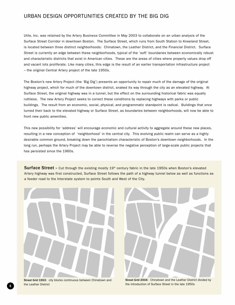
Street Grid 1953: city blocks continuous between Chinatown and the Leather District
Street Grid 2004: Chinatown and the Leather District divided by the introduction of Surface Street in the late 1950s
Utile, Inc. was retained by the Artery Business Committee in May 2003 to collaborate on an urban analysis of the
Surface Street Corridor in downtown Boston. The Surface Street, which runs from South Station to Kneeland Street,
is located between three distinct neighborhoods: Chinatown, the Leather District, and the Financial District. Surface
Street is currently an edge between these neighborhoods, typical of the ‘soft’ boundaries between economically robust
and characteristic districts that exist in American cities. These are the areas of cities where property values drop off
and vacant lots proliferate. Like many cities, this edge is the result of an earlier transportation infrastructure project
– the original Central Artery project of the late 1950s.
The Boston’s new Artery Project (the ‘Big Dig’) presents an opportunity to repair much of the damage of the original
highway project, which for much of the downtown district, snaked its way through the city as an elevated highway. At
Surface Street, the original highway was in a tunnel, but the effect on the surrounding historical fabric was equally
ruthless. The new Artery Project seeks to correct these conditions by replacing highways with parks or public
buildings. The result from an economic, social, physical, and programmatic standpoint is radical. Buildings that once
turned their back to the elevated highway or Surface Street, as boundaries between neighborhoods, will now be able to
front new public amenities.
This new possibility for ‘address’ will encourage economic and cultural activity to aggregate around these new places,
resulting in a new conception of ‘neighborhood’ in the central city. This evolving public realm can serve as a highly
desirable common ground, breaking down the parochialism characteristic of Boston’s downtown neighborhoods. In the
long run, perhaps the Artery Project may be able to reverse the negative perception of large-scale public projects that
has persisted since the 1960s.
URBAN DESIGN OPPORTUNITIES CREATED BY THE BIG DIG
Surface Street > Cut through the existing mostly 19th century fabric in the late 1950s when Boston’s elevated
Artery highway was first constructed, Surface Street follows the path of a highway tunnel below as well as functions as
a feeder road to the Interstate system to points South and West of the City.

7
Scope of Study
Scope of C17A6
Scope of P23D Park Design
Scope of C17A6
Properties Contiguous with Open Space
Scope of Urban Design
Scope of P23D Park Design
Scope of Study
Scope of Study
From its inception, this study acknowledged the advantages of a new ‘place’
at Surface Street that would better connect the abutting districts. The
symbolic and functional center is the new Chinatown Park that the Artery
Project will build on the west side of the Surface Street (at Beach Street).
This study was timed to coincide with the park design so that reciprocities
could be found between the specific programmatic content of the park
and larger possibilities for city-building, whether in the public realm (with
improved streets and squares) or in the private sector (with new real estate
development and the resulting ground floor modifications and activation).
The study is as much about ‘visioning’ as it is about encouraging dialogue
between interests. In general, strong communication between design of
the public realm (in this case the Chinatown Park) and design of private
development (in this case, abutting property owners) will lead to reciprocal
decisions that benefit both the park and the new development – creating an
active urban realm.
The goal of the study in regards to the park design was to expand the
perceptual realm of the park beyond its specific contractual boundaries.
Instead of the park functioning as a ‘place apart’ from the city around it,
we consider the park an anchor to a new inclusive district that connects
the Financial District, Dewey Square, the Leather District, Chinatown, and
proposed new developments south of Kneeland Street. Future development
on the vacant parcels surrounding the park will re-connect the urban fabric
between the abutting districts if given an appropriate density and diversity of
uses.
NEW PUBLIC SPACES AS THE COMMON GROUND BETWEEN NEIGHBORHOODS

8
METHODOLOGY OF STUDY
Zoning and Buildable Parcels
Mid-town Cultural District
Leather District
Tyler StreetSpecial StudyArea
Historic ChinatownProtection Area
Commercial Chinatown Sub-District
South Station
Parcel to Parcel Linkage
General
General
Developable Parcels
Future building edges were determined by an analysis of as-of-right zoning. For the
purposes of this study, as-of-right
zoning was depicted as a ‘what if’
scenario, first to see if development
was likely to be built out to parcel
lines (it is) and secondly to better
understand the future potential of an
active building edge as it meets the
public realm. The other advantage
of depicting as-of-right zoning
development is that it provides a
gauge of what is feasible.
An overall plan was informed by a focus on detailed conditions. The study
looked at the planning, urban design,
and architectural opportunities of
specific interfaces between the
Chinatown Park (parcel 23D) and
the surrounding city. These areas
included the Beach Street corridor,
the Kingston-Edinboro loop, and
the Surface and Essex Streets
intersection.
Detailed Study Areas
Kingston-Edinboro Loop
Surface and Essex Streets Intersection
Beach Street Corridor

9
THE RECOMMENDATIONS THAT EMERGED FROM THIS STUDY WERE BASED ON SEVERAL PRINCIPLES:
The whole should be greater than the sum of the parts. The study recommendations aim at providing
a mutual benefit to abutting neighborhoods, the general public, and the abutting property owners in a way that ‘the
whole is greater than the sum of the parts’. New development that benefits from the park will enliven and diversify
the user population of the park, add ‘eyes on the park’ and thus increase the sense of security, and will add to the
pool of abutting property owners that can contribute to the park’s maintenance. At the same time, the park will be
an important amenity to the adjacent properties, perhaps encouraging development to occur sooner, reducing the
perceived risk in terms of financing options and leading to higher quality buildings.
Successful urban design looks for reciprocal benefits between public space and private property. The careful coordination of public space and privately held but publicly accessible private property is
one of the primary aims of urban design. The coordination of the design of publicly owned public space and privately
accessible plazas, arcades, and retail spaces is critical for a diverse and culturally rich urban environment. This
continuum of urban experience privileges the spatial, programmatic, and economic grain of the city over the specific
location of property lines. The culture of cities not only in the West, but also in the East and Middle East is predicated
on this larger mosaic of public and semi-public space as well as the ability of commerce to overlap boundaries into the
public realm. The Italian outdoor café, the Middle Eastern souk, and Asian markets are all examples of the necessity
of this overlap.
Future improvements to the urban realm should increase the perceptual boundaries of the park. The study recommendations attempt to expand the perceptual realm of the park and thereby position it as
anchor not only of neighboring Chinatown but also of a broader area that includes the Leather District, the southern
edges of the Financial District, and the emerging South Bay district. This would be done by adopting specific features
of the park design such as lighting, paving, and trees in future open space contracts in the immediate vicinity.
The vacant private parcels should be built out. Preferably, new development will include a variety of uses
such as office, residential, retail, and hotels. All new development should maximize ground level retail. Diverse uses
encourage an active public realm. If the vacant lots of the area are filled in, then the current ‘no-mans-land’ between
Chinatown, the Leather District, and the Financial District will disappear. Instead, the park will be read as a beautiful
open space in the continuous urban grain of Boston, much the way that Post Office Square is understood within its
neighborhood.
Future improvements should be realistic. The study recommendations are based on a short to medium
term - a 1 to 10 year time frame - and realistic vision for the area. They are intended to be economically, politically,
legally, and technically feasible to implement given the economic conditions of the current real estate market, the
regulatory and approvals process, the larger development pressures of the neighborhood, and an understanding of the
needs and desires of the community.

10
EXISTING

11
LIKELY FUTURE GROUND FLOOR EDGES

12
BEACH STREET CORRIDORPublic Improvements
The study of the Beach Street corridor looked at several important issues:
1> The expansion of the perceptual realm of the park across Surface Street.
2> The mitigation of the presence of the Artery vent building.
3> The addition of appropriately scale publicly accessible ground-level program to the south end of the park, a space otherwise difficult to program.
4> Reinforcement of the symbolic importance of the Chinatown Gate.
Beach Street.
Sur
face
Str
eet
Key Plan
Extend specialty paving > A separate Central Artery Project surface restoration contract exists for specialty art
paving on both the west and east sides of Surface Street in the Beach Street corridor. Our recommendation is to treat
both components of the paving as a single composition. The segment of the design that crosses Surface Street can
function as the designated crosswalk zone.
Recommendation: Realign proposed C17A6 art paving and extend the language of the specialty art paving across Surface Street as paved crosswalks
Re-align C17A6 proposed paving
Recommended pavedcrosswalk

13
Existing: Highway ramp
Beach Street
Sur
face
Str
eet
Increase paved area to extend perceptual realm of park across Surface Street
Beach Street
Sur
face
Str
eet
Reclaim space above ramp > Initial analysis suggests that the southbound ramp opening is longer than it needs to
be. More paved pedestrian area can be claimed at the Beach Street-Surface Street intersection. This will encourage more
west-facing ground-level retail on the redeveloped garage parcel. The potential addition of this pedestrian space will most
likely be implemented as part of the scope of a future redevelopment of the garage site.
Existing Recommendation: Add additional pedestrian space over the ramp opening

14
BEACH STREET CORRIDORPrivate Development
Recommendation: Active ground flooruses along street edge with parking along ramp edge
Plan Option 1: Lobby at Beach Street Plan Option 2: Lobby at Lincoln Street
Hotel | Residential
Retail | Restaurant
Parking | Service
Lobby
Retail Restaurant
Parking
Parking Entry
Lobby
Retail Restaurant
Parking
Parking Entry
Beach Street.
Sur
face
Str
eet
Beach Street.
Sur
face
Str
eet
Future development on Lincoln Street > This study examined the potential improvements to the ground-
level sidewalk edge if the garage site on Lincoln Street was redeveloped. An as-of-right development housing/hotel
scenario was modeled to analyze options for the location of building lobbies, retail, and service/parking access. In
conjunction with the recommended expansion to the paved pedestrian area over the ramp, the study recommends
ground-floor retail at the Beach Street/Surface Street corner.
Key Plan

15
Analysis: As-of-right development at Hudson Street
ResidentialCommercial(4 Parcels)
RetailRestaurant
RetailRestaurant
Lobby
Sur
face
Str
eet
Hud
son
Str
eet
Park space
Park Space
Recommendation Option 1: Tea pavilion and/or park concession as park ammenities on either or both sides of the vent building
Recommendation Option 2: Community use at vent building
Park Concession
MaintenanceServiceStorage
Park Use :Tea HouseFood Vendors
Park Concession
Park Use :Tea HouseFood Vendors
Lobby
Community Use :LibraryCommunity Center
Second Story “Tea Balcony”
ResidentialCommercial
ResidentialCommercial
Community Use :LibraryCommunity Center
Sur
face
Str
eet
Hud
son
Str
eet
Sur
face
Str
eet
Hud
son
Str
eet
Future development on Hudson Street > The study
looked at several options for the
privately owned development parcels
at the south end of the park. One
option examined the possible
continuation of the park, which would
require a public purchase of these four
privately owned parcels.
The study also considers the likely
as-of-right development on the four
contiguous development parcels on
Hudson Street. While the Chinatown
Park could continue up to the
boundary of these new buildings, a
one-story structure on either or both
sides of the vent building would help
mitigate the negative impact of the
existing Artery vent structure on
the park. Options for this structure
include a park concession building
and/or tea house.
Analysis: Continue park
Sur
face
Str
eet
Hud
son
Str
eet
Park space
Another concept that emerged
was to think of the privately-held
development parcels and the public
space around the base of the vent
building as a single building site for
a combination of public and private
functions. This concept envisions a
community-based use or uses on the
first two floors and housing above.
The community use could be a
branch of the Boston Public Library
with a second story ‘tea balcony’.

16

17
18
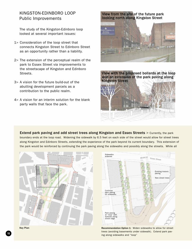
KINGSTON-EDINBORO LOOP Public Improvements
Recommendation Option 1: Widen sidewalks to allow for street trees (avoiding basements under sidewalk). Extend park pav-ing along sidewalks and “loop”
Kingston S
treet
Edinboro Street
Essex Street
Sidewalks widened
Continue park paving on sidewalks
Existing historicpaving
Park paving at “loop” withbollards along street edge
New street trees
The study of the Kingston-Edinboro loop looked at several important issues:
1> Consideration of the loop street that connects Kingston Street to Edinboro Street as an opportunity rather than a liability.
2> The extension of the perceptual realm of the park to Essex Street via improvements to the streetscape of Kingston and Edinboro Streets.
3> A vision for the future build-out of the abutting development parcels as a contribution to the public realm.
4> A vision for an interim solution for the blank party walls that face the park.
Key Plan
Extend park paving and add street trees along Kingston and Essex Streets > Currently, the park
boundary ends at the loop road. Widening the sidewalk by 6.5 feet on each side of the street would allow for street trees
along Kingston and Edinboro Streets, extending the experience of the park beyond its current boundary. This extension of
the park would be reinforced by continuing the park paving along the sidewalks and possibly along the streets. While all

19
three options recommend expanding the park’s perceptual boundaries and enhancing the pedestrian experience in the
Kingston-Edinboro loop by extending the park pavement along the sidewalks and partially or fully along the streets, the
intent is that both streets will remain open to managed/regulated vehicular traffic to allow on-street parking, service
vehicles, pick-up and drop-off, and residential car access to the adjacent redeveloped buildings.
Recommendation Option 2: Widen sidewalks to allow for street trees. Extend park paving along sidewalks and streets to Es-sex Street
Kingston S
treet
Edinboro Street
Essex Street
Sidewalks widened
Continue park paving on street and sidewalks to Essex Street
Existing historicpaving
Bollards along street edge
New street trees
Recommendation Option 3: Widen sidewalks to allow for street trees. Extend park paving along sidewalks and “loop”. Modify “loop” configuration
Kingston S
treet
Edinboro Street
Essex Street
Sidewalks widened
Continue park paving on sidewalks to Essex Street
Existing historicpaving
Modify shape of loop road to provide more park area.
New street trees

20
KINGSTON-EDINBORO LOOPPrivate Development
There is potential for development along the edges of
the park that will change both the character and spatial
definition of the park boundaries. In the short-term, design
solutions are required to screen the surface parking lots
that currently occupy these development parcels. As a
result, the designers of the park have proposed a wall and
heavily planted edge along the northern boundary of the
park between Kingston Street and Essex Street. Once an
appropriate redevelopment plan emerges, modifications to
that edge of the park may be warranted to encourage more
accessible ground-level retail or public uses.
At the same time, we recommend creative short-term
solutions for the blank party walls that face the park. A
large-scale tasteful advertising /art image can temporarily
transform the walls. Corporate or government agency
sponsorship may be required to fund these improvements.Key Plan
Encourage active ground floor uses along park edges >

21

22
SURFACE AND ESSEX STREETS INTERSECTIONPublic Improvements
The study of the Surface-Essex Streets intersection looked at three important issues:
1> Consideration of the paving of the adjacent sidewalks and plazas as a way to extend the perceptual realm of the park.
2> A vision of the future build-out of the abutting development parcel as a contribution to the public realm.
3> A vision for an interim solution for the blank party walls that face the park.
Key Plan
Red brick with granite

23
Brick with Granite
Grass
Granite
Black Brick
Red Brick
Concrete
Red BrickRed Brick
Unique ParkPaving
ChinatownPaving
Dewey SquarePaving
Analysis: Future paving per current contracts Recommendation Option 1: Unify sidewalk and park paving as unique district south and west of Surface Street – Essex Street intersection. This change will require modifications to C17A6 contract that will necessitate an additional funding source
Recommendation Option 2: Deploy red brick as a ‘base’ sidewalk material and treat area within sidewalk boundaries as a special park paving. This change will require modifications to C17A6 that will necessitate an additional funding source
Recommendation Option 3: Same as Option 2, but carry red brick paving to threshold gate at egress stair structure. Also make changes to Dewey Square design by replacing grey brick with red brick west of the vent structure at Essex Street. This change will require modifications to C17A6 that will necessitate an additional funding source
Create paved threshold between Chinatown and Dewey Square > The study looked at several
options for the interface between the park paving and the paving of the surrounding district. Our recommendations
examine either extending the park paving beyond the realm of the park or extending the surrounding brick paving to
frame the park. Either would require a modification to the current C17A6 contract.
Unique ParkPaving
Unique ParkPaving

24
Encourage active ground floor uses along park edges > There is potential for development
along the edges of the park that will change both the
character and spatial definition of the park boundaries.
In the short-term, design solutions are required
to screen the surface parking lots that currently
occupy these development parcels. As a result,
the designers of the park have proposed a wall and
heavily planted edge along the northern boundary of
the park between Kingston Street and Essex Streets.
Once an appropriate redevelopment plan emerges,
modifications to that edge of the park may be
warranted to encourage more accessible ground-level
retail or public uses.
At the same time, the study recommends a creative
short-term solution for the blank party wall that
faces this area of the park. A large-scale tasteful
advertising /art image can temporarily transform the
wall. Corporate or government agency sponsorship
may be required to fund this improvement through an
appropriate permitting process.
View from the corner of Essex Street andSurface Street looking south and west
Vi f d k d lik l
Key Plan
SURFACE AND ESSEX STREETS INTERSECTIONPrivate Development

25

26
IMPLEMENTATION
Existing: Current Ground Floor Uses
Commercial (Public Access)
Service
Restaurant
Commercial (No Public Access)
Vacant
Recommendation: Future Added Ground Floor Uses
Existing and recommended future ground floor uses >
Commercial (Public Access)
Service
Restaurant
Residential
Community Use
Given regulatory and economic conditions in Boston, the framework for implementation must be somewhat open-
ended. For example, how will the recommended improvements to Kingston Street be funded? It is likely that a private
developer will pay for the improvements to neighboring streets and sidewalks as part of project mitigation. The study
recommendations are intended to provide a vision that can advise the development process when developers, the
community, and city agencies get together to plan and to approve upcoming development in the area. The following are
two examples of how these recommended improvements could be implemented:
A library at vent building adjacent to Chinatown Park > The implementation of a library adjacent to
the vent building, while possible, will require both consensus building within the Chinatown community and with the
city of Boston and Boston Public Library. With suitable support, a well-coordinated strategy should be put into place
to leverage the opportunities afforded by the mitigation that will result from large-scale real estate development in the
Chinatown area. For a project of this complexity to happen, one or several members of the community will need to
adopt the project and champion its cause with the city and within the context of the community approvals process for
neighboring development projects. Most importantly, a case will need to be made to the private property owners on
the block that there can be both economic and community benefits to working together to develop a single and more
ambitious scheme for the site.
Widen sidewalks and add street trees along Kingston and Edinboro Streets > The
implementation of our recommended improvements to the Kingston-Edinboro loop will require several steps. Like
any of the study recommendations, the concept will need to be embraced by the community and then championed
by neighborhood leaders as opportunities arise. For the proposal to have more chances of implementation, a more
thorough study should be done. This study would include a more detailed assessment of the location and condition
of subterranean sidewalk vaults and utilities so that future tree and street light locations can be more accurately
coordinated.
There are two general implementation scenarios for this project. The first is a project that is paid for by public monies,
coordinated by the Boston Redevelopment Authority (BRA), the Boston Transportation Department (BTD), and the

27
ImprovementsBeach Street Corridor >
Re-align proposed C17A6 art paving
Extend specialty art paving at Chinatown Gate across Surface Street as paved crosswalks
Reclaim paved space over southbound ramp opening on Surface Street
Retail use along Surface, Beach, and Lincoln Streets
Tea pavilion and/or concession space at existing vent building adjacent to Chinatown Park
Community use (library, etc.) at vent building adjacent to Chinatown Park
Kingston-Edinboro Loop >
Widen sidewalks along Kingston and Edinboro Streets
Plant street trees along Kingston and Edinboro Streets
Extend Chinatown Park paving along Kingston and Edinboro sidewalks and streets partially or fully
Possible modification of loop road configuration
Provide interim advertising/art screens on building facades facing park
Future ground floor restaurants along park edges
Modifications to park planters to allow future ground floor restaurants to open onto park
Surface and Essex Streets Intersection >
Provide interim advertising/art screen on building facade facing park
Future ground floor cafes/restaurants
Potential modification to park planters to allow future ground floor cafes/restaurants to open onto park
Department of Public Works (DPW), and then implemented by the DPW. The second option is that the improvements
are completed as part of the redevelopment of the abutting parcels. In this case, all of the same city departments
will be closely involved in the design development, approval, and implementation of the public realm improvements. A
combination of both scenarios is also possible when the improvements are implemented through various models of a
public-private partnership.
Implementation
C17A6 contract
Public or private funding source
Private development mitigation and public contract
Private development
Publicly funded and/or mitigation
Publicly funded and/or mitigation
Public contract and/or private development
Public contract and/or private development
C17A6 and another public contract and/or private development
C17A6 and/or another public contract
Property owner and/or corporate sponsorship or funded art project
Private development
Private development
Corporate sponsorship or funded art project
Private development
Private development
Timeframe
1 year
1 year
10 years
10 years
5-10 years
5-10 years
5-10 years
5-10 years
1 year
1 year
1 year
5-10 years
5-10 years
1 year
5-10 years
5-10 years
Page
12
12
13
14
15
15
18
18
18
19
21
20
21
25
24
25

28
FUTURE VISION FOR PARK EDGESExisting and Recommended Ground Floor Uses
Retail use along Surface, Beach, and Lincoln Streets
Community use (library, etc.) at vent building adjacent to Chinatown Park
Commercial (Public Access)
Service
Restaurant
Residential (Public Access)
14
15
Future ground fl oor cafes and restaurants along park edges
2521

29
Extend specialty art paving at Chinatown Gate across Surface Street as paved crosswalks
Reclaim paved space over southbound ramp opening on Surface Street
Widen sidewalks along Kingston and Edinboro Streets
Plant street trees along Kingston and Edinboro Streets
Extend Chinatown Park Paving along Kingston and Edinboro sidewalks and streets
Possible modifi cation to loop road confi guration
Paving along sidewalks adjacent to park
Potential modifi cations to park planters to allow future ground fl oor restaurants to open onto park
FUTURE VISION FOR PARK EDGESPlanned and Recommended Public Space Improvements
18
23
25
13
12
19
18
18
21

30