pacific region integrated fisheries management plan … · pacific region integrated fisheries...
TRANSCRIPT
PACIFIC REGION
INTEGRATED FISHERIES MANAGEMENT PLAN
SHRIMP BY TRAWL
JUNE 1, 2004 - MARCH 31, 2005
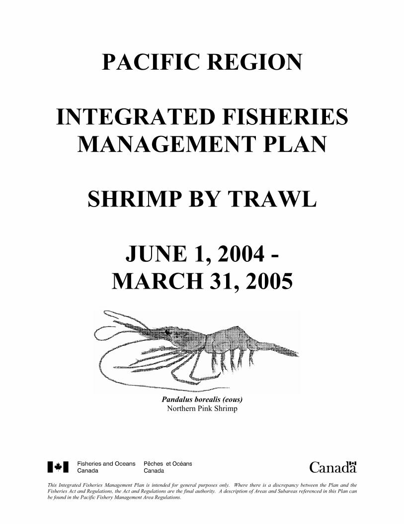
Pandalus borealis (eous) Northern Pink Shrimp
This Integrated Fisheries Management Plan is intended for general purposes only. Where there is a discrepancy between the Plan and the Fisheries Act and Regulations, the Act and Regulations are the final authority. A description of Areas and Subareas referenced in this Plan can be found in the Pacific Fishery Management Area Regulations.


TABLE OF CONTENTS
1. CONTACTS ................................................................................................................................3 2. SHRIMP TRAWL SECTORAL COMMITTEE.........................................................................5 3. GLOSSARY ................................................................................................................................6 4. INTERNET SITES ....................................................................................................................10 5. INTRODUCTION .....................................................................................................................10 6. ANNUAL POST-SEASON REVIEW FOR THE 2003/2004 FISHERY .................................11 7. STOCK STATUS ......................................................................................................................11
7.1. Prospects ................................................................................................................11 7.2. Research.................................................................................................................12
7.2.1. Fishery Independent Shrimp Trawl Surveys..............................................12 7.2.2. By-catch Sampling Program......................................................................12
8. MANAGEMENT ISSUES ........................................................................................................13 8.1. General Issues ........................................................................................................13
8.1.1. Multi-species, Multi-stocks Management..................................................13 8.2. Issues Related to the Commercial Fishery.............................................................13
8.2.1. Over-capacity.............................................................................................13 8.2.2. Fishery Values and Future Management Strategies...................................14 8.2.3. Co-management .........................................................................................14 8.2.4. Stock Status of Eulachon ...........................................................................14 8.2.5. Rockfish Conservation Strategy ................................................................15
8.3. Issues Related to the First Nations Fishery............................................................15 8.4. Issues Related to the Recreational Fishery ............................................................15
9. SPECIFIC MANAGEMENT OBJECTIVES............................................................................15 9.1. Conservation and Sustainability ............................................................................15
9.1.1. Determine Scientifically Defensible Catch Ceilings and TACs by Area. .15 9.1.2. Ensure Fishing Season Consistent with Biological Year...........................16 9.1.3. Develop Biological Reference Points for the WCVI Fishery....................16
9.2. Domestic Considerations .......................................................................................16 9.2.1. Species at Risk Act (SARA) ......................................................................16 9.2.2. First Nations Fishery..................................................................................16 9.2.3. Commercial Fishery...................................................................................17 9.2.4. Exploratory/Experimental..........................................................................18 9.2.5. Aquaculture................................................................................................18
10. ENFORCEMENT MEASURES..............................................................................................19 10.1. Overview................................................................................................................19 10.2. Main Program Activities........................................................................................19
10.2.1. Priorities for 2004/2005 .............................................................................19 10.2.2. Enforcement Issues and Strategies.............................................................20
11. FINANCIAL RESPONSIBILITIES........................................................................................21 11.1. Commercial Fishery...............................................................................................21 11.2. First Nations...........................................................................................................22 11.3. Fisheries and Oceans Canada.................................................................................22
12. 2004/ 2005 PERFORMANCE REVIEW CRITERIA.............................................................22 12.1. Management Plan Evaluation Criteria ...................................................................22
2004/2005 Shrimp by Trawl Integrated Fisheries Management Plan Page 1 of 25

12.2. Enforcement Plan Evaluation Criteria ...................................................................23 13. REFERENCES ........................................................................................................................24 14. ATTACHMENTS....................................................................................................................25
2004/2005 Shrimp by Trawl Integrated Fisheries Management Plan Page 2 of 25
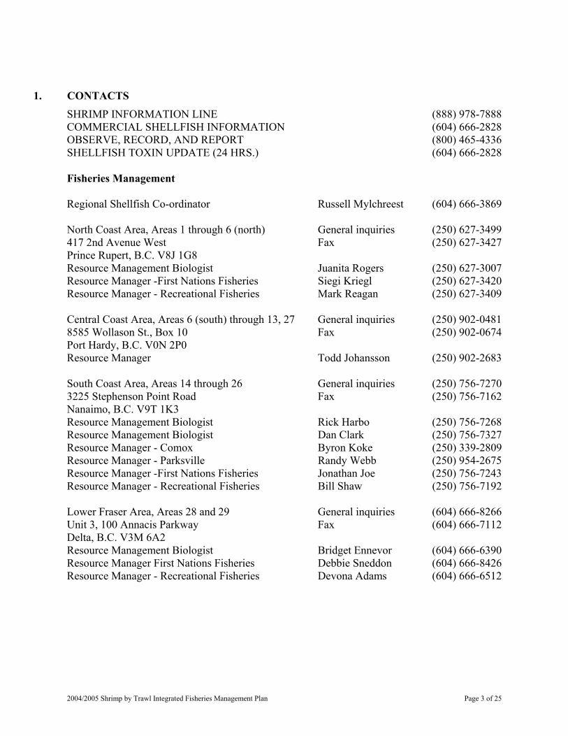
1. CONTACTS
SHRIMP INFORMATION LINE (888) 978-7888 COMMERCIAL SHELLFISH INFORMATION (604) 666-2828 OBSERVE, RECORD, AND REPORT (800) 465-4336 SHELLFISH TOXIN UPDATE (24 HRS.) (604) 666-2828 Fisheries Management Regional Shellfish Co-ordinator Russell Mylchreest (604) 666-3869 North Coast Area, Areas 1 through 6 (north) General inquiries (250) 627-3499 417 2nd Avenue West Fax (250) 627-3427 Prince Rupert, B.C. V8J 1G8 Resource Management Biologist Juanita Rogers (250) 627-3007 Resource Manager -First Nations Fisheries Siegi Kriegl (250) 627-3420 Resource Manager - Recreational Fisheries Mark Reagan (250) 627-3409 Central Coast Area, Areas 6 (south) through 13, 27 General inquiries (250) 902-0481 8585 Wollason St., Box 10 Fax (250) 902-0674 Port Hardy, B.C. V0N 2P0 Resource Manager Todd Johansson (250) 902-2683 South Coast Area, Areas 14 through 26 General inquiries (250) 756-7270 3225 Stephenson Point Road Fax (250) 756-7162 Nanaimo, B.C. V9T 1K3 Resource Management Biologist Rick Harbo (250) 756-7268 Resource Management Biologist Dan Clark (250) 756-7327 Resource Manager - Comox Byron Koke (250) 339-2809 Resource Manager - Parksville Randy Webb (250) 954-2675 Resource Manager -First Nations Fisheries Jonathan Joe (250) 756-7243 Resource Manager - Recreational Fisheries Bill Shaw (250) 756-7192 Lower Fraser Area, Areas 28 and 29 General inquiries (604) 666-8266 Unit 3, 100 Annacis Parkway Fax (604) 666-7112 Delta, B.C. V3M 6A2 Resource Management Biologist Bridget Ennevor (604) 666-6390 Resource Manager First Nations Fisheries Debbie Sneddon (604) 666-8426 Resource Manager - Recreational Fisheries Devona Adams (604) 666-6512
2004/2005 Shrimp by Trawl Integrated Fisheries Management Plan Page 3 of 25
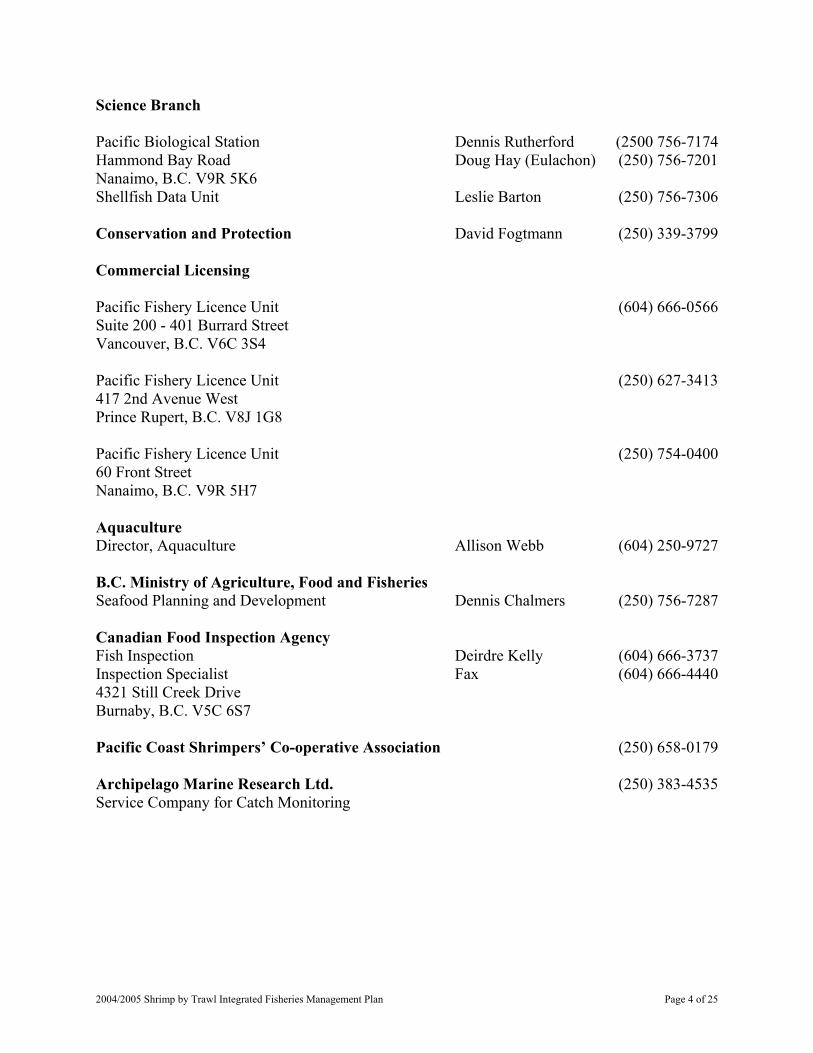
Science Branch Pacific Biological Station Dennis Rutherford (2500 756-7174 Hammond Bay Road Doug Hay (Eulachon) (250) 756-7201 Nanaimo, B.C. V9R 5K6 Shellfish Data Unit Leslie Barton (250) 756-7306 Conservation and Protection David Fogtmann (250) 339-3799 Commercial Licensing Pacific Fishery Licence Unit (604) 666-0566 Suite 200 - 401 Burrard Street Vancouver, B.C. V6C 3S4 Pacific Fishery Licence Unit (250) 627-3413 417 2nd Avenue West Prince Rupert, B.C. V8J 1G8 Pacific Fishery Licence Unit (250) 754-0400 60 Front Street Nanaimo, B.C. V9R 5H7 Aquaculture Director, Aquaculture Allison Webb (604) 250-9727 B.C. Ministry of Agriculture, Food and Fisheries Seafood Planning and Development Dennis Chalmers (250) 756-7287 Canadian Food Inspection Agency Fish Inspection Deirdre Kelly (604) 666-3737 Inspection Specialist Fax (604) 666-4440 4321 Still Creek Drive Burnaby, B.C. V5C 6S7 Pacific Coast Shrimpers’ Co-operative Association (250) 658-0179 Archipelago Marine Research Ltd. (250) 383-4535 Service Company for Catch Monitoring
2004/2005 Shrimp by Trawl Integrated Fisheries Management Plan Page 4 of 25
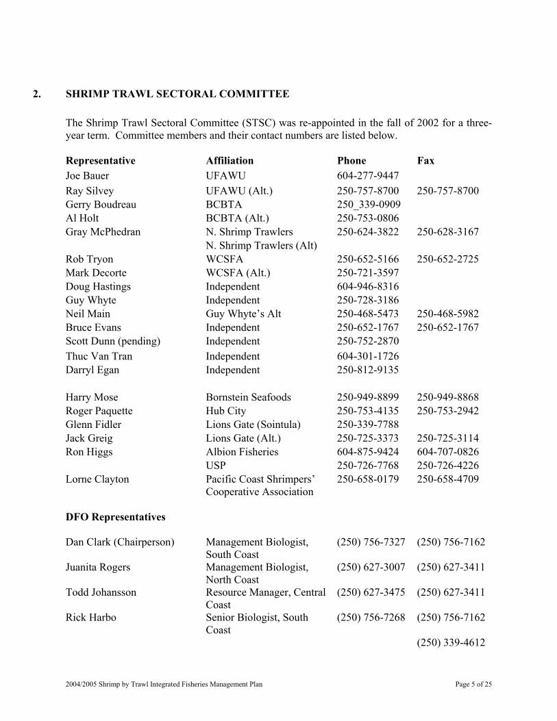
2. SHRIMP TRAWL SECTORAL COMMITTEE
The Shrimp Trawl Sectoral Committee (STSC) was re-appointed in the fall of 2002 for a three-year term. Committee members and their contact numbers are listed below. Representative Affiliation Phone Fax Joe Bauer UFAWU 604-277-9447 Ray Silvey UFAWU (Alt.) 250-757-8700 250-757-8700 Gerry Boudreau BCBTA 250_339-0909 Al Holt BCBTA (Alt.) 250-753-0806 Gray McPhedran N. Shrimp Trawlers 250-624-3822 250-628-3167 N. Shrimp Trawlers (Alt) Rob Tryon WCSFA 250-652-5166 250-652-2725 Mark Decorte WCSFA (Alt.) 250-721-3597 Doug Hastings Independent 604-946-8316 Guy Whyte Independent 250-728-3186 Neil Main Guy Whyte’s Alt 250-468-5473 250-468-5982 Bruce Evans Independent 250-652-1767 250-652-1767 Scott Dunn (pending) Independent 250-752-2870 Thuc Van Tran Independent 604-301-1726 Darryl Egan Independent 250-812-9135 Harry Mose Bornstein Seafoods 250-949-8899 250-949-8868 Roger Paquette Hub City 250-753-4135 250-753-2942 Glenn Fidler Lions Gate (Sointula) 250-339-7788 Jack Greig Lions Gate (Alt.) 250-725-3373 250-725-3114 Ron Higgs Albion Fisheries 604-875-9424 604-707-0826 USP 250-726-7768 250-726-4226 Lorne Clayton Pacific Coast Shrimpers’
Cooperative Association 250-658-0179 250-658-4709
DFO Representatives Dan Clark (Chairperson) Management Biologist,
South Coast (250) 756-7327 (250) 756-7162
Juanita Rogers Management Biologist, North Coast
(250) 627-3007 (250) 627-3411
Todd Johansson Resource Manager, Central Coast
(250) 627-3475 (250) 627-3411
Rick Harbo Senior Biologist, South Coast
(250) 756-7268 (250) 756-7162
(250) 339-4612
2004/2005 Shrimp by Trawl Integrated Fisheries Management Plan Page 5 of 25
Byron Koke Resource Manager, South Coast
(250) 339-2809
Bridget Ennevor Management Biologist, Lower Fraser
(604) 666-6390 (604) 666-7112
Dennis Rutherford Assessment Biologist (250) 756-7174 (250) 756-7053 Graham Gillespie Research Biologist (250) 756-7215 (250) 756-7053 Other Representatives Dennis Chalmers B.C. Ministry of
Agriculture, Food, and Fisheries
(250) 756-7287 (250) 756-7162
Jason Clarke Archipelago Marine Research Ltd.
(250) 383-4535 (250) 383-0103
3. GLOSSARY
aquaculture The process of spawning animals and rearing the progeny to marketable size, usually involving some level of intervention (e.g. feeding, predator protection) by the aquaculturist.
Area (or Management Area)
A division of Canadian fisheries waters as described in Schedule II of the Pacific Management Area Regulations, maps are available on the Pacific Region Internet at: http://www.pac.dfo-mpo.gc.ca/ops/fm/Areas/areamap_e.htm
beam trawl A type of trawl net in which the mouth of the net is held open by a “beam” or “pole.” The beam is held horizontal across the mouth of the net while under tow.
by-catch Incidental or unintentional catch of non-target stocks or species.
catch ceiling A total allowable catch (TAC).
cod end The narrow-necked bag at the end of a trawl net.
communal licence Issued to First Nations organizations pursuant to the Aboriginal Communal Fishing Licences Regulations to carry on fishing and related activities.
Communal Commercial Licence
Issued to First Nations organizations pursuant to the Aboriginal Communal Fishing Licences Regulations for participation in the general commercial fishery. Licences issued are equivalent to the capacity of licences that have been retired under the Aboriginal Fisheries Strategy (AFS) Licence Retirement/Allocation Transfer Program.
2004/2005 Shrimp by Trawl Integrated Fisheries Management Plan Page 6 of 25
Designated Service Bureau
The service bureau designated to undertake the Shrimp Trawl Catch Monitoring Program.
exclusion grate or excluder
A grate that when inserted properly into a trawl net reduces the amount of non-target species in the catch.
excluder net A second trawl net that when attached properly inside a trawl net reduces the amount of non-target species in the catch.
fishing hail That report required by licence condition as notification prior to commencement of fishing.
fishing hail number That unique number which is issued by the Designated Service Bureau upon completion of a fishing hail as confirmation of making a fishing hail.
fishing trip That period when the vessel departs from a dock to engage in fishing until fishing ceases and shrimp are offloaded.
fixed exploitation rate The exploitation rate is the proportion of the fishable population that is taken as catch. With a fixed rate, the harvestable quota varies with the population size.
harvested Referring to fish, including shrimp, caught by any means.
invertebrate An animal without a backbone. landed or landing The transfer of catch from a licensed vessel to land (including docks
and wharves).
landing hail That report required by licence condition as notification prior to landing or offloading catch at the end of a fishing trip.
landing hail number That unique number which is issued by the Designated Service Bureau upon completion of a landing hail as confirmation of making a landing hail.
offloaded The landing or removal of catch from the licensed vessel.
observer An individual who has been designated as an observer by the Regional Director General for Pacific Region pursuant to section 39 of the Fishery (General) Regulations.
on board Referring to that which takes place or exists on the licensed fishing vessel as compared to on land.
2004/2005 Shrimp by Trawl Integrated Fisheries Management Plan Page 7 of 25
otter trawl A type of trawl net in which the mouth of the net is held open and
towed by means of boards of wood and/or metal (“otter” boards or “doors”).
packer A vessel licensed to pack or transport commercially caught fish.
PCSCA Pacific Coast Shrimpers’ Cooperative Association -the incorporated society that negotiates on behalf of shrimp by trawl (S licence) licensed vessel owners and undertakes to provide the fishery monitoring, hail system, observer coverage and dockside monitoring required to monitor the fishery.
PSARC Pacific Scientific Advice Review Committee
quota For the purposes of the shrimp trawl fishery, an annual quota refers to the total allowable catch TAC determined from a biomass survey or other stock assessment information.
recruitment The process whereby young animals are added to a fishable stock or population.
sectoral A committee providing a forum for the exchange of information and views between the clients and Fisheries and Oceans Canada on issues important to the management of a fishery for shrimp.
selective fishing The ability to avoid known, non-target species and stocks or, if encountered, to release them alive and unharmed.
selectivity device A general term that refers to a device that when added to a trawl net will reduce the amount of non-target species in the catch.
Shrimp Fisher Identification Number (Fisher ID #)
The unique number assigned by the Designated Service Bureau to the person who makes hails under the conditions of the shrimp trawl licence.
Shrimp Management Area (SMA)
The area of a management unit in the shrimp trawl fishery, based on location of fishing grounds and shrimp stocks. Maps of SMAs are in Appendix 7.
Shrimp Trawl Fishing Log (Logbook)
A harvest log of fishing activity, catch, and gear for the purpose of stock assessment and fisheries management.
smelt belt An on board automatic by-catch-discarding machine that uses a series of sandpaper belts to separate small fishes, such as smelt, from shrimp (not permitted).
2004/2005 Shrimp by Trawl Integrated Fisheries Management Plan Page 8 of 25
Southern Inside Waters
Shrimp Management Areas 12IN, 14, 16, 17, 18, 19, GSTE, FR and 23IN.
stock assessment Analyses of fisheries and research data used to estimate stock abundance and health or evaluate the effects of fishing on a stock or population and predict the reactions of populations to alternative management choices.
stock A biologically discrete population.
Subarea As in Section 2 of the Pacific Management Area Regulations or see Management Areas - Pacific Region on the Internet at: www.pac.dfo-mpo.gc.ca/ops/fm/Areas/areamap_e.htm
TAC Total Allowable Catch. The amount of catch that may be taken from a stock, determined by analytical procedures, to achieve management objectives. Varies from 17% to 33% of estimated shrimp biomass.
tranship The transfer of fish, including shrimp, from one vessel to another vessel.
trawl net Any bag-type net that is dragged in the water by a vessel for the purpose of catching fish, (under the Fisheries Act and Regulations, “fish” includes shellfish).
twin trawl Two independent trawl nets rigged together to be towed by the same vessel. Facilitates the study of a trawl net with selectivity gear compared to a trawl net without selectivity gear (“control”).
user All users of the fisheries resources including First Nations, recreational and commercial fishers, crew members or charter services, and other parties with an interest in the fishery.
verification Verification of any or all of the following activities: estimating, weighing, sampling all species, inspection of fishing records, and/or interviewing the vessel master.
WCVI West Coast of Vancouver Island (generally includes Areas 21, 121, 123 to 127 and Subareas 23-7 to 23-11, but may be less depending on the area surveyed and used to estimate biomass).
QCSND Queen Charlotte Sound (Areas 107, 108, 109, 110, 111, 130 and Subareas 7-1, 7-25, 7-26, 7-31, 8-1, 10-1, 10-2, 11-1 and 11-2.).
2004/2005 Shrimp by Trawl Integrated Fisheries Management Plan Page 9 of 25
4. INTERNET SITES
Shrimp page, and links to the shrimp by trawl fishing plan: www.pac.dfo-mpo.gc.ca/ops/fm/shellfish/shrimp/default_e.htm Pacific Region home page: www.pac.dfo-mpo.gc.ca/pages/default_e.htm Acts, Regulations, and Pacific Fishery Management Area definitions: www.dfo-mpo.gc.ca/communic/policy/dnload_e.htm Area and Subarea maps: www.pac.dfo-mpo.gc.ca/ops/fm/Areas/areamap_e.htm Consultation Secretariat: www-comm.pac.dfo-mpo.gc.ca/pages/consultations/default_e.htm Infectious diseases of shrimp: www.pac.dfo-mpo.gc.ca/sci/shelldis/title_e.htm Invertebrate stock status reports, including shrimp: www.pac.dfo-mpo.gc.ca/sci/psarc/SSRS/invert_ssrs_e.htm Openings and Closures, notices: www-ops2.pac.dfo-mpo.gc.ca/xnet/content/fns/index.cfm?pg=search_options&lang=en&id=commercial
5. INTRODUCTION
The 2004/2005 Pacific Region Shrimp by Trawl Integrated Fisheries Management Plan (IFMP) encompasses the period of June 1, 2004 to March 31, 2005. This plan is approved by the Fisheries and Oceans Canada Regional Director General for the Pacific Region.
The IFMP document provides a broad and recent context to the management and interrelationships of all fishing sectors of the shrimp by trawl fisheries. The Commercial Harvest Plan can be found in Appendix 1.
2004/2005 Shrimp by Trawl Integrated Fisheries Management Plan Page 10 of 25
This plan refers to Canada’s Pacific coast harvest of shrimp by means of trawl gear. Shrimp are harvested by two means in the Pacific Region: trawl nets and traps. Refer to the Pacific Region Prawn and Shrimp by Trap IFMP for more information on the commercial trap (or the “prawn” fishery), First Nations fisheries, and recreational fisheries for shrimp and prawn by trap. The Prawn and Shrimp by Trap IFMP are available from the Fisheries and Oceans Canada Pacific Region web site or from Pacific Fishery Licensing Units (see Contacts).
Additional information to that presented here is available from the Fisheries and Oceans Canada Pacific Region Shrimp web page.
www.pac.dfo-mpo.gc.ca/ops/fm/shellfish/shrimp/default_e.htm
6. ANNUAL POST-SEASON REVIEW FOR THE 2003/2004 FISHERY
Overall, the 2004/2005 fishing season was poor, with continued poor prices and only about 100 vessels fishing. Still, as of February 2004, seven SMAs were closed as a result of reaching their catch ceiling in at least one of the species quota available. The catch ceilings were exceeded in three SMAs, two by less than two percent and one (coonstripe shrimp, area 19) by 11.7%.
In 2003/2004, the PCSCA collected funds from vessel owners for co-management, covering the cost-shared management and assessment program with the Department and the catch monitoring program requirements. This was the first year for the arrangements; previously, co-management funds had been collected with licence fees. The arrangement was a struggle for the industry because of low participation in the fishery, but the season was completed.
For complete information on the annual review, see the following documents.
a) Landings Quota Status Report (weekly in-season) b) Catch Monitoring Program report (post-season). c) 2003/2004 Post Season Review (post-season). d) Catch Sampling Program report (post-season). e) Shrimp Survey Bulletins (in-season).
These documents are available from Resource Managers (see Contacts) or the Pacific Region Shrimp web page.
7. STOCK STATUS
7.1. Prospects
In 2003, WCVI shrimp stocks (SMA 23OFF, 21OFF, 124OFF, 125OFF) continued to decline from record highs in 2001. Smooth pink and sidestripe shrimp biomass in SMA 21OFF/23OFF were below the long-term average. The estimated smooth pink shrimp biomass in SMA 124 significantly decreased from the 2002 level, but remains slightly above the long term average. The outlook for 2004/2005 for the WCVI shrimp stocks is for continued decline from the 2003 level of 8,171.8 tonnes and for biomass to be below
2004/2005 Shrimp by Trawl Integrated Fisheries Management Plan Page 11 of 25
the long-term average of 9,786.7 tonnes. Pink shrimp biomass in SMA 23IN increased slightly and was at a record high since surveys began in 1998. Sidestripe biomass in SMA 23IN remained unchanged from 2002 and is above the long-term average. Little concern exists for the biomass levels of most shrimp management areas on the coast, and even SMA FR shows an increase from the record low in 2002.
The eulachon abundance index in SMA 21OFF and 23OFF, thought to be mostly Fraser River and Columbia River stocks, increased significantly in 2001, peaked in 2002, and remains at a high level. Encounter (by-catch) rates by shrimp trawl vessels have decreased in recent years due to by-catch reduction devices within the gear, an encouraging trend.
Detailed results of the 2003 shrimp surveys are presented in Shrimp Survey Bulletins available from the Fisheries and Oceans Canada Shrimp Trawl web site:
www.pac.dfo-mpo.gc.ca/ops/fm/shellfish/shrimp/default_e.htm
Additional scientific information concerning shrimp stocks and the shrimp trawl fishery can be obtained from the Pacific Scientific Advice Review Committee (PSARC) at the following web site:
www-sci.pac.dfo-mpo.gc.ca/sci/default_e.htm
7.2. Research
7.2.1. Fishery Independent Shrimp Trawl Surveys
Trawl surveys are undertaken to index shrimp abundance in selected SMA and to collect biological information needed to understand stock structure. The Survey Subcommittee of the STSC has identified priority areas to be surveyed on an annual basis. In 2003, 9 SMA were surveyed. These include SMA 21OFF, 23OFF, 124OFF, 125OFF, 23IN, QCSND, PRD, 14, and FR. Continuation of these surveys is planned for 2004/05.
7.2.2. By-catch Sampling Program
A By-catch Sampling Program in the shrimp trawl fishery has been in place since 1997. At-sea observers estimate catch composition at sea, identify gear composition and collect biological samples. The program for 2003 was changed to a target of 50 days of at-sea observer coverage with most of the effort directed at SMA 23IN and 23OFF. Coverage is directed to address mainly eulachon and overall by-catch concerns. Additional areas (FR, 14, PRD, GSTE) will be included, depending on in-season planning constraints.
2004/2005 Shrimp by Trawl Integrated Fisheries Management Plan Page 12 of 25
8. MANAGEMENT ISSUES
The following sections highlight the ongoing, or longer-term, management issues that are being addressed in the fishery. Specific management objectives designed to mitigate these issues are detailed in the next section.
The Department and the STSC continue to examine several management issues identified in recent years. Continued efforts and progress are being made towards resolution, although the issues may not be easily resolved. The Future Management Committee contracted an independent consultant to prepare a report on the issues that affect the long-term sustainability of the shrimp industry along with options for managing the fishery so that it remains viable in the future. All shrimp trawl licence holders and interested third parties have had an opportunity to provide input into the report and comment on the recommendations in 2001. Contact the PCSCA for further information or to obtain a copy of the final report (see Contacts).
8.1. General Issues
8.1.1. Multi-species, Multi-stocks Management
The geological, geographic, and biological features of the British Columbia coast have created many discrete stocks for many invertebrate species, including shrimp. The multitudes of shrimp species and stocks involved in the shrimp trawl fishery have resulted in complex management and assessment issues and programs.
The expectations of licence holders for the development of directed humpback and coonstripe shrimp fisheries has not been achieved within the current management framework for this fishery, which has focused primarily on pink and sidestripe shrimp. A policy for new fisheries directed towards specific species/stocks is being developed (New and Emerging Fisheries Framework). Fishery independent biomass surveys, catch monitoring by at-sea observers and catch validation are tools that may be employed to define biologically based assessment and management scenarios to control harvest rates, monitor by-catch and identify habitat impacts (Dunham et al, 2002). Some stocks (e.g., Area 19 coonstripe) that may be exploited by shrimp trawl and shrimp trap fisheries should be assessed and managed to account for total exploitation by all gear types.
8.2. Issues Related to the Commercial Fishery
8.2.1. Over-capacity
The Department and the shrimp trawl industry have concerns regarding shrimp stocks and the current capacity of the fishing fleet. In light of the capacity of the fishing fleet, shrimp management areas can be fished quickly and closed. Decreasing participation due to poor economic returns in recent years reduces the risk of too much fishing effort, but even with only 100 vessels active, some SMAs can close after a few months.
2004/2005 Shrimp by Trawl Integrated Fisheries Management Plan Page 13 of 25

The catch monitoring program is designed to provide resource managers with the in-season information to monitor shrimp harvest by SMA and take the appropriate measures as catch ceilings are approached. A random dockside validation program was implemented for 2003 as an independent check on landing hails. Both will continue for 2004/2005, with some changes to improve efficiency through consultations between the Department, STSC industry caucus, PCSCA, and the service provider.
8.2.2. Fishery Values and Future Management Strategies
Fishers have expressed concern that the current value of the fishery does not meet the economic needs of the participants. The report of the Future Management Committee contained a number of options, but lack of consensus stalled any movement to changes in management strategies.
8.2.3. Co-management
A new co-management approach was introduced in 2003/2004, with co-management programs and cost-sharing for the enhanced management, assessment, and enforcement activities derived through a Joint Project Agreement (JPA) with the representative industry association, the PCSCA. With low participation in the fishery and poor prices, the commercial industry and PCSCA struggled to collect sufficient funds to meet their commitments. The industry caucus recommended that the Department initiate efforts to have all licence holders responsible for the cost-shared programs.
The co-management approach will continue for 2004/2005, with a JPA developed with the representative industry association.
8.2.4. By-catch of Eulachon
A precautionary approach is used to deal with eulachon by-catch. For the West Coast of Vancouver Island SMAs, an eulachon by-catch ‘action levels’ is used. There were no restrictions in the 2003/04 season as a result of the action levels because the use of fish exclusion grids and by-catch reduction modifications to gear has reduced eulachon by-catch and because of reduced low fishing activity. For the Queen Charlotte Sound SMA, no shrimp by trawl fishing is allowed because of concerns for Central Coast eulachon stocks. The industry caucus has recommended that efforts continue to re-start commercial fishing opportunities in the Queen Charlotte Sound SMA.
The action levels, by-catch monitoring, and Queen Charlotte Sound closure will continue for 2004/2005. Considerations to re-open Queen Charlotte Sound will depend on criteria established by the Department for eulachon protection and discussion with the shrimp trawl industry and local First Nations.
2004/2005 Shrimp by Trawl Integrated Fisheries Management Plan Page 14 of 25
8.2.5. Rockfish Conservation Strategy
Fisheries and Oceans Canada is currently working with Commercial, Recreational, First Nations, and other user groups on developing rockfish conservation measures aimed at protecting several rockfish species. Further consultations with affected clients will take place during 2004. Currently, fishing shrimp by trawl is not permitted in Rockfish Conservation Areas (RCA). New RCAs have been identified in 2004 through consultation with user groups and will be implemented for 2004/2005. The closures are identified in Appendix 2.
For further information on the rockfish conservation areas, the permitted fishing activities within the areas, and possible further consultations see:
http://www-comm.pac.dfo-mpo.gc.ca/pages/consultations/fisheriesmgmt/rockfish/default_e.htm
8.3. Issues Related to the First Nations Fishery
First Nations harvest of shrimp by trawl for food, social, and ceremonial (FSC) purposes is small. Trawl gear is not a preferred means of shrimp harvest for First Nations FSC fishing. FSC harvest of shrimp is mostly by trap or nets, for more information refer to the IFMP for Shrimp and Prawn by Trap.
8.4. Issues Related to the Recreational Fishery
Trawl gear is not permissible for recreational fishing. Shrimp are harvested by recreational fishers using traps, ring nets, or spears while diving. A British Columbia tidal waters sport fishing licence is required to harvest shrimp. Shrimp recreational fishing regulations are outlined in the B.C. Tidal Waters Sport Fishing Guide, which is available free of charge from licence vendors, Pacific Region Licensing offices, or the Pacific Region Internet site at:
www.pac.dfo-mpo.gc.ca/recfish/default_e.htm.
9. SPECIFIC MANAGEMENT OBJECTIVES
9.1. Conservation and Sustainability
9.1.1. Determine Scientifically Defensible Catch Ceilings and TACs by Area.
To achieve the conservation and sustainable fishery objectives of the Department and the shrimp industry and to address the issue of the fishing capacity of the fleet, harvest is limited to a TAC in most areas. The setting of TAC follows a biological or precautionary approach.
2004/2005 Shrimp by Trawl Integrated Fisheries Management Plan Page 15 of 25
For 2004/2005, the initial catch ceilings have been forecast based available information, with in-season, fishery independent surveys planned to adjust the catch ceilings as part of the co-management program.
9.1.2. Ensure Fishing Season Consistent with Biological Year
To ensure the fishing season is consistent with the biological year. The fishing season follows the egg bearing period to protect mature female shrimp from being impacted by the fishery twice in the same biological year.
9.1.3. Develop Biological Reference Points for the WCVI Fishery
To develop biological reference points for the WCVI shrimp fishery. Historically, a precautionary approach was taken in the management of the WCVI by restricting fishing to a six-month seasonal opening for the offshore fishery. More recently, shrimp biomass surveys are conducted as an index of the populations. The long-term goal is to develop sufficient information to define stock recruitment relationships for WCVI shrimp stocks. This work is on-going.
9.2. Domestic Considerations
9.2.1. Species at Risk Act (SARA)
The Species at Risk Act will be coming into force in June 2003. The purpose of this Act is “to prevent wildlife species from being extirpated or becoming extinct, to provide for the recovery of a wildlife species that are extirpated, endangered or threatened as a result of human activity and to manage species of special concern to prevent them from becoming endangered or threatened”.
Any possible impacts of this legislation on the red urchin fishery will be discussed through the advisory process. For more information on SARA, please refer to the Environment Canada Internet site at:
www.speciesatrisk.gc.ca/
The Department would like assistance in the reporting of any Leatherback turtle sightings or entanglement. Leatherback turtles are listed as endangered in Schedule I of SARA. The Turtle Sightings Network toll-free phone number is 1-866-472-9663, or email [email protected].
9.2.2. First Nations Fishery
9.2.2.1. Fisheries and Oceans Canada provides opportunities on a priority basis for First Nations harvest of shrimp for food, social and ceremonial purposes. The Department will continue to provide opportunities for First Nations to harvest fish for food, social, ceremonial purposes, in a manner consistent with the Sparrow decision.
2004/2005 Shrimp by Trawl Integrated Fisheries Management Plan Page 16 of 25
9.2.2.2. Landing records in the First Nations food, social, and ceremonial fishery for shrimp by trawl are incomplete. The Department has initiated, in consultation with First Nations, a more comprehensive approach to gathering catch data for these species.
9.2.2.3. To address the issue of concern raised by some First Nations for the incidental by-catch of eulachon by taking a precautionary approach to the management of eulachon by-catch using the best scientific information available.
9.2.3. Commercial Fishery
9.2.3.1. To monitor fishing effort and landings. An industry-funded catch monitoring program, with hail and reporting requirements, tracks fishery landings in each SMA and allows the Department to monitor the TACs. In addition, the catch monitoring program collects bio-samples and information on fishing activity and effort through logbook reporting for stock assessment purposes.
A random dockside validation program was implemented for 2003 to replace the landings record. The intention was for 50 days of dockside coverage to gather information on the species landed, the size of landed shrimp, and to provide a check of the data integrity of hails and fish slips. There were difficulties in obtaining dockside information because of the partial coverage, multiple landing points, the short time frame for landing hail and sorting and off-loading of products at different times. For 2004/2005, the goal will be to improve the efficiency of this program and obtain 20 days of observer coverage. Further adjustments may be made in-season.
9.2.3.2. To incorporate in-season stock assessment information in the management of the fishery. Biomass surveys are conducted in selected SMAs and the annual quotas are adjusted based on estimated biomass plus catch to date. Catch ceilings are set at a fixed exploitation rate ranging between 17% and 33% of the estimated biomass. This will continue for 2004/2005.
9.2.3.3. To avoid over harvesting weak stocks by setting species specific catch ceilings and monitoring catch on a species-specific basis. SMAs are closed when the catch ceiling for one of the species is reached. This will continue for 2004/2005.
9.2.3.4. To address issues of selective and responsible fishing practices. The mandatory use of selectivity devices (rigid grid or excluder net and fish release panel in the trawl) is the main mechanism to address selective fishing practices. An at-sea and dockside catch sampling program monitors and verifies fishery catches, composition of the catches and collects biological samples. Estimates of by-catch are defined for specific species, and by-catch is controlled through setting by-catch action levels, monitoring by-catch, and defining gear restrictions and area closures for areas with significant by-catch of specific species.
2004/2005 Shrimp by Trawl Integrated Fisheries Management Plan Page 17 of 25
The use of selectivity devices and monitoring of by-catch will continue for 2004/2005. Eulachon action levels will remain for the West Coast of Vancouver Island and by-catch of rockfish is partially addressed by restricting shrimp by trawl fishing from Rockfish Conservation Areas.
9.2.3.5. To involve the commercial sector in co-management of the fishery through increased participation in the decision making process. An agreement has been made annually with the Pacific Coast Shrimpers’ Cooperative Association to provide for co-management programs.
9.2.4. Exploratory/Experimental
9.2.4.1. To consider experimental fishing proposals and development of selective fishing techniques and standards in consultation with the STSC. Other proposals for research are directed through the scientific licence protocols with the Department.
9.2.4.2. To consider experimentation with selectivity devices that do not meet the specifications set out in the conditions of the licence. Consideration will be given to applications for a special amendment to the Conditions of Licence or for a scientific licence (see Appendix 1 for more information).
9.2.4.3. To allow for exploratory fishing in areas with a lack of catch history, arbitrary precautionary catch ceilings (generally 10 tonnes) have been assigned. A protocol for assessing shrimp stocks based on fishing information collected from these unsurveyed areas and further development of an exploratory protocol is under consideration.
9.2.4.4. To consider experimental fisheries for the development of directed humpback shrimp fisheries under the framework presented in Boutillier and Nguyen, 1999. This document can be reviewed from the Internet web site:
www.pac.dfo-mpo.gc.ca/sci/psarc/ResDocs/Invertebrate_99_e.htm
9.2.5. Aquaculture
Recognizing both the potential for aquaculture to benefit Canadians and the need to ensure the sustainable use of aquatic resources, Cabinet endorsed the Federal Aquaculture Development Strategy (FADS) in 1995. Building on FADS and more recent opportunities and challenges associated with aquaculture development, Fisheries and Oceans Canada recently released the “Aquaculture Policy Framework”. The policy framework recognizes aquaculture as a legitimate use of land, water, and aquatic resources and the importance of providing aquaculturists with predictable, equitable, and timely access to the aquatic resource base, including access to biological materials such as broodstock and seedstock. Therefore, aquaculturists will be treated on an equal footing with other resource users.
2004/2005 Shrimp by Trawl Integrated Fisheries Management Plan Page 18 of 25
The “DFO’s Aquaculture Policy Framework” can be accessed at the following Internet site:
www.dfo-mpo.gc.ca/aquaculture/policy/pg001_e.htm
Requests to access the wild shrimp resource must be addressed to Fisheries and Oceans Canada and supported by a project proposal.
For more information on aquaculture or access to broodstock, please contact the Director, Sustainable Aquaculture (see the Contacts section of this IFMP).
10. ENFORCEMENT MEASURES
Fisheries and Oceans Canada has the responsibility to enforce the Fisheries Act and associated regulations, to address conservation, health and safety issues and to maintain proper management and control of the various fisheries.
Users of the resource have a responsibility to report violations. Any suspected or actual fisheries, wildlife or pollution violations can be quickly and discretely reported to the appropriate enforcement officer by using the toll free Observe, Record and Report hotline. This toll free number is available 24 hours a day. Confidentiality is assured.
OBSERVE, RECORD AND REPORT - 1-800-465-4DFO (1-800-465-4336)
Enforcement enquiries can also be directed to the local field offices during regular office hours.
10.1. Overview
The Department’s Conservation and Protection (C&P) has the main responsibility for carrying out the Department’s enforcement program. Enforcement staff will pursue opportunities to enforce the regulations and conditions of licence applicable to this fishery while engaged in enforcement activities directed to other fisheries in the Pacific Region.
10.2. Main Program Activities
10.2.1. Priorities for 2004/2005
Fisheries Management staff identified the following priority enforcement issues for the 2004/2005 season to maintain control of this fishery: patrol of closed areas/times and monitoring of catches through hailing and reporting requirements.
Resource managers will monitor the harvest in SMAs using the catch monitoring program, random dockside monitoring, and at-sea observer information.
C&P staff will pursue opportunities to monitor and enforce the issues and problems associated with this fishery in conjunction with other regional priorities.
2004/2005 Shrimp by Trawl Integrated Fisheries Management Plan Page 19 of 25
C&P staff will pursue opportunities to monitor and inspect fishing vessels at-sea and at landing ports. Inspections will focus on hails, landing records and harvest logs. Closed time and area patrols may be conducted by Canadian Coast Guard (CCG) patrol vessels, program vessels, or by air, in conjunction with other patrols.
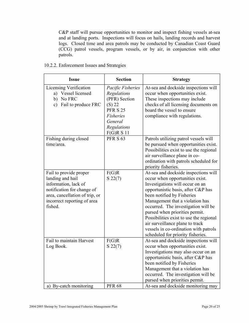
10.2.2. Enforcement Issues and Strategies
Issue Section Strategy
Licensing Verification a) Vessel licensed b) No FRC c) Fail to produce FRC
Pacific Fisheries Regulations (PFR) Section (S) 22 PFR S 25 Fisheries General Regulations F(G)R S 11
At-sea and dockside inspections will occur when opportunities exist. These inspections may include checks of all licensing documents on board the vessel to ensure compliance with regulations.
Fishing during closed time/area.
PFR S 63 Patrols utilizing patrol vessels will be pursued when opportunities exist. Possibilities exist to use the regional air surveillance plane in co-ordination with patrols scheduled for priority fisheries.
Fail to provide proper landing and hail information, lack of notification for change of area, cancellation of trip, or incorrect reporting of area fished.
F(G)R S 22(7)
At-sea and dockside inspections will occur when opportunities exist. Investigations will occur on an opportunistic basis, after C&P has been notified by Fisheries Management that a violation has occurred. The investigation will be pursed when priorities permit. Possibilities exist to use the regional air surveillance plane to track vessels in co-ordination with patrols scheduled for priority fisheries.
Fail to maintain Harvest Log Book.
F(G)R S 22(7)
At-sea and dockside inspections will occur when opportunities exist. Investigations may also occur on an opportunistic basis, after C&P has been notified by Fisheries Management that a violation has occurred. The investigation will be pursed when priorities permit.
a) By-catch monitoring PFR 68 At-sea and dockside monitoring may
2004/2005 Shrimp by Trawl Integrated Fisheries Management Plan Page 20 of 25

Issue Section Strategy
b) Retain prawns during closed time for prawn
c) Exceed prawn by catch limit (100)
d) Retain prawns < 33 mm e) Fail to keep prawns
separate from shrimp catch
f) Fish without a selectivity device in place
g) Use of mechanical device for the purposes of automatically separating by-catch from shrimp
h) More squid than 2% of total shrimp onboard
i) Retention of non-retention species
j) Failure to record retained squid or octopus on “shrimp Trawl Landing Record”
F(G)R S 22(7)
include inspections for by-catch limits as noted to ensure compliance with the regulatory requirement. Inspections may occur in conjunction with enforcement activities in other fisheries, particularly where non-compliance in this fishery may impact conservation or control in other fisheries.
Fail to off-load “shrimp by trap” prior to fishing shrimp by trawl.
F(G)R S 22(7)
At-sea and dockside inspections will occur when opportunities exist.
Fish with gear other than trawl net.
F(G)R S 22(7)
At-sea and dockside inspections will occur when opportunities exist.
Dockside sales with out Fish Vending Licence.
B.C. Fish Act S 13(4)
Dockside inspections and monitoring will be pursued when opportunities exist.
11. FINANCIAL RESPONSIBILITIES
11.1. Commercial Fishery
A Joint Project Agreement is agreed upon annually between the Department and the industry association representing the shrimp trawl licence holders (PCSCA) for delivery of co-management programs in support of the commercial fishery. In 2003-2004, the Department received $80,000 to provide in-season support by Stock Assessment Division personnel for stock assessment programs.
2004/2005 Shrimp by Trawl Integrated Fisheries Management Plan Page 21 of 25
Licence holders are required by conditions of licence to make arrangements with an industry service provider for the delivery of in-season information to the Department regarding vessel fishing locations and a landing hail report. A catch monitoring program including at-sea by-catch and dockside sampling of shrimp are included in the JPA. The cost of this service to vessel owners is established by the PCSCA by negotiation with a service company on behalf of shrimp by trawl vessel owners. The industry service provider is Archipelago Marine Research Ltd.
11.2. First Nations
There are eleven “FS” licences providing First Nations community participation in the commercial fishery. There is no licence fee attached to these licences. However, the obligations for service company based information delivery from the fishing grounds remains the same as with other “S” licences.
11.3. Fisheries and Oceans Canada
Fisheries and Oceans Canada provides stock assessment, management of the fishery and enforcement activities. Personnel are generally multi-tasked and, as a consequence, costs incurred by the Department to manage this fishery are difficult to assess. The estimate of the direct costs to the Department to implement this fishery is $670K annually (for management, stock assessment, enforcement and other activities, including licensing and administration). These costs are in addition to the co-management programs funded by licence holders (above).
Area Resource Managers also have duties that relate to First Nations fisheries, including shrimp. Intermittent duties of local enforcement personnel can also be ascribed to this fishery.
12. 2004/ 2005 PERFORMANCE REVIEW CRITERIA
12.1. Management Plan Evaluation Criteria
12.1.1. Was there progress in maintaining the co-management approach for the 2004/2005 fishery? Were co-management programs accomplished successfully?
12.1.2. Was harvest limited to the catch ceilings for each SMA?
12.1.3. How closely were the eulachon action levels met? Has a more comprehensive approach to eulachon assessment and management been developed?
12.1.4. Was there adequate enforcement of this fishery?
12.1.5. What progress was made in regard to fishers’ goals for the improved economics of the fishery, enhancing fishery values, or alternative management strategies?
2004/2005 Shrimp by Trawl Integrated Fisheries Management Plan Page 22 of 25
12.1.6. What progress was made with respect to managing and accounting for multiple shrimp species in the catch?
12.1.7. Were the egg-bearing females protected long enough for the larval hatch to complete prior to the fishery opening?
12.1.8. Were fishery landings adequately monitored through the Catch Monitoring Program and logbooks? Was there misreporting or under-reporting of catch? Were there problems with the Catch Monitoring Program in the opinion of industry members, the Department, or the Service Bureau?
12.1.9. Was in-season stock assessment information incorporated into the in-season management of the fishery?
12.1.10. Were results compiled from the Catch Sampling Program? Can areas for improvement to selective fishing practices be identified?
12.1.11. What was the participation ion the fishery: number of vessels licensed, number meeting pre-condition for arranging catch monitoring, number actively fished for both ‘regular’ and communal commercial licences?
12.1.12. How many communal licences for food, social or ceremonial fisheries were issued? What were the First Nations catches of shrimp?
12.1.13. Were any issues brought forward by First Nations and, if so, how were they addressed?
12.1.14. Were issues of safety in the operation and management of the fishery brought forward?
12.1.15. How many amendments and scientific licences were issued to experiment with selectivity devices? What were results?
12.1.16. How many exploratory areas were fished? Has there been any information collected for stock assessment in those exploratory areas that were identified as productive for shrimp?
12.1.17. Was there any further progress in developing directed humpback shrimp fisheries?
12.2. Enforcement Plan Evaluation Criteria
12.2.1. How many hours were spent on enforcement of this fishery? How many charges, warnings, seizures and suspected violations? Is this an increase or decrease from last season?
12.2.2. How many occurrences were reported by the Catch Monitoring Service Bureau, and what was the nature of these occurrences?
2004/2005 Shrimp by Trawl Integrated Fisheries Management Plan Page 23 of 25
12.2.3. Were there any other in-season enforcement issues and were any unresolved?
13. REFERENCES
Front cover illustration by A. Denbigh, in Shrimps of the Pacific Coast of Canada, T. H. Butler, 1980. Can. Bull. Fish. Aquat. Sci. 202: 280 p.
Anon. Fisheries and Oceans Canada. 1999. Selective Fishing in Canada’s Pacific Fisheries. A new direction: The third in a series of papers from Fisheries and Oceans Canada. May, 1999. 34 p.
Boutillier, J. A. and H. Nguyen. 1999. Pandalus hypsinotus, humpback shrimp a review of the biology and a recommended assessment framework for a directed fishery. Canadian Stock Assessment Secretariat Research Document 99/067.
Boutillier, J. A., M. Joyce, J. Bond, and I. Winther. 1996. Assessing the inshore shrimp fisheries: data status, model requirements, problems. PSARC Working Paper I-96-11.
Butler, T. H. 1980. Shrimps of the Pacific Coast of Canada. Can. Bull. Fish. Aquat. Sci. 202: 280 p.
Conway, K.W. 1999. Hexactinellid sponge reefs on the British Columbia continental shelf: geological and biological structure with a perspective on their role in the shelf ecosystem. Canadian Stock Assessment Secretariat Research Document 99/192.
Dahlstrom, W.A. 1970. Synopsis of biological data on the ocean shrimp Pandalus jordani Rathburn, 1902. FAO Fish Rep. 57: 1377-1416.
Jensen, G. C. 1995. Pacific Coast Crabs and Shrimps. 81 pp.
Dunham, J. S. and J. A. Boutillier. 2001. Pandalus danae, Coonstripe shrimp: A Review of the Biology and Recommended Assessment Framework for Directed Fisheries. Canadian Science Advisory Secretariat Research Document 2001/151.
Dunham, J. S., J. A. Boutillier, D. Rutherford and K. Fong. 2002. Biological decision rules for the assessment and management of directed fisheries on Pandalus hypsinotus, Humpback Shrimp. Canadian Science Advisory Secretariat Research Document 2002/127.
Martell, S., J. Boutillier, H. Nguyen, C. Walters. 2000. Reconstructing the offshore Pandalus jordani trawl fishery off the WCVI and simulating alternative management policies. Canadian Stock Assessment Secretariat Research Document 2000/149.
Olsen, N., J. A. Boutillier and L. Convey. 2000. Estimated by-catch in the British Columbia shrimp trawl fishery. Canadian Stock Assessment Secretariat Research Document 2000/168.
2004/2005 Shrimp by Trawl Integrated Fisheries Management Plan Page 24 of 25

2004/2005 Shrimp by Trawl Integrated Fisheries Management Plan Page 25 of 25
Southey, K., R. Harbo and J. Boutillier. in prep. Shrimp Trawl Fishery 1997/98. Fisheries Update in Pacific Commercial Fishery Updates for Invertebrate Resources (1998). Can. Man. Rep. Fish. Aquat. Sci.
Troffe, P. M., S. Ong, C. D. Levings and T. F. Sutherland. 2003. Anatomical Damage to Humpback Shrimp, Pandalus Hypsinotus (Brandt 1851) Caught by Tawling and Trapping. J. Shellfish Res. Vol. 22(2) 561-568.
14. ATTACHMENTS
Appendix 1: 2004/2005 Shrimp by Trawl Commercial Harvest Plan Appendix 2: Permanent Closures and Maps of Rockfish Conservation Area Closures Appendix 3: Identification Features of Commercial Shrimp Species Appendix 4: Example of Shrimp Trawl Fishery Log (Harvest Log) Record Appendix 5: Prawn Minimum Size Limit Appendix 6: Locations of Glass Sponge Reefs in Hecate Strait and Queen Charlotte Sound Appendix 7: Maps of Shrimp Management Areas Appendix 8: Fishing Safety
Appendix 1: 2004/2005 Shrimp by Trawl Commercial Harvest Plan
TABLE OF CONTENTS
1. MANAGEMENT CHANGES AND HIGHLIGHTS - 2004/2005 .............................................3 2. OPEN TIMES FOR 2004/2005 ...................................................................................................4
2.1. Fishery Notices .............................................................................................................5 2.2. Canadian Coast Guard Announcements .......................................................................5
3. CLOSURES .................................................................................................................................5 3.1. In-season Closure..........................................................................................................5 3.2. Seasonal Closures .........................................................................................................5
3.2.1. Areas 1, 2, 101, 102, 104, 105 ....................................................................5 3.2.2. Area 14........................................................................................................6 3.2.3. Areas 27 and 127 ........................................................................................6
3.3. Area 29 Sponge Reef Advisory ....................................................................................6 3.4. Permanent Closures and Maps of Rockfish Conservation Areas (New for 2004/05) ..6
4. LICENSING ................................................................................................................................6 4.1. Licence Category ..........................................................................................................6 4.2. Species ..........................................................................................................................6 4.3. Application Fees ...........................................................................................................7 4.4. Licence Application and Issuance ................................................................................7 4.5. Gear...............................................................................................................................7 4.6. Vessel Replacement ......................................................................................................8 4.7. Dual Shrimp by Trawl and Shrimp and Prawn by Trap Licence Restrictions..............8 4.8. Schedule II Species .......................................................................................................9 4.9. Conditions of Licence to Transport Fish ......................................................................9 4.10. Fishers Registration Card............................................................................................9
5. INCIDENTAL CATCH - RETENTION SPECIES ....................................................................9 5.1. Catch Reporting Requirements for Incidental Catch - Retention Species....................9
5.1.1. Retention Limit of Prawn............................................................................9 5.1.2. Squid - Incidental Catch Permitted to be Retained...................................10 5.1.3. Octopus - Incidental Catch Permitted to be Retained...............................10 5.1.4. Humpback and Coonstripe Fisheries ........................................................10
6. SHRIMP MANAGEMENT AREAS AND CATCH CEILINGS .............................................11 6.1. West Coast of Vancouver Island Offshore .................................................................13 6.2. Southern Inside Waters - Two Openings ....................................................................14 6.3. In-Season Adjustments to Catch Ceilings...................................................................14
6.3.1. In-season Changes to Catch Ceilings Based on Biomass Estimates.........14 6.3.2. In-Season Re-openings in the Event of Available Quota .........................15 6.3.3. In-Season Changes to Catch Ceilings for Southern Inside Waters...........15
7. SPECIAL MANAGEMENT AREAS .......................................................................................15 7.1. Shrimp Management Area Queen Charlotte Sound....................................................15 7.2. Shrimp Management Area 2IN...................................................................................16 7.3. Shrimp Management Areas 27IN and 27OFF ............................................................16
8. SELECTIVE FISHING PRACTICES.......................................................................................16 8.1. Selectivity Devices......................................................................................................16
Appendix 1: 20042005 Shrimp by Trawl Commercial Harvest Plan Page 1 of 28
8.1.1. Experimenting with Selectivity Devices...................................................17 8.1.2. Future Standards for Selectivity Devices..................................................18
8.2. Selective Fishing Practices .........................................................................................18 8.3. Incidental Catch - Non-retention Species ...................................................................19
8.3.1. Non-retention of Finfish ...........................................................................19 8.4. Eulachon Monitoring ..................................................................................................19 8.5. Dumping of Shrimp ....................................................................................................20
9. SHRIMP TRAWL CATCH MONITORING PROGRAM .......................................................21 9.1. Notification Prior to Commencement of a Fishing Trip.............................................21 9.2. Notification of a Change in Fishing Area ...................................................................22 9.3. For Fishing Trips Longer Than Seven Days...............................................................22 9.4. Notification Prior to Landing Catch ...........................................................................22 9.5. Cancellation of a Fishing Hail Number ......................................................................23 9.6. Catch Reporting Requirements ...................................................................................23
9.6.1. Catch Reports – Fish Slips........................................................................23 9.6.2. Dockside Verification ...............................................................................24 9.6.3. At-Sea Observers ......................................................................................24
10. SHRIMP TRAWL FISHING LOG (HARVEST LOG) RECORD.........................................24 10.1. Harvest Log or Shrimp Trawl Fishing Log Data ......................................................25
10.1.1. Gear Questionnaire .................................................................................26 10.1.2. Confidentiality of Shrimp Trawl Fishing Log Data................................26 10.1.3. Nil Report for Harvest Log - Licence Issued but not Fished..................26
10.2. Confidentiality of Data .............................................................................................27 11. CATCH SAMPLING PROGRAM..........................................................................................27
11.1. Selection of Vessels for Catch Sampling Program...................................................27 11.2. Designation of Observers..........................................................................................27 11.3. Observer Coverage - Request from Regional Director General ...............................28 11.4. Shrimp Samples for Biological Sampling.................................................................28
Appendix 1: 2004/2005 Shrimp by Trawl Commercial Harvest Plan Page 2 of 28
1. MANAGEMENT CHANGES AND HIGHLIGHTS - 2004/2005
1.1.
1.2.
1.3.
1.4.
1.5.
1.6.
Application process for S licence renewal - letter from an approved Service Provider (New for 2004/2005): The vessel owner is required to provide a letter to Fisheries and Oceans Canada from an approved service company indicating arrangements have been made for notifications (hails) to the Department: of intent to fish shrimp prior to commencing fishing, when changing fishing areas, and at least two hours prior to offloading upon termination of a fishing trip.
Opening date: The 2004/2005 shrimp trawl fishery will open coast-wide no earlier than 00:01 June 1, 2004. A Notice to Industry will announce the actual opening date and time. All openings referred to in this plan are tentative until confirmed by issuance of a variation order accompanied by a Notice to Industry.
Eulachon action levels (West Coast of Vancouver Island (WCVI)): A very precautionary approach will continue to be taken in 2004 to the setting of eulachon by-catch action levels in the shrimp trawl fishery. As an interim measure, the initial eulachon by-catch action level for WCVI will be set at 40 tonnes, divided equally between Shrimp Management Area (SMA) 23IN and combined SMA 21OFF/23OFF/124OFF/125OFF. These initial action levels may be adjusted in-season following a review of eulachon abundance indices from offshore surveys of the shrimp grounds to 1% of the index of eulachon abundance on the shrimp grounds, which is a conservative estimate of juvenile eulachon abundance offshore, to a maximum ceiling of 40 tonnes.
Southern Inside Waters: In support of a recommendation from the Shrimp Trawl Sectoral Committee the “Southern Inside Waters” (SMA 23IN, 12IN, 14, GSTE, 16, 17, 18, 19, and FR), will have a split seasonal opening. The openings for Southern Inside waters will be June 1, 2004 for 75% of the catch ceiling and November 1, 2004 for the remainder of the annual quota.
Hail Requirement: For the 2004/05 season fishers are required to hail out of a fishing location 2 hours prior to landing product at the dock. Random dockside validation checks will inspect and weigh product at the time of landing. Vessels not hailing 2 hours prior to landing will be in violation of conditions of licence. If hailing requirements are not met the Department will implement closures to ensure that catch monitoring and proper management of the fishery are maintained.
Fish Slips: Licence holders are required to ensure that information in the form of Fish Slips is submitted to the Department for all fish and shellfish caught under the authority of this licence. A report must be made even if the fish or shellfish landed are used for bait, personal consumption or disposed of otherwise.
Appendix 1: 20042005 Shrimp by Trawl Commercial Harvest Plan Page 3 of 28
1.7.
1.8.
1.9.
1.10.
1.11.
At-Sea Observers: As a condition of licence fishing masters must arrange for at-sea observer coverage. Observers will be deployed to monitor catch onboard vessels and to obtain biological data and samples.
Random Dockside Validation: A random dockside validation program (50 days) was introduced in 2003/04 to verify information in the hail program. This program will continue for 2004/05 with more specific objectives and a reduced goal of 20 validations. Vessels are required to hail landing information a minimum of 2 hours prior to landing at port and offloading product. Dockside validation conducted by a Department certified observer will weigh and verify product off-loaded from the vessel.
Shrimp Biomass Surveys: Areas surveyed in 2003/2004 will continue to be surveyed in order to maintain a time series of biomass estimates. Additional areas will be added as time and funding permit. Areas not surveyed during the season will open under precautionary forecast quotas.
Funding of Fishery Programs: Co-management programs to partially fund the stock assessment and catch monitoring programs for the shrimp trawl fishery will be delivered through a Joint Project Agreement between the department and the Pacific Coast Shrimpers’ Cooperative Association.
Sponge Reefs: Permanent area closures have replaced the voluntary closures around four hexactinellid (glass) sponge reefs in Hecate Strait and Queen Charlotte Sound (see Section 2.4.1 for more detail). Fishers are also advised that concern has been expressed about the impact of commercial fishing gear on a sponge reef area in the lower Gulf of Georgia (see Section 3.3 for more detail).
2. OPEN TIMES FOR 2004/2005
With the exception of those seasonal and permanent closures the harvest of shrimp by trawl will open no earlier than 00:01 hours June 1, 2004 and generally will remain open until either the catch ceiling or action level for a given SMA is attained, or until March 31, 2005. A Notice to Industry will announce the actual opening and closing dates and times. All openings referred to in this plan are tentative until confirmed by issuance of a variation order accompanied by a Notice to Industry.
It is the fisher’s responsibility to ensure that an area is open prior to setting gear.
Vessel masters are advised to call the Shrimp Information Line 1 (888) 978-7888 for information on area closures, the results of surveys, adjustments to catch ceilings and other in-season fishery information. Information will be available 24 hours a day by recording at this toll free number.
Fishers are advised to note that Archipelago is not responsible for notifying fishers of existing or pending closures.
Appendix 1: 2004/2005 Shrimp by Trawl Commercial Harvest Plan Page 4 of 28
The Resource Managers (listed in the IFMP Contacts section) may be contacted as an alternative to the Shrimp Information Line for the status of the fishery in a given area.
2.1. Fishery Notices
Information on area openings, through Fishery Notices for Shrimp by Trawl, can be obtained by contacting local Fisheries Offices, the Fishery Managers listed in the Contacts section of the IFMP, or through the Pacific Region Internet (see below).
www-ops2.pac.dfo-mpo.gc.ca/xnet/ content/fns/index.cfm?pg=search_options&lang=en&id=commercial
2.2. Canadian Coast Guard Announcements
Once a week the Canadian Coast Guard (CCG) may announce shellfish openings and closures. These announcements will be made, time permitting, following regular scheduled WX broadcasts and may be interrupted or delayed for Search and Rescue (SAR) priorities. Broadcast times are as follows:
Tofino MCTS Mondays 14:15 hours 2115 UTC Vancouver MCTS Tuesdays 08:10 hours 1510 UTC Comox MCTS Tuesdays 08:20 hours 1520 UTC Prince Rupert MCTS Tuesdays 09:05 hours 1650 UTC
3. CLOSURES
3.1. In-season Closure
SMA will close in-season as required on the basis of any one or more of the following: a) Catch ceilings or annual quotas for any species of shrimp have been attained. b) For the areas included as Southern Inside waters, the proportion of the catch
ceiling allocated to that period has been attained. c) Indications of misreporting of harvest on hails or harvest logs. d) Eulachon or other by-catch levels, including that of prawns, are deemed by the
Department as too high. e) For other reasons of conservation. f) If the Department is of the opinion that the fishery may be characterized as
unmanageable. g) Access to shrimp by First Nations for food, social and ceremonial purposes is
jeopardized.
3.2. Seasonal Closures
3.2.1. Areas 1, 2, 101, 102, 104, 105
3.2.1.1. Dixon Entrance/Hecate Strait Closure: Those waters of Subareas 1-3, 1-4, 1-5, 1-6, 2-1, 2-2, 2-3, 101-7, 102-1, 104-2, 104-4, 104-5 and that portion of
Appendix 1: 20042005 Shrimp by Trawl Commercial Harvest Plan Page 5 of 28
Subareas 101-10 and 104-1 south of 54016’N latitude, that portion of Subarea 102-2 north of 530N latitude and west of 1310W longitude and that portion of Subareas 104-3, 105-1 and 105-2 west of 1310W longitude will be closed 00:01 hours June 1, 2004 to 08:00 hours July 15, 2004. (Crab Softshell Closure)
3.2.2.
3.2.3.
Area 14
3.2.2.1. Baynes Sound Closure: Those waters of Subareas 14-8 and 14-15 will be closed April 1, 2004 to March 31, 2005 pending proposal from fishers to address by-catch issues in this area. (Conservation closure, by-catch concern.)
Areas 27 and 127
3.2.3.1. SMA 27IN and 27OFF: Open under request with confirmation of observer coverage. (See Section 7.3)
3.3. Area 29 Sponge Reef Advisory
Fishers are advised that concern has been expressed for the impact of commercial fishing gear on sponge reefs in the lower Gulf at a location 12 kilometres offshore of Sturgeon Bank at approximately 49-09.5 North and 123-23.0 West in 160 to 220 metres of water.
3.4. Permanent Closures and Maps of Rockfish Conservation Areas (New for 2004/05)
The areas that have been permanently closed to shrimp by trawl fishing are identified in Appendix 2. The areas include the maps and legal descriptions of Rockfish Conservation Areas (RCA) that are closed to shrimp by trawl fishing.
4. LICENSING
4.1. Licence Category
A category S or FS (communal commercial) licence eligibility is required to commercially harvest shrimp with trawl gear.
4.2. Species
The following shrimp species may be retained:
a) Northern (spiny) pink shrimp (Pandalus borealis).
b) Pink (smooth or Ocean) shrimp (Pandalus jordani). c) Flexed shrimp (Pandalus goniurus).
d) Sidestripe shrimp (Pandalopsis dispar).
e) Coonstripe (dock) shrimp (Pandalus danae).
f) Humpback shrimp (Pandalus hypsinotus).
Appendix 1: 2004/2005 Shrimp by Trawl Commercial Harvest Plan Page 6 of 28

g) One shrimp species and additional incidental species listed in section 4.1.
For proper identification and reporting of catch by species, illustrations of the common commercial shrimp species are attached to this plan (see Appendix 3) and included as a colour plate in the Shrimp Trawl Fishing Logbook.
4.3. Application Fees
Currently the annual licence application fee for a category S licence eligibility is $100.00.
4.4. Licence Application and Issuance
The 2004/2005 Shrimp by Trawl licensing period will encompass June 1, 2004 to March 31, 2005.
Applications must be completed and submitted to a Pacific Fishery Licence Unit by March 31 of each year along with the required fee.
Category FS (communal commercial) licence eligibilities are party-based. An Aboriginal organization holds the licence eligibility, which is designated annually to a vessel that meets the licensing requirements, including length restrictions.
Prior to annual application for either an S or FS licence, please ensure:
a) Any Ministerial conditions placed on the licence eligibility are met.
b) Any conditions of the previous year’s licence such as submission and approval of Shrimp Trawl Harvest Logbooks and Hail Reports have been met.
c) That you have a letter to Fisheries and Oceans from an approved service company indicating that arrangements have been made for notifications (hails) to the Department: of intent to fish shrimp prior to commencing fishing, when changing fishing areas and at least two hours prior to offloading upon termination of a fishing trip. The Service Company selected by the industry (through the PCSCA) and approved by the Department for the 2004-2005 fishing season is Archipelago Marine Research Ltd.
4.5. Gear
A trawl net modified to reduce by-catch of species other than shrimp in one of the following ways:
a) Insert a rigid grid (e.g. aluminium, PVC) into the forward end of the cod end of the trawl net at an angle so that it entirely blocks access to the cod end, except for the spaces between the bars. The spacing between the bars of the grid must be no greater than 76 mm apart (the Shrimp Trawl Sectoral Committee recommends that the spacing between the bars of the grid be no greater than 25 mm apart). The netting directly above the grid must have an opening (“escape hole”) and the sides of the opening must be reinforced so
Appendix 1: 20042005 Shrimp by Trawl Commercial Harvest Plan Page 7 of 28
that the opening remains unobstructed and maintains its shape while the net is being towed through the water; or
b) Attach a second trawl net, called an excluder net*, to the inside of the main trawl net so that the bag of the excluder net blocks access to the cod end of the main trawl net, except for the spaces between the web. The excluder net must have a mesh size no greater than 76 mm. The mouth of the excluder net must be attached completely around the inside circumference of the body of the main trawl net, between the mouth and cod end of the main trawl net. An opening shall be cut into the bellies of the excluder net and the main trawl net so that an unobstructed opening is made from the inside to the outside of both nets. The sides of the opening (“escape hole”) must be reinforced with rope so that the opening remains unobstructed and maintains its shape while the net is being towed through the water.
c) In addition to the gear modification described in Subsection 3.4.a. or 3.4.b., the top (hood or upper belly) of an otter trawl net shall be comprised of a minimum 4.4 square metre (48 square foot) panel of plastic lattice with minimum 4 cm square openings, such as is found in snow-fencing (note that the Shrimp Trawl Sectoral Committee recommends that more than 48 square feet be installed).
Amended conditions of licence to the shrimp trawl licence or a scientific licence may be issued upon application to permit the use of an experimental selectivity device* that does not fit the description in (a) or (b), above.
* The excluder net and other untested devices that are in an experimental phase, may not be acceptable for use in the future under the conditions of shrimp trawl licence. Standards for acceptable selectivity gear will be developed in co-operation with the Selective Fishing Subcommittee of the Shrimp Trawl Sectoral Committee.
4.6. Vessel Replacement
Only one category S or FS licence eligibility is allowed on a vessel at a time.
Replacing vessels may not exceed the overall length of the existing vessel.
Category S licence eligibilities become ‘married’ to other vessel based licence eligibilities when combined on a vessel.
4.7. Dual Shrimp by Trawl and Shrimp and Prawn by Trap Licence Restrictions
Where a vessel holds a shrimp by trawl licence eligibility and a shrimp and prawn by trap licence eligibility, all shrimp including prawns caught under the authority of the shrimp and prawn by trap licence must be offloaded prior to the vessel fishing under the authority of the shrimp by trawl licence.
Appendix 1: 2004/2005 Shrimp by Trawl Commercial Harvest Plan Page 8 of 28
4.8. Schedule II Species
The commercial shrimp trawl licence includes harvest opportunities under specific gear requirements for the species listed in “Schedule II - Part II” of the Pacific Fishery Regulations. Refer to part II of the conditions of shrimp trawl licence and the Pacific Region Integrated Fisheries Management Plan for Lingcod, Dogfish, Tuna, Skate, Sole, Flounder and Pacific Cod by Hook and Line (available from Pacific Fishery Licensing Units), for the conditions and guidelines for harvest of these species.
4.9. Conditions of Licence to Transport Fish
Part III of the shrimp trawl licence authorizes the vessel to transport fish other than fish caught by the licensed vessel, provided that the conditions are followed as outlined in Part III of the licence. A vessel with this capability is generally referred to as a “packer.” Packers must also be licensed as a “Fish Buying Station” under British Columbia provincial requirements. This provision does not authorize processing of product, including freezing, by the packer vessel. Refer to the conditions of the shrimp trawl licence Part III for details.
4.10. Fishers Registration Card
Under Pacific Fishery Regulations, any person over the age of sixteen engaged in commercial fishing, or on board a vessel being used in commercial fishing, must possess a Fishers Registration Card (available from Pacific Fishery Licensing Units).
5. INCIDENTAL CATCH - RETENTION SPECIES
5.1. Catch Reporting Requirements for Incidental Catch - Retention Species
5.1.1. Retention Limit of Prawn
5.1.1.1. Quantity: Vessels operating under the authority of a shrimp by trawl licence are restricted to an incidental, legal size, possession limit of 100 individual prawn (Pandalus platyceros) whole, in the shell provided that the area is open for fishing for prawn by means of trawl gear. This generally occurs in areas and at times when the shrimp and prawn by trap fishery is open. It is the vessel master’s responsibility to ensure an area is open to prawn retention by shrimp trawl gear. Vessel masters are advised to regularly contact a local Fisheries and Oceans Canada office for advice on prawn closures in their area. The quantity of catch is recorded and reported as weight in pounds in the logbook.
5.1.1.2. Size: The minimum legal size limit for prawns is 33mm carapace length (measured from the posterior most part of the eye orbit to the posterior mid-dorsal margin of the carapace). See Appendix 5 for instructions on measurement.
Appendix 1: 20042005 Shrimp by Trawl Commercial Harvest Plan Page 9 of 28
Concern has been expressed regarding the by-catch of undersize prawns. Fishers are asked to avoid areas where there is a high incidence of undersize prawn. If this is a persistent problem, shrimp trawl closures may be implemented.
5.1.1.3. Permanent Prawn Closures: South coast Area 17 and Subarea 29-5 are closed year round to the retention of prawn by shrimp trawl gear.
5.1.1.4. Sorting and Release: All prawns must be sorted out of the catch immediately upon being brought on deck. Undersize prawns and prawns in excess of the allowed by-catch must be returned immediately to the water. Concerns have been raised regarding the by-catch mortality of trawl caught prawn during conservation closures for prawn. If this is a persistent problem, shrimp trawl closures may be implemented.
5.1.1.5. Storage: All retained prawns must be kept segregated from all other catch.
5.1.1.6. Berried Prawns: From May 1 to June 30, any prawns with more than 200 eggs shall be released immediately and unharmed to the waters from which they are caught.
5.1.2.
5.1.3.
5.1.4.
Squid - Incidental Catch Permitted to be Retained
Vessels operating under the authority of an “S” licence are restricted in the retention of incidentally caught squid to an amount that does not exceed 2% of the total weight of shrimp on board.
Octopus - Incidental Catch Permitted to be Retained
Vessels operating under the authority of an “S” licence are allowed to retain all incidentally caught octopus. This catch must be recorded on the Shrimp Trawl Landing Record.
Humpback and Coonstripe Fisheries
As set forth by the Minister of Fisheries and Oceans Canada in a letter to the Shrimp Trawl Sectoral Committee (January 31, 1997), “any directed fishery for humpback shrimp in non-traditional areas or with new or modified trawl or trap gear, will be subject to the Pacific Region Guidelines on New and Developing Invertebrate Fisheries”.
In general, the harvest of humpback and coonstripe shrimp is restricted to an incidental harvest. Closures to all shrimp fishing may be implemented in non-traditional Areas or Subareas where directed fishing for humpback or coonstripe shrimp occurs. New and Emerging Fisheries Guidelines and Procedures are being reviewed, and it has been recommended that directed coonstripe fisheries should be based on species-specific catch ceilings developed through fishery independent surveys (Dunham and Boutillier, 2001). A by-catch monitoring program and catch validation/monitoring for both the trap and trawl fisheries would be used to
Appendix 1: 2004/2005 Shrimp by Trawl Commercial Harvest Plan Page 10 of 28
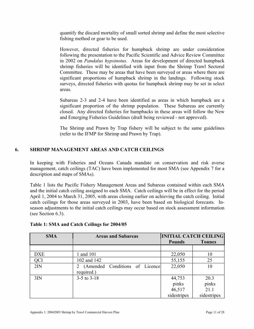
quantify the discard mortality of small sorted shrimp and define the most selective fishing method or gear to be used.
However, directed fisheries for humpback shrimp are under consideration following the presentation to the Pacific Scientific and Advice Review Committee in 2002 on Pandalus hypsinotus. Areas for development of directed humpback shrimp fisheries will be identified with input from the Shrimp Trawl Sectoral Committee. These may be areas that have been surveyed or areas where there are significant proportions of humpback shrimp in the landings. Following stock surveys, directed fisheries with quotas for humpback shrimp may be set in select areas.
Subareas 2-3 and 2-4 have been identified as areas in which humpback are a significant proportion of the shrimp population. These Subareas are currently closed. Any directed fisheries for humpbacks in these areas will follow the New and Emerging Fisheries Guidelines (draft being reviewed - not approved).
The Shrimp and Prawn by Trap fishery will be subject to the same guidelines (refer to the IFMP for Shrimp and Prawn by Trap).
6. SHRIMP MANAGEMENT AREAS AND CATCH CEILINGS
In keeping with Fisheries and Oceans Canada mandate on conservation and risk averse management, catch ceilings (TAC) have been implemented for most SMA (see Appendix 7 for a description and maps of SMAs).
Table 1 lists the Pacific Fishery Management Areas and Subareas contained within each SMA and the initial catch ceiling assigned to each SMA. Catch ceilings will be in effect for the period April 1, 2004 to March 31, 2005, with areas closing earlier on achieving the catch ceiling. Initial catch ceilings for those areas surveyed in 2003, have been based on biological forecasts. In-season adjustments to the initial catch ceilings may occur based on stock assessment information (see Section 6.3).
Table 1: SMA and Catch Ceilings for 2004/05
SMA Areas and Subareas INITIAL CATCH CEILING Pounds Tonnes
DXE 1 and 101 22,050 10 QCI 102 and 142 55,155 25 2IN 2 (Amended Conditions of Licence
required.) 22,050 10
3IN 3-5 to 3-18 44,753 pinks
46,517 sidestripes
20.3 pinks 21.1
sidestripes
Appendix 1: 20042005 Shrimp by Trawl Commercial Harvest Plan Page 11 of 28
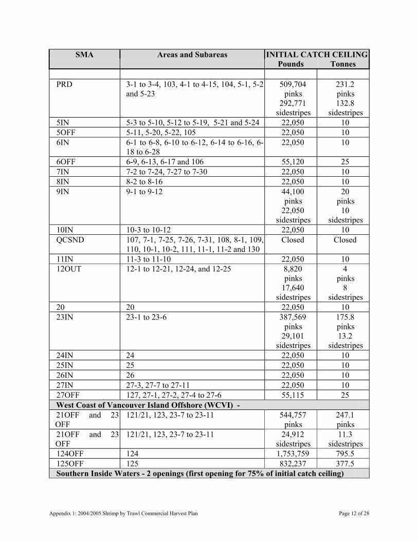
SMA Areas and Subareas INITIAL CATCH CEILING Pounds Tonnes
PRD 3-1 to 3-4, 103, 4-1 to 4-15, 104, 5-1, 5-2
and 5-23 509,704
pinks 292,771
sidestripes
231.2 pinks 132.8
sidestripes 5IN 5-3 to 5-10, 5-12 to 5-19, 5-21 and 5-24 22,050 10 5OFF 5-11, 5-20, 5-22, 105 22,050 10 6IN 6-1 to 6-8, 6-10 to 6-12, 6-14 to 6-16, 6-
18 to 6-28 22,050 10
6OFF 6-9, 6-13, 6-17 and 106 55,120 25 7IN 7-2 to 7-24, 7-27 to 7-30 22,050 10 8IN 8-2 to 8-16 22,050 10 9IN 9-1 to 9-12
44,100 pinks
22,050 sidestripes
20 pinks
10 sidestripes
10IN 10-3 to 10-12 22,050 10 QCSND
107, 7-1, 7-25, 7-26, 7-31, 108, 8-1, 109, 110, 10-1, 10-2, 111, 11-1, 11-2 and 130
Closed
Closed
11IN 11-3 to 11-10 22,050 10 12OUT
12-1 to 12-21, 12-24, and 12-25
8,820 pinks
17,640 sidestripes
4 pinks
8 sidestripes
20 20 22,050 10 23IN 23-1 to 23-6 387,569
pinks 29,101
sidestripes
175.8 pinks 13.2
sidestripes 24IN 24 22,050 10 25IN 25 22,050 10 26IN 26 22,050 10 27IN 27-3, 27-7 to 27-11 22,050 10 27OFF 127, 27-1, 27-2, 27-4 to 27-6 55,115 25 West Coast of Vancouver Island Offshore (WCVI) - 21OFF and 23 OFF
121/21, 123, 23-7 to 23-11 544,757 pinks
247.1 pinks
21OFF and 23 OFF
121/21, 123, 23-7 to 23-11 24,912 sidestripes
11.3 sidestripes
124OFF 124 1,753,759 795.5 125OFF 125 832,237 377.5 Southern Inside Waters - 2 openings (first opening for 75% of initial catch ceiling)
Appendix 1: 2004/2005 Shrimp by Trawl Commercial Harvest Plan Page 12 of 28

SMA Areas and Subareas INITIAL CATCH CEILING Pounds Tonnes
12IN 12-22, 12-23, 12-26 to 12-48 88,180
pinks and coonstripes
17,640 sidestripes
3,970 humpback
40 pinks and
coonstripes 8
sidestripes 1.8
humpback GSTE 13 and 15 205,248
pinks 37,037
sidestripes
93.1 pinks 16.8
sidestripes 14 14 170,636
pinks 24,251
sidestripes
77.4 pinks
11 sidestripes
16 16 63,492 pinks
15,653 sidestripes
28.8 pinks 7.1
sidestripes 17 17 17,640 8 18 18 24,250
pinks 4,630
sidestripes 12,340
coonstripes
11 pinks 2.1
sidestripes 5.6
coonstripes 19 19 22,050
pinks 4,190
sidestripes 22,050
coonstripes
10 pinks 1.9
sidestripes 10
coonstripes FR 28 and 29 85,979
pinks 81,791
sidestripes
39.0 pinks 37.1
sidestripes
6.1. West Coast of Vancouver Island Offshore
The offshore areas included as the WCVI are SMA 21OFF, 23OFF, 124OFF, and 125OFF.
Appendix 1: 20042005 Shrimp by Trawl Commercial Harvest Plan Page 13 of 28

The in-season evaluation will incorporate the results of the May 2004 biomass survey, catch and effort data, status of the fishery to date, biological sampling, eulachon by-catch levels, advice from reconstructing the offshore Pandalus jordani trawl fishery off the WCVI, and simulating alternative management policies (Martell et al. 2000).
By-catch action levels for eulachon are set annually for the WCVI, and may result in fishery closures (see section 8.4).
Notification of closure or any changes to the duration of the seasonal opening will be announced by fishery notice and by the shrimp information line (888) 978-7888.
Fishers are requested to submit logbook information earlier than is outlined in the conditions of the shrimp trawl licence to assist in the evaluation of fishing opportunities.
6.2. Southern Inside Waters - Two Openings
Based on the recommendation from the Shrimp Trawl Sectoral Committee the “Southern Inside Waters” (12IN, GSTE, 14, 16, 17, 18, 19, FR, and 23IN) will have two openings:
a) June 1, 2004 for 75% of the initial catch ceiling; and
b) November 1, 2004 for the remainder of the annual quota.
The initial catch ceilings for these areas are provided above in Table 1. Each SMA will close independently upon attaining the allocated proportion of the catch ceiling.
Landings from the first opening that exceed, or are short, of the allocated amount will be applied to the final opening.
In-season adjustments to catch ceilings may result from in-season biomass estimates and will be applied at the time the biomass estimates become available.
6.3. In-Season Adjustments to Catch Ceilings
Notification will be given by fishery notice and by the shrimp information line (888) 978-7888 for any in season adjustments to the catch ceilings listed in Table 1.
6.3.1. In-season Changes to Catch Ceilings Based on Biomass Estimates
In-season adjustments to the catch ceilings set out in Table 1 may occur based on stock assessment information. Industry-supported, fishery-independent biomass surveys will be conducted to collect biomass information. Biomass estimates may be made in those areas or in non-surveyed areas that have been identified as a priority for analysis.
If an in-season adjustment to the catch ceiling results in the re-opening of an area, effort will be made to give a minimum 48 hours advance notice prior to re-opening.
Appendix 1: 2004/2005 Shrimp by Trawl Commercial Harvest Plan Page 14 of 28

The results from surveys are reported in “Shrimp Survey Bulletins” and are available in-season from the Fisheries and Oceans Canada Pacific Region Shrimp Trawl web page (below) or the Shrimp Trawl Sectoral Committee Representatives (listed in the IFMP).
www.pac.dfo-mpo.gc.ca/ops/fm/shellfish/default_e.htm
6.3.2.
6.3.3.
In-Season Re-openings in the Event of Available Quota
Areas that close but do not achieve the catch ceiling or annual quota, will re-open provided all hailed vessels are cleared from the grounds and an assessment of landings determines that there is sufficient quota available for the Department to deem a re-opening to be manageable. Effort will be made to provide a minimum 48 hours advance notice prior to re-opening. Vessel operators may assist in this process by ensuring that all landings have been hailed and that all hails have been cleared with Archipelago.
In-Season Changes to Catch Ceilings for Southern Inside Waters
In-season changes to catch ceilings for Southern Inside waters will be determined at the time the survey results become available, and will be re-proportioned to the two harvest periods at that time.
If survey results indicate additional quota and become available while an area is open and actively being fished, the quota will be re-proportioned at that time and the fishery will continue. If survey results indicate sufficient additional quota to manage a re-opening and become available while the area is closed, effort will be made to provide 48 hours advance notice prior to re-opening.
7. SPECIAL MANAGEMENT AREAS
7.1. Shrimp Management Area Queen Charlotte Sound
Pacific Fisheries Management Areas 107, 108, 109, 110, 111, 130, and Subareas 7-1, 7-25, 7-26, 7-31, 8-1, 10-1, 10-2, 11-1 and 11-2 are currently closed pending status of central coast eulachon stocks. SMA Queen Charlotte Sound was closed in 2000, due to concerns for eulachon stocks in central coast rivers. Considerations to re-open Queen Charlotte Sound will be dependent on the criteria established by Fisheries and Oceans Canada in discussion with the shrimp trawl industry and First Nations. These criteria include seeing returns of eulachons to central coast rivers, the index of offshore eulachon abundance, identifying an available shrimp quota and adopting a precautionary approach to eulachon by-catch. Subject to these criteria, a precautionary eulachon by-catch action level may be set in-season. An announcement on the status of this area can be expected in-season. In the event SMA Queen Charlotte Sound is re-opened in 2004/05, vessel operators wishing to fish in these areas would be required to obtain amended Conditions
Appendix 1: 20042005 Shrimp by Trawl Commercial Harvest Plan Page 15 of 28
of Licence prior to commencement of fishing. For further information, contact the Fisheries Manager in Port Hardy (see Contacts section of the IFMP).
7.2. Shrimp Management Area 2IN
Pacific Fisheries Management Area 2 (note closure of Subareas 2-3 and 2-4). Vessel operators wishing to fish in this area are required to obtain amended Conditions of Licence prior to commencement of fishing. Sampling coverage in this remote area has been proven to be cost prohibitive to the catch sampling program. Commencing in 2001, and continuing for the 2004/05 season, costs for observer coverage in this area will be the responsibility of the individual vessel master. Amended conditions of licence to the shrimp trawl licence to fish in SMA 2IN (Pacific Fishery Management Area 2) will be required. Amended conditions of licence are issued subject to fulfilling application requirements, including the vessel master securing arrangements for certified shrimp fishery observer coverage. Proposals will be considered from groups of fishers that arrange collectively for adequate observer coverage. Arrangements for amended conditions of licence can be made with the North Coast Management Biologist (see Contacts section of the IFMP).
7.3. Shrimp Management Areas 27IN and 27OFF
Pacific Fisheries Management Areas 27 and 127, SMA 27IN and 27OFF (Pacific Fishery Management Areas 27 and 127), open upon request from a vessel master subject to the vessel master securing arrangements for a certified shrimp fishery observer for the first fishing trip to these areas. Contact the Central Coast Fisheries Co-ordinator to request an opening (see Contacts section of the IFMP).
8. SELECTIVE FISHING PRACTICES
8.1. Selectivity Devices
The shrimp trawl industry through the Shrimp Trawl Sectoral Committee with the support of the Pacific Coast Shrimpers’ Cooperative Association and the Department, recommended that selectivity devices (also known as exclusion grates, excluders, soft mesh excluders or BRD) be mandatory as a condition of licence. Fisheries and Oceans Canada commends the shrimp trawl industry’s initiative in fishing selectively and taking active measures to reduce by-catch.
Two types of selectivity devices, an exclusion grate and an excluder net, are accepted under the conditions of licence as per the recommendation from the Shrimp Trawl Sectoral Committee.
Although a spacing of 76 mm for the selectivity devices has been implemented as a condition of licence, the Shrimp Trawl Caucus recommends the minimum spacing for grates be 25 mm to more effectively reduce by-catch.
Appendix 1: 2004/2005 Shrimp by Trawl Commercial Harvest Plan Page 16 of 28
The shrimp trawl industry has undertaken directed studies and efforts to minimize eulachon by-catch. Preliminary results from a twin trawl comparison study are encouraging and have lead to an industry recommendation that a panel of plastic lattice be installed in all otter trawl nets beginning in 2001 to reduce the incidence of eulachon and other by-catch. It is anticipated that by-catch of eulachon will be reduced significantly and that fishing opportunities should be extended with the use of this material. The plastic lattice is similar to the material used in snow fencing. The plastic is rigid enough to maintain a minimum 4cm square opening while being towed to allow small fish to escape. The lattice is available in 4 foot wide rolls and is inexpensive. A 4 foot by 12 foot (48 square feet) panel was tested during the twin trawl studies. Vessel masters already using this material are convinced of its capabilities in reducing by-catch of many species and have installed more than 4.4 square metres in their nets. The Shrimp Trawl Sectoral Committee has recommended that more than 4.4 square metres (48 square feet) be installed. Please contact the industry representatives to the Shrimp Trawl Sectoral Committee (in the IFMP) for further information on installation and sources for this material.
8.1.1. Experimenting with Selectivity Devices
For the 2004/2005 season, experimentation with selectivity devices that differ from those described in the conditions of the shrimp trawl licence will be made possible through an application for amended conditions of licence of shrimp trawl licence or through a scientific licence.
Those fishers wishing to experiment during open times may apply for amended conditions of licence to the shrimp trawl licence by submitting a proposal to the Fraser River Management Biologist, or Central Coast Fisheries Coordinator (see Contacts section of the IFMP). The proposal shall include a description of the proposed experimental gear and will require that the vessel master agree to take an observer or catch monitor on board upon request from the Department while fishing under authority of the amended conditions of licence. Amended conditions of licence will be valid for a period of five months from the date of issue.
Requests for renewals of amended conditions of licence beyond five months will require that the vessel take on board a certified shrimp observer in order to collect catch composition information. Prior to issuance, the vessel master must provide a letter from a catch monitoring service bureau to Fisheries Management personnel stating that arrangements for one day of certified shrimp observer coverage have been made. This letter shall accompany the application for a renewal. Cost of observer coverage is the responsibility of the vessel owner.
Those fishers wishing to experiment with selective fishing devices during close times will be required to apply for a scientific licence. There is special consideration given to experimentation during close times as areas are allocated total allowable catches. Prior to the Department issuing a scientific licence, the Selective Fishing subcommittee of the Shrimp Trawl Sectoral Committee will
Appendix 1: 20042005 Shrimp by Trawl Commercial Harvest Plan Page 17 of 28

review the proposal and make a recommendation to the Department for the study to be undertaken under scientific licence. Full time observer or catch monitoring coverage will be required. The Department will approve the observer or catch monitor prior to issuance of a scientific licence. Costs of the observer coverage are the responsibility of the project proponents.
8.1.2. Future Standards for Selectivity Devices
Future standards for selectivity devices will be determined in consultation with the Department and the Selective Fishing Subcommittee of the Shrimp Trawl Sectoral Committee. Those selectivity devices that are acceptable to the Selective Fishing Subcommittee will be considered as a Condition of Licence for shrimp trawling in 2004/2005. Fishers that have found experimental selectivity devices to be effective are advised to submit a report to the Selective Fishing Subcommittee (contact Pacific Coast Shrimpers’ Cooperative Association (see Contacts section of the IFMP) for consideration in developing standards. The report should provide details on testing of the device and demonstrate the value of the device as legitimate selectivity gear.
8.2. Selective Fishing Practices
For information on selective fishing initiatives in the shrimp trawl fishery, visit the shrimp trawl web page.
www.pac.dfo-mpo.gc.ca/ops/fm/shellfish/shrimp/default_e.htm
Fishers are asked to avoid areas where there is by-catch of those species not permitted to be retained by the conditions of the shrimp trawl licence.
The ongoing Catch Sampling Program will collect information for the evaluation of selective fishing practices. Anyone who would like to provide information or feedback on by-catch and selectivity devices should contact the Selective Fishing Subcommittee. By-catch information collected through the Catch Sampling Program, and other directed studies, will be consolidated for review by the Selective Fishing Subcommittee and the Shrimp Trawl Sectoral Committee. The gear questionnaire included in the Shrimp Trawl Fishing Logbook is an important component of this study and fishers are reminded to submit a completed questionnaire as part of the logbook condition of licence. Results of the catch sampling program are available in the document, Estimated by-catch in the British Columbia Shrimp Trawl Fishery (Olsen et al. 2001), available from the Pacific Scientific Advice Review Committee Secretariat at:
www.dfo-mpo.gc.ca/csas/
Based on a recommendation from the shrimp trawl sectoral committee, the use of mechanised devices (e.g. “smelt belts”) for the purposes of automatically separating by-catch from shrimp has been prohibited. Smelt belts can be described as on board by-catch-discarding machines that use a series of sandpaper belts to separate small fishes, such as smelts, from shrimp. The texture and slope angle of the belt allows the fish to
Appendix 1: 2004/2005 Shrimp by Trawl Commercial Harvest Plan Page 18 of 28
travel up the belt and be discarded overboard while shrimp, having a hard exoskeleton, do not adhere to the belt and roll to the bottom of the machine. Smelt belts come in different sizes and configurations, generally made of aluminium and powered by several small hydraulic motors, which turn the belts. Smelt belts are not to be confused with conveyor belts that are used simply to move shrimp on deck, or grading machines (series of slotted trays) used to grade shrimp into different sizes to maximize value, although they may be used in conjunction with grading machines. Smelt belts are not as commonly used in British Columbia, as they may be in other jurisdictions. In particular, the British Columbia shrimp trawl industry does not support high by-catches of eulachon and believes that allowing the use of these devices may overcome the usual incentives to avoid fishing in areas with high eulachon by-catches.
The West Coast Shrimp Fishery Association recommends that on board shrimp sizing graders be allowed only with certain restrictions on mesh size and use of selectivity devices for shrimp size in the trawl. The shrimp industry supports and recommends that in-water shrimp sizing grates be installed in all nets to reduce the incidence of juveniles in the catch and improve market quality and value.
The shrimp industry supports responsible fishing practices, including the recommendation that larger, better quality and better-valued shrimp be targeted, and that juvenile shrimp be avoided. To reduce the incidence of fishing on undersize and unmarketable shrimp, minimum shrimp counts (i.e. a shrimp count per litre) are under consideration. The shrimp trawl industry representatives recommend the use of in-water shrimp sizing devices to reduce the incidence of small unmarketable shrimp and improve the value of the catch.
The use and effectiveness of on board graders and “pickers” will be evaluated and additional restrictions may be implemented in the future.
8.3. Incidental Catch - Non-retention Species
Unless the retention of an incidental catch is expressly authorized by the licence, under Section 33 of the Fishery (General) Regulations, every person who catches a fish incidentally (includes shellfish) shall forthwith return it to the place from which it was taken; and in a manner that causes it the least harm.
8.3.1. Non-retention of Finfish
Note that the retention of any incidentally caught fin fish is not allowed when shrimp trawling under the authority of a category “S” licence. This includes “Schedule II Species” (those species listed in Part 2 of the shrimp trawl licence and in “Schedule II - Part II” of the Pacific Fishery Regulations), as trawl gear is not permissible for the harvest of these species.
8.4. Eulachon Monitoring
Information collected from the co-management Catch Sampling Program will be used to monitor in-season estimates of incidental eulachon by-catch in areas where eulachon by-
Appendix 1: 20042005 Shrimp by Trawl Commercial Harvest Plan Page 19 of 28

catches can occur. These areas are offshore off the WCVI and Queen Charlotte Sound. By-catch action levels for eulachon for otter trawls are set annually in these areas in discussion with the Shrimp Trawl Sectoral Committee. The shrimp trawl industry and Fisheries and Oceans Canada is committed to controlling and minimizing the by-catch of this species.
In the event the estimate of eulachon by-catch from the fishery reaches the “eulachon action level” in a given area, the fishery will continue under amended conditions to the shrimp trawl licence to permit the use of beam trawl only in that specific area. Beam trawl catch rates of eulachon in the past years have been regarded as having minimal risk to eulachon stocks. Under the amended conditions of licence, sampling will continue to monitor and assess eulachon by-catch with beam trawl gear. If the by-catch of eulachon by beam trawls is observed to increase above the level it has been over the last six seasons of sampling (1997-2002), additional management actions may be implemented.
If required, amended conditions of licence will be sent in-season by registered mail from the Pacific Fishery Licensing Unit to all licence holders and will replace the original shrimp trawl Conditions of Licence in their entirety. Note that amended conditions of licence will be required to be on-board while undertaking fishing activities. Contact one of the Fishery Managers (see Contacts section of the IFMP) for further information.
At the request of the Shrimp Trawl Sectoral Committee to avoid higher eulachon by-catches offshore of Barkley Sound, eulachon monitoring off the WCVI will be divided into two management areas: SMA 23OFF and combined SMA 21OFF, 124OFF, and 125OFF. The initial eulachon by-catch action level will be divided equally between the two areas. In-season adjustment to the action levels would be based on the eulachon abundance in each area as determined from the May shrimp trawl survey.
A precautionary approach is being taken in 2004/05 to the setting of eulachon by-catch action levels in the shrimp trawl fishery. The initial eulachon action level for the WCVI will be set at a maximum of 1% of the estimated eulachon biomass, to a maximum of 40 tonnes.
In the event eulachon abundance is determined to reach critically low levels, further management actions to address incidental by-catch may be implemented.
For further information see the Shrimp Trawl Selective Fishing Program on the Shrimp Trawl web page at:
www.pac.dfo-mpo.gc.ca/ops/fm/shellfish/shrimp/default_e.htm
8.5. Dumping of Shrimp
Subject to Section 34 of the Fishery (General) Regulations, no person who is fishing under the authority of a licence issued for the purpose of commercial fishing shall dump from a vessel any fish, including shellfish, that has been caught in accordance with the Act and the regulations made thereunder. In regards to fishing shrimp in the shrimp trawl
Appendix 1: 2004/2005 Shrimp by Trawl Commercial Harvest Plan Page 20 of 28
fishery, note that this regulation means there is to be no dumping of shrimp. Incidentally trawl caught fin fish must be released.
9. SHRIMP TRAWL CATCH MONITORING PROGRAM
For the period of this plan and purposes of notification, the Designated Service Bureau is Archipelago Marine Research Ltd. of Victoria, British Columbia.
To meet the conservation and sustainable fishing objectives in this fishery, a Shrimp Trawl Catch Monitoring Program has been developed to track commercial fishery landings, and to monitor the status of SMA catch ceilings. The program has two main components: A “hailing” requirement including notification prior to fishing and prior to offloading, and a catch verification requirement in the form of random dockside validation by a Department certified observer.
9.1. Notification Prior to Commencement of a Fishing Trip
The vessel master shall obtain a Fishing Hail Number prior to commencing fishing from Archipelago at (866) 377-1400 between the hours of 08:00 to 17:00, and provide the following information (hereinafter referred to as a “Fishing Hail”):
a) Vessel name and Vessel Registration Number (VRN #).
b) Vessel master’s name (first and last) and contact phone number.
c) Vessel’s autotel or cellular number.
d) Gear type (beam or otter trawl).
e) SMA or Subarea to be fished (note - one area only).
f) Anticipated date and time that fishing will begin.
g) Anticipated number of fishing days for the trip.
h) Target shrimp species.
i) Product type (fresh, live, frozen at sea, etc.).
j) Anticipated offload location and date.
Alternatively, a Shrimp Fisher ID number issued in-season by Archipelago may replace items (a) through (d) providing there is no change to the contact information provided at the start of the season. If there is a change in vessel masters, this information must be updated with Archipelago.
Upon completion of the notification, Archipelago will provide the vessel master (skipper) with a unique Fishing Hail Number.
Vessel masters must have available for inspection by Fisheries and Oceans Canada officers or fishery guardians their current Fishing Hail Number at all times during fishing or while shrimp are on board their vessel.
Appendix 1: 20042005 Shrimp by Trawl Commercial Harvest Plan Page 21 of 28
In all instances, it is the vessel master’s responsibility to obtain a Fishing Hail Number prior to leaving the dock to go fishing. A Fishing Hail Number may be refused if the hail location is vague or misleading. It is a condition of licence that vessels arrange for 100% at-sea observer coverage. This requirement may be waived at the time of Fishing Hail if the Department does not require an observer on-board the vessel for that particular fishing trip.
The service bureau, Archipelago Marine Research Ltd., is not responsible for notifying fishers of existing or impending closures. Fishers should consult Fishery Notices, District Offices, or Department Resource Managers (See Contacts in the IFMP).
Vessel masters who are having difficulty dialling the Archipelago toll free number using marine radio telephones in remote locations are advised to dial the operator and ask for assistance.
9.2. Notification of a Change in Fishing Area
If the SMA or target species to be fished is different from the original Fishing Hail, the vessel master shall contact Archipelago at (866) 377-1200 (24 hours per day) or (866) 377-1400 (08:00 h to 17:00 h) to update the fishing hail record prior to fishing in the new SMA. This shall be done by quoting the original Fishing Hail Number for that trip and advising of the new SMA to be fished and the weight of each species of shrimp on board from the SMA fished prior to changing locations.
Changes to the anticipated number of fishing days (trip length), product type (fresh, live, frozen at sea, etc.) and/or landing port do not need to be re-hailed unless the SMA to be fished changes.
9.3. For Fishing Trips Longer Than Seven Days
If the fishing trip is longer than seven days (i.e. the landing date is more than seven days after the Fishing Hail), the vessel master shall provide Archipelago at (866) 377-1200 (24 hours per day) or (866) 377-1400 (08:00 h to 17:00 h) the following update of catch information every seven days:
a) Fishing hail number which applies to the current fishing trip.
b) SMA or subarea in which fishing occurred.
c) Total weight of each species of shrimp, on board the vessel from each SMA fished.
For example, if the fishing hail report is made on Monday, then an update of catch information is required every Monday for the duration of the fishing trip.
9.4. Notification Prior to Landing Catch
At least two hours prior to landing any catch, the vessel master shall obtain a Landing Hail Number from Archipelago at (866) 377-1200 (24 hours per day) or (866) 377-1400
Appendix 1: 2004/2005 Shrimp by Trawl Commercial Harvest Plan Page 22 of 28

(08:00 h to 17:00 h) and provide the following information (hereinafter referred to as a “Landing Hail”):
a) Fishing hail number which applies to the current fishing trip.
b) Vessel name and Vessel Registration Number (VRN #).
c) Vessel master’s name.
d) Date fishing began.
e) Date and time of offloading.
f) Port and location of offloading.
g) Buyer.
h) SMA(s) or Subarea(s) in which fishing occurred.
i) Weight of each species* of shrimp on board from each SMA fished.
j) Total hours towed for each SMA fished.
*Northern pink shrimp (Pandalus borealis) and pink shrimp (Pandalus jordani) may be reported as “pink shrimp.”
Upon completion of the Landing Hail, Archipelago will provide the vessel master (skipper) a unique Landing Hail Number.
During the period of this plan, the Landing Hail and harvest log must be completed and account for all shrimp and incidental catch retained prior to any shrimp or incidental catch being offloaded from the vessel.
9.5. Cancellation of a Fishing Hail Number
Where a fishing hail number has been issued and no fishing occurs, the vessel master shall notify Archipelago at (866) 377-1200 (24 hours per day) or (866) 377-1400 (08:00 h to 17:00 h) to cancel the hail, i.e. specify that no fishing took place. No follow-up paperwork will be required by the vessel master.
Active hails that have not been cancelled are deemed to be late, and thereby not in compliance of the conditions of licence.
9.6. Catch Reporting Requirements
Under British Columbia Provincial requirements, a Fish Buying Station Licence with an accompanying “bill of lading” is required in order to transport any product other than that caught under the authority of one’s own licence. Alternately, the person transporting shrimp shall possess a bill of lading.
9.6.1. Catch Reports – Fish Slips
Appendix 1: 20042005 Shrimp by Trawl Commercial Harvest Plan Page 23 of 28
An accurate written report shall be furnished on a fish slip of all fish and shellfish caught under the authority of the licence. A report must be made even if the fish and shellfish landed are used for bait, personal consumption, or otherwise disposed. The written report shall be posted not later than seven days after the offloading and sent to:
Fisheries and Oceans Canada Regional Data Unit 200 - 401 Burrard St. Vancouver, B.C., V6C 3S4
Fish slip books may be purchased at the above address, or at most Fisheries and Oceans Canada offices. Phone (604) 666-2716.
9.6.2.
9.6.3.
Dockside Verification
Fisheries and Oceans Canada and Archipelago Marine Research will conduct “dockside validation” during 2004/05 to verify shrimp landing weights, species composition, and quality against hailed or otherwise reported figures. Biological samples may also be requested for use in the stock assessment program.
Under Section 47 of the Fishery General Regulations, the vessel master of the licensed vessel shall:
a) Permit the observer to go on board the vessel to perform the designated duties. This would include providing access to the vessel’s fish holds, freezers, and other fish storage areas at any time during the landing.
b) Allow the observer to inspect a hard copy of the harvest logbook upon completion of each verification.
c) Provide the observer with such assistance as is reasonably necessary to enable the observer to perform those duties.
At-Sea Observers
During the 2004/05 season licence holders will be responsible for arranging at-sea observer coverage with a Fisheries and Oceans Canada certified service provider. Observers will be distributed coast-wide to monitor catch onboard vessels, and in some instances to collect biological information or samples.
Members of the Pacific Coast Shrimpers’ Cooperative Association have agreed to have the Association contract Archipelago Marine Research to provide services. Fishers who have not arranged coverage through the Association may contact a fisheries manager listed in the Contacts section of the IFMP for information on how to meet this licence condition.
10. SHRIMP TRAWL FISHING LOG (HARVEST LOG) RECORD
Appendix 1: 2004/2005 Shrimp by Trawl Commercial Harvest Plan Page 24 of 28

An important component of the developing stock assessment program is the information collected from the vessel master in the form of the Shrimp Trawl Fishing Log. In-season adjustments to catch ceilings rely on information collected from these logs. Vessel masters and processors are encouraged to submit log information early (e.g. following each trip), to ensure more timely analyses and assessments that may result in further fishing opportunities. Timely submission of logs is particularly important for assessing WCVI fishing opportunities.
10.1. Harvest Log or Shrimp Trawl Fishing Log Data
The vessel master is responsible for the provision and maintenance of an accurate record, a “log,” of daily harvest operations. This log must be completed and a copy submitted in both hard copy (paper) and electronic form in an approved format as defined by Fisheries and Oceans Canada Stock Assessment Division’s Shellfish Data Unit.
To fulfil stock assessment objectives it is imperative that much finer resolution of fishing location be reported in this fishery. The vessel master is responsible for reporting latitude/longitude or loran position on harvest logs in the “location” field. For those vessels not equipped with the appropriate instruments, fishing position must be indicated on a chart record of the locations fished. The harvest chart must have marked directly on it the VRN number, the tab number, and the dates that fishing activity occurred at each location.
Logbooks meeting Fisheries and Oceans Canada requirements are available from outside service bureau’s who, for a fee, will provide the logbook coding and keypunch service, thus complying with the requirements for a hard (paper), an electronic copy and location information.
The original white page copy of the log, the accompanying chart record, and the electronic copy must be forwarded within 28 days, or sooner, following the end of each month in which fishing occurred. This information must be sent to:
Fisheries and Oceans Canada Shellfish Data Unit Pacific Biological Station Hammond Bay Road Nanaimo, B.C. V9R 5K6
Tel: (250) 756-7022 or (250) 756-7306
As an alternative to harvest log provision through a service bureau, the vessel master may provide a hard copy log in the same form and providing the same particulars as shown in the fishing log sample attached as Appendix 4. The vessel master must also provide an electronic copy, which is required to be a true and accurate transcription of the hard copy data, delivered on a DOS compatible 3.5” disk. Disks will remain the property of Fisheries and Oceans Canada. The electronic copy must be either:
a) An ASCII text file in the data format specified by Fisheries and Oceans Canada Shellfish Data Program, or
Appendix 1: 20042005 Shrimp by Trawl Commercial Harvest Plan Page 25 of 28
b) Preferably a database table of specific design created by any of the following database management tools: Access 97 (or earlier version), FoxPro, Paradox or dBase (III or IV).
Contact the Shellfish Data Unit at the above address to obtain the requirements and acceptable data formats for supplying harvest log, chart, and electronic data in a format that meets the conditions of licence. The paper copy of the harvest log and the electronic copy including latitude/longitude or loran locations (or arrangements for a bonded map service provider) must be forwarded within 28 days, or sooner, following the end of each month in which fishing occurred. This information must be sent to the above address.
Catch information must be recorded in the harvest log by midnight of the day of fishing. The logbook must be kept aboard the licensed vessel. Logbooks must be produced for examination on demand of a fishery officer, guardian, or a fishery observer designated under the Fisheries Act.
Fisheries and Oceans Canada reminds fishers that harvest logs must be completed accurately during fishing operations and submitted to Fisheries and Oceans Canada in accordance with the timing set out in the conditions of licence. Delay of completion or submission of logs is a violation of a condition of licence.
10.1.1.
10.1.2.
10.1.3.
Gear Questionnaire
A gear questionnaire is included in the front of the Shrimp Trawl Fishing Log and is an important component of the logbook requirement under the conditions of the shrimp trawl licence. The questionnaire intends to address and acknowledge the type of gear in use in the shrimp trawl industry. A new questionnaire must be filled out and submitted for any change to the gear being used.
Confidentiality of Shrimp Trawl Fishing Log Data
The vessel owner of record reported with the Pacific Fishery Licensing Unit is responsible to ensure that the vessel master has completed and submitted a copy of the log data. Fisheries and Oceans Canada can only release log data to the reported vessel owner, and only upon written request.
Nil Report for Harvest Log - Licence Issued but not Fished
In the event that a licence is issued but not fished, the vessel owner is responsible for submitting a Nil report for the season. The Nil report must be submitted to Fisheries and Oceans Canada Shellfish Data Unit prior to the issuing of approval for licence renewal. One page from the harvest log identifying the vessel, licence tab number, and the year with “nil” entered in the body of the log and signed by the vessel owner constitutes a nil report.
Appendix 1: 2004/2005 Shrimp by Trawl Commercial Harvest Plan Page 26 of 28
10.2. Confidentiality of Data
Harvest data, including fishing location data supplied through latitude/longitude coordinates, loran or chart records and gear configurations, collected for use under the harvest logbooks for Shellfish Fisheries programs, are collected for use by the Department in the proper assessment, management, and control of the fisheries. Upon receipt by the Department of harvest log data and/or fishing location information, supplied by the fisher in accordance with conditions of licence, Section 20(1)(b) of the Access to Information Act prevents the Department from disclosing to a third party, records containing financial, commercial, scientific or technical information that is confidential information. Further, Section 20(1)(c) of the Act prevents the Department from giving out information, the disclosure of which could reasonably be expected to prejudice the competitive position of the fisher.
11. CATCH SAMPLING PROGRAM
A Catch Sampling Program will be undertaken dockside and at-sea by observers or catch monitors to collect biological samples of shrimp for size and age analysis, and to assess the composition of the catch for both shrimp and non-target species. This information is necessary for the proper management of the fishery, and for the developing stock assessment program. Fishing closures will be implemented if the level of catch sampling coverage required by the Department has not been achieved.
11.1. Selection of Vessels for Catch Sampling Program
During the course of the season, certified shrimp fishery observer coverage is required as part of the catch sampling program. Vessels will be selected randomly for catch sampling depending on sampling requirements by area and time period. The actual days of coverage will be determined in-season according to area fished, gear, fishing effort, month, and the need for biological samples.
It is a condition of licence that vessels arrange for 100% observer coverage prior to leaving the dock to start fishing activities. For vessels that are not deemed to require an observer on that particular trip Archipelago will issue an exemption at the time of hail-in. The shrimp information line will provide updates on the outstanding requirements for observer coverage in priority areas. Fishery closures will be implemented if the level of observer coverage required for the proper management of the fishery has not been achieved.
11.2. Designation of Observers
Observers are designated to perform the duties of monitoring of fishing activity, the examination and measurement of fishing gear, the recording of scientific data and observations, the taking of samples, the verification of the weight and species of fish caught and inspection of fishing records.
Appendix 1: 20042005 Shrimp by Trawl Commercial Harvest Plan Page 27 of 28
Appendix 1: 2004/2005 Shrimp by Trawl Commercial Harvest Plan Page 28 of 28
11.3. Observer Coverage - Request from Regional Director General
Under Section 46 of the Fisheries Acts and Regulations, the licence holder or master of a fishing vessel shall, at the request of the Regional Director General, permit an observer to go on board that vessel to perform the designated duties for the period of time specified and arrange for the embarkation or disembarkation of the observer, at such time and place as is specified. The vessel master shall provide all reasonable assistance to the observer.
The request shall be in the form of a letter from the Regional Director General outlining the conditions under which the vessel master will be contacted in-season to take an observer. This letter is given to all shrimp trawl licence holders at the time of licence issuance. During the course of the season, requests will be made in-season by a representative of Archipelago Marine Research Ltd. by phone or during a hail report. The representative will specify a date for which observer coverage is required, at which time the vessel master will be obligated to take on board an observer on the first fishing trip following this date. Once the request has been made in-season, the vessel master is legally obligated to arrange observer coverage prior to undertaking any further fishing activity.
Fishery closures will be implemented if the level of sampling and observer coverage required for the proper management and control of the fishery has not been achieved. Licence holders or vessel masters that fail to comply with the request to take on board an observer are subject to prosecution under the Fisheries Act.
11.4. Shrimp Samples for Biological Sampling
Observers, catch monitors, or patrol vessels from Fisheries and Oceans Canada may also approach vessels, while at a dock or at-sea while fishing, to request samples of shrimp or to collect other catch information. Detailed information may be requested concerning the location, depth and area of catch, gear type and cod end mesh size, by-catch species and marketing of the shrimp sampled. Fisheries and Oceans Canada, the Pacific Coast Shrimpers Cooperative Association and the Shrimp Trawl Sectoral Committee ask for the co-operation of fishers and processors in providing biological samples and other catch information.
These samples will provide information such as: the determination of the species of shrimp in the catch, strength of age classes, location of shrimp stocks, number of egg-bearing female shrimp and preferred mesh size or gear.
Appendix 2: Permanent Closures and Maps of Rockfish Conservation Area Closures. 1. PERMANENT CLOSURES........................................................................................................4
1.2. Area 1.......................................................................................................................4 1.3. Area 2.......................................................................................................................4 1.4. Glass Sponge Reef Closures in 105, 106, 107 and 110 ...........................................4 1.5. Area 13.....................................................................................................................4 1.6. Area 14.....................................................................................................................4 1.7. Area 16.....................................................................................................................4 1.8. Area 17.....................................................................................................................4 1.9. Area 18.....................................................................................................................5 1.10. Area 19.................................................................................................................5 1.11. Area 20.................................................................................................................5 1.12. Area 24.................................................................................................................5 1.13. Area 28.................................................................................................................6 1.14. Area 29.................................................................................................................6
2. MAPS OF ROCKFISH CONSERVATION AREA CLOSURES (NEW FOR 2004/05)...........7 2.2. Area 1 - Frederick Island .........................................................................................7 2.3. Area 2 - South Moresby...........................................................................................8 2.4. Area 6 - Kitasu Bay/Laredo Inlet.............................................................................9 2.5. Area 7 - McMullin Group........................................................................................9 2.6. Area 7 - Goose Island ............................................................................................10 2.7. Area 9 - Fish Egg Inlet...........................................................................................11 2.8. Area 10 - Smith Sound...........................................................................................12 2.9. Area 11 - Storm Islands .........................................................................................13 2.10. Area 12 - Numas Islands....................................................................................13 2.11. Area 12 - Weynton Passage ...............................................................................14 2.12. Area 12 - Salmon Channel.................................................................................15 2.13. Area 12 - Susquash ............................................................................................15 2.14. Area 12 - Browning Island.................................................................................16 2.15. Area 12 - Goletas Channel.................................................................................16 2.16. Area 13 - Maud Island .......................................................................................17 2.17. Area 13 - Menzies Bay ......................................................................................17 2.18. Area 13 - Deepwater Bay...................................................................................18 2.19. Area 13 - Kanish Bay.........................................................................................18 2.20. Area 13 - Waiatt Bay/Octopus Islands...............................................................19 2.21. Area 13 - Maurelle-Read Island.........................................................................20 2.22. Area 13 - Heriot Bay..........................................................................................21 2.23. Area 13 - Penn Islands .......................................................................................22 2.24. Area 13 - Stuart Island .......................................................................................23 2.25. Area 13 - Thurston Bay......................................................................................23 2.26. Area 13 - Bute Inlet North .................................................................................24 2.27. Area 13 - Jackson Point .....................................................................................25 2.28. Area 13 - Walkem Islands..................................................................................26 2.29. Area 13 - Topaze Harbour .................................................................................26 2.30. Area 13 - Forward Harbour................................................................................27
Appendix 2: Permanent Closures and Maps of Rockfish Conservation Area Closures Page 1 of 77
2.31. Area 13 - Cooper Reach.....................................................................................27 2.32. Area 14 - Ajax/Achilles Bank............................................................................28 2.33. Area 14 - Lasqueti Island South.........................................................................29 2.34. Area 15 - Copelands Islands ..............................................................................29 2.35. Area 15 - Gifford Peninsula...............................................................................30 2.36. Area 15 - Teakerne Arm ....................................................................................31 2.37. Area 15 - Kinghorn Island .................................................................................32 2.38. Area 16 - Thormanby Island ..............................................................................33 2.39. Area 16 - McNaughton Point.............................................................................34 2.40. Area 16 - Nelson Island .....................................................................................35 2.41. Area 17 - Trincomali Channel ...........................................................................36 2.42. Area 17 - Saltspring Island North ......................................................................37 2.43. Area 17 - Pylades Island ....................................................................................38 2.44. Area 17 - Danger Reefs......................................................................................39 2.45. Area 17 - Thetis/Kuper Island............................................................................40 2.46. Area 17 - Ballenas Island........................................................................................41 2.47. Area 17 - Ladysmith ..........................................................................................42 2.48. Area 17 - Valdes Island......................................................................................42 2.49. Area 17 - Gabriola Island...................................................................................43 2.50. Area 18 - Mayne Island North II........................................................................44 2.51. Area 18 - Prevost Island.....................................................................................45 2.52. Area 18 - Bedwell Harbour................................................................................46 2.53. Area 18 - South Pender Island ...........................................................................46 2.54. Area 18 - Portland Island ...................................................................................47 2.55. Area 18 - Burgoyne Bay ....................................................................................48 2.56. Area 18 - Maple Bay..........................................................................................49 2.57. Area 18 - Patey Rock .........................................................................................49 2.58. Area 18 - Saturna Island ....................................................................................50 2.59. Area 19 - Royal Roads.......................................................................................51 2.60. Area 19 - Race Rocks ........................................................................................52 2.61. Area 19 - Gonzales Point ...................................................................................53 2.62. Area 19 - Discovery Island ................................................................................54 2.63. Area 19 - Beaumont Shoal.................................................................................55 2.64. Area 19 - D’Arcy Island ....................................................................................56 2.65. Area 19 - Domville Island..................................................................................57 2.66. Area 19 - Senanus Island ...................................................................................58 2.67. Area 19 - Finlayson Arm ...................................................................................59 2.68. Area 20 - Carmanah ...........................................................................................60 2.69. Area 20 - Becher Bay II .....................................................................................60 2.70. Area 20 - Sooke Inlet .........................................................................................61 2.71. Area 20 - Bentinck Island ..................................................................................62 2.72. Area 21 - Pachena Point.....................................................................................62 2.73. Area 21 - Dare Point ..........................................................................................63 2.74. Area 23 - Folger Passage ...................................................................................64 2.75. Area 23 - Broken Islands Group ........................................................................65 2.76. Area 24 - Vargas Island .....................................................................................66
Appendix 2: Permanent Closures and Maps of Rockfish Conservation Area Closures Page 2 of 77
2.77. Area 24 - Bedwell Sound...................................................................................67 2.78. Area 24 - Saranac Island ....................................................................................68 2.79. Area 27 - Topknot..............................................................................................69 2.80. Area 27 - Brooks Bay ........................................................................................70 2.81. Area 27 - Holberg Inlet ......................................................................................71 2.82. Area 28 - Pasley Island ......................................................................................71 2.83. Area 28 - Millers Landing..................................................................................72 2.84. Area 28 - Bowyer Island ....................................................................................73 2.85. Area 28 - Pam Rock...........................................................................................74 2.86. Area 28 - Croker Island......................................................................................75 2.87. Area 29 - Galiano Island North..........................................................................75 2.88. Area 105 - West Banks Island ...........................................................................76 2.89. Area 111 - Scott Islands.....................................................................................77
Appendix 2: Permanent Closures and Maps of Rockfish Conservation Area Closures Page 3 of 77
1. PERMANENT CLOSURES
The following areas will be closed April 1, 2004 to March 31, 2005.
1.2. Area 1
McIntyre Bay: Subarea 1-5 (Conservation Closure - Halibut)
1.3. Area 2
Cumshewa Inlet: Subareas 2-3 and 2-4 (Under New and Developing Fisheries Guidelines).
1.4. Glass Sponge Reef Closures in 105, 106, 107 and 110
Four area closures have been established surrounding glass sponge reefs in the North and Central Coast areas. Area closure boundaries for each reef are shown in Appendix 6.
1.5. Area 13
Deep Water Bay: A portion of Subarea 13-7 inside a line from a fishing boundary sign at Separation Head to a fishing boundary sign at the north-westerly entrance to Deepwater Bay. (Salmon Holding Area)
Kelsey Bay: Subarea 13-34. (Navigational Closure)
1.6. Area 14
Subareas 14-11 (Upper Baynes Sound) and 14-14 (Comox Harbour). (Navigational Closure)
1.7. Area 16
Subareas 16-3 (Bargain Bay), 16-4 (Pender Harbour) and 16-5 (Head of Sechelt Inlet). (Navigational Closure)
Skookumchuck Narrows Provincial Park: Those waters of Skookumchuck Narrows and Sechelt Rapids in Subarea 16-9 bounded on the West by a line from a point on the foreshore at the westerly limit of Secret Bay on Sechelt Peninsula thence 500 true to a point on the foreshore on the mainland; and the east by a line from Raland Point on Sechelt Peninsula, thence 500 true to a point on the foreshore on the mainland. (Park)
1.8. Area 17
Area 17 is closed year round to the retention of prawn by shrimp trawl gear. (Conservation Closure)
Appendix 2: Permanent Closures and Maps of Rockfish Conservation Area Closures Page 4 of 77
Subareas 17-7 (Ladysmith Harbour) and 17-14 (Nanaimo Harbour). (Navigational Closure)
1.9. Area 18
Subareas 18-7 (Sansum Narrows, Burgoyne Bay and Maple Bay), 18-8 (Cowichan Bay) and 18-10 (Fulford Harbour). (Navigational Closure)
Satellite Channel: Subarea 18-8 and that portion of Subarea 18-6 found inside a line starting at 48°41.46'N 123°29.48'W, thence one nautical mile 60° true to 48°41.96'N 123°28.178'W, thence one nautical mile 330° true to 48°42.82'N 123°28.92'W, thence one nautical mile 240° true to 48°42.32'N 123°30.23'W, thence one nautical mile 150° true to the point of origin. (B.C. Provincial Ecological Reserve #67)
1.10. Area 19
Subareas 19-1 (Victoria Harbour, navigational closure), 19-2 (Esquimalt Harbour, navigational closure), 19-6 (Sidney Spit Marine Park, park reserve), and 19-7 to 19-12 (Saanich Inlet, conservation).
Ogden Point: Those waters of Subarea 19-3 inside a line from the navigation light at the western end of the Ogden Point Causeway thence to Brotchie Ledge Light, thence to Holland Point on Vancouver Island. (Marine Reserve)
10 Mile Point: Those waters of Subareas 19-4 and 19-5 within 0.4 nautical miles of Cadboro Pt. navigation light. (Marine Reserve)
Race Rocks: Those waters of Subareas 19-3 and 20-5 within 0.5 nautical miles of Great Race Rocks. (Marine Reserve)
1.11. Area 20
Race Rocks: Those waters of Subareas 19-3 and 20-5 within 0.5 nautical miles of Great Race Rocks. (Marine Reserve)
Subareas 20-2 (Port San Juan), 20-6 and 20-7 (Sooke Harbour and Basin). (Navigational Closure)
1.12. Area 24
Pacific Rim National Park, Grice Bay and McBey Islets: The waters of Tofino Inlet within Pacific Rim National Park including McBey Islets and Dinner Island in Tsapee Narrows, Browning Passage in Subarea 24-9 and Grice Bay West and South of Indian Island in Subarea 24-11. (Park)
Appendix 2: Permanent Closures and Maps of Rockfish Conservation Area Closures Page 5 of 77
1.13. Area 28
Horseshoe Bay: That portion of Subarea 28-2 bounded by a line commencing from Whytecliff Point, thence in a straight line to the most southerly point of Bowyer Island, thence in a straight line 1120 true to the mainland. (Navigational Closure)
Porteau Cove: That portion of Subarea 28-4, east of a line drawn from a white fishing boundary sign located on the south shore of Porteau Cove to a white fishing boundary sign located on the north shore of Porteau Cove. (Marine Reserve)
Whytecliff Park: That portion of Subarea 28-2 bounded by a line commencing from the most southerly point of Whytecliff Park; thence in a straight line to a point located 100 m East of the most southeasterly point of Whyte It.; thence following the southern shoreline of Whyte It. at a distance of 100 m to a point lying 100 m from the most southwesterly point of Whyte It.; thence in a straight line to a point lying 100 m west of White Cliff Point; thence following the shoreline at a distance of 100 m in a northerly direction to a point 100 m North of Lookout Point; thence following the shoreline at a distance of 100 m in an easterly direction to a point 100 m perpendicular to the most northerly point of Whytecliff Park; thence to the most northerly point of Whytecliff Park on the mainland. (Marine Reserve)
Point Atkinson Reef: That portion of Subarea 28-6 bounded by a line commencing at the southwest entrance to Starboat Cove thence seaward in a southwest direction for 85 meters, thence westerly following the shoreline for 100 meters, thence in a northeast direction to a point on land. (Conservation Closure)
Subareas 28-8 and 28-10. (Navigational Closure)
Subareas 28-11 to 28-14. (Conservation Closure)
1.14. Area 29
Georgia Strait (Subarea 29-4): Advisory: Fishers are advised that concern has been expressed for the impact of commercial fishing gear on sponge reefs in the lower Gulf at a location 12 km. offshore of Sturgeon Bank at approximately 49-09.5 North and 123-23.0 West in 160 to 220 meters of water.
Subarea 29-5 is closed year round to the retention of prawn by shrimp trawl gear. (Conservation Closure)
Subareas 29-7 to 29-10 and those portions of Subareas 29-3, 29-4, and 29-6, shoreward of the 100 metre contour line as shown on charts 3463 and 3512, as published by the Canadian Hydrographic Service of the Department of Fisheries and Oceans Canada. (Crab Conservation Closure)
Appendix 2: Permanent Closures and Maps of Rockfish Conservation Area Closures Page 6 of 77
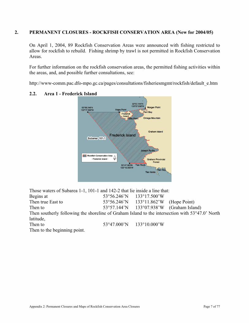
2. PERMANENT CLOSURES - ROCKFISH CONSERVATION AREA (New for 2004/05)
On April 1, 2004, 89 Rockfish Conservation Areas were announced with fishing restricted to allow for rockfish to rebuild. Fishing shrimp by trawl is not permitted in Rockfish Conservation Areas.
For further information on the rockfish conservation areas, the permitted fishing activities within the areas, and, and possible further consultations, see:
http://www-comm.pac.dfo-mpo.gc.ca/pages/consultations/fisheriesmgmt/rockfish/default_e.htm
2.2. Area 1 - Frederick Island
Those waters of Subarea 1-1, 101-1 and 142-2 that lie inside a line that: Begins at 53°56.246’N 133°17.500’W Then true East to 53°56.246’N 133°11.862’W (Hope Point) Then to 53°57.144’N 133°07.938’W (Graham Island) Then southerly following the shoreline of Graham Island to the intersection with 53°47.0’ North latitude, Then to 53°47.000’N 133°10.000’W Then to the beginning point.
Appendix 2: Permanent Closures and Maps of Rockfish Conservation Area Closures Page 7 of 77
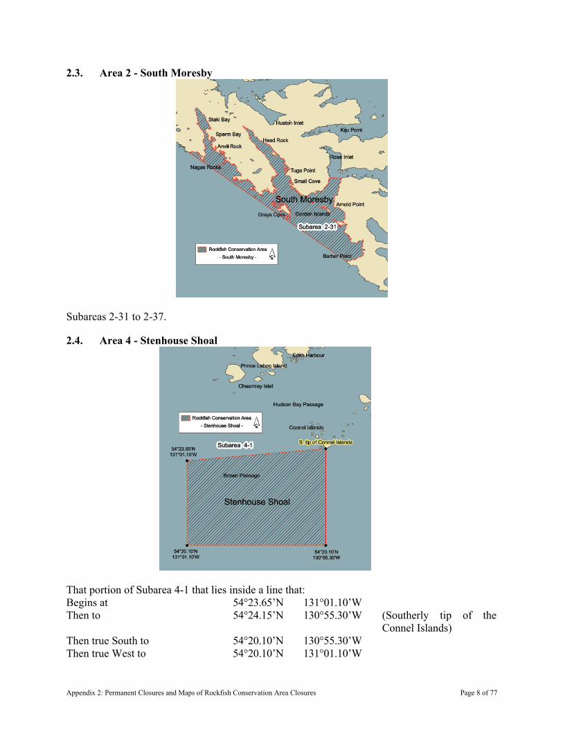
2.3. Area 2 - South Moresby
Subareas 2-31 to 2-37.
2.4. Area 4 - Stenhouse Shoal
That portion of Subarea 4-1 that lies inside a line that: Begins at 54°23.65’N 131°01.10’W Then to 54°24.15’N 130°55.30’W (Southerly tip of the
Connel Islands) Then true South to 54°20.10’N 130°55.30’W Then true West to 54°20.10’N 131°01.10’W
Appendix 2: Permanent Closures and Maps of Rockfish Conservation Area Closures Page 8 of 77
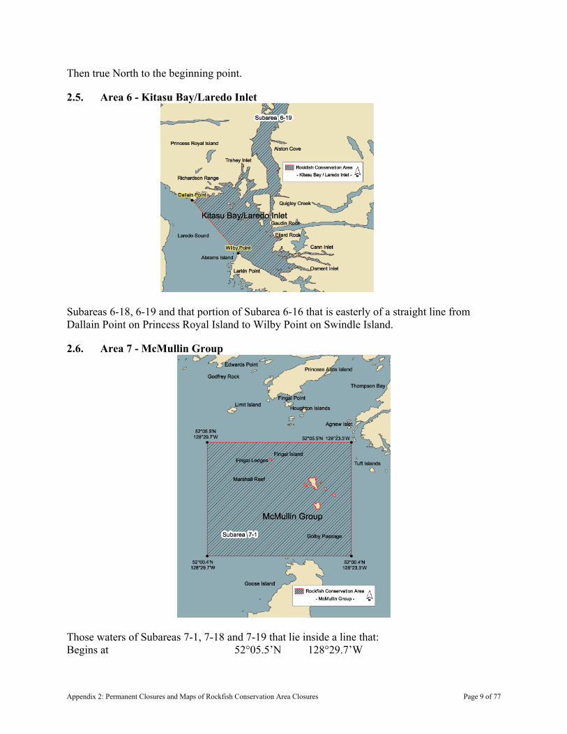
Then true North to the beginning point.
2.5. Area 6 - Kitasu Bay/Laredo Inlet
Subareas 6-18, 6-19 and that portion of Subarea 6-16 that is easterly of a straight line from Dallain Point on Princess Royal Island to Wilby Point on Swindle Island.
2.6. Area 7 - McMullin Group
Those waters of Subareas 7-1, 7-18 and 7-19 that lie inside a line that: Begins at 52°05.5’N 128°29.7’W
Appendix 2: Permanent Closures and Maps of Rockfish Conservation Area Closures Page 9 of 77
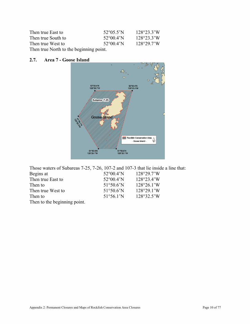
Then true East to 52°05.5’N 128°23.3’W Then true South to 52°00.4’N 128°23.3’W Then true West to 52°00.4’N 128°29.7’W Then true North to the beginning point.
2.7. Area 7 - Goose Island
Those waters of Subareas 7-25, 7-26, 107-2 and 107-3 that lie inside a line that: Begins at 52°00.4’N 128°29.7’W Then true East to 52°00.4’N 128°23.4’W Then to 51°50.6’N 128°26.1’W Then true West to 51°50.6’N 128°29.1’W Then to 51°56.1’N 128°32.5’W Then to the beginning point.
Appendix 2: Permanent Closures and Maps of Rockfish Conservation Area Closures Page 10 of 77
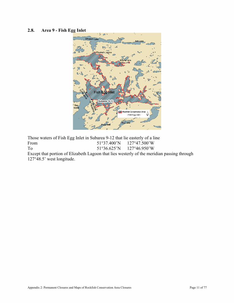
2.8. Area 9 - Fish Egg Inlet
Those waters of Fish Egg Inlet in Subarea 9-12 that lie easterly of a line From 51°37.400’N 127°47.500’W To 51°36.625’N 127°46.950’W Except that portion of Elizabeth Lagoon that lies westerly of the meridian passing through 127°48.5’ west longitude.
Appendix 2: Permanent Closures and Maps of Rockfish Conservation Area Closures Page 11 of 77
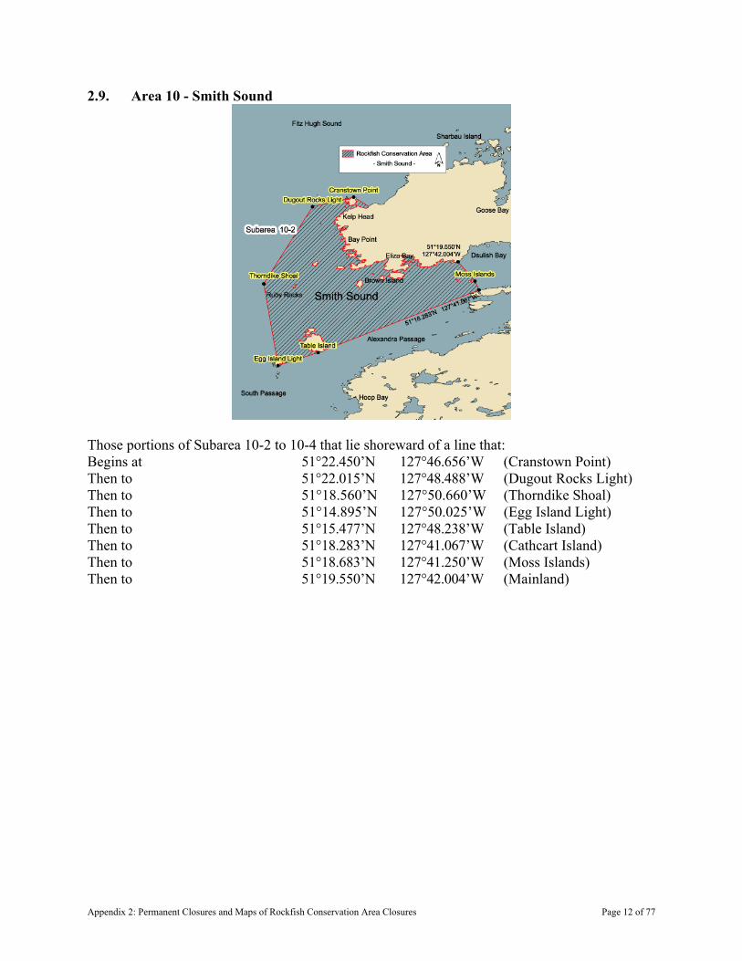
2.9. Area 10 - Smith Sound
Those portions of Subarea 10-2 to 10-4 that lie shoreward of a line that: Begins at 51°22.450’N 127°46.656’W (Cranstown Point) Then to 51°22.015’N 127°48.488’W (Dugout Rocks Light) Then to 51°18.560’N 127°50.660’W (Thorndike Shoal) Then to 51°14.895’N 127°50.025’W (Egg Island Light) Then to 51°15.477’N 127°48.238’W (Table Island) Then to 51°18.283’N 127°41.067’W (Cathcart Island) Then to 51°18.683’N 127°41.250’W (Moss Islands) Then to 51°19.550’N 127°42.004’W (Mainland)
Appendix 2: Permanent Closures and Maps of Rockfish Conservation Area Closures Page 12 of 77
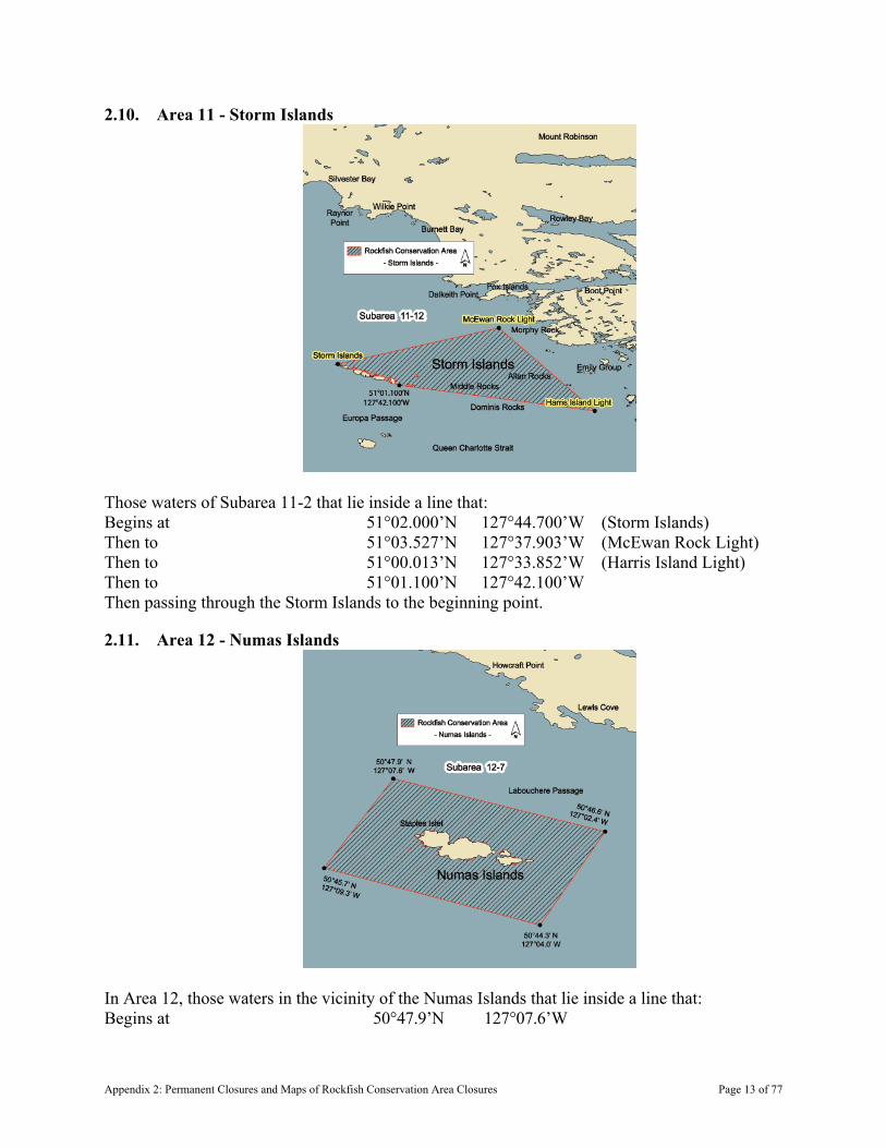
2.10. Area 11 - Storm Islands
Those waters of Subarea 11-2 that lie inside a line that: Begins at 51°02.000’N 127°44.700’W (Storm Islands) Then to 51°03.527’N 127°37.903’W (McEwan Rock Light) Then to 51°00.013’N 127°33.852’W (Harris Island Light) Then to 51°01.100’N 127°42.100’W Then passing through the Storm Islands to the beginning point.
2.11. Area 12 - Numas Islands
In Area 12, those waters in the vicinity of the Numas Islands that lie inside a line that: Begins at 50°47.9’N 127°07.6’W
Appendix 2: Permanent Closures and Maps of Rockfish Conservation Area Closures Page 13 of 77
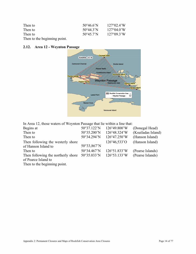
Then to 50°46.6’N 127°02.4’W Then to 50°44.3’N 127°04.0’W Then to 50°45.7’N 127°09.3’W Then to the beginning point.
2.12. Area 12 - Weynton Passage
In Area 12, those waters of Weynton Passage that lie within a line that: Begins at 50°37.122’N 126°49.800’W (Donegal Head) Then to 50°35.200’N 126°48.324’W (Ksuiladas Island) Then to 50°34.294’N 126°47.250’W (Hanson Island) Then following the westerly shore of Hanson Island to 50°33,867’N
126°46,533’O (Hanson Island)
Then to 50°34.467’N 126°51.833’W (Pearse Islands) Then following the northerly shore of Pearce Island to
50°35.033’N 126°53.133’W (Pearse Islands)
Then to the beginning point.
Appendix 2: Permanent Closures and Maps of Rockfish Conservation Area Closures Page 14 of 77

2.13. Area 12 - Salmon Channel
Those waters of Subareas 12-6 and 12-7 that lie inside a line that: Begins at 50°42.500’N 126°52.300’W (near Foster Rock) Then to 50°44.200’N 126°48.900’W (near Holford Rocks) Then to 50°44.100’N 126°48.250’W (near Holford Islets) Then to 50°41.325’N 126°48.504’W (near Penfold Islet) Then to 50°41.800’N 126°50.900’W (near Twin Islets) Then to the beginning point.
2.14. Area 12 - Susquash
Those waters of Subareas 12-8 and 12-17 that lie inside a line that: Begins at 50°39.536’N 127°16.947’W (False Head) Then to 50°39.900’N 127°16.000’W
Appendix 2: Permanent Closures and Maps of Rockfish Conservation Area Closures Page 15 of 77

Then to 50°37.800’N 127°11.800’W Then to 50°37.300’N 127°12.400’W (Vancouver Island) Then northwesterly following the Vancouver Island shoreline to the beginning point.
2.15. Area 12 - Browning Island
Those waters of Subarea 12-13 that lie northeasterly of a line that: Begins at 50°54.250’N 127°20.000’W Then to 50°52.400’N 127°12.700’W Then to 50°52.347’N 127°10.752’W (Aylmer Point)
2.16. Area 12 - Goletas Channel
Those waters of Subarea 12-15 that lie easterly of a line:
Appendix 2: Permanent Closures and Maps of Rockfish Conservation Area Closures Page 16 of 77
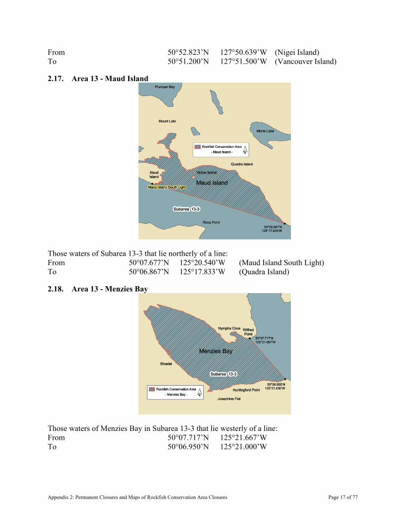
From 50°52.823’N 127°50.639’W (Nigei Island) To 50°51.200’N 127°51.500’W (Vancouver Island)
2.17. Area 13 - Maud Island
Those waters of Subarea 13-3 that lie northerly of a line: From 50°07.677’N 125°20.540’W (Maud Island South Light) To 50°06.867’N 125°17.833’W (Quadra Island)
2.18. Area 13 - Menzies Bay
Those waters of Menzies Bay in Subarea 13-3 that lie westerly of a line: From 50°07.717’N 125°21.667’W To 50°06.950’N 125°21.000’W
Appendix 2: Permanent Closures and Maps of Rockfish Conservation Area Closures Page 17 of 77

2.19. Area 13 - Deepwater Bay
Those waters of Deepwater Bay in Subarea 13-7 that lie southerly of a line: From 50°10.861’N 125°20.885’W (near Separation Head) To 50°11.434’N 125°20.268’W
2.20. Area 13 - Kanish Bay
Those waters of Kanish Bay in Subarea 13-11 that lie easterly of the meridian passing through 125°21.75’ West longitude.
Appendix 2: Permanent Closures and Maps of Rockfish Conservation Area Closures Page 18 of 77
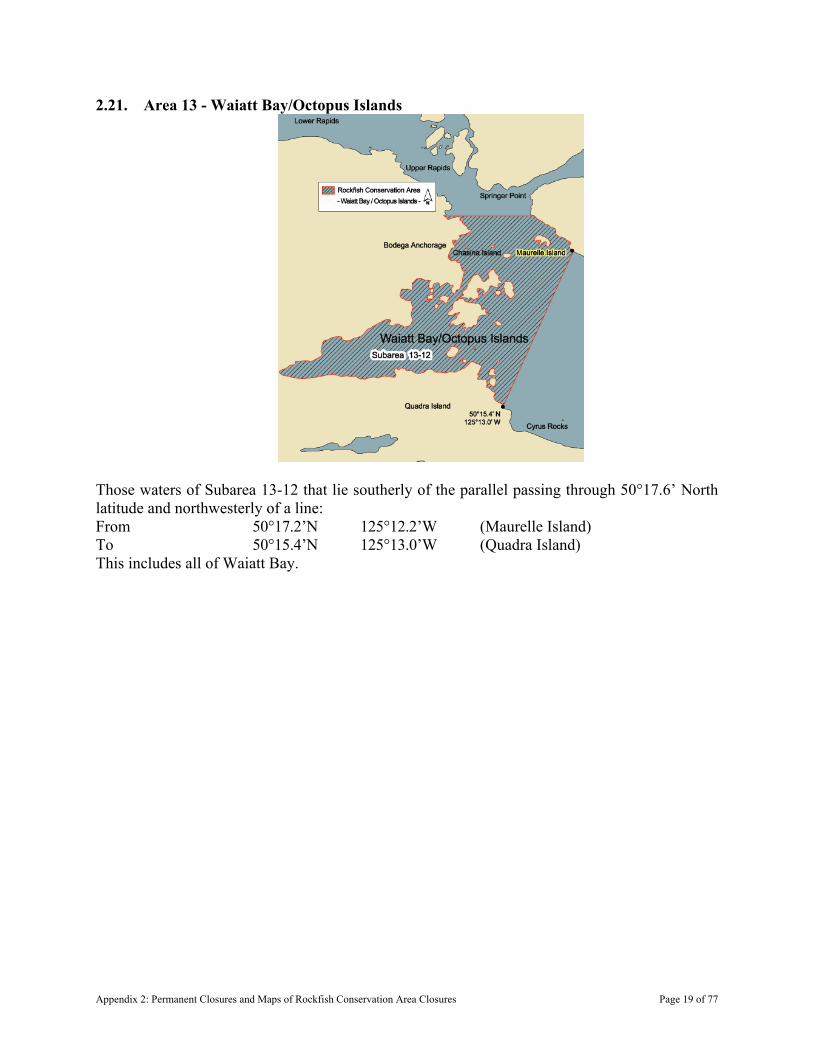
2.21. Area 13 - Waiatt Bay/Octopus Islands
Those waters of Subarea 13-12 that lie southerly of the parallel passing through 50°17.6’ North latitude and northwesterly of a line: From 50°17.2’N 125°12.2’W (Maurelle Island) To 50°15.4’N 125°13.0’W (Quadra Island) This includes all of Waiatt Bay.
Appendix 2: Permanent Closures and Maps of Rockfish Conservation Area Closures Page 19 of 77
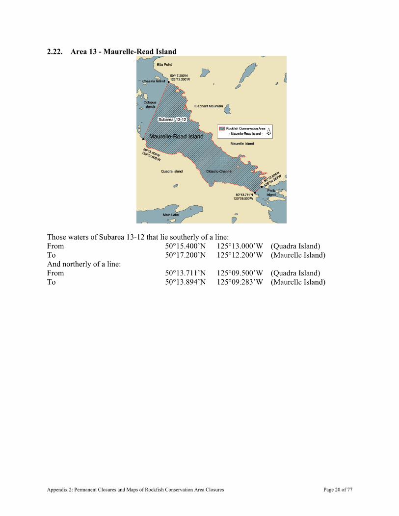
2.22. Area 13 - Maurelle-Read Island
Those waters of Subarea 13-12 that lie southerly of a line: From 50°15.400’N 125°13.000’W (Quadra Island) To 50°17.200’N 125°12.200’W (Maurelle Island) And northerly of a line: From 50°13.711’N 125°09.500’W (Quadra Island) To 50°13.894’N 125°09.283’W (Maurelle Island)
Appendix 2: Permanent Closures and Maps of Rockfish Conservation Area Closures Page 20 of 77
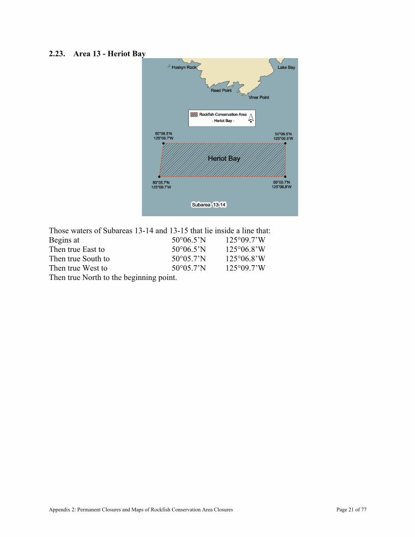
2.23. Area 13 - Heriot Bay
Those waters of Subareas 13-14 and 13-15 that lie inside a line that: Begins at 50°06.5’N 125°09.7’W Then true East to 50°06.5’N 125°06.8’W Then true South to 50°05.7’N 125°06.8’W Then true West to 50°05.7’N 125°09.7’W Then true North to the beginning point.
Appendix 2: Permanent Closures and Maps of Rockfish Conservation Area Closures Page 21 of 77
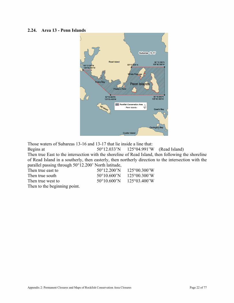
2.24. Area 13 - Penn Islands
Those waters of Subareas 13-16 and 13-17 that lie inside a line that: Begins at 50°12.033’N 125°04.991’W (Read Island) Then true East to the intersection with the shoreline of Read Island, then following the shoreline of Read Island in a southerly, then easterly, then northerly direction to the intersection with the parallel passing through 50°12.200’ North latitude, Then true east to 50°12.200’N 125°00.300’W Then true south 50°10.600’N 125°00.300’W Then true west to 50°10.600’N 125°03.400’W Then to the beginning point.
Appendix 2: Permanent Closures and Maps of Rockfish Conservation Area Closures Page 22 of 77
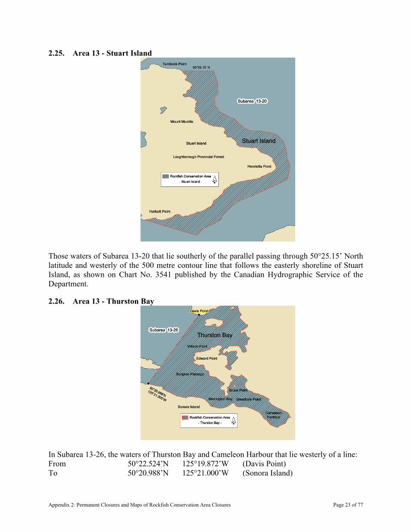
2.25. Area 13 - Stuart Island
Those waters of Subarea 13-20 that lie southerly of the parallel passing through 50°25.15’ North latitude and westerly of the 500 metre contour line that follows the easterly shoreline of Stuart Island, as shown on Chart No. 3541 published by the Canadian Hydrographic Service of the Department.
2.26. Area 13 - Thurston Bay
In Subarea 13-26, the waters of Thurston Bay and Cameleon Harbour that lie westerly of a line: From 50°22.524’N 125°19.872’W (Davis Point) To 50°20.988’N 125°21.000’W (Sonora Island)
Appendix 2: Permanent Closures and Maps of Rockfish Conservation Area Closures Page 23 of 77
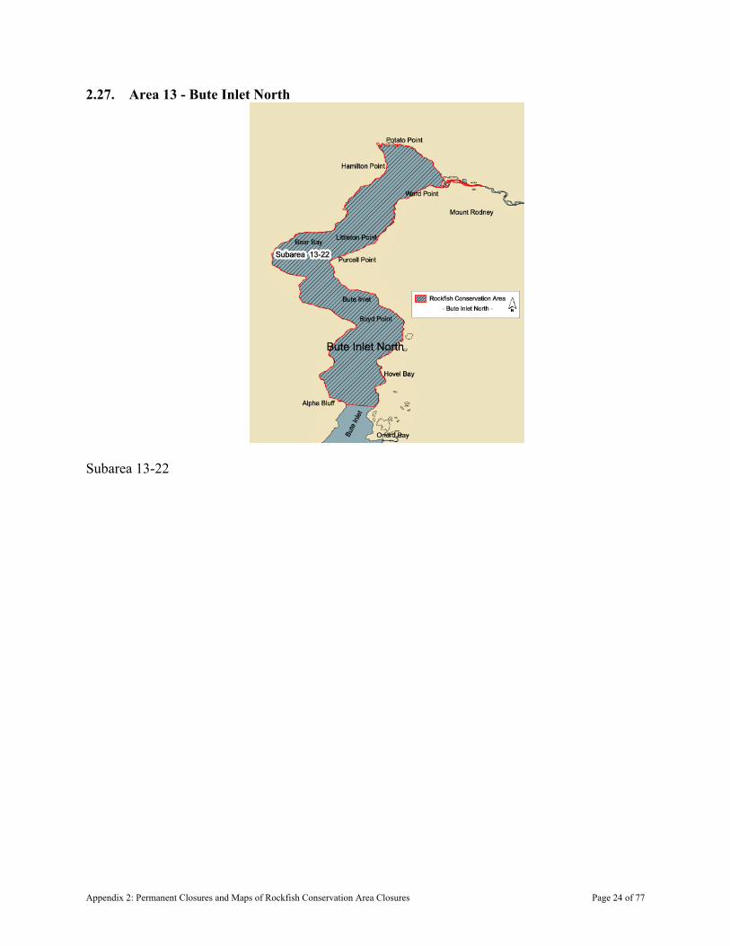
2.27. Area 13 - Bute Inlet North
Subarea 13-22
Appendix 2: Permanent Closures and Maps of Rockfish Conservation Area Closures Page 24 of 77
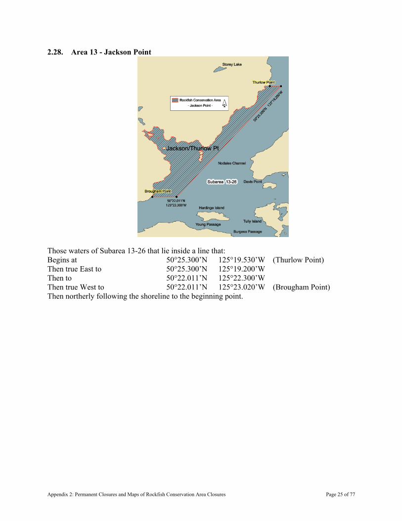
2.28. Area 13 - Jackson Point
Those waters of Subarea 13-26 that lie inside a line that: Begins at 50°25.300’N 125°19.530’W (Thurlow Point) Then true East to 50°25.300’N 125°19.200’W Then to 50°22.011’N 125°22.300’W Then true West to 50°22.011’N 125°23.020’W (Brougham Point) Then northerly following the shoreline to the beginning point.
Appendix 2: Permanent Closures and Maps of Rockfish Conservation Area Closures Page 25 of 77

2.29. Area 13 - Walkem Islands
In Subarea 13-28, those waters shoreward or northerly of a line that: Begins at 50°22.638’N 125°33.083’W (Edith Point) Then to 50°21.457’N 125°31.510’W (Walkem Islands Light) Then to 50°20.707’N 125°27.930’W (Turn Island Light) Then through Turn Island to 50°20.876’N 125°27.429’W (East Thurlow Island)
2.30. Area 13 - Topaze Harbour
Subarea 13-37.
Appendix 2: Permanent Closures and Maps of Rockfish Conservation Area Closures Page 26 of 77
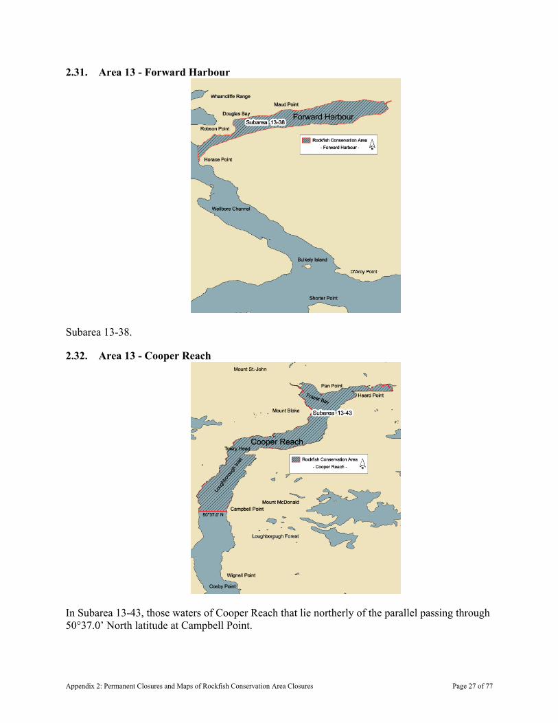
2.31. Area 13 - Forward Harbour
Subarea 13-38.
2.32. Area 13 - Cooper Reach
In Subarea 13-43, those waters of Cooper Reach that lie northerly of the parallel passing through 50°37.0’ North latitude at Campbell Point.
Appendix 2: Permanent Closures and Maps of Rockfish Conservation Area Closures Page 27 of 77

2.33. Area 14 - Ajax/Achilles Bank
Those waters of Subarea 14-6 and 14-12 that lie inside a line that Begins at 49°39.50’N 124°43.42’W Then to 49°40.90’N 124°39.60’W Then to 49°33.00’N 124°28.50’W Then to 49°31.95’N 124°29.25’W Then to the beginning point.
Appendix 2: Permanent Closures and Maps of Rockfish Conservation Area Closures Page 28 of 77
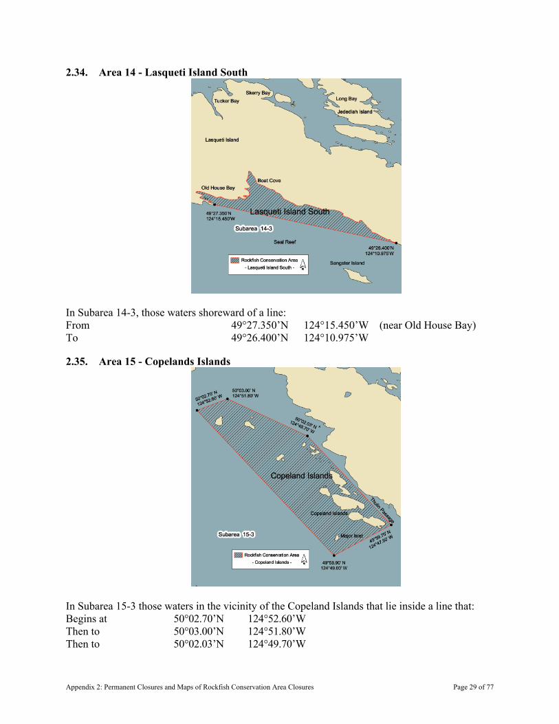
2.34. Area 14 - Lasqueti Island South
In Subarea 14-3, those waters shoreward of a line: From 49°27.350’N 124°15.450’W (near Old House Bay) To 49°26.400’N 124°10.975’W
2.35. Area 15 - Copelands Islands
In Subarea 15-3 those waters in the vicinity of the Copeland Islands that lie inside a line that: Begins at 50°02.70’N 124°52.60’W Then to 50°03.00’N 124°51.80’W Then to 50°02.03’N 124°49.70’W
Appendix 2: Permanent Closures and Maps of Rockfish Conservation Area Closures Page 29 of 77
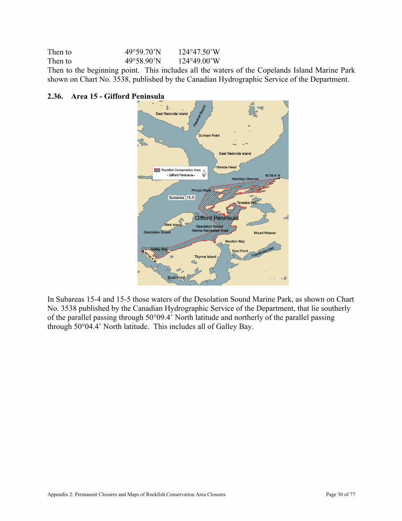
Then to 49°59.70’N 124°47.50’W Then to 49°58.90’N 124°49.00’W Then to the beginning point. This includes all the waters of the Copelands Island Marine Park shown on Chart No. 3538, published by the Canadian Hydrographic Service of the Department.
2.36. Area 15 - Gifford Peninsula
In Subareas 15-4 and 15-5 those waters of the Desolation Sound Marine Park, as shown on Chart No. 3538 published by the Canadian Hydrographic Service of the Department, that lie southerly of the parallel passing through 50°09.4’ North latitude and northerly of the parallel passing through 50°04.4’ North latitude. This includes all of Galley Bay.
Appendix 2: Permanent Closures and Maps of Rockfish Conservation Area Closures Page 30 of 77

2.37. Area 15 - Teakerne Arm
Those waters of Teakerne Arm in Subarea 15-5 that lie easterly of the meridian passing through 124°54.0’ West longitude.
Appendix 2: Permanent Closures and Maps of Rockfish Conservation Area Closures Page 31 of 77
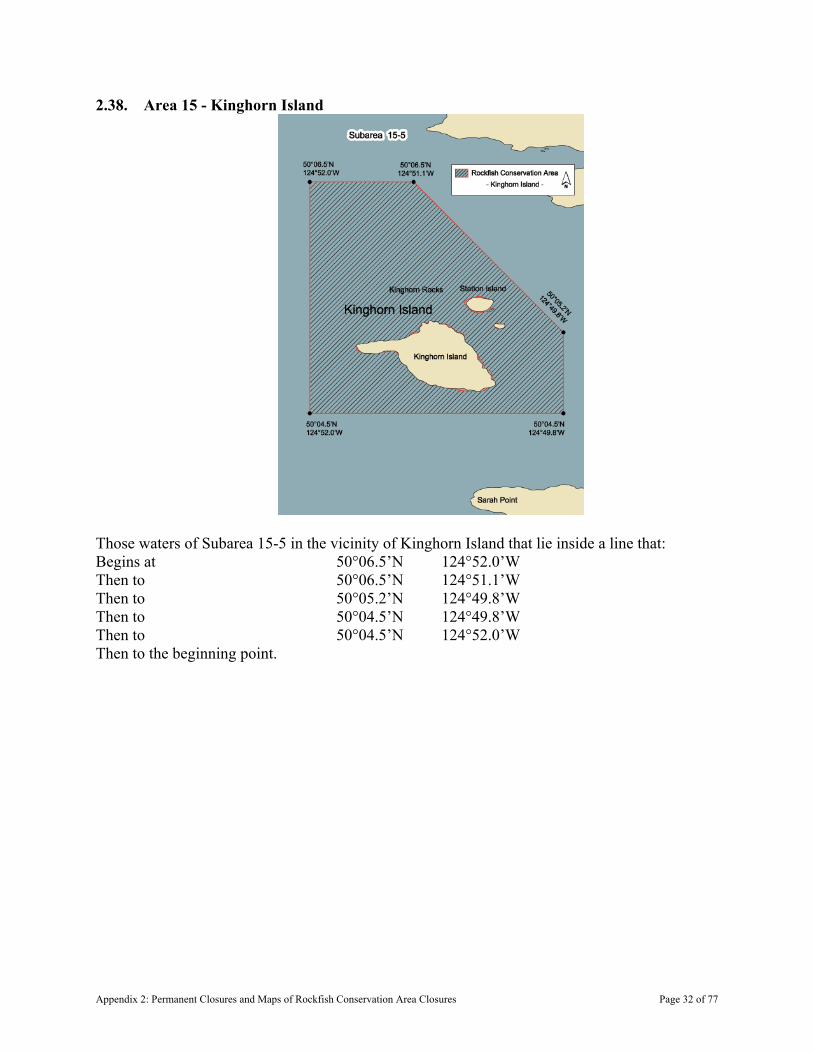
2.38. Area 15 - Kinghorn Island
Those waters of Subarea 15-5 in the vicinity of Kinghorn Island that lie inside a line that: Begins at 50°06.5’N 124°52.0’W Then to 50°06.5’N 124°51.1’W Then to 50°05.2’N 124°49.8’W Then to 50°04.5’N 124°49.8’W Then to 50°04.5’N 124°52.0’W Then to the beginning point.
Appendix 2: Permanent Closures and Maps of Rockfish Conservation Area Closures Page 32 of 77
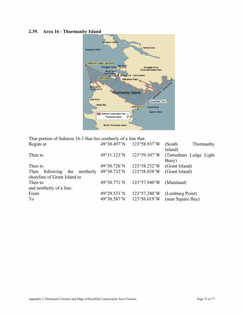
2.39. Area 16 - Thormanby Island
That portion of Subarea 16-1 that lies southerly of a line that: Begins at 49°30.497’N 123°58.937’W (South Thormanby
Island) Then to 49°31.123’N 123°59.107’W (Tattenham Ledge Light
Buoy) Then to 49°30.726’N 123°58.252’W (Grant Island) Then following the northerly shoreline of Grant Island to
49°30.732’N 123°58.058’W (Grant Island)
Then to 49°30.771’N 123°57.940’W (Mainland) and northerly of a line: From 49°29.533’N 123°57.240’W (Lemburg Point) To 49°30.587’N 123°56.019’W (near Square Bay)
Appendix 2: Permanent Closures and Maps of Rockfish Conservation Area Closures Page 33 of 77
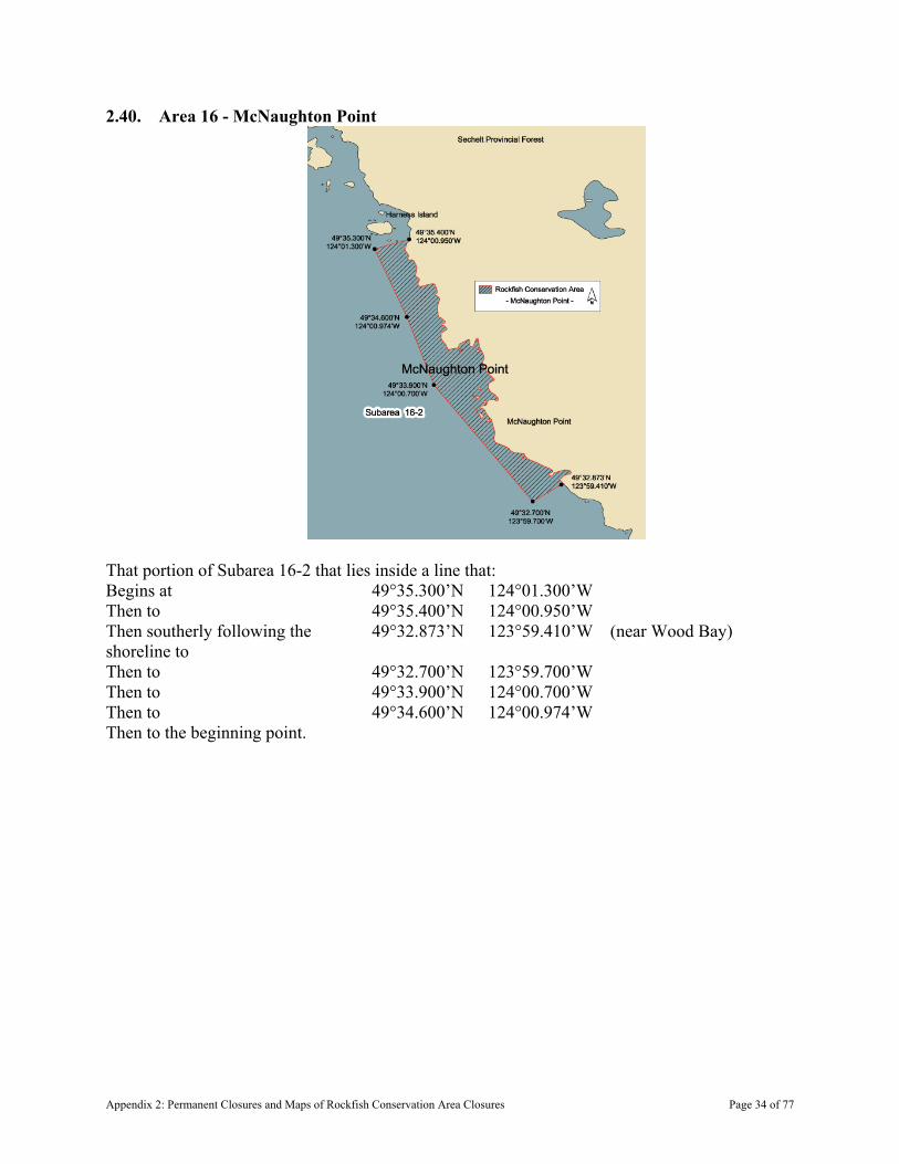
2.40. Area 16 - McNaughton Point
That portion of Subarea 16-2 that lies inside a line that: Begins at 49°35.300’N 124°01.300’W Then to 49°35.400’N 124°00.950’W Then southerly following the shoreline to
49°32.873’N 123°59.410’W (near Wood Bay)
Then to 49°32.700’N 123°59.700’W Then to 49°33.900’N 124°00.700’W Then to 49°34.600’N 124°00.974’W Then to the beginning point.
Appendix 2: Permanent Closures and Maps of Rockfish Conservation Area Closures Page 34 of 77
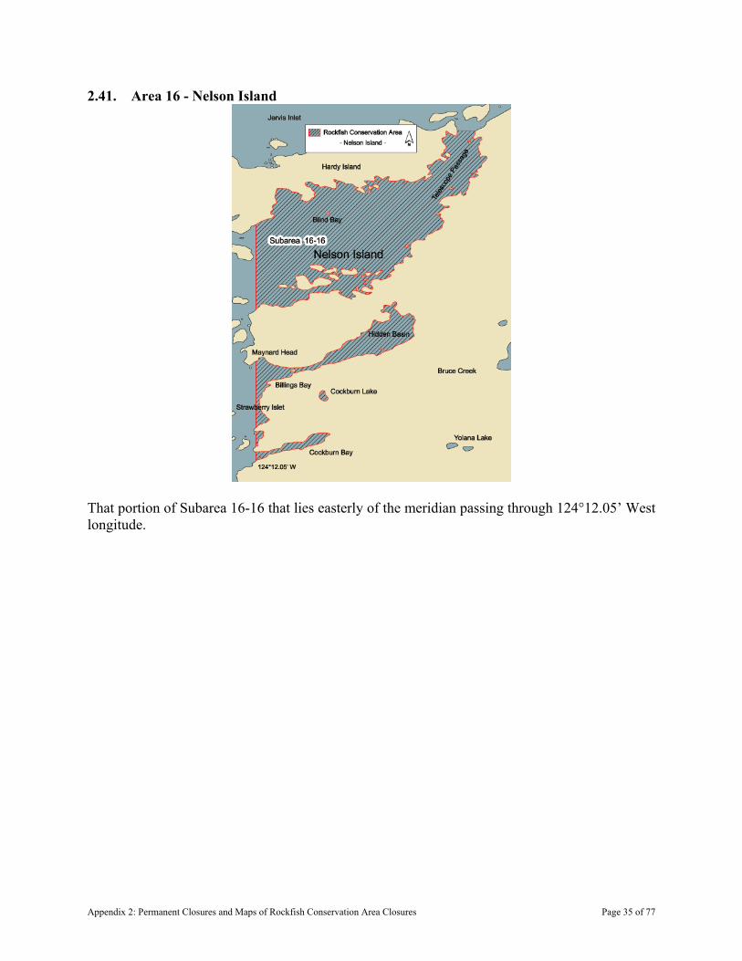
2.41. Area 16 - Nelson Island
That portion of Subarea 16-16 that lies easterly of the meridian passing through 124°12.05’ West longitude.
Appendix 2: Permanent Closures and Maps of Rockfish Conservation Area Closures Page 35 of 77
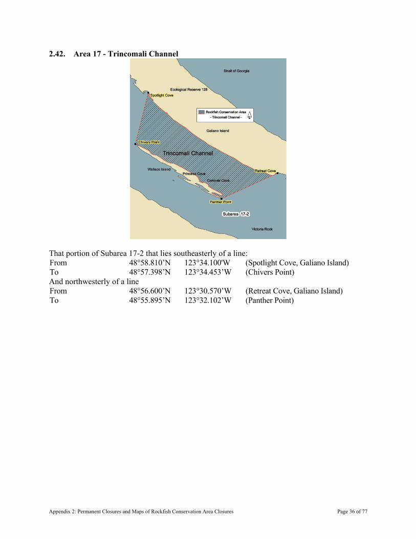
2.42. Area 17 - Trincomali Channel
That portion of Subarea 17-2 that lies southeasterly of a line: From 48°58.810’N 123°34.100'W (Spotlight Cove, Galiano Island) To 48°57.398’N 123°34.453’W (Chivers Point) And northwesterly of a line From 48°56.600’N 123°30.570’W (Retreat Cove, Galiano Island) To 48°55.895’N 123°32.102’W (Panther Point)
Appendix 2: Permanent Closures and Maps of Rockfish Conservation Area Closures Page 36 of 77
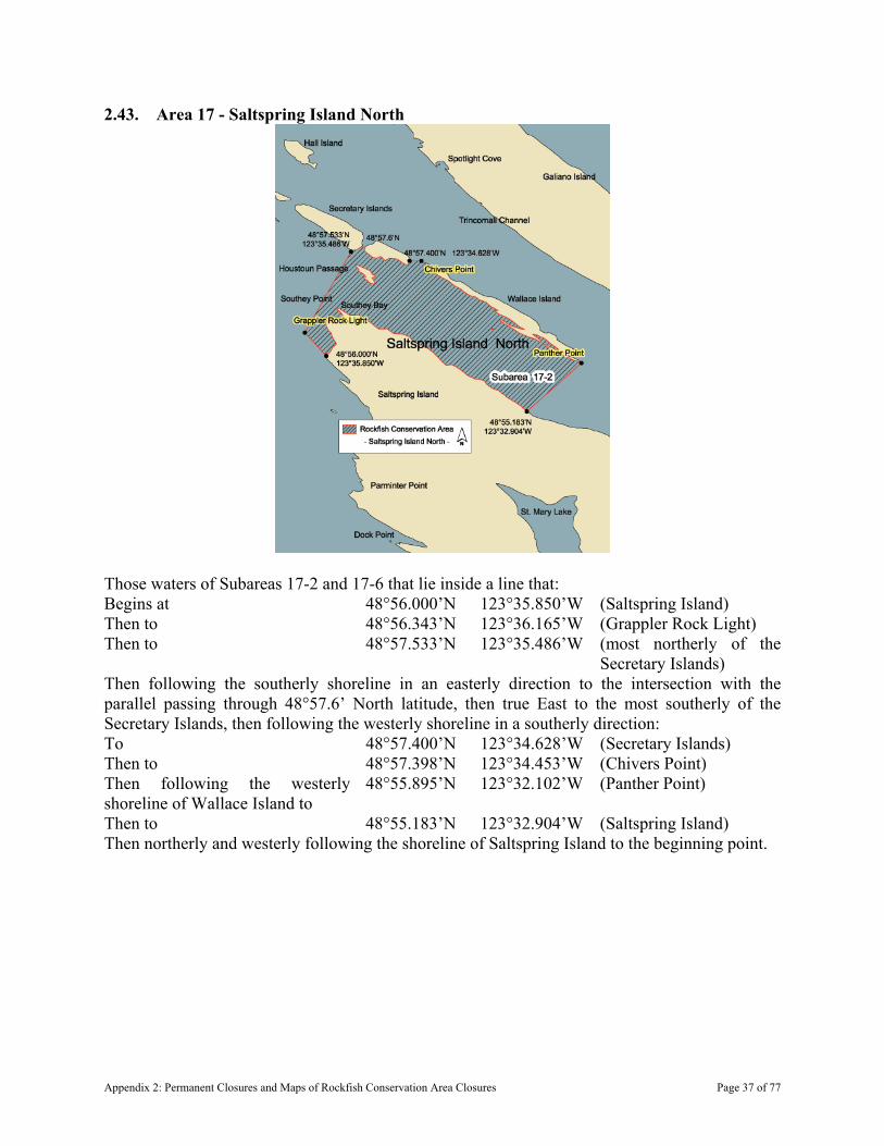
2.43. Area 17 - Saltspring Island North
Those waters of Subareas 17-2 and 17-6 that lie inside a line that: Begins at 48°56.000’N 123°35.850’W (Saltspring Island) Then to 48°56.343’N 123°36.165’W (Grappler Rock Light) Then to 48°57.533’N 123°35.486’W (most northerly of the
Secretary Islands) Then following the southerly shoreline in an easterly direction to the intersection with the parallel passing through 48°57.6’ North latitude, then true East to the most southerly of the Secretary Islands, then following the westerly shoreline in a southerly direction: To 48°57.400’N 123°34.628’W (Secretary Islands) Then to 48°57.398’N 123°34.453’W (Chivers Point) Then following the westerly shoreline of Wallace Island to
48°55.895’N 123°32.102’W (Panther Point)
Then to 48°55.183’N 123°32.904’W (Saltspring Island) Then northerly and westerly following the shoreline of Saltspring Island to the beginning point.
Appendix 2: Permanent Closures and Maps of Rockfish Conservation Area Closures Page 37 of 77

2.44. Area 17 - Pylades Island
Those waters of Subareas 17-4 and 17-17 that lie inside a line that: Begins at 49°04.15’N 123°42.20’W Then to 49°04.30’N 123°40.80’W Then to 49°03.50’N 123°40.60’W Then to 49°03.40’N 123°42.00’W Then to the beginning point.
Appendix 2: Permanent Closures and Maps of Rockfish Conservation Area Closures Page 38 of 77

2.45. Area 17 - Danger Reefs
Those waters of Subarea 17-4 that lie inside a line that: Begins at 49°03.6’N 123°43.6’W Then to 49°03.9’N 123°43.0’W Then to 49°03.0’N 123°42.3’W Then to 49°02.8’N 123°42.8’W Then to the beginning point.
Appendix 2: Permanent Closures and Maps of Rockfish Conservation Area Closures Page 39 of 77

2.46. Area 17 - Thetis/Kuper Island
Those portions of Subareas 17-4, 17-5 and 17-6 that lie inside a line that: Begins at 49°02.468’N 123°42.785’W (Miami Rock Buoy) Then to 49°01.267’N 123°41.194’W (Pilkey Point) Then following the northerly and westerly shoreline of Thetis Island to
48°58.156’N 123°40.420’W (West of Foster Point)
then to 48°57.458’N 123°39.715’W (Active Point) then southerly following the westerly shoreline of Kuper Island to
48°56.031’N 123°37.921’W (Josling Point)
Then to 48°55.773’N 123°42.364’W (Bare Point Light) Then to the beginning point.
Appendix 2: Permanent Closures and Maps of Rockfish Conservation Area Closures Page 40 of 77

2.47. Area 17 - Ballenas Island
The waters of Subareas 17-11 and 17-12 that lie inside a line that: Begins at 49°21.023’N 124°09.615’W (Ballenas Island Light) Then true East to 49°21.023’N 124°07.600’W Then true South to 49°19.600’N 124°07.600’W Then true West to 49°19.600’N 124°09.615’W Then true North to the beginning point.
Appendix 2: Permanent Closures and Maps of Rockfish Conservation Area Closures Page 41 of 77
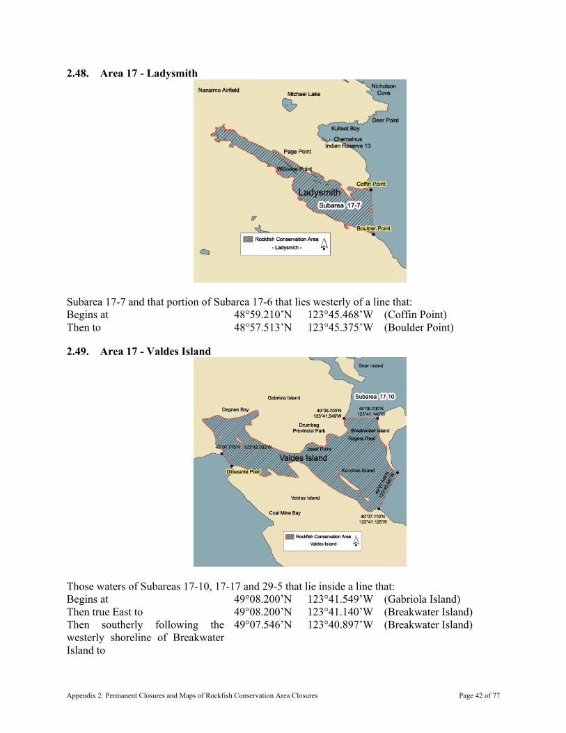
2.48. Area 17 - Ladysmith
Subarea 17-7 and that portion of Subarea 17-6 that lies westerly of a line that: Begins at 48°59.210’N 123°45.468’W (Coffin Point) Then to 48°57.513’N 123°45.375’W (Boulder Point)
2.49. Area 17 - Valdes Island
Those waters of Subareas 17-10, 17-17 and 29-5 that lie inside a line that: Begins at 49°08.200’N 123°41.549’W (Gabriola Island) Then true East to 49°08.200’N 123°41.140’W (Breakwater Island) Then southerly following the westerly shoreline of Breakwater Island to
49°07.546’N 123°40.897’W (Breakwater Island)
Appendix 2: Permanent Closures and Maps of Rockfish Conservation Area Closures Page 42 of 77
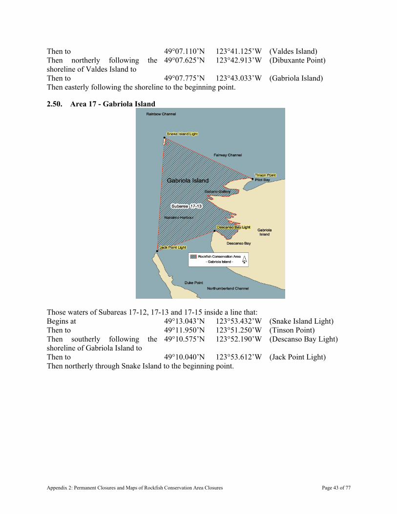
Then to 49°07.110’N 123°41.125’W (Valdes Island) Then northerly following the shoreline of Valdes Island to
49°07.625’N 123°42.913’W (Dibuxante Point)
Then to 49°07.775’N 123°43.033’W (Gabriola Island) Then easterly following the shoreline to the beginning point.
2.50. Area 17 - Gabriola Island
Those waters of Subareas 17-12, 17-13 and 17-15 inside a line that: Begins at 49°13.043’N 123°53.432’W (Snake Island Light) Then to 49°11.950’N 123°51.250’W (Tinson Point) Then southerly following the shoreline of Gabriola Island to
49°10.575’N 123°52.190’W (Descanso Bay Light)
Then to 49°10.040’N 123°53.612’W (Jack Point Light) Then northerly through Snake Island to the beginning point.
Appendix 2: Permanent Closures and Maps of Rockfish Conservation Area Closures Page 43 of 77
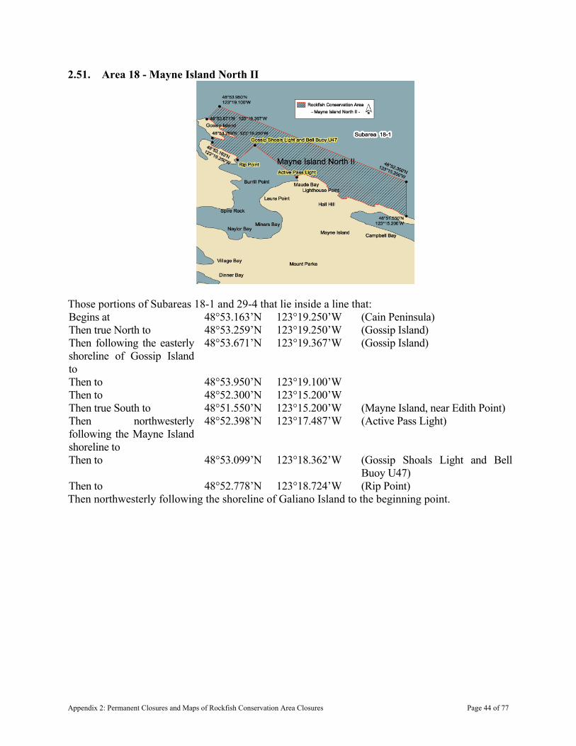
2.51. Area 18 - Mayne Island North II
Those portions of Subareas 18-1 and 29-4 that lie inside a line that: Begins at 48°53.163’N 123°19.250’W (Cain Peninsula) Then true North to 48°53.259’N 123°19.250’W (Gossip Island) Then following the easterly shoreline of Gossip Island to
48°53.671’N 123°19.367’W (Gossip Island)
Then to 48°53.950’N 123°19.100’W Then to 48°52.300’N 123°15.200’W Then true South to 48°51.550’N 123°15.200’W (Mayne Island, near Edith Point) Then northwesterly following the Mayne Island shoreline to
48°52.398’N 123°17.487’W (Active Pass Light)
Then to 48°53.099’N 123°18.362’W (Gossip Shoals Light and Bell Buoy U47)
Then to 48°52.778’N 123°18.724’W (Rip Point) Then northwesterly following the shoreline of Galiano Island to the beginning point.
Appendix 2: Permanent Closures and Maps of Rockfish Conservation Area Closures Page 44 of 77

2.52. Area 18 - Prevost Island
Those waters of Subareas 18-3, 18-4 and 18-9 that lie inside a line that: Begins at 48°49.67’N 123°21.10’W (Portlock Point Light) Then to 48°49.60’ N 123°20.70’W Then to 48°48.40’ N 123°21.40’W Then to 48°48.60’ N 123°23.10’W Then to 48°49.60’ N 123°24.10’W Then to 48°49.70’ N 123°24.00’W (Prevost Island) Then following the southeasterly shoreline of Prevost Island to the beginning point.
Appendix 2: Permanent Closures and Maps of Rockfish Conservation Area Closures Page 45 of 77

2.53. Area 18 - Bedwell Harbour
In Subarea 18-4 that portion of Bedwell Harbour that lies northerly of a line: From 48°44.200’N 123°13.900’W (Wallace Point) To 48°43.950’N 123°12.483’W (Tilly Point) and southeasterly of a line From 48°45.250’N 123°14.500’W (South Pender Island) To 48°44.900’N 123°14.750’W (North Pender Island)
2.54. Area 18 - South Pender Island
That portion of Subarea 18-5 that lies inside a line that: Begins at 48°45.144’N 123°11.390’W (South Pender Island) Then to 48°44.633’N 123°09.973’W (Eastern tip of Blunden Island)
Appendix 2: Permanent Closures and Maps of Rockfish Conservation Area Closures Page 46 of 77

Then to 48°44.000’N 123°10.720’W Then to 48°44.139’N 123°11.029’W (Gowlland Point Light) Then northerly following the shoreline of South Pender Island to the beginning point.
2.55. Area 18 - Portland Island
That portion of Subarea 18-6 that lies inside a line that: Begins at 48°44.100’N 123°22.200’W (Northern tip of Portland Island) Then to 48°44.012’N 123°20.404’W (Canoe Rock Light) Then to 48°43.339’N 123°21.045’W (Pellow Islets Light Buoy U15) Then to 48°42.639’N 123°22.962’W (Celia Reef Light Buoy U14) Then to 48°43.559’N 123°23.215’W (Kanaka Bluff Light) Then following the southwesterly shoreline of Portland Island to the beginning point.
Appendix 2: Permanent Closures and Maps of Rockfish Conservation Area Closures Page 47 of 77
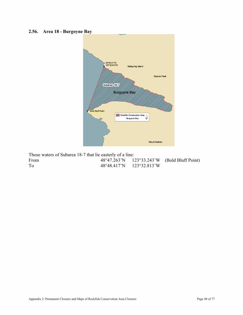
2.56. Area 18 - Burgoyne Bay
Those waters of Subarea 18-7 that lie easterly of a line: From 48°47.263’N 123°33.243’W (Bold Bluff Point) To 48°48.417’N 123°32.813’W
Appendix 2: Permanent Closures and Maps of Rockfish Conservation Area Closures Page 48 of 77
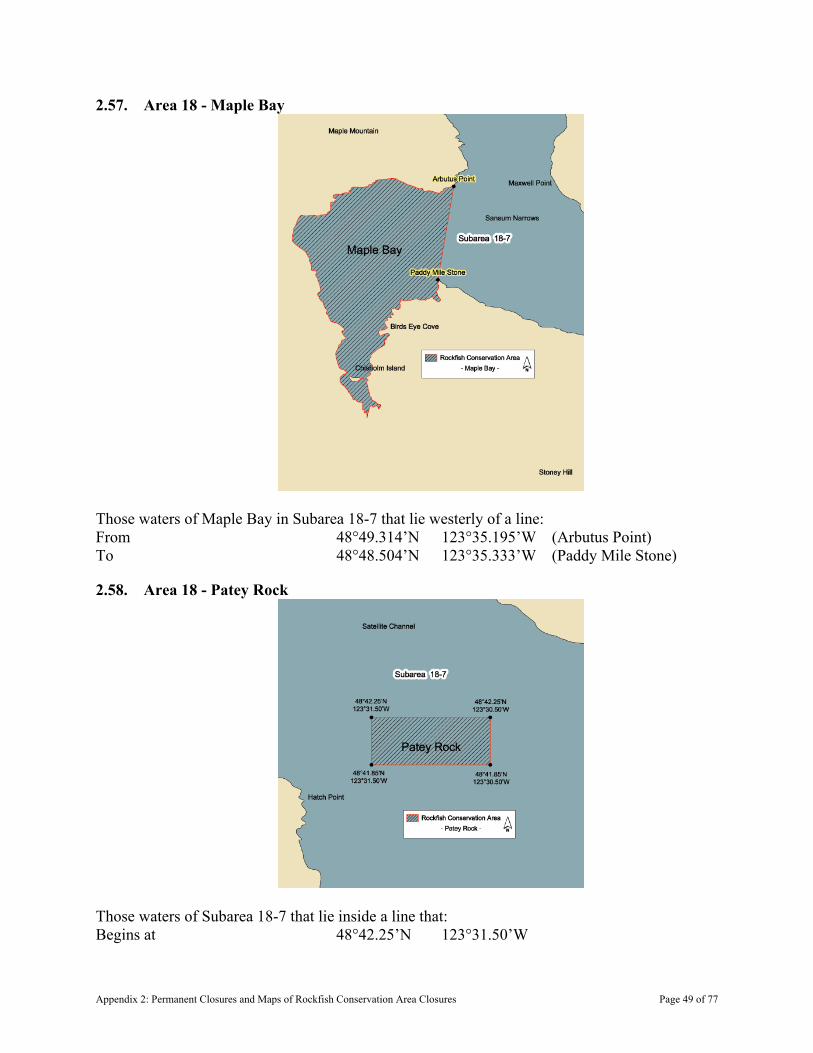
2.57. Area 18 - Maple Bay
Those waters of Maple Bay in Subarea 18-7 that lie westerly of a line: From 48°49.314’N 123°35.195’W (Arbutus Point) To 48°48.504’N 123°35.333’W (Paddy Mile Stone)
2.58. Area 18 - Patey Rock
Those waters of Subarea 18-7 that lie inside a line that: Begins at 48°42.25’N 123°31.50’W
Appendix 2: Permanent Closures and Maps of Rockfish Conservation Area Closures Page 49 of 77
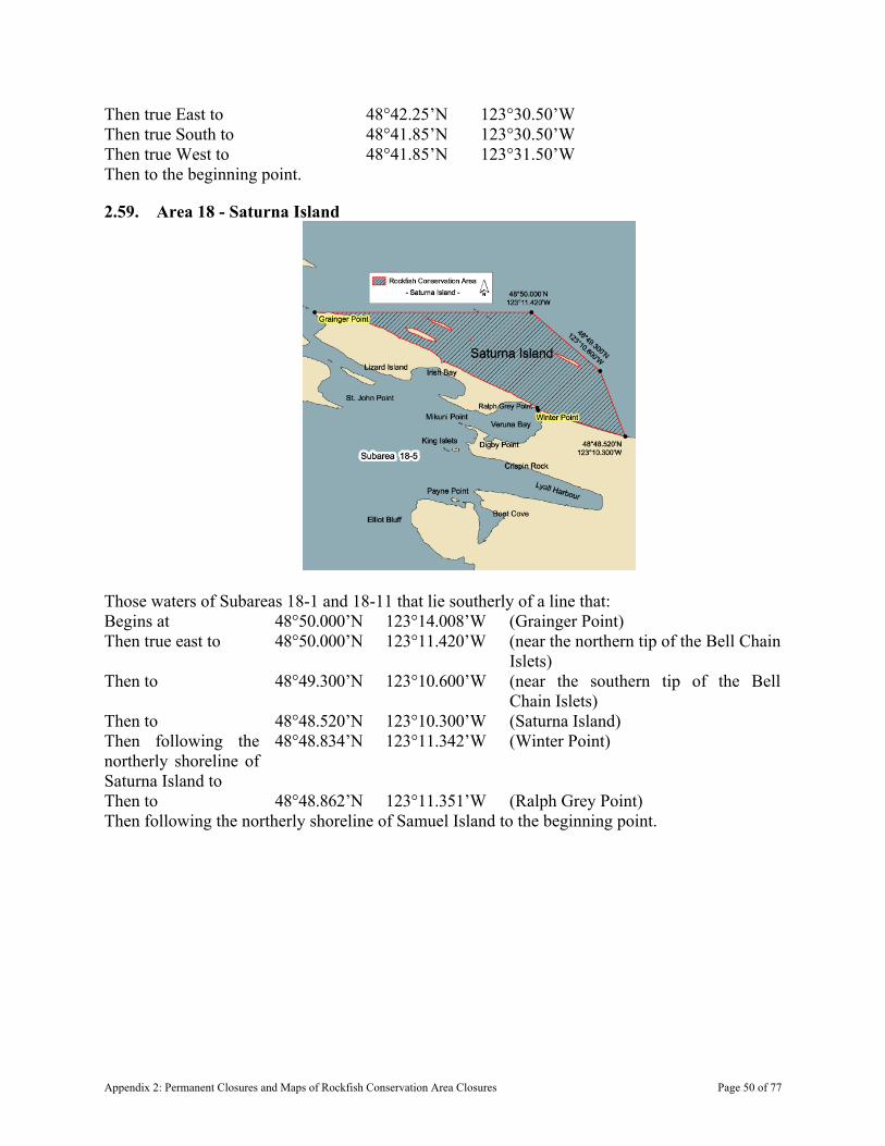
Then true East to 48°42.25’N 123°30.50’W Then true South to 48°41.85’N 123°30.50’W Then true West to 48°41.85’N 123°31.50’W Then to the beginning point.
2.59. Area 18 - Saturna Island
Those waters of Subareas 18-1 and 18-11 that lie southerly of a line that: Begins at 48°50.000’N 123°14.008’W (Grainger Point) Then true east to 48°50.000’N 123°11.420’W (near the northern tip of the Bell Chain
Islets) Then to 48°49.300’N 123°10.600’W (near the southern tip of the Bell
Chain Islets) Then to 48°48.520’N 123°10.300’W (Saturna Island) Then following the northerly shoreline of Saturna Island to
48°48.834’N 123°11.342’W (Winter Point)
Then to 48°48.862’N 123°11.351’W (Ralph Grey Point) Then following the northerly shoreline of Samuel Island to the beginning point.
Appendix 2: Permanent Closures and Maps of Rockfish Conservation Area Closures Page 50 of 77

2.60. Area 19 - Royal Roads
Those waters of Subarea 19-3 that lie inside or shoreward of a line that: Begins at 48°25.854’N 123°26.375’W (Duntze Head) Then to 48°25.550’N 123°26.500’W Then to 48°25.150’N 123°25.400’W Then to 48°25.311’N 123°25.208’W (Saxe Point)
Appendix 2: Permanent Closures and Maps of Rockfish Conservation Area Closures Page 51 of 77
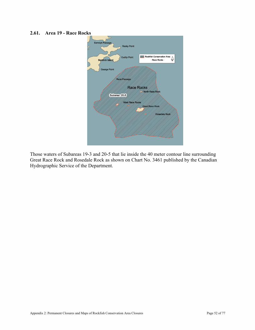
2.61. Area 19 - Race Rocks
Those waters of Subareas 19-3 and 20-5 that lie inside the 40 meter contour line surrounding Great Race Rock and Rosedale Rock as shown on Chart No. 3461 published by the Canadian Hydrographic Service of the Department.
Appendix 2: Permanent Closures and Maps of Rockfish Conservation Area Closures Page 52 of 77
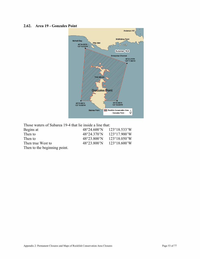
2.62. Area 19 - Gonzales Point
Those waters of Subarea 19-4 that lie inside a line that: Begins at 48°24.600’N 123°18.533’W Then to 48°24.370’N 123°17.900’W Then to 48°23.800’N 123°18.050’W Then true West to 48°23.800’N 123°18.600’W Then to the beginning point.
Appendix 2: Permanent Closures and Maps of Rockfish Conservation Area Closures Page 53 of 77
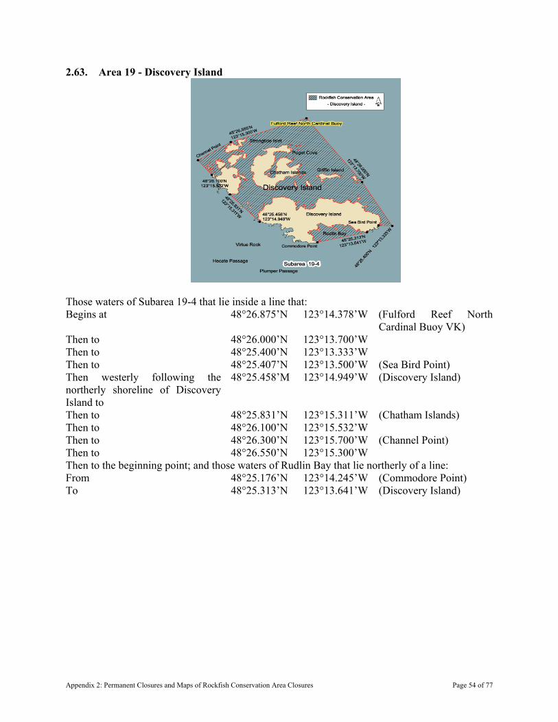
2.63. Area 19 - Discovery Island
Those waters of Subarea 19-4 that lie inside a line that: Begins at 48°26.875’N 123°14.378’W (Fulford Reef North
Cardinal Buoy VK) Then to 48°26.000’N 123°13.700’W Then to 48°25.400’N 123°13.333’W Then to 48°25.407’N 123°13.500’W (Sea Bird Point) Then westerly following the northerly shoreline of Discovery Island to
48°25.458’M 123°14.949’W (Discovery Island)
Then to 48°25.831’N 123°15.311’W (Chatham Islands) Then to 48°26.100’N 123°15.532’W Then to 48°26.300’N 123°15.700’W (Channel Point) Then to 48°26.550’N 123°15.300’W Then to the beginning point; and those waters of Rudlin Bay that lie northerly of a line: From 48°25.176’N 123°14.245’W (Commodore Point) To 48°25.313’N 123°13.641’W (Discovery Island)
Appendix 2: Permanent Closures and Maps of Rockfish Conservation Area Closures Page 54 of 77
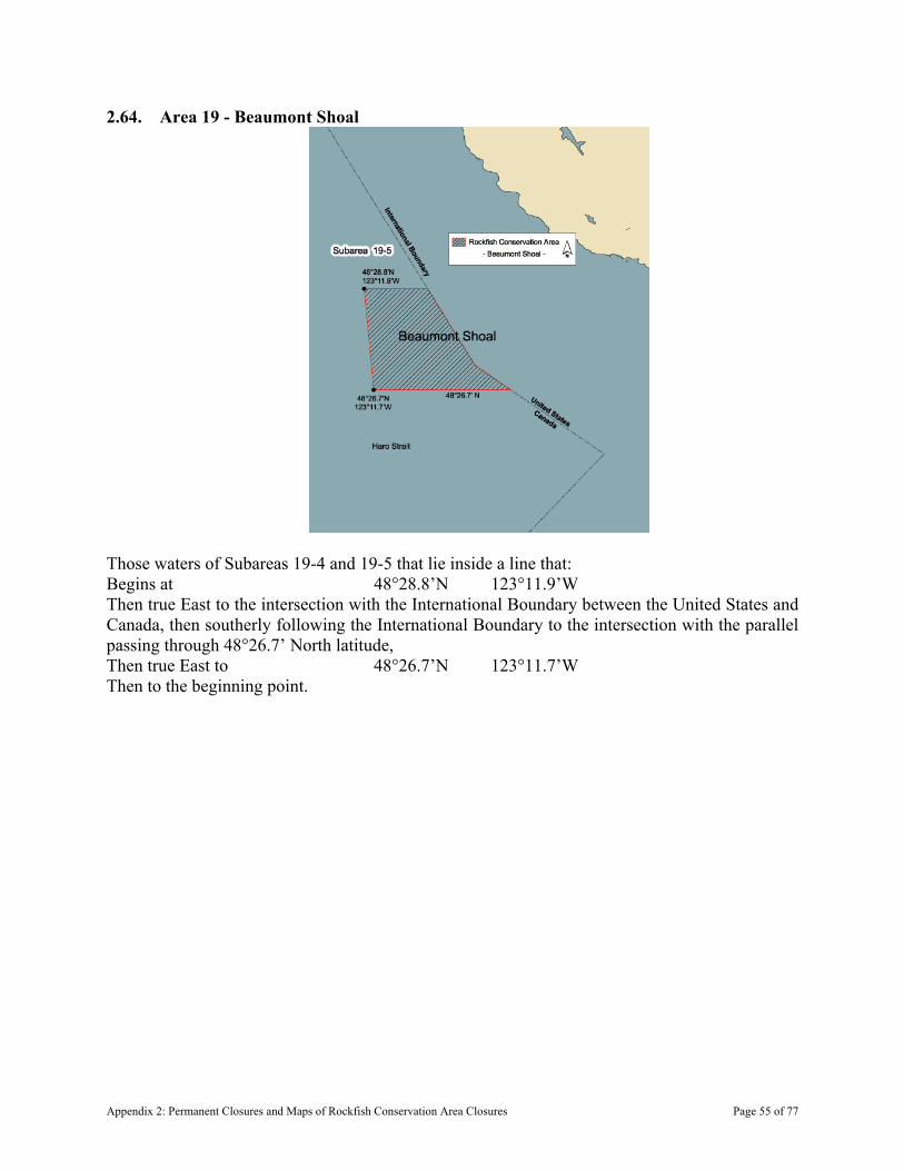
2.64. Area 19 - Beaumont Shoal
Those waters of Subareas 19-4 and 19-5 that lie inside a line that: Begins at 48°28.8’N 123°11.9’W Then true East to the intersection with the International Boundary between the United States and Canada, then southerly following the International Boundary to the intersection with the parallel passing through 48°26.7’ North latitude, Then true East to 48°26.7’N 123°11.7’W Then to the beginning point.
Appendix 2: Permanent Closures and Maps of Rockfish Conservation Area Closures Page 55 of 77
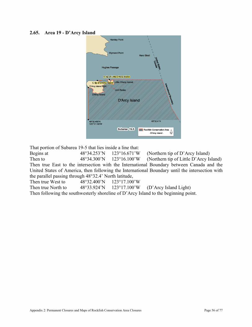
2.65. Area 19 - D’Arcy Island
That portion of Subarea 19-5 that lies inside a line that: Begins at 48°34.253’N 123°16.671’W (Northern tip of D’Arcy Island) Then to 48°34.300’N 123°16.100’W (Northern tip of Little D’Arcy Island) Then true East to the intersection with the International Boundary between Canada and the United States of America, then following the International Boundary until the intersection with the parallel passing through 48°32.4’ North latitude, Then true West to 48°32.400’N 123°17.100’W Then true North to 48°33.924’N 123°17.100’W (D’Arcy Island Light) Then following the southwesterly shoreline of D’Arcy Island to the beginning point.
Appendix 2: Permanent Closures and Maps of Rockfish Conservation Area Closures Page 56 of 77
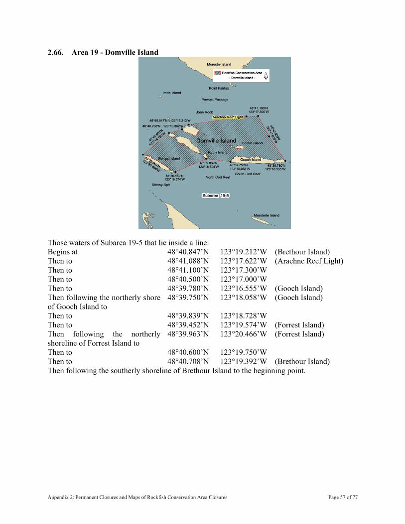
2.66. Area 19 - Domville Island
Those waters of Subarea 19-5 that lie inside a line: Begins at 48°40.847’N 123°19.212’W (Brethour Island) Then to 48°41.088’N 123°17.622’W (Arachne Reef Light) Then to 48°41.100’N 123°17.300’W Then to 48°40.500’N 123°17.000’W Then to 48°39.780’N 123°16.555’W (Gooch Island) Then following the northerly shore of Gooch Island to
48°39.750’N 123°18.058’W (Gooch Island)
Then to 48°39.839’N 123°18.728’W Then to 48°39.452’N 123°19.574’W (Forrest Island) Then following the northerly shoreline of Forrest Island to
48°39.963’N 123°20.466’W (Forrest Island)
Then to 48°40.600’N 123°19.750’W Then to 48°40.708’N 123°19.392’W (Brethour Island) Then following the southerly shoreline of Brethour Island to the beginning point.
Appendix 2: Permanent Closures and Maps of Rockfish Conservation Area Closures Page 57 of 77
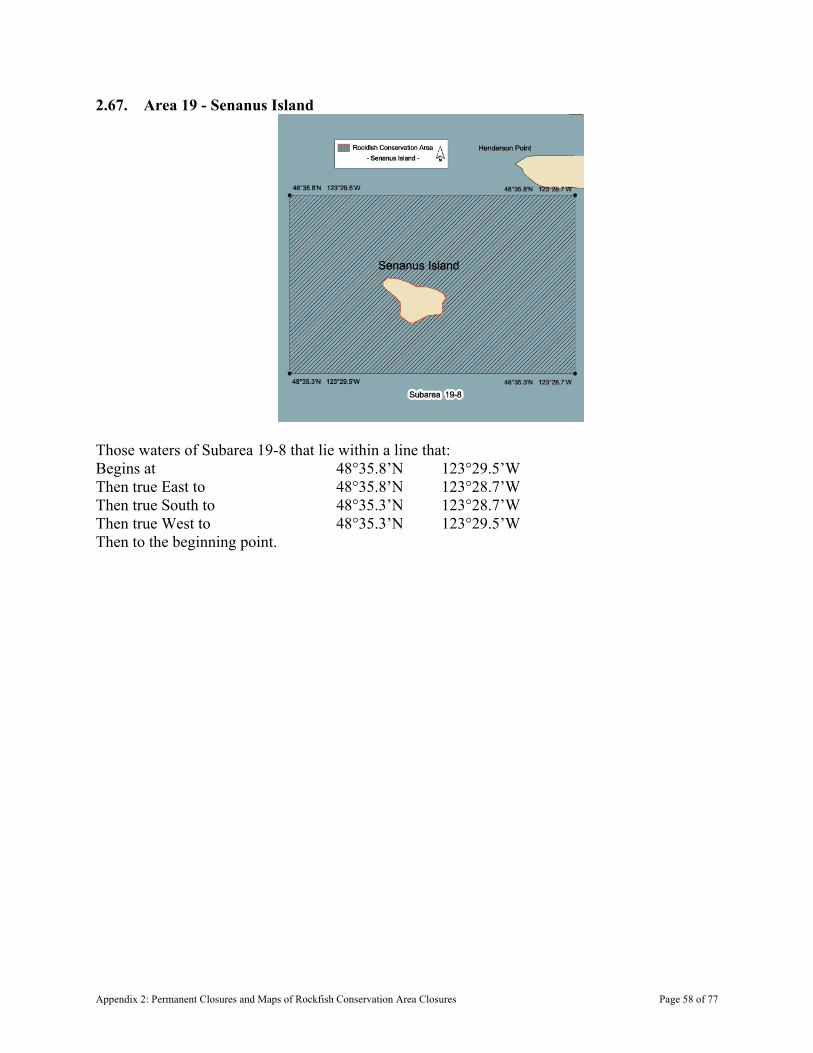
2.67. Area 19 - Senanus Island
Those waters of Subarea 19-8 that lie within a line that: Begins at 48°35.8’N 123°29.5’W Then true East to 48°35.8’N 123°28.7’W Then true South to 48°35.3’N 123°28.7’W Then true West to 48°35.3’N 123°29.5’W Then to the beginning point.
Appendix 2: Permanent Closures and Maps of Rockfish Conservation Area Closures Page 58 of 77

2.68. Area 19 - Finlayson Arm
Those waters of Subarea 19-12 that lie southerly of a line: From 48°30.20’N 123°33.10’W To 48°30.12’N 123°32.70’W
Appendix 2: Permanent Closures and Maps of Rockfish Conservation Area Closures Page 59 of 77
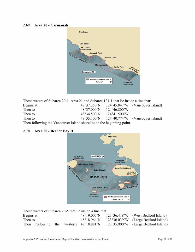
2.69. Area 20 - Carmanah
Those waters of Subarea 20-1, Area 21 and Subarea 121-1 that lie inside a line that: Begins at 48°37.350’N 124°45.847’W (Vancouver Island) Then to 48°37.000’N 124°46.800’W Then to 48°34.500’N 124°41.500’W Then to 48°35.100’N 124°40.774’W (Vancouver Island) Then following the Vancouver Island shoreline to the beginning point.
2.70. Area 20 - Becher Bay II
Those waters of Subarea 20-5 that lie inside a line that: Begins at 48°19.007’N 123°36.418’W (West Bedford Island) Then to 48°18.964’N 123°36.039’W (Large Bedford Island) Then following the westerly 48°18.881’N 123°35.900’W (Large Bedford Island)
Appendix 2: Permanent Closures and Maps of Rockfish Conservation Area Closures Page 60 of 77
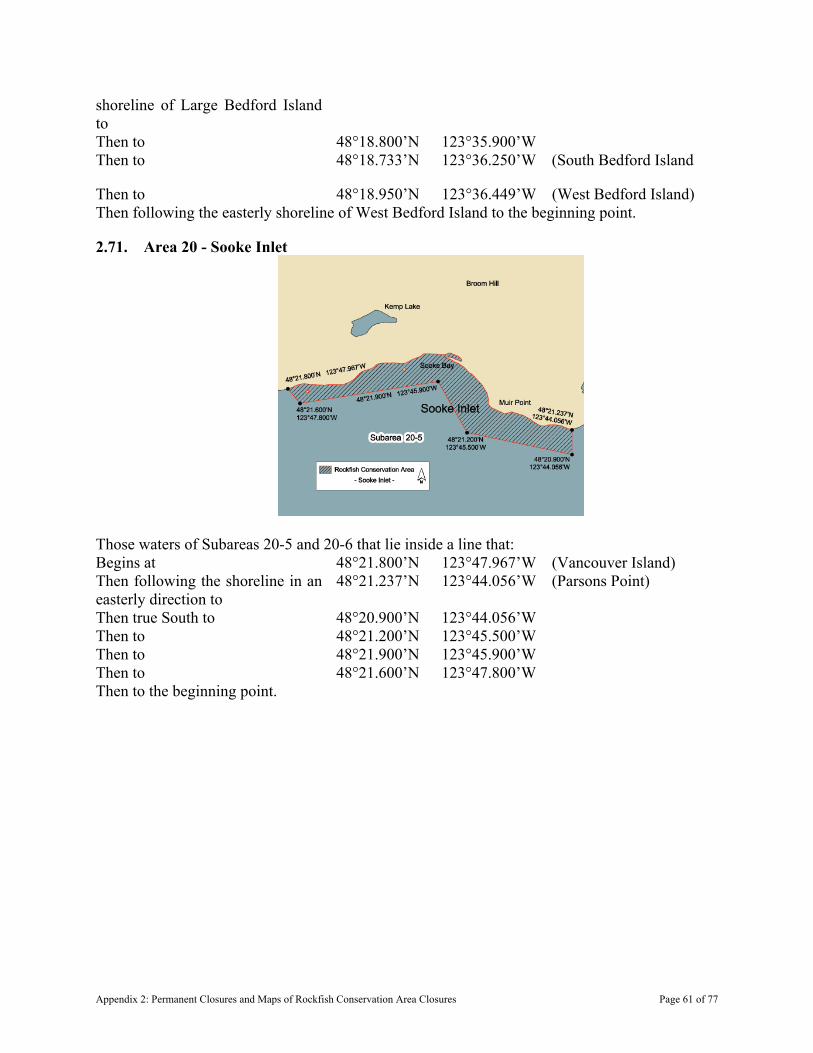
shoreline of Large Bedford Island to Then to 48°18.800’N 123°35.900’W Then to 48°18.733’N 123°36.250’W (South Bedford Island
Then to 48°18.950’N 123°36.449’W (West Bedford Island) Then following the easterly shoreline of West Bedford Island to the beginning point.
2.71. Area 20 - Sooke Inlet
Those waters of Subareas 20-5 and 20-6 that lie inside a line that: Begins at 48°21.800’N 123°47.967’W (Vancouver Island) Then following the shoreline in an easterly direction to
48°21.237’N 123°44.056’W (Parsons Point)
Then true South to 48°20.900’N 123°44.056’W Then to 48°21.200’N 123°45.500’W Then to 48°21.900’N 123°45.900’W Then to 48°21.600’N 123°47.800’W Then to the beginning point.
Appendix 2: Permanent Closures and Maps of Rockfish Conservation Area Closures Page 61 of 77
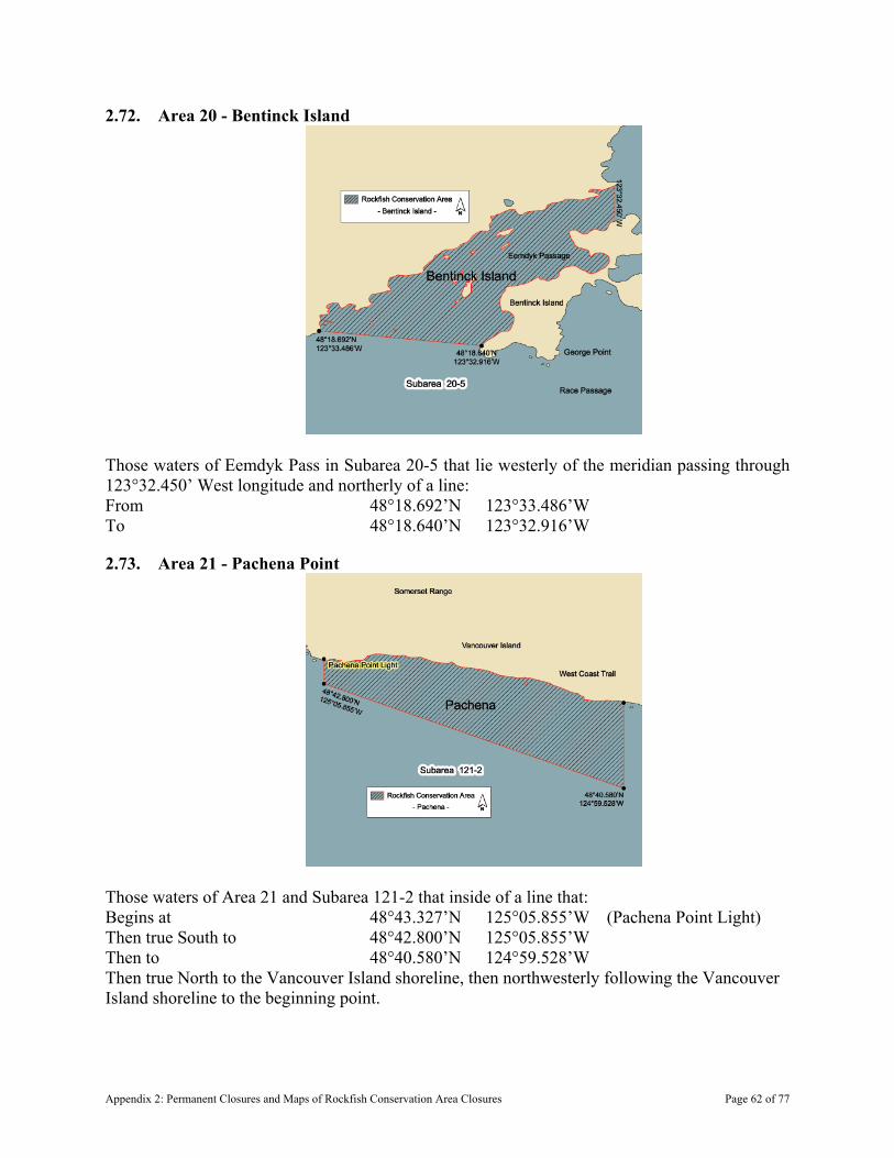
2.72. Area 20 - Bentinck Island
Those waters of Eemdyk Pass in Subarea 20-5 that lie westerly of the meridian passing through 123°32.450’ West longitude and northerly of a line: From 48°18.692’N 123°33.486’W To 48°18.640’N 123°32.916’W
2.73. Area 21 - Pachena Point
Those waters of Area 21 and Subarea 121-2 that inside of a line that: Begins at 48°43.327’N 125°05.855’W (Pachena Point Light) Then true South to 48°42.800’N 125°05.855’W Then to 48°40.580’N 124°59.528’W Then true North to the Vancouver Island shoreline, then northwesterly following the Vancouver Island shoreline to the beginning point.
Appendix 2: Permanent Closures and Maps of Rockfish Conservation Area Closures Page 62 of 77
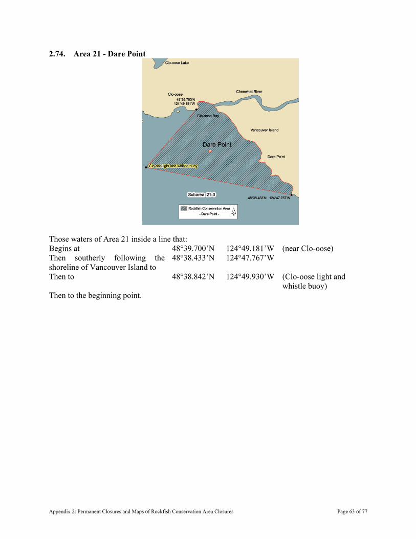
2.74. Area 21 - Dare Point
Those waters of Area 21 inside a line that: Begins at 48°39.700’N 124°49.181’W (near Clo-oose) Then southerly following the shoreline of Vancouver Island to
48°38.433’N 124°47.767’W
Then to 48°38.842’N 124°49.930’W (Clo-oose light and whistle buoy)
Then to the beginning point.
Appendix 2: Permanent Closures and Maps of Rockfish Conservation Area Closures Page 63 of 77
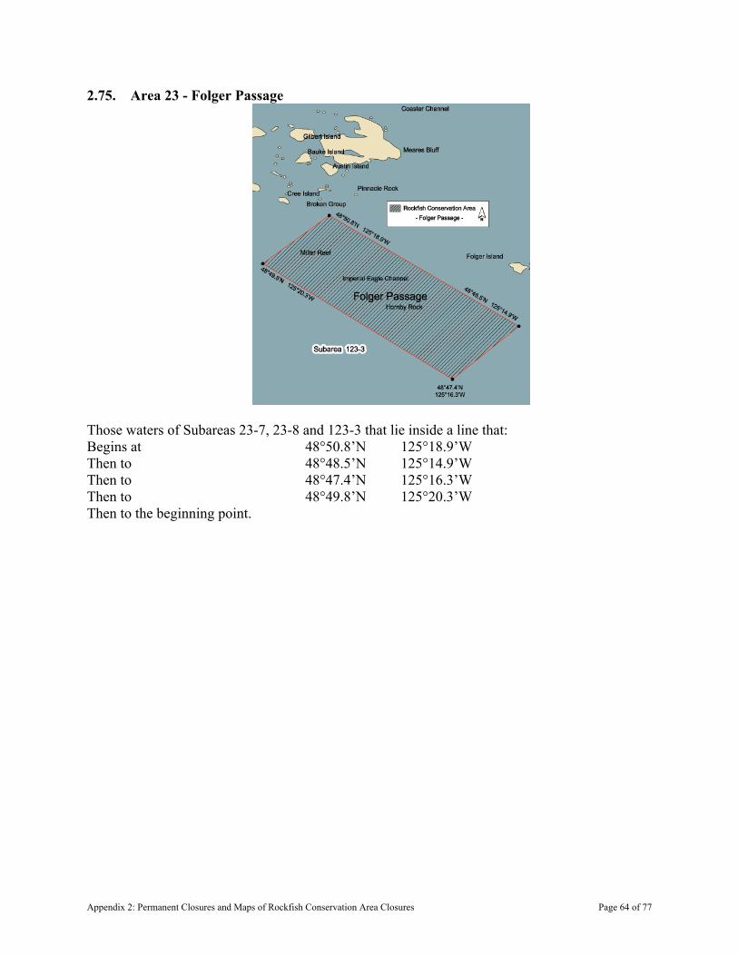
2.75. Area 23 - Folger Passage
Those waters of Subareas 23-7, 23-8 and 123-3 that lie inside a line that: Begins at 48°50.8’N 125°18.9’W Then to 48°48.5’N 125°14.9’W Then to 48°47.4’N 125°16.3’W Then to 48°49.8’N 125°20.3’W Then to the beginning point.
Appendix 2: Permanent Closures and Maps of Rockfish Conservation Area Closures Page 64 of 77

2.76. Area 23 - Broken Islands Group
That portion of Subarea 23-8 that lies inside a line that: Begins at 48°55.329’N 125°19.300’W (Eastern tip of Dodd Island) Then to 48°55.767’N 125°17.600’W (Northwest tip of Jarvis Island) Then to 48°56.533’N 125°16.537’W (Western tip of Prideaux Island) Then follows the southerly shoreline to
48°56.4’N 125°15.867’W (Eastern tip of Prideaux Island)
Then true East to 48°56.300’N 125°15.600’W (Northwest tip of Nettle Island) Then follows the southerly shoreline to
48°55.463’N 25°15.200’W (Southern tip of Nettle Island)
Then true South to 48°55.056’N 125°15.200’W (Gibraltar Island) Then follows the westerly shoreline to
48°54.767’N 125°15.767’W (Southwestern tip of Gibraltar Island)
Then true South to 48°54.400’N 125°15.767’W (Dempster Island) Then follows the easterly shoreline to
48°54.275’N 125°15.833’W (Southeastern tip of Dempster Island)
Then to 48°53.500’N 125°16.600’W Then to 48°52.853’N 125°18.600’W (Northwestern tip of Effingham
Island) Then follows the westerly shoreline to
48°52.000’N 125°19.000’W (Southwestern tip of Effingham Island)
Then true South to 48°51.900’N 125°19.000’W (Austin Island) Then to 48°51.300’N 125°20.283’W (Southeastern tip of Howell
Island) Then follows the northerly shoreline to
48°51.733’N 125°20.817’W (Western tip of Howell Island)
Appendix 2: Permanent Closures and Maps of Rockfish Conservation Area Closures Page 65 of 77
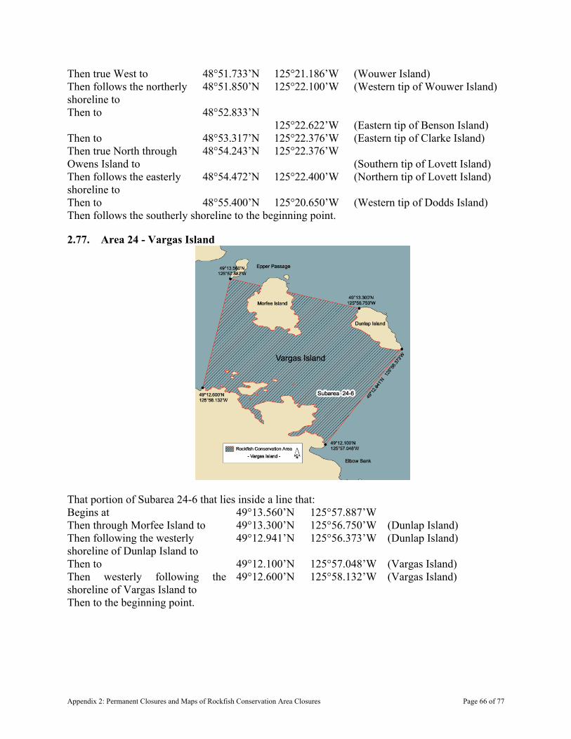
Then true West to 48°51.733’N 125°21.186’W (Wouwer Island) Then follows the northerly shoreline to
48°51.850’N 125°22.100’W (Western tip of Wouwer Island)
Then to 48°52.833’N 125°22.622’W
(Eastern tip of Benson Island)
Then to 48°53.317’N 125°22.376’W (Eastern tip of Clarke Island) Then true North through Owens Island to
48°54.243’N 125°22.376’W (Southern tip of Lovett Island)
Then follows the easterly shoreline to
48°54.472’N 125°22.400’W (Northern tip of Lovett Island)
Then to 48°55.400’N 125°20.650’W (Western tip of Dodds Island) Then follows the southerly shoreline to the beginning point.
2.77. Area 24 - Vargas Island
That portion of Subarea 24-6 that lies inside a line that: Begins at 49°13.560’N 125°57.887’W Then through Morfee Island to 49°13.300’N 125°56.750’W (Dunlap Island) Then following the westerly shoreline of Dunlap Island to
49°12.941’N 125°56.373’W (Dunlap Island)
Then to 49°12.100’N 125°57.048’W (Vargas Island) Then westerly following the shoreline of Vargas Island to
49°12.600’N 125°58.132’W (Vargas Island)
Then to the beginning point.
Appendix 2: Permanent Closures and Maps of Rockfish Conservation Area Closures Page 66 of 77
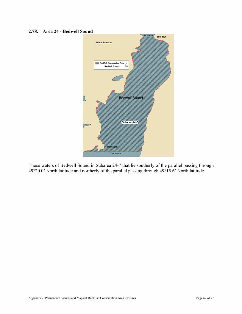
2.78. Area 24 - Bedwell Sound
Those waters of Bedwell Sound in Subarea 24-7 that lie southerly of the parallel passing through 49°20.0’ North latitude and northerly of the parallel passing through 49°15.6’ North latitude.
Appendix 2: Permanent Closures and Maps of Rockfish Conservation Area Closures Page 67 of 77
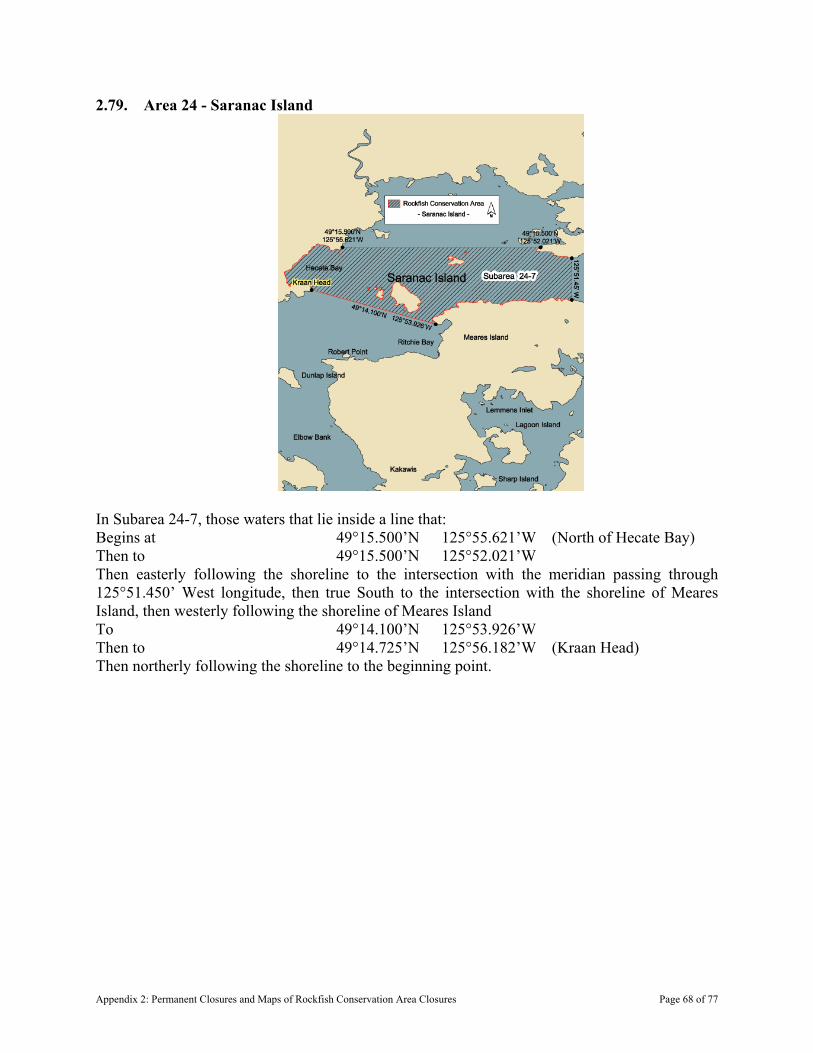
2.79. Area 24 - Saranac Island
In Subarea 24-7, those waters that lie inside a line that: Begins at 49°15.500’N 125°55.621’W (North of Hecate Bay) Then to 49°15.500’N 125°52.021’W Then easterly following the shoreline to the intersection with the meridian passing through 125°51.450’ West longitude, then true South to the intersection with the shoreline of Meares Island, then westerly following the shoreline of Meares Island To 49°14.100’N 125°53.926’W Then to 49°14.725’N 125°56.182’W (Kraan Head) Then northerly following the shoreline to the beginning point.
Appendix 2: Permanent Closures and Maps of Rockfish Conservation Area Closures Page 68 of 77
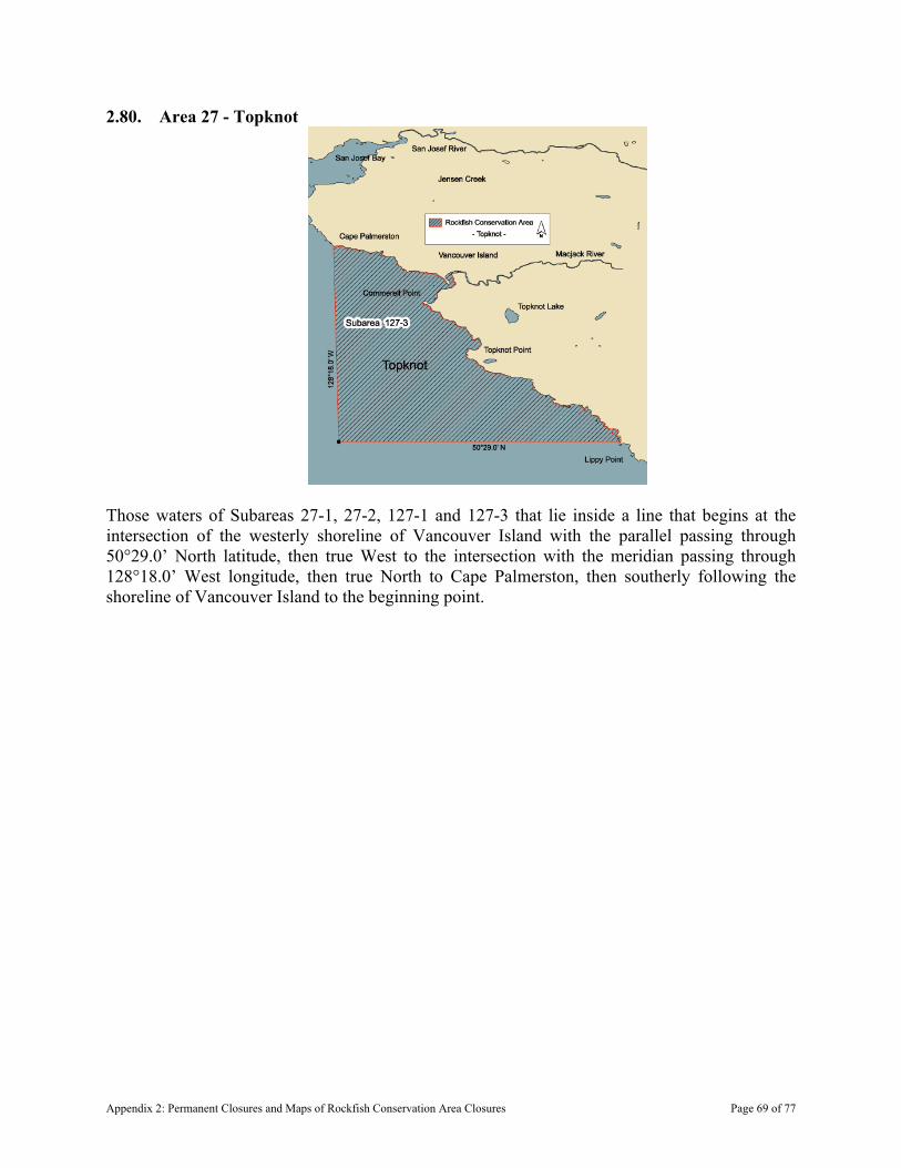
2.80. Area 27 - Topknot
Those waters of Subareas 27-1, 27-2, 127-1 and 127-3 that lie inside a line that begins at the intersection of the westerly shoreline of Vancouver Island with the parallel passing through 50°29.0’ North latitude, then true West to the intersection with the meridian passing through 128°18.0’ West longitude, then true North to Cape Palmerston, then southerly following the shoreline of Vancouver Island to the beginning point.
Appendix 2: Permanent Closures and Maps of Rockfish Conservation Area Closures Page 69 of 77

2.81. Area 27 - Brooks Bay
Subareas 27-5 and 27-6 and those waters of Subarea 27-4 that lie northeasterly of a line: From 50°17.263’N 127°51.893’W (Heater Point) To 50°13.847’N 127°48.495’W (Donald Islets Light)
Appendix 2: Permanent Closures and Maps of Rockfish Conservation Area Closures Page 70 of 77

2.82. Area 27 - Holberg Inlet
That portion of Subarea 27-11 that lies easterly of a line: From 50°36.117’N 127°45.013’W (Norton Point) To 50°35.600’N 127°45.590’W (Dahlstrom Point) And westerly of the meridian passing through 127°37.1’ West longitude at Thorp Point.
2.83. Area 28 - Pasley Island
Those waters of Subarea 28-1 that lie inside a line that: Begins at 49°21.930’N 123°30.200’W (In water) Then to 49°22.300’N 123°28.637’W (Hermit Island)
Appendix 2: Permanent Closures and Maps of Rockfish Conservation Area Closures Page 71 of 77
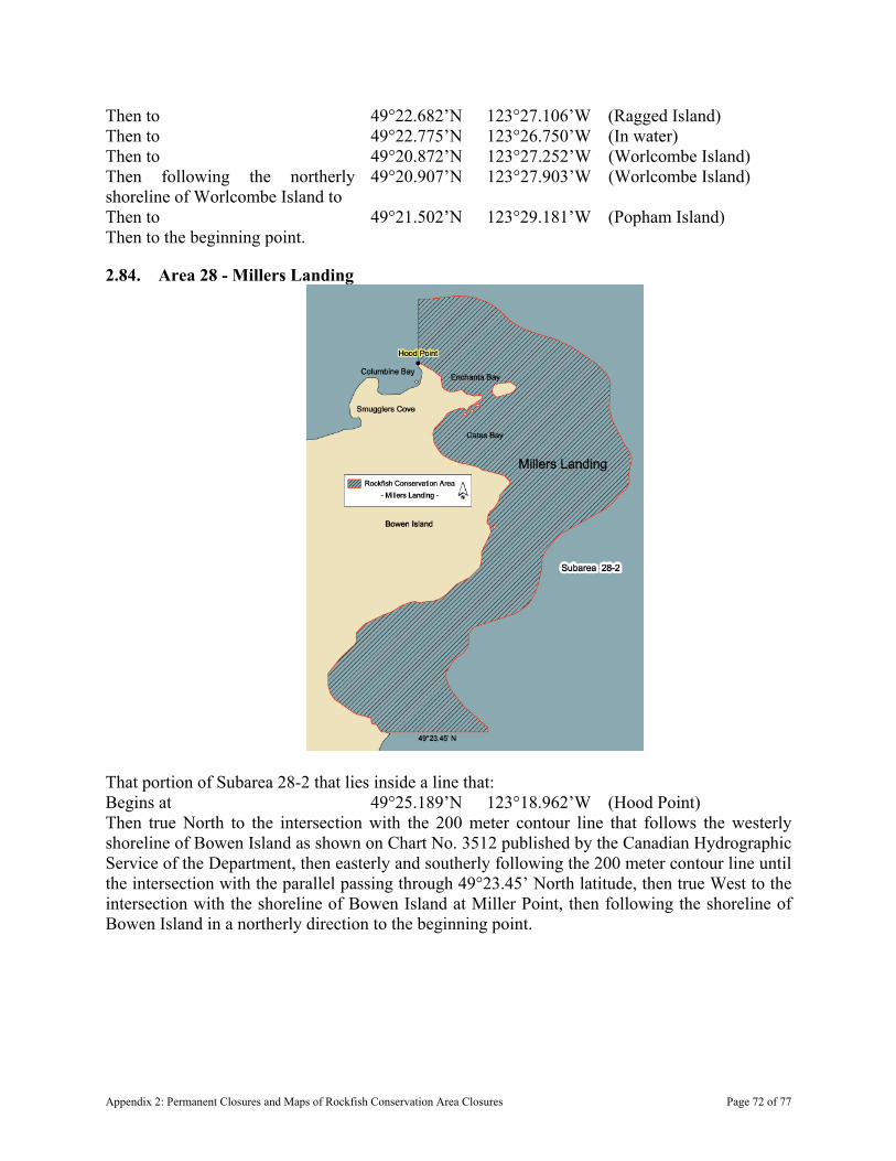
Then to 49°22.682’N 123°27.106’W (Ragged Island) Then to 49°22.775’N 123°26.750’W (In water) Then to 49°20.872’N 123°27.252’W (Worlcombe Island) Then following the northerly shoreline of Worlcombe Island to
49°20.907’N 123°27.903’W (Worlcombe Island)
Then to 49°21.502’N 123°29.181’W (Popham Island) Then to the beginning point.
2.84. Area 28 - Millers Landing
That portion of Subarea 28-2 that lies inside a line that: Begins at 49°25.189’N 123°18.962’W (Hood Point) Then true North to the intersection with the 200 meter contour line that follows the westerly shoreline of Bowen Island as shown on Chart No. 3512 published by the Canadian Hydrographic Service of the Department, then easterly and southerly following the 200 meter contour line until the intersection with the parallel passing through 49°23.45’ North latitude, then true West to the intersection with the shoreline of Bowen Island at Miller Point, then following the shoreline of Bowen Island in a northerly direction to the beginning point.
Appendix 2: Permanent Closures and Maps of Rockfish Conservation Area Closures Page 72 of 77
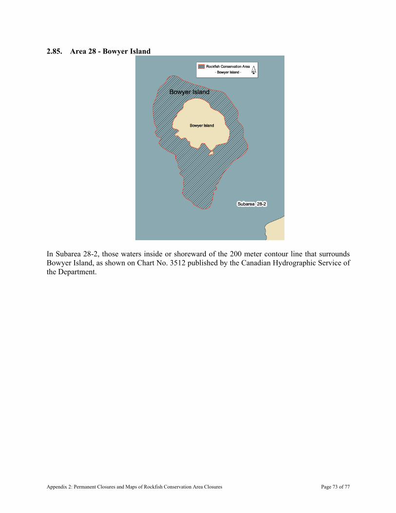
2.85. Area 28 - Bowyer Island
In Subarea 28-2, those waters inside or shoreward of the 200 meter contour line that surrounds Bowyer Island, as shown on Chart No. 3512 published by the Canadian Hydrographic Service of the Department.
Appendix 2: Permanent Closures and Maps of Rockfish Conservation Area Closures Page 73 of 77
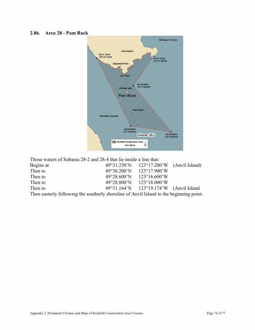
2.86. Area 28 - Pam Rock
Those waters of Subarea 28-2 and 28-4 that lie inside a line that: Begins at 49°31.230’N 123°17.200’W (Anvil Island) Then to 49°30.200’N 123°17.900’W Then to 49°28.600’N 123°16.600’W Then to 49°28.800’N 123°18.000’W Then to 49°31.164’N 123°19.174’W (Anvil Island Then easterly following the southerly shoreline of Anvil Island to the beginning point.
Appendix 2: Permanent Closures and Maps of Rockfish Conservation Area Closures Page 74 of 77
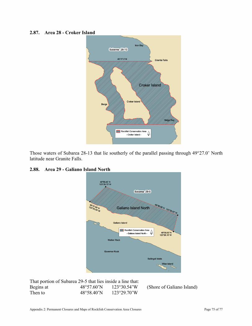
2.87. Area 28 - Croker Island
Those waters of Subarea 28-13 that lie southerly of the parallel passing through 49°27.0’ North latitude near Granite Falls.
2.88. Area 29 - Galiano Island North
That portion of Subarea 29-5 that lies inside a line that: Begins at 48°57.60’N 123°30.54’W (Shore of Galiano Island) Then to 48°58.40’N 123°29.70’W
Appendix 2: Permanent Closures and Maps of Rockfish Conservation Area Closures Page 75 of 77

Then to 48°56.88’N 123°25.87’W Then to 48°56.00’N 123°26.10’W (Shore of Galiano Island) Then follows the Galiano Island shoreline in a northwesterly direction to the beginning point.
2.89. Area 105 - West Banks Island
Those waters of Area 105 that lie inside a line that: Begins at 53°27.967’N 130°40.000’W Then true East to 53°27.967’N 130°35.241’W (Southwestern tip of Bonilla Island) Then to 53°15.400’N 130°18.000’W (Near North Danger Rocks) Then to 53°12.000’N 130°10.400’W Then true West to 53°12.000’N 130°18.000’W Then to 53°15.700’N 130°25.700’W Then to 53°25.000’N 130°38.000’W (Near South Rocks) Then to the beginning point.
Appendix 2: Permanent Closures and Maps of Rockfish Conservation Area Closures Page 76 of 77

2.90. Area 111 - Scott Islands
Those waters of Area 111 and Subareas 127-3 and 127-4 that lie inside a line that: Begins at 50°52.0’N 128°56.5’W Then true East to 50°52.0’N 128°33.0’W Then true South to 50°45.0’N 128°33.0’W Then true West to 50°45.0’N 128°56.5’W Then true North to the beginning point.
Appendix 2: Permanent Closures and Maps of Rockfish Conservation Area Closures Page 77 of 77

Appendix 3: Identification Features of Commercial Shrimp Species
Pandalus eous (P. borealis)
SpineBody uniform colour
To 150 mm or 5.9 in. total length
Pink Shrimp - Spiny, Flexed and Smooth
To 78 mm or 3.1 in. total length
Body striped with red to orange dots
Pandalus goniurus
Body uniform colour
To 175 mm or 6.9 in. total length
Pandalus jordani
Appendix 3: Identification Features of Commercial Shrimp SpeciesPage 1 of 2
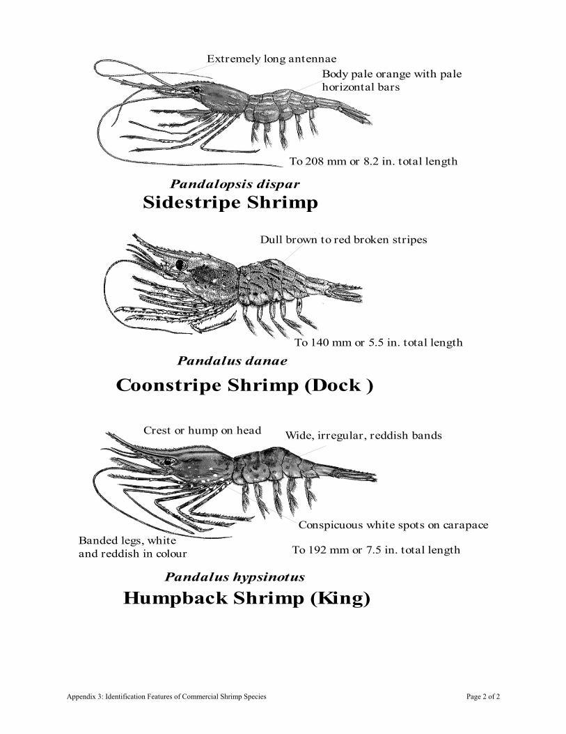
Sidestripe Shrimp
To 208 mm or 8.2 in. total length
Extremely long antennaeBody pale orange with palehorizontal bars
Pandalopsis dispar
Coonstripe Shrimp (Dock )
Dull brown to red broken stripes
To 140 mm or 5.5 in. total length
Pandalus danae
Humpback Shrimp (King)
Conspicuous white spots on carapaceBanded legs, whiteand reddish in colour
Wide, irregular, reddish bandsCrest or hump on head
To 192 mm or 7.5 in. total length
Pandalus hypsinotus
Appendix 3: Identification Features of Commercial Shrimp Species Page 2 of 2
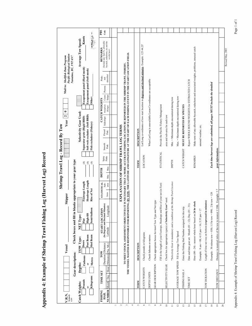
App
endi
x 4:
Exa
mpl
e of
Shr
imp
Tra
wl F
ishi
ng L
og (H
arve
st L
og) R
ecor
d
Shri
mp
Tra
wl L
og -
Rec
ord
By
Tow
V.R
.N.
Ves
sel
Skip
per
Yea
r
Cat
ch W
eigh
ts:
Dep
ths:
TO
W T
ype:
NE
T T
ype:
Sele
ctiv
ity G
ear
Use
d:A
vera
ge T
ow S
peed
:Po
unds
Doo
rs
Flat
Foot
rope
Len
gth
(ft)
Sep
arat
or g
rate
(Rig
id B
RD
)E
scap
emen
t pan
el (H
ard
mes
h)K
nots
oror
Post
Bea
mH
igh-
lift
Hea
drop
e L
engt
h(f
t)E
scap
emen
t pan
el (S
oft m
esh)
Kilo
gram
sSl
ed B
eam
Sem
i-bal
loon
Ris
e of
Net
(ft)
Fis
h ex
clud
eer
(Fis
heye
) O
ther
:___
____
____
____
_
PBS
HA
ILD
urat
ion
Dis
tanc
e(I
n D
egre
es a
nd D
ecim
al M
inut
es)
Cod
e
Mon
thD
ayH
our
(Min
utes
)(N
a. M
i.)
1 2E
XPL
AN
AT
ION
OF
SHR
IMP
TR
AW
L L
OG
TE
RM
S
3 4 5T
ER
MD
ESC
RIP
TIO
NT
ER
MD
ESC
RIP
TIO
N
6C
ATC
H W
EIG
HTS
Che
ck p
ound
s or k
ilogr
ams
LOC
ATI
ON
7D
EPTH
UN
ITS
Che
ck fa
thom
s or m
etre
sW
hen
Lat/L
ong
is u
nava
ilabl
e Lo
ran
Co-
ordi
nate
s are
acc
epta
ble
8G
EAR
DES
CR
IPTI
ON
Che
ck a
ppro
pria
te b
oxes
for t
raw
l Tow
Typ
e an
d N
et ty
pe
9Fi
ll in
the
leng
th o
f you
r Foo
trope
, Hea
drop
e an
d R
ise
of y
our n
et (i
n Fe
et)
STA
TIST
ICA
LPr
ovid
e th
e Pa
cific
Fis
hery
Man
agem
ent
10SE
LEC
TIV
ITY
GEA
RC
heck
box
for a
ppro
pria
te ty
pe(s
) of S
elec
tivity
Gea
r* u
sed.
ar
ea a
nd su
b-ar
ea fo
r eac
h to
w
11*S
elec
tivity
Gea
r is m
anda
tory
and
a c
ondi
tion
of th
e Sh
rim
p Tr
awl L
icen
ceD
EPTH
Min
. = M
inim
um d
epth
enc
ount
ered
dur
ing
tow
12A
VER
AG
E TO
W S
PEED
Fi
ll in
Ave
rage
Tow
Spe
edM
ax. =
Max
imum
dep
th e
ncou
nter
ed d
urin
g to
w
13FI
SHIN
G H
AIL
#En
ter t
he F
ishi
ng H
ail N
umbe
r ass
igne
d fo
r thi
s trip
.C
ATC
H W
EIG
HT
MU
ST B
E R
EPO
RT
ED
BY
SPE
CIE
S
14TI
ME
SET
Dat
e an
d tim
e ge
ar se
t. M
onth
(01
- 12)
; Day
(01
- 31)
;R
epor
t WH
OLE
RO
UN
D W
EIG
HTS
for E
STIM
ATE
D C
ATC
H
15H
our (
00 -
24) -
nea
rest
who
le h
our b
ased
on
24 h
r cl
ock
REM
AR
KS
Mak
e no
te o
f any
allo
wab
le b
ycat
ch, e
ulac
hons
and
ass
ocia
ted
wei
ghts
, pro
blem
s, un
usua
l cat
ch
16Ex
ampl
e: 8
am
= 0
8; 4
:15
pm =
16;
5:3
5 pm
= 1
7un
usua
l wea
ther
, etc
.
17TO
W D
UR
ATI
ON
Leng
th o
f tim
e ne
t was
on
botto
m (e
xpre
ssed
in m
inut
es)
18Ex
ampl
e: 3
0 m
inut
e to
w =
030
; 1.5
hr t
ow =
090
; 2
hr to
w =
120
Eac
h tim
e ha
rves
t log
s are
subm
itted
, all
page
s MU
ST in
clud
e th
e de
taile
d
19TO
W D
ISTA
NC
ED
ista
nce
in n
autic
al m
iles o
f the
tow
to n
eare
st 1
/10t
h. E
xam
ple:
2.7
gear
info
rmat
ion.
20R
evis
ed M
ay, 2
003
NU
MB
ER
Latit
ude
Long
itude
FISH
ING
TIM
E S
ET
TO
WST
AR
T L
OC
AT
ION
STA
TIS
TIC
AL
Min
Max
Are
aSu
b-ar
ea
DE
PTH
CA
TC
H W
EIG
HT
SSp
iny
Pink
sSm
ooth
Pink
Flex
edPi
nkSi
dest
ripe
Hum
pbac
k(K
ings
)C
oon-
Strip
ePr
awns
RE
MA
RK
S
Soft
web
exc
lude
r (S
oft B
RD
)
(Inc
lude
any
hai
l #'s,
allo
wab
le
byca
tch,
eul
acho
ns, e
tc a
nd th
e w
eigh
t her
e)
Fath
oms
Met
res
Pink
sno
t id
entif
ied
Gea
r de
scri
ptio
n:
Mai
l to:
She
llfis
h D
ata
Prog
ram
Pa
cific
Bio
logi
cal S
tatio
n
Nan
aim
o, B
C, V
9T 6
N7
Che
ck b
oxes
and
fill
in b
lank
s app
ropr
iate
to y
our
gear
type
form
erly
CFV
TO
ME
ET
ST
OC
K A
SSE
SSM
EN
T O
BJE
CT
IVE
S IT
IS N
EC
ESS
AR
Y T
HA
T A
MO
RE
AC
CU
RA
TE
FIS
HIN
G L
OC
AT
ION
BE
RE
POR
TE
D IN
TH
E S
HR
IMP
TR
AW
L F
ISH
ERY
. T
HE
VE
SSE
L M
AST
ER
IS R
ESP
ON
SIB
LE
FO
R R
EPO
RT
ING
, BY
TO
W, T
HE
LA
TIT
UD
E A
ND
LO
NG
ITU
DE
AT
TH
E S
TA
RT
OF
EA
CH
FIS
HIN
G E
VE
NT
IN T
HE
ST
AR
T L
OC
AT
ION
FIE
LD
.
Lat
/Lon
g co
-ord
inat
es o
f tow
star
t loc
atio
n in
deg
rees
and
dec
imal
min
utes
Exa
mpl
e: 1
25 4
4.25
'
Soft
web
exc
lude
r (S
oft B
RD
)20
A
ppen
dix
4: E
xam
ple
of S
hrim
p Tr
awl F
ishi
ng L
og (H
arve
st L
og) R
ecor
d Pa
ge 1
of 1
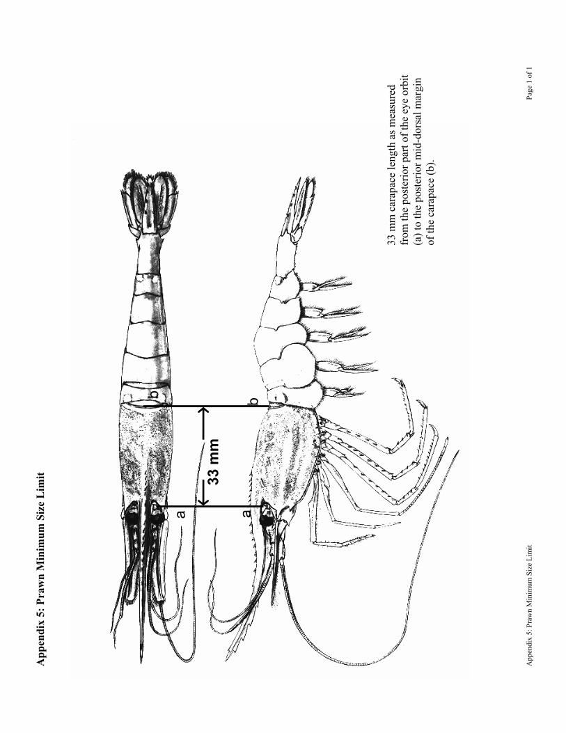
App
endi
x 5:
Pra
wn
Min
imum
Siz
e L
imit
ba
b
a
33 m
m
33 m
m c
arap
ace
leng
th a
s mea
sure
d fr
om th
e po
ster
ior p
art o
f the
eye
orb
it (a
) to
the
post
erio
r mid
-dor
sal m
argi
n of
the
cara
pace
(b).
App
endi
x 5:
Pra
wn
Min
imum
Siz
e Li
mit
Pa
ge 1
of 1
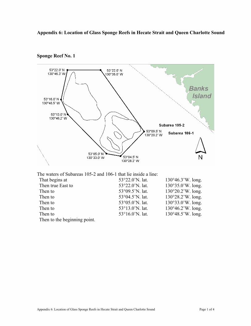
Appendix 6: Location of Glass Sponge Reefs in Hecate Strait and Queen Charlotte Sound
Sponge Reef No. 1
The waters of Subareas 105-2 and 106-1 that lie inside a line: That begins at 53°22.0’N. lat. 130°46.3’W. long. Then true East to 53°22.0’N. lat. 130°35.0’W. long. Then to 53°09.5’N. lat. 130°20.2’W. long. Then to 53°04.5’N. lat. 130°28.2’W. long. Then to 53°05.0’N. lat. 130°33.0’W. long. Then to 53°13.0’N. lat. 130°46.2’W. long. Then to 53°16.0’N. lat. 130°48.5’W. long. Then to the beginning point.
Appendix 6: Location of Glass Sponge Reefs in Hecate Strait and Queen Charlotte Sound Page 1 of 4

Sponge Reef No. 2
The waters of Subarea 106-2 that lie inside a line: That begins at 52°30.0’N. lat. 129°51.5’W. long. Then to 52°30.5’N. lat. 129°46.5’W. long. Then to 52°28.0’N. lat. 129°39.0’W. long. Then to 52°22.5’N. lat. 129°42.0’W. long. Then to 52°23.0’N. lat. 129°44.6’W. long. Then to 52°27.2’N. lat. 129°52.0’W. long. Then to the beginning point.
Appendix 6: Location of Glass Sponge Reefs in Hecate Strait and Queen Charlotte Sound Page 2 of 4

Sponge Reef No. 3
The waters of Subarea 107-2 that lie inside a line: That begins at 52°08.0’N. lat. 129°31.0’W. long. Then true East to 52°08.0’N. lat 129°21.0’W. long. Then true South to 51°54.5’N. lat. 129°21.0’W. long. Then true West to 51°54.5’N. lat. 129°38.0’W. long. Then true North to 52°01.5’N. lat. 129°38.0’W. long. Then to the beginning point
Appendix 6: Location of Glass Sponge Reefs in Hecate Strait and Queen Charlotte Sound Page 3 of 4
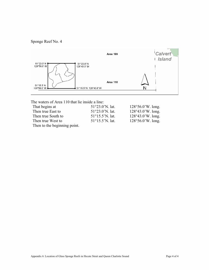
Sponge Reef No. 4
The waters of Area 110 that lie inside a line: That begins at 51°23.0’N. lat. 128°56.0’W. long. Then true East to 51°23.0’N. lat. 128°43.0’W. long. Then true South to 51°15.5’N. lat. 128°43.0’W. long. Then true West to 51°15.5’N. lat. 128°56.0’W. long. Then to the beginning point.
Appendix 6: Location of Glass Sponge Reefs in Hecate Strait and Queen Charlotte Sound Page 4 of 4

Appendix 7: Maps of Shrimp Management Areas
Shrimp Management Areas of the British Columbia Coast
Appendix 7: Maps of Shrimp Management Areas Page 1 of 27

Figure 1: Shrimp Management Areas: DXE (Areas 1, 101), QCI (Areas 102, 142) and 2IN (Area 2).
Appendix 7: Maps of Shrimp Management Areas Page 2 of 27
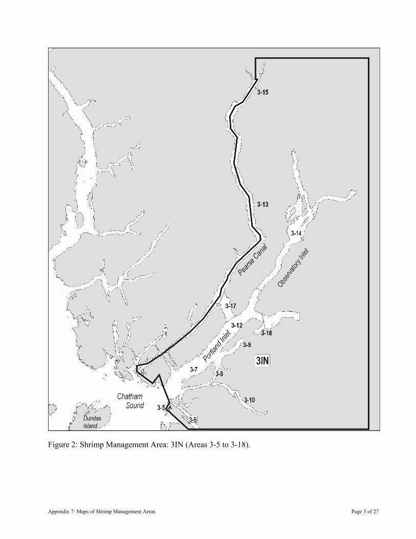
Figure 2: Shrimp Management Area: 3IN (Areas 3-5 to 3-18).
Appendix 7: Maps of Shrimp Management Areas Page 3 of 27

Figure 3: Shrimp Management Area: PRD (3-1 to 3-4, 103, 4-1 to 4-15, 104, 5-1, 5-2 and 5-23).
Appendix 7: Maps of Shrimp Management Areas Page 4 of 27
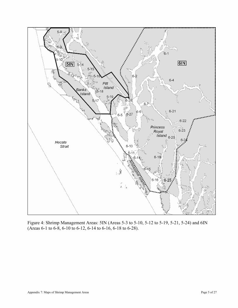
Figure 4: Shrimp Management Areas: 5IN (Areas 5-3 to 5-10, 5-12 to 5-19, 5-21, 5-24) and 6IN (Areas 6-1 to 6-8, 6-10 to 6-12, 6-14 to 6-16, 6-18 to 6-28).
Appendix 7: Maps of Shrimp Management Areas Page 5 of 27
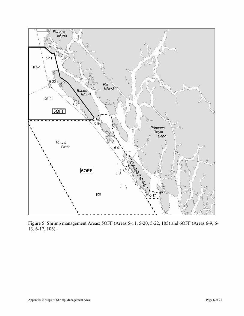
Figure 5: Shrimp management Areas: 5OFF (Areas 5-11, 5-20, 5-22, 105) and 6OFF (Areas 6-9, 6-13, 6-17, 106).
Appendix 7: Maps of Shrimp Management Areas Page 6 of 27
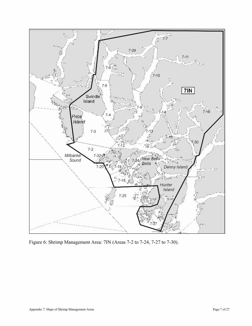
Figure 6: Shrimp Management Area: 7IN (Areas 7-2 to 7-24, 7-27 to 7-30).
Appendix 7: Maps of Shrimp Management Areas Page 7 of 27
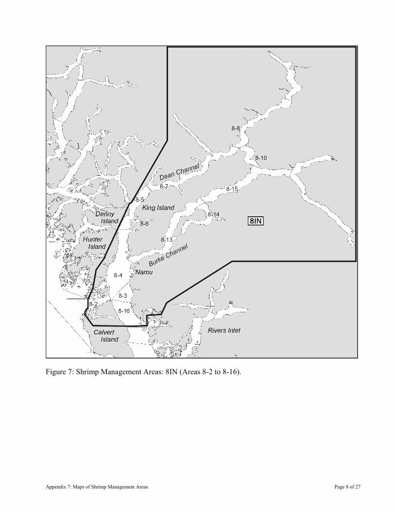
Figure 7: Shrimp Management Areas: 8IN (Areas 8-2 to 8-16).
Appendix 7: Maps of Shrimp Management Areas Page 8 of 27
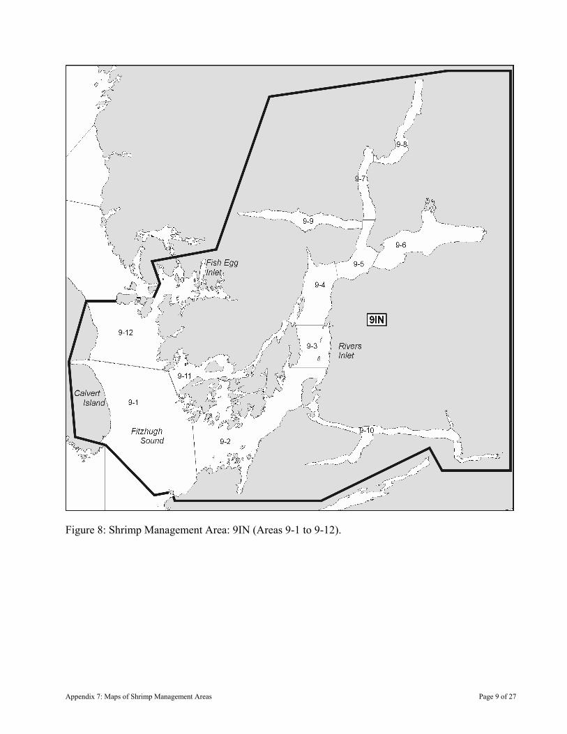
Figure 8: Shrimp Management Area: 9IN (Areas 9-1 to 9-12).
Appendix 7: Maps of Shrimp Management Areas Page 9 of 27
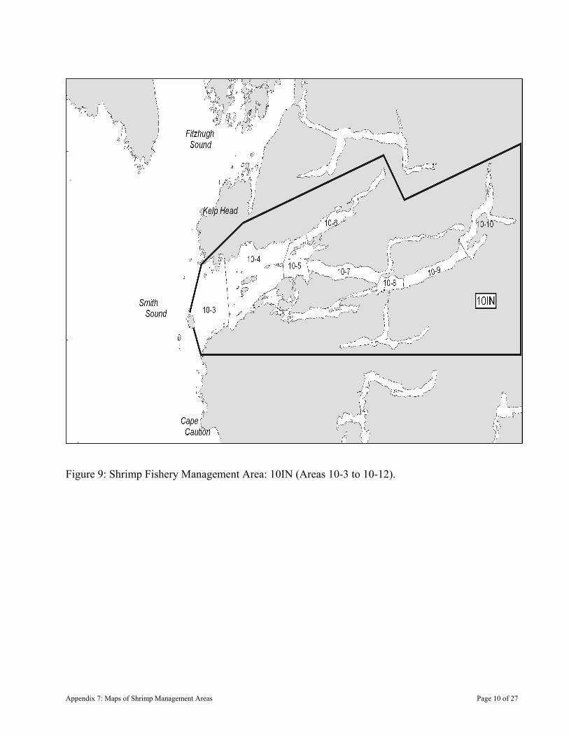
Figure 9: Shrimp Fishery Management Area: 10IN (Areas 10-3 to 10-12).
Appendix 7: Maps of Shrimp Management Areas Page 10 of 27
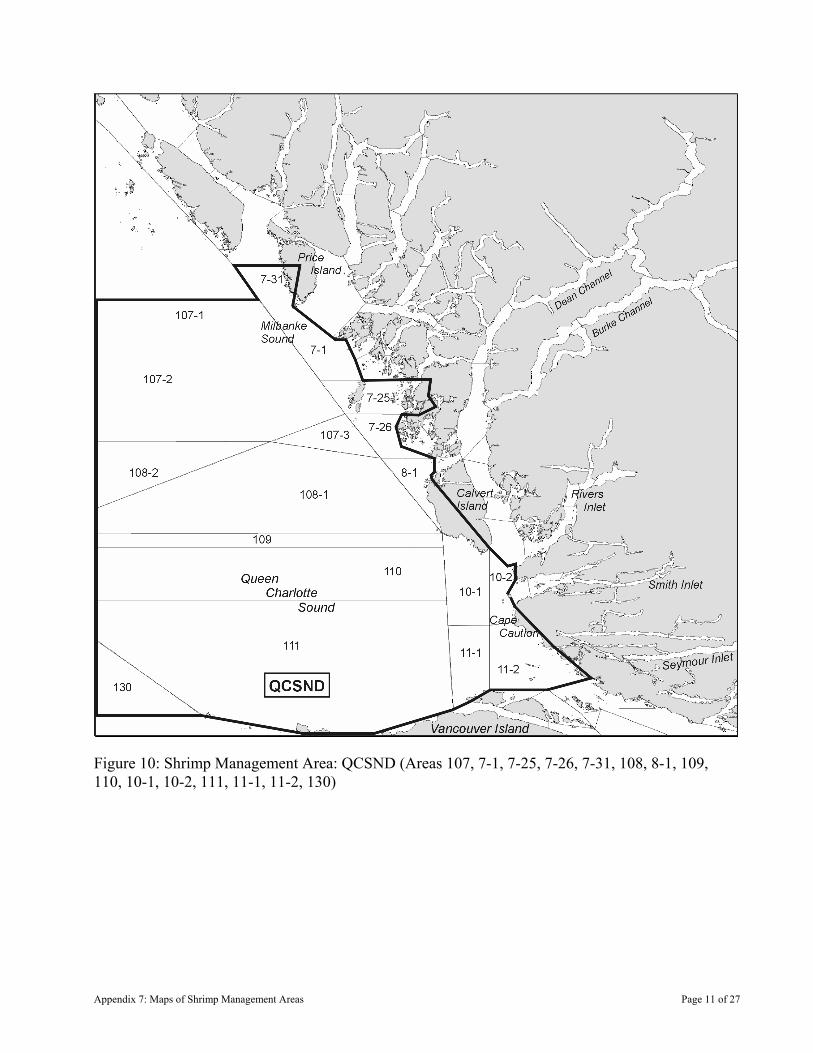
Figure 10: Shrimp Management Area: QCSND (Areas 107, 7-1, 7-25, 7-26, 7-31, 108, 8-1, 109, 110, 10-1, 10-2, 111, 11-1, 11-2, 130)
Appendix 7: Maps of Shrimp Management Areas Page 11 of 27
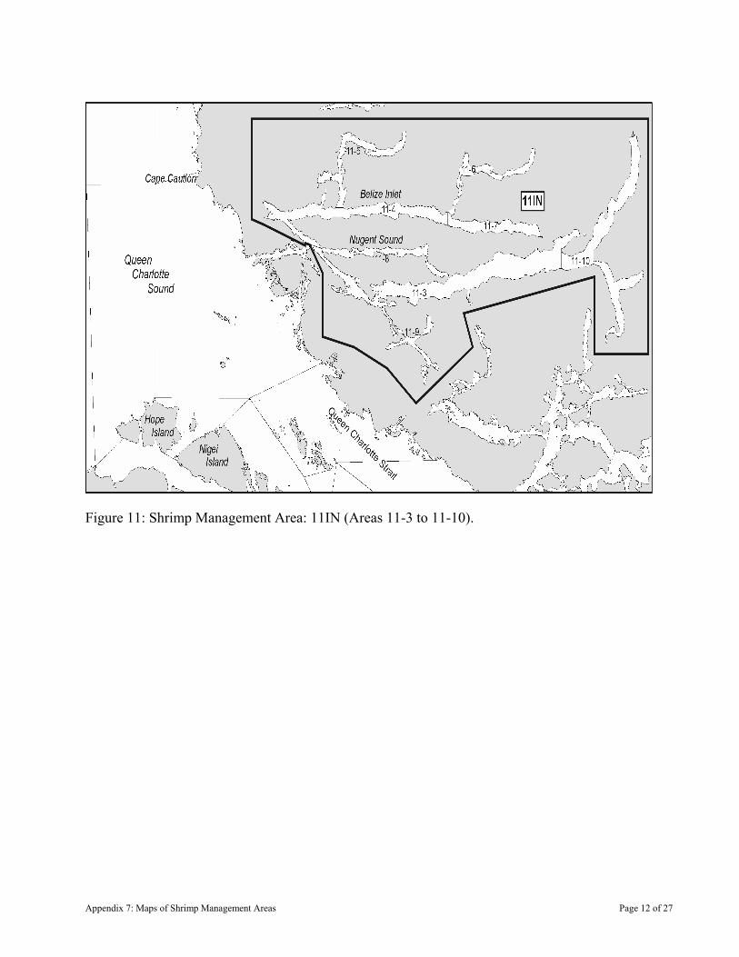
Figure 11: Shrimp Management Area: 11IN (Areas 11-3 to 11-10).
Appendix 7: Maps of Shrimp Management Areas Page 12 of 27
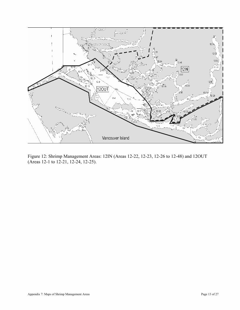
Figure 12: Shrimp Management Areas: 12IN (Areas 12-22, 12-23, 12-26 to 12-48) and 12OUT (Areas 12-1 to 12-21, 12-24, 12-25).
Appendix 7: Maps of Shrimp Management Areas Page 13 of 27
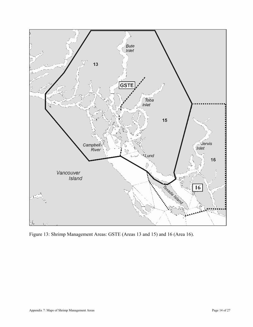
Figure 13: Shrimp Management Areas: GSTE (Areas 13 and 15) and 16 (Area 16).
Appendix 7: Maps of Shrimp Management Areas Page 14 of 27
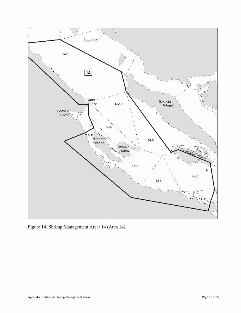
Figure 14. Shrimp Management Area: 14 (Area 14).
Appendix 7: Maps of Shrimp Management Areas Page 15 of 27

Figure 15: Shrimp Management Area: 17 (Area 17).
Appendix 7: Maps of Shrimp Management Areas Page 16 of 27
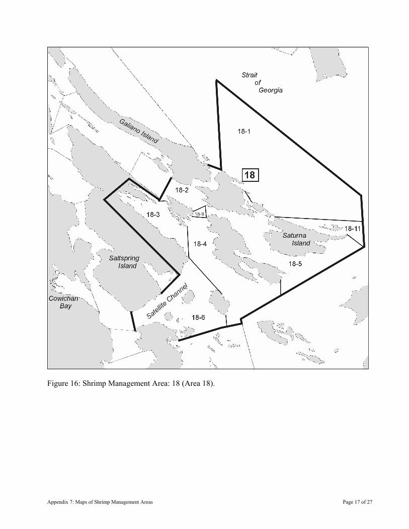
Figure 16: Shrimp Management Area: 18 (Area 18).
Appendix 7: Maps of Shrimp Management Areas Page 17 of 27
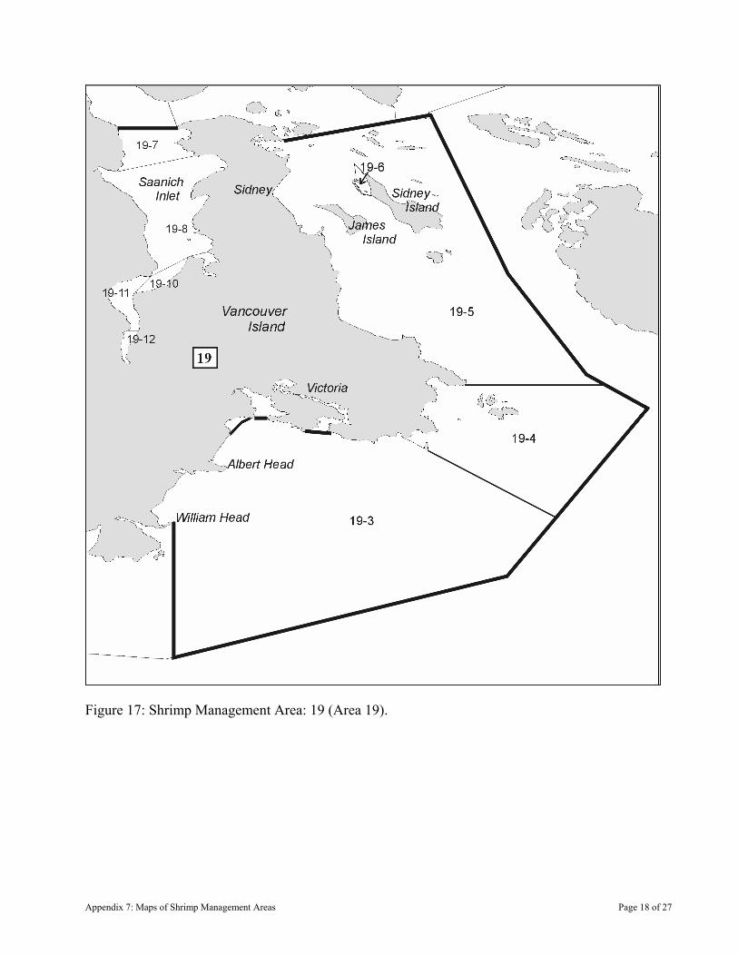
Figure 17: Shrimp Management Area: 19 (Area 19).
Appendix 7: Maps of Shrimp Management Areas Page 18 of 27
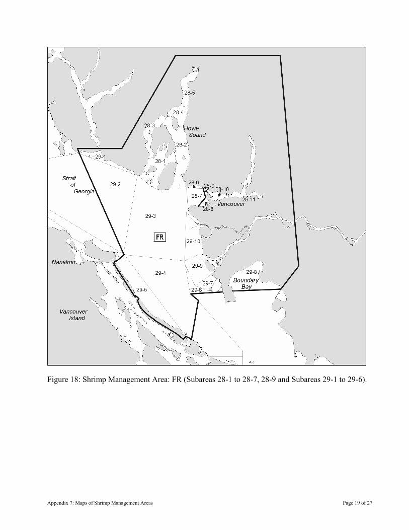
Figure 18: Shrimp Management Area: FR (Subareas 28-1 to 28-7, 28-9 and Subareas 29-1 to 29-6).
Appendix 7: Maps of Shrimp Management Areas Page 19 of 27
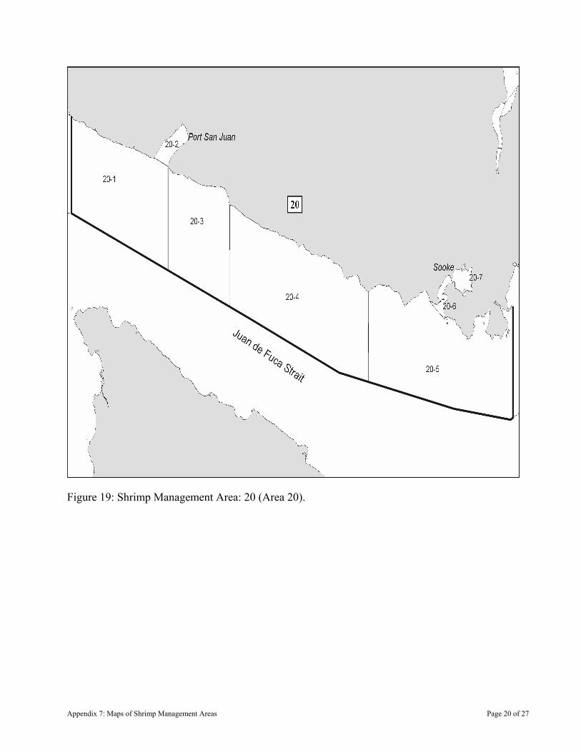
Figure 19: Shrimp Management Area: 20 (Area 20).
Appendix 7: Maps of Shrimp Management Areas Page 20 of 27

Figure 20: Shrimp Management Area: 21OFF (Areas 21, 121).
Appendix 7: Maps of Shrimp Management Areas Page 21 of 27
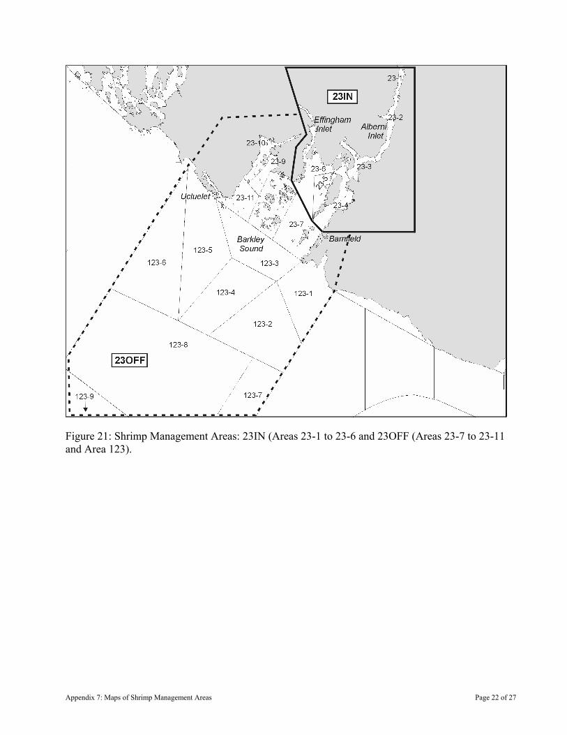
Figure 21: Shrimp Management Areas: 23IN (Areas 23-1 to 23-6 and 23OFF (Areas 23-7 to 23-11 and Area 123).
Appendix 7: Maps of Shrimp Management Areas Page 22 of 27
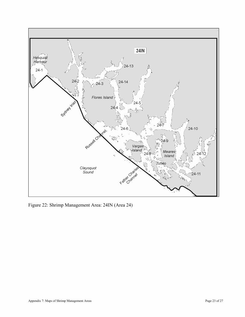
Figure 22: Shrimp Management Area: 24IN (Area 24)
Appendix 7: Maps of Shrimp Management Areas Page 23 of 27
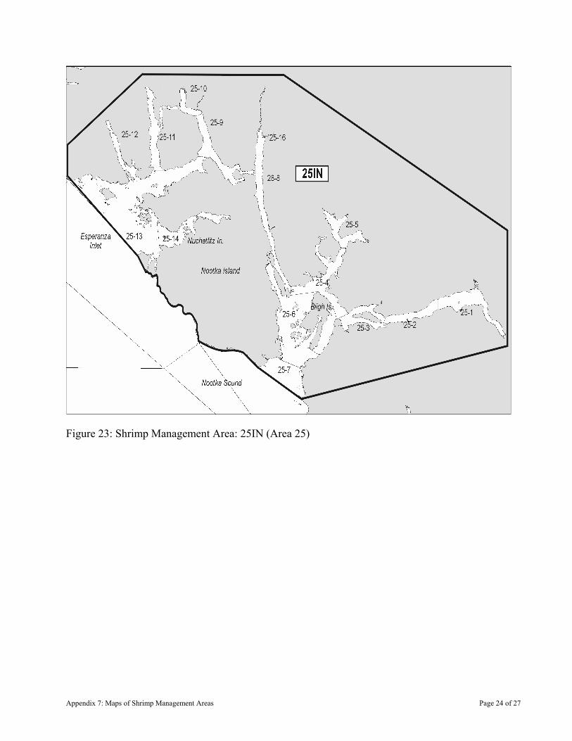
Figure 23: Shrimp Management Area: 25IN (Area 25)
Appendix 7: Maps of Shrimp Management Areas Page 24 of 27
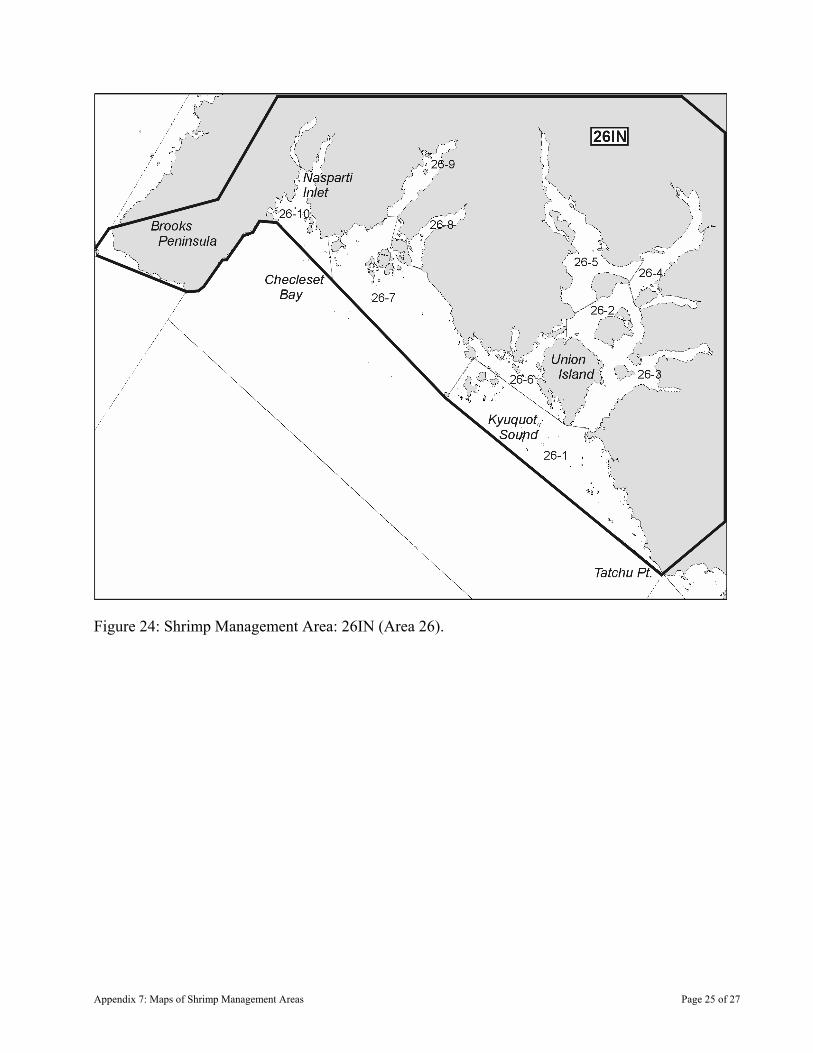
Figure 24: Shrimp Management Area: 26IN (Area 26).
Appendix 7: Maps of Shrimp Management Areas Page 25 of 27
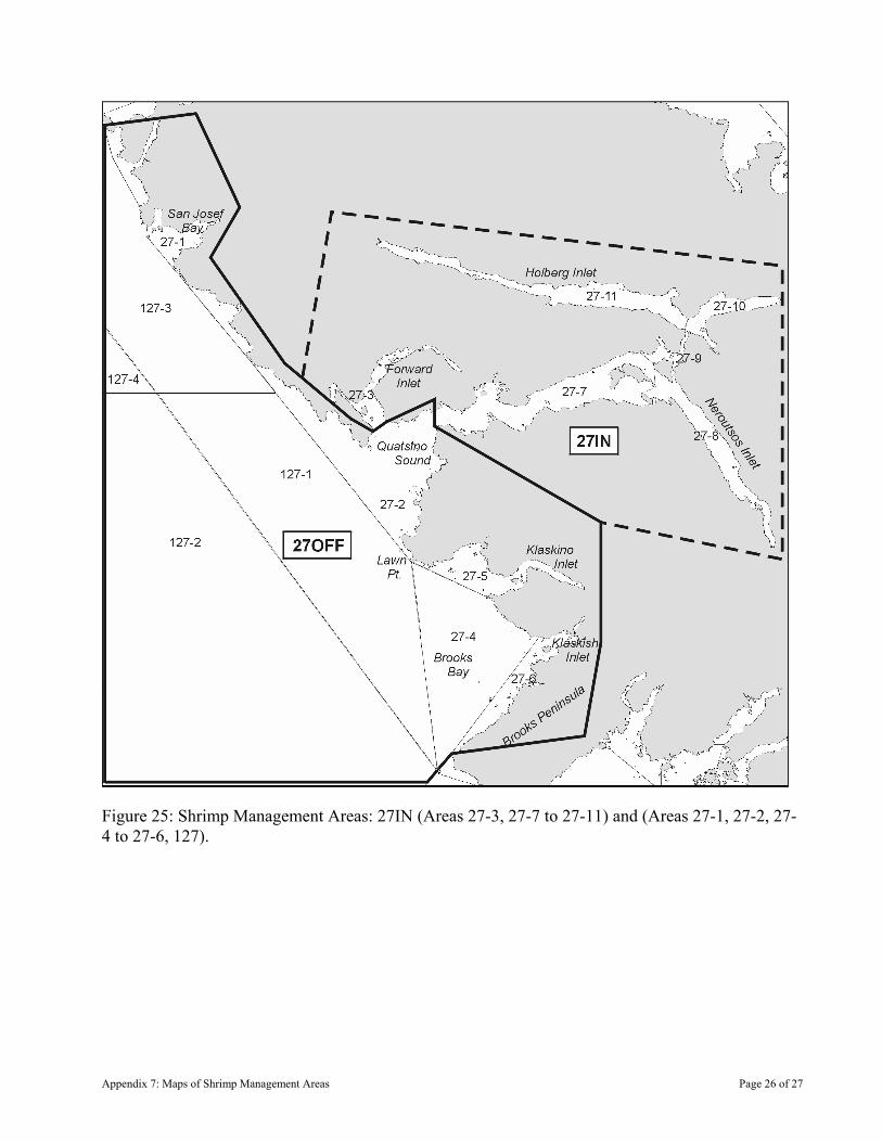
Figure 25: Shrimp Management Areas: 27IN (Areas 27-3, 27-7 to 27-11) and (Areas 27-1, 27-2, 27-4 to 27-6, 127).
Appendix 7: Maps of Shrimp Management Areas Page 26 of 27
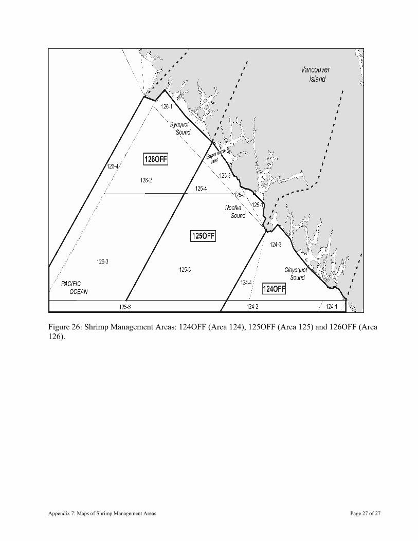
Figure 26: Shrimp Management Areas: 124OFF (Area 124), 125OFF (Area 125) and 126OFF (Area 126).
Appendix 7: Maps of Shrimp Management Areas Page 27 of 27

Appendix 8: Fishing Safety in the Shrimp by Trawl Fishery
1. VESSEL SAFETY
Owners and masters have a duty to ensure the safety of their crew and vessel. Adherence to safety regulations and good practices by owners, masters and crew of fishing vessels will help save lives, protect the vessel from damage and protect the environment. All fishing vessels must be in a seaworthy condition and maintained as required by Transport Canada (TC), Workers Compensation Board of British Columbia (WCB) and other applicable agencies. Vessels subject to inspection should ensure that the certificate of inspection is valid for the area of intended operation. Before leaving on a voyage the owner, master or operator must ensure that the fishing vessel is capable of safely making the passage. Critical factors for a safe voyage include the seaworthiness of the vessel, vessel stability, having the required carriage safety equipment in good working order, crew training, and knowledge of current and forecasted weather conditions. Useful publications include TC Publication TP 10038 Small Fishing Vessel Safety Manual that can be obtained from TC or printed from the Internet at: www.tc.gc.ca/MarineSafety/Tp/Tp10038/menu.htm On July 30, 2003 all crew with more than six months at sea will be required to have taken minimum Marine Emergency Duties (MED) training or be registered for such training. MED provides a basic understanding of the hazards associated with the marine environment; the prevention of shipboard incidents (including fires), raising and reacting to alarms; fire and abandonment situations; and the skills necessary for survival and rescue. Fishers are reminded of the importance of paying close attention to current weather trends and forecasts during the voyage. Marine weather information and forecasts can be obtained on VHF channels 21B, W1, W 2, W 3, or W4. Weather information is also available from Environment Canada on the Internet at: www.weatheroffice.ec.gc.ca/marine/region_03_e.html Vessel stability is paramount for safety. Care must be given to the stowage and securing of all cargo, skiffs, equipment, fuel containers and supplies, and also to correct ballasting. Fishers must be familiar with their vessel’s centre of gravity, the effect of liquid free surfaces on stability, loose water or fish on deck, loading and unloading operations and the vessel’s freeboard. Know the limitations of your vessel, and if you are unsure contact a reputable marine surveyor or the local TC Marine Safety office. Fishers should ensure that all crew are able to activate the Search and Rescue (SAR) system early rather than later by contacting the Canadian Coast Guard (CCG). It is strongly recommended that all fishers carry a registered 406 MHz Emergency Position Indicting Radio Beacon (EPIRB). When activated, an EPIRB transmits a distress call,
Appendix 8: Fishing Safety Page 1 of 5
which is picked up or relayed by satellites and transmitted via land earth stations to the Joint Rescue Co-ordination Centre (JRCC), which will task and co-ordinate rescue resources. Fishers should monitor VHF channel 16 or MF 2182 Khz and make themselves and their crews familiar with other radio frequencies. All crew should know how to make a distress call. However, whenever possible, masters should contact the nearest CCG Marine Communications and Traffic Services (MCTS) station (on VHF channel 16 or MF 2182 kHz) prior to a distress situation developing. Correct radio procedures are important for communications in an emergency. Incorrect or misunderstood communications may hinder a rescue response. As of August 1, 2003 all commercial vessels greater than 20m in length are required to carry a Class D VHF DSC radio. A registered Digital Selective Calling (DSC) VHF radio has the capability to alert other DSC equipped vessels in your immediate area and MCTS that your vessel is in distress. Masters should be aware that they should register their DSC radios with Industry Canada to obtain an MMSI number or the automatic distress-calling feature of the radio may not work. A DSC radio that is connected to a GPS unit will also automatically include your vessel’s current position in the Distress message. More detailed information on MCTS and DSC can be obtained by contacting your local CCG MCTS centre or from the Internet at: www.pacific.ccg-gcc.gc.ca/index_e.htm Fishers must be knowledgeable of the Collision Regulations and the responsibilities between vessels where risk of collision exists. Navigation lights must be kept in good working order and must be displayed from sunset to sunrise and during all other times of restricted visibility. To help reduce the potential for collision or close quarters situations which may also result in the loss of fishing gear, fishers are encouraged to monitor the appropriate local Vessel Traffic Services (VTS) VHF channel, when travelling or fishing near shipping lanes or other areas frequented by large commercial vessels. Vessels required to participate in VTS include:
a) Every ship twenty metres or more in length. b) Every ship engaged in towing or pushing any vessel or object,
other than fishing gear. c) Where the combined length of the ship and any vessel or object
towed or pushed by the ship is forty-five metres or more in length. d) Where the length of the vessel or object being towed or pushed by
the ship is twenty metres or more in length. Exceptions include:
a) A ship towing or pushing inside a log booming ground. b) A pleasure yacht less than 30 metres in length. c) A fishing vessel that is less than 24 metres in length and not more
than 150 tons gross. More detailed information on VTS can be obtained by calling (604) 775-8862, or from the Internet at:
Appendix 8: Fishing Safety Page 2 of 5
www.pacific.ccg-gcc.gc.ca/mcts-sctm/index_e.htm Fishers are encouraged to use the buddy system when transiting, and fishing as this allows for the ability to provide mutual aid. An important trip consideration is the use of a sail plan, which includes the particulars of the vessel, crew and voyage. The sail plan should be left with a responsible person on shore or filed with the local MCTS. After leaving port the fisher should contact the holder of the sail plan daily or as per another schedule. The sail plan should ensure notification to JRCC when communication is not maintained which might indicate your vessel is in distress. Be sure to cancel the sail plan upon completion of the voyage.
2. THE WORKERS’ COMPENSATION BOARD OF BRITISH COLUMBIA AND THE SHRIMP BY TRAWL FISHERY
Jurisdiction over occupational health and safety on commercial fishing vessels in Canada is the mandate of the provinces. In British Columbia, the Workers’ Compensation Board of British Columbia (WCB) regulates occupational health and safety on fishing vessels. Health and safety issues on fishing vessels include the health and safety of the crew and design, construction and use of fishing equipment on the vessel. Matters of transportation and shipping are federal government jurisdiction and are administered by Transport Canada, Marine Safety (TCMS). The WCB and TCMS have entered into a Memorandum of Understanding on fishing vessel safety that addresses, to the extent possible, jurisdiction. The document also states that each party will work co-operatively to ensure that vessels and their crew remain healthy and safe. The shrimp beam and otter trawl fisheries are regulated under the Workers’ Compensation Act and the Occupational Health and Safety Regulation (OHSR). The Act outlines general duty requirements for employers and workers. In the commercial fishing industry, vessel owners and masters are required to meet the responsibilities for employers. Crewmembers are required to meet the responsibility for workers. The OHSR is designed with general requirements for all workplaces set out in Parts 1 -19. Many of the general sections of the regulation apply to fishing operations. For example, Part 8 addresses issues related to personal protective equipment such as safety footwear and personal flotation devices and Part 9 addresses confined space entry requirements. Part 24 of the OHSR details specific requirements for fishing operations. The entire regulation can be accessed at the WCB web site at: www.worksafebc.com
2.1. Specific WCB Requirements for Shrimp operations Although the entire OHSR applies to fishing operations, this section highlights specific requirements of interest to shrimp fishers.
a) OHSR S.24.71 requires the vessel owner to ensure that major modifications to fishing vessels do not adversely affect the stability of the vessel. Fishers must also consider the cumulative affect that several minor changes have on the vessel’s stability. Vessel owners that have added freezers, tanks and/or
Appendix 8: Fishing Safety Page 3 of 5
sorting gear are to consider the affect these changes have on vessel stability. Weights acting at heights also affect vessel stability. Tow points off booms, use of booms to lift heavy cod ends and vessel loading are to be considered when assessing vessel stability.
b) OHSR S.24.74 requires the vessel master to develop procedures and conduct drills for emergency situations including crewmember overboard, fire on board, flooding of the vessel, abandoning ship and calling for help.
c) OHSR S.24.97 requires that all crewmembers are supplied with immersion suits and procedures are developed to recover a crewmember overboard, including re-boarding procedures.
d) OHSR S.8.26 requires that all workers who are exposed to the risk of drowning be supplied with and wear a life jacket or PFD with sufficient buoyancy to keep their head above water.
e) OHSR S.24.77 requires that all injuries be recorded in the vessel’s logbook and that these injuries be reported to the vessel’s owner.
f) OHSR S.24.79 requires that the owner of a vessel ensure the vessel is equipped with required first aid supplies. The vessel master is required to ensure a certified first aid attendant is available, where required.
g) OHSR S.24.88 requires that winches and drums capable of freewheeling are fitted with an effective brake device.
h) OHSR S.24.102 requires that all work areas are arranged and organized to minimize the potential for injury to crewmembers including sprain and strain. This requires that sorting areas be set up such that excessive, prolonged bending or reaching is not required. Also work areas are arranged to avoid slipping and tripping hazards.
i) OHSR S.24.104 requires that drums are fitted with an effective ratchet device, an effective brake and a hold to run (deadman) device.
j) OHSR S.24.105 requires that pin rollers are designed and maintained such that they do not lift out while in use.
k) OHSR S.24.138 requires that the master establish safe shooting and hauling procedures for trawls. This should include a procedure for clearing fouled gear and clearing obstructions from fouled gear. On Otter trawl vessels, this is to include crewmembers staying clear of pinch points between trawl doors and davits. Trawl doors must be secured to davits when not in use. On beam vessels, beams must be secured to prevent inadvertent movement when attaching and detaching plumb staffs.
l) OHSR S.24.139 requires that shrimp and fish boxes are secured to prevent inadvertent movement.
m) OHSR S.24.140 requires all trawl cod ends be fitted with splitting straps.
WCA Division 10 requires that accidents that result in the serious injury or death of a worker are immediately reported to the WCB and that the employer investigates these incidents and any other incident that had the potential to cause serious injury or death. 86 % of fishing fatalities result from drowning or are persons missing and presumed drown. Two significant events contribute to these deaths, vessels flounder or capsize or crew fall overboard. This has resulted in the
Appendix 8: Fishing Safety Page 4 of 5
Appendix 8: Fishing Safety Page 5 of 5
WCB stepping up the requirement for crew on deck to be protected by a personal floatation devise and for the entire crew to be versed and practiced on recovery of a crewman overboard. Our cold waters leave very little time for successful rescue and recovery of a stricken crewmember. These requirements have been highlighted for shrimp fishing vessels. The above requirements are not the only requirements vessel owners and masters are required to know and comply with. It is the responsibility of vessel owners and masters to know the requirements of the WC Act and OHSR and to comply with those requirements. For additional information, feel free to contact the following:
2.2. WCB Contacts
Peter Gilmour Focus Sector Manager/Fishing
Courtney (250) 334-8730
Shane Neifer Occupational Safety Officer
Terrace (250) 615-6605
David Clarabut Occupational Safety Officer
Victoria (250) 881-3418
Mark Lunny Occupational Safety Officer
Courtney (250) 334-8732
Mike Ross Occupational Safety Officer
Vancouver (604) 232-1564