otmc trip reports
TRANSCRIPT

Otago Tramping and Mountaineering Club – Trip Reports 1989 (V1.0) © www.otmc.co.nz
OTMC TRIP REPORTS 1989
Sourced from the 1989 OTMC Bulletins
OTMC TRIP REPORTS – 1989
1 | P a g e
CONTENTS
Introduction ....................................................................................... 3
Scarlet Lady, Blue Boy and Bag Lady In The Huxley ....................... 4
The East Eglinton Valley .................................................................... 6
The Five Passes .................................................................................. 8
Sugarloaf, Rockburn, Park Pass ...................................................... 10
Ahuriri (Canyon Creek).................................................................... 13
Bushcraft ’89 – Directors Report .................................................... 15
Lake Ohau Bushcraft Weekend - Huxley ........................................ 16
The Extended Ohau Weekend ......................................................... 18
A Geriartic Grovel ............................................................................ 20
Bushcraft 1989 – Silver Peaks Weekend ....................................... 23
Lake Ohau Two/Three Day Trip ...................................................... 25
Maungatua Traverse ........................................................................ 27
Mueller Hut, Mt Cook ....................................................................... 28
Copland At Easter ............................................................................ 29
Cascade Creek – Livingstone Mountains ........................................ 31
Bushcraft Huxley Weekend ............................................................. 33
Mt Cook – Mueller Hut ..................................................................... 35
Waitangi Weekend – The Trip That Wasn’t.................................... 38
Canyon Creek to Ahuriri & Little Canyon Creek ............................. 40
Homer Area – Waitangi Weekend .................................................. 42
Ahuriri Valley ................................................................................... 44
Jim Freeman Track – Craiglowan Falls ........................................... 46
Hooker Valley ................................................................................... 48
Kohurau – Hundred Mists................................................................ 50
West Matukituki Trip ....................................................................... 52

OTMC TRIP REPORTS – 1989
2 | P a g e
Matukituki Weekend ....................................................................... 54
Trotters Hut Wine & Dine ................................................................ 56
North Col – Park Pass - Rockburn .................................................. 58
Chinaman’s Hut ................................................................................ 61
That’s The Worst Of It? – Bledisloe Gorge ..................................... 63
Mt Luxmore Cooking Competition .................................................. 65
Climbing Avalanche Peak ................................................................ 66
Key Summit to Cascade Creek ........................................................ 68
Possum Hut Workparty ................................................................... 70
Macetown ......................................................................................... 71
Parakeet Ridge ................................................................................ 73
Geriatrics Attack Dore and Glade Passes ....................................... 74
The Grand Three Pass Travese........................................................ 78
OTMC Committee (1989-90) ........................................................... 81
OTMC Trip Programme 1989 ........................................................... 82
OTMC Bulletin Covers (February to May) ....................................... 84
OTMC Bulletin Covers (June to September) .................................. 85
OTMC Bulletin Covers (October to December) .............................. 86

OTMC TRIP REPORTS – 1989
3 | P a g e
INTRODUCTION Two major issues were resolved more or less by the OTMC in 1989. The first was a final
decision that we should purchase a suitable building as our own clubrooms, assuming we could
find a property that was affordable. The preferred area would be somewhere between North
Dunedin and the Oval – a sub-committee set about looking at possible properties throughout
the year.
Another big issue that had caused much deliberation over many years was the removal of the
exotic plantings on our Ben Rudd’s property. The trees were planted with the best intentions
(anticipating untold wealth for the club), but over the years the club’s ethics on exotic trees on
our property had changed, and by the end of 1989 the majority of the plantation was gone.
The cost of extraction eroded heavily into the club’s eventual financial return, but the resultant
surplus has been used to fund various projects on the property over the years, and the capitol
from the trees remains today and is ably managed by the Ben Rudd’s Management Trust.
Good numbers on Bushcraft 1989 continued a trend from the recent years, and the
participation and enthusiasm from those on the course ensured we had some very well
supported trips over the year.
The optional Bushcraft trip to the Ohau area encountered heavy rain on the Saturday night to
the point that multiple parties were trapped in various locations across the Maitland, Temple,
Hopkins and Huxley valleys. The trip was a large one, with 59 trampers. Remember this was
the days before email and mobile phones, so the job of our Dunedin based SAR contact was
huge in contacting friends and families to say that all were safe but will not be home on Sunday
night. The weather fortunately cleared during Sunday night, and the trip arrived back in
Dunedin on Monday afternoon. Bushcraft 1989 was my first time running the course, and I
remain proud of the way all the party leaders managed the risk and made sound decisions.
After a dry and hot weekend in the Silver Peaks two weeks earlier, the Ohau trip certainly
provided a glimpse of some quite different weather conditions.
Coincidentally, a return bus trip to Ohau in December 1989 suffered the same weather, but we
managed to get out on the Sunday – maybe there will be reports on this trip in the 1990 Trip
Report collection.
Overall trips were well supported in 1989, with an average of 20.3 per weekend trip, and two
carloads on the day trips. The 1989 Annual Report mentioned that we were disappointed that
only 20 people turned up to the Club Picnic – that would be regarded a great number today, an
indication of how the club has evolved over the years.
Antony Pettinger
March 2021
Cover Photo: Hidden Falls Creek (back valley), Park Pass and the head of the Rockburn from near lakelets to the
north of Lake Nerine (PHOTO Antony Pettinger)
OTMC TRIP REPORTS – 1989
4 | P a g e
SCARLET LADY, BLUE BOY AND BAG LADY IN THE
HUXLEY
November 1988
Author: Teresa Wasilewska
Published in Bulletin 474, February 1989
Having decided to explore the South Huxley area, we headed off via greasies in Oamaru
(Gastronomic Note - we recommend the Chinese down the road from the usual stop although
Heather didn’t think much of the chips, Cafe de Curb had excellent if slightly more expenses
fish and chips. Bill’s remarks about his paua pattie are unrepeatable!) We carefully recorded
the mileage to separate points along the Ohau Road for those who wish to find the Maitland or
Temple turnoff in the dark and took advantage of the Temple Shelter for our night’s sleep,
giving the new ultralite sleeping mats suitable initiation on hard concrete!
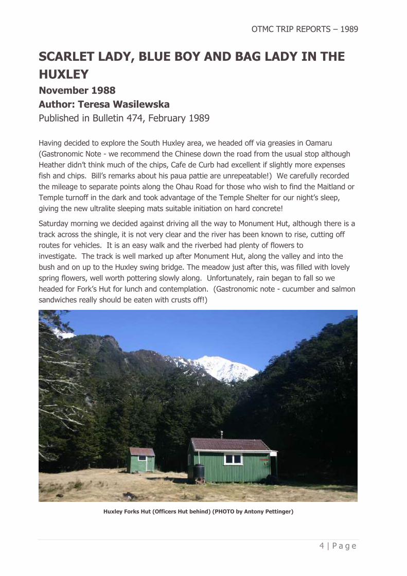
Saturday morning we decided against driving all the way to Monument Hut, although there is a
track across the shingle, it is not very clear and the river has been known to rise, cutting off
routes for vehicles. It is an easy walk and the riverbed had plenty of flowers to
investigate. The track is well marked up after Monument Hut, along the valley and into the
bush and on up to the Huxley swing bridge. The meadow just after this, was filled with lovely
spring flowers, well worth pottering slowly along. Unfortunately, rain began to fall so we
headed for Fork’s Hut for lunch and contemplation. (Gastronomic note - cucumber and salmon
sandwiches really should be eaten with crusts off!)
Huxley Forks Hut (Officers Hut behind) (PHOTO by Antony Pettinger)

OTMC TRIP REPORTS – 1989
5 | P a g e
The rain continued but we pressed on, along a well-marked track towards the South
Huxley. We reached the forked stream on the true left of the river where the map shows the
track crossing well below the fork, then heading towards the river edge of a small plateau,
crossing diagonally and into the South Huxley. Having had some difficulty crossing the stream
due to both the rain and the snow melt, we could not find the track and decided to return to
the forks. On final inspection, we looked above the fork and saw a feeble marker on a fallen
tree - there had been quite extensive and recent avalanche spill in the stream, which washed
away cairns and knocked down some trees on the stream edge - and the map shows the track
incorrectly. Because of the continuing rain and being uncertain whether the track would once
again mislead we decided to return to the Forks Hut for the night. Just as well, as we hear that
the ‘Bivy’ in the South Huxley is little more than a dachshund’s dog kennel!!
After Heather’s wonderful dinner (Gastronomic Note - always check who is bringing the sherry -
we ended up with two bottles, how wasteful - there being only two empty bottles
remaining). We retired to the honeymoon suite - the original Forks Hut, which is very small but
still on site, where Bill and Blue Boy chose the floor and Heather left her scarlet lady clip behind
the bunk. Anyone going to that area please check behind the bottom bunk! We decided to
head up Broderick on Sunday - a good track, although lots of recent slip and avalanche debris
and lovely views.
North Huxley River (PHOTO by Antony Pettinger)
Because we took the weekend at a leisurely pace we all felt that we had seen and done more -
hares, a wallaby, a variety of bird life and (I’m convinced) a wild mink!?? The flowers - lupins
along the lake, mistletoe, orchids, curisia, Mt Cook lilies, celmisia and all the ones that we
couldn’t name were lovely.
Teresa Wasilewska for Heather and Bill Roberson (for those of you with fanciful minds, Bill and
Heather had bright coloured silk sleeping bag liners!)

OTMC TRIP REPORTS – 1989
6 | P a g e
THE EAST EGLINTON VALLEY
November 5-6, 1988
Author: Sue Harding
Published in Bulletin 474, February 1989
The forecast was promising, and we had a pleasant crew to tramp with, so it looked like we
were in for a great weekend. Our trip involved making our way up the East Eglinton
Valley. Saturday morning was overcast but not too bad. The route was undulating, and the
track was covered with windfall and overgrown in parts. However, by lunchtime we had made
our way to the first clearing. After a rather wet lunch (it started to rain), we lost John and
Sandy, however 40 minutes later we were all reunited, well up the valley. The Livingstone
Mountains now surrounded us and Cascade Creek Saddle was coming into sight. By 6.30pm
we were tired, wet, cold and miserable so we decided to call it a day. Luckily we did as the
rain became heavier and soon it began to snow.
Exiting the bushline from Cascade Creek, heading towards the head of the East Eglinton
(PHOTO by Antony Pettinger)
Sunday morning we awoke to a white, cold world. Walking up to Cascade Creek Saddle was a
rather miserable affair as the snow continued to fall on us. We all had frozen feet so we
decided to change our plans. Rather than make our way across the tops of the Livingstones
we’d drop into the Greenstone. An excellent decision as it was much warmer and drier in the
valley. We lunched in the Lake McKellar Hut with Gary Nixon who also happened to be

OTMC TRIP REPORTS – 1989
7 | P a g e
tramping in the area. We continued down the valley and finally reached the Routeburn Shelter
and vans at 4pm. A long but very enjoyable trip.
Sue Harding for John Robinson, Michelle Williams, Arthur Blondell, Doug Forrester and Sandy
Gordon.
On the Livingstone Mountains, the valley behind the trampers is the head of Cascade Creek, the one going straight
back is the head of the East Eglinton River (PHOTO by Antony Pettinger)

OTMC TRIP REPORTS – 1989
8 | P a g e
THE FIVE PASSES
January 31 – February 3, 1989
Author: Sue Harding
Published in Bulletin 474, February 1989
Our epic trip began with a rather late start of 9.30am, however by 11am we had reached the
Routeburn Flats Hut and were heading up towards North Col. The North Branch is often
overlooked by trampers doing the Routeburn, however it is a very beautiful valley, well worth a
visit. North Col was covered in snow and so John and I were thankful we had taken ice
axes. The snow was soft however it still felt more secure with an ice axe in my hand.
In the North Routeburn, cloud spilling over North Col (PHOTO by Antony Pettinger)
That night we camped on top of North Col in the mist. The following morning there was low
cloud hanging around, however we were on our way by 8.30am. The climb around to Lake
Nerine was rather lovely, as the cloud slowly disappeared revealing all the glorious peaks and
valleys of Fiordland. To our surprise Lake Nerine was partially frozen which destroyed any
ideas of a quick dip. Snow lay all around the lake and the surrounding slopes. The journey to
Park Pass was very quick but hot work as the sun beat down on us. We lunched by a little tarn
on Park Pass before heading down to Hidden Falls Creek. It was a fast trip down but rather
hard on our knees. We still had plenty of energy to make our way up to Cow Saddle. We
camped in a rock biv, a short distance from Cow Saddle where we were joined by some rather
shy kea.
The next morning was bright and sunny. We were heading up by 8.30am to Fiery Col which
turned out to be heaps easier than I imagined. We reached the top by 10.30am. Being in high

OTMC TRIP REPORTS – 1989
9 | P a g e
spirits we decided to climb Fiery Peak. This I didn’t enjoy very much as the rock was rotten
and crumbly, so I stopped about 80m short of the top, but John continued to the summit. We
then continued on to the Olivine Ledge in the heat of the day. About 1.30pm we had a much-
needed lunch break by another pretty little tarn. We had views of the Olivine’s, Forgotten
River, Alabaster Pass, etc. The afternoon was to prove long and tiring. Getting to Fohn Lakes
involved climbing 2000 feet under the hot sun. It was an interesting area with rock ledges and
a gorged river.
Camping at the lakes below the main Fohn Lake (PHOTO by Antony Pettinger)
By 4.30pm we had reached Fohn Lakes which were frozen over but very beautiful. We had
planned to climb Sunset Peak but felt too stuffed so just headed onto Fohn Saddle which was
also covered in snow. The descent was quick at first as we bounded down the snow
slopes. However further down we ended up bashing through nasty Matagouri. By 6.45pm we
were down at the rock bivy where we planned to stay but it was so dark and dingy and had
unsavoury occupants (sandflies) that we decided to pitch our tent instead. That night it
rained.
Next morning, we didn’t leave until 9.30am as we thought we would have an easy day (ha ha
ha!) I visualized John and I both having a drink in the Glenorchy Pub but after 6½ hours of
grovelling down the Beans Burn we had only reached the Dart River. This included a detour we
made due to a certain (nameless) friend’s instruction. We reached Rock Burn Hut at 5.30pm
and continued on to Lake Sylvan which took a lot longer than we had anticipated. We arrived
at the road end at about 8.45pm very weary. John then ran to the Routeburn car park which
took about ½ hour. We arrived in Dunedin at about 3am. A very enjoyable trip but next time
we’ll take 5 days and will avoid the Beans Burn.
Sue Harding for John Robinson

OTMC TRIP REPORTS – 1989
10 | P a g e
SUGARLOAF, ROCKBURN, PARK PASS
December 29, 1988 – January 2, 1989
Author: Teresa Wasilewska
Published in Bulletin 474, February 1989
A slow start to see if the weather would lift, it did and we headed off with good instructions -
the Sugarloaf track is well marked, apart from the initial turn off form the Routeburn. This is
just after the 5th board bridge along the track, ignoring some of the little ones, about 20
minutes down the track. There is a definite track leading off to the right, but only an old axe
blaze on the tree. 2 hours to the pass is definite puff material for the likes of Linda and me.
The tussock, heading towards the left side of the pass where the track goes over and down
quite steeply. I’m told that a trip to the ‘false’ top of Sugarloaf is wonderful on a clear day - it
takes about an extra hour and there is a tarn for swimming with panoramic views - this was not
to be for us, as a cold wind came up while we picnicked and we headed smartly off down to
the bush.
Rockburn Valley side of Sugarloaf Pass, looking up the Rockburn Valley (PHOTO by Antony Pettinger)
Having been warned to watch carefully for the point where the track divides, one to the gorge
and one up to Park Pas we found it extremely well marked, with about 4 different markers,
arrows and directions! Obviously many have been caught out before! Although rain was falling
steadily and the river was obviously high, we had no problem crossing the streams on the

OTMC TRIP REPORTS – 1989
11 | P a g e
track. There is a small bivy just after the second stream - the track crosses the stream just
above a waterfall and then goes down along the edge, skirting round the bivy rock - a
wonderful spot for a morning shower! Once we reached the river, the track was fairly easy to
follow to the first small flat (good camping spots) and the 2nd flat (good swimming spots) and
varied bush and beech forests. Staying fairly close to the true right, the track follows the river
up to the swing bridge just below Theatre Flat, crosses and heads across the flats to go into
the bush, marked by cairns.
Theatre Flat has three small clusters of trees with excellent camping sites for whatever weather
conditions occur - the largest has a bivy rock, which has been well used, as well as three well
established campsites. There are good swimming areas in the river and around different rocks
in the flat. We based ourselves in a corner sheltered from the southerlies, pitched our tents
and retired early after John’s gallant efforts finally got the fire going in the rain! Other
trampers sheltering around the flat had met with Chris’s party doing the Five Passes trip and
dreadful stories of rain, cold and misery.
Theatre Flat from below Lake Nerine (PHOTO by Antony Pettinger)
New Year’s Eve dawned misty but got better so we headed off for the day to Park Pass - over
Janus Knob at the head of Theatre Flat - making a side trip for wonderful views of Amphion,
Minos and the flats, a swim in a tarn and study of a wonderful little ecosystem on top of the
rock. Through the flats on the other side and into an area called the Deer Trails - the track
goes up quite steeply immediately after crossing the stream that comes off Amphion and is
relatively well marked but I was warned not to be tempted to go too high. After coming out of

OTMC TRIP REPORTS – 1989
12 | P a g e
that area, the track winds down to the river where it opens out and is easy to cross, following
up the true right towards the pass. At the bottom of the pass there is a substantial bivy - a big
triangular rock near the stream coming off the pass, which is a good shelter in all weather
conditions except southerlies.
We reached the pass and looked carefully for Chris’s party who were to join us for New Year’s
celebrations but were hiding in Hidden Falls. Celebrating with an exothermic swim in the tarn,
we headed back down and almost had to resort to violence to keep Linda awake to see in the
New Year.
New Year’s Day was spent in total laziness on Janus Knob, swimming, sunning, photographing,
fossicking round for different flowers, orchids, water creatures and watching Linda being dive
bombed by curious kea! We never even heard Chris and party trudge by but met them later on
the second flat en-route out (gastronomic note - never eat a scrumptious tea after 3 days
tramping being watched by a group that have lived on muesli bars for a week). We bribed
Rosemary with a cold sausage, toast and honey and were treated to a New Year’s hymn in
return. I lent my poofta pad to John for the night (generous soul I am) and he didn’t even
snore at ALL! We were grateful to Chris’s party for being relatively quiet in departing at some
ungodly hour - we enjoyed toast and honey before out via the gorge.
The track does most of the climbing before dividing into the gorge and Sugarloaf directions;
however, the gorge track does have a fair amount of guts and gully’s to cross, some of them
quite steep. There are excellent views up valley to the Pass and across to Earnslaw and Leary
Peak. The track returns to the river at a refreshing swimming spot and then meanders through
the final shoulder of beech and divides right towards Lake Sylvan and out and towards the
McIntyre Hut and the Rockburn outlet into the Dart. The extra 10 minutes to the hut and river
are well worth it - the river comes out spectacularly through a narrow gorge, quietly but swiftly
and is wonderful to swim in.
The track to Lake Sylvan is well marked, the lake itself is full of frogs, ducks and jumping fish.
Thanks for a wonderful start to 1989.
Teresa Wasilewska for Linda Miles and John Galloway

OTMC TRIP REPORTS – 1989
13 | P a g e
AHURIRI (CANYON CREEK)
January 14-14, 1989
Author: Heather and Bill Robertson, with Teresa Wasilewska
Published in Bulletin 475, March 1989
We reached the Ahuriri well after dark and thought we should establish some landmarks en-
route down the valley. 103 rabbits after the turn-off, you should reach the Ben Ohau/Birchdale
boundary where the road divides (beware kamikaze rabbit #57 who dared Bill to run him over
and #87 who did a double somersault in front of the car before running away and #151
appeared drunk and ran towards the car in a wobbly line; #156 should be a sign that your
destination is near!)
Ahuriri Base Hut is easily visible in daylight, very near the edge of the bush, however neither
the bush nor the hut are obvious in the dark. Start looking for a grass track just beyond the
first fence line after the cattle yards. We had a decadent start to the weekend with a brew-up
and biscuits on arrival (while Bill locked the car to keep the possums out!) and discussed what
happens to our brains when soaked in Formalin. The strain was so much that Heather
dreamed of sharks (what would Freud say?) and Bill had to have his breakfast in bed.
We walked up the valley road about 1½ hours to Canyon Creek - Moir says ‘the road ends at
Canyon Creek and a four-wheel drive track continues up the valley (obtain permission first)’ as
we did not intend to go beyond Canyon Creek we did not contact the run holder in question
and did not take vehicles on his track. En-route on Sunday we were questioned as to where
we had been and whether we had thought about obtaining permission first - our questioner
OTMC TRIP REPORTS – 1989
14 | P a g e
drove past us and was seen to stop at Ahuriri Base Hut, possibly to check the intentions book,
before driving on.
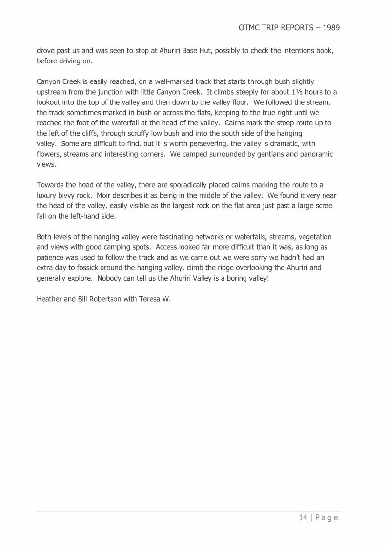
Canyon Creek is easily reached, on a well-marked track that starts through bush slightly
upstream from the junction with little Canyon Creek. It climbs steeply for about 1½ hours to a
lookout into the top of the valley and then down to the valley floor. We followed the stream,
the track sometimes marked in bush or across the flats, keeping to the true right until we
reached the foot of the waterfall at the head of the valley. Cairns mark the steep route up to
the left of the cliffs, through scruffy low bush and into the south side of the hanging
valley. Some are difficult to find, but it is worth persevering, the valley is dramatic, with
flowers, streams and interesting corners. We camped surrounded by gentians and panoramic
views.
Towards the head of the valley, there are sporadically placed cairns marking the route to a
luxury bivvy rock. Moir describes it as being in the middle of the valley. We found it very near
the head of the valley, easily visible as the largest rock on the flat area just past a large scree
fall on the left-hand side.
Both levels of the hanging valley were fascinating networks or waterfalls, streams, vegetation
and views with good camping spots. Access looked far more difficult than it was, as long as
patience was used to follow the track and as we came out we were sorry we hadn’t had an
extra day to fossick around the hanging valley, climb the ridge overlooking the Ahuriri and
generally explore. Nobody can tell us the Ahuriri Valley is a boring valley!
Heather and Bill Robertson with Teresa W.

OTMC TRIP REPORTS – 1989
15 | P a g e
BUSHCRAFT ’89 – DIRECTORS REPORT
February - March, 1989
Author: Antony Pettinger
Published in Bulletin 476, April 1989
The Bushcraft Course is now over, and once again the course was a roaring success. 51 people
participated in the course, which is about the same as the past couple of years. We had 11
school students who were partly subsidised by AMP Perpetual Trustees and the Family
Tramping Group. I would like to extend the club’s gratitude to these organisations.
The course would not have worked if it wasn’t for the help and dedication of all club members
who instructed, led etc. so they all deserve a BIG thank-you. I would also like to personally
thank David Peacock for Tirohanga, Peter Mason for the Silver Peaks, Bill Robertson for Ohau,
Mike Floate for Rivercrossing and Ross Cocker, Stu Mathieson and Debbie Williams for all your
help, advice and encouragement since last October.
I enjoyed co-ordinating this year’s Bushcraft, and I wish Ross Cocker all the best for next year
and hope he will get the same level of club members involvement as I did.
Course Director
Antony Pettinger
Bushcraft 1989 – Tirohanga Weekend, tent instruction with Debbie Williams and Stu Mathieson
(PHOTO by Antony Pettinger)
OTMC TRIP REPORTS – 1989
16 | P a g e
LAKE OHAU BUSHCRAFT WEEKEND - HUXLEY
March 11-13, 1989
Author: Suzanne Mackay
Published in Bulletin 476, April 1989
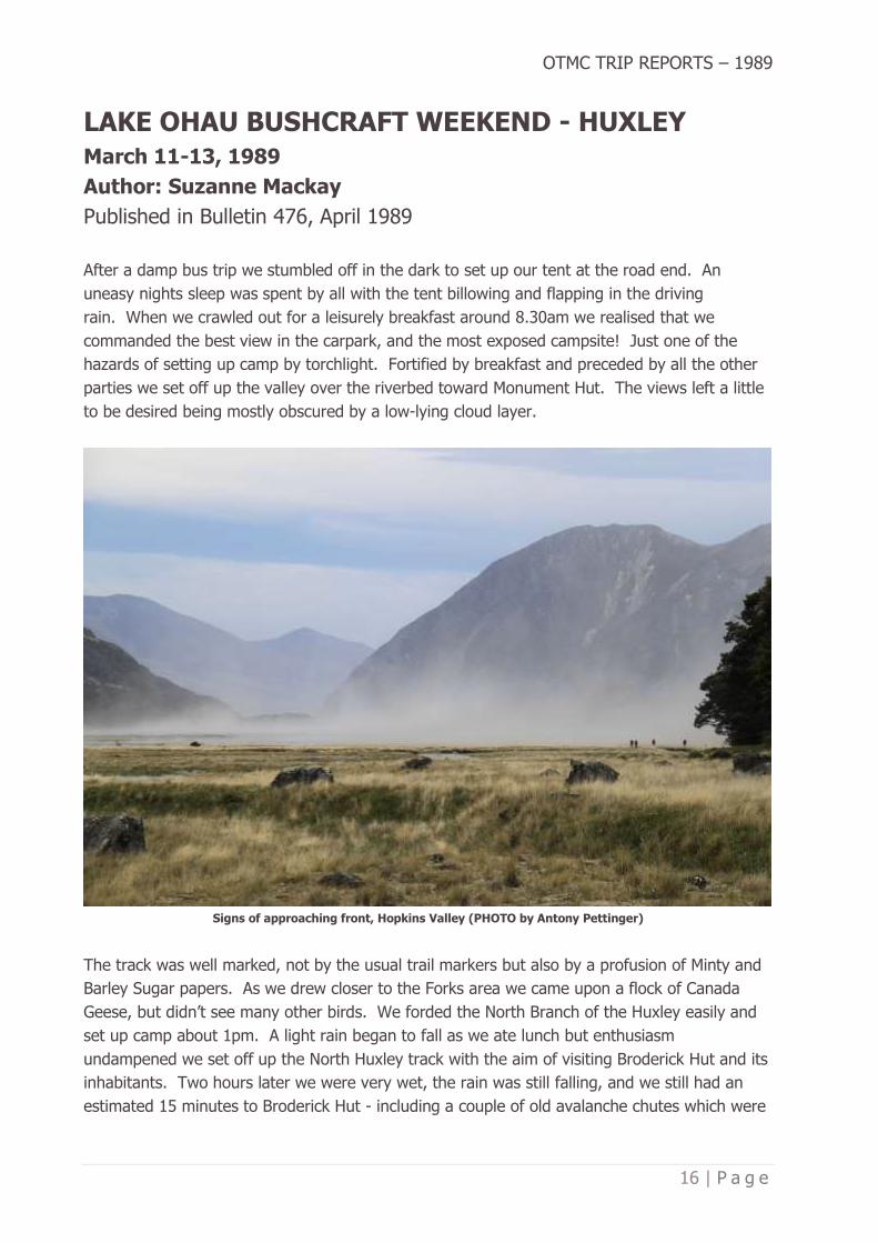
After a damp bus trip we stumbled off in the dark to set up our tent at the road end. An
uneasy nights sleep was spent by all with the tent billowing and flapping in the driving
rain. When we crawled out for a leisurely breakfast around 8.30am we realised that we
commanded the best view in the carpark, and the most exposed campsite! Just one of the
hazards of setting up camp by torchlight. Fortified by breakfast and preceded by all the other
parties we set off up the valley over the riverbed toward Monument Hut. The views left a little
to be desired being mostly obscured by a low-lying cloud layer.
Signs of approaching front, Hopkins Valley (PHOTO by Antony Pettinger)
The track was well marked, not by the usual trail markers but also by a profusion of Minty and
Barley Sugar papers. As we drew closer to the Forks area we came upon a flock of Canada
Geese, but didn’t see many other birds. We forded the North Branch of the Huxley easily and
set up camp about 1pm. A light rain began to fall as we ate lunch but enthusiasm
undampened we set off up the North Huxley track with the aim of visiting Broderick Hut and its
inhabitants. Two hours later we were very wet, the rain was still falling, and we still had an
estimated 15 minutes to Broderick Hut - including a couple of old avalanche chutes which were

OTMC TRIP REPORTS – 1989
17 | P a g e
developing into terrific torrents! We did the sensible thing and went back to camp for tea! We
hit our ‘pits’ early that night and played a few rounds of cards.
On waking in the morning a loud thunder like rumbling could be heard and it was still
raining! The rumbling was large boulders travelling down the river - which had risen several
feet overnight. An empty four litre billy that we’d left out overnight had filled almost to the
brim in 12 hours! We chomped through breakfast and decided to flag our excursion up the
South Huxley Valley. Leaving our campsite was quite different to arriving, in that the track was
now covered by 6-8 inches of water in places! We chatted with a few other parties at the Forks
Hut before meeting some damp and discouraged people coming back from the first ávo’ chute
which had become a stroppy little stream. After some discussion we decided to put our newly
acquired river crossing skills to the test. Bill handed us a good-sized log and checked our holds
and we were off. The crossing was actually much easier than it looked but the really
disconcerting things was the number of pieces the log broke into when we dropped it on the
other side. We showed the pieces to Bill and thanked him! Unfortunately, about five minutes
further on we encountered another stream - slightly larger and swifter than the first. We
trudged quite a long way upstream before we found a halfway possible crossing. Having been
persuaded to try it in spite of a few misgivings, we were all rather proud of ourselves when we
arrived safely on the opposite bank. Credit to our leader and mini Moro bars all around! The
rest of the trudge back to Monument Hut was fairly uneventful except for my ability for finding
the deepest mud holes in the creeks to fall into!
At the hut we found a note from the bus driver to say that he was unable to get through as the
roads were badly washed out - and that he would try again next day. We were joined by three
other parties just as wet as we were, but we all warmed up and dried out once we got the fire
blazing. A lot of the things I heard about instant spud, I found were true but faced with no
alternative it actually does the job of filling you up. A cosy night was spent by all and most of
us were much drier when Monday dawned clear and sunny - a pleasant surprise. After a little
conversation and some hard labour on the roads we were on our way home. Just so that the
trip home couldn’t be called uneventful the bus blew a tyre a bit before Omarama. The fine
weather deteriorated steadily as we came down the coast - tea in Oamaru and eventually back
in steady rain to Dunedin.
Even though this trip turned out to be an excellent one for checking the water repellent (or not)
qualities of our gear - our enthusiasm for being out there’ hasn’t dampened!
Suzanne Mackay for John Cox, Tim More and Brynley Crosado.

OTMC TRIP REPORTS – 1989
18 | P a g e
THE EXTENDED OHAU WEEKEND
March 11-13, 1989
Author: Megan Park
Published in Bulletin 476, April 1989
We left on Friday night in the pouring rain, and it didn’t look good for the weekend. We had
our normal feast of fish and chips at Oamaru. Our group consisted of Rosemary, Les, Lisa and
myself - a good mix between experienced and amateur.
Falling off the bus on our arrival we spent further time finding a decent campsite. As we were
sleeping under a fly it was necessary to find ‘a dry spot’, sheltered from the wind. When this
proved impossible, we camped on open ground. Next morning as the weather cleared we
moved up the Huxley Valley. We crossed a swing bridge, open ground, streams and walked
through beech forests until we decided that our walking was done for the day. We set up
camp and prepared tea then the weather changed.
Huxley River swing-bridge, not far from the Hopkins River confluence (PHOTO by Antony Pettinger)
Suddenly our inspiration of a peaceful and relaxing evening was shattered by 11 shrill
chattering voices - a group of 6th formers were doing a Bushcraft course. As I had been over
enthusiastic on my cooking quantities, we shared some food with the others. During the night
weather conditions became worse. Because of the driving rain the fly leaked, and we were

OTMC TRIP REPORTS – 1989
19 | P a g e
drenched. Our equipment was wet, and we were kept awake for the rest of the night. At
7.30am on Sunday with no change in the weather we arose, packed our gear and headed back
to the carpark where the bus was going to meet us.
We met up with David’s party who had attempted to cross one of the rivers with no
success. We successfully crossed the first river but were not so lucky with the second. Feeling
depressed we turned back as I slid down the gravely bank. I watched ‘Batman’ (David) and
‘Robin’ (Bill) come to the rescue. We all hibernated into Huxley Forks hut for the night. Our
spirits were revived by the sunshine the next morning and despite being very hungry we
walked out.
From my point of view I experienced many emotions . . . fear, happiness, wet, cold and hunger
but have come out looking forward to my next experience, hopefully not so dramatic. Many
thanks to Rosemary for leadership qualities which made for a successful trip.
By Megan Park

OTMC TRIP REPORTS – 1989
20 | P a g e
A GERIARTIC GROVEL
March 11-13, 1989
Author: Chris Ehrhardt
Published in Bulletin 476, April 1989
First, so I heard, there were to be four on the trip, then three and finally we were down to two
- perhaps we shouldn’t have gone. Both of us are in our fifties and neither had led a trip
before (we still don’t know who led this one). Still, we arrived with about twenty others at the
Temple Shelter and rather than fighting for a few inches of concrete we set up a tent and
passed a comfortable night. On Saturday morning we were appropriately enough, the last to
leave. The idea was to follow the South Temple Stream to its most southern point, follow the
valley which flows south north and cross the range into the Maitland Valley, coming back out
down the Maitland Stream.
South Temple Stream – the valley this party traversed to the Maitland is assumed to be the one straight ahead (the
Temple turns to the right at the junction) (PHOTO by Antony Pettinger)
At the stream junction the easiest way seemed to be the east (true right) side ridge rather than
the creek; the mist at about 3500 feet hid the tops. There was, in fact, no difficulty though the
upper slopes were often loose and gravelly and we felt cheated that we had climbed (with
great effort) to over 5000 feet and got no view at all. We had aimed rather too far east and
reached the crest at almost its highest point, 5291. From there we were first southwest and
then south along the long spur pointing to the Maitland Valley before turning south east and
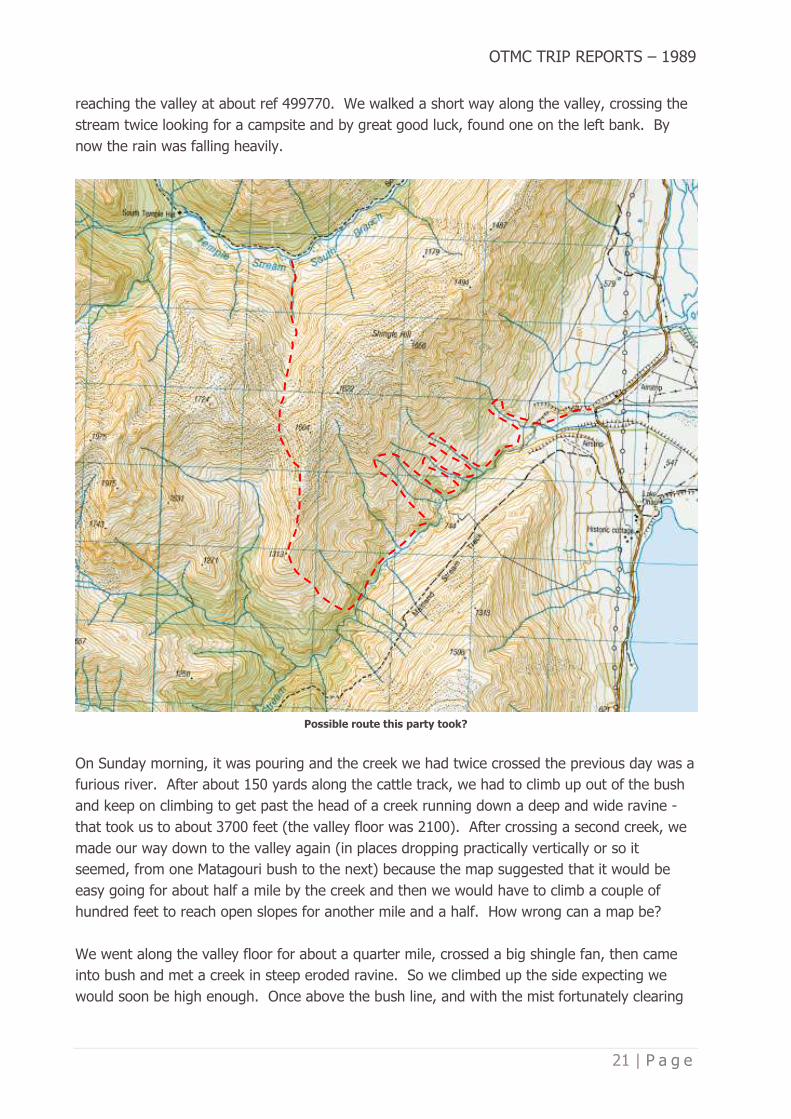
OTMC TRIP REPORTS – 1989
21 | P a g e
reaching the valley at about ref 499770. We walked a short way along the valley, crossing the
stream twice looking for a campsite and by great good luck, found one on the left bank. By
now the rain was falling heavily.
Possible route this party took?
On Sunday morning, it was pouring and the creek we had twice crossed the previous day was a
furious river. After about 150 yards along the cattle track, we had to climb up out of the bush
and keep on climbing to get past the head of a creek running down a deep and wide ravine -
that took us to about 3700 feet (the valley floor was 2100). After crossing a second creek, we
made our way down to the valley again (in places dropping practically vertically or so it
seemed, from one Matagouri bush to the next) because the map suggested that it would be
easy going for about half a mile by the creek and then we would have to climb a couple of
hundred feet to reach open slopes for another mile and a half. How wrong can a map be?
We went along the valley floor for about a quarter mile, crossed a big shingle fan, then came
into bush and met a creek in steep eroded ravine. So we climbed up the side expecting we
would soon be high enough. Once above the bush line, and with the mist fortunately clearing

OTMC TRIP REPORTS – 1989
22 | P a g e
for a while we saw that the hillside was totally blocked by two deep ravines, the only way was
to climb above them. So back up to well over 3000 feet again and the contours on the ground
bore very little relation to those on the map. In all, there are five long and deep ravines on
that stretch of hillside, none of them marked on the map. The first three have to be
circumvented, the other two can be crossed some way below their tops. So altogether, what
should have been two and a half miles along the valley, took us six hours of hard work. It
would have been better to have stayed high all the way - and we might have profited from
studying aerial photographs, rather than relying only on the map.
Looking from the Maitland towards the South Temple, this party crossed over in this area
(PHOTO by Antony Pettinger)
Moir says that the best way along the Maitland is high up on the right bank. We kept looking
there, whenever the mist allowed and the track is very clear, but it also seemed clear that it
would be impossible to reach it from anywhere along the valley floor. So if we had happened
to camp on the right bank of the stream, we might have had a very long and damp wait till the
creek subsided!
The rest of the story - how we came to a motel, provided warmth, shelter and cups of tea to
over a dozen soaked trampers, and finally returned to Dunedin on the Monday by ‘bus and
thumb’is irrelevant to tramping. Thanks Brian for your company and support and sincere thanks
to Trevor Pullar who organised the food and our sympathy that he couldn’t be with us.
Chris Ehrhardt for Brian Laws.

OTMC TRIP REPORTS – 1989
23 | P a g e
BUSHCRAFT 1989 – SILVER PEAKS WEEKEND
February 25-26, 1989
Author: Mike Jaket
Published in Bulletin 476, April 1989
Our four ‘man’ party for this weekend comprised of our leader Michelle (Mountain Goat)
Williams and three ‘bushcraftees’, Lindsay Aitcheson, Chris Wild and myself, Mike Jaket. Our
pre-tramp meeting lasted two hours where we discussed the tramp while downing some of
Lindsay’s well known home brew. That set the atmosphere for the tramp proper.
On Saturday morning we were dropped off on the motorway at Leith Saddle and walked up the
new Leith Saddle Walkway to Swampy Summit. The weather was perfect with brilliant
sunshine and a very light breeze. On Swampy we picked out a few landmarks and set off along
the track past Hightop and round to the clearing at Green Hut where we stopped for lunch and
discovered our first oversight. No one had brought a decent knife, excluding the two-
centimetre job on Lindsay’s pocketknife. Not a problem, the only problem we could see was
that Michelle ran the risk of drowning in her honey sandwiches if she wasn’t careful!
On the climb to Pulpit Rock the party was showing definite signs of wear and tear and slowed
up a few times for air and to cool down while being budgeted by our intrepid leader (the one
with the yellow brolley and the sharp point) to keep going. We dropped our packs on the track
just below the top and walked up to the top of Pulpit Rock. Arthur Blondell came bounding up
the hill and caught us in about four strides. At the top we were covered in flying ants which
were harmless enough but there were too many of them for comfort. They were flying from
the highest peaks on the hills.
From Pulpit Rock we made our way past the Painted Forest and down the Devils Staircase. At
the bottom we turned right up the valley and pitched our fly under a stand of large Manukas
and Beech Trees. After a walk past other campsites to Jubilee Hut we got down to cooking tea
while taking advantage of the chilled refreshments that had been cooling in the stream. Later
on that chocolate cheesecake went down well too. We spent a couple of hours swapping
stories and telling jokes. If you get the chance, ask Michelle to tell you the real story of
Cinderella and the Pumpkin.
At night a few glow worms lit up on the far bank and two of us decided to sleep out in the
open. One hardy soul in our party didn’t even bother to take a sleeping mat - next time I’ll
know better! Glancing at the map, our first day looked to have been a long one and Sunday’s
trip seemed fairly easy in comparison. Should have used those bushcraft skills and had a closer
look at the contour lines. We got underway about 8.30am and worked up the far side of the
valley to Hermits Cave - ‘worked’ and ‘up’ being the two operative words. Even Michelle was
complaining of sore balls by this time - it is all true, believe it or not.

OTMC TRIP REPORTS – 1989
24 | P a g e
Lindsay Aitcheson, Mike Jaket & Chris Wild outside Jubilee Hut, February 25, 1989 (Photo OTMC Archives)
Once up on the ridge we headed north. Any query on direction was met with the standard
‘don’t ask me, I’m following you guys’ Our only hint was when she stopped and stood
still. After a while we would realise someone was missing (the chatter had stopped), turn back
and reassess the situation. We left our packs on the ridge and did a quick inspection of ABC
Cave then onto The Gap and back to our packs for lunch. From there we set a good pace
down Yellow Ridge but were passed by Alistair Metherell’s party who were virtually running.
We cooled off down at the Waikouaiti Stream where Lindsay ‘never dare me to do anything’
Aitcheson then picked up our intrepid leader and, despite her protests, dropped her right in the
middle of the pool - and she reckons we gave her a hard time. After all the posing in the
stream for a photo we headed up the Tunnels Track to meet the bus, still with half an hour to
spare. This turned out to be a really enjoyable weekend with a good solid tramp with warm
weather and good company. When’s the next one?!
By Mike Jaket

OTMC TRIP REPORTS – 1989
25 | P a g e
LAKE OHAU TWO/THREE DAY TRIP
March 11-13, 1989
Author: Lindsay Aitcheson
Published in Bulletin 476, April 1989
Leader: Michelle (Mountain Goat) Williams
Co Leader: Russell Godfrey
Party: Mike Arnott, Mike Jaket, Lindsay Aitcheson
The bus arrived at the end of the road at approximately 12.30am and unlike other parties who
camped where the bus stopped, Michelle talked us into walking to Monument Hut and camping
there. Off we go in the rain and the dark of night. I think she found the hut more by good
luck than good management. We pitched our fly, tying one end to a BBQ table in front of the
hut.
Naumann Range from Elcho Stream, Mt Glenisla on left, Dasler Pinnacles with Mt Glencairn behind on right
(PHOTO by Antony Pettinger)
We were woken in the morning by a dog who came alone to have a good sniff. We set off for
Elcho Hut at about 8.30am. It was a waste of time putting on dry socks as they only stayed
dry for about 30 seconds. At Elcho Hut we pitched our fly in what we thought was a good dry
spot and headed off for a walk up Elcho Stream. We walked for half an hour through beech
forest, across a swing bridge then on till the track disappeared. By this time it had started
OTMC TRIP REPORTS – 1989
26 | P a g e
raining and lunch was had under a rock overhang, trying to keep dry. The rest of the day was
spent rock hopping up the side of the stream sometimes on avalanche debris. We came across
two climbers who were also sitting under a rock waiting on the weather to clear (they would
have a long wait). Through a gap in the cloud we managed a glimpse of the glacier at the
head of the valley.
We returned to Elcho Hut at about 5.30 to be met by Dave Levick and Doug Forrester’s parties
who offered us a hot Raro. Tea was cooked in the hut with the three parties trying to outdo
each other. By this time the rain was bucketing down and when it came time to hit the pit
Michelle said anyone sleeping in the hut was a wimp’ so armed with bivvy bags out our party
goes. It was hosing down and in the dark we had trouble finding the fly and I had visions of
wandering around the valley all night looking for it. I have become a fan of these Gore-Tex
bivvy bags (made by a Texan living in Gore so Dave Levick reckons). It is hard to get to sleep
with drips off the fly landing on your face and my sleeping bag did get a little wet but I didn’t
mind as I would be back in my own bed the next night - or so I thought.
In the morning we had a creek running down both sides of the fly and a dam behind
us. Russell’s boots were fill to overflowing so we went back to the hut for breakfast. Rhonda’s
rivercrossing at Tirohanga on the road came in handy only this time it was for real. What a
change in the rivers with rocks rolling down the Huxley making an eerie sound.
Back at Monument Hut the bus driver had been in on a four-wheel drive tractor and left a note
saying the bus was unable to negotiate the wash outs on the road and we would have to stay
the night at the hut. How intimate with seventeen in a six-bunk hut. Doug ‘the OLD buggar’ as
he seems to be known started playing silly games which seemed to fill in the hours. Time for
bed by double bunking with five on the floor (it looked a bit like sardines) but we all fitted
in. The Old Buggar tried to burn the hut down with his cooker and he was the guy talking
about safety with cookers at Tirohanga!
Monday was spent waiting on other parties to come out. The two words to describe the trip
would WET and LATE but a very enjoyable and educational end to the bushcraft
course. Thanks to Michelle, Russell, and the members of the tramping club. I am looking
forward to my next trip.

OTMC TRIP REPORTS – 1989
27 | P a g e
MAUNGATUA TRAVERSE
April 2, 1989
Author: Pam Cocker
Published in Bulletin 477, May 1989
Sunday morning dawned cool, windy and cloudy. Let’s cancel this day trip and get some more
beauty sleep. Can’t do that, the phone rang all yesterday with interested day-trippers so by
9am at the clubrooms we arranged 14 people into two cars and a van and headed for
Maungatua, collecting Doug at the Wine Shop and meeting Kathy and Chris at Outram in their
car. One car was parked at McKendry Road and three went on with all trampers aboard to
Wesleydale Camp at the Southern end.
On and up through the bush with a couple of sightings of Strikemasters in training at
Momona. As soon as we left the bush it was on with the wind-proofs and up again. Good
views of the Taieri River and Plains in the earlier stages but the cloud ceiling, wind and cold
made our stops very brief and cameras remained packed away. Our lunch stop in a bushy
patch near the highest trig was also short and sweet. The Pinus Contorta that were growing on
the tops were sorry we hadn’t cancelled the trip. Passed a couple of tarns, not very inviting
and as we dropped at the Northern end views inland towards Middlemarch and Mosgiel area
made it seem as though we had covered a greater area. A 4-wheel drive road has been
pushed through and was easy to pick up and follow down to cross the stream on a new
bridge. A short map and compass exercise ensured we were on the right ridge to McKendry
Road (the road marked on the map does not meet up with the new 4-wheel drive road).
As we dropped the weather changed to warmth and sunshine and we rested in the grass at the
end of McKendry Road while our drivers collected the vehicles parked at
Wesleydale. Permission to cross land was obtained from Donald Phillips, a trustee from
Wesleydale and Ken Harrex of Horsehoof Station.
Pam Cocker (leader) for Glenda Swift, Neville Mulholland, David Barnes, Eric Callaghan, Laurie
Parker, Sharon St-Clair Newman, Garth Brown, Angela Pearson, Chris Rodley, Doug Forrester,
Kathy & Chris Pearson and the ones who ran away’ Ross Cocker, Megan Park, Lindsay
Aitcheson and Ken Mason.

OTMC TRIP REPORTS – 1989
28 | P a g e
MUELLER HUT, MT COOK
April 8-9, 1989
Author: Garth Brown
Published in Bulletin 477, May 1989
We headed off on a drizzly Mount Cook day up the Mueller track. Driving sleet necessitated us
wrapping up well. We stopped for a brief look at the Sealy tarns on the way up. On the ridge,
the wind was very strong, but the views of Sefton with the occasional avalanche made up for it,
and we battled onto the hut. Darcy, Peter and I then headed up onto Mt Ollivier for the first
views of Hicks, Malte Burn and the Minarets although Aorangi was still engulfed in cloud. We
picked our way down a rock chute and headed up as far as a snow pocket for some self-
arresting practice. The light was failing and so we returned to the hut which was packed with
16 people in total that night.
Aoraki Mt Cook and the Hooker Valley from Mt Ollivier (PHOTO by Antony Pettinger)
Strong winds and the occasional snow shower persisted until the early hours of Sunday
morning and the new day greeted us with clear skies and crystal-clear views of the alps. We
refrained from the urge to spend the day there basking in the sun and enjoying the view and
instead returned back down the track the way we had come. The views of the Hooker Valley
and beyond were superb and we finished our Mount Cook sojourn with an easy stroll up the
Hooker as far as the glacier lake.
Garth Brown for Darcy Espie, Jane Caldwell and Peter Swarbrick.

OTMC TRIP REPORTS – 1989
29 | P a g e
COPLAND AT EASTER
March 10-12, 1989
Author: Not recorded
Published in Bulletin 477, May 1989
Friday we woke in a lovely dry shelter at Pleasant Point Picnic area on the West Coast in low
mist. From here we had a two-hour drive to the start of the Copland Valley. It was a chilly
start as we crossed the first creek at 9.50am, the start of our trip.
Throughout the day we wandered through beautiful lush green native cedar and southern
rata. Along the where were many slippery tree stumps, over one I decided to take diving
lessons, headfirst. Landing with my feet up in the air and on my head. Everyone else thought
it was funny, except me. Lunch was had in the sun beside the Copland River, followed by Sue’s
squashed Easter eggs.
Copland Valley from the pass (PHOTO by Doug Forrester)
Arrived at Welcome Flats after an enjoyable stroll at 4.30pm and we set up camp on the old
unused airstrip. Lovely tea by Sue, then it was off to the natural hot pools for an hour in the
drizzle covered night. Saturday morning we waited for the rain to stop before venturing on at
9.50am. Weather cleared slowly as we meandered along Welcome Flats where we had
amazing views through the low cloud of the surrounding freshly covered snow peaks and of the

OTMC TRIP REPORTS – 1989
30 | P a g e
Lyttle Glacier. We arrived at Douglas Rock Hut in time for lunch at 12.30pm and from Douglas
Rock the track drifted int’s way up to the base of the Copland River where it ascended steeply
through tussock and rock.
By 6.30pm we all got quite cold and hungry so it was decided to build a flat camp spot at
5,100ft. After a warm cosy night we rose early to mist and drizzle despite a good weather
forecast (typical weather man!) So we decided from there it was a no go and we packed up
and raced back down to Douglas Rock Hut then onto Welcome Flats where we met Peter once
again.
Sue Harding and John Robinson in the Copland Valley, March 11, 1989 (PHOTO by Michelle Williams)
We pitched our tent then spent the rest of the night with the University Club in the natural hot
pools by candlelight. Sunday, for some of us, it was a four hour stretch back to the cars and
off home.
Thanks for a restful weekend, Sue Harding, John Robertson, Kerstin Mueller, Peter Mason and
Michelle Williams.

OTMC TRIP REPORTS – 1989
31 | P a g e
CASCADE CREEK – LIVINGSTONE MOUNTAINS
February 4-6, 1989
Author: Teresa Wasilewska
Published in Bulletin 477, May 1989
Having heard horror stories of badly marked tracks and knee deep bog up the East Eglington
and being faint hearted and lazy, I amended our initial route and we were unceremoniously
dumped at Cascade Creek late on Friday night, to wake seven hours later to the constant roar
of Works trucks going by every 90 seconds to the depot at the end of the road!
Start up the creek on the true right past the generator and along the pipeline track crossing the
creek on the pipe at one point, until the water inlet is reached. From this point we spent some
time in the creek bed and found new plastic markers in the areas where the track went through
bush. We reached the forks in under 1½ hours and crossed the South Branch just up from the
junction, bush bashing up the ridge to gain the trail again above the blue cliffs visible from the
forks. John spotted the old axe blazes, now well grown over, on some of the older trees along
the ridge and we followed them ever upwards and out of the bush. We lunched in the rain and
swirling mist, grabbing the map each time the mist rose momentarily and planned our route.
Head of Cascade Creek (PHOTO by Antony Pettinger)

OTMC TRIP REPORTS – 1989
32 | P a g e
After a side trip attempting to look into the East Eglington (the saddle is wide and boggy at the
base, we stayed high but couldn’t see very far) we headed up towards the Cascade Saddle - a
slow leisurely potter, gradually uphill through some soggy, boggy areas and tussock and
scrub. The weather gradually improved and our stops became more frequent to admire the
view and snooze in the sun and to discuss the meaning of Waitangi Day, explain the treaty to
our American companion . . . . Once on the saddle, the views into the Greenstone and over the
McKellar Saddle were spectacular, despite a strong cold wind. We tucked away in a little hollow
just on the Greenstone side of the saddle, Pam did champion work cooking tea in a billy whose
sides cooled as fast as the bottom heated! There is not a lot of shelter near the saddle, and we
kept our options open as to whether we would head down Williamson’s track into the
Greenstone. Despite waking up in the clouds the next morning we decided against going
down.
To avoid the bluffs beside the saddle, we climbed higher almost to the top of the ridge on the
Eglington side and meandered back and forth across the Livingstons looking down into
whichever valley was clear as the day went on. When the weather is clear there are some
wonderful vantage points and views from either side. As you get closer to Key Summit there
are good sized tarns with views either way. We picked up the track from Key Summit about ½
hour from the end and (after John and I decided that the plane table must be wrong because
we couldn’t find Hidden Falls Creek) descended via Pass Creek track to the Hollyford. There
are not many places to camp along the Hollyford Road and we found a small meadow just short
of Gunn’s Camp.
Monday dawned cloudless and we meandered up to Lake Marion for swimming and sunbathing,
somewhat disturbed by a low fly-over from the Helicopter Line! Rhonda’s party having stopped
for their hot showers at Gunn’s Camp made the pickup a little late. They then threatened
mutiny unless we stopped for food in Te Anau!
Teresa Wasilewska for Pam Bardsley, Dan Hummel and John Galloway

OTMC TRIP REPORTS – 1989
33 | P a g e
BUSHCRAFT HUXLEY WEEKEND
March 11-13, 1989
Author: Neville Mulholland
Published in Bulletin 477, May 1989
It all started with one small rain drop. We met in the usual place on the usual day at the usual
time for the usual reason. The single rain drop unfortunately multiplied and spread and
multiplied and spread.
The bus, on the way to Lake Ohau, was just as wet on the inside as it was on the outside due
to the condensation. We dropped into Oamaru to embarrass the locals then off to the Lake
Ohau road end we went. Surprisingly enough the rain was still falling when we joyfully leapt
off the bus and into the cold darkness. Almost as if overnight a small city had been formed
around the carpark and next morning it was still raining.
We got up really early (7.30am) and after doing the necessary house calls, we packed our gear
and roared off to Monument Hut. Unfortunately, we were pursued by a very noisy party
consisting of an elderly gentleman and three young ladies. By this time, it had stopped raining
and the rain stayed stopped until we got to Huxley Forks when, while we were having lunch
(outside the hut) it started really pissing down so my deputy (David P) said that since this was
a bushcraft trip we weren’t to use the hut so we finished our lunch and headed off up the North
Huxley to a campsite which David knew was 10 minutes from the bridge. We camped and
were in bed by 3pm as the weather did not really encourage the thought of more tramping.
By the next morning David’s summer campsite had become a leaky waterbed with half a food
of water under the tent floor. We packed and made a very hasty retreat to Huxley Forks Hut
only to find the track cairns had moved about five metres into the river, so we went up and
over the large land-slide. At the hut we found a group of LPHS people. We greeted Bill R’s
party then made for Monument Hut only to be confronted by a raging torrent which was only a
small side creek the day before. We nearly lost our dear president before deciding to turn back
for the hut.
After returning to the hut, along with Bill R and Les’s parties, we had a well appreciated hot
brew then went off to attempt to cross the side creeks again. We managed to cross the first
stream but then spent an hour trying to outwit the second. Eventually, as everyone was very
cold, we returned to the hut and resigned ourselves to the weather. By that time, we only had
half an hour to get to the bus and had decided that we were spending the night there. Later
that night while we were having what there was as our evening meal, Arthur B arrived from
Broderick where he had left his party. We spent the night in an overcrowded hut with wet
clothes and wet sleeping bags.

OTMC TRIP REPORTS – 1989
34 | P a g e
The Huxley Gorge, swing bridge in centre of photo (PHOTO by Antony Pettinger)
Next morning at 6.30am, Arthur returned to Broderick to collect his party. By now the weather
had cleared and the creeks had gone down, so we more or less made a run for it. We got to
the Huxley River bridge in an hour and a quarter instead of the two and a half hours on the
sign. Those of us who were expecting a very long walk out to Omarama were quite surprised
to see the bus and everybody else at the carpark. After a bit of relaxation, we piled on the bus
and went to make our pickups. When we got to Maitland, we were mildly concerned to find
that Mary H’s party had not shown up. They were eventually found and brought out to the
bus. On the road again but this was not the end of our fun because about ten minutes from
Omarama the bus tyre blew out. We got to Omarama where, at last, we had lunch (4pm) Off
home we went to waiting parents and families. Despite the weather and the unexpected extra
day, I enjoyed the weekend with great company. Thanks people!
By Neville Mulholland for David Peacock, Tiffany Hague and Sharyn Hellyer

OTMC TRIP REPORTS – 1989
35 | P a g e
MT COOK – MUELLER HUT
April 8-9, 1989
Author: Neville Mulholland
Published in Bulletin 478, June 1989
Our weekend started in the usual way, meeting at the clubrooms, etc. We stopped for tea in
Oamaru then onto Mt Cook. On our way past the Omarama pub we just happened to notice
Arthur, Shue, John, Michelle and Mark who later claimed they were only making a toilet stop.
We spent the night at the shelter at Mt Cook, where it rained. At about 8.30am on Saturday
morning we headed off for a leisurely stroll up to Mueller Hut, closely pursued by three other
parties. At the bottom of the track leading up to Mueller, Chris thought the sign pointing at the
steep hill had been turned around and so tried to turn it back.
Mt Cook Village and the confluence of the Hooker and Tasman Valleys, April 8, 1989 (PHOTO by Antony Pettinger)
We got to Mueller Hut at about 11.30am where, after walking all the way around the hut, we
found the door and went in. In the hut we found a person by the name of Phil who was not
too pleased to see nine dirty, wet, cold and noisy bodies intruding into what, till then, had been
his privacy, then hearing that eight more were on the way.
We had lunch and decided that we didn’t really want to go further considering the wind was
blowing quite hard. Arthur’s party went on to find a camp spot on the ice plateau. Antony,

OTMC TRIP REPORTS – 1989
36 | P a g e
Debbie and just about everyone else went out for a wander along the ridge leaving the lazy
ones among us alone in the hut.
We started cooking tea at about 5p, so as to get it finished before everyone else did the
same. The aroma in the room was not of some fancy perfume but that of kerosine cookers
that were operating. Phil and Chris managed to keep each other amused by trying to see who
would be the first to create the smokeless fart, much to our disgust!?! We all finally got to
sleep after a difference of opinion over sleeping arrangements.
Mueller Hut and Aoraki Mt Cook, April 8, 1989 (PHOTO by Antony Pettinger)
Next morning, after defrosting the billy, which had been filled with water and left outside to
soak but instead froze, we had breakfast with real milk which had been left by some kind
human beings who had gone ten minutes earlier. With clear, sunny skies above, we all stood,
sat or lay and admired Mt Cook and the rest of the view. The general consensus seemed to be
that the toilet should be rotated 90 degrees anti-clockwise so that patrons could look at Mt
Cook, and not the Hermitage.
We tidied the hut, after the others had left, then we, ourselves were away. In the valley, once
again we dropped our packs and went for a walk to Kea Point to see why everyone else was
going there, then back to our packs for lunch. After lunch the lazy one among us stayed to
mind the packs and catch some sleep while Antony, Debbie and Chris went wandering again.
On arriving back at the shelter, we found no one there so we went to visit the Hooker Bridge
just to see why everybody else was going there. We made a hasty retreat when we noticed an

OTMC TRIP REPORTS – 1989
37 | P a g e
old guy approaching the party in tow. Back at the van we waited for Andrew and Graham to
show up then headed off to Twizel for tea and onto to Dunedin.
I would like to say thank you guys for a great weekend, but I would be lying. Thanks guys!
L-R Chris Wild, Debbie Williams and Neville Mulholland, with the upper Mueller Glacier beyond, April 9, 1989
(PHOTO by Antony Pettinger)

OTMC TRIP REPORTS – 1989
38 | P a g e
WAITANGI WEEKEND – THE TRIP THAT WASN’T
February 4-6, 1989
Author: Debbie Williams
Published in Bulletin 478, June 1989
It was raining when we left Dunedin, however at the Gore pie cart the weather looked slightly
more promising and we arrived at Mistake Creek/Hut Creek drop off the stars were looking
down on us. U Pass, Glade Pass and Dore Pass here we come!
We woke on a slightly overcast day and it was cold feet first thing with the bridge over the
Eglington no longer there. David determined not to have wet socks so early crossed the river
without them. Then it was an easy walk up Mistake Creek. The track was washed away in
places or that was David’s excuse for losing the track. It was lunch at the turn off to U Pass
and the weather was not looking good. The mist was rolling up the valley but ‘up and over’
was the vote. The way up to the waterfall is not marked but easy to negotiate. The true left
side of the waterfall is recommended but was very wet.
Campsite in head of Hut Creek, February 5, 1989 (PHOTO by Antony Pettinger)
A hail storm at the top made sure we didn’t get to enjoy the view and onto the top of U
Pass. It’s a very obvious pass and the heavy rain and hail cleared at the top long enough for a
rest and look around, then it was down. Boulder hopping all the way to Hut Creek. We found
the only campsite close to Glade Pass turn off while tea was being made, a debate was started
on the idea of carrying on our intended trip if the weather continued the way it was. Our party

OTMC TRIP REPORTS – 1989
39 | P a g e
leader had heard that Glade Pass was tricky if the route was not decided on from a distance. A
party following arrived to find an uncomfortable but adequate site to pitch their tent. Our
heartfelt sympathies to them.
It was an early night, and we woke to more mist and after deciding that we couldn’t see the
other side of Hut Creek let alone the route to Glade Pass, there was no doubt in our minds that
we were not going any further. So, the only female was thrown out of the tent to make a cup
of tea. The other party had packed up and were heading off in search of Glade Pass. We
wished them luck and then continued on with breakfast. After packing up we headed down
Hut Creek with the intention to stay at Cascade Creek. The track to the top bush is on the true
right of the riverbank. It gets slightly obscure due to a fall of trees and comes out of the bush
near a cairn on the other side. It is gentle meander down the riverbed to the second lot of
bush where the opening of the track is a long way up the riverbank and is close to the true left
side of the valley. The track is clearly marked from here except when it crossed a dried-up
riverbed, however there is a track marker down the river bed and it enters the bush just behind
a tree with a marker on it.
We had lunch by the Eglington River and then a hard pound down the road to Cascade
Creek. Our camp for the night was the picnic spot and while we were brewing up tea, the
other party appeared. After a discussion about the hopelessness of trying to navigate Glade
Pass in misty weather we headed to Cascade Downs for refreshments. Monday dawned fine
and promised to be hot. The other party decided to go for a walk to Cascade Creek Saddle
while our party elected to have a lazy day by the tent. David had us running to the toilet for
endless cups of tea. How many was it David? Eight or more? The day really heated up and all
our wet gear dried out and we packed ready for the van.
It arrived late and once again we squashed in and waited for the other van, which did not
show. A run up the road and we found them on their way back to Cascade Creek, something
about a muck up with the meeting place but at 6pm we were off to the Gore Pie Cart and then
back to Dunedin. An enjoyable weekend, thanks to Robert Sinclair, David Peacock and Antony
Pettinger. By Debbie Williams

OTMC TRIP REPORTS – 1989
40 | P a g e
CANYON CREEK TO AHURIRI & LITTLE CANYON
CREEK
April 22-23, 1989
Author: Garth Brown
Published in Bulletin 478, June 1989
Canyon Creek to Ahuriri (Saturday)
We headed up the hill above the Canyon itself for spectacular views of the Canyon Creek
Valley. Carrying only day packs we made quick progress over the flats and up the cairns track
on the true right of the wall to the hanging valley itself. The waterfall cascading down into the
lower valley was beautiful. The Canyon Creek Valley never ceases to leave me inspired -
National Park quality? A little more snow on Mt Barth now than when I was last here in early
March.
We were soon at the rock bivy for a chocolate stop before heading eastwards up to the saddle
tarns halfway up the valley side going up to the saddle (MR343752 on S99) - an ideal place to
camp. We had lunch at the head of the side stream which flows down into the Ahuriri. We
then headed on down the eastward running ridge between the two streams (MR360750) to
come out in the valley where the Ahuriri flows close to its true right bank. The views as we
came down of Watson Stream, Mt Maitland and of the upper Ahuriri were superb in the
afternoon light. A couple of us took superb tumbles skidding down the steep loose debris of
the beech forest floor; no damage done though. A gentle meander back down the valley past
Shamrock Rock to our camp in the Canyon Creek confluence in a round trip tie of just under 8
hours.
Little Canyon Creek (Sunday)
The trick of getting into Little Canyon Creek is to cross Little Canyon Creek just above the
confluence and then to traverse on the true left to avoid the gorge as follows: after crossing
the creek move around to the right skirting the outcrop in the bush and then climb about 150
feet (but not go too high), then sidle back down to the valley. Time to where the valley opens
out and the scree starts is about 2½ hours. The sheer pinnacled sides of the Little Canyon
Creek are spectacular indeed. The tarn up on the true left of the valley looks like a way
through to Canyon Creek.
We climbed up to the head of Little Canyon Creek and over a short way down the other side for
views of the Hunter River disappearing in either direction as far as the eye could see. We could
pick out Trent Peak, Mt Brewster and Ferguson, the Wills Pass and the Melville Glacier. Back in
the canyon confluence with exhilarating scree sliding en-route in a round trip time of about 7
hours.

OTMC TRIP REPORTS – 1989
41 | P a g e
Canyon Creek, OTC Easter Trip 1959 (PHOTO by Ron Keen)
Thanks to Laurie for superbly organising and cooking the food and to John Galloway for
organising and leading the trip. Garth Brown for John Galloway, John Warburton and Laurie
Parker.

OTMC TRIP REPORTS – 1989
42 | P a g e
HOMER AREA – WAITANGI WEEKEND
February 4-6, 1989
Author: Sue Levick
Published in Bulletin 479, July1989
Two van loads headed away to Homer Hut on Friday. We arrived at the hut at about 1am after
an uneventful trip. In the morning we had a rather late start as we tried to decide what the
weather was going to inflict upon us. Eventually we set off up the valley in cloudy, showery
weather. We planned to climb up to Gertrude Saddle and then on to Barrier Knob. We arrived
at the saddle at about 3pm and stopped for lunch.
Gertrude Valley from Barrier Knob (PHOTO by Antony Pettinger)

OTMC TRIP REPORTS – 1989
43 | P a g e
We had time for about a 10-minute snooze in the sun before the rain pelted down. As it
showed no signs of letting up, we decided the best course of action was retreat!
Milford Sound and Mitre Peak from Barrier Knob (PHOTO by Antony Pettinger)
Sunday was grotty so it was spent as a pit day, however Monday dawned brilliantly fine, and
we decided to take a trip up to Lake Marion. After about an hour and a half we saw the
lake. It looked so nice, so a few of the brave ones had a swim. A very relaxing weekend.
Sue Levick for Dave Levick, Tim Thomas and Wayne Redmond

OTMC TRIP REPORTS – 1989
44 | P a g e
AHURIRI VALLEY
April 22-23, 1989
Author: Lindsay Aitcheson
Published in Bulletin 479, July 1989
Party: Arthur Blondell, Michelle Williams, Mary Hewinson, Sharon St Clair Newman and myself
(Lindsay Aitcheson)
We left in the vans from the city as usual and with a fish & chip stop in Oamaru, then it onto
the Ahuriri Valley. The valley seemed to go on for miles (37km). We arrived at Canyon Creek
at about 11.30pm. We pitched our tent beside the van. Our intrepid leader Arthur and Mary
decided the back of the van looked more comfortable than the tent so Mary loaned me her
poofta pad (one of them could be next on my Christmas list).
OTC Climbing Party, Ahuriri Valley, Easter Trip, March 27-31, 1959 (PHOTO by Peter Barker)
The morning was crisp and clear. We had our first view of this little hill that Arthur wanted us
to climb. I thought ‘full frontal’ was women with no clothes on, not going straight up the front
of a mountain! The morning was spent mostly out of breath climbing this little hill. As we
climbed higher and higher the tussock changed to rock and the views we had of the valley
below became more magnificent. Lunch was had at about 5800ft being cooled by the wind off
the surrounding peaks. Time for a few photos then off down the other side. First off barrelling
down rock scree - GREAT STUFF. Then onto a rock face where Sharon and I had our fist go at
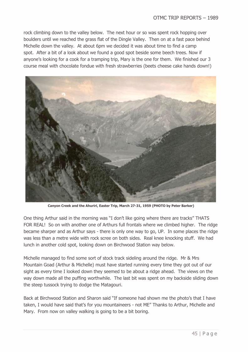
OTMC TRIP REPORTS – 1989
45 | P a g e
rock climbing down to the valley below. The next hour or so was spent rock hopping over
boulders until we reached the grass flat of the Dingle Valley. Then on at a fast pace behind
Michelle down the valley. At about 6pm we decided it was about time to find a camp
spot. After a bit of a look about we found a good spot beside some beech trees. Now if
anyone’s looking for a cook for a tramping trip, Mary is the one for them. We finished our 3
course meal with chocolate fondue with fresh strawberries (beets cheese cake hands down!)
Canyon Creek and the Ahuriri, Easter Trip, March 27-31, 1959 (PHOTO by Peter Barker)
One thing Arthur said in the morning was “I don’t like going where there are tracks” THATS
FOR REAL! So on with another one of Arthurs full frontals where we climbed higher. The ridge
became sharper and as Arthur says - there is only one way to go, UP. In some places the ridge
was less than a metre wide with rock scree on both sides. Real knee knocking stuff. We had
lunch in another cold spot, looking down on Birchwood Station way below.
Michelle managed to find some sort of stock track sideling around the ridge. Mr & Mrs
Mountain Goad (Arthur & Michelle) must have started running every time they got out of our
sight as every time I looked down they seemed to be about a ridge ahead. The views on the
way down made all the puffing worthwhile. The last bit was spent on my backside sliding down
the steep tussock trying to dodge the Matagouri.
Back at Birchwood Station and Sharon said “If someone had shown me the photo’s that I have
taken, I would have said that’s for you mountaineers - not ME” Thanks to Arthur, Michelle and
Mary. From now on valley walking is going to be a bit boring.

OTMC TRIP REPORTS – 1989
46 | P a g e
JIM FREEMAN TRACK – CRAIGLOWAN FALLS
(no date listed)
Author: Jane Bruce
Published in Bulletin 479, July 1989
Are you suffering from midwinter blues? Why not dash out for the afternoon and try this new
track that the Over Thirties Club opened on 4 June 1989?
Craiglowan Falls used to be a common destination for day trips. In the last few years only a
few diehards (like David Barnes) have known their location. The Over Thirties decided it was
time to remedy this situation. The track is dedicated to the memory of Jim Freeman, a life
member of the OTMC who died on 5 August 1987. Jim was a keen tramper and track-cutter all
his life, and formed the OTC in 1973 to keep the initials of the Otago Tramping Club alive.
Bottom end of the Jim Freeman Track (PHOTO by Antony Pettinger)
We parked our car at the Bull Ring carpark and walked up the road, now metalled, courtesy of
the environmentally unconscious DCC as far as the Flagstaff Reserve boundary. We took the
Ben Rudd’s track, which at one place used to pass through the edge of the pine
plantation. Now that the plantation has been logged, you have to climb over trees which the
contractor felled over the track and didn’t remove. A sign with a commemorative plaque has
been placed at the beginning of the Jim Freeman track. The track passes Ben Rudd’s spring
and then takes you downhill following the yellow and blue plastic ribbons.

OTMC TRIP REPORTS – 1989
47 | P a g e
Top end of the Jim Freeman track, not far from Ben Rudd’s Shelter (PHOTO by Antony Pettinger)
The route chosen is scenic rather than direct, so it crosses a stream - note the rhododendrons -
turns and sidles back through the bush. You may be lucky enough to see the odd pigeon and
parakeet. The track takes about half an hour and finishes at the Whare Flat Road. There is no
roadside marker at this bottom end. Turn left and go up the road about 200 yards to
Sanatorium Road. This isn’t signposted but you can’t miss it - it is a wide and very muddy
logging road with a gate across it. Definitely gumboot country.
The Craiglowan track starts from where the pine trees finish, at the very end of Sanatorium
Road. The beginning deliberately isn’t marked but you will see boot prints leading off the true
right. White cloth markers, and skid marks in the mud, lead down to a grovelly little
stream. Look for the huge totara on the opposite bank. You stay on the true right until you
reach the confluence with Craiglowan Creek then follow up the true left bank of this
stream. Nice ferns and astelias! Take a bit of care clambering over the boulders - Steve Aimes
(OTC) broke his leg here on the day the track was officially opened! The track crosses to the
true right and 20 yards further on you’ll find Craiglowan Falls. They are about 15 feet high, not
spectacular but worth visiting.
You can extend your trip by bush bashing up or down the creek of your choice to get out. We
wimps went back up Sanatorium Road and walked up Whare Flat Road back to the carpark
which gave us a round trip of about two and a half hours. Warm and muddy and not a trace of
midwinter blues left!
Jane Bruce for Paul and Sue Clark and Spen Walker.

OTMC TRIP REPORTS – 1989
48 | P a g e
HOOKER VALLEY
April 8-9, 1989
Author: Not recorded
Published in Bulletin 479, July 1989
What a great trip! The food was excellent (always muesli - yuk) - the weather was superb
(rained the first day, clouds to the valley floor), nice people (they actually pinched our whiskey
bottle and exchanged the contents for cold coffee mixed with cold soup and left over
dishwashing water - this was then offered to Doug and you should have heard his warm thanks
for the drink . . . “you blood b….ds!!) His face was movie quality!
Hooker Lake, photo taken from near the head (PHOTO by Antony Pettinger)
But seriously, it was a really great trip. The second day, Sunday, was full of sweat and
sunshine. We climbed or rather crawled up to the Copland Shelter in less than 2 hours (1 hour
59 minutes) Mark (named J90 for his qualities in locating big rocks in the mountains and
throwing them onto innocent glaciers), had a lot of fun improving the shape of Hooker Valley
and Doug showed us great leadership to find the way to the Copland Shelter. Somehow the
shelter had moved its location compared to previous years and we arrived much earlier than
planned. This gave us plenty of time to enjoy Mt Cook and the valley. Some crazy German
fellow took 101 pictures of Mt Cook. Typical tourist, camera under his coat - looked like a
pregnant woman according to some female expert in the group. Others took only a few
pictures less.

OTMC TRIP REPORTS – 1989
49 | P a g e
The track was wild enough to scare the hell out of a sidewalk trained city person, we had to
cross a few gullies hanging to nearly loose rocks, but thanks to the scouts this was really
enjoyable. The only problem was that after all that slippery fun a waterfall blocked our access
to the glacier. That of course did not stop J90 from going on the glacier, throwing rocks and
leaving his sand shovel as a souvenir for the next boy.
Copland Shelter, below Copland Pass (PHOTO by Doug Forrester)
The Saturday night in the Hooker Hut was also very educational with intellectual mind games,
for example: travelling to Mars without socks but with a jellyfish, and some people might have
nightmares about this as some strange couple trying to make love without waking up
everybody (not OTMC members). And the food was really not bad, chicken a’la kart with rice,
beans and soup and plenty of excellent bread and cheese supplied by a professional baker but
the best was the absolutely pink Mt Cook on Saturday night.
Trip rating: Very good and just right for a moderately fit to fit person.
Party led by Doug Forrester however author and party members names not supplied.
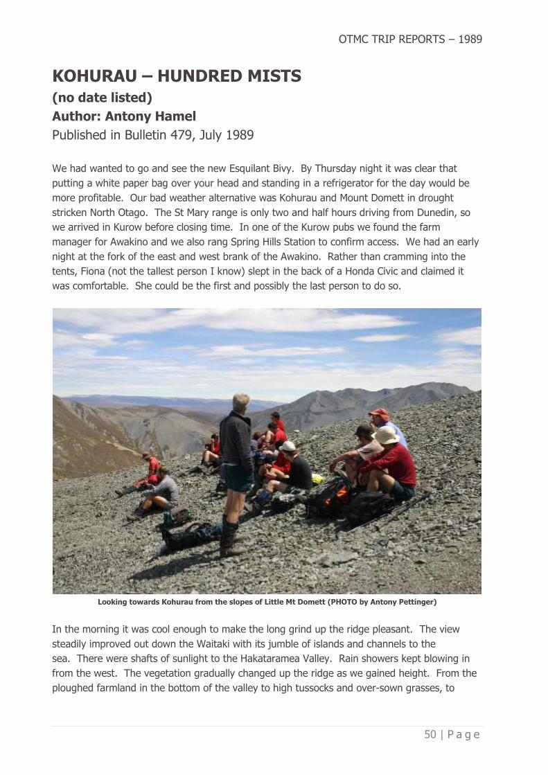
OTMC TRIP REPORTS – 1989
50 | P a g e
KOHURAU – HUNDRED MISTS
(no date listed)
Author: Antony Hamel
Published in Bulletin 479, July 1989
We had wanted to go and see the new Esquilant Bivy. By Thursday night it was clear that
putting a white paper bag over your head and standing in a refrigerator for the day would be
more profitable. Our bad weather alternative was Kohurau and Mount Domett in drought
stricken North Otago. The St Mary range is only two and half hours driving from Dunedin, so
we arrived in Kurow before closing time. In one of the Kurow pubs we found the farm
manager for Awakino and we also rang Spring Hills Station to confirm access. We had an early
night at the fork of the east and west brank of the Awakino. Rather than cramming into the
tents, Fiona (not the tallest person I know) slept in the back of a Honda Civic and claimed it
was comfortable. She could be the first and possibly the last person to do so.
Looking towards Kohurau from the slopes of Little Mt Domett (PHOTO by Antony Pettinger)
In the morning it was cool enough to make the long grind up the ridge pleasant. The view
steadily improved out down the Waitaki with its jumble of islands and channels to the
sea. There were shafts of sunlight to the Hakataramea Valley. Rain showers kept blowing in
from the west. The vegetation gradually changed up the ridge as we gained height. From the
ploughed farmland in the bottom of the valley to high tussocks and over-sown grasses, to

OTMC TRIP REPORTS – 1989
51 | P a g e
shorter tussocks and finally scree and rock fields. By 1700 metres the vegetation was really
hammered. There were small patches of snow in sheltered gullies but otherwise the top looked
like the face of the moon. In places the rock expanse has strange vegetable blobs and rock
alignments. We obtained a good view of the Awakino Ski Field. There were occasional sounds
coming from the valley as somebody was tinkering in one of the buildings. To the south the Mt
Buster gold diggings were clearly visible as a light golden area against the dark gloom of the
surrounding hills. The weather was steadily closing in and restricting the view.
Kohurau is surprisingly high at 2010 metres and is shaped like a buttock with a 100-metre
pimple. Unlike Domett you could easily push your grandmother in a wheelchair onto the
rounded top. Someone has made a low rock-walled shelter just off the summit but was clearly
a mad place to attempt to camp for the night. The descent into Hut Creek was frustratingly
slow over the ankle twisting rock terrain. Wind and rain lashed through the holes in my
coat. It didn’t help that Marie had to change into her running shoes because her boots had
started to pinch her tendon. This was despite having stuck a milk bottle into the boots for
three days to try and reshape them. In a hopeful fashion we camped in the top of Hut Creek
so that we could go on to Mount Domett on Sunday. For some time I tried to convince David
there was enough room in his Olympus tent to sleep three. I thought sharing his tent with
Fiona and Marie would convince him of this but the grumblings in the morning proved
otherwise. Mist, iced up tussocks, cold drizzle; Sunday morning in drought stricken North
Otago. Kicking an iced covered tussock with resulting crash and tinkle of tice is very
satisfying. Winter does make these hills a far more interesting place to be.
The previous cursing at the scar of the four-wheel drive track was quickly replaced by the
realisation that we could walk out by lunchtime using the track. It was quick and there was no
chance of getting lost in the freezing fog. I was even back in town early enough to summon up
the energy to go see the Return of the Killer Tomatoes and Lust in the Dust on Sunday night at
the Film Festival. All in all a good weekend.
Antony Hamel for Michael Hamel, David McFarlane, Marie Drury and Fiona McLeod.

OTMC TRIP REPORTS – 1989
52 | P a g e
WEST MATUKITUKI TRIP
May 6-7, 1989
Author: Sharon St Clair-Newman
Published in Bulletin 480, August 1989
After an uneventful trip from Dunedin by van we arrived at the car park to set up for our first
night. Ian had a fly, large enough to accommodate a small circus if required so we spent the
night in spacious luxury, or rather four of us did as one of our party decided the van looked
more comfortable. The rest of us were treated to ‘Savoury Toast’ for supper, just a sample of
what Diane had lined up for our food for the weekend.
Shovel Flat, West Matukituki Valley (PHOTO by Antony Pettinger)
We woke up to a cold but fine morning and after the usual preparations and breakfast we set
off for Liverpool Bivvy. After a fairly leisurely walk up the valley, taking time out for photos and
taking advantage of Ian’s seemingly inexhaustible supply of local knowledge, we arrived at
Aspiring Hut at about 11.15am for an early lunch. We sat in the sun admiring Mt Aspiring while
we feasted on more of Diane’s fare - individual salad rolls, marinated chicken nibbles followed
by homemade Muesli Square. After a longer than usual lunch break (due mainly to the amount
we ate coupled with the company of other parties and the sun) we set off once again. This
turned out to be a very pleasant afternoon, with beautiful sections of forest followed by small
river flats and a very warm, windless day.
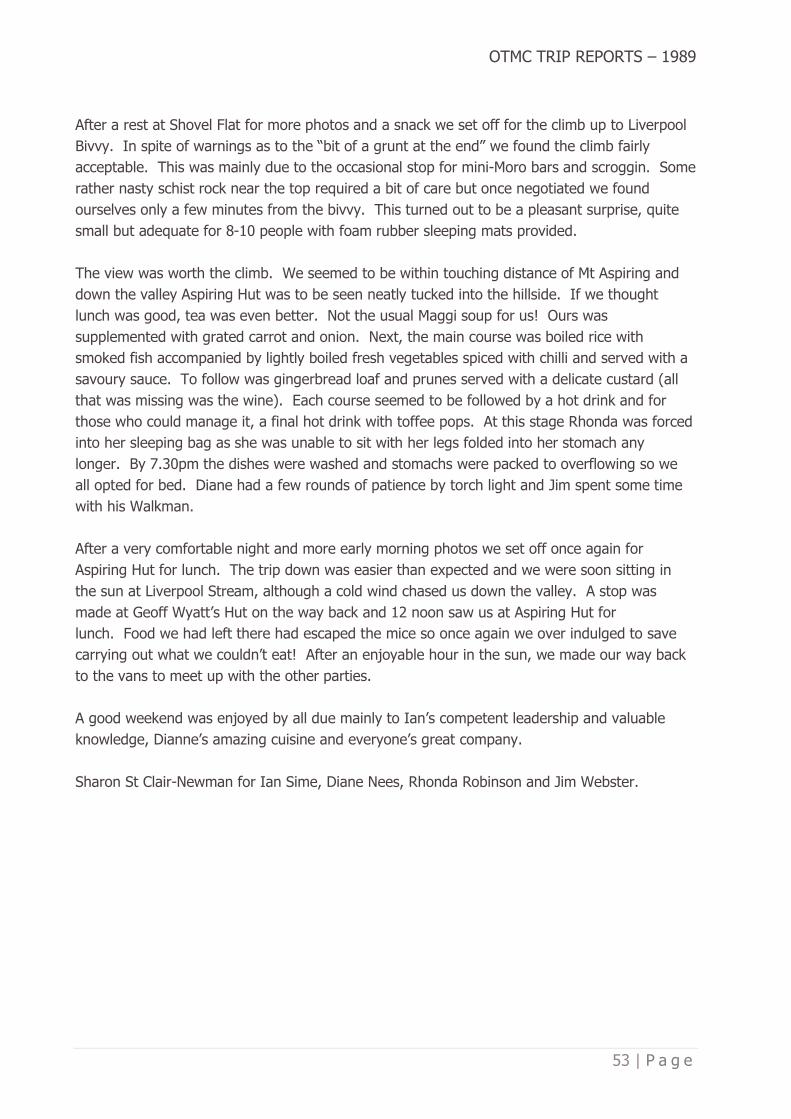
OTMC TRIP REPORTS – 1989
53 | P a g e
After a rest at Shovel Flat for more photos and a snack we set off for the climb up to Liverpool
Bivvy. In spite of warnings as to the “bit of a grunt at the end” we found the climb fairly
acceptable. This was mainly due to the occasional stop for mini-Moro bars and scroggin. Some
rather nasty schist rock near the top required a bit of care but once negotiated we found
ourselves only a few minutes from the bivvy. This turned out to be a pleasant surprise, quite
small but adequate for 8-10 people with foam rubber sleeping mats provided.
The view was worth the climb. We seemed to be within touching distance of Mt Aspiring and
down the valley Aspiring Hut was to be seen neatly tucked into the hillside. If we thought
lunch was good, tea was even better. Not the usual Maggi soup for us! Ours was
supplemented with grated carrot and onion. Next, the main course was boiled rice with
smoked fish accompanied by lightly boiled fresh vegetables spiced with chilli and served with a
savoury sauce. To follow was gingerbread loaf and prunes served with a delicate custard (all
that was missing was the wine). Each course seemed to be followed by a hot drink and for
those who could manage it, a final hot drink with toffee pops. At this stage Rhonda was forced
into her sleeping bag as she was unable to sit with her legs folded into her stomach any
longer. By 7.30pm the dishes were washed and stomachs were packed to overflowing so we
all opted for bed. Diane had a few rounds of patience by torch light and Jim spent some time
with his Walkman.
After a very comfortable night and more early morning photos we set off once again for
Aspiring Hut for lunch. The trip down was easier than expected and we were soon sitting in
the sun at Liverpool Stream, although a cold wind chased us down the valley. A stop was
made at Geoff Wyatt’s Hut on the way back and 12 noon saw us at Aspiring Hut for
lunch. Food we had left there had escaped the mice so once again we over indulged to save
carrying out what we couldn’t eat! After an enjoyable hour in the sun, we made our way back
to the vans to meet up with the other parties.
A good weekend was enjoyed by all due mainly to Ian’s competent leadership and valuable
knowledge, Dianne’s amazing cuisine and everyone’s great company.
Sharon St Clair-Newman for Ian Sime, Diane Nees, Rhonda Robinson and Jim Webster.

OTMC TRIP REPORTS – 1989
54 | P a g e
MATUKITUKI WEEKEND
May 6-7, 1989
Author: Darcy Espie
Published in Bulletin 480, August 1989
On Friday, 5 May at about 6pm everyone on the Matukituki weekend left Dunedin in two vans
and arrived at the end car park after midnight. The next morning we left at about 8.30am and
headed up the West Matukituki. Our first climb of the day took us past Bride’s Veil Waterfall
and up to the tarns immediately below the Shotover Saddle. We took photos and had scroggin
stops on the way up and climbed about 5000ft.
Brides Veil Waterfall, West Matukituki Valley (PHOTO by Antony Pettinger)
About 1.30pm we left our packs and tramped up to Red Rock and continued on the rocky,
gravelly scree ridge to a high point which was approximately 6700ft. This was a flat ledge on a
ridge below Mt Tyndall. Looking beyond, you could see Forks Hut and the Shotover River. We
arrived back to our packs before dark to set up camp and cook tea. It was a starry, frosty
night and the keas were out in flight.
We awoke to frosty boots - couldn’t wait to get going. We climbed an unnamed peak between
Tyndall Stream and Tummel Burn and at the top we saw jagged cliffs that looked like the
Organ Pipes. Looking down into the Tummel Burn we spotted five thar. On the way back to
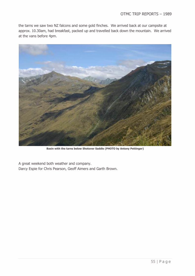
OTMC TRIP REPORTS – 1989
55 | P a g e
the tarns we saw two NZ falcons and some gold finches. We arrived back at our campsite at
approx. 10.30am, had breakfast, packed up and travelled back down the mountain. We arrived
at the vans before 4pm.
Basin with the tarns below Shotover Saddle (PHOTO by Antony Pettinger)
A great weekend both weather and company.
Darcy Espie for Chris Pearson, Geoff Aimers and Garth Brown.

OTMC TRIP REPORTS – 1989
56 | P a g e
TROTTERS HUT WINE & DINE
July 1-2, 1989
Author: Doug Forrester
Published in Bulletin 480, August 1989
With another mid-winter wine and dine behind us I would like to thank those who came for
supporting it. 26 wasn’t too bad I guess, we would have liked more, perhaps next
year. Special thanks to David, El Presidento for organising everything. Thanks also to Peter
Mason, a very handy and obliging fella is Peter, nothing seems to be a problem. He did a
“Crumpy” with his ute and delivered the wood, coal and incidentals. 1am Sunday and no doubt
about it he was the brightest light around, spotted him again about 11am and the light seemed
to have dimmed considerably.
I suppose I’ve got to thank the Chief Guide for piggy backing me through the fords, even
though he and his girlfriend went a bit funny about me leaving my pack on. There are certainly
some strange people around.
OUTC’s Trotters Gorge Hut – it is better than it looks! (PHOTO by Antony Pettinger)
Trotters Hut is a good venue, it is cheap, it’s roomy, it’s warm and it’s handy. The weather was
perfect. The volleyball was of a very high standard (the best team lost). The night was also
terrific. I was particularly impressed with Arthur Blondell’s “Broomstick on the wall” trick. I

OTMC TRIP REPORTS – 1989
57 | P a g e
think we need to look a bit harder at the music we have. I worked out the average age on
Saturday night to be 30 (boy they’ll be scrambling for pen and paper on this one). Admittedly I
had to give some of the ladies the benefit of the doubt of a few years. So surely we need more
popular songs, perhaps some enterprising bod might tape the best of the “Top Nine at 9” , 4X0
over a few weeks. You young ones must realise that we are not all into heavy metal. There
has to be a compromise guys. It’s not a bad dancing area, so let's encourage it and all enjoy
the music.
And so to next year, what about it, do we go back or look for somewhere different? We need
some feedback on this so tell your committee. Also how about a summer BBQ there? It’s a
great spot in the summer, perhaps instead of the club picnic in February, bring the kids, ma-in-
law or your local MP. stay the night and amble off home in the morning. We need your
thoughts so tell us.
DF for all those happy mid winter-nites.
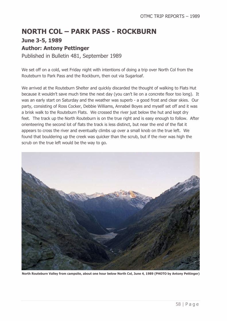
OTMC TRIP REPORTS – 1989
58 | P a g e
NORTH COL – PARK PASS - ROCKBURN
June 3-5, 1989
Author: Antony Pettinger
Published in Bulletin 481, September 1989
We set off on a cold, wet Friday night with intentions of doing a trip over North Col from the
Routeburn to Park Pass and the Rockburn, then out via Sugarloaf.
We arrived at the Routeburn Shelter and quickly discarded the thought of walking to Flats Hut
because it wouldn’t save much time the next day (you can’t lie on a concrete floor too long). It
was an early start on Saturday and the weather was superb - a good frost and clear skies. Our
party, consisting of Ross Cocker, Debbie Williams, Annabel Boyes and myself set off and it was
a brisk walk to the Routeburn Flats. We crossed the river just below the hut and kept dry
feet. The track up the North Routeburn is on the true right and is easy enough to follow. After
orienteering the second lot of flats the track is less distinct, but near the end of the flat it
appears to cross the river and eventually climbs up over a small knob on the true left. We
found that bouldering up the creek was quicker than the scrub, but if the river was high the
scrub on the true left would be the way to go.
North Routeburn Valley from campsite, about one hour below North Col, June 4, 1989 (PHOTO by Antony Pettinger)

OTMC TRIP REPORTS – 1989
59 | P a g e
We had lunch on the flats and continued up the river. When you come to a bend, the easiest
route is straight towards the col, leaving the river. There are a couple of cairns on the
way. We climbed steadily, coming across a couple of tarns. We camped at a good bivy rock
(grid approx. 131 147 on Tutoko map). After having fun putting up the tent (with two of the
shock cords being four inches longer than the poles) we cooked tea in the biv and then had an
early night.
Mt Madeline and Mt Tutoko from North Col, June 4, 1989 (PHOTO by Antony Pettinger)
OTMC TRIP REPORTS – 1989
60 | P a g e
We got up at 6.30am the next morning to another fine and frosty morning. We quickly packed
up and set off for the col. We basically picked our way through rocks and stood on the col one
hour later. We encountered very little snow, but the ice waterfalls were impressive. We then
sidled around keeping our height till we got to Lake Nerine. We lunched in the sun by one of
the lakelets, but the sun soon dropped, and the temperature must have dropped below zero
and we were on our way around the bluffs above the Rockburn valley. After some hairy
traverses we ended up on the ridge which we then had to sidle in order to reach Park Pass. It
had been a long day and we still had a long way to go. However, we took time off to sit in the
sun and eat our sponge cake, it really boosted morale quickly and it didn’t take long before we
were on Park Pass with the bushline in the Rockburn being our destination. We arrived just on
dark and quickly had tea and were in bed ready for another early start.
Debbie Williams at a cold Lake Nerine, June 4, 1989 (PHOTO by Antony Pettinger)
We left at 7.30am and made good time to Theatre Flat although we did not have time to fully
appreciate the Rockburn. We lunched at Sugarloaf track turnoff and then in glorious weather
we ambled over the pass and down to the vans - three minutes before the due time.
It was one of the best trips I have ever done and would recommend it to anybody as a trip well
worth your while. My thanks to the party for an enjoyable trip.
Antony Pettinger for Ross Cocker, Debbie Williams, Annabel Boyes

OTMC TRIP REPORTS – 1989
61 | P a g e
CHINAMAN’S HUT
July 15-16, 1989
Author: Darcy Espie
Published in Bulletin 481, September 1989
On Friday, 14 July six of us in 2 cars headed to North Otago for tea in Palmerston and arrived
at Blanchards farmhouse at Beatties Hill at 9pm. They arranged for us to stay the night in their
shearers hut, a luxury we greatly appreciated as we watched television and used their electric
range.
It was a clear moonlit night, so it wasn’t surprising we had to slosh hot water over the
windscreens to clear them at 7am before heading up the road for half an hour towards Danseys
Pass. we parked under trees near a shearing shed and farm hut to escape the expected frost
on Saturday night. The route followed a fence line, then across tussocks and down a sheep
track to the Otekaieke River. About an hour from the cars we reached a major junction. The
leading group of four walked on up the true right branch till they realised by looking at their
map they were heading in the wrong direction. They returned to the junction and then
reached Chinaman’s after only another 10 minutes. They were still there before the slower pair
arrived.
Chinaman’s Hut in the Otekaieke River (PHOTO by Antony Pettinger)
The fast 4 who hoped to climb Mt Domett dumped all their gear except proactive clothing, ice
axes and lunch and tramped upstream to a large rock outcrop. Opposite this they headed up a
steep snow covered ridge on their right. After climbing icy patches in fog, they lunched on a
flat section of the ridge near rocks. Domett is 6350 ft high. About 600 ft from the top, out of
the mist and into the sun, they had spectacular views and decided it was time to head
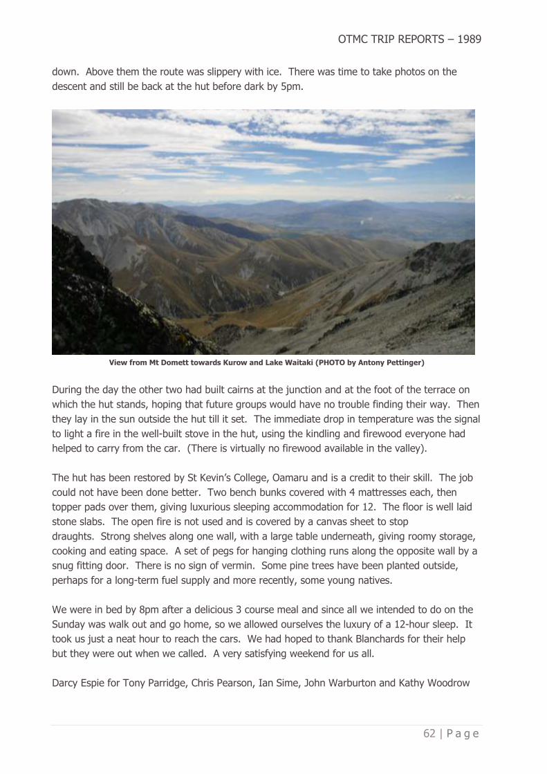
OTMC TRIP REPORTS – 1989
62 | P a g e
down. Above them the route was slippery with ice. There was time to take photos on the
descent and still be back at the hut before dark by 5pm.
View from Mt Domett towards Kurow and Lake Waitaki (PHOTO by Antony Pettinger)
During the day the other two had built cairns at the junction and at the foot of the terrace on
which the hut stands, hoping that future groups would have no trouble finding their way. Then
they lay in the sun outside the hut till it set. The immediate drop in temperature was the signal
to light a fire in the well-built stove in the hut, using the kindling and firewood everyone had
helped to carry from the car. (There is virtually no firewood available in the valley).
The hut has been restored by St Kevin’s College, Oamaru and is a credit to their skill. The job
could not have been done better. Two bench bunks covered with 4 mattresses each, then
topper pads over them, giving luxurious sleeping accommodation for 12. The floor is well laid
stone slabs. The open fire is not used and is covered by a canvas sheet to stop
draughts. Strong shelves along one wall, with a large table underneath, giving roomy storage,
cooking and eating space. A set of pegs for hanging clothing runs along the opposite wall by a
snug fitting door. There is no sign of vermin. Some pine trees have been planted outside,
perhaps for a long-term fuel supply and more recently, some young natives.
We were in bed by 8pm after a delicious 3 course meal and since all we intended to do on the
Sunday was walk out and go home, so we allowed ourselves the luxury of a 12-hour sleep. It
took us just a neat hour to reach the cars. We had hoped to thank Blanchards for their help
but they were out when we called. A very satisfying weekend for us all.
Darcy Espie for Tony Parridge, Chris Pearson, Ian Sime, John Warburton and Kathy Woodrow

OTMC TRIP REPORTS – 1989
63 | P a g e
THAT’S THE WORST OF IT? – BLEDISLOE GORGE
May 6-7, 1989
Author: Michelle Williams
Published in Bulletin 481, September 1989
We were awoken early on Saturday by the sound and lights of a vehicle shortly after
6.30am. Breakfast was had, after Arthur found the fruit salad and were away by 7.30am,
across the river and up the East Matukituki to Junction Flats where we had a short break and
admired the views of surrounding mountains.
It was a short 35-minute grunt up through the bush to the bushline, where we took time to
admire the view back down the East Matukituki, before taking the high route over the Bledisloe
Gorge. It was difficult as we sidled the unmaintained track. The lunch stop was by a washed
out gorge where there was a debate between the pen pushers (Barry & Arthur) and the
labourers (Michelle & Russell). We arrived at Ruth Flats by 2pm and the sun was
disappearing. A water stop was needed and here I foolishly volunteered to get the water 300m
away. Revenge was sweet as the others suffered with sandflies.
Barry Wybrow above the bushline on the Bledisloe Gorge track, May 6, 1989 (PHOTO by Michelle Williams)
I chose the route from here and decided the best route up was what looked the easiest terrain
but, instead it turned out to be a grovel through dense bush, led by Barry and Arthur. Camp
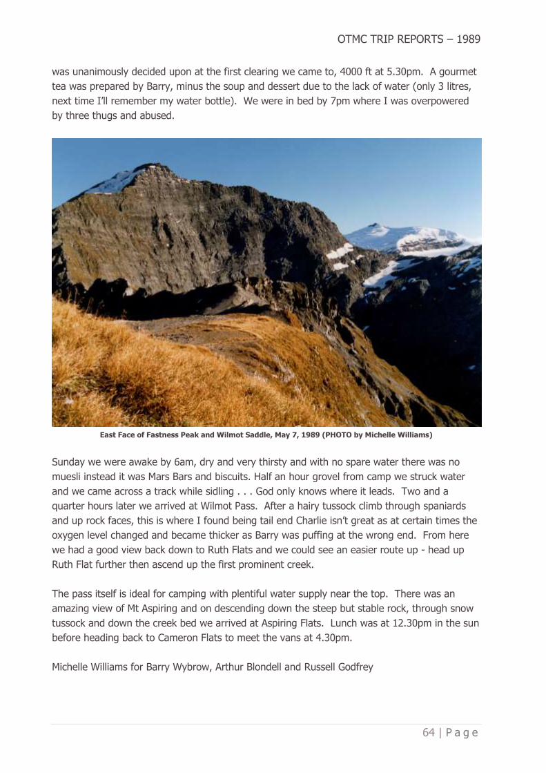
OTMC TRIP REPORTS – 1989
64 | P a g e
was unanimously decided upon at the first clearing we came to, 4000 ft at 5.30pm. A gourmet
tea was prepared by Barry, minus the soup and dessert due to the lack of water (only 3 litres,
next time I’ll remember my water bottle). We were in bed by 7pm where I was overpowered
by three thugs and abused.
East Face of Fastness Peak and Wilmot Saddle, May 7, 1989 (PHOTO by Michelle Williams)
Sunday we were awake by 6am, dry and very thirsty and with no spare water there was no
muesli instead it was Mars Bars and biscuits. Half an hour grovel from camp we struck water
and we came across a track while sidling . . . God only knows where it leads. Two and a
quarter hours later we arrived at Wilmot Pass. After a hairy tussock climb through spaniards
and up rock faces, this is where I found being tail end Charlie isn’t great as at certain times the
oxygen level changed and became thicker as Barry was puffing at the wrong end. From here
we had a good view back down to Ruth Flats and we could see an easier route up - head up
Ruth Flat further then ascend up the first prominent creek.
The pass itself is ideal for camping with plentiful water supply near the top. There was an
amazing view of Mt Aspiring and on descending down the steep but stable rock, through snow
tussock and down the creek bed we arrived at Aspiring Flats. Lunch was at 12.30pm in the sun
before heading back to Cameron Flats to meet the vans at 4.30pm.
Michelle Williams for Barry Wybrow, Arthur Blondell and Russell Godfrey
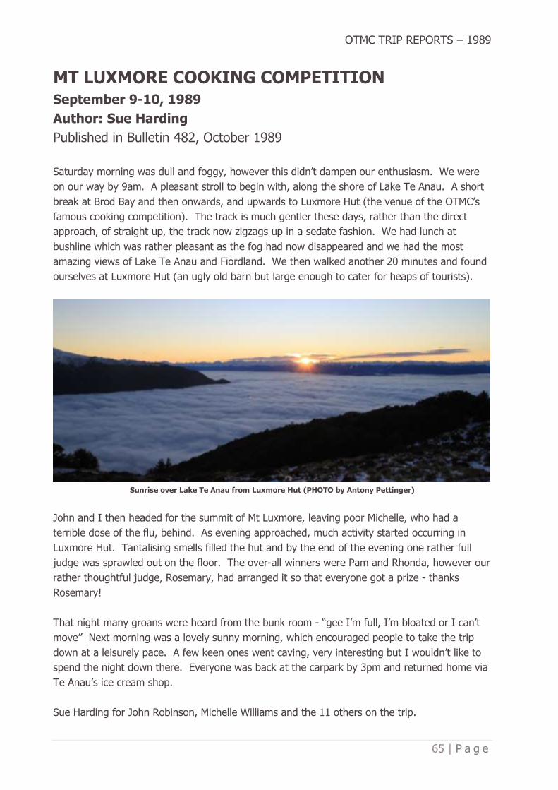
OTMC TRIP REPORTS – 1989
65 | P a g e
MT LUXMORE COOKING COMPETITION
September 9-10, 1989
Author: Sue Harding
Published in Bulletin 482, October 1989
Saturday morning was dull and foggy, however this didn’t dampen our enthusiasm. We were
on our way by 9am. A pleasant stroll to begin with, along the shore of Lake Te Anau. A short
break at Brod Bay and then onwards, and upwards to Luxmore Hut (the venue of the OTMC’s
famous cooking competition). The track is much gentler these days, rather than the direct
approach, of straight up, the track now zigzags up in a sedate fashion. We had lunch at
bushline which was rather pleasant as the fog had now disappeared and we had the most
amazing views of Lake Te Anau and Fiordland. We then walked another 20 minutes and found
ourselves at Luxmore Hut (an ugly old barn but large enough to cater for heaps of tourists).
Sunrise over Lake Te Anau from Luxmore Hut (PHOTO by Antony Pettinger)
John and I then headed for the summit of Mt Luxmore, leaving poor Michelle, who had a
terrible dose of the flu, behind. As evening approached, much activity started occurring in
Luxmore Hut. Tantalising smells filled the hut and by the end of the evening one rather full
judge was sprawled out on the floor. The over-all winners were Pam and Rhonda, however our
rather thoughtful judge, Rosemary, had arranged it so that everyone got a prize - thanks
Rosemary!
That night many groans were heard from the bunk room - “gee I’m full, I’m bloated or I can’t
move” Next morning was a lovely sunny morning, which encouraged people to take the trip
down at a leisurely pace. A few keen ones went caving, very interesting but I wouldn’t like to
spend the night down there. Everyone was back at the carpark by 3pm and returned home via
Te Anau’s ice cream shop.
Sue Harding for John Robinson, Michelle Williams and the 11 others on the trip.

OTMC TRIP REPORTS – 1989
66 | P a g e
CLIMBING AVALANCHE PEAK
(no date listed)
Author: Sue Harding
Published in Bulletin 482, October 1989
The morning was crisp and frosty. It was so cold, that we nearly decided not to bother about
the climb, however we did continue, and it was well worth the effort.
The first part of the climb, which was in the bush, was very steep. By the time we had reached
the bushline our legs were trembling, and our lungs were grasping for air however the view
was super. We could see Arthurs Pass Village, the road, Mt Rolleston and Temple Basin Ski
field and much more.
Bealey Valley from Scott’s track route to Avalanche Peak (PHOTO by Antony Pettinger)
After a short rest we continued up the ridge, stopping every now and then to take
photos. Finally, we reached the snow. John was wishing he had taken his skis as the snow
was so good. On one particular slope we felt rather nervous about avalanches. The last part
of the climb involved making our way along this cornice lip with the other side being steep
rock. We didn’t quite make it all the way up as we felt the last bit (40 metres) would be safer
with ropes which we didn’t have.

OTMC TRIP REPORTS – 1989
67 | P a g e
Bealey Valley through to the Waimakariri Valley and the Black Range, from the Avalanche Peak Track
(PHOTO by Antony Pettinger)
It was a lovely climb in the sunshine and the views were worth the effort. The journey down
was quick and by 2pm we were having coffees in Arthurs Pass Village
Sue Harding and John Robinson

OTMC TRIP REPORTS – 1989
68 | P a g e
KEY SUMMIT TO CASCADE CREEK
October 7-8, 1989
Author: Rhonda Robinson
Published in Bulletin 483, November 1989
Since the three of us had the van Friday night, we parked it in at the Lake Gunn picnic site and
on Saturday morning woke to a peaceful lakeside scene - which Teresa soon proceeded to
disturb by plunging her body into the freezing water! After breakfast on the picnic table (how
civilised) we drive down to The Divide and at the reasonable hour of 9.45am set off up to Key
Summit.
Tarns beyond Key Summit, Livingstone Mountains (PHOTO by Antony Pettinger)
The weather was perfect, and the views got better and better all day with Mt Christina
especially beautiful. The going was easy at first with pretty little tanks everywhere and a few
larger ones. We rewarded ourselves for three hours ambling by having lunch by one of the
large tarns, sunning ourselves (much to Tim Moore’s party’s consternation when they happened
upon us semi-clothed) The route became much more uphill as we strived to avoid the large
bluffs on the Greenstone side - we kept heading more to the Eglington side which meant

OTMC TRIP REPORTS – 1989
69 | P a g e
climbing to 5000 feet instead of taking the easier looking route which avoided the peaks but
ended in bluffs.
At about 5pm after more scroggin stops, we arrived at Cascade Saddle, having lost Tim’s party
somewhere down towards the bluffs. A long search found an almost level, almost large
enough, almost lump free place to put up our tent with a tiny flat area upon which to perch the
cooker. We had a superb view over the Greenstone whilst we ate our modest meal of pasta
with fresh veges, smoked mussels, bananas and grapes braised in brown sugar, lemon juice
with cream plus coffee and Kahlua to finish with.
Looking south along the Livingstone Mountains, Greenstone Valley to the left, Eglinton to the right
(PHOTO by Antony Pettinger)
Next morning breakfast of bacon, mushrooms and tomatoes went down well. Once we were all
up - Rosemary seemed to think our clocks should be put back instead of forward and hence we
slept in till 9.30am (NB: sleeping on Rosemary’s left can be very interesting - if you’re into
sharing body warmth!)
We found Williamson’s track easily on the ridge to the right of the saddle and followed it down
into the Greenstone (it emerges on the track to McKeller Hut, behind the ‘Now entering the
Whakatipu State Forest’ sign). After 5 hours we arrived back out at the Divide. A very
worthwhile trip with great tucker and congenial company.
Rhonda Robinson for Teresa Wasilewska and Rosemary Goodyear.

OTMC TRIP REPORTS – 1989
70 | P a g e
POSSUM HUT WORKPARTY
September 3, 1989
Author: Doug Forrester
Published in Bulletin 483, November 1989
Things didn’t look too good leading up to the day, main reason being I felt I had made a bad
booboo having a work party the morning after the Annual Dinner. Come Sunday morning and
we had 9 keen workers - that was great! It was a Hi Ho Hi Ho and off to work we go, a
pleasant day for toil.
L-R John Galloway, Stephen Cathro, Neville Mulholland, Peter Mason, mark Planner, Sharon St Clair-Newman, Chris
Ehrhardt, Les Smith at Possum Hut, September 3, 1989 (PHOTO by Doug Forrester)
We worked our way down to Possum Hut for lunch and then it was time for a pleasant lunch
break. The afternoon was spent from Possum Hut to Green Hut site.
We achieved what we set out to do so it was all very worthwhile. Worthy note, one female in
the party, Sharon St Clair-Newman (a tough wee chick, this one and a real find out of
Bushcraft ’89). Sharon mowed them down with the best of us.
A special thanks to DoC for the use of their equipment and all the bods who gave their time to
help. Stephen Cathro, John Galloway, Neville Mulholland, Peter Mason, Mark Planner, Sharon
St Clair-Newman, Chris Ehrhardt, Les Smith and yours truly, Doug Forester. Thanks Team!

OTMC TRIP REPORTS – 1989
71 | P a g e
MACETOWN
October 21-23, 1989
Author: Julie Clark
Published in Bulletin 483, November 1989
Friday - Teresa fast talks charms her way out of a speeding ticket, she was mistaken for a
doctor! We camped before the Glendhu Bay Motor Camp by taking a dirt track on the lake side
of the road.
Saturday - We left at 9.20am from the Motatapu Station and the road chasm. We got passed
by four mountain bike riders and we called in at the hut by Glencoe Bush. This was a great
wee runholders hut with a lovely T&G ceiling. John proceeded to give us a lesson on top
dressing because as far as the eye could see, there were lovely green strips where the plane
had dropped the load. After an easy five-hour day we arrived at the junction to camp. A
couple of pack horses (real apallosas) arrived too late to carry Rhonda but alas, they travelled
in the wrong direction. Tea was cooked in a ‘suspect’ hole which was perfectly shaped like a
big outhouse offal pit. John, however, seemed the only one not happy about it. We spent the
night star gazing because the southern Aurora was putting on a fine display.
Descending from Roses Saddle to the Arrow River / Macetown (PHOTO by Antony Pettinger)

OTMC TRIP REPORTS – 1989
72 | P a g e
Sunday - As this day was slightly harder over Roses Saddle and down the Arrow River to
Macetown Teresa decided to give Neville’s party three old cracked dirty bottles (priceless
heirlooms she claimed) to carry out. The first part of the tack up to the saddle was a 4x4WD
track and then it became harder to find with the trail becoming an old miners horse trail which
had collapsed in places. All it was possible to see at times was the bank. This part took 1¾
hours to climb to the saddle with no water. The trip down was great with lovely views and was
quite easy because once you reached the top fence line, the track can be easily seen on the
other side. After a fairly straight forward descent to the river where we met Neville’s party on
the way up, it started to rain and the mist rolled in. Lunch was had under Teresa’s anorak and
then we followed a rough path through Matagouri and found it easier to follow the river. After
three hours, four sodden trampers stumbled into Macetown to claim Mrs Needhams house (one
of three huts still standing).
Southern end of Macetown, crossing the Arrow River (PHOTO by Antony Pettinger)
Monday - After a late start we went to see Anderson’s battery and then it was on up to
Homeward Battery (one hour return). Both were really worthwhile trips. We pressed on the
final three hours to Arrowtown in which time we were passed by numerous trail bikes,
mountain bikes and 4x4WD vehicles.
Julie Clark for Rhonda Robinson, Teresa Wasilewska and John Galloway.

OTMC TRIP REPORTS – 1989
73 | P a g e
PARAKEET RIDGE (ROSELLA RIDGE)
October 29, 1989
Author: (not noted)
Published in Bulletin 483, November 1989
A phenomenal fifteen people turned up for this wander into the Silver Peaks. There was a
good mixed bunch of people, ranging from first timers on a club trip to a couple of people who
had over twenty years active membership behind them.
Rosella Ridge, Silver Peaks – referred to as Parakeet Ridge in this report (PHOTO by Antony Pettinger)
WE set off from Hightop and ambled around to the start of Green Ridge where we met Mike
Gillies who was off on his own trip. Next stop was the old Green Hut site where the warm
muggy conditions meant a long break was definitely in order. From here it was upwards and
onwards to Parakeet Ridge. We stopped at the high point for a leisurely lunch stop with
Richard and Dave making a detour to ring bark a couple of pines. We retraced our steps back
to the main ridge with no sign of grotty bush which had been forecast. Five people continue to
Pulpit Rock while the rest of us headed for Green Hut site. A refreshing shower of rain cooled
us all down before we headed for the cars.
So where exactly is Parakeet Ridge? Try asking Jillian Underhill, Ian McElhinney, Annabel Boys,
Richard Pettinger, Tracey Pettinger, Dave Levick, Sue Levick, Yvonne Greet, Anne Marris, Clarie
Hand, Stephen Cathro, Megan Park, Margaret Middlemass, Anne-Marie McIllroy or David
Barnes.

OTMC TRIP REPORTS – 1989
74 | P a g e
An enjoyable day trip had by all.
GERIATRICS ATTACK DORE AND GLADE PASSES
October 7-8, 1989
Author and Line Drawing: John Galloway
Published in Bulletin 484, December 1989
Our 4-person party had an aggregate age of 191 years. As you reach for your calculator and
glancing for names at the end of this report: let me tell anyone who doesn’t know Sue Harding,
she isn’t “some old hag” Well she’s certainly not old and I wouldn’t call her a “hag” except
when she is pelting me with snowballs as I stagger and puff towards the top of Dore Pass.
Then there was young Doug Forrester: the second youngest in our party. The youngest boy in
the party! Some people just get more juvenile all the time! Two, more mature, senior, gents
completed the team.
It saddens me to have to report that, despite
frequent prompting, young Doug never
showed due respect to his elders. Just little
things like carrying my pack all weekend
would have been appreciated! We tramped
with seven other OTMCers, hence reference
to other names in this report.
Bad stories about Glade Pass meant we were
equipped with rope and harness, which I was
told was fairly heavy. Early on, the leaders
developed the ploy that if anyone showed
unseemly friskiness, they became the bearer
of the rope. Going up to Dore Pass, Russell
did a ‘jump on the field’, got out of earshot
and was first to the top by a “country
mile”. He did quite a lot of rope carrying
after that.
It was a superb westward view from
the top of Dore Pass, down on Glade House,
up the Clinton River, the head of the lake and
Fiordland’s mountains all around. If you are planning a tramp and want fine weather, get Doug
Forrester to make your weather bookings. This weekend was excellent, just as he promised in
the September Bulletin. Just over the top Darcy’s knees started folding excessively so we
distributed FIVE of his jerseys and a tin of Dubbin around other packs. As a lunchtime
diversion, I went pale and my leg muscles started tying themselves in knots, where upon Doug

OTMC TRIP REPORTS – 1989
75 | P a g e
applied some Grant Fox therapy to my instep. It worked! By early afternoon we were resting
by the Glade Burn, in preparation for upward tramping again. In an hour we reached a
fork. Be sure to take the left (northward) branch. The lesser tributary, straight ahead up the
mountain has been severely scoured or avalanched and deceptively appears to be the main
water course.
We camped above the bushline in the Glade Burn. It had been a long day. As Arthur had
traverses of Glade and U Passes planned for his Sunday workout, he kick-started us into action
around 4.45am standard time (5.45am daylight savings time) Whichever way you say it, it is
still very early and mutinous sounds came from at least one sleeping bag.
Glade Pass as seen from U Pass (PHOTO by Antony Pettinger)
The approach to Glade Pass from the south is easy and at 8am (daylight savings time) we
apprehensively peered over into Hut Creek. The route down: as you descend sidle to your right

OTMC TRIP REPORTS – 1989
76 | P a g e
(east) until you reach a steep rocky gut. Staying on the vegetated, true left, side of this gut,
proceed directly down to a rock outcrop that overhangs the gut from the true left. Go round
the west shoulder of this rock then close in front of the rock towards the gut, before
proceeding straight down. Hooray- and we didn’t need that rope.
The upward route (from Hut Creek): The main stream comes from the direction of the sheer
rock face below the pass, and a lesser stream comes down a rocky gut to the east. From the
confluence of these streams, climb directly up the vegetated true left side of the eastern
stream, making for the dominant overhanging rock. From close in front of the rock, you can
get up the western shoulder. Then straight up, veering to your right as the gradient becomes
easier and the pass comes into view.
On Dore Pass, looking over Lake Te Anau (PHOTO by Doug Forrester)
Once over Glade Pass, we sorted out the REAL men, the UNREAL men and OLD
men. (confused? So am I and I am the writer!). The REAL men (Arthur, Russell and Lindsay)
and the UNREAL men (Sue and Sharon) battled on over U Pass, leaving the old men (the rest
of us) to amble down Hut Creek.
Away up Hut Creek Darcy wanted a few rocks put in his pack for ballast, but with some deft
stowing Peter was able to keep their weight to an absolute minimum. You might have to go
back up Hut Creek for those rocks some time Darcy!

OTMC TRIP REPORTS – 1989
77 | P a g e
Given weather, such as we enjoyed and freedom from snow, neither pass is a problem; but you
do have to be prepared for 10 to 11 hours of solid tramping to reach Saturday night’s campsite
above the Glade Burn bushline. However, in deteriorating weather it could be very different;
risking being trapped in the Glade catchment, unable to retreat down the Glade Burn riverbed
or safely descend into Hut Creek.
The veteran team in ascending order of maturity, Sue Harding, Doug Forrester (captain), John
Galloway (scribe) and Peter Vollweiler - but I am not telling how those 191 years are
apportioned.

OTMC TRIP REPORTS – 1989
78 | P a g e
THE GRAND THREE PASS TRAVESE
October 7-8, 1989
Author: Sharon St Clair-Newman
Published in Bulletin 484, December 1989
After the usual late evening trek by van from Dunedin, we arrived at the Dore Pass car park
about 12am. Due to a complete lack of suitable campsites here all parties eventually set up
camp in the car park itself and a few extra puffs into the poofta-pads ensured the stones didn’t
leave bruises in the morning.
“Morning” turned out to be 5.30am! Doug discovered he was the second youngest member of
his party, an astounding fact we were to be reminded of continually for the next two
days. Eleven grumbling bodies then breakfasted, packed up and set out for Dore Pass at
6.45am. The mapped walk-wire was no longer there so the eleven grumbled further about
crossing the river after only five minutes walking. We discovered a few new ways of coping
with wet feet - poms actually take their boots off and ring out their socks! One of our younger
members found that lying with his feet in the air emptied his boots and the tougher members
of the party just grumbled on.
Michelle and Debbie Williams in the Murcott Burn, the route to Dore Pass (PHOTO by Antony Pettinger)
The climb to Dore Pass was relatively easy through a bush track then tussock. Three and a
quarter hours saw us on the pass. The weather was perfect and we had a great view over the
pass down to the start of the Milford Track and Glade House. It paid to be first onto the pass

OTMC TRIP REPORTS – 1989
79 | P a g e
though, as the later members were subjected to a barrage of snowballs ably led by Sue
Harding. We eventually pulled ourselves away from the view and traversed across to the right
and down to a terrace just above bushline for lunch. Any earlier thoughts of traversing the
peaks to Glade Pass were put paid when we actually saw them. We then dropped down a very
muddy and boggy track to the Glade Burn, about three hours walking from the pass.
After a very pleasant Moro stop in the sun, beating off the sandflies, we set off up the Glade
Burn. This turned out to an easy boulder climb up a lovely little valley with bush and
impressive bluffs on both sides. We climbed until at bushline and eventually found a campsite
in the tussock almost under Glade Pass at 6pm, approximately 3½ hours from the
bottom. With thoughts of an hours less sleep due to daylight savings starting next morning we
had tea and once more set the alarm for 5.30am!
Due to darkness, tiredness or lack of energy (or all three) we left half an hour later at 7.15am
and ¾ hour later we found ourselves on Glade Pass with a great view of U Pass ahead of
us. Our earlier fears of not having enough time to complete the three passes now had us
feeling more confident. As we were unsure of the route down, our party set off earlier and
after some searching around found a route down by traversing the tussock to the right. We
then dropped down the second creek bed and across the bottom of this to the next tussock
ridge. We edged around a tussock bluff after finding a track of sorts about 1-2 metres from the
top, then dropped sharply down into another creek-bed. From here it was just a scramble down
to the bottom.
After deciding that U Pass was definitely on, we took up the offer of those not wanting to come
with us and offloaded wet tents and rope. Sue joined us leaving Doug the youngest member of
his party, and about 9am we headed for U Pass. A steady but steep climb up the boulders to
snowline, then a small traverse over frozen snow slopes found us on the top after about one
and a half hours. From here we had a great view back to a very mean looking Glade Pass, and
from here it could be argued whether there could possibly be a route over from this side!
From U Pass an easy climb down the tussocks found us in a very pleasant little basin, then
down over rocks towards the waterfall, keeping to the true left. This was where the fun
started, after hearing about this little climb down Mistake Creek some of us were a little
concerned. Russell went down first as he’d been up this way before and generally knew where
to go. Sue and I followed, knee’s knocking and unsavoury comments issuing at every
step. Arthur just carried on undaunted as usual, sling at the ready! We lowered ourselves
down the steep tussock backwards finding good footholds and clinging to handfuls of tussock,
then down the rocks to the base of the waterfall. Those of us with short legs took advantage
of Arthur’s sling and a helping hand from both Russell and Arthur on occasions.
Lunch was taken at the base of the waterfall about 1¾ from the pass and we then made our
way down the creek-bed before heading into the bush to the right to avoid a waterfall further

OTMC TRIP REPORTS – 1989
80 | P a g e
down. We came out at the junction of the creek into a beautiful valley and headed down the
flats until we found the track and made our way back to the carpark by 4.20pm.
Former grassy flat in Mistake Creek (PHOTO by Antony Pettinger)
An ice cream stop at Te Anau finished another terrific weekend. The highlight being actually
completing the three passes. Thanks must go to the other two parties who made U Pass much
easier by carrying some of our gear. It was great having another female along, thanks Sue for
your company and teaching me some new tricks! Thanks once again to Lindsay and Russell.
Sharon St Clair-Newman for Arthur Blondell, Lindsay Aitcheson and Russell Godfrey.

OTMC TRIP REPORTS – 1989
81 | P a g e
OTMC COMMITTEE (1989-90)
President – Stuart Mathieson
Vice President / Mountain Safety – Rhonda Robinson
Secretary – Mark Planner
Treasurer – Teresa Wasilewska
Chief Guide / Transport – Antony Pettinger
Bulletin Editor – Debbie Pettinger
Membership Secretary – Ian Sime
Social Convenor – Elspeth Gold
Day Trip Convener – Sharon St Clair-Newman
Gear Hire – Russell Godfrey
SAR – Stuart Mathieson
Bushcraft 1990 – Ross Cocker
Property & Maintenance – Peter Mason
FMC – Mike Floate
Librarian – Peter Mason
Climbing – Peter Mason
Immediate Past President – David Peacock
Outdoor Recreation Group – Jane Bruce
Hon. Solicitor – Antony Hamel
Family Group – Lyall Campbell
Family Group – David McArthur
Over Thirties – Neil Donaldson
Over Thirties – Muriel Mason
Over Thirties – Eric Brodie

OTMC TRIP REPORTS – 1989
82 | P a g e
OTMC TRIP PROGRAMME 1989
January 22 Heather's Mystery Heather Robertson
January 29 Philip's Mystery Cycle Philip Jenkins
February 4-6 Homer - Darren's (Waitangi Weekend) Andy Beecroft
February 12 Club Picnic - Bucklands Crossing Doug Forrester
February 17-19 Bushcraft 1989 (Tirohanga Weekend) Antony Pettinger
February 19 Taieri Mouth (Family Group) David and Penny McArthur
February 25-26 Bushcraft 1989 (Silver Peaks Weekend) Antony Pettinger
March 5 Bushcraft 1989 (Rivercrossing) Antony Pettinger
March 11-12 Bushcraft 1989 (Optional Weekend - Lake Ohau) Antony Pettinger
March 18 Pre Easter Social Doug Forrester
March 19 Nenthorn Peter Mason
March 19 Deep Stream (Family Group) Rosemary Clarkson
March 24-27 Makarora Area (Easter) Mark Hanger
March 24-27 Esquilant Bivy Project Committee
April 2 Maungatua Pam Cocker
April 9 The Chalkies Mike Gillies
April 8-9 Mt Cook Doug Forrester
April 16 Orienteering David Peacock
April 16 Leith Saddle (Family Group) Sara and Ron Keen
April 23 Hindon to the Reefs Peter Mason
April 22-23 Ahuriri - Dingle Valleys Arthur Blondell
April 30 Painted Forest (Silver Peaks) Doug Forrester
May 7 The Last Of The Seasons Rockclimbing Andy Beecroft
May 6-7 Matukituki David Peacock
May 14 ABC Cave Arthur Blondell
May 21 Craiglowan Falls via Jim Freeman Track Mike Floate
May 21 Possum Hut (Family Group) Paddy O'Neill
May 20-21 Lake Isobel (Twelve Mile Creek) Mark Hanger
May 28 Town Belt Doug Pagel
June 3-5 Rees - Dart - Routeburn Antony Pettinger
June 11 The Gap David Barnes
June 18 Shag Point - Puketapu Hill Peter Mason
June 18 Signal Hill (Family Group_ Lyall Campbell
June 17-18 Catlins Area Doug Pagel
June 25 Mark's Mystery Mark Hanger
July 1-2 Midwinter Wine & Dine - Trotters Gorge David Peacock
July 2 Trotters Gorge David Peacock
July 9 Mystery Trip Mary Hewinson
July 16 Burns Saddle - Possum Hut & Return David Barnes
July 16 Bethunes Gully - Organ Pipes Nancy Strang

OTMC TRIP REPORTS – 1989
83 | P a g e
July 15-16 Danseys Pass - Mt Domett Ian Sime
July 23 Where The Hell Is The Burns Track' David Barnes
July 22-23 Snow I - Basic Snowcraft Antony Pettinger and Graham Hopkins
July 30 Burns Saddle - Hightop - Swampy - Leith Saddle David Barnes
July 29-30 X/C Skiing Instruction Bruce Mason
August 6 Pulpit Rock Kathy Woodrow
August 5-6 Winter Routeburn (Falls Side) Stuart Mathieson
August 13 Hermit's Cave Bill Robertson
August 20 Silver Peaks David Peacock
August 20 Ben Rudd's Shelter (Family Group) Judy McLeod and Joyce Shaw
August 19-20 Snow II - Snowcaving (Old Man Range) Arthur Blondell
August 27 There and Back (To See How Far It Is) David Barnes
August 26-27 X/C Skiing Instruction John Robinson
September 2 OTMC Annual Dinner Social Convenor
September 3 Track Maintenance - Possum Hut Doug Forrester
September 10 Hindon - Little Mt Allan Teresa Blondell
September 9-10 Mt Luxmore - Kepler Mountains + Cooking Competition Bill Robertson
September 17 Jubilee Hut Arthur Blondell
September 17 Government Track - Waipori Gorge Dave McArthur
September 24 Round The Town Belt Doug Pagel
September 23-24 Mavora Lakes Arthur Blondell
September 30-1 Spring X/C Skiing John Robinson
October 1 SAREX (Search & Rescue Exercise) Stuart Mathieson
October 8 Nenthorn Two Peter Mason
October 7-8 Fiordland Doug Forrester
October 15 Introduction to Rockclimbing Andy Beecroft
October 15 The Chalkies (Family Group) Dave Brooker
October 21-23 Macetown (Labour Weekend) Mike Floate
October 29 Parakeet Ridge (Rosella Ridge) David Barnes
November 5 Cycling Trip To Brighton Mary Hewinson
November 4-5 Lake Monowai Don Greer
November 12 Visit to the Penguin Colony David Barnes
November 19 Nicholls Creek Jane Bruce
November 19 Careys Creek (Family Group) Bob Clarkson and Ken Allen
November 18-19 The Bowels Of The Earth Barry Wybrow
November 26 Nardoo Five Ross Cocker
December 3 Mt Highlay Peter Mason
December 2-3 Huxley - Hopkins David Peacock
December 9 OTMC Christmas Social Social Convenor
December 10 Akatore Bush Jane Bruce
December 17 Mystery Trip Mike Gillies
December 17 Purakanui (Family Group) Family Group

OTMC TRIP REPORTS – 1989
84 | P a g e
OTMC BULLETIN COVERS (FEBRUARY TO MAY)

OTMC TRIP REPORTS – 1989
85 | P a g e
OTMC BULLETIN COVERS (JUNE TO SEPTEMBER)
OTMC TRIP REPORTS – 1989
86 | P a g e
OTMC BULLETIN COVERS (OCTOBER TO DECEMBER)