otay water districtotaywater.gov/wp-content/uploads/files/publications/owd...otay water district...
TRANSCRIPT
OTAY WATER DISTRICT
2015 Water Facilities
Master Plan Update Final Program Environmental Impact Report
CEQA Findings of Fact SCH No. 2015061091
November 2016
Prepared for:
Otay Water District
2554 Sweetwater Springs Boulevard
Spring Valley, California 91978-2096
Prepared by:
3570 Carmel Mountain Road Suite 300
San Diego, California 92130 Atkins Project #100038569
CEQA Findings of Fact
Otay Water Facilities Master Plan Update PEIR
Page i
November 2016
Contents
1.0 Introduction ..................................................................................................................................... 1
2.0 Project Description .......................................................................................................................... 1 2.1 Planning Area ...................................................................................................................... 1 2.2 Project Characteristics ........................................................................................................ 3 2.3 Description of Projects ........................................................................................................ 4 2.4 Project Purpose, Goals and Objectives ............................................................................... 9 2.5 Permits, Approvals, and Regulatory Requirements ............................................................ 9 2.6 Project Background ........................................................................................................... 11
3.0 Record of Proceedings ................................................................................................................... 12
4.0 Findings Required Under CEQA ..................................................................................................... 13
5.0 Legal Effects of Findings ................................................................................................................. 14
6.0 Mitigation Monitoring and Reporting Program ............................................................................. 15
7.0 Significant Effects and Mitigation Measures ................................................................................. 15 7.1 Air Quality ......................................................................................................................... 15 7.2 Biological Resources ......................................................................................................... 19 7.3 Cultural Resources ............................................................................................................ 26 7.4 Energy ............................................................................................................................... 32 7.5 Geology, Soils, and Paleontology ...................................................................................... 33 7.6 Global Climate Change ...................................................................................................... 42 7.7 Hydrology and Water Quality ........................................................................................... 45 7.8 Landform Alteration and Visual Aesthetics ...................................................................... 52 7.9 Land Use and Planning ...................................................................................................... 60 7.10 Noise ................................................................................................................................. 62 7.11 Public Safety ...................................................................................................................... 67 7.12 Transportation and Traffic ................................................................................................ 71 7.13 Growth Inducement .......................................................................................................... 72 7.14 CEQA Checklist Items Not Applicable to the 2015 WFMP Update ................................... 74
8.0 Alternatives .................................................................................................................................... 75
Figure
Figure 1 2015 WFMP Planning Area and CIP Projects ..................................................................... 2
Tables
Table 1 Miscellaneous CIP Projects ................................................................................................. 4 Table 2 Potable Water Storage CIP Projects(1) ................................................................................. 5 Table 3 Potable Water Pump Station CIP Projects(1) ....................................................................... 5 Table 4 Potable Water Pipeline CIP Projects ................................................................................... 6 Table 5 Recycled Water CIP Projects ............................................................................................... 8 Table 6 Potential Permits and Approvals ...................................................................................... 10
CEQA Findings of Fact
Otay Water Facilities Master Plan Update PEIR
Page 1
November 2016
1.0 Introduction
Otay Water District (OWD) was authorized as a California Special District by the State Legislature in 1956, under the provisions of the Municipal Water District Law of 1911, and thereby gained its entitlement to imported water. As a member agency of the San Diego County Water Authority (SDCWA), OWD purchases all of the potable water that it delivers from the SDCWA. The SDCWA is responsible for transmission of the imported water supply within San Diego County to its member agencies, and is itself a member of the Metropolitan Water District of Southern California (MWD).
In 2002, OWD developed a comprehensive Water Resources Master Plan (WRMP) that combined all previously existing master plans and facility plans into one system wide plan outlining the Capital Improvement Program (CIP) projects required to serve their customers. In 2009, OWD updated the WRMP. The following three phases were identified in the 2009 WRMP Update: Phase I (2015-2016), Phase II (2017-2022), Phase IIIA (2023-2050), and Phase IIIB (2023-2050). Minor updates to the 2009 WRMP were completed in 2010 and 2013.
Since 2002, OWD has continued to improve its potable water facilities to meet the water demands associated with growth. OWD has also continued to improve and expand its recycled water facilities to serve irrigation demands and conserve potable water supplies. The CIP is updated annually to reflect system improvements and to identify future needs for budgeting purposes.
OWD has explored opportunities to expand its local resources as a means to offset the risk of interrupted imported water supplies. To address the uncertainties surrounding imported water supplies due to potential drought shortages or emergency seismic conditions, in addition to the rising costs of imported water, OWD has prepared an Integrated Resources Plan (IRP) to develop a flexible, long-term strategy for its future supply portfolio. The IRP defines a course for OWD’s development of local water supply projects. To the extent the supply plans identified in the IRP affect the planning of OWD’s potable and recycled water systems, they are incorporated into the Master Plan.
The purpose of the 2015 Water Facilities Master Plan (WFMP) Update is to revise the OWD 2009 WRMP; update planning criteria and OWD’s hydraulic system models; map out water and recycled water facility improvements; update OWD’s CIP projects; and identify adaptive responses to changed conditions.
2.0 Project Description
2.1 Planning Area
The OWD service area is regionally located within south central San Diego County, and is bounded by rural lands to the east, the Padre Dam Municipal Water District to the north, the Helix Water District to the northwest, the Sweetwater Authority and the city of San Diego to the west, and the U.S./Mexico International Border to the south. There are several major transportation routes through which access across the OWD service area is possible, including I-8, SR- 54, and SR-94 in the north; I-805 to the west; and SR-125 in the north and south.
The OWD service area consists of 80,320 acres (125.5 square miles), and provides water service to approximately 217,000 residents. The OWD boundaries encompass a large portion of eastern Chula Vista, a portion of the city of San Diego on Otay Mesa, and various unincorporated areas, including Rancho San Diego, Jamul, Spring Valley, Bonita, Otay Mesa, and areas adjacent to El Cajon and La Mesa. An additional 11 square miles on the OWD’s eastern flank are designated by the San Diego Local Area Formation Commission (LAFCO) as being within the OWD’s Area of Influence (AOI) (also known as Sphere of Influence, or SOI), but outside its current active service area.

!(
#0")")
#0
")
!(
")
!(
")!(!(
") ")
#0 !(
!(
")
!(
#0
$1
#0
")
#0
")
")
$1
")
")
")")
")
")
!(
U S A
M E X I C O
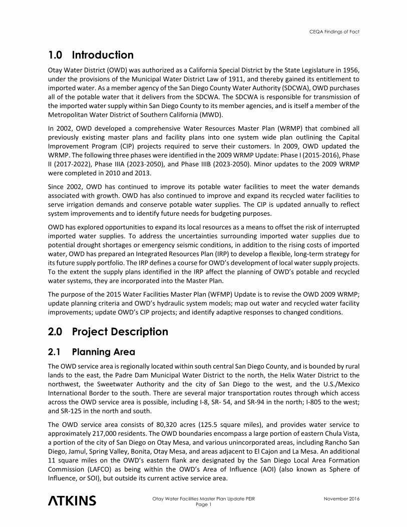
LA PRESASYSTEM
REGULATORYSYSTEM
HILLSDALESYSTEM
CENTRAL AREASYSTEM
OTAY MESASYSTEM
SYCUAN RESERVATION
!"̂$
!"_$
!"_$
%&s(
Aä
Aä
?p
A¦
AË
AË
Lower Otay Reservoir
Upper Otay Reservoir
SweetwaterReservoir
LovelandReservoir
LakeMurray
P2584
P2437P2577
P2578
P2405
P2579
P2431
P2412
P2037
P2002P2576
P2142
P2174P2411
P2575P2040
P2228
P2256
P2233
P2391
P2434
P2554
P2517
P2393
P2392
P2511
P2482
P2248
P2379
P2202P2585
P2500
P2407
P2235
CIP Projects!( Reservoir
") Pump Station
$1 Water Supply Project
#0 Miscellaneous
Pipeline
OWD Jurisdiction
Area of Influence
2015 WFMP Planning Area & CIP Projects
Figure 1
100038569 2015 OWD WFMP Update - EIR
Source: SanGIS 2014, CASIL 2009, ESRI 2016
10/28/2016 cava6246 H:\Clients\Otay WD\100038569 2015 OWD WMP Update\EIR\GIS\data\Figure 3-2 WFMP Planning Area CIP Projects Coversheet.mxd
I 0 1.25 2.50.625
Miles
1 in = 2.5 miles
CEQA Findings of Fact
Otay Water Facilities Master Plan Update PEIR
Page 3
November 2016
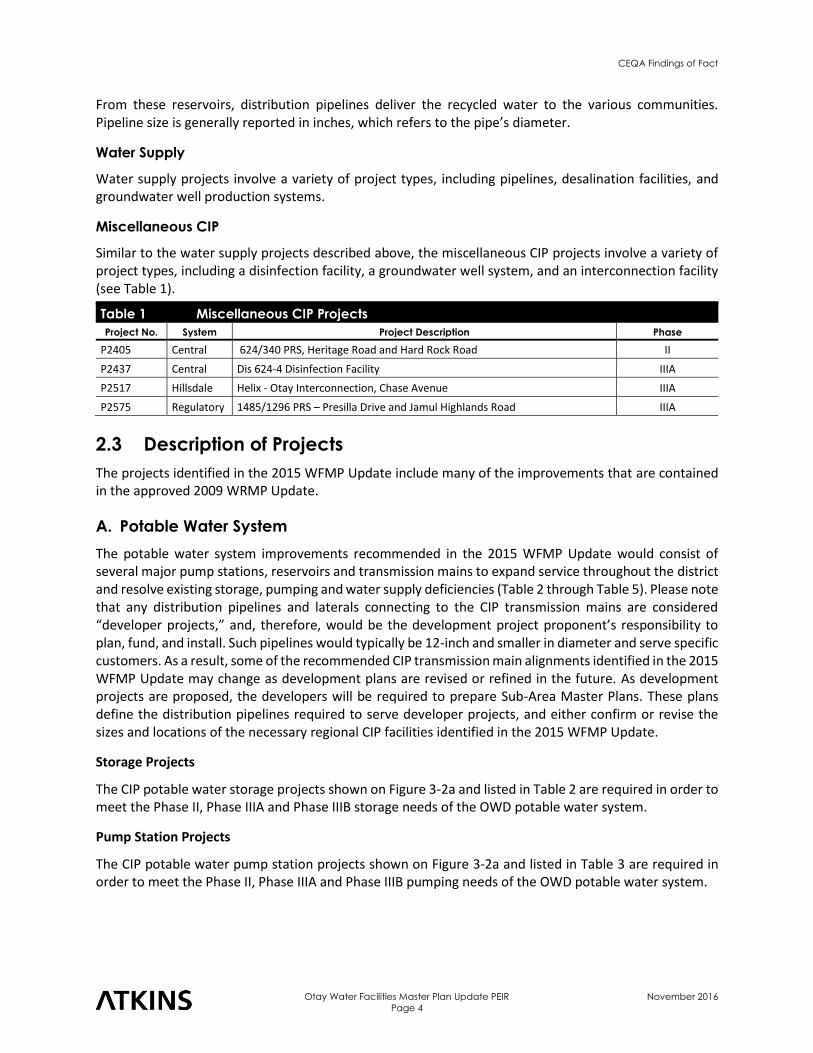
The OWD water service area is divided into five distinct water service areas (Figure 3-2). The three northernmost service areas – Hillsdale, La Presa and Regulatory – are collectively referred to as the North District (Figure 3-2a through Figure 3-2c). The two southernmost service areas – Central and Otay Mesa – are collectively referred to as the South District (Figure 3-2d through Figure 3-2e). The North District serves San Diego County communities above Sweetwater Reservoir; and, the South District serves the Chula Vista and Otay Mesa.
In addition to water supply, OWD also provides sewage collection, treatment, and disposal services to users within a small portion of the North District. OWD provides sewer service only within the Jamacha drainage basin in the northern portion of its service area where it also operates a small water reclamation plant. Sewer service for the remainder of the area within OWD boundaries is provided by other public entities. OWD also maintains and operates a recycled water system in the South District, primarily within the eastern portion of Chula Vista, in OWD’s Central service area.
2.2 Project Characteristics
The CIP projects identified in the 2015 WFMP Update can be classified into five general categories: storage, pump station, pipeline, water supply, and miscellaneous CIP projects. The following is an overview of definitions, issues, and construction information associated with each of these categories. Details for each category of projects are provided in Section 3.4.4, with the exception of miscellaneous CIP projects, which are described in Table 3-1.
Storage
Storage projects generally involve the construction and/or alteration of water-holding reservoirs. Typical reservoir sites consist of a storage tank (reservoir) constructed on a level, graded pad; underground water supply and delivery pipelines; fencing for security purposes; and an access road for maintenance purposes. Placement of storage projects is essential, because optimizing the elevation at which a storage project is located can greatly increase efficiency by reducing the amount of pumping (energy) needed to move water to and from the reservoir. In general, reservoir capacity is reported in units of millions of gallons (MG).
Pump Stations
Pump station projects involve the movement of water uphill, or to higher pressure zones, and pressure reducing valves are used when water is moving to lower pressure zones (downhill). Pump stations typically consist of buildings containing pumps, electric power-line connections, pipeline connections, fencing, and access roads. Pressure reducing valves are installed along pipelines. In general, pump capacity is reported in units of gallons per minute (gpm) or millions of gallons per day (MGD).
Pipeline
Pipeline projects involve trench excavation, preparing the bed for pipe placement, laying the pipe in the trench, filling the trench, and restoring the disturbed surface area. Where it is not feasible to install a pipeline within a street right-of-way, OWD makes every effort to use the shortest possible route between connection points to minimize ground-level impacts. In this practice, OWD considers factors such as engineering principles and site-specific constraints. The CIP pipeline projects identified in the 2015 WFMP Update include transmission and distribution lines. Transmission lines generally transport large quantities of water over broad areas. Distribution lines generally have lower capacities, and transport water to specific locations. For example, recycled water delivered from the City of San Diego South Bay Water Reclamation Plant travels through a transmission line to several reservoirs within the OWD service area.
CEQA Findings of Fact
Otay Water Facilities Master Plan Update PEIR
Page 4
November 2016
From these reservoirs, distribution pipelines deliver the recycled water to the various communities. Pipeline size is generally reported in inches, which refers to the pipe’s diameter.
Water Supply
Water supply projects involve a variety of project types, including pipelines, desalination facilities, and groundwater well production systems.
Miscellaneous CIP
Similar to the water supply projects described above, the miscellaneous CIP projects involve a variety of project types, including a disinfection facility, a groundwater well system, and an interconnection facility (see Table 1).
Table 1 Miscellaneous CIP Projects
Project No. System Project Description Phase
P2405 Central 624/340 PRS, Heritage Road and Hard Rock Road II
P2437 Central Dis 624-4 Disinfection Facility IIIA
P2517 Hillsdale Helix - Otay Interconnection, Chase Avenue IIIA
P2575 Regulatory 1485/1296 PRS – Presilla Drive and Jamul Highlands Road IIIA
2.3 Description of Projects
The projects identified in the 2015 WFMP Update include many of the improvements that are contained in the approved 2009 WRMP Update.
A. Potable Water System
The potable water system improvements recommended in the 2015 WFMP Update would consist of several major pump stations, reservoirs and transmission mains to expand service throughout the district and resolve existing storage, pumping and water supply deficiencies (Table 2 through Table 5). Please note that any distribution pipelines and laterals connecting to the CIP transmission mains are considered “developer projects,” and, therefore, would be the development project proponent’s responsibility to plan, fund, and install. Such pipelines would typically be 12-inch and smaller in diameter and serve specific customers. As a result, some of the recommended CIP transmission main alignments identified in the 2015 WFMP Update may change as development plans are revised or refined in the future. As development projects are proposed, the developers will be required to prepare Sub-Area Master Plans. These plans define the distribution pipelines required to serve developer projects, and either confirm or revise the sizes and locations of the necessary regional CIP facilities identified in the 2015 WFMP Update.
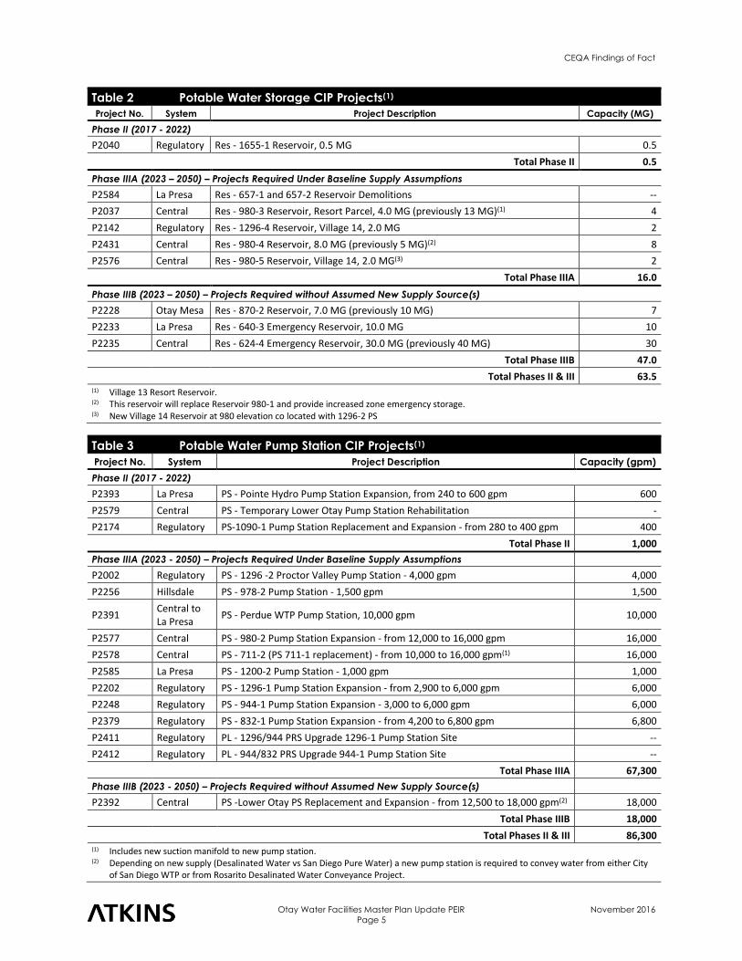
Storage Projects
The CIP potable water storage projects shown on Figure 3-2a and listed in Table 2 are required in order to meet the Phase II, Phase IIIA and Phase IIIB storage needs of the OWD potable water system.
Pump Station Projects
The CIP potable water pump station projects shown on Figure 3-2a and listed in Table 3 are required in order to meet the Phase II, Phase IIIA and Phase IIIB pumping needs of the OWD potable water system.
CEQA Findings of Fact
Otay Water Facilities Master Plan Update PEIR
Page 5
November 2016
Table 2 Potable Water Storage CIP Projects(1)
Project No. System Project Description Capacity (MG)
Phase II (2017 - 2022)
P2040 Regulatory Res - 1655-1 Reservoir, 0.5 MG 0.5
Total Phase II 0.5
Phase IIIA (2023 – 2050) – Projects Required Under Baseline Supply Assumptions
P2584 La Presa Res - 657-1 and 657-2 Reservoir Demolitions --
P2037 Central Res - 980-3 Reservoir, Resort Parcel, 4.0 MG (previously 13 MG)(1) 4
P2142 Regulatory Res - 1296-4 Reservoir, Village 14, 2.0 MG 2
P2431 Central Res - 980-4 Reservoir, 8.0 MG (previously 5 MG)(2) 8
P2576 Central Res - 980-5 Reservoir, Village 14, 2.0 MG(3) 2
Total Phase IIIA 16.0
Phase IIIB (2023 – 2050) – Projects Required without Assumed New Supply Source(s)
P2228 Otay Mesa Res - 870-2 Reservoir, 7.0 MG (previously 10 MG) 7
P2233 La Presa Res - 640-3 Emergency Reservoir, 10.0 MG 10
P2235 Central Res - 624-4 Emergency Reservoir, 30.0 MG (previously 40 MG) 30
Total Phase IIIB 47.0
Total Phases II & III 63.5 (1) Village 13 Resort Reservoir. (2) This reservoir will replace Reservoir 980-1 and provide increased zone emergency storage. (3) New Village 14 Reservoir at 980 elevation co located with 1296-2 PS
Table 3 Potable Water Pump Station CIP Projects(1)
Project No. System Project Description Capacity (gpm)
Phase II (2017 - 2022)
P2393 La Presa PS - Pointe Hydro Pump Station Expansion, from 240 to 600 gpm 600
P2579 Central PS - Temporary Lower Otay Pump Station Rehabilitation -
P2174 Regulatory PS-1090-1 Pump Station Replacement and Expansion - from 280 to 400 gpm 400 Total Phase II 1,000
Phase IIIA (2023 - 2050) – Projects Required Under Baseline Supply Assumptions
P2002 Regulatory PS - 1296 -2 Proctor Valley Pump Station - 4,000 gpm 4,000
P2256 Hillsdale PS - 978-2 Pump Station - 1,500 gpm 1,500
P2391 Central to La Presa
PS - Perdue WTP Pump Station, 10,000 gpm 10,000
P2577 Central PS - 980-2 Pump Station Expansion - from 12,000 to 16,000 gpm 16,000
P2578 Central PS - 711-2 (PS 711-1 replacement) - from 10,000 to 16,000 gpm(1) 16,000
P2585 La Presa PS - 1200-2 Pump Station - 1,000 gpm 1,000
P2202 Regulatory PS - 1296-1 Pump Station Expansion - from 2,900 to 6,000 gpm 6,000
P2248 Regulatory PS - 944-1 Pump Station Expansion - 3,000 to 6,000 gpm 6,000
P2379 Regulatory PS - 832-1 Pump Station Expansion - from 4,200 to 6,800 gpm 6,800
P2411 Regulatory PL - 1296/944 PRS Upgrade 1296-1 Pump Station Site --
P2412 Regulatory PL - 944/832 PRS Upgrade 944-1 Pump Station Site --
Total Phase IIIA 67,300
Phase IIIB (2023 - 2050) – Projects Required without Assumed New Supply Source(s)
P2392 Central PS -Lower Otay PS Replacement and Expansion - from 12,500 to 18,000 gpm(2) 18,000
Total Phase IIIB 18,000
Total Phases II & III 86,300 (1) Includes new suction manifold to new pump station.
(2) Depending on new supply (Desalinated Water vs San Diego Pure Water) a new pump station is required to convey water from either City of San Diego WTP or from Rosarito Desalinated Water Conveyance Project.

CEQA Findings of Fact
Otay Water Facilities Master Plan Update PEIR
Page 6
November 2016
Pipeline Projects
The CIP projects listed in Table 4 are required in order to meet the Phase II, Phase IIIA and Phase IIIB transmission pipeline needs of the OWD potable water system. For the CIP projects involving pipeline installation within existing roads, OWD has and will continue to coordinate with local jurisdictions to ensure the timing of this work is coincident with roadway improvements performed under a local agency public improvement or CIP project. For the CIP projects involving installation of new pipelines within newly constructed roads, OWD has and will continue to coordinate with the private developers responsible for new road construction to ensure concurrent timing of both projects. Since many of these CIP pipeline projects are assumed to be installed concurrently with existing road improvements by local agencies or new road construction by private developers, they would not require open cut and traffic control. In the event the timing of pipeline installation within existing roadways does not coincide with the local agency public road improvements, then open cut trenching and traffic control measures would be required.
Table 4 Potable Water Pipeline CIP Projects
Project No. System Project Description Length (ft)
Phase II (2017 - 2022)
P2400 Central PL - 20-in Pipeline Replacement, 711 Zone, Otay Lakes Road at Santa Paula 3,800
P2403 Central PL - 12-in, 624 Zone, Heritage Road - Olympic/Otay Valley 5,300
P2451(1) Otay Mesa Otay Mesa Desalination Conveyance and Disinfection System 22,000
P2516 La Presa PL - 12-in, 640 Zone, Jamacha Road - Darby/Osage 2,500
P2553 Central Heritage Road Bridge Replacement Utility Relocation --
P2574 Hillsdale PL - 12-Inch and 14-inch Pipeline Replacement, 803 and 978 Zone, Vista Grande, Pence Drive
6,900
P2595 Central PL – 16-inch, 624 Zone, Village 3N – Heritage Road, Main St/Energy Way 1,200
Total Phase II 41,700
Phase IIIA (2023 – 2050) – Projects Required Under Baseline Supply Assumptions
P2104 Central PL - 12-in, 711 Zone, La Media Road - Birch/Rock Mountain 1,800
P2106 Central PL - 12-in, 711 Zone, La Media Road - Rock Mountain/Otay Valley 3,400
P2107 Central PL - 16-in, 711 Zone, Rock Mtn Road-La Media Road (previously 12-in) 2,400
P2116 Central PL - 16-in, 711 Zone, Rock Mtn Road - SR 125/EastLake Pkwy (previously 12-in) 3,000
P2135 Central PL - 20-in, 980 Zone, Otay Lakes Road to Village 13 5,500
P2137 Central PL - 20-in, 980 Zone, Village 13 to 980-3 Reservoir 3,500
P2138 Central PL - 20-in, 980 Zone, 980-3 Reservoir Transmission PL 2,200
P2148 La Presa PL - 16-in, 850 Zone, Jamacha Boulevard - Sweetwater Springs/Trace 5,200
P2150 Central PL - 16-in, 458 Zone, East Palomar Street - Medical Center/Raven 900
P2156 Regulatory PL - 12-in, 1485 Zone, Olive Vista Drive Parallel 2,500
P2190 Regulatory PL - 12-in, 1485 Zone, Jamul Highlands 2,300
P2398 Central PL - 20-in, 624 Zone, Paseo Ladera between Telegraph/Olympic Upsizing 2,800
P2402 Central PL - 16-in, 624 Zone, La Media Road - Village 7/Otay Valley 2,500
P2404 Central PL - 12-in, 624 Zone, Rock Mtn Road - Village 4/Otay Valley 3,600
P2500 Hillsdale Padre Dam - Otay Interconnection, Dehesa Valley 3,900
P2511(1)
La Presa to/from Central
PL – Otay Interconnect (North District - South District Interconnection) 31,000
P2528 Central PL – 30-inch, 624 Zone, Manifold between Res 624-1 & 624-2 8,000
P2554 Central PL – 12-in. and 624/340 PRS at Energy Way and Nirvana Avenue 2,000
P2583 Central PL - 20-in, 624 Zone, Otay Mesa Interconnect 711 PRS Bypass 5,800
P2589 Otay Mesa PL - 24-in, 871 Zone, Donovan Prison 600
P2590 Central PL - 20-in, 624 Zone, Village 7 6,400
CEQA Findings of Fact
Otay Water Facilities Master Plan Update PEIR
Page 7
November 2016
Table 4 Potable Water Pipeline CIP Projects
Project No. System Project Description Length (ft)
P2033 Regulatory PL - 16-in, 1296 Zone, Melody Road - Campo/Presilla 6,400
P2053 Regulatory PL - 20-in, 944 Zone, Campo Road - 944-1 Pump Station/944 Reservoirs 5,800
P2056 Regulatory PL - 12-in, 1296 Zone, Jamul Drive Replacement 3,000
P2058 Regulatory PL - 20-in, 1296 Zone, Proctor Valley Road - Pioneer/Campo (previously 24-in) 8,000
P2122 Central PL - 20-in, 711 Zone, OTC to Hunte Parkway 5,500
P2171 Regulatory PL - 20-in, 1296 Zone, Proctor Valley Road - Pioneer/Melody (previously 30-in) 2,200
P2181 Regulatory PL - 20-in, 1296 Zone, Proctor Valley Road - Proctor Valley PS/Millar Ranch (previously 30-in)
10,500
P2188 Regulatory PL - 24-in, 832 Zone, Campo Road - Steele Canyon/944-1 Pump Station 3,400
P2197 Regulatory PL - 24-in, 832 Zone, 832-1 Pump Station to 832 Reservoirs 1,800
P2198 Regulatory PL - 24-in, 832 Zone, 832 Reservoirs to Fair Oaks Drive 5,100
P2203 Regulatory PL - 20-in, 1296 Zone, Proctor Valley Road - Melody (previously 30-in) 5,000
P2204 Regulatory PL - 20-in, 1296 Zone, Pioneer Way - Proctor Valley/1296 Reservoirs (previously 24-in)
3,100
P2407 La Presa Dictionary Hill Fireflow Capacity pipeline Improvements --
P2430 Central PL - 20-in in Proctor Valley Road 8,500
P2435 Central PL - 20-in, 980 Zone, Proctor Valley Road to Proctor Valley PS 6,500
P2580 Central PL - 12-in, 980 Zone, Bob Pletcher Pkwy 125 Freeway Crossing 1,000
P2581 Central PL - 16-in, 624 Zone, Santa Victoria Road - Olympic/Heritage 3,600
P2582 Central PL - 20-in, 711 Zone, Eastlake Pkwy between Olympic and Birch Upsizing 2,500
P2586 Regulatory PL - 24-in, 832 Zone, Campo Road - Florence Terrace / Steele Canyon 1,500
P2587 Regulatory PL - 16-in, 1296 Zone, Jefferson Road - Campo/Lyons Valley 1,900
P2588 Regulatory PL - 12-in, 1296 Zone, Jamul Highlands Road to Presilla Drive 1,100
P2591 Regulatory PL - 16-in, 1296 Zone, Proctor Valley to 1296-4 Reservoir 9,500
P2596 Central PL - 16-inch, 624 Zone, Village 3N – Main St, Heritage Rd/Wolf Canyon 3,200
P2597 Central PL - 16-inch, 624 Zone, Main St, Wolf Canyon Bridge 1,500
P2598 Central PL - 16-inch, 624 Zone, Village 8W – Main St, La Media/Village 4 1,000
P2599 Central PL - 16-inch, 624 Zone, Village 8W – Otay Valley Rd, School/Village 8E 900
P2600 Central PL - 16-inch, 624 Zone, Village 8E 2,100
P2602 Central PL - 16-inch, 624 Zone, Otay Valley Rd, SR 125 Bridge 500
P2603 Central PL - 16-inch, 711 Zone, Hunte Parkway, SR 125 Bridge 600
Total Phase IIIA 205,000
Phase IIIB (2023 – 2050) – Projects Required without Assumed New Supply Source(s)
P2195 Regulatory PL - 24-in, 640 Zone, Campo Road - Regulatory Site/Millar Ranch 4,100
P2196 Regulatory PL - 24-in, 640 Zone, Millar Ranch Road to 832-1 Pump Station 2,200
P2374 Otay Mesa PL - 30-in, 870 Zone, 870-2 Reservoir to 870-1 Reservoir 400
Total Phase IIIB 6,700
Total Phases II & III 253,400 (1) CEQA environmental review has been completed.
B. Recycled Water System
The recycled water system improvements recommended in the 2015 WFMP Update would consist of several major pump stations, reservoirs and transmission mains to expand service throughout OWD and resolve existing storage and pumping deficiencies. As with the potable water system, any distribution pipelines and laterals connecting to the CIP recycled water transmission mains would be the development project proponent’s responsibility to plan, fund, and install. Some of the recommended CIP transmission
CEQA Findings of Fact
Otay Water Facilities Master Plan Update PEIR
Page 8
November 2016
main alignments identified in the 2015 WFMP Update may change as development plans are revised or refined in the future; however, it is assumed for purposes of analysis in this PEIR that they would be installed within planned roadways.
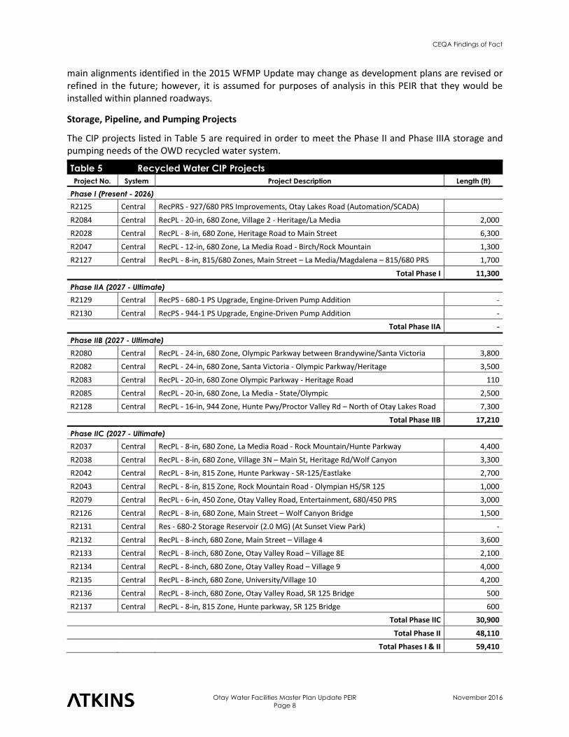
Storage, Pipeline, and Pumping Projects
The CIP projects listed in Table 5 are required in order to meet the Phase II and Phase IIIA storage and pumping needs of the OWD recycled water system.
Table 5 Recycled Water CIP Projects
Project No. System Project Description Length (ft)
Phase I (Present - 2026)
R2125 Central RecPRS - 927/680 PRS Improvements, Otay Lakes Road (Automation/SCADA)
R2084 Central RecPL - 20-in, 680 Zone, Village 2 - Heritage/La Media 2,000
R2028 Central RecPL - 8-in, 680 Zone, Heritage Road to Main Street 6,300
R2047 Central RecPL - 12-in, 680 Zone, La Media Road - Birch/Rock Mountain 1,300
R2127 Central RecPL - 8-in, 815/680 Zones, Main Street – La Media/Magdalena – 815/680 PRS 1,700
Total Phase I 11,300
Phase IIA (2027 - Ultimate)
R2129 Central RecPS - 680-1 PS Upgrade, Engine-Driven Pump Addition -
R2130 Central RecPS - 944-1 PS Upgrade, Engine-Driven Pump Addition -
Total Phase IIA -
Phase IIB (2027 - Ultimate)
R2080 Central RecPL - 24-in, 680 Zone, Olympic Parkway between Brandywine/Santa Victoria 3,800
R2082 Central RecPL - 24-in, 680 Zone, Santa Victoria - Olympic Parkway/Heritage 3,500
R2083 Central RecPL - 20-in, 680 Zone Olympic Parkway - Heritage Road 110
R2085 Central RecPL - 20-in, 680 Zone, La Media - State/Olympic 2,500
R2128 Central RecPL - 16-in, 944 Zone, Hunte Pwy/Proctor Valley Rd – North of Otay Lakes Road 7,300
Total Phase IIB 17,210
Phase IIC (2027 - Ultimate)
R2037 Central RecPL - 8-in, 680 Zone, La Media Road - Rock Mountain/Hunte Parkway 4,400
R2038 Central RecPL - 8-in, 680 Zone, Village 3N – Main St, Heritage Rd/Wolf Canyon 3,300
R2042 Central RecPL - 8-in, 815 Zone, Hunte Parkway - SR-125/Eastlake 2,700
R2043 Central RecPL - 8-in, 815 Zone, Rock Mountain Road - Olympian HS/SR 125 1,000
R2079 Central RecPL - 6-in, 450 Zone, Otay Valley Road, Entertainment, 680/450 PRS 3,000
R2126 Central RecPL - 8-in, 680 Zone, Main Street – Wolf Canyon Bridge 1,500
R2131 Central Res - 680-2 Storage Reservoir (2.0 MG) (At Sunset View Park) -
R2132 Central RecPL - 8-inch, 680 Zone, Main Street – Village 4 3,600
R2133 Central RecPL - 8-inch, 680 Zone, Otay Valley Road – Village 8E 2,100
R2134 Central RecPL - 8-inch, 680 Zone, Otay Valley Road – Village 9 4,000
R2135 Central RecPL - 8-inch, 680 Zone, University/Village 10 4,200
R2136 Central RecPL - 8-inch, 680 Zone, Otay Valley Road, SR 125 Bridge 500
R2137 Central RecPL - 8-in, 815 Zone, Hunte parkway, SR 125 Bridge 600
Total Phase IIC 30,900
Total Phase II 48,110
Total Phases I & II 59,410
CEQA Findings of Fact
Otay Water Facilities Master Plan Update PEIR
Page 9
November 2016
2.4 Project Purpose, Goals and Objectives
The purpose of the 2015 WFMP is to revise the OWD 2009 WRMP; update planning criteria and OWD’s hydraulic system models; map out water and recycled water facility improvements; update OWD’s CIP; and identify adaptive responses to changed conditions.
The WFMP’s forecast is based on the latest regional growth forecasts developed by the San Diego Association of Governments (SANDAG), and is consistent with the adopted land use plans of all jurisdictions within the district boundaries. OWD coordinates with these jurisdictions through its development of Urban Water Management Plans, and through other ongoing coordination to ensure land use plans account for the availability of water supplies and water service infrastructure. Consistent with the LAFCO AOI designation, the 2015 WFMP Update accounts for projected development within the AOI to the extent consistent with adopted land use plans and to the extent these lands are expected to annex into the OWD boundary. These areas include the Otay Ranch Villages 13 and 14, and the San Ysidro Mountain Ranch/Planning Area 17 area. The AOI also includes the Sycuan Indian Reservation, located to the northeast of the OWD service boundary, but these lands are not included in the demand forecast.
The primary goals and objectives for the 2015 WFMP Update include the following actions:
■ Update Planning Criteria and the District’s Hydraulic System Models: Review and update, as necessary, the District’s system performance criteria, and update the District’s InfoWater system hydraulic models to account for new development and to maintain integration with the District’s GIS system.
■ Map Out Water and Recycled Water Facility Improvements: Identify and prioritize the District’s facility needs, including transmission, storage, and pumping facilities, to serve projected future conditions.
■ Update OWD CIP: Update the District’s near-term (2020) and long-term (2050) CIP, based on a new demand forecast, new supply options and identified facility needs.
■ Identify Adaptive Responses to Changed Conditions: Identify how needed facility improvements and CIP items would change should future demand and supply conditions vary from baseline assumptions.
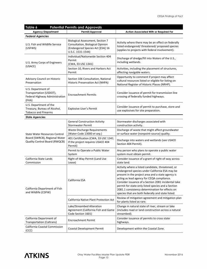
2.5 Permits, Approvals, and Regulatory Requirements
Numerous federal, state and local regulations and permit requirements would be applicable to the implementation of the 2015 WFMP (Table 6). OWD, or its contractors, would be required to comply with all applicable requirements, unless by exception of Government Code Section 53091. Because zoning ordinances do not apply to the location or construction of facilities used for the production, generation, storage or transmission of water, this PEIR will address only those specific objectives, policies and standards from the planning agencies of communities potentially affected by the future CIP projects that support the implementation of water storage and transmission facilities.
CEQA Findings of Fact
Otay Water Facilities Master Plan Update PEIR
Page 10
November 2016
Table 6 Potential Permits and Approvals Agency/Department Permit/Approval Action Associated With or Required For
Federal Agencies
U.S. Fish and Wildlife Service (USFWS)
Biological Assessment, Section 7 Consultation, Biological Opinion (Endangered Species Act [ESA] 16 U.S.C. 1531-1544)
Activity where there may be an effect on federally listed endangered/ threatened/ proposed species (applies to projects with federal involvement).
U.S. Army Corps of Engineers (USACE)
Individual/Nationwide Section 404 Permit (CWA, 33 USC 1341)
Discharge of dredge/fill into Waters of the U.S., including wetlands.
Section 10, Rivers and Harbors Act Permit
Activities, including the placement of structures, affecting navigable waters.
Advisory Council on Historic Preservation
Section 106 Consultation, National Historic Preservation Act (NHPA)
Opportunity to comment if project may affect cultural resources listed or eligible for listing on National Register of Historic Places (NRHP).
U.S. Department of Transportation (USDOT), Federal Highway Administration (FHA)
Encroachment Permits Consider issuance of permit for transmission line crossing of federally funded highways.
U.S. Department of the Treasury, Bureau of Alcohol, Tobacco and Firearms
Explosive User’s Permit Consider issuance of permit to purchase, store and use explosives for site preparation.
State Agencies
State Water Resources Control Board (SWRCB), Regional Water Quality Control Board (RWQCB)
General Construction Activity Stormwater Permit
Stormwater discharges associated with construction activity.
Waste Discharge Requirements (Water Code 13000 et seq.)
Discharge of waste that might affect groundwater or surface water (nonpoint-source) quality.
401 Certification (CWA, 33 USC 1341. If the project requires USACE 404 Permit)
Discharge into waters and wetlands (see USACE Section 404 Permit).
Permit to Operate a Public Water System
Any person who plans to operate a public water system must obtain permit.
California State Lands Commission
Right-of-Way Permit (Land Use Lease)
Consider issuance of a grant of right-of-way across state land.
California Department of Fish and Wildlife (CDFW)
California ESA
Activity where a listed candidate, threatened, or endangered species under California ESA may be present in the project area and a state agency is acting as lead agency for CEQA compliance. Consider issuance of a Section 2081 incidental take permit for state-only listed species and a Section 2081.1 consistency determination for effects on species that are both federally and state listed.
California Native Plant Protection Act Review of mitigation agreement and mitigation plan for plants listed as rare.
Lake/Streambed Alteration Agreement (California Fish and Game Code Section 1601)
Change in natural state of river, stream or lake (includes road or land construction across a natural streambed).
California Department of Transportation (Caltrans)
Encroachment Permit Consider issuance of permits to cross state highways.
California Coastal Commission (CCC)
Coastal Development Permit Development within the Coastal Zone.
CEQA Findings of Fact
Otay Water Facilities Master Plan Update PEIR
Page 11
November 2016
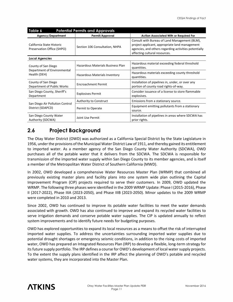
Table 6 Potential Permits and Approvals Agency/Department Permit/Approval Action Associated With or Required For
California State Historic Preservation Office (SHPO)
Section 106 Consultation, NHPA
Consult with Bureau of Land Management (BLM), project applicant, appropriate land management agencies, and others regarding activities potentially affecting cultural resources.
Local Agencies
County of San Diego Department of Environmental Health (DEH)
Hazardous Materials Business Plan Hazardous material exceeding federal threshold quantities.
Hazardous Materials Inventory Hazardous materials exceeding county threshold quantities.
County of San Diego Department of Public Works
Encroachment Permit Installation of pipelines in, under, or over any portion of county road rights-of-way.
San Diego County, Sheriff’s Department
Explosives Permit Consider issuance of a license to store flammable explosives.
San Diego Air Pollution Control District (SDAPCD)
Authority to Construct Emissions from a stationary source.
Permit to Operate Equipment emitting pollutants from a stationary source.
San Diego County Water Authority (SDCWA)
Joint Use Permit Installation of pipelines in areas where SDCWA has prior rights.
2.6 Project Background
The Otay Water District (OWD) was authorized as a California Special District by the State Legislature in 1956, under the provisions of the Municipal Water District Law of 1911, and thereby gained its entitlement to imported water. As a member agency of the San Diego County Water Authority (SDCWA), OWD purchases all of the potable water that it delivers from the SDCWA. The SDCWA is responsible for transmission of the imported water supply within San Diego County to its member agencies, and is itself a member of the Metropolitan Water District of Southern California (MWD).
In 2002, OWD developed a comprehensive Water Resources Master Plan (WRMP) that combined all previously existing master plans and facility plans into one system wide plan outlining the Capital Improvement Program (CIP) projects required to serve their customers. In 2009, OWD updated the WRMP. The following three phases were identified in the 2009 WRMP Update: Phase I (2015-2016), Phase II (2017-2022), Phase IIIA (2023-2050), and Phase IIIB (2023-2050). Minor updates to the 2009 WRMP were completed in 2010 and 2013.
Since 2002, OWD has continued to improve its potable water facilities to meet the water demands associated with growth. OWD has also continued to improve and expand its recycled water facilities to serve irrigation demands and conserve potable water supplies. The CIP is updated annually to reflect system improvements and to identify future needs for budgeting purposes.
OWD has explored opportunities to expand its local resources as a means to offset the risk of interrupted imported water supplies. To address the uncertainties surrounding imported water supplies due to potential drought shortages or emergency seismic conditions, in addition to the rising costs of imported water, OWD has prepared an Integrated Resources Plan (IRP) to develop a flexible, long-term strategy for its future supply portfolio. The IRP defines a course for OWD’s development of local water supply projects. To the extent the supply plans identified in the IRP affect the planning of OWD’s potable and recycled water systems, they are incorporated into the Master Plan.
CEQA Findings of Fact
Otay Water Facilities Master Plan Update PEIR
Page 12
November 2016
The purpose of the 2015 Water Facilities Master Plan (WFMP) Update is to revise the OWD 2009 WRMP; update planning criteria and OWD’s hydraulic system models; map out water and recycled water facility improvements; update OWD’s CIP projects; and identify adaptive responses to changed conditions.
3.0 Record of Proceedings
For purposes of CEQA and these Findings, the Record of Proceedings for the 2015 WFMP Update consists of the following documents, at a minimum:
■ The NOP and all other public notices issued by OWD in conjunction with the 2015 WFMP Update PEIR;
■ The Draft PEIR and Final PEIR, including appendices;
■ All comments submitted by agencies, organizations, or members of the public during the 45-day public comment period on the Draft PEIR;
■ The project design features, standard construction practices, and mitigation/performance measures incorporated into the CIP projects to avoid significant environmental impacts;
■ All findings and resolutions adopted by OWD decision makers in connection with the 2015 WFMP Update PEIR, and all documents cited or referred therein;
■ All final reports, studies, memoranda, maps, or other documents relating to the 2015 WFMP Update PEIR prepared by PBS&J, consultants to OWD;
■ Minutes and/or verbatim transcripts of all information sessions, public meetings, and public hearings held by OWD, in connection with the 2015 WFMP Update PEIR;
■ Any documentary or other evidence submitted to OWD at such information sessions, public meetings, and public hearings;
■ Matters of common knowledge to OWD including, but not limited to, federal, state, and local laws and regulations;
■ Any documents expressly cited in these Findings, in addition to those cited above; and
■ Any other materials required for the Record of Proceedings by PRC §21167.6(e).
The custodian of the documents comprising the Record of Proceedings is OWD, whose office is located at 2554 Sweetwater Springs Boulevard, Spring Valley, California 91978-2004.
OWD has relied on all of the documents listed above in reaching its decision on the 2015 WFMP Update PEIR, even if every document was not formally presented to the OWD decision makers as part of the OWD files generated in connection with the 2015 WFMP Update PEIR. Without exception, any document set forth above that is not found in the OWD files falls into one of two categories: (1) many of the documents reflect prior planning or legislative decisions with which OWD was aware in approving the 2015 WFMP Update PEIR (see City of Santa Cruz v. Local Agency Formation Commission (1978) 76 Cal.App.3d 381, 391-392; Dominey v. Department of Personnel Administration (1988) 205 Cal.App.3d 729, 738, fn. 6); (2) other documents influenced the expert advice provided to OWD staff or consultants, who then provided advice to the OWD decision makers. Therefore, such documents form part of the underlying factual basis for OWD’s decision relating to approval of the 2015 WFMP Update and certification of the Final PEIR (see PRC §21167.6(e)(10); Browning-Ferris Industries v. City Council of City of San Jose (1986) 181 Cal.App.3d 852, 866; Stanislaus Audubon Society, Inc. v. County of Stanislaus (1995) 33 Cal.App.4th 144, 153, 155).
CEQA Findings of Fact
Otay Water Facilities Master Plan Update PEIR
Page 13
November 2016
4.0 Findings Required Under CEQA
PRC §21002 provides that “public agencies should not approve projects as proposed if there are feasible alternatives or feasible mitigation measures available that would substantially lessen the significant environmental effects of such projects[...]” (emphasis added). The same statute states that the procedures required by CEQA “are intended to assist public agencies in systematically identifying both the significant effects of proposed projects and the feasible alternatives or feasible mitigation measures that will avoid or substantially lessen such significant effects” (emphasis added). Section 21002 goes on to state that “in the event [that] specific economic, social, or other conditions make infeasible such project alternatives or such mitigation measures, individual projects may be approved in spite of one or more significant effects.”
The mandate and principles announced in PRC §21002 are implemented, in part, through the requirement that agencies must adopt findings before approving projects for which EIRs are required (see PRC §21081(a); State CEQA Guidelines §15091(a)). For each significant environmental effect identified in an EIR for a proposed project, the approving agency must issue a written finding reaching one or more of three permissible conclusions. The first such finding is that “[c]hanges or alterations have been required in, or incorporated into, the project which avoid or substantially lessen the significant environmental effect as identified in the Final EIR” (State CEQA Guidelines §15091(a)(1)). The second permissible finding is that “[s]uch changes or alterations are within the responsibility and jurisdiction of another public agency and not the agency making the finding. Such changes have been adopted by such other agency or can and should be adopted by such other agency” (State CEQA Guidelines §15091(a)(2)). The third potential conclusion is that “[s]pecific economic, legal, social, technological, or other considerations, including provision of employment opportunities for highly trained workers, make infeasible the mitigation measures or project alternatives identified in the Final EIR” (State CEQA Guidelines §15091(a)(3)). PRC §21061.1 defines “feasible” to mean “capable of being accomplished in a successful manner within a reasonable period of time, taking into account economic, environmental, social and technological factors.” State CEQA Guidelines §15364 adds another factor: “legal” considerations (see also Citizens of Goleta Valley v. Board of Supervisors (1990) 52 Cal.3d 553, 565).
The concept of “feasibility” also encompasses the question of whether a particular alternative or mitigation measure promotes the underlying goals and objectives of a project (City of Del Mar v. City of San Diego (1982) 133 Cal.App.3d 410, 417). “[F]easibility” under CEQA encompasses “desirability” to the extent that desirability is based on a reasonable balancing of the relevant economic, environmental, social, and technological factors” (Ibid.; see also Sequoyah Hills Homeowners Assn. v. City of Oakland (1993) 23 Cal.App.4th 704, 715).
The State CEQA Guidelines do not define the difference between “avoiding” a significant environmental effect and merely “substantially lessening” such an effect. OWD must, therefore, glean the meaning of these terms from the other contexts in which the terms are used. PRC §21081, on which State CEQA Guidelines §15091 is based, uses the term “mitigate” rather than “substantially lessen.” The State CEQA Guidelines therefore equate “mitigating” with “substantially lessening.” Such an understanding of the statutory term is consistent with the policies underlying CEQA, which include the policy that “public agencies should not approve projects as proposed if there are feasible alternatives or feasible mitigation measures available that would substantially lessen the significant environmental effects of such projects” (PRC §21002).
For purposes of these Findings, the term “avoid” refers to the effectiveness of one or more mitigation measures to reduce an otherwise significant effect to a less than significant level. In contrast, the term “substantially lessen” refers to the effectiveness of such measure or measures to substantially reduce the
CEQA Findings of Fact
Otay Water Facilities Master Plan Update PEIR
Page 14
November 2016
severity of a significant effect, but not to reduce that effect to a less than significant level. These interpretations appear to be mandated by the holding in Laurel Hills Homeowners Association v. City Council (1978) 83 Cal.App.3d 515, 519-527, in which the Court of Appeal held that an agency had satisfied its obligation to substantially lessen or avoid significant effects by adopting numerous mitigation measures, not all of which rendered the significant impacts in question less than significant.
Although State CEQA Guidelines §15091 requires only that approving agencies specify that a particular significant effect is “avoid[ed] or substantially lessen[ed],” these Findings, for purposes of clarity, in each case will specify whether the effect in question has been reduced to a less than significant level or has simply been substantially lessened but remains significant. Moreover, although Section 15091, read literally, does not require findings to address environmental effects that an EIR identifies as merely “potentially significant,” these Findings will nevertheless fully account for all such effects identified in the Final PEIR.
In short, CEQA requires that the lead agency adopt mitigation measures or alternatives, where feasible, to substantially lessen or avoid significant environmental impacts that would otherwise occur. Certain project modifications or the adoption of certain mitigation measures or alternatives are not required, however, where such actions are infeasible or where the responsibility for implementation lies with some other agency (State CEQA Guidelines §15091(a), (b)).
State CEQA Guidelines §15126.2(b) requires the identification of significant impacts that would not be avoided, even with the implementation of feasible mitigation measures or a feasible environmentally superior alternative. With respect to a project for which significant impacts are not avoided or substantially lessened, either through the adoption of feasible mitigation measures or a feasible environmentally superior alternative, a public agency, after adopting proper findings, may nevertheless approve the project if the agency first adopts a statement of overriding considerations setting forth the specific reasons why the agency found that the project’s “benefits” rendered “acceptable” the “unavoidable adverse environmental effects” (State CEQA Guidelines §§15093, 15043(b); see also PRC §21081(b)). According to the evaluation within the 2015 WFMP Update PEIR, all potential environmental effects would be reduced to less than significant levels with implementation of identified project design features (PDFs), standard construction practices (SCPs) and feasible mitigation/performance measures, and no significant unavoidable environmental impacts would remain. Therefore, a statement of overriding considerations is not required for the 2015 WFMP Update PEIR. Please note that the final determination of significance of impacts and of the feasibility of mitigation/performance measures will be made by the OWD Board of Directors as part of their certification of the Final PEIR.
5.0 Legal Effects of Findings
To the extent that these Findings conclude that various project design features, standard construction practices and mitigation/performance measures outlined in the Final PEIR are feasible and have not been modified, superseded, or withdrawn, OWD hereby binds itself to implement these measures. These Findings, in other words, are not merely informational, but rather constitute a binding set of obligations that will come into effect when OWD formally approves the 2015 WFMP Update and certifies the Final PEIR.
The project design features, standard construction practices and mitigation/performance measures are included in the Mitigation Monitoring and Reporting Program (MMRP) adopted concurrently with these Findings, and will be effectuated through the process of implementing the 2015 WFMP Update (refer to Section 8.0 of these Findings).
CEQA Findings of Fact
Otay Water Facilities Master Plan Update PEIR
Page 15
November 2016
6.0 Mitigation Monitoring and Reporting Program
A MMRP has been prepared for the 2015 WFMP Update PEIR, and has been adopted concurrently with these Findings (see PRC §21081.6(a)(1)), that includes the project design features, standard construction practices and mitigation/performance measures incorporated into the 2015 WFMP Update CIP projects to avoid or substantially lessen significant environmental effects, as outlined in the Final PEIR. OWD will use the MMRP, which is a separate, stand-alone document, to track compliance with the adopted project design features, standard construction practices and mitigation/performance measures. The MMRP will remain available for public review during the compliance period.
7.0 Significant Effects and Mitigation Measures
7.1 Air Quality
A. Standards of Significance
Thresholds used to evaluate impacts to air quality are based on applicable criteria in the State CEQA Guidelines (CCR §§15000-15387), Appendix G. A significant impact would occur if the CIP projects proposed under the 2015 WFMP Update would:
1. Result in a conflict with or obstruct implementation of the San Diego County RAQS, applicable portions of the SIP, and/or any local air quality plans.
2. Violate any air quality standard or contribute substantially to an existing or projected air quality violation including pollutant emissions for which the region is in federal or state nonattainment.
B. Impacts
Threshold 1: Would implementation of the 2015 WFMP Update expose sensitive receptors to
substantial pollutant concentrations?
The 2009 RAQS was developed based on growth assumptions, land use, and other information from SANDAG. Growth assumptions made within the 2015 WFMP Update to determine appropriate future service requirements were also derived from SANDAG growth assumptions and land use information. As such, the 2015 WFMP Update would be consistent with the applicable SDAPCD air quality management plan and the California SIP, as these documents utilized the same growth assumptions. Implementation of the 2015 WFMP Update would not conflict with or obstruct implementation of an applicable air quality plan.
Threshold 2: Would implementation of the 2015 WFMP Update create objectionable odors
affecting a substantial number of people?
Threshold 2: Construction of CIP projects proposed under the 2015 WFMP Update would result in temporary increases in air pollutant emissions. These emissions would be generated in the form of fugitive dust emissions (PM10 and PM2.5) and ozone precursor emissions (NOX, VOC). Therefore, implementation of the 2015 WFMP Update could potentially contribute to the existing regional violation of state and federal air pollutant standards, resulting in a significant impact, and mitigation/performance measures are required (see below). Operational sources of air pollutants from the constructed CIP projects would be negligible. Therefore, implementation of the 2015 WFMP Update would not violate any air quality standard or contribute substantially to an existing or projected air quality violation with regards to stationary or mobile sources.
CEQA Findings of Fact
Otay Water Facilities Master Plan Update PEIR
Page 16
November 2016
C. Findings
The OWD Board of Directors finds that implementation of the 2015 WFMP Update would not
■ conflict with or obstruct implementation of the applicable air quality plans (2009 RAQS and California SIP);
■ expose sensitive receptors to substantial pollutant concentrations; and
■ create objectionable odors affecting a substantial number of people.
Therefore, no mitigation/performance measures are required.
Pursuant to State CEQA Guidelines §15091(a)(1), changes or alterations have been required in, or incorporated into, the CIP projects proposed under the 2015 WFMP Update which avoid or substantially lessen the potential for
■ violations of any air quality standard or substantial contributions to an existing or projected air quality violation;
■ conflicts with any applicable plan, policy, or regulation of an agency adopted for the purpose of reducing the emissions of greenhouse gases; and
■ cumulatively considerable net increases of any criteria pollutant for which the SDAB is non-attainment under the NAAQS and CAAQS, including releasing emissions which exceed quantitative thresholds for O3 precursors (see Section 5.5 of the PEIR for cumulative impact discussion).
D. Explanation
Threshold 1: Would implementation of the 2015 WFMP Update expose sensitive receptors to
substantial pollutant concentrations?
The most current air quality planning document for the SDAPCD, and thus the applicable air quality management plan for the 2015 WFMP Update, is the 2009 RAQS which was prepared by the SDAPCD as part of the California SIP to demonstrate how the SDAB would either maintain or strive to attain the NAAQS. Being that the SDAB is classified as a nonattainment area for the NAAQS and CAAQS for O3, PM2.5
and PM10, the RAQS outlines specific actions (emission control measures) that the SDAPCD will take towards achieving attainment of these pollutants. The California SIP, which was prepared by the California Air Resources Board (CARB) to demonstrate how the entire state of California will maintain or attain the NAAQS and CAAQS, is also applicable to the WRMP planning area. These documents were developed based on growth assumptions, land use, and other information from SANDAG. Growth assumptions made within the 2015 WFMP Update to determine appropriate future service requirements were also derived from SANDAG growth assumptions and land use information. Therefore, the 2015 WFMP Update would be consistent with the applicable air quality management plans (2009 RAQS and California SIP), as these documents utilized the same growth assumptions.
Threshold 2: Would implementation of the 2015 WFMP Update create objectionable odors
affecting a substantial number of people?
Implementation of the 2015 WFMP Update would include, but not be limited to, the following SCPs to reduce potential impacts associated with violation of air quality standards:
Air-SCP-1 Prior to construction of CIP projects, the following measures shall be taken to reduce fugitive dust emissions (PM2.5, and PM10). Measures shall be implemented during construction, including but not limited to, the following actions:
CEQA Findings of Fact
Otay Water Facilities Master Plan Update PEIR
Page 17
November 2016
i. During grading and site preparation activities, exposed soil areas shall be watered as necessary (at least twice per day) to prevent dust emissions. During windy days or when fugitive dust can be observed leaving construction sites, additional applications of water shall be required. Under windy conditions where wind velocities are forecast to exceed 25 miles per hour, all ground disturbing activities shall be halted until the winds are forecast to be less than 25 miles per hour.
ii. Where visible soil material is carried onto adjacent public paved roads, the paved roads shall be swept or washed down at the end of the day to avoid vehicles from pulverizing the dirt into fine particles.
iii. Trucks transporting materials to and from the site shall allow for at least two feet of freeboard (i.e., minimum vertical distance between the top of the load and the top of the trailer). Alternatively, trucks transporting materials shall be covered.
Air-SCP-2 Prior to construction of CIP projects, the following measures shall be taken to reduce potential emissions of ozone precursors (NOX and VOCs) associated with construction equipment. Measures shall be implemented during construction, including but not limited to the following action:
i. All construction equipment utilized for the construction of proposed CIP projects shall be maintained, tuned, and operated in accordance with all relevant SDAPCD, ARB, and EPA standards.
Construction Emissions
Construction of CIP projects proposed under the 2015 WFMP Update would result in temporary increases in air pollutant emissions. These emissions would be generated in the form of fugitive dust emissions (PM10 and PM2.5) and ozone precursor emissions (NOX, VOC). Operation of heavy equipment and vehicles during the construction phases would generate exhaust emissions from fuel combustion. Fugitive dust emissions would be generated from earth disturbance during site grading and building demolition, as well as from construction vehicles operating on open fields or dirt roadways within or adjacent to CIP project construction sites.
Equipment that would be associated with construction of the proposed CIP projects includes dozers, rollers, dewatering pumps, backhoes, loaders, delivery and haul trucks. At this time, many of the CIP projects under the 2015 WFMP Update are still in the design phase and, as such, information regarding the number and type of construction equipment required and the duration of construction activities is still unknown. Therefore, it is unknown whether or not construction emissions for the CIP projects (either individually or collectively) would exceed the screening thresholds established by the SDAPCD.
The SDAB is currently designated as a nonattainment area for the state standard for PM10, PM2.5, 1-hour and 8-hour ozone, and the federal 8-hour standard for ozone. Implementation of Air-SCP-1 would require that construction of all proposed CIP projects adhere to standard construction practices for controlling fugitive dust emissions. In addition, all equipment utilized for construction of the proposed CIP projects would be required to implement Air-SCP-2. This standard construction practice requires that all construction vehicles meet the requirements of the relevant air quality agencies, the SDAPCD, ARB, and the EPA with regards to tuning, maintenance, and operation of the vehicles. Although incorporation of these standard construction practices would reduce potential pollutant emissions, compliance with the standard construction practices does not ensure that emissions from combined construction activity would be less than the applicable SDAPCD screening levels.
CEQA Findings of Fact
Otay Water Facilities Master Plan Update PEIR
Page 18
November 2016
Implementation of the 2015 WFMP Update could potentially contribute to the existing regional violation of state and federal air pollutant standards, resulting in a significant impact.
Operational Emissions
Operational impacts associated with the 2015 WFMP Update would be incremental emissions of air pollutants resulting from two emission source categories: stationary and mobile sources. The following describes these emissions associated with the 2015 WFMP Update.
Stationary Sources. Stationary sources of air pollutant emissions associated with the CIP projects include fuel combustion emissions from diesel-powered emergency generators. Criteria air pollutants from these sources include carbon monoxide, NOX, SOX, VOC, PM10, and PM2.5. Of the proposed CIP projects, the only projects that may require such equipment would be pump stations. Pipeline projects, storage projects, and groundwater wells, once constructed, would not require the use of emergency generators or any other type of fuel-consuming operating equipment. None of the CIP projects would require space heating or landscape equipment. The 2015 WFMP Update proposes construction of twelve new pump stations: two within Phase II, six within Phase IIIA, and four within Phase IIIB. Diesel fuel for the generators would only be consumed when the equipment is tested, approximately once per month, or in the event of an emergency. Due to the minimal use of diesel fuel required for operation of the pump stations, stationary sources of air pollutant emissions would be negligible.
Mobile Sources. Mobile sources of air pollutant emissions for the CIP projects would be primarily associated with vehicular trips by employees. However, operation of CIP projects proposed under the 2015 WFMP Update would not generate a significant volume of new vehicle trips. The maintenance for most of the CIP projects would require approximately one visit per day. Due to the minimal number of vehicular trips associated with maintenance of the CIP projects, mobile sources of air pollutant emissions would be negligible. Therefore, implementation of the 2015 WFMP Update would not violate any air quality standard or contribute substantially to an existing or projected air quality violation with regards to mobile sources.
E. Mitigation/Performance Measures
Implementation of mitigation measure Air-1 would reduce potential impacts associated with violations of air quality standards with regards to construction emissions to a less than significant level.
Air-1 An air quality technical study shall be prepared for each CIP once the project reaches the design stage to determine whether potential air pollutant emissions associated with construction activities are less than the screening thresholds established by the SDAPCD. The air quality technical study shall include an air pollutant emissions inventory for the CIP under design, as well as emissions for all other designed CIPs that would undertake construction within the same timeframe. All recommendations and measures identified in the air quality technical study to ensure that air pollutant emissions remain within established thresholds shall be incorporated by the Otay Water District prior to any groundbreaking activities associated with the project.
F. Residual Impacts after Mitigation
No residual impacts would remain after implementation of the PDFs, SCPs, and mitigation/ performance measures listed above.
CEQA Findings of Fact
Otay Water Facilities Master Plan Update PEIR
Page 19
November 2016
7.2 Biological Resources
A. Standards of Significance
Thresholds used to evaluate impacts to biological resources are based on applicable criteria in the State CEQA Guidelines (CCR §§15000-15387), Appendix G. A significant impact would occur if the CIP projects proposed under the 2015 WFMP Update would:
1. Either directly or through habitat modifications, on any sensitive or special-status species or sensitive habitats identified in local or regional plans, policies, or regulations, or by the CDFW or USFWS.
2. Have a substantial adverse effect on any riparian habitat or other sensitive natural community identified in local or regional plans, policies, regulations, or by CDFW or USFWS.
3. Have a substantial adverse effect on federally protected wetlands as defined by Section 404 of the Clean Water Act through direct removal, filling, hydrological interruption, or other means.
4. Interfere substantially with the movement of any native resident or migratory fish or wildlife species or with established native resident or migratory wildlife corridors, or impede the use of native wildlife nursery sites.
B. Impacts
Threshold 1 – Sensitive Species and Habitats
Implementation of the 2015 WFMP Update would result in significant direct and indirect impacts to sensitive plant and animal species and sensitive habitats; therefore, mitigation/performance measures are required (see Threshold 1 explanation below).
Threshold 2 - Riparian Habitat and Other Sensitive Natural Communities
Implementation of some of the CIPs located in the OWD planning area would have the potential to result in significant direct and indirect impacts to riparian habitat and other sensitive natural communities. The biological resources mitigation measures outlined below would reduce those impacts to less than significant levels.
Threshold 3 – Federally Protected Wetlands
Implementation of portions of the 2015 WFMP Update would have the potential to result in direct and indirect impacts to federally protected wetlands. The biological resources mitigation measures outlined below would reduce direct and indirect impacts to federally protected wetlands to less than significant levels.
Threshold 4 – Wildlife Movement Corridors and Nursery Sites
Implementation of the 2015 WFMP Update would have the potential to temporarily impact wildlife movement corridors. The biological resources mitigation measures outlined below would reduce direct and indirect impacts to wildlife movement corridors to less than significant levels.
CEQA Findings of Fact
Otay Water Facilities Master Plan Update PEIR
Page 20
November 2016
C. Findings
The OWD Board of Directors finds that implementation of the 2015 WFMP Update would not
■ have a substantial adverse effect on federally protected wetlands as defined by Section 404 of the CWA;
■ interfere substantially with the movement of any native resident or migratory fish or wildlife species, or with established native resident migratory wildlife corridors; or
■ substantially conflict with any local policies or ordinances protecting biological resources.
Therefore, no mitigation/performance measures are required.
Pursuant to State CEQA Guidelines §15091(a)(1), changes or alterations have been required in, or incorporated into, the CIP projects proposed under the 2015 WFMP Update which avoid or substantially lessen the potential for:
■ substantial adverse effects, either directly or through habitat modifications, on any sensitive or special-status species or sensitive habitats; and
■ cumulatively considerable contributions to significant cumulative biological resources impacts considering past, present, and probable future projects (see Section 5.5 of the PEIR for cumulative impact discussion).
D. Explanation
Threshold 1 – Sensitive Species and Habitats
Direct Impacts
Direct impacts include the direct destruction or displacement of biological resources from clearing, grubbing, grading, and other initial land disturbance activities. Implementation of the 2015 WFMP Update would have the potential to result in direct impacts to special-status plant and wildlife species and/or sensitive habitats.
Reservoir/Storage Projects. Construction of CIP potable water storage projects located within sensitive habitats could result in direct impacts to sensitive biological resources from temporary and permanent vegetation removal. Potable water storage CIP projects, and sensitive habitats potentially impacted by construction of the projects, are listed in Table 4.2-6 of the PEIR. Coastal sage scrub, chaparral, and grassland habitat are likely to be directly impacted from the implementation of the proposed water storage CIPs. Disturbed or developed areas are not considered sensitive habitats.
Pump Station Projects. Construction of CIP pump stations located within sensitive habitats could result in direct impacts to sensitive biological resources from temporary and permanent vegetation removal. Pump station CIP projects, and sensitive habitats potentially impacted by construction of the projects, are listed in Table 4.2-7 of the PEIR. Coastal sage scrub, chaparral, riparian, and grassland habitat are likely to be directly impacted from the implementation of the proposed pump station CIPs. Disturbed or developed areas are not considered sensitive habitats.
Pipeline Projects. Construction of CIP pipeline projects located within sensitive habitats could result in direct impacts to sensitive biological resources from temporary and permanent vegetation removal. Pipeline CIP projects, and sensitive habitats potentially impacted by construction of the projects, are listed in Table 4.2-8 of the PEIR. Coastal sage scrub, chaparral, riparian, wetland, and grassland habitat are likely to be directly impacted from the implementation of the proposed pipeline CIPs. Disturbed or developed areas are not considered sensitive habitats.

CEQA Findings of Fact
Otay Water Facilities Master Plan Update PEIR
Page 21
November 2016
Miscellaneous CIP. Similar to the water supply projects described above, the miscellaneous CIP projects involve a variety of project types, including installation of an air and vacuum ventilation system, demolition of an existing reservoir and pump station, meter and vault installations, pipeline crossings, and distribution pipelines, as listed in Table 4.2-9 of the PEIR. Construction of miscellaneous CIP projects located within sensitive habitats could result in direct impacts to sensitive biological resources from temporary and permanent vegetation removal. Miscellaneous CIP projects, and sensitive habitats potentially impacted by construction of the projects, are listed in Table 4.2-6 of the PEIR. Coastal sage scrub and chaparral are likely to be directly impacted from the implementation of the proposed miscellaneous CIPs. Disturbed or developed areas are not considered sensitive habitats.
Indirect Impacts
Potential indirect impacts to sensitive species and habitats from construction of CIPs under the 2015 WFMP Update could include impaired water quality, fugitive dust, noise, night lighting, staging areas, and establishment and spread of invasive non-native plant species from graded areas. Potential indirect impacts to sensitive species and habitats from long-term operations at above-ground CIP facilities (i.e., storage reservoirs/tanks and pump stations) under the 2015 WFMP Update could include impaired water quality, noise from pumps, security night lighting, and establishment and spread of invasive non-native plant species from graded areas. Potential impacts from impaired water quality (e.g., erosion/ sedimentation from graded areas, storm water runoff pollution from oil leaks during construction and from paved areas post-construction, etc.) would be reduced to less than significant levels through compliance with the NPDES program and Hazardous Materials Business Plan (HMBP) requirements (refer to Geo-SCP-3 in Section 7.5 and Hyd-SCP-1 in Section 7.5 Hydrology below). Temporary, construction-related impacts from fugitive dust impacts would be reduced to less than significant levels through implementation of dust control Best Management Practices (BMPs) during construction (refer to Air-SCP-1 in Section 7.1 above). Potential impacts due to establishment and spread of invasive non-native plant species from graded areas into adjacent native vegetation communities would be reduced to less than significant levels through implementation of the measures listed in Bio-SCP-1 above. The remaining indirect impacts related to CIP construction activities and from long-term operations at CIP storage reservoirs/tanks and pump stations are discussed below.
Noise. CIP construction activities would result in temporary increases in noise levels that could disturb sensitive breeding birds and raptors that use adjacent native habitats for nesting and foraging.
For CIP pump stations located adjacent to native vegetation communities that could be used by sensitive breeding birds and raptors, potential impacts due to permanent increases in noise levels from operation of pumps would be reduced to less than significant levels through implementation of Noi-PDF-1 (Section 7.10 below), which requires the placement of pumps, emergency generators, and any other motorized equipment within a masonry enclosure.
Night Lighting. Night lighting used during nighttime construction of CIPs may alter nocturnal behavior patterns of wildlife that use adjacent native habitats for nesting and foraging. Night lighting could also give nocturnal predators an unnatural advantage over prey species, which could cause an increased loss of native wildlife.
For above-ground CIP facilities (i.e., storage reservoirs/tanks and pump stations) under the 2015 WFMP Update that would be located adjacent to native vegetation communities, potential impacts could occur to nocturnal wildlife from increased predation due to “spill-over” of nighttime light levels into the adjacent habitats from outdoor (security) lighting installed at these facilities. These potential impacts would be reduced to less than significant levels through implementation of Ene-PDF-2 (discussed below in Section
CEQA Findings of Fact
Otay Water Facilities Master Plan Update PEIR
Page 22
November 2016
7.4), which requires such lighting to be of low illumination (i.e., light emitting diodes with motion-sensor lighting controls), shielded, and directed downwards and away from these areas.
Other Construction-Related Impacts
Fueling and maintenance of equipment in construction staging areas could lead to accidental leaks or spills resulting in storm water runoff contamination due to elevated concentrations of hydrocarbons that could enter downstream drainages and wetlands. As stated above, such temporary, construction-related impacts from decreased water quality would be reduced to less than significant levels through compliance with the NPDES program and HMBP requirements (refer to Geo-SCP-3 in Section 7.5 and Hyd-SCP-1 in Section 7.7 below). CIP construction activities could result in inadvertent intrusions of construction equipment and personnel into sensitive habitats adjacent to construction zones.
Threshold 2 - Riparian Habitat and Other Sensitive Natural Communities
The proposed project would result in a potentially significant impact to sensitive habitats in the planning area from direct and indirect impacts associated with the 2015 WFMP implementation. Therefore, the following section focuses solely on riparian habitats. Riparian communities occur along rivers, streams, and other drainages in the unincorporated county. According to the Riparian Bird Conservation Plan, riparian habitats are defined as habitats along the banks or otherwise adjacent to freshwater bodies, watercourses, estuaries, and other surface waters. These areas can be perennial, intermittent, or ephemeral. Riparian areas connect terrestrial and aquatic habitats and provide linkages between water bodies and upstream vegetation communities. The available water provides soil moisture in excess of that typically available in upland habitats.
Implementation of some of the CIPs located in the OWD planning area (refer to Tables 4.2-6, 4.2-7, and 4.2-8 and Figures 4.2-1a – f of the PEIR) would have the potential to result in directs and indirect impacts to riparian habitat and other sensitive natural communities (refer to Section 4.2.3.1 of the PEIR).
Threshold 3 – Federally Protected Wetlands
Federally protected wetlands are defined in Section 404 of the CWA as areas that are inundated or saturated by surface or ground water at a frequency and duration sufficient to support, and that under normal circumstances do support, a prevalence of vegetation typically adapted for life in saturated soil conditions. Wetlands generally include swamps, marshes, bogs, and similar areas.
Implementation of some of the CIPs located in the OWD planning area (refer to Tables 4.2-7 and 4.2-8 and Appendix B: Figure B-1 of the PEIR) would have the potential to result in directs and indirect impact to federally protected wetlands. These projects would comply with applicable federal regulations such as Section 401 and 404 of the CWA.
Threshold 4 – Wildlife Movement Corridors and Nursery Sites
Implementation of some of the CIPs located in the OWD planning area (refer to Tables 4.2-7 and 4.2-8 and Figure 4.2-3 of the PEIR) would have the potential to temporarily impact wildlife movement corridors. Some of the CIPs are within the San Diego National Wildlife Refuge.
E. Mitigation/Performance Measures
Implementation of the following measures would reduce direct and indirect impacts to sensitive species and habitats to less than significant levels. These are considered both mitigation and performance measures since the same measures are required for both the near-term and long-term projects.

CEQA Findings of Fact
Otay Water Facilities Master Plan Update PEIR
Page 23
November 2016
Bio-1A During the design phase, OWD shall retain a qualified biologist to conduct biological surveys as part of the “tiered” CEQA documentation for these projects, following the program described in Section 1.2 (Intended Use and Purpose) of this PEIR.
Bio-1B If the biological surveys identified in performance measure Bio-1A determine the presence of special-status species and/or sensitive or critical habitats on or adjacent to the CIP site, then OWD shall map and quantify the impacts in a Biological Technical Report as part of the “tiered” CEQA documentation referenced in Bio-1A. Detailed project-specific avoidance and mitigation measures for significant impacts to biological resources shall be negotiated between OWD and the regulatory agencies, as part of the approval and certification process for the subsequent CEQA documentation. In addition, the following measures shall be implemented, as applicable:
i. Six (6) weeks prior to vegetation clearing, grading and/or construction activities that are scheduled to occur between February 15 and August 30, a qualified biologist shall commence focused surveys in accordance with USFWS protocols to determine the presence or absence of the California gnatcatcher. Documentation of the survey results shall be provided to OWD and USFWS within 45 days of completing the final survey, as required pursuant to FESA Section 10(a)(1)(A). If the survey results are negative, then no further mitigation for California gnatcatcher is necessary and vegetation clearing can occur at any time in the year following the survey; only mitigation for the habitat loss shall be required (refer to Bio-1B(iv) below). If surveyed habitat is determined to be occupied by California gnatcatcher, then the following measures shall be implemented:
a. Coastal sage scrub/gnatcatcher habitat shall not be removed during the gnatcatcher breeding season (February 15 through August 30). Work that has commenced prior to the breeding season shall be allowed to continue without interruption. If gnatcatchers move into an area within 500 feet of ongoing construction noise levels and attempt to nest, then it can be deduced that the noise is not great enough to discourage gnatcatcher nesting activities. If work begins prior to the breeding season, the contractor(s) should maintain continuous construction activities adjacent to coastal sage scrub that falls within 500 feet, until the work is completed. However, if clearing, grading and/or construction activities are scheduled to begin during the gnatcatcher breeding season, then updated pre-construction surveys are necessary as defined above. In addition, if these activities are initiated prior to, and extend into, the breeding season, but they cease for any period of time and the contractor wishes to restart work within the breeding season window, then updated pre-construction surveys are also necessary. If these surveys indicate no nesting birds occur within the coastal sage scrub that falls within 500 feet of the proposed work, then the adjacent construction activities shall be allowed to commence. However, if the birds are observed nesting within these areas, then the adjacent construction activities shall be postponed until all nesting has ceased.
b. Noise monitoring shall be conducted if construction activities are scheduled during the gnatcatcher breeding season; if the construction-related noise levels would exceed 60 dB Leq (i.e., the noise threshold suggested by the USFWS for indirect impacts to gnatcatcher); and if gnatcatchers are found within 500 feet of the noise source. Noise monitoring shall be conducted by a biologist experienced in both the vocalization and appearance of California gnatcatcher, and in the use of noise meters. Construction activities that generate noise levels over 60 dB Leq may be permitted
CEQA Findings of Fact
Otay Water Facilities Master Plan Update PEIR
Page 24
November 2016
within 300 feet of occupied habitat if methods are employed that reduce the noise levels to below 60 dB Leq at the boundary of occupied habitat (e.g., temporary noise attenuation barriers or use of alternative equipment). During construction activities, daily testing of noise levels shall be conducted by a noise monitor with the help of the biologist to ensure that a noise level of 60 dB Leq at the boundary of occupied habitat is not exceeded. Documentation of the noise monitoring results shall be provided to OWD and USFWS within 45 days of completing the final noise monitoring event.
ii. Ten (10) days prior to vegetation clearing, grading and/or construction activities that are scheduled to occur between February 1 and August 15, surveys for nesting bird species other than the California gnatcatcher, including those protected by the MBTA, shall be conducted by a qualified biologist following applicable USFWS and/or CDFW guidelines. If no active avian nests are identified within the disturbance limits, then no further mitigation is necessary. However, if active nests for avian species of concern are found within the disturbance limits, then species-specific measures prescribed by the MBTA shall be implemented by a qualified biologist. Documentation of the mitigation measures shall be provided to OWD and USFWS within 10 days after implementation.
iii. Ten (10) days prior to vegetation clearing, grading and/or construction activities that are scheduled to occur during the raptor nesting season (generally January 15 through July 31), and where suitable trees (such as Eucalyptus spp.) for raptor nesting occur within 500 feet of such activities, pre-construction surveys for raptor nests shall be performed by a qualified biologist. If no occupied raptor nests are identified in suitable trees on or within 500 feet of the construction site, then no further mitigation is necessary. Construction activities within 500 feet of occupied nests shall not be allowed during the raptor breeding season until a qualified biologist determines that the nests are no longer active. Documentation of the raptor surveys and any follow-up monitoring, as necessary, shall be provided to OWD and USFWS within 10 days of completing the final survey or monitoring event.
iv. For CIPs that would affect non-listed sensitive species and sensitive vegetation communities, the measures listed below shall be implemented prior to vegetation clearing, grading and/or construction activities. In addition, applicable regulatory agency permits and/or authorizations shall be obtained for CIPs that would affect federal and state-listed species, and the conditions of such permits and/or authorizations shall be implemented prior to vegetation clearing, grading and/or construction activities.
a. Special-status species (and any corresponding USFWS-designated critical habitats), sensitive vegetation communities and MSCP resources shall be avoided through project design or site selection, to the extent practicable.
b. For unavoidable impacts to special-status species (and any corresponding USFWS-designated critical habitats), sensitive vegetation communities and MSCP resources, off-site mitigation shall be provided by one, or a combination of, the following measures, in consultation with the USFWS and CDFW: 1) Debit credits from the San Miguel HMA (Table 4.2-10 shows the status of the mitigation bank credits, as of the date of this Final PEIR); 2) Contribute to the preserve system of other agency MSCPs through land acquisition or purchase of mitigation banking credits; and 3) Enhance, restore, create, and preserve in perpetuity off-site habitat areas at locations and mitigation ratios to be approved by the appropriate regulatory agencies and in compliance with the mitigation ratios, guidelines, and standards required by the
CEQA Findings of Fact
Otay Water Facilities Master Plan Update PEIR
Page 25
November 2016
applicable MSCP subarea plans. Typical mitigation ratios for direct impacts to sensitive vegetation types include 2:1 for coastal sage scrub; 3:1 for maritime succulent scrub; 3:1 for native grassland; 2:1 for oak woodlands; 3:1 for southern interior cypress forest; 3:1 for riparian woodlands/forests; 3:1 for coastal freshwater marsh; 2:1 for riparian scrubs (absent threatened or endangered species); 5:1 for San Diego mesa claypan vernal pools; 3:1 for Gabbroic chaparrals; and 0.5:1 for non-native grassland (absent threatened or endangered species). These ratios will be decreased or increased depending on whether the impacts and mitigation would occur inside or outside an MSCP preserve area. For example, these ratios are typically doubled if impacts occur within previously conserved lands. Plans for habitat enhancement, restoration and creation shall be prepared by persons with expertise in southern California ecosystems and native plant revegetation techniques. Such plans shall include, at a minimum: (a) location of the mitigation site(s); (b) plant species to be used, container sizes, and seeding rates; (c) schematic depicting the mitigation area(s); (d) planting schedule; (e) description of the irrigation methodology; (f) measures to control exotic vegetation at the mitigation site(s); (g) specific success criteria (e.g., percent cover of native and non-native species, species richness); (h) detailed monitoring program; (i) contingency measures should the success criteria not be met; and (j) identification of the party responsible for meeting the success criteria and preserving the mitigation site(s) in perpetuity (including conservation easements and management funding). In addition, OWD shall negotiate and implement long-term maintenance requirements to ensure the success of the mitigation site(s).
c. If federal permits or funding are required for CIPs (and listed species) that occur within USFWS-designated critical habitat, then Section 7 Consultations with the USFWS shall be initiated by the appropriate federal permitting agency.
Bio-1C Prior to vegetation clearing, grading, and/or construction activities for CIPs that have the potential to impact sensitive vegetation communities or special-status species (and any corresponding USFWS-designated critical habitats), a qualified biologist shall attend a pre-construction meeting to inform construction crews of the sensitive species and habitats within and/or adjacent to these project sites.
Bio-1D Prior to vegetation clearing, grading, and/or construction activities, a qualified biologist shall oversee installation of appropriate temporary fencing and/or flagging to delineate the limits of construction and the approved construction staging areas for protection of identified sensitive resources outside the approved construction/staging zones: All construction access and circulation shall be limited to designated construction/staging zones. The fencing shall be checked weekly to ensure that fenced construction limits are not exceeded. This fencing shall be removed upon completion of construction activities. Construction staging areas shall be located a minimum of 100 feet from drainages, wetlands and areas supporting sensitive habitats or species. Fueling of equipment shall occur in designated fueling zones within the construction staging areas. All equipment used within the approved construction limits shall be maintained to minimize and control fluid and grease leaks. Provisions to contain and clean up unintentional fuel, oil, fluid and grease leaks/spills shall be in place prior to construction.
Bio-1E During vegetation clearing, grading, and/or construction, a qualified biologist shall monitor these activities: If sensitive species and/or habitats adjacent to these project sites are inadvertently impacted by these activities, then the biologist shall immediately inform the on-
CEQA Findings of Fact
Otay Water Facilities Master Plan Update PEIR
Page 26
November 2016
site construction supervisor who shall temporarily halt or redirect work away from the area of impact. OWD shall immediately be notified of the impact and shall consult with the appropriate regulatory agencies to determine the required mitigation, according to Bio-1B(iv)(b) and (c) above. The biologist shall also ensure that all construction night lighting adjacent to sensitive habitat areas is of low illumination, shielded, and directed downwards and away from these areas.
Bio-1F Construction equipment will be checked by the biological monitor prior to use each morning to ensure no sensitive wildlife species sheltered in or around any equipment left on site overnight.
Bio-1G Trenches associated with pipe installation will be backfilled with earth at the end of each work day to prevent wildlife access, with the exception of the end of the open pipe, which will be left exposed. During installation, the area surrounding the end segment of exposed open pipe will be sloped at the end of each work day at an angle to allow wildlife to easily escape. Also, the open end of the exposed pipe will be covered at the end of each work day with a material flush with the open pipe entrance such as a wooden board or cap such that no wildlife, including smaller species like lizards, can enter the pipe. Should wildlife become trapped in the vicinity of the open exposed pipe, the qualified biologist(s) will remove and relocate the individual outside the construction zone.
F. Residual Impacts after Mitigation
No residual impacts would remain after implementation of the PDFs, SCPs, and mitigation/ performance measures listed above.
7.3 Cultural Resources
A. Standards of Significance
Thresholds used to evaluate potential impacts on cultural resources are based on applicable criteria in the State CEQA Guidelines (CCR §§15000-15387), Appendix G; and Section 106 of the NHPA. A significant impact on cultural (historical and/or archaeological) resources would occur if the CIP projects proposed under the 2015 WFMP Update would:
1. Cause a substantial adverse change in the significance of an historical resource as defined in State CEQA Guidelines §15064.5. Under these provisions, a Lead Agency shall find that a historical resource is significant if it meets one or more of the criteria for listing on the California Register of Historic Resources (CRHR), which extends to any building, structure, feature, or site that:
a. Is associated with events that have made a significant contribution to the broad patterns of California’s history and cultural heritage;
b. Is associated with the lives of persons important to local, California, or national history;
c. Embodies the distinctive characteristics of a type, period, region, or method of construction, or represents the work of an important creative individual or possesses high artistic values; or
d. Has yielded, or may be likely to yield, information important in the prehistory or history of the local area, California, or the nation.
CEQA Findings of Fact
Otay Water Facilities Master Plan Update PEIR
Page 27
November 2016
With few exceptions, for a structure or building to qualify as a historical resource it must be at least 45 years old and retain physical integrity relevant to its period of significance.
2. Cause a substantial adverse change in the significance of an archaeological resource as defined in State CEQA Guidelines §15064.5. Archaeological resources include resources that the Lead Agency determines meet at least one of the criteria listed in PRC §21082.2(g).
3. Disturb any human remains, including those interred outside of formal cemeteries. Section 15064.5(d) and (e) of the State CEQA Guidelines assigns special importance to human remains and specifies certain procedures when Native American remains are discovered. These procedures are detailed under PRC §5097.98.
B. Impacts
Threshold 1: Cause a substantial adverse change in the significance of a historical resource
as defined in State CEQA Guidelines §15064.5
Implementation of a historical building assessment (Cul-PDF-1) prior to demolition of PS 657-1 and PS 657-2, and a subsequent documentation/treatment program (Cul-PDF-2) as necessary, would reduce impacts to potential historical resources to less than significant levels.
Threshold 2: Cause a substantial adverse change in the significance of an archaeological
resource as defined in State CEQA Guidelines §15064.5
Ground disturbance associated with construction of certain CIP projects proposed under the 2015 WFMP Update has the potential to impact potentially significant unknown archaeological resources; therefore, mitigation/performance measures are required (see below).
Threshold 3: Disturb any human remains, including those interred outside of formal cemeteries
Native American or other human remains could be encountered during ground disturbance associated with construction of certain CIP projects proposed under the 2015 WFMP Update; however, compliance with the California Health and Safety Code (Cul-SCP-1) would reduce impacts associated with discovery of human remains to less than significant levels.
C. Findings
Pursuant to State CEQA Guidelines §15091(a)(1), changes or alterations have been required in, or incorporated into, the CIP projects proposed under the 2015 WFMP Update which avoid or substantially lessen the potential for:
■ substantial adverse change in the significance of an historical resource as defined in State CEQA Guidelines §15064.5;
■ substantial adverse change in the significance of an archaeological resource as defined in State CEQA Guidelines §15064.5;
■ disturbance of any human remains, including those interred outside of formal cemeteries; and
■ cumulatively considerable contributions to significant cumulative cultural resources impacts considering past, present, and probable future projects (see Section 5.5 of the PEIR for cumulative impact discussion).
CEQA Findings of Fact
Otay Water Facilities Master Plan Update PEIR
Page 28
November 2016
D. Explanation
Threshold 1: Cause a substantial adverse change in the significance of a historical resource
as defined in State CEQA Guidelines §15064.5
Implementation of the 2015 WFMP Update would include, but would not be limited to, the following PDFs to reduce potential impacts to potential historical resources:
Cul-PDF-1 Approximately six months prior to demolition of P2584 (Reservoirs 657-1 and 657-2), OWD will retain a qualified architectural historian to conduct a historical building assessment. The architectural historian will record, on a California Department of Parks and Recreation (DPR) 523 form, or equivalent documentation, the potential historical resources, if any, that would be affected by this CIP project. The forms will be filed with the SCIC to receive Primary numbers and Trinomials. Should the analysis involved in completing the DPR 523 form indicate that a particular structure does not meet the eligibility criteria for listing on the California Register of Historic Places, then no further research and documentation is necessary (a 6-week to 2-month process). If, however, the structure is determined to be a historical resource, then measure Cul-PDF-2 will be implemented. OWD will provide a copy of the historical building assessment and DPR 523 form to the San Diego County Archaeological Society (SDCAS).
Cul-PDF-2 For each structure determined to be a historical resource according to measure Cul-PDF-1, the architectural historian will oversee the following documentation and treatment program:
i. Prior to alteration, remodeling, renovation, relocation, and/or demolition of the historical resource, the architectural historian will document the structure, and associated landscaping and setting, via still and video photography (to be provided on a CD-ROM) and will prepare a written record in accordance with the standards of the Historic American Building Survey (HABS) or Historic American Engineering Record (HAER), including accurate scaled mapping, architectural descriptions, and scaled architectural plans (if available). The record will be accompanied by a report containing site-specific history and appropriate contextual information. This information will be gathered through site-specific and comparative archival research, and oral history collection as appropriate.
ii. For historical resources that will be demolished, additional mitigation beyond HABS/HAER documentation may be necessary. The extent of mitigation will depend upon the importance of the historical resources to be demolished and will be determined in consultation with the State Office of Historic Preservation. Mitigation may include, but not be limited to, the preparation/dissemination of an informational brochure, interpretive displays about the history of the area, and website development and links to other historical buildings.
iii. Within three months after completion of documentation and treatment of the affected historical resources, a copy of the photographic and written record and HABS/HAER report will be submitted to SCIC.
The buildings that would be demolished under the 2015 WFMP Update would include two reservoirs on one site P2584 (Reservoirs 657-1 and 657-2), a chlorine disinfection facility on the site of P2228 (Res 870-2). The chlorine disinfection facility was built in 1993 at the time of construction of Res 870-1, and therefore would not qualify as an historical resource. PS 657-1 and PS 657-2 are both more than 45 years
CEQA Findings of Fact
Otay Water Facilities Master Plan Update PEIR
Page 29
November 2016
of age, being built in 1957 and 1959, respectively. As these buildings are of the age to potentially be considered historical resources, an assessment would be conducted by a qualified architectural historian prior to their demolition and if they are determined to be potentially historic, then HABS/HAER documentation and additional mitigation measures would be implemented, as necessary. Therefore, implementation of Cul-PDF-1 and Cul-PDF-2 would reduce any impacts to potential historical resources associated with the demolition of P2584 (Reservoirs 657-1 and 657-2) under the 2015 WFMP Update to a less than significant level.
Threshold 2: Cause a substantial adverse change in the significance of an archaeological
resource as defined in State CEQA Guidelines §15064.5
For the CIP pipeline projects, impacts to potential archaeological resources would only occur for those projects that would involve excavation into native soils below the level of roadway fill materials. Some pipeline projects may only require excavation into roadway fill material which would not disturb potential archaeological resources; however, the depth of fill along the CIP pipeline routes is unknown at this time. In the absence of such data, it must be assumed that grading and excavation activities associated with all of the CIP pipeline projects could have significant impacts to potential archaeological resources.
With the exception of P2233 (Res 640-3) ground-disturbing activities (e.g., grading, trenching, excavation) and equipment/material staging areas associated with the construction of CIP reservoirs under the 2015 WFMP Update would have the potential to damage or destroy archaeological resources that may be present on or below the ground surface, particularly in areas that have not been previously developed. According to a previous cultural resources investigation (Kyle Consulting 2004), as part of a Mitigated Negative Declaration (MND) for the facilities (HDR 2006) located on the 10-acre parcel in which Res 640-3 would be located, no cultural resources were identified by the literature review or record search. As such, no further research regarding cultural resources at this site was recommended in the referenced MND. Additionally, only ground-disturbing activities associated with the following CIP projects in reservoirs, pump stations, and groundwater wells could have significant impacts to potential archaeological resources: P2040 (Res-1655-1), P2393 (pump station), P2579 (pump station), P2174 (pump station 1090-1), P2400 (pipeline), P2403 (pipeline), P2405 (pipeline), P2451 (desalination conveyance and disinfection system), P2516 (pipeline), P2553 (replacement and utility relocation), R2129 (recycled water pipeline and engine driven pump addition), R2130 (recycled water pipeline and pump station addition), R2080 (recycled water pipeline), R2082 (recycled water pipeline), R2083 (recycled water pipeline), R2085 (recycled water pipeline), R2128 (recycled water pipeline), R2037 (recycled water pipeline), R2038 (recycled water pipeline), R2042 (recycled water pipeline), R2043 (recycled water pipeline), R2079 (recycled water pipeline), R2126 (recycled water pipeline), R2131 (reservoir 680-2), R2132 (recycled water pipeline), R2133 (recycled water pipeline), R2134 (recycled water pipeline), R2135 (recycled water pipeline), R2136 (recycled water pipeline), and R2137 (recycled water pipeline).
Threshold 3: Disturb any human remains, including those interred outside of formal cemeteries
Implementation of the 2015 WFMP Update would include, but would not be limited to, the following SCP to reduce potential impacts to human remains:
Cul-SCP-1 The OWD will implement the provisions of California Health and Safety Code Section 7050.5 and PRC Section 5097.98 which establish procedures to be followed if Native American or other skeletal remains are discovered during construction of a project, including the treatment of remains prior to, during, and after evaluation, and reburial procedures.
CEQA Findings of Fact
Otay Water Facilities Master Plan Update PEIR
Page 30
November 2016
Although unlikely, Native American human remains could be discovered during ground disturbance (e.g., grading, trenching, excavation) associated with construction of CIP projects under the 2015 WFMP Update, with the exception of P2233 (Res 640-3). If human remains are encountered, then these finds would be addressed in accordance with California Health and Safety Code Section 7050.5 and PRC Section 5097.98 which require the County Coroner be notified immediately to determine the origin and disposition of the remains. If the human remains are determined to be prehistoric, the Coroner would notify the NAHC and MLD who would complete the inspection within 48 hours and confer with OWD over reasonable options for treatment. Therefore, implementation of Cul-SCP-1 would reduce potential impacts to Native American human remains encountered during ground disturbance associated with construction of certain CIP projects under the 2015 WFMP Update to a less than significant level.
E. Mitigation/Performance Measures
In addition to Cul-PDF-1 and Cul-PDF-2 reducing impacts to historical resources, implementation of the following measures would reduce impacts to potential archaeological resources to a less than significant level. These are considered both mitigation and performance measures since the same measures are required for both the near-term and long-term projects.
Cul-2A Prior to initiation of any CIP project work, a review of records search data, a search of the Native American Heritage Commission’s Sacred Lands Files, and an appropriate-level field survey shall be conducted by a qualified archaeologist to determine if any unrecorded archaeological sites are present. If archaeological resources are found, if feasible, the preferred course of action is that that archaeological resources be preserved in-situ. When avoidance of impacts is not possible, site evaluations and possible data recovery mitigation, as needed, shall be required for all resources. Any artifacts recovered during excavation, other than cultural material subject to repatriation, shall be curated with its associated records at a curation facility approved by OWD and a qualified archaeologist. Excavation of deposits shall be coordinated with and monitored by local Native American representatives. The results of the field survey shall be presented in an Archaeological Resources Management – formatted report and a copy of the report with all associated Department of Parks and Recreation site recordation forms be submitted to the South Coastal Information Center within one month of report finalization.
Cul-2B During the design phase, available data shall be reviewed by a qualified archaeologist on the depth of fill below existing roads in which pipelines would be installed. If such review indicates that native soils would not be disturbed by pipeline trenching activities, then cultural resources monitoring will not be required for those CIP projects, and this determination by a qualified archaeologist shall be documented by OWD in accordance with CEQA requirements. OWD will provide a copy of this CEQA documentation to the SDCAS. If it is determined that native soils would be disturbed by project activities, then a cultural resources monitoring program shall be implemented in accordance with measures Cul-2C through Cul-2D.
Cul-2C Prior to grading of CIP projects, OWD shall retain a qualified archaeologist to monitor all ground-disturbing activities in coordination with a Native American monitor (as applicable). Prior to beginning any work that requires cultural resources monitoring:
i. A preconstruction meeting shall be held that includes the archaeologist, construction supervisor and/or grading contractor, and other appropriate personnel to go over the cultural resources monitoring program.
CEQA Findings of Fact
Otay Water Facilities Master Plan Update PEIR
Page 31
November 2016
ii. The archaeologist shall (at that meeting or subsequently) submit to the OWD a copy of the site/grading plan that identifies areas to be monitored.
iii. The archaeologist shall coordinate with the construction supervisor and OWD on the construction schedule to identify when and where monitoring is to begin, including the start date for monitoring.
iv. The archaeologist shall be present during grading/excavation and shall document such activity on a standardized form. A record of monitoring activity shall be submitted to OWD each month and at the end of monitoring.
Cul-2D In the event archaeological resources are discovered during ground-disturbing activities, the on-site construction supervisor shall be notified and shall redirect work away from the location of the discovery to allow for preliminary evaluation of potentially significant archaeological resources. The OWD shall consult with the archaeologist to consider means of avoiding or reducing ground disturbance within the archaeological site boundaries, including minor modifications of project footprints, placement of protective fill, establishment of a preservation easement, or other means. If development cannot avoid ground disturbance within the archaeological site boundaries, then OWD shall implement the measures listed below. The construction supervisor shall be notified by the archaeologist when the discovered resources have been collected and removed from the site, at which time the construction supervisor shall direct work to continue in the location of the discovery.
i. Prepare a research design, resource evaluation plan and, if necessary, an archaeological data recovery plan that will capture those categories of data for which the site is significant. The significance of the discovered resources shall be determined in consultation with the Native American representative, as appropriate. All archaeological work shall be conducted in the presence of a Native American monitor.
ii. If, in the opinion of the qualified archaeologist and in light of the data available, the significance of the site is such that data recovery cannot capture the values that qualify the site for inclusion in the CRHR, then OWD shall reconsider project plans in light of the high value of the resource, and implement more substantial project modifications that would allow the site to be preserved intact, such as redesign, placement of fill, or relocation or abandonment.
iii. Perform appropriate technical analyses, prepare a report and file it with the SCIC, and provide for the permanent curation of recovered resources, as follows:
a. The archaeologist shall ensure that all significant cultural resources collected are cleaned, catalogued, and analyzed to identify function and chronology as they relate to the history of the area; that faunal material is identified as to species; that specialty studies are completed, as appropriate; and that a letter of acceptance from the curation institution has been submitted to OWD.
b. Curation of artifacts shall be completed in consultation with the Native American representative, as applicable.
CEQA Findings of Fact
Otay Water Facilities Master Plan Update PEIR
Page 32
November 2016
F. Residual Impacts after Mitigation
No residual impacts would remain after implementation of the PDFs, SCPs, and mitigation/ performance measures listed above.
7.4 Energy
A. Standards of Significance
Thresholds used to evaluate impacts to energy are based on applicable criteria in the State CEQA Guidelines (CCR §§15000-15387), Appendix G. A significant impact would occur if the CIP projects proposed under the 2015 WFMP Update would result in the wasteful, inefficient, or unnecessary consumption of energy.
B. Impacts
Threshold 1: Result in the inefficient, wasteful, and unnecessary use of energy
The construction and operation of CIP projects proposed under the 2015 WFMP Update would result in the consumption of energy; however, implementation of energy efficient measures (Ene-PDF-1, Ene-PDF-2, Ene-PDF-3, and Ene-PDF-4) for all CIP projects would ensure that energy use would not be inefficient, wasteful, or unnecessary.
C. Findings
Pursuant to State CEQA Guidelines §15091(a)(1), changes or alterations have been required in, or incorporated into, the CIP projects proposed under the 2015 WFMP Update which avoid or substantially lessen the potential for:
■ inefficient, wasteful, and unnecessary use of energy; and
■ cumulatively considerable contributions to significant cumulative impacts on energy resources considering past, present, and probable future projects (see Section 5.5 of the PEIR for cumulative impact discussion).
D. Explanation
Threshold 1: Result in the inefficient, wasteful, and unnecessary use of energy
Construction
Construction of the CIP projects would result in the consumption of fuel associated with the operation of construction equipment. Due to a number of unknown factors including the specific site conditions, the horsepower of the engine, the load factor of each machine, and the number of days each piece of equipment would be used, it is not possible to determine the precise total fuel consumption that would occur during construction at each CIP project site at this time. However, there are no unusual project site characteristics within OWD that would necessitate the use of construction equipment that would be less energy-efficient than at comparable construction sites in other parts of the region and the state. Therefore, it is expected that construction fuel consumption associated with the CIP projects would not be any more inefficient, wasteful, or unnecessary than at other construction sites in the region.
CEQA Findings of Fact
Otay Water Facilities Master Plan Update PEIR
Page 33
November 2016
Operation
Transportation Energy Demand. Traffic generated by the CIP projects is discussed in Section 4.12 of the PEIR. As addressed in this section, operation of CIP projects proposed under the 2015 WFMP Update would not generate a significant volume of new vehicle trips. The maintenance for most of the CIP projects may require approximately one visit per day. CIP projects located within the Regulatory potable water operating system (see Figure 3-2 of the PEIR) may require as many as 5-10 trips per day. Vehicular trips associated with maintenance of the CIP projects would be minimal.
Electricity Demand. Of the proposed CIP projects, the only projects that would require energy to operate would be pump station projects (for standard operation as well as emergency generators). Pipeline projects and storage projects, once constructed, would not require the use of electricity, emergency generators, or any other type of fuel-consuming operating equipment.
None of the CIP projects would require space heating or landscape equipment.
The 2015 WFMP Update proposes construction of four new pump stations within Phase IIIA. The 2015 WFMP Update proposes rehabilitation, replacement or expansion of another 11 pump station. In addition, recycled water facility project CIP R2129 would upgrade the existing PS 680-1 pump station. CIP R2130 would upgrade the pump station at the 944-1 pump station. Implementation of Ene-PDF-1 though Ene-PDF-4 would reduce the electricity required at the proposed pump stations. Measures Ene-PDF-1 and Ene-PDF-2 ensure that the new mechanical components within the proposed pump stations are more energy efficient than older mechanical equipment in existing pump stations. Measures Ene-PDF-3 and Ene-PDF-4 insure that the CIP projects operate efficiently. Therefore, the proposed pump stations would not result in the wasteful, inefficient and unnecessary consumption of energy.
E. Mitigation/Performance Measures
Implementation of Ene-PDF-1, Ene-PDF-2, Ene-PDF-3, and Ene-PDF-4 would ensure that the operation of the CIP projects within the 2015 WFMP Update would not result in the wasteful, inefficient, and unnecessary consumption of energy; therefore, no mitigation is required.
F. Residual Impacts after Mitigation
No residual impacts would remain after implementation of the PDFs, SCPs, and mitigation/ performance measures listed above.
7.5 Geology, Soils, and Paleontology
A. Standards of Significance
Thresholds used to evaluate potential geology and soils impacts are based on applicable criteria in the State CEQA Guidelines (CCR §§15000-15387), Appendix G. A significant geology and soils impact would occur if the CIP projects proposed under the 2015 WFMP Update would:
1. Expose people or CIP facilities to substantial adverse effects, including the risk of loss, injury, death or property damage involving:
a. Rupture along a known earthquake fault, as delineated on the most recent Alquist-Priolo Earthquake Fault Zoning Map issued by the State Geologist for the area, or based on other substantial evidence of a known fault, as delineated on the California Division of Mines and Geology (CDMG) Special Publication 42;
CEQA Findings of Fact
Otay Water Facilities Master Plan Update PEIR
Page 34
November 2016
b. Strong seismic ground shaking;
c. Seismic-related ground failure, including liquefaction; or
d. Landslides.
2. Result in substantial soil erosion or the loss of topsoil.
3. Be located on a geologic unit or soil that is unstable, or that would become unstable and potentially result in landslides, lateral spreading, subsidence, liquefaction or collapse.
4. Be located on expansive soil, as defined in Table 18-1-B of the 1994 Uniform Building Code (UBC), or most current edition, creating substantial risks to life or property.
5. Directly or indirectly destroy a unique paleontological resource or site.
B. Impacts
Threshold 1: Expose people or structures to potential substantial adverse effects of a rupture
of a known earthquake fault, strong seismic groundshaking, seismic-related ground failure,
liquefaction or landslides
Compliance with UBC and California Building Code (CBC) standards and CDMG’s Special Publications 117 (Geo-PDF-1), and implementation of recommendations provided in site-specific geotechnical investigations (Geo-SCP-1), would minimize impacts associated with seismic-related groundshaking, ground failure, liquefaction, and landslides to less than significant levels.
Threshold 2: Result in substantial soil erosion or the loss of topsoil
Compliance with UBC and CBC standards (Geo-PDF-1), implementation of recommendations provided in site-specific geotechnical investigations, and implementation of standard erosion control measures (Geo-SCP-2 and Geo-SCP-3) would reduce impacts associated with soil erosion and loss of topsoil to less than significant levels.
Threshold 3: Be located on a geologic unit or soil that is unstable, or that would become
unstable and potentially result in landslides, lateral spreading, subsidence, liquefaction or
collapse
Implementation of recommendations provided in site-specific geotechnical investigations (Geo-SCP-1 and Geo-SCP-4) would reduce impacts associated with geologic/soil instability (landslides, lateral spreading, liquefaction/collapse) to less than significant levels.
Threshold 4: Be located on expansive soils, creating substantial risks to life or property
Implementation of recommendations provided in site-specific geotechnical investigations (Geo-SCP-1 and Geo-SCP-4) would reduce impacts associated with expansive soils to less than significant levels.
Threshold 5: Directly or indirectly destroy a unique paleontological resource or site
Implementation of the 2015 WFMP Update could result in significant impacts to potential paleontological resources within the planning area; therefore, mitigation/performance measures are required (see Threshold 5 explanation below).

CEQA Findings of Fact
Otay Water Facilities Master Plan Update PEIR
Page 35
November 2016
C. Findings
The OWD Board of Directors finds that implementation of the 2015 WFMP Update would not involve the use of septic tanks or other alternative wastewater disposal systems. Therefore, no mitigation/ performance measures are required.
Pursuant to State CEQA Guidelines §15091(a)(1), changes or alterations have been required in, or incorporated into, the CIP projects proposed under the 2015 WFMP Update which avoid or substantially lessen the potential for:
■ exposure of people or CIP facilities to substantial adverse effects, including the risk of loss, injury, death or property damage involving earthquake fault rupture, strong seismic ground shaking, seismic-related ground failure (liquefaction), and landslides;
■ substantial soil erosion or the loss of topsoil;
■ landslides, lateral spreading, subsidence, liquefaction or collapse;
■ substantial risks to life or property due to expansive soils;
■ direct or indirect impacts to a unique paleontological resource or site; and
■ cumulatively considerable contributions to significant cumulative soils, geology and paleontological resources impacts considering past, present, and probable future projects (see Section 5.5 of the PEIR for cumulative impact discussion).
D. Explanation
Threshold 1: Expose people or structures to potential substantial adverse effects of a rupture
of a known earthquake fault, strong seismic groundshaking, seismic-related ground failure,
liquefaction or landslides
Implementation of the 2015 WFMP Update would include, but would not be limited to, the following PDF and SCP to reduce potential impacts associated with exposure to seismic-related hazards.
Geo-PDF-1 At the time of CIP project design, OWD will implement the relevant requirements of the 2013 UBC and CBC, as updated or amended, and the CDMG Special Publication 117.
Geo-SCP-1 Prior to construction of CIP projects, areas of liquefaction and/or landslides will be identified as part of site-specific geotechnical investigations. The investigations will specifically address foundation and slope stability in liquefiable and landslide areas proposed for construction. Recommendations made in conjunction with the geotechnical investigations will be implemented during construction, including but not limited to the following actions:
i. Over-excavate unsuitable materials and replace them with engineered fill.
ii. For thinner deposits, remove loose, unconsolidated soils and replace with properly compacted fill soils, or apply other design stabilization features (i.e., excavation of overburden).
iii. For thicker deposits, implement applicable techniques such as dynamic compaction (i.e., dropping heavy weights on the land surface), vibro-compaction (i.e., inserting a vibratory device into the liquefiable sand), vibro-replacement (i.e., replacing sand by drilling and then vibro-compacting backfill in the bore hole), or compaction piles (i.e., driving piles and densifying surrounding soil).
iv. Lower the groundwater table to below the level of liquefiable soils.
CEQA Findings of Fact
Otay Water Facilities Master Plan Update PEIR
Page 36
November 2016
v. Perform in-situ densification of soils or other alterations to the ground characteristics.
vi. For landslides, implement applicable techniques such as stabilization (i.e., construction of buttress fills, retaining walls, or other structural support to remediate the potential for instability of cut slopes composed of landslide debris); remedial grading and removal of landslide debris (e.g., over-excavation and recompaction); or avoidance (e.g., structural setbacks).
Fault Rupture
Two CIP Phase II projects, P2554 (624/340 PRS at Energy Way and Nirvana Avenue) and P2405 (624/340 PRS, Heritage Road and Hard Rock Road), would be located in the vicinity of an active fault. Implementation of Geo-PDF-1 would ensure that this project would be designed in accordance with UBC and CBC regulations regarding seismic hazards. Therefore, the project would be equipped to withstand seismic events associated with active faults, and impacts attributed to fault rupture would be reduced to a less than significant level.
Groundshaking
Groundshaking from earthquakes along any of the regional active faults listed in Section 4.5.1.3 of the PEIR, or along any of the local active faults mapped within the planning area (Figure 4.5-3 of the PEIR), could cause substantial damage to proposed reservoirs, pump stations, pipelines, groundwater wells, and other CIP facilities under the 2015 WFMP Update. However, all CIP facilities would be designed to withstand damage from seismic groundshaking to the extent feasible via compliance with the relevant requirements of the 2013 UBC and CBC, as updated or amended, and the CDMG Special Publication 117. Therefore, implementation of Geo-PDF-1 would reduce the exposure of people and CIP facilities to substantial adverse effects of strong seismic groundshaking to a less than significant level.
Ground Failure and Liquefaction
Based on the presence of liquefiable soils within a corridor along the Sweetwater River (Figure 4.5-4 of the PEIR), there is a potential for seismic-related ground failure and liquefaction to occur in this area that could cause substantial damage to two Phase II pipeline projects, P2500 (Padre Dam - Otay Interconnection, Dehesa Valley) and P2405 (624/340 PRS, Heritage Road and Hard Rock Road), and one Phase IIIB pump station project, P2379 (832-1 Pump Station Expansion, from 4,200 to 6,800 gpm). Geo-SCP-1 would require the completion of a geotechnical study prior to pipeline construction to adequately assess geotechnical issues, including the liquefaction potential of unconsolidated alluvium underlying the pipeline alignment. The geotechnical study would include sampling of subsurface earth materials; if such materials are found to be susceptible to seismically induced liquefaction, then appropriate techniques to minimize this potential would be designed and implemented, including but not limited to, removal or treatment of liquefiable soils, drainage to lower the groundwater table to below the level of liquefiable soils, in-situ densification of soils, or other alterations to the ground characteristics. Therefore, implementation of Geo-SCP-1 would reduce the exposure of people and CIP facilities to substantial adverse effects of seismic-related ground failure and liquefaction to a less than significant level.
Landslides
Based on the presence of relatively steep topography and the underlying geologic formations (Figure 4.5-2 of the PEIR), there is a potential for seismically induced landslides to cause substantial damage to the following CIP projects under the 2015 WFMP Update: P2002 (1296-2 Proctor Valley Pump Station, 4,000 gpm), P2576 (980-5 Reservoir Village 14, 2.0 MG), and P2228 (870-2 Reservoir, 7.0 MG [previously 10 MG]) projects to adequately assess geotechnical issues, including landslide potential. Such geotechnical
CEQA Findings of Fact
Otay Water Facilities Master Plan Update PEIR
Page 37
November 2016
study would include sampling of subsurface earth materials. If such materials are found to be susceptible to seismically induced landslides, then appropriate techniques to minimize this potential would be designed and implemented, including but not limited to, remedial grading and removal of landslide debris, slope stabilization in areas of proposed development, or construction of buttress fills to remediate the potential for instability of cut slopes composed of landslide debris. Therefore, implementation of Geo-SCP-1 would reduce the exposure of people and CIP facilities to substantial adverse effects of seismically induced landslides to a less than significant level.
Threshold 2: Result in substantial soil erosion or the loss of topsoil
Implementation of the 2015 WFMP Update would include, but would not be limited to, the following SCPs to reduce potential impacts associated with soil erosion or loss of topsoil, in addition to Geo-PDF-1.
Geo-SCP-2 Prior to construction of CIP projects, areas of severely erodable soils will be identified as part of site-specific geotechnical investigations. The investigations will specifically address foundation and slope stability in erodable soils proposed for construction. Recommendations made in conjunction with the geotechnical investigations will be implemented during construction, including but not limited to the following actions:
i. Minimize disturbance to existing vegetation and slopes.
ii. Construct drainage control devices (e.g., storm drains, brow ditches, subdrains, etc.) to direct surface water runoff away from slopes and other graded areas.
iii. Provide temporary hydroseeding of cleared vegetation and graded slopes as soon as possible following grading activities for areas that will remain in disturbed condition (but will not be subject to further construction activities) for a period greater than two weeks during the construction phase.
Geo-SCP-3 The construction bid documents for each CIP project will include either a 90 percent Erosion Control Plan (for projects that would result in less than one acre of land disturbance) or a 90 percent Storm Water Pollution Prevention Plan (SWPPP) (for projects that would result in one acre or greater of land disturbance). The Erosion Control Plan will comply with the storm water regulations or ordinances of the local agency jurisdiction within which the CIP project occurs, while the SWPPP will comply with the NPDES General Construction Permit. These plans will be based on site-specific hydraulic and hydrologic characteristics, and identify a range of BMPs to reduce impacts related to storm water runoff, including sedimentation BMPs to control soil erosion. The construction contractor will identify the specific storm water BMPs to be implemented during the construction phase of a given CIP project, and will prepare and implement the final Erosion Control Plan or SWPPP for that project. Typical BMPs to be implemented as part of the Erosion Control Plan or SWPPP may include, but may not be limited to, the actions listed below. For protection of finished graded areas and manufactured slopes, the construction contractor will implement OWD Standard Specifications for Slope Protection and Erosion Control (Section 02202).
i. Implement a “weather triggered” action plan during the rainy season involving installation of enhanced erosion and sediment control measures prior to predicted storm events (i.e., 40 percent or greater chance of rain).
CEQA Findings of Fact
Otay Water Facilities Master Plan Update PEIR
Page 38
November 2016
ii. Use erosion control/stabilizing measures in cleared areas and on graded slopes of 3:1 (horizontal to vertical) gradient or steeper, such as geotextiles, mats, fiber rolls, soil binders, or temporary hydroseeding.
iii. Use sediment controls to protect the site perimeter and prevent off-site sediment transport, such as filtration devices (e.g., temporary inlet filters), silt fences, fiber rolls, gravel bags, temporary sediment basins, check dams, street sweeping, energy dissipaters, stabilized construction access points (e.g., temporary gravel or pavement) and sediment stockpiles (e.g., silt fences and tarps), and properly fitted covers for sediment transport vehicles.
iv. Divert runoff from uphill areas around disturbed areas of the construction site.
v. Protect storm drain inlets on-site or downstream of the construction site to eliminate entry of sediment.
vi. Store BMP materials in on-site areas to provide “standby” capacity adequate to provide complete protection of exposed areas and prevent off-site sediment transport.
vii. Train personnel responsible for BMP installation and maintenance.
viii. Implement solid waste management efforts such as proper containment and disposal of construction debris.
ix. Install permanent landscaping (or native vegetation in areas adjacent to natural habitats) and irrigation as soon as feasible after final grading or construction.
x. Implement appropriate monitoring and maintenance efforts (e.g., prior to and after storm events) to ensure proper BMP function and efficiency.
xi. Implement sampling/analysis, monitoring/reporting and post-construction management programs per NPDES requirements.
xii. Implement additional BMPs as necessary (and as required by appropriate regulatory agencies) to ensure adequate erosion and sediment control.
Impacts from Construction Activities
Earth-disturbing activities associated with construction and development of the CIP projects under the 2015 WFMP Update would expose soils that could be subject to erosion during rain events. In compliance with 2013 UBC and CBC regulations, a geotechnical study would be performed prior to construction of CIP projects to adequately assess geotechnical issues, including soil erosion potential. Such geotechnical study would include sampling of subsurface earth materials. If such materials are found to be susceptible to soil erosion, then appropriate techniques to minimize this potential would be designed and implemented, including but not limited to, minimizing disturbance to existing vegetation and slopes, construction of drainage control devices, and temporary hydroseeding of cleared vegetation and graded slopes. In addition, all CIP construction contractors are required to implement either an Erosion Control Plan (for projects that would result in less than one acre of land disturbance), in accordance with the storm water regulations or ordinances of the local agency jurisdiction within which the CIP project occurs, or a SWPPP (for any project greater than one acre in size), in accordance with the NPDES General Construction Permit. These plans identify BMPs to reduce impacts related to storm water runoff, including sedimentation BMPs to control soil erosion. Therefore, implementation of Geo-PDF-1, Geo-SCP-2 and Geo-SCP-3 would reduce
CEQA Findings of Fact
Otay Water Facilities Master Plan Update PEIR
Page 39
November 2016
impacts associated with soil erosion or loss of topsoil resulting from CIP construction projects to a less than significant level.
Impacts Following Construction
Upon completion of construction, each CIP project site would be developed according to the 2015 WFMP Update and relevant erosion control regulations (refer to Geo-SCP-2 and Geo-SCP-3). Any stockpiled topsoils would be reapplied to the surface of areas proposed for landscaping or revegetation; all residual stockpiles of construction debris, unusable soils, rock, and other materials would be removed from the project site. All permanent manufactured slopes, graded areas and exposed soils would be landscaped (or revegetated in areas adjacent to natural habitats) and irrigated as soon as feasible after final grading or construction to minimize the effects of wind and water erosion. All landscaped or revegetated areas would be monitored and maintained (including irrigation systems) to ensure successful plant establishment. Therefore, implementation of Geo-PDF-1, Geo-SCP-2 and Geo-SCP-3 would reduce impacts associated with soil erosion or loss of topsoil following construction of CIP projects to a less than significant level.
Threshold 3: Be located on a geologic unit or soil that is unstable, or that would become
unstable and potentially result in landslides, lateral spreading, subsidence, liquefaction or
collapse
Implementation of the 2015 WFMP Update would include, but would not be limited to, the following SCPs to reduce potential impacts associated with geologic/soil instability, in addition to Geo-SCP-1.
Geo-SCP-4 Prior to construction of CIP projects, areas of geologic/soil instability will be identified as part of site-specific geotechnical investigations. The investigations will specifically address foundation and slope stability within unstable geologic units/soils proposed for construction. Recommendations made in conjunction with the geotechnical investigations will be implemented during construction, including but not limited to the following actions:
i. Perform site-specific settlement analyses in areas deemed appropriate by the geotechnical engineer and evaluate the potential for groundwater-related subsidence.
ii. Over-excavate unsuitable materials and replace them with engineered fill.
iii. To minimize or avoid lateral spreading of on-site soils, remove compressible soils and replace them with properly compacted fill, perform compaction grouting or deep dynamic compaction, or use stiffened conventional foundation systems.
iv. To minimize or avoid differential compression or settlement of on-site soils, manage oversized material (i.e., rocks greater than 12 inches) via off-site disposal, placement in non-structural fill, or crushing or pre-blasting to generate material less than 12 inches. Oversized material greater than 4 feet will not be used in fills, and will not be placed within 10 feet of finished grade, within 10 feet of manufactured slope faces (measured horizontally from the slope face), or within 3 feet of the deepest pipeline or other utilities.
v. To minimize or avoid shrinking/swelling of on-site expansive soils, over-excavate for deeper fills (at least five feet below finished grade).
vi. Locate foundations and larger pipelines outside of cut/fill transition zones and landscaped irrigation zones.
CEQA Findings of Fact
Otay Water Facilities Master Plan Update PEIR
Page 40
November 2016
Landslides
Even in the absence of a seismic event, the San Diego and Otay geologic formations have been historically susceptible to landslides throughout San Diego County, particularly where these formations occur on steep slopes and when they have become saturated. As is discussed in Section 4.5.3.1 of the PEIR, there is a potential for seismically induced landslides to cause substantial damage to the following CIP projects under the 2015 WFMP Update: P2374 (PL 30-in, 870 Zone, 870-2 Reservoir to 870-1 Reservoir), P2002 (1296-2 Proctor Valley Pump Station, 4,000 gpm), P2576 (980-5 Reservoir Village 14, 2.0 MG), and P2228 (870-2 Reservoir, 7.0 MG [previously 10 MG]). However, implementation of Geo-SCP-1 would reduce these impacts to a less than significant level.
Lateral Spreading
The sites of P2554 (624/340 PRS at Energy Way and Nirvana Avenue), P2235 (624-4 Emergency Reservoir, 30 MG (previously 40 MG), P2437 (624-4 Disinfection Facility), P2577 (980-2 Pump Station Expansion, from 12,000 to 16,000 gpm), and P2578 (711-2 Pump Station [PS 711-1 replacement], from 10,000 to 14,000 gpm) are underlain by soils that have the potential for lateral spreading (Figure 4.5-2 of the PEIR). Geo-SCP-1 and Geo-SCP-4 require the completion of a geotechnical study prior to construction of these CIP projects to adequately assess geotechnical issues, including the potential for lateral spreading. Such geotechnical study would include sampling of subsurface earth materials. If such materials are found to be susceptible to lateral spreading, then appropriate techniques to minimize this potential would be designed and implemented, including but not limited to, removal of compressible soils and replacement with properly compacted fill, compaction grouting or deep dynamic compaction, use of stiffened conventional foundation systems, management of oversized materials, or placement of foundations and larger pipelines outside of cut/fill transition zones and landscaped irrigation zones. Therefore, implementation of Geo-SCP-1 and Geo-SCP-4 would reduce potential structural impacts to the CIP facilities associated with lateral spreading to a less than significant level.
Subsidence
Construction of CIP projects under the 2015 WFMP Update may require short-term dewatering operations that necessitate groundwater-pumping within the OWD service area. Because land subsidence is a relatively slow process that may continue for several decades, such short-term use of groundwater is not expected to result in substantial subsidence effects locally. Therefore, short-term dewatering operations associated with construction of CIP projects under the 2015 WFMP Update would not result in significant impacts associated with subsidence. Long-term operations associated with the Otay Mesa Lot 7 Groundwater Well System (P2484) would involve groundwater extraction, which can result in local subsidence. Implementation of Geo-SCP-4 would evaluate the potential of subsidence associated with these two projects and reduce these impacts to a less than significant level.
Liquefaction/Collapse
As discussed in Section 4.5.3.1 above, based on the presence of liquefiable soils within a corridor along the Sweetwater River (Figure 4.5-4 of the PEIR), there is a potential for seismic-related liquefaction and ground failure to occur in this area that could cause substantial damage to two Phase II pipeline projects, P2500 (Padre Dam - Otay Interconnection, Dehesa Valley) and P2405 (624/340 PRS, Heritage Road and Hard Rock Road), and one Phase IIIB pump station project, P2379 (832-1 Pump Station Expansion, from 4,200 to 6,800 gpm). However, implementation of Geo-SCP-1 would reduce this impact to a less than significant level.

CEQA Findings of Fact
Otay Water Facilities Master Plan Update PEIR
Page 41
November 2016
Threshold 4: Be located on expansive soils, creating substantial risks to life or property
The potential for expansive soils exists throughout large portions of the planning area (Figure 4.5-2 of the PEIR). Geo-SCP-1 and Geo-SCP-4 require the completion of a geotechnical study prior to construction of CIP projects involving excavation activities to adequately assess geotechnical issues, including the potential for expansive soils. The geotechnical study would include soil sampling of the final sub-grade areas and excavation sidewalls for their expansion index. For areas where the expansion index is found to be greater than 20, appropriate techniques to minimize the shrink/swell potential would be designed and implemented, including but not limited to, removal of expansive soils and replacement with properly compacted fill, management of oversized materials, over-excavation for deeper fills, or placement of foundations and larger pipelines outside of cut/fill transition zones and landscaped irrigation zones. Therefore, implementation of Geo-SCP-1 and Geo-SCP-4 would reduce impacts associated with expansive soils resulting from CIP construction projects to a less than significant level.
Threshold 5: Directly or indirectly destroy a unique paleontological resource or site
As shown in Figure 4.5-5 of the PEIR, portions of the planning area are underlain by geologic formations that have potential to contain fossils. For the CIP pipelines, impacts to potential paleontological resources within these geologic formations would only occur for those projects that would involve excavation into native soils, below the level of roadway fill materials. Some pipeline projects may only require excavation into roadway fill material, which would not disturb potential paleontological resources; however, the depth of fill along the CIP pipeline routes is unknown at this time. In the absence of such data, it must be assumed that grading and excavation activities associated with all of the CIP pipeline projects could have significant impacts to potential paleontological resources. In addition, grading and excavation activities associated with the following CIP reservoirs, pump stations, and related activities which would occur within the “high,” “moderate,” “low,” and “marginal” paleontological sensitivity areas (Figure 4.5-5 of the PEIR), could have significant impacts to potential paleontological resources. Table 4.5-3 of the PEIR lists projects that would occur within established areas of paleontological sensitivity.
E. Mitigation/Performance Measures
Implementation of the following measures would reduce impacts to potential paleontological resources to a less than significant level. These are considered both mitigation and performance measures since the same measures are required for both the near-term and long-term projects.
Geo-5A During the design phase for all CIP pipeline projects within the 2015 WFMP Update, available data shall be reviewed on the depth of fill below existing roads in which pipelines would be installed. If such review indicates that native soils would not be disturbed by pipeline trenching activities, then paleontological monitoring will not be required for those CIP projects, and this determination shall be documented by OWD in accordance with CEQA requirements. If it is determined that native soils would be disturbed by pipeline trenching activities, then a paleontological monitoring program shall be implemented in accordance with measures Geo-5B through Geo-5D.
Geo-5B Prior to grading for CIP projects, OWD shall retain a qualified paleontologist to monitor all ground-disturbing activities for all CIP projects described under Section 4.5.3.5 of the PEIR. A record of monitoring activity shall be submitted to OWD each month and at the end of monitoring.
Geo-5C In the event fossils are discovered during ground-disturbing activities, the on-site construction supervisor shall be notified and shall redirect work away from the location of the discovery, so that the fossils can be removed by the paleontologist for significance evaluations. The on-
CEQA Findings of Fact
Otay Water Facilities Master Plan Update PEIR
Page 42
November 2016
site construction supervisor shall be notified by the paleontologist when the fossils have been removed, at which time the construction supervisor shall direct work to continue in the location of the fossil discovery.
Geo-5D For fossils removed from the construction site in accordance with measure Geo-5C that are determined to be significant, the following measures shall be implemented:
i. The paleontologist shall ensure that all significant fossils collected are cleaned, identified, catalogued, and permanently curated with an appropriate institution with a research interest in the materials;
ii. The paleontologist shall ensure that specialty studies are completed, as appropriate, for any significant fossil collected; and
iii. The paleontologist shall ensure that curation of fossils are completed in consultation with OWD. A letter of acceptance from the curation institution shall be submitted to OWD.
F. Residual Impacts after Mitigation
No residual impacts would remain after implementation of the PDFs, SCPs, and mitigation/ performance measures listed above.
7.6 Global Climate Change
A. Standards of Significance
Based on Appendix G of the CEQA Guidelines, implementation of the 2015 WFMP Update may have a significant adverse impact if it would result in the generation of GHGs, either directly or indirectly, that may have a significant impact on the environment.
Note that the CEQA Guidelines do not quantify the amount of GHG emissions that would constitute a significant impact on the environment. Instead, they leave the determination of the significance of GHG emissions up to the lead agency, and authorize the lead agency to consider thresholds of significance previously adopted or recommended by other public agencies or recommended by experts (CEQA Guidelines Sections 15064.4(a) and 15064.7(c).)
Specifically, CEQA Guidelines Section 15064.7(c) states, "[w]hen adopting thresholds of significance, a lead agency may consider thresholds of significance previously adopted or recommended by other public agencies or recommended by experts, provided the decision of the lead agency to adopt such thresholds is supported by substantial evidence."
OWD utilizes the thresholds of significance adopted by the County of San Diego in November 2013 to determine whether the GHG emissions from a project may have a significant impact on the environment. The County’s Guidelines for Determining Significance for Climate Change are based on regional data including the incorporated cities and therefore may be used by lead agencies in the region other than the County of San Diego. The purpose of the guidelines is to ensure that new development in San Diego County achieves its fair share of emissions reductions needed to meet the statewide AB 32 mandate (County 2012).
The County’s guidelines establish a screening level threshold for annual emissions of 2,500 MT CO2e. Projects that would emit less than 2,500 MT CO2e are considered to have insignificant emissions and would not affect the region’s ability to meet reduction goals. This screening level applies separately to
CEQA Findings of Fact
Otay Water Facilities Master Plan Update PEIR
Page 43
November 2016
both construction and operation. Therefore, projects that result in emissions that are below this screening level would not result in significant GHG emissions and no further analysis is required.
B. Impacts
Threshold 1: Generation of Greenhouse Gases Emissions
The construction emissions inventory cannot be reasonably quantified at this time. The construction of CIP projects proposed under the 2015 WFMP Update may result in construction emissions above the annual 2,500 MT CO2e county threshold and impacts may be significant. Operational GHG emissions from the CIP projects would be less than significant.
Threshold 2: Conflicts with Applicable Plan, Policy, or Regulation
See Threshold 1 impact analysis.
C. Findings
The OWD Board of Directors finds that implementation of the 2015 WFMP Update would not
■ definitively increase construction or operational GHG levels
Therefore, no mitigation/performance measures are required.
Pursuant to State CEQA Guidelines §15091(a)(1), changes or alterations have been required in, or incorporated into, the CIP projects proposed under the 2015 WFMP Update which avoid or substantially lessen the potential for
■ significant adverse impact if it would result in the generation of GHGs, either directly or indirectly, that may have a significant impact on the environment;
■ conflicts with any applicable plan, policy, or regulation of an agency adopted for the purpose of reducing the emissions of greenhouse gases; and
■ cumulatively considerable net increases of any criteria pollutant for which the SDAB is non-attainment under the NAAQS and CAAQS, including releasing emissions which exceed quantitative thresholds for O3 precursors (see Section 5.5 of the PEIR for cumulative impact discussion).
D. Explanation
Threshold 1: Generate greenhouse gas emissions, either directly or indirectly, that may have
a significant impact on the environment?
Implementation of the 2015 WFMP Update, would include, but would not be limited to, the following SCP to reduce potential impacts associated with the generations of GHGs.
Air-SCP-3 During project construction activities, the CIP Project Construction Manager will supervise the following BMPs to reduce emissions associated with diesel equipment:
i. Properly operate and maintain all diesel-powered vehicles and equipment.
ii. Retrofit diesel-powered equipment with “after-treatment” products (e.g., diesel oxidation catalysts, diesel particulate filters).
iii. Use electric or natural gas-powered construction equipment in lieu of gasoline or diesel-powered engines.
CEQA Findings of Fact
Otay Water Facilities Master Plan Update PEIR
Page 44
November 2016
iv. Turn off all diesel-powered vehicles and gasoline-powered equipment when not in use for more than five minutes.
v. Support and encourage ridesharing and transit incentives for the construction crew.
vi. Encourage the use of locally available building materials, such as concrete, stucco, and interior finishes.
vii. Use light-colored or a high-albedo (reflectivity) concrete and asphalt paving materials with a Solar Reflectance Index of 29 or higher.
viii. Establish a construction management plan with the local waste hauler that diverts a minimum of 50% of construction, demolition, and site clearing waste.
Construction Emissions
Construction of CIP projects proposed under the 2015 WFMP Update would result in temporary emissions of GHGs from the operation of construction equipment and from worker and building supply vendor vehicles. A full list of the CIP projects are listed in Tables 3-1 through 3-4 of Chapter 3 of the PEIR. Equipment that would be associated with construction of the proposed CIP projects would likely include site preparation, trenching, grading, and paving activities. These activities may include the use of excavators, industrial saws, pavers, rollers, dozers, graders, tractors, and scrapers. At this time, many of the CIP projects under the 2015 WFMP Update are still in the design phase, and as such, information regarding the number and type of construction equipment required and the duration of construction activities is still unknown. The construction emissions inventory cannot be reasonably quantified at this time. The construction of CIP projects proposed under the 2015 WFMP Update may result in construction emissions above the annual 2,500 MT CO2e county threshold and impacts may be significant.
Operational Emissions
Operational GHG emissions from the CIP projects would include indirect emissions from electricity usage, and direct emissions from mobile (vehicle trips associated with project maintenance), stationary sources (fuel combustion from emergency generators). Of the proposed CIP projects, the only projects that may generate stationary operational GHG emissions would be pump stations. It is assumed that pipeline projects, groundwater wells, and storage projects, once constructed, would not require substantial demands of electricity, or require the use of emergency generators, or any other fuel-consuming operating equipment. A list of the pump station projects are shown in Table 3-2 of the PEIR.
The 2015 WFMP Update proposes construction of twelve new pump stations: two within Phase II, six within Phase IIIA, and four within Phase IIIB. Mobile sources of GHG emissions for the CIP Projects would be primarily associated with vehicular trips by employees. However, operation of CIP projects proposed under the 2015 WFMP Update would not generate a significant volume of new vehicle trips. The only source of stationary GHG emissions would be from diesel-fueled standby emergency generators. Standby generators are not used frequently or for extended durations, and are only tested once per month for a period of less than one hour. GHG emissions from mobile and stationary sources would be marginal. The largest source of GHG emissions would be indirect GHG emissions resulting from electricity usage to power the pump stations. Due to state legislation such as SB 350, electricity will continue to become increasingly efficient as the California Renewables Portfolio Standards Program increases the electricity generated by renewable energy. Indirect GHG emissions from electricity usage to power pump stations would be unlikely to exceed the 2,500 MT CO2e county threshold and would likely decrease over time. As such, potential impacts due to the operational GHG emissions would be less than significant.
CEQA Findings of Fact
Otay Water Facilities Master Plan Update PEIR
Page 45
November 2016
Threshold 2: Conflict with any applicable plan, policy, or regulation of an agency adopted
for the purpose of reducing the emissions of greenhouse gases?
The PDFs/SCPs for above under Threshold 1 would apply to Issue 2 as well.
As demonstrated in Section 4.6.3.1 of the PEIR, construction of the 2015 WFMP Update CIP projects may exceed the county threshold without mitigation. However, operational GHG emissions are unlikely to exceed the CEQA screening level threshold of 2,500 MT CO2e. Therefore, this impact will be potentially significant.
E. Mitigation/Performance Measures
Implementation of the following mitigation measure would reduce potential impacts from construction GHG emissions to less than significant.
GHG-1 Otay Water District will prepare annual construction activity estimates prior to undertaking the first construction activity of any year. The annual construction estimate shall demonstrate that the annual construction equipment use will be less than or equal to the activity shown in Table 4.6-4 of the PEIR.
Operational GHG emissions would be unlikely to exceed the 2,500 MT CO2e county threshold and potential impacts would be less than significant; therefore, no mitigation is required for operational activities.
F. Residual Impacts after Mitigation
No residual impacts would remain after implementation of the PDFs, SCPs, and mitigation/ performance measures listed above.
7.7 Hydrology and Water Quality
A. Standards of Significance
Thresholds used to evaluate potential impacts on hydrology and water quality are based on applicable criteria in the State CEQA Guidelines (CCR §§15000-15387), Appendix G. A significant impact on these resources would occur if the CIP projects proposed under the 2015 WFMP Update would:
1. Violate any water quality standards or waste discharge requirements, or otherwise substantially degrade water quality.
2. Substantially degrade groundwater quality, or interfere substantially with groundwater supplies or recharge, such that there would be a net deficit in aquifer volume or a lowering of the local groundwater table level (e.g., the production rate of pre-existing nearby wells would drop to a level which would not support existing land uses or planned uses for which permits have been granted).
3. Substantially alter existing drainage patterns, including the alteration of the course of a stream or river, or substantially increase the rate or amount of surface runoff in a manner which would provide substantial additional sources of polluted runoff (including erosion/siltation); result in flooding (and exposure of people or structures to a significant risk of loss, injury or death); or exceed the capacity of storm water drainage systems.
4. Expose above-ground CIP structures to a significant risk of loss involving inundation by mudflow.
CEQA Findings of Fact
Otay Water Facilities Master Plan Update PEIR
Page 46
November 2016
5. Result in a cumulatively considerable contribution to significant cumulative hydrology and water quality impacts considering past, present, and probable future projects.
6. Place structures within a 100-year flood hazard area, which would impede or redirect flood flows.
7. Have the potential to be inundated by tsunami or seiche.
8. Expose people or structures to a significant risk of loss, injury or death involving flooding as a result of the failure of a levee or dam.
B. Impacts
Threshold 1: Violate any water quality standards or waste discharge requirements, or
otherwise substantially degrade water quality
Implementation of Geo-SCP-2, Geo-SCP-3, Hyd-SCP-1, and Hyd-PDF-1 would reduce impacts associated with potential violations of water quality standards or waste discharge requirements resulting from construction and operation of CIP projects under the 2015 WFMP Update to a less than significant level.
Threshold 2: Substantially degrade groundwater quality, or interfere substantially with
groundwater supplies or recharge such that there would be a net deficit in aquifer volume or
a lowering of the local groundwater table
Implementation of Geo-SCP-3 and Hyd-SCP-1 would reduce potential groundwater quality impacts due to storm water runoff pollution associated with construction of P2391 (Perdue WTP Pump Station, 10,000 gpm), P2554 (624/340 PRS at Energy Way and Nirvana Avenue), P2405 (624/340 PRS, Heritage Road and Hard Rock Road), P2579 (Temporary Lower Otay Pump Station Rehabilitation), and P2392 (Lower Otay Pump Station Replacement and Expansion, from 12,500 to 18,000 gpm) to a less than significant level. Implementation of Geo-SCP-2 and Hyd-PDF-1 would reduce potential groundwater quality impacts due to storm water runoff pollution associated with development and long-term operations at P2391 (Perdue WTP Pump Station, 10,000 gpm), P2554 (624/340 PRS at Energy Way and Nirvana Avenue), P2405 (624/340 PRS, Heritage Road and Hard Rock Road), P2579 (Temporary Lower Otay Pump Station Rehabilitation), and P2392 (Lower Otay Pump Station Replacement and Expansion, from 12,500 to 18,000 gpm) to a less than significant level.
Threshold 3: Substantially alter existing drainage patterns, including the alteration of the
course of a stream or river, or substantially increase the rate or amount of surface runoff in a
manner which would provide substantial additional sources of polluted runoff (including
erosion/siltation); result in flooding (and exposure of people or structures to a significant risk
of loss, injury or death); or exceed the capacity of storm water drainage systems
Implementation of Geo-SCP-2, Geo-SCP-3, Hyd-SCP-1, and Hyd-PDF-1 would reduce impacts associated with storm water runoff pollution (including erosion and excess siltation) from construction and operation of CIP projects under the 2015 WFMP Update to a less than significant level. Implementation of Geo-SCP-2, Geo-SCP-3, and Hyd-PDF-2 would reduce temporary (construction) and permanent (operational) impacts associated with potential flooding at CIP project sites to a less than significant level. Implementation of Geo-SCP-2, Geo-SCP-3, and Hyd-PDF-2 would reduce impacts associated with potentially exceeding the capacity of storm water drainage systems (for construction, post-construction, and developed conditions) to a less than significant level.
Threshold 4: Inundation by mudflow
Implementation of Geo-SCP-1 would reduce the exposure of people and CIP facilities to substantial adverse effects associated with potential mudflows to a less than significant level.
CEQA Findings of Fact
Otay Water Facilities Master Plan Update PEIR
Page 47
November 2016
C. Findings
The OWD Board of Directors finds that implementation of the 2015 WFMP Update would not result in placement of a structure within a 100-year flood hazard area that would otherwise impede or redirect flood flows; or expose people or structures to a significant risk of loss, injury or death involving flooding as a result of the failure of a levee or dam. The OWD Board of Directors further finds that implementation of the 2015 WFMP Update would not result in placement of a structure within an area that would be at significant risk for inundation by a tsunami or seiche. Therefore, no mitigation/performance measures are required for these issues.
Pursuant to State CEQA Guidelines §15091(a)(1), changes or alterations have been required in, or incorporated into, the CIP projects proposed under the 2015 WFMP Update which avoid or substantially lessen the potential for:
■ violation of any water quality standards or waste discharge requirements, or substantial degradation of water quality;
■ substantial degradation of groundwater quality, or interference with groundwater supplies or recharge, such that there would be a net deficit in aquifer volume or a lowering of the local groundwater table;
■ substantial alteration of existing drainage patterns or substantial increase in the rate or amount of surface runoff in a manner which would provide substantial additional sources of polluted runoff;
■ exposure of above-ground CIP structures to a significant risk of loss involving inundation by mudflow; and
■ cumulatively considerable contributions to significant cumulative hydrology and water quality impacts considering past, present, and probable future projects (see Section 5.5 of the PEIR for cumulative impact discussion).
D. Explanation
Threshold 1: Violate any water quality standards or waste discharge requirements, or
otherwise substantially degrade water quality
Implementation of the 2015 WFMP Update would include, but would not be limited to, the following SCP and PDF, as well as Geo-SCP-2 and Geo-SCP-3 (refer to Section 7.4 above), to reduce potential impacts to water quality standards.
Hyd-SCP-1 In accordance with the Water Agencies’ Standards, the construction contractor is required to implement a safety plan at each CIP construction site that would involve the transport, storage, use, and disposal of hazardous materials. Such plans will also specify storm water BMPs, to be consistent with those identified in Geo-SCP-3 (refer to Section 7.4 above), to minimize downstream water quality degradation from runoff pollution associated with CIP construction activities.
Hyd-PDF-1 For each CIP facility that would involve the transport, storage, use, and disposal of hazardous materials during project operation, OWD will implement a site-specific Hazardous Materials Business Plan (HMBP), including BMPs to prevent downstream water quality degradation from runoff pollution associated with CIP post-construction operations. In addition, OWD is required to obtain a permit from the County Department of Environmental Health (DEH) allowing for the use of specified hazardous substances during the CIP post-construction operation of these sites (refer to Section 4.11, Public
CEQA Findings of Fact
Otay Water Facilities Master Plan Update PEIR
Page 48
November 2016
Safety, of this PEIR). Typical BMPs to be implemented as part of the HMBP may include, but are not limited to, the actions listed below.
i. Minor chemical spills will be contained by absorbent, using trained employees in proper protective equipment, and waste will be placed in a properly labeled container for disposal.
ii. For major chemical spills, employees will notify the local fire department. Prior to arrival by emergency responders, trained employees using proper protective equipment will attempt to contain the spill using absorbent, physical barriers, or other methods as specified in the HMBP, and prevent it from entering the storm drain and from discharging off-site as runoff.
Construction Impacts
Storm water pollutants associated with construction activities could include, but are not limited to, sediments, oil and grease, and organic compounds. Water quality standards and waste discharge requirements that would be applicable to OWD and to the CIP projects under the 2015 WFMP Update are set forth by the SWRCB and/or the RWQCB. As described in Geo-SCP-2 and Geo-SCP-3 (refer to Section 7.4 above), all CIP construction contractors are required to implement construction and post-construction BMPs in accordance with either an Erosion Control Plan (for projects that would result in less than one acre of land disturbance), pursuant to the storm water regulations or ordinances of the local agency jurisdiction within which the CIP project occurs, or in accordance with a SWPPP (for any project greater than one acre in size), pursuant to the NPDES General Construction Permit. In addition, as described in Hyd-SCP-1 above, prior to grading, all CIP construction contractors are required to submit and implement a safety plan. These plans would also identify construction BMPs to reduce impacts to surface water quality due to storm water runoff pollution from construction sites including, but not limited to, erosion control/stabilizing measures in cleared areas and on graded slopes (e.g., geotextiles, mats, fiber rolls, soil binders, temporary hydroseeding); sediment controls (e.g., temporary inlet filters, silt fences, fiber rolls, gravel bags, temporary sediment basins, check dams, street sweeping, energy dissipaters); and stabilized construction access points (e.g., temporary gravel or pavement) and sediment stockpiles (e.g., silt fences and tarps).
Operational Impacts
Potential storm water pollutants associated with the developed CIP project sites could include, but are not limited to, sediment discharges, nutrients from fertilizers, heavy metals, organic compounds, trash and debris deposited in drain inlets, oxygen demanding substances, oil and grease, bacteria and viruses, and pesticides from landscaping. For long-term operations at CIP reservoirs, pump stations, and groundwater wells that would involve the transport, storage, use, and disposal of hazardous materials, OWD would prepare and implement a HMBP and obtain and comply with a DEH permit, as described in Hyd-PDF-1 above. The HMBP would identify post-construction BMPs to reduce potential impacts to surface water quality due to storm water runoff pollution from developed sites including, but not limited to, containment of chemical spills (e.g., absorbent, physical barriers, or other methods) by trained employees using proper protective equipment and disposal of waste in a properly labeled container; and notification of emergency response agencies for major chemical spills. Therefore, implementation of Geo-SCP-2, Geo-SCP-3, Hyd-SCP-1, and Hyd-PDF-1 would reduce impacts associated with potential violations of water quality standards or waste discharge requirements resulting from construction and operation of CIP projects under the 2015 WFMP Update to a less than significant level.
CEQA Findings of Fact
Otay Water Facilities Master Plan Update PEIR
Page 49
November 2016
Threshold 2: Substantially degrade groundwater quality, or interfere substantially with
groundwater supplies or recharge such that there would be a net deficit in aquifer volume or
a lowering of the local groundwater table
Groundwater Quality
Construction Impacts. As shown in Figure 4.7-3, no CIP projects would be located within the Sweetwater and Otay Valley groundwater basins; however, the following projects would be constructed adjacent to these basins, and could therefore affect the quality of groundwater in these basins: P2391 (Perdue WTP Pump Station, 10,000 gpm), P2554 (624/340 PRS at Energy Way and Nirvana Avenue), P2405 (624/340 PRS, Heritage Road and Hard Rock Road), P2579 (Temporary Lower Otay Pump Station Rehabilitation), and P2392 (Lower Otay Pump Station Replacement and Expansion, from 12,500 to 18,000 gpm). Pollutants generated by construction activities for these CIP projects could potentially be carried in runoff that may drain off-site and percolate into the nearby groundwater basins. Storm water pollutants associated with construction activities are listed in Section 4.7.3.1 of the PEIR and could include, but are not limited to, sediments, oil and grease, and organic compounds. However, implementation of Geo-SCP-3 and Hyd-SCP-1 would reduce potential groundwater quality impacts due to storm water runoff pollution associated with construction of P2391 (Perdue WTP Pump Station, 10,000 gpm), P2554 (624/340 PRS at Energy Way and Nirvana Avenue), P2405 (624/340 PRS, Heritage Road and Hard Rock Road), P2579 (Temporary Lower Otay Pump Station Rehabilitation), and P2392 (Lower Otay Pump Station Replacement and Expansion, from 12,500 to 18,000 gpm) to a less than significant level.
Operational Impacts. Following construction of P2391 (Perdue WTP Pump Station, 10,000 gpm), P2554 (624/340 PRS at Energy Way and Nirvana Avenue), P2405 (624/340 PRS, Heritage Road and Hard Rock Road), P2579 (Temporary Lower Otay Pump Station Rehabilitation), and P2392 (Lower Otay Pump Station Replacement and Expansion, from 12,500 to 18,000 gpm), pollutants generated by development and operational activities for these CIP projects could potentially be carried in runoff that may drain off-site and percolate into the nearby groundwater basins. Such storm water pollutants are listed in Section 4.7.3.1 of the PEIR and could include, but are not limited to, sediment discharges, nutrients from fertilizers, heavy metals, organic compounds, trash and debris deposited in drain inlets, oxygen demanding substances, oil and grease, bacteria and viruses, and pesticides from landscaping. In addition, the Otay Mesa Lot 7 groundwater well development project (P2482) would involve groundwater extraction. This CIP project would involve the addition of water treatment facilities to the existing wells which would avoid impacts to groundwater quality. Implementation of Geo-SCP-2 and Hyd-PDF-1 would reduce potential groundwater quality impacts due to storm water runoff pollution associated with development and long-term operations at P2391 (Perdue WTP Pump Station, 10,000 gpm), P2554 (624/340 PRS at Energy Way and Nirvana Avenue), P2405 (624/340 PRS, Heritage Road and Hard Rock Road), P2579 (Temporary Lower Otay Pump Station Rehabilitation), and P2392 (Lower Otay Pump Station Replacement and Expansion, from 12,500 to 18,000 gpm) to a less than significant level.
Groundwater Supplies and Recharge
The Otay Mesa Lot 7 groundwater well development project (P2482) would involve groundwater extraction. The groundwater well is estimated to extract between 300 and 500 AFY (per Section 4.7.3.2 of the PEIR). The amount of groundwater extraction associated with P2482 would not increase over existing conditions. Therefore, CIP project P2482 would not result in a net deficit in aquifer volume or a lowering of the local groundwater table.
As shown in Figure 4.7-3 of the PEIR, construction of the CIP reservoirs and pump stations would occur outside of the Sweetwater and Otay Valley groundwater basins. In addition, these projects would be located at higher elevations than the adjacent groundwater basins; therefore, it would not be practical to
CEQA Findings of Fact
Otay Water Facilities Master Plan Update PEIR
Page 50
November 2016
install groundwater pumps and pipelines to serve these sites for any dewatering activities that may be required for construction of these CIP projects. Since none of these CIP projects would be placed over the Sweetwater and Otay Valley groundwater basins, there would not be an increase in impermeable surface areas that would otherwise substantially prohibit groundwater percolation. Therefore, there would be no impacts to groundwater supplies and recharge from implementation of the 2015 WFMP Update.
Threshold 3: Substantially alter existing drainage patterns, including the alteration of the
course of a stream or river, or substantially increase the rate or amount of surface runoff in a
manner which would provide substantial additional sources of polluted runoff (including
erosion/siltation); result in flooding (and exposure of people or structures to a significant risk
of loss, injury or death); or exceed the capacity of storm water drainage systems
Implementation of the 2015 WFMP Update would include, but would not be limited to, the following PDF, as well as Geo-SCP-2 and Geo-SCP-3 (refer to Section 4.5.3.2, Geology, of the PEIR), to reduce potential impacts associated with potential storm water runoff pollution (including erosion/siltation), flooding and exceedance of capacity of storm water drainage facilities due to alteration of localized drainage patterns.
Hyd-PDF-2 At the time of CIP project design, the OWD will implement the relevant requirements of the 2013 UBC and CBC for all above-ground CIP projects (reservoirs, pump stations, and facilities for groundwater production wells), including the design of appropriately sized drainage facilities, where necessary, to capture runoff from each project site to reduce the risk of flooding.
Increases in Surface Runoff - Additional Sources of Polluted Runoff/Erosion/Siltation
None of the CIP projects under the 2015 WFMP Update would be located within a drainage course. Although not altering drainage courses, construction and development of the CIP project sites could result in the localized alteration of drainage patterns through topographic modifications. Such alterations of drainage patterns may result in temporary (during construction) and permanent (post-construction) increases in the rate or amount of surface runoff discharging from the CIP project sites which could represent additional pollutant sources, including erosion and downstream siltation. However, implementation of Geo-SCP-2, Geo-SCP-3, Hyd-SCP-1, and Hyd-PDF-1 would reduce impacts associated with storm water runoff pollution (including erosion and excess siltation) from construction and operation of CIP projects under the 2015 WFMP Update to a less than significant level.
Flooding
In addition to potential impacts associated with increased runoff pollutants, alteration of drainage courses could also result in temporary or permanent increases in runoff volumes that could cause ponding and/or flooding events. However, as described in Geo-SCP-2 and Geo-SCP-3 (refer to Section 7.4 above), all CIP construction contractors are required to implement construction and post-construction BMPs in accordance with either an Erosion Control Plan (for projects that would result in less than one acre of land disturbance), pursuant to the storm water regulations or ordinances of the local agency jurisdiction within which the CIP project occurs, or in accordance with a SWPPP (for any project greater than one acre in size), pursuant to the NPDES General Construction Permit. These plans identify BMPs to reduce temporary flooding impacts, such as detention basins to collect surface water runoff and allow it to percolate slowly into the soils. In addition, as described in Hyd-PDF-2 above, to prevent flooding from the developed sites, all CIP reservoirs, pump stations, and above-ground facilities for groundwater production wells would be designed to include appropriately sized drainage facilities to capture and convey storm water flows, in accordance with UBC and CBC standards. Therefore, implementation of Geo-SCP-2, Geo-SCP-3, and Hyd-
CEQA Findings of Fact
Otay Water Facilities Master Plan Update PEIR
Page 51
November 2016
PDF-2 would reduce temporary (construction) and permanent (operational) impacts associated with potential flooding at CIP project sites to a less than significant level.
Storm Water Drainage Capacity
Temporary and/or permanent alterations of localized drainage patterns may result in increases in the rate or volume of surface runoff discharging from the CIP project sites which could exceed the capacity of existing or planned off-site storm water drainage systems. However, as described in Geo-SCP-2 and Geo-SCP-3 (refer to Section 7.4 above), all CIP construction contractors are required to implement construction and post-construction BMPs in accordance with either an Erosion Control Plan (for projects that would result in less than one acre of land disturbance), pursuant to the storm water regulations or ordinances of the local agency jurisdiction within which the CIP project occurs, or in accordance with a SWPPP (for any project greater than one acre in size), pursuant to the NPDES General Construction Permit. These plans identify BMPs to reduce temporary flooding impacts, such as detention basins to collect surface water runoff and allow it to percolate slowly into the soils. For the developed condition, all CIP reservoirs and pump stations would be designed to include appropriately sized drainage facilities to capture and convey storm water runoff flows, in accordance with UBC and CBC standards. With these drainage facilities in place, the incremental increase in surface runoff flows from the developed reservoir and pump station sites are not expected to exceed the capacity of storm water drainage systems. Therefore, implementation of Geo-SCP-2, Geo-SCP-3, and Hyd-PDF-2 would reduce impacts associated with potentially exceeding the capacity of storm water drainage systems (for construction, post-construction, and developed conditions) to a less than significant level.
Threshold 4: Inundation by mudflow
As discussed in Section 4.5.3.1 (Geology) of this PEIR, based on the presence of relatively steep topography and the underlying San Diego and Otay geologic formations within the planning area (refer to Figure 4.5-2 of the PEIR), there is a potential for seismically induced landslides and mudflows to occur in these areas that could cause substantial damage to the following CIP projects under the 2015 WFMP Update: P2002 (Phase IIIA pump station), P2576 (Phase III water storage), and P2228 (Phase III water storage). Geo-SCP-1 would require the completion of a geotechnical study prior to construction of these CIP projects to adequately assess geotechnical issues, including mudflow potential. Such geotechnical study would include sampling of subsurface earth materials. If such materials are found to be susceptible to mudflows, then appropriate techniques to minimize this potential would be designed and implemented, including but not limited to, remedial grading, slope stabilization in areas of proposed development, or construction of buttress fills to remediate the potential for instability of cut slopes. Therefore, implementation of Geo-SCP-1 would reduce the exposure of people and CIP facilities to substantial adverse effects associated with potential mudflows to a less than significant level.
E. Mitigation/Performance Measures
Implementation of Geo-SCP-2, Geo-SCP-3, Hyd-SCP-1, and Hyd-PDF-1 would reduce impacts associated with potential violations of water quality standards or waste discharge requirements and potential surface water quality degradation resulting from construction, development and long-term operations of CIP projects under the 2015 WFMP Update to a less than significant level; therefore, no mitigation is required.
Implementation of Geo-SCP-2, Geo-SCP-3, Hyd-SCP-1, and Hyd-PDF-1 would reduce potential groundwater quality impacts due to storm water runoff pollution associated with construction, development and long-term operations at P2391 (Perdue WTP Pump Station, 10,000 gpm), P2554 (624/340 PRS at Energy Way and Nirvana Avenue), P2405 (624/340 PRS, Heritage Road and Hard Rock Road), P2579 (Temporary Lower Otay Pump Station Rehabilitation), and P2392 (Lower Otay Pump Station

CEQA Findings of Fact
Otay Water Facilities Master Plan Update PEIR
Page 52
November 2016
Replacement and Expansion, from 12,500 to 18,000 gpm) to a less than significant level. In addition, there would be no impacts to groundwater supplies and recharge from implementation of the 2015 WFMP Update; therefore, no mitigation is required.
Implementation of Geo-SCP-2, Geo-SCP-3, Hyd-SCP-1, Hyd-PDF-1, and Hyd-PDF-2 would reduce potential impacts from storm water runoff pollution (including erosion/siltation), flooding, and exceedance of capacity of storm water drainage facilities due to alteration of localized drainage patterns associated with construction and operation of CIP projects under the 2015 WFMP Update to a less than significant level; therefore, no mitigation is required.
Implementation of Geo-SCP-1 would reduce the exposure of above-ground CIP facilities to substantial adverse effects associated with mudflows to a less than significant level; therefore, no mitigation is required.
F. Residual Impacts after Mitigation
No residual impacts would remain after implementation of the PDFs, SCPs, and mitigation/ performance measures listed above.
7.8 Landform Alteration and Visual Aesthetics
A. Standards of Significance
Thresholds used to evaluate potential landform alteration/visual aesthetics impacts are based on applicable criteria in the State CEQA Guidelines (CCR §§15000-15387), Appendix G. A significant impact would occur if the CIP projects proposed under the 2015 WFMP Update would:
1. Have a substantial adverse effect on a scenic vista.
2. Substantially degrade the existing visual character or quality of the CIP project sites and their surroundings.
3. Create a new source of substantial light or glare that would adversely affect day or nighttime views in the immediate vicinity of the CIP projects.
4. Result in a cumulatively considerable contribution to significant cumulative landform alteration and visual aesthetics impacts considering past, present, and probable future projects.
5. Substantially damage scenic resources, including, but not limited to, trees, rock outcroppings, and historic buildings within a State scenic highway.
B. Impacts
Threshold 1: Substantial adverse effects on a scenic vista
Implementation of Aes-PDF-1 would reduce the visual impacts of P2431 (Res 980-4), P2228 (Res 870-2), P2392 (LOPS), P2256 (PS 978-2), P2374 (PS 870-2), and P2391 (PS Perdue WTP) on scenic vistas within the OWD jurisdiction to a less than significant level.
CEQA Findings of Fact
Otay Water Facilities Master Plan Update PEIR
Page 53
November 2016
Threshold 2: Substantially degrade the existing visual character or quality of the project sites
and their surroundings
Implementation of Aes-PDF-1 and any additional project-specific mitigation measures identified in subsequent CEQA documentation would reduce visual impacts resulting from construction activities and design of above-ground CIP projects under the 2015 WFMP Update to a less than significant level.
Threshold 3: Create a new source of substantial light or glare that would adversely affect day
or nighttime views in the immediate vicinity of the CIP projects
Implementation of Aes-PDF-1, low-reflective paint and glass would be used, reducing impacts from glare to less than significant levels.
C. Findings
The OWD Board of Directors finds that implementation of the 2015 WFMP Update would not impact views from State scenic highways or Chula Vista Scenic Roadways. Therefore, no mitigation/performance measures are required.
Pursuant to State CEQA Guidelines §15091(a)(1), changes or alterations have been required in, or incorporated into, the CIP projects proposed under the 2015 WFMP Update which avoid or substantially lessen the potential for:
■ substantial adverse effects on a scenic vista;
■ substantial degradation of the existing visual character or quality of the CIP project sites and their surroundings;
■ substantial light or glare that would adversely affect day or nighttime views in the immediate vicinity of the CIP projects; and
■ cumulatively considerable contributions to significant cumulative landform alteration and visual aesthetics impacts considering past, present, and probable future projects (see Section 5.5 of the PEIR for cumulative impact discussion).
D. Explanation
Threshold 1: Substantial adverse effects on a scenic vista
Implementation of the 2015 WFMP Update would include, but would not be limited to, the following PDF to reduce potential impacts to scenic vistas.
Aes-PDF-1 In accordance with Water Agencies’ Standards and standard operating procedures, the following design, landscaping and irrigation measures will be implemented for CIP projects:
i. Reservoirs, pump station buildings, and groundwater wells will use appropriate building materials and color palettes that visually blend the structures in with their surroundings (natural and urban).
ii. Reservoirs, pump station buildings, and groundwater wells will use low-reflective paint and glass.
iii. For portions of pipeline projects installed in naturally vegetated areas, the disturbance footprints for the pipeline corridor and associated staging areas will be hydroseeded, following backfilling and recontouring, using a non-irrigated native plant mix consistent with original site conditions and surrounding vegetation.

CEQA Findings of Fact
Otay Water Facilities Master Plan Update PEIR
Page 54
November 2016
iv. For CIP reservoirs, pump stations, and groundwater wells in naturally vegetated settings, any disturbed unpaved areas following construction will be revegetated (hydroseeding and/or plantings) using native plant materials consistent with original site conditions and surrounding vegetation. A temporary irrigation system will be installed and maintained by OWD, or watering trucks shall be used at a frequency to be determined by OWD to maintain successful plant growth. Temporary irrigation will be discontinued upon OWD’s determination that the landscaping has permanently established, without the need for supplemental watering.
v. For CIP reservoirs, pump stations and groundwater projects in urban settings, any disturbed unpaved areas following construction will be landscaped using plant materials consistent with original site conditions and/or surrounding ornamental vegetation. A permanent irrigation system will be installed and maintained by OWD.
The County of San Diego, City of San Diego, and City of Chula Vista General Plans have identified “highly valued landscapes,“ which for the purpose of this analysis are defined as scenic topographic and aquatic features, that occur within or adjacent to the planning area. In the following discussion, an evaluation of the relevant above-ground CIP projects that have the potential to impact a scenic vista is provided. CIP pipeline projects that are underground and, therefore, will not impact a scenic vista are not included in the discussion below. In addition to these pipeline projects, Table 4.8-1 of the PEIR identifies CIP projects that would not feature above-ground structures, or are in areas where development has already occurred, and are not discussed further.
San Miguel/Mother Miguel Mountains
The San Miguel and Mother Miguel mountains are located in the central portion of the planning area, and have peak elevations of 2,565 feet AMSL and 1,512 feet AMSL, respectively (Figure 4.8-2 of the PEIR).
P2431: Res 980-4 would be located adjacent to the existing 1090-1 Reservoir, on an undeveloped foothill at the northern base of San Miguel Mountain.
P4231: Res 980-4 would be within the viewshed of San Miguel Mountain; however, since it would be placed immediately adjacent to an existing 500-gallon reservoir, the construction of the new reservoir would not substantially alter the existing viewshed, and with implementation of Aes-PDF-1, the impact to the scenic vista would be less than significant.
P2002: PS 1296-2 would be located along Proctor Valley Road, although its exact location has not yet been determined. Proctor Valley Road is a relatively flat undeveloped area with an approximate elevation of 800 feet AMSL. For purposes of this analysis, it is assumed P2002 would be situated approximately 1.5 miles southeast of San Miguel Mountain and approximately three miles east of Mother Miguel Mountain (Figure 4.8-2 of the PEIR). With implementation of Aes-PDF-1, P2002 would not impact this scenic vista.
P2142: Res 1296-4 would be located on an undeveloped hill with an approximate elevation of 1,000 feet AMSL. P2142 would be situated approximately three miles east of San Miguel Mountain and approximately five miles east of Mother Miguel Mountain. With implementation of Aes-PDF-1, P2142 would not impact this scenic vista.
P2576: Res 980-5 in the Central Area System would be located just east of P2002 (PS 1296-2) in an undeveloped hill with an approximate 1,000 feet of elevation. With implementation of Aes-PDF-1, P2576 would not impact this scenic vista.
CEQA Findings of Fact
Otay Water Facilities Master Plan Update PEIR
Page 55
November 2016
Jamul Mountains
The Jamul Mountains are located northeast of the Upper and Lower Otay reservoirs, the majority of which are just outside the central portion of the planning area (Figure 4.8-2 of the PEIR). The peak of the Jamul Mountains is at 1,627 feet AMSL.
P2248: PS 944-1 pump expansion would be located approximately two miles northwest and northeast, respectively, of the Jamul Mountains. Due to the large distances from these mountains, this CIP project would not impact this scenic vista.
P2431: Res 980-4 would be located on a lower hilltop at the southwestern base of the Jamul Mountains, and would be clearly visible to viewers southwest of the reservoir. These viewers would consist of motorists along Otay Lakes Road and future residents of the planned Rolling Hills Ranch (refer to “Village 13” in Figure 3-2 of the PEIR), which would contain residential, commercial and other uses, as designated by the Chula Vista Major Project and Redevelopment Areas map (Chula Vista 2002). Due to the view orientation of drivers along Otay Lakes Road, P2431 (Res 980-4) is not expected to impact the scenic vista offered by the Jamul Mountains to these motorists. This is because, once constructed, the reservoir would blend into the overall landscape from the viewpoint of motorists who would tend to focus on the roadway. If P2431 (Res 980-4) is constructed prior to Rolling Hills Ranch, then it would be a part of the pre-existing landscape for these viewers, and it would not impact the scenic vista offered by the Jamul Mountains. However, if it is constructed after Rolling Hills Ranch, then the “starkness” of the new reservoir and associated grading could result in a significant impact to this scenic vista. Implementation of Aes-PDF-1 would minimize potential visual impacts to a less than significant level.
Sweetwater Reservoir
Sweetwater Reservoir is located approximately 9 miles southeast of the City of San Diego, just outside the westerly boundary of the planning area (Figure 4.8-2 of the PEIR). The 28,100 acre-foot reservoir is formed by the Sweetwater Dam.
P2584: Demolition of the existing reservoir 657-1 would occur approximately one mile north of Sweetwater Reservoir. This project involves the removal of the existing reservoir and revegetation of the project site. No new structures would be constructed; therefore, no visual impacts to this scenic vista would occur.
P2585: This project would include 2 pump stations in undeveloped native soil about 2 miles north of Sweetwater Reservoir. The construction of P2585 would minimally impact visual aesthetics of the scenic vista.
P2407: A proposed pipeline improvement in undisturbed soil; the pipeline will have no visual impacts to the scenic vista.
P2391: Pump Station Perdue WTP would be constructed immediately west of the Sweetwater Reservoir, adjacent to the existing Robert A. Perdue WTP. The pump station would be constructed near the water treatment plant, within OWD facility property. The new pump station would visually blend in with the existing water treatment plant, which viewers in the area have already grown accustomed to as part of the landscape. Therefore, no visual impacts to this scenic vista would occur.
McGinty Mountain
McGinty Mountain is a small mountain located in the northeast portion of the planning area (Figure 4.8-2 of the PEIR). The top of the peak has an elevation of 2,135 feet AMSL.

CEQA Findings of Fact
Otay Water Facilities Master Plan Update PEIR
Page 56
November 2016
P2256: PS 978-2 would be located approximately 1.5 miles northwest of the base of McGinty Mountain, which contains several hills ranging in elevation from 600 feet AMSL to 800 feet AMSL running along both sides of the Sweetwater River valley. P2256 would be located at the site of the existing 803-3 Reservoir, on a small hill with an approximate elevation of 700 feet AMSL. Due to the placement of P2256 on a hilltop, this project may be visible to some viewers from various angles in the surrounding area. Since this pump station would be next to an existing reservoir and at a much lower elevation than McGinty Mountain, and due to the large intervening distance and topography between the pump station and McGinty Mountain, implementation of P2256 would not impact this scenic vista.
P2379: This project would expand pump station 832-1 in undeveloped terrain that will have minimal effects on the scenic vista, due to the nature of the construction of the pump station.
Pipelines P2053, P2188, P2195, P2196, P2197, P2198, P2586, and P2587 would be built underground and therefore will have no impact on scenic vistas.
Upper and Lower Otay Reservoirs
The Upper and Lower Otay reservoirs are located approximately 8 miles east of Chula Vista and 20 miles southeast of San Diego, just outside the central portion of the planning area (Figure 4.8-2 of the PEIR). When at capacity, Upper Otay Reservoir holds 20 surface acres of water, and Lower Otay Reservoir has 1,100 surface acres, a maximum water depth of 137.5 feet, and 25 shoreline miles. Due to their size and accessibility, these reservoirs are used by Olympic trainers, recreational fishermen, bicyclists and members of the community.
P2037: Construction of reservoir 980-3 located at the southwestern base of the Jamul Mountains, approximately one mile northeast of Upper and Lower Otay reservoirs. P2037 would be located on a lower hilltop within the mountain range. Because the orientation of the views from this reservoir would be towards the north, away from the Upper and Lower Otay reservoirs, implementation of P2037 would not impact this scenic vista.
Under the 2015 WFMP Update, the Lower Otay Pump Station would be adjacent to the southwest of the San Diego Otay Water Treatment Plant (OWTP), which is located at the southern tip of Lower Otay Reservoir, and the following three CIP projects would be located between 1.0 and 1.5 miles southeast of the Lower Otay Reservoir, within the western foothills of Otay Mountain: Pump station P2083 (PS 870-2), P2392, and P2579. Storage project P2228 (Res 870-2) is also within the vicinity of southeast Lower Otay Reservoir. The pump station would be constructed at a lower elevation and down-gradient from the OWTP and Lower Otay Reservoir; therefore, this CIP project would not impact this scenic vista. Due to the large distance and intervening topography that exists between the Lower Otay Reservoir and P2083, P2392, P2579, these CIP projects would also not impact this scenic vista.
Poggi Canyon and Rock Mountain
Poggi Canyon and Rock Mountain are located in the City of Chula Vista within the southwest portion of the planning area, and north of Otay River Valley (Figure 4.8-2 of the PEIR). The nearest above-ground CIP project to Poggi Canyon and Rock Mountain scenic resources would be located approximately three miles to the southeast (P2482). Due to the large distances from these natural features, this CIP project would not impact Poggi Canyon or Rock Mountain scenic vistas.
Otay River Valley
Otay River Valley traverses the southwest portion of the planning area extending from the Lower Otay Reservoir. The nearest CIP projects to the river valley would be P2579 Temporary Lower Otay PS Rehabilitation and P2392 Lower Otay PS Replacement and Expansion (adjacent to the City of San Diego
CEQA Findings of Fact
Otay Water Facilities Master Plan Update PEIR
Page 57
November 2016
OWTP at the southern tip of Lower Otay Reservoir) located about one-half mile to the northeast. Reservoir P2228 and P2374 (PS 870-2) (adjacent to the Richard J. Donovan State Correctional Facility and East Mesa Detention Facility within San Diego County) are located about one mile to the southeast. Both projects would be constructed at higher elevations above the river valley. In addition, a ridgeline with an elevation of 400 feet AMSL runs between the river valley and the P2374 (PS 870-2) project site at approximately 350 feet AMSL) Due to the large distances from the natural features and intervening topography, these CIP projects would not impact this scenic vista.
Portions of P2589 and P2451 pipelines would be built in underdeveloped grassland and scrub territory, but will have no effect on the scenic vista as they will be built and installed underground.
Threshold 2: Substantially degrade the existing visual character or quality of the project sites
and their surroundings
Implementation of the 2015 WFMP Update would result in temporary and permanent visual impacts. Temporary visual impacts would occur from construction of CIP projects, primarily through the removal or alteration of existing vegetation. Construction of CIP projects would involve the disturbance of ground cover, grading, excavation, material stockpiles, and the presence of construction equipment, all of which would temporarily degrade the pre-existing visual character at the CIP construction site and its surroundings. However, these impacts are temporary, and implementation of Aes-PDF-1 would ensure that all disturbed areas of the construction site remaining after completion of construction would either be hydroseeded (pipelines in naturally vegetated settings), revegetated (reservoirs and pump stations in naturally vegetated settings), or landscaped (reservoirs, pump stations, and groundwater wells in urban settings). All vegetated areas would be irrigated to ensure successful plant establishment. Therefore, implementation of Aes-PDF-1 would reduce visual impacts associated with CIP construction activities under the 2015 WFMP Update to a less than significant level.
The above-ground CIP projects (i.e., reservoirs, pump stations, and groundwater wells) would result in varying degrees of long-term, permanent visual impacts, as discussed below. The CIP pipeline projects, would not result in long-term, permanent visual impacts, as they would be placed underground.
Reservoir Projects
Reservoirs are typically the most visible of the CIP projects because the function of these facilities require them to be located at higher elevations, often on hillsides, hilltops, or ridges. The visual impacts of CIP reservoir projects would vary depending on the visibility of the project site; the degree of landform alteration required; the size, color and prominence of the reservoir; and the remaining existing vegetation or landscaping. Depending on the individual site characteristics, some of the CIP reservoir projects may be partially buried or located completely underground. In undeveloped areas, the steel or concrete material of the new reservoir can substantially alter the visual character of the existing natural setting. Table 4.8-2 lists the CIP reservoir projects that would occur in undeveloped areas.
Reservoir projects may also feature fencing and/or other above-ground appurtenances. Of the CIP projects listed in Table 4.8-1 of the PEIR, P2431 (Res 980-4) will occur adjacent to existing reservoir facilities; therefore, the visual impacts of these projects may be lessened as viewers are already familiar with the existing structures within the natural landscape. P2040 (Res 1655-1) would be visible to existing and future residents of Rancho Jamul Estates. P2142 (Res 1296-4) would be visible to existing residents within the Whispering Meadows neighborhood approximately one-half mile to the north, and P2431 (Res 980-4) would be visible to future residents of the planned Rolling Hills Ranch (refer to “Village 13” in Figure 3-2 of this PEIR), which would contain residential, commercial and other uses, as designated by the Chula Vista Major Project and Redevelopment Areas map (Chula Vista 2002). Due to the view orientation of
CEQA Findings of Fact
Otay Water Facilities Master Plan Update PEIR
Page 58
November 2016
drivers along Otay Lakes Road, P2431 would not impact the views of these motorists because, once constructed, the reservoir would blend into the overall landscape from the viewpoint of motorists who would tend to focus on the roadway. In addition, implementation of OWD’s standard requirements for landscaping and using natural color palettes for building materials (Aes-PDF-1) would ensure that the appearance of the proposed reservoirs, though visible, would not substantially degrade the existing visual character of the project sites and their surroundings.
Pump Station Projects
Similar to the CIP reservoir projects evaluated above, visual impacts associated with pump station projects would vary depending on the visibility of the project site, the degree of landform alteration required, the size of the pump station, and the remaining existing vegetation or landscaping. 2015 WFMP Update CIP pump station projects that would be constructed in undeveloped regions are discussed individually below.
P2002: As discussed in Section 4.8.3.1 of the PEIR, the exact location of PS 1296-2 along the unpaved Proctor Valley Road is not known; however, for purposes of this analysis, it is assumed PS 1296-2 would be situated at the location shown on Figure 4.8-2. In addition, with implementation of Aes-PDF-1, all disturbed areas of the construction site remaining after completion of construction would be revegetated and irrigated to ensure successful plant establishment. Because the surrounding area is undeveloped, and there are no reasonably foreseeable plans for development in this area, PS 1296-2 would not result in a significant visual impact.
P2248: PS 944-2 is a pump station expansion located in the north portion of the Regulatory System, within an undeveloped area. The expansion of this pump station will be to upgrade an existing pump station, therefore the impacts to the existing visual character will be minimal. Disturbed soil areas around the proposed pump station upgrade will be revegetated and irrigated for successful plant reestablishment. There will be no substantial visual impacts.
P2256: PS 978-2 is a pump station that would be located at the site of the existing (P2500) 803-3 Reservoir adjacent to the Sycuan Golf Resort, within an undeveloped area. The addition of this new pump station would be consistent with existing uses of the site, and would not represent a stark contrast in the landscape as viewed from visitors to the golf resort. In addition, with implementation of Aes-PDF-1, all disturbed areas of the construction site remaining after completion of construction would be revegetated and irrigated to ensure successful plant establishment. Therefore, PS 978-2 would not result in a significant visual impact.
P2379: PS 832-1 is a pump station upgrade located about 2 miles northeast of Sweetwater Reservoir in the Regulatory System region, within an undeveloped area. The expansion of this pump station will be to upgrade an existing pump station, therefore the impacts to the existing visual character will be minimal. Disturbed soil areas around the proposed pump station upgrade will be revegetated and irrigated for successful plant reestablishment. There will be no substantial visual impacts.
P2391: This pump station would be constructed directly west of the Sweetwater Reservoir, adjacent to the existing Robert A. Perdue WTP. The areas surrounding the proposed pump station and the water treatment facility are undeveloped. The new pump station would be consistent in appearance and scale with the existing reservoir and treatment plant and would therefore not result in a substantial alteration of the existing visual character.
P2585: PS 1200-2 is a new pump station that would be constructed a half mile directly north of Sweetwater Reservoir in an undeveloped scrub vegetated area. With implementation of Aes-PDF-1, disturbed construction areas would be revegetated and irrigated for successful plant reestablishment. PS 1200-2 would not result in a significant visual impact.
CEQA Findings of Fact
Otay Water Facilities Master Plan Update PEIR
Page 59
November 2016
Water Supply Projects
Of the four water supply projects, two projects have the potential to create visual impacts to the surrounding areas, which are discussed below.
P2434: The Rancho Del Rey groundwater well would involve constructing a water treatment system to accompany an existing well located within Chula Vista, near the intersection of Rancho Del Rey Parkway and Terra Nova Drive. The treatment facility would be constructed within the existing site boundary. The site is located within a residential neighborhood and directly adjacent to a childcare facility. In addition, off-site sewer and water lines would be necessary to serve the project. With implementation of Aes-PDF-1, the new treatment facility would be visually screened with landscaping that is compatible with existing vegetation. Therefore, the Rancho Del Rey groundwater well would not result in a significant visual impact.
P2482: The Otay Mesa Lot 7 groundwater well development project would involve constructing a water treatment system to accompany an existing well located in Otay Mesa and the installation of a distribution pipeline at the project site. The existing well is located within an industrial area, and the proposed water treatment facility would be consistent with existing uses of the site, and would be visually consistent with the land uses surrounding the site. Therefore, the Otay Mesa Lot 7 well would not result in a significant visual impact.
Threshold 3: Create a new source of substantial light or glare that would adversely affect day
or nighttime views in the immediate vicinity of the CIP projects
It is anticipated that any nighttime lighting associated with reservoirs, pump stations and groundwater wells would be limited to emergency lighting that would typically be activated only in emergency situations, such as the repair of a leak that occurs at night. Therefore, none of the above-ground CIP projects under the 2015 WFMP Update are expected to create a new source of substantial nighttime lighting that would adversely affect nighttime views.
Potential impacts from glare would primarily occur from the sunlight reflecting from the reservoir, pump station or groundwater well building surfaces. Daytime views that could be subject to the effects of new sources of glare would include the following residential, institutional and recreational areas (in the vicinity of the identified CIP projects): Rancho Jamul Estates (P2040), Whispering Meadows neighborhood (P2142), Richard J. Donovan State Correctional Facility (P2228), and Sycuan Golf Resort (P2500). However, with implementation of Aes-PDF-1, low-reflective paint and glass would be used, reducing impacts from glare to less than significant levels.
E. Mitigation/Performance Measures
No mitigation required.
F. Residual Impacts after Mitigation
No residual impacts would remain after implementation of the Aes-PDF-1 listed above.
CEQA Findings of Fact
Otay Water Facilities Master Plan Update PEIR
Page 60
November 2016
7.9 Land Use and Planning
A. Standards of Significance
Thresholds used to evaluate potential land use impacts are based on applicable criteria in the State CEQA Guidelines (CCR §§15000-15387), Appendix G. A significant land use impact would occur if the CIP projects proposed under the 2015 WFMP Update would conflict with any applicable Habitat Conservation Plan (HCP) or Natural Communities Conservation Plan (NCCP).
B. Impacts
Threshold 1: Conflict with any applicable HCP/NCCP
Implementation of LU-PDF-1 through LU-PDF-3, Noi-PDF-1, and mitigation measure Bio-1C would reduce potential indirect impacts to biological resources in and adjacent to the MSCP reserves, and potential conflicts with these HCPs/NCCPs, to below a level of significance.
C. Findings
The OWD Board of Directors finds that implementation of the 2015 WFMP Update would not:
■ physically divide an established community; or
■ conflict with any applicable land use plan, policy, or regulation of an agency with jurisdiction over the project (including, but not limited to, a general plan, specific plan, local coastal program, or zoning ordinance) adopted for the purpose of avoiding or mitigating an environmental effect.
Therefore, no mitigation/performance measures are required.
Pursuant to State CEQA Guidelines §15091(a)(1), changes or alterations have been required in, or incorporated into, the CIP projects proposed under the 2015 WFMP Update which avoid or substantially lessen the potential for:
■ conflicts with applicable HCPs/NCCPs; and
■ cumulatively considerable contributions to significant cumulative land use and planning impacts considering past, present, and probable future projects (see Section 5.5 of the PEIR for cumulative impact discussion).
D. Explanation
Threshold 1: Conflict with any applicable HCP/NCCP
Implementation of the 2015 WFMP Update would include, but would not be limited to, the following PDFs to reduce potential impacts associated with conflicts with HCPs or NCCPs.
LU-PDF-1 The design of CIP reservoirs, pump stations and water supply projects located within and adjacent to the “Conserved (Subject to Agreement with Wildlife Agencies)” areas under the County of San Diego MSCP (refer to Figure 4.2-2 of this PEIR) will incorporate the following guidelines:
i. Plant materials used for landscaping will consist of native species similar/compatible with the adjacent habitat, and those species should be based on plants with genetic materials of the area.
CEQA Findings of Fact
Otay Water Facilities Master Plan Update PEIR
Page 61
November 2016
ii. Fencing will be installed along the reserve boundary to prevent uncontrolled human access.
iii. Lighting within 100 feet of reserve boundary will be confined to areas necessary for public safety.
LU-PDF-2 The design of CIP reservoirs, pump stations, and water supply projects located within and adjacent to the “Hardline Preserve” and “Pre-Approved Mitigation” areas under the City of San Diego MSCP (refer to Figure 4.2-2 of this PEIR) will incorporate the following guidelines:
i. Drainage will be directed away from the reserves so as to avoid the release of toxins, chemicals, and petroleum products in storm water runoff that might degrade or harm the natural environment or ecosystem processes.
ii. Barriers (e.g., non-invasive vegetation, rocks/boulders, fences, walls, and/or signage) will be installed along the reserve boundary to prevent uncontrolled human access.
iii. Plant materials used for landscaping will consist of native species similar/compatible with the adjacent habitat, and those species should be based on plants with genetic materials of the area.
iv. Lighting of all developed areas adjacent to the reserves shall be directed away from the preserve wherever possible.
v. Manufactured slopes associated with site development shall be included within the development footprint for projects within or adjacent to the reserve.
LU-PDF-3 The design of CIP reservoirs, groundwater wells, pump stations, and water supply projects located within and adjacent to the “Conserved” areas under the City of Chula Vista MSCP (refer to Figure 4.2-2 of this PEIR) will incorporate the following guidelines:
i. Through the use of detention basins, drainage will not be discharged directly into the reserves so as to avoid the release of toxins, chemicals, and petroleum products in storm water runoff that might degrade or harm the natural environment or ecosystem processes.
ii. Plant materials used for landscaping will consist of native species that reflect the adjacent native habitat, and non-native plant species will not be introduced into landscaped areas adjacent to the reserves.
iii. Barriers (fencing, rock/boulders, vegetation) and/or signage will be installed to direct public access to appropriate locations.
iv. Lighting of all developed areas adjacent to the reserves shall be directed away from the preserve wherever possible.
As described in Section 4.9.1.1 of the PEIR, P2002 would be located within the Jamul Mountain Ecological Reserve under the County of San Diego MSCP. In addition, the following CIP projects under the 2015 WFMP Update would be located within or adjacent to the MSCP preserves identified in Figure 4.2-2 of this PEIR: P2379, P2248, P2412, P2411, P2202, P2393, P2431, P2142, P2576, P2002, P2037, P2579, P2392, and 2228. In addition, lands to the west of LOPS are designated “Conserved (Subject to Agreement with Wildlife Agencies)” in the Chula Vista MSCP Subarea Plan. These “Conserved” areas are included within the Otay-Sweetwater Unit of the San Diego NWR and the OVRP Concept Plan. However, implementation of LU-PDF-1 through LU-PDF-3, Noi-PDF-1, and mitigation measure Bio-1C would incorporate the

CEQA Findings of Fact
Otay Water Facilities Master Plan Update PEIR
Page 62
November 2016
respective land use adjacency guidelines of the County of San Diego, City of Chula Vista, City of San Diego MSCP Subarea Plans, including but not limited to, landscaping with native plants indigenous to the area; fencing or other barriers to prevent uncontrolled human access; installation of drainage features to prevent discharge of storm water runoff pollutants; installation of acoustical louvers in pump station buildings to reduce operational noise levels; and temporary noise walls or berms to reduce construction noise levels. Although the LOPS project site is not located within the Chula Vista MSCP Subarea Plan, it would nevertheless be considered a “conditionally compatible use” under the plan, and would therefore not preclude habitat preservation or recreational uses identified within adjacent areas of the San Diego NWR or OVRP. Therefore, implementation of LU-PDF-1 through LU-PDF-3, Noi-PDF-1, and mitigation measure Bio-1C would reduce potential indirect impacts to biological resources in and adjacent to the MSCP reserves, and potential conflicts with these HCPs/NCCPs, to below a level of significance.
E. Mitigation/Performance Measures
Implementation of LU-PDF-1 through LU-PDF-3, Noi-PDF-1, and mitigation measure Bio-1C would reduce potential indirect impacts to biological resources in adjacent MSCP reserves, and potential conflicts with applicable HCPs and NCCPs resulting from construction, development and long-term operations of CIP projects under the 2015 WFMP Update to a less than significant level; therefore, no mitigation is required.
F. Residual Impacts after Mitigation
No residual impacts would remain after implementation of the PDFs, SCPs, and mitigation/ performance measures listed above.
7.10 Noise
A. Standards of Significance
Thresholds used to evaluate potential noise and vibration impacts are based on applicable criteria in the State CEQA Guidelines (CCR §§15000-15387), Appendix G, and the applicable County of San Diego, City of San Diego, and City of Chula Vista noise standards and regulations. A significant noise and/or vibration impact would occur if the CIP projects proposed under the 2015 WFMP Update would result in:
1. Exposure of persons to, or generation of, noise levels in excess of standards established in applicable plans or noise ordinances, or applicable standards of other agencies; or otherwise result in a substantial permanent increase in ambient noise levels in the CIP project vicinity above levels existing without the project.
2. Exposure of persons to, or generation of, noise levels in excess of standards established in applicable plans or noise ordinances, or applicable standards of other agencies; or otherwise result in a substantial temporary or periodic increase in ambient noise levels in the CIP project vicinity above levels existing without the project.
3. Exposure of persons to, or generation of, excessive groundborne vibration equal to, or in excess of, 0.2 in/sec Peak Particle Velocity (PPV). Construction activities within 200 feet and pile driving within 600 feet would be potentially disruptive to vibration-sensitive operations.
CEQA Findings of Fact
Otay Water Facilities Master Plan Update PEIR
Page 63
November 2016
B. Impacts
Threshold 1: Substantial permanent increase in ambient noise levels or expose persons to
noise in excess of standards
Implementation of the 2015 WFMP Update would not result in permanent increases in ambient noise associated with transportation noise sources or storage project, pump station project, or pipeline project operation.
Threshold 2: Substantial temporary or periodic increase in ambient noise levels in the project
vicinity
Implementation of Noi-SCP-1 and Noi-SCP-2 would ensure that noise from construction activity would remain within the limits established by applicable jurisdictions, and temporary noise impacts would be less than significant.
Threshold 3: Expose persons to or generate excessive groundborne vibration or groundborne
noise levels
Compliance with the OWD Standard Specifications for Explosives and Blasting (Section 02200), as specified in Noi-SCP-2 would reduce impacts associated with groundborne vibration due to blasting activities to a less than significant level.
C. Findings
The OWD Board of Directors finds that implementation of the 2015 WFMP Update would not expose people residing or working in the planning area to excessive noise levels resulting from aircraft. Therefore, no mitigation/performance measures are required.
Pursuant to State CEQA Guidelines §15091(a)(1), changes or alterations have been required in, or incorporated into, the CIP projects proposed under the 2015 WFMP Update which avoid or substantially lessen the potential for:
■ substantial permanent increases in ambient noise levels;
■ substantial temporary or periodic increases in ambient noise levels;
■ excessive groundborne vibration equal to, or in excess of, 0.2 in/sec PPV
■ cumulatively considerable contributions to significant cumulative noise and vibration impacts considering past, present, and probable future projects (see Section 5.5 of the PEIR for cumulative impact discussion).
D. Explanation
Threshold 1: Substantial permanent increase in ambient noise levels or expose persons to
noise in excess of standards
Implementation of the 2015 WFMP Update would include the following PDF to reduce potential impacts associated with permanent increases in ambient noise.
Noi-PDF-1 CIP pump station and well development projects located adjacent to residential land uses shall place pumps, emergency generators, and any other motorized equipment within a masonry enclosure that minimizes interior noise. For any vents included in the enclosure, the construction contractor shall use materials specified within the OWD Standard Specifications for Louvers and Vents (Section 10200).
CEQA Findings of Fact
Otay Water Facilities Master Plan Update PEIR
Page 64
November 2016
Prior to operation, the noise levels from stationary motorized equipment (including emergency generators) shall be measured to ensure that the following standards are not exceeded:
i. CIP Projects located within the San Diego County shall not exceed a one-hour exterior noise limit of 50 dBA at the property line during daytime hours (7:00 a.m. to 10:00 p.m.) and 45 dBA during nighttime hours (10:00 p.m. to 7:00 a.m.).
ii. CIP Projects located within the city of San Diego shall not exceed a one-hour exterior noise limit of 50 dBA at the property line during daytime hours (7:00 a.m. to 7:00 p.m.), 45 dBA during evening hours (7:00 pm to 10:00 p.m.), and 40 dBA during nighttime hours (10:00 p.m. to 7:00 a.m.).
iii. CIP Projects located within the city of Chula Vista shall not exceed a one-hour exterior noise limit of 55 dBA at the property line during daytime hours (7:00 a.m. to 10:00 p.m.) and 45 dBA during nighttime hours (10:00 p.m. to 7:00 a.m.).
Transportation Noise Sources
Transportation noise sources for the CIP projects would be primarily associated with vehicular trips by employees. However, as addressed in Chapter 4.12 (Transportation/Traffic) of the PEIR, operation of CIP projects proposed under the 2015 WFMP Update would not generate a significant volume of new vehicle trips. The maintenance for most of the CIP projects may require approximately one visit per day by OWD employees. CIP projects located within the Regulatory potable water operating system (see Figure 3-2 of the PEIR) may require as many as 5-10 trips per day. Due to the minimal number and the geographic distribution of vehicular trips associated with the maintenance of the CIP projects, audible transportation noise increases in comparison to existing conditions would be negligible. Therefore, implementation of the 2015 WFMP Update would not result in permanent increases in ambient noise associated with transportation noise sources.
Operational Noise Sources
Operational noise sources associated with the 2015 WFMP Update could potentially affect nearby residences. The operational noise levels would vary depending on the type of CIP project, as described below.
Storage Projects. The CIP water storage projects located near residential land uses are identified in Table 4.10-1 of the PEIR. Nine CIP water storage projects would be constructed within the OWD planning area. Once installed, these reservoirs would be passive facilities, and would not require the use of pumps, motors, or other noise-generating machinery. Therefore, operation of these facilities would not result in permanent increases in the ambient noise environment and no operational noise impact would occur.
Pump Station Projects. Pump stations are likely to generate noise that may be audible beyond the facility site due to the motors that are used to pump the water. During normal operation, pump stations are powered by electric motors; during emergencies, diesel engine generators are used. The 2015 WFMP Update proposes construction of potable pump stations CIPs; some pump station CIPs entail upgrades or expansions to existing pump stations, others propose new pump stations (see Table 3-2 of the PEIR). The 2015 WFMP Update also proposes recycled water CIP pump station projects (see Table 3-4 of the PEIR). Emergency generators would only generate noise when the equipment is tested, approximately once per month, or in the event of an emergency.
Operational noise generated from pump station motors may generate noise levels that exceed those established within the local jurisdiction that may affect nearby NSLU (primarily residences). CIP pump
CEQA Findings of Fact
Otay Water Facilities Master Plan Update PEIR
Page 65
November 2016
station projects located adjacent to residential land uses are identified in Table 4.10-2 of the PEIR. However, it is typical for pump stations to be placed within a masonry enclosure, which insulate pump stations and attenuate operational noise. In addition, noise generated from the periodic testing of the emergency power generators would temporarily increase ambient exterior noise levels. OWD tests emergency generators approximately once a month for approximately 30 minutes during normal working hours. Although OWD has never received complaints from nearby residents about noise produced from normal operations or emergency tests at pump stations, the implementation of Noi-PDF-1 would ensure that for pump stations that are located adjacent to residential land uses, any stationary noise-generating mechanical equipment (including emergency generators) would be enclosed within a masonry structure, and that the exterior noise levels from the equipment does not exceed the exterior noise level limits for residential land uses for the applicable jurisdictions within which the projects are located.
Pipeline Projects. CIP pipeline projects would be constructed under pre-existing roadways or concurrently with proposed roadways. Similar to storage projects, pipelines are passive facilities. Once installed, pipelines would not require the use of pumps, motors, or other noise-generating machinery. Therefore, operation of these facilities would not result in permanent increases in the ambient noise environment that may affect surrounding NSLU and no operational noise impact would occur.
Threshold 2: Substantial temporary or periodic increase in ambient noise levels in the project
vicinity
Implementation of the 2015 WFMP Update would include, but would not be limited to, the following SCPs to reduce potential impacts associated with temporary increases in ambient noise.
Noi-SCP-1 Construction activities shall comply with applicable local noise ordinances and regulations specifying sound control, including the County of San Diego, City of San Diego, and the City of Chula Vista. Measures to reduce construction/demolition noise to the maximum extent feasible shall be included in contractor specifications and shall include, but not be limited to, the following:
i. Construction activity shall be restricted to the hours specified within each respective Municipal Code, depending on the location of the specific CIP project, as follows:
- Construction activity for CIP projects located within San Diego County and the city of San Diego shall occur between hours of 7:00 a.m. to 7:00 p.m., Monday through Saturday; construction shall be prohibited on Sundays and holidays.
- Construction activity for CIP projects located within Chula Vista shall occur between hours of 7:00 a.m. to 10:00 p.m., Monday through Friday, and between the hours of 8:00 a.m. to 10:00 p.m., Saturday and Sunday.
ii. Construction noise for projects located within San Diego County and the city of San Diego shall not exceed an average sound level of 75 dBA for an eight-hour period at the project’s property boundary.
iii. All construction equipment shall be properly outfitted and maintained with manufacturer-recommended noise-reduction devices.
Noi-SCP-2 For any construction activities which include blasting, the construction contractor shall implement the OWD Standard Specifications for Explosives and Blasting (Section 02200). Subject to these standard specifications, a qualified blasting consultant and geotechnical consultant shall prepare all required blasting plans and monitor all blasting activities. Prior to blasting, the contractor shall secure all permits required by law for blasting operations and
CEQA Findings of Fact
Otay Water Facilities Master Plan Update PEIR
Page 66
November 2016
provide notification at least five work days in advance of blasting activities within 300 feet of a residence or commercial building. Monitoring of all blasting activities shall be in conformance with the Standards of the State of California, Department of Mines and in no case shall blasting intensities exceed the safety standards of PPV established by the U.S. Department of Mines.
Construction of CIP projects proposed under the 2015 WFMP Update would result in temporary increases in ambient noise levels. Construction activities associated with CIP projects would involve the use of heavy equipment during land clearing, demolition of structures, and construction phases of access roads. Equipment that would be associated with construction of the proposed CIP projects includes dozers, rollers, dewatering pumps, backhoes, loaders, delivery and haul trucks. The magnitude of the impact would depend on the type of construction activity, noise level generated by various pieces of construction equipment, duration of the construction phase, distance between the noise source and receiver, and any intervening topography. Sound levels of typical construction equipment range from 60 dBA to 90 dBA at 50 feet from the source (EPA 1971). Temporary construction noise impacts to NSLU would be reduced through implementation of Noi-SCP-1, which would ensure compliance with applicable local noise ordinances and regulations, including the County of San Diego, City of San Diego, and City of Chula Vista. Additional measures such as outfitting construction equipment with manufacturer-recommended noise-reduction features and locating generators and pumps at least 100 feet from the nearest NSLU would also minimize construction equipment noise.
Blasting and rock removal may be required for construction of certain CIP projects. The blasting procedure would include drilling a hole, filling the hole with explosive material, capping the hole, and detonating the material. Blasting is a short-term event, typically lasting no more than several seconds. Noise levels from rock drilling and blasting could exceed 90 dBA – 100 dBA at a distance of 50 feet. Temporary noise impacts associated with blasting activities would be reduced through implementation of Noi-SCP-2, which would ensure compliance with the OWD Standard Specifications for Explosives and Blasting (Section 02200). Subject to these standard specifications, a qualified blasting consultant and geotechnical consultant would prepare all required blasting plans and monitor all blasting activities. Prior to blasting, the contractor would secure all permits required by law for blasting operations and provide notification at least five work days in advance of blasting activities within 300 feet of a residence or commercial building. Monitoring of all blasting activities would be in conformance with the Standards of the State of California, Department of Mines and in no case would blasting intensities exceed the safety standards of PPV established by the U.S. Department of Mines.
At this time, many of the CIP projects under the 2015 WFMP Update are still in the design phase, and as such, information regarding the specific number and type of construction equipment required and the duration of construction activities is still unknown. Therefore, it is unknown whether or not construction emissions for the CIP projects (either individually or collectively) would exceed the noise levels limits established by applicable noise ordinances. However, implementation of Noi-SCP-1 and Noi-SCP-2 would ensure that noise from construction activity would remain within the limits established by applicable jurisdictions, and temporary noise impacts would be less than significant.
Threshold 3: Expose persons to or generate excessive groundborne vibration or groundborne
noise levels
Vibration sources associated with implementation of the 2015 WFMP Update would be generated primarily from project construction. Once installed, the CIP project facilities include either passive uses (pipelines, reservoirs) or pump stations that would not generate substantial levels of vibration.

CEQA Findings of Fact
Otay Water Facilities Master Plan Update PEIR
Page 67
November 2016
Construction-related vibration would have the potential to impact nearby structures and vibration-sensitive equipment and operations. The level of vibration generated from other construction activities would depend on the type of soils and the energy-generating capability of the construction equipment. According to Caltrans, the highest measured vibration level during highway construction was 2.88 in/sec PPV at 10 feet from a pavement breaker. Other typical construction activities and equipment, such as dozers, earthmovers, and trucks have not exceeded 0.10 in/sec PPV at 10 feet. Vibration sensitive instruments and operations may require special consideration during construction. Vibration criteria for sensitive equipment and operations are not defined and are often case specific. In general, the criteria must be determined based on manufacturer specifications and recommendations by the equipment user. As a guide, major construction activity within 200 feet and pile driving within 600 feet may be potentially disruptive to sensitive operations (Caltrans 2002). Although no vibration-sensitive uses have been identified within 200 feet of the proposed CIP projects, construction of certain CIP projects may include blasting, which would have the potential to generate excessive groundborne vibration that may affect nearby vibration-sensitive uses. Compliance with the OWD Standard Specifications for Explosives and Blasting (Section 02200), as specified in Noi-SCP-2 would reduce impacts associated with groundborne vibration due to blasting activities to a less than significant level.
E. Mitigation/Performance Measures
No mitigation is required.
F. Residual Impacts after Mitigation
No residual impacts would remain after implementation of the PDFs, SCPs, and mitigation/ performance measures listed above.
7.11 Public Safety
A. Standards of Significance
Thresholds used to evaluate potential public safety impacts are based on applicable criteria in the State CEQA Guidelines (CCR §§15000-15387), Appendix G. A significant public safety impact would occur if the CIP projects proposed under the 2015 WFMP Update would:
1. Create a hazard to the public or the environment through the transport, use, or disposal of hazardous materials; through reasonably foreseeable upset and accident conditions involving the likely release of hazardous materials into the environment; or through hazardous emissions within one-quarter mile of an existing or proposed school.
2. Result in activities located on a site which is included on a list of hazardous materials sites compiled pursuant to Government Code Section 65962.5 and, as a result, would create a significant hazard to the public or the environment.
3. Impair implementation of, or physically interfere with, an adopted emergency response plan or emergency evacuation plan.
4. Result in a cumulatively considerable contribution to significant cumulative public safety impacts considering past, present, and probable future projects.
5. Result in a safety hazard for people residing or working within two miles of a public airport or within the vicinity of a private airstrip.
6. Expose CIP structures to a significant risk of loss involving wildland fires.
CEQA Findings of Fact
Otay Water Facilities Master Plan Update PEIR
Page 68
November 2016
B. Impacts
Threshold 1: Result in a significant hazard to the public or the environment through the
transport, use or disposal of hazardous materials; through reasonably foreseeable upset and
accident conditions involving the likely release of hazardous materials into the environment;
or through hazardous emissions within one-quarter mile of an existing or proposed school
Implementation of Haz-SCP-1 would reduce hazards to the public or the environment through the transport, storage, use, or disposal of hazardous materials during CIP construction activities, and associated accidental releases of hazardous materials into the environment and near schools, to a less than significant level. Implementation of Haz-PDF-1 and Haz PDF-2 would reduce hazards to the public or the environment through the routine transport, storage, use, or disposal of hazardous materials during CIP operations, and associated accidental releases of hazardous materials into the environment and near schools, to a less than significant level.
Threshold 2: Result in activities located on a listed hazardous materials site, creating a
significant hazard to the public or environment
CIP construction activities could be located on or near listed hazardous materials sites resulting in a significant hazard to the public or the environment; therefore, mitigation/ performance measures are required (see below).
Threshold 3: Impair implementation of or physically interfere with an adopted emergency
response plan or emergency evacuation plan
Threshold 3: implementation of Haz-SCP-2 would reduce public safety hazards associated with temporary, construction-related lane and road closures or detours and their potential impairment or interference with adopted emergency response and evacuation plans to a less than significant level.
C. Findings
The OWD Board of Directors finds that implementation of the 2015 WFMP Update would not:
■ result in a safety hazard for people residing or working within two miles of a public airport or within the vicinity of a private airstrip; or
■ expose CIP structures to a significant risk of loss involving wildland fires.
Therefore, no mitigation/performance measures are required.
Pursuant to State CEQA Guidelines §15091(a)(1), changes or alterations have been required in, or incorporated into, the CIP projects proposed under the 2015 WFMP Update which avoid or substantially lessen the potential for:
■ hazards to the public or the environment through transportation, use, and disposal of hazardous materials and associated accidental releases of hazardous materials into the environment and near schools;
■ hazards to the public or the environment due to activities located on a site which is included on a list of hazardous materials sites;
■ impairment or interference with adopted emergency response and evacuation plans; and
■ cumulatively considerable contributions to significant cumulative public safety impacts considering past, present, and probable future projects (see Section 5.5 of the PEIR for cumulative impact discussion).
CEQA Findings of Fact
Otay Water Facilities Master Plan Update PEIR
Page 69
November 2016
D. Explanation
Threshold 1: Result in a significant hazard to the public or the environment through the
transport, use or disposal of hazardous materials; through reasonably foreseeable upset and
accident conditions involving the likely release of hazardous materials into the environment;
or through hazardous emissions within one-quarter mile of an existing or proposed school
Implementation of the 2015 WFMP Update would include, but would not be limited to, the following SCP and PDF to reduce potential impacts associated with potential exposure to hazardous materials.
Haz-SCP-1 Prior to construction of CIP projects, the construction contractor will prepare and submit a HMBP to OWD. The procedures in the HMBP will comply with USDOT (Office of Hazardous Materials Safety) as it pertains to the transportation, storage, use, and disposal of hazardous materials and CHP regulations for the transportation of hazardous materials along state highways.
Haz-PDF-1 OWD will continue to prepare and implement a post-construction HMBP for long-term operations at CIP reservoirs, pump stations and groundwater wells involving the transportation, storage, use, and disposal of hazardous materials. The procedures in the HMBP will comply with USDOT (Office of Hazardous Materials Safety) and CHP regulations for the transportation of hazardous materials along state highways.
Haz-PDF-2 OWD will continue to prepare and implement SPCC plans for long-term operations at CIP pump stations that store fuel on site and meet the criteria of requiring an SPCC plan. The procedures in the SPCC will comply with US EPA’s regulations for stored fuel and oils to prevent any discharge of oil into or upon navigable waters of the United States or ad-joining shorelines.
Construction of CIPs under the 2015 WFMP Update would continue to involve a limited amount of hazardous materials, such as diesel fuel, oils, paints, and solvents. However, the construction contractor is required to implement a HMBP to allow for the transportation, storage, use, and disposal of hazardous materials during CIP construction activities. In addition, the County DEH Health Hazardous Incident Response Team (HIRT) would respond to hazardous materials incidents (including identification, evaluation and mitigation of threats to local populations and the environment) within the County’s jurisdiction and is also contracted to respond to hazardous materials incidents within the City of Chula Vista’s jurisdiction. The Hazardous Materials (HazMat) team of the City of San Diego Fire-Rescue Department would respond to toxic chemical spills within the city’s jurisdiction. This team utilizes specific training and equipment to handle such challenges that arise with toxic chemical spills and resulting emergency situations. Therefore, implementation of Haz-SCP-1 would reduce hazards to the public or the environment through the transport, storage, use, or disposal of hazardous materials during CIP construction activities, and associated accidental releases of hazardous materials into the environment and near schools, to a less than significant level.
Long-term operations at some CIP reservoirs, pump stations, and groundwater wells under the 2015 WFMP Update may involve a limited amount of hazardous materials, such as chlorine gas, sodium hypochlorite, and aqueous ammonia for water disinfecting purposes. However, OWD is required to implement a post-construction HMBP to allow for the transportation, storage, use, and disposal of hazardous materials for CIP reservoir, pump station, and groundwater well operations. Therefore, implementation of Haz-PDF-1 and Haz PDF-2 would reduce hazards to the public or the environment through the routine transport, storage, use, or disposal of hazardous materials during CIP operations, and associated accidental releases of hazardous materials into the environment and near schools, to a less than significant level.
CEQA Findings of Fact
Otay Water Facilities Master Plan Update PEIR
Page 70
November 2016
Threshold 2: Result in activities located on a listed hazardous materials site, creating a
significant hazard to the public or environment
The potential exists for CIP sites to have been contaminated by hazardous substances as a result of former uses of the sites, leaks from unidentified USTs, or unidentified buried debris that could contain hazardous substances or hazardous by-products. The potential risk associated with past contamination was not quantified for the various CIP sites as part of this PEIR. Therefore, CIP construction activities could be located on or near listed hazardous materials sites resulting in a significant hazard to the public or the environment.
Threshold 3: Impair implementation of or physically interfere with an adopted emergency
response plan or emergency evacuation plan
Implementation of the 2015 WFMP Update would include, but would not be limited to, the following SCP to reduce potential impacts associated with emergency response and evacuation plans.
Haz-SCP-2 In the event that CIP construction activities would require a lane or roadway closure, or could otherwise substantially interfere with traffic circulation, the contractor will obtain a Traffic Control Permit from the local land use agency and/or state agencies such as Caltrans, prior to construction as necessary, and implement a traffic control plan to ensure that adequate emergency access and egress is maintained and that traffic will move efficiently and safely in and around the construction site. The traffic control plan may include, but not be limited to, the following measures:
i. Install traffic control signs, cones, flags, flares, lights, and temporary traffic signals in compliance with the requirements of local jurisdictions, and relocate them as the work progresses to maintain effective traffic control.
ii. Provide trained and equipped flag persons to regulate traffic flow when construction activities encroach onto traffic lanes.
iii. Control parking for construction equipment and worker vehicles to prevent interference with public and private parking spaces, access by emergency vehicles, and owner’s operations.
iv. Traffic control equipment, devices, and post settings will be removed when no longer required. Any damage caused by equipment installation will be repaired.
v. For CIP construction activities near schools, the contractor will coordinate with schools prior to commencement of construction activity to minimize potential disruption of traffic flows during school day peak traffic periods.
E. Mitigation/Performance Measures
Implementation of the following measure would reduce potential impacts associated with listed hazardous materials sites to a less than significant level. This is considered both a mitigation and performance measure since the same measure is required for near-term and long-term projects.
Haz-2A As part of geotechnical investigations conducted prior to ground-disturbing activities for CIPs (refer to the SCPs listed in Section 4.5, Geology, Soils and Paleontology, of this PEIR), a database search of hazardous materials sites shall be performed within a one-mile radius surrounding the CIP site pursuant to Government Code Section 65962.5. In the event such sites are identified within the search parameters, OWD shall retain a registered environmental assessor to prepare a Remediation Plan for any contaminated
CEQA Findings of Fact
Otay Water Facilities Master Plan Update PEIR
Page 71
November 2016
soils or groundwater encountered within the construction area. The Remediation Plan shall be incorporated into the construction documents. If contamination is encountered during ground-disturbing activities, the on-site construction supervisor shall redirect work away from the location of the contamination and shall notify OWD, County DEH and RWQCB. The contamination remediation and removal activities shall be conducted in accordance with the Remediation Plan and pertinent regulatory guidelines, under the oversight of the appropriate regulatory agency.
F. Residual Impacts after Mitigation
No residual impacts would remain after implementation of the PDFs, SCPs, and mitigation/ performance measures listed above.
7.12 Transportation and Traffic
A. Standards of Significance
Thresholds used to evaluate potential traffic/circulation impacts are based on applicable criteria in State CEQA Guidelines (CCR §§15000-15387), Appendix G. A significant traffic/circulation impact would occur if the CIP projects proposed under the 2015 WFMP Update would:
1. Cause an increase in traffic which is substantial in relation to the existing traffic load and capacity of the street system (i.e., result in a substantial increase in either the number of vehicle trips, the volume to capacity ratio on roads, or congestion at intersections.
2. Exceed either individually or cumulatively, a Level of Service (LOS) standard for designated roads or highways.
3. Result in inadequate emergency access.
4. Result in inadequate parking capacity.
5. Conflict with adopted policies, plans, or programs supporting alternative transportation (e.g., bus turnouts, bicycle racks).
6. Result in a change in air traffic patterns, including either an increase in air traffic levels or a change in location that results in substantial safety risks.
7. Substantially increase traffic hazards due to a design feature (e.g., sharp curves or dangerous intersections) or incompatible uses (e.g., farm equipment).
B. Impacts
Thresholds 1 & 2 – Circulation System Performance and Level of Service Standards
The development of the proposed CIP projects under the 2015 WFMP Update would generate a minor amount of daily construction-related trips from trucks hauling soil and/or demolition materials from the proposed project construction sites; trucks delivering equipment and materials to/from the construction sites; and construction workers driving to/from the construction sites. These localized increases in construction traffic would be temporary. Operation of CIP projects proposed under the 2015 WFMP Update would not generate a significant volume of new vehicle trips.
C. Findings
The OWD Board of Directors finds that implementation of the 2015 WFMP Update would not:
CEQA Findings of Fact
Otay Water Facilities Master Plan Update PEIR
Page 72
November 2016
■ cause an increase in traffic which is substantial in relation to the existing traffic load and capacity of the street system;
■ exceed either individually or cumulatively, a LOS standard for designated roads or highways;
■ result in inadequate emergency access;
■ result in inadequate parking capacity;
■ conflict with adopted policies, plans, or programs supporting alternative transportation;
■ change air traffic patterns resulting in substantial safety risks; or
■ substantially increase traffic hazards due to a design feature or incompatible uses.
Therefore, no mitigation/performance measures are required.
Pursuant to State CEQA Guidelines §15091(a)(1), no changes or alterations are required for transportation and traffic.
D. Explanation
Thresholds 1 & 2 – Circulation System Performance and Level of Service Standards
The development of the proposed CIP projects under the 2015 WFMP Update would generate a minor amount of daily construction-related trips from trucks hauling soil and/or demolition materials from the proposed project construction sites; trucks delivering equipment and materials to/from the construction sites; and construction workers driving to/from the construction sites. These localized increases in construction traffic would be temporary. This construction traffic would be a temporary increase to infrequently used locations which should not impact the traffic of localized commuters. Construction would take place throughout the planning area so that even if multiple CIP construction projects are underway simultaneously, construction would not be concentrated in one area.
Traffic associated with operation of the CIP projects would be primarily from employee commutes and maintenance activities. However, operation of CIP projects proposed under the 2015 WFMP Update would not generate a significant volume of new vehicle trips. The maintenance for most of the CIP projects may require approximately one visit per day by OWD employees. CIP projects located within the regulatory potable water operating system (see Figure 3-2 of the PEIR) may require as many as 5-10 trips per day. Such incremental increases in vehicle trips would not be substantial in relation to the existing traffic load and capacity of intersections, street segments and freeways within the planning area.
E. Mitigation/Performance Measures
As discussed above, construction-related traffic and employee commutes would increase total trips by an incremental amount, but well below any noticeable level; therefore, impacts related to traffic and LOS standards would be less than significant. No mitigation is required.
F. Residual Impacts after Mitigation
No residual impacts would remain after implementation of the PDFs, SCPs, and mitigation/ performance measures listed above.
7.13 Growth Inducement
As required by CEQA Guidelines Section 15126.2(d), an EIR must include a discussion of the ways in which a proposed project could directly or indirectly foster economic development or population growth, and
CEQA Findings of Fact
Otay Water Facilities Master Plan Update PEIR
Page 73
November 2016
how that growth would affect the surrounding environment. Growth can be induced in a number of ways, including the elimination of obstacles to growth, or through the stimulation of economic activity within the region. The discussion of the “removal of obstacles to growth” relates directly to the removal of infrastructure limitations or regulatory constraints that could result in growth unforeseen at the time of project approval. According to CEQA Guidelines Section 15126.2(d), “it must not be assumed that growth in any area is necessarily beneficial, detrimental, or of little significance to the environment.” The CEQA Guidelines require a discussion of growth inducement, but not speculation as to when, where and what form growth may occur, as such speculation does not provide the reader with accurate or useful information about the project’s potential effects.
Future growth rates and associated water demands within the planning area were estimated within the 2015 WFMP Update to identify the CIPs that would be needed to serve OWD customers. As discussed in Chapter 4 (Cumulative Impacts and Mitigation) of this PEIR, data on future growth were obtained from SANDAG, the City of Chula Vista, and recent forecasts developed by OWD. The following sections discuss these data sources, the growth rates estimated for the planning area, and how this data relates to direct and indirect growth inducement with regards to implementation of the 2015 WFMP Update.
San Diego Association of Governments
SANDAG is a regional planning agency comprised of 18 representatives from city and county governments within the San Diego area. SANDAG is the regional authority for the creation of planning, transportation, and growth forecast documents. The growth projections in the 2015 WFMP Update are based partly on SANDAG’s 2050 Regional Growth Forecast (RGF) (Regional Transportation Plan 2050, Technical Appendix 2). The 2050 RGF provides a long-range forecast of population, housing, and employment that are used as a basic resource by elected officials, planners, academics, and the general public, and as the basis for the 2050 RTP. As such, the planning horizon for both the RGF and the 2015 WFMP Update is the year 2050.
With the exception of the portion of the planning area within Chula Vista, the 2015 WFMP Update utilized land use data from SANDAG as a basis for estimating and predicting future land use types and associated water consumption. As various land uses have different water requirements, these land use estimations were used to predict and size capacities for CIPs under the 2015 WFMP Update.
City of Chula Vista
The southern portion of the planning area is within the jurisdiction of the City of Chula Vista. Between the time frame of the 2009 WRMP and the present 2015 WFMP Update, Chula Vista has grown by nearly 2,000 new residential units (Atkins 2016). As such, future capacity and water consumption requirements within the portion of the planning area encompassed by Chula Vista were estimated by utilizing residential growth forecasts for the years 2015 through 2020 (Chula Vista 2015). In addition, the 2015 WFMP Update utilized information within Sub Area Master Plans (SAMPs), Specific/Sectional Plan Areas (SPAs), and the Otay Ranch General Development Plan (GDP) for specific development areas throughout Chula Vista.
OWD Forecasts
Estimated future capacity needs within the planning area were also calculated by utilizing OWD’s known water consumption data from water meters. This data was applied to land use predictions obtained from SANDAG and the City of Chula Vista to estimate future water consumption within undeveloped portions of the planning area.
CEQA Findings of Fact
Otay Water Facilities Master Plan Update PEIR
Page 74
November 2016
Direct and Indirect Growth-Inducing Effects
Implementation of the 2015 WFMP Update would not directly create or induce growth within the planning area because OWD has no land use authority and cannot approve land development. As stated in Section 6.3 above, indirect growth may result from the removal of physical impediments or restrictions to growth, as well as the removal of planning impediments resulting from land use plans and policies. In this context, physical growth impediments may include nonexistent or inadequate access to an area or the lack of essential public services (e.g., sewer service), while planning impediments may include restrictive zoning and/or general plan designations.
Many of the CIPs under the 2015 WFMP Update would be constructed at sites that contain existing OWD facilities; therefore, these projects would not result in indirect growth effects. The construction of new CIP facilities within undeveloped areas would be phased commensurate with planned growth; therefore, these projects would also not result in indirect growth effects because the timing of implementation is intended to serve the water delivery needs of specified planned developments as they are approved. In other words, none of the CIPs under the 2015 WFMP Update would be developed in anticipation of unforeseen or unplanned future growth. Therefore, implementation of the 2015 WFMP Update would not be growth-inducing because it would not remove an impediment to growth.
Furthermore, construction of CIPs under the 2015 WFMP Update may generate new jobs throughout the planning area, but this additional economic activity would be incremental compared to the economic growth of the greater San Diego region. Therefore, implementation of the 2015 WFMP Update would not be growth-inducing because it would not foster substantial economic expansion or growth in the region.
7.14 CEQA Checklist Items Not Applicable to the 2015 WFMP Update
The following four topics were not analyzed in Chapter 4 of this PEIR because they are not applicable to the 2015 WFMP Update: population and housing, public services, recreation, and utilities and service systems. The rationale for these findings are explained below.
Population and Housing
Implementation of the 2015 WFMP Update would not directly induce substantial growth, or displace substantial numbers of existing housing or people, otherwise necessitating the construction of new or replacement housing elsewhere. Key Project facilities identified in the 2015 WFMP would be developed in stages corresponding to planned population growth and development within the OWD service area. OWD does not approve or dictate how growth occurs. Therefore, there would be no impact to population housing, and no further analysis is required. The potential for the 2015 WFMP Update to induce substantial population growth, either directly or indirectly, is discussed in more detail in Section 6.3 below.
Public Services
Implementation of the 2015 WFMP Update would not result in impacts associated with maintaining acceptable service ratios, response times or other performance objectives for fire protection services, police protection services, schools, parks, or any other public facilities. Each respective planning jurisdiction’s General Plan within OWD’s service area provides a policy framework for providing public services. The policies address maintaining and improving necessary response times, maintaining a sufficient number of police officers and firefighters per capita, maintaining adequate amounts and types of equipment to provide necessary levels of service, maintaining and constructing adequate new firefighting infrastructure, incorporating public safety in design of structures and services, maintaining sufficient levels of fireflow, and coordinating development with planning for fire services, etc. As such, implementation of the 2015 WFMP Update would not require provision of new or physically altered fire
CEQA Findings of Fact
Otay Water Facilities Master Plan Update PEIR
Page 75
November 2016
protection, police protection, school, and park facilities, the construction of which could cause significant environmental impacts. Therefore, there would be no impact to public services, and no further analysis is required.
Recreation
Implementation of the 2015 WFMP Update would not impact the use of parks or other recreational facilities, such that substantial physical deterioration of the facility would occur or be accelerated, nor would it include require the construction or expansion of recreational facilities which may have an adverse physical effect on the environment. Therefore, there would be no impact to recreational facilities, and no further analysis is required.
Utilities and Service Systems
Implementation of the 2015 WFMP Update would not require increased capacity for wastewater treatment or sewer conveyance facilities or require or result in the construction or expansion of new wastewater treatment facilities, and therefore would not exceed wastewater treatment requirements of the San Diego RWQCB. Implementation of the 2015 WFMP Update would require construction of new, and expansion of existing, OWD water facilities, the environmental effects of which are addressed in this PEIR. The 2015 WFMP Update would require the construction of limited storm water drainage facilities at new CIP reservoir and pump station sites (refer to Section 4.7.3.3, Hydrology and Water Quality, of this PEIR for discussion of required drainage basins and brow ditches). However, any required storm water drainage facilities have been included in the overall disturbance footprints for the new CIP reservoirs and pump stations, for which the corresponding environmental effects have been thoroughly addressed within this PEIR.
As stated in Section 3.4.1 (Purpose, Project Description) of this PEIR, the primary purpose of the 2015 WFMP Update is to ensure an adequate, reliable, flexible, and cost effective potable and recycled water storage and delivery system commensurate with growth within the planning area and adjacent areas of influence, consistent with SANDAG forecasts, through 2050. Because the 2015 WFMP Update would be in response to projected growth in the region (refer to Section 6.3 below), it would not result in the need for new or expanded water supplies. Rather, the evaluation of water supply capacity is typically conducted by lead agencies and water districts as part of the required CEQA approvals for new development or redevelopment projects that would require additional water supplies to serve those projects.
As discussed in Section 4.11 (Public Safety) of this PEIR, all demolition debris and construction waste associated with construction of CIPs under the 2015 WFMP Update would be properly handled and disposed of, in accordance with federal, state and local statutes and regulations related to solid waste. Moreover, the long-term operations of CIP reservoirs and pump stations under the 2015 WFMP Update would not generate solid waste that would impact the permitted capacity of area landfills.
8.0 Alternatives
Where a lead agency has determined that, even with the adoption of all feasible mitigation measures, a proposed project would still cause one or more significant environmental impacts that cannot be substantially lessened or avoided, the agency, prior to approving the project as mitigated, must first determine whether, with respect to such impacts, there remain any project alternatives that are both environmentally superior and feasible within the meaning of CEQA. An alternative may be “infeasible” if it fails to fully promote the lead agency’s underlying goals and objectives with respect to the project. Thus, “‘feasibility’ under CEQA encompasses ‘desirability’ to the extent that desirability is based on a reasonable
CEQA Findings of Fact
Otay Water Facilities Master Plan Update PEIR
Page 76
November 2016
balancing of the relevant economic, environmental, social, and technological factors” of a project (City of Del Mar, supra, 133 Cal.App.3rd at p. 417; see also Sequoyah Hills, supra, 23 CalApp.4th at p. 715).
Thus, OWD can fully satisfy its CEQA obligations by determining whether any alternatives identified in the Final PEIR are both feasible and environmentally superior with respect to the significant impacts of the 2015 WFMP Update (Laurel Hills, supra, 83 Cal.App.3d at pp. 519-527; Kings County Farm Bureau v. City of Hanford (1990) 221 Cal.App.3d 692, 730-731; Laurel Heights Improvement Association v. Regents of the University of California (1988) 47 Cal.3d 376, 400-403). The alternatives addressed in the Final PEIR are summarized below.
No Project Alternative
Section 15126.6(e) of the CEQA Guidelines requires the No Project Alternative to be addressed in an EIR. Under this alternative, the OWD Board of Directors would not adopt the 2015 WFMP Update.
Impact Analysis. The No Project Alternative would not necessarily prevent the implementation of the CIP projects listed in the 2015 WFMP Update. Without the 2015 WFMP Update, these projects could still be constructed on an individual basis. The potential environmental impacts associated with implementation of the CIP projects identified in this PEIR would still occur. Under the No Project Alternative, impacts associated with individual CIP projects might not be reduced to less than significant levels with implementation of the various PDFs, SCPs, and mitigation/performance measures identified in this PEIR.
Ability to Accomplish Project Objectives. The No Project Alternative would not meet any of the four objectives identified for the 2015 WFMP Update. Under this alternative, OWD would not be able map out the District’s facilities needs and would not be able to identify adaptive responses to changed conditions. This would hinder OWD’s ability to meet the future water demands of the planning area. In addition, this alternative would deny OWD the opportunity to streamline the environmental review of future projects with this PEIR and subsequent tiered CEQA documents.
Reduced Footprint Alternative
The Reduced Footprint Alternative would reduce the size and capacity of several CIP projects located within sensitive biological resources. Refer to Tables 4.2-6, 4.2-7, and 4.2-8 in Section 4.2.3.1 of the PEIR for CIPs that are proposed to occur within areas containing these sensitive resources.
Impact Analysis. The Reduced Footprint Alternative may result in incrementally reduced impacts to biological resources, in comparison to the proposed CIP projects. However, biological impacts in undeveloped areas could still occur due to the presence of development and construction activities, and may not directly correlate to the development footprint. For example, decreasing the capacity of a CIP water storage project by a certain percentage would still result in clearing, grading, and other initial land disturbances. Temporary impacts to air quality may incrementally decrease with this alternative, as it may take less time to construct smaller projects. Impacts to cultural resources may also be lessened due to the reduced development footprints of CIP projects. In general, the Reduced Footprint Alternative may result in less environmental impacts in comparison to the proposed CIP projects, but probably not to a substantial degree.
Ability to Accomplish Project Objectives. The Reduced Footprint Alterative would fully meet three out of four objectives identified for the 2015 WFMP Update, in addition to reducing potential impacts to air quality and biological and cultural resources. This alternative would not meet the following objective of the 2015 WFMP Update because the reduced sizes of some of the proposed and planned CIP facilities may not fully satisfy the water demands of the entire planning area and identified area of influence: Update the District’s Capital Improvement Program and Identify Adaptive Responses to Changed Conditions.
CEQA Findings of Fact
Otay Water Facilities Master Plan Update PEIR
Page 77
November 2016
OWD is required to fulfill state, regional, and local polices which mandate the development of alternative water sources. The CIP projects listed in the 2015 WFMP Update are designed to meet the water demands of the planning area and identified area of influence based upon development patterns, types, location and timing. With the reduced CIP projects, additional facilities (pump stations, reservoirs and groundwater wells) may be needed in other locations to meet the water supply demands. This could result in increased impacts to air quality, cultural resources, energy consumption, landform alteration, water quality, and noise.
Environmentally Superior Alternative
CEQA Guidelines Section 15126.6(e)(2) requires that an EIR identify the environmentally superior alternative from among the range of reasonable alternatives that are evaluated. The No Project Alternative would avoid all potentially significant environmental impacts identified for the 2015 WFMP Update. However, this alternative would not preclude implementation of some, if not all, of the CIP projects on an individual basis. In addition, this alternative would not meet any of the objectives of the 2015 WFMP Update.
CEQA Guidelines Section 15126.6(e)(2) also requires that an EIR identify another alternative as environmentally superior, besides the No Project Alternative. In this case, the next environmentally superior alternative would be the Reduced Footprint Alternative, which would reduce, but not eliminate, potential impacts to air quality, biological, and cultural resources. However, this alternative would not achieve all four of the stated objectives (Section 3.4.2 Project Description, and Section 6.1 Project Objectives of the PEIR) of the 2015 WFMP Update.