organizing topic - augusta.k12.va.us€¦ · web viewcompare maps and make inferences. draw...
TRANSCRIPT

World Geography
Commonwealth of Virginia
History and Social Science
Standards of LearningEnhanced Scope and Sequence

Department of EducationRichmond, Virginia
2004
Copyright © 2004by theVirginia Department of EducationP.O. Box 2120Richmond, Virginia 23218-2120http://www.pen.k12.va.us/
All rights reserved. Reproduction of materials contained hereinfor instructional purposes in Virginia classrooms is permitted.
Superintendent of Public InstructionJo Lynne DeMary
Assistant Superintendent for InstructionPatricia I. Wright
Office of Elementary Instructional ServicesLinda M. Poorbaugh, DirectorBetsy S. Barton, Specialist, History and Social Science
Office of Middle Instructional ServicesJames C. Firebaugh, DirectorBeverly M. Thurston, Coordinator, History and Social Science, International Education
Office of Secondary Instructional ServicesMaureen B. Hijar, DirectorColleen C. Bryant, Specialist, History and Social Science
Edited, designed, and produced by the CTE Resource CenterMargaret L. Watson, Administrative CoordinatorMary C. Grattan, Writer/EditorBruce B. Stevens, Writer/EditorRichmond Medical Park Phone: 804-673-37782002 Bremo Road, Lower Level Fax: 804-673-3798Richmond, Virginia 23226 Web site: http://CTEresource.orgThe CTE Resource Center is a Virginia Department of Education grant projectadministered by the Henrico County Public Schools.
NOTICE TO THE READERIn accordance with the requirements of the Civil Rights Act and other federal and state laws and regulations, this document has been reviewed to ensure that it does not reflect stereotypes based on sex, race, age, or national origin.
The Virginia Department of Education does not unlawfully discriminate on the basis of sex, race, age, color, religion, handicapping conditions, or national origin in employment or in its educational programs and activities.
The content contained in this document is supported in whole or in part by the U.S. Department of Education. However, the opinions expressed herein do not necessarily reflect the position or policy of the U.S. Department of Education, and no official endorsement by the U.S. Department of Education should be inferred.

Introduction_______________________________________________________________________
The History and Social Science Standards of Learning Enhanced Scope and Sequence is a resource intended to help teachers align their classroom instruction with the History and Social Science Standards of Learning that were adopted by the Board of Education in March 2001. The History and Social Science Enhanced Scope and Sequence is organized by topics from the original Scope and Sequence document and includes the content of the Standards of Learning and the essential knowledge and skills from the Curriculum Framework. In addition, the Enhanced Scope and Sequence provides teachers with sample lesson plans that are aligned with the essential knowledge and skills in the Curriculum Framework.
School divisions and teachers can use the Enhanced Scope and Sequence as a resource for developing sound curricular and instructional programs. These materials are intended as examples of how the knowledge and skills might be presented to students in a sequence of lessons that has been aligned with the Standards of Learning. Teachers who use the Enhanced Scope and Sequence should correlate the essential knowledge and skills with available instructional resources as noted in the materials and determine the pacing of instruction as appropriate. This resource is not a complete curriculum and is neither required nor prescriptive, but it can be a useful instructional tool.
The Enhanced Scope and Sequence contains the following:Units organized by topics from the original History and Social Science Scope and SequenceEssential understandings, knowledge, and skills from the History and Social Science Standards of Learning Curriculum FrameworkRelated Standards of LearningSample lesson plans containingInstructional activitiesSample assessment itemsAdditional activities, where notedSample resources
History and Social Science Enhanced Scope and Sequence iVirginia Department of Education

Acknowledgments________________________________________________________________
Donald J. Zeigler, Ph.D.Old Dominion University
Helen R. Aspaas, Ph.D.Virginia Commonwealth University
Eleanor JoyceCity of Salem Schools
Martha SmithRoanoke County Schools
John HoffmanPrince William County Schools
History and Social Science Enhanced Scope and Sequence iiVirginia Department of Education

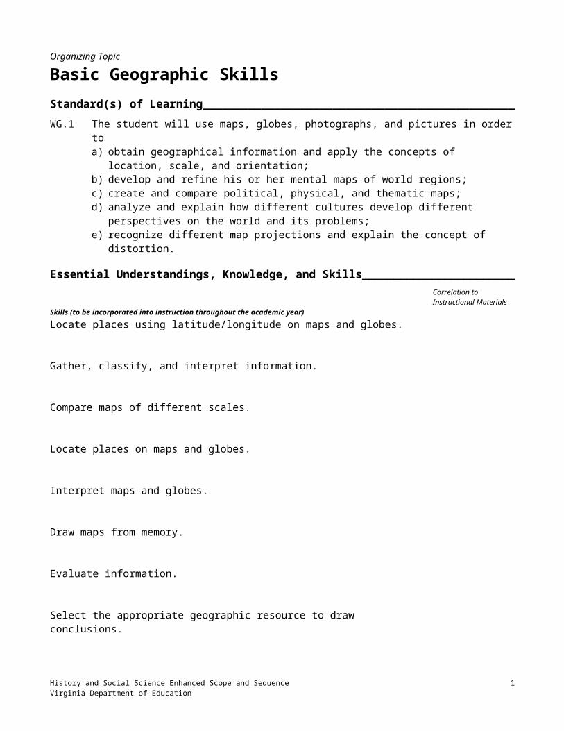
Organizing Topic
Basic Geographic SkillsStandard(s) of Learning__________________________________________________________WG.1 The student will use maps, globes, photographs, and pictures in order to
a) obtain geographical information and apply the concepts of location, scale, and orientation;b) develop and refine his or her mental maps of world regions;c) create and compare political, physical, and thematic maps;d) analyze and explain how different cultures develop different perspectives on the world and its
problems;e) recognize different map projections and explain the concept of distortion.
Essential Understandings, Knowledge, and Skills_____________________________Correlation to Instructional Materials
Skills (to be incorporated into instruction throughout the academic year)Locate places using latitude/longitude on maps and globes.
Gather, classify, and interpret information.
Compare maps of different scales.
Locate places on maps and globes.
Interpret maps and globes.
Draw maps from memory.
Evaluate information.
Select the appropriate geographic resource to draw conclusions.
Compare and contrast information found on different types of maps.
Compare maps and make inferences.
Draw conclusions and make inferences about geographic data.
Identify and interpret regional patterns on maps.
History and Social Science Enhanced Scope and Sequence 1Virginia Department of Education
Compare maps and make inferences.
Interpret the ideas, concepts, or events expressed by a cartoon, picture, or other graphic media.
Identify and explain distortions in map projections.
Identify regional patterns on maps and globes.
History and Social Science Enhanced Scope and Sequence 2Virginia Department of Education

World Geography Basic Geographic Skills
ContentExplain how the use of a variety of sources supports the process of geographic inquiry.
Define the following geographic concepts: Scale
Latitude
Longitude
Relative location
Orientation
Explain that latitude and longitude define absolute location.
Explain how relative location describes the spatial relationship between and among places.
Explain that a variety of scales are necessary to represent areas when developing maps and the scale determines the amount of detail shown on a map.
Explain that a compass rose (directional indicator) identifies map orientation.
Explain that a compass rose (directional indicator) to identify and use cardinal directions.
Demonstrate the following sources used to obtain information: GIS (Geographic Information Systems)
Field work
Satellite images
Photographs
Maps and globes
Data bases
Primary sources
Identify the following uses of mental maps to organize information: Carry out daily activities (e.g., route to school, shopping)
Give directions to others
History and Social Science Enhanced Scope and Sequence 3Virginia Department of Education

World Geography Basic Geographic Skills
Understand world events
Explain that people develop and refine their mental maps through both personal experience and learning.
Describe the following ways mental maps can be developed and refined: Comparing sketch maps to maps in atlases or other resources
Describing the location of places in terms of reference points (e.g., the equator, prime meridian)
Describing the location of places in terms of geographic features and land forms (e.g., west of the Mississippi River, north of the Gulf of Mexico)
Describing the location of places in terms of the human characteristics of a place (e.g., languages, types of housing, dress, recreation, customs and traditions)
Explain that mental maps serve as indicators of how well people know the spatial characteristics of certain places.
Illustrate the following ways maps show information: Symbols
Color
Lines
Boundaries
Contours
Explain that a map is a visual representation of geographic information.
Show the following major types of thematic maps: Population (e.g., distribution and density)
Economic activity
Resource
History and Social Science Enhanced Scope and Sequence 4Virginia Department of Education

World Geography Basic Geographic Skills
Language
Ethnicity
Climate
Precipitation
Vegetation
Physical
Political
Explain how maps reflect changes over time in the following areas: Knowledge Map of Columbus’s time
Satellite images
GIS (Geographic Information Systems)
Place names Formosa, Taiwan, Republic of China
Palestine, Israel, Occupied Territories
Boundaries Africa — 1914, 1990s
Europe — Before World War II and after World War II; since 1990
Russia and the former Soviet Union
Middle East — Before 1948; after 1967
Perspectives of place names Arabian Gulf v. Persian Gulf
Sea of Japan v. East Sea
Middle East v. North Africa and Southwest Asia
Disputed areas Korea Western Sahara
Former Yugoslavia
Kashmir
History and Social Science Enhanced Scope and Sequence 5Virginia Department of Education

World Geography Basic Geographic Skills
Explain that all maps are distorted representations of the Earth’s surface.
Identify the following aspects of the Earth that can be distorted by maps: Area
Shape
Distance
Direction
Explain that different map projections are developed for specific purposes.
Show samples of the following map projections: Mercator
Polar
Robinson
Identify the following ways in which specific projections are used: Mercator — Ship navigation
Polar — Airline navigation
Robinson — Data representation
History and Social Science Enhanced Scope and Sequence 6Virginia Department of Education

World Geography Basic Geographic Skills
Sample Resources________________________________________________________________
Below is an annotated list of Internet resources recommended for this organizing topic. Copyright restrictions may exist for the material on some Web sites. Please note and abide by any such restrictions.
Alternative Assessment in Geography: 9-12 — Alternative Geography Assessment Items. Illinois. State University. <http://www.coe.ilstu.edu/IGA/interact/assess/9-12.htm>. This Web site provides sample assessments for geography, as well as a classification of test items to national and state standards in geography.
Dana, Peter H. Map Projections Overview. University of Texas at Austin. <http://www.colorado.edu/geography/gcraft/notes/mapproj/mapproj_f.html>. This site provides information on map projections.
The Geographic Information Systems FAQ. U.S. Census Bureau - <http://www.census.gov/geo/www/faq-index.html>. This site provides information on Geographic Information Systems (GIS).
Outline Maps — Education Place. Houghton Mifflin, 2002. <http://www.eduplace.com/ss/ssmaps/>. This site permits visitors to print a variety of maps related to this organizing topic.
“Sleuthing for a Lost Ship.” National Geographic Xpeditions: Geography Standards in Your Classroom. <http://www.nationalgeographic.com/xpeditions/lessons/18/g68/ballardsleuthing.html>. This Web site provides a lesson plan to help students understand the uses of geography. Additional lesson plans can also be accessed from this site.
Virginia Standards of Learning Assessments for the 2001 History and Social Science Standards of Learning: History and Social Science Released Items for Virginia and United States History. Virginia Department of Education 2003/04. <http://www.pen.k12.va.us/VDOE/Assessment/Release2003/History/VA-RIBs_g11wgeo-1.pdf>.
Virginia Standards of Learning Assessments for the 2001 History and Social Science Standards of Learning: World Geography Test Blueprint. Virginia Department of Education, 2003/04. <http://www.pen.k12.va.us/VDOE/Assessment/HistoryBlueprints03/2002Blueprint9WG.pdf>. This site provides assessment information for the course in World Geography.
History and Social Science Enhanced Scope and Sequence 7Virginia Department of Education

World Geography Basic Geographic Skills
Session 1: Sources of Geographic Information_________________________________
Materials Examples of the following: Geographic Information System (GIS), field work, satellite images, photographs
of geographic features, maps, globes, data bases, and primary sources Classroom map that illustrates scale, latitude, and longitude
Instructional Activities1. Define geographic information as that which has to do with places, regions, and environments on the surface
of the Earth.
2. Put the following questions on the board or overhead, and instruct students to write their responses to them: What sources do we have to assist us in obtaining geographic information? (Possible answers include
“GIS, field work, satellite images, maps, globes, data bases, and primary sources.”) What are longitude and latitude? When are they used? (Possible answers include “in defining absolute
locations.”) What is relative location? How is it different from absolute location? What is scale, and how is it used on maps? What purpose does a compass rose serve?
3. Allow a few minutes for students to respond, then divide the class into groups of two or three, and ask the students in each group to compare their answers and develop a single response for their group. After a few minutes, have the groups share their responses.
4. Explain to the students that they will be working with many of these sources throughout the year. Begin to demonstrate the various sources by selecting one or more of the following activities: Have students prepare a map of a location in their area, for example, their yard, a mall, or a ballpark. The
map should reflect the location accurately, using scale, a compass rose to reflect relative location, a legend, etc.
Have students locate aerial photographs that reflect geographic features, identify the location pictured, and explain the features.
Have students prepare a database of geographic information. Have students identify primary sources that provide geographic information. Have students complete a student-selected project approved by the teacher. Provide GIS systems, if available, and instruct students to chart locations identified by the teacher. (See
ESRI Web site for more information.)
5. Assign a teacher-selected reading, worksheet, or other reinforcement activity, using available teacher resources.
History and Social Science Enhanced Scope and Sequence 8Virginia Department of Education

World Geography Basic Geographic Skills
Session 2: Longitude and Latitude______________________________________________
Materials Outline maps Teacher-prepared worksheet requesting students to identify the longitude and latitude of various cities and to
name various physical features of those locations
Instructional Activities1. Review the previous session’s activities.
2. Review the concepts of longitude and latitude.
3. Distribute outline maps and teacher-prepared worksheets. Allow a few minutes for students to respond to the questions on the worksheet. Collect the worksheets.
4. Assign a teacher-selected reading, worksheet, or other reinforcement activity, using available teacher resources.
History and Social Science Enhanced Scope and Sequence 9Virginia Department of Education

World Geography Basic Geographic Skills
Session 3: Relative Location and Map Orientation_____________________________
Materials Maps of the students’ home area Teacher-prepared worksheet instructing students to identity local, regional, and national places and their
spatial relationships, as well as map orientation
Instructional Activities1. Review information from previous sessions.
2. Explain the concepts of relative location and map orientation. Use examples in the immediate vicinity to demonstrate the concepts.
3. Display a map of the students’ locality, and ask them to identify the spatial relationships of places, using relative location. Have the class orient the map to their current location.
4. After students demonstrate as a group their understanding of the concepts of relative location and map orientation, distribute the teacher-prepared worksheets for students to complete individually in class or as homework.
History and Social Science Enhanced Scope and Sequence 10Virginia Department of Education

World Geography Basic Geographic Skills
Session 4: Mental Maps of Local Locations; Following Verbal Directions____
Materials Teacher-prepared directions to specific places in the local area Large map of the local area
Instructional Activities1. Review information from previous sessions.
2. Instruct students to close their eyes and visualize the drive from their home to school.
3. Ask students to write the directions from their home to school for someone who is unfamiliar with the area.
4. After a few minutes, select students to share their directions with the class. As the students share their directions, instruct the class to make notes of questions that need to be answered in order to follow the directions from the student’s home to the school.
5. Explain that we use mental maps every day to go about our normal routines. We also use mental maps to give directions to others. Mental maps are also used when we hear about world events and try to place locations mentioned in the news in their proper context. Explain that the students are going to begin working with mental maps of local areas and then expand to global locations.
6. Instruct the students to write down a set of verbal directions to a local destination as you give them. Explain that when you have finished giving the directions, they are to write down where they would end up if they were to follow the directions. Select a location in the local area that all students are familiar with, and give them verbal directions from a well-known starting location to that destination. Read the directions clearly, and repeat them only once. Allow a few minutes for students to record their response, and then have students share their response with the class. Repeat this exercise a few times, using different destinations and increasing the difficulty of the directions (i.e., their length, their degree of detail) as students become more proficient with the process. Display a local map once students have identified a specific destination, and trace the given directions on it.
7. Assign a teacher-selected reading, worksheet, or other reinforcement activity, using available teacher resources.
History and Social Science Enhanced Scope and Sequence 11Virginia Department of Education

World Geography Basic Geographic Skills
Session 5: Mental Maps of State Locations_____________________________________
Materials Large map of Virginia
Instructional Activities1. Review the concepts from the previous session.
2. Explain that students are now going to locate some state locations, using mental maps. Develop your own descriptions of state locations, or use selections from the following appropriate to knowledge and ability of students: Identify the large city on the Atlantic Ocean and near the Chesapeake Bay. (Virginia Beach) Identify the city at the intersection of I-64 and I-95. (Richmond) Identify the major historic house in the hills around Charlottesville. (Monticello) Identify the river that divides Virginia and Maryland. (Potomac) Identify the state due south of Virginia (North Carolina) Identify the large body of water that borders Virginia to the east (Atlantic Ocean)Have the students respond individually to these descriptions, or divide the class into groups for students to work together to identify the locations. The number of locations to be identified should reflect the abilities of the class.
3. When the class has finished, display a large map of Virginia, and review the descriptions and the students’ responses, pointing out the locations on the map.
4. Ask the whole class to name and compare geographic features found in each of the locations identified.
5. Assign a teacher-selected reading, worksheet, or other reinforcement activity, using available teacher resources.
History and Social Science Enhanced Scope and Sequence 12Virginia Department of Education

World Geography Basic Geographic Skills
Session 6: Mental Maps of U.S./World Locations_______________________________
Materials Large world map U.S. and/or world unlabeled outline maps
Instructional Activities1. Review the activity from the previous session.
2. Ask students to share how they mentally “place” distant locations when they hear them mentioned in the news, in television programs, in movies, and in music. Ask them whether they can mentally place such a location on a world map. Ask them whether they can envision the terrain of the location based on their prior knowledge of the location. Ask students on what they base their mental picture (e.g., experience with pictures of the location, a visit to the location, stories/descriptions they have heard or read about the location).
3. Tell students to imagine that they are living in Kansas. Have them place this location mentally on a world map: check some of their responses to the question: Where is Kansas? Then ask them to write down, without looking at any map, the cardinal directions (review this term) they must travel in order to fly the most direct route to each of the following locations: Washington State Belgium Cuba El Salvador Canada Pennsylvania Appalachian Mountains Nile River Hawaii Great Britain Japan
4. Ask the students to check their answers as you point out the directions on a large map of the world.
5. Distribute an unlabeled outline map of the U.S. or the world to each student. Provide students with a list of 10 to 20 locations to place on their map without looking at any resource. Ask the students to identify for each location some aspect of human culture that would be common in that location, e.g., language, type of housing, dress, recreation, customs, or traditions.
6. After students have had time to complete the assignment, move them into groups to share their maps and develop one group map on a fresh unlabeled outline map.
7. After students have completed the group assignment, display a world map with each of the locations identified. Encourage students to compare their individual maps and their group’s map with the display map.
8. Assign a teacher-selected reading, worksheet, or other reinforcement activity, using available teacher resources.
History and Social Science Enhanced Scope and Sequence 13Virginia Department of Education
World Geography Basic Geographic Skills
Session 7: Different Types of Maps_____________________________________________
Materials Different types of maps List of information for students to identify map types
Instructional Activities1. Review the information from the previous session.
2. With no maps displayed in the room, discuss as a class the various types of information provided on maps. Record student responses.
3. Explain that maps are designed to provide different types of information. Have the students examine examples of different types of maps (e.g., road maps, political maps, climate maps, population maps, physical maps, thematic maps) and the reasons/situations in which they would be used. Examples of many of these maps will be found in the students’ textbook.
4. As students look at examples of different types of maps, ask them to identify the types of information contained on most maps — that is, common to most of them. Responses may include symbols, color, lines, direction, and boundaries.
5. Ask students to identify information they might need a map to provide for a particular purpose. Post a list of types of thematic maps on the board or overhead. Distribute a list of information needed for students to research using a map or atlas. Instruct the students to identify, using the list of thematic maps displayed, which map would contain the specified information needed. The list of information needed may include the countries that have hottest climates and highest temperatures year round countries that grow wheat boundaries of Europe countries that share languages with England population density of China countries with the highest elevation total annual precipitation of Brazil areas with a high concentration of Spanish speakers distribution of Hinduism countries that have large deposits of coal countries having a gross domestic product the same as or greater than Japan’s.
6. Assign a teacher-selected reading, worksheet, or other reinforcement activity, using available teacher resources.
History and Social Science Enhanced Scope and Sequence 14Virginia Department of Education

World Geography Basic Geographic Skills
Session 8: The Evolution of Maps_______________________________________________
Materials A display map of the U.S. in 1789 Unlabeled outline maps selected from the following:
Formosa; Taiwan; Republic of China (change in place name) Palestine; Israel; Occupied Territories (change in place name) Congo; Zaire; Democratic Republic of Congo (change in place name) Africa in 1914; Africa in the 1990s (changes in boundaries) Europe before World War II; Europe after World War II; Europe since 1990 (changes in boundaries) The former Soviet Union; Russia (changes in boundaries) The Middle East before 1948; Middle East after 1967 (changes in boundaries) Arabian Gulf v. Persian Gulf (perspectives of place names) Sea of Japan v. East Gulf (perspectives of place names) Middle East v. North Africa and Southwest Asia (perspectives of place names) Korea (disputed area) Western Sahara (disputed area) Tibet (disputed area) Kashmir (disputed area)
A list of these places with an indication of the nature of their evolution
Instructional Activities1. Review information from the previous sessions.
2. Ask students to describe what a political map of the United States looked like in 1789. Display a large 1789 U.S. map, and ask them to identify the differences between it and a present-day U.S. map.
3. Explain that countries’ boundaries change over time. Ask students what may cause countries’ boundaries to change. Ask students to identify some countries that have experienced boundary changes throughout history.
4. Ask students whether the actual physical shape of continents changes to any significant degree. Have them explain what causes international boundaries to change if the physical shape of the land does not change.
5. Provide students with unlabeled outline maps of the places listed above. NOTE: These are identified in the Curriculum Framework under Standard of Learning WG.1d, “Essential Knowledge” column. Ensure that each map is large enough for the following activity. Also provide students with the list of these places together with the indications of the nature of their evolution. Instruct students to identify the places listed and to reflect them on their maps, using titles, shading, keys, and/or lines. Provide students with atlases and other resource materials, in addition to their textbooks. NOTE: This activity may take more than one session.
6. Assign a teacher-selected reading, worksheet, or other reinforcement activity, using available teacher resources.
History and Social Science Enhanced Scope and Sequence 15Virginia Department of Education

World Geography Basic Geographic Skills
Session 9: Map Projections; Distortion_________________________________________
Materials Information on the area of each continent Various map projections
Instructional Activities1. Ask students if they know why the changes identified on the maps during the previous session occurred. Base
a class discussion on their responses. Ask students if they know of changes that have occurred in a country’s borders so recently that they have not yet appeared in textbooks.
2. Explain that it is not possible to take a round object and flatten its surface out without distorting something. Demonstrate this with an orange peel, a tennis ball, or a baseball. Projections are mathematically derived to move a portion or all of the Earth’s curved surface to a flat map. The goal of a good projection is to eliminate this distortion as much as possible. Different map projections reflect the Earth’s surface differently. Some reflect the size of continents more accurately, while others provide better information for navigational purposes. Display a map of the world, and ask students which continents are bigger. Then provide students with the actual size of each continent, or display a globe for comparison of continent sizes. Display a map that reflects each of the following aspects of the Earth’s surface displayed on different map projections: Shape Area Distance DirectionNOTE: A mnemonic device to help students remember is “SADD.” Instruct students to compare the size and shape of Greenland with that of South America, using different map projections.
3. Demonstrate the following map projections, and explain how each one is used: Mercator — ship navigation Polar — plane navigation Robinson — data representationEncourage students to speculate about why different projections may be used for different purposes
4. Assign a teacher-selected reading, worksheet, or other reinforcement activity, using available teacher resources.
History and Social Science Enhanced Scope and Sequence 16Virginia Department of Education

World Geography Basic Geographic Skills
Session 10: Review_______________________________________________________________
Materials None identified
Instructional Activities1. Show a video or slides that illustrate the various concepts of geography learned in this unit as a review for the
assessment.
History and Social Science Enhanced Scope and Sequence 17Virginia Department of Education

World Geography Basic Geographic Skills
Session 11: Assessment_________________________________________________________
Materials Assessment
Instructional Activities1. Administer the assessment. Sample assessment items can be found at Attachment A.
History and Social Science Enhanced Scope and Sequence 18Virginia Department of Education

World Geography Basic Geographic Skills
Attachment A: Sample Assessment Items______________________________________NOTE: The teacher will need to provide the options as they may differ based on the map used.
Provide a map with various locations identified. Ask students to identify what locations are close to (relatively located) different positions on the map. For example:
1. What river is located close to the Chesapeake Bay?A ______B ______C ______D ______
Provide a map with longitude and latitude lines identified. Write multiple choice questions that ask what locations on the map are identified by specific longitude and latitude, for example:
2. What location is found at 90W latitude and 30N longitude?A B C D New Orleans
Ask two or three questions about specific locations.
Provide a map, and ask students to identify the distance between two points on the map. Sample questions may include:
3. How far is it from location A to location B on the map provided?A kilometersB kilometersC kilometersD kilometers
Provide a map, and ask students to identify items based on their orientation from one item to another. For example:
4. What ocean is west of California?A __________B __________C __________D __________
Provide a map with a map key, and ask students to identify the location of specific symbols. An example is a map with various economic activities indicated, such as fishing, industrial areas, mining, and/or lumber mills, together with questions such as:
5. What cities depicted on the map have mining activities?A B C D
Provide samples of different maps, and ask students to identify specific information depicted on the map. For example:
6. On the map provided, which of the following information is provided?A Population densityB Ethnic distributionC PrecipitationD Political divisions
Provide different map projections, and ask students to identify the map most likely to provide specific information.
History and Social Science Enhanced Scope and Sequence 19Virginia Department of Education
World Geography
Organizing Topic
Physical Geography, Regional GeographyStandard(s) of Learning__________________________________________________________WG.2 The student will analyze how selected physical and ecological processes shape the Earth’s surface by
a) identifying regional climatic patterns and weather phenomena and their effects on people and places;
b) describing how humans influence the environment and are influenced by it;c) explaining how technology affects one’s ability to modify the environment and adapt to it.
WG.3 The student will apply the concept of a region bya) explaining how characteristics of regions have led to regional labels;b) explaining how regional landscapes reflect cultural characteristics of their inhabitants;c) analyzing how cultural characteristics, including the world’s major languages and religions, link or
divide regions.
WG.4 The student will locate and analyze physical, economic, and cultural characteristics of world regions: Latin America and the Caribbean, Europe, United States and Canada, North Africa and Southwest Asia, Sub-Saharan Africa, Russia and Central Asia, South Asia, Southeast Asia, East Asia, Australia and the Pacific Islands, and Antarctica.
WG.10 The student will analyze how the forces of conflict and cooperation affect the division and control of the Earth’s surface bya) explaining and analyzing reasons for the different spatial divisions at the local and regional levels;b) explaining and analyzing the different spatial divisions at the national and international levels;c) analyzing ways cooperation occurs to solve problems and settle disputes.
Essential Understandings, Knowledge, and Skills_____________________________Correlation to Instructional Materials
Skills (to be incorporated into instruction throughout the academic year)Compare maps and make inferences related to the physical and ecological processes.
Interpret the ideas, concepts, or events expressed by pictures or other graphic media as they relate to the physical and ecological processes.
Apply latitude to help identify climate zones.
Interpret charts, diagrams, and climographs.
Select the appropriate geographic resources to draw conclusions about the physical and ecological processes.
Draw conclusions and make inferences about data.
History and Social Science Enhanced Scope and Sequence 20Virginia Department of Education

World Geography
Gather, classify, and interpret information.
Explain cause-and-effect relationships.
Identify and interpret regional patterns on maps and globes.
Locate areas (regions) on maps and globes.
History and Social Science Enhanced Scope and Sequence 21Virginia Department of Education

World Geography Physical Geography, Regional Geography
Draw conclusions and make generalizations about data.
Analyze photographs and pictures and make inferences.
Draw conclusions and make generalizations about information.
Explain charts comparing two or more geographic concepts.
Identify primary ideas expressed in graphic data as they relate to geographic concepts.
Identify and locate regions, continents, oceans, and major features on maps and globes.
Compare maps and make inferences.
Identify regional patterns.
Participate in problem solving.
ContentIdentify the following common characteristics that define climate:
Temperature
Precipitation
Seasons (hot/cold, wet/dry)
Explain how the interplay of the following elements influence regional climate patterns: Influence of latitude
Influence of winds
Influence of elevation
Proximity to water
Label and describe the following world climate regions:History and Social Science Enhanced Scope and Sequence 22Virginia Department of Education
World Geography Physical Geography, Regional Geography
Low latitudes — e.g., tropical wet, tropical wet and dry, arid, semiarid, highland
Middle latitudes — e.g., semiarid, arid, Mediterranean (dry summer subtropical), humid continental, marine west coast, highland High latitudes — e.g., subarctic, tundra (subpolar), icecap
Identify the climate that would probably exist in the following vegetation regions: Rain forest
Savanna
Desert
Steppe
Middle latitude forests
Taiga
Tundra
Identify the regions where the following weather phenomena occur and are unique to that region:
Monsoons — South and Southeast Asia
Typhoons — Pacific Ocean
Hurricanes — Atlantic Ocean
Tornadoes — United States
Explain how climate and weather phenomena affect the following areas of people’s lives in different regions:
Crops
Clothing
Housing
Natural hazards
Explain how the following physical and ecological processes shaped the Earth’s surface: Earthquakes
Floods
Volcanoes
History and Social Science Enhanced Scope and Sequence 23Virginia Department of Education

World Geography Physical Geography, Regional Geography
Erosion
Explain the following ways humans influence their environment: Water diversion/management Aral Sea
Colorado River
Aswan High Dam
Canals Reservoirs
Irrigation
Changing landscapes Agricultural terracing (e.g., China, Southeast Asia)
Polders (e.g., Netherlands)
Deforestation (e.g., Nepal, Brazil, Malaysia)
Desertification (e.g., Africa, Asia)
Environmental changes Acid rain (e.g., forests in Germany, Scandinavia, China and Eastern North
America)
Pollution (e.g., Mexico City, Chernobyl, oil spills)
Explain how the environment has the following impact on humans: Settlement patterns
Housing materials
Agricultural activity
Types of recreation
Transportation patterns
Explain the following technological innovations and how they have expanded the capacity of people to modify and adapt to their physical environment:
Agriculture (e.g. fertilizers, mechanization)
Energy usage (e.g. fossil fuels, nuclear)
Transportation (e.g. road building, railways)
Automobiles (e.g. parking lots, suburbs)
History and Social Science Enhanced Scope and Sequence 24Virginia Department of Education

World Geography Physical Geography, Regional Geography
Airplanes (e.g. airport expansion, noise)
Explain that regions are areas of Earth’s surface that share unifying characteristics.
Explain that geographers create and use regions as organizing concepts to simplify the world for study and understanding.
Show the following examples of physical regions: Sahara
Taiga
Rain forest
Great Plains
Low Countries
Show the following examples of cultural regions: Language Latin America
Francophone world
Ethnic Chinatowns
Kurdistan
Religion Islam Buddhism
Economic Wheat Belts European Union (EU)
Political
North Atlantic Treaty Organization (NATO)
Organization of African Unity (OAU)
Explain how regional labels reflect people’s perceptions of the following areas: Middle East
Sun Belt
History and Social Science Enhanced Scope and Sequence 25Virginia Department of Education

World Geography Physical Geography, Regional Geography
Rust Belt
Explain how the following regional landscapes reflect the cultural characteristics of their inhabitants:
Architectural structures Religious buildings (e.g., mosques, churches, synagogues, temples, pagodas)
Dwellings (e.g., tiled roofs in Mediterranean, chalets in Switzerland, thatched roofs in Pacific Islands, tents and yurts in Central and Southwest Asia, castles in Europe)
Statues and monuments of local, national, or global significance Taj Mahal (India)
Kaaba (Mecca)
Western Wall (Jerusalem)
Dome of the Rock (Jerusalem)
Church of the Holy Sepulcher (Jerusalem)
Pyramids (Egypt)
Kremlin (Moscow)
Eiffel Tower (Paris)
Virginia State Capitol Building (Richmond)
Washington Monument (Washington, D.C.)
White House (Washington, D.C.)
Lincoln Memorial (Washington, D.C.)
Statue of Liberty (New York City)
Describe how cultural characteristics link or divide regions, and identify examples reflected in each of the following:
Language: Arab world — Arabic
Hispanic America — Spanish
Brazil — Portuguese
Canada — French/English
Switzerland — multiple languages
English — world language
History and Social Science Enhanced Scope and Sequence 26Virginia Department of Education

World Geography Physical Geography, Regional Geography
Ethnic heritage: former Yugoslavia — Serbs, Croats, Bosnians, Albanians
Burundi and Rwanda — Hutus and Tutsis
United States, Switzerland — unity in multiple-ethnicity countries
Korea and Japan — predominantly single ethnicity
Cyprus — Greeks and Turks
Religion as a unifying force: Hinduism
Buddhism
Judaism Christianity
Islam Religion as a divisive force: Conflicts between Hindus and Muslims in Pakistan and India
Conflicts between Catholics and Protestants in Northern Ireland
Jews, Christians, and Muslims all claiming Jerusalem as their religious heritage site
Compare and contrast differing sets of ideas, beliefs, and behaviors.
Describe how physical, economic, and cultural characteristics influence regional development.
Use the information provided in each regional plan.
Explain the following ways human interaction with the environment affects the development of a region:
Human interaction with environment
Deforestation — Amazon Basin, Nepal, Malaysia
Acid rain — Black Forest
Decreased soil fertility — Aswan High Dam
Explain how each of the following criteria contributes to the determination of a country’s relative importance:
GDP (Gross Domestic Product)
History and Social Science Enhanced Scope and Sequence 27Virginia Department of Education

World Geography Physical Geography, Regional Geography
Land size
Populations size
Resources
Explain how the following elements of the physical environment, such as major bodies of water and mountains, influence the economic and cultural characteristics of regions:
Water: Rio Grande — Boundary
Ob River — Flows northward into Arctic Ocean
Zambezi River — Water power
Ganges and Brahmaputra Rivers — Flood hazard
Mountains: Rocky Mountains — Create rain shadows on leeward slopes
Himalayas — Block moisture to create steppes and deserts in Central Asia
Describe divisions as regions of the Earth’s surface over which groups of people establish social, economic, and political control.
Summarize the following examples of spatial divisions at the local and regional levels: Neighborhoods
Election districts
School districts
Regional districts (e.g., bus lines, waste disposal, conservation districts, planning districts, area code zones)
Cities
Counties
States
Explain the following reasons for spatial divisions: Desire for government closer to home
Need to solve local problems
Need to administer resources more efficiently
History and Social Science Enhanced Scope and Sequence 28Virginia Department of Education

World Geography Physical Geography, Regional Geography
Explain that spatial divisions may generate conflict or cooperation. Explain the following reasons for the conflict and cooperation at the local and regional levels:
Reasons for conflict: Boundary disputes
Cultural differences
Economic differences
Competition for scarce resources
Political advantages (e.g., gerrymandering)
Reasons for cooperation: Natural disasters
Economic advantages (attract new businesses)
Cultural similarities, ethnic neighborhoods
Addressing regional issues (e.g., waste management, magnet schools, transportation)
Describe the following examples of spatial divisions at the national and international levels:
Countries
Economic and political alliances: North Atlantic Treaty Organization (NATO)
European Union (EU)
Organization of Petroleum Exporting Countries (OPEC)
North American Free Trade Agreement (NAFTA)
Commonwealth of Nations
United Nations
Red Cross/Red Crescent
Organization of American States (OAS)
League of Arab States
Association of Southeast Asian Nations (ASEAN)
African Union (AU)
Explain the following reasons for spatial division at the national and international level:
History and Social Science Enhanced Scope and Sequence 29Virginia Department of Education

World Geography Physical Geography, Regional Geography
Differences in culture, language, religion
Retention of historical boundaries
Imperial conquest and control
Economic similarities and differences
Explain that spatial divisions may generate conflict or cooperation.
Explain the following reasons for conflict and examples of cooperation at the national and international levels, and explain the examples provided:
Reasons for conflict Boundary and territorial disputes (Syria/Israel, Western Sahara/Morocco,
China/Taiwan, India/Pakistan, Iraq/Kuwait)
Cultural differences (language, religion) Indonesia
Canada (Quebec)
Ireland
Sudan
Economic differences (fertile land, access to fresh water, access to coast, fishing rights, natural resources, different economic philosophies)
Ethnic differences Balkans
Cyprus
Rwanda and Burundi
Kashmir
Nationalism
Examples of cooperation Humanitarian initiatives — e.g., Red Cross/Red Crescent
Economic alliances — e.g., Law of Sea, China and United States, multinational corporations, North American Free Trade Agreement (NAFTA), Organization of Petroleum Exporting Countries (OPEC)
Cultural alliances — e.g., Francophone world, Commonwealth of Nations
Military alliances — e.g., North Atlantic Treaty Organization (NATO)
History and Social Science Enhanced Scope and Sequence 30Virginia Department of Education

World Geography Physical Geography, Regional Geography
Problem-solving alliances — e.g., Antarctic Treaty, United Nations (UN) peacekeepers
Programs to promote international understanding — e.g., Peace Corps
Alliances for environmental preservation
Foreign aid
History and Social Science Enhanced Scope and Sequence 31Virginia Department of Education

World Geography Physical Geography, Regional Geography
Sample Resources________________________________________________________________
Below is an annotated list of Internet resources recommended for this organizing topic. Copyright restrictions may exist for the material on some Web sites. Please note and abide by any such restrictions.
“Geography 370: Climatology — Climate Regions, Fall, 2003.” Sonoma State University. <http://www.sonoma.edu/users/f/freidel/climate/370regions.htm>. This site provides information on various climate regions.
Guide to the Science of the Atmosphere. USA Today. <http://www.usatoday.com/weather/resources/basics/wworks0.htm>. This site provides links to graphics and other information on various weather phenomena.
Outline Maps — Education Place. Houghton Mifflin, 2002. <http://www.eduplace.com/ss/ssmaps/>. This site permits visitors to print a variety of maps related to this organizing topic.
“Polders and Dykes of the Netherlands.” <http://geography.about.com/library/weekly/aa033000a.htm>. This site provides information on the ways the Dutch reclaim dry land from the sea.
Subject Access: World Geography, Languages, and Regional Information. Discovery Channel School. <http://school.discovery.com/schrockguide/world/geog.html>. This site provides links to many Web sites on geography.
Virginia Standards of Learning Assessments for the 2001 History and Social Science Standards of Learning: History and Social Science Released Items for Virginia and United States History. Virginia Department of Education 2003/04. <http://www.pen.k12.va.us/VDOE/Assessment/Release2003/History/VA-RIBs_g11wgeo-1.pdf>.
Virginia Standards of Learning Assessments for the 2001 History and Social Science Standards of Learning: World Geography Test Blueprint. Virginia Department of Education, 2003/04. <http://www.pen.k12.va.us/VDOE/Assessment/HistoryBlueprints03/2002Blueprint9WG.pdf>. This site provides assessment information for the course in World Geography.
The World Factbook 2002. U.S. Central Intelligence Agency. <http://www.cia.gov/cia/publications/factbook/>. This site contains searchable information on all countries.
History and Social Science Enhanced Scope and Sequence 32Virginia Department of Education

World Geography Physical Geography, Regional Geography
Session 1: Weather Phenomena and Their Effects on the Environment______
Materials Class notes Video, slides, or photographs of the effects of weather phenomena
Instructional ActivitiesNOTE: These activities and the activities throughout the course will require students to annotate multiple outline maps. It is recommended that students acquire a notebook to store their maps. The notebook should be organized by organizing topics, using tabs. After grades have been recorded, maps should be saved in the notebook for use as a resource when preparing for assessments or projects. The teacher may choose to give a notebook grade after providing students with a list of the maps that should be present in their notebooks. Class notes will be given at the teacher’s discretion.
1. Explain that the next sessions will examine the effects of ecological processes on the Earth’s surface as well as the division of the Earth into regions (areas of the Earth’s surface that share unifying characteristics). The impact of conflict and cooperation on the divisions of the Earth will also be examined.
2. Display the following on the board or overhead:Weather phenomena: Monsoons — South and Southeast Asia Typhoons — Pacific Oceans Hurricanes — Atlantic Ocean Tornadoes — United StatesHave the students identify the characteristics of each of these weather phenomena. Encourage students not only to describe each phenomenon but also to identify the most probable location(s) for it to occur.
3. Show a video, slides, or photographs that reflect the long term effects on the Earth’s surface of these various weather phenomena.
4. Ask students to identify the effects of these weather phenomena on the climate. Ensure that the matters of crops, clothing, housing, and natural hazards are addressed during the discussion.
5. Assign a teacher-selected reading, worksheet, or other reinforcement activity, using available teacher resources.
History and Social Science Enhanced Scope and Sequence 33Virginia Department of Education

World Geography Physical Geography, Regional Geography
Session 2: The Impact of Ecological Processes on the Environment__________
Materials Photographs or slides of the impact of earthquakes, floods, volcanic eruptions, and erosion Outline map of the world with only countries and continents listed
Instructional Activities1. Review the information from the previous session.
2. Explain to students that in addition to the impact weather phenomena have on the physical environment, the environment is also impacted by other processes: earthquakes, floods, volcanic eruptions, and erosion. Describe each of these processes, explaining how they occur and what their specific impact may be. If possible, display photographs or slides that reflect these impacts.
4. Assign a teacher-selected reading, worksheet, or other reinforcement activity, using available teacher resources.
History and Social Science Enhanced Scope and Sequence 34Virginia Department of Education

World Geography Physical Geography, Regional Geography
Session 3: The Influence of Human Activity on the Environment_____________
Materials Video, slides, or photographs that illustrate dams, canals, reservoirs, irrigation, polders, terracing,
deforestation, desertification, acid rain, and pollution A political map of the world that has very little information, thus providing room for students to enter
information
Instructional Activities1. Review the information from the previous session.
2. Explain that although nature impacts the physical features of the Earth’s surface greatly, humans also have a significant impact on the environment. Ask students to suggest ways human activities may affect the physical features of the Earth.
3. Provide an unlabeled outline map of the world to each student. Instruct students to indicate on their map the following impacts of humans on the environment. You may wish to assign a key or color for students to use when they mark their maps. As you display each impact on the board or overhead, show the location on a map in the front of the room. NOTE: This may take more than one session. Water diversion/management
Aral Sea Colorado River Aswan High Dam Canals Reservoirs Irrigation
Landscape alteration Agricultural terracing (e.g., China, Southeast Asia) Polders (e.g., Netherlands) Deforestation (e.g., Nepal, Brazil, Malaysia) Desertification (e.g., the Sahara in Africa, desert regions in India)
Environment alteration Acid rain (e.g., forests in Germany, Scandinavia, China, and Eastern North America) Pollution (e.g., Mexico City, Chernobyl, oil spills)
4. Use videos, slides, and/or photographs to provide visual examples of the effect of humans on the environment.
5. Assign a teacher-selected reading, worksheet, or other reinforcement activity, using available teacher resources.
History and Social Science Enhanced Scope and Sequence 35Virginia Department of Education

World Geography Physical Geography, Regional Geography
Session 4: The Influence of Technology on the Environment; The Impact of the Environment on Humans_________________________________________________
Materials Video, slides, or photographs that illustrate the impact of technological advances in agriculture, energy usage,
transportation, automobiles, and airplanes on the environment
Instructional Activities1. Remind students that they have already studied the impact of weather phenomena, physical and ecological
processes, and human activity on the Earth’s surface. Explain that other factors also affect the Earth’s surface. Ask students if they can think of what these other factors may be.
2. Explain that technological advances have had an impact on the Earth’s surface. Have students suggest how.
3. Display the following information on the board or overhead and discuss each influence as it is displayed. Provide visual examples, if they are available.Influence of technology on the environment: Agriculture (e.g., fertilizers, mechanization) Energy usage (e.g., fossil fuels, nuclear) Transportation (e.g., road building, railways) Automobiles (e.g., parking lots, suburbs) Airplanes (e.g., airport expansion, noise pollution)
4. Ask students to identify any possible impacts of the environment on humans. Guide discussion to include the following: Settlement patterns Housing materials Agricultural activity Types of recreation Transportation patterns
5. Assign a teacher-selected reading, worksheet, or other reinforcement activity, using available teacher resources.
History and Social Science Enhanced Scope and Sequence 36Virginia Department of Education
World Geography Physical Geography, Regional Geography
Session 5: Physical Regions_____________________________________________________
Materials Political and physical maps of the world Photographs or slides that reflect the characteristics of the physical regions
Instructional Activities1. Review the information from the previous sessions.
2. Ask students to explain how their state and nation are divided. Students may suggest physical or cultural divisions. Ask students why these divisions occur. Prompt discussion by suggesting that the divisions help us to understand different areas.
3. Ask whether the boundary lines between these divisions (regions) are visible or imaginary. Ask if the region boundaries change. If the students agree that they may change, ask what may cause such change.
4. Explain that the Earth is divided into regions based on common unifying characteristics. This division into regions assists in studying and understanding the world. Regions may be defined by physical or cultural characteristics. These regions are found in the various parts of the world: Latin America and the Caribbean, Europe, United States and Canada, North Africa and Southwest Asia, Sub-Saharan Africa, Russia and Central Asia, South Asia, Southeast Asia, East Asia, Australia and the Pacific Islands, and Antarctica.
5. Display the following terms on the board or overhead: Sahara taiga rain forest great plains low countriesInstruct students to define these terms. Make sure they understand that these terms are regional labels that have been given to world regions based on unifying physical characteristics of these regions. Distribute an unlabeled outline map of the world, and instruct students to identify these regions on the map.
6. Ask the students to identify the specific physical characteristics of the regions they defined.
7. Assign a teacher-selected reading, worksheet, or other reinforcement activity, using available teacher resources.
History and Social Science Enhanced Scope and Sequence 37Virginia Department of Education

World Geography Physical Geography, Regional Geography
Session 6: Cultural Regions______________________________________________________
Materials Map of the world
Instructional Activities1. Review information from the previous session.
2. Explain to students that in addition to physical regions, the world is divided into cultural regions. Ask students to suggest some different cultural divisions. Record their responses on the board or overhead.
3. Display the following list of cultural regions on the board or overhead. Add additional regions as desired: Language
Latin America — Spanish Francophone world — French
Ethnicity Chinese Kurdistan
Religion Islam Buddhism
Economic Wheat belts European Union (EU)
Political North Atlantic Treaty Organization (NATO)
4. Distribute an unlabeled outline map of the world to students, and instruct them to draw a line around or color each of these regions, using different colors for each type of region. Have them indicate with symbols or lines where cultural regions overlap, e.g., the Francophone world overlaps with a wheat belt in France.
5. Explain that different areas/countries may share characteristics that put them in the same language region but in different economic regions.
5. Assign a teacher-selected reading, worksheet, or other reinforcement activity, using available teacher resources.
History and Social Science Enhanced Scope and Sequence 38Virginia Department of Education

World Geography Physical Geography, Regional Geography
Session 7: Regional Landscapes and Cultural Characteristics________________
Materials Large maps of the continents or of the world Photographs of cultural characteristics identified in the list below (NOTE: These are identified in the
Curriculum Framework under Standard of Learning WG.3b, “Essential Knowledge” column.) Unlabeled outline maps
Instructional Activities1. Review the cultural regions studied in the previous session.
2. Provide students with maps of each continent or a map of the world large enough to allow for easy placement of photos of each item in the list below. Explain that certain regions of the world are referred to by a specific title, for example, the Middle East, the Sun Belt, or the Rust Belt. Illustrate these regions on a display map. Instruct students to develop a key to annotate their individual maps with these regions.
3. Provide photographs of the cultural characteristics listed below, and instruct students to annotate their individual maps with pictures or drawings to reflect the location of each example. Provide research material in the classroom, or have the students use the computer lab. NOTE: This may be done as a small group project and continued for the regions identified in Session 8.Cultural characteristics Architectural structures
Religious buildings (e.g., mosques, churches, synagogues, temples, pagodas) Dwellings (e.g., tiled roofs in Mediterranean, chalets in Switzerland, thatched roofs in Pacific Islands,
tents and yurts in Central and Southwest Asia, castles in Europe) Statues and monuments of local, national, or global significance
Taj Mahal (India) Kaaba (Mecca) Western Wall (Jerusalem) Dome of the Rock (Jerusalem) Church of the Holy Sepulcher (Jerusalem) Pyramids (Egypt) Kremlin (Moscow) Eiffel Tower (Paris) Virginia State Capitol Building Washington Monument White House Lincoln Memorial Statue of Liberty
4. Assign a teacher-selected reading, worksheet, or other reinforcement activity, using available teacher resources.
History and Social Science Enhanced Scope and Sequence 39Virginia Department of Education

World Geography Physical Geography, Regional Geography
Session 8: Language and Ethnicity as Region Links___________________________
Materials Large maps of the continents or of the world
Instructional Activities1. Repeat the activity from session 7 for the following information:
Language Arab world — Arabic Hispanic America — Spanish Brazil — Portuguese Canada — French/English Switzerland — multiple languages Many part of the world — English
Ethnic heritage former Yugoslavia — Serbs, Croats, Bosnians, and Albanians Burundi and Rwanda — Hutus and Tutsis Cyprus — Greeks and Turks United States, Switzerland — examples of multiple-ethnicity countries Korea, Japan — examples of predominantly single-ethnicity countries
2. Assign a teacher-selected reading, worksheet, or other reinforcement activity, using available teacher resources.
History and Social Science Enhanced Scope and Sequence 40Virginia Department of Education

World Geography Physical Geography, Regional Geography
Session 9: Religions as Region Divider_________________________________________
Materials Map Short stories or news articles about the division between Hindus and Muslims in Pakistan and India; between
Catholics and Protestants in Northern Ireland; and among Jews, Christians, and Muslims in Jerusalem.
Instructional Activities1. Review information from the previous session.
2. Ask students whether most of them cheer for their school’s athletic teams during games. Ask them why they do this. Ask them to share their favorite professional baseball, basketball, or football team. A variety of answers may be given. If so, ask the students how they can all cheer for the same school team and not for the same professional team. What causes them to prefer one team to another? One television show over another? One music group?
3. Explain that people within the same culture may have similar points of view about an issue. When groups share the same interests or background, they often become united in one cause — for example, they may all want the same team to win. Explain that people within the same culture sometimes have opposite views on certain issues. These opposing views often lead to conflict or division within the culture. Ask students to provide examples of a culture being united by one cultural factor and divided by another. Remind students that they have already identified two characteristics that people share — language and ethnicity.
5. Ask students whether it is possible for something to be a dividing factor for some and a uniting factor for others. Explain that religion is an example of a characteristic that can unite or divide. Provide the following examples, and explain them to the students: Religion as a unifying force
Hinduism Buddhism Judaism Christianity Islam
Religion as a divisive force Conflicts between Hindus and Muslims in Pakistan and India Conflicts between Catholics and Protestants in Northern Ireland Jews, Christians, and Muslims all claiming Jerusalem as their religious heritage site
6. Illustrate on a map where each of these religious conflict are centered. Provide some background on the practices and beliefs of each religion.
7. Provide passages for students to read about these conflicts. Show a video that provides background information on these conflicts.
History and Social Science Enhanced Scope and Sequence 41Virginia Department of Education

World Geography Physical Geography, Regional Geography
Session 10: Local and National Spatial Divisions______________________________
Materials A map of the local area that shows city and county boundary lines A map of national and international boundaries
Instructional Activities1. Review information from the previous session.
2. Remind students that when the United States was colonized, there were no cities, counties, or other political divisions. Ask students to speculate why the nation began to assign boundary lines for various regions. Suggest problems that would occur if there were no divisions of the regions.
3. Display the following possible reasons for spatial divisions: Desire for government closer to home Need to solve local problems Need to administer resources more efficientlyAsk students what local problems may need to be solved.
4. Display the definition for spatial division on the board or overhead. Explain that spatial divisions generate cooperation and conflict just as cultural divisions do. Also, spatial divisions often serve to define areas of government responsibility and control. Display the following examples of spatial divisions: Neighborhoods Election districts School districts Regional districts (e.g., bus lines, waste disposal, conservation districts, planning districts, area code
zones) Cities Counties States
5. Display a map of different spatial divisions. Distribute unlabeled outline maps to students, showing their locality, state, or the United States. Provide a list of spatial divisions for the students to annotate on their map.
6. Assign a teacher-selected reading, worksheet, or other reinforcement activity, using available teacher resources.
History and Social Science Enhanced Scope and Sequence 42Virginia Department of Education

World Geography Physical Geography, Regional Geography
Session 11: Spatial Divisions: Cooperation and Conflict_______________________
Materials None identified
Instructional Activities1. Remind students that in the previous session they learned that communities need spatial divisions to define
responsibility for control. Explain that sometimes these divisions are not always governmental but may be cultural. Display the following reasons for cooperation among and within spatial divisions, and discuss each with the class: Dealing with natural disasters Economic advantages (attract new businesses) Cultural similarities, ethnic neighborhoods Addressing regional issues (e.g., waste management, magnet schools, transportation)Share with the students examples of each of these reasons for cooperation.
2. Explain that while spatial divisions provide definition for government control and boundaries for services as well as centers for ethnic groups, they can also lead to conflict. Display the following reasons for conflict, and discuss each with the class: Boundary disputes Cultural differences Economic differences Competition for scarce resources Political advantages (e.g., gerrymandering)Share with the students examples of each of these reasons for conflict.
4. Assign a teacher-selected reading, worksheet, or other reinforcement activity, using available teacher resources.
History and Social Science Enhanced Scope and Sequence 43Virginia Department of Education

World Geography Physical Geography, Regional Geography
Session 12: International Spatial Divisions_____________________________________
Materials Unlabeled outline maps of the world Overhead with cultural and political divisions listed
Instructional Activities1. Review information from the previous session.
2. Explain that just as the United States is divided into states, counties, cities, and districts, the world is similarly divided into various spatial divisions. Ask students to recall some of the regional divisions already studied. After students have listed several, display an overhead of the types of regional divisions already studied.
3. Display the following list on the board or overhead one at a time. Instruct students to annotate unlabeled outline maps to reflect these various divisions as they are explained in class. NOTE: This may take more than one session. Countries Alliances — economic and political
North Atlantic Treaty Organization (NATO) European Union (EU) Organization of Petroleum Exporting Countries (OPEC) North American Free Trade Agreement (NAFTA) Commonwealth of Nations United Nations Red Cross/Red Crescent Organization of American States (OAS) League of Arab States Association of Southeast Asian Nations (ASEAN) African Union
4. Explain to students that these divisions are the result of the following: Differences in culture, language, religion Retention of historical boundaries Imperial conquest and control Economic similarities and differences
5. Discuss each of these reasons providing examples of each from history or current events.
History and Social Science Enhanced Scope and Sequence 44Virginia Department of Education

World Geography Physical Geography, Regional Geography
Session 13: Spatial Divisions and Conflict______________________________________
Materials Outline world maps
Instructional Activities1. Review information from the previous session.
2. Remind students that, as with other divisions, political spatial divisions can result in conflict. That conflict can be caused by the following reasons: Boundary and territorial disputes — e.g., Syria/Israel, Western Sahara/Morocco, China/Taiwan,
India/Pakistan, Iraq/Kuwait Cultural differences (language, religion) — e.g., Indonesia, Canada (Quebec), Ireland, Sudan Economic differences — e.g., fertile land, access to fresh water, access to coast, fishing rights, natural
resources, different economic philosophies Ethnic differences — e.g., Balkans, Cyprus, Rwanda and Burundi, Kashmir Nationalism.
3. Instruct students to annotate a world map with these areas, using symbols or drawings to reflect the cause of the conflicts. Notes explaining the reason for the conflict as well as the outcome should be attached to the maps or secured in the student’s notebook of class notes.
History and Social Science Enhanced Scope and Sequence 45Virginia Department of Education

World Geography Physical Geography, Regional Geography
Session 14: Spatial Divisions and Cooperation_________________________________
Materials None identified
Instructional Activities1. Review content from the previous session.
2. Explain that, while countries do have conflict between and within their boundaries, cooperation among nations does exist. Ask students if they can think of examples where countries cooperate.
3. Display the following examples of international cooperation, and explain each example: Humanitarian initiatives — e.g., Red Cross/Red Crescent Economic alliances — e.g., China and United States, multinational corporations, North American Free
Trade Agreement (NAFTA), Organization of Petroleum Exporting Countries (OPEC) Cultural alliances — e.g., Francophone world, Commonwealth of Nations Military alliances — e.g., North Atlantic Treaty Organization (NATO) Problem-solving alliances — e.g., Antarctica Treaty, United Nations (UN) peacekeepers, Law of the Sea Programs to promote international understanding — e.g., Peace Corps Alliances for environmental preservation Foreign aid.
History and Social Science Enhanced Scope and Sequence 46Virginia Department of Education

World Geography Physical Geography, Regional Geography
Session 15: Assessment_________________________________________________________
Materials Assessment
Instructional Activities1. Administer the assessment. Sample assessment items can be found at Attachment A.
History and Social Science Enhanced Scope and Sequence 47Virginia Department of Education

World Geography Physical Geography, Regional Geography
Attachment A: Sample Assessment Items______________________________________NOTE: the teacher should identify specific information that students should label on maps. Use items 1-6 as a guide to develop those instructions.
1. Annotate an unlabeled outline map of the world with world climate regions and specific vegetation regions.
2. Place on an unlabeled outline map of the world the areas where the following weather phenomena would most likely occur: monsoons, typhoons, hurricanes, tornadoes.
3. Identify on an unlabeled outline map of the world specific cultural regions where heavy concentrations of Buddhism would be found.
4. Using an unlabeled outline map of the world, identify countries that are members of NATO.
5. Using an unlabeled outline map of the world, identify the area known as the Middle East.
6. Place on an unlabeled outline map of the world specific statues and monuments in their proper country or location.
7. What country changed is borders by reclaiming land from the sea with the construction of polders?A France.B Netherlands. *C Norway.D Finland.
8. The dominant languages in Canada areA French and Spanish.B English and German.C French and English. *D Italian and Spanish.
9. Serbs, Croats, Bosnians, and Albanians are ethnic groups inA the former Soviet Union.B Saudi Arabia.C Austria.D the former Yugoslavia. *
10. Conflict between Jews, Christians, and Muslims have created major division inA Ireland.B England.C Jerusalem. *D Baghdad.
History and Social Science Enhanced Scope and Sequence 48Virginia Department of Education

World Geography
Organizing Topic
PopulationStandard(s) of Learning__________________________________________________________WG.5 The student will compare and contrast the distribution, growth rates, and characteristics of human
population in terms of settlement patterns and the location of natural and capital resources.
WG.6 The student will analyze past and present trends in human migration and cultural interaction as they are influenced by social, economic, political, and environmental factors.
WG.11 The student will analyze the patterns of urban development bya) applying the concepts of site and situation to major cities in each region;b) explaining how the functions of towns and cities have changed over time;c) describing the unique influence of urban areas and some challenges they face.
Essential Understandings, Knowledge, and Skills_____________________________Correlation to Instructional Materials
Skills (to be incorporated into instruction throughout the academic year)Compare maps and make inferences.
Identify and interpret regional patterns on maps.
Draw conclusions and make generalizations about data.
Explain cause-and-effect relationships as they relate to human population.
Interpret charts and graphs as they relate to human population.
Interpret population pyramids.
Analyze data and interpret patterns of human population.
Identify and interpret regional human migration patterns on maps.
Identify primary ideas about human migration expressed in graphic data.
Draw conclusions and make generalizations about human migration data.
Explain cause-and-effect relationships as they relate to human migration.
History and Social Science Enhanced Scope and Sequence 49Virginia Department of Education

World Geography
Gather, classify, and interpret information related to the concepts of site and situation.
Draw conclusions and make generalizations about information related to the concepts of site and situation.
Explain cause-and-effect relationships related to the concepts of site and situation.
Identify and interpret regional patterns on maps as they relate to the concepts of site and situation.
Locate area on maps and globes related to the concepts of site and situation.
History and Social Science Enhanced Scope and Sequence 50Virginia Department of Education

World Geography Population
ContentExplain that population distribution is described according to location and density.
Describe the following human, environmental, economic, and political factors that influence population distribution:
Natural resources (oil, arable land, water)
Climate (hot/cold; wet/dry)
Economic development
Government policy
Rural/urban settlement
Capital resources (transportation, technology)
Conflicts (refugees)
Explain that characteristics of human populations differ over time and from region to region.
Explain the following characteristics of human populations: Birth and death rates
Age distribution
Male/female distribution
Life expectancy
Infant mortality
Urban/rural
GDP
Ethnicity
Language
Religion
Education
Explain that population growth rates are influenced by human, environmental, economic, and political factors.
History and Social Science Enhanced Scope and Sequence 51Virginia Department of Education
World Geography Population
Describe the following factors that influence growth rate: Modern medicine and hygiene
Education
Industrialization and urbanization
Economic development
Government policy
Role of women in society
Explain the following social, economic, political, and environmental push/pull factors that have influenced human migration:
Push factors Overpopulation
Religious persecution
Lack of job opportunities
Agricultural decline
Conflict Political persecution
Natural hazards — Droughts, floods, famines, volcanic eruptions
Limits on personal freedom
Environmental degradation
Pull factors Religion
Economic opportunity
Land availability
Political freedom
Ethnic and family ties
Arable land
Explain how migrations have influenced the following: Language
Religion and religious freedom
History and Social Science Enhanced Scope and Sequence 52Virginia Department of Education

World Geography Population
Customs/traditions
Cultural landscape
Explain how modern transportation and communication are encouraging higher levels of cultural interaction worldwide. Include the following evidence of cultural interaction:
Diffusion of U.S. culture to other regions
Popularization of other cultures’ traditions in the United States
Describe site as the actual location of a city.
Describe the following examples of site: Harbor sites: New York City; Alexandria, Egypt; Istanbul, Turkey
Island sites: Paris (originally located on an island in the Seine River), Hong Kong, Singapore
Fall line sites: Richmond, Virginia
Confluence sites: Khartoum, Sudan; Pittsburgh, Pennsylvania
Hilltop sites: Rome, Athens, Jerusalem
Oasis sites: Damascus, Syria
Sites where rivers narrow: London, Quebec City
Describe situation as another name for relative location — the location of a city with respect to other geographic features, regions, resources, and transport routes.
Explain that site and situation are important geographic concepts when studying the growth of cities.
Describe the following examples of situation: Baghdad — Command of land between the Tigris and Euphrates rivers
Istanbul — Command of straits and land bridge to Europe
Mecca, Saudi Arabia; Varanasi (Benares), India — Focal point of pilgrimages
Samarkand, Uzbekistan; Xi’an, China; Timbuktu, Mali; Singapore — Cities that grew up around trade routes (the Silk Road; Trans-Sahara trade; maritime trade)
Capetown, South Africa — Supply station for ships
History and Social Science Enhanced Scope and Sequence 53Virginia Department of Education

World Geography Population
Omaha, Nebraska; Sacramento, California — Cities that grew up along the U.S. Transcontinental Railroad
Novosibirsk, Vladivostok — Cities that grew up along the Trans-Siberian Railroad
Explain that patterns of urban development occur according to site and situation.
Summarize the following functions of towns and cities: Security, defense
Religious centers
Trade centers (local and long distance)
Government administration
Manufacturing centers
Service centers
Use the following examples to explain how the functions of towns and cities have changed over time:
Rio de Janeiro — Move of Brazil’s capital city from Rio de Janeiro to Brasilia
Pittsburgh, Pennsylvania — Early function connected to defense, then became steel manufacturing center, later shifted to diverse services (financial, light manufacturing)
New York City — Changes in trade patterns, coastal and transatlantic trade, trade from Great Lakes via Erie Canal, worldwide trade and finances
Mining towns, “ghost” towns — Resource depletion, changes in the environment
Explain the following powerful influences urban areas have on the world’s cultural, political, and economic ideas and systems:
Nation-building (monuments, symbols)
Transportation/communication hubs
Magnets for migration
Seed beds of new ideas and technologies
Diversity, leading to creativity in the arts
Universities, educational opportunities
Corporate headquarters/regional offices
History and Social Science Enhanced Scope and Sequence 54Virginia Department of Education

World Geography Population
Media centers (news, entertainment)
Summarize the following problems related to human mobility, social structure, and the environment that may occur as a result of development:
Transportation problems emerge, especially as automobile travel increases.
Rich and poor neighborhoods exist in different areas isolated from one another.
Providing essential services (fresh water, sewage treatment, waste disposal, electricity, schools, clinics) becomes a problem.
Air, water, and noise pollution increase.
Sprawl results in conversion of agricultural land to urban uses, especially in North America.
Rapid immigration results in “shantytowns” on the edges of cities in Latin America, Africa, and Asia.
In developing countries, major cities are more connected to regions outside the country than to regions within the country.
History and Social Science Enhanced Scope and Sequence 55Virginia Department of Education
World Geography Population
Sample Resources________________________________________________________________
Below is an annotated list of Internet resources recommended for this organizing topic. Copyright restrictions may exist for the material on some Web sites. Please note and abide by any such restrictions.
“2003 Comprehensive Revision of the National Income and Product Accounts.” National Economic Accounts. U.S. Department of Commerce; Bureau of Economic Analysis. <http://www.bea.doc.gov/bea/dn1.htm>. This site provides information on the GDP.
“The Characteristics, Distribution, and Migration of Human Population on Earth’s Surface.” National Geographic Xpeditions: Geography Standards in Your Classroom. <http://www.nationalgeographic.com/xpeditions/standards/09/>. This site provides information on population distribution.
Outline Maps — Education Place. Houghton Mifflin, 2002. <http://www.eduplace.com/ss/ssmaps/>. This site permits visitors to print a variety of maps related to this organizing topic.
Subject Access: World Geography, Languages, and Regional Information. Discovery Channel School. <http://school.discovery.com/schrockguide/world/geog.html>. This site provides links to many Web sites on geography.
Virginia Standards of Learning Assessments for the 2001 History and Social Science Standards of Learning: History and Social Science Released Items for Virginia and United States History. Virginia Department of Education 2003/04. <http://www.pen.k12.va.us/VDOE/Assessment/Release2003/History/VA-RIBs_g11wgeo-1.pdf>.
Virginia Standards of Learning Assessments for the 2001 History and Social Science Standards of Learning: World Geography Test Blueprint. Virginia Department of Education, 2003/04. <http://www.pen.k12.va.us/VDOE/Assessment/HistoryBlueprints03/2002Blueprint9WG.pdf>. This site provides assessment information for the course in World Geography.
The World Factbook 2002. U.S. Central Intelligence Agency. <http://www.cia.gov/cia/publications/factbook/>. This site contains searchable information on all countries.
History and Social Science Enhanced Scope and Sequence 56Virginia Department of Education

World Geography Population
Session 1: Population Distribution______________________________________________
Materials Atlas depicting population trends from early civilizations Class notes
Instructional Activities1. Ask students to suggest factors they would want to consider when selecting a place to live and to give reasons
why these factors matter. Ask them to list places they would not want to live and why. Encourage them to think internationally. Record their responses.
2. Provide an atlas that reflects the population trends from early civilizations. Instruct students to identify 10 observations about population distribution over time. Encourage them to think, when making their observations, about the reasons people changed their locations. For example, if they indicate that people began to move to certain locations, tell them to identify possible reasons for this movement. Prompt them with historical information.
3. Explain that population distribution is described by location and density. Ensure that all students understand the term population density. If desired, illustrate population density by directing half the students in the class to move to one corner of the room. Place a few students in another corner, a few more in another corner, and one or two in the fourth corner.
4. Explain that people move to different locations for different reasons. Review hunter-gatherer societies, explaining that the population began to spread as people searched for food and water. Groups split up as food becomes scarce. Illustrate on a map the patterns of early settlement. Encourage students to identify common elements in the settlement patterns. For example, a source of water may be a key factor in the pattern.
5. Display the following factors that influence population distribution, and discuss each with the students: Natural resources (oil, arable land, water) Climate (hot/cold; wet/dry) Economic development Government policy Urban/rural settlement Capital resources (transportation, technology) Conflicts (refugees)Provide photographs, slides, or maps to illustrate each of the above factors.
6. Ask students to write a sentence about each of these factors, explaining how it would influence population distribution.
7. Assign a teacher-selected reading, worksheet, or other reinforcement activity, using available teacher resources.
History and Social Science Enhanced Scope and Sequence 57Virginia Department of Education

World Geography Population
Session 2: Characteristics of Human Populations______________________________
Materials Class notes Almanacs
Instructional Activities1. Review the information from the previous session.
2. Explain that human population characteristics differ over time and from region to region. Display maps or charts that reflect the following characteristics, and discuss each with the students. An almanac or The World Factbook 2002 of the U.S. Central Intelligence Agency <http://www.cia.gov/cia/publications/factbook/> may be of assistance. Birth and death rates Age distribution Male/female distribution Life expectancy Infant mortality Urban/rural GDP Ethnicity Language Religion Education
3. Provide students with an almanac and other resource materials, and instruct them to prepare a chart that includes the above information for five or six selected countries. Add to the chart literacy rate, number of doctors, type of government, and other teacher-selected factors. NOTE: Select countries that do not have similar statistics so students can compare developing countries and developed countries. Also, select countries that represent each of the world regions. This may take more than one session for students to complete. An alternative is to divide the class in groups and have each group research different countries.
4. Have the students share what they discovered as they completed the charts. Encourage them to consider why these factors vary so much from country to country. Point out that countries with a high death rate and low life expectancy tend to have low literacy rates. Ask students to consider possible reasons for this and what other corresponding or related variables may exist.
5. Assign a teacher-selected reading, worksheet, or other reinforcement activity, using available teacher resources.
History and Social Science Enhanced Scope and Sequence 58Virginia Department of Education
World Geography Population
Session 3: Population Growth Rates____________________________________________
Materials Class notes Historical population chart (teacher-developed)
Instructional Activities1. Review the information from the previous session.
2. Display a chart that illustrates the population changes of countries over time. Make sure to include countries whose population has grown at rapid rate as well as those whose population has stabilized or declined. Encourage students to consider why a country’s population trend would change. Record student responses on the board or overhead.
3. Display the following factors that influence growth rates, and discuss each one with the students: Modern medicine and hygiene Education Industrialization and urbanization Economic development Government policy Role of women in society
4. Refer back to the information students identified on the chart to illustrate each of these factor’s influence on growth rates, or prepare a chart reflecting growth rates of other countries.
5. Assign a teacher-selected reading, worksheet, or other reinforcement activity, using available teacher resources.
History and Social Science Enhanced Scope and Sequence 59Virginia Department of Education

World Geography Population
Session 4: Human Migration: Push Factors_____________________________________
Materials Information on the populations of various countries over the last 100 years. An almanac may provide this
information. Maps, almanacs, and atlases that illustrate push factors
Instructional Activities1. Review content from the previous session.
2. Conduct a brainstorming session on push/pull factors. Have the students define human migration. Ask students to suggest reasons why large numbers of people leave an area. What factors push them away? Record their responses on the board or overhead.
3. Display the following factors that push populations to migrate away from an area. Discuss each one, and provide historical examples that reflect the push factor: Overpopulation Religious persecution Lack of job opportunities Agricultural decline Conflicts Political persecution Natural disasters — droughts, floods, famines, volcanic eruptions Limits on personal freedom Environmental degradation
4. Assign a teacher-selected reading, worksheet, or other reinforcement activity, using available teacher resources.
History and Social Science Enhanced Scope and Sequence 60Virginia Department of Education

World Geography Population
Session 5: Human Migration: Pull Factors; Impact of Migrations_____________
Materials Maps, almanacs, and atlases that illustrate pull factors
Instructional Activities1. Review the content from the previous session.
2. Explain that factors also exist that pull people to an area. Brainstorm possible pull factors, recording student responses on the board or overhead.
3. Display the following factors that pull populations to an area. Discuss each one, and provide historical examples that reflect it: Religious freedom Economic opportunity Land availability Political freedom Ethnic and family ties Arable land
4. Ask students what benefits exist for the countries or areas to which people are pulled. Ensure discussion includes information about and examples of the following: Language Religion and religious freedom Customs/traditions Cultural landscape
5. Display examples of cultural interaction due to migrations, such as:, etc.: Diffusion of U.S. culture to other regions (American movies and music in foreign countries) Popularization of other cultures’ traditions in the U.S. (ethnic food trends and foreign clothing trends in
the U.S.)
6. Assign a teacher-selected reading, worksheet, or other reinforcement activity, using available teacher resources.
History and Social Science Enhanced Scope and Sequence 61Virginia Department of Education

World Geography Population
Session 6: Site and Situation____________________________________________________
Materials Unlabeled outline maps that reflect the location of sites and situations identified in standard WG.11a (one for
each student) Teacher-developed worksheet for students to locate sites and situations identified in standard WG.11a, using
longitude and latitude
Instructional Activities1. Display the terms site and situation on the board or overhead, and instruct students to write a definition for
each without using any resources. They should write down what they think these terms mean from a geographical perspective.
2. Ask students to share their definitions of site. After a few minutes, display the following on the board or overhead: Site is the actual location of a city.
3. Distribute the unlabeled outline maps and worksheets. Instruct students to annotate on their maps the following locations and to indicate on their worksheet the approximate longitude and latitude of each: Harbor sites: New York City; Alexandria, Egypt; Istanbul, Turkey Island sites: Paris (originally located on an island in the Seine River), Hong Kong, Singapore Fall line sites: Richmond, Virginia Confluence sites: Khartoum, Sudan; Pittsburgh, Pennsylvania Hilltop sites: Rome, Athens, Jerusalem Oasis sites: Damascus, Syria Sites where rivers narrow: London, Quebec City
4. Ask students to share their definitions of situation. After a few minutes, display the following on the board or overhead: Situation is another name for relative location — the location of a city with respect to other geographic
features, regions, resources, and transport routes.
5. Instruct students to continue with the above activity, using the following information: Baghdad — command of land between the Tigris and Euphrates rivers Istanbul — command of straits and land bridge to Europe Mecca, Saudi Arabia; Varanasi (Benares), India — focal points of pilgrimages Samarkand, Uzbekistan; Xi’an, China; Timbuktu, Mali; Singapore — cities that grew up around trade
routes (the Silk Road; Trans-Sahara trade; maritime trade) Capetown, South Africa — supply station for ships Omaha, Nebraska; Sacramento, California — cities that grew up along the U.S. Transcontinental Railroad Novosibirsk, Vladivostok — cities that grew up along the Trans-Siberian Railroad
6. Assign a teacher-selected reading, worksheet, or other reinforcement activity, using available teacher resources.
History and Social Science Enhanced Scope and Sequence 62Virginia Department of Education

World Geography Population
Session 7: Functions of Towns and Cities______________________________________
Materials Video, slides, or photographs that reflect the various functions of towns and cities
Instructional Activities1. Review the content from the previous session.
2. Ask students to explain the difference between rural areas and metropolitan areas. Encourage students to think about availability of shopping, community centers, government operations, open space, agriculture, and other aspects.
3. Explain that cities and towns serve certain functions for the larger community. People often have to travel some distance to purchase certain products, take care of business associated with property and legal issues, and receive some services. Ask students to share if they or someone they know has to travel more than 30 minutes to go to a mall, a courthouse, school, or work. Display the following list of functions of towns and cities, and ask students to explain reasons why rural communities generally do not serve these functions: Security, defense Religious centers Trade centers (local and long distance) Government administration Manufacturing centers Service centers
4. Explain that the functions of cities and towns can change over time. Ask students to suggest reasons why this may happen. Provide the following examples of the change in a city’s function, and discuss possible reasons for each: Rio de Janeiro — move of Brazil’s capital city from Rio de Janeiro to Brasilia Pittsburgh, Pennsylvania — early function connected to defense, then became steel manufacturing center,
later shifted to diverse services (financial, light manufacturing) New York City — changes in trade patterns: coastal and transatlantic trade, trade from Great Lakes via
Erie Canal, worldwide trade and finances Mining towns, “ghost” towns — resource depletion, changes in the environment
5. Assign a teacher-selected reading, worksheet, or other reinforcement activity, using available teacher resources.
History and Social Science Enhanced Scope and Sequence 63Virginia Department of Education

World Geography Population
Session 8: Influence of Urban Areas on Regions and Countries_______________
Materials Class notes
Instructional Activities1. Review the content from the previous session.
2. Ensure students understand the difference between urban, suburban, and rural areas. Provide examples with which students are already familiar.
3. Explain that urban areas influence a region’s and country’s cultural, political, and economic ideas and systems. Display the following influences of urban areas on their regions and countries, and discuss each one, providing examples, videos, slides, or photographs to facilitate understanding. Ensure students understand terms that may be new to them: Nation-building (monuments, symbols) Transportation/communication hubs Magnets for migration Seed beds of new ideas and technologies Diversity, leading to creativity in the arts Universities, educational opportunities Corporate headquarters/regional offices Media centers (news, entertainment)
4. Explain that while urban areas provide positive influences on their regions and countries, they also create problems. Display the following problems associated with growth of urban areas, and discuss each one, providing examples, videos, slides, or photographs to facilitate understanding: Transportation problems emerge, especially as automobile travel increases. Rich and poor neighborhoods exist in different areas isolated from one another. Providing essential services, such as fresh water, sewage treatment, waste disposal, electricity, schools,
and clinics, becomes a problem. Air, water, and noise pollution increase. Sprawl results in conversion of agricultural land to urban uses, especially in North America. Rapid immigration results in “shantytowns” on the edges of cities in Latin America, Africa, and Asia. In developing countries, major cities are more connected to regions outside the country than to regions
within the country.
5. Assign a teacher-selected reading, worksheet, or other reinforcement activity, using available teacher resources.
History and Social Science Enhanced Scope and Sequence 64Virginia Department of Education

World Geography Population
Session 9: Reinforcement through Essay Composition________________________
Materials Computer lab or media center
Instructional Activities1. Have the students write a two-page essay on an urban area, illustrating the influence of that area on the region
and/or country and the problems associated with that area. Provide research time in the media center or computer lab for students to do research for their essay.
History and Social Science Enhanced Scope and Sequence 65Virginia Department of Education

World Geography Population
Session 10: Assessment_________________________________________________________
Materials Assessment
Instructional Activities1. Administer the assessment. Sample assessment items can be found at Attachment A.
History and Social Science Enhanced Scope and Sequence 66Virginia Department of Education

World Geography Population
Attachment A: Sample Assessment Items______________________________________NOTE: Teachers should develop questions using available resources. The following may serve as a guide for developing the questions.
1. Which countries (cities) on a population-density map have a population of ________ ? NOTE: Use the map key to fill in specific population.
2. What is the current population density of ___________________, as shown on a population-density may? NOTE: Use the map to identify specific locations for students to identify.
3. Write a brief paragraph identifying and explaining factors that may influence population distribution, as shown on the map of the world provided.
4. Using the given maps, answer teacher-developed questions about human population characteristics.
5. Factors that push populations to move away from an area includeA limits on personal freedoms. *B agricultural opportunities.C stable governments.D high standard of living.
6. Providing security, government administration, trade centers, and service centers areA activities the government must provide according
to the Constitution.B services provided by local industry.C functions of towns and cities. *D services provided at no cost by the local
community.
History and Social Science Enhanced Scope and Sequence 67Virginia Department of Education

World Geography
Organizing Topic
Economic GeographyStandard(s) of Learning__________________________________________________________WG.7 The student will identify natural, human, and capital resources and explain their significance by
a) showing patterns of economic activity and land use;b) evaluating perspectives and consequences regarding the use of resources.
WG.8 The student will distinguish between developed and developing countries and relate the level of economic development to the standard of living and quality of life.
WG.9 The student will analyze the global patterns and networks of economic interdependence bya) identifying criteria that influence economic activities;b) explaining comparative advantage and its relationship to international trade;c) describing ways that economic and social interactions have changed over time;d) describing and evaluating the formation of economic unions.
Essential Understandings, Knowledge, and Skills_____________________________Correlation to Instructional Materials
Skills (to be incorporated into instruction throughout the academic year)Compare maps and globes and make inferences.
Interpret regional patterns on maps and globes.
Identify primary ideas expressed in graphic data.
Gather, classify, and interpret geographic information as it relates to resources.
Analyze and evaluate geographic resource information.
Draw conclusions and make generalizations from data.
Explain cause-and-effect relationships as they related to geographic resources.
Sequence information related to resources.
Explain charts comparing two or more concepts related to the development of countries.
Identify primary ideas expressed in graphic data related to the development of countries.
History and Social Science Enhanced Scope and Sequence 68Virginia Department of Education

World Geography
Gather, classify, and interpret information related to the development of nations.
Draw conclusions and make generalizations about data.
Explain cause-and-effect relationships related to the development of nations.
Interpret population pyramids related to the development of nations.
Compare maps and globes and make inferences as they relate to economic interdependence.
History and Social Science Enhanced Scope and Sequence 69Virginia Department of Education

World Geography Economic Geography
Identify regional patterns on maps and globes as they relate to economic interdependence.
Identify primary ideas expressed in graphic data related to economic interdependence.
Gather, classify, and interpret information related to economic interdependence.
Explain cause-and-effect relationships as they relate to economic interdependence.
Draw conclusions and make generalizations about data related to economic interdependence.
ContentExplain that natural substances become resources if and when they become useful to humans.
Explain the following uses of energy resources and technology as they have changed over time:
Wood (deforestation)
Coal (pollution, mining problems, competition with oil and gas)
Petroleum (transportation, environmental considerations)
Nuclear (contamination/waste)
Solar, wind (cost, aesthetics)
Explain the following ways natural, human, and capital resources determine economic activity in regions:
Natural resources: Renewable — Soil, water, forests
Nonrenewable — Fossil fuels (oil, coal, natural gas) and metals (gold, iron, copper, bauxite)
Human resources: Level of education
Skilled and unskilled laborers
Entrepreneurial and managerial abilities
Capital resources: Availability of money for investment
History and Social Science Enhanced Scope and Sequence 70Virginia Department of Education

World Geography Economic Geography
Level of infrastructure
Availability and use of tools, machines, and technologies
Describe the following three levels of classification for economic activity: Primary — Dealing directly with resources (fishing, farming, forestry, mining)
Secondary — Manufacturing and processing (steel mills, automobile assembly, sawmills)
Tertiary — Services (transportation, retail trade, informational technology services)
Describe the effect of unequal distribution of resources: Interdependence of nations/trade in goods, services, and capital resources
Uneven economic development
Energy producers and consumers
Imperialism
Conflict over control of resources
Explain, using the following information, how the location of resources influences economic activity and patterns of land use:
Proximity of economic activity and natural resources: coal, steel; grain, cattle; fishing, ocean; hydro-electric power, aluminum smelting
Non-proximity of resources to economic activity: Japan — Limited natural resources, major manufacturing region; United Arab Emirates (UAE) — Oil, lack of industry
Explain that the use of a resource depends on a nation’s culture, values, access to technology, and governmental priorities as they change over time.
Explain how the following social and economic priorities influence a culture’s perspective on resources:
Economic development priorities
Environmental conservation priorities
Priorities of indigenous minorities
Describe the following examples of technologies that have created demand for particular resources:
Steam engine — Demand for coal
History and Social Science Enhanced Scope and Sequence 71Virginia Department of Education

World Geography Economic Geography
Internal combustion engine (cars and trucks) — Demand for gasoline (petroleum)
Computer chips — Demand for skilled labor
Explain the following costs and benefits in the use of resources: Costs: Resource depletion
Environmental degradation
Health problems
Benefits: Production of goods and service
Employment opportunities
Development of technologies
Explain that levels of economic development vary from country to country and from place to place within countries.
Use the following information to explain how and why economic development varies from one part of the world to another:
Access to natural resources
Access to capital resources (investment in technology and infrastructure)
Numbers and skills of human resources
Levels of economic development
Standards of living and quality of life
Relationships between economic development and quality of life
Use the following indicators of economic development to assess the standard of living and quality of life of selected countries:
Population growth rate (natural increase)
Population age distribution
Literacy rate
Life expectancy
Infant mortality
Percentage of urban population
History and Social Science Enhanced Scope and Sequence 72Virginia Department of Education

World Geography Economic Geography
Use the following information to explain how resources and technology influence economic development and quality of life:
Urban/rural ratio
Labor force characteristics (primary, secondary, tertiary sectors)
GDP per capita
Educational achievement
Explain the following criteria that influence economic activity: Access to human, natural, and capital resources: Skills of the work force
Natural resources
Access to new technologies
Transportation and communication networks
Availability of investment capital
Location of and ability to exchange goods: Landlocked countries
Coastal and island countries
Proximity to shipping lanes
Access to communication networks
Membership in political and economic alliances that provide access to markets, e.g., European Union (EU), North American Free Trade Association (NAFTA)
Explain that economic activities are influenced by availability of resources, cultural values, economic philosophies, and levels of supply and demand for goods and services.
Explain that resources are not equally distributed.
Explain that no country has all the resources it needs to survive and grow.
Explain the following effects of unequal distribution of resources and its impact on economic interdependence:
Specialization in goods and services that a country can market for profit
Exchange of goods and services (exporting what a country can market for profit; importing what a country cannot produce profitably)
History and Social Science Enhanced Scope and Sequence 73Virginia Department of Education

World Geography Economic Geography
Describe comparative advantage as a situation where countries will export goods and services that they can produce at lower relative costs than other countries.
Explain that nations participate in those economic activities compatible with their human, natural, and capital resources.
Summarize the following examples of how some countries use their resources to engage in economic activities:
Japan — Highly industrial nation despite limited natural resources
Russia — Numerous resources, many of which are not economically profitable to develop
United States — Diversified economy, abundant natural resources, specialized industries
Côte d’Ivoire — Limited natural resources, cash crops in exchange for manufactured goods
Switzerland — Limited natural resources, production of services on a global scale
Explain the following reasons countries engage in trade: To import goods and services that they need
To export goods and services that they can market for profit
Explain that international trade fosters inter-dependence.
Summarize how comparative advantage affects international trade using the following information:
Enables nations to produce goods and services that they can market for profit
Influences development of industries (e.g., steel, aircraft, automobile, clothing)
Supports specialization and efficient use of human resources
Summarize the following spatial relationship changes that occur in economic and social interactions over time. Also, explain how improvements in transportation and communication promote globalization:
Industrial labor systems (e.g., cottage industry, factory, office, telecommunications)
Migration from rural to urban areas
Industrialized countries export labor-intensive work to developing nations
History and Social Science Enhanced Scope and Sequence 74Virginia Department of Education

World Geography Economic Geography
Growth of trade alliances
Growth of service (tertiary) industries
Growth of financial services networks and international banks
Internationalization of product assembly (e.g., vehicles, electronic equipment)
Technology that allows instant communication among people in different countries
Modern transportation networks that allow rapid and efficient exchange of goods and materials (e.g., Federal Express, United Parcel Service, U. S. Postal Service)
Widespread marketing of products (e.g., Fuji film, Nike, United Colors of Benetton)
Explain that economic interdependence fosters the formation of economic unions.
Contrast the following examples of economic unions: EU — European Union
NAFTA — North American Free Trade Agreement
ASEAN — Association of Southeast Asian Nations
OPEC — Organization of Petroleum Exporting Countries
Compare the following advantages and disadvantages of economic unions:Advantages of economic unions
More efficient industries
Access to larger markets
Access to natural, human, and capital resources without restrictions
Greater influence on world market
Disadvantages of economic unions Closing of some industries
Concentration of some industries in certain countries, leaving peripheral areas behind
Agribusiness replacing family farms
Difficulty in agreeing on common economic policies
Explain that, as a global society, the world is increasingly interdependent.
History and Social Science Enhanced Scope and Sequence 75Virginia Department of Education

World Geography Economic Geography
Sample Resources________________________________________________________________
Below is an annotated list of Internet resources recommended for this organizing topic. Copyright restrictions may exist for the material on some Web sites. Please note and abide by any such restrictions.
Association of Southeast Asian Nations. <http://www.aseansec.org/home.htm>. This site offers access to information on many aspects of the countries in Southeast Asia.
“European Union institutions and other bodies.” Europa: Gateway to the European Union. <http://europa.eu.int/institutions/index_en.htm>. This Web site introduces and provides information about the EU.
“Indicators on income and economic activity.” United Nations Department of Economic and Social Affairs, Statistics Division. <http://unstats.un.org/unsd/demographic/social/inc-eco.htm>. This site provides information on the Gross Domestic Product of the world’s countries.
Office of NAFTA and Inter-American Affairs. <http://www.mac.doc.gov/nafta/>. This site provides access to information about the North American Free Trade Agreement, which aims to increase access to international markets for U.S. exports.
Organization of Petroleum Exporting Countries. <http://www.opec.org/>. This is the homepage of OPEC, providing access to much information about these oil-exporting countries.
Outline Maps — Education Place. Houghton Mifflin, 2002. <http://www.eduplace.com/ss/ssmaps/>. This site permits visitors to print a variety of maps related to this organizing topic.
Ruby, Douglas A. “Comparative Advantage as a Basis for Specialization and Exchange.” The Digital Economist. <http://www.digitaleconomist.com/ca_4010.html>. This site explains the concepts of absolute advantage and comparative advantage in the world of economics.
Subject Access: World Geography, Languages, and Regional Information. Discovery Channel School. <http://school.discovery.com/schrockguide/world/geog.html>. This site provides links to many Web sites on geography.
Virginia Standards of Learning Assessments for the 2001 History and Social Science Standards of Learning: History and Social Science Released Items for Virginia and United States History. Virginia Department of Education 2003/04. <http://www.pen.k12.va.us/VDOE/Assessment/Release2003/History/VA-RIBs_g11wgeo-1.pdf>.
Virginia Standards of Learning Assessments for the 2001 History and Social Science Standards of Learning: World Geography Test Blueprint. Virginia Department of Education, 2003/04. <http://www.pen.k12.va.us/VDOE/Assessment/HistoryBlueprints03/2002Blueprint9WG.pdf>. This site provides assessment information for the course in World Geography.
The World Factbook 2002. U.S. Central Intelligence Agency. <http://www.cia.gov/cia/publications/factbook/>. This site contains searchable information on all countries.
History and Social Science Enhanced Scope and Sequence 76Virginia Department of Education

World Geography Economic Geography
Session 1: Changes in Energy Resources Use over Time______________________
Materials Class notes
Instructional Activities1. Ask students to identify uses for the following resources:
kerosene lamp oil woodExplain that each of these resources were sought after at one time to provide heating, light, and cooking for people living in the United States. Ask students to suggest reasons these resources are no longer a primary source of energy in the United States and to identify what replaced them.
2. Display the following list of energy resources and technology, and explain how they have changed over time. Provide examples, videos, slides, or photographs to facilitate understanding of each resource: wood (deforestation) coal (pollution, mining issues such as labor unions and mine safety, competition with oil and gas) petroleum (transportation, environmental considerations) nuclear (contamination/waste) solar, wind (cost, aesthetics)
3. Display the following terms on the board or overhead, and instruct students to write down three examples of each: natural resources human resources capital resourcesAsk students to share their responses and record them on the board or overhead under column headings for each type of resource. Explain the difference between natural, human, and capital resources. Ask students if any of the recorded responses should be moved to other columns.
4. Instruct students to use their textbooks to identify pictures of the various types of resources. Discuss the pictures they identify.
5. Assign a teacher-selected reading, worksheet, or other reinforcement activity, using available teacher resources.
History and Social Science Enhanced Scope and Sequence 77Virginia Department of Education

World Geography Economic Geography
Session 2: Natural, Human, and Capital Resources____________________________
Materials List of resources developed in the previous session
Instructional Activities1. Display the list of natural, human, and capital resources developed in the previous session. Ask students to
consider again if any item should be moved to another column.
2. Display the following list of natural, human, and capital resources and make final corrections or additions to the class list. Provide examples, pictures, photographs, or slides of resources as they are discussed: Natural resources:
Soil, water, forests — renewable Fossil fuels (oil, coal, natural gas) and metals (gold, iron, copper, bauxite) — nonrenewable
Human resources: Level of education Skilled and unskilled laborers Entrepreneurial and managerial abilities
Capital resources: Availability of money for investment Level of infrastructure Availability and use of tools, machines, and technologies
Ensure students understand the difference between renewable and nonrenewable, skilled and unskilled, and the definition of entrepreneurial and infrastructure.
3. Instruct students to use their textbooks to identify pictures of the various types of resources. Discuss the pictures they identify.
4. Assign a teacher-selected reading, worksheet, or other reinforcement activity, using available teacher resources.
History and Social Science Enhanced Scope and Sequence 78Virginia Department of Education

World Geography Economic Geography
Session 3: Levels of Economic Activity_________________________________________
Materials Pictures representing the levels of economic activity in a selected country Poster paper
Instructional Activities1. Review the content from the previous session.
2. Explain that countries have different levels of economic activity based on their natural resources. Display the following list of levels of economic activity, and provide examples of each: Primary — dealing directly with resources (fishing, farming, forestry, mining) Secondary — manufacturing and processing (steel mills, automobile assembly, sawmills) Tertiary — services (transportation, retail trade, informational technology services)
3. Distribute photos reflecting the three levels of economic activity in a selected country, or arrange for students to use the computer lab to access such photos. Instruct students to divide a large piece of poster paper into three columns and label the columns: Primary Level of Economic Activity, Secondary Level of Economic Activity, and Tertiary Level of Economic Activity. Direct the students to paste or draw in each column pictures of at least six items that accurately reflect that type of economic activity in that country.
4. Assign a teacher-selected reading, worksheet, or other reinforcement activity, using available teacher resources.
History and Social Science Enhanced Scope and Sequence 79Virginia Department of Education
World Geography Economic Geography
Session 4: Unequal Distribution of Resources__________________________________
Materials Pictures that reflect the uneven distribution of resources Class notes
Instructional Activities1. Review the previous session’s content by displaying the students’ posters reflecting the levels of economic
activity.
2. Display pictures reflecting the uneven distribution of resources. Explain that this uneven distribution impacts national and international relations. Display the following effects of unequal distribution of resources, and discuss and provide examples of each: Interdependence of nations: trade in goods, services, natural resources, and capital resources Uneven economic development Energy producers and consumers Imperialism Conflict over control of resources
3. Explain that the location of resources may influence economic activity and patterns of land use. Display the following examples of this, and provide specific examples, using videos, slides, or photographs: Proximity of economic activity and natural resources: steel manufacturing and coal; cattle raising and
grain; fishing and the ocean; aluminum smelting and hydro-electric power Non-proximity of economic activity and natural resources: major manufacturing but limited natural
resources (Japan); little industry but abundant oil (United Arab Emirates [UAE])
4. Suggest reasons why some economic activities are located near resources and others are not.
5. Assign a teacher-selected reading, worksheet, or other reinforcement activity, using available teacher resources.
History and Social Science Enhanced Scope and Sequence 80Virginia Department of Education

World Geography Economic Geography
Session 5: Resource Use and Culture; Resource Use and Technologies______
Materials Class notes
Instructional Activities1. Review the content from the previous session.
2. Ask students whether they regularly eat beef products. Explain that in areas of the Hindu religion, cows are considered sacred and therefore cannot be eaten. This is a good example of the way the culture of an area dictates how resources are used.
3. Display the following on the board or overhead:Social and economic priorities that influence a culture’s perspective on resources include economic development priorities environmental conservation priorities priorities of indigenous minorities.Discuss each of these influences on the use of resources. Provide examples to facilitate understanding. For example, a nation that has a high number of people of a specific religious faith may invest a significant percentage of resources to build religious centers. Also, an area that has experienced recent, long-term drought may invest a large amount of resources to develop water conservation methods. Ensure students know the meaning of indigenous.
4. Explain that technological innovations may create a new demand for certain resources at the same time they decrease the demand for other resources. For example, the introduction of the automobile created a high demand for the resources necessary to produce automobiles, such as metal or glass. However, as the automobile gained in popularity, demand for horses as a means of regular transportation decreased.
5. Display the following on the board or overhead:Examples of technologies that have created demand for particular resources are the steam engine — demand for coal internal combustion engine (cars and trucks) — demand for gasoline (petroleum) computer chips — demand for skilled labor.Discuss the impact of each of these technologies on the demand for the resources.
6. Assign a teacher-selected reading, worksheet, or other reinforcement activity, using available teacher resources.
History and Social Science Enhanced Scope and Sequence 81Virginia Department of Education

World Geography Economic Geography
Session 6: Costs and Benefits of Resources Use_______________________________
Materials Class notes
Instructional Activities1. Review content from the previous session.
2. Explain that the use of resources entails both costs and benefits. Display the following information on the board or overhead, and discuss it with the students, providing examples of each: Costs:
Resource depletion Environmental degradation Health problems
Benefits: Production of goods and services Employment opportunities Development of technologies
Include in the discussion the problems related to non-renewable resources, such as petroleum.
3. Assign a teacher-selected reading, worksheet, or other reinforcement activity, using available teacher resources.
History and Social Science Enhanced Scope and Sequence 82Virginia Department of Education

World Geography Economic Geography
Session 7: Levels of Economic Development___________________________________
Materials Photographs, slides, or video depicting contrasting levels of economic development in various countries Index cards listing contrasting indicators of levels of economic development, e.g., high population growth,
low population growth; high literacy rate, low literacy rate; etc.
Instructional Activities1. Review content from the previous session.
2. Display the differences between developed and developing nations: Access to natural resources Access to capital resources (investment in technology and infrastructure) Numbers and skills of human resources Levels of economic development Standards of living and quality of life, including healthcare Relationships between economic development and quality of life Distribution of wealthProvide selected photographs depicting the different levels of economic development of various countries, for example, a photograph of a modern home in the United States with a high level of technology versus a home in rural India; a photograph of cars traveling on an interstate highway versus bicycles or horses traveling down a small rural road. Explain that the level of economic development varies from country to country for a combination of the reasons shown above.
3. Explain that a country’s level of economic development is measured by the following indicators: Urban/rural ratio Labor force characteristics (primary, secondary, tertiary sectors) GDP per capita Educational achievement
4. Explain that the standard of living and quality of life of a country is measured by: Population growth rate (natural increase) Population age distribution Literacy rate Life expectancy Infant mortality Percentage of urban population Gender parity
5. Display cards with economic indicators such as high population growth, low population growth, high literacy rate, low literacy rate, etc. Instruct students to identify whether the indicator is common to developed or developing countries.
6. Instruct students to develop a chart to record economic indicators of selected countries. The chart should contain a column for each of the indicators listed in steps 3 and 4 above and a row for each country specified by the teacher. Provide computer access or almanacs for students to complete the chart.
7. Have the students complete the chart for homework, or assign a teacher-selected reading, worksheet, or other reinforcement activity, using available teacher resources.
History and Social Science Enhanced Scope and Sequence 83Virginia Department of Education

World Geography Economic Geography
Session 8: Criteria That Influence Economic Activity__________________________
Materials Unlabeled outline maps of selected countries Atlases Almanacs Class notes
Instructional Activities1. Review the types of resources and their uses, the impact of unequal distribution of resources, the ways the
culture of a region influences the use of resources, and the definition and tools of measurement of developed and developing nations. Tell students that they will now analyze the global patterns and networks of economic interdependence.
2. Explain that many factors influence the economic activity of a region. These factors include the following: Access to human, natural, and capital resources:
Skills of the work force, i.e., human capital Natural resources Access to new technologies Transportation and communication networks Availability of investment capital
Location of and ability to exchange goods: Landlocked countries Coastal and island countries Proximity to shipping lanes Access to communication networks
Membership in political and economic alliances that provide access to markets, e.g., European Union (EU), North American Free Trade Association (NAFTA).
Provide examples of each of these.
3. Distribute unlabeled outline maps and atlases. Instruct students to annotate their maps so that landlocked countries are reflected in green and countries with coastal boundaries are reflected in blue. Also, have them indicate with dotted lines those countries that are members of the European Union, and with dots those countries that are members of the North American Free Trade Association.
4. Provide students with outline maps of five developed nations and five developing nations. Provide students with atlases, and instruct them to write on their maps these nations’ literacy rate and GDP. Instruct them to write a paragraph explaining the correlation between education and the level of economic development of a country.
5. Assign a teacher-selected reading, worksheet, or other reinforcement activity, using available teacher resources.
History and Social Science Enhanced Scope and Sequence 84Virginia Department of Education

World Geography Economic Geography
Session 9: Comparative Advantage; Interdependence________________________
Materials Class notes
Instructional Activities1. Review the content from the previous session.
2. Explain to students that certain countries seem to have a natural advantage over other countries. Use various sports teams as an example. The teams that have more money are able to draw the better players, and the better the players, the more money the teams make, as fans want to see the better players. In addition, sports teams in large populated areas develop a loyal following.
3. Display the term comparative advantage on the board or overhead. Explain that comparative advantage means that countries will export goods and services that they can produce at lower relative costs than other countries — i.e., a country enjoys comparative advantage when it has relative advantage over other countries in the production of certain products because it can produce the products at a lower opportunity cost (define this term) than the others countries can. Further explanation of comparative advantage, as well as of absolute advantage, may be found at the following Web site: <http://www.digitaleconomist.com/ca_4010.html>
4. Explain the following effects of comparative advantage on international trade: Enables nations to produce goods and services that they can market for profit Influences development of industries (e.g., steel, aircraft, automobile, clothing) Supports specialization and efficient use of human resources
5. Explain that since no country has all the resources it needs, countries become dependent on other countries to meet their needs. This interdependence as a result of unequal distribution of resources leads to specialization in goods and services that a country can market for profit exchange of goods and services (exporting what a country can market for profit; importing what a country
cannot produce profitably).Provide examples of this interdependence. For example, Japan sells manufactured products and purchases food and raw materials to meet its needs.
6. Assign a teacher-selected reading, worksheet, or other reinforcement activity, using available teacher resources.
History and Social Science Enhanced Scope and Sequence 85Virginia Department of Education

World Geography Economic Geography
Session 10: International Trade_________________________________________________
Materials Class notes
Instructional Activities1. Review the content from the previous session.
2. Display the following list of some countries’ use of resources: Japan — limited natural resources; highly industrialized Russia — numerous resources, many of which are not economically profitable to develop United States — diversified economy; abundant natural resources; has specialized industries Côte d’Ivoire — limited natural resources; produces cash crops in exchange for manufactured goods Switzerland — limited natural resources; produces highly skilled services for a global marketProvide students with examples of each of these.
3. Explain that countries engage in trade for the following reasons: To import goods and services that they need To export goods and services that they can market for profit
4. Assign a teacher-selected reading, worksheet, or other reinforcement activity, using available teacher resources.
History and Social Science Enhanced Scope and Sequence 86Virginia Department of Education

World Geography Economic Geography
Session 11: Changes in Economic and Social Interactions; Economic Unions_____________________________________________________________________________
Materials Class notes
Instructional Activities1. Review content from the previous session.
2. Explain that economic and social interactions change over time. Display the following changes on the board or overhead, and discuss them with the students, providing examples: Industrial labor systems (e.g., cottage industry, to factory, to office, to telecommunications) Migration from rural to urban areas Export by industrialized countries of labor-intensive work to developing nations Growth of trade alliances Growth of service (tertiary) industries Growth of financial services networks and international banks Internationalization of product assembly (e.g., vehicles, electronic equipment) Technology that allows instant communication among people in different countries, i.e., e-mail,
voicemail, fax Modern transportation networks that allow rapid and efficient exchange of goods and materials (e.g.,
Federal Express, United Parcel Service, U. S. Postal Service) Widespread marketing of products (e.g., Fuji film, Nike products, United Colors of Benetton products)
3. Explain that many countries participate in economic unions. Examples of these unions include: EU — European Union NAFTA — North American Free Trade Agreement ASEAN — Association of Southeast Asian Nations OPEC — Organization of Petroleum Exporting Countries
4. Explain that belonging to an economic union has advantages and disadvantages for countries, as shown: Advantages of economic unions
More efficient industries Access to larger markets Access to national, human, and capital resources without restrictions Greater influence on world market
Disadvantages of economic unions Closing of some industries Concentration of some industries in certain countries, leaving peripheral areas behind Agribusiness replacing family farms Difficulty in agreeing on common economic policies Increased competition between trade blocs may marginalize non-member countries
4. Assign a teacher-selected reading, worksheet, or other reinforcement activity, using available teacher resources.
History and Social Science Enhanced Scope and Sequence 87Virginia Department of Education
World Geography Economic Geography
Session 12: Assessment_________________________________________________________
Materials Assessment
Instructional Activities1. Administer the assessment. Sample assessment items can be found at Attachment A.
History and Social Science Enhanced Scope and Sequence 88Virginia Department of Education

World Geography Economic Geography
Attachment A: Sample Assessment Items______________________________________
1. Which of the following resources are considered renewable?A Forests *B OilC CoalD Iron
2. Which of the following is a human resource?A A teacher *B Bank accountsC An oil fieldD Machines
3. An example of tertiary economic activity isA steel mills.B retail trade. *C fishing.D automobile assembly.
4. Using a provided atlas or almanac, identify various indicators of levels of economic development specific to certain given countries.
5. Using a provided atlas or almanac, identify the resources indigenous to specified countries and explain the ways economic activities in these countries may be impacted by their resources.
History and Social Science Enhanced Scope and Sequence 89Virginia Department of Education

World Geography
Organizing Topic
United States and CanadaStandard(s) of Learning__________________________________________________________WG.4 The student will locate and analyze physical, economic, and cultural characteristics of world regions:
United States and Canada, .
WG.12 The student will apply geography to interpret the past, understand the present, and plan for the future bya) using geographic knowledge, skills, and perspectives to analyze problems and make decisions;b) relating current events to the physical and human characteristics of places and regions.
Essential Understandings, Knowledge, and Skills_____________________________Correlation to Instructional Materials
Skills (to be incorporated into instruction throughout the academic year)Compare maps and make inferences.
Identify and interpret regional patterns on maps
Identify primary ideas expressed in graphic data.
Gather, classify, and interpret information.
Draw conclusions and make generalizations about data.
Explain cause-and-effect relationships.
Explain charts comparing two or more concepts.
Identify and locate regions, continents, oceans, and major features on maps and globes.
ContentDescribe how physical, economic, and cultural characteristics influence regional development. Use the regional information provided below.
Physical characteristics Abundant natural resources
Continental Divide
Rivers Mississippi
History and Social Science Enhanced Scope and Sequence 90Virginia Department of Education

World Geography United States and Canada
St. Lawrence
Colorado
Columbia
Rio Grande
Other water features Gulf of Mexico
Great Lakes
Arctic Ocean
Pacific Ocean
Atlantic Ocean
Hudson Bay
Land forms Aleutian Islands
Hawaiian archipelago
Appalachian Mountains
Pacific Coastal Ranges
Basin and Range
Rocky Mountains
Great Plains
Interior lowlands
Atlantic and Gulf coastal plains
Canadian Shield
Grand Canyon
Varied climate regions, ranging from tundra in Alaska to tropical wet in Hawaii
Economic characteristics Major exporters of technology, consumer goods, information systems, and foodstuffs
Highly developed infrastructures
History and Social Science Enhanced Scope and Sequence 91Virginia Department of Education

World Geography United States and Canada
Highly diversified economies
Rich supply of mineral, energy, and forest resources
North American Free Trade Agreement (NAFTA)
Multinational corporations
Center of world financial markets (New York Stock Exchange)
Sustained economic growth
Widening gap between rich and poor
Export of U.S. culture via the global marketplace (e.g., McDonald’s, Coca Cola, music, blue jeans)
Cultural characteristics Colonized by the Europeans
Multicultural societies
Increasingly diverse populations
High literacy rates
High standard of living
Highly urbanized
Canada’s struggle to maintain a national identity
Highly mobile populations
World’s longest unfortified border between the United States and Canada
Democratic forms of government
Arts that reflect the cultural heritage of multicultural societies
North Atlantic Treaty Organization (NATO)
Cities as centers of culture and trade Toronto Montreal
Ottawa Quebec Vancouver, British Columbia
Washington, D.C.
ChicagoHistory and Social Science Enhanced Scope and Sequence 92Virginia Department of Education

World Geography United States and Canada
New York City
Los Angeles
Houston Cultural landscape U.S. Capitol building
Golden Gate Bridge
Independence Hall
St. Louis Gateway Arch
Wheat fields
Skyscrapers, shopping malls
Bilingual signs
Influence of the automobile (e.g., gas stations, motels, interstate highways, drive-up services)
Explain the following practical applications of how geography enables students to be informed, active citizens in their communities:
Recycling programs
Conversion of land from agricultural use
Water sources (e.g., dams, reservoirs, wells, pipelines, ocean)
Airport expansion
Air quality
Boundaries (e.g., school zones)
Bicycle paths
Mass transit
City planning and zoning laws
Energy use
Location and size of public buildings (e.g., schools, recreation centers, hospitals, and libraries)
Selection of locations for new stores and businesses
History and Social Science Enhanced Scope and Sequence 93Virginia Department of Education

World Geography United States and Canada
Explain that current events are shaped by the physical and human characteristics of the places and regions where they occur.
Use the following examples to explain how physical and human characteristics influence current events of places and regions:
How physical characteristics influence current events: Natural hazards (e.g., flooding, earthquakes, volcanoes, drought)
Climate, vegetation
How human characteristics influence current events: Population distribution
Geographic patterns of ethnic diversity
A sense of place (emotional attachment to specific locations)
Geographic patterns of trade and interdependence (e.g., oil)
Geographic patterns of wealth and poverty (developed and developing nations)
History and Social Science Enhanced Scope and Sequence 94Virginia Department of Education

World Geography United States and Canada
Sample Resources________________________________________________________________
Below is an annotated list of Internet resources recommended for this organizing topic. Copyright restrictions may exist for the material on some Web sites. Please note and abide by any such restrictions.
Maps of the United States. United States Geological Survey, United States Department of Interior. http://info.er.usgs.gov/fact-sheets/maps-us/>. This site provides access to information about geographic maps of the United States, including how to purchase them.
NYSE: New York Stock Exchange. <http://www.nyse.com/>. This is the homepage of the New York Stock Exchange.
Office of NAFTA and Inter-American Affairs. <http://www.mac.doc.gov/nafta/>. This site provides access to information about the North American Free Trade Agreement, which aims to increase access to international markets for U.S. exports.
Outline Maps — Education Place. Houghton Mifflin, 2002. <http://www.eduplace.com/ss/ssmaps/>. This site permits visitors to print a variety of maps related to this organizing topic.
Subject Access: World Geography, Languages, and Regional Information. Discovery Channel School. <http://school.discovery.com/schrockguide/world/geog.html>. This site provides links to many Web sites on geography.
United States of America Geography. Kidport Reference Library. <http://www.kidport.com/RefLib/UsaGeography/UsaGeography.htm>. This site provides access to information on the geography of the United States.
Virginia Standards of Learning Assessments for the 2001 History and Social Science Standards of Learning: History and Social Science Released Items for Virginia and United States History. Virginia Department of Education 2003/04. <http://www.pen.k12.va.us/VDOE/Assessment/Release2003/History/VA-RIBs_g11wgeo-1.pdf>.
Virginia Standards of Learning Assessments for the 2001 History and Social Science Standards of Learning: World Geography Test Blueprint. Virginia Department of Education, 2003/04. <http://www.pen.k12.va.us/VDOE/Assessment/HistoryBlueprints03/2002Blueprint9WG.pdf>. This site provides assessment information for the course in World Geography.
The World Factbook 2002. U.S. Central Intelligence Agency. <http://www.cia.gov/cia/publications/factbook/>. This site contains searchable information on all countries.
History and Social Science Enhanced Scope and Sequence 95Virginia Department of Education
World Geography United States and Canada
Session 1: Physical Features____________________________________________________
Materials Maps, atlases, and textbooks that contain information on the United States and Canada Unlabeled outline maps of the Western Hemisphere or the world Pictures or slides of important physical features of the region (listed in step 3 below)
Instructional Activities1. NOTE: This may take more than one session. Display the following questions on the board or overhead, and
instruct students to respond to them in writing: Where is Canada in relation to the United States? What three oceans border the United States? What are the major mountain ranges and other prominent land features in the United States and Canada? What are the major agricultural products of the United States? What are the major agricultural products of
Canada?Divide the class into groups of three or four students each, and instruct the students in each group to share their responses and develop a group response to each question. Allow students to use their textbooks and other available resources. Allow time for groups to share their responses.
2. Distribute unlabeled outline maps and atlases to students, and instruct them to lightly shade the following physical feature on the outline maps and label each feature appropriately: Rivers
Mississippi St. Lawrence Colorado Columbia Rio Grande
Other water features Gulf of Mexico Great Lakes Arctic Ocean Pacific Ocean Atlantic Ocean Hudson Bay
Land forms Aleutian Islands Hawaiian archipelago Appalachian Mountains Pacific coastal ranges Rocky Mountains Great Plains Atlantic and Gulf coastal plains Canadian Shield Grand Canyon Piedmont Niagara Falls
3. Instruct the students to define the following terms or features, using their textbooks or other available resources: Continental Divide Archipelago Basin and ranges Interior lowlands
History and Social Science Enhanced Scope and Sequence 96Virginia Department of Education

World Geography United States and Canada
Varied climate regions, ranging from tundra in Alaska to tropical wet in HawaiiDisplay pictures or slides illustrating each of the above terms or features, and discuss them as a class.
5. Assign a teacher-selected reading, worksheet, or other reinforcement activity, using available teacher resources.
History and Social Science Enhanced Scope and Sequence 97Virginia Department of Education

World Geography United States and Canada
Session 2: Economic Characteristics____________________________________________
Materials Pictures, slides, and/or videos that illustrate various aspects of the economies of the United States and Canada
Instructional Activities1. Review the content from the previous session.
2. Ask students to define the factors that contribute to a region’s or a nation’s economy. Guide discussion by suggesting natural resources and land use.
3. Ask students to describe factors that contribute to the economies of the United States and Canada. After some discussion, display the following characteristics, and encourage students to respond to the questions or statements listed. Provide resource materials in the class, or have students use the media center or computer lab to answer these questions. Another option is to assign certain questions to different groups and to allow the groups to report the answers to the class. Review the answers with the class by displaying pictures, slides, and/or videos that illustrate the answers or by providing additional information to enhance content understanding Major exporters of technology, consumer goods, information systems, and foodstuffs. What products
are exported from each country? What technology is exported from each country? Highly developed infrastructures. Define infrastructure, and identify key elements of the infrastructures
of the United States and Canada. Highly diversified economy. Describe the various features of the economy of the United States and
Canada. Rich supply of mineral, energy, and forest resources. Identify the various minerals found in the United
States and Canada and the location of each of the major deposits of these minerals. Identify the various sources of energy and their location. Identify the types of forest products and the regions from which they come.
North American Free Trade Agreement (NAFTA). Describe what this agreement is and how it serves all member nations.
Multinational corporations. Identify some of these multinational corporations that operate in the United States and Canada.
Center of world financial markets (New York Stock Exchange). Describe how the New York Stock Exchange functions within a global economy.
Sustained economic growth. Prepare a chart illustrating the economic growth of the United States and Canada. Include the GDP of both countries over the past 50 years.
Widening gap between rich and poor. Develop a chart that indicates the percentage of citizens in the United States and Canada who were in the lower, middle, and upper levels of income over the past 50 years.
Consumer mentality. Examine what products are purchased. Export of U.S. culture via the global marketplace (e.g., McDonald’s Coca Cola, music, blue jeans).
Provide other examples of U.S. culture spreading to other parts of the world.
History and Social Science Enhanced Scope and Sequence 98Virginia Department of Education

World Geography United States and Canada
Session 3: Cultural Diversity____________________________________________________
Materials A video reflecting the elements of various cultures of the United States and Canada, and a related, teacher-
developed viewing guide
Instructional Activities1. Review the content from the previous sessions.
2. Show a video that depicts various cultures of the United States and Canada. Develop a worksheet to guide students’ viewing. Ask them to describe the scenery, dress, and other cultural characteristics observed in the video.
3. Assign a teacher-selected reading, worksheet, or other reinforcement activity, using available teacher resources.
History and Social Science Enhanced Scope and Sequence 99Virginia Department of Education

World Geography United States and Canada
Session 4: Historical Cultural Characteristics__________________________________
Materials None identified
Instructional Activities1. Review the content of the previous session.
2. NOTE: This may take more than one session. Provide a brief background of the settlement of the United States and Canada. Explain that the early explorers contributed to the present-day culture of the region in which they settled. Provide examples of this by explaining the different aspects of the following cultural characteristics of the U.S. and Canada, providing pictures and videos when appropriate: Colonized by the Europeans Multicultural societies Increasingly diverse populations Canada’s struggle to maintain a national identity Democratic forms of government Arts that reflect the cultural heritage of multicultural societies Consumer mentality
3. Assign a teacher-selected reading, worksheet, or other reinforcement activity, using available teacher resources.
History and Social Science Enhanced Scope and Sequence 100Virginia Department of Education

World Geography United States and Canada
Session 5: Evolved Cultural Characteristics____________________________________
Materials Atlases Almanacs
Instructional Activities1. Review the content of the previous session.
2. Provide resource atlases and almanacs, or have students visit the computer lab or media center to research statistics that support the following statements about the United States and Canada: Both countries have a high literacy rates. Both countries have a high standard of living. Both countries are highly urbanized. Both countries have highly mobile populations. The Unites States and Canada share the world’s longest unfortified border. Both countries are members of multinational alliances, such as the North Atlantic Treaty Organization
(NATO). Both countries produce large quantities of waste and pollution.An option is to have the students work in groups and to assign each group one of the above topics to research and then report back to the class.
3. Provide time for students to report to the class on the information they found. Conduct a class discussion on each of these characteristics as they are reported.
4. Assign a teacher-selected reading, worksheet, or other reinforcement activity, using available teacher resources.
History and Social Science Enhanced Scope and Sequence 101Virginia Department of Education

World Geography United States and Canada
Session 6: Cultural Landscape___________________________________________________
Materials Pictures or slides of sites and features
Instructional Activities1. Review content from the previous session.
2. Display pictures of the following structures in the United States, and ask students to identify them: U.S. Capitol building Golden Gate Bridge Independence Hall St. Louis Gateway ArchDivide the class into groups of three or four, and instruct each group to locate information on one of these structures and prepare a chart or poster that includes its size, age, cost, etc, to present to the class.
3. Display pictures or slides of the following features of the cultural landscape of the United States and Canada, and ask students to explain their significance: Wheat fields Skyscrapers Shopping malls Bilingual signs Influence of the automobile, to include
gas stations motels interstates highways drive-up services
Duplicated landscape of chain stores Urban sprawl
4. Assign a teacher-selected reading, worksheet, or other reinforcement activity, using available teacher resources.
History and Social Science Enhanced Scope and Sequence 102Virginia Department of Education

World Geography United States and Canada
Session 7: Cities__________________________________________________________________
Materials Maps of the United States and Canada Atlases and almanacs
Instructional Activities1. Review the content of the previous session.
2. Distribute maps of North America, and instruct students to annotate the following locations on their maps: Toronto Montreal Ottawa Quebec Vancouver, British Columbia Washington, D.C. Chicago New York City Los Angeles Houston Miami Boston San Francisco
3. Distribute atlases and/or almanacs, and instruct students to locate the following information on each city and develop a chart comparing the following information for each: current population major industry or industries.
4. Assign a teacher-selected reading, worksheet, or other reinforcement activity, using available teacher resources.
History and Social Science Enhanced Scope and Sequence 103Virginia Department of Education

World Geography United States and Canada
Session 8: Assessment___________________________________________________________
Materials Assessment
Instructional Activities1. Administer the assessment. Sample assessment items can be found at Attachment A.
History and Social Science Enhanced Scope and Sequence 104Virginia Department of Education

World Geography United States and Canada
Attachment A: Sample Assessment Items______________________________________
1. Which of the following rivers is located in the central part of the United States and empties into the Gulf of Mexico?A ColoradoB JamesC Mississippi *D Hudson
2. The body of water that borders Alaska is theA Atlantic Ocean.B Hudson Bay.C Labrador Sea.D Arctic Ocean. *
3. Which of the following cities is in Canada?A ChicagoB HoustonC Montreal *D Albany
4. North America is characterized by a variety of climate regions. Tundra is a climate region inA Texas.B the Great Plains.C Alaska. *D the Pacific Islands.
5. The mountain range that extends north and south through the eastern coastal states is theA Rocky Mountains.B Cascades Mountains.C Appalachian Mountains. *D Pyrenees.
History and Social Science Enhanced Scope and Sequence 105Virginia Department of Education

World Geography
Organizing Topic
Latin America and the CaribbeanStandard(s) of Learning__________________________________________________________WG.4 The student will locate and analyze physical, economic, and cultural characteristics of world regions:
Latin America and the Caribbean,.
WG.12 The student will apply geography to interpret the past, understand the present, and plan for the future bya) using geographic knowledge, skills, and perspectives to analyze problems and make decisions;b) relating current events to the physical and human characteristics of places and regions.
Essential Understandings, Knowledge, and Skills_____________________________Correlation to Instructional Materials
Skills (to be incorporated into instruction throughout the academic year)Compare maps and make inferences.
Identify and interpret regional patterns on maps
Identify primary ideas expressed in graphic data.
Gather, classify, and interpret information.
Draw conclusions and make generalizations about data.
Explain cause-and-effect relationships.
Explain charts comparing two or more concepts.
Identify and locate regions, continents, oceans, and major features on maps and globes.
ContentDescribe how physical, economic, and cultural characteristics influence regional development. Use the regional information provided below.
Countries Mexico and Central America Mexico Belize Guatemala
El Salvador
History and Social Science Enhanced Scope and Sequence 106Virginia Department of Education
World Geography Latin America and the Caribbean
Honduras
Nicaragua
Costa Rica
Panama South America Colombia
Venezuela
Guyana, Suriname
French Guiana
Ecuador Peru Bolivia Brazil Paraguay
Argentina
Uruguay
Chile Caribbean Cuba Haiti Jamaica Dominican Republic
Puerto Rico (U.S.)
Physical Characteristics Major mountain ranges — Andes, Sierra Madres
Rain forests
Coastal desert — Atacama
Reversed seasons south of the equator
Amazon River Basin
Grasslands: pampas, llanos
Tropical climates predominant
Volcanoes and earthquakes
History and Social Science Enhanced Scope and Sequence 107Virginia Department of Education

World Geography Latin America and the Caribbean
Archipelagoes
Vertical zonation (tierra caliente, tierra templada, tierra fria)
Economic Characteristics Diverse economies
Subsistence farming
Plantation agriculture
Slash-and-burn agriculture
Cash crops and food crops
Haciendas
Cattle ranges, gauchos
Deforestation
Destruction of rain forests
Oil resources, Ecuador, Venezuela, and Mexico
Heavy smog, pollution — Mexico City
Disparity of income distribution
North American Free Trade Agreement (NAFTA) — Mexico, Canada, United States
Diverse mineral resources (e.g., copper in Chile, iron ore in Venezuela and Brazil)
Cultural Characteristics Indian civilizations
African traditions
Influence of European colonization
Predominance of Roman Catholic religion
Rigid social structure
Mestizos
Location of settlements: coastal in South America
Megacities, squatter settlements
History and Social Science Enhanced Scope and Sequence 108Virginia Department of Education

World Geography Latin America and the Caribbean
Rapid population growth
Out-migration
Cultural heritage Music — African influences, calypso, steel drum bands, reggae
Traditional dances
Spanish, Portuguese languages
Cultural landscape Pyramids, cathedrals
Haciendas, ejidos (communal land)
Machu Picchu
Tikal Cities as centers of culture and trade Mexico City
Rio de Janeiro
Buenos Aires
Santiago
Explain the following practical applications of how geography enables students to be informed, active citizens in their communities:
Recycling programs
Conversion of land from agricultural use
Water sources (e.g., dams, reservoirs, wells, pipelines, ocean)
Airport expansion
Air quality
Boundaries (e.g., school zones)
Bicycle paths
Mass transit
City planning and zoning laws
Energy use
Location and size of public buildings (e.g., schools, recreation centers, hospitals, and libraries)
History and Social Science Enhanced Scope and Sequence 109Virginia Department of Education
World Geography Latin America and the Caribbean
Selection of locations for new stores and businesses
Explain that current events are shaped by the physical and human characteristics of the places and regions where they occur.
Use the following examples to explain how physical and human characteristics influence current events of places and regions:
How physical characteristics influence current events: Natural hazards (e.g., flooding, earthquakes, volcanoes, drought)
Climate, vegetation
How human characteristics influence current events: Population distribution
Geographic patterns of ethnic diversity
A sense of place (emotional attachment to specific locations)
Geographic patterns of trade and interdependence (e.g., oil)
Geographic patterns of wealth and poverty (developed and developing nations)
History and Social Science Enhanced Scope and Sequence 110Virginia Department of Education

World Geography Latin America and the Caribbean
Sample Resources________________________________________________________________
Below is an annotated list of Internet resources recommended for this organizing topic. Copyright restrictions may exist for the material on some Web sites. Please note and abide by any such restrictions.
Countries in Latin America & the Caribbean. University of Texas at Austin. <http://lanic.utexas.edu/subject/countries/>. This Web site provides access to information about the countries studied in this organizing topic.
Flags of Latin America. Discovery Channel School. <http://school.discovery.com/lessonplans/programs/flagslatinamerica/>. This site provides a sample lesson plan on Latin America, as well as access to many other geography lesson plans (click “Geography” in the menu at left).
Outline Maps — Education Place. Houghton Mifflin, 2002. <http://www.eduplace.com/ss/ssmaps/>. This site permits visitors to print a variety of maps related to this organizing topic.
Subject Access: World Geography, Languages, and Regional Information. Discovery Channel School. <http://school.discovery.com/schrockguide/world/geog.html>. This site provides links to many Web sites on geography.
Virginia Standards of Learning Assessments for the 2001 History and Social Science Standards of Learning: History and Social Science Released Items for Virginia and United States History. Virginia Department of Education 2003/04. <http://www.pen.k12.va.us/VDOE/Assessment/Release2003/History/VA-RIBs_g11wgeo-1.pdf>.
Virginia Standards of Learning Assessments for the 2001 History and Social Science Standards of Learning: World Geography Test Blueprint. Virginia Department of Education, 2003/04. <http://www.pen.k12.va.us/VDOE/Assessment/HistoryBlueprints03/2002Blueprint9WG.pdf>. This site provides assessment information for the course in World Geography.
The World Factbook 2002. U.S. Central Intelligence Agency. <http://www.cia.gov/cia/publications/factbook/>. This site contains searchable information on all countries.
History and Social Science Enhanced Scope and Sequence 111Virginia Department of Education

World Geography Latin America and the Caribbean
Session 1: Countries; Physical Features________________________________________
Materials Maps, atlases, and textbooks that contain information on Latin America Handout listing the Latin American and Caribbean countries to be identified Unlabeled outline political and physical maps of the Western Hemisphere or the world Pictures or slides of important physical features of the region (listed in step 4 below)
Instructional Activities1. NOTE: This may take more than one session. Display the following questions on the board or overhead, and
instruct students to respond to them in writing: Where is Latin America and the Caribbean in relation to the United States? What climates do Latin American and the Caribbean countries have? What are the major cities in Latin America and the Caribbean? What resources are available in Latin America and the Caribbean? What physical features are present in Latin American and the Caribbean? What ethnic groups are in Latin America and the Caribbean? What country or countries colonized Latin America and the Caribbean? What languages are spoken in Latin American and the Caribbean?Divide the class into groups of three or four students each, and instruct the students in each group to share their responses and develop a group response to each question. Allow students to use their textbooks and other available resources. Allow time for groups to share their responses.
2. Distribute unlabeled outline political maps, handouts, and atlases, and instruct students to label the following countries: Mexico and Central America
Mexico Belize Guatemala El Salvador Honduras Nicaragua Costa Rica Panama
South American Colombia Venezuela Guyana Suriname French Guiana Ecuador Peru Bolivia Brazil Paraguay Argentina Uruguay Chile
Caribbean Cuba Haiti Jamaica Dominican Republic
History and Social Science Enhanced Scope and Sequence 112Virginia Department of Education

World Geography Latin America and the Caribbean
Puerto Rico
3. Distribute outline physical maps, and instruct students to lightly shade and label the following: Andes mountains Sierra Madres Atacama Amazon River Basin Pacific Ocean Atlantic Ocean Gulf of Mexico
4. Instruct the students to define the following terms or features, using their textbooks or other available resources: Altiplano Rain forests Pampas Llanos Volcanoes Earthquake Vertical zonation (how human activities vary across regions and why)
Tierra caliente Tierra templada Tierra fria
Display pictures or slides illustrating each of the above terms or features, and discuss them as a class.
5. Assign a teacher-selected reading, worksheet, or other reinforcement activity, using available teacher resources.
History and Social Science Enhanced Scope and Sequence 113Virginia Department of Education

World Geography Latin America and the Caribbean
Session 2: Economic Characteristics____________________________________________
Materials Pictures, slides, and/or videos that illustrate various aspects of Latin American economy
Instructional Activities1. Review the content from the previous session.
2. Ask students to define the factors that contribute to the economy of a region or nation. Guide discussion by suggesting natural resources and land use.
3. NOTE: This may take more than one class session. Ask students to describe factors that contribute to the economy of Latin America. After some discussion, display the following characteristics, and encourage students to respond to the questions or statements listed. Provide resource materials in the class, or have students use the media center or computer lab to answer these questions. Another option is to assign certain questions to different groups and to allow the groups to report the answers to the class. Review the answers with the class by displaying pictures, slides, and/or videos that illustrate the answers or by providing additional information to enhance content understanding. Subsistence farming. What crops are grown? Plantation agriculture. What is the difference between subsistence farming and plantation agriculture? Slash and burn agriculture. Define this process Cash crops and food crops. Define the term cash crops, and identify products Latin America sells
domestically and internationally. Haciendas. How do these differ from American homes? Cattle ranges, gauchos. Compare these to the image of the American cattle and cowboy. Deforestation. What is causing this? What problem does it create for Latin America? What problem does
it create for the world? Destruction of rain forests. What is causing this? What problem does it create for Latin America? What
problem does it create for the world? Oil resources in Venezuela, Mexico, and Ecuador. How much oil do these countries have available?
Who is their biggest customer? Who is their biggest competitor? Heavy smog, pollution in Mexico City. What physical features contribute to the smog problem in
Mexico City? What human activities make it worse? Disparity of income distribution. Describe what this means. Illustrate the disparity with facts obtained
from atlases or the Internet. North American Free Trade Agreement (NAFTA). What countries are parties to this agreement? How
do these countries work together through NAFTA? Diverse mineral resources, e.g., copper in Chile, iron ore in Venezuela and Brazil. How are these
minerals extracted? What are their uses? Are these resources considered renewable or non-renewable?
History and Social Science Enhanced Scope and Sequence 114Virginia Department of Education

World Geography Latin America and the Caribbean
Session 3: Cultural Diversity____________________________________________________
Materials A video that reflects the cultures of Latin America and the Caribbean, and a related, teacher-developed
viewing guide
Instructional Activities1. Review the content from the previous sessions.
2. Show a video that illustrates various cultures of Latin America and the Caribbean. Develop a worksheet to guide students’ viewing. Ask them to describe the physical environment, human adaptations to the environment, climate, dress, and other cultural characteristics observed in the video.
3. Assign a teacher-selected reading, worksheet, or other reinforcement activity, using available teacher resources.
History and Social Science Enhanced Scope and Sequence 115Virginia Department of Education

World Geography Latin America and the Caribbean
Session 4: Historical Cultural Characteristics__________________________________
Materials None identified
Instructional Activities1. Review the content of the previous session.
2. Provide a brief background of the settlement of Latin America. Explain that the early explorers contributed to the present-day culture of the region. Provide examples of this, and explain the different aspects of the following cultural characteristics, providing pictures and videos when appropriate: Indian civilizations and current themes associated with indigenous people, such as the Chiapas and
Amazonian Indians African traditions Influence of European colonization Predominance of Roman Catholic religion Rigid social structure/changing gender roles Meztizos Location of settlements, e.g., coastal in South America Megacities, squatter settlements Rapid urbanization Out-migration
3. Assign a teacher-selected reading, worksheet, or other reinforcement activity, using available teacher resources.
History and Social Science Enhanced Scope and Sequence 116Virginia Department of Education

World Geography Latin America and the Caribbean
Session 5: Cultural Landscape___________________________________________________
Materials Videos, CDs, or tapes of Latin American music Pictures or slides depicting Latin American pyramids, cathedrals, haciendas, ejidos, Machu Picchu, Tikal
Instructional Activities1. Review the content from the previous session.
2. Provide examples of Latin American music that illustrate African influences, such as calypso, steel drum bands, and reggae.
3. Display pictures or slides of the following features representing the cultural landscape of Latin America: Pyramids Cathedrals Haciendas Ejidos (communal land) Machu Picchu TikalAs each picture or slide is displayed, ask students if they can identify the subject and its location. Also ask them to explain why this feature is important to the culture of its region and what the picture shows about life in the region. After the students have responded, provide information on each subject, and discuss it with the class.
4. Assign a teacher-selected reading, worksheet, or other reinforcement activity, using available teacher resources.
History and Social Science Enhanced Scope and Sequence 117Virginia Department of Education

World Geography Latin America and the Caribbean
Session 6: Capital Cities_________________________________________________________
Materials Unlabeled outline maps of Latin America Atlases and almanacs
Instructional Activities1. Review the content of the previous session.
2. Distribute maps of Latin America, and instruct students to annotate the following locations on their maps: Havana Mexico City Brasília Buenos Aires Santiago Sao Paulo Rio de JaneiroAsk students to identify what these cities have in common. (They are all capitals.)
3. Distribute atlases and/or almanacs, and instruct students to locate the following information on each city and develop a chart comparing the following information for each: current population economic activities.
History and Social Science Enhanced Scope and Sequence 118Virginia Department of Education

World Geography Latin America and the Caribbean
Session 7: Assessment___________________________________________________________
Materials Assessment
Instructional Activities1. Administer the assessment. Sample assessment items can be found at Attachment A.
History and Social Science Enhanced Scope and Sequence 119Virginia Department of Education

World Geography Latin America and the Caribbean
Attachment A: Sample Assessment Items______________________________________
1. Which of the following countries is in the region known as Latin America?A LaosB BruneiC Bolivia *D Bermuda
2. The Caribbean includesA Uruguay.B Venezuela.C Panama.D Jamaica. *
3. Physical characteristics of Latin America includeA tundra.B the Andes mountains. *C taiga.D the Cascades Mountains.
4. Which of the following countries in Latin America has oil resources?A Panama.B Venezuela. *C Chile.D Paraguay.
5. The region known as Latin America and the Caribbean includes the following in the cultural landscape:A Taj MahalB PagodasC Machu Picchu *D Skyscrapers
History and Social Science Enhanced Scope and Sequence 120Virginia Department of Education

World Geography
Organizing Topic
EuropeStandard(s) of Learning__________________________________________________________WG.4 The student will locate and analyze physical, economic, and cultural characteristics of world regions:
Europe,.
WG.12 The student will apply geography to interpret the past, understand the present, and plan for the future bya) using geographic knowledge, skills, and perspectives to analyze problems and make decisions;b) relating current events to the physical and human characteristics of places and regions.
Essential Understandings, Knowledge, and Skills_____________________________Correlation to Instructional Materials
Skills (to be incorporated into instruction throughout the academic year)Compare maps and make inferences.
Identify and interpret regional patterns on maps
Identify primary ideas expressed in graphic data.
Gather, classify, and interpret information.
Draw conclusions and make generalizations about data.
Explain cause-and-effect relationships.
Explain charts comparing two or more concepts.
Identify and locate regions, continents, oceans, and major features on maps and globes.
ContentDescribe how physical, economic, and cultural characteristics influence regional development. Use the regional information provided below.
CountriesLocation of countries, with particular emphasis on countries listed (determined by their per capita GDP, land size, and population)
GDP Switzerland
Luxembourg
History and Social Science Enhanced Scope and Sequence 121Virginia Department of Education

World Geography Europe
Sweden Land size Ukraine France Spain Population Germany
United Kingdom
Italy France
Physical Characteristics Part of large landmass called Eurasia
Peninsulas Iberian Italian Scandinavian
Jutland Islands Great Britain
Ireland Sicily Fjords
Mountains Alps Pyrenees
North European plain
Rivers Danube Rhine Seine Volga Seas Adriatic Aegean Mediterranean
Baltic Black North Oceans Atlantic Arctic Strait of Gibraltar
Varied climate regions — tundra to Mediterranean
History and Social Science Enhanced Scope and Sequence 122Virginia Department of Education

World Geography Europe
Effects of the North Atlantic Drift and prevailing westerlies on Europe’s climates
Economic Characteristics Mountain regions — Tourism, recreation, and mineral resources
Areas threatened by air and water pollution Forests (Black Forest)
Cities (Venice)
Rivers (Rhine, Danube, Seine)
Development of industrial and transportation centers near mineral deposits, coal and iron ore Ruhr valley
Po valley
Rivers and canals serving as major transportation links
Oil reserves in the North Sea
Well-educated workforce — industrial and technological societies, banking in Switzerland
Advanced farming techniques, high crop yields, fertile soils, black earth (chernozem)
Well-developed infrastructure
The Chunnel
Differences in Western and Eastern European industrial development due to differing economic systems in prior years
European Union (EU)
Trade important, especially to island nations; interdependence
Large role of government in some economies (Sweden and Denmark)
Replacement of communism with capitalism in Eastern Europe
Reclaimed land — polders in Netherlands
Demographics typical of developed economies High per capita GDP
High life expectancy
Low population growth rate
History and Social Science Enhanced Scope and Sequence 123Virginia Department of Education

World Geography Europe
Low infant mortality
Low percentage of population under age 15
High literacy rate
Cultural Characteristics Birthplace of Industrial Revolution
Many ethnic groups — languages, religions, customs
Sporadic conflict among groups (wars, revolutions)
Birthplace of western democracy — Greece and Rome
Spread of European culture to many other parts of the world (exploration, colonization, imperialism)
Highly urbanized
One of the world’s most densely populated areas
North Atlantic Treaty Organization (NATO)
Cities as centers of culture and trade Berlin London Paris Madrid Rome Athens Warsaw Cultural landscape Notre Dame, Arc de Triomphe, Louvre, Eiffel Tower
Coliseum, Leaning Tower of Pisa, St. Peter’s Basilica
Parthenon
Westminster Abbey, Big Ben
windmills
castles
Explain the following practical applications of how geography enables students to be informed, active citizens in their communities:
Recycling programs
Conversion of land from agricultural use
Water sources (e.g., dams, reservoirs, wells, pipelines, ocean)
History and Social Science Enhanced Scope and Sequence 124Virginia Department of Education

World Geography Europe
Airport expansion
Air quality
Boundaries (e.g., school zones)
Bicycle paths
Mass transit
City planning and zoning laws
Energy use
Location and size of public buildings (e.g., schools, recreation centers, hospitals, and libraries)
Selection of locations for new stores and businesses
Explain that current events are shaped by the physical and human characteristics of the places and regions where they occur.
Use the following examples to explain how physical and human characteristics influence current events of places and regions:
How physical characteristics influence current events: Natural hazards (e.g., flooding, earthquakes, volcanoes, drought)
Climate, vegetation
How human characteristics influence current events: Population distribution
Geographic patterns of ethnic diversity
A sense of place (emotional attachment to specific locations)
Geographic patterns of trade and interdependence (e.g., oil)
Geographic patterns of wealth and poverty (developed and developing nations)
History and Social Science Enhanced Scope and Sequence 125Virginia Department of Education
World Geography Europe
Sample Resources________________________________________________________________
Below is an annotated list of Internet resources recommended for this organizing topic. Copyright restrictions may exist for the material on some Web sites. Please note and abide by any such restrictions.
The Euro: Our Currency. <http://europa.eu.int/comm/economy_finance/euro/notes_and_coins/notes_images_en.html>. This site, the European Commission’s Web site on the euro, offers downloadable images of the different denominations of the recently instituted currency.
“Historical Annual Real Gross Domestic Product Per Capita (GDPPC) for Baseline Countries /Regions (in 2000 dollars) 1971–2003.” Economic Research Service, U.S. Department of Agriculture. <http://www.ers.usda.gov/data/macroeconomics/HistoricalRealPerCapitaIncomeValues.xls>. This site is an Excel spreadsheet providing data on the World’s Gross Domestic Product.
“Notre Dame.” Paris.org. <http://www.paris.org/Monuments/NDame/>. This site provides pictures and historical information on the Cathedral of Notre Dame in Paris.
Outline Maps — Education Place. Houghton Mifflin, 2002. <http://www.eduplace.com/ss/ssmaps/>. This site permits visitors to print a variety of maps related to this organizing topic.
Subject Access: World Geography, Languages, and Regional Information. Discovery Channel School. <http://school.discovery.com/schrockguide/world/geog.html>. This site provides links to many Web sites on geography.
Virginia Standards of Learning Assessments for the 2001 History and Social Science Standards of Learning: History and Social Science Released Items for Virginia and United States History. Virginia Department of Education 2003/04. <http://www.pen.k12.va.us/VDOE/Assessment/Release2003/History/VA-RIBs_g11wgeo-1.pdf>.
Virginia Standards of Learning Assessments for the 2001 History and Social Science Standards of Learning: World Geography Test Blueprint. Virginia Department of Education, 2003/04. <http://www.pen.k12.va.us/VDOE/Assessment/HistoryBlueprints03/2002Blueprint9WG.pdf>. This site provides assessment information for the course in World Geography.
The World Factbook 2002. U.S. Central Intelligence Agency. <http://www.cia.gov/cia/publications/factbook/>. This site contains searchable information on all countries.
“World Gross Domestic Product and Population, 1997.” <http://www.cia.gov/cia/di/products/hies/graphics/figure04.pdf>. This site provides circle graphs of the world Gross Domestic Product.
xe.com: The Universal Currency Converter ®. <http://www.xe.com/ucc/>. This site calculates up-to-the-minute exchange rates between the currencies of the world’s countries.
History and Social Science Enhanced Scope and Sequence 126Virginia Department of Education

World Geography Europe
Session 1: Countries; Physical Features_____________________________________________________________________________________________________________________________
Materials Maps of Europe, atlases, almanacs, and other resources providing information on Europe Unlabeled outline physical and political maps of Europe
Instructional Activities1. NOTE: This may take more than one session. Display the following questions on the board or overhead, and
instruct students to respond to them in writing: Where is Europe? What countries make up the European continent? What continents border Europe? What buildings and monuments dot the cultural landscape of Europe? What major physical features are located in Europe? What major bodies of water border Europe?Divide the class into groups of three or four students each, and instruct the students in each group to share their responses and develop a group response to each question. After a few minutes of group work, instruct the groups to check and correct their responses by using available textbooks, atlases, almanacs, maps, or other available resources. Review the group responses through a class discussion. Explain that the students will answer all of these questions through the study of Europe.
2. Distribute unlabeled outline political maps, almanacs, and atlases to students, and instruct them to label on the outline map the following countries: Switzerland Luxembourg Sweden Ukraine France Spain Germany United Kingdom Italy France
3. Distribute outline physical maps, and instruct students to lightly shade and label the following: Peninsulas
Iberian Italian Scandinavian Jutland
Islands Great Britain Ireland Sicily
Mountains Alps Pyrenees
Rivers Danube Rhine Seine
History and Social Science Enhanced Scope and Sequence 127Virginia Department of Education

World Geography Europe
Volga Seas
Adriatic Aegean Mediterranean Baltic Black North
Oceans Atlantic Arctic
Strait of Gibraltar
3. Assign a teacher-selected reading, worksheet, or other reinforcement activity, using available teacher resources.
History and Social Science Enhanced Scope and Sequence 128Virginia Department of Education
World Geography Europe
Session 2: Countries; Profile of a Nation_______________________________________
Materials Maps, almanacs, and atlases that provide information on Europe Handout: European project instructions (below)
Instructional Activities1. Review the content from the previous session.
2. Instruct the students to develop a chart with the countries of Europe listed in the left column and having three additional columns with the headings “Gross Domestic Product (GDP),” “Land Area” and “Population.” Instruct the students to use their textbooks, almanacs, and atlases to fill in each column with the appropriate information on each country.
3. Assign a student project on Europe by distributing and reviewing project directions, such as those shown below. NOTE: Alter these directions to fit your schedule and your students’ needs.
Profile of a European NationDirections: Prepare a report that includes the following information on a European country that you select or that your teacher assigns: Type of climate Language(s) is spoken Physical features reflected on a map Important cities and their functions Economic information, such as GDP, resources, industries, whether the country is a member of the
European Union Global influence, if any, e.g., stock exchange, United Nations Security Council Cultural information, such as ways the landscape of the selected country reflects the culture of Europe
(e.g., language(s) of signage, churches) Ethnic groups, including the issue of the migrant-worker population and the country’s response to this
issue A summary of two-to-four current news stories about the selected countryCompile the above information into a booklet, and design a cover for the booklet that reflects an aspect of the selected country.
4. Provide a due-date for the project and the date set for research in the media center or computer lab.
History and Social Science Enhanced Scope and Sequence 129Virginia Department of Education

World Geography Europe
Session 3: More Physical Features; Climates___________________________________
Materials Maps Pictures or slides of important physical features of the region (listed in step 1 below) Climate map of Europe Unlabeled outline maps of Europe
Instructional Activities1. Review the maps completed in session 1 on the major physical features of Europe. Discuss the following
terms with the students, and illustrate examples of them through pictures or slides: Eurasia (include Ural Mountains) fjords North European plain tundra North Atlantic Drift poldersPoint out examples of these physical features on the map of Europe.
2. Distribute unlabeled outline maps of Europe and atlases containing climate information. Instruct students to color-code the different climate regions of Europe. Instruct students to write down the lines of latitudes that run through Europe and North America. Direct students to then write a brief paragraph, using available resources, to explain the effects of the North Atlantic Drift and prevailing westerlies on Europe’s climates.
3. Assign a teacher-selected reading, worksheet, or other reinforcement activity, using available teacher resources.
History and Social Science Enhanced Scope and Sequence 130Virginia Department of Education

World Geography Europe
Session 4: Exchange Rates and Currency Exchange___________________________
Materials Current exchange rate between the euro and the dollar Imitation money representing the euro as well as the currencies of several European countries that do not use
the euro. NOTE: See the Web site <http://europa.eu.int/comm/economy_finance/euro/notes_and_coins/notes_images_en.html> for downloadable images of the euro.
Chart showing current exchange rates between the currencies of various European countries. NOTE: See the Web site <http://www.xe.com/ucc/> for up-to-the-minute rates.
Instructional Activities1. Review content from the previous session.
2. Discuss the economy of Europe. Include in the discussion the problems created by having so many countries that are located so close together using different currencies.
3. Divide the class into several different “countries,” one that uses the euro and others, such as Great Britain, Switzerland, Denmark, and Sweden, which do not. Distribute money in various denominations to each country (or have the students make it.)
4. Conduct a simulation in which students travel about the room visiting other countries. Prepare and display a large chart on the board or overhead showing the exchange rates between the selected countries’ currencies. As students travel from one country to another, have them exchange their money, using these rates, so that they can make purchases there. Every three or four minutes, update the rates slightly in one direction or another. Allow enough time for students to develop an understanding of how complicated it can be to move from one country to another with different currencies and with constantly changing exchange rates. At the end of the simulation, ask students if any of them felt they were losing money in the exchanges as the rates changed. Point out that in the real world, additional loss occurs because every time such an exchange is made by a bank or other financial entity, a small fee or commission, usually a percentage, must be paid to the entity making the exchange.
5. Discuss with students the reason why changing exchange rates may be a greater problem in a continent like Europe, which has so many small countries close together, in contrast to North America, which has only two large countries. Instruct students to examine a map of Europe and identify the countries in which exchanging money would be most frequent because they are located in such a small geographic area. For example, the Benelux countries (Belgium, Netherlands, Luxembourg) were the first to cooperate — a forerunner of the European Union.
6. Assign a teacher-selected reading, worksheet, or other reinforcement activity, using available teacher resources.
History and Social Science Enhanced Scope and Sequence 131Virginia Department of Education

World Geography Europe
Session 5: The European Union_________________________________________________
Materials Unlabeled outline map of Europe
Instructional Activities1. Review the content from the previous session.
2. Divide students into groups of three or four, and have the groups research/read information on the European Union (EU). Have them label a map to reflect the countries that have joined the European Union and prepare a report on the history of the European Union the expansion of the European Union a comparison of the European Union and the North American Free Trade Agreement in terms of total
population, number of member nations, combined GDP, etc. the euro (countries using the common currency, why some do not, advantages, etc.) the economic impact of the European Union among member and non-member nations
3. Have the groups present their report to the class.
4. Conduct a discussion on the advantages and disadvantages of adding new members to the European Union.
5. Assign a teacher-selected reading, worksheet, or other reinforcement activity, using available teacher resources.
History and Social Science Enhanced Scope and Sequence 132Virginia Department of Education

World Geography Europe
Session 6: Economic Characteristics____________________________________________
Materials Map of Europe
Instructional Activities1. Provide an explanation of how the following characteristics contribute to the economy of Europe. Provide
pictures, slides, or videos of the characteristics. Discuss each of the following as it is displayed on the board or overhead: Europe has extensive and spectacular mountain regions. Identify ways European mountains support
economic activity, e.g., tourism, recreation, source of minerals. Identify the mineral resources found in the mountains. Do mountains serve as borders in Europe? Why, or why not?
Air and water pollution are impacting areas of Europe. Include an explanation of the sources of the pollution in forests (Black Forest) cities (Venice) rivers (Rhine, Danube, Seine) the Mediterranean Sea the Black Sea.
The Ruhr valley and the Po valley, industrial and transportation centers near mineral deposits, coal, and iron ore, contributed to the development of Europe. How?
Rivers and canals serve as major transportation links. Provide examples and locations. Oil reserves in the North Sea impact surrounding areas. How? Europe has a well-educated workforce with industrial and technological societies, banking in Switzerland,
and the stock markets in Paris and London. Europe has advanced farming techniques, high crop yields, fertile soils, and black earth (chernozem). Europe has a well-developed infrastructure. Trade among European countries is highly interdependent.
2. Assign a teacher-selected reading, worksheet, or other reinforcement activity, using available teacher resources.
History and Social Science Enhanced Scope and Sequence 133Virginia Department of Education
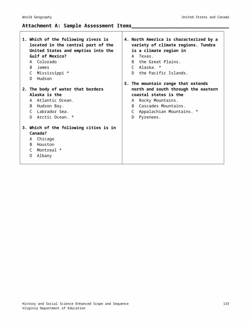
World Geography Europe
Session 7: Reinforcement through Group Reports_____________________________
Materials None identified
Instructional Activities1. Review the content from the previous session.
2. Divide students into groups of three or four, and assign one of the following topics to each group to prepare a report for the class: Support the statement: “Now all European countries are developed.” The Chunnel A comparison between the levels of industrial development in Western and Eastern Europe Government involvement in the economies of Sweden and Denmark Replacement of communism with capitalism in Eastern Europe Reclaimed land — Polders in the NetherlandsProvide research materials in the class for the groups to prepare their two-to-three-minute report on their assigned topics.
3. Assign a teacher-selected reading, worksheet, or other reinforcement activity, using available teacher resources.
History and Social Science Enhanced Scope and Sequence 134Virginia Department of Education

World Geography Europe
Session 8: Cultural Characteristics______________________________________________
Materials Index card for each student
Instructional Activities1. Review content covered in the previous session.
2. Ask students to describe their image of European culture.
3. Provide a brief background on the following elements of European history: Birthplace of Industrial Revolution Various ethnic groups, including languages, religions, and customs Sporadic conflict (wars, revolutions) among groups Birthplace of democracy and representative government — Greece and Rome Spread of European culture to many other parts of the world through exploration, colonization, and
imperialism Highly urbanized One of the world’s most densely populated areas North Atlantic Treaty Organization
4. Have each student select a city/landmark from the following list (make sure that each is selected) and research its significance. Distribute index cards to the students, and have them compose and write on the card a postcard message that reflects their visit to the location. The message should include the where (including country), when, and why of their visit. On the other side of the card, have them illustrate the landmark or city with a drawing or by gluing a picture of it. Focus of the activity should be on the aspects of culture represented in the landscape. Cities
Berlin London Paris Madrid Rome Athens Warsaw
Landmarks Notre Dame Arc de Triomphe Louvre Eiffel Tower Coliseum Leaning Tower of Pisa St. Peter’s Basilica Parthenon Westminster Abbey Big Ben windmills castles cathedrals Brandenburg Gate
5. Allow time for the students to share their postcards.
History and Social Science Enhanced Scope and Sequence 135Virginia Department of Education

World Geography Europe
6. Assign a teacher-selected reading, worksheet, or other reinforcement activity, using available teacher resources.
History and Social Science Enhanced Scope and Sequence 136Virginia Department of Education

World Geography Europe
Session 9: Assessment___________________________________________________________
Materials Assessment
Instructional Activities1. Administer the assessment. Sample assessment items can be found at Attachment A.
History and Social Science Enhanced Scope and Sequence 137Virginia Department of Education

World Geography Europe
Attachment A: Sample Assessment Items______________________________________
1. The EU (European Union) isA a mutual defense agreement that includes most of
the European countries including Russia.B an economic alliance to encourage free trade and
a single market among its member. *C a political organization that wants to unite all
countries of Europe under one government.D an agreement made between the United States and
the United Kingdom to promote the sharing of natural resources.
2. Europe is separated from Asia, in part by theA Transylvanian AlpsB Northern European PlainC Danube RiverD Ural Mountains *
3. About one-third of the forests in Germany have been damaged byA Acid rain *B EarthquakesC FloodingD Volcanoes
4. Which of the following is an example of a multilingual nation?A FranceB GermanyC Switzerland *D Sweden
5. Western Europe has a mild climate because ofA its latitude.B differences in elevation.C its mountains.D the North Atlantic Drift *
6. Fighting in Bosnia and other areas of former Yugoslavia is mainly due toA high unemployment.B changes in government policies.C natural disasters.D ethnic differences. *
History and Social Science Enhanced Scope and Sequence 138Virginia Department of Education

World Geography
Organizing Topic
Russia and Central AsiaStandard(s) of Learning__________________________________________________________WG.4 The student will locate and analyze physical, economic, and cultural characteristics of world regions:
Russia and Central Asia,.
WG.12 The student will apply geography to interpret the past, understand the present, and plan for the future bya) using geographic knowledge, skills, and perspectives to analyze problems and make decisions;b) relating current events to the physical and human characteristics of places and regions.
Essential Understandings, Knowledge, and Skills_____________________________Correlation to Instructional Materials
Skills (to be incorporated into instruction throughout the academic year)Compare maps and make inferences.
Identify and interpret regional patterns on maps
Identify primary ideas expressed in graphic data.
Gather, classify, and interpret information.
Draw conclusions and make generalizations about data.
Explain cause-and-effect relationships.
Explain charts comparing two or more concepts.
Identify and locate regions, continents, oceans, and major features on maps and globes.
ContentDescribe how physical, economic, and cultural characteristics influence regional development. Use the regional information provided below.
CountriesLocation of countries with particular emphasis on countries listed (determined by their per capita GDP, land size, and population)
GDP Kazakhstan
Russia
History and Social Science Enhanced Scope and Sequence 139Virginia Department of Education

World Geography Russia and Central Asia
Turkmenistan
Land size Russia Kazakhstan
Turkmenistan
Population Russia Kazakhstan
Uzbekistan
Physical Characteristics Vast land area — spans two continents (Europe, and Asia) and covers 11 time zones
Vast areas of tundra, permafrost, taiga, and steppe
Varied climate regions
Black-earth belt (rich chernozem soil)
Mountains
Caucasus Mountains
Ural Mountains (divide Europe from Asia)
Siberia (the sleeping land), located east of the Urals
Major oil, natural gas, and mineral resources
Water features Volga River
Ob River
Amur River
Lake Baikal
Caspian Sea
Aral Sea
Bering Strait
Pacific Ocean
Arctic Ocean
History and Social Science Enhanced Scope and Sequence 140Virginia Department of Education

World Geography Russia and Central Asia
Some rivers flow northward to the Arctic Ocean
Economic Characteristics Transition from communist to free market economy
Farming and industry concentrated in the Fertile Triangle region, rich, chernozem soils (wheat farming)
Infrastructure — Trans-Siberian Railroad, systems of rivers, canals, and railroads
Energy resources — Hydroelectric power, oil, and natural gas
Russian natural resources not fully developed due to climate, limited transportation links, and vastness of the country
Foreign competition for investment in the region (oil pipelines)
Widespread pollution
Shrinking of the Aral Sea
Political and economic difficulties after the breakup of the Soviet Union
Cotton production in Central Asia
Cultural Characteristics Diverse ethnic groups, customs, and traditions (many of Turkic and Mongol heritage)
Cultural heritage Ballet Fabergé eggs
Music Icons Matrioshka dolls
Oriental carpets
Samovars
Cultural landscape Russian Orthodox churches
St. Basil’s Cathedral
Red Square
Kremlin Mosques, minarets
History and Social Science Enhanced Scope and Sequence 141Virginia Department of Education

World Geography Russia and Central Asia
Siberian villages
Soviet-style apartment blocks
Cities as centers of culture and trade Moscow
St. Petersburg
Novosibirsk
Explain the following practical applications of how geography enables students to be informed, active citizens in their communities:
Recycling programs
Conversion of land from agricultural use
Water sources (e.g., dams, reservoirs, wells, pipelines, ocean)
Airport expansion
Air quality
Boundaries (e.g., school zones)
Bicycle paths
Mass transit
City planning and zoning laws
Energy use
Location and size of public buildings (e.g., schools, recreation centers, hospitals, and libraries)
Selection of locations for new stores and businesses
Explain that current events are shaped by the physical and human characteristics of the places and regions where they occur.
Use the following examples to explain how physical and human characteristics influence current events of places and regions:
How physical characteristics influence current events: Natural hazards (e.g., flooding, earthquakes, volcanoes, drought)
Climate, vegetation
How human characteristics influence current events:
History and Social Science Enhanced Scope and Sequence 142Virginia Department of Education

World Geography Russia and Central Asia
Population distribution
Geographic patterns of ethnic diversity
A sense of place (emotional attachment to specific locations)
Geographic patterns of trade and interdependence (e.g., oil)
Geographic patterns of wealth and poverty (developed and developing nations)
History and Social Science Enhanced Scope and Sequence 143Virginia Department of Education

World Geography Russia and Central Asia
Sample Resources________________________________________________________________
Below is an annotated list of Internet resources recommended for this organizing topic. Copyright restrictions may exist for the material on some Web sites. Please note and abide by any such restrictions.
A Chronology of Russian History. Bucknell University. <http://www.departments.bucknell.edu/russian/chrono.html>. This page dates the major (and some not so major) events in Russian history and links them with explanatory and related materials on the Web.
“Astronomy Picture of the Day: Earth at Night.” NASA. <http://antwrp.gsfc.nasa.gov/apod/ap001127.html>. This site offers a map that shows the lights of the world at night.
Cyrillic Alphabet. Berlitz Russian Phrase Book and Dictionary, 1993. <http://www.friends-partners.org/oldfriends/language/russian-alphabet.html>. This Web site provides transliterations of all letters in the Russian alphabet, plus the opportunity to hear each letter pronounced.
The Face of Russia. Public Broadcasting Service. <http://www.pbs.org/weta/faceofrussia/>. This site offers information about the TV series The Face of Russia, together with a timeline of Russian history and references.
“Historical Backdrop: Timeline of Selected Events.” Turner Learning. <http://www.turnerlearning.com/tntlearning/animalfarm/aftimeline.html>. This site provides a timeline of world events from 1825 through 1999.
Justice for Everybody: Human Rights in the Russian Federation. Amnesty International. <http://www.amnesty.org/russia/>. This site highlights the discrepancy between the human rights protections that those living in the Russian Federation have in international and national law, and the reality of widespread human rights abuses committed in a climate of impunity.
“Letter to Bolshevik.” The Library of Congress. <http://lcweb.loc.gov/exhibits/archives/d2presid.html>. This site shows a translation of a real letter written in 1926 to the Presidium of the Central Executive Committee of the All-Union Communist Party (Bolshevik) by prisoners who are returning from the Solovetsky concentration camp because of our poor health. (Reprinted in part on Attachment G.)
Map Machine. National Geographic. <http://plasma.nationalgeographic.com/mapmachine/index.html?id=362&size=medium&left=-36&bottom=41.2&right=180&top=81.85.> National Geographic's redesigned online atlas provides access to National Geographic maps of the entire world.
The Moscow Kremlin: An Historic Tour. The University of Texas at Austin. <http://uts.cc.utexas.edu/~powellm/kremlin.html>. This site provides historical information about and pictures of the Kremlin.
Outline Maps — Education Place. Houghton Mifflin, 2002. <http://www.eduplace.com/ss/ssmaps/>. This site permits visitors to print a variety of maps related to this organizing topic.
Owl and Mouse Educational Software. <http://www.yourchildlearns.com/owlmouse.htm>. This site provides activities to promote geographic knowledge.
Rare Antique Imperial Russian Samovars. The Lower East Side Restoration Project. <http://www.russiansamovars.com/samovars1.htm>. This site provides information about and pictures of antique samovars that are for sale, allowing buyers to own a piece of Jewish cultural history.
Russia. Centennial Campus Middle School. <http://ccms.wcpss.net/media/russia.htm>. This site provides many links to Web sites about Russia.
Schulman, Bruce R. “The Fabergé Experience: Fabergé Eggs.” <http://users.vnet.net/schulman/Faberge/eggs.html#TOP>. This site provides historical information as well as pictures of Fabergé eggs.
History and Social Science Enhanced Scope and Sequence 144Virginia Department of Education
World Geography Russia and Central Asia
“Solzhenitsyn, Aleksandr (Isayevich).” The Nobel Prize Internet Archive. <http://www.almaz.com/nobel/literature/Solzhenitsyn.html>. This site offers a biography of the famous Russian author.
“Timeline: Early Russian History from Legendary Warrior Rurik to Ivan the Great.” Infoplease.com. <http://www.infoplease.com/spot/russiatime1.html>. This site provides a timeline of Russian history from 862 until today.
Virginia Standards of Learning Assessments for the 2001 History and Social Science Standards of Learning: History and Social Science Released Items for Virginia and United States History. Virginia Department of Education 2003/04. <http://www.pen.k12.va.us/VDOE/Assessment/Release2003/History/VA-RIBs_g11wgeo-1.pdf>.
Virginia Standards of Learning Assessments for the 2001 History and Social Science Standards of Learning: World Geography Test Blueprint. Virginia Department of Education, 2003/04. <http://www.pen.k12.va.us/VDOE/Assessment/HistoryBlueprints03/2002Blueprint9WG.pdf>. This site provides assessment information for the course in World Geography.
Where, Oh Where Will We Go? Guilford County Schools, North Carolina. <http://its.guilford.k12.nc.us/webquests/russia/russia.htm>. In this Webquest, students prepare a trip to St. Petersburg for four people and take on different roles to learn about Russia
The World Factbook 2002. U.S. Central Intelligence Agency. <http://www.cia.gov/cia/publications/factbook/>. This site contains searchable information on all countries.
History and Social Science Enhanced Scope and Sequence 145Virginia Department of Education

World Geography Russia and Central Asia
Session 1: Physical Features____________________________________________________
Materials Physical and political maps of Russia and Central Asia Video on the physical features of the region, and a related, teacher-developed viewing guide Unlabeled physical/political outline maps of the region A list of the physical characteristics, countries, and cities to be located (see list on pp. 121–123) Student geography notes for the region (Attachment F)
Instructional Activities1. Display a physical map of the region, and instruct students to analyze the physical features by reading the key
and interpreting the map. Have the students answer the following questions: What physical feature separates Europe from Asia? (Ural Mountains) How many time zones does Russia span? (11) What oceans border Russia? (Arctic and Pacific)Discuss the answers to the questions, using the maps to demonstrate.
2. Show a video on the physical features of Russia and Central Asia, and have students answer questions based on the information in the viewing guide. Discuss student responses to the questions.
4. Distribute physical/political outline maps of Russia and Central Asia and the list of the physical features, countries, and cities to be located. Direct students to complete their maps, using the student geography notes for the region (Attachment F). Alternatively, assign a teacher-selected reading, worksheet, or other reinforcement activity, using available teacher resources.
5. Have students practice locating countries of the region, using free map puzzles and games found at the following site: Owl and Mouse Educational Software. <http://www.yourchildlearns.com/owlmouse.htm>.
History and Social Science Enhanced Scope and Sequence 146Virginia Department of Education

World Geography Russia and Central Asia
Session 2: Climates; Vocabulary________________________________________________
Materials Climate map of Russia and Central Asia Teacher-developed worksheet listing necessary vocabulary words PowerPoint presentation on “The Geography of Russia and Central Asia.” Background information on the region included with this lesson
Instructional Activities1. Review the activity from the previous session
2. Display a climate map of the region. Instruct students to analyze the climates by reading the key and interpreting the map. Have the students predict the population density in the northern part of the region and justify their prediction. Instruct students to write a paragraph describing the climate extremes in Russia and Central Asia. Descriptions should include statements that show the students understand that the climates found in Russia and Central Asia range from subtropical to arctic. Have students share their paragraphs, and discuss the concepts mentioned.
3. Distribute the worksheet listing vocabulary words students need to understand. The teacher may direct students to define the words or may provide the terms and definitions as a matching exercise for students to complete. Vocabulary should include the following words: tundra permafrost taiga steppe chernozem Siberia divert irrigation desertification
4. Use the PowerPoint titled “The Geography of Russia and Central Asia” to discuss the definitions with the students and show pictures that illustrate the meaning of each term. In addition, the teacher may wish to point out on a map the locations where particular geographical features occur.
History and Social Science Enhanced Scope and Sequence 147Virginia Department of Education
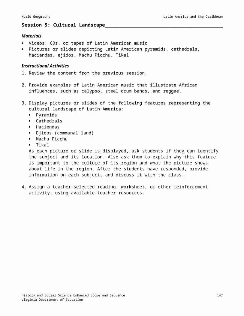
World Geography Russia and Central Asia
Session 3: Natural Resources, Employment, Exports; Pollution; Fabergé Eggs_______________________________________________________________________________
Materials Transparency of a natural resource map of Russia and Central Asia One copy of the Natural Resources, Employment, Exports Worksheet (Attachment A) for each student An outline political map of the region for each student Almanacs and/or Internet access
Instructional Activities1. Display a natural resource map or the region, and instruct students to list the natural resources found in Russia
and Central Asia, create a symbol for each resource, and draw the symbols in the appropriate countries on an outline map.
2. Instruct students to research on the Internet or in almanacs the primary types of employment in each country and the primary exports of each country. Have students complete a chart (Attachment A) to display the data they find.
3. Direct students to research pollution in Russia and Central Asia to determine the state of the environment and the laws governing the environment. For example, students may research the accident at Chernobyl and the state of that area today.
4. Introduce Fabergé eggs by displaying pictures of some, explaining the reasons they were created, and outlining the expense involved in creating them. Emphasize that the precious jewels and gold in the eggs were mined in Russia.
5. Assign a teacher-selected reading, worksheet, or other reinforcement activity, using available teacher resources.
History and Social Science Enhanced Scope and Sequence 148Virginia Department of Education

World Geography Russia and Central Asia
Session 4: Siberia________________________________________________________________
Materials An overhead transparency of a map that shows the lights of the world at night (See
<http://antwrp.gsfc.nasa.gov/apod/ap001127.html>) PowerPoint presentation on “Siberia” (or video on Siberia) Handouts: Escape from Siberia assignment and grading rubric. (Attachments B and C) Student geography notes for the region (Attachment F)
Instructional Activities1. Display the map of the lights of the world at night. Ask students to identify the string of lights that extends
across Siberia and to explain what the string of lights represents. Students should conclude that the lights represent the towns along the Trans-Siberian Railroad. Point out that the cities along the route developed because they are located on the railroad.
2. Show students the PowerPoint presentation titled “Siberia,” or show a video on Siberia. Discuss the physical features and the climate of the region. Include facts from the student geography notes that are included in this lesson (Attachment F).
3. Assign the “Escape from Siberia” paper by distributing the assignment sheet (Attachment B) and the grading rubric (Attachment C) for students to use as they complete the assignment. Review the information on these sheets, and answer all questions the students may have.
History and Social Science Enhanced Scope and Sequence 149Virginia Department of Education

World Geography Russia and Central Asia
Session 5: Developing vs. Developed Countries_______________________________
Materials Almanacs and/or Internet access A copy of the blank Economic Indicators Data chart for each student (Attachment D)
Instructional Activities1. Instruct students to list the characteristics of a developed country and those of a developing country. Have the
students share their answers, reviewing with the students the characteristics of developed and developing countries.
2. Instruct students to go to the <http://www.cia.gov/cia/publications/factbook/> Web site or use almanacs to gather data and complete the Economic Indicators Data chart (Attachment D). Have students compare the data to their understanding of developed and developing countries and determine whether each country is developed or developing.
3. After students have completed their chart, have them write a paragraph that summarizes the economic status of the countries in the region, supporting their summary by the data in their chart.
History and Social Science Enhanced Scope and Sequence 150Virginia Department of Education

World Geography Russia and Central Asia
Session 6: Cultural Characteristics______________________________________________
Materials Photographs of cultural sites and cultural symbols of the region PowerPoint presentation on “Russian History and Culture” Copies of Travel Brochure assignment (Attachment E)
Instructional Activities1. Have the students list examples of symbols, buildings, sites, and ideas that reflect the culture of Russia and
Central Asia.
2. Show the PowerPoint presentation on “Russian History and Culture,” and discuss the elements of culture included in the slides. Discuss the symbols, buildings, sites, and ideas that are part of the culture of Russia. Make sure to include the following: The region is composed of diverse ethnic groups, customs, and traditions. Many of these are of Turkic
and Mongol heritage. Cultural heritage
Ballet Fabergé eggs Music Icons Matrioshka dolls Oriental carpets Samovars
Cultural landscape Russian Orthodox churches St. Basil’s Cathedral Red Square Kremlin Mosques, minarets Siberian villages Soviet-style apartment blocks
The following cities are centers of culture and trade Moscow St. Petersburg Novosibirsk
3. Distribute copies of the Travel Brochure assignment (Attachment E), and review the directions with the students, answering all questions. Supply the students with a due date for this assignment.
History and Social Science Enhanced Scope and Sequence 151Virginia Department of Education

World Geography Russia and Central Asia
Session 7: Review________________________________________________________________
Materials PowerPoint presentation of “Jeopardy: Russia” game
Instructional Activities1. Have the students prepare for the unit test on Russia and Central Asia by playing the “Jeopardy: Russia”
game, which is played like the Jeopardy game on TV. The teacher should determine methods for keeping score selecting teams keeping track of which questions have been answered.
History and Social Science Enhanced Scope and Sequence 152Virginia Department of Education
World Geography Russia and Central Asia
Session 8: Assessment___________________________________________________________
Materials Unlabeled outline map of the region
Instructional Activities1. Administer a test on Russia and Central Asia. Examples of test questions in SOL format are included at
Attachment G. Include an unlabeled outline map of the region, and have students identify important political units, cities, rivers, lakes, seas, oceans, mountains, and deserts on it. You may wish to number the places on the map and have students respond to test questions presented in the following format:
History and Social Science Enhanced Scope and Sequence 153Virginia Department of Education
The country located at number 1 isA BelarusB LatviaC EstoniaD Lithuania
The body of water located at number 2 isA Lake BaikalB the Aral SeaC the Black SeaD the Caspian Sea
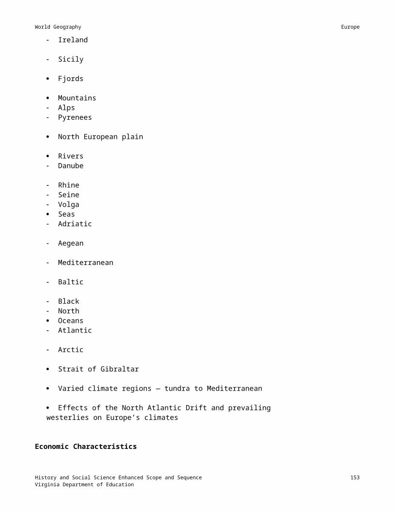
World Geography Russia and Central Asia
Attachment A: Natural Resources, Employment, Exports Worksheet________
Name: Date:
Natural resources in the region Resources are not fully developed due to the harsh climate and vastness of the country. Transportation links are limited.
The major means of transportation include train, rivers, and canals. Major rivers in Siberia flow north to the Arctic Circle. These regions are iced over for most of the year. Roads in Siberia are not good; most are gravel and are muddy in the summer. The Caspian Sea is landlocked.
Manufacturing in the region produces widespread pollution. Chernobyl Nuclear Disaster. <http://www.chernobyl.co.uk/>
Country Primary resources Secondary resources
Primary types of employment
Primaryexports
Russia
manganese (#1 in the world)chromium (#1 in the world)coal and ligniteoilnatural gas (#1 exporter in
the world)hydroelectric powerforestlandfishcoppersilver
goldleadsalttungstenzinciron orenickelprecious stones
Ukrainecoal and lignitewheat, rye, oats, barley, sugar, rich chernozem soil
Belarus forestland
Kazakhstan coal and lignite
Turkmenistan sulfursodium nitrate
Uzbekistan cotton — known as white gold in Uzbekistan
Azerbaijanoil — must be moved through pipelines. Foreign competition for the oil in this region is great.
History and Social Science Enhanced Scope and Sequence 154Virginia Department of Education

World Geography Russia and Central Asia
Attachment B: Political Prisoners_______________________________________________
Due Date:
Political Prisoners Escape from Siberian Labor Camp near YakutskMoscow, Russia. Three political prisoners escaped from a forced labor camp on January 27, 1950. The prisoners are enemies of the state and must be captured. The two men and one woman were last seen near the town of Yakutsk. The Soviet government and the KGB are seeking leads that will enable them to capture the fugitives. If you see these prisoners, you must immediately contact the Soviet government and report their location.
Objectives The student will write a one-page paper explaining how the refugees mentioned in the newspaper article
above might escape from the Soviet Union and seek asylum in another country. This paper may be in the form of a journal entry, letter, first person account, or newspaper article.
The student will use correct facts about the region, correct place names, and correct relative directions. The student will use map-reading skills to complete basic research on the geography of the region. The student will evaluate the paper of a classmate and evaluate his or her own paper.
You have to plan very carefully in order to survive and be successful. Before you begin your plans, you must do some research. You might want to insert a symbol for the location of the mountains/forests and highlight the Arctic Circle. Using an atlas, answer the following questions: What physical feature is located at 66½° N, 130° E? Would this be a problem or a possible solution? What natural vegetation is found in northeast Russia? Would the existence of this natural vegetation region
influence the planning of your escape route? How many people might you find in that region who could help you get out of Russia or provide food and
shelter? What is the average temperature in January? What transportation routes are available in the area? In which direction does the Lena River flow? Would this influence your escape route? Would an escaped fugitive from the Soviet Union in 1950 be welcome in all the countries that bordered the
Soviet Union at that time?
Once you answer these questions, plan your escape route. Make sure you name the country to which you hope to immigrate. Keep in mind the scale of distances. How long do you think it would take you to get out of the Soviet Union? In your writing, make sure you use place names of the countries and/or regions along your escape route and use correct relative directions, for example, “I walked south toward the city of Novosibirsk for one month.”Make sure you follow the rubric for the assignment (Attachment C).
History and Social Science Enhanced Scope and Sequence 155Virginia Department of Education

World Geography Russia and Central Asia
Attachment C: Grading Rubric for Escape from Siberia________________________
Name:
Criteria PointsPossible
Points a peer
thinks I earned
Points I think I earned
PointsEarned
Prewriting activities 2Paper format
Introduction 2 Three paragraph body 2 Conclusion 2
Mechanics of writing Capitalization 2 Punctuation 2 Sentence structure 2
Facts based on geography research Correctly identified physical regions 3 Correctly identified natural vegetation region 3 Correctly interpreted population density map 3 Correctly stated the temperature in January 3 Correctly identified transportation routes 3 Correctly stated the influence of the Lena River 3 Correctly identified a country to immigrate to that
would accept a refugee from the Soviet Union. 3
Correctly uses place names 5Correctly uses relative directions 3Correctly drawn compass rose 2Escape plan is realistic 5Total Score 50
History and Social Science Enhanced Scope and Sequence 156Virginia Department of Education
Teacher Comments:

World Geography Russia and Central Asia
Attachment D: Economic Indicators Data____________________________________________________________________
Country Population
Percentage of population under 15
Literacy rate: male
Literacy rate: female
Life expectancy: male
Life expectancy: female
GDP per capita
Percentage of population: urban
Annual population growth rate
Check this column if the country is developing
Belarus
Ukraine
Moldova
Russia
Kazakhstan
Kyrgyzstan
Tajikistan
Uzbekistan
Turkmenistan
Armenia
Azerbaijan
Georgia
History and Social Science Enhanced Scope and Sequence 157Virginia Department of Education

World Geography Russia and Central Asia
Attachment E: Travel Brochure__________________________________________________
Since the fall of the USSR, 15 independent republics have worked toward economic stability. A potential economic boost would be increased tourism. As a citizen of one of these republics, you have been asked by an ambassador of your country to create a travel brochure about your country. This brochure will be used to entice visitors to your homeland. This assignment will be worth 100 points.
Due Date:
CountriesArmeniaAzerbaijanBelarusEstonia
GeorgiaKazakhstanKyrgyzstanLatvia
LithuaniaMoldovaRussiaTajikistan
TurkmenistanUkraineUzbekistan
1. Information to be included in the brochure: Flag – neatly colored Physical Map – hand-drawn, neatly colored with a key including bodies of water, capital, major cities,
and physical features Fact List including all of the following: population, land area, type of government, major imports and
exports, crops, and resources Culture Information including four of the following items: language(s), religions, holidays, festivals,
sports, recreation, dress, education, customs, and traditions Current Events/Issues – at least two different events or issues Major Landmarks – at least one with a picture List of Resources – at least three; one must be from the Internet
2. No pencil writing! Use blue or black pen, or create the brochure on the computer. The brochure should be colorful, but not too busy. You may type your information and then cut and paste. If you choose this option, please use 12-point Arial or Times New Roman font.
3. Another option is a PowerPoint show. If you choose this option, everything above must be included. A printout of the slides or the disk must be submitted with the hand-drawn map. If you choose this option, please notify me at the end of class.
4. Grading Scale – 100 Points Total Accuracy of content – 20 points Fact list – 15 points Culture – 15 points Map – 10 points Landmarks – 5 points Resources – 5 points Creativity – 10 points Neatness – 10 points Flag – 5 points Current events – 5 points
History and Social Science Enhanced Scope and Sequence 158Virginia Department of Education

Turan Lowland
West Siberian Plain
North European Plain
East Siberian Uplands
Central Siberian Plateau
World Geography Russia and Central Asia
Attachment F: Student Geography Notes on Russia and Central Asia________
I. Three plains connect Europe and Asia:A. The North European Plain
1. Center of economic life for one-quarter of the people of Russia and central Asia2. Chernozen soil in the area makes the Ukraine one of the best farming areas in Europe3. Two major Russian cities are on the plain — Moscow and St. Petersburg4. One Ukrainian city is located on the plain — Kiev
B. West Siberian Plain1. East of the Ural Mountains2. World’s largest flat land — about 1 million sq. miles3. Unsuited for farming — mostly marshes, swamps, and frozen land
C. The Turan Lowland1. Located between the Caspian Sea and the Tian Shan Mountains2. Some irrigated land, but most of the area is desert, called kums (the two Kara-Kum or “Black Sands”
deserts and the Kyzylkum or “Red Sands” desert)
II. Mountains and plateausA. Carpathian Mountains border the UkraineB. Caucasus Mountains separate Azerbaijan and GeorgiaC. Ural Mountains separate Europe from Asia and European Russia from SiberiaD. East Siberian Uplands form the largest region in SiberiaE. Central Siberian Plateau
III. Seas and lakesA. Many rivers and lakes are ice covered most of the year.B. The Black Sea (warm water sea) empties into the Mediterranean Sea.C. The Caspian Sea is the largest inland body of water in the world.
1. The Caspian Sea is shrinking due to evaporation and irrigation.D. The Aral Sea is also shrinking due to evaporation and irrigation.E. Lake Baikal in Siberia is the oldest (25 million years) and deepest lake in the world.
1. Contains one-fifth of the world’s fresh water2. Holds more water than the five great lakes combined
History and Social Science Enhanced Scope and Sequence 159Virginia Department of Education
World Geography Russia and Central Asia
3. It would take all the water from all the major rivers in the world to fill Lake Baikal.
IV. RiversA. The Amur River flows east and forms the boundary between Russia and China
1. This is the only agricultural area in east SiberiaB. The Lena, Yenisey and Ob Rivers flow north and are frozen most of the year.C. The Volga River flows into the Caspian Sea.
1. Longest river in European Russia2. Most important waterway in Russia3. Important for hydroelectric power
V. ClimatesA. The climate of the region is influenced by the following:
1. Lack of mountains to break the hot winds from deserts and cold winds from the north2. Its location in the higher latitudes3. Cold water bordering the region on the north
B. The climate range is the largest in any region of the world.1. Subarctic in the north2. Continental in the middle3. Subtropical near the Black Sea
VI. Facts about the regionA. Russia is the largest country in the world.B. Russia has more natural resources than any country in the world, but they are hard to get to and transport.C. The rivers are frozen over in northern Siberia and are used as highways. It’s easier to travel in the winter
than the summer.D. Roads in northern Siberia are not paved because of the extreme cold. They are gravel roads and are very
muddy in the summer.E. Homes in northern Siberia are built on pilings because the heat generated in the house will melt the
permafrost and cause the house to collapse.F. There are 11 time zones in Russia; the sun is rising in the east as it is setting in the west.G. In 1992, Ukraine reported a 900% increase in leukemia near the Chernobyl nuclear power plant.H. Items the Russians like the most from the U.S. are T-shirts, blue jeans, rock and country/western
recordings, chewing gum, and baseball caps.I. In Moscow, the subways are clean, efficient, and beautifully decorated.J. In 1993 shortly after the fall of Communism, the average salary was $14.00 a month.K. Salt and other minerals blowing off the Aral Sea’s dry seabed have shortened the life expectancy and led
to high death rates for mothers and newborns as well as caused many infections, respiratory diseases, eye infections, hepatitis, throat cancer, and severe anemia.
L. The railroad system in Russia is the greatest mover of people in the world. It has 90,000 miles of track.
History and Social Science Enhanced Scope and Sequence 160Virginia Department of Education

World Geography Russia and Central Asia
Attachment G: Sample Assessment Items______________________________________NOTE: A map requiring students to locate countries, rivers, lakes, cities, oceans, mountains and deserts should be included.
1. The Crimean Peninsula has a ______ climate that is suitable for growing citrus fruits, winter grains, and vegetables.A Mediterranean *B TundraC HighlandD Subarctic
2. In Russia, most people who practice a religion belong to theA Catholic Church.B Protestant faith.C Orthodox Church. *D Muslim faith.
3. Russia and Central Asia cover almost____ of all the land on the Earth.A 1/2B 1/3C 1/6 *D 1/4
4. In the sub-arctic region of Russia, snow is common for _____months a year.A 6B 8 *C 10D 12
5. The largest forest region in the world is theA coniferous forests (taiga) of Russia. *B The Black Forest of Europe.C The Brazilian tropical rain forest.D tundra of Russia.
6. The pollution crisis in the former Soviet Union and central Asia was caused byA government neglect of the environment. *B focus on production of consumer goods.C government overspending.D focus on developing a market economy.
7. The border between Europe and Asia is formed by theA Carpathian Mountains.B Ural Mountains. *C Pamir Mountains.D Yenisei River.
8. The largest country in Asia isA Belarus.B Russia. *C Ukraine.D Georgia.
9. Chernobyl is the site ofA the beginning of the Bolshevik revolution in 1917.B the eastern-most city on the Trans-Siberian Railroad.C a nuclear reactor accident in 1986. *D Lenin’s birthplace.
10. The fortress that houses the government of Russia isA St. Basil’s Cathedral.B The Kremlin. *C Gorky Park.D Siberia.
11. A religious painting found in the homes of members of the Russian Orthodox Church isA a crucifix.B an icon. *C a cross.D a mural.
12. The religious building in Red Square with nine colorful domes is A the Church of the Holy Sepulcher.B the Dome of the Rock.C the Church of the Annunciation.D St. Basil’s Cathedral. *
13. In a command economyA the government makes all decisions regarding the
manufacture, sales, and distribution of products. *B the supply and demand of the consumers determines
what is bought and sold.C Individuals make all decisions regarding the
manufacture, sales, and distribution of products.D Foreign governments make all decisions regarding
the manufacture, sales, and distribution of products.
14. In a market economyA the government makes all decisions regarding the
manufacture, sales, and distribution of products.B the supply and demand of the consumers determines
what is bought and sold. *C Individuals can operate their own businesses but
profits go to the government.D Foreign governments run the businesses.
History and Social Science Enhanced Scope and Sequence 161Virginia Department of Education

World Geography Russia and Central Asia
15. The major means of travel in Russia and Eurasia isA the airplane.B ships and boats.C the automobile.D trains and metros. *
16. Which statement best describes the main problem Russia experiences in transporting goods?A Many rivers and harbors freeze over in the winter
and make travel almost impossible. *B There are no railroads that provide access to
Siberia.C The warm climate of northern Siberia causes
flooding in the winter.D Due to heavy pollution, ships are not allowed to
travel on most rivers.
17. Which statement best describes the climate range in Russian and Central Asia?A Mediterranean and tropicalB Marine and tropicalC Arctic and MediterraneanD Continental and Arctic *
18. The Aral Sea is gradually drying up and becoming a desert (desertification) becauseA the herders are overgrazing the land.B water is being diverted to irrigate cotton. *C people are cutting down the trees.D the sea is being drained to create farmland.
History and Social Science Enhanced Scope and Sequence 162Virginia Department of Education

Organizing Topic
North Africa and Southwest Asia (Middle East)Standard(s) of Learning__________________________________________________________WG.4 The student will locate and analyze physical, economic, and cultural characteristics of world regions:
North Africa and Southwest Asia,....
WG.12 The student will apply geography to interpret the past, understand the present, and plan for the future bya) using geographic knowledge, skills, and perspectives to analyze problems and make decisions;b) relating current events to the physical and human characteristics of places and regions.
Essential Understandings, Knowledge, and Skills_____________________________Correlation to Instructional Materials
Skills (to be incorporated into instruction throughout the academic year)Compare maps and make inferences.
Identify and interpret regional patterns on maps
Identify primary ideas expressed in graphic data.
Gather, classify, and interpret information.
Draw conclusions and make generalizations about data.
Explain cause-and-effect relationships.
Explain charts comparing two or more concepts.
Identify and locate regions, continents, oceans, and major features on maps and globes.
ContentDescribe how physical, economic, and cultural characteristics influence regional development. Use the regional information provided below.
CountriesLocation of countries with particular emphasis on countries listed (determined by their per capita GDP, land size, and population)
GDP Kuwait United Arab Emirates
Qatar

World Geography North Africa and Southwest Asia (Middle East)
Israel Land size Algeria Saudi Arabia
Libya Population Iran Turkey Egypt
Physical Characteristics Crossroads of Europe, Africa, and Asia
Desert and semiarid climates — Sahara, Sahel, steppes
Mountains
Atlas Taurus Zagros Water features
Mediterranean Sea
Red Sea Black Sea
Arabian Sea
Persian/Arabian Gulf
Strait of Hormuz
Bosporus Strait
Dardanelles Strait
Nile River
Tigris River
Euphrates River
Jordan River
Seasonal flooding, alluvial soils, delta regions, oases, wadis
Economic Characteristics Heavy reliance on primary economic activity (oil drilling, agriculture, pastoralism)
Major producers of world’s oil

World Geography North Africa and Southwest Asia (Middle East)
Oil revenues — Positive and negative effects
Water — The region’s most precious resource
Great variation in standard of living — Ranging from relatively high to poverty-stricken
Regional conflicts, political unrest that affects tourism
Aswan High Dam — Positive and negative effects
Suez Canal — Enhanced shipping routes in the region
Guest workers
Trade important to region from earliest time
Wide range of per capita income and levels of development
Contemporary trade routes (sea lanes)
Organization of Petroleum Exporting Countries (OPEC)
Cultural Characteristics Rapid urbanization
Modernization centered in urban areas while traditional life continues in rural areas
Large percentage of population under age 15
Population unevenly distributed
Arab countries and Arabic language
Non-Arab countries: Turkey, Iran, Israel
Birthplace of three major monotheistic religions — Judaism, Christianity, and Islam
Conflict over Palestine
Nomadic lifestyles
Art that reflects the diversity of religions (stained glass, geometric tiles, calligraphy, mosaics, prayer rugs)
Cities as centers of culture and trade Baghdad
Cairo Istanbul

World Geography North Africa and Southwest Asia (Middle East)
Jerusalem
Mecca Tehran Cultural landscape Mosques, minarets
Church of the Holy Sepulcher
Hagia Sophia
Bazaars, suqs
Western Wall
Dome of the Rock
Kaaba Pyramids
Oil rigs Walled cities
Explain the following practical applications of how geography enables students to be informed, active citizens in their communities:
Recycling programs
Conversion of land from agricultural use
Water sources (e.g., dams, reservoirs, wells, pipelines, ocean)
Airport expansion
Air quality
Boundaries (e.g., school zones)
Bicycle paths
Mass transit
City planning and zoning laws
Energy use
Location and size of public buildings (e.g., schools, recreation centers, hospitals, and libraries)
Selection of locations for new stores and businesses

World Geography North Africa and Southwest Asia (Middle East)
Explain that current events are shaped by the physical and human characteristics of the places and regions where they occur.
Use the following examples to explain how physical and human characteristics influence current events of places and regions:
How physical characteristics influence current events: Natural hazards (e.g., flooding, earthquakes, volcanoes, drought)
Climate, vegetation
How human characteristics influence current events: Population distribution
Geographic patterns of ethnic diversity
A sense of place (emotional attachment to specific locations)
Geographic patterns of trade and interdependence (e.g., oil)
Geographic patterns of wealth and poverty (developed and developing nations)

World Geography North Africa and Southwest Asia (Middle East)
Sample Resources________________________________________________________________
Below is an annotated list of Internet resources recommended for this organizing topic. Copyright restrictions may exist for the material on some Web sites. Please note and abide by any such restrictions.
Africa. Geographia. <http://www.geographia.com/indx06.htm>. This site provides access to much information about countries in Africa.
“Ancient Egyptian Hieroglyphics.” Bergen County Technical Schools. <http://www.bergen.org/AAST/Projects/Egypt/hieroglyphics_report.html>. This site offers a short history of hieroglyphics in Ancient Egypt.
“Arabesque.” Wikipedia, The Free Encyclopedia. <http://www.wikipedia.org/wiki/Arabesque>. This site describes arabesque, an aspect of Islamic art that is an elaborate application of repeating geometric forms often echoing the forms of plants and animals and that is usually found decorating the walls of Mosques.
“Arabic Alphabet.” Wikipedia, The Free Encyclopedia. <http://www.wikipedia.org/wiki/Arabic_alphabet>. This site provides much information about the Arabic alphabet.
“The Aswan High Dam.” What You Need to Know About. <http://geography.about.com/library/weekly/aa012698.htm?once=true&>. This Web site outlines the positive and negative effects of the dam on the Nile Rive and surrounding land.
Country Watch. <http://www.countrywatch.com/cw_regions.asp?REGION=6>. This site provides up-to-the-minute articles about countries in various regions of the world.
Going Places: Turkey. Public Broadcasting System. <http://www.pbs.org/wnet/goingplaces3/turkey/index.html>. This Web site offers a travelogue to Turkey.
Graphic Maps.com. World Atlas.com. <http://www.worldatlas.com/clipart.htm>. This site provides numerous free outline maps, map tests, and clip art.
InfoNation. United Nations. <http://www.un.org/Pubs/CyberSchoolBus/infonation/e_infonation.htm>. This site provides information to facilitate comparison of data on three or more countries; from the UN Cyberschoolbus: A Global Teaching and Learning Project.
The Jewish People and the Land of Israel. http://israelemb.org/sanfran/pp_files/The_Jewish_People_and_the_Land_of_Israel_01.ppt>. This site offers a 37-page Microsoft PowerPoint presentation on the history of the Jews in this ancient land. It can be downloaded and edited.
A Journey into Africa. Education Service Center, Corpus Christi, TX. <http://www.esc2.net/TIELevel2/projects/africa/>. This site is a Webquest activity that take the student to various parts of Africa.
“Label Middle Eastern Countries and Major Bodies of Water.” Enchanted Learning.com. <http://www.enchantedlearning.com/subjects/continents/Mideast/label/>. This site presents an outline map with blanks for filling in names of the countries and bodies of water in this area.
Mesopotamia, The Code of Hammurabi.” Washington State University. <http://www.wsu.edu/~dee/MESO/CODE.HTM>. This site provides a 1910 translation of the law codes of Hammurabi.
Middle East Webquest. Jones Academic Magnet High. <http://home.earthlink.net/~lazarski/home/Midest1.htm>. This site is a fully programmed Webquest activity designed to help students learn more about the Middle East.

World Geography North Africa and Southwest Asia (Middle East)
OnlineNewsHour. Public Broadcasting Service. <http://www.pbs.org/newshour/bb/middle_east/conflict/>. This site, the Web site of the NewsHour with Jim Lehrer, provides an index of past programs and a search feature, thus allowing access to information about this organizing topic.
Outline Maps — Education Place. Houghton Mifflin, 2002. <http://www.eduplace.com/ss/ssmaps/>. This site permits visitors to print a variety of maps related to this organizing topic.
Owl and Mouse Educational Software. <http://www.yourchildlearns.com/owlmouse.htm>. This site offers various map puzzles, interactive maps, and map games.
Pyramids: The Inside Story. Public Broadcasting Service. <http://www.pbs.org/wgbh/nova/pyramid/>. This site provides information on Ancient Egypt.
Sakkal, Mamoun. “The Art of Arabic Calligraphy.” Sakkal Design. <http://www.sakkal.com/ArtArabicCalligraphy.html>. This site gives the history and describes the styles of Arabic calligraphy.
Shulman, Robin. Tracing Borders. Public Broadcasting Service. <http://www.pbs.org/frontlineworld/fellows/israel/intro.html>. This site details the “border” between Israel and the Palestinian people.
Siddiqui, Elisabeth. “Islamic Art.” Colorado State University. <http://www.colostate.edu/Orgs/MSA/find_more/islart.html>. This site gives a concise description of Islamic art.
“Southwest Asia/North Africa.” Arizona Geographic Alliance. <http://alliance.la.asu.edu/maps/MIDEAST.PDF>. This site provides an outline map of the countries of this area.
Theban Mapping Project. <http://www.thebanmappingproject.com/>. This is an interactive site on Egypt, including flash tours.
The World Factbook 2002. U.S. Central Intelligence Agency. <http://www.cia.gov/cia/publications/factbook/>. This site contains searchable information on all countries.
Virginia Standards of Learning Assessments for the 2001 History and Social Science Standards of Learning: History and Social Science Released Items for Virginia and United States History. Virginia Department of Education 2003/04. <http://www.pen.k12.va.us/VDOE/Assessment/Release2003/History/VA-RIBs_g11wgeo-1.pdf>.
Virginia Standards of Learning Assessments for the 2001 History and Social Science Standards of Learning: World Geography Test Blueprint. Virginia Department of Education, 2003/04. <http://www.pen.k12.va.us/VDOE/Assessment/HistoryBlueprints03/2002Blueprint9WG.pdf>. This site provides assessment information for the course in World Geography.

World Geography North Africa and Southwest Asia (Middle East)
Session 1: Countries; Physical Features________________________________________
Materials Physical and political map of North Africa and Southwest Asia Wall map or transparency of the North Africa and Southwest Asia Video on the physical features of North Africa and Southwest Asia and a related, teacher-prepared viewing
guide Physical and political outline maps of North Africa and Southwest Asia A list of the physical features, countries, and cities to be located (see list on pp. 143–145) Copies of student geography notes on the region (Attachment A)
Instructional Activities1. Display a physical map of the region, and instruct students to analyze the physical features by reading the key
and interpreting the map. Have the students answer the following questions: What physical feature dominates North Africa? (Sahara Desert) Why is the region sometimes referred to as the Middle East? (Because it is at the crossroads of three
continents) What is the name of the river that flows through Egypt? Why do you think it is an important river?Discuss the answers to the questions, using the maps to demonstrate.
2. Show a video on the physical features of the region, and have students answer questions based on the information in the viewing guide. Discuss student responses to the questions.
4. Distribute outline physical and political maps of the region, and instruct students to label the following: Kuwait United Arab Emirates Qatar Israel Algeria Saudi Arabia Libya Iran Turkey Egypt Iraq Atlas Mountains Taurus Mountains
Zagros Mountains Mediterranean Sea Red Sea Black Sea Arabian Sea Persian/Arabian Gulf Bosporus Strait Dardanelles Strait Strait of Hormuz Nile River Tigris River Euphrates River Jordan River
Outline maps may be found at the following Web sites: “Southwest Asia/North Africa.” Arizona Geographic Alliance.
<http://alliance.la.asu.edu/maps/MIDEAST.PDF>. “Label Middle Eastern Countries and Major Bodies of Water.” Enchanted Learning.com.
<http://www.enchantedlearning.com/subjects/continents/Mideast/label/>.Free map puzzles and games can be found at the following site: Owl and Mouse Educational Software. http://www.yourchildlearns.com/owlmouse.htm>.

World Geography North Africa and Southwest Asia (Middle East)
Session 2: Climate; Vocabulary__________________________________________________
Materials Climate map of the regions either from an atlas or from the textbook or from the following website
http://www.cpc.ncep.noaa.gov/products/analysis_monitoring/regional_monitoring/middle_east.html Wall map or transparency of the region Students will need a teacher-developed worksheet that lists vocabulary words students need to know. Background information on the region included with this lesson
Instructional Activities1. Display a climate map of the region, and have students analyze the climate by reading the key and
interpreting the map. Instruct the students to write a paragraph that describes the climate in North Africa and Southwest Asia. NOTE: Answers should show that the students understand the arid climate in the region. Next, have the students explain how to predict the population density in the deserts.
2. Distribute worksheets that list vocabulary words students need to understand, and have students write definitions of the terms. You may wish to have them create a picture display of the terms by assigning one or two terms to each student to locate and bring in pictures. Vocabulary should include the following:1. seasonal flooding2. oasis3. delta4. alluvial soil5. irrigation6. desertification7. wadis8. petroleum9. desalination10. nomad11. Bedouins
12. Sahel13. Farsi14. mosque15. synagogue16. church17. Torah18. Koran19. Bible20. Kurds21. Palestine22. Mecca
23. Medina24. Jerusalem25. Jews26. Muslims27. Islam28. Muhammad29. Jesus30. Christians31. Suez Canal32. Aswan Dam
Discuss the definitions with the students, display pictures to illustrate the terms, and point out on a map the locations where these items are found.
3. Have the students research on the Internet and in other sources, desertification and its impact on the region. Make sure students include the causes of desertification in the Sahel.

World Geography North Africa and Southwest Asia (Middle East)
Session 3: Monotheistic Religions_______________________________________________
Materials Map of the area that shows the religions found there Notes and timeline of the history of the three monotheistic religions of the region (Attachment B, and from
referenced Web sites or a textbook)
Instructional Activities1. Point out on a map of the area the religions found there.
2. Discuss the history of the region as it relates to the three monotheistic religions found there. The notes and timeline at Attachment B may be helpful. Focus attention particularly on the contested land in Israel and the holy sites in Israel and Saudi Arabia.
3. Assign a teacher-selected reading, worksheet, or other reinforcement activity, using available teacher resources.
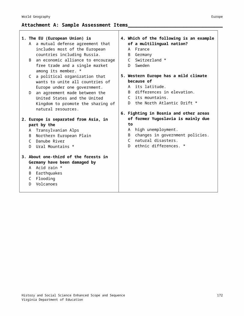
World Geography North Africa and Southwest Asia (Middle East)
Sessions 4, 5, 6, and 7: Jerusalem; Judaism; Christianity; Islam______________
Materials Videos Viewing guides to accompany the videos
Instructional Activities1. Show videos on the subjects listed below. Provide viewing guides for students to complete after viewing:
Jerusalem: Mosaic of Faith Religions of the World: Judaism Religions of the World: Christianity Religions of the World: IslamAfter each video, review the video and viewing guide with students. Have students complete a list of questions about the material seen.
2. During these sessions, discuss the Arab-Israeli conflict.
3. Assign a teacher-selected reading, worksheet, or other reinforcement activity, using available teacher resources.

World Geography North Africa and Southwest Asia (Middle East)
Session 8: Assessment___________________________________________________________
Materials A copy of the Monotheistic Religions Chart for each student (Attachment C) A copy of the Monotheistic Religions Quiz for each student (Attachment E)
Instructional Activities1. Distribute the Monotheistic Religions chart, and review it with students.
2. Allow time in class for students to study the chart in pairs before administering the quiz. Review answers to the quiz upon completion by the students.
Answer Key1. B2. A3. A4. B5. C6. G7. C8. D9. D10. G11. A12. B13. A
14. A15. C16. B17. A18. C19. B20. B21. C22. A23. A24. B25. C
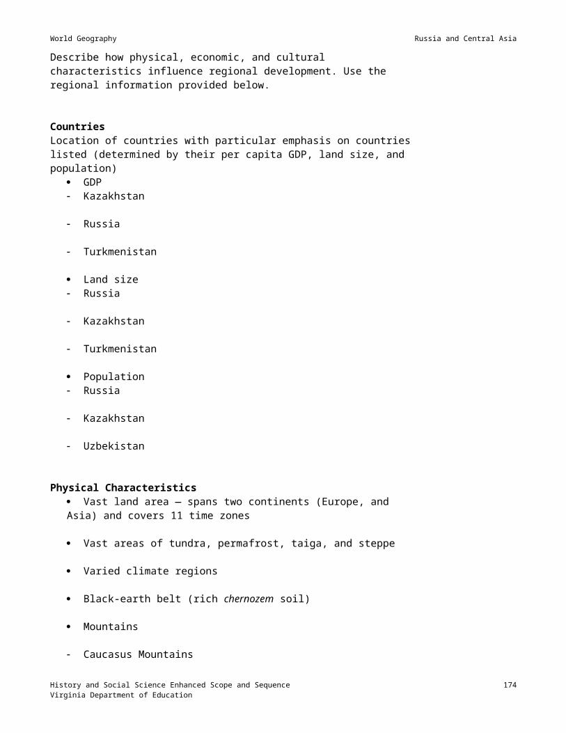
World Geography North Africa and Southwest Asia (Middle East)
Session 9: Developed vs. Developing Countries_______________________________
Materials Almanacs and/or Internet access A copy of the Economic Indicators Data chart for each student (Attachment D)
Instructional Activities1. Instruct students to list the characteristics of a developed country and those of a developing country. Review
with the students the characteristics of developed and developing countries, as identified in the Russia and Central Asia unit, session 6.
2. Instruct students to go to the <http://www.cia.gov/cia/publications/factbook/> Web site or use almanacs to gather data and complete the Economic Indicators Data chart (Attachment K). Have students compare the data to their understanding of developed and developing countries and determine whether each country is developed or developing.
3. After students have completed their chart, have them write a paragraph that summarizes the economic status of the countries in the region, supporting their summary by the data in their chart.
4. Alternative activity: Direct students to the following Web site to make comparisons with nations from other regions and within the region: http://www.un.org/Pubs/CyberSchoolBus/infonation/e_infonation.htm.
5. Assign a teacher-selected reading, worksheet, or other reinforcement activity, using available teacher resources.

World Geography North Africa and Southwest Asia (Middle East)
Session 10: Cultural Characteristics____________________________________________
Materials Photographs of cultural sites and cultural symbols of the region Copies of travel brochure assignment.
Instructional Activities1. Discuss with the students the symbols, buildings, sites, and ideas that are part of the culture of North Africa
and Southwest Asia, including the items listed below. Display photographs of cultural sites and symbols, perhaps in the form of a PowerPoint presentation.
2. Have the students locate the following cities and other cultural sites on a map of the region and describe the cultural characteristics of each: Cities
Baghdad Cairo (An interactive Web site on Egypt, <http://www.thebanmappingproject.com/>, may be helpful.) Istanbul (The PBS Web site on Turkey <http://www.pbs.org/wnet/goingplaces3/turkey/index.html>
may be helpful.) Jerusalem Mecca Tehran
Cultural landscape Mosques, minarets Church of the Holy Sepulcher Hagia Sophia bazaars, suqs Western Wall Dome of the Rock Kaaba pyramids oil rigs walled cities
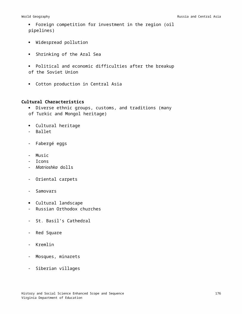
World Geography North Africa and Southwest Asia (Middle East)
Session 11: Arabesque___________________________________________________________
Materials Examples of arabesque art Pictures of prayer rugs, Islamic buildings, and other Islamic symmetrical art
Instructional Activities1. Review with students the five pillars of Islam. Show them pictures of prayer rugs, Islamic buildings, and other
symmetrical Islamic art. Discuss with the students the characteristics of Islamic art.
2. Direct students in creating an arabesque drawing. Explain that an arabesque is a form of symmetrical drawing that includes calligraphy designs, geometric shapes, flowers, vines, leaves, animals, and other things from nature. Images of people are not included in an arabesque. The designs of many oriental rugs are examples of arabesque. The following Web sites provide examples of Islamic art: Arabesque. Wikipedia, The Free Encyclopedia. http://www.wikipedia.org/wiki/Arabesque The Art of Arabic Calligraphy. Sakkal Design. http://www.sakkal.com/ArtArabicCalligraphy.html.To complete the assignment, have the students fold a square piece of paper in half, vertically, horizontally, or diagonally draw the design on one-half of the folded paper trace the drawn design on the other half of the paper open the paper to reveal the whole design, which will be symmetrical color the design, making sure the colors in the two sections also match.NOTE: To challenge the more artistically gifted students, have them make an arabesque that is identical in each of the quarters of the paper.
3. Provide an opportunity for students to display their drawings.

World Geography North Africa and Southwest Asia (Middle East)
Session 12: Global Choke Points________________________________________________
Materials PowerPoint presentation on “Major Choke Points in the World” An outline map of the world
Instructional Activities1. Instruct students to identify on the map of the world where the major straits and canals are located.
2. Show the PowerPoint presentation on “Major Choke Points in the World,” and have students respond to the instructions within the presentation.

World Geography North Africa and Southwest Asia (Middle East)
Session 13: Review_______________________________________________________________
Materials PowerPoint presentation of “Jeopardy: North Africa” game
Instructional Activities1. Have the students prepare for the unit test on North Africa and Southwest Asia by playing the “Jeopardy:
North Africa” game, which is played like the Jeopardy game on TV. The teacher should determine methods for keeping score selecting teams keeping track of which questions have been answered.

World Geography North Africa and Southwest Asia (Middle East)
Session 13: Assessment_________________________________________________________
Materials Unlabeled outline map of the region
Instructional Activities1. Administer a test on North Africa and Southwest Asia. Examples of test questions in SOL format are included
at Attachment F. Include an unlabeled outline map of the region, and have students identify important political units, cities, rivers, lakes, seas, mountains, and deserts on it. You may wish to number the places on the map and have students respond to test questions presented in the following format:
The country located at number 1 isA KuwaitB QatarC IraqD Turkey
The body of water located at number 2 isA the Bosporus StraitB the Arabian SeaC the Persian/Arabian GulfD the Red Sea

World Geography North Africa and Southwest Asia (Middle East)
Attachment A: Student Geography Notes on North Africa and Southwest Asia (Middle East)_______________________________________________________________________________
The region is located at the crossroad of three continents — Europe, Asia and Africa. Trade has always been important in this area, goods and ideas having been exchanged in the region for thousands of years. Today, many contemporary trade routes cross through the region. Because of the divisive influence of the Sahara, the African portion of this region is distinct from sub-Saharan Africa. Egypt and Mesopotamia were the site of the world’s earliest civilizations.
I. MountainsA. Atlas Mountains — located in Northeast AfricaB. Taurus Mountains — located in TurkeyC. Zagros Mountains — located in Iran
II. Seas and LakesA. Mediterranean Sea — borders all three continentsB. Black Sea — most important water route connecting eastern Europe and Russia to the Mediterranean SeaC. Red Sea — separates Africa and AsiaD. Persian Gulf — critical to the transportation of oil out of the regionE. Arabian Sea — connects to the Persian/Arabian Gulf
III. RiversA. Nile River — longest river in the world; critical to the survival of Egypt
1. Aswan High Dam — significant infrastructure in Egypta) Built to control annual flooding on the Nile Riverb) Positive effects on region
(1) hydroelectric power(2) controls the annual flooding in the region(3) provides water for irrigation
c) Negative effects on region(1) prevents river from contributing to fertile soil in area by flooding and spreading silt(2) causes need to use fertilizers to produce fertile soil
B. Tigris River — one of the two main rivers in Iraq; a cradle of civilizationC. Euphrates River — one of the two main rivers in Iraq and Syria; a cradle of civilizationD. Jordan River — rises in Israel; forms the boundary between Israel and Jordan; flows into the Dead Sea,
important in Biblical timesIV. “Choke Points” — straits and canals
A. Suez Canal — man made canal; provides a short cut from the Mediterranean Sea to the Red SeaB. Bosporus — natural strait; part of the connection between the Black Sea and the Mediterranean SeaC. Dardanelles — natural strait; part of the connection between the Black Sea and the Mediterranean SeaD. Strait of Hormuz — strait located at the entrance to the Persian Gulf
V. Climate regions of North Africa and Southwest AsiaA. Desert (Arid) — predominant climate of the region
1. The Sahara — the largest desert in the worldB. Semi-arid — on the fringes of the desert
1. The Sahel — the region south of the Sahara desert; influenced by desertificationC. Mediterranean —all along the Mediterranean coast
1. Wadis or dry riverbeds contain water only when it rains; common in the area2. Torrential floods are created by seasonal rains.
VI. Economic characteristicsA. Desert people used to be nomadic herders (Bedouins).
1. Pastoralism (herding animals) is a primary economic activity.B. The scarcest resource in the region is fresh water. Some countries, such as Saudi Arabia, desalinate
seawater to make fresh water.C. The most plentiful resource in the region is oil.

World Geography North Africa and Southwest Asia (Middle East)
1. Most of the countries, such as Saudi Arabia, UAE, Qatar, Kuwait, and Bahrain, have used their oil revenues to improve the standard of living of their citizens.
2. Other countries, such as Iraq and Iran, have used their oil revenues to create defense systems that include armed forces and modern weapons.
3. The region has a large number of workers from other countries. These workers, from other Middle Eastern countries as well as South Asia and the Philippine Islands, immigrated to the region during the oil boom.
4. The region’s income is based on a single commodity: oil. This is a negative effect of oil.5. Oil resources are not evenly distributed among the countries in the regions. There is a great variation
in the standard of living, ranging from relatively high to poverty-level. There are developed countries and developing countries in the region.
6. Oil-producing nations are members of OPEC (Organization of Petroleum Exporting Countries). The OPEC nations determine the quantity of oil produced and exported and the price per barrel.
D. Agriculture, a primary economic activity in the region, is limited to1. Areas along the coast where the soil and climate are suited to growing wheat, olives, grapes, and citrus
fruits.2. Locations where irrigation is available to grow crops. The people of Israel have successfully irrigated
the Negev desert in order to increase the amount of land that will grow crops.3. Oases — areas of lush green vegetation in the desert.4. Areas along the fertile riverbanks where alluvial soil is left after seasonal flooding.5. Delta regions at the mouths of rivers. The Nile River Delta is a major agricultural region due to the
alluvial soil deposits.E. Regional conflicts and political unrest in the region affect tourism.
1. Conflict between the Palestinians and the Jews in Israel have negatively impacted the tourist industry in the region. Israel is known as the Holy Land — the site of religious holy places of the Jews, Muslims, and Christians. Tourism is a main source of income in Israel.
2. The presence of terrorist activities in other countries, such as Egypt, has also negatively impacted the tourist industry.
F. Trade has been important to the region for hundreds of years.1. There are many contemporary trade routes (sea lanes) in the region. 2. The presence of the Suez Canal enhances shipping routes in the region.
G. The Aswan High Dam has positive and negative effects. Go to the following Web site for a discussion of the construction of the dam, its positive impact, and its negative effects: “The Aswan High Dam.” What You Need to Know About. <http://geography.about.com/library/weekly/aa012698.htm?once=true&>
VII. Cultural characteristicsA. Languages
1. Arabic — most of the nations in the region2. Hebrew — Israel3. Farsi — Iran4. Turkish — Turkey
B. Rapid urbanization1. Cities becoming modern2. Rural areas continuing in traditional ways
a) Some nomads continue to live in the desert and herd animals.b) Farmers continue to farm along the riverbanks and the coast, using traditional tools.
C. Large percentage of the population is under 15 years old.D. Population of the region is unevenly distributed due to the arid climate. People live where there is fresh
water along the riverbanks and along the coast.E. The art reflects the diversity of the religions in the area.
1. Christian church — stained glass2. Islam — geometric tiles, prayer rugs, mosaics, calligraphy
E. The region is the birthplace of the three monotheistic religions: Judaism, Christianity, and Islam. Due to the religious diversity, the region sees conflict today. The timeline at Attachment B explains the origin of each religion and traces its history from the beginning to the present time.

World Geography North Africa and Southwest Asia (Middle East)
Attachment B: Timeline of the Three Monotheistic Religions_________________Early civilizations, such as those of ancient Egypt, Greece, and Rome, invented numerous gods to worship. The idea of worshipping one god was started about 1900 BC by a man named Abraham, to whom Jews, Christians, and Muslims all trace their religious heritage. Each religion has its own holy book — the Torah, Bible, and Koran — which tells the same story of Abraham. Because God told Abraham that God would establish his covenant with Abraham’s descendents, each religion lays claim to the “Holy Land,” which is in the present-day country of Israel. Jews and Christians claim their heritage through Isaac, while Muslims claim their heritage through Ishmael. The Muslims conquered the Holy Land, which at the time was called Palestine, and lived there from about 900 until 1947, when the land was partitioned between the Jews and the Muslims. After the partitioning, a war was fought between the Muslims and the Jews. The Jews won, and Palestine ceased to exist as a country; the country of Palestine became known as Israel. The controversy in Israel has continued since 1947. The Palestinian Liberation Organization (PLO) represents the destroyed nation of Palestine. They have a leader, Yasir Arafat, but they do not have any land/country named Palestine, as their historic territory is occupied by Israeli troops. The goal of the PLO is to reestablish a Palestinian state. Since 1993, the PLO has controlled the Gaza Strip and part of the West Bank. They now want to control all of the Gaza Strip, the West Bank, and the Golan Heights. One reason the Taliban and many Muslim states are angry with the United States is because of the amount of economic aid the United States has given to Israel through the years, which they say has enabled the Jews to hold on to Israel. They are also angry that the United States went into Saudi Arabia in 1991 and desecrated their Holy Land. Most recently the PLO has not been as militant as it once was. It does not condone the actions of 9/11/01.
Date Tora (Judaism) Bible (Christianity) Koran (Islam)1900 BC Abraham journeys from Ur, in present-
day Iraq, to the Promised Land, Canaan (Israel), with his wife Sarah and her handmaiden Hagar. Ishmael is born to Hagar. Isaac is born to Sarah.
Same as Tora Ishmael is sent into the Arabian desert.
Time of the Patriarchs
Abraham, Isaac, and JacobJacob, son of Isaac, has 12 sons: 10 by Leah and 2 by Rachel. The two by Rachel were Joseph and Benjamin. Joseph is taken to Egypt and put in prison, where he wins the favor of the Pharaoh by interpreting dreams. He predicts a famine, which comes true, and is given a high position in the Egyptian government. The famine and the desire to reunite with Joseph eventually causes the 12 tribes of Israel to move to Egypt, where they are enslaved.
Same as Tora Abraham and IshmaelIshmael grows up around the present site of Mecca. The Islamic holy book, the Koran, describes how God cared for them. The Koran tells that Abraham visited Ishmael in the desert.
1200 BC Moses leads the Israelites out of Egypt. Joshua leads the Israelites back to Canaan (Israel) where they have to fight to regain the “promised land.”
Same as Tora
538 BC The Persian conquerors of Babylon allow Jews to return to Jerusalem. Many return, but some stay in Babylon
Same as Tora
63 BC The Romans take Jerusalem and control Palestine, but they allow religious freedom.
Same as Tora
4 BC Jesus is born. Jesus is born (later to be crucified and rise from the dead). Christianity and the Christian Church is born.

World Geography North Africa and Southwest Asia (Middle East)
135 AD Jews are exiled into other regions particularly Eastern and Western Europe. This migration to Europe was the beginning of a large Jewish population in western Europe in the 20th century.
313 AD Roman Emperor Constantine, the first Christian ruler, establishes religious tolerance and accepts Christianity
570 AD Muhammad is born in Mecca.619 AD Muhammad establishes the Islamic
faith. Holy cities of Islam are Mecca, Medina, and Jerusalem.
632 AD Muhammad dies. Islam is spread throughout much of the Middle East and North Africa.
687 AD Dome of the Rock, a Muslim Mosque, is built on the site where the Temple of Solomon stood. This site is sacred to all three religions.
1099 AD Muslims lose the Holy Land to the Christians.
1187 AD Christians lose the Holy Land to the Muslims.
Muslims recapture Jerusalem and remain in Palestine until after WWII (1948).
1945 The Arab League is established: its members pledge cooperation to prevent a Jewish state in Palestine.World War II ends, leaving European Jewry decimated from the Holocaust. Displaced Jews want their ancestral home returned.
1947 The UN votes in favor of partitioning Palestine. Palestine is divided into Jewish, Arab, and international areas (city of Jerusalem)
1948 State of Israel is proclaimed (recognized by the USSR and U.S.)Egypt and Jordan attack Israel. Results: Israel wins three-fourths of Palestine; Egypt and Jordan divide the rest of Palestine. Palestine ceases to exist.
1964 Palestinian Liberation Organization is established with Yasir Arafat as leader. The goal of the PLO is to destroy Israel. PLO terrorism begins.
1967 Six Day War. Israel occupies the Golan Heights, the Gaza Strip, the West Bank, and Jerusalem.1973 Egypt and Syria attack Israel. Israel wins Sixteen Day War.
Arab embargo on oil forces gasoline prices to increase.1978 Israel invades Lebanon.1978 Camp David Accords settle the issue between Egypt and Israel. 1979 Shah leaves Iran and Khomeini takes over.1979 U.S citizens in Iran are seized and become hostages. Attempt by President Carter to rescue them fails.1980 Iran-Iraq war begins.1981 Hostages in Iran are freed after Reagan becomes president.1983 241 Marines are killed in suicide bombings in Beirut, Lebanon.1986 U. S bombed Libya.1988 Palestinians National Council states they were willing to negotiate for a Palestinian state in the Israeli-
occupied territories. Israel agrees to negotiate but wants a unified Jerusalem.1988 PanAm flight 103 explodes over Lockerbee, Scotland — terrorist activity1991 War in the Gulf — world coalition against Iraq1993 World Trade Center towers in NYC bombed by terrorists1998 American embassies in Tanzania and Kenya bombed by terrorists2000 USS Cole off cost of Yemen bombed by terrorists9/11/2001 World Trade Center towers destroyed and Pentagon attacked by terrorists

World Geography North Africa and Southwest Asia (Middle East)
Attachment C: Monotheistic Religions Chart________________________________________________________________
Religion FounderDate
Place of Origin Symbol Followers
Called
HolyBook God
Major BeliefsHouse of Worship
Name of God
Judaism
AbrahamIsaacJacob Mesopotamia
andIsrael Jews
Hebrews
TorahOne God
Monotheism God sent laws people must obey — The Ten Commandments The Messiah or son of God has not yet been born House of worship called a synagogue or temple Day of worship is called the Sabbath, which begins on Friday
evening and continues through Saturday There are about 14 million Jews today. They live predominantly
in the United States, Israel, and the former Soviet Union.2000 B. C. YahwehSynagogue
(Temple)
Christianity
Followers of Jesus
Jerusalem Christians
Bible:Old and NewTestaments
One God Monotheism Jesus is the Messiah or son of God. He lived, died, and was
resurrected from the dead. Believe in life after death. Day of worship is Sunday There are over one billion Christians today. They are primarily
Roman Catholics, Protestants, and Orthodox Christians.30 A.D.
GodLordChurch
Cathedral
Islam
Muhammad
MeccaMedina Muslims
Quran or Koran One God
Monotheism Five Pillars of Islam:
1. No other God but Allah2. Pray five times a day facing Mecca3. Give alms to the poor4. Fast during the month of Ramadan5. Make a pilgrimage to the Holy City of Mecca
Believe in life after death No day of worship. Men must attend a prayer service on Fridays. There are over 800 million Muslims today. They live mostly in the
Middle East, Europe, North Africa, Indonesia, and Pakistan.
600 A. D. Mosque Allah
History and Social Science Enhanced Scope and Sequence 185Virginia Department of Education

World Geography North Africa and Southwest Asia (Middle East)
Attachment D: Economic Indicators Data_____________________________________________________________________
Country Population
Percentage of population under 15
Literacy rate: male
Literacy rate: female
Life expectancy: male
Life expectancy: female
GDP per capita
Percentage of population: urban
Annual population growth rate
Check this column if the country is developing
Algeria
Egypt
Iran
Iraq
Israel
Jordan
Kuwait
Lebanon
Libya
Morocco
Qatar
Syria
Tunisia
Turkey
Turkey
Yemen
History and Social Science Enhanced Scope and Sequence 186Virginia Department of Education

World Geography North Africa and Southwest Asia (Middle East)
Attachment E: Monotheistic Religions Quiz____________________________________
Directions: Answer the questions below, using the following letters to fill in the blanks:A ChristianityB IslamC JudaismD Christianity, Islam, JudaismE Islam, JudaismF Islam, ChristianityG Christianity, Judaism
Questions1. Their Holy Book is called the Quran. _______2. Jesus is considered the Son of God. _______3. This religion’s Holy Book is the Bible, which contains the Old and the New Testaments. _______4. Followers participate in a pilgrimage to Mecca and participate in the Hajj. _______5. This religion is the oldest of the three. _______6. Abraham is regarded as the father of their people; the other patriarchs are Isaac and Jacob. _______7. This religion’s Holy Book is the Torah. _______8. This religion(s) believes in one supreme being or God. _______9. Jerusalem is considered a Holy City. _______10. The Ten Commandments are accepted as guidelines for ethical behavior. _______11. This religion is the second oldest of the three. _______12. This religion recognizes a different calendar that begins after the Hegira. _______13. Their Holy Book includes the story of the birth of Jesus at Bethlehem. _______14. Their place of worship is a church. _______15. Their place of worship is a synagogue or temple. _______16. Their place of worship is a mosque. _______17. This religion is the world’s largest religion and is mostly found in the Western Hemisphere, Europe, Africa,
and Australia. _______18. This religion is the smallest and is found mostly in the U.S., Israel, and the former Soviet Union. _______19. This religion is the second largest and is found mostly in Africa and Asia. _______20. This religion must follow five pillars. Men must attend prayer service on Fridays. _______21. The leaders of this religion are called Rabbis, and their Sabbath is on Saturday. _______22. The leaders of this religion are called Ministers or Reverends, and their day of worship is Sunday. _______23. The founders of this religion were the followers of Jesus. _______24. The founder of this religion was Muhammad. _______25. This religion places prayers in the Wailing Wall or the Western Wall in Jerusalem. _______
History and Social Science Enhanced Scope and Sequence 187Virginia Department of Education

World Geography North Africa and Southwest Asia (Middle East)
Attachment F: Sample Assessment Items______________________________________
SECTION I ___________________________________
1. Wadis areA abandoned mineral deposits.B areas of intense urbanization.C streambeds that are dry except during a heavy
rain. *D desert areas that once held oases.
2. Most of the population of North Africa and Southwest Asia livesA near water. *B in the mountains.C in the plains.D inland.
3. The longest river in the world is theA Amazon.B Nile.*C Tigris.D Euphrates.
4. The largest desert in the world is theA Atacama.B Kara Kum.C Sahara. *D Gobi.
5. All of the following are “choke points” in the Middle East except theA Panama Canal. *B Bosporus.C Suez Canal.D Strait of Hormuz.
6. Most of the rainfall in the region occurs in or nearA the plains.B mountain ranges. *C on the Plateau of Iran.D around the Tropic of Cancer.
7. The language spoken in Iran isA English.B Farsi.*C Russian.D Greek.
8. The desert areas of North Africa and Southwest Asia areA densely populated.B largely unpopulated, except in the cities. *C usually too hot to herd animals.D without oases.
9. The term “ships of the desert” refers toA camels. *B donkeys.C jeeps.D oil barges.
10. Which series of words best describes the primary economic activities in the region?A Manufacturing, service industry, oil drillingB Oil drilling, pastoralism, service industryC Agriculture, manufacturing, pastoralismD Oil drilling, agriculture, pastoralism *
11. Which city was the ancient capital of Israel?A Jerusalem *B BeirutC BaghdadD Tel Aviv
12. Which Middle Eastern country exports fine cotton?A IsraelB IranC Egypt *D Iraq
13. What was the name of the organization formed to give oil-producing nations control over the production and price of oil?A UNB OPEC *C NATOD NAFTA
14. What is the process that converts salt water to fresh water?A DistillationB BoilingC Desalination *D Filtration
15. The major means of transporting oil within the region is byA truck.B pipeline. *C ship.D air.
16. Those people who followed the teachings of Jesus became known asA Prophets.B Jews.C Muslims.D Christians. *
History and Social Science Enhanced Scope and Sequence 188Virginia Department of Education

World Geography North Africa and Southwest Asia (Middle East)
17. A major occupation of the people of the steppe region isA building houses.B manufacturing automobiles.C surveying land.D raising livestock. *
18. The followers of Muhammad are calledA Muslims. *B Christians.C Jews.D Buddhists.
19. The holy cities of the followers of Muhammad in the order of their importance areA Jerusalem, Mecca, Medina.B Medina, Mecca, Jerusalem.C Mecca, Medina, Jerusalem. *D Jerusalem, Medina, Mecca.
20. The memorial built on the Temple Mount in Jerusalem is theA Church of the Holy Sepulcher.B Hagia Sophia.C The Kaaba.D Dome of the Rock. *
21. All of the following are reasons why the Aswan High Dam is important to Egypt except toA provide a lake for recreation. *B supply electricity in the region.C improve irrigation.D control flooding.
22. The main language in Southwest Asia (Middle East) isA Hebrew.B Arabic. *C Farsi.D Turkish.
23. In terms of religion, most of the people in the region areA Christians.B Jews.C Sunni Muslims. *D Shiite Muslims.
24. An ongoing issue in the Arab-Israeli conflict in Israel isA the dispute between Christians and Muslims over
control of the government.B disputes over rights to oil reserves and to fresh
water.C the status of the Palestinians, who want a separate
homeland. *D the establishment of a common government in the
region.
25. The nation of people who live in the mountains of Iraq, Turkey, Syria, and Iran are theA Nomads.B Kurds. *C Cypriots.D Palestinians.
26. The climate type that dominates Southwest Asia isA desert. *B humid continental.C humid subtropical.D steppe.
27. The most economically developed country of Southwest Asia isA Afghanistan.B Iraq.C Yemen.D Israel. *
28. The sacred book of Islam is theA Quran. *B Rub al Khali.C Bible.D Torah.
29. Nomads who attend the animals in the desert are calledA shepherds.B Bedouins. *C Afghanis.D hunters.
30. All of the following resources are scarce in the Middle East except forA water for drinking.B coal.C oil. *D trees for building.
31. Places in the cities where people in the region go to trade goods are calledA bazaars. *B fairs.C open markets.D department stores.
History and Social Science Enhanced Scope and Sequence 189Virginia Department of Education

World Geography North Africa and Southwest Asia (Middle East)
32. The three countries in the region that are not Arab areA Egypt, Libya, Morocco.B Israel, Iran, Turkey. *C Iran, Iraq. Kuwait.D Afghanistan. Yemen, Qatar.
33. What event left the Palestinians without a homeland?A The Arab-Israeli war of 1948. *B World War I.C the Arab-Israeli war of 1967.D World War II.
34. The Middle East is located at the crossroads of these three continents:A Europe, Asia, and North America.B North America, South America, Central America.C Africa, North America, Asia.D Africa, Asia, Europe.*
35. A large percentage of the population in the region isA under the age of 15. *B over the age of 15.C approaching retirement.D already retired.
36. The purpose of the Suez Canal is toA provide water for irrigation.B provide water for fishing.C be used for shipping routes in the region. *D be used in case of war to transport troops.
37. An area in the desert where usable water is available is called a/anA oasis *B deltaC gulfD wadis
38. Palestinians who have fled Israel to live in the neighboring countries are calledA immigrants.B emigrants.C refugees. *D aliens.
39. Which statement best describes the movement of people in the region?A People are rapidly moving to the cities. *B People are being forced to move to the cities.C People are being encouraged to stay in the rural
areas.D People are not moving within the region.
40. One employment problem facing the region is that there areA not enough people to work on the jobs.B too many people engaged in agriculture.C too many people leaving the region to work
elsewhere.D too many guest workers from other countries. *
41. The Suez Canal connects the following two major bodies of water:A the Red Sea and the Persian Gulf.B the Indian Ocean and the Caspian Sea.C the Persian Gulf and the Nile River.D the Mediterranean Sea and the Red Sea. *
42. Which country in the region has the greatest supply of oil reserves?A IraqB Saudi Arabia *C LibyaD Egypt
43. Which statement best describes the distribution of the population in the region?A Most people live along the coast.B Most people live in the desert.C The population is evenly distributed.D The population is unevenly distributed.*
44. Ancient cities were defended byA walls built around them.*B armies armed with crossbows.C moats built around themD being built on steep, inaccessible cliffs.
45. Muslim artA is mostly seen in stained glass.B includes pictures of Muhammad.C is symmetrical or balanced. *D mostly included statues of people.
SECTION II __________________________________Teachers may add location questions in the following format, using a map of their choice.
46. Country number 10 isA Algeria.B Egypt.C Iran.D Saudi Arabia.
47. Water body A is theA Red Sea.B Mediterranean Sea.C Black Sea.D Persian/Arabian Gulf.
History and Social Science Enhanced Scope and Sequence 190Virginia Department of Education

Organizing Topic
South AsiaStandard(s) of Learning__________________________________________________________WG.4 The student will locate and analyze physical, economic, and cultural characteristics of world
regions: ...South Asia....
WG.12 The student will apply geography to interpret the past, understand the present, and plan for the future bya) using geographic knowledge, skills, and perspectives to analyze problems and make decisions;b) relating current events to the physical and human characteristics of places and regions.
Essential Understandings, Knowledge, and Skills_____________________________Correlation to Instructional Materials
Skills (to be incorporated into instruction throughout the academic year)Compare maps and make inferences.
_________
Identify and interpret regional patterns on maps
Identify primary ideas expressed in graphic data.
Gather, classify, and interpret information.
Draw conclusions and make generalizations about data.
Explain cause-and-effect relationships.
Explain charts comparing two or more concepts.
Identify and locate regions, continents, oceans, and major features on maps and globes.
ContentDescribe how physical, economic, and cultural characteristics influence regional development. Use the regional information provided below.
Countries Afghanistan

World Geography South Asia
Pakistan
Nepal
Bhutan
Bangladesh
India
Sri Lanka
Physical Characteristics Influence of mountains — Population, settlements, movement, climate
Mountains
Himalayas
Western and Eastern Ghats
Varied climate regions, ranging from tropical wet to humid subtropical
Natural hazards — Monsoons
Influence of water (rivers, seas, and ocean currents) on agriculture, trade, and transportation
Bodies of water
Arabian Sea
Indian Ocean
Bay of Bengal
Ganges River
Indus River
Brahmaputra River
Abundant arable land
Loess
Plateau of Tibet
Gobi Desert
Economic Characteristics
History and Social Science Enhanced Scope and Sequence 192Virginia Department of Education

World Geography South Asia
Varied economies in the region, ranging from subsistence/commercial agriculture to high-tech industrial manufacturing
Participation in global markets
Agricultural advancements and technology, enabling greater food production — ”Green Revolution”
Environmental degradation
Deforestation
Fishing
Rice, tropical crops
Cultural Characteristics Areas of extremely dense and sparse population
Contrast between rural and urban areas
Religious diversity — Hinduism, Islam, Buddhism, Christianity
Caste system in India
Respect for ancestors
Religious conflicts (Hindu vs. Muslim)
Cultural heritage Silks Batik Wood and ivory carving
Unique alphabets
Jewels Cultural landscape Taj Mahal
Floating markets
Mosques, minarets
Temples and shrines
Terraced rice fields
Cities as centers of culture and trade New Delhi
History and Social Science Enhanced Scope and Sequence 193Virginia Department of Education

World Geography South Asia
Explain the following practical applications of how geography enables students to be informed, active citizens in their communities:
Recycling programs
Conversion of land from agricultural use
Water sources (e.g., dams, reservoirs, wells, pipelines, ocean)
Airport expansion
Air quality
Boundaries (e.g., school zones)
Bicycle paths
Mass transit
City planning and zoning laws
Energy use
Location and size of public buildings (e.g., schools, recreation centers, hospitals, and libraries)
Selection of locations for new stores and businesses
Explain that current events are shaped by the physical and human characteristics of the places and regions where they occur.
Use the following examples to explain how physical and human characteristics influence current events of places and regions:
How physical characteristics influence current events: Natural hazards (e.g., flooding, earthquakes, volcanoes, drought)
Climate, vegetation
How human characteristics influence current events: Population distribution
Geographic patterns of ethnic diversity
A sense of place (emotional attachment to specific locations)
Geographic patterns of trade and interdependence (e.g., oil)
Geographic patterns of wealth and poverty (developed and developing nations)
History and Social Science Enhanced Scope and Sequence 194Virginia Department of Education

World Geography South Asia
Sample Resources________________________________________________________________
Below is an annotated list of Internet resources recommended for this organizing topic. Copyright restrictions may exist for the material on some Web sites. Please note and abide by any such restrictions.
Bangladesh – A Country Study. <http://lcweb2.loc.gov/frd/cs/bdtoc.html>. The Library of Congress. This site provides extensive information on Bangladesh.
Hinduism. Minnesota State University. <http://www.mnsu.edu/emuseum/cultural/religion/hinduism/hinduism.html>. This site offers a variety of information about Hinduism.
“The Himalayas: Two Continents Collide.” United States Geological Survey. <http://pubs.usgs.gov/publications/text/himalaya.html>. This site gives information about one of the most dramatic and visible creations of plate-tectonic forces.
An Introduction to Buddhism. Shippensburg University. <http://www.ship.edu/~cgboeree/buddhaintro.html>. This site provides information on Buddhism.
Investigating al-Qaeda. BBC News. <http://news.bbc.co.uk/1/hi/in_depth/world/2001/war_on_terror/>. This site is an ongoing chart of events related to al-Qaeda, with links to details about each event.
The Majestic Taj Mahal. Australian National University. <http://rubens.anu.edu.au/student.projects/tajmahal/home.html>. This site provides information about India’s noble tribute to the grace of Indian womanhood.
Outline Maps — Education Place. Houghton Mifflin, 2002. <http://www.eduplace.com/ss/ssmaps/>. This site permits visitors to print a variety of maps related to this organizing topic.
Pakistan – A Country Study. The Library of Congress. <http://lcweb2.loc.gov/frd/cs/pktoc.html>. This site provides extensive information on Pakistan.
Virginia Standards of Learning Assessments for the 2001 History and Social Science Standards of Learning: History and Social Science Released Items for Virginia and United States History. Virginia Department of Education 2003/04. <http://www.pen.k12.va.us/VDOE/Assessment/Release2003/History/VA-RIBs_g11wgeo-1.pdf>.
Virginia Standards of Learning Assessments for the 2001 History and Social Science Standards of Learning: World Geography Test Blueprint. Virginia Department of Education, 2003/04. <http://www.pen.k12.va.us/VDOE/Assessment/HistoryBlueprints03/2002Blueprint9WG.pdf>. This site provides assessment information for the course in World Geography.
What Is a Monsoon? University of Nebraska-Lincoln, School of Natural Resources. <http://snrs.unl.edu/amet351/ogren/monsoons.html>. This site provides information on monsoons.
History and Social Science Enhanced Scope and Sequence 195Virginia Department of Education

World Geography South Asia
Session 1: Countries; Physical Features________________________________________
Materials Student atlases Unlabeled outline map of South Asia Video on Hinduism, and a related, teacher-developed viewing guide
Instructional Activities1. Display the following questions on the board or overhead, and instruct students to respond to them in writing:
What nations make up South Asia? What is the longitude and latitude running through the center of South Asia? What products does the United States import from South Asia?Divide the class into groups of three or four students each, and instruct the students in each group to share their responses but to prepare their own response sheet. Allow students to use their textbooks and other available resources. Allow time for groups to share their responses.
2. Distribute unlabeled outline maps and atlases, and instruct students to annotate their map with the following information: Color rivers, oceans, and seas blue Color each nation a different color Label the following physical and political features:
East and West Ghats Himalayas Hindu Kush Bay of Bengal Arabian Sea Indian Ocean Indus River Brahmaputra River Ganges River Deccan Plateau
Khyber Pass Thar Desert Pakistan India Bangladesh Sri Lanka Maldives Bhutan Nepal Karachi
New Delhi Bangalore Calcutta Bombay Islamabad Kathmandu Thimphu Colombo
3. Assign a teacher-selected reading, worksheet, or other reinforcement activity, using available teacher resources.
History and Social Science Enhanced Scope and Sequence 196Virginia Department of Education

World Geography South Asia
Session 2: Geographic Features; Hinduism_____________________________________
Materials Handout: Geography Notes on South Asia (Attachment A) Large display map of South Asia Video on development and/or current practice of Hinduism, and a related, teacher-developed viewing guide
Instructional Activities1. Review content from the previous session.
2. Hand out the geography notes (Attachment A). Allow time for students to study maps of South Asia and present their observations of the geographic features of this region. Guide students by using a large display map to identify key geographic features.
3. Show a video on the Hindu religion. Provide a teacher-developed viewing guide with questions for students to answer as they view the video.
4. Assign a teacher-selected reading, worksheet, or other reinforcement activity on the practices of Hinduism and Buddhism, using available teacher resources.
History and Social Science Enhanced Scope and Sequence 197Virginia Department of Education

World Geography South Asia
Session 3: Buddhism_____________________________________________________________
Materials Recent article on Buddhism (The following Web site may be of assistance:
<http://www.ship.edu/~cgboeree/buddhaintro.html>)
Instructional Activities1. Review with students the content covered to this point in the unit.
2. Instruct students to read an article on Buddhism taken from a Web site or newspaper and prepare a review of the article. The review should include a critique of the article a synthesis of the content of the article with other knowledge definitions of at least five key wordsProvide information for students on the number of Buddhist currently in South Asia as compared to the number of members of other religions.
3. Instruct students to prepare a chart that reflects the differences and similarities between Hinduism and Buddhism. Provide resources in class for students to refer to when preparing the chart, or arrange for students to visit the computer lab or media center to do research.
History and Social Science Enhanced Scope and Sequence 198Virginia Department of Education

World Geography South Asia
Session 4: Distribution of Religions; History___________________________________
Materials Handout: Notes on History of South Asia (Attachment B) Unlabeled outline map of South Asia
Instructional Activities1. Review the content from the previous session, discussing the articles students were assigned.
2. Have the students indicate on an unlabeled outline map of South Asia the areas of Hinduism and those of Buddhism. Have them use color-coding to reflect the distribution of these religions in the region.
3. Conduct a brief discussion on the major eras of South Asia history.
History and Social Science Enhanced Scope and Sequence 199Virginia Department of Education

World Geography South Asia
Session 5: Timeline of Historic Events__________________________________________
Materials Unlabeled outline map of South Asia Computers with Internet access, at least one computer for every two students Textbooks
Instructional Activities1. Have the students use an unlabeled outline map of South Asia to reflect specific historic events from ancient
times up to 1947. Events to be included are Aryan invasions Life of the Buddha Maurya Empire Gupta Empire Mughal Empire Rule of Akbar British East India Company building of the Taj Mahal Sepoy Rebellion Indian National Congress Muslim League Indian-Pakistani IndependenceAllow students to use their textbook and the Internet to research information about these topics. Monitor and assist students as they search Web sites for data.
2. Instruct students to complete the assignment out of class. Provide a due date.
History and Social Science Enhanced Scope and Sequence 200Virginia Department of Education

World Geography South Asia
Session 6: Indian and Pakistani Architecture, Landscapes, and Culture_____
Materials Slides or pictures of India and Pakistan architecture, landscapes, and cultural features Examples of music from India and Pakistan Pictures of instruments from India, such as the sitar and tabla Handout: Introduction to Indian Architecture (Attachment C)
Instructional Activities1. Review content from the previous session.
2. Play examples of music from India and Pakistan, and discuss the similarities and differences between American and South Asian music.
3. Display pictures and/or slides of the architecture, landscapes, and cultural features of India and Pakistan, and use the notes at Attachment C to guide discussion. Ask students to comment on their observations in writing. They should make notes on the similarities and differences between India and Pakistan, and between each of these countries and the United States.
4. Assign a teacher-selected reading, worksheet, or other reinforcement activity focusing on Indian and Pakistani Independence from 1947 to 1973 with focus on territorial disputes between the two nations, using available teacher resources. This topic will be the focus of the next session.
History and Social Science Enhanced Scope and Sequence 201Virginia Department of Education

World Geography South Asia
Session 7: South Asian Boundary Changes and Disputes since 1947_________
Materials Large display map of the region Video about South Asian boundary changes and disputes, with a related, teacher-prepared viewing guide Create South Asia mid-unit quiz covering all material from previous sessions
Instructional Activities1. Review the content from the previous sessions.
2. Display the following notes on the board or overhead. Discuss each point, and illustrate it on a large display map of the region:Territorial changes and disputes in South Asia from 1947 to the present: The visions of 1947
Mohandas K. Gandhi’s vision of Greater India from the Hindu-Kush to Burma (Gandhi was also referred to as mahatma, or “great soul”)
Jinnah’s vision of a Muslim Pakistan The realities of 1947
Indian boundaries Pakistan divided between East and West Sri Lanka seemingly united
Disputes Kashmir: terrorism or freedom fighting? The Punjab and the Sikhs: religious autonomy? East Pakistan becomes Bangladesh in 1971. Sri Lanka and the Tamil Tigers: problem solved?
3. Show a short video about South Asian boundary changes and disputes, and give students three or four questions to answer in order to guide their viewing.
4. Administer a quiz on the class discussion and video.
History and Social Science Enhanced Scope and Sequence 202Virginia Department of Education
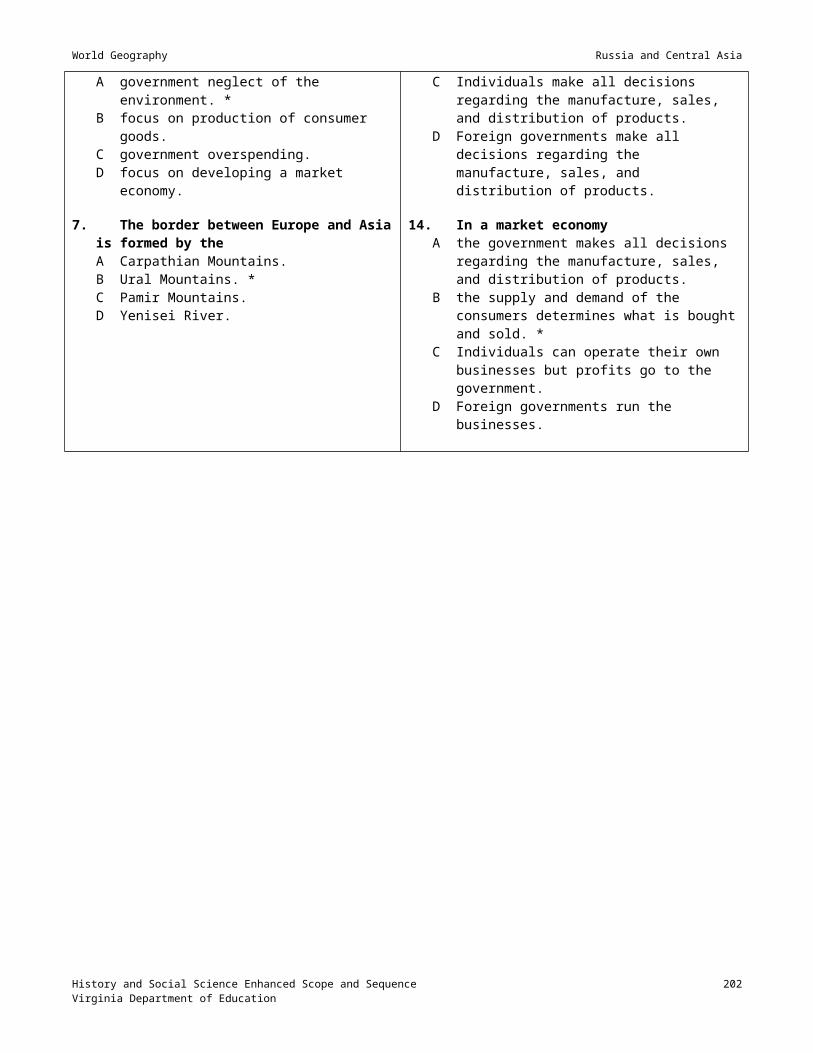
World Geography South Asia
Session 8: Assessment___________________________________________________________
Materials South Asia Quiz (Attachment D or teacher-prepared)
Instructional Activities1. Administer the mid-unit assessment, using the quiz at Attachment D or a teacher-prepared quiz.
History and Social Science Enhanced Scope and Sequence 203Virginia Department of Education

World Geography South Asia
Session 9: Kashmir_______________________________________________________________
Materials Articles on the Kashmir dispute Unlabeled outline map of North India and Pakistan
Instructional Activities1. Have students read an introductory article about Kashmir, and follow the reading with a discussion of the
current issues involving Kashmir.
2. Arrange a visit to the computer lab or media center for students to conduct research on Kashmir. Instruct them to prepare a brief report outlining the political issues in Kashmir.
History and Social Science Enhanced Scope and Sequence 204Virginia Department of Education

World Geography South Asia
Session 10: South Asia Resources; Monsoons; Bangladesh___________________
Materials Atlases with physical and resource information on South Asia South Asia Resources worksheet (Attachment E) Article on monsoons, with related, teacher-prepared questions (What Is a Monsoon?
<http://snrs.unl.edu/amet351/ogren/monsoons.html>) Article on Bangladesh, with related, teacher-prepared questions (Bangladesh – A Country Study
<http://lcweb2.loc.gov/frd/cs/bdtoc.html>)
Instructional Activities1. Review Quiz from session 8.
2. Distribute the South Asia Resources worksheet (Attachment E) and atlases, and review the worksheet with the students. Have them complete the worksheet individually, using the atlases.
3. Have students read a short article on the monsoons in South Asia (What Is a Monsoon? <http://snrs.unl.edu/amet351/ogren/monsoons.html>) and respond to a series of related, teacher-prepared questions about the topic.
4. Have students read a short article on Bangladesh (Bangladesh – A Country Study <http://lcweb2.loc.gov/frd/cs/bdtoc.html>) and respond to a series of related, teacher-prepared questions about the topic.
History and Social Science Enhanced Scope and Sequence 205Virginia Department of Education
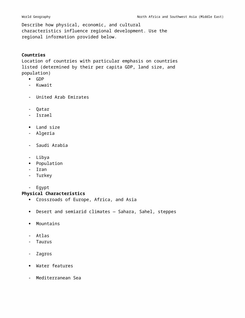
World Geography South Asia
Session 11: South Asian Economic Development______________________________
Materials Video on South Asian development Article on United States trade with South Asia, with related, teacher-prepared questions
Instructional Activities1. Show a video on South Asian economic development, highlighting:
emerging high-tech sector bureaucratic reforms in India sweatshop labor issues and emerging middle class.
2. Hold a discussion on the economic possibilities for South Asia.
3. Distribute an article on South Asian development, with related, teacher-prepared questions.
History and Social Science Enhanced Scope and Sequence 206Virginia Department of Education
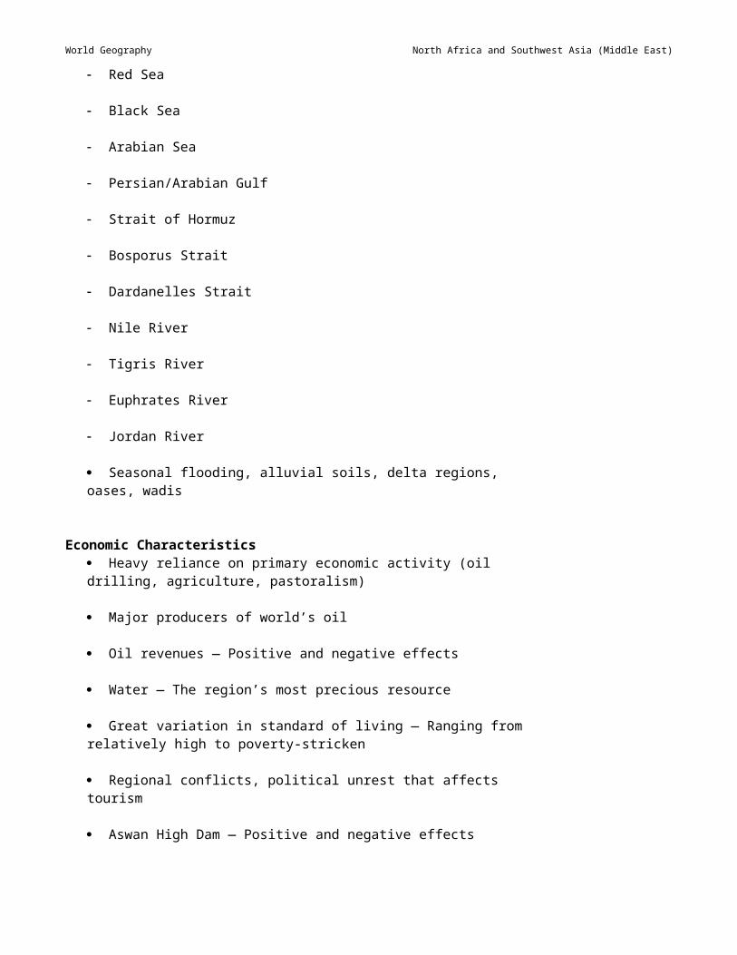
World Geography South Asia
Session 12: Pakistan, Afghanistan, and Al Qaeda; Unit Review_______________
Materials Article on Pakistan, Al Qaeda, and the Afghanistan war (Pakistan – A Country Study
<http://lcweb2.loc.gov/frd/cs/pktoc.html> and Investigating al-Qaeda <http://news.bbc.co.uk/1/hi/in_depth/world/2001/war_on_terror/>)
Teacher-prepared review sheet for the unit on South Asia
Instructional Activities1. Distribute an article on Pakistan and the war against Al Qaeda, with related, teacher-prepared questions. Have
the students read and make notes on the article. (Pakistan – A Country Study <http://lcweb2.loc.gov/frd/cs/pktoc.html> and Investigating al-Qaeda <http://news.bbc.co.uk/1/hi/in_depth/world/2001/war_on_terror/>)
2. Hold a class discussion on South Asia and the war on terrorism, with students responding to prompts by using the notes they have made.
3. Hand out review sheet for the unit, and conduct a review of the material to be covered on the unit test. Give further study cues for test.
History and Social Science Enhanced Scope and Sequence 207Virginia Department of Education

World Geography South Asia
Session 13: Assessment_________________________________________________________
Materials Assessment
Instructional Activities1. Administer the assessment. A unit test for South Asia can be found at Attachment F.
History and Social Science Enhanced Scope and Sequence 208Virginia Department of Education

World Geography South Asia
Attachment A: Geography Notes on South Asia________________________________
Major Regions Himalayas Hindu-Kush Indo-Gangetic Plain Deccan Plateau Thar Desert Indian Ocean islands: Sri Lanka, Maldives
Climate-hazard patterns of South Asia Monsoons Earthquakes Desertification Deforestation
Resources Rice Wheat Jute, sisal Cotton Cash crops: tea Minerals: coal, iron
History and Social Science Enhanced Scope and Sequence 209Virginia Department of Education

World Geography South Asia
Attachment B: Notes on History of South Asia_________________________________
Indus Civilization (2500–1500 B.C.) Civilization grew on banks of the Indus River in what is today Pakistan. Cities became highly advanced, with grid planning, interior plumbing, and granaries. Hieroglyphic script, which has yet to be deciphered, was developed. Invades and drought caused slow decline.
Aryan Period (1500–400 B.C.) Nomadic, illiterate warriors drove south into the Deccan plateau. A strict caste system evolved based on lineage. Hinduism was formed and practiced for the first time.
Imperial Period (400 B.C.–100 A.D.) Hellenistic Greeks invaded and influenced Indian art and philosophy. The Mauryan Empire (ca. 200 B.C.) excelled in administration and philosophy. The Gupta Empire (ca. 320 A.D.) excelled in science, literature, and the arts. Sanskrit was developed as the sacred language of Hinduism and Buddhism.
Medieval Period (1000–1600 A.D.) Muslims invaded from Persia. Rivalry between southern Hindus and northern Muslims erupted into battles over trade routes with
Chinese and Europeans.
Imperialist Era (1600–1947) Vasco da Gama reached India in 1498 and was followed by many Europeans. Battles took place over which European nation would dominate India. The British East India Company was created in South Asia about 1750. Greater India became a crown colony after the Sepoy rebellion in 1857. Resistance movements against British rule surfaced around 1900. The Partition and its impact Mohandas K. Gandhi and independence
History and Social Science Enhanced Scope and Sequence 210Virginia Department of Education

World Geography South Asia
Attachment C: An Introduction to Indian Architecture________________________ Early Architecture: Both Buddhist and Hindu lasting architecture stem from the symmetrical stupa model.
The stupa started as a small tomb or cell, sometimes carved out of the cave used by a Buddhist Holy man. Walls, gates, porches, and eventually vertical height or a dome were added, as the structures became grander and more elaborate. Stupas are often adorned with ornate carving and sculpture that is always balanced. Examples: Chaitya Cave Temple at Sanchi Temple at Orissa
Mughal Architecture: Created by the Muslim Mughals, it often highlighted the wealth and grandeur of Mughal courtly life. Islamic styles, such as pointed arches and minarets, were copied. Examples: Taj Mahal Red Fort
Colonial and Modern Architecture: Heavily influenced by European ideas and ideals. Examples: British Administration Building in Delhi Modern Parliament Buildings in New Delhi Nuclear Power Plant in Bombay
History and Social Science Enhanced Scope and Sequence 211Virginia Department of Education

World Geography South Asia
Attachment D: South Asia Quiz__________________________________________________
Name: Part I: Map (30 points) — Match the features listed below to the lettered features on the map.1. Arabian Sea2. Deccan Plateau3. Ganges River4. Hindu-Kush Range5. Himalaya Range6. Western Ghats7. Brahmaputra River8. Indian Ocean9. Bay of Bengal10. Indo-Gangetic Plain11. Vindhya Range12. Indus River13. Thar Desert14. Himalaya Highlands15. Eastern Ghats
Part II: Multiple Choice (30 points) — Select the best possible answer.1. All of the following have isolated South Asia from the rest of the continent except the
A Himalayas.B Hindu-Kush.C Bay of Bengal.D Ganges River. *
2. The Aryans invaded the Deccan Plateau from theA North. *B South.C East.D West.
3. The most amazing thing about the archaeology of the Indus Civilization is theirA planned and gridded cities. *B development of modern Hindi and Bengali script.C Buddhist stupas.D All of the above.
4. All of the following would be sources of irrigation water for South Asia except theA Arabian Sea. *B Himalayan snow melt.C summer monsoons.D Ganges River.
5. Sanskrit is theA sacred language of Hinduism. *B sacred language of Buddhism.C root language of English.D All of the above
History and Social Science Enhanced Scope and Sequence 212Virginia Department of Education

World Geography South Asia
6. Stupas areA special hand gestures used by the Buddha.B temples for both Buddhists and Hindus. *C holy scriptures of the Hindus.D members of the peasant caste.
7. Which of the following cereal grains is most common in Southern India?A Rice *B BarleyC CornD Millet
8. An example of a valuable export textile from South Asia would beA tapa cloth.B microchips. *C silk.D porcelain.
9. Which statement best describes the impact of monsoons on South Asia?A They affect only the Gangetic plains and the Northern highlands.B They help the environment only if there is a mild winter in the North with little snow.C They are essential to all India, but they also kill many inhabitants. *D They are caused by human behavior and should be prevented through behavioral change.
10. The home of the first great civilization of South Asia was the river valley of theA Indus. *B Ganges.C Brahmaputra.D Krishna.
Part III: Short Answer — You must answer two of the three questions. (40 points — 20 points each) 1. Describe three natural resources that have enriched South Asian civilization. How are these resources utilized
in the modem world?
2. Describe two geographic factors that have isolated South Asia from the world. How have transportation advances in the 20th century overcome these barriers?
3. How have the monsoons been both a blessing and curse to South Asia? Support your answer with solid facts.
History and Social Science Enhanced Scope and Sequence 213Virginia Department of Education

World Geography South Asia
Attachment E: South Asia Resources___________________________________________
Name:
Answer the following questions, using information found in an atlas of South Asia:
1. What energy resources are available on the South Asian subcontinent?
2. Where are these energy resources found?
3. What are the cash crops of India?
4. Where are these cash crops grown?
5. What products are manufactured in South Asia?
6. Where is the industrial area of South Asia?
7. What are the major ports of South Asia?
8. What route would South Asian products take to reach each of the following countries?
Japan
North America
Europe
Australia
History and Social Science Enhanced Scope and Sequence 214Virginia Department of Education

World Geography South Asia
Attachment F: South Asia Unit Test_____________________________________________
Name:
Part I: Map (20 points) — Match the countries listed below to the lettered countries on the map.
1. India2. Nepal3. Sri Lanka4. Pakistan5. Bangladesh6. Afghanistan7. Bhutan
Part II: Multiple Choice (30 points) — Select the best possible answer.1. The conflict in Kashmir has led to
A the Soviet withdrawal from Afghanistan.B increased tension between India and Pakistan. *C fighting between India and Bangladesh.D civil war in Pakistan.
2. What form of government did India form after the withdrawal of the British?A CommunistB Democracy with strong presidential executiveC Parliamentary democracy *D Autocracy run by military leaders
3. Which pair of events or developments reflects a cause-and-effect relationship?A Green revolution — Decrease in food supplyB Invasion of Tibet — Invasion of AfghanistanC Bangladesh created — Conflict over Sri LankaD Population explosion — Shortages of environmental resources *
4. Most of recent Indian economic growth has been in the sector ofA improved agriculture.B high technology. *C heavy industry, such as cars and steel.D services, such as entertainment and banking.
5. Which is an accurate generalization about India’s foreign policy?A India has always sided with the Western powers of Great Britain and the U. S.B India has become a leader among the nonaligned nations. *C India refused to join the United Nations.D India sided with the Soviet Union during the Cold War.
6. The first European traders to take advantage of the route around Africa to India were theA Dutch led by de Soto.B Portuguese led by da Gama. *C British led by Drake.D French led by Diaz.
History and Social Science Enhanced Scope and Sequence 215Virginia Department of Education

World Geography South Asia
7. Mahatma Gandhi’s greatest failure wasA his failure to unite the entire South Asian sub-continent. *B the rejection of India’s admission into the UN.C the British retreat from India in 1947.D his failure to gain popular support among Indian Hindus.
8. The British unified India and the rest of South Asia by using all of the following exceptA railway and communication lines.B Christian missionaries to convert all Hindus.C improved education. *D central administration and justice by the British Raj.
Part III: Map Interpretation (25 points) — Answer the following questions based upon the resource map attached.1. What specific region of India is most important to the modern economy? Describe why.
2. What specific industrial resources that are critical in developing a high-technology or service economy might be “missing” from India? Describe two of these.
Part IV: Essay (25 points) — Answer the following question, using well-developed paragraphs.Like other developing regions, South Asia has had mixed success in modernizing since 1947. In a standard-format essay, describe the success or failure of the region in the following areas: Solving long-term territorial disputes, like those in Kashmir and Sri Lanka Providing food and good nutrition to the greatly expanding population of South Asia Controlling environmental problems that threaten resources, human health, and lives.
History and Social Science Enhanced Scope and Sequence 216Virginia Department of Education

Organizing Topic
Southeast and East AsiaStandard(s) of Learning__________________________________________________________WG.4 The student will locate and analyze physical, economic, and cultural characteristics of world
regions: ...Southeast Asia, East Asia,....
WG.12 The student will apply geography to interpret the past, understand the present, and plan for the future bya) using geographic knowledge, skills, and perspectives to analyze problems and make decisions;b) relating current events to the physical and human characteristics of places and regions.
Essential Understandings, Knowledge, and Skills_____________________________Correlation to Instructional Materials
Skills (to be incorporated into instruction throughout the academic year)Compare maps and make inferences.
_________
Identify and interpret regional patterns on maps
Identify primary ideas expressed in graphic data.
Gather, classify, and interpret information.
Draw conclusions and make generalizations about data.
Explain cause-and-effect relationships.
Explain charts comparing two or more concepts.
Identify and locate regions, continents, oceans, and major features on maps and globes.
ContentDescribe how physical, economic, and cultural characteristics influence regional development. Use the regional information provided below.
Countries South Asia Philippines

World Geography Southeast and East Asia
Indonesia
Malaysia
Thailand
Cambodia
Burma (Myanmar)
Laos Vietnam
Singapore
Brunei East Asia Mongolia
China (People’s Republic of China)
Japan Taiwan (Republic of China)
North Korea
South Korea
Physical Characteristics Influence of mountains — Population, settlements, movement, climate
Mountains
Himalayas
Mount Fuji
Varied climate regions ranging tropical wet to humid continental
Natural hazards — Monsoons, typhoons, volcanoes, and earthquakes
Influence of water (rivers, seas, and ocean currents) on agriculture, trade, and transportation
Bodies of water
Bay of Bengal
Pacific Ocean
Yangtze River (Chaing Jiang)
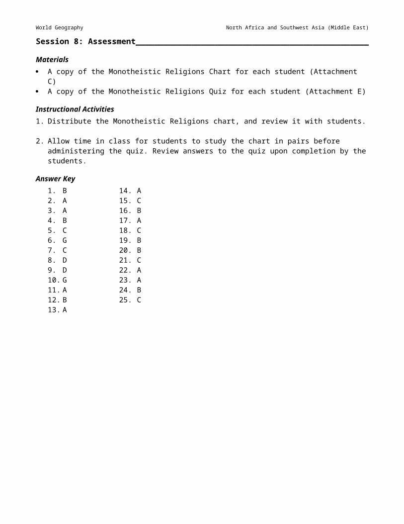
World Geography Southeast and East Asia
Mekong River
Yellow River (Huang He)
Abundant arable land
Loess
Plateau of Tibet
Gobi Desert
Economic Characteristics Varied economies in the region ranging from subsistence/commercial agriculture to high-tech industrial manufacturing
Participation in global markets
Newly industrialized countries — South Korea, Taiwan, Singapore
Japan — Economic leader
China in transition from a centrally planned economy
Agricultural advancements and technology, enabling greater food production — ”Green Revolution”
Environmental degradation
Deforestation
Fishing
ASEAN (Association of Southeast Asian Nations)
Rice, tropical crops
Cultural Characteristics Areas of extremely dense and sparse population
Contrast between rural and urban areas
Religious diversity — Hinduism, Islam, Buddhism, Christianity, Taoism, Shinto, Confucianism
Respect for ancestors
Religious conflicts (Hindu/Muslim)
Cultural heritage Silks Batik

World Geography Southeast and East Asia
Wood and ivory carving
Ideograms, unique alphabets
Jewels Cultural landscape Angkor Wat
Great Wall of China
Pagodas Temples and shrines
Terraced rice fields
Cities as centers of culture and trade Tokyo Beijing
Explain the following practical applications of how geography enables students to be informed, active citizens in their communities:
Recycling programs
Conversion of land from agricultural use
Water sources (e.g., dams, reservoirs, wells, pipelines, ocean)
Airport expansion
Air quality
Boundaries (e.g., school zones)
Bicycle paths
Mass transit
City planning and zoning laws
Energy use
Location and size of public buildings (e.g., schools, recreation centers, hospitals, and libraries)
Selection of locations for new stores and businesses
Explain that current events are shaped by the physical and human characteristics of the places and regions where they occur.
Use the following examples to explain how physical and human characteristics influence current events of places and regions:
How physical characteristics influence current events:

World Geography Southeast and East Asia
Natural hazards (e.g., flooding, earthquakes, volcanoes, drought)
Climate, vegetation
How human characteristics influence current events: Population distribution
Geographic patterns of ethnic diversity
A sense of place (emotional attachment to specific locations)
Geographic patterns of trade and interdependence (e.g., oil)
Geographic patterns of wealth and poverty (developed and developing nations)

World Geography Southeast and East Asia
Sample Resources________________________________________________________________
Below is an annotated list of Internet resources recommended for this organizing topic. Copyright restrictions may exist for the material on some Web sites. Please note and abide by any such restrictions.
“Construction of the Great Wall Begins, 221 B.C.” North Park University. <http://campus.northpark.edu/history/WebChron/China/GreatWall.html>. This site contains information on the construction of the Great Wall of China.
“Fuji, Honshu, Japan.” University of North Dakota. <http://volcano.und.nodak.edu/vwdocs/volc_images/img_fuji.html>. This site provides information about and pictures of Mount Fuji.
Lienhard, John H. “Engines of Our Ingenuity #1299: Stability of Pagodas.” University of Houston. <http://www.uh.edu/engines/epi1299.htm>. This Web page explains why pagodas are able to withstand the destructive power of earthquakes.
Perry-Castañeda Library Map Collection. University of Texas at Austin. <http://www.lib.utexas.edu/maps/asia.html>. This site provides a great variety of downloadable maps.
Virginia Standards of Learning Assessments for the 2001 History and Social Science Standards of Learning: History and Social Science Released Items for Virginia and United States History. Virginia Department of Education 2003/04. <http://www.pen.k12.va.us/VDOE/Assessment/Release2003/History/VA-RIBs_g11wgeo-1.pdf>.
Virginia Standards of Learning Assessments for the 2001 History and Social Science Standards of Learning: World Geography Test Blueprint. Virginia Department of Education, 2003/04. <http://www.pen.k12.va.us/VDOE/Assessment/HistoryBlueprints03/2002Blueprint9WG.pdf>. This site provides assessment information for the course in World Geography.
“Yangtze River.” Newton Public Schools. <http://www.newton.mec.edu/Angier/DimSum/Yangtze%20River%20Pix.html>. This site provides information about and pictures of the Yangtze River, the largest river in China.

World Geography Southeast and East Asia
Session 1: Countries; Physical Features________________________________________
Materials Maps, atlases, and textbooks that contain information on Southeast and East Asia Handout listing Southeast and East Asia countries to be identified Unlabeled outline political and physical maps of the Eastern Hemisphere or the world
Instructional Activities1. Display the following questions on the board or overhead, and instruct students to respond to them in writing:
What is the longitude and latitude running through the center of Southeast and East Asia? What nations make up Southeast and East Asia? What countries in Southeast and/or East Asia have you visited, if any? What products does the United States import from Southeast and East Asia? What type of food would you find at a restaurant featuring cuisine from Southeast and East Asia?Divide the class into groups of three or four students each, and instruct the students in each group to share their responses and develop a group response to each question. Allow students to use their textbooks and other available resources. Allow time for groups to share their responses.
2. Distribute unlabeled outline political maps, handouts, and atlases to students, and instruct them to label on the map the following countries: Southeast Asia
Philippines Indonesia Malaysia Thailand Cambodia Burma (Myanmar) Laos Vietnam Singapore Brunei
East Asia Mongolia China (People’s Republic of China) Japan Taiwan (Republic of China) North Korea South Korea
3. Distribute outline physical maps, and instruct students to lightly shade and label the following physical features: Mountains
Himalayas Mount Fuji
Bodies of water Bay of Bengal Pacific Ocean Yangtze River (Chang Jiang)

World Geography Southeast and East Asia
Other physical characteristics Plateau of Tibet Gobi Desert Loess Plateau
4. Assign a teacher-selected reading, worksheet, or other reinforcement activity, using available teacher resources.

World Geography Southeast and East Asia
Session 2: Physical Characteristics_____________________________________________
Materials Notes on physical characteristics of Southeast and East Asia Pictures or slides of important physical features found in the region (listed in step 2 below)
Instructional Activities1. Review content from the previous session.
2. Display physical maps of Southeast and East Asia, and point out the key features students located and labeled in the previous session. Instruct students to define the following terms or features, using their textbooks or other available resources: Monsoons Typhoons Volcanoes Earthquakes LoessDisplay pictures or slides illustrating each of the above terms or features, and discuss them as a class.
3. Discuss the following physical characteristics of Southeast and East Asia. Provide students with notes to explain each: Influence of mountains on population, settlements, movement, and climate Varied climate regions include tropical wet, tropical wet and dry, humid subtropical, highland, arid, and
humid continental Influence of water (rivers, seas, and ocean currents) on agriculture, trade, and transportation Abundant arable land
4. Assign a teacher-selected reading, worksheet, or other reinforcement activity, using available teacher resources.

World Geography Southeast and East Asia
Session 3: Economic Characteristics____________________________________________
Materials Pictures, slides, and/or videos that illustrate various aspects the economy of Southeast and East Asia
Instructional Activities1. Review the content from the previous session.
2. Ask students to define the factors that contribute to a region’s or nation’s economy. Guide discussion by suggesting natural resources and land use.
3. NOTE: This may take more than one class session. Ask students to describe factors that contribute to the economy of Southeast and East Asia. After some discussion, display the following characteristics, and encourage students to respond to the questions or statements listed. Provide resource materials in the class, or have students use the media center or computer lab to answer these questions. Another option is to assign certain questions to different groups and to allow the groups to report the answers to the class. Review the answers with the class by displaying pictures, slides, and/or videos that illustrate the answers or by providing additional information to enhance content understanding. Varied economies in the region, ranging from subsistence and/or commercial agriculture to high-
tech industrial manufacturing. What types of plants are grown on the subsistence farms in the region? What types of crops are grown on the commercial farms? What types of high-tech industries exists?
Participation in global markets. How does each of the countries in the region participate in the global market?
Newly industrialized countries: South Korea, Taiwan, and Singapore. What is the GDP of each of these countries?
Japan: economic leader. What products do we purchase from Japan? What is the GDP of Japan? How does the GDP of Japan compare to that of the U.S.?
China in transition from a centrally planned economy. What is a centrally planned economy? How is China changing? What is the GDP of China? What type of government does China have?
Agricultural advancements and technology, enabling greater food production: the “Green Revolution.” (What is the “Green Revolution”? What does it have to do with the countries in the region?
Environmental degradation. How is the environment of the region being degraded? What steps are being taken to prevent this degradation?
Deforestation. What is causing deforestation in the region? Fishing. What types of fish are indigenous to these areas? Association of Southeast Asian Nations (ASEAN). What function does ASEAN serve for the countries? Rice, tropical crops. What are the tropical crops of the region?

World Geography Southeast and East Asia
Session 4: Cultural Diversity____________________________________________________
Materials A video that reflects the culture of Southeast and East Asia, and a related, teacher-developed viewing guide
Instructional Activities1. Review the content from the previous sessions.
2. Show a video that illustrates various cultures of Southeast and East Asia. Develop a worksheet to guide students as they view the video. Ask them to describe the scenery, dress, and other cultural characteristics observed in the video.
3. Assign a teacher-selected reading, worksheet, or other reinforcement activity, using available teacher resources.

World Geography Southeast and East Asia
Session 5: Cultural Characteristics______________________________________________
Materials None identified
Instructional Activities1. Review the content of the previous session.
2. Provide a brief background of the settlement of Southeast and East Asia. Divide the class into groups of three or four, and assign one of the following cultural characteristics to each group to research. Instruct each group to prepare a report on their specific topic. The report should include pictures, charts, maps, and/or posters when appropriate: Areas of extremely dense and/or sparse population Contrast between rural and urban areas Religious diversity — Hinduism, Islam, Buddhism, Christianity, Taoism, Shinto, Confucianism Respect for ancestorsHave groups present their reports to the rest of the class.
4. Assign a teacher-selected reading, worksheet, or other reinforcement activity, using available teacher resources.

World Geography Southeast and East Asia
Session 6: Cultural Heritage_____________________________________________________
Materials Pictures, slides, and/or actual examples of the cultural heritage of Southeast and East Asia
Instructional Activities1. Review the content from the previous session.
2. Display pictures, slides, and/or actual examples of the cultural heritage of Southeast and East Asia, including silks batik wood and ivory carving ideograms, unique alphabets jewels.Explain the process of making some of these products.
3. Assign a teacher-selected reading, worksheet, or other reinforcement activity, using available teacher resources.

World Geography Southeast and East Asia
Session 7: Important Cities______________________________________________________
Materials Maps of Southeast and East Asia Atlases and almanacs
Instructional Activities1. Review the content of the previous session.
2. Distribute maps of Southeast and East Asia, and instruct students to annotate the following location on their maps: Tokyo Beijing Seoul Singapore Ho Chi Minh City Jakarta
3. Distribute atlases and/or almanacs, and instruct students to locate the following information on each city and develop a chart comparing the following information for each: Literacy rate GDP Current population Major industry or industries Type of national government of the city’s country Famous people who came from the city
4. Assign a teacher-selected reading, worksheet, or other reinforcement activity, using available teacher resources.
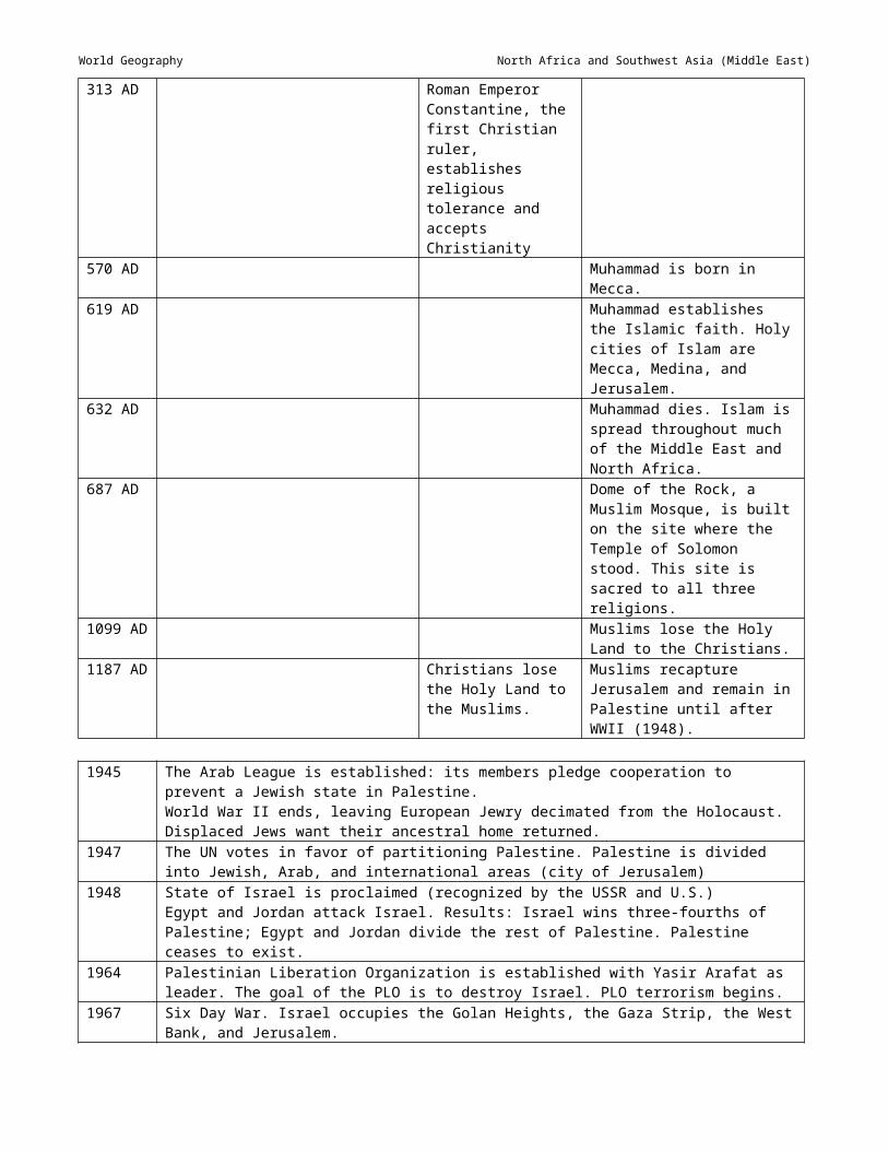
World Geography Southeast and East Asia
Session 8: Cultural Landscape___________________________________________________
Materials None identified
Instructional Activities1. Review the content of the previous session.
2. Ask students to identify well-known landmarks in the United States. Ask what they think makes these landmarks special.
3. Display pictures or slides of the following features representing the cultural landscape of Southeast and East Asia: Angkor Wat Great Wall of China Pagodas Temples and shrines Terraced rice fieldsAs each picture or slide is displayed, ask students if they can identify the item and it’s location. Also ask students to explain why this feature is important to the culture of its region. Provide information on each item as it is presented, and discuss with the class.
4. Assign a teacher-selected reading, worksheet, or other reinforcement activity, using available teacher resources.

World Geography Southeast and East Asia
Session 9: Assessment___________________________________________________________
Materials Assessment
Instructional Activities1. Administer the assessment. Sample assessment items can be found at Attachment A.

World Geography Southeast and East Asia
Attachment A: Sample Assessment Items______________________________________
1. What is the climate type of Malaysia, encouraging growth of dense rain forests and complex land ecosystems?A Humid tropical *B TundraC MediterraneanD Subarctic
2. What mountain range is the world’s highest and is located along China’s border with Nepal and Bhutan?A Taurus MountainsB Eastern GhatsC Himalayas *D Caucasus
3. The fine-grained, windblown, fertile soil common to Southeast and East Asia isA tundra.B loam.C alluvial.D loess. *
4. Asia’s longest river is theA Yellow (Huang He).B Mekong.C Yangtze (Chaing Jiang). *D Brahmaputra.
5. What Khmer temple in present day Cambodia was also a tomb for the ruler under whose reign it was built?A Angkor Wat *B Taj MahalC Hagia SophiaD St. Basil
6. Which of the following countries is located in Southeast Asia?A Malaysia *B BelizeC AustraliaD Pakistan
7. Economics characteristics of Southeast and East Asia includeA newly industrialized countries.B oil resources.C rigid social structures.D highly developed infrastructures. *
8. Which of the following is a body of water in Southeast or East Asia?A Amazon RiverB Yangtze River *C Nile RiverD Indus River
9. Which of the following is a major city in Southeast or East Asia?A Jakarta *B New DelhiC Buenos AiresD Melbourne
10. Which of the following is an example of a natural hazard in Southeast and East Asia?A tornadoesB typhoons *C hurricanesD blizzards

Organizing Topic
Sub-Saharan AfricaStandard(s) of Learning__________________________________________________________WG.4 The student will locate and analyze physical, economic, and cultural characteristics of world
regions: ...Sub-Saharan Africa,....
WG.12 The student will apply geography to interpret the past, understand the present, and plan for the future bya) using geographic knowledge, skills, and perspectives to analyze problems and make decisions;b) relating current events to the physical and human characteristics of places and regions.
Essential Understandings, Knowledge, and Skills_____________________________Correlation to Instructional Materials
Skills (to be incorporated into instruction throughout the academic year)Compare maps and make inferences.
Identify and interpret regional patterns on maps
Identify primary ideas expressed in graphic data.
Gather, classify, and interpret information.
Draw conclusions and make generalizations about data.
Explain cause-and-effect relationships.
Explain charts comparing two or more concepts.
Identify and locate regions, continents, oceans, and major features on maps and globes.
ContentDescribe how physical, economic, and cultural characteristics influence regional development. Use the regional information provided below.
CountriesLocation of countries with particular emphasis on countries listed (determined by their per capita GDP, land size, and population)
GDP South Africa
Gabon Botswana
Land size

World Geography Sub-Saharan Africa
Democratic Republic of Congo
Sudan Chad Mozambique
Madagascar
Population Nigeria Ethiopia Democratic Republic of Congo
Tanzania
KenyaPhysical Characteristics
Continent composed of a huge plateau, escarpments
River transportation impeded by waterfalls and rapids
Location of equator through middle of region; similar climate patterns north and south of the equator
Smooth coastline; few harbors
Large number of landlocked states
Storehouse of mineral wealth
Limited fertility of rain forest soils
Kalahari and Namib deserts
Bodies of water Nile River
Zambezi River
Niger River
Congo River
Atlantic Ocean
Indian Ocean
Red Sea Lake Victoria
Lake Tanganyika
Nature preserves and national parks
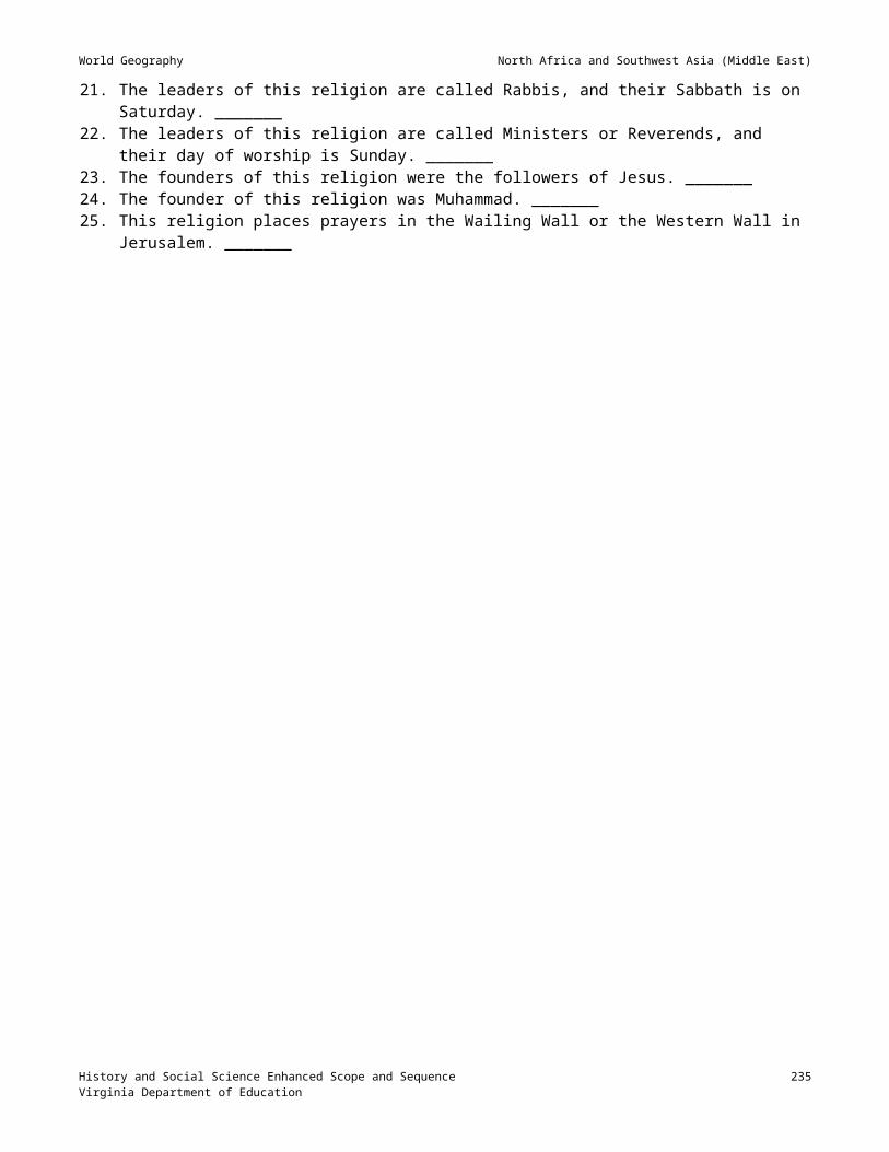
World Geography Sub-Saharan Africa
Economic Characteristics Large percentage of population engaged in agriculture (primary activity)
Subsistence agriculture
Nomadic herding
Slash and burn agriculture
Plantation agriculture
Cash crops and food crops
Poorly developed infrastructure
Large number of landlocked states
Substantial mineral wealth (diamonds, gold, alloys)
Major exporters of raw materials
Wide range of per capita income
Productivity that lags behind population growth
Desertification
Demographics typical of developing economies
Low per capita GDP
Low life expectancy
High population growth rate
High infant mortality
Large percentage of population under age 15
Low literacy rates
Cultural Characteristics Uneven population distribution
Many ethnic groups — Languages, customs
Large numbers of refugees
Few cities with population over one million
Knowledge of history through oral tradition

World Geography Sub-Saharan Africa
Country names related to historical empires — Mali, Ghana, Zimbabwe
Cities as centers of culture and trade Lagos Dakar Johannesburg
Cultural landscape Markets Churches
Mosques, minarets
Villages Modern city cores
Diversity of Africans reflected in cultural heritage Masks Sculpture
Dance Music Colorful dress
Jewelry
Explain the following practical applications of how geography enables students to be informed, active citizens in their communities:
Recycling programs
Conversion of land from agricultural use
Water sources (e.g., dams, reservoirs, wells, pipelines, ocean)
Airport expansion
Air quality
Boundaries (e.g., school zones)
Bicycle paths
Mass transit
City planning and zoning laws
Energy use
Location and size of public buildings (e.g., schools, recreation centers, hospitals, and libraries)
Selection of locations for new stores and businesses

World Geography Sub-Saharan Africa
Explain that current events are shaped by the physical and human characteristics of the places and regions where they occur.
Use the following examples to explain how physical and human characteristics influence current events of places and regions:
How physical characteristics influence current events: Natural hazards (e.g., flooding, earthquakes, volcanoes, drought)
Climate, vegetation
How human characteristics influence current events: Population distribution
Geographic patterns of ethnic diversity
A sense of place (emotional attachment to specific locations)
Geographic patterns of trade and interdependence (e.g., oil)
Geographic patterns of wealth and poverty (developed and developing nations)

World Geography Sub-Saharan Africa
Sample Resources________________________________________________________________
Below is an annotated list of Internet resources recommended for this organizing topic. Copyright restrictions may exist for the material on some Web sites. Please note and abide by any such restrictions.
Chege, Nancy. “Lake Victoria: a sick giant.” People & the Planet. <http://www.peopleandplanet.net/doc.php?id=2110>. This site provides information on the negative impact of human activity on Lake Victoria.
“Introduction to the Nile River Basin.” Nile Basin Initiative. <http://www.nilebasin.org/IntroNR.htm>. This site provides information on the Nile River.
Virginia Standards of Learning Assessments for the 2001 History and Social Science Standards of Learning: World Geography Test Blueprint. Virginia Department of Education, 2003/04. <http://www.pen.k12.va.us/VDOE/Assessment/HistoryBlueprints03/2002Blueprint9WG.pdf>. This site provides assessment information for the course in World Geography.
Virginia Standards of Learning Assessments for the 2001 History and Social Science Standards of Learning: History and Social Science Released Items for Virginia and United States History. Virginia Department of Education 2003/04. <http://www.pen.k12.va.us/VDOE/Assessment/Release2003/History/VA-RIBs_g11wgeo-1.pdf>.
“Where is the world’s longest freshwater lake?” What You Need to Know about Geography. <http://geography.about.com/library/faq/blqzlongfreshwaterlake.htm>. This site provides information about Lake Tanganyika.
The World Factbook 2002. U.S. Central Intelligence Agency. <http://www.cia.gov/cia/publications/factbook/>. This site contains searchable information on all countries, including Gross Domestic Product, land size, and population.
Other resources, such as the books listed below, may prove helpful in teaching this unit:
Aardema, Vema. Bringing the Rain to Kapati Plain. New York: Dial Books, 1981.
Courland, Harold. The King’s Drum and Other African Stories. New York: Harcourt, Brace, Jovanovich, 1970.
Musgrove, Margaret. Ashanati to Zulu: African Traditions. New York: Dial Books, 1976.

World Geography Sub-Saharan Africa
Session 1: Countries; Physical Features________________________________________
Materials Maps, atlases, almanacs, and textbooks that contain information on Sub-Saharan Africa Handout listing Sub-Saharan African countries to be identified Unlabeled outline political and physical maps of Sub-Saharan Africa
Instructional Activities1. Introduce the unit on Sub-Saharan Africa by displaying the following questions on the board or overhead, and
instructing students to respond to them in writing: What is the longitude and latitude running through the center of Sub-Saharan Africa? What countries make up Sub-Saharan Africa? What countries are immediately north of Sub-Saharan Africa? What famous landmarks are located in Sub-Saharan Africa? What major geographic features are located in Sub-Saharan Africa? What major bodies of water border Sub-Saharan Africa?Divide the class into groups of three or four students each, and instruct the students in each group to share their responses and develop a group response to each question. Allow students to use their textbooks and other available resources. Allow time for groups to share their responses.
2. Distribute unlabeled outline political maps, handouts, and atlases to students, and instruct them to label on the map the following countries: South Africa Gabon Botswana Democratic Republic of Congo Sudan Chad Mozambique Madagascar Nigeria Ethiopia Tanzania Kenya
3. Distribute outline physical maps, and instruct students to lightly shade and label the following physical features: Kalahari Desert Namib Desert Nile River Zambezi River Niger River Congo River Atlantic Ocean Indian Ocean Red Sea Lake Victoria Lake Tanganyika Victoria Falls Mt. Kilimanjaro Mt. Kenya Great Rift Valley

World Geography Sub-Saharan Africa
4. Assign a teacher-selected reading, worksheet, or other reinforcement activity, using available teacher resources.

World Geography Sub-Saharan Africa
Session 2: Countries; Profile of a Nation_______________________________________ Maps, almanacs, and atlases that provide information on Sub-Saharan Africa Handout: Sub-Saharan Africa project instructions (below)
Instructional Activities1. Review the content from the previous session.
2. Instruct the students to develop a chart with the countries of Sub-Saharan Africa listed in the left column and having three additional columns with the headings “Gross Domestic Product (GDP),” “Land Area” and “Population.” Instruct the students to use their textbooks, almanacs, and atlases to fill in each column with the appropriate information on each country.
3. Assign a student project on Sub-Saharan Africa by distributing and reviewing project directions, such as those shown below. NOTE: Alter these directions to fit your schedule and your students’ needs.
Profile of a Sub-Saharan African NationDirections: Prepare a report that includes the following information on a Sub-Saharan Africa country that you select or that your teacher assigns: Earlier name(s) of the country Type of climate Language(s) is spoken Important cities and their functions Physical features reflected on a map Political information, such as the type of government, current government leaders, and current political
issues Economic information, such as GDP, resources, and industries Cultural information, such as the type of food, clothing, and popular pastimes Information on education, availability of healthcare, farming, population A summary of two-to-four current news stories about the selected countryCompile the above information into a booklet, and design a cover for the booklet that reflects an aspect of the selected country.
4. Provide a due-date for the project and the date set for research in the media center or computer lab.
5. Grade the report on the basis of points assigned to each of the following: Topic Presentation Cover Physical features Travel information Political information Economic information Cultural information News stories

World Geography Sub-Saharan Africa
Session 3: Physical Characteristics_____________________________________________
Materials Pictures and/or slides of physical features in Sub-Saharan Africa Climate map of Sub-Saharan Africa Unlabeled outline maps of Sub-Saharan Africa
Instructional Activities1. Review content from the previous session.
2. Review the maps students completed in session 1 on the major physical features of Sub-Saharan Africa. Discuss the following terms or physical features with the students, and point out examples of them on maps and through pictures or slides: plateau escarpment equator
3. Illustrate, using maps, how river transportation is impeded by waterfalls and rapids in the region.
4. Distribute an unlabeled outline map of the African continent, and instruct students to annotate the map with the location of the equator and to identify the different climate regions that exist north and south of the equator. Ask, “Are the climates found north and south of the equator similar or different?”
5. Using a physical map of Africa, point out the smooth coastlines and lack of harbors. Ask, “Is such a coastline a positive or a negative for the economy of a country?”
6. Instruct students to shade on their outline map the landlocked countries of Sub-Saharan Africa. Have them write a brief paragraph explaining the challenges that result from being a landlocked country.
7. Identify the major mineral resources that are located in Sub-Saharan Africa.
8. Display a map of Africa showing the location of the tropical rain forest, then discuss why it is not well-suited to agriculture.
9. Assign a teacher-selected reading, worksheet, or other reinforcement activity, using available teacher resources.

World Geography Sub-Saharan Africa
Session 4: Characteristics of Developing Economies__________________________
Materials Maps, almanacs, atlases, and textbooks that provide information on Sub-Saharan Africa Computers with Internet access Handout: Sub-Saharan Africa Glossary (Attachment A)
Instructional Activities1. Review the content from the previous session.
2. Divide students into groups of three or four, and assign each group one of the following topics to research. Have each group gather information on their topic from maps, almanacs, atlases, and textbooks, as well as from the Internet, and prepare a report on it. The GDP of the countries in the region The life expectancy in the region The high population-growth rate in the region The high infant-mortality rate in the region The large percentage of population under age 15 in the region The low literacy rate in the region
3. Allow time for the groups to report to the class.
4. Distribute the Sub-Saharan Africa Glossary (Attachment A), and discuss each term and definition. Instruct students to study it and place it in their notebooks.
5. Assign a teacher-selected reading, worksheet, or other reinforcement activity, using available teacher resources.

World Geography Sub-Saharan Africa
Session 5: Economic Characteristics____________________________________________
Materials Pictures, slides, and/or videos that illustrate various aspects of the economy of Sub-Saharan Africa
Instructional Activities1. Review the content from the previous session.
2. Review with students the factors that contribute to a region’s or nation’s economy. Guide discussion by reminding them of natural resources and land use.
3. Provide pictures, slides, and/or videos of the economic characteristics of Sub-Saharan Africa listed below, and explain and discuss the significance/impact of each on the economy of the region. Allow time for students to research the questions listed and to report on their findings to the class. Large percentage of population engaged in agriculture (primary activity). What crops are grown? Subsistence agriculture. What products do subsistence farmers grow? Nomadic herding. What animals are indigenous? Slash and burn agriculture Plantation agriculture. What products are grown on these plantations? Cash crops and food crops. What crops are grown for sale? Poorly developed infrastructure Large number of landlocked states Substantial mineral wealth (diamonds, gold, alloys) Major exporters of raw materials. What materials are exported from what countries? Wide range of per capita income Productivity lags behind population growth Desertification Democracy slow to evolve Impact of AIDS
3. Assign a teacher-selected reading, worksheet, or other reinforcement activity, using available teacher resources.

World Geography Sub-Saharan Africa
Session 6: Ethnic Groups; Languages; Historical Names______________________
Materials Maps, almanacs, atlases, and textbooks that provide information on Sub-Saharan Africa
Instructional Activities1. Review the content from the previous session.
2. Divide students into groups of three or four, and assign one of the following topics to each group to research. Provide research materials in the classroom for groups to use, and have each group prepare a two-to-three-minute report on their assigned topic. Identify the major ethnic groups of Sub-Saharan Africa. (NOTE: As there are many ethnic groups,
provide a list of these in order to limit the scope of the project to a reasonable number.) Identify the major languages of Sub-Saharan Africa, both native languages and colonial languages. Prepare a brief report on the relation of the country names, such as Mali, Ghana, and Zimbabwe, and
historical empires.
3. Assign a teacher-selected reading, worksheet, or other reinforcement activity, using available teacher resources.

World Geography Sub-Saharan Africa
Session 7: Cultural Characteristics______________________________________________
Materials Maps, almanacs, atlases, and textbooks that provide information on Sub-Saharan Africa Index card for each student
Instructional Activities1. Review content covered in the previous session.
2. Ask students to describe their image of African culture.
3. Provide a brief background on the following elements of African history: The uneven population distribution Large number of refugees Few cities with population over one million Knowledge of history through oral tradition
4. Have each student select a city or element of the cultural landscape from the following list (make sure that each is selected) and research its significance, including its history, size, location and other aspects. Distribute index cards to the students, and have them compose and write on the card a postcard message that reflects their visit to the location. The message should include the where (including country), when, and why of their visit. On the other side of the card, have them illustrate the city or cultural feature with a drawing or by gluing a picture of it. Focus of the activity should be on the aspects of culture represented in the landscape. Lagos Dakar Johannesburg Markets Churches Mosques Minarets Villages Modern city cores
5. Allow time for the students to share their postcards.
6. Assign a teacher-selected reading, worksheet, or other reinforcement activity, using available teacher resources.

World Geography Sub-Saharan Africa
Session 8: Cultural Heritage Diversity; Analogies; Quiz ______________________
Materials Pictures, slides, tapes, and/or posters of aspects of cultural heritage Handout: African Analogies (Attachment B) Handout: Africa Facts Quiz (Attachment C)
Instructional Activities1. Review the content of the previous session.
2. Provide pictures, slides, tapes, and/or posters of the following examples of the diversity of African heritage: Masks Sculpture Dance Music Colorful dress Jewelry
3. Distribute the African Analogies handout (Attachment B), and allow time for students to complete it. Review the answers with the students.
4. Distribute the Africa Fact Quiz (Attachment C), and allow time for students to complete it. Review the answers with the students.
5. Review with the students the material covered in this unit for the assessment.
Answers1. Mount Kilimanjaro2. Addis Ababa3. Lake Victoria4. Congo River5. Zimbabwe6. gorilla7. Dar es Salaam8. Victoria Falls9. cheetah10. Mali11. Kalahari12. Namibia

World Geography Sub-Saharan Africa
Session 9: Assessment___________________________________________________________
Materials Assessment
Instructional Activities1. Administer the assessment. Sample assessment items can be found at Attachment D.
World Geography Sub-Saharan Africa
Attachment A: Sub-Saharan Africa Glossary___________________________________
escarpment. A steep cliff; steep side of a plateau.
erg. Large area of sand dunes.
Sahel. Band of semi-arid land south of the Sahara.
deforestation. Process of stripping land of its trees.
desertification. Transition of arable land into desert.
coup. Use of force in an attempt to take over a government.
animism. Traditional religion of Africa based on belief that things in nature have spirits.
malnutrition. Lack of a healthy diet.
famine. Widespread shortage of food.
apartheid. Policy of strict racial segregation that was practiced in South Africa. The word means “apartness.”
sanctions. Actions taken to punish a country for a policy (such as apartheid) and to bring pressure to change.
rift valley. Deep land depression caused where the Earth’s crust stretches. The Great Rift Valley is in eastern Africa.
Swahili. Language spoken by many people in east Africa.
subsistence agriculture. Raising only enough food to support the family.
staple crop. Main food of a region.

World Geography Sub-Saharan Africa
Attachment B: African Analogies________________________________________________
Analogies require thinking. You must determine the relationship between the first pair of terms and use that relationship to solve for the missing term.
Example“Canada: North America: _________: Africa.” is read “Canada is to North America as _________ is to Africa.”
SolutionCanada is the largest country in North America. Sudan is the largest country in Africa. Therefore, “Sudan” is the missing term.
1. Mount McKinley: North America: _________: Africa.
2. Nairobi: Kenya: _________: Ethiopia.
3. Lake Superior: North America: _________: Africa.
4. Zambezi River: Indian Ocean: _________: Atlantic Ocean.
5. Congo: Belgium Congo: _________: Rhodesia.
6. Crocodile: reptile: _________: mammal.
7. Khartoum: Sudan: _________: Tanzania.
8. Niagara Falls: Niagara River: _________: Zambezi.
9. Ostrich: 40 mph: _________: 70 mph.
10. Congo: Tropical Wet: _________: Arid.
11. Limpopo: river: _________: desert.
12. Chad: Libya: _________: South Africa.
Make up two African analogies:
1.
2.
World Geography Sub-Saharan Africa
Attachment C: Africa Facts Quiz_________________________________________________
1. True or False: There is a purple animal native to Africa. _________
2. How many independent countries are there in Africa? _________
3. Africa is the only continent in all four ___________________.
4. What is the African nation whose capital, Monrovia, honors an American president? __________________
5. What African lake was once as big as New Jersey but has been shrinking into extinction since 1970?
_____________________________
6. Hobe West in Namibia weighs 66 tons and is the world’s largest known ___________________.
7. What is Africa’s highest mountain? ______________________ Is it taller than North America’s highest mountain? _________
8. True or False: About 800 different languages are spoken throughout Africa. _________
9. What is Africa’s most populous country? ___________________________
10. Comoros, an African archipelago, is the world’s leading producer of ylang-ylang. What is it used for?
______________________________

World Geography Sub-Saharan Africa
Attachment D: Sample Assessment Items______________________________________
1. Most of Sub-Saharan Africa isA a large jungle.B plains and hills.C a large plateau. *D mountains and valleys.
2. Europeans wanted colonies in Africa for all the following reasons exceptA to provide markets for European goods.B to provide valuable resources.C to build an empire for their country.D to improve the way of life for Africans. *
3. The African city that served as a supply station for ships traveling between Europe and Asia wasA Cape Town. *B Nairobi.C Johannesburg.D Kinshasa.
4. The Hutu and Tutsi are two ethnic groups that are in conflict inA Sudan and Mali.B Kenya and Tanzania.C Ethiopia and Somalia.D Rwanda and Burundi. *
5. Which of the following was a major effect of colonial rule of Africa?A Colonial-drawn boundaries often included rival
ethnic groups, leading to fighting and political unrest. *
B African countries modeled the governments of European nations.
C African nations developed strong economies and industrialized rapidly.
D Many Africans received education so they could hold political offices.
6. Which of the following is not characteristic of sub-Saharan Africa?A River transportation is impeded because of
waterfalls and rapids.B Many countries are landlocked.C There are similar climate patterns north and south
of the Equator.D Africa’s irregular coastline provides many
harbors. *
7. Most people in Africa make a living inA service industries.B mining.C manufacturing.D agriculture. *
8. Khartoum, the capital of Sudan, developed because of its locationA on the Mediterranean Sea.B at the confluence of the Blue Nile and White Nile
Rivers. *C in the fertile Congo River Valley.D as a trade center between Kenya and South
Africa.
9. Which of the following is not characteristic of sub-Saharan Africa’s population?A Low literacy ratesB Low life expectancyC Low per capita GDPD Low infant mortality rate *
10. Apartheid was practiced inA Sudan.B Congo.C South Africa. *D Nigeria.

Organizing Topic
Australia, the Pacific Islands, and AntarcticaStandard(s) of Learning__________________________________________________________WG.4 The student will locate and analyze physical, economic, and cultural characteristics of world regions:
Australia and the Pacific Islands, and Antarctica.
WG.12 The student will apply geography to interpret the past, understand the present, and plan for the future bya) using geographic knowledge, skills, and perspectives to analyze problems and make decisions;b) relating current events to the physical and human characteristics of places and regions.
Essential Understandings, Knowledge, and Skills_____________________________Correlation to Instructional Materials
Skills (to be incorporated into instruction throughout the academic year)Compare maps and make inferences.
Identify and interpret regional patterns on maps
Identify primary ideas expressed in graphic data.
Gather, classify, and interpret information.
Draw conclusions and make generalizations about data.
Explain cause-and-effect relationships.
Explain charts comparing two or more concepts.
Identify and locate regions, continents, oceans, and major features on maps and globes.
ContentDescribe how physical, economic, and cultural characteristics influence regional development. Use the regional information provided below.
Countries Australia
New Zealand
Papua New Guinea

World Geography Australia, the Pacific Islands, and Antarctica
Physical Characteristics Wide range of vegetation, from tropical rain forests to desert scrub
Australia mostly desert
The Great Dividing Range
The Great Barrier Reef
Australia’s isolation, resulting in unique animal life
Antarctica, the world’s coldest, driest, windiest continent; icecap
Pacific Islands — Volcanoes, coral

World Geography Australia, the Pacific Islands, and Antarctica
Economic Characteristics Air and water travel that bring goods and services to remote areas
Dry areas of Australia well suited to cattle and sheep ranching
Upset of environmental balance, caused by the introduction of non-native plants and animals
Ranching, mining (primary activities)
Cultural Characteristics Pacific Islands are sparsely populated.
Most of Australia’s population lives near the coast.
Traditional culture continues to shape life in the Pacific Islands.
Lifestyles range from subsistence farming to modern city living.
Cultures reflect the mix of European and indigenous cultures (e.g., Maori and aborigines).
Antarctica has no permanent residents.
Cities as centers of culture and trade Canberra, A.C.T. (Australian Capital Territory)
Sydney Melbourne
Cultural landscape Sydney Opera House
Cattle and sheep stations (Australia)
Research stations (Antarctica)
Thatched roof dwellings (Pacific Islands)
Explain the following practical applications of how geography enables students to be informed, active citizens in their communities:
Recycling programs
Conversion of land from agricultural use
Water sources (e.g., dams, reservoirs, wells, pipelines, ocean)
Airport expansion
Air quality

World Geography Australia, the Pacific Islands, and Antarctica
Boundaries (e.g., school zones)
Bicycle paths
Mass transit
City planning and zoning laws
Energy use
Location and size of public buildings (e.g., schools, recreation centers, hospitals, and libraries)
Selection of locations for new stores and businesses
Explain that current events are shaped by the physical and human characteristics of the places and regions where they occur.
Use the following examples to explain how physical and human characteristics influence current events of places and regions:
How physical characteristics influence current events: Natural hazards (e.g., flooding, earthquakes, volcanoes, drought)
Climate, vegetation
How human characteristics influence current events: Population distribution
Geographic patterns of ethnic diversity
A sense of place (emotional attachment to specific locations)
Geographic patterns of trade and interdependence (e.g., oil)
Geographic patterns of wealth and poverty (developed and developing nations)

World Geography Australia, the Pacific Islands, and Antarctica
Sample Resources________________________________________________________________
Below is an annotated list of Internet resources recommended for this organizing topic. Copyright restrictions may exist for the material on some Web sites. Please note and abide by any such restrictions.
“Australian Capital Territory: Canberra.” Pacific Island Travel. <http://www.pacificislandtravel.com/australia/capitalterritory/capitalterritory.asp>. This site provides information on Canberra, the capital of Australia.
Australian History on the Internet. National Library of Australia. <http://www.nla.gov.au/oz/histsite.html>. This site provides access to a large amount of information on the history of Australia.
A Guide to Australia. Charles Sturt University. <http://www.csu.edu.au/australia/>. This site provides a plethora of information about Australia and her people.
Infoplease Atlas. <http://www.infoplease.com/atlas/pacificislands.html>. This site provides maps of and information on the geography of the Pacific Islands.
Kluge, P.F. “Pacific Islands.” NationalGeographic.com. <http://www.nationalgeographic.com/traveler/articles/1020pacific_islands.html>. This site provides information on the Pacific island Palau.
Sydney.com.au. <http://www.sydney.com.au/>. This site provides information on Sydney, Australia.
Virginia Standards of Learning Assessments for the 2001 History and Social Science Standards of Learning: History and Social Science Released Items for Virginia and United States History. Virginia Department of Education 2003/04. <http://www.pen.k12.va.us/VDOE/Assessment/Release2003/History/VA-RIBs_g11wgeo-1.pdf>.
Virginia Standards of Learning Assessments for the 2001 History and Social Science Standards of Learning: World Geography Test Blueprint. Virginia Department of Education, 2003/04. <http://www.pen.k12.va.us/VDOE/Assessment/HistoryBlueprints03/2002Blueprint9WG.pdf>. This site provides assessment information for the course in World Geography.
Welcome to Melbourne: The Official Site for Melbourne, Victoria, Australia. <http://www.visitmelbourne.com/ This site provides information on Melbourne, Australia.

World Geography Australia, the Pacific Islands, and Antarctica
Session 1: Countries; Physical Features________________________________________
Materials Maps, atlases, almanacs, and textbooks that contain information on Australia, New Zealand, Papua New
Guinea, and Antarctica Handouts listing locations in Australia, New Zealand, Papua New Guinea, and Antarctica to be identified Unlabeled outline political maps of the Eastern Hemisphere
Instructional Activities1. Display the following questions on the board or overhead:
What is the longitude and latitude running through the center of the following: Australia, New Zealand, Papua New Guinea, and Antarctica?
What type of climate do these countries/continent have? What major cities are in these countries/continent? What resources are available in these countries/continent? What physical features are present in these countries/continent? What ethnic groups lie in these countries/continent? What country colonized these countries/continent? What language(s) is/are spoken in these countries/continent?Divide the class into groups of three or four students each, and instruct each group to work together to answer the above questions. Allow students to use their textbooks and other available resources to develop their responses.
2. Distribute unlabeled outline maps, handouts, and atlases to students, and instruct them to lightly shade in and label the following countries: Australia New Zealand Papua New Guinea Antarctica
3. On the same map, instruct students to draw and label the following: The Great Dividing Range The Great Barrier Reef The Pacific Ocean

World Geography Australia, the Pacific Islands, and Antarctica
Session 2: Physical Characteristics_____________________________________________
Materials Pictures and/or slides illustrating types of vegetation of Australia, New Zealand, Papua New Guinea
Instructional Activities1. Display maps of Australia, New Zealand, Papua New Guinea, and Antarctica, and point out the key features
students were instructed to locate and label in the previous session.
2. Display pictures and/or slides illustrating the various types of vegetation indigenous to each of these areas, and discuss them as a class. Also show pictures of the Australian desert the Great Dividing Range the Great Barrier Reef Australia’s unique animal life Antarctica’s icecap the Pacific Islands with volcanoes and coral.
3. Assign a teacher-selected reading, worksheet, or other reinforcement activity, using available teacher resources.

World Geography Australia, the Pacific Islands, and Antarctica
Session 3: Economic Characteristics____________________________________________
Materials Pictures, slides, and/or videos that illustrate various aspects of the economy of Australia, New Zealand, Papua
New Guinea, and Antarctica.
Instructional Activities1. Review the content from the previous session.
2. Review with students the factors that contribute to a country’s economy. Guide discussion by suggesting natural resources and land use.
3. Ask students to describe factors that contribute to the economy of Australia, New Zealand, Papua New Guinea, and Antarctica. After some discussion, display the following characteristics, and encourage students to respond to the questions or statements listed. Provide resource materials in the class, or have students use the media center or computer lab to answer these questions. Another option is to assign certain questions to different groups and to allow the groups to report the answers to the class. Review the answers with the class by displaying pictures, slides and/or videos that illustrate the answers or by providing additional information to enhance content understanding. Air and water travel are significant to the supply of the remote areas in these countries. What types
of transportation are available in each of these areas? What type of weather obstacles do modes of transportation encounter?
Ranching, mining are primary activities. What types of livestock are raised on ranches in these countries? What minerals are mined in these countries?
Dry area of Australia well suited to cattle and sheep ranching. What types of cattle are raised in Australia? How large are the ranches? Do sheep and cattle graze together?
Upset of environmental balance caused by the introduction of non-native plants and animals. What plants and animals have been introduced into these countries? What problems have they caused?

World Geography Australia, the Pacific Islands, and Antarctica
Session 4: Cultural Characteristics______________________________________________
Materials Video, pictures, videos, and/or slides illustrating the various cultures of Australia, New Zealand, and Papua
New Guinea, and a related, teacher-developed viewing guide for the video
Instructional Activities1. Review the content from the previous sessions.
2. Show a video that illustrates the various cultures of Australia, New Zealand, and Papua New Guinea. Distribute a worksheet to guide students’ viewing of the video. Ask them to describe the scenery, dress, and other cultural characteristics observed in the video.
2. Provide a brief background of the settlement of Australia, New Zealand, Papua New Guinea, and Antarctica. Display the following information on the cultural characteristics of these regions, and provide examples of these characteristics by explaining and providing pictures, videos, and/or slides of them: The Pacific Islands are sparsely populated. Most of Australia’s population lives near the coast. Traditional culture continues to shape life in the Pacific Islands. Lifestyles range from subsistence farming to modern city living. Cultures reflect the mix of European and indigenous cultures (e.g., Maori and aborigines) Antarctica has no permanent residents.
3. Assign a teacher-selected reading, worksheet, or other reinforcement activity, using available teacher resources.

World Geography Australia, the Pacific Islands, and Antarctica
Session 5: Cities of Australia____________________________________________________
Materials Classroom or media center research resources Pictures or slides depicting cities of Australia Teacher-selected reading, worksheet, or other reinforcement activity
Instructional Activities1. Review the content from the previous session.
2. Use pictures or slides to introduce the major cities of Australia. Divide the class into groups of three or four students. Assign each group one of the following cities on which to do research: Canberra, A.C.T. (Australian Capital Territory) Sydney MelbourneProvide resource materials or have the groups use the media center or library to gather data on their assigned city. The report should include the following information: Location of the city Current population of the city Economic and political functions of city Primary, secondary, and tertiary economic activities The major products traded in the area
3. Have the groups develop maps and/or posters to use during a class presentation about their assigned city.
4. Assign a teacher-selected reading, worksheet, or other reinforcement activity, using available teacher resources.

World Geography Australia, the Pacific Islands, and Antarctica
Session 6: Cultural Landscape___________________________________________________
Materials Pictures and/or slides of the cultural landscape of Australia, New Zealand, Papua New Guinea, and Antarctica Atlases and almanacs
Instructional Activities1. Review the content of the previous session.
2. Show students pictures and/or slides of the cultural landscape of Australia, New Zealand, Papua New Guinea, and Antarctica. Include the following: Sydney Opera House (Australia) Cattle and sheep stations (Australia) Research stations (Antarctica) Thatched roof dwelling (Pacific Islands) Petroglyphs of the Aborigines (Australia)Discuss each of the above features of the cultural landscape as the pictures are displayed.
3. Assign a teacher-selected reading, worksheet, or other reinforcement activity, using available teacher resources.

World Geography Australia, the Pacific Islands, and Antarctica
Session 7: Assessment___________________________________________________________
Materials Assessment
Instructional Activities1. Administer the assessment. Sample assessment items can be found at Attachment A.

World Geography Australia, the Pacific Islands, and Antarctica
Attachment A: Sample Assessment Items______________________________________
1. A significant physical feature of Australia isA Western Ghats.B rain forests.C archipelagoes.D the Great Barrier Reef. *
2. The cultural landscape of Australia is characterized byA floating markets.B the Golden Gate Bridge.C skyscrapers.D the Sydney Opera House. *
3. Physical characteristics of the Pacific Islands includeA volcanoes and coral. *B tundra and tropical climates.C grasslands and humid continental climate.D rain forests and desert.
4. Economic characteristics of Australia and the Pacific Islands have been affected byA heavy smog.B the introduction of non-native plants. *C the destruction of rain forests.D tropical crops.
5. Research stations are the major cultural characteristics ofA East Asia.B Europe.C Antarctica. *D South Africa.