oregon state school for the deaf
TRANSCRIPT
DAS DEPARTMENT OFADMINISTRATIVES E R V I C E S
oregon state school for
the deaf
area plan
january 2013


ContentsIntroduction 1
Purpose of Area Plans 3
Oregon State School for the Deaf Area Plan Goal 3School History 5
Site Data 7
Location 9Existing Development and Current Uses 10Surrounding Community Development 12Comprehensive Plan Designation and Zoning 14Natural Resources 14Infrastructure 16Transportation and Circulation 18Transit 20
Development and Management Policies 23
Design Standards 29
Height, Bulk, and Area: 31Setbacks: 31Screening: 32Landscaping: 33Variances: 33
Land-Use Plan 35


Oregon State School for the Deaf Area Plan - January 2013 1
INTRODUCTION

January 2013 - Oregon State School for the Deaf Area Plan2

Oregon State School for the Deaf Area Plan - January 2013 3
Purpose of Area Plans
Area Plans are authorized and required by Oregon Revised Statute 276.054, which states in part:
A special relationship exists between the City of Salem, Oregon’s capitol, and state government. State lands and buildings and the functions of state government have a signifi cant impact on the City of Salem. It is declared to be the purpose and policy of the State of Oregon to establish and effectuate a long-range plan of development of the capitol area in the City of Salem and the areas immediately surrounding state buildings situated outside the capitol area within the boundaries of the City of Salem and to coordinate the acquisition and disposition of real property and the construction of buildings by the state, the laying out of streets and the landscaping of grounds in the areas . . .
Area Plans are further authorized by Oregon Revised Statute 276.098, which directs the Department of Administrative Services to adopt standards for development of state buildings and grounds; develop a template for area plans; and require state agencies to develop area plans.
The Capitol Planning Commission (CPC) will review new project proposals for compliance with the Area Plan.
Oregon State School for the Deaf Area Plan Goal
The goal of the Oregon State School for the Deaf Area Plan (Area Plan) is to coordinate the development and use of state-owned property currently housing the School, bounded by Locust and Cherry Avenues in north Salem.
This Area Plan is a tool to direct future development of currently-underutilized portions of the site, while supporting ongoing State agency operations.
Impacts on transportation, parking, open space, environmental sustainability, and other aspects of development upon the surrounding City of Salem were considered in its development.
Development and Management Policies incorporate direction from Department of Administrative Services adopted policies, the long-term needs of the current owners (Department of Education), other State of Oregon policies and regulations, and City of Salem plans and policies. These Development and Management Policies, in conjunction with policies in the DAS-Salem Coordination Plan, will guide new projects within the Plan area.
Planning HistoryThis Area Plan was last revised in 1984. Since that date, new buildings have been constructed, and other buildings have been remodeled or been put to different uses.
This updated Area Plan was adopted by the Capitol Planning Commission on January 12, 2013.

January 2013 - Oregon State School for the Deaf Area Plan4

Oregon State School for the Deaf Area Plan - January 2013 5
School History
The Oregon School for the Deaf’s history is nearly as long as the State of Oregon’s. The 1870 census -- 11 years after statehood -- reported at least thirty deaf children in the state of Oregon, leading the state legislature to allocate $2,000 for the establishment of the “Deaf and Mute Institute” under William Steven Smith, a deaf-mute from New York who had been educated at Gallaudet College in Washington, D.C. The school opened November 15, 1870 at “Island Home” on the J. B. McClane property, but classes were suspended in April of 1872 due to lack of funding.
A two-year appropriation approved by the Legislature in 1872 allowed the reopening of the school in a new location in the former Academy of the Sacred Heart, located at Chemeketa and Church Streets in downtown Salem.
By 1880, the school had moved to its third Salem location. This building, located at Church and Mission Streets and in a building then owned by Asahel Bush, was later occupied by the Oregon School for the Blind and is now owned by Salem Health. Land nearby was rented for gardening. The Institute remained at this location until 1894 when bids were solicited for available property in the area to construct a new home for The Oregon Institute for Deaf-Mutes.
The State reviewed eighteen proposals and selected Z. F. Moody’s 321 acre farm six miles southeast of the city. Construction began in the Spring of 1894. Printing and carpentry shops were provided to train young students. A farm and orchard were maintained to employ the young people, to supply food for the school, and to generate a small income. The school’s isolation -- six miles was far before the automobile -- and proximity to the “bad infl uence” of the adjacent “Boys Home” reformatory (later the Department of Corrections Farm Annex, now largely the Mill Creek Corporate Center) led to community concern. A crusade began to relocate the school to town where students would have more opportunities to interact with the hearing population and to avoid “the bad boys” next door. This culminated in 1909 with the purchase of 52 acres in North Salem near the Fairgrounds where a new brick facility was built. The old Deaf-Mute School became a state Tuberculosis Sanitarium, opened in 1910. The Sanitarium was later sold to Western Baptist College, now known as Corban University.
In the Fall of 1910 the new school plant was completed and featured classrooms, a gymnasium, laundry, carpenter shop, printing offi ce, shoe shop, industrial department and domestic science department, enclosed by some 100 acres of farmlands. This facility (with numerous expansions) has housed and educated the state’s deaf students up until the present day.
Resources:
“Smith Bible Records,” Beaver Briefs. Vol. 19, #2 (Spring 1987). Daily Oregon Statesman, January 1, 1910, p. 6. Daily Statesman, March 2,. 1894, p. 3.“Oregon School for Deaf Mutes. Principal’s Report for the Year 1880,” p. 4.
January 2013 - Oregon State School for the Deaf Area Plan6
Oregon Statesman, November 15, 1870, p. 3.; January 1, 1899, p. 21.“Report of State Board of Education on the Deaf Mute School,” dated 5 Sep. 1872, p. 26.

Oregon State School for the Deaf Area Plan - January 2013 7
SITE DATA

January 2013 - Oregon State School for the Deaf Area Plan8
Oregon State School for the Deaf Area Plan - January 2013 9
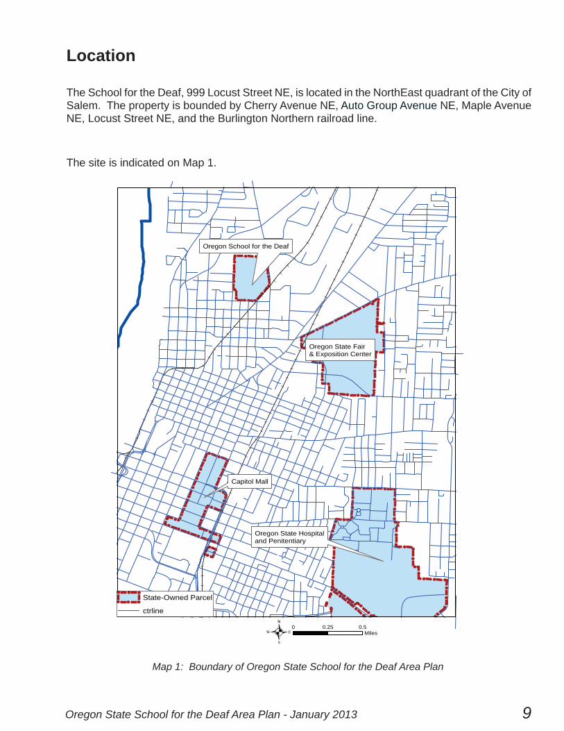
Location
The School for the Deaf, 999 Locust Street NE, is located in the NorthEast quadrant of the City of Salem. The property is bounded by Cherry Avenue NE, Auto Group Avenue NE, Maple Avenue NE, Locust Street NE, and the Burlington Northern railroad line.
The site is indicated on Map 1.
!
!
!
!
!
!!
!!
!!
!!
!
!!
!
!
!!
!
! ! ! !
!!
!!
!!
!
! !!
!
!
! ! !
!!
!!
!
!
!
!
!
!
!
!
!
!
!!
!!
!!
! !
!!
!!
!!
!
!! !
!!
!
!
!!
!
!!
!!
!
! ! !
!!
!!
!
!!!
!
!!
!
!
!!!
!!!
!
!
!!
!!
!
!!
!
!!
!
!
!
!
!!
!
!!
!!
!!!!
Oregon School for the Deaf
Oregon State Fair& Exposition Center
Capitol Mall
Oregon State Hospitaland Penitentiary
0 0.25 0.5Miles.
!
! !
!
!! State-Owned Parcel
ctrline
Map 1: Boundary of Oregon State School for the Deaf Area Plan

January 2013 - Oregon State School for the Deaf Area Plan10
Existing Development and Current Uses
The 52-acre campus remains in use as an educational institution. However, Kuenzi Hall (former
Primary Building) is leased to the Baker Charter Elementary School, and a portion of the Smith
Building is leased to the JEGEMS Charter School. Lindstrom Hall (current Boys’ Dormitory)
is to be vacated when the new dormitory building is completed (anticipated 2013). The former
Preschool Dormitory (Wallace Hall) is presently available for lease.
The campus plan places several large buildings along the busier street frontages, sheltering the
core of the campus, which is primarily exposed on the north and west to vacant land or single-family
residential development.
Buildings:
1 - Carpenter House 2 - Wallace Hall (Currently Vacant) 3 - Peterson Hall 4 - Kuenzi Hall (Currently Leased) 5 - Lindstrom Hall 6 - Administration Building 7 - Clatterbuck Building 8 - Maintenance and Heat Plant 9 - Hokanson Gym10 - Paint Shop11 - Peck Gym12 - Ulmer Building13 - Smith Building (3/4 OSD Occupancy, 1/4 Leased)14 - Garage15 - Grandstand16 - New Dormitory (Not Shown on Aerial)17 - Garage18 - Pump House19 - Green House20 - Head Start (Ground Lease)

Oregon State School for the Deaf Area Plan - January 2013 11
Current UsesCampus Uses
Leased - Agriculture
Leased - Education
!!
!
! !
!
School for the Deaf
Ü 0 250 500 750125Feet
Map 2: Existing Facilities and Current Uses
12
3
45
6
789
10
11
1213
14
15
16
17
18
19
20
January 2013 - Oregon State School for the Deaf Area Plan12
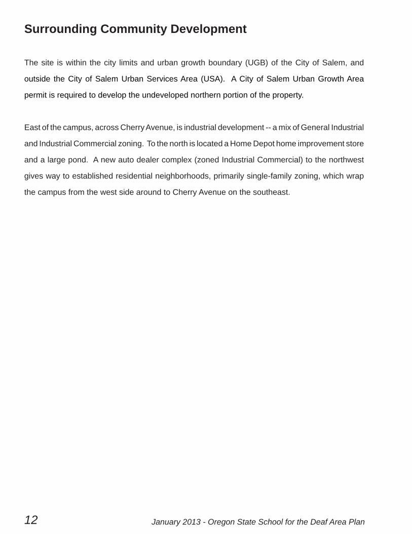
Surrounding Community Development
The site is within the city limits and urban growth boundary (UGB) of the City of Salem, and
outside the City of Salem Urban Services Area (USA). A City of Salem Urban Growth Area
permit is required to develop the undeveloped northern portion of the property.
East of the campus, across Cherry Avenue, is industrial development -- a mix of General Industrial
and Industrial Commercial zoning. To the north is located a Home Depot home improvement store
and a large pond. A new auto dealer complex (zoned Industrial Commercial) to the northwest
gives way to established residential neighborhoods, primarily single-family zoning, which wrap
the campus from the west side around to Cherry Avenue on the southeast.

Oregon State School for the Deaf Area Plan - January 2013 13
S
MA
PLE
AVN
E
NE
NE
PINE ST NE
0 250 500 750 1,000Feet.
ZoningGeneral Commercial
Commercial Office
Retail Commercial
Industrial Commercial
General Industrial
Industrial Park
Public Amusement
Public/Private Education
Residential - MultiFamily 1
Residential - MultiFamily 2
Residential - Single Family
Map 3: Surrounding Uses

January 2013 - Oregon State School for the Deaf Area Plan14
Comprehensive Plan Designation and Zoning
The Salem Area Comprehensive Plan (SACP) designation in the current acknowledged Plan
(2009) is Community Service. The SACP states that “Community Service” designation includes
sites and facilities for uses such as health and medicine, religion, education, culture, and
government, including cemeteries, airports, and waste disposal. The entire property is currently
zoned “Public and Private Educational Services” (PE), which limits development to Health,
Educational, and Social Services, along with staff/caretaker housing and fi re protection uses.
Agricultural uses, parks, and the like are also permitted in this zone.
Airport-Related Overlay: The Property is wholly outside the McNary Field Instrument Flight
Rules Conical Surface and Primary Approach Surface.
Natural Resources
The developed campus area is separated from the northern, undeveloped portion of the property
by delineated wetlands totaling 3.91 acres. The bulk of the property is located within the 500-
year FEMA fl oodplain. See Map 6 for details.
There are no known endangered or threatened plant or animal species on the property.
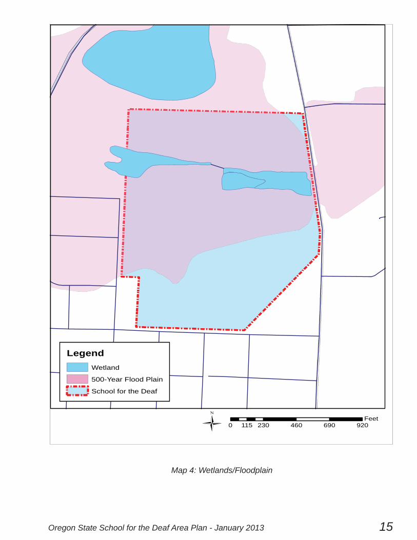
Oregon State School for the Deaf Area Plan - January 2013 15
LegendWetland
500-Year Flood Plain
School for the Deaf
0 230 460 690 920115Feet
Map 4: Wetlands/Floodplain
January 2013 - Oregon State School for the Deaf Area Plan16
Infrastructure
SEWER
A City of Salem sewer main crosses the property from east to west, passing underneath the
track area and the parcel leased to Head Start. Sewer mains are also available in Auto Group
Avenue NE and in Cherry Avenue NE.
ELECTRIC UTILITIES
The property is served by Portland General Electric.
STORM WATER
The City of Salem Stormwater Master Plan proposes enlarging a stormwater conveyance
beginning immediately west of the northern portion of the Property. This conveyance is designed
based upon the current rate of discharge from the site; development of the northern portion of
the Property will require consideration and management of storm runoff. No improvements are
proposed to the existing privately-owned storm water conveyance main crossing the property,
which generally follows the wetland swale.
WATER
The property is served by multiple water mains in the surrounding streets, including a 12” main
on Locust, a 14”-16” main on Cherry, a 14” main on Auto Group Avenue, and a 6”-8” main on
Maple. Current campus development has a water line loop connecting to both the Locust and
Maple mains.
WATER RIGHTS
Two wells exist on the property, each for domestic use and irrigation of up to 50 acres. They are
listed as Oregon Water Resources Department claims GR 1481 and GR 1482.

Oregon State School for the Deaf Area Plan - January 2013 17
School for the Deaf
SewerTrunk
Main
Storm Sewer
0 250 500 750 1,000125
Feet
Map 5: Infrastructure
January 2013 - Oregon State School for the Deaf Area Plan18
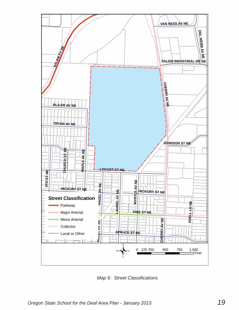
Transportation and Circulation
Streets in this area, as described in the City of Salem Transportation System Plan, are shown on the map below.
Salem Parkway NE (Parkway): The Salem Transportation Plan lists a committed intersection safety improvement project at Salem Parkway and Cherry Avenue. The Plan also proposes an extension to the existing eastbound shared-use path along Salem Parkway (heading west from Salem Parkway and Cherry Avenue).
Cherry Avenue (Major Arterial): The Salem Transportation Plan recommends widening the northern portion of Cherry Avenue (south of Salem Parkway NE) to four travel lanes, a center turn lane, and bicycle lanes. This is a medium-priority improvement, for completion within 15 years. The Plan also recognizes a possible transition of traffi c on the southern portion of Cherry Avenue from industrial to commuter traffi c and recommends, if an increase occurs, widening Cherry Avenue north of Pine Street NE to include a center turn lane. This is a low priority improvement (needed within 25 years). The Plan also recommends new sidewalks along Cherry Avenue, a designated “Critical ADA Route” in the Plan.
Pine Street NE (Minor/Major Arterial): No improvements are identifi ed at this time. However, an alternative under consideration for the Salem River Crossing project transforms Pine into a couplet with Hickory, leading to a new bridge across the Willamette River. Pine is a designated “Critical ADA Route” in the Salem Transportation Plan.
Locust Street (Local): No improvements are identifi ed at this time.
Maple Avenue (Local): The Salem Transportation Plan proposes sidewalk infi ll and a Family-Friendly Bikeway and Shared-Use Path along Maple Avenue and the continued alignment of Maple Avenue to intersection with Auto Group Drive.
Auto Group Avenue NE / Salem Industrial Drive NE (Local): The Salem Transportation Plan proposes sidewalks and bike lanes along Salem Industrial Drive NE and Auto Group Avenue NE to connect with the proposed Shared-Use Path at the northern terminus of the Maple Avenue alignment.
Burlington Northern Railroad: There are no improvements immediately planned for the railroad. It currently carries freight traffi c only, and is expected to remain in use indefi nitely.
Oregon State School for the Deaf Area Plan - January 2013 19
! ! ! ! ! ! ! ! ! ! ! ! ! !
!!
!!
!!
!!
!!
!!
!
!
!
!
!
!
!
!
!
!
!!!!!!!!
!!
!!
!!
!!
!!
!!
!!
!!
!!
!!
!
PINE ST NE
CH
ERRY
AVN
E
MA
PLE
AVN
E
5TH
STN
E LOCUST ST NE
SPRUCE ST NE
SALE
MPY
NE
LAU
REL
AVN
E
MYR
TLE
AVN
E
TRYON AV NE
HA
ZEL
AVN
E
CH
UR
CH
STN
E
BLILER AV NE
DEL
WEB
BAV
NE
HICKORY ST NE
JOHNSON ST NE
VAN NESS AV NE
SALEM INDUSTRIAL DR NE
AD
ELL
LNN
E
CH
UR
CH
STN
E
CH
ERRY
AVN
E
HA
ZEL
AVN
E
HICKORY ST NE
Street ClassificationParkway
Major Arterial
Minor Arterial
Collector
Local or Other
. 0 250 500 750 1,000125Feet
Map 6: Street Classifi cations
January 2013 - Oregon State School for the Deaf Area Plan20
TRANSIT
The site is currently served by three Salem-Keizer Transit District (Cherriots) routes: Route
4, Route 13, and Route 14. The property may be accessed from Cherry Avenue, from Salem
Parkway, or from Pine Street.
Routes are subject to change.

Oregon State School for the Deaf Area Plan - January 2013 21
Route 14

January 2013 - Oregon State School for the Deaf Area Plan22

Oregon State School for the Deaf Area Plan - January 2013 23
DEVELOPMENT ANDMANAGEMENT
POLICIES

January 2013 - Oregon State School for the Deaf Area Plan24
Oregon State School for the Deaf Area Plan - January 2013 25
DEVELOPMENT AND MANAGEMENT POLICIES
The following series of policies combines with the preceding site and surrounding development analysis to guide the land use plan (see page 35).
Policy 1: Protect and provide for ongoing State agency uses.
1.1: Provide adequate buffers around existing and new facilities.
1.2: Reserve space for replacement of aging facilities.
Policy 2: Effi ciently manage retained property.
2.1: Lease or place under management agreement any retained property not currently in use.
Policy 3: Encourage planned and integrated development of the Property.
3.1: Encourage physical and architectural integration with the surrounding campus through appropriate siting and design of new buildings and construction. Consider height, volume, size, scale, setbacks, material choices and aesthetic considerations of existing buildings which are to remain. Recall that complementary designs need not duplicate existing structures.
3.2: Consider functional and aesthetic compatibility between new projects and neighboring land uses; provide transitions as appropriate.
3.3: New projects should provide an attractive and safe environment for employees, students, and visitors through building and site design, materials, landscaping, lighting, pertinent signage, sidewalks or other pedestrian linkages, and other site amenities.
3.4: Consider the needs of Property users with a range of purposes and abilities in the design of new projects.
3.5: Consider and respect impacts upon locations of particular historic or natural signifi cance in design and implementation of new projects. Consider options for public access to and interpretation of these resources.
3.6: Adhere to Design Standards presented in this Plan.
January 2013 - Oregon State School for the Deaf Area Plan26
Policy 4: Maximize transportation effi ciency and balance.
4.1: Recognize Cherry Avenue and Pine Street as necessary regional thoroughfares which must be accommodated in development by:
a. Facilitating traffi c fl ow to reduce emissions, fuel consumption, and noise.
b. Providing designated crosswalks as needed for pedestrians and bicyclists.
4.2: Achieve balanced transportation system access to the Property via coordination with State, City, and regional transportation and transit planning agencies:
a. Coordinate with current known plans (referenced in Streets and Transit sections of Plan).
b. Coordinate with Salem-Keizer Transit District to maintain or enhance transit service to site when routes and service levels are reviewed.
c. Provide effi cient circulation on site and link to the City and regional transportation network.
d. Pursue additional coordination as needed.
4.3: Incorporate transit, pedestrian, and bicyclist circulation and related needs into the design of new construction or renovation projects, as appropriate, to encourage the use of transportation alternatives. Provide appropriate pedestrian and cyclist links between buildings, to transit stops, and to public pedestrian and cyclist routes, including those designated in the Salem Transportation Plan.
4.4: Encourage alternative modes of transportation such as carpooling, park and ride programs, employee transit subsidies, and other transportation demand management measures (in conjunction with conventional parking solutions) to satisfy parking demand, reduce traffi c impacts in the area, and comply with the Salem Transportation Plan; the State’s Transportation Rule (a transportation demand management strategy for State agencies); and other applicable plans, rules, and ordinances.
4.5: Meet parking demands for new development on the Property through the provision of on-site parking or other parking facilities provided or designated by the State. Discourage employees or visitors from parking in adjacent residential areas.
4.6: Consider safety enhancements along existing railroad frontage when proposing projects.
Policy 5: Continually consider sustainability enhancements.
5.1: Where appropriate, rehabilitate existing State buildings to provide more effi cient use of space, with attention to security, energy usage, safety, aesthetics, employee work environment, and access for the disabled.
Oregon State School for the Deaf Area Plan - January 2013 27
5.2: Where appropriate, consider adaptive reuse of existing structures.
5.3: Design new landscaping to maximize building energy effi ciency by permitting solar gain in winter and shading buildings in summer.
5.4: Replace or relocate landscaping and trees to be removed in new development, when feasible and appropriate.
5.5: Preserve those features that are special and unique to the Property while being responsive to changing needs and conditions, and sensitively address wildlife habitat areas.
5.6: When developing new projects, enhance fl ood control and wildlife habitat amenities where feasible and appropriate.
5.7: Consider landscaping as an architectural element in new development to alter spatial relationships; do not restrict to the cosmetic treatment of buildings.
5.8: Utilize native and drought-tolerant plants where feasible.
Policy 6: Proactively coordinate and encourage interjurisdictional and citizen participation.
6.1: Provide a basis for coordination between State government and the city of Salem, neighborhood groups, Salem Area Mass Transit District and other public and private entities affected by future development of the Property.
6.2: Encourage citizen participation in the planning and development review processes for the campus.
6.3: Consult with the State Historic Preservation Offi ce and the Salem Historic Landmarks and Design Review Commission regarding projects affecting structures or sites on the Property which may have historic or cultural signifi cance. Consider protecting for future generations those structures identifi ed as signifi cant.
6.4 Comply with the Salem Area Comprehensive Plan and other relevant City regulations.

January 2013 - Oregon State School for the Deaf Area Plan28

Oregon State School for the Deaf Area Plan - January 2013 29
DESIGN STANDARDS

January 2013 - Oregon State School for the Deaf Area Plan30
Oregon State School for the Deaf Area Plan - January 2013 31
Design Standards
The Property is situated between residential and industrial properties, and is immediately adjacent to two signifi cant travel corridors (Cherry Avenue and Salem Industrial Drive).
The State has determined that it is in the interests of the State and the surrounding community to create a smooth aesthetic and functional transition between industrial and residential uses and the campus, and has incorporated design standards to help achieve this goal. These standards address height, bulk, and area; setbacks; screening; and landscaping.
Height, Bulk, and Area:
New projects should respect the scale of the buildings located on adjacent properties, and provide orderly transitions between industrial and residential areas and the campus. Height and lot coverage shall be consistent with current City of Salem zoning code:
Height of non-residential buildings should not exceed 70 feet. Height of residential buildings should not exceed 35 feet.
Lot Coverage: Buildings, structures, accessory buildings and accessory structures shall occupy not more than fi fty percent of the net acreage (area not included in setbacks or otherwise restricted from development) of an individual parcel.
Setbacks:
Dedicated landscape setbacks should be established for new projects consistent with the current City of Salem zoning code. However, variances from City of Salem zoning code setback requirements may be requested. Existing, non-conforming buildings may continue to be used and may be remodeled or upgraded consistent with current City of Salem permit requirements.
The streetscape should enhance the character of the site, and incorporate setback and architectural design standards to promote such a character.
Appropriate uses or features within the City-required street-side landscape setback(s) include:
Accessory structures such as gatehouses, not to exceed 300 square feet each or 800 square feet in aggregate, with minimum 20-foot setback to gate;
Transit stops;
Sidewalks, bicycle paths, trails, or other non-motorized transportation corridors, provided they return to right-of-way to cross driveways or at intersections;
Landscaped, naturalistic stormwater management features;

January 2013 - Oregon State School for the Deaf Area Plan32
Bicycle parking facilities; and
Landscaping.
Inappropriate uses or features within any street-side landscape setback include:
New buildings larger than 300 square feet;
New fencing greater than three feet in height within 15 feet of right-of-way; and
Storage buildings, workshops, or similar accessory structures.
Regulated uses or features within any setback include:
Signifi cant built structures, including opaque walls;
Barbed wire or chain link fencing; and
Air-conditioning, electrical, and similar equipment.
The designation of a use or feature as “Appropriate” or “Regulated” in this Area Plan does not exempt construction of such a use or feature from all City of Salem zoning and permitting requirements. Some of these uses or features, if deemed desirable by the Commission, may require variances from City of Salem codes.
Regulated features may be permitted on a case-by-case basis, with suffi cient screening (see Screening) or other design solutions which provide visual relief and promote an aesthetically pleasing, context-appropriate streetscape, and which meet City of Salem codes.
Review for compliance with City of Salem codes, which may change over time.
Screening:A feature is considered “100% screened” when it is rendered invisible from the height of six feet or lower from any point along the right-of-way or property line. Screening may be accomplished through the use of landscaping, berms, opaque walls, or other means consistent with a semi-rural landscape. Percent screening provided by plant materials is measured based upon mature plant size. Opaque walls or similar features which exceed 100-feet in length should include visual relief such as offsets, recesses, pilasters, or other detailing.
All features requiring screening should be screened to a minimum of 70%, with the goal of 100%, with the following exceptions:
Parking lots should be screened a minimum of 50% from right-of-way or property line, and must be screened 100% from right-of-way or property line to a minimum height of 36” from parking lot grade.
Unexpected headlight glare may blind motorists on roadway. Views of parking lots from roadway do not enhance neighborhood.

Oregon State School for the Deaf Area Plan - January 2013 33
Barbed wire, razor/concertina wire, or chain link fencing shall be screened 100% from the right-of-way when used within a setback. These types of barriers should also be screened to the degree feasible from the right-of-way or property lines, regardless of their relation to setbacks.
Barbed, razor, and concertina wire and chain link fencing do not enhance the visual appeal of the site or suit a neighborhood aesthetic.
Landscaping:Dedicated landscape setbacks shall be landscaped in a unifi ed composition appropriate to the neighborhood and the campus setting. Native and drought-tolerant plant material is strongly recommended. Trees listed as prohibited street trees under City of Salem 86.120 shall not be planted within 25 feet of the right-of-way of any established roadway or within 25 feet of any motorized or non-motorized transportation corridor. Plants listed on the Oregon State Weed Board Noxious Weed List shall not be planted anywhere on the site, and should be targeted for elimination.
Setback areas used for agricultural, forestry, or similar purposes which preclude installation of an all-native planting scheme as of the date of this Plan may continue in that capacity. At such time as use of these areas changes to a new agency or institutional use, they shall be landscaped to conform to this Standard.
Variances:The Capitol Planning Commission (Commission) may recommend a variance from any of these design standards if:
(1) The Property and proposed improvements are challenged by unusual topographic, environmental, functional, or aesthetic circumstances; or
(2) The proposed alternative achieves the purposes of the Design Standards as well or better than a compliant alternative.
Variances granted should not create material adverse aesthetic, functional, or health, safety, or welfare effects on neighboring owners or others coming to or passing by the Property.
Each variance request shall be considered solely on its own merits; granting of a variance in one situation shall not change the Design Standards or compel the Commission to grant any further variances.
The Commission can grant variances only to this Area Plan, not to City of Salem codes. The proposing agency must separately seek from the City of Salem any necessary permits, adjustments, or variances for any Commission-recommended project.

January 2013 - Oregon State School for the Deaf Area Plan34
Oregon State School for the Deaf Area Plan - January 2013 35
LAND-USE PLAN

January 2013 - Oregon State School for the Deaf Area Plan36
The Land-Use Plan is divided into campus facilities in use, campus facilities available for lease, and undeveloped lands which may be made available for use by other state agencies or private development.
Area 1 comprises campus facilities in use.
Areas 2a through 2d are adjacent to the campus facilities in use, but have different opportunities and constraints.
Area 2a shares an entrance and parking areas with Area 1. Educational uses serving youth are appropriate uses for leased facilities in Area 2a. However, the campus serves a youth population. School offi cials do not consider it appropriate to introduce offi ce uses not directly related to education or the serving of the deaf community to the core of the campus--Area 1--for this reason.
Area 2b has a separate entrance from Cherry Avenue and its own parking area, and is separated by fencing and distance from the core of the campus. It may be appropriate for other, carefully selected offi ce uses, consistent with City of Salem zoning code or permits obtained from the City. It is also appropriate for educational or related purposes.
Area 2c has a separate entrance and shares a parking area outside of the core of the campus. However, the building is 75% occupied by OSD uses. It is appropriate for educational uses.
Area 2d shares the separate entrance and parking area with Area 2c. The structures are privately owned, and the property is under a ground lease for educational purposes. This is an appropriate ongoing use.
Area 3 comprises approximately 12.5 acres of undeveloped land separated from the campus by wetland areas. It has frontage on Salem Industrial Drive Northeast, and is separated from the campus facilities by open space, wetland areas, and a fence. It is appropriate for most types of development by public or private-sector entities, with improvements to the fence and addition of appropriate landscape screening.
2b
1
3
2a
Campus Use
Leased or Available for Lease - Educational Use Only
Surplus Property
Available for Lease - Educational or Offi ce Use
2c Leased - Educational Use Only
2d Leased - Educational Use Only

Oregon State School for the Deaf Area Plan - January 2013 37
Land Use PlanCampus Use
Surplus Property
Leased or Available
!!
!
! !
!
School for the Deaf
Ü 0 250 500125Feet
3
2b
1
2a
2c
2d