(old) alresford - hampshiredocuments.hants.gov.uk/landscape/historic-settlement/… · ·...
TRANSCRIPT

(Old) Alresford
(Old) Alresford
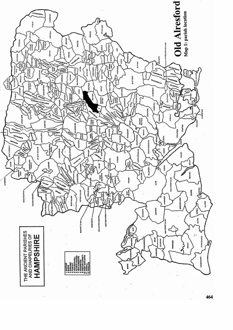
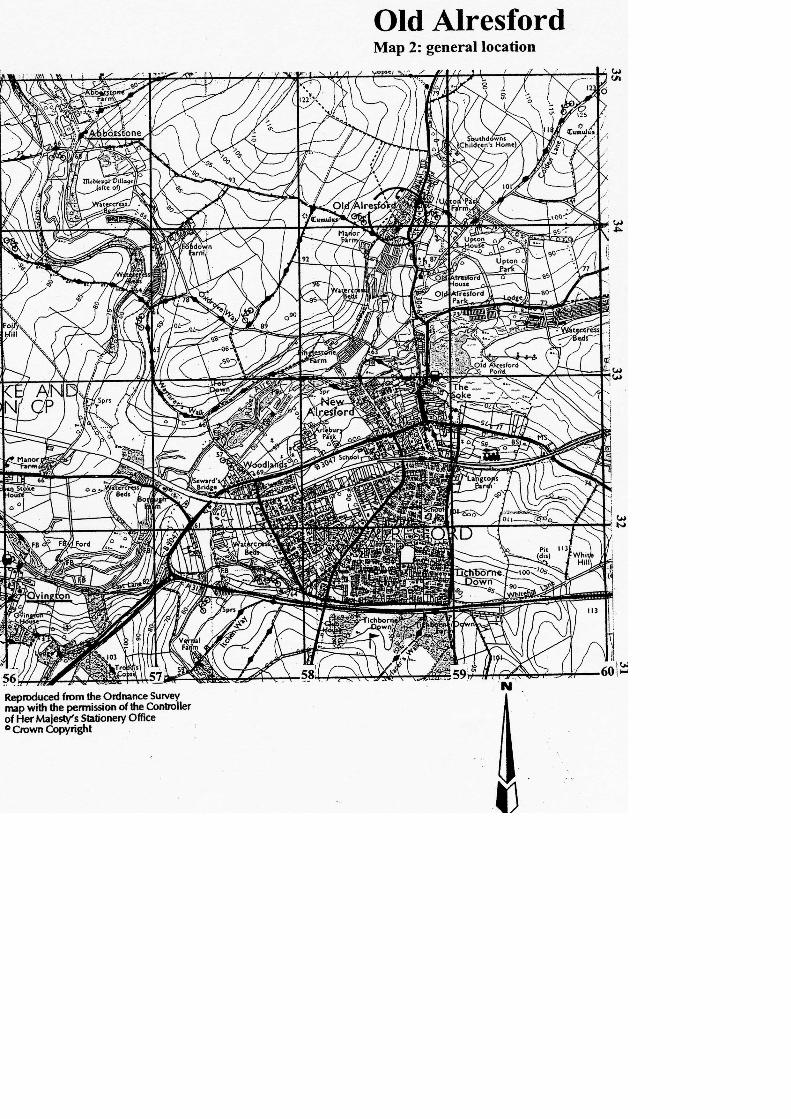
1.0 PARISH Old Alresford (Map 1) 2.0 HUNDRED Fawley 3.0 NGR 458610 133680 4.0 GEOLOGY Upper Chalk; River Valley Gravel 5.0 SITE CONTEXT (Map 2)
The parish of Old Alresford (now including Godsfield) is c. 8km in length extending from the District boundary of East Hampshire in the north-east to the river Itchen at Itchen Stoke in the south-west. For much of its length the parish is c. 1.6km wide. The principal settlement is also known as Old Alresford (c. 70m AOD) and this is situated towards the south-west end of the parish, in the valley of the river Alre. The area is noted for its watercress beds and these can be seen to the west and to the south-east of Old Alresford. Just 1km to the south is the later medieval town of New Alresford but this is now administratively separate from the parent parish.
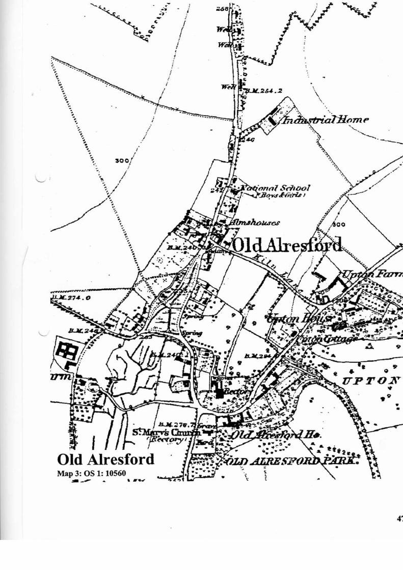
6.0 PLAN TYPE & DESCRIPTION (Maps 3, 4 and 5) Church & manor house + regular rows 6.1 Church & manor house The church of St Mary is probably C12 (or earlier) in origin
but major rebuilding programmes in the C18 and C19 have left almost no evidence of the medieval building. The church stands upon a low knoll, a feature that suggests a pre-Christian or early Christian origin for the site. Less than 50m east-north-east of the church stands Old Alresford (manor) House. This building is C18 but it is on the site of a medieval predecessor. In an account of Old Alresford written in the C18 (Sumner, 192 : 335), GB Rodney tells of a tradition whereby the juries of the manorial Court Leet met at a certain spot in the garden of the House. Presumably, this traditional meeting place must have been marked in some way. South, and to the rear of the manor house is Old Alresford Park and Old Alresford Pond. The pond is a reservoir that supplies the river Itchen, and it is thought that it was created as part of Bishop Geoffrey de Lucy's late C12 scheme to render the river Itchen navigable from Alresford to Winchester.
6.2 Regular rows The B3046 passes through the parish of Old Alresford in a more or less
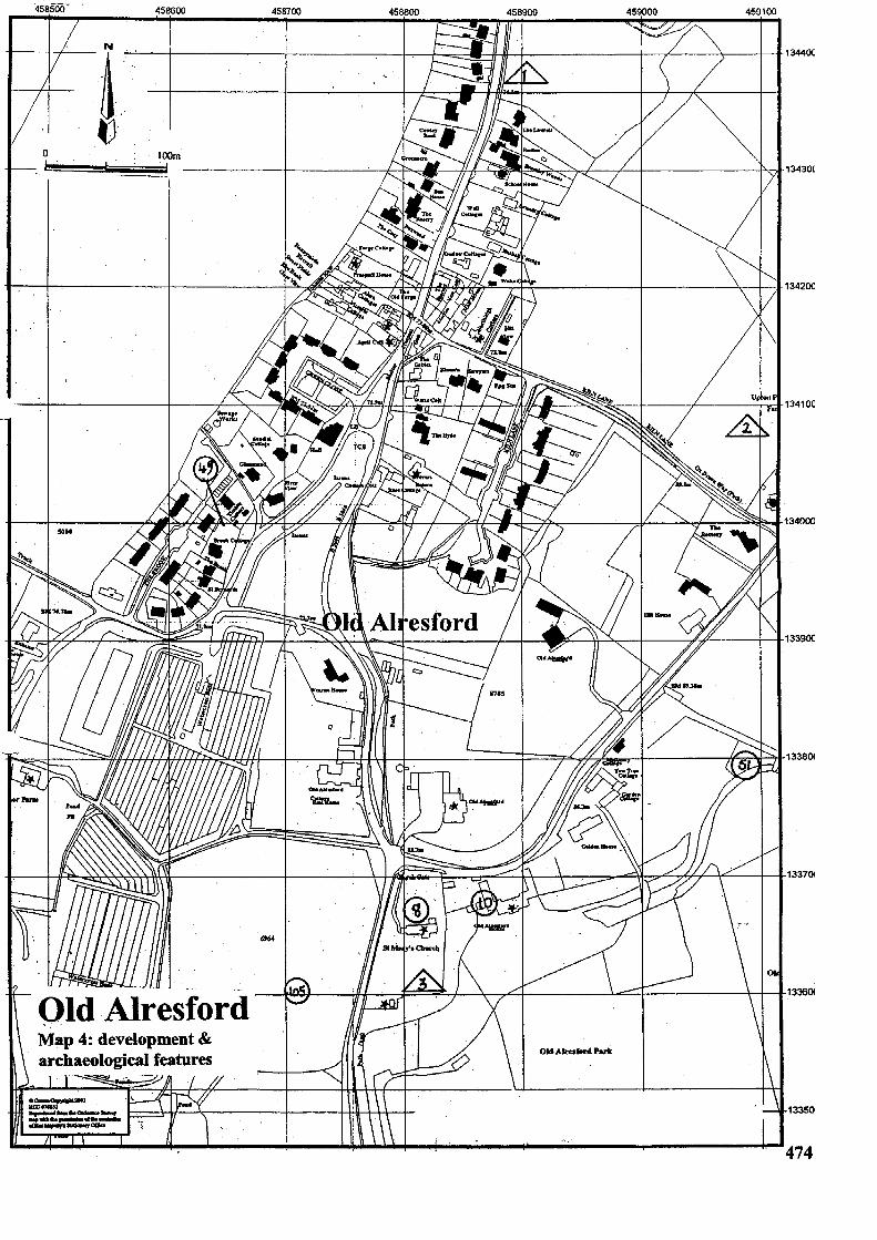
north / south direction, and it is the principal route through an area of settlement that is situated 300m north of St Mary's Church. This part of Old Alresford is a double regular row, the buildings to the east and west of the B3046 being set at right angles to the road. This arrangement of properties is most obvious on the east side where a common rear boundary is also apparent. However, most of the buildings are C19 or C20. So far as is known, the oldest structures (C17) are concentrated around a triangular junction of Kiln Lane (from the east-south-east) and the B3046. South of the junction the road is divided by a large triangular green. The overall regularity of

(Old) Alresford
(Old) Alresford
the layout of Old Alresford (north of St Mary's) suggests that it is a settlement that has been planned. Planned linear settlements of this type have much in common with medieval new towns where burgage plots are set out in a uniform manner at right angles to the road. The C12 town of New Alresford that was carved out of the southern tip of the parish, has similar regular qualities to Old Alresford. It is quite possible that the town and a re-planned rural settlement were devised at the same time (late C12)
6.3 A conjectural sequence of historic settlement at Alresford is as follows: Phase 1 (C10, C11 or earlier) Church and manor house, attendant farms (e.g. Manor
Farm), occasional cottages; Phase 2 (late C12) development of new town (New Alresford), rebuilding of St Mary's, planned appendage to rural settlement (Old Alresford).
6.4 Site visit conditions: strong sun (19.4.2002) 7.0 ARCHAEOLOGICAL POTENTIAL (Maps 3, 4 and 5) 7.1 AsAP 7.1.1 The group of properties at the junction of Kiln Lane with the B3046 includes some of
the earliest known structures in Old Alresford. Kiln Lane is classified as an ox drove way and it has the characteristic wayside embankments of a much-used route.
7.2 AsHAP 7.2.1 The parish church and the manor house are at the south end of Old Alresford. Both
buildings are of medieval origin although subsequent rebuilding has obscured the evidence (see paragraphs 6.1 and 11.0, no. 4)
8.0 CHURCH & CHURCHYARD St Mary, 1753 Probably C12 origin; Reconstructed c. 1400 as a result of fire damage; Parts of the C12 and C16 remain in the church; Totally rebuilt in 1753; 1769 west tower was replaced by the present structure using bricks from the derelict
manor house at Abbotstone, owned by the Duke of Bolton (green glaze is evident on the bricks of the south-east quoin- IH / 2002);
C19 south transept and north vestry; 1852 Caen stone font (the SMR says that it is Norman); Interior gothicized by Colson in 1862.

(Old) Alresford
(Old) Alresford
NB The full SMR entry alludes to a fragment of C14 wall painting representing a
ship. This could not be found at the time of this survey (2002). The Church guide leaflet does not mention this painting directly but it does say, …and then in 1938, when electric light was installed together with a new heating system, the stenciling on the east wall and chancel arch was painted over. If the stenciling is a reference to the wall painting, then the chancel arch and at least a part of the east wall must be medieval.
9.0 BUILDINGS (Map 4) PRN Details Dates Grade 10252 Prospect House early C19, 20 II 10253 Victoria Cottage C17, 18, 19, 20 II 10254 April Cottage (previously Green End) C17, 18, 19 II 10255 Drovers Return C17, 1968 II 10256 Manor Farm: barn at late C17, 18 II 10257 Manor Farmhouse mid C18 & earlier II 10258 Pinglestone Farm: barn at late C17 II 10259 Swan Cottage early C19 II 10260 Weir Mill 1814, C19, 20 II 10261 Old Alresford Place (former rectory) c.1740, C19 II* 10262 Church of St Mary: lych gate 20m north- west of C18 II 10263 Church of St Mary c. 1300, C14, C19 II* 10264 St Mary's churchyard: 6 x tomb chests (4 x north of chancel; 1 x east of chancel;
1 x south of tower) early C19 II 10265 Old Alresford House: wall and gates to forecourt of mid C18 II 10267 Armsworth House early C19, 20 II 10268 Armsworth Park House C18, 19, 20 II 10272 Lower Lanham Farmhouse mid C18, 20 II 10273 Lower Lanham Farmhouse: barn at C18 II 1150 Upton House c.1764, C18, 19 II* 14103 Upton Park Farm: farm buildings at not given unlisted 14104 Upton Park Farm: greenhouse at not given unlisted 14194 School House, Basingstoke Road C19 unlisted 14629 Armsworth Park House: barn at not given unlisted 1856 Upton Park House: stables at C18, 19 II 412 Northleigh Cottage, Kiln Lane C17, 18, 19 II 518 Old Alresford House 1749-51 II* 831 Upton Park Farm, Kiln Lane: barn at C18 II

(Old) Alresford
(Old) Alresford
10.0 SMR DATA SW 458475 133470, NE 459115 134425 (Map 4) SU53SE No. 8 458810 133650 Medieval parish church of St Mary (see paragraph 8.0). 10 458890 133670 Medieval. Site of the ancient manor house of
Old Alresford manor now occupied by a C18 building.
49 458640 133950 Medieval. Find spot of grass tempered pottery sherd. 51 459100 133800 Approximate location of a post-medieval ice-
house. The pit has been walled-up and only the passage remains. There was one inner door.
105 458700 133600 Medieval. (Old) Alresford first documented in AD 701.
10.1 Hampshire Romano-British Settlements survey Hants No. NGR Parish NAR / NMR Nos 69 458000 133000 Old Alresford SU53SE12 70 462000 136000 Old Alresford SU63NW13 10.2 Scheduled Ancient Monuments (SAMs) SAM No. NGR Site 129 458900 133000 Alresford Bridge. 315 462300 136500 Roman villa north of Bighton Wood. 12143 462590 136780 Bowl barrow 600m east of Upper Lanham Farm. 11.0 ADDITIONAL SITES / FEATURES (Map 4) 1 458895 134380 Low linear earthworks at the north end of Old Alresford that
might be indicative of lost settlement units, or Modern pipe trench. The OS 10,560 map of 1873 has no buildings occupying this site.
2 459100 134080 Earthworks in the field west of Upton Park Farm. 3 458830 133605 Sumner ([undated]: 338) tells of an impromptu excavation, in
1769, of a mound that was situated in the south-east corner of the churchyard. Apparently, the mound concealed the foundations of a wall and a pavement within it (a mosaic? – IH / 2002).
(Old) Alresford
(Old) Alresford
12.0 CARTOGRAPHIC SOURCES Tithe Map 21M65/F7/178/2 (1839 / 1840) GSGB 300 Alresford OS 1: 2500 SW 458475 133470, NE 459115 134425 OS 1: 25000 Explorer 132: Winchester, New Alresford & East Meon OS 1: 10,560 459022 134156 (1873) 13.0 BIBLIOGRAPHY Coates R 1989 The Place-names of Hampshire Southampton, Ensign Fitzpatrick AP (et al) 2001 An unusual early 17th-century burial at the Roman villa at
Pinglestone Farm, Old Alresford Proceedings of the Hampshire Field Club & Archaeological Society 56: 219-228
HTS 1: 217-224 Sumner H (undated) An Account of Alresford written by Sir George Brydges Rodney c. 1768 – 82 Proceedings of the Hampshire Field Club and Archaeological Society 9:
334-341 VCH 3: 304-6
14.0 PRIMARY HISTORIC SOURCES 14.1 Domesday Book
(2,1) Walkelin, Bishop of Winchester holds Alresford in lordship. It is and always was in the Bishopric. Before 1066 it answered for 51 hides; now for 42 hides. Land for 40 ploughs. In lordship 10 ploughs; 48 villagers and 36 smallholders with 13 ploughs. 31 slaves; 9 mills at £9 30d. Meadow, 8 acres; woodland at 10 pigs pasturage; from grazing, 50d; 3 churches at £4. They paid £6 a year, but they could not bear it.
Robert holds 3½ hides of the land of this manor; Walter 2 hides; Durand 4 hides in Soberton and 6 hides in Beauworth; an Englishman 1½ hides. They have in lordship 6 ploughs; 17 villagers, 6 smallholders and 19 slaves with 6 ploughs. A mill at 20s; meadow, 6 acres. Wulfric Chipp, Robert’s predecessor, could not go wither he would, nor could Osbern, Walter’s predecessor; nor Edward and Alric, Durand’s predecessors.
Value of the whole manor before 1066 £40; later £20; now , the Bishop’s lordship £40, Robert’s £4, Walter’s 40s, Durand’s £11.
14.2 Subsidy Rolls 1334 £1.9.8 1524 1st survey: £3.4.0 (26 taxpayers) 2nd survey: £2.15.4 (20 taxpayers)
(Old) Alresford
(Old) Alresford
14.3 Manors
(Old) Alresford only. 14.4 Hearth Tax 1665 76 hearths chargeable (24 houses) 13 hearths not chargeable (12 houses). Total: 36 houses. 15.0 PLACE NAME
701 (C12) (to) alresforda; 947 x 995 (C14) (to) alresforda; 1167 Alresford. OE ‘alder ford’, with the possible but not certain implication ‘at the alder tree’ because of the genitive singular form of the first element. The tradition showing no -s is later and only sporadic. Most forms from 701all through the medieval period are of the type Alresford. The modern pronunciation may be first hinted at in 1408 (Allesford). New Alresford, founded by Bishop Godfrey de Lucy in 1200, is first distinguished in the mid C13 (Nova Villa de Alresford), later 1332 Chepyng Alresford, i.e ‘Alresford Market’ (town). Alresford does not take its name from the river Alre, but vice versa (Coates 1989, 21-2).
16.0 PHOTOGRAPHS Church of St Mary from the south-west with glazed bricks visible on south wall of the
tower. 17.0 OTHER PROJECT ELEMENTS 17.1 Pre-Conquest Charters AD 701 Ine, king, to the church of SS Peter and Paul, Winchester; restitution of land at
Alresford, Hampshire. Latin with English bounds (132 / 242). Undated Egbert, king, to the church of Winchester; restitution of land at Alresford,
Hampshire. Latin with English bounds (142 / 284). AD 909 King Edward to Frithestan, bishop of Winchester; confirmation of land at
Alresford, Hampshire. Latin (163 / 375). AD 956 King Eadwig to Ælfric, his faithful familiar; grant of land at Alresford,
Hampshire. Latin with English bounds (208 / 589). AD 963 X 975 King Edgar to the church of Winchester; restoration of land at
Alresford, Hampshire. Latin (258 / 814). AD 963 X 975 King Edgar to the bishopric of Winchester; confirmation of land at
Chilcombe, Hampshire, and restoration of land at Downton, Wiltshire; Taunton, Somerset; Alresford, Clere, Tichbourne, Worthy, Hampshire; Fonthill, Wiltshire; Bishopstoke, Hampshire; and at Farnham, Surrey. Latin (259 / 818).
AD 879 X 909 Denewulf, bishop, and the community of Winchester, to Alfred; lease, for life, of the land at Alresford, Hampshire, with reversion to St Peters. English (372 / 1287).

(Old) Alresford
(Old) Alresford
17.2 Other parish settlements include: Name MSP No. NGR / map ref. First recorded Armsworth House 1862 460800 137400 1245 Coombe Farm 1863 438500 135200 1245 Fobdown Farm 1864 457220 133980 1257 17.3 Enclosures Parliamentary: NEP No. Act Order Award Details 14004 9 Geo. II 1737 634.96 acres (actual); cap. 19, 1736 500 acres (Act). Includes land in Medstead. Stankham and Soldridge Commons.
14005 43 Geo. III 1805 104.43 cares (actual); cap. 67, 1803 70 acres (Act). Nythen Common. Formal Agreements: NEP No. Agreement Award Details No formal enclosure known. 17.4 Commons & Greens (residual)
None recorded in 1874, but Old Alresford green remains (2.6 acres). 18.0 ILLUSTRATIONS 1 Map 1: Parish location (not to scale) 2 Map 2: General (settlement) location at 1: 25000 3 Map 3: Ordnance Survey First Edition County Series (c. 1870s) not to scale 4 Map 4: Development & archaeological features at 1: 2500 reduced to 71% 5 Map 5: Areas of archaeological potential at 1: 2500 reduced to 71%.