of the city of harrison, arkansas - amazon s3art. 200 definitions 100-2 land development regulations...
TRANSCRIPT

LAND DEVELOPMENT REGULATIONS
of the City of Harrison, Arkansas
Ordinance No. 1432 Adopted May 24, 2018
Affective August 1, 2018

ACKNOWLEDGMENTS
Daniel D. Sherrell, Mayor
Jeff Pratt, City Clerk
Van Younes, City Attorney
Wade W. Phillips, PE, Director of Public Works
Jeremy Johnson, CFM, Building Official
Harrison City Council
Chris Head Mary Jean Creager
Mitch Magness John Eoff
Ryan Oswalt Heath Kirkpatrick
Joel Williams Dena Taylor
Harrison Planning Commission
J. Michael Norton, Chairman Pat Brown
Cloyd Baltimore Bob Dodson
Michael Horne Herb Lair
Joel Williams
Table of Contents
City of Harrison Land Development Regulations i
TABLE OF CONTENTS ARTICLE 100 – PURPOSE ................................................................................................................... 100-1
Sec. 100.1 – Title ...................................................................................................................... 100-1 Sec. 100.2 – Authority ............................................................................................................... 100-1 Sec. 100.3 – Purpose................................................................................................................ 100-1 Sec. 100.4 – Jurisdiction ........................................................................................................... 100-2 Sec. 100.5 – Planning Area Map .............................................................................................. 100-2 Sec. 100.6 – Applicability .......................................................................................................... 100-2 Sec. 100.7 – Exemptions .......................................................................................................... 100-2 Sec. 100.8 – Approval Required ............................................................................................... 100-2 Sec. 100.9 – Amendments ........................................................................................................ 100-3 Sec. 100.10 – Conflicting Regulations ...................................................................................... 100-3 Sec. 100.11 – Effective Date .................................................................................................... 100-3 Sec. 100.12 – Severability ........................................................................................................ 100-3 ARTICLE 200 – DEFINITIONS .............................................................................................................. 200-1 ARTICLE 300 – ADMINISTRATION & ENFORCEMENT ..................................................................... 300-1
Sec. 300.1 – Administration ...................................................................................................... 300-1 Sec. 300.2 – Enforcement ........................................................................................................ 300-1 Sec. 300.3 – Violation and Penalty ........................................................................................... 300-2 Sec. 300.4 – Waivers ................................................................................................................ 300-2 Sec. 300.5 – Vacation of Plats .................................................................................................. 300-3 Sec. 300.6 – Vacation of Street Right-of-Way, Easements, or Alleys ...................................... 300-3 Sec. 300.7 – Appeals ................................................................................................................ 300-4 Sec. 300.8 – Trail Construction ................................................................................................. 300-4 Sec. 300.9 – Maintenance Letter of Credit ............................................................................... 300-4 Sec. 300.10 – Guarantees ........................................................................................................ 300-5 Sec. 300.11 – Off-Site Performance Guarantee ....................................................................... 300-5 ARTICLE 400 – PRELIMINARY PLAT ................................................................................................. 400-1
Sec. 400.1 – Applicability .......................................................................................................... 400-1 Sec. 400.2 – Pre-Application Conference ................................................................................. 400-1 Sec. 400.3 – Application for Preliminary Plat Approval ............................................................ 400-1 Sec. 400.4 – Review and Approval ........................................................................................... 400-2 Sec. 400.5 – Review Criteria .................................................................................................... 400-2 Sec. 400.6 – Authorization to Proceed ..................................................................................... 400-3 Sec. 400.7 – Expiration of Preliminary Plat .............................................................................. 400-3 Sec. 400.8 – Building Permits – Model Homes ........................................................................ 400-3 ARTICLE 500 – FINAL PLAT................................................................................................................ 500-1
Sec. 500.1 – Applicability .......................................................................................................... 500-1 Sec. 500.2 – Application for Final Plat ...................................................................................... 500-1 Sec. 500.3 – Prior to Planning Commission ............................................................................. 500-2 Sec. 500.4 – Review and Approval ........................................................................................... 500-2 Sec. 500.5 – Inspections ........................................................................................................... 500-2 Sec. 500.6 – Recording............................................................................................................. 500-2 Sec. 500.7 – Application for Building Permit ............................................................................. 500-2 Sec. 500.8 – Criteria for Substantial Completion ...................................................................... 500-3 Sec. 500.9 – Criteria for Guarantees (Bondable Items) ............................................................ 500-4

Table of Contents
ii Land Development Regulations City of Harrison
ARTICLE 600 – INCIDENTAL SUBDIVISIONS
Sec. 600.1 – Applicability .......................................................................................................... 600-1 Sec. 600.2 – Application for Approval of an Incidental Subdivision .......................................... 600-1 Sec. 600.3 – Review and Approval ........................................................................................... 600-2 Sec. 600.4 – Recording............................................................................................................. 600-2 Sec. 600.5 – Review Criteria .................................................................................................... 600-2 ARTICLE 700 – LARGE SCALE DEVELOPMENTS ............................................................................ 700-1
Sec. 700.1 – Applicability .......................................................................................................... 700-1 Sec. 700.2 – Pre-Application Conference ................................................................................. 700-1 Sec. 700.3 – Application for Large Scale Development Approval ............................................ 700-1 Sec. 700.4 – Review and Approval ........................................................................................... 700-2 Sec. 700.5 – Review Criteria .................................................................................................... 700-2 Sec. 700.6 – Adjustments and Alterations ................................................................................ 700-3 Sec. 700.7 – Expiration of Large Scale Development Approval ............................................... 700-3 Sec. 700.8 – Appeals ................................................................................................................ 700-3 Sec. 700.9 – Application for Building Permit ............................................................................. 700-4 Sec. 700.10 – Large Scale Development Final Inspection ....................................................... 700-4 ARTICLE 800 – PLANNED UNIT DEVELOPMENTS ........................................................................... 800-1
Sec. 800.1 – Pre-Application Conference and Plan ................................................................. 800-1 Sec. 800.2 – Application for Planned Unit Development Approval ........................................... 800-1 Sec. 800.3 – Notification ........................................................................................................... 800-2 Sec. 800.4 – Review and Approval ........................................................................................... 800-2 Sec. 800.5 – Review Criteria .................................................................................................... 800-2 Sec. 800.6 – Amendments to Master Site Plan ........................................................................ 800-2 Sec. 800.7 – Guarantee of Completion..................................................................................... 800-3 Sec. 800.8 – Causes for Revocation ........................................................................................ 800-3 Sec. 800.9 – Application for Building Permit ............................................................................. 800-3 ARTICLE 900 – PLAT AND PLAN REQUIREMENTS ......................................................................... 900-1
Sec. 900.1 – Items to be Shown on Plat or Plan ...................................................................... 900-1 Sec. 900.2 – Certificates ........................................................................................................... 900-7 Sec. 900.3 – Waiver .................................................................................................................. 900-9 ARTICLE 1000 – MINIMUM SURVEY STANDARDS ......................................................................... 1000-1
Sec. 1000.1 – General Requirements ..................................................................................... 1000-1 Sec. 1000.2 – Horizontal Control Standards .......................................................................... 1000-1 Sec. 1000.3 – Vertical Control Standards ............................................................................... 1000-1 Sec. 1000.4 – Monumentation ................................................................................................ 1000-1 ARTICLE 1100 – DESIGN STANDARDS ........................................................................................... 1100-1
Sec. 1100.1 – General Provisions .......................................................................................... 1100-1 Sec. 1100.2 – Utilities ............................................................................................................. 1100-1 Sec. 1100.3 – Blocks .............................................................................................................. 1100-2 Sec. 1100.4 – Lots .................................................................................................................. 1100-2 Sec. 1100.5 – Streets .............................................................................................................. 1100-3 Sec. 1100.6 – Sidewalks ......................................................................................................... 1100-5 Sec. 1100.7 – Grading and Drainage ..................................................................................... 1100-5 Sec. 1100.8 – Vacant .............................................................................................................. 1100-9 Sec. 1100.9 – Access Requirements ...................................................................................... 1100-9 Sec. 1100.10 – Driveway and Parking Lot Design ............................................................... 1100-12 Sec. 1100.11 – Outdoor Lighting .......................................................................................... 1100-14

Table of Contents
City of Harrison Land Development Regulations iii
ARTICLE 1100 – DESIGN STANDARDS (CONT.)
Sec. 1100.12 – Vacant .......................................................................................................... 1100-15 Sec. 1100.13 – Design Standards for Large Scale Developments ...................................... 1100-15 Sec. 1100.14 – Asthetics for Wireless Communication Facilties .......................................... 1100-18 Sec. 1100.15 – Design Standards for C-1, Central Business District ................................... 1100-18 ARTICLE 1200 – OFF-SITE IMPROVEMENTS .................................................................................. 1200-1
Sec. 1200.1 – General Provisions .......................................................................................... 1200-1 Sec. 1200.2 – Determining Necessity for Off-Site Improvements .......................................... 1200-1 Sec. 1200.3 – Waivers ............................................................................................................ 1200-1 Sec. 1200.4 – Performance Guarantees ................................................................................ 1200-2 ARTICLE 1300 – VACANT.................................................................................................................. 1300-1 ARTICLE 1400 – LANDSCAPING, SCREENING, AND BUFFERING............................................... 1400-1
Sec. 1400.1 – Intent and Purpose .......................................................................................... 1400-1 Sec. 1400.2 – Applicability ...................................................................................................... 1400-1 Sec. 1400.3 – General Requirements ..................................................................................... 1400-1 Sec. 1400.4 – Landscape Plan ............................................................................................... 1400-3 Sec. 1400.5 – Preservation ..................................................................................................... 1400-3 Sec. 1400.6 – Landscaping Requirements ............................................................................. 1400-4 Sec. 1400.7 – Parking Lot Landscaping and Screening ......................................................... 1400-6 Sec. 1400.8 – Fence and Wall Requirements ........................................................................ 1400-7 ARTICLE 1500 – FLOOD DAMAGE PREVENTION .......................................................................... 1500-1
Sec. 1500.1 – Inclusion by Reference .................................................................................... 1500-1 ARTICLE 1600 – STREET NAMING ................................................................................................... 1600-1 Sec. 1600.1 – Purpose............................................................................................................ 1600-1 Sec. 1600.2 – Street Names ................................................................................................... 1600-1 Sec. 1600.3 – Address Numbers ............................................................................................ 1600-1 Appendix A, Flood Damage Prevention Ordinance ............................................................................. A-1

Art. 100 General Provisions
City of Harrison Land Development Regulations 100-1
ARTICLE 100 PURPOSE
SEC. 100.1 TITLE These regulations shall officially be known, cited and referred to as the Land Development Regulations of the City of Harrison, Arkansas, hereinafter referred to as “these Regulations.” SEC. 100.2 AUTHORITY
These Regulations for the subdividing and developing of land within the corporate limits and the planning area boundary of the City of Harrison are adopted in accordance with the provisions of Arkansas Code Annotated § 14-56-401 through § 14-56-426.
SEC. 100.3 PURPOSE
These regulations are formulated to promote safety, public health, and the general welfare of the citizens of Harrison and the planning area. The purpose of these regulations is to provide for the harmonious development of Harrison and the coordination of streets and other public utility improvements within subdivisions with existing or planned improvements or other features of the General Plan. These regulations and standards for the subdivision and improvement of land for urban use are designed to make provision for adequate air, open space, drainage, transportation, public utilities, and other needs, and to ensure the development and maintenance of a healthy, attractive, and efficient community that provides for the conservation and protection of its human and natural resources. These regulations are intended to set forth the procedures, requirements, and minimum standards governing the subdivision and development of land within the territorial jurisdiction of the City of Harrison and should be administered in a manner: A. To assist the orderly, efficient, and coordinated land development within the planning area of Harrison
in accord with its adopted plans, codes, and regulations.
B. To promote the health, safety, and general welfare of the residents of the City.
C. To ensure conformance of subdivision plans with public improvement plans for the City.
D. To protect and conserve the value of buildings and improvements and to minimize adverse impact on
adjoining or nearby properties.
E. To establish a beneficial relationship between the uses of land and buildings and the municipal street
system to require proper location and design of streets and building lines, to minimize traffic congestion, and to make adequate provision for pedestrian traffic circulation.
F. To establish reasonable standards of design and procedures for subdivision and re-subdivision to
further the orderly development and use of land and to ensure proper legal descriptions and monumenting of subdivided lands.
G. To encourage the wise use and management of natural resources and to provide adequate and safe
recreational areas of natural beauty and topography within the community.

Art. 200 Definitions
100-2 Land Development Regulations City of Harrison
SEC. 100.4 JURISDICTION
These regulations shall be applicable to all lands within the city and its planning area and, also, to lands either contiguous to or served by Harrison city water or sewer. The planning area includes those areas depicted on the Planning Area Map, copies of which are on file with the City Clerk, Harrison Building Official and the Boone County Recorder.
SEC. 100.5 PLANNING AREA MAP
Included as part of this regulation is the map titled "Planning Area Map" which delineates the planning area boundary. Within the planning area the City shall plan and apply these Regulations. The map includes the corporate city limits and that area outside the city limits within the territorial jurisdiction. The planning boundary was reviewed by and recommended by the Harrison Planning Commission, ratified by the Harrison City Council and filed of record with the Boone County Clerk’s Office. SEC. 100.6 APPLICABILITY It is hereby declared to be the policy of the City of Harrison to consider the subdivision of land and the subsequent development of land as subject to the control of the City pursuant to the General Plan, primarily the Land Use Plan and Master Street Plan of the City for orderly planning and efficient development of the City and the planning area. These regulations and development standards shall apply to the following forms of land subdivision and development: A. Subdivision. The division of land into two or more tracts, lots, sites, or parcels; B. Property Line Adjustments. A transfer or adjustment of a property line which does not create a
separate, new lot. A property line adjustment may or may not dedicate right-of-way or utility easements; C. Large Scale Developments. All development, other than single-family and duplex; or D. Dedications. The dedication of any street or alley right-of-way, utility easement, drainage easement,
or access easement through any tract of land regardless of the area involved. SEC. 100.7 EXEMPTIONS A. Street Widening. These regulations and development standards shall not apply to the public
acquisition by purchase or dedication of parcels of land for the widening or opening of streets or for other public improvements.
B. Horizontal Property Regime. These regulations and development standards shall not apply to any
horizontal property regime within any lot for which the same documentation as required by state statute to be filed with the county for the establishment of that horizontal property regime shall have been filed with the City of Harrison and where all buildings within that lot shall have been built to meet the fire separation requirements of the City of Harrison between apartments as defined in the Horizontal Property Act of the State of Arkansas.
SEC. 100.8 APPROVAL REQUIRED No subdivider or developer proposing to make or having made a subdivision or development within the planning area of the City of Harrison shall proceed with any construction work on the proposed subdivision or development prior to obtaining Planning Commission approval, and shall not convey title to any lot or lots before obtaining from the Planning Commission a Certificate of Final Plat Approval and the acceptance and filing of said plat with the County Recorder. Clearing of land shall not be considered construction work for the purposes of this ordinance.

Art. 100 General Provisions
City of Harrison Land Development Regulations 100-3
SEC. 100.9 AMENDMENTS On any proposed amendments to these regulations, the Planning Commission shall hold a public hearing, for which fifteen (15) days advance notice in a local newspaper of general distribution has been published. Following such hearing, the City Council may adopt the amendments or amendments as recommended by the Planning Commission or as determined by a majority vote of the City Council.
SEC. 100.10 CONFLICTING REGULATIONS All ordinances or parts of ordinances inconsistent or in conflict with these Regulation for the City of Harrison are hereby repealed and amended to comply herewith by virtue of the ordinance adopting this regulation.
SEC. 100.11 EFFECTIVE DATE This regulation shall take effect upon the date established in adoption by ordinance of the City Council of the City of Harrison, Arkansas. These regulations shall be printed in booklet form and made available to the general public. No fewer than three (3) copies of the code shall remain on file in the office of the Department of Public Works for examination by the public. These regulations shall be published as required by law by title only through the City's adoption of the ordinance entitled "Land Development Regulations". SEC. 100.12 SEVERABILITY Any clause or provision of this code declared invalid or unconstitutional by the court shall not affect the validity of the regulation as a whole or any other part of the code thereof.
END OF ARTICLE 100

Art. 200 Definitions
City of Harrison Land Development Regulations 200-1
ARTICLE 200 DEFINITIONS
Definitions not expressly prescribed herein are to be construed in accordance with the customary usage in municipal planning and engineering practices. Whenever used in this regulation, the word "may" is permissive, while the word "shall" is to be interpreted in its mandatory sense. For the purpose of interpreting this regulation, certain words used herein are defined as follows:
A
AASHTO: American Society of State Highway and Transportation Officials.
Access: A way or means of approach to provide vehicular or pedestrian entrance or exit to a property. Access Connection: Any driveway, street, turnout or other means of providing for the movement of vehicles to or from the public roadway system. Alley: A minor public right-of-way used for utility installations and vehicular access to the back or the side of properties abutting a street. Apex: A point on an alluvial fan or similar landform below which the flow path or the major stream that formed the fan becomes unpredictable and alluvial fan flooding can occur. ARDOT: Arkansas Department of Transportation; formerly Arkansas Highway & Transportation Department (AHTD). Area of Special Flood Hazard: The land in the floodplain within a community subject to a one percent (1%) or greater chance of flooding in any given year. The area may be designated as Zone A on the Flood Hazard Boundary Map (FHBM). After detailed ratemaking has been completed in preparation for publication of the FIRM (Flood Insurance Rate Map), Zone A usually is refined into Zones A, AE, AH, AO, A1-99, VO, V1-30, VE or V.
B
Base Flood: The flood having a one percent (1%) chance of being equaled or exceeded in any given year. Basement: Any area of the building having its floor subgrade (below ground level) on all sides. Bill of Assurances: The document containing the limitations and restrictions (restrictive covenants) placed
upon a development by the sub-divider. Block: A parcel of land, intended to be used for urban purposes, which is entirely surrounded by public streets, highways, railroad rights-of-way, public walks, parks, drainage channels, or a combination thereof. Bond: Any form of security including a cash deposit, surety bond, collateral, property, or instrument of credit in an amount and form satisfactory to the City. Building Lines: The phrase "building line" shall be the line within a property, which defines the minimum horizontal distance between the building and the adjacent property line. Berm: An earthen mound designed to provide visual interest, screen undesirable views, and/or decrease noise.

200-2 Land Development Regulations City of Harrison
Buffer, Perimeter Landscape: A continuous area of land set aside along the perimeter of a lot in which
landscaping is used to provide a transition between and reduce the environmental, aesthetic, and other impacts of one type of land use upon another
C
Canopy Structure: (Outdoor Lighting) Any overhead protective structure which is constructed in such a manner as to allow pedestrian and vehicles to pass under. Certified Arborist: An expert that is trained and knowledgeable in all aspects of arboriculture. City: City of Harrison, Boone County, Arkansas. City Attorney, City Clerk, Mayor: Any office referred to in this Code by title, i.e. City Attorney, City Clerk, Mayor, etc., shall be the person so retained by the City or elected to this position, or his/her duly authorized representative. Cul-de-sac: A local street with only one outlet and having an appropriate terminal for the safe and convenient reversal of traffic movement. Commission: The word "Commission" or "Planning Commission" shall be the official City Planning Commission of the City of Harrison, Arkansas. Contour interval: Topographical map lines connecting points of equal elevations. County Recorder: The County Recorder of Boone County, Arkansas. Cross Access: A service drive providing vehicular access between two or more contiguous sites so the
driver need not enter the public street system. Cultivated landscape area: Planted areas that are frequently maintained by mowing, irrigating, pruning, fertilizing, etc.
D
Dead End Street: A street having one end open to traffic and being permanently terminated at the opposite end. Deciduous: A plant with foliage that is shed annually. Dedication: Land and improvements offered to the city and accepted by the city for public use, control and maintenance. Deed: A legal document conveying ownership of real property. Development: Any man-made change in improved and unimproved real estate, including but not limited to buildings or other structures, mining, dredging, filling, paving, excavation or drilling operations or storage of equipment or materials. Development plan: A drawing showing all proposed improvements to a piece of property including streets, parking lots, buildings, drives, signs, utilities, drainage, grading by size and location.

Art. 200 Definitions
City of Harrison Land Development Regulations 200-3
Director of Public Works or Director: The Director of Public Works for the City of Harrison, Arkansas. Drainage way: An approved means, whether natural or constructed, of removing or providing for the removal of surface water.
E
Easement: A right-of-way or parcel of land specified or set aside for a specific use, normally used for access, utilities, and other public or private usages given by the owner or land to another party, the City or the public. Engineer: A person duly authorized under the provisions of the Arkansas Engineering Registration Act to practice the profession of engineering in the State of Arkansas. Evergreen: A plant with foliage that persists and remains green year-round.
F Federal Emergency Management Agency (FEMA): The independent federal agency that, in addition to
carrying out other activities, oversees the administration of the National Flood Insurance Program. Flood or Flooding: A general and temporary condition of partial or complete inundation of normally dry land areas from:
a) The overflow of inland or tidal waters. b) The unusual and rapid accumulation of runoff or surface waters from any source.
Flood Hazard Boundary Map (FHBM): (Flood Damage Prevention) An official map of a community on which the Federal Emergency Management Agency has delineated the boundaries of the flood, mudslide, (i.e. mudflow) related erosion areas having special hazards have been designated as Zone A, M and/or E. Flood Insurance Rate Map (Firm): An official map of a community, on which the Federal Emergency Management Agency has delineated both the areas of special flood hazards and the risk premium zones applicable to the community. Flood Insurance Study: The official report provided by the Federal Emergency Management Agency. The report contains flood profiles, water surface elevation of the base flood, as well as the Flood Boundary-Floodway Map. Floodplain or Flood-Prone Area: Any land area susceptible to being inundated by water from any source (see definition of Flooding). Floodplain Management: The operation of an overall program of corrective and preventive measures for reducing flood damage, including but not limited to emergency preparedness plans, flood control works and floodplain management regulations. Floodplain Management Regulations: Zoning ordinances, subdivision regulations, building codes, health regulations, special purpose ordinances (such as a floodplain ordinance, grading ordinance and erosion control ordinance) and other applications of police power. The term describes such state or local regulations, in any combination thereof, which provide standards for the purpose of flood damage prevention and reduction. Flood Proofing: Any combination of structural and non-structural additions, changes, or adjustments to
structures which reduce or eliminate flood damage to real estate or improved real property, water and

200-4 Land Development Regulations City of Harrison
sanitary facilities, structures and their contents Flood Protection Systems: Those physical structural works for which funds have been authorized, appropriated, and expended and which have been constructed specifically to modify flooding in order to reduce the extent of the areas within a community subject to a “special flood hazard” and the extent of the depths of associated flooding. Such a system typically includes hurricane tidal barriers, dams, reservoirs, levees or dikes. These specialized flood modifying works are those constructed in conformance with sound engineering standards. Floodway (Regulatory Floodway): The channel of a river or other watercourse and the adjacent land
areas that must be reserved in order to discharge the base flood without cumulatively increasing the water surface elevation more than a designated height. Freeboard: A factor of safety usually expressed in feet above a flood level for purposes of flood plain management.
G
Gated Community: A residential neighborhood where accessibility is controlled by means of a gate, guard, barrier or other similar improvement within or across a publicly or privately maintained right-of-way.
Ground cover: Plants, other than turf grass, normally reaching an average maximum height of not more than 24 inches at maturity.
General Plan: The adopted City of Harrison plans that provide long-range planning and development including but not limited to the future land use plan and master street plan.
H Health Department: The Boone County Health Department and/or the Arkansas State Department of Health. Hedge: A landscape barrier consisting of a continuous, dense planting of shrubs.
Highest Adjacent Grade: The highest natural elevation of the ground surface prior to construction next to the proposed walls of a structure.
Historic Structure: Any structure that is:
a) Listed individually in the National Register of Historic Places (a listing maintained by the Department of Interior) or preliminarily determined by the Secretary of the Interior as meeting the requirements for individual listing on the National Register;
b) Certified or preliminarily determined by the Secretary of the Interior as contributing to the historical significance of a registered historic district or a district preliminary determined by the Secretary to qualify as a registered historic district; or
c) Individually listed on a state inventory of historic places in states with historic preservation programs which have been approved by the Secretary of Interior.
I
Improvements: Any betterment of the existing conditions of the land, such as streets, extension of utilities, grading or excavation, or other actions resulting in permanent changes in the condition of the land.

Art. 200 Definitions
City of Harrison Land Development Regulations 200-5
Incidental Subdivision: The subdivision of land that does not require an applicant to go through the complete preliminary and final plat process. Incidental subdivisions include lot splits, informal plats, property line adjustments and correction plats. Interior Parking Lot Landscaping: The planting area within and adjacent to parking areas and adjacent to the structure.
J Joint Access (or Shared Access): A driveway connecting two or more contiguous sites to the public street system.
L Landscape Architect: As defined by the American Society of Landscape Architects; must be registered in the State of Arkansas Land Surveyor: A person who is registered in the state of Arkansas to make land surveys. Levee: A man-made structure, usually an earthen embankment, designed and constructed in accordance with sound engineering practices to contain, control or divert the flow of water so as to provide protection from temporary flooding. Levee System: A flood protection system which consists of a levee or levees and associated structures such as closure and drainage devices which are constructed and operated in accordance with sound engineering practices. Lot: A parcel of land, legally defined in a recorded deed or a recorded plat, fronting on a public dedicated right-of-way or other approved private drive. The lot shall not be divided by any public highway or alley, including any part thereof subject to any easement for any purpose other than a public highway or alley, but excluding any part thereof severed from another lot where the severance creates any nonconformity of use or structure. Said lot shall establish one building site and comply with all subdivision rules and regulations of the City. Lot, Corner: A lot located at the intersection of and abutting on two or more streets. Lot, Double Frontage (Through Lot): A lot which runs through a block from street to street and having frontage on two non-intersecting streets. Lot, Reverse Frontage: A double frontage lot which is designed to be developed with the rear yard abutting a major street and with the primary means of ingress and egress provided on a minor street. Lot Split: A subdivision of three lots or less where right-of-ways and/or utility easements are being dedicated to the City. Lowest Floor: The lowest floor of the lowest enclosed area (including basement). An unfinished or flood resistant enclosure usable solely for parking of vehicles, building access or storage in an area other than a basement area is not considered a building’s lowest floor provided that such enclosure is not built so as to render the structure in violation of the applicable non-elevation design requirements of Section 60.3 of the National Flood Insurance Program regulations.

200-6 Land Development Regulations City of Harrison
M
Manual of Uniform Traffic Control Devices (MUTCD): A Federal document adopted by the Arkansas
Department of Transportation that provides standards for traffic control devices. Manufactured Home: A detached single-family dwelling unit fabricated on or after June 15, 1976, in an off-site manufacturing facility for installation or assembly at the building site as a permanent structure with transport features removed, bearing a seal certifying that it is built in compliance with the Federal Manufactured Housing Construction and Safety Standards Code. This Code means the standard for construction, design and performance of a manufactured home as set forth in the Code of Federal Regulations, Title 24, Part 3280, 3282, 3283, and 42 USC 5401, ET SEQ, as mandated in the United Stated of America and as administered by the United States Department of Housing and Urban Development. Master Street Plan: The plan made and recommended by the Planning Commission and adopted by the City Council classifying certain streets within the planning area jurisdiction as arterial or collector streets. Mean Sea Level: For purposes of the National Flood Insurance Program, the National Geodetic Vertical Datum (NGVD) of 1929 or other datum to which base flood elevations shown on a community’s Flood Insurance Rate Map are referenced. Mulch: Non-living organic and synthetic materials customarily used in landscape design to retard erosion and retain moisture.
N New Construction: (Flood Damage Prevention) For the purpose of determining insurance rates, structures for which the “start of construction” commenced on or after the effective date of an initial FIRM or after December 31, 1974, whichever is later, and includes any subsequent improvements to such structures. For floodplain management purposes, “new construction” means structures for which the “start of construction” commenced on or after the effective date of a floodplain management regulation adopted by a community and includes any subsequent improvements to such structures.
O Open space: Open space shall be interpreted to mean:
a) All areas of natural plant communities of area replanted with vegetation after construction, such as re-vegetated natural areas;
b) tree, shrub, hedge, or ground cover planting areas; and lawns and other areas allowed to be counted as open space as per the City of Harrison Land Development Regulations.
P
Parcel: A division of land composed of one or more lots in contiguous ownership. Parking space: An area of definite length and width, exclusive of drives, aisles or entrances, giving access thereto, and fully accessible for the storage or parking of permitted vehicles. Pavement Width: The portion of a street available for vehicular traffic; where curbs are laid, it is the distance from back of curb to back of curb. Perimeter landscaping: A planting strip along the rear and side lot lines that includes landscaping and screening, if required.

Art. 200 Definitions
City of Harrison Land Development Regulations 200-7
Planned Unit Development (PUD): A comprehensive planned land development project in which the standard requirements of the zoning ordinance and subdivision regulations may be varied to permit design flexibility, building clustering, grouping of open space, increased density and alternatives to public facility improvements. Plat, Correction: A plat correcting an existing plat that is necessary due to an incorrect legal description or other errors. Plat, Final: Any plat of any lot, tract, or parcel of land requested to be recorded in the deed and plat records of the County Recorder. Plat, Informal: A plat for record of property not requiring dedications, easements or extensive development. Plat, Preliminary: Any plat of any lot, tract or parcel of land that is not to be recorded, but is only a proposed
division of land that is presented only for review and study by the City; and to provide the basis for installing site improvements and utilities, and for dedicating and/or reserving land for public use. Plant community: A natural association of plants that are dominated by one or more prominent species,
or a characteristic physical attribute. Plant Species, Prohibited: Those plant species, which are demonstrably detrimental to native plants, native wildlife, ecosystems, or human health, safety and welfare. Preserve areas: Vegetative areas required to be preserved by law. Property Line Adjustment: A transfer or adjustment of a property line which does not create a separate,
new lot. A property line adjustment may or may not dedicate right-of-way or utility easements. Protective Covenants: Property restrictions established by the sub-divider. PUD: See “Planned Unit Development”. Public Grounds: Areas including street rights-of-way, alleys, parks, medians, treatment plants, plazas, squares, public buildings and any other area designated for public use.
R
Recreational Vehicle: A vehicular type unit primarily designed as temporary living quarters for
recreational, camping, or travel use, which either has its own motor power or is mounted on or drawn by another vehicle. The basic entities are: travel trailers, truck campers, and motor homes that are not larger than 8.5 feet X 40 feet. Right-of-Way: The usage of the term "right-of-way" for land platting purposes shall mean that every right-of-way hereafter established and shown on a final plat is to be separate and distinct from the lots or parcels adjoining such right-of-way and not included within the dimensions or areas of such lots or parcels. Rights-of-way intended for streets, crosswalks, water mains, sanitary sewers, storm drains, trees or any other use involving maintenance by a public agency or public utility company shall be dedicated to public use by the maker of the plat on which such right-of-way is established. Retaining wall: Retaining walls are defined as a wall resisting the lateral displacement of soil or other
materials resulting in a separation of grade.

200-8 Land Development Regulations City of Harrison
S
Screen: A method of reducing the impact of noise and unsightly visual intrusions with less offensive or more harmonious elements, such as plants, berms, fences, walls, or any appropriate combination thereof. Service Road: A public or private street or road, auxiliary to and normally located parallel to a controlled access facility that maintains local road continuity and provides access to parcels adjacent to the controlled access facility. Setback Line: A line or lines, established by the Zoning Ordinance, designating the area intended for future right-of-way as established by the Master Street Plan and restricting the placement of buildings therein. Shrub: A self-supporting woody perennial plant of low to medium height characterized by multiple stems and branches continuous from the base, usually not more than 10 feet in height at its maturity. Sidewalk: A pedestrian way constructed along public or private right-of-way to provide pedestrian access removed from traffic lanes. Sight Triangle: The triangular area formed by a diagonal line connecting two points located on intersecting street right-of-way lines in which nothing may be erected, planted, placed, or allowed to grow in a manner which will obstruct the vision of motorists entering or leaving the intersection. Significant Change in Trip Generation: A change in the use of the property, including land, structures or facilities, or an expansion of the size of the structures or facilities causing an increase in the trip generation of the property exceeding 10 percent more trip generation (either peak or daily) and 100 vehicles per day more than the existing use for all roads under local jurisdiction; or exceeding 25 percent more trip generation (either peak or daily) and 100 vehicles per day more than the existing use for all roads under state jurisdiction. Street: A public right-of-way, however designated, which provides vehicular access to adjacent areas. Street, Arterial: Arterial streets carry high volumes of through-traffic. They link major commercial, residential, industrial, and institutional areas. The main function of an arterial street is to carry traffic within the community between major activity centers of the area. Arterial streets are designated in the Master Street Plan. Street, Collector: Collector streets provide both access and circulation within residential, commercial, and industrial areas. Collector streets are located along neighborhood borders and collect traffic from residential and commercial areas and channel vehicles to arterials. Collector streets are designated on the Master Street Plan. Street, Local & Residential: Local and residential streets have the sole function of providing access to adjacent land. Residential and local streets serve traffic within neighborhoods and should carry low volumes of traffic at slower speeds. Local and Residential streets are designated on the Master Street Plant. Street Frontage Buffer Landscaping: Planting area parallel to and including the public street right-of-
way. Street Right-of-Way Width: The shortest distance between the lines which delineate the right-of-way of a street. It runs from abutting property line to abutting property line. Structure: Anything inanimate constructed or erected with a fixed location on the ground, or attached to something having a fixed location on the ground, including roof overhangs, carports, garages, porches, and other similar structures. Does not include sidewalks and driveways.
Art. 200 Definitions
City of Harrison Land Development Regulations 200-9
Stub-out (Stub-Street): A portion of a street or cross access drive used as an extension to an abutting property that may be developed in the future. Sub-divider or Developer: Any individual, association, firm, corporation or any agent thereof dividing or proposing to divide land so as to constitute a subdivision as that term is defined herein. The terms "sub-divider" and "developer" shall be restricted to include only the owner, equitable owner, or authorized agent of such owner or equitable owner, of land to be subdivided. He/She is sometimes referred to herein as the "applicant". Subdivision: The division of land into two (2) or more lots or blocks for the immediate or future purpose of sale or development. It includes laying out residential, commercial, or industrial lots, or any lots, and streets, alley, or other portions intended for public use or the use of purchasers or owners of lots fronting thereon or adjacent thereto. Substantial Improvement: (Flood Damage Prevention) Any reconstruction, rehabilitation, addition, or other improvement of a structure, the cost of which equals or exceeds fifty percent (50 %) of the market value of the structure before “start of construction” of the improvement. This includes structures which have incurred “substantial damage”, regardless of the actual repair work performed. The term does not, however, include either: (1) Any project for improvement of a structure to correct existing violations of state or local health, sanitary, or safety cost specification which have been identified by the local code enforcement official and which are the minimum necessary conditions, or (2) Any alteration of a “historic structure”, provided that the alteration will not preclude the structure’s continued designation as a “historic structure”.
T
Tree: Any self-supporting woody perennial plant which has a DBH of two inches (2”) or more at maturity and normally attains an overall height of at least 15 feet, usually with one main stem or trunk and many branches (some flowering species may be multi-trunked). Tree Caliper: The measurement of the diameter of the trunk six (6) inches above ground level for trees up to four (4) inches in caliper size. If more than four (4) inches in caliper size, take measurement at twelve (12) inches above ground level. Tree Canopy: Layer of leaves, branches, and stems of trees that cover the ground when viewed from above. In urban areas, the tree canopy provides important stormwater management functions, reduces the urban heat island effect, reduces heating/cooling costs, lowers air temperatures, reduces air pollution, increases property values, provides wildlife habitat, and provides aesthetic and community benefits such as improved quality of life. Tree, Hazardous: A tree or tree parts with high probability of falling or causing injury or property loss; also, a tree harboring insects or a disease that could be detrimental to surrounding trees. Tree, Ornamental: A deciduous tree planted primarily for its ornamental attributes; tends to be smaller at maturity than a shade tree. Tree, Shade: Usually a deciduous tree, rarely an evergreen, planted primarily for its high crown of foliage or overhead canopy.
U
Understory: Assemblages of natural low-level woody, herbaceous, and ground cover species, which exist in the area below the canopy of the trees.

200-10 Land Development Regulations City of Harrison
V Vacation: Legal abandonment of a platted street right-of-way or easement. Variance: (Flood Damage Prevention) A grant of relief to a person from the requirements of this ordinance when specific enforcement would result in unnecessary hardship. A variance, therefore, permits construction or development in a manner otherwise prohibited by this ordinance. (For full requirements, See Section 60.3 of the National Flood Insurance Program regulations). Vegetation, Native: Any plant species with a geographic distribution indigenous to all or part of the state of Arkansas. Plant species, which have been introduced by man, are not native vegetation. Violation: (Flood Damage Prevention) The failure of a structure or other development to be fully compliant with the community’s floodplain management regulations. A structure or other development without the elevation certificate, other certifications, or other evidence of compliance required in Section 60.3 (b) (5), (c)(4), (c)(10), (d) (3), (e) (2), (e) (4), or (e) (5) of the National Flood Insurance Program Regulation, is presumed to be in violation until such time as that documentation is provided.
W
Waiver: Permission from the Planning Commission to depart from the requirements of these regulations. The granting of a waiver applies only to the specific request and does not set a precedence to allow departure from these regulations in other situations or locations. Water Surface Elevation: (Flood Damage Prevention) The height, in relation to the National Geodetic Vertical Datum (NGVD) of 1929, (or other datum, where specified), of floods of various magnitudes and frequencies in the flood plains of coastal or river line areas. Wireless Communications Facility: A land use facility that transmits and/or receives electromagnetic signals for the purpose of transmitting analog or digital voice or data communications. It includes antennas, microwave dishes, horns and other types of monopoles, or similar structures supporting said equipment, equipment buildings, shelters or cabinets, and other accessory development. Wireless communication facility includes personal wireless services as defined in the Federal Telecommunication Act of 1996, and as subsequently amended. Wireless communication facility shall not include the following: federally licensed amateur radio stations and facilities used exclusively for receive-only antennas. Woodlands, existing: Existing trees and shrubs of a number, size and species that accomplish the same general function as new plantings.
Y Yard: That portion of a lot established by the building lines as minimum open space and intended to be
unobstructed and unoccupied by any structure. Such things as fences, poles, posts, fence walls and other customary yard accessories, ornaments and furniture may be permitted in any yard subject to height and visibility limitations. Yard, Front: That minimum required open space extending between side lot lines from the front lot line to the nearest point of any building, as set forth in the Zoning Ordinance. Yard, Rear: That minimum required open space extending between side lot lines measured from the rear
lot line to the nearest point of any building, as set forth in the Zoning Ordinance.

Art. 200 Definitions
City of Harrison Land Development Regulations 200-11
Yard, Side: That minimum required open space extending from the front yard line to the rear lot line on both sides of any lot, measured from the side lot line to the nearest point of any building, as set forth in the Zoning Ordinance.
END OF ARTICLE 200


Art. 300 Administration & Enforcement
City of Harrison Land Development Regulations 300-1
ARTICLE 300 ADMINISTRATION & ENFORCEMENT
SEC. 300.1 ADMINISTRATION A. These rules and regulations shall be administered by the Department of Public Works staff. The
Commission may, from time to time, recommend instructions and operating procedures to be followed in the administration of these regulations to the end that the public may be better informed and that approval of plats be expedited.
B. In addition to the requirements established herein, all subdivision plats shall comply with all other
applicable rules, regulations and laws including but not limited to the General Plan, the Harrison Zoning Code, building and housing codes, and any other regulations adopted by the City Council and any regulations or special requirements of the State Health Department, Arkansas Department of Transportation, or other appropriate State agencies.
SEC. 300.2 ENFORCEMENT It shall be the duty of the Building Official and Director of Public Works to enforce these regulations and to bring to the attention of the Mayor and the City Attorney any violation or lack of compliance herewith. In order to carry out the purposes of the regulations and to assure the orderly development of land after the effective date of these regulations, the following shall apply: A. Building Permits. The Building Official shall not issue building permits for any structure on any lot in a
subdivision for which the plat or plan has not been approved and recorded in the manner prescribed herein.
B. Plat Approval. No plat of any tract of land within the planning area jurisdiction shall be accepted by the
Circuit Clerk/Recorder for filing of record unless the plat has been approved by the Planning Commission.
C. Compliance. No conveyance by metes and bounds of tracts or lots coming under the definition of
subdivision of land without compliance with the applicable provisions of this code or amendments thereto shall be permitted. No dedication of streets shall by itself be accepted by the City unless the usage of the adjoining affected land is shown. If the purpose of the opening of the street is to make the affected land available for sale as a redevelopment or subdivision, the street may not be accepted until accompanied by the required plat.
D. Utilities. No public utility whether publicly or privately owned shall provide, extend or authorize the
extension of service to any lot, building, structure, or location within the area under the jurisdiction of the City of Harrison unless:
1. Prior establishment. A lot, building or structure was established before the adoption of these Land
Development Regulations; or 2. Approval. A plat of the location has been approved by the Planning Commission and filed and
recorded in the office of the Circuit Clerk/Recorder. 3. Notwithstanding the above provisions, nothing herein shall prevent a citizen of Harrison, other than
a sub-divider in violation of this ordinance, from obtaining a building permit, final inspection, utility service or any other administrative service or remedy, upon the following conditions:

Art. 300 Administration & Enforcement
300-2 Land Development Regulations City of Harrison
(a) Where the lot for which the administrative permit or service sought lies within a subdivision which fails to conform with the requirements of this ordinance and such nonconformity was known to the Planning Commission Staff and no action to enforce the requirements of this ordinance was initiated by requesting an injunction in a court of competent jurisdiction within twelve (12) months of acquiring knowledge of the alleged violations or nonconformity; or,
(b) Where the lot for which the administrative permit or services sought lies within a subdivision which was located in the planning area boundary, but outside the city limits at the time of filing.
4. The issuance of any building permit does not constitute acceptance of or intent by the City to
accept any streets providing access to the lot on which the permit is issued.
SEC. 300.3 VIOLATION AND PENALTY A. When, in the opinion of the Department of Public Works staff, a violation of the these Regulations exists,
and a subdivider who has not complied with the requirements and procedures set forth herein attempts to proceed with construction work, or attempts to convey title to any lot or lots before obtaining Final Plat Approval, or otherwise is in substantial violation of the Regulations, the Department of Public Works shall, within thirty (30) days of becoming aware of a possible violation, issue a written order to the alleged violator. Said written order shall be by certified mail, restricted delivery, and shall set out the specific violations alleged. Notification to the Mayor and City Attorney of the issuance of the written order shall be given. If the alleged violator, within fifteen (15) days of receipt of said order, does not cease and desist from activities not in conformance with this Regulations, the Department of Public Works shall, within sixty (60) days, transmit to the City Attorney an affidavit setting out the nature of the violation. The City Attorney shall take appropriate measures to enforce the ordinance, including but not limited to, seeking injunctive relief from a court of competent jurisdiction.
B. Any person, firm or corporation that violates any provision of these regulations or amendments thereto
shall be guilty of a misdemeanor and on conviction shall be fined not less than $50.00 nor more than $1,000.00 for each offense and each day that any violation of these rules and regulations are in effect shall constitute a separate offense and be subject to additional fines of between $50.00 and $1,000.00 per day. Appropriate actions and proceedings may be taken by law or in equity to prevent any violation of these regulations, to prevent unlawful construction, to recover damages, to restrain, correct, or abate a violation, to prevent illegal occupancy of a building, structure, or premise, and these remedies shall be in addition to the penalties described above.
SEC. 300.4 WAIVERS A. When, by the strict interpretation of these regulations, an applicant incurs undue restrictions on the
physical property to be subdivided, a waiver for such requirements may be granted by the Planning Commission. Under no circumstance should a waiver be granted because of a personal hardship or for personal or emotional reasons. Waivers shall not be granted based strictly on financial hardship. A waiver is determined by the strict interpretation and enforcement of the rules and regulations upon a given piece of property to be subdivided.
B. No waiver shall be granted except upon written petition by the applicant when the application is filed. Under exceptional circumstances, the Planning Commission may grant waivers at the time of final plat approval. The petition shall state fully the grounds for the waiver and all the facts upon which the petition is made. In granting the waiver, the Planning Commission shall prescribe any conditions that it deems necessary to or desirable in the public interest. In considering the petition for a waiver, the Planning Commission shall take into account the nature of the proposed use of land involved, existing uses of land in the area, proximity to public utilities, the number of persons who will reside or work in the proposed subdivision, and the probable effect of such waiver upon traffic conditions and upon the public health, safety and general welfare in the vicinity. No waiver shall be granted unless the Planning Commission finds all four of the following:

Art. 300 Administration & Enforcement
City of Harrison Land Development Regulations 300-3
1. That there are special circumstances or conditions affecting the land involved such that the strict application of the provision of these regulations would deprive the applicant of the reasonable use of this land.
2. That the waiver is necessary for the preservation and enjoyment of a substantial property right of the applicant.
3. That the granting of the waiver will not be detrimental to the public health, safety and welfare or injurious to other property in the area.
4. That the granting of the waiver will not have the effect of preventing the orderly subdivision and/or development of other land in the area in accord with the provision of these regulations.
C. The findings of the Planning Commission together with the specific facts upon which findings are based shall be incorporated into the official minutes of the Planning Commission meetings at which such waiver is granted. Waivers may be granted only when in harmony with the general purpose and intent of this code.
D. Applications for waivers shall be reviewed and considered independently from all other applications for waivers previously reviewed or under review. The granting of a waiver by the Planning Commission shall not, in any way, set a precedent with regard to other or future applications for a waiver.
SEC. 300.5 VACATION OF PLATS A. Vacation prior to lots being sold. Any plat or any part of a plat may be vacated by the owner of the
premises at any time before the sale of any lot therein by written instrument to which a copy of such plat shall be attached declaring the same to be vacated. Vacation of a plat shall be subject to the approval of the City Council if the plat is located within the corporate limits. It will be subject to Quorum Court approval if located outside the corporate limits, but within the planning area of the Harrison Planning Commission.
B. Approval by Planning Commission. Such an instrument shall be approved by the Planning
Commission with the same plat submission requirements, review processes and fees as are required for plats of subdivisions. Between the preliminary plat and the final plat, the City Council will be afforded the opportunity for review and may reject any such plat that destroys public rights in any of its public uses, improvements, streets or alleys.
C. Filing and recording. Such an instrument shall be executed, acknowledged or approved and recorded
or filed in like manner as plats of subdivisions. Being duly recorded or filed shall operate to destroy the force and effect of the recording of the plat so vacated and to divest all public rights in the streets, alleys, and public grounds and all dedications laid out or described in such plat.
D. Vacation, after lots are sold. When lots have been sold, the plat may be vacated in a manner herein
provided by all the owners of lots in such plat joining in the execution of such writings. SEC. 300.6 VACATION OF STREET RIGHT-OF-WAY, EASEMENTS OR ALLEYS
A. Application for ROW/Easement/Alley Vacation. The application shall be submitted to the
Department of Public Works not fewer than twenty-two (22) days prior to the regular Planning Commission meeting at which it is to be considered and shall consist of the following:
Art. 300 Administration & Enforcement
300-4 Land Development Regulations City of Harrison
1. Application. Completed and signed application form as provided by the City.
2. Fee. There shall be no fee for an easement or alley vacation.
3. Petition. A petition to vacate street right-of-way, alley or easement.
4. Consent for Property Owners. Consent of all property owners abutting the street right-of-way, alley or easement to be vacated.
5. Ownership. Proof of ownership of all property owners abutting the street right-of-way, alley or easement to be vacated.
6. Consent from Utilities. Written consent from all utilities affected by street right-of-way, alley or easement to be vacated.
B. Review and Approval. City staff will review the request and make recommendations to approve,
approve with comments or deny the request for a vacation. The City Council shall make the final determination on approval of vacations by adopting an ordinance stating that the legal description as provided by the applicant and verified by the City is vacated.
SEC. 300.7 APPEALS Appeals of interpretations of the Land Development Regulations may be made to the Board of Adjustment in accordance with the procedures set forth in the City of Harrison Zoning Code. SEC. 300.8 TRAIL CONSTRUCTION
Any person wishing to construct a trail shall submit an application for an In-House Large Scale Development and follow the procedures for administrative approval of a large scale development as identified in Article 700.4 Review and Approval. Trails constructed as part of an approved large scale development or preliminary plat shall not be required to meet this regulation. SEC. 300.9 MAINTENANCE LETTER OF CREDIT A maintenance letter of credit shall meet the following conditions:
A. Amount. The maintenance letter of credit shall reflect 25% of the donated assets value estimate
prepared by the engineer-of-record.
Phased Projects. For a development project of 40 acres or more which has been approved for phasing by the Planning Commission, a maintenance letter of credit shall reflect 25% of the donated assets value for the first phase, which must be a minimum of 20 acres, plus 10% of the donated assets for additional phases, each of which must be a minimum of 20 acres. In the event the letter of credit issued for the first phase has expired, the maintenance letter of credit shall reflect 25% of the donated assets value for the second phase and all subsequent phases.
B. Beneficiary. The maintenance letter of credit shall be irrevocable and shall list the City of Harrison as
the beneficiary.
C. Format. The maintenance letter of credit shall be in a format as provided by the City or as approved
by the City Attorney or his or her designee. D. Term. The maintenance letter of credit shall run for no less than one (1) year from the date of approval
by City Council.

Art. 300 Administration & Enforcement
City of Harrison Land Development Regulations 300-5
E. Entitlement of Payment. At the end of that year, if the improvements have not been adequately maintained, as determined by the Director of Public Works or his or her designee(s), the City shall be entitled to payment under the terms of the maintenance letter of credit. Further, the City shall be entitled to use all of the money secured by the maintenance letter of credit to assure the proper maintenance of the improvement.
F. Excess Monies. The owner/developer shall not be entitled to any excess monies until the maintenance
of the improvements in the development has been completed. SEC. 300.10 GUARANTEES Prior to final plat approval, the owner/developer shall enter into an agreement with the City to guarantee installation or ensure the completion of improvements. The City will accept the subdivision and issue a Certificate of Final Plat approval subject to the following guarantee requirements: A. Amount. The owner/developer shall provide a cashier’s check to the City of Harrison for an amount
150% of the total estimated cost for improvements as approved by the Director of Public Works or his or her designee(s).
B. Term. The cashier’s check shall be deposited immediately. The owner/developer shall have a maximum
of 60 days to complete the improvements, unless an extension is granted by the Director of Public Works or his or her designee(s).
C. City Action. If the improvements have not been completed within the terms provided for in B. Term
above, the City may take one of the following actions: 1. Construct the remaining improvements using the amount of the cashier’s check. Any balance
remaining after the improvements have been constructed shall be returned to the owner/developer. The owner/developer shall be liable for any cost exceeding the amount of the cashier’s check; or,
2. Continue to hold the funds until the owner/developer completes the required improvements. D. Release of Guarantee
1. Certificate of Completion. To request a release of a guarantee, the owner/developer’s engineer
of record shall submit a certification of completion to the Director of Public Works or his or her designee(s) that the development is complete and functional.
2. Final Inspection. The Director of Public Works shall conduct a Final Inspection of remaining guaranteed items. The Final Inspection must be approved prior to releasing the guarantee.
3. Guarantee Released. Guarantee released and the City shall reimburse the owner/developer for
the amount of the cashier’s check. SEC. 300.11 OFF-SITE PERFORMANCE GUARANTEE At or prior to the preconstruction conference with the City, the owner/developer shall provide to the Director of Public Works, or his or her designee(s), a performance guarantee for off-site improvements meeting the following criteria:
A. Amount. The owner / developer shall provide a letter of credit or a cashier’s check to the City of
Harrison for an amount 100% of the total estimated cost for improvements within the public right-of-way and any off-site improvements. The cost estimate shall be prepared by the owner / developer’s engineer-of-record and approved by the Director of Public Works or his or her designee(s).

Art. 300 Administration & Enforcement
300-6 Land Development Regulations City of Harrison
B. Term. The term of the performance guarantee shall be agreed to in writing by the owner/ developer’s
engineer-of-record and by the Director of Public Works or his or her designee(s). C. Letter of Credit Standards. Performance guarantee letter of credits shall be irrevocable and shall list
the City of Harrison as the beneficiary. The letter of credit shall be in a format as provided by the City or as approved by the City Attorney or his or her designee.
D. Cashier’s Check. The cashier’s check will be deposited immediately.
E. City Action. Prior to expiration of the term agreed to in subsection B above, the City shall inspect the
improvements. If the improvements are not complete to the City’s satisfaction, the owner / developer or engineer of record may request in writing an extension. If the City does not agree to the extension, the City may construct the remaining improvements using the amount of the cashier’s check or letter of credit. If the improvements are complete, the City shall release the performance guarantee in accordance with Subsection H.
F. Excess Monies. The owner / developer shall not be entitled to any excess monies until the off-site
improvement has been completed and the performance guarantee is released in accordance with Subsection H.
G. Excess Costs. The owner / developer shall be liable for any cost exceeding the amount of the
cashier’s check or letter of credit.
H. Release of Performance Guarantee.
1. Certificate of Completion. To request a release of a performance guarantee, the owner /
developer’s engineer-of-record shall submit a certification of completion to the Director of Public Works or his or her designee(s) that the development is complete and functional.
2. Final Inspection. The Director of Public Works or his or her designee(s) shall conduct a Final Inspection of the off-site improvement. The Final Inspection must be approved prior to releasing the performance guarantee.
3. Guarantee Released. The performance guarantee is released and the City shall reimburse the
owner / developer for the amount of the cashier’s check or return the letter of credit to the owner/developer.
END OF ARTICLE 300
Art. 400 Preliminary Plat
City of Harrison Land Development Regulations 400-1
ARTICLE 400 PRELIMINARY PLAT
SEC. 400.1 APPLICABILITY Any owner of land within the jurisdiction of the City of Harrison seeking to subdivide property shall not proceed with any construction work on the proposed subdivision before obtaining Preliminary Plat approval nor shall the owner attempt to record the plat of the subdivision or any part thereof prior to obtaining Final Plat approval from the Planning Commission.
SEC. 400.2 PRE-APPLICATION CONFERENCE A. Purpose. The purpose and intent of the pre-application conference is to afford the subdivider an
opportunity to obtain the advice of the City staff in order to avoid unnecessary costs and delays to the sub-divider and to give informal guidance to the development at a stage where potential points of conflict or differences can be readily resolved.
B. Optional. When the owner of a tract of land proposes its subdivision, the sub-divider is urged to discuss
informally the intent of his subdivision with the City staff. C. Fees. No fees shall be collected for a pre-application conference, its purpose being to acquaint the
subdivider with plans and policies in effect that may be significant to his proposed subdivision. D. Sketch Plans. The subdivider may submit sketch plans and data showing existing conditions within
the site and its vicinity and the proposed layout and development of the proposed subdivision. E. Discussion. At the pre-application conference, the general character of the development will be
discussed and items including zoning, utility service, street requirements, flooding and drainage, and other pertinent factors related to the proposed development will be reviewed. Discussions at the pre-application conference shall not imply any approval of subsequent preliminary or final plat approval.
SEC. 401.3 APPLICATION FOR PRELIMINARY PLAT APPROVAL The application shall be submitted to the Department of Public Works not fewer than twenty-two (22) days prior to the regular Planning Commission meeting at which it is to be considered and shall consist of the following: A. Application. A Letter of Intent along with a completed application form, as provided by the Department
of Public Works. B. Fee. Payment of the filing fee as specified in the application packet. C. Preliminary Plat. The number of copies of the preliminary plat as indicated on the application packet
that includes all the requirements for a preliminary plat indicated in Article 900 Plat and Plan Requirements. The preliminary plat shall be drawn clearly and legibly at a scale not smaller than 1" = 100'. A digital copy will be required after approval.
D. Drainage Report. Submit drainage report, grading and soil erosion plan (sites over 0.5 acre). E. Deed. Copy of warranty deed showing ownership of property. F. Recorded Plat. Copies of existing recorded plats associated with the property.

Art. 400 Preliminary Plat
400-2 Land Development Regulations City of Harrison
SEC. 400.4 REVIEW AND APPROVAL A. Planning Department. The Department of Public Works staff and other appropriate city and public
agency staff shall review the proposed subdivision for conformance with these regulations. In its review, staff shall take into consideration the requirements of the community and the use of the land being subdivided and may offer suggestions concerning changes it feels would enable the project to meet the purpose and intent of the Regulations. Particular attention shall be given to width, arrangement and location of streets, utility easements, drainage, lot sizes and arrangements and other facilities such as parks, playgrounds or school sites, public buildings, parking areas, and arterial streets, and the relationship of the proposed subdivision to adjoining, existing, proposed and possible subdivision of lands.
B. Other City Departments. The city staff shall distribute copies of the preliminary plat to other city
departments with the request that its recommendations for either approval or disapproval be provided in writing. Such recommendations shall be forwarded to the staff and thence to the Planning Commission along with the staff’s own recommendation.
C. Planning Commission Action.
1. Changes or Additions. After the Planning Commission has reviewed the Preliminary Plat and
taken into account any staff recommendation, the applicant shall be advised of any required changes and/or additions.
2. Action. The Planning Commission shall approve, approve conditionally, or disapprove the Preliminary Plat within sixty (60) days from the date of receipt thereof or the Preliminary Plat shall be deemed approved unless the subdivider stipulates in writing to the Planning Commission that additional time is allowed. If disapproved, the Preliminary Plat shall be returned to the subdivider with a written statement as to the reasons for disapproval.
3. Disapproval.
(a) A disapproved preliminary plat may be resubmitted. The plat shall be submitted for review as outlined in this regulation for an original preliminary plat submission.
(b) The Director of Public Works may forego those steps in the review process of a resubmitted plat found to be redundant.
SEC. 400.5 REVIEW CRITERIA The preliminary plat will be approved by the Planning Commission when the applicant has provided clear and convincing evidence that: A. Water. Definite provision has been made for a water supply system that is sufficient in terms of quantity,
dependability, fire protection, and quality to provide an appropriate supply of water for the type of subdivision proposed. The applicant shall provide verification of approval from the State Board of Health.
B. Sewer. If a public sewage system is proposed, adequate provision has been made for such a system
and, if other methods of sewage disposal are proposed, that such systems will comply with federal, state and local laws and regulations. The applicant shall provide verification of approval from the State Board of Health.
C. Special Precautions. All areas of the proposed subdivision which may involve soil or topographical
conditions presenting hazards or requiring special precautions have been identified by the subdivider and that the proposed uses of these areas are compatible with such conditions.

Art. 400 Preliminary Plat
City of Harrison Land Development Regulations 400-3
D. Transportation. The existing municipal transportation is adequate to accommodate the traffic to be generated by the subdivision. The Planning Commission may require, as part of plat approval, a traffic study, prepared by a professional traffic engineer and paid for by the developer, demonstrating that existing streets can handle the proposed traffic. If the traffic study indicates that the development will create more demand than the existing transportation system can accommodate, the developer shall show that it will make appropriate off-site improvements to meet the increase in demand and capacity. The City has the right to hire an independent consultant to verify the findings of the original study.
E. Mitigation. The developer has taken every effort to mitigate the impact of the proposed subdivision on
public health, safety, and welfare. F. Design Standards. The plans meet the requirements of Article 1100, Design Standards. SEC. 400.6 AUTHORIZATION TO PROCEED Receipt of an approved or conditionally approved copy of the Preliminary Plat, together with an approved copy of the Improvements Plan shall constitute authorization of the Planning Commission for the subdivider to proceed with the installation of improvements and the staking out of lots and blocks. The subdivider, after approval of the Preliminary Plat, shall complete all improvements required under this regulation prior to filing a final plat application. SEC. 400.7 EXPIRATION OF PRELIMINARY PLAT A. Expiration. The preliminary plat approval shall automatically expire 12 months from the original date
of approval and further development work will require approval of another Preliminary Plat. An approved preliminary plat conditioned upon the developer completing a "punch list" shall also be considered to be null and void should the "punch list" in its entirety not be completed within the designated twelve (12) month period from the date of preliminary plat approval.
B. Extensions. If at the end of the twelve (12) month date of approval of the Preliminary Plat the subdivider
submits a written request for extension of the preliminary approval, the Planning Commission may grant an extension of up to twelve (12) additional months providing, in the opinion of the Planning Commission, sufficient work has been completed with respect to the required improvements on the property. Further, no more than one extension shall be granted.
SEC. 400.8 BUILDING PERMITS – MODEL HOMES A. Permitted. All new subdivision containing more than 10 lots may be permitted to construct one (1)
model home. In subdivisions containing more than one (1) phase, model homes shall be allowed only in the first phase of the subdivision. Model homes shall be placed adjacent to the primary entrance to the subdivision. Temporary offices intended for the purpose of marketing homes in the subdivision shall be placed inside the model home.
B. Restrictions. Building permits for model homes shall not be issued until:
1. A preliminary plat is approved for the subdivision.
2. Fire protection is available to the site.
3. Roads are cut into the site and covered with crushed base.

Art. 400 Preliminary Plat
400-4 Land Development Regulations City of Harrison
C. Right of Refusal. The City of Harrison reserves the right to refuse a permit for a model home based on any one of the following conditions:
1. Any one of the requirements in Sec. 400.8(B) are not met.
2. Past performance indicates that a particular developer is non-compliant with this regulation and/or
is attempting to abuse this regulation.
END OF ARTICLE 400

Art. 500 Final Plat
City of Harrison Land Development Code 500-1
ARTICLE 500 FINAL PLAT
SEC. 500.1 APPLICABILITY An application for final plat approval may be submitted for Planning Commission approval when one of the following requirements are met: A. Improvements Complete. The Final Plat of the proposed subdivision or an approved phase shall be
submitted to the Planning Commission for final approval at time of completion of improvements shown on preliminary plat.
1. Certificate of Completion. The owner/developer’s engineer of record submits a statement
certifying that all improvements and installations to the subdivision required for its approval under the terms of these regulations have been made, added, or installed in accordance with city specifications.
2. Final Inspection. The Director of Public Works or his or her designee conducts and certifies a Final Inspection.
B. Improvements Substantially Complete. When the subdivision is substantially complete, as provided
for in Sec. 500.7 Criteria for Substantial Completion, the owner/developer shall guarantee completion of the remaining items, as provided for in Sec. 500.8 Criteria for Guarantees, in accordance with Sec. 300.9 Guarantees.
SEC. 500.2 APPLICATION FOR FINAL PLAT When the requirements of these regulations have been satisfied and while the Preliminary Plat Approval is in effect, the owner/developer may submit to the Planning Commission an Application for Review and Approval of the Final Plat. At least twenty-two (22) days prior to the meeting at which it is to be considered, the owner/developer shall submit an application which shall consist of: A. Application. A completed application requesting review and approval of the Final Plat. B. Plat. The Final Plat in the number of prints as indicated on the application form, with all items required
for a final plat as provided for in Article 900 Plat and Plan Requirements, and other documents as specified in the application packet.
C. Fee. Payment of the filing fee as specified in final plat application packet. D. Digital copy. The owner/developer must submit with an application for final plat approval, the proposed
final plat in digital form with all information in AutoCAD. Information shall include property boundary, lot lines, easements, building setbacks, rights-of-way, street widths, pre-addresses, street names, arc radius, arc distance, etc. Line and curve data shall have bearing and distance chords. Questions concerning this requirement may be directed to the Department of Public Works.
E. Donated Assets. Approved estimate of donated assets, broken down by improvement type (streets,
water, sewer, drainage, and sidewalks), as prepared by the engineer-of-record.

Art. 500 Final Plat
500-2 Land Development Code City of Harrison
SEC. 500.3 PRIOR TO PLANNING COMMISSION A. Maintenance Letter of Credit. The owner/developer shall submit a maintenance letter of credit in
accordance with the requirements set forth in SEC. 300.8 Maintenance Letter of Credit no later than 12:00 pm the Friday before the Planning Commission meeting at which the final plat will be reviewed.
B. Guarantee of Improvements. If improvements are substantially complete, the owner/developer shall
submit a cashier’s check in accordance with the requirements set forth in SEC. 300.9 Guarantees no later than 12:00 pm the Friday before the Planning Commission meeting at which the final plat will be reviewed.
SEC. 500.4 REVIEW AND APPROVAL A. Planning Commission Action. The Planning Commission shall approve or disapprove the Final Plat
within sixty (60) days of receipt of the application; otherwise said Final Plat shall be deemed to have been approved. Disapproval of the plat shall be transmitted to the owner/developer with the reasons therefore within a reasonable time (not to exceed two weeks) after the meeting at which the plat was disapproved. Approval of the Final Plat by the Planning Commission shall not constitute the acceptance by the public of the dedication of any streets or other public ways or grounds.
B. City Council Action. City Council approval of the final plat shall provide for the acceptance of right-
of-way dedications. SEC. 500.5 INSPECTIONS A. Inspections Required. All projects shall be constructed according to the plans and specifications
reviewed and approved by the City. Inspections shall be made periodically by the City in accordance with other applicable ordinances. The City, through designated agents, may inspect those facilities, improvements and installations for conformance with plans and specifications.
B. Defects and Deficiencies. If such inspection reveals that there are any defects or deficiencies in such
improvements as installed or that improvements differ from the final engineering plans and specifications accepted by the City, the appropriate City agency shall notify the owner/developer and his engineer of record in writing of such defects, deficiencies, and deviations. The owner/developer shall, at his expense, correct such defects or deviations prior to final plat approval. When such deficiencies have been corrected, the engineer-of-record shall notify the appropriate City agency in writing that improvements are again ready and a final inspection shall be conducted.
SEC. 500.6 RECORDING Upon approval of the Final Plat and acceptance of the public dedications by the City Council, the owner/developer shall have the final plat recorded in the office of the County Recorder within 30 days of final acceptance and approval. Upon recording of the plat, the owner/developer shall provide two (2) copies with recording stamps to the City for its files. SEC. 500.7 APPLICATION FOR BUILDING PERMIT No building permits may be issued until proof of the recording of the approved Final Plat has been presented to the appropriate City department, with the exception of model homes as provided for in Sec. 400.8.

Art. 500 Final Plat
City of Harrison Land Development Code 500-3
SEC. 500.8 CRITERIA FOR SUBSTANTIAL COMPLETION The following items shall not be guaranteed and shall be completed prior to Planning Commission approval of the final plat.
A. Streets.
1. All curb and gutter completed and backfilled. 2. Final layer of asphalt in-place. 3. Street signs paid for. 4. Sidewalks constructed.
B. Sewer.
1. All sewer lines constructed to grade. 2. Mandrel and pressure tests complete. 3. All manholes complete to required elevations and vacuum tested. 4. Sewer services marked. 5. Lift station site functionally complete, with the exception of electricity. 6. Tracer wires on force mains and tested. 7. Draft of as-builts. 8. Passing test results for all backflow devices provided. 9. All backflow prevention devices installed properly and functional.
C. Water.
1. All waterlines in-place, pressure tested, and bacteriologically tested safe. 2. All hydrants and valves in-place, accessible, and operational (facing street). 3. Meter tiles and setters in-place. 4. Tracer wires in place and tested. 5. Draft of as-builts.
D. Other Utilities
1. Provisions for electrical service are complete. 2. Provisions for natural gas service (if planned) are complete. 3. Provision for other franchise utilities (i.e. cable, telephone) are complete.
E. Drainage
1. Drainage swales in-place, sodded or concrete-lined, properly dedicated with erosion control
measures in- place. 2. Detention/retention facilities to grade and draining properly. 3. Outlet structures, pilot channels, and headwalls, flumes, etc. in-place and constructed to approved
plans and specifications. 4. Any needed off-site improvements or easements in-place. 5. Sodding of detention/retention ponds complete and established. 6. Fencing of detention/retention ponds in-place. 7. Aeration facilities for retention ponds in-place. 8. All drainage inlets, outlets, and conduits in proper location and constructed to approved plans and
specifications. 9. Final layer of drainage paving in-place as required by approved plan, including parking lots.

Art. 500 Final Plat
500-4 Land Development Code City of Harrison
SEC. 500.9 CRITERIA FOR GUARANTEES (BONDABLE ITEMS) The following items may be guaranteed: A. Streets
1. Correction of final layer of pavement to the required thickness and density. 2. Correction of low or ponding areas in street. 3. Correction of unacceptable curb sections. 4. Correction of damaged sidewalk sections. 5. Approved as-built street drawings.
B. Sewer.
1. Cosmetic work. 2. Final as-built drawings.
C. Water
1. Painting hydrants. 2. Adjusting meter tiles to grade. 3. Adjusting meter setters. 4. Adjusting valve stacks. 5. Pouring concrete valve operator pads. 6. Final as-built drawings.
D. Drainage. Cosmetic work (finish grout, clean out boxes and pipes, etc.).
END OF ARTICLE 500
Art. 600 Incidental Subdivisions
City of Harrison Land Development Regulations 600-1
ARTICLE 600 INCIDENTAL SUBDIVISIONS
SEC. 600.1 APPLICABILITY
For the purposes of these regulations, incidental subdivisions include the following: A. Lot Split. A lot split in which a lot, tract or parcel located within the planning area is divided into three
(3) lots or less, and where right-of-ways and/or utility easements are being dedicated to the City. An original lot shall be split no more than three times.
B. Informal Plat. An informal plat in which a lot, tract, or parcel is divided into five (5) lots or less and
does not require dedications, vacations, reservations, changes in alignment of easements or rights-of-ways, or extensions of utilities.
C. Property Line Adjustment. A property line adjustment in which a property line(s) is moved or relocated
but does not create an additional lot. A property line adjustment may or may not dedicate right-of-way and/or utility easements.
D. Correction Plat. A correction plat in which a correction to an existing plat is necessary due to an
incorrect legal description or scribner errors. The correction plat does not change the boundaries, does not change the subdivision name and does not create new lots. The correction plat may or may not create new utility easements.
SEC. 600.2 APPLICATION FOR APPROVAL OF AN INCIDENTAL SUBDIVISION The application shall be submitted to the Department of Public Works not fewer than twenty-two (22) days prior to the regular Planning Commission meeting at which it is to be considered and shall consist of the following: A. Application. Completed and signed application form. B. Fee. Payment of the filing fee as specified in the application packet. C. Survey. Survey of the property signed and sealed by a registered land surveyor with the State of
Arkansas showing the information as required on the application. D. Plat. Provide the number of copies of the plat as indicated in the application packet. The plat shall be
drawn clearly to include the information as required in Article 900, Plat and Plan Requirements. E. Deed. Copy of land deed showing ownership of property. Digital Copy. The owner/developer must submit with an application for incidental subdivision approval, the proposed incidental subdivision in digital form with all information in AutoCAD .DWG format. Information shall include property boundary, lot lines, easements, building setbacks, rights-of-way, street widths, pre-addresses, street names, arc radius, arc distance, etc. Line and curve data shall have bearing and distance chords. Questions concerning this requirement may be directed to the Department of Public Works.
Art. 600 Incidental Subdivisions
600-2 Land Development Regulations City of Harrison
SEC. 600.3 REVIEW AND APPROVAL A. Staff Review and Administrative Approval.
1. Applicability. The Director of Public Works may review and administratively approve an informal
plat, property line adjustment and correction plat if no dedications are being made.
2. Staff Action. Within ten (10) days of receipt of the complete plat, the Director of Public Works shall approve, approve with conditions, or disprove said plat. If the plans are approved, a building permit can be issued immediately. If the plat is approved with conditions, the conditions shall be set forth in written form to the developer. The signature of the developer on the form setting forth the conditions of approval shall be deemed his agreement to comply with said conditions, whereupon a building permit may be issued. If the plat is disapproved, the reasons for such action shall be provided in written form to the developer.
3. Additional Review. If the Director of Public Works determines that there is a necessity of
transmitting the plans to outside sources for additional comment or in-depth study, he shall notify the developer in writing within ten (10) days that a decision will not be made within the ten (10) day time period, what the reasons are for the delay and the date at which a decision can be expected. A copy of said letter shall be sent to the Chairman of the Planning Commission. If the developer objects to such an extension, said objection shall be heard as a priority item at the next regularly scheduled Planning Commission meeting.
4. Approval Signatures. All staff approvals to any plat shall be signified by the signature of said staff
member upon the development plan. B. Planning Commission Action. The Planning Commission shall take action on any incidental
subdivision that is not being administratively approved as set forth in Sec. 600.3(A) within ninety (90) days of receipt thereof, otherwise said incidental subdivision shall be deemed to have been disapproved. Disapproval of the plat shall be transmitted to the applicant with the reasons therefore within a reasonable time after the meeting at which the plat was disapproved. Approval of the incidental subdivision by the Planning Commission shall not constitute the acceptance by the public of the dedication of any streets or other public ways or grounds.
C. City Council Action. Any incidental subdivision that dedicates street right-of-way or easements shall
be reviewed by the City Council. Upon approval by the Planning Commission, all recommendations shall be submitted to the Harrison City Council for approval.
SEC. 600.4 RECORDING If approved, and after all conditions have been met, the applicant shall submit the plat for recordation with the County Clerk/Recorder. Two (2) copies of the final recorded plat shall be furnished by the applicant to the Department of Public Works. SEC. 600.5 REVIEW CRITERIA Approval or disapproval of incidental subdivisions shall be given based on the following threshold guidelines:
A. No new street or alley is required or proposed. B. No vacation of streets, alleys, setback lines, access control or easements is required or proposed. C. Such action will not result in any significant increases in public service requirements, nor will interfere
with maintaining existing public service levels.

Art. 600 Incidental Subdivisions
City of Harrison Land Development Regulations 600-3
D. There is adequate street right-of-way as required by these regulations and the Master Street Plan. E. All easement requirements have been satisfied. F. All lots created by such split or readjustment shall have access on a public street. G. No substandard sized lots or parcels shall be created. H. No waivers or variances from these regulations are requested.
END OF ARTICLE 600


Art. 700 Large Scale Developments
City of Harrison Land Development Regulations 700-1
ARTICLE 700 LARGE SCALE DEVELOPMENTS
SEC. 700.1 APPLICABILITY A development plan shall be submitted to the Harrison Planning Commission for all developments or building construction regardless of zone and for all additions to existing developments or buildings regardless of zone. Single family and duplex residential construction is specifically exempted from this requirement.
No building permit shall be issued and no temporary or permanent connection to city utilities shall be permitted until the development plan has been approved as set forth in this article. No permanent connection to city utilities shall be permitted until the City Building Official has certified compliance with the approved development plan. SEC. 700.2 PRE-APPLICATION CONFERENCE A. Purpose. The purpose and intent of the pre-application conference is to afford the applicant an
opportunity to obtain the advice of the City staff in order to avoid unnecessary costs and delays to the applicant and to give informal guidance to the development at a stage where potential points of conflict or differences can be readily resolved.
B. Optional. When the owner of a tract of land proposes its development, the applicant is urged to discuss
informally the intent of his development with the planning staff. C. Fees. No fees shall be collected for pre-application conference, its purpose being to acquaint the
applicant with plans and policies in effect that may be significant to his proposed development. D. Sketch Plans. The applicant may submit sketch plans and data showing existing conditions within the
site and its vicinity and the proposed layout and development. E. Discussion. At the pre-application conference, the general character of the development will be
discussed and items including zoning, utility service, street requirements, flooding and drainage, and other pertinent factors related to the proposed development will be reviewed. Discussions at the pre-application conference shall not imply any approval of subsequent development plan approval.
SEC. 700.3 APPLICATION FOR LARGE SCALE DEVELOPMENT APPROVAL Development plans are to be submitted to the Department of Public Works at least 22 days prior to the meeting at which it is to be considered and shall be reviewed upon their individual merits upon specific application of the developer. The Director of Public Works shall be permitted to waive certain requirements as set forth herein, depending on the size and complexity of the building or development and upon the impact which the building or development may have on the General Plans of the City.
A. Application. Complete the application provided by the Department of Public Works. B. Fee. Pay the fee as indicated on the application. C. Plans. The number of copies of development plans and landscaping plans as identified on the
application and including the information required in Article 900, Plat and Plan Requirements. D. Deed. Copy of land deed showing ownership of property.

Art. 700 Large Scale Developments
700-2 Land Development Regulations City of Harrison
E. Submittal to other Departments. The developer shall submit to the Director of Public Works or his designee(s) for the Water, Sewer and Street Departments, agencies, as required by the Director of Public Works or the Planning Commission, sufficient copies of the development plan drawn to scale. The plan shall be submitted containing a Development Plan, Landscape or Planting Plan, Utility Plan, Detail Sheet and Erosion Control Plans.
SEC. 700.4 REVIEW AND APPROVAL A. Administrative Approval.
1. Applicability. The Director of Public Works may administratively approve:
(a) Residential. Any residential development not exceeding four (4) family units; or,
(b) Nonresidential. Any nonresidential alteration or extension not exceeding 50% of the gross floor
area of the existing structure. Only one (1) such alteration or extension to a structure may be approved by the Director of Public Works.
2. Staff Action. Within twenty (20) days of receipt of the complete development, landscape and
construction plans by the Director of Public Works, he shall approve, disapprove or approve with conditions said plans. If the Director of Public Works approves the plans, he shall immediately issue a building permit to the developer. If the plans are approved with conditions, the conditions shall be set forth in written form to the developer. The signature of the developer on the form setting forth the conditions of approval shall be deemed his agreement to comply with said conditions, whereupon the Building Official shall immediately issue the building permit. If the plans are disapproved, the reasons for such action shall be reduced to written form and supplied to the developer.
3. Additional Review. If the Director of Public Works determines that there is a necessity of transmitting the plans to outside sources for additional comment or in-depth study, he shall notify the developer in writing within the twenty (20) day period that a decision will not be made within the twenty (20) day period, what the reasons are for the delay and the date at which a decision can be expected. A copy of said letter shall be sent the Chairman of the Harrison Planning Commission. If the developer objects to such an extension, said objection shall be heard as a priority item at the next regular Planning Commission meeting.
4. Approval Signatures. All staff approvals to any development plan shall be signified by the
signature of said staff member upon the development plan.
B. Planning Commission Action. All developments other than those excepted by Sec. 700.4(A)(1) shall be submitted to the Planning Commission, which shall approve, disapprove or approve with conditions the submitted plan. The Harrison Planning Commission is required to take such action within ninety (90) days of submission unless the applicant agrees to a postponement. All Planning Commission approvals to any development plan shall be signified by the signature on the development plan of the Chairperson of the Planning Commission. SEC. 700.5 REVIEW CRITERIA The Director of Public Works, Planning Commission or City Council may refuse approval of any development plan for any of the following reasons: A. Incomplete Application. The development plan is not submitted in accordance with the requirements
of this article.

Art. 700 Large Scale Developments
City of Harrison Land Development Regulations 700-3
B. Violation of Law. The proposed development or construction would violate a City Ordinance, a State or Federal Law.
C. Dangerous Traffic Conditions. The proposed development would create or compound a dangerous
traffic condition. For the purpose of this ordinance, a “dangerous traffic condition” shall be construed to mean a traffic condition in which the risk of accidents involving motor vehicles is significant due to factors such as, but not limited to, high traffic volume, topography, or the nature of the traffic pattern.
D. Lack of utilities. City water and sewer are not readily available to the property and the developer has
made no provision for extending such service to the development. E. Inadequate Drainage Conditions. The property to be developed reflects an extreme drainage problem
uncorrected by the proposed development plan. F. Other Actions Required. The plans pertain to a parcel which requires prior platting or rezoning. SEC. 700.6 ADJUSTMENTS AND ALTERATIONS The development plan approved by the Director of Public Works or Planning Commission will be deemed to be a final plan for which minor adjustments and modifications may be granted upon request of the Director of Public Works. In no event may any modifications to a development plan be made without prior approval of the Director of Public Works. Any substantial changes in the development will be in conformance with the procedures for a new submission. Determination of the gravity of the alterations will lie with the Director of Public Works.
SEC. 700.7 EXPIRATION OF LARGE SCALE DEVELOPMENT APPROVAL A. Expiration. The approved development plan is conditioned upon the applicant accomplishing the
following tasks within six (6) months from the date of approval:
1. receive a building permit; 2. pour footing; and 3. receive all permits and approvals required by City, State and Federal regulations to start
construction of the development or project. B. Extension. Prior to the expiration of the six (6) month time limit, an applicant may request the Planning
Commission to extend the period to accomplish the task by up to six (6) additional months. The applicant has the burden to show good cause why the task could not be reasonably completed with the normal six (6) month time limit.
SEC. 700.8 APPEALS A. Administrative Determination. Any decision of the Director of Public Works disapproving or approving
with conditions a development plan may be appealed to the Planning Commission provided the developer does so within thirty (30) days of the Director of Public Works’ decision.
B. Planning Commission Determination. Any decision of the Planning Commission may be appealed
to the Harrison City Council provided the developer does so within thirty (30) days of the decision of the Planning Commission. All such appeals shall be in writing, and shall be filed with the City Clerk of the City of Harrison, Arkansas.

Art. 700 Large Scale Developments
700-4 Land Development Regulations City of Harrison
SEC. 700.9 APPLICATION FOR BUILDING PERMIT Upon approval or conditional approval of the large scale development plan, the applicant may submit an application for a building permit. The applicant shall provide the following documents prior to issuance of the building permit. A. Grant of all dedications proposed; B. Any Large Scale Development that has over $20,000 of sewer infrastructure, as determined by the
engineer of record that is to be dedicated to the City of Harrison shall provide a maintenance letter of credit in accordance with the requirements in Sec. 300.8 Maintenance Letter of Credit and a warranty in accordance with the requirements in Sec. 300.9 Guarantees.
SEC. 700.10 LARGE-SCALE DEVELOPMENT FINAL INSPECTION A. Purpose. The purpose of the large scale development final inspection (development final) is to insure
the completed project complies with the Land Development Regulations, Zoning Code, and other governing specifications and regulations of the City of Harrison.
B. Process.
1. Certificate of Completion. When site construction is complete, the owner/developer’s engineer-
of-record shall submit a written statement certifying that all improvements and installations to the large scale development required for its approval under the terms of these regulations have been made, added, or installed and functional in accordance with City specifications.
2. Development Final Inspection (Development Final). The owner/developer’s engineer-of-record
shall request in writing a development final inspection, addressed to the Department of Public Works. No inspection shall be passed until all items are completed in accordance with Section C and D below.
3. Certificate of Occupancy Inspection (Building Final). A certificate of occupancy inspection
(building final) shall be scheduled only after the project has passed the development final inspection.
C. Completed Improvements for Certificate of Occupancy. The following improvements shall be
complete prior to the city passing the development final inspection and the owner/developer scheduling a certificate of occupancy inspection.
1. Streets
(a) All curb and gutter completed and backfilled. (b) Final layer of pavement in-place to required thickness and density. (c) Sidewalks constructed per approved plan including accessible ramps. (d) Low or ponding areas in public street corrected.
2. Drainage
(a) Drainage swales in-place, sodded or concrete-lined, properly dedicated with erosion control
measures in- place. (b) Detention / retention facilities to grade and draining properly. (c) Outlet structures, pilot channels, and headwalls, flumes, etc. in-place and constructed to
approved plans and specifications. (d) Any needed off-site improvements or easements in-place. (e) Sodding of detention/retention ponds complete and established. (f) Aeration facilities for retention ponds in-place.

Art. 700 Large Scale Developments
City of Harrison Land Development Regulations 700-5
(g) All drainage inlets, outlets, and conduits in proper location and constructed to approved plans and specifications.
(h) Fencing of detention/retention ponds in-place, if required. (i) Final layer of drainage paving in- place as required by approved plan, including parking lots.
3. Water
(a) All water lines in-place, pressure tested and bacteriological tested safe. (b) Meter tiles and setters in-place and operational. (c) Tracer wires in-place and tested. (d) Draft of as-builts submitted. (e) All valves operational. (f) Passing test results for all backflow devices provided. (g) All backflow prevention devices installed properly and functional.
4. Sewer
(a) All sewer lines constructed to grade. (b) Mandrel and pressure tests complete. (c) All manholes complete to required elevations and vacuum tested. (d) Sewer services marked. (e) Lift stations operational. (f) Tracer wires on force mains and tested. (g) Lift station extra pump delivered. (h) Draft of as-builts submitted.
5. Fire
(a) All hydrants and valves in-place, accessible, and operational (facing street). (b) Fire lanes marked. (c) Building addressed (temporary).
6. Planning
(a) Final grades achieved. (b) Seeding and sodding in-place. (c) ADA requirements met. (d) Landscaping installed when scheduling a development final inspection between March 2 to
July 14 and September 16 to November 30. (e) Parking paved and marked. (f) Dumpsters screened.
D. Exceptions for Temporary Certificate of Occupancy. The city may schedule a certificate of
occupancy inspection to issue a temporary certificate of occupancy if the items in Section C above are complete, but any of the following items are incomplete: 1. Streets
(a) Unacceptable curb sections on city streets corrected. (b) Approved as-built street drawings submitted. (c) Joints in concrete pavement and curb and gutter cleaned and caulked.

Art. 700 Large Scale Developments
700-6 Land Development Regulations City of Harrison
2. Drainage (a) Cosmetic work (finish grout, clean out boxes and pipes, etc.).
3. Water
(a) Hydrants painted. (b) Meter tiles adjusted to grade. (c) Meter setters adjusted to grade. (d) Valve stacks adjusted to grade. (e) Concrete valve operator pads installed and / or grouted. (f) Final as-built drawings submitted.
4. Sewer
(a) Cosmetic work complete. (b) Final as-built drawings submitted.
5. Fire
(a) Building addressed (permanently).
5. Planning. Landscaping installed when scheduling a development final inspection between
December 1 to March 1 and July 15 to September 15 if the climate and weather delay completion.
END OF ARTICLE 700

Art. 800 Planned Unit Developments
City of Harrison Land Development Regulations 800-1
ARTICLE 800 PLANNED UNIT DEVELOPMENTS
SEC. 800.1 PRE-APPLICATION CONFERENCE AND PLAN A. Applicant. The applicant for a Planned Unit Development permit shall be the owner(s) of the property
or the party designated to act as agent for the owner(s). B. Pre-application Conference. Each prospective applicant shall confer with the City Staff in connection
with the preparation of the application prior to the submission. At this conference, the following information and data shall be considered:
1. The boundaries of the property; 2. Existing easements and covenants affecting the property; 3. Physical characteristics such as drainage, topography, vegetation and existing structures; 4. Development characteristics such as surrounding land uses, existing streets and availability of
utilities; and 5. Elements of the proposed layout such as land uses, open spaces, community facilities, densities,
traffic flow and estimated impact on traffic and adjacent land uses.
Upon review of the site plan and general area, and following completion of the pre-application conference, the City Staff shall furnish the applicant with written comments regarding the conference, including appropriate recommendations to inform and assist the applicant prior to preparing the components of the Planned Unit Development Application.
SEC. 800.2 APPLICATION FOR PLANNED UNIT DEVELOPMENT APPROVAL After receiving written comments following the Pre-Application Conference, the applicant may proceed in preparing a formal application for a Planned Unit Development to the Harrison Planning Commission. The application shall consist of a simultaneous submission of a rezoning request and master site plan. The master site plan shall conform to all requirements contained in the Harrison Land Development Regulations with the exception of certain design requirements regarding lot, setbacks, etc. that are specifically exempted or modified by provisions of these regulations and the Zoning Ordinance. A. Application. Completed and signed application form. B. Fee. Payment of the filing fee as specified in the application packet. C. Deed. Copy of land deed showing ownership of property. D. Plan. The number of copies of the master site plan as indicated in the application packet and including
the information required as set forth in Art. 900 Plat and Plan Requirements. E. Written Description. The applicant shall provide a written description of the proposed planned unit
development to include:
1. Justification of compliance with the intent of the PUD District; 2. Description of proposed land uses and percentage of land area devoted to each. 3. Description of proposed zoning and development standards. 4. Description of structural design. 5. Description of compliance with PUD development criteria; and 6. If phasing is proposed, a schedule of construction.

Art. 800 Planned Unit Developments
800-2 Land Development Regulations City of Harrison
SEC. 800.3 NOTIFICATION For all PUD’s, a public hearing shall be held coincidental with review of the preliminary PUD plan by the Planning Commission. Notification for said public hearing shall follow the same requirements and procedures for zoning amendment hearings as set forth in the Harrison Zoning Code, 301.8 Zoning Ordinance Amendments. SEC. 800.4 REVIEW AND APPROVAL A. Rezoning and Master Site Plan. The PUD Master Site Plan shall be submitted and reviewed by the
Planning Commission following the same procedures as a rezoning. A public hearing shall be held at the time of review by the Planning Commission.
B. Preliminary Plat / Large Scale Development. Once the property is rezoned to a PUD, the applicant
may proceed with a preliminary plat or large scale development. These shall be submitted and reviewed by the Planning Commission following the same procedures and requirements outlined in Art. 400 Preliminary Plats or Art. 700 Large Scale Developments. Development shall follow the master site plan exactly.
SEC. 800.5 REVIEW CRITERIA The Planning Commission shall investigate and ascertain that the plans for a Planned Unit Development meet the following conditions: A. That the project is in conformity with the requirements and standards of development of the Planned
Unit Development District as set forth in the Zoning Ordinance and is consistent with the intent and purpose of these regulations.
B. That the proposed project constitutes an environment of sustained desirability and stability, and that it
is in harmony with the character of the surrounding neighborhood. C. That the property adjacent to the proposed development will not be adversely affected. SEC. 800.6 AMENDMENTS TO MASTER SITE PLAN At the time a preliminary plat/large scale development is submitted for review, it shall be determined whether or not any amendments have been made to the approved master site plan. If amendments have been made, then a determination shall be required as to whether or not said amendments constitute a major or minor plan change. Modifications from the previously approved master site plan shall be deemed by the staff to be minor plan changes if any and all modifications by the applicant of the plan do not: A. Vary the total number of dwelling units by more than five percent (5%);
B. Involve a reduction of the area set aside for common open space nor the substantial relocation of
such area or areas; C. Increase by more than five percent (5%) the total floor area proposed for any nonresidential use; and D. Does not substantially change the location of any nonresidential areas as shown on the preliminary
plan. Additionally, modifications in the location or design of minor streets, cul-de-sacs, alleys, or facilities for water and for disposal of storm water and sanitary sewage shall not be considered as major modifications.

Art. 800 Planned Unit Developments
City of Harrison Land Development Regulations 800-3
All other changes in the Planned Unit, including changes in the master site plan and development schedule, must be made under the procedures that are applicable to the initial approval of a Planned Unit Development Project. SEC. 800.7 GUARANTEE OF COMPLETION Before approval of the final development plan, the Planning Commission shall require a contract with safeguards satisfactory to the Commission guaranteeing completion of the development plan for any single phase in a period to be specified by the Commission, but which period shall not exceed five (5) years unless extended by the Commission. SEC. 800.8 CAUSES FOR REVOCATION The Planning Commission may recommend to the City Council that any previous Planned Unit Development approval be revoked and all building permits be voided under the following circumstances: A. No Final Development Plan Submitted. If the applicant has not submitted a final development plan
to the City within one (1) year of master site plan approval. Where an optional staged development plan is utilized, the affected portion of the approved master site plan may be revoked in its entirety or to the extent of that portion on which a preliminary plat /large scale development has not been submitted and approved.
B. No Building Permit Issued. If no building permit has been issued within two (2) years from the
recording date of the final plat/large scale development, or initial plan of a staged final development plan/plat and the applicant has not been granted an extension.
C. Development Schedule. If the applicant does not adhere to the phased development schedule as
stated in the approved preliminary development plan. D. Open Spaces and Recreational Facilities. If the construction and provision of all common open
spaces and public and recreational facilities which are shown on the final plat / large scale development are proceeding at a substantially slower rate than other project components.
E. Monitoring. From time to time, the Planning Commission shall compare the actual development
accomplished with the approved development schedule. If the Commission finds that the rate of construction of dwelling units or other structures is substantially greater than the rate at which common open spaces and public recreational facilities have been constructed and provided, then the Planning Commission may initiate revocation action or cease to approve any additional final development plan/plats if preceding phases have not been finalized. The City may also issue a stop work order or discontinue issuance of building permits, or revoke those previously issued. If the project is revoked, it would revert to previously determined zoning district.
SEC. 800.9 APPLICATION FOR BUILDING PERMIT The proposed development shall follow all applicable procedures, standards, regulations, and laws governing the subdivision of land. No building permit for any structure shall be issued until a final plat of the proposed development or part thereof is approved and recorded and an approved plot plan has been submitted in accordance with this article.
END OF ARTICLE 800

Art. 900 Plat & Plan Requirements
City of Harrison Land Development Regulations 900-1
ARTICLE 900 PLAT AND PLAN REQUIREMENTS
SEC. 900.1 ITEMS TO BE SHOWN ON PLAT OR PLAN
Plat and Plan Requirements
Requirements
Pre
lim
ina
ry P
lat
Fin
al P
lat
Larg
e S
ca
le
Develo
pm
en
t
Pla
nn
ed
Un
it
Develo
pm
en
t
Incid
en
tal
Su
bd
ivis
ion
General Requirements
(1) Property lines of all property owners adjacent to the exterior boundaries of the project shall be located on the plat at the location of their property.
(2) Names, addresses, telephone number, and fax numbers, if available, of all parties involved in project. Include registration and license number.
(3) North arrow, scale, dates of preparation, zoning classification, and proposed use.
(4) Title block located in the lower right hand corner indicating the name and type of project, scale, firm or individual preparing drawing, date, and revisions.
(5) Provide a complete and accurate legend.
(6) Note regarding wetlands, if applicable. Note if Army Corps of Engineers determination is in progress.
(7) Boundary survey of the property shown on the plat/plan or separate sheet. The surveyor shall seal, sign, and date the survey. The survey shall be tied to State Plane Coordinates on two controlling corners of the property.
(8) Written legal descriptions including area in square feet or acres that read clockwise. (Note: If the project is contained in more than one tract, the legal for each individual tract and a total tract description must be provided.)
(9) Point-of-beginning from a permanent well-defined reference point. This P.O.B shall be clearly labeled on the drawing.
(10) Curve data for any street, which forms a project boundary. Curve data shall include radius and arc distance.

Art. 900 Plat & Plan Requirements
900-2 Land Development Regulations City of Harrison
Plat and Plan Requirements
Requirements
Pre
lim
ina
ry P
lat
Fin
al P
lat
Larg
e S
ca
le
Develo
pm
en
t
Pla
nn
ed
Un
it
Develo
pm
en
t
Incid
en
tal
Su
bd
ivis
ion
(11) Street right-of-way lines clearly labeled. The drawing shall depict any future R.O.W needs as determined by the ARDOT and Master Street Plan. Future R.O.W as well as existing R.O.W. and centerlines should be shown and dimensioned.
(12) Show 100 yr. Floodplain and/or Floodway and base flood elevations. Reference the FIRM panel number and effective date.
(13) Provide a benchmark (IF WITHIN 1/2 MILE)-clearly defined with an Accuracy of 1/100’. This Benchmark must be tied to USGS Datum.
(14) Spot elevations at grade breaks along existing road centerlines, gutter lines and top of curbs or edge of pavement.
(15) A general vicinity map of the project with a radius of 1 mile from the project.
(16) Existing and proposed topographic information with source of the information noted. Show:
(a) Two-foot contour interval for ground slope between level and ten percent.
(b) Five-foot contour intervals for ground slope exceeding ten percent. Contours of adjacent land within 100 feet of the project shall also be shown.
(17) The location of all existing structures. On large-scale developments, show the location of proposed buildings and square feet. Dimension building and setbacks from the building side to property lines.
(18) Sign-off block.
(19) Revision block.
Existing Utilities
(20) Please show all known on-site and off-site existing utilities and easements (dimensioned) and provide the structures locations, types, and condition and note them as “existing” on the plat.
(21) Existing easements shall show the name of the easement holder and purpose of the easement. If an easement is blanket or indeterminate in nature, a note to this effect shall be placed on the plat or plan.

Art. 900 Plat & Plan Requirements
City of Harrison Land Development Regulations 900-3
Plat and Plan Requirements
Requirements
Pre
lim
ina
ry P
lat
Fin
al P
lat
Larg
e S
ca
le
Develo
pm
en
t
Pla
nn
ed
Un
it
Develo
pm
en
t
Incid
en
tal
Su
bd
ivis
ion
Proposed Utilities
(22) Regarding all proposed storm sewer structures and drainage structures:
(a) Provide structure locations and types. (b) Provide pipe types and sizes.
(23) Regarding all proposed sanitary sewer systems: If you should have system design questions, please contact the City of Harrison Water Department before submittal.
(a) Provide pipe locations, sizes and types (b) Manhole locations of rim and invert elevations (c) Profiles including slope in percentage and existing and
proposed utilities when crossing or parallel in vicinity. (d) Provide plan and route for access to all manholes. (e) If lift-station is proposed, submit plans to the Wastewater
Treatment Plant supervisor. (f) Show off-site plans (if applicable) for gravity sewer and force
mains.
(24) Note the occurrence of any previous overflow problems on-site or in the proximity of the site.
(25) If a septic system is proposed, note it on the plat or plan. Show proposed location of septic tank and lateral fields including detail of leachate pipes and drain fill material.
(26) Regarding all proposed water systems, on or near the site.
(27) Provide pipe locations, types and sizes
(28) Note the static pressure and flow of the nearest hydrant.
(29) Show location of proposed fire hydrants, meters, valves, and related appurtenances.
(30) Design water and sewer utilities in a manner to minimize conflict with other underground utilities.
(31) Locations of all related utility structures.
(32) Locations of all utility lines.

Art. 900 Plat & Plan Requirements
900-4 Land Development Regulations City of Harrison
Plat and Plan Requirements
Requirements
Pre
lim
ina
ry P
lat
Fin
al P
lat
Larg
e S
ca
le
Develo
pm
en
t
Pla
nn
ed
Un
it
Develo
pm
en
t
Incid
en
tal
Su
bd
ivis
ion
(33) The width, approximate locations, and purposes of all proposed easements or rights of way for utilities, drainage, sewers, flood control, ingress/egress or other public purposes within and adjacent to the project.
Proposed and Existing Streets, Rights-of-Way, and Easements
(34) The location, widths, grades, and names of all existing and proposed streets, alleys, paths, and other rights-of-way, whether public or private, within and adjacent to the project; private easements within and adjacent to the project; and the radius of each centerline curve. Curve/arc of streets should include radius and arc distance data on survey or plat. Private streets shall be clearly indicated and named. Street names must clearly be indicated. Names shall be final as approved on the Preliminary Plat. All items shall be dimensioned and labeled if previously dedicated per a separate document.
(35) A layout of adjoining property (within 300’) in sufficient detail to show the affect of proposed and existing streets (including those on the master street plan), adjoining lots, and off-site easements.
(36) Identify and dimension all access easements, including ingress and egress.
(37) A preliminary easement plat may be required depending on the number and location of easements. After construction of the approved large-scale development, a final easement plat must be submitted to the Department of Public Works (seven (7) copies).
Subdivision of Land
(38) The lot layout, the dimensions of each lot, number of each lot, total area in square footage or acreage to the nearest one-hundredth (1/100th) acre of each lot, and the approximate finish grade where pads are proposed for building sites. Lots shall be numbered consecutively for all phases. These numbers shall be associated with each phase of subdivision. Avoid using blocks. The total number of lots shall be indicated on the plat. Subdivision names shall be shown and final as approved on the Preliminary Plat.
(39) The designation of all “out lots” and anticipated uses, if known.
(40) For phased development, a plat showing all phases is required.

Art. 900 Plat & Plan Requirements
City of Harrison Land Development Regulations 900-5
Plat and Plan Requirements
Requirements
Pre
lim
ina
ry P
lat
Fin
al P
lat
Larg
e S
ca
le
Develo
pm
en
t
Pla
nn
ed
Un
it
Develo
pm
en
t
Incid
en
tal
Su
bd
ivis
ion
Site Specific Information
(41) Provide a note of any known existing erosion problems on-site or within 100’ downstream of the property.
(42) The location of known existing or abandoned water wells, sumps, cesspools, springs, water impoundments, and underground structures within the project.
(43) The locations of known existing or proposed ground leases or access agreements, if known (e.g. shared parking lots, drives, areas of land that will be leased).
(44) The location of all known potentially dangerous areas, including areas subject to flooding, slope stability, settlement, excessive noise, previously filled areas and the means of mitigating the hazards (abatement wall, signage, etc.)
(45) The boundaries, acreage, and the use of existing and proposed public areas in and adjacent to the project. If land is to be offered for dedication for park and recreation purposes it shall be designated.
(46) Indicate the use and list in a table the number of units and bedrooms.
(47) For non-residential use, indicate the gross floor area, and if for multiple uses, the floor area devoted to each type of use.
(48) The location and size of existing and proposed signs, if any.
(49) Location and width of curb cuts and driveways. Dimensions all driveways and curb cuts from side property line and surrounding intersections.
(50) Location, size, surfacing, landscaping, and arrangement of parking and loading areas. Indicate pattern of traffic flow; include a table showing required, provided, and handicapped accessible parking spaces.
(51) Location of buffer strips, fences or screen walls, where required.
(52) Indicate location of garbage service.
(53) A description of commonly held areas, if applicable.

Art. 900 Plat & Plan Requirements
900-6 Land Development Regulations City of Harrison
Plat and Plan Requirements
Requirements
Pre
lim
ina
ry P
lat
Fin
al P
lat
Larg
e S
ca
le
Develo
pm
en
t
Pla
nn
ed
Un
it
Develo
pm
en
t
Incid
en
tal
Su
bd
ivis
ion
(54) Draft of covenants, conditions, and restrictions, if any.
(55) A written description of requested waivers from any city requirement.
(56) Show required building setbacks for large-scale developments. Provide a note on the plat of the current setback requirements for the subdivision. A variance is necessary from the Board of Adjustment for proposed setbacks less than those set forth in the zoning district.
(57) Preliminary drainage plan as required in the City Engineer’s Office.
(58) Landscape plan in accordance with Article 1400, Landscaping.
(59) Location of proposed and existing light fixtures.
(60) Elevation drawings of front, rear and sides of the structure showing all entrances, windows, site objects and fixtures to include color and type of material.
(61) A note shall be added to the landscape plan that states: “Once installed, landscaping shall be maintained in healthy living condition and all plant material that dies shall be replaced.”
(REMAINDER OF PAGE INTENTIALLY BLANK)

Art. 900 Plat & Plan Requirements
City of Harrison Land Development Regulations 900-7
SEC. 900.2 CERTIFICATES A. Preliminary Plats. Each preliminary plat submitted in accord with applicable state statutes shall
include the following certificates:
1. Certificate of Preliminary Survey Accuracy
I, ________________________, hereby certify that this plat correctly represents a boundary survey made by me and all monuments shown hereon actually exist and their location, size, type and material are correctly shown. Date of Execution:
Licensed Land Surveyor State of Arkansas License No.
2. Certificate of Preliminary Engineering Accuracy. Each set of street and drainage plans submitted in accordance with applicable state statutes and in conformance with Arkansas Code Annotated 17-27-101-ET-SEQ shall include the following certificate:
I, , hereby certify that this plan correctly represents a plan made under my direction and engineering requirements of the Harrison Land Development Regulations have been complied with. Date of Execution: Licensed Engineer State of Arkansas License No.
3. Certificate of Preliminary Plat Approval This plat has been given preliminary plat approval only and has not bee approved for recording purposes as a public record. This certificate shall expire on (date). Date of Execution: Chairman, Harrison Planning Commission

Art. 900 Plat & Plan Requirements
900-8 Land Development Regulations City of Harrison
B. Final Plats. Each final plat submitted in accord with applicable state statutes shall include the following certificates:
1. Certificate of Ownership
We the undersigned, owners of the real estate shown and described herein, do hereby certify that we have laid off, platted, and subdivided and do hereby lay off, plat, subdivide said real estate in accordance with this plat and do hereby dedicate to the use of the public the streets, alleys, drives, easements, etc. as shown on said plat. Date of Execution: Signed: Name & Address Source of Title: Page
2. Certificate of Recording
This document filed for record , 20 in Plat Book No. , Page .
Signed: Circuit Clerk
3. Certificate of Surveying Accuracy I, , hereby certify that this plat correctly represents a boundary survey made by me and boundary markers and lot corners shown hereon actually exist and their location, type and material are correctly shown and all minimum requirements of the Arkansas Minimum Standards for Land Surveyors have been met. Date of Execution: Licensed Land Surveyor State of Arkansas License No.

Art. 900 Plat & Plan Requirements
City of Harrison Land Development Regulations 900-9
4. Certificate of Approval Pursuant to the Harrison Land Development Regulations and all other conditions and approval having been completed, this document is hereby accepted. This Certificate is hereby executed under the authority of the said rules and regulations. Date of Execution: Chairman, Harrison Planning Commission
SEC. 900.3 WAIVER The Director of Public Works may waive any of the foregoing requirements when, in their discretion, any such requirement is not necessary due to the nature of the proposed subdivision or large scale development, or other circumstances justify such waiver. A pre-application conference can be arranged and is encouraged to review the proposed project and discuss the checklist requirements.
END OF ARTICLE 900


Art. 1100 Minimum Survey Standards
City of Harrison Land Development Regulations 1000-1
ARTICLE 1000 MINIMUM SURVEY STANDARDS
SEC. 1000.1 GENERAL REQUIREMENTS This article is provided to establish minimum standards for surveying work performed for the development of subdivisions within the jurisdiction of the Planning Commission. This article shall apply to all developments requiring the submittal of a preliminary or final plat to the Planning Commission or Department of Public Works for review and approval. All boundary surveys performed for the purpose of subdividing properties within the jurisdiction of the city shall conform to the “Arkansas Minimum Standards for Property Boundary Surveys and Plats,” except where the standards contained within this chapter exceed those established by the state.
SEC. 1000.2 HORIZONTAL CONTROL STANDARDS A. Horizontal Datum. The horizontal datum for all survey work performed shall be the Arkansas State
Plane Coordinate System – north zone – NAD 83. B. Accuracy Standard. Horizontal control monuments shall be determined to an accuracy standard equal
to Urban Type A classification as defined by the Arkansas Minimum Standards for Property Boundary Surveys and Plats. All field techniques and procedures shall be compatible with the equipment utilized to insure that a true urban type A accuracy level is achieved.
C. Interior Corners. All interior corners of the subdivision (lot corners, street center line control points,
etc.) shall be established and monumented to meet the minimum accuracy standards established by the Arkansas Minimum Standards for Property Boundary Surveys and Plats.
SEC. 1000.3 VERTICAL CONTROL STANDARDS A. Vertical Datum. The vertical datum for all survey work performed shall be the National Geodetic
Vertical Datum 1988 Adjustment (NGVD88). B. Accuracy Standard. Elevations for all concrete monuments shall be determined to an accuracy
standard equal to third order classification as defined by the Federal Geodetic Control Committee. All field techniques and procedures shall be compatible with the equipment utilized to insure that a true third order accuracy level is achieved.
SEC. 1000.4 MONUMENTATION All lot and boundary corners shall be monumented according to the specifications outlined with the “Arkansas Minimum Standards for Property Survey and Plats” and any amendment made thereto.
END OF ARTICLE 1000


Art. 1100 Design Standards
City of Harrison Land Development Regulations 1100-1
ARTICLE 1100 DESIGN STANDARDS
SEC. 1100.1 GENERAL PROVISIONS A. Conformance to the General Plan. The purpose of this portion of these regulations is to specify the
basic and minimum requirements for lots, blocks, streets, and other physical elements in new subdivisions and land development. It also provides a guide for the staff, the Planning Commission and the applicant in the review and preparation of subdivision plats. To ensure the various purposes of the Land Development Regulations are adhered to, all subdivisions and development hereinafter established shall conform to the various elements of the City of Harrison General Plan (including but not limited to Master Street Plan, Master Water Plan, Land Use Plan, etc.). The various elements of the these plans, including the location of major thoroughfares and streets, location of parks, playgrounds, schools, and other public sites, and appropriate land uses, shall be designed to conform with minimum zoning and building regulations for the area in which the proposed subdivision or development is located.
B. Suitability of Land. Land subject to flooding or topographically unsuitable for residential occupancy
and which the Planning Commission considers unsuitable for subdividing shall not be platted for any use that may increase the danger to health, life, property or aggravate erosion or flood hazard. When such land is in the proposed plat, this land shall be set aside for such land uses as will not be affected by periodic flooding or unsuitable topographic conditions unless adequate corrective measures are formulated by the developer and approved by the Planning Commission.
C. Provision of Land for Public Purposes. Where proposed community or public facilities of the
General Plan are located in whole or in part in a proposed subdivision, the Planning Commission or City Council shall require that land for those public facilities be reserved as a condition of preliminary plat approval.
Such reservations shall be referred to the appropriate public board, commission, or body having jurisdiction or financial responsibility to permit the opportunity to acquire said sites either through purchase, taking an option, or the filing of condemnation proceedings under the power of eminent domain. The contract to acquire the subject public site must be closed within 12 months following the date of approval of the preliminary plat by the Planning Commission or the subdivision process shall continue without regard for the proposed community or public facilities.
D. Access. A publicly dedicated street shall serve every subdivision. Every lot or parcel within a
subdivision shall have access to a publicly dedicated street, or in the case of a PUD, access to a public street by means of a private street. All lots shall front on public streets except for PUD’s where the Planning Commission may approve the private streets.
E. Fitness for Development. Based on topographic maps, soil surveys prepared by the Department of
Agriculture, drainage information and any special studies made by or for the City or information provided by the developer, the Planning Commission may require that steep grades, unstable soil and floodplains be set aside and not subdivided until corrections are made to protect life, health and property.
SEC. 1100.2 UTILITIES A. Coordination. The sub-divider shall coordinate with the City of Harrison and other local utilities for the
design, supply and installation of all utilities serving subdivisions within the planning jurisdiction of the City of Harrison.

Art. 1100 Design Standards
1100-2 Land Development Regulations City of Harrison
B. Specifications. All water and sewer utilities shall comply with the City of Harrison Standard Specifications for Water & Sewer Construction.
C. Placement Underground. In new residential developments requiring Planning Commission approval
and new commercial developments all utility wires, lines, and/or cables in said developments utilized by electric and/or telecommunications companies shall be placed underground. Overhead wires, supporting structures, and associated structures of a temporary nature which provide temporary service are exempt from this requirement. A single power pole near the exterior boundary of a development shall be allowed to provide connections for underground service.
D. Structures. No structures shall be located within a utility easement. SEC. 1100.3 BLOCKS The length, width and shape of blocks shall be determined with regard to the following:
A. Use. Provision of adequate building sites suitable to the special needs of the type of use proposed. B. Zoning. Zoning requirements as to lot sizes and dimensions. C. Access. Needs for convenient access, circulation, and control and safety of street traffic. D. Topography. Limitations and opportunities of topography. E. Size. Blocks of less than four hundred (400) feet in length or more than one thousand five hundred
(1,500) feet in length shall be prohibited. Blocks of over one thousand (1,000) feet in length may require a public crosswalk within a dedicated easement of not less than fifteen (15) feet in width including a paved crosswalk not less than five (5) feet in width to provide pedestrian circulation.
F. Business and Industrial Use. Blocks intended for business and industrial uses should be of a width
suitable for the intended purpose with due allowance for off-street parking and loading facilities. G. Residential Use. Residential blocks shall be wide enough to provide two tiers of lots of minimum depth
except where fronting on major thoroughfares or prevented by topographic constraints in which case the Commission may approve a single tier of lots of minimum depth.
SEC. 1100.4 LOTS A. Access. Every lot shall have access to a public street except where private streets are explicitly
approved by the Planning Commission in Planned Unit Developments. B. Shape. The shape of residential lots shall conform to the design of the subdivision. The Planning
Commission shall judge lot shapes on the type of development and the use for which the lot is intended. C. Dimensions. Except as provided herein, the minimum lot dimensions shall conform to the requirements
of the Zoning Ordinance for the zoning districts within which the subdivision is located. Within the planning area boundary beyond the corporate limits the minimum lot dimensions shall be a width of sixty feet (60’) and a depth of one hundred (100) feet.
D. Setbacks. The minimum building setback lines shall be as required by the City of Harrison Zoning
Code. G. Double frontage lots. Double frontage lots other than corner lots fronting on two streets shall not be
platted except as may be approved by the Planning Commission, in which case building lines shall be established for both front and rear lot lines. Double frontage and reverse frontage lots should be avoided except where they are needed to provide for the separation of residential developments and traffic

Art. 1100 Design Standards
City of Harrison Land Development Regulations 1100-3
arteries or to overcome specific topographic or site constraints. Where double frontage exists, a planting screen easement of at least ten feet (10’) shall be provided along the portion of the lot abutting the traffic artery or other use where screening is required. In this circumstance, there shall be no right of access across the planting screen easement. At the discretion of the Planning Commission, the developer may substitute for an easement and a planting screen, a permanent ornamental fence or wall of the height and architectural character which will be appropriate and appropriately screened. Should the ornamental wall or fence be used, there shall still be a restriction upon right of access and such restriction shall clearly be so designated on the plat and within the accompanying Bill of Assurance.
H. Slope and Drainage. Every lot must slope to a street or its intended stormwater collection system. SEC. 1100.5 STREETS A. Standard Street Specifications. All streets shall be constructed in conformance with the requirements
of the City’s current adopted Standard Specifications for Streets. B. Right-of-way Dedication. Subdivisions and large-scale developments shall dedicate sufficient right-
of-way to bring those streets which the Master Street Plan shows to abut or intersect the development
into conformance with the right-of-way requirements of the most recently adopted Master Street Plan for said streets; provided the Planning Commission may recommend a lesser dedication in the event of undue hardship or practical difficulties. Such lesser dedication shall be subject to approval by the City Council. The right-of-way requirements for the street classifications are as follows:
Master Street Plan Requirements
Street Classification Total Right-of-Way Right-of-Way from
Centerline BOC to BOC
Arterial 90 ft. 45 ft. 60 ft.
Collector 70 ft. 35 ft. 38 ft.
Local 52 ft. 26 ft. 30 ft.
Residential 50 ft. 25 ft. 27 ft.
C. Coordination. The street system of a proposed subdivision shall be designed to coordinate with
existing, proposed, and planned streets outside of the subdivision as provided in this section. D. Connectivity. Local and residential streets shall connect with surrounding streets to permit the safe
and convenient movement of traffic between residential neighborhoods or facilitate emergency access and evacuation, but such connections shall not be permitted where the effect would be to encourage the use of such streets by substantial through traffic.
1. Gated Communities. To ensure public safety with easy access to residential neighborhoods by
police, fire and ambulance services and to maintain neighborhood connectivity as described above, gated communities are prohibited. a. In cases where site conditions do not allow for adequate connectivity, a waiver may be
requested in accordance with Sec. 300.4 Waivers of these Land Development Regulations . The waiver shall be reviewed based on the following criteria:
i. The development is adjacent to developed land that does not provide locations for
connection of the street system. ii. The development is adjacent to topography with slopes greater than 17%. iii. The property does not include a collector, minor or major arterial shown on the Master
Street Plan.

Art. 1100 Design Standards
1100-4 Land Development Regulations City of Harrison
E. Street Stubs. Wherever a proposed development abuts un-platted land or a future development phase of the same development, street stubs shall be provided as deemed necessary by the Planning Commission to provide access to abutting properties or to logically extend the street system into the surrounding area. Street stubs shall be provided with temporary turn-around or cul-de-sac if required by the Director of Public Works or his or her designee(s)/Fire Chief or his/her designee(s) or Planning Commission, and the restoration and extension of the street shall be the responsibility of any future developer of the abutting land.
F. Street Intersections. Street intersections shall be designed to ensure safety. Because steep grades
at intersections reduce sight distances and hinder vehicle control, street grades shall be flattened out within one-hundred (100) feet of intersections according to AASHTO.
G. Additional Safeguards. These requirements shall be considered minimums, and where deemed
necessary by the Director of Public Works and/or Planning Commission for the interest of public health, safety, and welfare, additional safeguards may be required.
H. Residential Street Lights.
1. Public Streets. Developers of all new residential subdivisions with public streets shall install street
lighting at locations required by the Director of Public Works and/or Planning Commission. The Developer shall coordinate design and installation of street lighting with the local electric utility (Entergy Arkansas) and shall be responsible for all installation costs. Following completion of the development and approval of a final plat, lease costs associated with street lighting shall be the responsibility of the City (ownership of the street lighting shall remain with the local electric utility).
2. Private Streets. The developer of new residential subdivisions with private streets shall have the option of installing street light fixtures and installing a metering pedestal, per local electric utility standards, or setting up a rent light service through the local electric utility. The developer and/or property owners association shall be responsible for the cost of street light installation and the electrical power service. The City will bear no responsibility for any lights installed on private streets.
3. Gas Street Light Fixtures. Gas operated residential street (public or private) light fixtures are prohibited in the City of Harrison.
4. Location and Placement. Location and placement of street light fixtures shall be coordinated with the City and local electric utility.
I. Commercial Street Lights.
1. Public Streets. Developers of all new commercial subdivisions that contain public streets within the development or Large Scale Developments (LSD) that front a public street or public street extensions shall install street lighting at locations required by the Director of Public Works and/or Planning Commission, unless location of overhead wires create an unsafe condition. The Developer shall coordinate design and installation of street lighting with the local electric utility (Entergy Arkansas) and shall be responsible for installation costs. Following completion of the development and approval of a final plat or acceptance of a Large Scale Development, lease costs associated with street lighting shall be the responsibility of the City (ownership of the street lighting shall remain with the local electric utility).
2. Private Streets. The developer of new commercial subdivisions or Large Scale Developments (LSD) with private streets shall have the option of installing street light fixtures and installing a metering pedestal, per local electric utility standards, or setting up a rent light service through the local electric utility. The developer and/or property owners association shall be responsible for the cost of street light installation and the electrical power service. The City will bear no responsibility for any lights installed on private streets.

Art. 1100 Design Standards
City of Harrison Land Development Regulations 1100-5
3. Gas Street Light Fixtures. Gas operated residential street (public or private) light fixtures are prohibited in the City of Harrison.
4. Location and Placement. Location and placement of street light fixtures shall be coordinated with
the City and local electric utility. J. Cul-de-sacs. Cul-de-sac streets shall be no longer than 1,000 feet. SEC. 1100.6 SIDEWALKS A. Intent. The intent of this section is to provide for safe pedestrian transportation; to enhance the value
of the city; and to maintain the character of the city through the installation of sidewalks along all city streets on both sides.
B. Applicability. The provisions of this section shall apply to development in all zoning districts that meet
one or more of the following conditions:
1. New Construction. New residential, commercial, or industrial construction.
2. Additions: Additions to a building or site that total fifty percent (50%) or more of the gross square
footage of all existing buildings.
3. Large Scale Development. Any development that requires a Large Scale Development approval.
4. Parking Lots. Development of a new parking lot or expansion of an existing parking lot by more than twenty-five (25%) of the existing parking lot square footage.
5. Interior Alterations. Interior alterations that add one or more dwelling units to the existing number
of dwelling units. C. Requirement. The developer of any property abutting a public street or highway shall construct a
sidewalk as set forth in the city’s current adopted Standard Specifications for Streets. D. Replacement. The owner of any property abutting a public sidewalk that has been deemed by the city
to be in poor condition or is damaged by construction shall replace the sidewalk consistent with the city’s current adopted Standard Specifications for Streets.
SEC. 1100.7 GRADING AND DRAINAGE A. Stormwater Drainage Control Standards. All grading and drainage shall be designed and developed
in conformance with the requirements of the City’s current adopted Stormwater Drainage Control Standards.
B. Notice of Intent. If the site to be disturbed is greater than five (5) acre, then a “Notice of Intent” (NOI)
shall be filed with the Arkansas Department of Environmental Quality in accordance with state law. A copy of the submitted NOI will be required to be received by the City prior to or at the latest at the preconstruction conference for the project before the project will be approved to begin construction. When a request is made to begin grading on a project prior to a preconstruction conference, the grading plan, erosion control plan and a copy of the submitted Notice of Intent will be required by the city for review for approval prior to grading commencing. Under state law, the Notice of Intent is a requirement of the contractor(s) who are working on the project. It is the sole responsibility of the contractor(s) to be fully informed of the requirements of the State law in this regard.

Art. 1100 Design Standards
1100-6 Land Development Regulations City of Harrison
C. Detention and Retention Ponds.
1. Ownership and maintenance.
(a) Residential Subdivisions. Stormwater detention and retention ponds deeded to the city prior to the adoption of these Regualtions shall be owned and maintained by the City. After adoptions of these regulations, stormwater detention and retention ponds in new residential subdivisions shall remain under the ownership and maintenance of the property owner during development. Stormwater detention and retention ponds shall be deeded to the property owner’s association upon filing of the final plat. Maintenance of the facilities shall be the responsibility of the property owner’s association.
(b) Non-residential Development. Ownership of stormwater detention and retention ponds in new
non-residential development shall be vested in the property owner. Maintenance of the facilities shall be the responsibility of the property owner.
3. Platting. All new detention and retention ponds shall be shown on a final plat as a lot number and
drainage easement to allow for inspection and maintenance of the outfall structure by the City. Access to the detention or retention pond shall be shown with a minimum of 18’ wide unobstructed drainage access easement between a public street and the pond.
D. Grading Permits.
1. Applicability. Grading permits shall be required for grading, filling, excavation or land alteration of
any kind on any site one acre or more in size during the entire construction process, where such activity is not part of an approved preliminary plat or large scale development.
2. Exemptions. Grading permits shall not be required for the following:
(a) Excavation below Finish Grade. Excavations below finish grade for basements, footings, swimming pools, hot tubs, septic systems, and like structures authorized by a valid building permit or retaining walls with an approved retaining wall permit.
(b) Cemetery Graves. Cemetery graves.
(c) Refuse Disposal. Refuse disposal sites controlled by other regulations.
3. Application. A separate permit shall be required for each site; it may cover both excavations and
fills. Grading permits may be issued jointly for parcels of land that are contiguous, so long as erosion control measures are in place until project completion.
(a) Application Form. Completed and signed application form.
(b) Fee. Payment of fee as indicated on the application.
(c) Grading Plan. A grading plan in accordance with the specifications identified in the application
and in conformance with all applicable regulations, including but not limited to, the currently adopted stormwater regulations as established by the U.S. Environmental Protection Agency, Region VI published in the Federal Register, the City’s currently adopted Stormwater Drainage Control Standards.
(d) Warranty Deed. A copy of the warranty deed showing ownership of property. (e) Recorded Plat. A copy of the recorded plat of the property, if applicable. (f) Stormwater Pollution Prevention Plan (SWP3). The Stormwater Pollution Prevention Plan

Art. 1100 Design Standards
City of Harrison Land Development Regulations 1100-7
(SWP3) in accordance with the specifications identified in the currently adopted Stormwater Pollution Prevention and Erosion Control Standards.
(g) NOC (one acre or more but than five acres). A copy of Arkansas Department of
Environmental Quality’s (ADEQ) Notice of Coverage (NOC) on a site where construction will disturb soil or remove vegetation on less than five acres during the life of the construction project.
(h) NOI (five or more acres). A copy of the Notice of Intent (NOI) submitted to ADEQ is required
at the time of application where construction on a site will disturb soil or remove vegetation on five or more acres. The ADEQ approved National Pollutant Discharge Elimination System (NPDES) permit shall be submitted prior to approval of the grading permit.
4. Review and Approval.
(a) Evaluation. Grading plans shall be evaluated by the Director of Public Works or his/her designee for conformance with the requirements of all applicable regulations, including but not limited to, the currently adopted stormwater regulations as established by United State Environmental Protection Agency, Region VI published in the Federal Register and the city’s currently adopted Stormwater Drainage Control Standards.
(b) Variations in Requirements. Requirements may be varied by the Director of Public Works
with the approval of the Planning Commission. The extent to which variations may be made will depend on the soil types encountered, planned slopes, planned vegetation, and investigative engineering reports. In no case shall the Director of Public Works waive or modify any of the minimum erosion control requirements.
(c) Approval. No grading permit shall be issued until the grading plan, endorsed by a registered
landscape architect, engineer, or similar design professional, is approved in writing by the Director of Public Works.
5. Permit Posted. A copy of the grading permit cover page shall be posted at or near the street right-
of-way line and shall be clearly visible from the street. E. Retaining Walls.
1. Applicability. The requirements of this section shall apply to the construction, installation, extension and replacement of all retaining walls, as defined in Article 200, of more than four (4) feet in height, measured from the final grade at lower-side of wall to the top of the wall, in all zoning districts, except as exempted in 2. Exemptions below.
2. Exemptions. Retaining walls that meet the following requirements shall be exempt from these requirements:
(a) Retaining walls less than four (4) feet in height. (b) Retaining walls designed as part of the primary structure. (c) Retaining walls shown on an approved large scale development plan or preliminary plat. (d) Retaining walls designed as part of a public capital improvement project.

Art. 1100 Design Standards
1100-8 Land Development Regulations City of Harrison
3. Permit Required. A retaining wall permit shall be obtained prior to beginning construction, extension or replacement of all applicable retaining walls.
(a) Application. To obtain a retaining wall permit, a completed application form and a plot plan (site
plan) must be submitted to the Department of Public Works. The plot plan shall show:
(i) Location of all property lines; (ii) Location of all existing and proposed structures; (iii)) Location of existing retaining walls on
or adjacent to the property that is to remain in place, if applicable; (iv) Portions of existing retaining wall that will be replaced, if applicable; (v) Location of new retaining wall; (vi) Location of utilities and utility easements; drainage easements and drainageways (vii) Construction details to include, but not limited to, dimensions, cross-section, and footing
design; (viii) Elevations above and below the retaining wall; (ix) A note indicating the height of the proposed retaining wall and the material; (x) Engineer’s certification, if required; and (xi) Additional information may be requested from staff after initial review.
(b) Review and Approval. Once all the required information is submitted, it shall be reviewed by
Director of Public Works or his designee for compliance. If the application is approved, the applicant shall pay the permit fee and the retaining wall permit will be issued.
(c) Compliance. All retaining walls shall be installed in compliance with the retaining wall regulations
and with the information shown on the approved plot plan and retaining wall permit application form.
(d) Inspection Required. The applicant shall contact the Department of Public Works to request a
final inspection upon completion of the retaining walls. If the building inspector determines that the retaining wall is constructed in accordance with the ordinance requirements and the approved retaining wall permit, a Certificate of Compliance will be issued. If the retaining wall does not pass the inspection, the building inspector shall prepare an inspection report detailing the deficiencies.
4. Engineer Certification Required.
An engineer’s design, certification and construction observation shall be required in the instances listed below. All engineering services shall be performed under the supervision of a Professional Engineer registered in the State of Arkansas.
(a) Any retaining wall over four (4)
feet in height where 1.5 times the height of the wall is either (1) greater than or equal to the building setback of an adjacent lot, or (2) such distance encroaches on any structure.
(b) Any retaining walls over four (4) feet in height located adjacent to a public right-of-way.

Art. 1100 Design Standards
City of Harrison Land Development Regulations 1100-9
5. Private Property. All retaining walls shall be located on private property and shall be built with the consent of the property owner. The retaining wall installer and/or property owner shall be responsible to correctly locate property boundaries. Retaining walls shall not encroach neighboring property lines.
6. Sight Triangle. Retaining walls over 30” in
height constructed near street intersections shall not be located in the “sight distance triangle”, shown to the right, in order to provide a reasonable degree of traffic visibility.
7. Easements.
(a) Utility Easements. Retaining walls shall not restrict access to utilities. Retaining walls proposed in a utility easement shall be approved on a case by case basis.
(b) Drainage Easements. Retaining walls shall not impede the normal flow of storm water and shall not cross an open drainage channel. Retaining walls proposed in drainage easements shall be approved on a case by case basis.
(c) Access Easement. Retaining walls shall not
be constructed over a public or private access easement.
8. Terraced Retaining Walls. If walls are
terraced, the upper wall shall be located no closer to the lower wall than 1.0 times the height of the tallest wall.
F. Slopes. Slopes of 1:1 or steeper shall be required to comply with the retaining wall regulations above. SEC. 1100.8 (VACANT) SEC. 1100.9 ACCESS REQUIREMENTS A. Curb Cuts
1. City Approval. Property owners desiring curb cuts off of City streets or AHTD highways, not associated with an approved large scale development plan or subdivision, must obtain a permit from the City of Harrison Street Department prior to installation of said curb cut/driveway.
2. Width. Ingress-egress openings in concrete, asphalt, rock, or other street curbing, commonly referred to as “curb cuts” shall be not less than twenty four (24) feet nor more than forty (40) feet in width for nonresidential uses unless approved by the Director of Public Works.
3. Distance from Intersections. Curb cuts or access points shall be no closer than one hundred
(100) feet measured from the right-of-way of intersecting streets to the center line of the drive, unless otherwise approved by the Planning Commission.
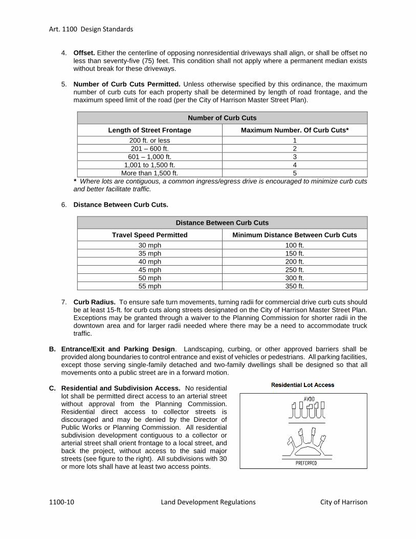
Art. 1100 Design Standards
1100-10 Land Development Regulations City of Harrison
4. Offset. Either the centerline of opposing nonresidential driveways shall align, or shall be offset no less than seventy-five (75) feet. This condition shall not apply where a permanent median exists without break for these driveways.
5. Number of Curb Cuts Permitted. Unless otherwise specified by this ordinance, the maximum number of curb cuts for each property shall be determined by length of road frontage, and the maximum speed limit of the road (per the City of Harrison Master Street Plan).
Number of Curb Cuts
Length of Street Frontage Maximum Number. Of Curb Cuts*
200 ft. or less 1
201 – 600 ft. 2
601 – 1,000 ft. 3
1,001 to 1,500 ft. 4
More than 1,500 ft. 5
* Where lots are contiguous, a common ingress/egress drive is encouraged to minimize curb cuts and better facilitate traffic.
6. Distance Between Curb Cuts.
Distance Between Curb Cuts
Travel Speed Permitted Minimum Distance Between Curb Cuts
30 mph 100 ft.
35 mph 150 ft.
40 mph 200 ft.
45 mph 250 ft.
50 mph 300 ft.
55 mph 350 ft.
7. Curb Radius. To ensure safe turn movements, turning radii for commercial drive curb cuts should
be at least 15-ft. for curb cuts along streets designated on the City of Harrison Master Street Plan. Exceptions may be granted through a waiver to the Planning Commission for shorter radii in the downtown area and for larger radii needed where there may be a need to accommodate truck traffic.
B. Entrance/Exit and Parking Design. Landscaping, curbing, or other approved barriers shall be
provided along boundaries to control entrance and exist of vehicles or pedestrians. All parking facilities, except those serving single-family detached and two-family dwellings shall be designed so that all movements onto a public street are in a forward motion.
C. Residential and Subdivision Access. No residential
lot shall be permitted direct access to an arterial street without approval from the Planning Commission. Residential direct access to collector streets is discouraged and may be denied by the Director of Public Works or Planning Commission. All residential subdivision development contiguous to a collector or arterial street shall orient frontage to a local street, and back the project, without access to the said major streets (see figure to the right). All subdivisions with 30 or more lots shall have at least two access points.
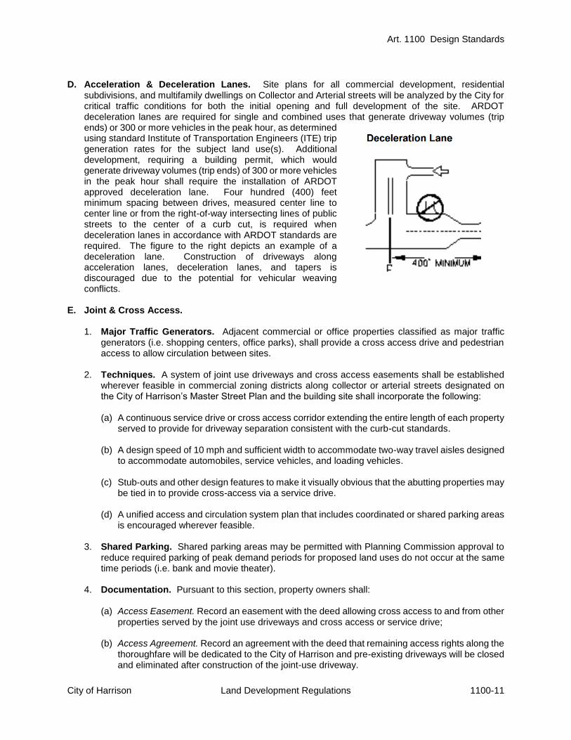
Art. 1100 Design Standards
City of Harrison Land Development Regulations 1100-11
D. Acceleration & Deceleration Lanes. Site plans for all commercial development, residential subdivisions, and multifamily dwellings on Collector and Arterial streets will be analyzed by the City for critical traffic conditions for both the initial opening and full development of the site. ARDOT deceleration lanes are required for single and combined uses that generate driveway volumes (trip ends) or 300 or more vehicles in the peak hour, as determined using standard Institute of Transportation Engineers (ITE) trip generation rates for the subject land use(s). Additional development, requiring a building permit, which would generate driveway volumes (trip ends) of 300 or more vehicles in the peak hour shall require the installation of ARDOT approved deceleration lane. Four hundred (400) feet minimum spacing between drives, measured center line to center line or from the right-of-way intersecting lines of public streets to the center of a curb cut, is required when deceleration lanes in accordance with ARDOT standards are required. The figure to the right depicts an example of a deceleration lane. Construction of driveways along acceleration lanes, deceleration lanes, and tapers is discouraged due to the potential for vehicular weaving conflicts.
E. Joint & Cross Access.
1. Major Traffic Generators. Adjacent commercial or office properties classified as major traffic generators (i.e. shopping centers, office parks), shall provide a cross access drive and pedestrian access to allow circulation between sites.
2. Techniques. A system of joint use driveways and cross access easements shall be established wherever feasible in commercial zoning districts along collector or arterial streets designated on the City of Harrison’s Master Street Plan and the building site shall incorporate the following: (a) A continuous service drive or cross access corridor extending the entire length of each property
served to provide for driveway separation consistent with the curb-cut standards. (b) A design speed of 10 mph and sufficient width to accommodate two-way travel aisles designed
to accommodate automobiles, service vehicles, and loading vehicles. (c) Stub-outs and other design features to make it visually obvious that the abutting properties may
be tied in to provide cross-access via a service drive. (d) A unified access and circulation system plan that includes coordinated or shared parking areas
is encouraged wherever feasible.
3. Shared Parking. Shared parking areas may be permitted with Planning Commission approval to reduce required parking of peak demand periods for proposed land uses do not occur at the same time periods (i.e. bank and movie theater).
4. Documentation. Pursuant to this section, property owners shall:
(a) Access Easement. Record an easement with the deed allowing cross access to and from other properties served by the joint use driveways and cross access or service drive;
(b) Access Agreement. Record an agreement with the deed that remaining access rights along the
thoroughfare will be dedicated to the City of Harrison and pre-existing driveways will be closed and eliminated after construction of the joint-use driveway.

Art. 1100 Design Standards
1100-12 Land Development Regulations City of Harrison
(c) Maintenance Agreement. Record a joint maintenance agreement with the deed defining maintenance responsibilities of property owners.
F. Reduction in Separation Distance. The Director of Public Works may reduce required separation
distance of access points where they prove impractical, provided all of the following requirements are met:
1. Joint access driveways and cross access easements are provided wherever feasible in accordance
with this section.
2. The site plan incorporates a unified access and circulation system in accordance with this section.
3. The property owner shall enter a written agreement with the City of Harrison, recorded with the deed, that pre-existing connections on the site will be closed and eliminated after construction of each side of the joint use driveway.
G. Waivers. The Director of Public Works or Planning Commission may modify or waive the requirements
of this section where the characteristics or layout of abutting properties would make development of a unified or shared access and circulation system impractical.
H. Nonconforming Access Features
1. Existing. Permitted access connections in place as of the date of the adoption of this ordinance
that do not conform with the standards herein shall be designated as nonconforming features and shall be brought into compliance with applicable standards under the following conditions:
(a) When new access connection permits are requested; (b) Substantial enlargements or improvements; (c) Significant change in trip generation; or (d) As roadway improvements allow.
SEC. 1100.10 DRIVEWAY AND PARKING LOT DESIGN A. Driveway Width. Commercial, industrial, and multi-family driveway widths shall meet the following
guidelines:
1. One-way in or out. If the driveway is a one-way in or one-way out drive, then the driveway shall
be a minimum width of 16 feet and shall have appropriate signage and pavement markings designating the driveway as a one-way connection.
2. Two-way. For two-way access, each lane shall have a width of 12 feet and a maximum of three lanes shall be allowed. Whenever more than two lanes are proposed, entrance and exit lanes shall be divided by a raised median. The median shall be four (4) feet wide and conform to ARDOT standard detail for curbed islands.
3. Arterials. Driveways that enter an arterial at traffic signals must have at least two (2) outbound
lanes (one for each turning direction) of at least 12 feet in width, and one in-bound lane with a 14 foot width.
B. Driveway Grades. Driveway grades shall conform to the recommendations of the Center for Urban
Transportation Research as shown in the table titled “Maximum Drive Grades.” Maximum grade changes between roadway cross-slope and driveway slope shall not exceed the grades listed below. The cross-slope of the driveway shall meet the cross-slope of the sidewalk, which shall have a slope of no more than 2%.

Art. 1100 Design Standards
City of Harrison Land Development Regulations 1100-13
Maximum Drive Grades
Roadway Driveway Grade
Arterial 5%
Collector 7%
Residential 10%
C. Sight Triangle. Driveway approaches must be designed
and located to provide an exiting vehicle with an unobstructed view. Any planting or structures in the site triangle must not exceed 30” in height as shown to the right.
D. Throat Length. The length of driveways or “Throat Length”
shall be designed in accordance with the anticipated storage length for entering and exiting vehicles to prevent vehicles from backing into the flow of traffic on the public street or causing unsafe conflicts with on-site circulation. General standards appear in the table below titled “Generally Adequate Driveway Throat Lengths”, but may vary according to the projected volume of the individual driveway. These measures generally are acceptable for the principle access to a property and are not intended for minor driveways. The figure titled “Driveway Throat Length,” depicts an example of adequate throat length. Variation from these shall be permitted for good cause upon approval of the Director of Public Works and/or Planning Commission.
Generally Adequate Driveway Throat Lengths
Development Type Driveway Throat
Length
Shopping Centers >200,000 GLA* (Signalized) (800 Spaces)
200 ft.
Smaller Developments <200,000 GLA* (Signalized)
75 ft. – 95 ft.
Unsignalized Driveways 40 ft. – 60 ft.
* GLA – Gross Lease-able Area E. Driveway Design, Location, and Construction Standards for Four (4) or Less Parking Spaces
within the Front Yard Area
1. Minimum Distance of Driveway and Parking from Street and into Property.
(a) Driveway Approach to Property Line. The driveway approach shall extend to the property
line and/or master street plan right-of-way from the paved street and shall be paved with concrete in accordance with the Standard Street Specifications.
(b) Driveways Beyond the Property Line. Except in A-1 Zoning Districts, all driveways shall be
paved from the property line and/or master street plan right-of-way with asphalt, concrete, brick or stone pavers, or other solid surface.
2. Driveway Grading and Drainage. The driveway shall be graded in such a way to dispose of
surface water into appropriate structures.

Art. 1100 Design Standards
1100-14 Land Development Regulations City of Harrison
F. Parking Lot Design. All parking lots shall be paced with asphalt, concrete brick or stone pavers, or
other hard surface (“chip-seal” is not allowed). All parking lots shall be designed and constructed with curbing and shall not be designed to allow parking on any street or highway right-of-way.
SEC. 1100.11 OUTDOOR LIGHTING A. Purpose and Intent. The regulations for outdoor lighting are intended to:
1. minimize light pollution for the enjoyment of Harrison citizens and visitors;
2. limit the degradation of the nighttime visual environment by production of unsightly and dangerous
glare;
3. minimize urban sky-glow to help protect the scenic view of the night sky;
4. reduce light trespass onto neighboring properties; and
5. allow for flexibility in the style of lighting fixtures. B. Applicability. The outdoor lighting regulations apply to:
1. All new construction, except single family and duplex residential uses.
2. All new outdoor lighting fixture installations, except single family and duplex residential uses.
3. All replacement fixtures, in cases of total replacement.
C. Exemptions. The following conditions are exempt from these requirements:
1. The temporary use of low wattage or low voltage lighting for public festivals, celebrations, and the
observance of holidays are exempt from regulation except where they create a hazard or nuisance from glare.
2. Temporary emergency lighting, used by police, firefighting or medical personnel for as long as the
emergency exists.
3. Routine maintenance, including changing the lamp ballast, starter, photo control, fixture housing, lens and other required components.
4. Airport lighting provided the owner or occupant demonstrates that the Federal Aviation
Administration (FAA) regulations can only be met through the use of lighting that does not comply with this code.
5. Neon lights only as permitted by the sign regulations.
6. Illuminated signs only as permitted by the sign regulations.
D. (VANCANT)
Art. 1100 Design Standards
City of Harrison Land Development Regulations 1100-15
E. Standards.
1. Cutoff Required. All nonexempt outdoor light fixtures with an initial output greater than or equal to
2,000 lumens shall be Cutoff or Full Cutoff, as defined by IESNA.
2. Installation. All outdoor light fixtures that have Cutoff restrictions shall be installed and maintained in such a manner as to be horizontal to the ground so that the Cutoff characteristics of the fixture are maintained.
3. Shielding. Beyond the Cutoff requirements in Section E.1 above, all light fixtures shall be located,
aimed or shielded so as to minimize light trespass across property boundaries. Where applicable, all commercial installations shall utilize house side shielding to minimize light trespass on residential properties.
F. Special Use Standards.
1. Landscape/Facade Lights. Landscape and facade lighting fixtures shall be selected, located,
aimed and shielded so that direct illumination is focused solely on the building façade, plantings, and other intended site feature, and away from adjoining properties and the public street right-of-way. Down-lighting is encouraged.
2. Recreational Facilities.
(a) Cutoff Exemption. Recreational facilities are exempt from the Cutoff requirement in E.1
above, however, the use of Cutoff fixtures is encouraged. The shielding requirement in E.3 above is applicable to recreational facilities.
(b) Glare Control. All outdoor recreational facilities lighting fixtures shall be equipped with a glare control package (louvers, shields, or similar devices). The fixture shall be aimed so that the beams are directed and fall within the primary playing or performance area.
(c) Hours. All activity and lights shall be turned off one hour after the end of the last event.
3. Canopy Structures. Canopy lights, such as service station lighting, shall be fully recessed or fully
shielded so as to ensure that no light source is visible from or causes glare on public rights of way or adjacent properties.
G. Nonconforming Outdoor Light Fixtures.
1. All nonconforming outdoor light fixtures lawfully installed prior to and operable on the effective date
of this ordinance are exempt from all outdoor lighting requirements.
2. In the event that an outdoor lighting fixture is abandoned or damaged to the point of requiring repairs for safe operation, the repaired or replacement fixture shall comply with the provisions these regulations.
SEC. 1100.12 (VACANT) SEC. 1100.13 DESIGN STANDARDS FOR LARGE SCALE DEVELOPMENTS A. Purpose and Intent. The design standards in this section are intended to implement the city’s vision
for commercial development. The intent of these standards is to improve the overall quality of commercial development with surrounding land uses and enhance pedestrian safety and walkability.

Art. 1100 Design Standards
1100-16 Land Development Regulations City of Harrison
B. Applicability. The provisions of this section shall apply to all developments requiring large scale development approval. Agriculture and Industrial Zoned properties shall only be required to meet the standards for the side(s) facing a street frontage.
C. (VACANT)
D. Review Process. These standards shall be applied in the normal review process for large scale developments and shall be approved by the Planning Commission.
E. Building Design.
1. Material. The primary material shall constitute at least 75 percent of the wall area, excluding glass.
The primary exterior material shall consist of a combination of brick, textured concrete block, natural stone, wood, stucco, or architectural concrete paneling/veneer. The standard shall apply to all sides of any building visible from the public realm. The remaining exterior material shall be considered building trim. Trim is defined as an ornamental design feature, that when removed does not significantly alter the appearance of the building. This commonly consists of moldings, cornices, parapet, frieze, sills, lintels, stringcourse, quoining, and ledgement. No masonite, asphaltic exterior wall or roof material, aluminum or steel siding, non-textured concrete block, vinyl or other similar materials shall constitute a portion of any building except trim.
2. Facades. All commercial structures shall be architecturally finished on all sides with same
materials, detailing, and features when visible from the public realm or adjacent residential areas. The degree of visibility from the public realm shall be evaluated using the following criteria: (a) The degree of visibility from all adjacent public ways; (b) Possible visibility from future buildings and public ways; and (c) Internal overall appearance in relation to the site.
3. Entrances. Each primary building on a site, regardless of size, shall have clearly defined, highly
visible customer entrances featuring no less than two (2) of the following:
(a) Canopies or porticos; (b) Overhangs; (c) Recesses/projections; (d) Arcades; (e) Raised corniced parapets over the door; (f) Peaked roof forms; (g) Arches; (h) Architectural detail such as tile work and moldings integrated into the building structure and
design; (i) Integral planters or wing walls that incorporate landscaped areas and/or places for sitting; or, (j) Other architectural features approved by Planning Commission.
4. Architectural Details. All buildings shall be designed to incorporate no less than three (3) of the
architectural elements from the list below, in addition to regulations regarding the design of entrances above. Buildings over fifty thousand (50,000) square feet shall include a minimum of five (5) of the referenced architectural elements. Buildings over one hundred thousand (100,000) square feet shall include a minimum of six (6) of the referenced architectural elements.
(a) Canopies, awnings, or porticos; (b) Recesses/projections; (c) Arcades; (d) Peaked roof forms; (e) Arches; (f) Display windows;

Art. 1100 Design Standards
City of Harrison Land Development Regulations 1100-17
(g) Accent materials (minimum of 15% of exterior façade); (h) Architectural details (such as tile work and moldings) integrated into the building façade; (i) Articulated cornice line; (j) Articulated ground floor levels or base; (k) Varied roof heights; or, (l) Other architectural features approved by Planning Commission.
F. Utility and Mechanical Equipment Screening
1. Screening of service yards, utility meters and hardware, mechanical equipment, refuse areas,
and/or other potentially unattractive places from public view, shall be accomplished by the use of walls, fencing, planting, or a combination of the measures that follow. Screening shall be equally effective in the winter and the summer seasons. For rooftop equipment, parapet walls or other screening methods approved by Planning Commission are required along street frontages and bordering residential areas.
(a) Adjusting the architectural or landscape profile to screen those elements from view. (b) Placing those elements on service courts or other locations usable by the general public. (c) Integrating those elements into the architecture or landscaping of the site.
2. The degree of visibility and screening of service yards, utility meters and hardware, mechanical
equipment, refuse areas, and/or other potentially unattractive places shall be evaluated using the following criteria:
(a) The degree of visibility from all adjacent public ways; (b) The architectural compatibility of the design and color of the yards, meters and equipment of
the building; (c) Possible visibility from future buildings and public ways; and (d) Internal overall appearance in relation to the site.
G. Site Planning
1. Building Placement. Place as much of the building width at the front of the lot as possible to
maximize front façade exposure to the public. The front façade shall be kept parallel with the street. On corner lots, place as much building mass near the intersection as possible to help anchor the lot and take advantage of high visibility.
2. Parking Placement. Whenever possible, attempt to link with adjacent parking lots or provide
shared parking areas which can serve neighboring buildings simultaneously. Parking lots shall be generally designed in regular, rectangular shapes. Parking lots shall be constructed with curbing.
3. Pedestrian Circulation. Clearly defined pedestrian walkways or paths shall be provided from public sidewalks to primary building entrances.
4. Site Amenities. Each commercial development is encouraged contribute to the establishment or
enhancement of the community and public spaces by providing at least two (2) of the amenities listed below. Any such areas shall have direct access to the public sidewalk network and such features shall not be constructed of materials that are inferior to the principal materials of the building and landscape.
(a) Patio, seating area; (b) Pedestrian plaza with benches; (c) Mini park, square or green;

Art. 1100 Design Standards
1100-18 Land Development Regulations City of Harrison
(d) Transit stop; (e) Public art; (f) Window shopping walkway; (g) Outdoor play area; (h) Kiosk area; (i) Water feature; (j) Clock tower or steeple; (k) Any other deliberately shaped area and/or focal feature that, in the Planning Commission’s
judgment adequately enhances such development and serves as a gathering place. SEC. 1100.14 ASTHETICS FOR WIRELESS COMMUNICATION FACILITIES The following guidelines shall govern the aesthetics of all towers and antennas, provided however, that the Community Development Director may waive these requirements where it is determined that the goals of this ordinance would be better served thereby.
A. Lighting. Lighting of tower and antenna shall meet the following requirements:
1. Towers shall be artificially illuminated if required by the FAA or other applicable authority or the
Governing Authority. If artificial lighting is required, the lighting design and intensity chosen should be that which complies with the applicable guidelines, yet causes the least disturbance to the surrounding and nearby properties.
2. Security lighting or motion-activated lighting may be used around the base of a tower and within the telecommunication facility, provided that the lighting is shielded in such a way that no light is directed towards adjacent properties or rights-or-way.
B. Stealth technologies. This ordinance encourages creative design measures to camouflage facilities
by integrating them with existing buildings and among other existing uses. Based on this, the color and design of towers and antennas shall meet the following requirements:
1. Towers shall be maintained with a galvanized steel finish, wood laminate or, subject to any
applicable FAA standards, be painted a neutral color so that visual obtrusiveness is minimized.
2. The design of buildings and related structures within a telecommunication facility shall, to the extent possible, utilize building materials, colors, screening, and landscaping that will camouflage and blend the tower and related facilities into the natural and/or surrounding environment.
3. If an antenna is to be attached to a supporting structure other than a tower, the antenna and
supporting electrical and mechanical equipment must be a color closely compatible with the color of the supporting structure.
SEC. 1100.15 DESIGN STANDARDS FOR C-1, CENTRAL BUSINESS DISTRICT A. Purpose and Intent. The design standards in this section are intended to implement the City’s vision
for the downtown area. The intent of these standards is to improve the overall quality of development and enhance pedestrian safety and walkability in the downtown area.
B. Applicability. The provisions of this section shall apply to all developments requiring large scale
development approval within the C-1, Central Business zoning district. C. Review Process. These standards shall be applied in the normal review process for large scale
developments and shall be approved by the Planning Commission.

Art. 1100 Design Standards
City of Harrison Land Development Regulations 1100-19
D. Building Design
1. Material. Minimum of two materials required.
Primary Material
Coverage 75% min. of façade, exclusive of windows
Permitted Brick, stone, manufactured stone, architectural steel, architectural concrete
Prohibited Aluminum, Vinyl, fiberglass
Secondary Material
Coverage 25% max. of façade, exclusive of windows
Permitted Tile, stone, glass block, copper flashing, metal and wood, EIFS
2. Compatibility. Structures shall be designed in a manner compatible with other structures in the
surrounding vicinity. The exterior building design, including roof style, color, materials, architectural form and detailing, shall be consistent with the character and historical period of the surrounding area.
3. Scale and Bulk. The height and scale of new buildings shall be consistent or compatible with the height and scale of adjacent buildings. Special care, however shall be taken to achieve the compatibility of larger buildings next to small scale buildings; techniques shall include limited size, building articulation, and shadow patterns. The scale of the building shall also consider building setback, lot size and relationship to street width.
4. Facades.
(a) Loading docks, overhead doors, and other service entries are prohibited on primary street-
facing facades.
5. Awnings/Canopies/Balconies.
Material Durable, protective, water repellant
Prohibited Plastic, aluminum, fiberglass, backlighting of awning.
6. Franchise Architecture. Franchise architecture (building design that is trademarked or identified
with a particular chain or corporation and is generic in nature) is prohibited. Franchises or national chains shall follow these standards to create a unique building this is compatible with the C-1, Central Business District.
E. Utility and Mechanical Equipment Screening Requirements. The Utility and Mechanical Equipment
Screening requirements in Sec. 1100.13 shall apply to the Central Business District.
F. Site Planning.
1. Building Placement.
Façade Built to Maximum Setback on Primary Street 80% minimum
Façade Built to Maximum Setback on Secondary Street
25% minimum
END OF ARTICLE 1100


Art. 1200 Offsite Improvements
City of Harrison Land Development Regulations 1200-1
ARTICLE 1200 OFF-SITE IMPROVEMENTS
SEC. 1200.1 GENERAL PROVISIONS A. Generally. The sub-divider / developer shall be required to install off-site improvements, where the
need for such improvements is created in whole or in part by the proposed subdivision or development, in accordance with Sec. 1200.2. For purposes of this section, an off-site improvement shall mean any improvement listed in these regulations which is to be installed on property located outside the proposed subdivision or development.
B. Installation. Any required off-site improvements shall be installed according to City standards; provided off-site improvements to roads located outside the City’s corporate limits but within the City’s planning area shall be installed to county standards.
C. Proportionate Share / Additional Off-site Improvements. The owner / developer shall be
responsible for the cost of off-site improvements deemed necessary by the Planning Commission and/or City to adequately service the proposed subdivision or development. Only the minimum necessary off-site improvements necessary to service the proposed subdivision or development will be required solely at the owner / developer’s expense. The City may, if deemed beneficial to the City, require additional (or larger scope) off-site improvements that would benefit more than only the proposed subdivision or development. The City shall be responsible for the added cost of additional (or expanded scope) off-site improvements beyond what is necessary to serve the proposed subdivision or development. The City and Owner/Developer shall enter into a cost sharing agreement for the proposed off-site improvements (subject to City Council approval).
The minimum necessary off-site improvements necessary shall be determined by engineer-of-record for a proposed sub-division or development, subject to review and approval from the Planning Commission and Director of Public Works.
SEC. 1200.2 DETERMINING NECESSITY FOR OFF-SITE IMPROVEMENTS A. Indirect Access to Substandard Streets. When a proposed subdivision has access to paved streets
or roads only by way of substandard or unimproved roads or streets leading from the subdivision to the paved streets or roads, the sub-divider / developer shall be responsible for the cost of improving the substandard access roads or street to existing City standards.
B. Direct Access to Substandard Streets. When a proposed subdivision has direct access to, or fronts on, an existing road or street which is below current standards, the sub-divider / developer shall be responsible for the cost of improving said street or road to existing City standards.
C. Off-site Drainage. Off-site drainage improvements shall be required whenever a proposed subdivision
or development causes the need for such improvements. The sub-divider / developer shall be responsible for the cost of necessary off-site drainage improvements.
D. Off-site Water and/or Sewer. Off-site water and/or sewer improvements shall be required whenever
a proposed subdivision or development causes the need for such improvements. The sub-divider / developer shall be responsible for the cost of necessary off-site water and/or sewer improvements.
SEC. 1200.3 WAIVERS A sub-divider may petition the Planning Commission for a waiver of off-site improvement requirements in whole or in part on one or more of the following grounds:

Art. 1200 Off-site Improvements
1200-2 Land Development Regulations City of Harrison
A. No plans for upgrading. The city has no plans for upgrading the substandard street or road on which off-site improvements are proposed to be required by the sub-divider/developer.
B. Primary access to improved streets. The proposed subdivision has primary access to improved
streets or roads and the portion of the subdivision which fronts on a substandard street or road is so small or remote from anticipated future traffic patterns as to cause an unfair imposition on the sub-divider/developer.
C. Alternate Off-site Improvements. The subdivider/developer proposes alternative off-site
improvements which will protect the health, safety and welfare of persons residing in the proposed subdivision and the surrounding area and equally benefit said persons.
SEC. 1200.4 PERFORMANCE GUARANTEES At or prior to the preconstruction conference with the City, the owner/developer shall provide to the Director of Public Works a performance guarantee for off-site improvements in compliance with Sec. 300.11.
END OF ARTICLE 1200

Art. 1300 (VACANT)
City of Harrison Land Development Regulations 1300-1
ARTICLE 1300 (VACANT)
Article 1300 has been left vacant and is reserved for future additions to the Land Development Regulations.
END OF ARTICLE 1300

Art. 1400 Landscaping, Screening and Buffering
City of Harrison Land Development Regulations 1400-1
ARTICLE 1400 LANDSCAPING, SCREENING, AND BUFFERING
SEC. 1400.1 INTENT AND PURPOSE It is the purpose of this article to establish regulations that pertain to landscaping within the City of Harrison, Arkansas. The goal is to promote the following: A. To enhance the visual appearance of the City of Harrison.
B. To enhance the quality of life of residents and encourage economic development within the City of
Harrison. C. To maintain and protect property value.
D. To improve air quality and minimize the urban heat island effect.
E. To screen automobiles and vehicular uses areas, dumpsters, loading areas and otherwise enhance the
appearance of public right-of-ways.
F. To break up large parking lots and other expanses of impervious surface.
G. To provide a transition between and improve the compatibility of abutting land uses.
H. To preserve, existing native vegetation, tree canopy and significant trees.
I. To promote energy efficiency and conservation in the site design, building construction, and
landscaping.
J. To serve as buffers that reduce wind, noise, and glare.
K. To reduce storm water runoff. SEC. 1400.2 APPLICABILITY The provisions of this Article apply in all development within the City of Harrison with the exception of single family detached and duplex residential development. SEC. 1400.3 GENERAL REQUIREMENTS A. Areas to be Landscaped. All areas not covered by structures, service yards, walkways, driveways,
patios, and parking spaces shall be landscaped.
B. Landscaping shall be provided which is sufficient to provide soil stability and suitable drainage. 1. Trees, shrubs, groundcover, and grass shall be planted with suitable plant materials.
2. Graded areas shall be re-vegetated to ensure erosion control by seeding, mulching, and fertilizing.
Disturbed areas shall be planted with suitable plant materials.
3. Landscape fabric or erosion blankets should be provided on slopes exceeding 50% while ground cover is being established.

Art. 1400 Landscaping, Screening, and Buffering
1400-2 Land Development Regulations City of Harrison
C. Maintenance of Landscaping. The current property owner shall properly maintain all required landscaping. 1. The property owner shall be responsible for maintain all landscaping within the boundaries of the
site so as to present a healthy, neat, and orderly appearance.
2. Any dead plant material shall be replaced in accordance with the approved landscaping plan.
3. Irrigation is encourage and may be required by the Planning Commission depending on the extent of the proposed development.
D. Native Species. The use of Native Species is encouraged in order to minimize watering. E. Prohibited Tree and Plant List. The following trees and plants are prohibited:
1. Autumn Olive 2. Bradford Pear 3. Common Privet 4. Empress Tree (Paulownia Tomentosa) 5. Garlic Mustard 6. Japanese Honeysuckle 7. Kudzu Vine 8. Lespedeza 9. Mimosa 10. Mulberry 11. Multiflora Rose 12. Purple Loosestrife 13. Shrub Honeysuckle 14. Siberian Elm 15. Silver Maple 16. Silver Popler 17. Tree of Heaven
F. Minimum Size. Immediately upon planting, trees and shrubs shall meet the following minimum
requirements as presented in the American Standard for Nursery Stock (ANSI Z60.1-2004):
Minimum Size
Shade Tree 2.5-inch caliper
Ornamental Tree 2-inch caliper
Ornamental Tree (Multi-trunk)
10-ft. to 12-ft. in height
Evergreen Tree 8-ft. in height
Flowering Perennials 1-gallon
Other Ground Cover 1-gallon
G. Utility Easements. The Harrison Department of
Public Works should be contacted for any plantings in utility easements.
H. Sight Distance. Safe sight distances at intersections and points of access shall be maintained. In
order to provide a reasonable degree of traffic visibility, landscaping, fences, and walls constructed near street intersections shall stay clear of the “sight distance triangle” shown to the above.

Art. 1400 Landscaping, Screening and Buffering
City of Harrison Land Development Regulations 1400-3
SEC. 1400.4 LANDSCAPE PLAN A. Standard.
1. The spacing of all trees and plants shall be designed to accommodate the mature height and width of the tree and plant.
2. If after a period of time, the owner wishes to renovate fifty percent (50%) or more of the total landscape areas or fifty percent (50%) or more of the total number of plants at an existing development, a new landscape plan that meets the current regulations of the Article shall be submitted to the Department of Public Works for an in-house administrative review.
B. Requirements. The landscape plan for any development shall show:
1. Existing Vegetation. Location, type, and quality of trees and other vegetation that will be protected and maintained as part of the proposed development.
2. Trees. Location of all trees to be planted and a tree list including the common name, scientific name, caliper size, height at maturity and quantity.
(a) Shade Trees. At time of planting, shade trees shall have a minimum caliper size of two-and-
a-half (2.5) inches. Caliper is defined as the measurement of the diameter of the trunk six (6) inches above ground level for trees up to four (4) inches in caliper size.
(b) Ornamental Trees. At time of planting, ornamental trees shall have a minimum caliper size of (2) inches. Caliper is defined as the measurement of the diameter of the trunk six (6) inches above ground level for trees up to four (4) inches in caliper size.
3. Plants. Location of all plants and a plant list including the common name, scientific name, size,
and quantity.
4. Flowering Perennials. At the time of planting, shrubs shall be a minimum of one (1) gallon size.
5. Shrubs. At the time of planting, shrubs shall be a minimum of three (3) gallon size and eighteen (18) inches in height.
6. Other Landscaping Improvements. Location of all other landscaping improvements including
benches, paving, screens, fountains, statues or other landscape features.
7. Sight Distances. The sight triangle, as described in Sec. 1400.3.H shall be indicated on the plan with a dimensional shaded area.
SEC. 1400.5 PRESERVATION A. Existing Vegetation. It is strongly encouraged that all landscaping plans attempt to incorporate
existing on-site landscape features and vegetation. B. Existing Trees. Where possible and reasonable, all existing mature, “significant” trees, rock
outcroppings, and riparian corridors shall be preserved and incorporated into landscaping plans. C. Credit for Existing Features. Where healthy plant material exists on the site prior to development
and the provision is made to preserve and incorporate that plant material on a permanent basis, then credit may be given against all pertinent city landscaping requirements, so long as the existing plant material meets the purpose and intent of said requirements.

Art. 1400 Landscaping, Screening, and Buffering
1400-4 Land Development Regulations City of Harrison
SEC. 1400.6 LANDSCAPING REQUIREMENTS A. Landscaping Standards Illustrated
A – Street Trees Site and regionally appropriate street trees required along abutting streets.
B – Street Tree Spacing Minimum 30-ft. tree spacing required.
C – Planting Strip Street Trees are planted in a continuous landscaping strip.
D – Planting Strip Width Minimum 4-ft. width (subject to Master Street Plan green space requirements)
E – Foundation Landscaping Plantings consisting of trees and shrubs required along base of structure and along non street facing sides when building is not built to the property lines.
F – Clear Sight Areas At street intersections and driveway entrances, safe sight distances shall be maintained. Refer to 1400.3.H, Sight Distance.

Art. 1400 Landscaping, Screening and Buffering
City of Harrison Land Development Regulations 1400-5
B. Foundation Landscaping. A landscaping strip around the base of structures should be planted with vegetation dense enough to sufficiently lessen the impact of an otherwise bulky appearance where a structure meets the ground. The landscaping strip shall be a minimum of four (4) feet wide on all sides of structures visible from abutting streets, driveways, and parking lots. Deviation from these standards may be allowed under special circumstances. Special circumstances that could justify deviation from standards include:
1. Conflict with utilities 2. Special security considerations 3. Preservation of significant trees or habitats 4. Traffic safety considerations
C. Site Perimeter Landscaping.
1. Street Fronting Property Lines. The perimeter of a site shall be landscaped to provide a buffer for adjacent uses as well as an attractive view from the street. Specific requirements are provided in 1400.6.A, Landscaping Standards Illustrated.
2. Non-Street Fronting Property Lines.
(a) A perimeter landscape strip at least five (5) feet shall be provided along all property lines
adjoining nonresidential areas. This provision is waived where neighboring structures adjoin (zero lot-line).
(b) A perimeter landscape strip at least twelve (12) feet in width shall be provided along all property lines adjoining any residential area or zone.
(c) There shall be one shade tree every thirty feet, one decorative tree every fifteen feet, or one
shrub every six feet along all boundaries of the site which do not abut streets. Up to 25% of these plantings may be grouped.
(d) Existing vegetation which meets, in whole or in part, the purposes of perimeter landscaping
described above may be applied toward these requirements. D. Sign Landscaping. There shall be a landscaped area around the base of all ground mounted signs
for the site regardless of being on premise or off-premise. The strip shall have a minimum width of four (4) feet. The sign landscaping strip should be increased in width and planting density as necessary to meet its intent, this is most often based upon the overall bulk and scale of the sign.
(REMAINDER OF PAGE INTENTIONALLY LEFT BLANK)

Art. 1400 Landscaping, Screening, and Buffering
1400-6 Land Development Regulations City of Harrison
SEC. 1400.7 PARKING LOT LANDSCAPING AND SCREENING A. Table of Required Parking Lot Landscaping Elements
A – Planting Buffer Minimum 12-ft. planting strip required around edges (site perimeter requirements still apply)
B – Row End Landscaped Islands Minimum 8-ft. wide landscaped island required at each end of every parking row.
C – Mid Row Planting Islands Minimum 8-ft. wide planting island required every 12 parking spaces
D – Shade Tree along Street Sides One (1) shade tree required every 30-ft. of street frontage
E – Shade Trees Minimum of one (1) shade tree required for every twelve (12) parking spaces.
F – Internal Landscape Buffer Internal 8-ft. (min.) landscaped buffer required every fourth row of cars at a minimum. Buffers that include a pedestrian walkway shall be a minimum of 10-ft. wide.
G - Screening Minimum 36-in. earthen berm, or evergreen vegetative screening along property line and residential areas/zones.
B. Parking areas and cars should not be dominant visual element of the site or streetscape. C. Trees shall be planted within the paved parking area so that each parking space is not more than 60
feet from the nearest tree. Perimeter trees may be used to satisfy this requirement. D. In parking lots with twenty four (24) spaces or more, no more than 12 continuous parking spaces are
permitted without a landscape island so as to provide a ratio of no less than one tree for each twelve (12) spaces throughout the lot.
1. A landscape island shall be provided at the end of each parking lot aisle.

Art. 1400 Landscaping, Screening and Buffering
City of Harrison Land Development Regulations 1400-7
2. Each island shall contain at least one tree. Each tree shall be maintained to provide a minimum vertical clearance of 8 feet.
3. All islands shall be a minimum of 150 square feet of unpaved landscaped area and a minimum of
8 feet in total width and a minimum length equal to the total length of abutting parking spaces.
4. All islands shall be sodded, seeded, or mulched. Applicants are required to plant additional shrubs, annuals, perennials, ornamental grass, and/or groundcover.
5. All islands shall be protected by a 6-inch concrete curb.
E. In addition to the above, parking lots with 200 or more parking spaces shall be divided by landscape
“buffer” areas to prevent large expanses of asphalt or concrete.
1. With the exception of driveways which may cross them, these areas shall extend the width or depth of the parking lot.
2. There shall be a minimum of one (1) landscape buffer every fourth row of parking.
3. The buffer shall be a minimum of 8-ft. wide. Buffers that include pedestrian walkways shall be a minimum of 10-ft. wide with a 2-ft. minimum landscaped (sodded, seeded, or mulched) strip on each side of the walkway.
F. Internal landscaping should be aligned to create green edges necessary to define access, circulation,
and parking areas. G. All parking lots shall be screened from adjacent residential properties or zones. Screening measures
shall be instituted with the measures below:
1. Any screening measure shall be a minimum of 36 inches above the average finish elevation of the adjacent streets, parking lots, and of the ground floors of all structures on the site.
2. Where earthen berms are used, they shall conform to the following: berms shall be gently rolling in nature and undulate so as to appear natural. If the berm does not reach the height needed for screening, then plantings may be included on top.
3. Where shrubs are used, they shall be evergreen in nature, be at least 30 inches tall at the time of
planting and be spaced so closely as to create a seamless row of hedging.
4. Where fences or walls are used, for screening purpose, they shall be constructed from a durable material and shall avoid a stockade appearance. Neither chain link fence with slats nor wooden fencing are acceptable for screening purposes. Screening shall not be implemented in a manner which impairs the sight line of drivers.
SEC. 1400.8 FENCE AND WALL REQUIREMENTS A. Applicability. The requirements of this section shall apply to the following conditions in all zoning
districts, except as exempted in B, Exemptions, below:
1. New Construction. Construction of a new fence or wall.
2. Extension. Extension of an existing fence or wall.
Art. 1400 Landscaping, Screening, and Buffering
1400-8 Land Development Regulations City of Harrison
3. Replacement. (a) Replacement of an existing fence or wall that is a different size, at a different location or of a
different material (i.e. a chain link fence being replaced by a wood privacy fence); or,
(b) Replacement of more than fifty percent (50%) of the linear length of an existing fence.
B. Exemptions. This section shall not apply to:
1. Replacement. Replacement of less than fifty percent (50%) of the linear length of an existing fence, except that the portion being replaced shall not: (a) Impede visibility at the sight triangle.
(b) Impede a natural drainage way.
(c) Be located in certain utility easements that required gated access.
(d) Encroach into neighboring property lines.
C. Fence Location.
1. Private Property. All fences and walls shall be located on private property and shall be built with the consent of the property owner. The installer and/or property owner shall be responsible for correctly locating all property lines. Fences and walls shall not encroach into any neighboring property lines.
2. Front Yard. A fence located in the front yard or positioned any closer to the front property line than the front surface of the building for a typical residential lot, shall not exceed three (3) feet in height. Decorative fencing is permitted.
3. Side Exterior Yard. A fence or wall located in the side exterior yard shall not exceed three (3) feet in height except as outlined in paragraph (a) below. Decorative fencing is permitted.
(a) If two corner lots have abutting rear property lines and side exterior yards along the same
street, a fence or wall located in the side exterior yard shall not exceed six (6) feet in height. Decorative fencing is permitted.
4. Side Interior Yard. A fence or wall located in the side interior yard shall not exceed six (6) feet in
height.
5. Rear Yard. A fence or wall located in the rear yard shall not exceed six (6) feet in height.
6. Adjacent to Public Right-of-Way. A fence or wall shall be placed no closer than five (5) feet to the current or proposed public right-of-way as prescribed within the Master Street Plan.
7. Sight Distances. Safe sight distances at intersections and points of access shall be maintained.
In order to provide a reasonable degree of traffic visibility, fences and walls constructed near street intersections shall stay clear of the “sight distance triangle” shown below.
8. Easements.
(a) Utility Easements. Walls used as fences and footings for retaining walls are prohibited in a
utility easement. Construction of all other fences in utility easements is permitted, but the fence installer and/or property owner assumes some risk by doing so. The fence enclosing utility easement(s) shall have a gate installed to permit access to the easement.

Art. 1400 Landscaping, Screening and Buffering
City of Harrison Land Development Regulations 1400-9
(b) Drainage Easements. Fences or walls shall not impede the normal flow of storm water and
shall not cross an open drainage channel. Fences or walls proposed in drainage easements shall be approved on a case by case basis.
(b) Access Easement. Fences or walls shall not be constructed over a public access easement.
Fences or walls proposed over private emergency access easements must be approved by the Fire Department to ensure adequate access for emergency vehicles and equipment at all times.
D. Design Standards. The following design standards shall apply to any new or replacements of any
fence or wall where the length of the replacement exceeds fifty percent (50%) of the length of the existing fence.
1. Height. Maximum height shall be six (6) feet above grade.
2. Finished Surface. Finished surface shall face outward from the property when visible from a
public right-of-way. Posts and support beams shall be inside the finished surface or designed to be an integral part of the finished surface.
3. Gates. All fence segments abutting a thoroughfare, except for corner lots, shall provide one gate opening per lot to allow access to the area between the fence and the street pavement for maintenance and mowing. An exception may be granted if the City receives a letter from the Home Owners Association stating that this area is maintained by the Association and not by individual homeowners. E. Fence Types.
1. Razor Wire. Razor wire is prohibited.
(a) Exception. Razor wire may be used as an anti-climbing deterrent in industrial zones, but shall not be placed within five (5) feet of the right-of-way of a public sidewalk or within five (5) feet of a street right-of-way where a public sidewalk does not exist.
2. Barbed Wire. Barbed wire is prohibited.
(a) Exception. Barbed wire is permitted in agricultural uses and may be used as an anti-climbing deterrent in industrial zones, but shall not be placed within five (5) feet of the right-of-way of a public sidewalk or within five (5) feet of a street right-of-way where a public sidewalk does not exist.
3. Electric Fences. Electric fences are prohibited.
(a) Exception. Electric fences are permitted in agricultural uses but shall not be placed within five
(5) feet of the right-of-way of a public sidewalk or within five (5) feet of a street right-ofway where a public sidewalk does not exist. Underground electric pet fences are permitted.
F. Pools and Spas. Outdoor pools, spas and hot tubs shall be protected by an enclosure designed to
restrict access by children. If a fence is intended to serve as the required enclosure, it shall meet the following requirements in addition to those that apply to a fence or wall.
1. Height. The minimum height of the fence enclosure shall be at least forty-eight (48) inches. The
maximum clearance between the bottom of the fence and the ground shall be two (2) inches. 2. Gates. Gates in the enclosing fence shall swing away from the pool/spa area and be designed to
be self-closing and self-latching. If the latch or latch release hardware is on the outside of the fence, it shall be at least fifty-four (54) inches above the ground. If the latch hardware is on the inside of

Art. 1400 Landscaping, Screening, and Buffering
1400-10 Land Development Regulations City of Harrison
the fence, it must be at least three (3) inches below the top of the fence and there shall not be any openings more than a half-inch in width within eighteen (18) inches of the latch. Gates more than five (5) feet in width and designed for equipment access to the fence area are not required to be self-closing or self-latching provided they are locked at all times except when needed for equipment access.
3. Design. The fence shall be designed so that there are no openings large enough to allow the
passage of a four (4) inch diameter sphere and so that no “ladder effect” is created on the outside. If a chain link fence material is used, the maximum size of the openings (i.e., the distance between parallel wires) shall not exceed one and a quarter (1¼) inches.
G. Detention/Retention Ponds. If a fence or wall is installed around a detention or retention pond with
permanent water two (2) feet deep or more, the fence or wall shall meet the requirements of F, Pools and Spas, above.
END OF ARTICLE 1400
Art. 1500 Flood Damage Prevention
City of Harrison Land Development Regulations 1500-1
ARTICLE 1500 FLOOD DAMAGE PREVENTION
SEC. 1500.1 INCLUSION BY REFERENCE City Ordinance No. 1326, titled “An Ordinance Providing for the Establishment of a Flood Damage Prevention Program for Harrison, Arkansas and other Purposes” is hereby included in these Land Development Regulations by reference and a copy of said ordinance is provided in Appendix A to these Regulations.
END OF ARTICLE 1500

Art. 1600 Street Naming
City of Harrison Land Development Regulations 1600-1
ARTICLE 1600 STREET NAMING
SEC. 1600.1 PURPOSE This article establishes a system for assigning street names which will assist the public and private sector in locating individual streets, buildings and places in an easy and logical manner and for the protection of public health and safety of all persons living, working or visiting in the City of Harrison. SEC. 1600.2 STREET NAMES A. Definition of Street. For the purpose of this article the word “street” shall mean all roadways, public
and private, open for general public travel. B. Street Names on Preliminary Plat. Street names shall be shown on the preliminary plat. The street
names shown on the final plat shall be consistent with those shown on the preliminary plat. C. Cul-de-sacs. Cul-de-sac streets which have only one entrance/exit shall not be called “avenue” or
“road” but shall have a suffix name such as “cove”, “lane”, “place” or “terrace” to indicate their dead-end nature.
D. Loop Streets. Loop streets are circular or rectangular plan streets which begin at one point and end at
another point along a common street and do not connect to any other streets. The street name suffixes on these streets must not be “road” or “avenue” but shall be “loop”, “circle”, or other name indicating a closed street layout.
E. Duplication. Street names shall not be duplicated and names with a similar pronunciation such as
Main/Maine shall be avoided. F. Name of Person. No street shall be named after a person’s first or last name, unless specifically
directed to do so by proclamation from the City Council in order to honor an individual. SEC. 1600.3 ADDRESS NUMBERS A. Final Plats. All Final Plats shall be preaddressed. Large Scale Developments with more than one suite
shall be addressed by the lot’s common address along with the individual suite number. Suite numbers will be assigned at time of tenant infill. (i.e. 1300 Main Street, Suite 1, Suite 2 etc.).
B. Numbering. Owners/Developers shall obtain address numbers from the Boone County 911 Office. C. Corner Lots. Structures on corner lots shall not be given dual addresses. The structure on a corner
lot shall be addressed off of the street where the front entrance is located. If the structure appears to have more than one front entrance, then the structure shall be addressed off of the street with the longest frontage.
D. Townhouse. Each unit within a townhouse development which is on an individual lot shall have a
separate address number and not a unit number.
END OF ARTICLE 1600