of rock and surrounding areas, - university of texas at austin
TRANSCRIPT
Bedrock Geology of Round Rock and Surrounding Areas, Williamson and Travis Counties, Texas
Todd B. Housh

Bedrock Geology of Round Rock and Surrounding Areas, Williamson and Travis Counties, Texas
Todd B. Housh
Copyright 2007 Todd B Housh, PhD, PG Round Rock, TX 78664
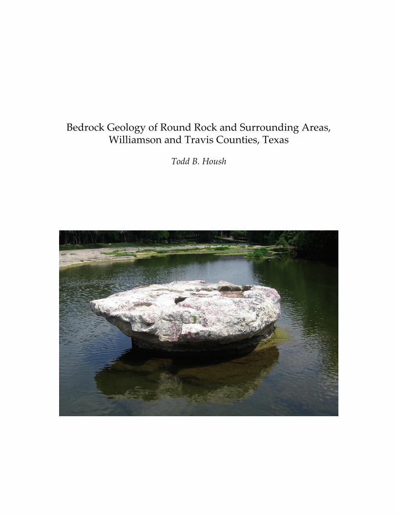
Cover photograph: The “Round Rock,” an erosional pedestal of Edward’s limestone that marked the low‐water crossing of Brushy Creek by the Chisholm Trail.

2
3
Table of Contents
Introduction 5 Tectonic History 6 Previous Studies 8 Other Geologic Constraints 9 Stratigraphy 9
Comanche Series Fredericksburg Group
Walnut Formation 10 Comanche Peak 10 Edwards 12 Kiamichi 13
Washita Group Georgetown 14
Del Rio 15 Buda 16
Gulf Series Woodbine Group
Pepper 16 Eagle Ford Group 17 Austin Group 19 Taylor Group 21
Tertiary and Quaternary Systems Plio‐Pleistocene to Recent 22 Structure 23 Acknowledgements 27 Bibliography 28 Appendix 1. Compilation of sources of other geologic information. 34 Appendix 2. Localities of note to observe important geologic 40 features in the Round Rock Area. Appendix 3. Checklist of Cretaceous and Pleistocene fossils 45

4
5
Bedrock Geology of Round Rock and Surrounding Areas, Williamson and Travis Counties, Texas
Todd B. Housh
Introduction
The purpose of this study was to produce a map of the bedrock geology of the city of Round Rock, Texas and its environs and to evaluate the geologic structure of the area. Most of the City of Round Rock lies within the Round Rock 7.5 minute quadrangle, Williamson County, Texas1, although parts of the city also lie within the Pflugerville West 7.5 minute quadrangle, Travis County, Texas2 and the Hutto 7.5 minute quadrangle, Williamson County, Texas3. Part of the Pflugerville East 7.5 minute quadrangle, Travis County, Texas4 was included in this study as well. The full extent of the area mapped in this study is bounded by latitudes 30° 27’ 30” and 30° 37’ 30”, and longitudes 97° 32’ 30” and 97° 45’. Round Rock sits astride the break between the Grand and Black prairies (Hill, 1901). The Black Prairie owes its name to the thick black calcareous soils which cover the Late Cretaceous shales, marls and chalks that underlie the prairie. The Grand Prairie, on the other hand, is a northern extension of the Edwards Plateau, and is characterized by thin, rocky soils overlying Lower Cretaceous limestone, dolomitic limestone, marl and chert. The Round Rock area is bisected by the Balcones Fault Zone, a series of generally down‐to‐the‐east normal faults which juxtapose Lower Cretaceous rocks to the west against Upper Cretaceous Rocks to the east. This juxtaposition of two very different sequences of rocks is ultimately responsible for the development of the two very different geographic provinces upon them. Prior to the urbanization of the Round Rock area, the Black Prairie was a region of extensive row agriculture of crops such as cotton, corn, oats and grain sorghums. The carbonate rocks of the Grand Prairie supported a dense growth of live oak, post oak, hackberry, pecan, short grasses, mesquite and cedar. This thick vegetation and the thin soil generally favored the use of this area for grazing as opposed to row crops.
Outcrop within the Round Rock area is, in general, poor, especially in the eastern half of the map area where extensive alluvial deposits, formed on a number of different terrace levels, and thick soils effectively obscure much of the 1 Reston, Virginia: United States Geologic Survey, 1987, scale 1:24,000 2 Ibid. 3 Ibid. 4 Ibid.
6
bedrock geology. As a result, much geologic information was gained from the inspection of trenches and other excavations associated with construction and utility projects between 1997 and 2006. These “outcrops” are ephemeral by their very nature. Outcrop is generally better in the western half of the quadrangle, the footwall side of the Balcones Fault Zone, where Lower Cretaceous carbonate formations are covered by only a thin soil. For the most part the Round Rock area lies within the drainages of the San Gabriel River and Brushy Creek, which joins the San Gabriel River farther downstream and eventually flows into the Brazos River. Terrace and alluvial deposits are extensive and thick within the valleys of both of these rivers and their tributaries; the terrace deposits may even be found at high elevations on the divides in the region where they blanket the landscape. The terrace deposits coupled with the thick soils of the eastern, or Black Prairie, region combines to effectively obscure much of the bedrock strata and geologic relationships.
Inspection of the existing maps of the Round Rock area and comparison of what can be seen and inferred regarding the relative elevations of strata versus geologic structures as shown indicates that the current structural understanding of the area is deficient. The purpose of this study is to delineate the bedrock geology of the Round Rock area in order to better elucidate the structural geology of the region. To that end, Tertiary and Quaternary terrace and alluvial deposits have been treated as something to “see through” in the production of this map. These deposits are already dealt with in existing maps of the area, and the interested reader is referred to them for further information (Marks, 1950; Walls, 1950; Gordon, 1951; Tydlaska, 1951).
A structure contour map and perspective block diagram of the elevation of the top of the Edwards Formation was prepared from logs from water wells drilled in the area. The structure contour map further constrains the faulting in the map area and the degree of offset along these faults. Tectonic History
Geophysical studies indicate that Williamson County lies near the
outboard edge of Laurentian continental crust (Kruger and Keller, 1986; Keller, et al., 1989; Sims et al., 2005). The transition from extended continental crust to noncontinental crust is marked by an abrupt linear gravity maximum coincident with a series of magnetic highs (Keller, et al., 1989). This isostatic gravity anomaly maximum and a series of aeromagnetic highs pass through the western parts of Bastrop, Lee and Milam counties (Bankey, 2007). The Laurentian basement underlying the county is believed to be a part of the Llano Terrane, a Mid‐Proterozoic high‐grade orogenic belt that occupies the southeastern half of
7
the state of Texas; ages from the nearby Llano uplift range between 1098 and 1360 Ma (Mosher, 1998). In Cambrian time the southeastern margin of Laurentia rifted away (Arbenz, 1989) and a Cambro‐Ordivician carbonate platform developed on top of the extended Llano crust, with sporadic carbonate and fine‐grained clastic sedimentation until the Late Devonian (Nicholas and Waddell, 1989).
Williamson County lies along the suture between Laurentia and the tectonic plate with which it collided during the Ouachita Orogeny in the Late Paleozoic. All of Williamson County, except the southeast corner, is underlain by rocks of the Ouachita Frontal Zone; whereas the southeast corner is underlain by rocks of the Ouachita Interior Zone (Flawn et al., 1961; Ewing, 1991). The Frontal Zone comprises a belt of thin‐skinned, northwestward directed thrusting of weakly metamorphosed to unmetamorphosed Lower Paleozoic basinal strata over the cratonal margin of Laurentia. By contrast, the Interior Zone consists of strongly deformed and weakly metamorphosed schist, phyllite, metaquartzite and marble of unknown age and affiliation that have been thrust over the Ouachita facies rocks of the Frontal Zone (Flawn et al., 1961; Ewing, 1991). The depth to upper Paleozoic rocks of the Ouachita Orogenic Belt varies tremendously in Williamson County, from a depth of approximately 695 feet in the northwestern corner of the county to 2850 feet or more in the southeast corner of the county (Flawn et al., 1961).
In contrast to the linear gravity maximum to the east of the Round Rock area that delimits the transition off Laurentian continental crust, the Round Rock area lies within a low in the isostatic gravity anomaly data (Bankey, 2007). This gravity low is often attributed to foreland basins that may, or may not, be overridden by Ouachita thrusts (Keller, et al., 1989). Although the isostatic gravity anomaly in the Round Rock area is less than that of the gravity high to the east, it likewise sits upon a local saddle between two profound gravity lows to the north and the south, which are parts of the Paleozoic Fort Worth Basin and the northern extension of the Kerr Basin, respectively (Meckel, et al., 1992).
Extension along the southern margin of North America began in the Triassic, culminating in the Jurassic with rifting and the formation of the Gulf of Mexico basin. The hinge point of extension in east Texas corresponds to the now buried Stuart City Reef trend, marking the edge of the Lower Cretaceous shelf margin. Crust to the west of the shelf margin is only slightly to unextended, whereas crust to the east of the shelf margin is moderately to highly extended (Sawyer, et al., 1991). Central Texas was intermittently covered by shallow seas during the Cretaceous resulting in thick accumulations of carbonate rocks and associated marls and shales, particularly during the Lower and Upper
8
Cretaceous. These Cretaceous rocks constitute the bedrock geology that is the focus of this report.
The tectonic development of the region during the Tertiary is dominated by down to the east normal faulting associated with the Balcones Fault Zone, an arcuate belt of normal faults extending from Del Rio towards Dallas (e.g. Ewing, 1990). Most of the movement along faults within the Balcones Fault Zone is believed to have occurred in the late Oligocene or early Miocene (Weeks, 1945), although some arguments have been made for both earlier, Late Cretaceous, and later, Pliocene, movements along the Balcones Fault Zone in addition.
Previous Studies
The earliest geologic maps of the central Texas region that included the Round Rock area were small‐scale maps published by J.A. Taff (1892) and the seminal work of Robert T. Hill (1901). Both of these studies were regional in nature. It was not until the middle of the twentieth‐century when the Round Rock area was mapped in greater detail by a number of students completing M.A. theses at The University of Texas as well as by two University of Texas faculty: Drs. Francis L. Whitney and Keith Young. The area encompassed by the Round Rock 7.5 minute quadrangle is all, or in part, within the areas studied in the following publications: Walls (1950), Ward (1950), Tydlaska (1951), Atchison (1954), Whitney and Young (1959a), Rogers (1963), Collins (1997). Surrounding areas included in this map have been studied by: Marks (1950), Gordon (1951), Rogers (1963), Whitney and Young (1959b), Garner and Young (1976). Modern, smaller‐scale compilations that cover the area include the geologic atlas of Texas (Barnes, 1974) and Collins (2005); it should also be noted that Collins’ map (1997) was produced at a scale of 1:24,000. The maps of J.A. Taff, Robert T. Hill, Francis L. Whitney, Keith Young and students working on M.A. theses in this area are largely original works of geologic mapping. In contrast, many of the later maps, including this map, are highly dependent upon the observations recorded by previous workers. A partial list of other notable studies relevant to the geology of the Round Rock quadrangle and surrounding areas that do not necessarily include maps also include Sellards (1931), who provided an early description of both the terrace deposits of Brushy Creek and of the early occurrence of man in the Round Rock area; Moreman (1942) and Adkins and Lozo (1951), who did much to unravel the complexities of the relationship of the Eagle Ford Group in central Texas to the much thicker and better understood equivalent section in northern Texas. Finally, the many studies by Keith Young (see bibliography) have played a monumental role in understanding the stratigraphy of not just Williamson
9
County, but aspects of the stratigraphy of the entire western Gulf of Mexico basin. Note: the voluminous literature concerning the Edwards aquifer is not included in this list, it may easily be found elsewhere (e.g., Esquilin, 2006). Other Geologic Constraints
There are two other important sources of information on the distribution of geologic units within this map area. These were of particular value in the eastern half of the map area where outcrop is relatively sparse due to the thick soils and alluvial deposits in this area. The first of these sources are water well drillersʹ logs. Water well information is recorded with the State of Texas, and was accessed through the Texas Water Development Board Groundwater Database (http://wiid.twdb.state.tx.us/). Not all water well records from within the area were useful as they do not all contain a driller’s log of the formations or lithologies encountered during the drilling of the well. Seventy‐seven well records containing drillersʹ logs were used in this study. Most of these wells are within the area of interest, although a few of the wells are outside of the area and provide addition control of elevation. Also available through the Texas Water Development Board are “Submitted Driller’s Reports.” Twenty‐three “submitted driller’s reports” within the area of interest were also used. A list of the well records consulted can be found in Appendix 1.
A second, critical source of information on the nature of buried bedrock were records of borings taken for geotechnical reports prepared for the development of residential subdivisions and public utility facilities within the region. Logs of these borings, which reached depths between a couple of feet to sixty feet, are typically given in these reports. Reports for areas within the City of Round Rock are on file with the cityʹs Department of Public Works; the existence or preservation of these reports is variable, with generally better coverage for the newer subdivisions. Important information was also gleaned from geotechnical reports on wastewater lines along Brushy, Lake and Chandler Creeks; these reports are on file with the Lower Colorado River Authority. Data from sixty‐eight geotechnical reports from twenty‐two subdivisions and facilities have been consulted during the generation of this map. A list of the geotechnical reports consulted can be found in Appendix 1. Stratigraphy Rocks of the Comanche (Lower Cretaceous) and Gulf (Upper Cretaceous) Series of the Cretaceous System, and terrace deposits of Pleistocene and Recent age are present within the map area. The Comanche Series comprises the
10
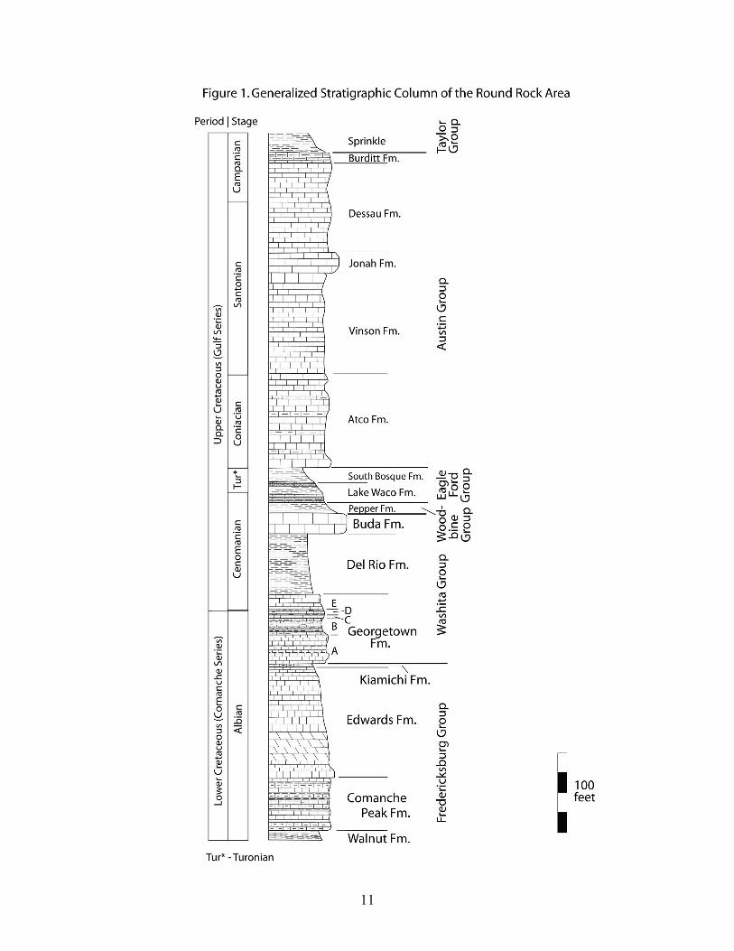
Trinity, Fredericksburg and Washita Groups. The Trinity Group does not crop out in the map area. The Fredericksburg Group includes the Walnut, Comanche Peak, Edwards, and Kiamichi formations in ascending order, while the Washita Group Comprises the Georgetown, Del Rio and Buda formations in ascending order. Fredericksburg rocks belong to the Middle to Upper Albian stages, whereas Washita rocks belong to the Upper Albian and Lower Cenomanian stages. The overlying Gulf Series comprises the Woodbine, Eagle Ford, Austin and Taylor groups in ascending order in the map area, as well as the overlying Navarro Group to the east of the map area. Rocks of the Woodbine Group belong to the Lower to Middle Cenomanian stages, whereas rocks of the Eagle Ford Group belong to the Middle Cenomanian to Upper Turonian stages. Rocks of the Austin group belong to the Coniacian and Santonian stages. And finally, rocks of the Taylor Group belong to the Campanian Stage. A generalized stratigraphic column is presented in Figure 1.
Comanche Series
Fredericksburg Group Walnut Formation The Walnut Formation consists of 70 to 80 feet of marly limestone alternating with harder more crystalline limestone and limy clay in Travis County (Young, 1977). In the map area the Walnut Formation is restricted to the western portion of the South Fork of the San Gabriel River where it is found in the river bed (Ward, 1950). The Walnut Formation is conformably overlain by the Comanche Peak Formation, which is gradational into it. Following Ward (1950), the contact between the Walnut and Comanche Peak formations was placed at the horizon where the lithology changed vertically from the clays of the Walnut Formation to the alternating layers of nodular limestone and shales of the Comanche Peak Formation. The thickness of the Walnut Formation in the map area is unknown. A compilation of the paleontology of the Walnut Formation in the Round Rock area is presented in Appendix 2. Comanche Peak Formation. Shumard (1860) first named the Comanche Peak Formation for exposures at Comanche Peak, Hood County, Texas. He also correctly placed the Comanche Peak below the Edwards Formation, but incorrectly placed it above the Austin chalk. The Comanche Peak Formation crops out along the banks of the South Fork of the San Gabriel River and along Brushy Creek in the western part of the
11
12
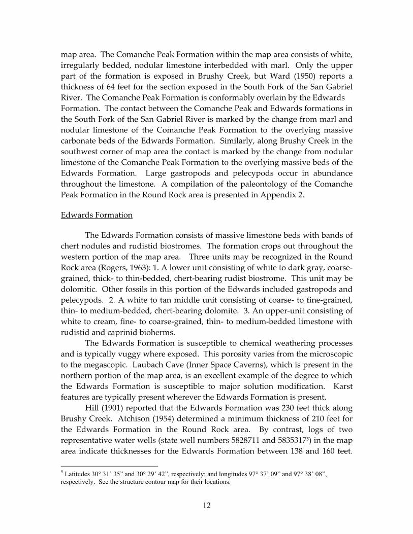
map area. The Comanche Peak Formation within the map area consists of white, irregularly bedded, nodular limestone interbedded with marl. Only the upper part of the formation is exposed in Brushy Creek, but Ward (1950) reports a thickness of 64 feet for the section exposed in the South Fork of the San Gabriel River. The Comanche Peak Formation is conformably overlain by the Edwards Formation. The contact between the Comanche Peak and Edwards formations in the South Fork of the San Gabriel River is marked by the change from marl and nodular limestone of the Comanche Peak Formation to the overlying massive carbonate beds of the Edwards Formation. Similarly, along Brushy Creek in the southwest corner of map area the contact is marked by the change from nodular limestone of the Comanche Peak Formation to the overlying massive beds of the Edwards Formation. Large gastropods and pelecypods occur in abundance throughout the limestone. A compilation of the paleontology of the Comanche Peak Formation in the Round Rock area is presented in Appendix 2. Edwards Formation The Edwards Formation consists of massive limestone beds with bands of chert nodules and rudistid biostromes. The formation crops out throughout the western portion of the map area. Three units may be recognized in the Round Rock area (Rogers, 1963): 1. A lower unit consisting of white to dark gray, coarse‐grained, thick‐ to thin‐bedded, chert‐bearing rudist biostrome. This unit may be dolomitic. Other fossils in this portion of the Edwards included gastropods and pelecypods. 2. A white to tan middle unit consisting of coarse‐ to fine‐grained, thin‐ to medium‐bedded, chert‐bearing dolomite. 3. An upper‐unit consisting of white to cream, fine‐ to coarse‐grained, thin‐ to medium‐bedded limestone with rudistid and caprinid bioherms. The Edwards Formation is susceptible to chemical weathering processes and is typically vuggy where exposed. This porosity varies from the microscopic to the megascopic. Laubach Cave (Inner Space Caverns), which is present in the northern portion of the map area, is an excellent example of the degree to which the Edwards Formation is susceptible to major solution modification. Karst features are typically present wherever the Edwards Formation is present. Hill (1901) reported that the Edwards Formation was 230 feet thick along Brushy Creek. Atchison (1954) determined a minimum thickness of 210 feet for the Edwards Formation in the Round Rock area. By contrast, logs of two representative water wells (state well numbers 5828711 and 58353175) in the map area indicate thicknesses for the Edwards Formation between 138 and 160 feet.
5 Latitudes 30° 31’ 35” and 30° 29’ 42”, respectively; and longitudes 97° 37’ 09” and 97° 38’ 08”, respectively. See the structure contour map for their locations.
13
These values are consistent with a thickness for the Edwards Formation of 125 feet reported near the North Fork of the San Gabriel River in Georgetown (Bebout, 1985). The Edwards Formation conformably overlies the Comanche Peak Formation and is unconformably overlain by the rocks of the Kiamichi and Georgetown Formations. A compilation of the paleontology of the Edwards Formation in the Round Rock area is presented in Appendix 2.
The rocks of the Edwards Formation were deposited in a variety of carbonate environments on an extensive, shallow‐water, medium‐ to high‐energy, marine platform: reef, lagoonal, shoal, basinal, and supratidal. The Edwards Formation is characterized by carbonate grainstone and rudist bioherms and biostromes; periodic restriction led to the deposition of intertidal facies rocks and evaporates (Fisher and Rodda, 1969; Fisher, 1977). Dolomitization and the presence of chert nodules are locally important in the section. Kiamichi Formation The Kiamichi Formation is the uppermost member of the Frederick Group. It has a thickness of 40 feet along the Red River, but pinches out to the south (Hill, 1901). In the Round Rock area it has a thickness around 4 feet, and is not present in the Austin area. The Kiamichi Formation is a light brown to gray, indistinctly bedded, argillaceous limestone.
The Kiamichi unconformably overlies the Edwards Formation; the nature of the contact with the Georgetown Formation is indistinct, and it has been suggested that it may be transitional (e.g., Feray, 1949). The Kiamichi Formation, however, is not everywhere present between the Edwards and Georgetown formations in the Round Rock area, indicating that there is, nonetheless, an unconformity between the Fredericksburg and Washita groups in the Round Rock area (Atchison, 1954). In central Texas the Kiamichi Formation thins and disappears over the San Marcos Arch (a southeastward plunging feature from the Llano uplift through Comal County; the northern limit of the arch is in southern Travis County) and the Belton High (a broad paleotopographic high in northern Williamson and Bell counties). The Kiamichi Formation is found in the Round Rock Syncline, the intervening paleotopographic low between the San Marcos Arch and the Belton High (Wilbert, 1966). Because of its thinness, the map combines the Kiamichi with the Edwards Formation for mapping purposes. The best site to see the Kiamichi Formation is along the bluff on the south side of Brushy Creek at Veterans Park in Round Rock (Atchison, 1954). The Kiamichi Formation is characterized by the presence of oxytopidoceroid ammonites; a
14
compilation of the paleontology of the Kiamichi Formation in the Round Rock area is presented in Appendix 2.
Comanche Series Washita Group
Georgetown Formation
This formation was first described by Shumard (1860). Hill and Vaughan (1898) applied the name Fort Worth Limestone to a section of rocks in the Fort Worth area that contains a similar fauna to that described by Shumard. The name, Georgetown Formation, was applied by Hill (1901) to strata exposed along the San Gabriel River east of Georgetown. Cuyler (1930) first attempted to correlate the Georgetown Formation of central Texas with formations in north Texas. The Georgetown Formation unconformably overlies formations of the Fredericksburg Group and is conformably overlain by the Del Rio Formation (Atchison, 1954).
The Georgetown Formation in Williamson County has been zoned by Walls (1950), who divided the formation into members on the basis of lithology and selected guide fossils for each member (Table 1). In the Round Rock area, Member A consists of 23 feet of thick‐bedded nodular limestone; Member B consists of 25 feet of interbedded chalky, argillaceous limestone and light gray to buff shale; Member C is a 5 foot Texigryphaea washitaensis (Hill) agglomerate; Member D consists of 10 feet of interbedded, thin, chalky limestone and light gray marl; and Member E consists of 20 feet of light gray, hard, crystalline, thin‐bedded limestone (Atchison, 1954). These members have been correlated with the recognized members of the thicker, north Texas section by Wilbert (1966): Members A, B, C, D, and E were correlated with the Duck Creek, Fort Worth, Denton, Weno and Paw Paw members, respectively. The zones A through E are included on this map where they have already been mapped, otherwise the Georgetown Formation is simply mapped as an undivided unit (Kgt). The aggregate thickness of the Georgetown formation is around 83 feet in the Round Rock area. This value is consistent with thicknesses of 87 and 90 feet reported in logs of two representative water wells (state well numbers 5828711 and 58353176) in the map area. A compilation of the paleontology of the Georgetown Formation in the Round Rock area is presented in Appendix 2.
The abundance of shallow‐water fossils (oysters, various species of ammonites) is consistent with the deposition of the Georgetown Formation in a
6 Op cit.
15
number of open‐shelf, subtidal environments, which are primarily differentiated by the faunas that occupied these environments (Wilbert, 1966; Young, 1977).
Table 1 Characteristic Fossils of the Members of the Georgetown Formation (Atchison, 1954)
Member A:
Idiohamites fremonti (Marcou, 1858) Eopachydiscus marcianus (Shumard, 1854) Mortoniceras aff. trinodesum (Böse)
Member B: Prohysteroceras austinense (Roemer) Mortoniceras (Leonites) maximum (Lasswitz) Amphidonte walkeri (White)
Member C: Texigryphaea washitaensis (Hill)
Member D: Mortoniceras (Angolaites) wintoni (Adkins, 1920)
Member E: Mariella (Wintonia) brazoensis (Roemer, 1849) Del Rio Formation Hill and Vaughan (1898) originally applied the name Del Rio to the southern extension of the Grayson Formation. The Del Rio Formation is a greenish‐gray to tan, soft, plastic, laminated and gypsiferous mudstone or shale. Adkins (1933) pointed out that the lower half is typified by numerous individuals of Ilygmatogyra arietina (Roemer) and the upper half contains many Texigryphaea graysonana Staton.
South of Georgetown, the Del Rio conformably underlies the Buda Formation, whereas farther north the Buda Formation pinches out and the Del Rio Formation unconformably underlies the Woodbine Group (Atchison, 1954). Atchison reports a thickness of 70 feet for the Del Rio Formation in the Round Rock area. This value is consistent with values of 75 and 73 feet reported in logs of two representative water wells (state well numbers 5828711 and 58353177, respectively) in the map area. A compilation of the paleontology of the Del Rio Formation in the Round Rock area is presented in Appendix 2.
7 Op cit.
16
The Del Rio Formation contains many very small species, and lacks a normal bottom assemblage. It has therefore been interpreted to have been deposited in a lagoon with abnormal bottom conditions; this is suggested by the large amounts of pyrite as well (Young, 1977). Buda Formation This formation was first named by Hill (1889) for exposures along Shoal Creek in Austin. The Buda limestone crops out continuously across the Brushy Creek Quadrangle (mapped by Atchison, 1954), but it thins to the north and occurs intermittently north of Georgetown. The northern extent of the Buda Formation is in McLennan County (Adkins, 1933).
The Buda Formation is a tan to brown, very hard, medium‐ to massive‐bedded, coarse‐grained, slightly glauconitic crystalline limestone. Atchison (1954) reports a section of Buda Formation greater than 27 feet thick near the southern boundary of the map area, while Tydlaska (1951) reported a 35 foot thick section along Brushy Creek. Near the northern end of the map area, Atchison (1954) reports a thickness for the Buda Formation of only 19.5 feet. These values are consistent with thicknesses of 25 and 27 feet reported in logs of two representative water wells in the map area (state well numbers 5828711 and 58353178, respectively). Abundant pelecypods are characteristic of this formation, especially the large scallop Neithea roemeri (Hill). A compilation of the paleontology of the Buda Formation in the Round Rock area is presented in Appendix 2.
The Buda Formation in central Texas represents shallow subtidal and intertidal deposits on a shallow marine shelf. The basal limestone represents a shoal that transgressed across the Del Rio Formation, scouring its top. The remainder of the Buda consists of shallow subtidal storm deposits (Young, 1977). The top of the Buda, likewise, represents a submarine discontinuity (Reaser and Dawson, 1995).
Gulf Series
Woodbine Group Pepper Formation The Pepper Formation was first described by Adkins and Arick (1930) in Bell County, and later named by Adkins (1933). The Pepper Formation is poorly
8 Op cit.
17
exposed in the map area, but it consists of dark gray to black, fissile, noncalcareous, gypsiferous shale. Selenite crystals are common along shale partings. The Pepper Formation unconformably overlies the Buda Formation, and the upper contact with the Eagle Ford Group has been reported to be unconformable as well (Adkins and Lozo, 1951). Because of its poor exposure and the thin section of the Pepper Formation in the map area, it has been combined with the Eagle Ford Group as a map unit following Rogers (Atchison, 1954 and Rogers, 1963). Tydklaska (1951) reports a thickness of 13 feet for the Pepper Formation in the Round Rock area. A compilation of the paleontology of the Pepper Formation in the Round Rock area is presented in Appendix 2.
The Pepper Shale appears to have been deposited in a very peculiar environment in central Texas; there is no silt, all of the mollusks are extremely thin‐shelled and appear to be mud burrowers, and there are no foraminifera except for a few agglutinates. This has led to the interpretation that the Pepper Shale represents deposition in a lagoon near a carbonate terrain with brackish water and no terrigenous source of sediment. (Young, 1977) Eagle Ford Group The name “Eagle Ford” was first applied by Hill (1987) to the dark shales that crop out in Dallas County, where it is over 500 feet thick. In north Texas the Eagle Ford is divided into three formations: Tarrant, Britton and Arcadia Park, in ascending order (Moreman, 1942). The unit thins markedly and changes character to the south. Adkins and Lozo (1951) divided the Eagle Ford Group in the Waco area into two formations: the Lake Waco Formation, comprising the lower limestones and shales; and the overlying South Bosque Marl. The Lake Waco Formation was further subdivided into three members (in ascending order): the Bluebonnet Flags, the Cloice Shale, and the Bouldin Flags. The Bluebonnet Flags thins and is only locally present in Williamson County. Atchison (1954) described the Bluebonnet Flags as 4.6 feet of brownish red to gray, thin‐bedded, sandy limestone with stringers of bentonite and light brown, fissile, laminated shale; whereas, Tydlaska (1951) did not describe it as present a few miles east. The Bluebonnet Flags is apparently missing in the Austin area (Young, 1977). The Cloice Shale is a greenish‐gray to tan fissile shale that disconformably overlies the Pepper Formation. Its upper boundary with the Bouldin Flags is gradational, however. The Cloice Shale is about 11 feet thick in Austin (Young, 1977). The Bouldin Flags Member comprises thin (ca. 4‐8 inches) sandy limestone beds separated by interbeds of soft, fissile, laminated, bentonitic shale. The contacts of the Bouldin Flags Member with both the Cloice Shale and
18
South Bosque Marl are gradational. The member is about 15 feet thick in Austin (Young, 1977).
The South Bosque Marl is a yellow‐brown, soft, friable, laminated, calcareous shale composed mostly of calcite and montmorillonite. While the contact of the South Bosque Marl with the Bouldin Flags is gradational, its upper boundary with the Austin Group is disconformable and is frequently marked by a “condensed zone,” an approximately 2 foot thick zone marked by many internal molds of fossils and borings that appears to represent 150 to 200 feet of section in Tarrant County (Adkins and Lozo, 1951). The South Bosque Marl is about 16 feet thick in Austin (Young, 1977). Thus, the total thickness of the Eagle Ford Group in Austin is around 42 feet thick. Poor exposure of the Eagle Ford Formation has historically hindered its study in the Round Rock area, but Atchison (1951) reported a thickness of around 41 feet on Rabbit Hill, while Tydlaska (1951) described a 45 foot thick section slightly further east. The logs of two representative water wells (state well numbers 5828711 and 58353179) report the thickness of the Eagle Ford Formation as 43 and 53 feet, respectively.
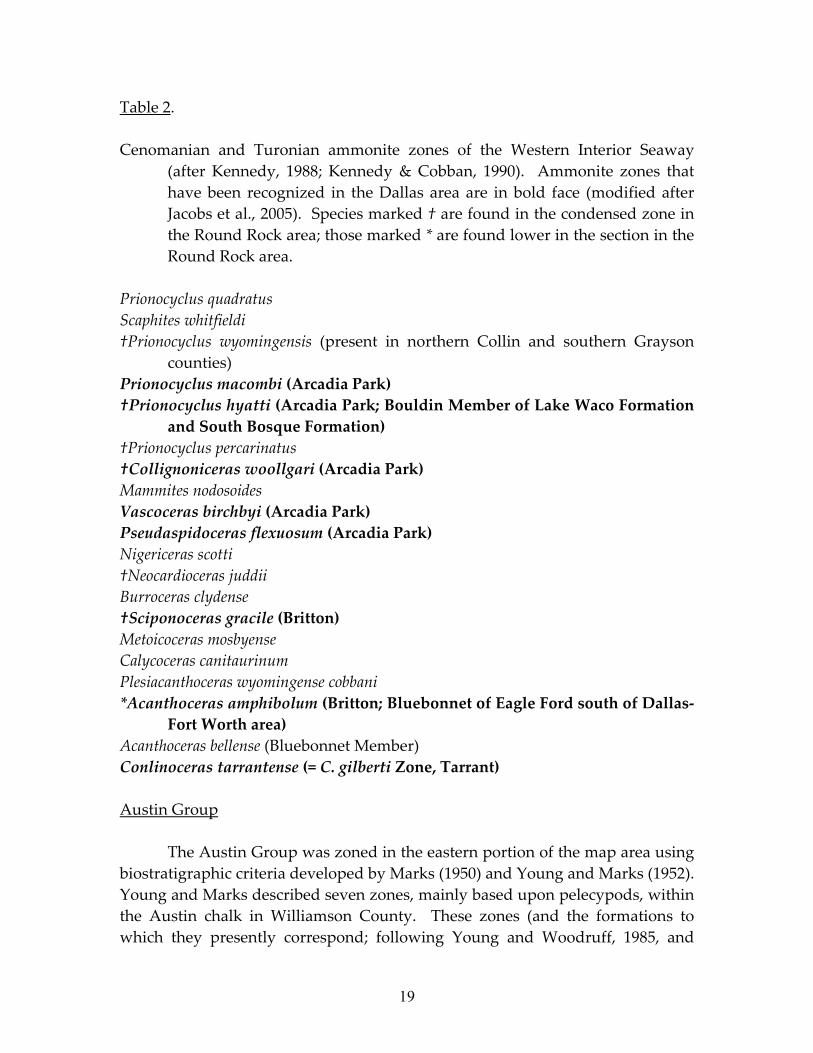
The Eagle Ford Formation in the Dallas area has a diverse ammonite assemblage that can be well‐correlated to the ammonite zones of the Western Interior Seaway (Table 2). Those zones found in the Round Rock area are also marked. From this is can be seen that the few feet of Eagle Ford condensed zone correlates with ammonite zones in the Dallas area ranging from the/Britton through the Arcadia Park. A compilation of the paleontology of the Eagle Ford Group in the Round Rock area is presented in Appendix 2.
Liro and others (1994) and Dawson (1997, 2000) interpreted the paleogeography of the Eagle Ford Group in central Texas to represent the progradation of deltas in the north and northwest which delivered siliciclastic detritus into a shallow marine basin. As a result, shales, siltstones, and fine‐grained sandstones are interstratified with marine limestones and bentonites. The predominance of marine fossils attests to a largely marine origin for the Eagle Ford Group. The presence, however, of lignitic, terrestrial and plant debris intermixed with marine fossils in the siltstone and sandstones suggests a near‐shore depositional setting (e.g., lagoonal; Young, 1977). The well‐preserved thin bentonites and finely laminated nature of the shales and siltstones are indicative of low‐energy (below storm wave base) depositional conditions. The fine sandstone and siltstone beds record periodic higher energy events (i.e., storms). The Eagle Ford Group thins and was deposited in shallower water in the Austin area on account of the San Marcos arch than in the vicinity of Waco.
9 Op cit.
19
Table 2. Cenomanian and Turonian ammonite zones of the Western Interior Seaway
(after Kennedy, 1988; Kennedy & Cobban, 1990). Ammonite zones that have been recognized in the Dallas area are in bold face (modified after Jacobs et al., 2005). Species marked † are found in the condensed zone in the Round Rock area; those marked * are found lower in the section in the Round Rock area.
Prionocyclus quadratus Scaphites whitfieldi †Prionocyclus wyomingensis (present in northern Collin and southern Grayson
counties) Prionocyclus macombi (Arcadia Park) †Prionocyclus hyatti (Arcadia Park; Bouldin Member of Lake Waco Formation
and South Bosque Formation) †Prionocyclus percarinatus †Collignoniceras woollgari (Arcadia Park) Mammites nodosoides Vascoceras birchbyi (Arcadia Park) Pseudaspidoceras flexuosum (Arcadia Park) Nigericeras scotti †Neocardioceras juddii Burroceras clydense †Sciponoceras gracile (Britton) Metoicoceras mosbyense Calycoceras canitaurinum Plesiacanthoceras wyomingense cobbani *Acanthoceras amphibolum (Britton; Bluebonnet of Eagle Ford south of Dallas‐
Fort Worth area) Acanthoceras bellense (Bluebonnet Member) Conlinoceras tarrantense (= C. gilberti Zone, Tarrant) Austin Group The Austin Group was zoned in the eastern portion of the map area using biostratigraphic criteria developed by Marks (1950) and Young and Marks (1952). Young and Marks described seven zones, mainly based upon pelecypods, within the Austin chalk in Williamson County. These zones (and the formations to which they presently correspond; following Young and Woodruff, 1985, and
20
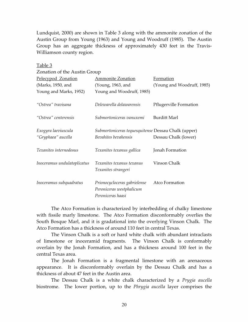
Lundquist, 2000) are shown in Table 3 along with the ammonite zonation of the Austin Group from Young (1963) and Young and Woodruff (1985). The Austin Group has an aggregate thickness of approximately 430 feet in the Travis‐Williamson county region. Table 3 Zonation of the Austin Group Pelecypod Zonation Ammonite Zonation Formation (Marks, 1950, and (Young, 1963, and (Young and Woodruff, 1985) Young and Marks, 1952) Young and Woodruff, 1985) “Ostrea” travisana Delewarella delawarensis Pflugerville Formation “Ostrea” centerensis Submortoniceras vanuxemi Burditt Marl Exogyra laeviuscula Submortoniceras tequesquitense Dessau Chalk (upper) “Gryphaea” aucella Bevahites bevahensis Dessau Chalk (lower) Texanites internodosus Texanites texanus gallica Jonah Formation Inoceramus undulatoplicatus Texanites texanus texanus Vinson Chalk Texanites strangeri Inoceramus subquadratus Prionocycloceras gabrielense Atco Formation Peroniceras westphalicum Peroniceras haasi The Atco Formation is characterized by interbedding of chalky limestone with fissile marly limestone. The Atco Formation disconformably overlies the South Bosque Marl, and it is gradational into the overlying Vinson Chalk. The Atco Formation has a thickness of around 110 feet in central Texas.
The Vinson Chalk is a soft or hard white chalk with abundant intraclasts of limestone or inoceramid fragments. The Vinson Chalk is conformably overlain by the Jonah Formation, and has a thickness around 100 feet in the central Texas area.
The Jonah Formation is a fragmental limestone with an arenaceous appearance. It is disconformably overlain by the Dessau Chalk and has a thickness of about 47 feet in the Austin area.
The Dessau Chalk is a white chalk characterized by a Prygia aucella biostrome. The lower portion, up to the Phrygia aucella layer comprises the
21
“Gryphaea” aucella zone of Young and Marks (1952); the overlying Exogyra laeviuscula zone comprises the upper portion of the Dessau Chalk. The Dessau Chalk has a thickness around 95 feet in the Austin area. The Dessau chalk is disconformably overlain by the Burditt Marl.
The Burditt Marl is a soft, fissile white marl. It is approximately 16 feet thick in the Austin area. The Burditt Marl grades into the overlying Pflugerville Formation in Travis County, but the Pflugerville Formation is absent in Williamson County in the Round Rock area.
A compilation of the paleontology of the Austin Group in the Round Rock area is presented in Appendix 2.
The division of the Austin Group into formations on the accompanying map has entirely followed that of earlier mapping. If the Austin Group was not originally divided into its constituent formations, then it is simply labeled with the inclusive symbol, Kau.
The Atco Formation has been interpreted to represents deposition on an open, shallow shelf, far from the shoreline. The shallowness of the water is testified by numerous oysters, benthonic foraminferans, and inocerami (Young, 1977, 1985). Young (1985) similarly noted that both the Vinson and Dessau Formations are relatively free of burrowing mollusks which may indicate that the substrate was so soupy that burrowing mollusks could not obtain traction for their foot. This, however, is not true of the Jonah Formation, where burrowing mollusks abound, and the presence of Actinostreon, Hemiaster, and Spondylus guadalupae (Romer) attest to a shallow, open, marine shelf well removed from shore. Similarly, Young (1985) argued that the both the Burditt Marls and the Pflugerville Formation were deposited in a broad, open, shallow (as attested to by the many oysters) marine shelf well removed from the shoreline. Taylor Group The Taylor Group is the worst exposed unit in the map area; its distribution is more readily discerned on soil maps and aerial photographs. The lowermost unit of the Taylor Group, and the only one present in the map area is the Sprinkle Formation. The Sprinkle formation is a thick (ca. 330 feet) massive, calcareous claystone. Its main clay mineral is montmorillonite (Young, 1977). The Sprinkle is present in the far eastern portion of the map area where it is only poorly exposed. A compilation of the paleontology of the Taylor Group in the Round Rock area is presented in Appendix 2.
22
Tertiary and Quaternary Systems Plio‐Pleistocene to Recent
Cenozoic deposits in the Round Rock area are typically dominated by pebbles of Edwards limestone and chert. Atchison divided these deposits into three units on the basis of their elevation. The highest, and oldest, were correlated by Atchison with the Uvalde gravel. The “upland,” or Uvalde gravel, is present mantling topographic highs. The Uvalde gravels are not well dated, but are considered to be Pliocene to Pleistocene in age (e.g., Blome et al., 2004; Page et al., 2005), although Byrd (1971) considers the Uvalde gravels to have been deposited during the Late Miocene and Pliocene. The Uvalde terraces cap topographic highs east of the Balcones Fault Zone; the highest of these occurs at the top of Rabbit Hill. A lower terrace caps the low hills parallel to and east of the highways I‐35 and north of U.S. 79. The two younger units are restricted to present‐day streams, and are likely Pleistocene to Recent in age. Unlike the Uvalde terraces, these deposits conform to the present‐day drainage pattern. The higher of the two units comprises consolidated gravel and boulders and was named the ‘Brushy Creek” terrace by Tydlaska (1951). The Brushy Creek terrace reaches thicknesses of 20 feet. Sellards (1936) described two terrace deposits along Brushy Creek near the bridge over north Georgetown Street. The lower terrace rises 10 to 13 feet above the level of the stream. The higher of the two terraces sits 20 to 25 feet above the stream and the deposit is approximately 15 to 20 feet thick. The second terrace is noteworthy for containing human artifacts. Sellards also described another terrace of the same height as the higher terrace approximately 2 miles further downstream along Brushy Creek, where more artifacts were found. Leedy (1937) also briefly described two terraces along Brushy Creek about 300 feet east of N. Mays Street. The upper terrace is 18 feet above stream level, while the lower one is 3 to 9 feet above stream level. The lower terraces are typically unconsolidated alluvium and gravel, as well as travertine deposits. These deposits are associated with deposition processes of Brushy Creek or associated with springs in the western part of the map area. The westernmost portion of the Taylor Fan, an “alluvial fan” deposit comprised of sandy pebble limestone and chert gravel eroded from the Edwards Plateau and deposited by interglacial braided streams, is present in the northeastern part of this map area, north of Hutto (Edwards, 1974). The present deposit is the remnant of a once more extensive deposit that has been eroded by Holocene entrenchment of meandering streams in response to climate change.
23
The Taylor Fan averages a thickness of 21 feet over much of eastern Williamson County. The soils of Williamson County are very variable and are beyond the scope of this work. The soils of Williamson County have been mapped by Werchan and others (1988). Structure Contacts between units are generally poorly exposed within the mapped area. While there are a few places where contacts can be seen (e.g. along the bluff at Memorial Park in Round Rock), these are generally contacts between more durable units, such as between limestone units. As much of the upper Cretaceous stratigraphy consists of alternating carbonate and marl or shale units, these contacts are frequently obscured on account of the less resistant nature of the marls or shales. Even though all contacts between the major stratigraphic units in the map area are shown as solid lines, this does not reflect a great confidence in the precise location of the boundary. Dashed lines on the map have been reserved for displaying the boundaries between subunits within the mapped stratigraphic units: either the members of the Georgetown Formation or the formations of the Austin Group. The generally poor outcrop of the area commonly makes the distinction of these subunits less definitive. The Cretaceous strata of central Texas are part of a regional homoclinal wedge of sediments that dip gently toward the Gulf of Mexico (Hill, 1901). The strata of the Grand Prairie to the west of the Balcones Fault Zone dip between 10 to 20 feet per mile toward the southeast (Rogers, 1963). In Williamson County between the Balcones Fault Zone and Thrall, Upper Cretaceous rocks of the Blackland Prairie dip 90 to 100 feet per mile (ca. 1°), whereas east of Thrall the same units dip 150 to 200 feet per mile (Sellards and Baker, 1934). Locally, however, dips are observed to vary greatly. The largest observed dip (37°) was found in strata of the Georgetown Formation immediately adjacent to the Chandler Fault just south of US Highway 79. In general, however, measured attitudes of strata away from faults in the map area varied from horizontal to a maximum of 5°. In every instance but one, measurements indicate the strata dip to the east or southeast; in the one exception strata were measured dipping 3° to the northwest. Dips of strata can sometimes be seen to increase near major faults, where dips as high as 37° have been measured. The structure contour map (see below), however, indicates that rocks are dipping in a northerly direction in a couple of places, most notably along a small ramp between the Three Mile and Onion Faults.
24
A structure contour map of the top of the Edwards Formation was prepared in conjunction with the geologic map in order to elucidate details of the large‐scale structure of the Round Rock area. The map was prepared from information gathered from one hundred water well logs that located the depth to the top of the Edwards Formation. As discussed previously, this information was available from the Texas Water Development Board; a list of the wells used in the preparation of the structure contour map is given in Appendix 1. In addition, in areas of sparse well coverage the elevation of the top of the Edwards Formation could also be approximated from the elevation of contacts between geologic units using representative values for unit thicknesses. These calculated values were considered less reliable, and the reported elevations, derived from well log information, were generally given preference when available.
In addition to the structure contour map, a perspective view of the top of the Edwards Formation was constructed from the structure contour map in order to illustrate the features of the fault systems on the map. The perspective view of the top of the Edwards Formation was simplified by leaving off some of the smaller faults, as well as those faults for which there is not good control of displacement across the fault. In the perspective view, the top of the Edwards Formation in each fault‐bounded slice was made a different color in order to better illustrate the structure. The perspective is taken from the southeast corner of the structure contour map, looking northwest. Perhaps the most noteworthy feature of the structure contour map is the significant down‐to‐the‐east displacement of the Edwards Formation across a number of generally north‐northeast trending normal faults of the Balcones Fault Zone. The Edwards Formation crops out in the western portion of the map area, attaining an elevation of over 940 feet in the northwestern portion of the map. In contrast, the elevation of the top of the formation is less than 150 feet below sea level in the southeast portion of the map area. This down‐to‐the‐east displacement is primarily accomplished across five main fault series: the Onion‐Three Mile, the Chandler, what is herein termed the Mankins Fault System, and the Brushy Creek and Shiloh Faults. The Mankins Fault System comprises a number of faults, including the Mankins Branch, Jonah, Cottonwood, Dyer Branch and Dry Branch faults as well as some unnamed faults. Some of the faults of the Mankins Fault System are mapable in the field while others are inferred from field relations and subsurface data. The Balcones Fault Zone extends as an arcuate belt of normal faults from Del Rio towards Dallas (e.g. Ewing, 1990). The Balcones Fault Zone appears to be developed over and follows the trend of the Ouachita front through central Texas (Sellards, 1931; Flawn et al., 1961). Most of the displacement along faults in the Balcones Fault Zone is believed to have occurred in the late Oligocene or
25
early Miocene (Weeks, 1945). Nonetheless, it has been argued that there is evidence for both earlier movement along faults within this zone during the Late Cretaceous (Collingwood and Retger, 1926; Collingwood, 1930) and perhaps later movements during the Pliocene as well (Weeks, 1945). In the immediate Austin area the Balcones Fault Zone predominantly comprises north‐ to northeast‐trending faults with down to the east displacement (Garner and Young, 1976), and has a composite down‐to‐the‐east structural relief between 1,100 and 1,600 feet, although displacement along the main fault strand, the Mount Bonnell Fault strand, only exceeds 600 feet (Collins and Woodruff, 2001).
The Mount Bonnell Fault strand continues northward into Williamson County where it terminates northeast of Georgetown. Moving northward from Austin, the Mount Bonnell Fault strand expands from a relatively narrow zone into wide splays that eventually terminate in northern Travis County. Further north, a fault strand trending about N10°E (the Chandler Fault in the Round Rock area) represents the Mount Bonnell Fault strand until it terminates northeast of Georgetown (Collins and Woodruff, 2001). This diminishment of the Mount Bonnell Fault strand in Williamson County is accompanied by the development of other en echelon fault series both to the east and west of the Chandler Fault.
Collins and Woodruff (2001) document a decrease in displacement along the Mount Bonnell Fault strand moving away from Austin, where it is in excess of 600 feet. By the time the fault strand reaches Round Rock Collins and Woodruff estimate displacement at approximately 130 feet, although the structure contour map of the top of the Edwards Formation indicates a displacement closer to 150 feet in the southern end of the Round Rock map area. Displacement along the Chandler Fault is down to approximately 10 feet at the northern end of the map area.
The Onion‐Three Mile fault series consists of two main faults developed west of the Chandler Fault. Displacement across the Onion and related faults is approximately 170 feet at the northern end of the map area, whereas the Three Mile Fault has a displacement of approximately 50 feet at its southern end, which decreases northward until the fault terminates on Rabbit Hill. Displacement along the Onion Fault series nearly makes up for the loss of displacement along the Three Mile and Chandler faults at the northern end of the map area.
The Mankins Fault System, comprising the Dry Branch, Dyer Branch, Cottonwood, Jonah, Mankins Branch and several unnamed smaller faults, lies to the east of the Chandler Fault. The Mankins Fault System is a complex structure of northeast‐trending normal faults and a conjugate set of north‐northwest
26
trending normal faults enclosing fault ramps and grabens. The overall displacement across the Mankins Fault System is around 200 feet.
Two more northeast‐trending faults with significant normal offset lie to the southeast of the Mankins Fault System: the Brushy Creek and Shiloh faults. These faults have approximately 150 and 200 feet of down‐to‐east displacement, respectively. The important role the Mankins Fault System and the Brushy Creek and Shiloh faults play in replacing the loss of displacement along the northern extension of the Mount Bonnell Fault Strand in the Balcones Fault Zone was not recognized by Collins and Woodruff (2001).
The top of the Edwards Formation lies at a maximum elevation of around 350 feet on the southeast side of the Cottonwood fault, a drop of around 600 feet from the northwest corner of the map area. On the southeastern side of the Cottonwood Fault, the Edwards Formation is displaced even more abruptly along the Brushy Creek Fault, where it drops approximately 150 feet to the southeast, and along the Shiloh Faults, where it drops approximately 200 feet to the southeast. This brings the total structural relief on the top of the Edwards Formation that can be documented to over 1000 feet across the map area. Minor faults, not shown on this map, are present in a number of areas across the map area; most of them are proximal to the major faults. For example, several minor faults proximal to the Chandler Fault can be observed along Onion Branch within a hundred yards in either direction of the Highway 79 bridge. Similarly, exploratory drilling preparatory to the construction of a regional wastewater line along Brushy Creek has demonstrated the presence of several minor faults just west of Chandler Fault where it crosses Brushy Creek (Geotechnical Data Report, Brushy Creek Interceptor Contracts 20 and 21, Round Rock, Texas. Fugro South, Inc., Austin, Texas, September 13, 2001). Similar features have also been described by Atchison (1954) near the Onion and Three Mile faults, and Tydlaska (1951) also noted a large number of minor faults along McNutt Creek near its intersection with the Cottonwood Fault. While studying the faults of the Round Rock Quadrangle, Rogers (1963) also studied the development of joints. He observed two dominant joint sets striking N25°E and N65°W. These orientations are parallel and perpendicular, respectively, to the trend of the major faults (N25°E) within the quadrangle. In addition, another east‐west joint set was observed in the west‐central part of the area. Rogers noted that joints were often more strongly developed near mapped faults. In summary, the structural geology of the Round Rock area is dominated by a set of north‐northeast normal faults, and their conjugate set, that are spread over the eastern three‐quarters of the map area. These faults disrupt a gently eastward dipping homoclinal pile of Early and Late Cretaceous sediments; the
27
net effect is approximately 1000 feet of down to the east displacement of these strata. Acknowledgements
A number of people deserve thanks for their help in making this study possible. Danny Holden, City Engineer, City of Round Rock, and his staff, particularly Jimmy Vrabel and Krista Keneipp, are thanked for helping the author find so many of the geotechnical reports used in the preparation of this map. Tony Skeen, of the Lower Colorado River Authority is also thanked for making geotechnical reports of LCRA wastewater projects along Brushy and Lake Creeks available to the author. The capable field assistance of Elijah Housh is gratefully acknowledged; his keen appreciation of rocks and fossils was a great motivation for the author. A thorough review of an earlier version of this manuscript and the geologic map by Mark Helper, Mark Cloos and Dennis Trombatore as well as technical assistance by Jeffrey Horowitz are gratefully acknowledged. Finally, the author acknowledges his great indebtedness to the late Keith Young by whom the author was introduced to the complexities of the geology and paleontology of central Texas.
28
Bibliography Adkins, W.S., 1933, The Mesozoic System in Texas, in, The Geology of Texas, vol.
1, Stratigraphy. Austin, University of Texas Bulletin 3232, pt. 2, p. 239‐518. Adkins, W.S., and Arick, M.B., 1930, Geology of Bell County, Texas. Austin,
University of Texas Bulletin. 3016, 92p. Adkins, W.S. and Lozo, F.E., 1951, The Woodbine and adjacent strata of the Waco
area of central Texas. Fondren Science Series, no. 4, Southern Methodist University Press, p. 101‐164.
Arbenz, J.K., 1989, The Ouachita System, in Bally, A.W. and Palmer, A.R., eds., The Geology of North America – An overview. Boulder, Colorado: Geological Society of America, The Geology of North America, v. A., p. 371‐396.
Atchison, D.E., 1954, Geology of the Brushy Creek quadrangle, Williamson County, Texas. Austin, The University of Texas at Austin, M.A. thesis, 94p. (scale of accompanying map approximately 1:40,000).
Bankey, V., 2007, Texas Magnetic and Gravity Maps and Data: A Website for Distribution of Data. U.S. Geological Survey Data Series 232, http://pubs.usgs.gov/ds/ 2006/232/index.html.
Barnes, V.E. (project director), 1974, Geologic Atlas of Texas, Austin Sheet; Francis Luther Whitney, Memorial Edition. Austin, The University of Texas at Austin, Bureau of Economic Geology, scale 1:250,000.
Bebout, D.G., 1985, Lower Cretaceous regional setting – Texas Crushed Stone Quarry, in Woodruff, C.M., Jr., Snyder, F., De La Garza, L., and Slade, R.M., Jr., eds., Edwards Aquifer – Northern Segment, Travis, Williamson, and Bell Counties, Texas. Austin, Austin Geological Society Guidebook 8, 38‐40.
Blome, C.D., Faith, J.R., Collins, E.W., Pedrazza, D.E., and Murray, K.E.., 2004, Geologic Map Compilation of the Upper Seco Creek Area, Medina and Uvalde Counties, south‐central Texas. Reston, United State Geological Survey, Open‐File Report 2004‐1430, 21p.
Byrd, C.L., 1971, Origin and History of the Uvalde Gravel of Central Texas. Waco, Baylor Geological Studies, Bulletin No. 20, 48p.
Collingwood, D.M., and Retger, R.E., 1926, The Lytton Springs Oil Field, Caldwell County, Texas. American Association of Petroleum Geologists Bulletin, 19: 953‐975.
Collingwood, D.M., 1930, Magnetics and Geology of Yoast Field, Bastrop County, Texas. American Association of Petroleum Geologists Bulletin, 14: 1191‐1197.
29
Collins, E.W., 1997, Geologic Map of the Round Rock quadrangle, Williamson County, Texas. Statemap Project Geologic Maps. Austin, The University of Texas at Austin, Bureau of Economic Geology, Open‐File Map, scale 1:24,000.
Collins, E. W., 2005, Geologic map of the west half of the Taylor, Texas, 30 x 60 minute quadrangle: Central Texas Urban Corridor, encompassing Round Rock, Georgetown, Salado, Briggs, Liberty Hill, and Leander. Austin, The University of Texas at Austin, Bureau of Economic Geology, scale 1:100,000.
Collins, E.W., and Woodruff, C.M., Jr., 2001, Faults in the Austin, Texas, area – defining aspects of local structural grain, in C.M. Woodruff, Jr. and E.W. Collins, eds., Austin Texas, and Beyond – Geology and Environment. Austin, Austin Geological Society Guidebook 21, p. 15‐26.
Cuyler, R.H., 1930, Georgetown Formation of central Texas and its north Texas equivalents. American Association of Petroleum Geologists Bulletin, 13: 1291‐1299.
Dawson, 1997, Limestone lithofacies and sequence Stratigraphy: Eagle Ford Group (Cenomanian‐Turonian) north‐central Texas outcrops. Gulf Coast Association of Geological Societies Transactions, 48: 99‐105.
Dawson, 2000, Shale microfacies: Eagle Ford Group (Cenomanian‐Turonian) north‐central Texas outcrops and subsurface equivalents. Gulf Coast Association of Geological Societies Transactions, 50: 607‐621.
Edwards, J.E., 1974, The geomorphology and hydrogeology of the Taylor alluvial fan, Williamson County, Texas. Austin, The University of Texas at Austin, M.A. thesis, 85p.
Esquilin, R., 2006, Edwards Aquifer Bibliography Through 2005. San Antonio, Edwards Aquifer Authority, 223p. [http://edwardsaquifer.org/pages/ bibliography.htm]
Ewing, T.E. (principal investigator), 1990, The tectonic map of Texas. Austin, The University of Texas at Austin, Bureau of Economic Geology, scale 1:750,000.
Feray, D.E., 1949, Brushy Creek, Round Rock, Williamson County, Texas, Bureau of Economic Geology Locality 245‐T‐16, in Hazzard, R.T., Feray, D.E., Lozo, F.E., Durham, C.O., and Nunnally, J.D., eds., Cretaceous of Austin, Texas Area, Seventeenth Annual Field Trip, Shreveport Geological Society, p. 30‐33.
Fisher, W.L. and Rodda, P.U., 1969, Edwards Formation (Lower Cretaceous), Texas: dolomitization in a carbonate platform system. American Association of Petroleum Geologists, 53: 55‐72.
30
Flawn, P.T., Goldstein, A., Jr., King, P.B., and Weaver, C.E., 1961, The Ouachita System. Austin, The University of Texas at Austin, Bureau of Economic Geology Publication 6120, 401p.
Garner, L.E. and Young, K.P., 1976, Environmental geology of the Austin area; an aid to urban planning. Austin, The University of Texas at Austin, Bureau of Economic Geology, 39p. (scale of accompanying map 1:62,500).
Geotechnical Data Report, Brushy Creek Interceptor Contracts 20 and 21, Round Rock, Texas. Fugro South, Inc., Austin, Texas, September 13, 2001.
Gordon, J.E., 1951, Geology of the Hutto quadrangle, Williamson County, Texas. Austin, The University of Texas at Austin, M.A. thesis, 43p. (scale of accompanying map 1:20,000).
Hill, R.T., 1889, A preliminary annotated check list of the Cretaceous invertebrate fossils of Texas, accompanied by a short description of the lithology and stratigraphy of the system. Austin, Texas Geological Survey Bulletin, 4, 57p.
Hill, R.T., 1901, Geography and geology of the Black and Grand prairies, Texas, detailed descriptions of the Cretaceous formations and special reference to artesian waters. U.S. Geological Survey Annual Report, 21, pt. 7, 666 p. (scale of accompanying map approximately 1:633,600).
Hill, R.T. and Vaughan, T.W., 1898, Geology of the Edwards Plateau and Rio Grande Plain adjacent to Austin and San Antonio, Texas, with references to the occurrence of underground waters. U.S. Geological Survey Annual Report, 18, pt. 2, p. 193‐321.
Jacobs, L.L., Ferguson, K., Polcyn, M.J., and Rennison, C., 2005, Cretaceous δ13C stratigraphy and the age of dolichosaurs and early mosasaurs. Geologie en Mijnbouw, 84: 257‐268.
Keller, G.R., Kruger, J.M., Smith, K.J., and Voight, W.M.,, 1989, The Ouachita system; a geophysical overview, in Hatcher, R.D., Thomas, W.A., and Viel, G.W., eds., The Appalachian‐Ouachita Orogen in the United States. Boulder, Colorado: Geological Society of America, The Geology of North America, Volume F‐2, p. 689‐689‐694.
Kennedy, W.J., 1988, Late Cenomanian and Turonian ammonite faunas from north‐east and central Texas. Special Papers in Palaeontology 39: 1‐131.
Kennedy, W.J. & Cobban, W.A., 1990, Cenomanian ammonite faunas from the Woodbine Formation and lower part of the Eagle Ford Group, Texas. Palaeontology 33: 75‐154.
Kruger, J.M. and Keller, G.R., 1986, Interpretation of crustal structure from regional gravity anomalies, Ouachita Mountains area and adjacent Gulf Coastal Plain. The American Association of Petroleum Geologists Bulletin, volume 70, p. 667‐689.
31
Leedy, D., 1937, Report on gravel in Williamson County. Austin, The University of Texas, Bureau of Economic Geology, Mineral Resource Survey Circular No. 18, 4p.
Liro, L.M., Dawson, W.C., Katz, B.J., Robison, V.D., 1994, Sequence Stratigraphic Elements and Geochemical Variability within a ʺCondensed Sectionʺ: Eagle Ford Group, East‐Central Texas. Gulf Coast Association of Geological Societies Transactions, 44: 393‐402.
Lundelius, E.L., Jr., 1985, Pleistocene vertebrates from Laubach Cave, in Woodruff, C.M., Jr., Snyder, F., De La Garza, L., and Slade, R.M., Jr., eds., Edwards Aquifer – Northern Segment, Travis, Williamson and Bell Counties, Texas. Austin, Austin Geological Society, Guidebook 8, p. 38‐40.
Lundquist, J.J., 2000, Foraminiferal biostratrigraphic and paleoceanographic analysis of the Eagle Ford, Austin, and Lower Taylor Groups (Middle Cenomanian through Lower Campanian) of Central Texas. Austin, The University of Texas at Austin, PhD dissertation, 545p.
Marks, E., 1950, Biostratigraphy of Jonah quadrangle, Williamson County, Texas. Austin, The University of Texas at Austin, M.A. thesis, 139p. (scale of accompanying map 1:20,000).
Meckel, L.D., Jr., Smith, D.G., and Wells, L.A., 1992, Ouachita Foredeep Basins: Regional Paleogeography and Habitat of Hydrocarbons, in Macqueen, L.W. and Leckie, D.A., eds., Foreland Basins and Fold Belts. Tulsa, American Association of Petroleum Geologists, Memoir 55, p. 427‐444.
Moreman, W.L., 1942, Paleontology of the Eagle Ford group of north and central Texas. Journal of Paleontology, 16:192‐220.
Mosher, S., 1998, Tectonic evolution of the southern Laurentian Grenville orogenic belt. Geological Society of America Bulletin, v. 110, p. 1357‐1375.
Musgrove, M., Banner, J.L., Mack, L.E., Combs, D.M., James, E.W., Cheng, H., and Edwards, R.L., 2001, Geochronology of late Pleistocene to Holocene speleothems from central Texas: implications for regional paleoclimate. Geological Society of America Bulletin, 113: 1532‐1543.
Nicholas, R.L. and Waddell, D.E., 1989, The Ouachita system in the subsurface of Texas, Arkansas, and Louisiana, in Hatcher, R.D., Thomas, W.A., and Viel, G.W., eds., The Appalachian‐Ouachita Orogen in the United States. Boulder, Colorado: Geological Society of America, The Geology of North America, Volume F‐2, p. 661‐672.
Page, W.R., VanSistine, D.P., and Turner, K.J., 2005, Preliminary Geologic Map of Southernmost Texas, United States, and parts of Tamaulipas and Nuevo Leon, Mexico: Environmental Health Investigations in the United States‐Mexico border region. U.S. Geological Survey Open File Report 2005‐1409, 11 p. (scale of accompanying map 1:250,000).
32
Reaser, D.F. and Dawson, W.C., 1995, Geologic study of Upper Cretaceous (Cenomanian) Buda Limestone in northeast Texas and some regional implications. Gulf Coast Association of Geologic Societies Transactions, 45: 495‐502.
Rogers, C.W., 1963, Geologic map and structure section of Round Rock quadrangle, Williamson County, Texas. Austin, The University of Texas at Austin, M.A. thesis, 48p. (scale of accompanying map approximately 1:3,265).
Sawyer, D.S., Buffler, R.T., and Pilger, R.H., 1991, The crust under the Gulf of Mexico Basin, in Salvador, A., ed., The Gulf of Mexico Basin. Boulder, Colorado: Geological Society of America, The Geology of North America, Volume J, p. 53‐72.
Sellards, E.H., 1931, Rocks underlying Cretaceous in Balcones Fault Zone of Central Texas. American Association of Petroleum Geologists Bulletin, 15: 819‐827.
Sellards, E.H., 1936, Recent studies of early man in the southwestern part of the United States. The American Naturalist. 70: 361‐369.
Sellards, E.H., and Baker, C.L., 1934, The Geology of Texas, Volume 2. Structural and Economic Geology. Austin, University of Texas Bulletin No. 3401, 884p.
Shumard, B.F., 1860, Observations upon the Cretaceous strata of Texas. St. Louis Academy of Science Transactions, 1: 582‐590.
Sims, P.K., Saltus, R.W., and Anderson, E.D., 2005, Preliminary Precambrian basement structure map of the continental United States – An interpretation of geologic and aeromagnetic data. U.S. Geological Survey, Open File Report 2005‐1029, 29p.
Slaughter, B.H., 1966, Platygonus compressus and associated fauna from the Laubach Cave of Texas. American Midland Naturalist, 75: 475‐494.
Taff, J.A., 1892, Reports on the Cretaceous area north of the Colorado River, in, E.T. Dumble (State Geologist), Third Annual Report of the Geological Survey of Texas, p. 269‐389. (scale of accompanying map is approximately 1:266,666).
Toomey, R.S., III, 1994, Vertebrate paleontology of Texas caves, in Elliott, W.R., and Veni, G., eds., The Caves and Karst of Texas. Hunstville, Alabama, National Speleological Society, p. 51‐68.
Tydlaska, L., 1951, Geology of Palm Valley quadrangle, Williamson County, Texas. Austin, The University of Texas at Austin, M.A. thesis, 56p. (scale of accompanying map 1:20,000).
33
Walls, B., 1950, Geology of the Bell Gin quadrangle, Williamson County, Texas. Austin, The University of Texas at Austin, M.A. thesis, 61p. (scale of accompanying map 1:20,000).
Ward, D.L., 1950, Geology of the area immediately west of Georgetown, Williamson County, Texas. Austin, The University of Texas at Austin, M.A. thesis, 47p. (scale of accompanying map 3 inches equals 1 mile).
Weeks, A.W., 1945, Balcones, Luling, and Mexia Fault Zones in Texas. American Association of Petroleum Geologists Bulletin, 29: 1733‐1737.
Werchan, L.E. and Coker, J.L., 1988, Soil Survey of Williamson County, Texas. Washington, D.C., United States Department of Agriculture in cooperation with the Texas Agricultural Experiment Station, 97p.
Whitney, F.L. (geology) and Young, K. (editor), 1959a, Geologic Quadrangle Map Series, Round Rock Quadrangle (BEG Map MM0016). Austin, The University of Texas at Austin, Department of Geological Sciences and Bureau of Economic Geology, scale 1:4,000.
Whitney, F.L. (geology) and Young, K. (editor), 1959b, Geologic Quadrangle Map Series, Austin NE Quadrangle (BEG Map MM0016). Austin, The University of Texas at Austin, Department of Geological Sciences and Bureau of Economic Geology, scale 1:4,000.
Wilbert, W.P., 1966, Stratigraphy of the Georgetown Formation, Bell, Williamson and Travis counties, Texas. Transactions‐Gulf Coast of Geological Societies, 16: 13‐18.
Young, K., 1957, Upper Albian (Cretaceous) Ammoidea from Texas. Journal of Paleontology, 31:1‐33
Young, K., 1959, Techniques of mollusc zonation in Texas Cretaceous., American Journal of Science , 257: 752‐769.
Young, K., 1963, Upper Cretaceous Ammonites from the Gulf Coast of the United States. Austin: The University of Texas, Bureau of Economic Geology, Publication No. 6304, 373p.
Young, K., 1977, Guidebook to the geology of Travis County. Austin, University of Texas, The Student Geological Society, 171p.
Young, K., 1985, The Austin Division of central Texas, in Young, K., and Woodruff, C.M., Jr., eds., Austin Chalk it its Type Area – Stratigraphy and Structure. Austin, Austin Geological Society, Guidebook 7, p. 3‐52.
Young, K., and Marks, E., 1952, Zonation of Upper Cretaceous Austin Chalk and Burditt Marl, Williamson County, Texas. Bulletin of the American Association of Petroleum Geologists, 36: 477‐488.
Young, K., and Woodruff, C.M., Jr., 1985, Austin chalk in its type area‐‐ stratigraphy and structure. Austin, Austin Geological Society, Field‐trip guidebook 7, 88p.
34
Appendix 1. Compilation of sources of other geologic information. Geotechnical engineering studies The following is a list of the geotechnical engineering reports consulted in the construction of this map. Most of these are available in the City Planning Office, City of Round Rock, although some are available at the offices of the Lower Colorado River Authority. Subsurface Investigation Mesa Park – Section IV, Round Rock, Texas. Trinity
Engineering Testing Corp., Austin, Texas, October 6, 1976. Geotechnical Engineering Study. Street Reconstruction. Egger Acres Subdivision.
Round Rock, Texas. HBC Engineering, Inc., Austin, Texas, March 26, 1977. Subsurface Investigation, Greenslopes at Lake Creek Subdivision, Section 1,
Round Rock, Texas. Trinity Engineering Testing Corp., Austin, Texas, May 3, 1977.
Soil and Foundation Investigation, Mesa Ridge Subdivision, Section Six‐Phase 1, Round Rock, Texas.. Cowher, Cooper & Associates, Inc., Austin, Texas, May 1979.
Subsurface Investigation and Foundation Recommendation, Greenslopes at Lake Creek Subdivision ‐ Section V, Round Rock, Texas. Trinity Testing Laboratories, Austin, Texas, May 1979.
Subsurface Investigation and Foundation Recommendation, Greenslopes at Lake Creek Subdivision ‐ Section IV, Round Rock, Texas. Trinity Testing Laboratories, Austin, Texas, May 4, 1979.
Subsurface Investigation, Greenslope Subdivision ‐ Section 2 Revised, Round Rock, Texas, Supplement No. 1. Trinity Engineering Testing Corp., Austin, Texas, August 6, 1979.
Subsurface Investigation and Pavement Design Recommendations Greenslopes at Lake Creek Subdivision, Section 4, Round Rock, Texas. Frank G. Bryant & Assoc., Austin, Texas, October 1, 1979.
Subsurface Investigation and Pavement Design Recommendations Greenslopes at Lake Creek Subdivision, Section 5, Round Rock, Texas. Frank G. Bryant & Assoc., Austin, Texas, October 1, 1979.
Soils Investigation, Mesa Ridge Subdivision, Section VI‐Phase III, Round Rock, Texas. Underground Resource Management, Inc., Austin, Texas, January 23, 1980.
Soils Investigation and Pavement Recommendations, Mesa Ridge, Section Eight, Subdivision, Round Rock, Texas. Underground Resource Management, Inc., Austin, Texas, May 9, 1983.
35
Soils Investigation and Pavement Recommendations, Mesa Ridge, Section Nine, Subdivision, Round Rock, Texas. Underground Resource Management, Inc., Austin, Texas, May 26, 1983.
Subsurface Investigation and Foundation Recommendations for South Creek – Section One, Round Rock, Texas. Jack H. Holt & Assoc., Austin, Texas, March 23, 1984.
Subsurface Investigation and Foundation Recommendations for South Creek – Section II Round Rock, Texas. Jack H. Holt & Assoc., Austin, Texas, April 11, 1984.
Subsurface Investigation and Foundation Recommendations for South Creek – Section Six, Round Rock, Texas. Jack H. Holt & Assoc., Austin, Texas, August 23, 1984.
Subsurface Investigation and Foundation Recommendations for South Creek – Sections Sixteen and Seventeen, Round Rock, Texas. Jack H. Holt & Assoc., Austin, Texas, August 23, 1984.
Geotechnical Investigation and Recommendations for Pavement Design, Heritage Center, U.S. 79, East, Round Rock, Texas. ML4 Consultants and Engineers, October 1984.
Subsurface Investigation and Foundation Recommendations for South Creek – Sections 3, 9, and 13, Round Rock, Texas. Jack H. Holt & Assoc., Austin, Texas, November 29, 1984
Geotechnical Investigation, South Creek, Sections 11, 14, and 15, Round Rock, Texas. Trinity Engineering Testing Corp., Austin, Texas, March, 1985.
Soils Investigation Pavement Recommendations, Apache Oaks Subdivision, Round Rock, Texas. Underground Resource Management, Inc., Austin, Texas, March 14, 1985.
Geotechnical Investigation, South Creek, Sections 5 and 7, Round Rock, Texas. Trinity Engineering Testing Corp., Austin, Texas, April 1, 1985.
Geotechnical Investigation, Lake Creek Lift Station, Round Rock Wastewater Treatment Plant, Austin Avenue near Georgetown Street, Round Rock, Texas. Bryant‐McClelland Consultants, January 27, 1987.
Soils Investigation and Pavement Recommendations, Mesa Ridge, Section 7, Subdivision, Round Rock, Texas. Underground Resource Management, Inc., Austin, Texas, August 23, 1987.
Subsurface Investigation and Engineering Analysis for Round Rock Ranch – Phase One – Section I, Round Rock, Texas. Jack H. Holt & Associates, Inc., Austin, Texas, 9 December 1987.
Geotechnical Pavement Investigation Round Rock Ranch, Phase 2, Section 1, Round Rock, Texas. Trinity Engineering Testing Corporation, Austin, Texas, June 1993.
36
Geotechnical Investigation, Pavement Thickness Recommendations, Rolling Ridge Subdivision Sections 1 and 2, Round Rock, Texas. MLA Labs, Austin, Texas, September 1993.
Subsurface Investigation and Foundation Recommendations for South Creek – Section Twenty, Mimosa Trail/Elder Way, Round Rock, Texas. Jack H. Holt & Assoc., Austin, Texas, May 19, 1994.
Geotechnical Investigation and Pavement Design for Round Rock Ranches P.U.D., Section 13, Round Rock, Texas. Pre‐Testing Laboratory, Georgetown, Texas, 28 June 1994.
Geotechnical Investigation and Pavement Design for Forest Ridge Subdivision, Round Rock, Texas. Pre‐Test Laboratory, Georgetown, Texas, 5 July 1994.
Geotechnical Investigation, New Round Rock Middle School Complex, Round Rock, Texas. Fugro‐McClelland (Southwest), Inc., Austin, Texas, February 1995.
Subsurface Investigation and Pavement Design for Forest Ridge Phase V and VI, Forest Ridge Boulevard, Round Rock, Texas. Jack K. Holt & Associates, Austin, Texas, 29 April 1996
Geotechnical Study, South Creek, Section Twenty‐one, Round Rock, Texas. Raba‐Kistner‐Brytest Consultants, Inc. Austin, Texas, December 20, 1996.
Subsurface Investigation and Pavement Design for Forest Ridge Phase 7‐B, Forest Ridge Boulevard, Round Rock, Texas. Jack K. Holt & Associates, Austin, Texas, 29 July 1997.
Subsurface Investigation and Pavement Design for Forest Ridge Phase 7‐A, Forest Ridge Boulevard, Round Rock, Texas. Jack K. Holt & Associates, Austin, Texas, 24 September 1997.
Geotechnical Investigation, Pavement Recommendations, Jester Farms, Sections 3 & 4, Round Rock, Texas. MLA Labs, Austin, Texas, December 1997.
Geotechnical Investigation, Revised Pavement Recommendations, Jester Farms, Sections 1 & 2, Round Rock, Texas. MLA Labs, Austin, Texas, January 1998.
Geotechnical Investigation, Pavement Recommendations, Jester Farms, Section 7, Round Rock, Texas. MLA Labs, Austin, Texas, March 1998.
Geotechnical Investigation, Pavement Recommendations, Jester Farms, Section 6, Round Rock, Texas. MLA Labs, Austin, Texas, July 1998.
Geotechnical Investigation, Pavement Recommendations, Jester Farms, Section 8, Round Rock, Texas. MLA Labs, Austin, Texas, July 1998.
Geotechnical Investigation, Pavement Recommendations, Jester Farms, Section 5, Round Rock, Texas. MLA Labs, Austin, Texas, September 1998.
37
Subsurface Investigation and Pavement Design for Forest Ridge Phase 8 Shady Hillside Pass, Round Rock, Texas. Jack K. Holt & Associates, Austin, Texas, 12 January 1999.
Geotechnical Investigation, Pavement Recommendations, Jester Farms, Section 9, Round Rock, Texas. MLA Labs, Austin, Texas, March 1999.
Geotechnical Investigation, Pavement Recommendations, Jester Farms, Section 10, Round Rock, Texas. MLA Labs, Austin, Texas, March 1999.
Subsurface Investigation and Engineering Analysis for Proposed Chandler Branch Wastewater Interceptor – Phase I, U.S. Highway 79, Round Rock, Texas. Jack H. Holt Ph.D. & Associates, Austin, Texas, May 6, 1999.
Subsurface Investigation and Engineering Analysis for Proposed Chandler Branch Wastewater Interceptor – Phase II, U.S. Highway 79, Round Rock, Texas. Jack H. Holt Ph.D. & Associates, Austin, Texas, August 25, 1999.
Geotechnical Engineering Study Lake Forest Subdivision – Phase 1, Round Rock, Texas. HBC Engineering, Inc., Austin, Texas, 3 November 1999.
Geotechnical Investigation and Pavement Thickness Design, Sonoma Sections 1, 2, & 3, Round Rock, Texas. Fugro South, Inc., Austin, Texas, 23 February 2000.
Geotechnical Investigation Sonoma Sections 4 and 5, Rusk Road and Forest Creek Drive, Round Rock, Texas. Fugro South, Inc., Austin, Texas, 23 May 2000.
Subsurface Investigation and Engineering Analysis for Proposed Southwest Round Rock Wastewater Improvements Phases B & C, McNeil Road, Round Rock, Texas. Jack H. Holt Ph.D. & Associates, Austin, Texas, July 13, 2000.
Geotechnical Investigation, Pavement Thickness Recommendations, Phase 1 – (Section 3), Round Rock Ranch, Round Rock, Texas. MLA Labs, Austin, Texas. September 2000.
Engineering and Drainage Report for Stonecrest Shops at Forest Commons, Weston Retail Subdivision. Bury + Partners, Austin, Texas, 2001.
Geotechnical Engineering Study, Lake Forest II – Village I, Round Rock, Texas. HBC Engineering, Inc., Austin, Texas, 30 January 2001.
Geotechnical Engineering Study, Lake Forest II – Village II, Round Rock, Texas. HBC Engineering, Inc., Austin, Texas, 2 February 2001.
Geotechnical Engineering Study, Lake Forest III – Village III, Round Rock, Texas. HBC Engineering, Inc., Austin, Texas, 16 February 2001.
Geotechnical Engineering Study, Lake Forest III – Village II, Round Rock, Texas. HBC Engineering, Inc., Austin, Texas, 22 May 2001.
Geotechnical Data Report, Brushy Creek Interceptor Contracts 20 and 21, Round Rock, Texas. Fugro South, Inc., Austin, Texas, September 13, 2001.
38
Geotechnical Investigation, Pavement Thickness Recommendations, Turtle Creek Village Phase One, Section A, Round Rock, Texas. MLA Labs, Austin, Texas, February 2002.
Geotechnical Investigation Sonoma Sections 11, 12, and 13, Rusk Road and Forest Creek Drive, Round Rock, Texas. Fugro South, Inc., Austin, Texas, 18 March 2002.
Geotechnical Engineering Survey, HEB Round Rock No. 4, Phase 1, Highway 79 at FM 1460, Round Rock, Texas. HBC Engineering, Inc., Austin, Texas, May 23, 2002.
Geotechnical Investigation Sonoma Subdivision, Round Rock, Texas. Fugro South, Inc., Austin, Texas, 26 June 2002.
Geotechnical Investigation, Pavement Thickness Recommendations, Turtle Creek Village Phase Three, Round Rock, Texas. MLA Labs, Austin, Texas, February 2003.
Geotechnical Pavement Design Study, The Creeks at Round Rock (Ashton Oaks), Round Rock, Texas. Raba Kistner, Austin, Texas, March 3, 2003.
Geotechnical Investigation, Pavement Thickness Recommendations, Turtle Creek Village Phase Four, Round Rock, Texas. MLA Labs, Austin, Texas, April 2003.
Pavement Recommendations Chisolm Crossing (aka HEB Tract) Round Rock, Texas, KB Home, August 8, 2003.
Subsurface Exploration and Pavement Analysis, Streets at Shadow Pointe Subdivision, Round Rock, Texas. Integrated Testing and Engineering Company of Austin, Inc., Austin, Texas, 5 May 2005.
Geotechnical Data Report McNutt Creek Interceptor, Round Rock, Texas. K. Friese & Associates, Austin, Texas, 21 October 2005.
39
Texas Water Development Board reports
The following is a list of wells (state well numbers as listed with the Texas Water Development Board) consulted for this project whose reports contained drilling logs that were used in the construction of a structure contour map of the top of the Edwards Formation: 58 20 701 58 20 705 58 20 802 58 20 805 58 27 204 58 27 210 58 27 213 58 27 224 58 27 226 58 27 301 58 27 302 58 37 303 58 27 304 58 27 305 58 27 306 58 27 509 58 27 510 58 27 511 58 27 517 58 27 520 58 27 533 58 27 535 58 27 602 58 27 603 58 27 801 58 27 805 58 27 806 58 27 807 58 27 808 58 27 809 58 27 810 58 27 811 58 27 812 58 27 813 58 27 815 58 27 816 58 27 818 58 27 828 58 27 837 58 27 903 58 27 904 58 27 905 58 27 907 58 27 908 58 27 910 58 27 911 58 27 912 58 27 914 58 27 915 58 27 917 58 28 101 58 28 103 58 28 402 58 28 502 58 28 701 58 28 704 58 28 711 58 35 204 58 35 212 58 35 213 58 35 214 58 35 219 58 35 220 58 35 222 58 35 305 58 35 306 58 35 311 58 35 314 58 35 316 58 35 317 58 35 319 58 35 322 58 35 325 58 35 514 58 36 207 58 36 208 58 36 303
Also following is a list of “submitted driller’s reports” consulted for the construction of the structure contour map. These reports are referred to by their tracking numbers with the Texas Water Development Board: 3106 3115 12843 12846 14840 24811 24813 38582 39458 41065 41941 41961 43987 44145 48789 57712 61381 67584 72747 81065 91616 94548 96249
40
Appendix 2. Places to Observe Important Geologic Features in the Round Rock Area: The following list comprises some of the places where important geologic features (e.g. contacts between units, representative sections, faults, etc.) in the Round Rock area may be observed. The locality numbers in this appendix are keyed to the map at the end of this appendix. The references are included in the bibliography at the end of the main section of this manuscript.
1. Contact between the Comanche Peak and Edwards Formations a. Location: Hairy Man Road along Brushy Creek Regional Trail
behind the swimming pool at Creekside Park (30° 31ʹ 11ʹʹN and 97° 44ʹ 15ʹʹW).
b. Brief Description: Approximately 2 meters of Comanche Peak Fm. is overlain by Edwards Formation. The Comanche Peak is an irregular bedded nodular limestone and marly limestone. The overlying Edwards Formation is a very vuggy, thick bedded, nodular, tan, crystalline limestone containing chert nodules.
c. References: This work. 2. Edwards Formation
a. Location: Texas Crushed Stone Quarry (30° 35ʹ 42ʹʹN and 97° 42ʹ 08W)
b. Brief Description: The Edwards Formation is approximately 130 feet thick at this quarry and comprises rudist banks and miliolid and mollusk wackestones deposited in and around shallow water banks. These carbonates are commonly recrystallized or dolomitized.
c. References: Bebout (1985). 3. Edwards Formation
a. Location: Inner Space Cavern, a.k.a., Laubach Cave (30° 36ʹ 29ʹʹN and 97° 41ʹ 17ʹʹW)
b. Brief Description: This extensive maze‐type cave system was discovered in 1963 when boreholes were drilled to test for a highway overpass on IH 35; since then approximately 4.6 km of cave of been mapped. The cave is developed in the Edwards Formation and contains speleothems with 230Th and 231Pa ages between 71,000 to 13,900 years B.P. (Musgrove, et al., 2001). Remains from 45 Late Pleistocene vertebrate taxa have been described from five talus cones, representing closed entrances to the cave (Slaughter, 1966; Lundelius, 1985; Toomey, 1994).
41
Radiocarbon determinations have been made of material from three of the talus cones: Laubach I, 15,580 ± 500 RCYBP; Laubach II, 13,970 ± 310 RCYBP; and Laubach III, 23,230 ± 490 RCYBP (Lundelius, 1985). The cave is currently operated as a show cave.
c. References: Slaughter (1966), Lundelius (1985), and Musgrove and others (2001)
4. Edwards Formation a. Location: Abandoned quarries occupied by Deepwood Elementary
School (30° 29ʹ 58ʹʹN and 97° 41ʹ 45ʹʹW) and Round Rock West Park, “Alligator Hole” (30° 30ʹ 11ʹʹN and 97° 41ʹ 28ʹʹW).
b. Brief Description: The uppermost portion of the Edwards Formation can be examined in the walls of the abandoned quarries. This part of the Edwards consists of cream to light grey, medium to thick bedded limestone locally containing caprinid rudists and Toucasia. Chert nodules are occasionally present as well.
c. References: This work. 5. Upper Edwards, Kiamichi, and Georgetown formations (Members A and
B) a. Location: Bluff along south bank of Brushy Creek between Round
Rock Memorial Park (30° 30ʹ 43ʹʹN and 97° 41ʹ 07ʹʹW) and North Mayes St. (30° 30ʹ 46ʹʹN and 97° 40ʹ 51ʹʹW).
b. Brief Description: Approximately 15 feet of the upper Edwards Formation, overlain by approximately 4 feet of the Kiamichi Formation, and all of Member A (23 feet) and the lower 9 feet of Member B of the Georgetown Formation are exposed in the bluff at this locality. See Atchison (1954) and Feray (1949) for detailed measured sections along this bluff.
c. References: Atchison (1954, measured section 2) and Feray (1949, measured section of locality 245‐T‐16).
6. Chandler Fault juxtaposing Georgetown and Del Rio formations; the Del Rio and Buda formations nearby also exhibit minor faulting.
a. Location: In Onion Branch within a hundred yards on either side of U.S. 79 (30° 31ʹ 07ʹʹN and 97° 40ʹ 26ʹʹW).
b. Brief Description: Numerous minor faults related to the Chandler Fault juxtapose parts of Georgetown Formation members A, B, C, D and the Buda Formation within Onion Branch on either side of the highway. Minor faulting offsetting the contact between the Del Rio and Buda formations may also be observed in Onion Branch shortly before it enters Brushy Creek. The Del Rio Formation is
42
about as well exposed as anywhere in the map area in Onion Branch between U.S. 79 and Brushy Creek.
c. References: Atchison (1954, measured section 17); this work. 7. Buda Formation
a. Location: Lake Creek at A.W. Grimes Boulevard (30° 30ʹ 38ʹʹN and 97° 39ʹ 18ʹʹW).
b. Brief Description: The Buda Formation is exposed in a small bluff along either side of Lake Creek. The exposure consists of medium to thick bedded, very fossiliferous limestone that is locally vuggy and also locally limonitic. The limestone is grey, brown, tan, and even reddish on weathered surfaces and grey to blue on fresh surfaces. Texigryphaea washitaensis, Exogyra sp., Turritella sp., Neithea roemeri, other mollusks and echinoids are present.
c. References: This work. 8. Upper Buda Formation and lower Eagle Ford Group
a. Location: Under the bridge of A.W. Grimes Boulevard over an unnamed tributary of Dry Branch (30° 30ʹ 22ʹʹN and 97° 39ʹ 28ʹʹW) approximately 0.07 miles north of Logan Drive, and up along the hill slope on the south side of the creek and west of A.W. Grimes Boulevard.
b. Brief Description: low, discontinuous outcrops of the top of the Buda Formation can be seen in the creek bottom in the area around the bridge of W.A. Grimes Boulevard over the tributary of Dry Branch. Small patches of the overlying poorly exposed Eagle Ford Group can be seen on the south side of the hill along the west side of A.W. Grimes Boulevard.
c. References: This work. 9. Eagle Ford Group
a. Location: Along the east side of A.W. Grimes Boulevard between the north end of the apartment complex north of Gattis School Road (30° 29ʹ 54ʹʹN and 97° 39ʹ 23ʹʹW) and Logan Drive (30° 30ʹ 18ʹʹN and 97° 39ʹ 26ʹʹW).
b. Brief Description: small, low, discontinuous, poorly‐exposed patches of marly limestone and shale can be observed off the shoulder of the road.
c. References: This work. 10. Austin Group: Atco Formation
a. Location: Brushy Creek at County Road 170 (30° 31ʹ 51ʹʹN and 97° 36ʹ 49ʹʹW)
43
b. Brief Description: Massive bedded, hard, white, chalky limestone. Inoceramus is locally present.
c. References: This work. 11. Austin Group: Atco and Vinson formations
a. Location: Along McNutt Creek north of U.S. 79 (30° 32ʹ 14ʹʹN and 97° 36ʹ 19ʹʹW)
b. Brief Description: McNutt Creek traverses the Atco and Vinson formations of the Austin Group north of U.S. 79. Numerous minor faults were noted by Tydlaska in the lower portion of the creek where it is cut by the Cottonwood Fault. The Vinson Formation in this area of McNutt Creek consists of medium bedded marly limestones containing Pycnodonte wratheri and P. aucella, as well as massive bedded chalky limestone which contain P. wratheri and Inoceramus.
c. References: Tydlaska (1951, measured sections 2 and 3, which are located at localities 7 and 8, respectively).
12. Austin Group: Dessau and Burditt formations a. Location: Bluff on southwest bank of Brushy Creek where crossed
by County Road 137 (30° 30ʹ 22ʹʹN and 97° 32ʹ 53ʹʹW). b. Brief Description: Approximately 110 feet of Austin Chalk,
comprising portions of the Dessau and Burditt formations, is described in this section starting at the bed of Brushy Creek, approximately 225 yards downstream of the bridge crossing the creek and ending on the road beside the cemetery on the top of the hill. The Dessau Formation consists of thick to massive bedded chalk and chalky limestone and is overlain by the Burditt Formation, a soft, marly limestone.
c. References: Gordon (1951, measured section 4).
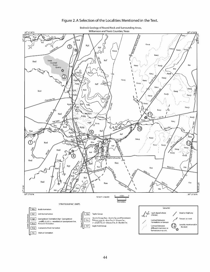
44
45
Appendix 3. Checklist of Cretaceous and Pleistocene fossils described in the Round Rock area, Williamson County, Texas. Following is a checklist of Cretaceous and Pleistocene fossils that have been found in the Round Rock area, Williamson and Travis counties, Texas compiled by the author from the references below. The taxonomy of the species listed generally follows that presented at the website: www.Cretaceousfossils.com (2006). Following each species is listed in brackets the formation the species has been observed as well as a number corresponding to the reference for that occurrence. A comprehensive micropaleontologic study of the Eagle Ford and Austin Groups in Travis County by Lundquist (27) has not been included in the lists below, however it is mentioned here because of its relevance. The sources for this checklist follow below:
1. this study 2. Atchison, Dick E., 1954, Geology of the Brushy Creek quadrangle,
Williamson County, Texas. Austin, The University of Texas at Austin, M.A. thesis, 94p.
3. Tydlaska, LeRoy, 1951, Geology of Palm Valley quadrangle, Williamson County, Texas. Austin, The University of Texas at Austin, M.A. thesis, 56p.
4. Gordon, James E., 1951, Geology of the Hutto quadrangle, Williamson County, Texas. Austin, The University of Texas at Austin, M.A. thesis, 43p.
5. Ward, Daniel Lee, 1950, Geology of the area immediately west of Georgetown, Williamson County, Texas. Austin, The University of Texas at Austin, M.A. thesis, 47p.
6. Marks, Edward, 1950, Biostratigraphy of Jonah quadrangle, Williamson County, Texas. Austin, The University of Texas at Austin, M.A. thesis, 139p.
7. Walls, Billy, 1950, Geology of the Bell Gin quadrangle, Williamson County, Texas. Austin, The University of Texas at Austin, M.A. thesis, 61p.
8. Hartwig, Albert Ernest, Jr., 1952, Geology of the Mozo quadrangle, Williamson County, Texas. Austin, The University of Texas at Austin, M.A. thesis, 66p.
9. Arrington, Robert N., 1954, Geology of the Berry Creek Quadrangle, Williamson County, Texas. Austin, The University of Texas at Austin, M.A. thesis, 69p.
46
10. Kennedy, W.J., Cobban, W.A., Hancock, J.M., and Gale, A.S., 2005, Upper Albian and Lower Cenomanian ammonites from the Main Street Limestone, Grayson Marl, and Del Rio Clay in northeast Texas. Cretaceous Research, 26: 349‐428.
11. Young, K. P., 1959, Techniques of mollusc zonation in Texas Cretaceous: American Journal of Science, 257: 752‐759.
12. Hazzard, R.T., Feray, D.E., Nunnally, J.D., Elliott, J.E., 1949, Seventeenth annual field conference of the Shreveport Geological Society, September 2nd, 3rd, and 4th, 1949, Austin, Texas: Cretaceous of the Austin Area. Shreveport, Shreveport Geological Society, 110 p.
13. Young, K., 1963, Upper Cretaceous Ammonites from the Gulf Coast of the United States. Austin, The University of Texas, Bureau of Economic Geology, Publication No. 6304, 373p.
14. Young, K., and Marks, E., 1952, Zonation of Upper Cretaceous Austin Chalk and Burditt Marl, Williamson County, Texas. Bulletin of the American Association of Petroleum Geologists, 36: 477‐488.
15. Adkins, W.S., 1949, Eagle Ford condensed zone in Travis County, Texas, in, Hazzard, R.T., Feray, D.E., Nunnally, J.D., Elliott, J.E. (eds.) Seventeenth annual field conference of the Shreveport Geological Society, September 2nd, 3rd, and 4th, 1949, Austin, Cretaceous of the Austin Area. Shreveport, Shreveport Geological Society, p. 95‐97.
16. Young, K., and Woodruff, C.M., Jr., 1985, Austin Chalk in its Type Area – Stratigraphy and Structure. Austin, Austin Geological Society Guidebook 7, 88p.
17. Young, K., 1968, Upper Albian (Cretaceous, M. roemeri Zone) ammonites in Texas and Mexico. Journal of Paleontology, 42: 70‐80.
18. Young, K., 1957, Upper Albian (Cretaceous) Ammoidea from Texas. Journal of Petrology, 31:1‐33.
19. Cooke, C.W., 1946, Comanche echinoids. Journal of Paleontology, 20:193‐237.
20. Moreman, W.L., 1942, Paleontology of the Eagle Ford group of north and central Texas. Journal of Paleontology, 16:192‐220.
21. Wells, J. W, 1944, A new coral from the Buda limestone (Cenomanian) of Texas. Journal of Paleontology, 18:100‐101.
22. Wells, J.W., 1934, A new species of stromatoporoid from the Buda limestone of central Texas. Journal of Paleontology, 8:169‐170.
23. Wells, J.W., 1934, A new species of calcisponge from the Buda limestone of central Texas. Journal of Paleontology, 8:167‐168.
24. Cheetham, A.H., Sanner, J., Taylor, P.D., and Ostrovsky, A.N., 2006, Morphological differentiation of Avicularia and the proliferation of
47
species in mid‐Cretaceous Wilbertopora Cheethan, 1954 (Bryozoa: Cheilostomata). Journal of Paleontology, 80:49‐71.
25. Slaughter, B.H., 1966, Platygonus compressus and associated fauna from the Laubach Cave of Texas. American Midland Naturalist, 75: 475‐494.
26. Lundelius, E.J., Jr., 1985, Pleistocene vertebrates from Laubach cave, in, C.M. Woodruff, Jr., F. Snyder, L. De La Garza, and R.M. Slade, Jr., Edwards Aquifer – Northern Segment, Travis, Williamson, and Bell counties, Texas. Austin, Austin Geological Society, p. 41‐45.
27. Lundquist, J.J., 2000, Foraminiferal biostratigraphic and paleoceanographic analysis of the Eagle Ford, Austin and Taylor Groups (Middle Cenomanian through lower Campanian) of Central Texas. Austin, The University of Texas at Austin, PhD dissertation, 545p.
Cretaceous Fauna from the Round Rock Area: Kingdom Protista Kingdom Protista Phylum Protozoa Microfossils of the Austin Group reported by Marks (1950) Discorbis sp. Gyroidina depressa (Alth) Gyroidina globosa (Hagenow) Gyroidina sp. Seabrookia eretacica Bermudez Quadrimorphina sp. Globigerina cretacea d’Orbigny Globigerinella volute (White) Globotruncana arca (Cushman) Globotruncana canaliculta (Reuss) Globotruncana fornicata Plummer Globotruncana spp. Globorotalites umbilicata (Loetterle) Globorotalites michelinianus d’Orbigny Globorotalites umbilicatus (Morrow) Cibicides constrictus (Hagenow) Cibicides nelsoni (W. Berry) Cibicides sp. Anomalina henbesti Plummer
48
Anomalina cf. A. pseudopapillosa Carsey Anomalina spp. Planulina taylorensis (Carsey) Microfossils of the Taylor Group reported by Marks (1950) Pseudoclavulina clavata (Cushman) Nodosaria amphioxys Reuss Planulina taylorensis (Carsey) Kingdom Animalia Phylum Porifera Subphylum Cellularia Class Demospongiae Subclass Ceractinomorpha Order Dictyoceratida Minchin Family Dysideidae Gray, 1867 Genus Spongeliomorpha Spongeliomorpha sp. [Eagle Ford, 1] Class Calcispongea Order Sycones Haeckel Family Verticillitidae Steinmann, 1882 Genus Verticillites Defrance, 1828 Verticillites budaensis Wells, n. sp. [Buda, 23] Kingdom Animalia Phylum Cnidaria Class Hydrozoa Order Stromatoporida Family Actinostromatidae Nicholson, 1886 Actinostromaria dehorneae Wells, n. sp. [Buda, 22] Class Anthozoa Subclass Zoantharia Order Scleractinia Suborder Fungiina Family Microsolenidae Genus Microsolena Lamouroux, 1821 Microsolena williamsonensis Wells, n. sp. [Buda, 21] Suborder ? Family ?
49
Hexacoralla sp. [Buda, 1, 2] Kingdom Animalia Phylum Bryozoa Class Gymnolaemata Order Cheilostomata Family Calloporidae Norman, 1903 Genus Wilbertopora Cheetham, 1954 Wilbertopora spatulifera n. sp. [Georgetown, 24] Wilbertopora attenuata n. sp. [Georgetown, 24] Wilbertopora improcera n. sp. [Georgetown, 24] Kingdom Animalia Phylum Brachiopoda Class Articulata Order Terebratulida Superfamily Terebratullaceae Family Terebratullidae Kingena wacoensis (Roemer) [Georgetown, 2, 5, 7, 9] Terebratulina guadalupe Roemer [Austin, 4, 14] Kingdom Animalia Phylum Mollusca Class Bivalvia Subclass Anomalodesmata Order Pholadomyoida
Superfamily Pholadomyaceae Family Pholadomyidae Homomya washita Cragin {Georgetown, 7] Pachymya austinensis Shumard [Georgetown, 7, 9] Order Veneroida Superfamily Arcticaceae Family Trapeziidae Trapezium sp. [Austin, 8]
Superfamily Cardiaceae Family Cardiidae (ʺHeart Clamsʺ) Subfamily Pleuriocardiinae
Cardium sp. [Buda, 1] Cardium subcongestum (Roemer) [Comanche Peak, 5] Cardium budanese Shattuck [Buda, 5]
50
Subfamily Protocardiinae Protocardia texana (Conrad) [Walnut, 5; Comanche
Peak, 2, 5] Superfamily Veneraceae
Family Veneridae Subfamily Cyclininae
Cyprimereia sp. [Comanche Peak, 2] Cyprimeria texana (Römer) [Comanche Peak, 5] Subclass Palaeoheterodonta Order Trigonoida Suborder ?
Superfamily Trigoniaceae Family Trigoniidae (ʺCordova Clamsʺ)
Trigonia clavigera Cragin [Buda, 2, 9; Georgetown, 7] Trigonia crenulata Lamarck (Roemer) [Walnut, 5] Trigonia sp. [Buda, 1; Austin, 4] Subclass Isofilibranchia Order Mytiloida Suborder Mytiloina
Superfamily Mytilaceae Family Mytilidae Subfamily Modiolinae
Modiolus pedernalis (Roemer) [Walnut, 5] Subclass Pteriomorphia Order Arcoida Suborder Arcoina
Superfamily Arcaceae Family Cucullaeidae
Idonearca sp. [Austin, 3, 4, 6, 8, 9, 14] Order Pterioida Suborder Pteriina
Superfamily Pinnaceae Family Pinnidae (ʺRazor Clamsʺ)
Pinna sp. [Comanche Peak, 2] Pinna guadalupe Böse [Comanche Peak, 5]
Superfamily Anomiacea Family Anomiidae
Anomia tellinoides Morton [Taylor, 6] Anomia sp. [Eagle Ford, 1]
Superfamily Pectinaceae
51
Family Pectinidae (Scallops) Neithea roemeri (Hill) [Buda, 1, 2, 3, 5, 7, 9] Neithea duplicicosta Roemer [Edwards, 5] Neithea texanus (Roemer) [Georgetown, 2, 9] Neithea casteeli Kniker [Buda, 3; Austin, 4, 6, 8, 9, 14] Neithea sp. [Edwards, 2; Austin, 3] Neithea occidentalis Conrad [Comanche Peak, 5] Pecten sp. [Kiamichi, 2; Georgetown, 2; Del Rio, 2] Neithea georgetownensis Kniker [Georgetown, 7] Neithea wrighti (Shumard) [Georgetown, 7] Family Spondylidae Spondylus sp. [Buda, 1] Spondylus Guadalupe Roemer [Austin, 3, 4, 6, 7, 8, 9, 14,
16] Superfamily Pteriaceae
Family Pteriidae Chondrodonta sp. [Edwards, 2]
Family Inoceramidae (ʺSnowshoe Clamsʺ) Inoceramus (Cladoceramus) undulatoplicatus (Römer)
[Austin, 3, 6, 7, 8, 9, 13, 14] Inoceramus (Volviceramus) grandis (Conrad) [Austin, 3,
6, 9, 14] Inoceramus (Magadiceramus) subquadratus (Schlüter) [Austin, 2, 3, 6, 7, 8, 9, 14]
Inoceramus concentricus Logan [Austin, 6] Actinoceramus concentricus (Parkinson) [Comanche
Peak, 5; Edwards, 5] Inoceramus labiatus Schlotheim [Eagle Ford, 7] Inoceramus fragilis Hall and Meek [Eagle Ford, 7, 9] Inoceramus sp. [Georgetown, 9; Eagle Ford, 1, 3, 5]
Superfamily Limaceae Family Limidaef
Lima wacoensis (Roemer) [Georgetown, 7] Lima sp. [Austin, 8] Suborder Ostreina
Superfamily Ostraceae (Oysters) Family Pycnodonteidae (ʺToenailsʺ) Subfamily Pycnodonteina
Pycnodonte (Phygraea) aucella (Römer) [Austin, 1, 3, 4, 6, 7, 8, 9, 13, 14]
52
Pycnodonte wratheri Stephenson [Austin, 1, 3, 4, 6, 7, 8, 9, 14] Texigryphaea roemeri (Marcou) [Austin, 1, 3] Texigryphaea washitaensis (Hill) [Georgetown, 2, 5, 7, 9;
Del Rio, 1; Buda, 1] Texigryphaea graysonana (Stanton) [Del Rio, 1, 2, 3, 7, 9;
Buda, 2, 3, 7, 9] Texigryphaea navia (Hall) [Kiamichi, 2] Texigryphaea mucronata (Gabb) [Walnut, 5; Comanche
Peak, 5; Buda, 1] Gryphaea sp. [Kiamichi, 2]
Subfamily Exogyrinae Exogyra ponderosa erraticostata Stephenson [Austin, 6;
Taylor, 6] Exogyra ponderosa Römer [Austin, 1, 4, 6, 7, 8, 14;
Taylor, 6, 14] Exogyra laeviuscula Römer [Austin, 4, 6, 8, 14] Exogyra texana (Roemer) [Walnut, 5; Comanche Peak,
2; Edwards, 5] Exogyra tigrina Stephenson [Austin, 4, 6, 8, 14] Ilymatogyra arietina (Römer) [Georgetown, 2, 7, 9; Del
Rio, 1, 2, 3, 7, 9] Exogyra clarki (Shattuck) [Buda, 2, 9] Exogyra sp. [Kiamichi, 2] Amphidonte walkeri (White) [Georgetown, 2, 7, 9]
Family Ostreidae Subfamily Lophinae
Nicaisolopha bellaplicata (Shumard) [Eagle Ford, 1, 5] Rastellum carinatum (Lamarck) [Georgetown, 5, 7, 9] Lopha travisana (Stephenson) [Austin, 3, 6, 7, 8, 9, 14,
16] Agerostrea falcata Morton [Taylor, 6] Lopha subovata (Shumard) [Georgetown, 7]
Subfamily Ostreinae Ostrea centerensis Stephenson [Austin, 6, 14] Ostrea crenulimargo Roemer [Walnut, 5] Ostrea sp. [Georgetown, 3Eagle Ford, 3] Order Hippuritoida
Superfamily Hippuritaceae (Rudists or Rudistids) Family Monopleuridae
53
Monopleura marcida White [Edwards, 5] Monopleura sp. [Eagle Ford, 1]
Family Caprinidae (ʺCaprinidsʺ) Subfamily Coalcomaninae
Caprinuloidea crassifibre (Roemer) [Edwards, 2, 5] Caprinuloidea sp. [Edwards, 2] Family Requieniidae Toucasia texana (Roemer) [Edwards, 5] Toucasia sp. [Edwards, 2] Family Radiolitidae
Subfamily Radiolitinae Eoradiolites davidsoni (Hill) [Edwards, 5] Eoradiolites robustus (Palmer) Eoradiolites sp. [Edwards, 2]
Subfamily Sauvagesiinae Durania austinensis (Roemer) [Austin, 7, 8, 14] Durania texanus (Roemer) [Edwards, 5] Durania sp. [Austin, 8] Class Gastropoda Subclass Streptoneura Superorder Prosobranchia Order Archaeogastropoda Suborder Vestigastropoda
Superfamily Pleurotomarioidea Family Pleurotomariidae (Turban Shells) Leptomaria austinensis (Shumard) [Georgetown, 5] Order Caenogastropoda Suborder Neotaenioglossa (Section Discopoda)
Superfamily Stromboidea Family Aporrhaidae Anchura sp. [Eagle Ford, 1]
Superfamily Cerithioidea Family Turritellidae Subfamily Turritellinae Turritella sp. [Comanche Peak, 2, 5; Edwards, 2; Buda,
1; Eagle Ford, 1, 5; Austin, 8, 9] Turritella seriatim‐granulata Roemer (Texas) [Walnut,
5; Georgetown, 5] Turritella budaensis Shattuck [Buda, 4, 7]
Superfamily Naticoidea
54
Family Naticidae Subfamily Naticinae Tylostoma sp. [Comanche Peak, 2, 5; Eagle Ford, 1] Tylostoma tumidum (Shumard) [Walnut, 5] Tylostoma shumardi Whitney [Buda, 5, 7] Order Heterostropha Suborder ?
Superfamily Nerineoidea Family Nerineidae Ceritella sp. [Edwards, 2] Nerinea cultrispira Roemer [Edwards, 5] Nerinea volana Cragin [Buda, 7] Class Myriapoda (Vielfüsser) Order Scolopendromorpha (Skolopenderartige) Family Scolopendriae (Skolopender) Alipes sp. [Comanche Peak, 2] Class Cephalopoda Subclass Nautiloidea Order Nautilida Superfamily Nautilaceae Family Nautilidae Eutrephoceras campbelli (Meek) [Austin, 1, 9, 14] Eutrephoceras sp. [Austin, 3, 4, 6, 8, 14]
Family Cymatoceratidae Cymatoceras sp. [Georgetown, 2] Paracymatoceras sp. [Georgetown, 2] Paracymatoceras texanum (Shumard) [Georgetown, 7,
9] Order Ammonoidea Zittel, 1884 Suborder Ammonitina Hyatt, 1889 Superfamily Desmocerataceae de Grossouvre, 1894 Family Desmoceratidae Zittel, 1895 Subfamily Puzosiinae Spath, 1922 Genus Parapuzosia Nowak, 1913 Subgenus Parapuzosia Nowak, 1913 Parapuzosia (Parapuzosia) americana Scott and Moore,
1928 [Austin, 6, 7, 13] Parapuzosia bosei Scott and Moore, 1928 [Austin, 13] Parapuzosia corbarica (Grossouvre) [Austin, 14] Genus Puzosia Bayle, 1878
55
Subgenus Puzosia Bayle, 1878 Puzosia (Puzosia) serratocarinata Kennedy and Cobban, 1988 [Eagle Ford, 1] Subfamily Desmoceratinae Zittel, 1895 Genus Desmoceras Zittel, 1884 Subgenus Moremanoceras Cobban, 1972 Moremanoceras sp. [Eagle Ford, 1] Family Muniericeratidae Wright, 1952 Genus Tragodesmoceras Spath, 1922 Tragodesmoceras socorroense [Eagle Ford, 1] Family Pachydiscidae Spath, 1922 Subfamily Pachydiscinae Spath, 1922 Genus Eopachydiscus Wright, 1955 Eopachydiscus marcianus (Shumard, 1854)
[Georgetown, 2, 5,7, 9] Genus Eupachydiscus Spath, 1922 Eupachydiscus sp. [Austin, 13] Genus Pachydiscus Zittel, 1884 Subgenus Pachydiscus Zittel, 1884 Pachydiscus sp. no. 1 cfr. P. gollevillensis (d’Orbignay)
[Austin, 13] Pachydiscus jimenzi Renz [Austin, 14] Pachydiscus sp. [Austin, 4] Superfamily Hoplitaceae Douvillé, 1890 Family Engonoceratidae Hyatt, 1900 Genus Engonoceras Neumayr and Uhlig, 1881 Engonoceras sp. [Comanche Peak, 2] Engonoceras hilli Böhm, 1898 [Walnut, 5] Family Placenticeratidae Hyatt, 1900 Genus Placenticeras Meek, 1876 Placenticeras cumminsi Cragin, 1893 [Eagle Ford, 1;
Austin, 15] Placenticeras sp. [Austin, 8, 9] Subgenus Stantonoceras Johnston, 1903 Stantonoceras pseudosyrtale (Hyatt, 1903) [Austin, 13] Family Schloenbachiidae Parona and Bonarelli, 1897 Genus Schloenbachia Neumayr, 1875 Schloenbachia roemeri Lasswitz [Buda, 2, 3] Superfamily Acanthocerataceae Grossouvre, 1894 Family Brancoceratidae Spath, 1934 (1900)
56
Subfamily Brancoceratinae Spath, 1934 Genus Hysteroceras Hyatt, 1900 Prohysteroceras austinense (Roemer) [Georgetown, 2, 7,
9, 12] Prohysteroceras atchisoni n. sp. [Georgetown, 18] Subfamily Mojsisovicziinae Hyatt, 1903 Genus Oxytropidoceras Stieler, 1920 Subgenus Oxytropidoceras Stieler, 1920 Oxytropidoceras (Oxytropidoceras) multifidum
(Steinmann, 1881) [Comanche Peak, 5] Oxytopidoceras trinitense (Gabb) [Comanche Peak, 5] Oxytropidoceras (Oxytropidoceras) supani (Lasswitz); Cooper [Kiamichi, 12] Subgenus Adkinsites Spath, 1931
Adkinsites bravoensis (Böse); Emerson et al. [Kiamichi, 12]
Oxytropidoceras (Adkinsites) bravoensis (Böse, 1910) [Comanche Peak, 2; Kiamichi, 2, 7]
Oxytropidoceras (adkinsites) trinitensis [Kiamichi, 12] Subfamily Mortoniceratinae H. Douvillé, 1912 Genus Mortoniceras Meek, 1876 Subgenus Mortoniceras Meek, 1876 Mortoniceras (Mortoniceras) equidistans (Cragin, 1893) [Georgetown, 5, 7, 9, 12] Mortoniceras (Mortoniceras) whitneyi (Young, 1957)
[Georgetown, 18] Subgenus Boeseites Young, 1968 Morto niceras (Boeseites) proteus (Haas, 1942)
[Georgetown, 17] Subgenus Angolaites Spath, 1932 Mortoniceras (Angolaites) drakei (Young, 1957) [Georgetown, 18] Mortoniceras (Angolaites) wintoni (Adkins, 1920)
[Georgetown, 7, 9, 11] Subgenus ? Mortoniceras n. sp. (Arrington) [Georgetown, 2] Mortoniceras maximum (Lasswitz) [Georgetown, 2, 9] Mortoniceras sp. [Del Rio, 7] Drakeoceras arringtoni n. sp. [Georgetown, 18] Genus Elobiceras Spath, 1921
57
Elobiceras sp. [Georgetown, 17] Family Acanthoceratidae Grossouvre, 1894 Subfamily Stoliczkaiinae Breistroffer, 1953 Genus Stoliczkaia Neumayr, 1875 Subgenus Lamnayella Wright and Kennedy, 1978 Stoliczkaia (Lamnayella) scotti Briestroffer, 1936 [Del
Rio, 10] Subfamily Acanthoceratinae Grossouvre, 1894 Genus Neocardioceras Spath, 1926 Neocardioceras juddii juddii (Barrois and Guerne, 1878)
Eagle Ford, 1] Genus Acanthoceras Neumayr, 1875 Acanthoceras amphibolum (Morrow) [Eagle Ford, 1] Acanthoceras sp. [Eagle Ford, 5] Subfamily Euomphaloceratinae Cooper, 1978 Genus Euomphaloceras Spath, 1923
Euomp halus septemseriatum (Cragin, 1893) [Eagle Ford, 15]
Genus Romaniceras Spath, 1923 Subgenus Romaniceras Spath, 1923 Romaniceras (Romaniceras) mexicanum Jones, 1938 [Eagle Ford, 1] Subfamily Mantelliceratinae Hyatt, 1903 Genus Graysonites Young, 1958 Graysonites sp. juv. [Del Rio, 2] Mantelliceras (Submantelliceras) wacoense Böse;
Mancini [Del Rio, 10; Buda, 5] Mantelliceras selllardsi Adkins, 1928 [Eagle Ford, 20] Subfamily Mammitinae Hyatt, 1900 Genus Pseudaspidoceras Hyatt, 1903 Pseudaspidoceras aff. aramatum Perv [Eagle Ford, 15] Family Coilopoceratidae, Hyatt, 1903 Genus Coilopoceras Hyatt, 1903 Coilopoceras chispaense Adkins [Eagle Ford, 15] Coilopoceras eaglefordense Adkins [Eagle Ford, 15] Coilopoceras springeri Hyatt, 1903 [Eagle Ford, 1, 15] Coilopoceras austinense Adkins [Austin, 14] Coilopoceras sp. indet. [Eagle Ford, 15] Family Sphenodiscidae Hyatt, 1900 Subfamily Sphenodiscinae Hyatt, 1900

58
Genus Manambolites Houreq, 1949 Manambolites ricensis, n. sp. [Austin, 13] Family Collignoniceratidae Wright and Wright, 1951 Subfamily Collignoniceratinae Wright and Wright, 1951 Genus Collignoniceras Breistroffer, 1947 Collignoniceras woollgari regulare Cobban and Hook,
1980 [Eagle Ford, 1, 15] Genus Prionocyclus Meek, 1876 Prionocyclus wyomingensis Meek, 1876 [Eagle Ford, 15] Prionocyclus eaglense Adkins [Eagle Ford, 15] Prionocyclus percarinatus [Eagle Ford, 15] Prionocyclus hyatti (Stanton, 1984) [Eagle Ford, 1] Prionocyclus sp. [Eagle Ford, upper part, 3, 7] Genus Prionocycloceras Spath, 1926 Prionocycloceras gabrielense Young, 1963 [Austin, 13] Prionocycloceras hazzardi n. sp. [Austin, 13] Genus Peroniceras Grossouvre, 1894 Peroniceras westphalicum (Schlütter) [Austin, 2, 9, 13] Peroniceras haasi n. sp. [Austin, 13, 16] Peroniceras sp. [Austin, 3] Subfamily Barroisiceratinae Basse, 1947 Genus Barroisiceras de Grossouvre, 1894 Subgenus Barroisiceras de Grossouvre, 1894 Barroisiceras sp. [Austin, 8, 14] Genus Texasia Reeside, 1932 Texasia dentatocarinata (Roemer, 1932) [Austin, 3, 4, 13] Subfamily Texanitinae Collignon, 1948 Genus Paratexanites Collignon, 1948 Paratexanites sellardsi Young, 1963 [Austin, 13] Genus Texanites Spath, 1932 Subgenus Texanites Spath, 1932 Texanites (Texanites) texanus texanus (Roemer, 1852)
[Austin, 4, 7, 8, 13, 14] Texanites americanus (Lasswitz) [Austin, 6, 7, 8, 14, 16] Texanites planatus (Lasswitz) [Austin, 8, 13, 14] Texanites internodosus (Renz) [Austin, 8, 9, 14] Texanites densinodosus (Renz) [Austin, 8, 14] Subgenus Plesiotexanites Matsumoto, 1970 Texanites (Plesiotexanites) stangeri densicostus (Spath, 1921) [Austin, 13]
59
Texanites (Plesiotexanites) shiloensis Young, 1963 [Austin, 1, 3, 4, 13]
Genus Bevahites Collignon, 1948 Bevahites bevahensis Collignon, 1948 [Austin, 13] Genus Submortoniceras Spath, 1921 Submortoniceras tequequitense n. sp. [Austin, 13] Subfamily Lenticeratinae Hyatt, 1900 Genus Eulophoceras Hyatt, 1900 Eulophoceras wollmanae n. sp. [Austin, 13] Suborder Ancyloceratina Wiedmann, 1966 Superfamily Turrilitaceae Gill, 1871 Family Anisoceratidae Hyatt, 1900 Genus Idiohamites Spath, 1925 Idiohamites fremonti (Marcou, 1858) [Georgetown, 2, 5,
7, 9,12] Genus Allocrioceras Spath, 1926 Allocrioceras sp. [Eagle Ford, 1] Family Hamitidae Gill, 1871 Genus Metaptychoceras Spath, 1926 Metaptychoceras sp. [Eagle Ford, 1] Family Turrilitidae Gill, 1871 Genus Mariella Nowak, 1916 Subgenus Wintonia Adkins, 1928 Mariella (Wintonia) brazoensis (Roemer, 1849)
[Georgetown, 2,7, 9; Del Rio, 2] Family Diplomoceratidae Spath, 1926 Genus Glyptoxoceras Spath, 1925 Glyptoxoceras sp. [Austin, 4, 14] Glyptoxoceras ellisoni, n.sp. [Austin, 13] Genus Smedaliceras, n. gen. Smedaliceras durhami, n. sp. [Austin, 13] Family Baculitidae Gill, 1871 Genus Sciponoceras Hyatt, 1894 Sciponoceras gracile (Shumard, 1860) [Eagle Ford, 1, 7,
15] Genus Baculites Lamarck, 1799 Baculites grandis Hall and Meek, 1854 [Eagle Ford, 9] Baculites sp. cfr. B. aquilaensis Reeside, 1927 [Austin,
13] Baculites yokoyamai Tokunaga and Shimizu, 1926
60
[Eagle Ford, 1] Baculites sp. [Eagle Ford condensed zone, 3; Austin, 8,
9] Family Phylcticrioceratidae Spath, 1926 Genus Phlycticrioceras Spath, 1926 Phlycticrioceras sp. cfr. P. Douviilei [Austin, 13] Superfamily Scaphitaceae Gill, 1871 Family Scaphitidae Gill, 1871 Subfamily Otoscaphitinae Wright, 1953
Genus Worthoceras Adkins, 1928 Worthoceras sp. [Eagle Ford, 1] Subfamily Scaphitinae Gill, 1871 Genus Scaphites Parkinson, 1811 Scapites aff. aequalis var. turonensis [Eagle Ford, 15] Scaphites sp. [Austin, 2] Subgenus Scaphites Parkinson, 1811 Scaphites (Scaphites) carlilensis Morrow, 1935 [Eagle
Ford, 1] Kingdom Animalia Phylum Annelida Class Chaetopoda Subclass Polychaeta Order Phanerocephala (?) Family ? Hamulus onyx Morton [Taylor, 6] Serpula (Linnaeus) spp. [Eagle Ford, 1] Kingdom Animalia Phylum Echinodermata Subphylum Echinozoa Class Crinoidea Subclass Articulata Order Uintacrinida Family Marsupitidae Marsupites testudinarius americanus Springer [Austin,
14] Class Echinoidea Subclass Euechinoidea Superorder Atelostomata
61
Order Holasteroida Family Holasteridae Holaster simplex Shumard [Georgetown, 5, 7, 9] Holaster laevis (Brongniart) [Georgetown, 19] Holaster sp [Austin, 8] Superorder Spatangoida Order Hemiasterina Family Hemiasteridae Hemiaster whitei (Clark) [Walnut, 5] Hemiaster texanus Roemer [Austin, 3, 4, 6, 7, 8, 9, 14,
16] Hemiaster sp. [Georgetown, 2] Leiostomaster bosei [Eagle Ford, 1] Order Toxasterina Family Toxasteridae Macraster elegans (Shumard) [Georgetown, 2, 5, 7, 9] Enallaster sp. [Comanche Peak, 2; Kiamichi, 2; Buda, 2] Superorder Echinacea Order Cidaroida Family Cidaridae Leiocidaris sp. [Georgetown, 2; Austin, 8] Leiocidaris hemigranosus (Shumard) [Georgetown, 7] Order Arbacioida Family Arbaciidae Goniopygus zitteli Clark [Edwards, 19] Order Salenioida Family Saleniidae Subfamily Saleniinae Salenia texana Credner [Buda, 19] Superorder Gnathostomata Order Holectypoida Family Holectypina Subfamily Holectypidae Coenholectypus planatus (Roemer) [Walnut, 5;
Edwards, 2] Unidentified echinoderm fragments [Buda, 1] Kingdom Animalia Phylum Chordata
62
Subphylum Vertebrata Class Chondrichthyes Subclass Elasmobranchii Cohort Euselachii Order Hybodontiformes Superfamily Hybodontoidea Family Ptychodontidae (extinct family of shell crushing sharks) Ptychodus whipplei Marcou [Eagle Ford, 1] Ptychodus latissimus Agassiz, 1843 [Eagle Ford, 1] Ptychodus mortoni Mantell [Eagle Ford, 1] Ptychodus sp. [Eagle Ford, 1] Cohort Neoselachii Superorder Galeomorphii Order Lamniformes Family Anacoracidae (ʺCrow Sharksʺ. An extinct family of broad,
serrate‐toothed lamniform sharks.) Squalicorax falcatus (Agassiz) [Eagle Ford, 1] Family Cretoxyrhinidae (Mako and Mackerel Sharks. An extinct
family of broad, smooth‐toothed lamniform sharks.)
Cretolamna appendiculata (Agassiz) [Eagle Ford, 1] Cretodus crassidens (Dixon) [Eagle Ford, 1] Cretoxyrhina mantelli (Agassiz) [Eagle Ford, 1]
Cretoxyrhina mantelli oxyrhinoides [Eagle Ford, 1] Family Mitsukurinidae (Ancestral Goblin Sharks. An extant family
of grooved, narrow‐toothed lamniform sharks.) Scapanorhynchus raphiodon (Agassiz) [Eagle Ford, 1] Class Osteichthyes Subclass Actinopterygii (Ray Finned Fishes) Infraclass Neopterygii Division ? Order Pycnodontiformes (Pycnodont Fishes) Family Pycnodontifae Hadrodus sp [Eagle Ford, 1] Division Teleostei Subdivision Elopomorpha Order Elopiformes Suborder Pachyrhizodontoidei Superfamily Pachyrhizodontidae Pachyrhizodus sp. [Eagle Ford, 1]
63
Subdivision Osteoglossomorpha Superorder Scopelomorpha Order Aulopiformes Suborder Enchodontoidei Family Enchodontidae Enchodus petrosus Cope, 1874 [Eagle Ford, 1] 1. Unidentified fragments of fossil fish material are common in some parts of the
Eagle Ford formation. [Eagle Ford, 1] 2. Fragments of bones (as large as ca. 4 x 2 inches) from unidentified vertebrate
animals. [Eagle Ford, 1] Trace Fossils Coprolites [Eagle Ford, 3] Lignitized wood [Eagle Ford, 3]
64
Pleistocene Fauna from Laubach Cave (Inner Space Caverns) Following is a list of Pleistocene fauna associated with five debris cones within the cave that marked former cave entrances (25, 26). Radiocarbon ages have been determined from material associated with material from three of the talus cones: Laubach I, 15,580 ± 500 RCYBP; Laubach II, 13,970 ± 310 RCYBP; and Laubach III, 23,230 ± 490 RCYBP (26). Kingdom Animalia Phylum Chordata Subphylum Vertebrata Class Amphibia Rana pipiens (leopard frog) Class Reptilia Terrapene carolina (eastern box turtle) Sceloporus sp. (fence lizard) Coluber sp. (racer) Elaphe sp. (rat snake) Heterodon sp. (hog nosed snake) Pituophis sp. (bull snake) Thamnophis sp. (garter snake) Agkistrodon contortrix (copperhead) Crotalus sp. (rattlesnake) Class Mammalia Didelphis marupialis (opossum) Tardarida brasiliensis (Mexican free‐tail bat) Myotis sp. (little brown rat) Cryptotis parvis (least shrew) Blarina carolinensis (southern short tailed shrew) Felis onca (jaguar) Homotherium serum (sabertoothed cat) Mephitis mephitis (striped skunk) Spilogale putorius (spotted skunk) Canus dirus (dire wolf) Canis latrans (coyote) Urocyon cinereoargenteus (gray fox) Tremarctos floridanus (spectacled bear) Mammuthus sp. (mammoth) Equus sp. (horse) Platygonus compressus (extinct peccary)
65
Odocoileus virginianus (whitetail deer) Tetrameryx shuleri (four horned antelope) Camelops sp. (camel) Dasypus bellus (large armadillo) Glytotherium floridanus (glyptodont) Megalonyx jeffersoni (ground sloth) Cynomys ludovicianus (prairie dog) Microtus sp. (vole) Microtus ochrogaster (prairie vole) Neotoma sp. (packrat) Peromyscus sp. (deer mouse)
Sigmodon hispidus (cotton rat) Geomys sp. (gopher) Perognathus hispidus (hispid pocket mouse) Perognathus flavus (silky pocket mouse) Dipodomys sp. (kangaroo rat) Dipodomys elator (Texas kangaroo rat) Lepus californicus (jackrabbit) Sylvilagus sp. (cottontail)