oceangate, suite 1000 g beach, ca 90802-4302 2) 590-5071
TRANSCRIPT
STATE OF CALIFORNIA· THE RESOURCES AGENCY
._... CALIFORNIA COASTAL COMMISSION RECORD PACKET COPY
tth Coast Area Office Oceangate, Suite 1000
g Beach, CA 90802-4302 2) 590-5071
Tu 15-c Filed: 9/1/2000 49th Day: 1 0/20/2000
•
•
180th Day: 2/28/2001 Staff: AM-LB Staff Report: 1/25/01 Hearing Date: 2/13/01 Commission Action:
STAFF REPORT: REGULAR CALENDAR
APPLICATION NUMBER: 5-00-318
APPLICANT: L.A. County, Department of Beaches and Harbors
PROJECT LOCATION: 100 Torrance Boulevard (along the Redondo County Beach from the Redondo Beach Pier to Sapphire Street), City of Redondo Beach, Los Angeles County
PROJECT DESCRIPTION: Demolish an 850 foot section of a five-foot wide pedestrian walkway adjacent to the Redondo County Beach and replace the 850 foot section with a 1 0-foot wide cement sidewalk. Also included in the project is the extension of an existing Sapphire Street storm drain box by 60 feet, two existing PVC drains by approximately 20-30 feet, and the addition of shower facilities on the northern end of the walkway.
LOCAL APPROVALS RECEIVED: 1) Notice of Exemption, County of Los Angeles Department of Beaches and
Harbors, July 24, 2000.
SUBSTANTIVE FILE DOCUMENTS: 1) City of Redondo Beach, Local Coastal Program 2) Coastal Development Permit 5-95-036 3) Coastal Development Permit 5-99-232; A 1 4) Santa Monica Bay Restoration Project, Jan. 1993 5) Historical Changes in the Beaches of L.A. County, by Coastal Frontiers, Feb. 1992
Reconnaissance Report, Malibu/L.A. County Coastline, by U.S. Army Corps of Engineers, April 1994
SUMMARY OF STAFF RECOMMENDATION:
Staff recommends approval of the proposed development subject to conditions relating to public safety, water quality, erosion control, and coastal access .
5-00-318 (Redondo Beach) Page 2 of 18
STAFF RECOMMENDATION OF APPROVAL:
MOTION:
I move that the Commission approve COP No. 5-00-318 pursuant to the staff recommendation.
Staff recommends a YES vote. Passage of this motion will result in approval of the permit as conditioned and adoption of the following resolution and findings. The motion passes only by affirmative vote of a majority of the Commissioners present.
I. RESOLUTION TO APPROVE THE PERMIT:
The Commission hereby approves a coastal development permit for the proposed development and adopts the findings set forth below on grounds that the development as conditioned will be in conformity with the policies of Chapter 3 of the Coastal Act and will not prejudice the ability of the local government having jurisdiction over the area to prepare a Local Coastal Program conforming to the provisions of Chapter 3. Approval of the permit complies with the California Environmental Quality Act because either 1) feasible mitigation measures and/or alternatives have been incorporated to substantially lessen any
.,
•
significant adverse effects of the development on the environment, or 2) there are no • further feasible mitigation measures or alternatives that would substantially lessen any significant adverse impacts of the development on the environment.
II. STANDARD CONDITIONS:
1 . Notice of Receipt and Acknowledgment. The permit is not valid and development shall not commence until a copy of the permit, signed by the permittee or authorized agent, acknowledging receipt of the permit and acceptance of the terms and conditions, is returned to the Commission office.
2. Expiration. If development has not commenced, the permit will expire two years from the date this permit is reported to the Commission. Development shall be pursued in a diligent manner and completed in a reasonable period of time. Application for extension of the permit must be made prior to the expiration date.
3. Interpretation. Any questions of intent or interpretation of any condition will be resolved by the Executive Director or the Commission.
•
• 4.
5.
Ill.
1.
•
2.
•
5-00-318 (Redondo Beach) Page 3 of 18
Assignment. The permit may be assigned to any qualified person, provided assignee files with the Commission an affidavit accepting all terms and conditions of the permit.
Terms and Conditions Run with the Land. These terms and conditions shall be perpetual, and it is the intention of the Commission and the permittee to bind all future owners and possessors of the subject property to the terms and conditions.
SPECIAL CONDITIONS
ASSUMPTION OF RISK, WAIVER OF LIABILITY AND INDEMNITY AGREEMENT
By acceptance of this permit, the applicant, on behalf of (1) itself; (2) its successors and assigns, and (3) any other holder of the possessory interest in the development authorized by this permit, acknowledges and agrees (i) that the site may be subject to hazards from waves, storm waves, flooding and erosion; (ii) to assume the risks to the applicant and the property that is the subject of this permit of injury and damage from such hazards in connection with this permitted development; (iii) to unconditionally waive any claim of damage or liability against the Commission, its officers, agents, and employees for injury or damage from such hazards; (iv) to indemnify and hold harmless the Commission, its officers, agents, and employees with respect to the Commission's approval of the project against any and all liability, claims, demands, damages, costs (including costs and fees incurred in defense of such claims), expenses, and amounts paid in settlement arising from any injury or damage due to such hazards, and (v) to agree to include a provision in any subsequent sublease or assignment of the development authorized by this permit requiring the sublessee or assignee to submit a written agreement to the Commission, for the review and approval of the Executive Director, incorporating all of the foregoing restrictions identified in (i) through (iv).
Storage of Construction Materials, Mechanized Equipment, and Removal of Construction Debris
The permittee shall comply with the following construction-related requirements:
(a) No construction materials, debris, or waste shall be placed or stored where it may be subject to wave/wind/rain erosion and dispersion.
(b) Any and all debris resulting from construction activities shall be removed from the project site within 24 hours of completion of construction .
3.
(c)
5-00-318 (Redondo Beach) Page 4 of 18
All mechanized machinery shall be removed from the beach at the end of the working day. No storage of mechanized equipment is allowed on the beach.
(d) No disturbance of areas below the mean high tide line is permitted.
(e) Best Management Practices (BMPs) designed to prevent spillage and/or runoff of construction-related materials, sediment, or contaminants associated with construction activity shall be implemented prior to the on-set of such activity. Selected BMPs shall be maintained in a functional condition throughout the duration of the project. Such measures shall be used during construction: temporary sediment basins (including debris basins, desilting basins or silt traps), temporary drains and swales, sand bag barriers, silt fencing, stabilize any stockpiled fill with geofabric covers or other appropriate cover, install geotextiles or mats on all cut or fill slopes, and close and stabilize open trenches as soon as possible.
(f) Construction debris and sediment shall be removed from construction areas each day that construction occurs to prevent the accumulation of sediment and other debris which may be discharged into coastal waters. Debris shall be disposed at a debris disposal site outside the coastal zone, pursuant to Special Condition No. 2.
Location of Debris Disposal Site
The applicant shall dispose of all demolition and construction debris resulting from the proposed project at an appropriate location outside the coastal zone. If the disposal site is located within the coastal zone, a coastal development permit or an amendment to this permit shall be required before disposal can take place.
4. Storm Drain/Structural Best Management Practices
A. The applicant shall implement structural Best Management Practices (BMPs} in the Sapphire Street Drain extension, which will serve to minimize pollutant loads contained in runoff prior to entering the storm water conveyance system and the Pacific Ocean.
B. PRIOR TO ISSUANCE OF THE COASTAL DEVELOPMENT PERMIT, the applicant shall submit a Drainage Plan to the Executive Director for review and approval. The Plan shall provide for the installation of one Continuous Deflection System (CDS) unit with a 1200 to 2000 micron screen. If a 1200 to 2000 micron screen is not available, the applicant shall insert a sorbent pad specifically designed
•
•
•
•
•
•
5-00-318 (Redondo Beach) Page 5 of 18
to remove vehicular contaminants and other typical urban runoff pollutants 1 more efficiently than a standard silt and grease trap. The pad shall be installed in conjunction with the CDS unit. These filters can be installed in-line within the catch basin, water quality inlets, or at the drain outlet. Such a filter shall be affective at removing pollutants of concern such as petroleum hydrocarbons, heavy metals, fecal coliform, and suspended solids. The Drainage Plan shall account for the following:
(1) The drainage system shall be designed to filter or treat (i.e., a physical and/or chemical reduction of pollutants achieved through active filtration) the volume of runoff produced from each and every storm event up to and including the 85th percentile 24-hour runoff event for volume based Best Management Practices (BMPs), and/or the 85th percentile, 1-hour runoff event, with an appropriate safety factor, for flow-based BMPs, prior to its discharge to the Pacific Ocean. The drainage system and its individual components (such as drop inlets and filtration mechanisms) shall be sized according to the specifications identified in the California Storm Water Best Management Practice Municipal Handbook (California Storm Water Management Task Force, March 1993).
(2) All drainage system elements shall be permanently operated and maintained at a minimum:
(a) All storm drain inlets, traps/separators, and/or filters shall be inspected to determine if they need to be cleaned out or repaired at the following minimum frequencies: ( 1) prior to October 15th each year; (2) prior to April 15th each year; and (3) during each month that it rains between November 1st and April 1st. Clean-out and repairs (if necessary} shall be done as part of these inspections. At a minimum, all traps/separators and/or filters must be cleaned prior to the onset of the storm season, no later than October 15th of each year; and,
(b) Debris and other water pollutants removed from filter device(s) during clean-out shall be contained and disposed of in a proper manner; and
(c) All inspection, maintenance and clean-out activities shall be documented in an annual report submitted to the Executive Director no later than June 30th of each year.
"Typical urban runoff pollutants" describes constituents commonly present in runoff associated with precipitation and irrigation. Typical runoff pollutants include, but are not limited to: paints, varnishes, and solvents; hydrocarbons and metals; non-hazardous solid wastes and yard wastes; sediment from construction activities (including silts, clays, slurries, concrete rinsates, etc.); ongoing sedimentation due to changes in land cover/land use; nutrients, pesticides, herbicides, and fertilizers (e.g., from landscape maintenance); hazardous substances and wastes; sewage, fecal coliforms, animal wastes, and pathogens; dissolved and particulate metals; and other sediments and floatables.
5-00-318 (Redondo Beach) Page 6 of 18
{3) The applicant is encouraged to develop connections from the storm drain system to the sanitary sewer system to allow polluted runoff to be directed from the storm drain system to the sanitary sewer, particularly during times of low-volume flows, wet street cleaning episodes, or hazardous spills. The applicant is also encouraged to implement a plan for future Best Management Practices on other storm drains that exit to Redondo State Beach.
{4) It is the applicant's responsibility to maintain the drainage system in a structurally sound manner and its approved state.
C. The applicant shall carry out the following water quality monitoring plan for all three drains:
The applicant shall develop and implement or incorporate the proposed development into an existing, stormwater monitoring program designed to a) evaluate the effectiveness of the selected Best Management Practices in reducing pollutants contained in stormwater being conveyed via the proposed development, and b) to evaluate stormwater compliance with applicable Regional Water Quality Control Board water quality objectives or standards established for the stormwater system or its components. The monitoring plan shall be designed and undertaken in substantial conformance with the following:
•
a) Stormwater conveyed through the proposed development shall be • sampled at points necessary to evaluate the efficacy of the BMPs at reducing pollutants contained in stormwater
b) Constituents to be sampled include, but are not limited to, the following: Total Suspended Solids (TSS) and Zinc.
c) Data shall be collected using flow-weighted, time weighted or other appropriate techniques with proper attention to quality assurance/quality control (QA/QC) issues.
d) Samples shall be collected from a minimum of 3 representative storm events during the storm season (October 15 - April 31st) for a period of no less than 2 years post-construction including BMP installation.
e) Monitoring results shall be submitted to the Executive Director, no later than June 30th of each year in which monitoring in accordance with the terms of this permit is occurring.
f) Monitoring results will be used, in part, to evaluate compliance with requirements pertaining to the incorporation and maintenance of BMPs
•
•
•
•
5-00-318 (Redondo Beach) Page 7 of 18
into the proposed components of the storm drain system pursuant to Special Condition #3.
D. The applicant shall undertake development in accordance with the approved final plan. Any proposed changes to the approved final plan shall be reported to the Executive Director. No changes to the approved final plan shall occur without a Commission amendment to this coastal development permit unless the Executive Director determines that no amendment is necessary.
5. Maintenance/Monitoring of Storm Drain Extensions
A. Prior to Issuance of the Coastal Development Permit, the applicant shall agree to the below conditions.
B. If, at any time, 10 feet or more of any storm drain is exposed and unsupported by sand, such portion shall be removed and support piles pulled out. Alternatively, if, at any time, 10 feet or more of the storm drain is exposed and unsupported by sand, the applicant shall implement a beach nourishment program to sufficiently cover the exposed section of the storm drain and restore the section of the beach in this area. The sand shall come from an approved beach nourishment site. The applicant shall not use or move sand from the surrounding beach .
C. The applicant shall carry out the following maintenance/monitoring plan:
Between April 15 and May 1 of every year, the applicant shall conduct a beach survey that includes measuring the beach profile surrounding the storm drains, measuring any exposed portion of the storm drains, and photographing the site. A written report, including photographs, a map of the pipe's location, showing any portion of the exposed pipe, shall be submitted to the Executive Director for review and approval. If, at such a time, it is discovered that 10 feet or more of the storm drain is exposed and unsupported, such portions shall be removed before May 31 of that same year or a beach nourishment program shall be implemented to sufficiently cover the exposed section of the storm drain and restore the section of the beach.
6. Support Piles
The permitee shall use reinforced concrete piles or piles made from other comparable inert materials for the support of the storm drain extension. The applicant shall not use recycled telephone poles for purposes of supporting the drain. Prior to issuance of the Coastal Development Permit, the permitee shall provide a written report indicating the material to be used for the piles. The piles shall not contain any of the following: petroleum, acid, coal or oil tar,
5-00-318 (Redondo Beach) Page 8 of 18
lampblack, aniline, asphalt, bitumen, or residuary product of petroleum, including • creosote, or carbonaceous materials or substance.
IV. FINDINGS AND DECLARATIONS:
The Commission hereby finds and declares:
A. Project Description and Location
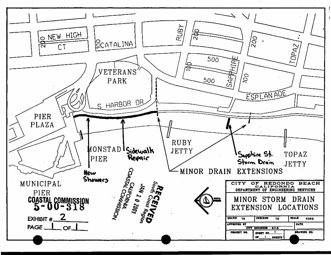
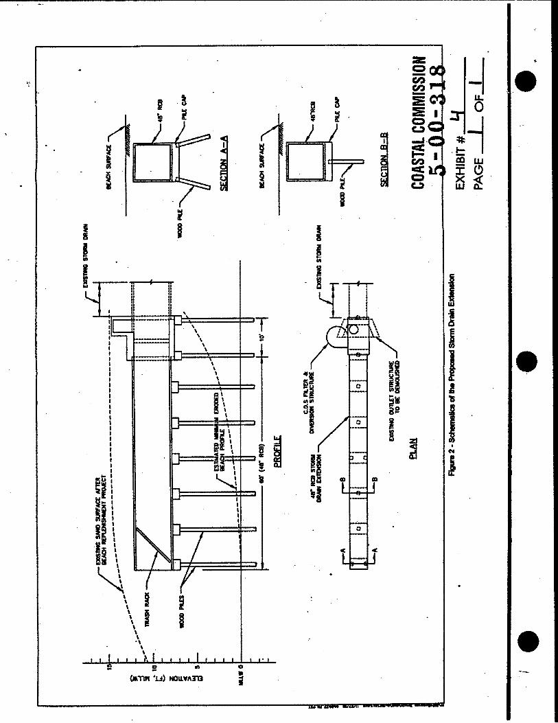
The proposed project is the demolition of an 850-foot section of a five-foot wide pedestrian walkway adjacent to the Redondo County Beach and replacement with a 1 0-foot wide cement sidewalk. The additional five feet in width will be placed seaward of the existing walkway. Also included in the project is the extension of three existing storm drains (See Exhibits). The existing 48-inch Sapphire Street storm drain will be extended 60 feet seaward (Exhibit #4). The new storm drain will remain 48 inches in diameter. The storm drain will be supported by 12-inch to 18-inch diameter vertical timber piles spaced at 1 0-foot intervals and double battered piles (at approximately 15 degrees with vertical) at 30-foot intervals (Exhibit #5). The City Engineer has stated that the timber piles will consist of discarded telephone poles. The remaining two storm drains {a ten-inch PVC drain near South Harbor Drive and an eight-inch PVC drain, 250 feet south of the Sapphire drain) are proposed to be extended approximately 20 to 30 feet seaward {Exhibit #2). These drains will extend the PVC pipe unsupported, below the existing beach profile. The project will • include the addition of shower facilities on the northern end of the walkway. As part if the project, the City proposes to take some measures to improve the water quality if the discharge from the Sapphire Drain.
The Beach is located at the south end of the city. Inland of the beach there is a 60-100 foot high bluff, that further south curves out, forming the beginning of the Palos Verdes peninsula.
Currently, there is a five-foot wide pedestrian walkway adjacent to the Redondo County Beach. Directly inland and parallel to the pedestrian walkway is a 1 0-foot wide bike path (Exhibit #2). This bikepath begins in the City of Torrance and terminates in Pacific Palisades in Will Rogers State Park. The proposed project involves 850 feet of this walkway. The proposed widening of the sidewalk is intended to alleviate hazards due to the congestion of foot and bike traffic on the walkway.
The three existing storm drains exit approximately ten feet from the edge of the pedestrian sidewalk, onto the sandy beach. During heavy rains run-off from the storm drain system erodes the beach to depths of nearly 15 feet. The applicant proposes to extend the storm drains seaward to alleviate the hazards to beach goers created by this erosion.
•
•
•
•
5-00-318 (Redondo Beach) Page 9 of 18
The City of Redondo Beach provides recreational activities to many in the Los Angeles area. The Redondo Beach Pier is directly north of the proposed project. The Redondo Beach Pier area includes visitor-serving facilities such as restaurants, hotels and specialty retail stores. The boardwalk, consisting of a five-foot wide pedestrian walkway and a 1 afoot wide bicycle path, connect an extensive beach path comprised of the entire Santa Monica Bay, from Torrance to Malibu.
B. Redondo Submarine Canyon/Sand Replenishment
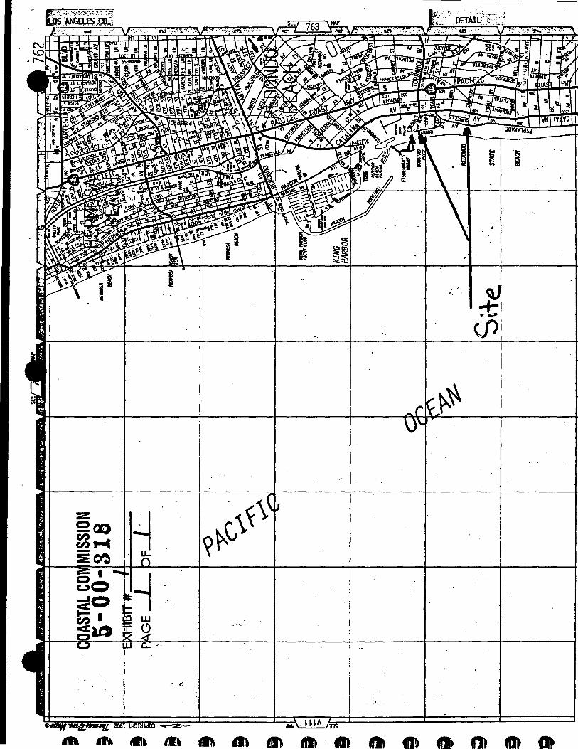
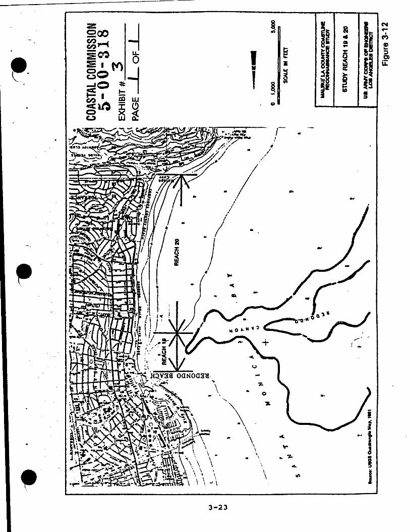
A report conducted by the U.S. Army Corps of Engineers, April 1994 indicates that the area between the Redondo Beach-King Harbor to the north and the Topaz Street groin to the south is a chronically narrow stretch of sandy beach. This narrow beach is strongly influenced by the effects of the groin as well as the Redondo Submarine Canyon, which lies in close proximity to the beach (Exhibit #3). The report states, "Slow but steady losses to the canyon are projected to occur in the future resulting in shoreline recession over the short segment". This canyon serves as a sink for littoral transport from both the north and the south. The report anticipates damage to the restroom and bike path in the short term and the retaining wall and fill that protects development on the bluff in the long term. To offset the loss of sand to the submarine canyon, the report concludes by stating the necessity to stabilize or renourish this section of beach.
On August 10, 1999, the Commission approved a sand replenishment program for Redondo Beach. The approval allowed for the placement of approximately 165,000 cubic meters of clean sand from an earlier dredging project in the Marina del Rey entrance channel, on a portion of Redondo County Beach from the Topaz Jetty north to the vicinity of Pearl Street (the location of the proposed project). The project was intended to widen the beach by approximately 1 00 feet. The beach replenishment would provide protection to public access along the beach, as well as the structures located along the bluffs.
C. Public Access
Sections 30210, 30211 and 30212 of the Coastal Act require that new development provide maximum public access and recreation, avoid interference with the public's right of acquired access, and provide public access from the nearest public roadway to the shoreline and along the coast except under certain circumstances.
Section 30210 of the Coastal Act states:
In carrying out the requirement of Section 4 of Article X of the California Constitution, maximum access, which shall be conspicuously posted, and recreational opportunities shall be provided for all the people consistent with public safety needs and the need to protect public rights, rights of private property owners, and natural resource areas from overuse .
5-00-318 (Redondo Beach) Page 10 of 18 .
Section 30211 of the Coastal Act states:
Development shall not interfere with the public's right of access to the sea where acquired through use or legislative authorization, including, but not limited to, the use of dry sand and rocky coastal beaches to the first line of terrestrial vegetation.
King Harbor, the Redondo Beach Marina, Fisherman's Wart, and Monstad and Municipal Piers are an attraction to residents and visitors alike. This area provides visitors with bike and walking paths, shops, boating activities, restaurants, and public parking facilities.
Pedestrian Walkway
Along the 2.8 mile stretch of Redondo Beach is a five foot wide pedestrian walking path as well as a ten foot wide bicycle path. The bike path is directly adjacent to and parallel with the walking path. This pathway connects to a larger walking/biking path that extends from Torrance to Will Rogers Beach in the Pacific Palisades. The proposed project includes the demolition of an 850-foot portion of the pedestrian walkway (between the Pier and Ainsworth Court) and construction of ten foot wide pedestrian walkway. The project will extend the walkway five feet seaward of its original location. This would displace a five foot wide, 850-foot long portion of the sandy beach. Widening the walkway on its inland side, away from the beach is not feasible because a high bluff and three-foot high retaining wall is located directly inland of the bike path.
..
•
The applicant has stated that during busy, summer days, pedestrian traffic and bicycle • traffic pose a hazard to one another. The current width of the walkway is five feet. This allows for two people to walk side by side. When the path is overcrowded, pedestrians use the bike path for walking. During a site visit, staff noted that, even during a winter weekday, the pedestrian sidewalk becomes overcrowded.
The widening of the pedestrian sidewalk will increase the availability of coastal access and provide and maintain public recreation within Redondo Beach. For this reason, the proposed project is consistent with the public access and recreation policies of the Coastal Act.
Storm Drain Extensions
As previously noted, the littoral transport of sand to Redondo Beach is lost to the Redondo Submarine Canyon, which lies directly offshore. The Commission approved a sand replenishment program in 1999. This widened the beach approximately 100 feet. The current width of the beach in the subject area is approximately 60 to 80 feet.
•
•
•
•
5-00-318 (Redondo Beach) Page 11 of 18
The storm drain system has also contributed to the loss of sand, as well as lateral public access. One major and four minor storm drains exit approximately 1 0 feet seaward of the pedestrian walkway between the Topaz Jetty and the Pier. During major rain storms deep canyons are created across the beach. During a site visit on January 23, 2001, approximately one week after extreme high tides and heavy rains, staff noted a deep eroded canyon in front of the Sapphire storm drain outlet. The erosion cut approximately 15 feet deep and extended across the entire beach. Only a ten~foot wide area, between the pedestrian walkway and the storm drain outlet remained of the preexisting beach. Other minor drains created deep pools where water collected but did not reach the ocean.
The erosion caused by the storm drains impedes lateral access to both the public and to emergency vehicles, such as lifeguard and fire trucks. The applicant has proposed to extend three storm drains seaward, in the area between the Topaz Jetty and the Pier (Exhibit #2). Two of the drains, considered "minor" because they drain a small area and use ten and eight inch diameter PVC pipe, would extend from 20 to 30 feet seaward of their present location (ten feet seaward of the pedestrian walkway). The extensions would connect to the existing pipe, extend beneath the sand, and exit near the shoreline, discharging into the sand.
The Sapphire Street storm drain is a 48-inch diameter concrete storm drain that currently exits ten feet seaward of the pedestrian walkway. This drain creates the most erosion and the greatest hazard to the public. At present, a large, canyon-like cut extends from the drain outlet to the shoreline. The Sapphire Street drain drains a four square block area, bordered by Pearl Avenue, Franciscan Avenue, Topaz Street, and Esplanade (Exhibit #7).
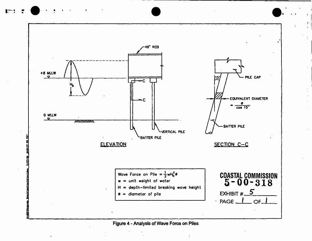
The applicant has proposed to extend the Sapphire Street Storm Drain 60 feet seaward of the existing location. The drain will remain 48 inches in diameter and will be supported by ten piles and existing beach sand. Batter piles (founded 15 degrees to vertical) will make up four of the piles while six piles will be founded vertically (Exhibit #4 & 5). The applicant has proposed to use cut telephone poles for the pile system (See Special Condition #6 and Water Quality section of this staff report for further information on pile materials). The storm drain would be buried approximately four feet with the existing sand surface. The storm drain, as proposed, would exit near the shoreline, away from the pedestrian walkway and dry sandy beach.
Extending the storm drains would allow the runoff water to exit closer to the shoreline instead of across the dry portion of the beach. In doing so, the proposed project would discharge pollutants carried by the drain directly into the water, instead of discharging into the sand that formerly performed some filtering functions. To address this problem the city is proposing to undertake water quality improvements, mainly stormwater BMP's such as inlet stenciling .
5-00-318 (Redondo Beach) Page 12 of 18
Ying Keung Poon, D.Sc., P .E. prepared a report entitled City of Redondo Beach Storm • Drain Extension Wave Force Evaluation on November 27, 2000. The report analyzed design conditions, wave conditions, horizontal wave forces on the storm drain, uplift force on the storm drain, and wave force on the piles. The City of Redondo Beach prepared structural calculations that incorporated the engineering reports findings. Lesley Ewing, Commission Senior Coastal Engineer, reviewed both the report and structural calculations. Her review found that the plan submitted by the applicant is designed to withstand a moderate earthquake and regular wave forces.
Although the proposed extension would allow for better lateral coastal access by discharging the water runoff away from the dry sandy beach, the storm drain structure could pose a major impediment if the beach were to retreat, exposing the drain pipes and piles. Staff noted that on two separate site visits, one before the winter storm season on Oct. 11, 2000 and one after a major rain storm event on Jan. 23, 2001, the beach profile remained relatively constant. However, the runoff from the storm drains caused extensive erosion across the width of the beach. Though the beach profile appears constant, beach areas are dynamic environments, which may be subject to unforeseen changes. Such changes may affect beach processes, including sand regimes. The mechanisms of sand replenishment are complex and may change over time, especially as beach process altering structures, such as jetties, are modified, either through damage or deliberate design. In order to prevent the storm drain extensions from impeding lateral access along the coastline if such beach erosion occurs, the Commission imposes Special Condition #5. Special Condition #5 requires that at any time, 10 feet or more of the storm drain is • exposed and unsupported by sand, such portion shall be removed and support piles pulled out. Alternatively, if, at any time, 10 feet or more of the storm drain is exposed and unsupported by sand, the applicant shall implement a beach nourishment program to sufficiently cover the exposed section of the storm drain and restore the section of the beach in this area. The sand shall come from an approved beach nourishment site. The applicant shall not use or move sand from the surrounding beach.
The permittee is also required to implement a monitoring program for the storm drain extensions. The monitoring shall take place between April 15 and May 1 of every year. The program shall include measuring the beach profile surrounding the storm drains, measuring any exposed portion of the storm drains, and photographing the site. A written report, including photographs, a map of the pipe's location, showing any portion of the exposed pipe, shall be submitted to the Executive Director for review and approval. If the city discovers during this inspection that 10 feet or more of the storm drain is exposed and unsupported, the exposed portions shall be removed before May 31 of that same year. As an alternative a beach nourishment program shall be implemented to sufficiently cover the exposed section of the storm drain and restore the section of the beach.
The proposed project is located near or on a sandy beach that is subject to hazards from wave run-up, scour, and erosion. For this reason, the Commission imposes
•
•
•
•
5-00-318 (Redondo Beach) Page 13 of 18
Special Condition #1 that requires the applicant to assume the risk of the proposed development. The assumption-of-risk language includes a waiver of liability by the applicant to indemnify the Commission for any damage to life and property which may occur as a result of the permitted development. The waiver of liability also shows that the applicant is aware of and appreciates the nature of the hazards which exists on the site and which may adversely affect the stability and safety of the proposed development.
The proposed project would enhance lateral coastal access by widening the existing pedestrian sidewalk and extending three storm drains to prevent erosion across the beach by water runoff. The proposed project, as conditioned to remove exposed, unsupported sections of the storm drains which could impeded lateral access along the beach and create a public hazard, is found consistent with Section 30210 and 30211 of the Coastal Act.
D. WATER QUALITY
Section 30230 of the Coastal Act states:
Marine resources shall be maintained, enhanced, and where feasible, restored. Special protection shall be given to areas and species of special biological or economic significance. Uses of the marine environment shall be carried out in a manner that will sustain the biological productivity of coastal waters and that will maintain healthy populations of all species of marine organisms adequate for longterm commercial, recreational, scientific, and educational purposes.
Section 30231 of the Coastal Act states:
The biological productivity and the quality of coastal waters, streams, wetlands, estuaries, and lakes appropriate to maintain optimum populations of marine organisms and for the protection of human health shall be maintained and, where feasible, restored through, among other means, minimizing adverse effects of waste water discharges and entrainment, controlling runoff, preventing depletion of ground water supplies and substantial interference with surface water flow, encouraging waste water reclamation, maintaining natural vegetation buffer areas that protect riparian habitats, and minimizing alteration of natural streams.
Section 30232 of the Coastal Act states, in pertinent part:
Protection against the spillage of crude oil, gas, petroleum products, or hazardous substances shall be provided in relation to any development or transportation of such materials .
5-00-318 (Redondo Beach) Page 14 of 18
Section 30240 of the Coastal Act states:
(a) Environmentally sensitive habitat areas shall be protected against any significant disruption of habitat values, and only uses dependent on such resources shall be allowed within such areas.
(b) Development in areas adjacent to environmentally sensitive habitat areas and parks and recreation areas shall be sited and designed to prevent impacts which would significantly degrade such areas, and shall be compatible with the continuance of such habitat areas.
Sections 30230, 30231, 30232, and 30240 of the Coastal Act require that marine resources be maintained, enhanced, and restored in a manner that will sustain the biological productivity of all species of marine organisms in coastal waters, and that the biological productivity and water quality of Santa Monica Bay be maintained and restored by controlling polluted runoff.
1. Construction Impacts to Water Quality
Storage or placement of construction materials, debris, or waste in a location subject to erosion and dispersion or which may be discharged into coastal water via rain, surf, or wind would result in adverse impacts upon the marine environment that would reduce the
•
biological productivity of coastal waters. For instance, construction debris entering coastal • waters may cover and displace soft bottom habitat. In addition, the use of machinery in coastal waters not designed for such use may result in the release of lubricants or oils that are toxic to marine life. Sediment discharged to coastal waters may cause turbidity, which can shade and reduce the productivity of foraging avian and marine species ability to see food in the water column. In order to avoid adverse construction-related impacts upon marine resources, Special Condition #2 outlines construction-related requirements to provide for the safe storage of construction materials and the safe disposal of construction debris.
Special Condition No.3 requires that the applicant dispose of all demolition and construction debris at an appropriate location outside of the coastal zone and informs the applicant that use of a disposal site within the coastal zone will require an amendment or new coastal development permit.
Only as conditioned for appropriate storage of construction materials and equipment, and for location of an appropriate debris disposal site does the Commission find that the proposed development is consistent with Sections 30230, 30231, 30232, and 30240 of the Coastal Act.
•
•
•
2.
5-00-318 (Redondo Beach) Page 15 of 18
Storm Drain/Water Quality
The proposed storm drain extensions will discharge directly on Redondo State Beach and into Santa Monica Bay and the Pacific Ocean. Santa Monica Bay has received recognition as an estuary of ecological importance. Under the Clean Water Act, 1977 and the Water Quality Act, 1987 Congress established the National Estuary Program (NEP). The Santa Monica Bay is an estuary participating in this program which provides a mechanism for coordination action. The Santa Monica Bay Restoration Program (SMBRP) was created to develop a Comprehensive Conservation and Management Plan for the Bay. The Plan addressed habitat and water quality concerns within the Bay through a long-term watershed management strategy.
The Santa Monica Bay supports a wide array of species. The Bay provides habitat for marine mammals, waterfowl, shorebirds and endangered species, such as the California grey whale and the California least tern. The Bay also provides several water-related recreational activities such as fishing, boating, swimming, and scuba diving. Because of the extensive coastal recreation activities and the sensitivity of the Bay habitat, water quality issues need to be addressed.
Pollutants such as sediments or toxic substances such as grease, motor oil, heavy metals, and pesticides are often contained within urban runoff entering the storm water system. The discharge of polluted runoff into the Santa Monica Bay would have significant adverse impacts on the overall water quality of the Bay and Pacific Ocean.
The proposed project would extend the Sapphire drain 60 feet seaward from its original location. This outfall drains an approximately four square block area. The drainage area includes 35 catch basins and 5,450 lineal feet of pipe. A large proportion of the area drained consists of City streets, parking lots, and landscaping. Water runoff from such regions typically contains high levels of petroleum hydrocarbons, heavy metals, pesticides, and fertilizers. The Commission approved an update to this drain system under Permit #5-95-036. A condition of this approval was to include Best Management Practices (BMPs). In this condition, the applicant was required to enact a Catch Basin Stenciling Program. This would give residents and visitors to the area an understanding that anything put or drained into the catch basin ends up on the beach and in the ocean. BMPs that would prevent or remove contaminants from entering the ocean were not imposed.
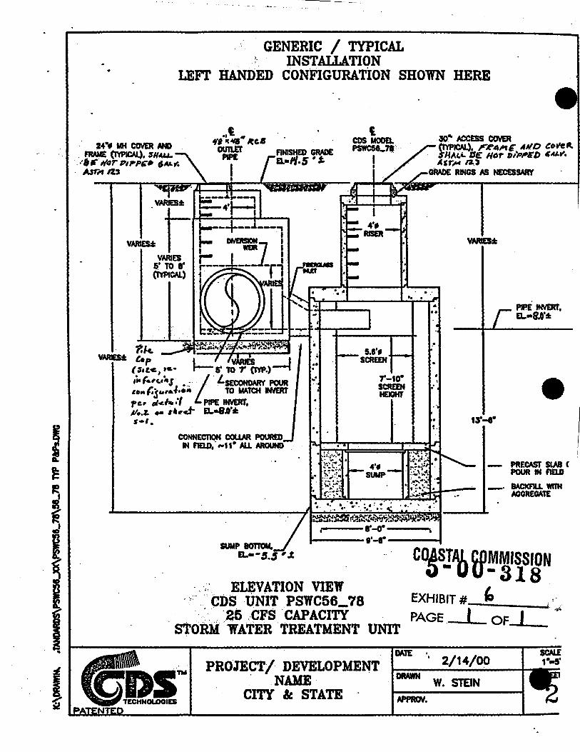
The applicant has proposed a Continuous Deflection Separator unit (CDS) for the Sapphire drain. The unit is installed near the existing outlet and removes floatable solids and some suspended sediments. The City engineer has stated that, if the Commission determines that there is a more effective alternative BMP that is feasible to the City and County, such an alternative would be used. The Commission water quality unit has reviewed alternatives and finds that the CDS unit would be effective at removing pollutants of concern if the unit implements a 1200 to 2000 micron screen. Since this drainage system connects up to 35 catch basins, it is not a feasible alternative to install catch basin
• inserts. However, if the applicant cannot
5-00-318 (Redondo Beach) Page 16 of 18
provide a CDS unit with a 1200 to 2000 micron screen, an alternative would be to insert a sorbent pad that is specifically designed to remove vehicular contaminants and other typical urban runoff pollutants more efficiently than a standard silt and grease trap. Special Condition #4 requires the applicant to implement the BMPs as proposed. If the CDS unit does not contain a 1200 to 2000 micron screen, the applicant shall install a sorbent pad within the CDS unit in the Sapphire Street Drain to decrease the contaminants entering the Santa Monica Bay.
The Commission notes that BMPs are very new in design and some are still in the experimental stage and the city may determine that another method is more effective. A change in method would need to be reported to the commission as an amendment to this permit. If the director determines that the method is as effective as that indicated in condition 4, such a change can be reported as an immaterial amendment.
For this reason, the Commission imposes Special Condition #4 that requires the maintenance and monitoring of the BMPs. All storm drain inlets, traps/separators, and/or filters shall be inspected to determine if they need to be cleaned out or repaired at the following minimum frequencies: (1) prior to October 15th each year; (2) prior to April 15th each year; and (3) during each month that it rains between November 1st and April 1st. Clean-out and repairs (if necessary) shall be done as part of these inspections. Traps/separators and/or filters must be cleaned prior to the onset of the storm season, no later than October 15th of each year. Debris and other water pollutants removed from filter device(s) during clean-out shall be contained and disposed of in a proper manner.
The applicant shall also submit a storm drain monitoring plan. This plan (as stipulated in Special Condition #4) shall ensure that the BMPs used for this project is effective at removing pollutants of concern. The applicant shall test for total suspended sediments (TSS) and zinc. TSS are chosen "because they are the most frequent constituent measures in all studies of storm water treatment control measures, and serves as a surrogate for the pollutants that in storm water tend to be primarily in the particulate form, like petroleum products, pesticides, lead, chromium, and phosphates. Zinc was selected to represent the more soluble constituents, including itself as well as copper, cadmium, and various nitrogen forms" ("Investigation of Structural Control Measures for New Development, 11/29/99).
The proposed project also includes extending two PVC drains 20 to 30 feet seaward of the existing location. Runoff water currently exits approximately 10 feet from the pedestrian walkway. As mention previously, this creates a pool of water, which at time impedes lateral coastal access. However, the sand acts as a prefiltering system and media for runoff water and pollutants. The applicant has not proposed BMPs for these drains. The outlets drain a small area, both approximately one city block. These drains still direct runoff across the sand and there is no increase in the discharges through the drains. Therefore, the Commission will not require the applicant to insert BMPs into these drains. The runoff, though, does contain
•
•
•
•
•
•
5-00-318 (Redondo Beach) Page 17 of 18
pollutants of concern and will create an adverse effect to the marine environment. The Commission encourages the City of Redondo Beach and Los Angeles County, Department of Beaches and Harbors to research and include water quality standards for these storm drains to reduce the pollutant loads entering Santa Monica Bay and the Pacific Ocean.
Pile System Material
The applicant has proposed to support the Sapphire Drain with ten piles. The City engineer has stated that the piles planned for the development would consist of cut telephone poles. He confirmed that the poles contained creosote, a residuary product of petroleum. The proposed project is located adjacent to the ocean. Water and sand contact leeches creosote from the wood and drains into the ocean. According to the California Department of Fish and Game, the use of any petroleum, acid, coal or oil tar, lampblack, aniline, asphalt, bitumen, or residuary product of petroleum, or carbonaceous materials is typically prohibited for use in State Waters. Creosote is included in this category. Special Condition #6 requires the applicant to use reinforced concrete piles or piles made from other comparable inert materials for the support of the storm drain extension. The applicant shall provide a written report indicating the types of materials to be used for the piles. The piles shall not contain any of the following: petroleum, acid, coal or oil tar, lampblack, aniline, asphalt, bitumen, or residuary product of petroleum, including creosote, or carbonaceous materials or substance .
Only as conditioned to comply with construction related requirements, dispose of all debris at an approved disposal site, incorporate, monitor, and maintain Best Management Practices for the Sapphire Drain, provide a plan for future Best Management Practices for the two PVC drain extension, and use concrete piles or a similar inert materials for the pile system is the proposed project consistent with the water quality provisions of the Coastal Act.
E. LOCALCOASTALPROGRAM
Section 30604(a) of the Coastal Act provides that the Commission shall issue a Coastal Development Permit only if the project will not prejudice the ability of the local government having jurisdiction to prepare a Local Coastal Program which conforms with Chapter 3 policies of the Coastal Act:
(a) Prior to certification of the Local Coastal Program, a Coastal Development Permit shall be issued if the issuing agency, or the Commission on appeal, finds that the proposed development is in conformity with the provisions of Chapter 3 (commencing with Section 30200) of this division and that the permitted development will not prejudice the ability of the local government to prepare a Local Coastal Program that is in conformity with the provisions of Chapter 3 (commencing with Section 30200). A denial of a Coastal
5-00-318 (Redondo Beach) Page 18 of 18
Development Permit on grounds it would prejudice the ability of the local • government to prepare a Local Coastal Program that is in conformity with the provisions of Chapter 3 (commencing with Section 30200) shall be accompanied by a specific finding which sets forth the basis for such conclusion.
Redondo Beach has a certified Land Use Plan, but does not have a certified Local Implementation Plan (LIP.} The beach is designated "Parks Recreation and Open Space" in the certified LUP. The City is in the process of revising its LUP. The draft revised LUP designates this area as "P" parks, open space, electrical generation plants and public facilities. The widening of the sidewalk and extending the storm drains is consistent with the public recreation policies of the certified LUP.
The proposed project, as conditioned, is consistent with the coastal access and water quality policies of the Coastal Act. Therefore, the Commission finds that approval of the proposed development, as conditioned, will not prejudice the City's ability to prepare a Local Coastal Program consistent with the policies of Chapter 3 of the Coastal Act, as required by Section 30604(a}.
F. CALIFORNIA ENVIRONMENTAL QUALITY ACT
Section 13096 of the Commission's regulations requires Commission approval of Coastal Development Permit applications to be supported by a finding showing the application, as conditioned by any conditions of approval, to be consistent with any applicable requirements of the California Environmental Quality Act (CEQA). Section 21 080.5(d)(2){A) of CEQA prohibits a proposed development from being approved if there are feasible alternatives or feasible mitigation measures available which would substantially lessen any significant adverse effect that the activity may have on the environment.
The proposed project has been conditioned for consistency with the marine resource protection policies and public recreation and access policies of the Coastal Act. The proposed development, as conditioned, is consistent with the Chapter 3 policies of the Coastal Act. There are no feasible alternatives or mitigation measures available that will lessen any significant adverse impact the activity would have on the environment. Therefore, the Commission finds that the proposed project, as conditioned, is consistent with CEQA and the policies of the Coastal Act.
End/am
•
•
__j \ J
o NEW HIGH f) = N CT
0 ~CATALINA
VETERANS PARK
PIER Sicle.'uel\\\ ~~i("
MUNICIPAL
New ~~-('~
8 A G? ~
Jtn ~ o~ ,..... .b: lS (:;' "V
PIER
CO!S!AQ f.D~I'iSWN EXHIBIT #-----.2 __ PAGE I OF--..~1..__
0§' ~ ~~ 0 0 1--.. !')"
• ~ ~ c;::) § f,; ~~ ~ ,..._ ,~ ~ c:::i ~..-~ -...; lb~
2 1-t~
~ 'J
5-t'P'-'~ Sf. T 0 PAZ s+o~~ t>c-.~" .JETTY
DRAIN EXTENSIONS CITY OF REDONDO BEACH
C.ALJ:FORNJ:.A DEPARTMENT OF ENGINEERING SERVICES
MINOR STORM . DRAIN EXTENSION LOCATIONS
~-
'
I
'
./ I
/ /
I
·f #
... .
'
\
3-23
•
-
C.)
..
\
\ \ \ \ ..
0
• !
•• .,
-
I ....
~
c .. ...
& I
.c. N 1
~
. .. ~ I ' ..... I j \ .t1
·~.~-----
I I I I I I I I I I I I I I I I I I I I I I I
' I I I I I
._ I
et i ~~ i li \ Is \
~ \ \ \ \ \ \ \ \ \ .,
\ \ 1
T
••
•
•
1-···• •.•..• . . . ...
Hb
1 ___ _
0 MLLW
4"1
•,
ELEVATION
• 48• RCB
14----oC
VERnCAL P1LE
BATTER PILE
Wove Force on Pile = ~ wH~ il w = unit weight of water
H = depth-limited breaking wove height
il = diameter of pile
Figure 4 - Analysis of Wave Force on Piles
.....
PILE CAP
• Y.l'<l• EQUIVALENT DIAMETER
• __! cos ts·
SECTION C-C
COASTAL COMMISSION 5-00-318
EXHIBIT # ....._. ..;;:;_5" _ ____,;._.
. PAGE I OF__._I_
('
; _ ... - ~
GENERIC / TYPICAL '- INSTALLATION
LEFT BANDED CONFIGURATION SHOWN HERE
t4•f MH COYER AND FRAME (1'1PICAI.), $N'-U. . ··t~ I/Or ,,,.,. •• ,..._~
. AJ'r" IZ'S
VARJ£1 S' TO 8' (1YPir&)
.. t tfl IC .,.,., ~C.4
OUI1.EI' PIPE
CONNECllON C0UM POURED IN f'IELD, ... u• ALL MOUND .
E~VATION VIEW · -,.· CDS UNIT PSWC56_78
. · -_ .. ·25 .-CFS CAPACITY
PIPE INVERr, EL.•8.0':1:
• - PRECAST SLAB C
POUR IN F1ELD
-· 8ACKF1U. wmt AGGREGAtE
COASTAL CDMMISSION 4)-uu-ais
.. STORM ·wATER TREATMENT UNIT
EXHIBIT#:-'--~ PAGE I OF I . -~
PROJECT/ DEVELOPM.ENT . NAME
CITY &: STATE · DRAWN W. STEIN N'FWN.
• SHEET No.6
SHEET No.2
u -&&.. -u ~
SHEET No 7
I r n r-:r ::::::-:----· ----«Hos HI~- AVE.
LOCATION- MAP SCALE: t • ~00' · r ~1 ~ ' 19q~
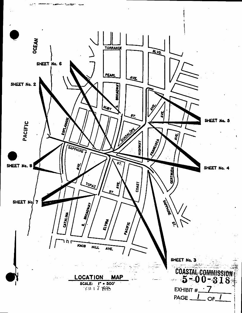
SHEET No.3 -- -~ --~~-- --- ~....:.~-;_-~- -.:~·, ... ~:.~~ ,--;-· __ .,_ ... :.:-~
, COAS!AbCO~MissUJN~~----·~ c.~~ ~5 -~.0 0 ~ 18"-:~
- ·- _ ... EXHIBIT # . 7 . ! PAGE I OF I I
I
I I j

..
•
•
•