ocd manual on mud and debris flow ...open_jicareport.jica.go.jp/pdf/11603305_19.pdfattachment 2...
TRANSCRIPT
Attachment 2
XXVII - 27
OCD MANUAL ON MUD AND
DEBRIS FLOW FORECASTING
AND WARNING
OCD

Attachment 2
XXVII - 28
OCD MANUAL ON MUD AND DEBRIS FLOWFORECASTING AND WARNING
TABLE OF CONTENTS
Part I : Introduction
Part II : Areas Affected by Mud and Debris Flow
Part II : Facilities and Equipment
Part IV : Interpretation on Data
Part V : Mud and Debris Flow Warning Alert Level
Part VI : Standard Action for Mud and Debris Flow (ROCD)
Part VII : Communication Flow
Part VIII : Directory of Gov’t Agencies, DCCs and Radio Stations
Attachments :
Attachment A : Speed of the Lahar
Attachment B : Areas to be Affected by Mud and Debris Flow
Attachment C : Information about OCD, N/RDCC and P/M/C/BDCCs
Attachment D : Mayon Mud and Debris Flow Warning Stations
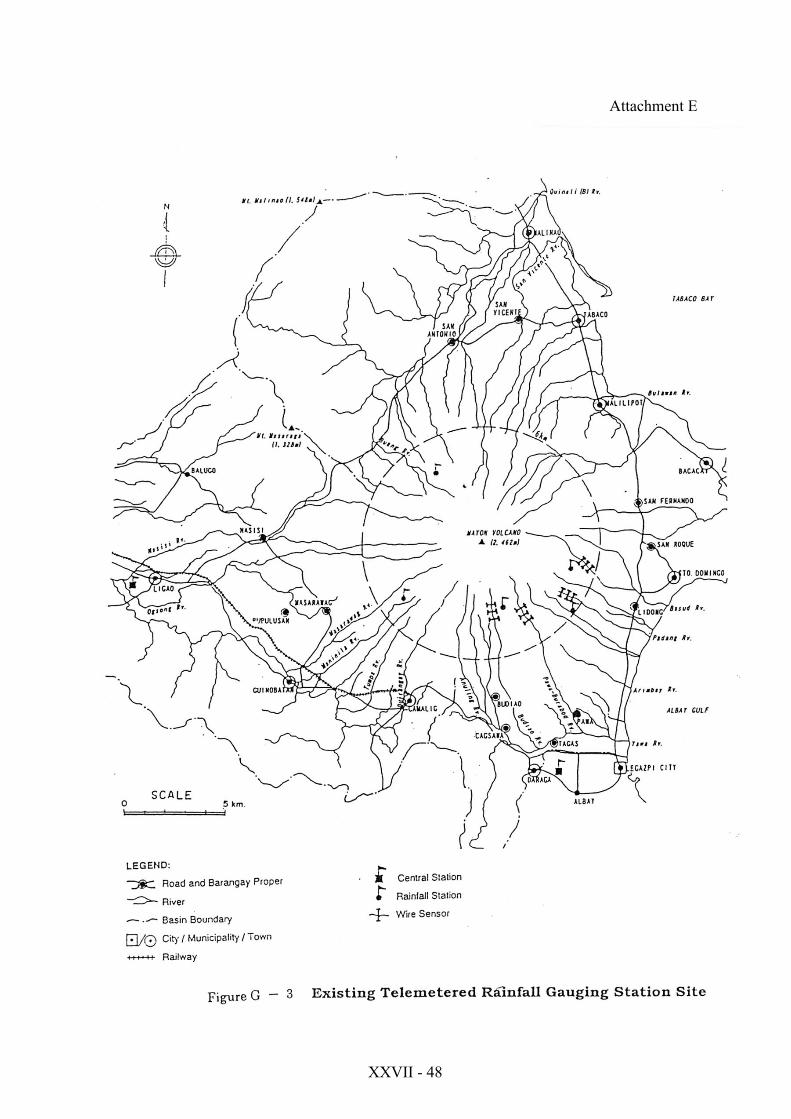
Attachment E : Existing Telemetered Rainfall Gauging Stations Sites
Attachment F : Warning Lines for Mud and Debris Flow

Attachment 2
XXVII - 29
1. INTRODUCTION
Mayon Volcano, the most active volcano in the Philippines, lies in the SoutheastLuzon in the province of Albay.
Mayon reaches up to around 2,462 m above sea level and covers an area of 250 sq.kms. It is surrounded by eight (8) municipalities and one (1) city that covers an areaof 1,261.4 sq. kms., with a total population of 638,696 people (1995 NCSO).
Mayon volcano’s recorded activities since the 17th century had brought aboutconsiderable losses in lives and properties.
Volcanic hazard in Mayon vary grately in type, aerial extent, duration anddestructive potential. These hazards area consequence of Mayon’s three (3) differenteruption types. ( Strombolian, Vulcanian, Plinian).
Lahars, a flowing mixture of volcanic debris and water are one of the mostpersistent and destructive hazard posed by Mayon volcano. It is sometimes calledmudflow or volcanic debris flow.
Lahars from Mayon volcano originate from the upper and middle slopes of thevolcano. Lava and pyroclastic materials perched on the steep slopes are eroded andthen mobilized by heavy rains, thus causing a debris-wet mixture to cascade and flowdownslope of the volcano. It usually follow pre-existing gullies and ravines. Uponreaching the lower slopes, it spreads out and leave thick and wide spread depositswhich span a wide range of velocities and dimensions.
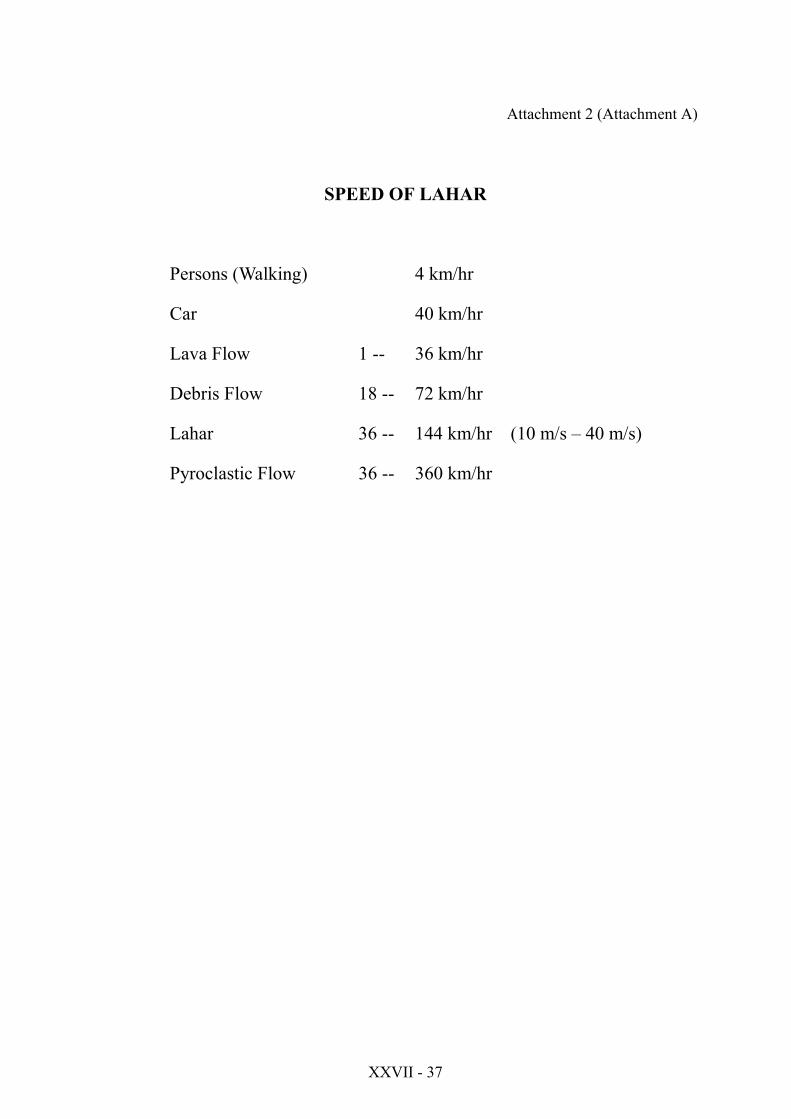
Lahar with an speed of 36 to 144 km per hour forcibly destroy buildings andinfrastructures, and bury low lying areas with boulders, sand and mud. Theyoftentimes block drainage channels, raise river beds and cause flooding of extensiveareas at the base of the volcano. (attachment A)
2. AREAS TO BE AFFECTED BY MUD AND DEBRIS FLOW
The pyroclastic materials deposited on the steep slope of Mayon Volcano duringthe last eruption pose hazards to 30 barangays of 5 municipalities and 1 city at thefoot of the Mayon Volcano with a total population of 64,700. When strongrains/typhoons occurs. The mud and debris flow usually passed thru 8 channels ofwhich 4 are ective high risk and 4 active moderate risk. (attachment B).

Attachment 2
XXVII - 30
The municipalities of Daraga and Sto. Domingo and the city of Legazpi will beaffected by the mud and dedris flow from the active high risk channels of Budiao,Bafiadero, Mabinit, Buyuan and Basud channel. (attachment B-1&2)
The municipalities of Tabaco, Guinobatan and Ligao will be affected by the mudand debris flow from the active moderate channels of San Vicente, Buang, Maninilaand Nasisi. (attachment B-3&4)
3. FACILITIES AND EQIPMENT
In 1996, Japan International Cooperation Agency (JICA) installed facilities andequipment for monitoring lahars and debris flow as a part of telemetry networksystem to the Philippine Government through NDCC and OCD Region 5 (attachmentC) in strategic location in the active risk channel and moderate risk channel of MayonVolcano in the Province of Albay, for the issuance of timely warning to the barangay(s) at risk and give them sufficient lead time to effect evacuation. (attachment D&E)
These facilities and equipment are as follows:
- Lahar Warning System (Six station)- Rain Gauge (Five station)- Central Telemeter Station (One station)- Repeater Telemeter Station (One station)
Lahar Warning Station - there are six (6) station which are expensive tomaintain for every occurrence of strong typhoon, the terminal pole and wire sensorare are destroyed by strong current of water and mud flow and spareparts are to beimported from Japan.
Rain Gauge Station - there are five (5) rain gauge station which the rain gaugerecorded rainfall and rain intensity and the data is transmitted to Central MonitoringStation by a radio transmitter and repeater station.
The monitoring station - records data transmitted by the different rain gaugestation in the field. The data are processed and the data are printed out in a screen, thestatus of volume of water received by each station.
By operation of the monitoring station equipment, rainfall data are displayed bystation or standard warning, evacuation rainfall level and current warning conditionas “rainfall judgement graph” are displayed by each station.
Attachment 2
XXVII - 31
In the graph displayed in the monitor wherein the intensity of total rainfall inmillimeter per hour and accumulated effective rainfall in mm are the two factors toconsider as basis on the issuance of different level at lahar warning to PDCC, MDCC,CDCC up to Barangay Captain concerned.
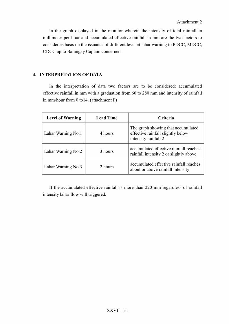
4. INTERPRETATION OF DATA
In the interpretation of data two factors are to be considered: accumulatedeffective rainfall in mm with a graduation from 60 to 280 mm and intensity of rainfallin mm/hour from 0 to14. (attachment F)
Level of Warning Lead Time Criteria
Lahar Warning No.1 4 hoursThe graph showing that accumulatedeffective rainfall slightly belowintensity rainfall 2
Lahar Warning No.2 3 hours accumulated effective rainfall reachesrainfall intensity 2 or slightly above
Lahar Warning No.3 2 hours accumulated effective rainfall reachesabout or above rainfall intensity
If the accumulated effective rainfall is more than 220 mm regardless of rainfallintensity lahar flow will triggered.
Attachment 2
XXVII - 32
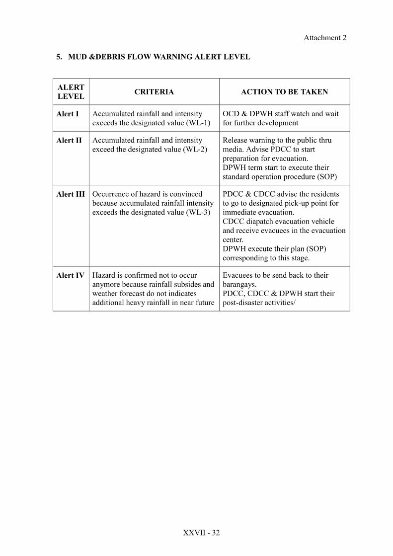
5. MUD &DEBRIS FLOW WARNING ALERT LEVEL
ALERTLEVEL CRITERIA ACTION TO BE TAKEN
Alert I Accumulated rainfall and intensityexceeds the designated value (WL-1)
OCD & DPWH staff watch and waitfor further development
Alert II Accumulated rainfall and intensityexceed the designated value (WL-2)
Release warning to the public thrumedia. Advise PDCC to startpreparation for evacuation.DPWH term start to execute theirstandard operation procedure (SOP)
Alert III Occurrence of hazard is convincedbecause accumulated rainfall intensityexceeds the designated value (WL-3)
PDCC & CDCC advise the residentsto go to designated pick-up point forimmediate evacuation.CDCC diapatch evacuation vehicleand receive evacuees in the evacuationcenter.DPWH execute their plan (SOP)corresponding to this stage.
Alert IV Hazard is confirmed not to occuranymore because rainfall subsides andweather forecast do not indicatesadditional heavy rainfall in near future
Evacuees to be send back to theirbarangays.PDCC, CDCC & DPWH start theirpost-disaster activities/

Attachment 2
XXVII - 33
6. Standard Action for Mud and Debris Flow (ROCD)
WL-1 - Report to the office as soon as possible- Establishment observing term (24 hours / d)- Confirm PAGASA’s Weather Forecast- Identify the Municipality / city to be warned- Confirm the situation to Regional DPWH
WL-2 - Confirm the situation with RDPWH- Confirm availability of warning equipment- Confirm PAGASA’s weather forecast- Inform the situation with RDPWH- Confirm the PDCC and MDCC / CDCC’s receive of the warning- Receive information on the condition of rivers and roads from DPWH- Log and record the conditions of rivers and roads- Watch the movement of snake curves- monitor the snake curves of other stations
WL-3 - Confirm the situation with RDPWH- Confirm PAGASA’s weather forecast- Inform level 3 warning to - Confirm the receive- Receive information from relevant MDCC / CDCC and assess them- Inform the situation to PDCC- Monitor the snake curves and other stations
WL-4 - Confirm the situation with RDPWH- Confirm PAGASA’s weather forecast- Watch snake curves- Inform release to PDCC- Continue monitoring the snake curve for 3 hours including one of otherstations

Attachment 2
XXVII - 34
7. COMMUNICATION FLOW CHART
RaingaugeField Stn
Lahar SensorField Stn
DPWH OCDMonitoring Stn
PDCC
RDCC
Amateur RadioClub
Media
LegazpiCity
(CDCC)Daraga
(MDCC)Sto. Domingo
(MDCC)Tabaco
(MDCC)Guinobatan
(MDCC)Ligao
(MDCC)
BDCC BDCCBDCCBDCCBDCCBDCC
For Information and Action
For feedback

Attachment 2
XXVII - 35
COMMUNICATION FLOW SYSTEM
The OCD and DPWH monitor in their respective monitoring system and closelywatch the further development of accumulated rainfall and rain intensity brought by theoccurrence of weather disturbances using the raingauge field stations. They compare theirfindings and decide the issuance of different level of copy furnish the RDCC Chairman forinformation and Guidance.
The Bulletin is transmitted to PDCC thru fax and / or telephone or courier. Thecontents of the bulletin are : bulletin No./Time/Date monitored parameter indicatingobservation time accumulated effective rainfall (mm), total rainfall intensity in mm/hr., theraingauge station were the data originates, area at risk, alert status and recommendation.
The bulletin transmitted to PDCC thru telephone will be dictated to the receiver. Thereceiver read back the dictated data doe any correction. The bulletin concerned MDCCdown to the barangay.
Media will be utilized for widest dessimination for the information especially inwarning level 3.
The amateur radio clubs may help in gathering information and situation in the areaat risk for information of the concerned DCC’s.
The BDCCs will report to the PDCC on their situation and needs thru higher DCCsfor information and guidance.

Attachment 2
XXVII - 36
DIRECTORY
GOV’T AGENCY TEL/ NOS. FAX NOS
OCD/RDCC 481-50-31/2455107/2455132 481-50-31
DPWH 482-06-49/482-03-59
PHIVOLCS 483-27-29 483-27-29
PAGASA 481-02-14/2143238 481-02-14
DCC’S TEL. NOS. FAX NOS.
ALBAY PDCC/PDMO 481-24-42
LEGAZPI CITY 820-35-26 481-25-75
DARAGA 483-35-60/483-35-62 483-35-61
STO. DOMINGO
TABACO 487-52-38
GUINOBATAN 484-63-33
LIGAO 485-11-15
RADIO STATION TEL. NOS. FAX NOS
DZGB 480-55-08
DWZR 480-88-20
RADIO BOMBO 481-38-70
ABS-CBN 480-10-01
DWBS 481-20-73
XXVII - 37
Attachment 2 (Attachment A)
SPEED OF LAHAR
Persons (Walking) 4 km/hr
Car 40 km/hr
Lava Flow 1 -- 36 km/hr
Debris Flow 18 -- 72 km/hr
Lahar 36 -- 144 km/hr (10 m/s – 40 m/s)
Pyroclastic Flow 36 -- 360 km/hr

XXVII - 38
Attachment 2 (Attachment B)
SUMMARY OF AREAS TO BEAFFECTED BY LAHAR
(Active High Risk)
CHANNEL NO. OFBARYS.
TOTALPOP.
NO. OFHHOLD
1. Budiao/Bañadero Channela. Daragab. Legazpi
9 19,863 3,764
2. Mabinit Channela. Legazpi City 3 6,193 1,149
3. Buyuan Channela. Legazpi City 3 9,048 1,658
4. Basud Channela. Sto. Domingo 4 7,716 1,351
TOTAL 19 42,820 7,922
MayonDat. doc/hts’99

XXVII - 39
Attachment 2 (Attachment B-1)
PROVINCE OF ALBAYSUMMARY OF AREAS TO BE
AFFECTED BY LAHAR
NO. OFCHANNEL
NO. OFMUN.
NO. OFBRGYS
TOT.POP.
NO. OFHHOLD
Active HighRisk 4 3 19 42,820 7,922
ActiveModerate
Risk4 3 11 21,880 4,151
Total 8 6 30 64,700 12,073
MayonDat. doc/hts’99

XXVII - 40
Attachment 2 (Attachment B-2)
SUMMARY OF AREAS TO BEAFFECTED BY LAHAR
(Active Moderate)
CHANNEL NO. OFBARYS. TOTAL POP. NO. OF
HHOLD
1. San Vicente Channela. Tabaco 2 5,979 1,156
2. Buang Channela. Tabaco 1 2,046 369
3. Maninila Channela. Guinobatan 5 10,441 1,974
4. Nasisi Channela. Ligao 3 3,414 652
TOTAL 11 42,820 4,151

XXVII - 41
Attachment 2 (Attachment B-3)
AREAS TO BE AFFECTED BY LAHARACTIVE HIGH RISK CHANNEL
MUN/BRGY TOTALPOPULATION
NO. OFHOUSEHOLD
1. Budiao/Bañadero ChannelDaraga:
Budiao 1,470 290Bañadero 1,457 275busay 1,857 358Culliat 1,153 208Bañag 2,697 518Bagumbayan 2,294 431Malobago 858 172Tagas 5,595 1,035
17,381 3,287Legazpi City:
Bogtong 2,482 477TOTAL 19,863 3,764
2. Mabinit ChannelLegazpi City:
Mabinit 916 172Pawa 2,587 477Bonga 2,690 500TOTAL 6,193 1,149
3. Buyuan ChannelLegazpi City:
Buyuan 2,746 485Bigaa 4,415 842Padang 1,887 331TOTAL 9,048 1,658
4. Basud ChannelSto. Domingo:
Sta. Mesirecordia 2,037 349Fidel Surtida 1,857 303Lidong 2,136 385San Isidro 1,716 314TOTAL 7,716 1,351
MayonDat. doc/hts’99 Note: 1995 Census
XXVII - 42
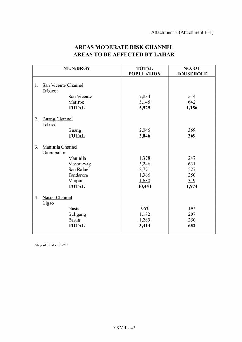
Attachment 2 (Attachment B-4)
AREAS MODERATE RISK CHANNELAREAS TO BE AFFECTED BY LAHAR
MUN/BRGY TOTALPOPULATION
NO. OFHOUSEHOLD
1. San Vicente ChannelTabaco:
San Vicente 2,834 514Mariroc 3,145 642TOTAL 5,979 1,156
2. Buang ChannelTabaco
Buang 2,046 369TOTAL 2,046 369
3. Maninila ChannelGuinobatan
Maninila 1,378 247Masarawag 3,246 631San Rafael 2,771 527Tandarora 1,366 250Maipon 1,680 319TOTAL 10,441 1,974
4. Nasisi ChannelLigao
Nasisi 963 195Baligang 1,182 207Basag 1,269 250TOTAL 3,414 652
MayonDat. doc/hts’99

XXVII - 43
Attachment 2 (Attachment C)
INFORMATION ABOUT OCD, N/RDCC & P/M/C/BDCCs
The Filipino has always endured the hardships of a hostile environment He hascontinually sought survival against typhoons, floods, earthquakes, epidemics, fires andother calamities. Experts tell us calamity will happen anywhere and anytime. Destructivecapacity can be enormous and the problem is made more difficult by absence of warning.Planned arrangements must be made available to:
1. Prevent loss of life2. Prevent needless suffering of the people3. Protect property, and4. Minimize damages during disasters and calamities.
The concept therefore is one of SELF-HELP and Mutual Assistance. It is expectedthat each political and administrative subdivision of the country shall utilize all availableresources in the immediate area before asking for assistance from neighboring entities orhigher authority.
THE ORGANIZATION
National Level
The Philippine Government fully supports the need for an effective civil defenseorganization and Republic Act 1190, otherwise known as the Civil Defense Act of 1954,and the Presidential Decree 1 as implemented by Letter of Instruction No. 19 gave effect tothis. Republic Act 1190 of 1954 was further re-enforced by Presidential Decree 1566 ofJune 11, 1978. This decree strengthened the Philippine Disaster Control Capability byestablishing the National Program on Community Disaster Preparedness.
THE FUNCTIONS OF THE OFFICE OF CIVIL DEFENSE ARE:
a) To establish and administer a comprehensive national civil defense and civilassistance program.
b) To formulate plans and policies for the protection and welfare of the civilianpopulation in time of war directly involving the Philippines or other nationalemergencies of equally grave in character.

XXVII - 44
c) To estimate total material, manpower and fiscal requirements for carrying out ofthe civil defense programs, and allocate to the provinces, cities, municipalitiesand barangays such aid in facilities, materials, and funds as may be available fromthe national government
d) To develop and coordinate a program for informing, educating and training thegeneral public, members of the disaster coordinating councils and disaster controlgroups on civil defense and civil assistance measures.
e) To furnish guidance to the various provinces, cities, municipalities and barangaysin the planning, organization and operation of their civil defense organization.
f) To advise the Secretary of National Defense on matters concerning civil defenseand make recommendations from time to time as may be deemed appropriate oras the Secretary may require, and
g) To perform such other duties as may be directed by higher authority or providedby law.
NATIONAL DISASTER COORDINATING COUNCIL
The National Disaster Coordinating Council (NDCC), which is the highest policydetermining body for major disaster, is composed of almost all members of the cabinetunder the chairmanship of the Secretary of National Defense.
The NDCC whose main function is to advise the President on the status of thenational disaster preparedness program, disaster operations and rehabilitation effortsundertaken by the government and the private sector, utilizes the facilities and services ofthe Office of Civil Defense in Camp Aguinaldo, Quezon City. All the members of thecouncil contribute their manpower, facilities and expertise to effectively carry out thefunctions of the NDCC.
Local Level
REGIONAL DISASTER COORDINATING COUNCIL
The Regional Disaster Coordinating Council (RDCC) shal be responsible for theregional preparedness programs, disaster operations and rehabilitation activities by thegovernment and the private sector and advise the National Disaster Coordinating Councilthrough the Office of Civil Defense on the status of disaster preparedness and operations inthe region.

XXVII - 45
LOCAL DISASTER COORDINATING COUNCIL
Legislative makes it compulsory for the local government from the provincial, city,municipal and barangay levels to:
a) Health Service - involves the medical services and first aid.
b) Auxiliary Fire Service - helps the existing fire departments in operating firedepartments in operating fire engines, putting out fires and organizing firebrigades.
c) Police Service - helps the Philippine National Police in enforcing trafficregulations, prevention of looting and other acts of lawlessness.
d) Emergency Transportation Service - operates trucks, buses, and other means oftransportation for hauling supplies, civil defense workers, injured persons andevacuees to dm designated places.
e) Communication and Warning Service - provides, operates and maintainscontinuous and reliable communications and adequate warning system throughoutthe period of impending and or existing disasters and calamities.
f) Public Information Service - provides accurate information and instructions tothe civilian population during emergencies.
g) Rescue and Engineering Service - provides teams to save lives and quicklygetting people out of damaged buildings, and freeing the trapped or isolated.
h) Evacuation Service - evacuates the populace and properties systematically if anemergency or calamity arises.
HOW CIVIL DEFENSE WORKS
When a disaster hits the country and a state of emergency is declared the Presidentupon the recommendation of NDCC, the Office of Civil Defense-National DisasterManagement Center shall perform the following tasks:
a) Process warning information received from warning agencies and other sourcesand disseminate alert notices to the cooperating/implementing agencies and CivilDefense Regional Offices and the general public.
XXVII - 46
b) Activate the Emergency Broad cast System, if and when necessary.
c) Monitor preparations for and actions taken by cooperating/implementing agencieson requirements obtained from the disaster-stricken areas and coordinate theiractivities and functions and those of the private sector to maximize the utilizationof the nation’s resources for the protection and preservation of the civilianpopulation and properties during disasters or emergencies.
d) Issue requests to cooperating/implementing agencies on additional requirementsfor mitigating the effects of disasters.
e) Prepare continuing reports and assessments for the President and Secretary ofNational Defense and other NDCC members.
COOPERATING/IMPLEMENTING AGENCIES SHALL PERFORM THEFOLLOWING:
a) Upon receipt of warning information from OCD and other sources, implementtheir respective action plans pursuant to the National Calamities and DisasterPreparedness Plan.
b) Monitor actions taken by their respective field units.
c) Recommend actions to be taken by other cooperating/implementing agencies inthe mitigation of disaster on requirements of disaster stricken areas beyond theircapability tasks.
d) Submit reports as obtained from the field.
e) Effect lateral coordination with other cooperating/implementing agencies and thelocal government to maximize assistance to the distressed community.
The direction and control of disaster operations of the national level shall beexercised by the National Disaster Coordinating Council through the facilities of the Officeof Civil Defense. Direction and control at all other levels shall be exercised through theirrespective disaster operation centers.

XXVII - 47
Attachment D
MAYON LAHAR WARNING STATION
RAINFALL STATION
STN:No. 01 - (Site A) Maninila, Guinobatan, Albay
02 - (Site B) Mabinit, Lrgazpi City
03 - (Site C) Buyuan, Legazpi
04 - (Site D) Sta. Mesirecordia, Sto. Domingo, Albay
05 - (Site E) Mayon Vista Lodge, Tabaco, Albay
MUDFLOW SENSOR STATION
06 - (Site F) Miisi/Budiao, Daraga, Albay
07 - (Site G) Mabinit, Legazpi City
08 - (Site H) Buyuan, Legazpi City
09 - (Site I) Sta. Mesirecordia, Sto. Domingo, Albay
16 - Repeater Station – Hill 27, Paulog, ligao, Albay
*Monitoring Station – RDMD, OCD, CAMP Gen.
Simeon A. Ola, Legazpi City
XXVII - 48
Attachment E