number twenty six (26)-------------- --------deed of … k-1_edc... · to me, the notary, which i...
TRANSCRIPT

I I I
I
/ I I
!
/
---------------NUMBER TWENTY SIX (26)--------------
--------DEED OF RATIFICATION AND CONVERSION--------
--------TO PUBLIC INSTRUMENT OF QUITCLAIM DEED-----
--------------CLEAN PARCEL SIX (6)-----------------
---At San Juan, Puerto Rico, this sixth (6 th) day of
May, Two Thousand Thirteen (2013).-----------------
--------------------BEFORE ME---------------------
---JORGE L. MENDIN, Attorney at Law and Notary
Public in and for Puerto Rico, residing at San
Juan, Puerto Rico and with offices at 60 Jose Marti
Street, Hato Rey, San Juan, Puerto Rico.-----------
------------------------APPEAR---------------------
---AS PARTY OF THE FIRST PART: United States of
America, hereinafter "Grantor", acting by and
through the Department of the Navy (the "Navy"),
Real Estate Contracting Officer, under and pursuant
to the powers and authority contained in the
provisions of Section 2905(b)(4) of the Defense
Base Closure and Realignment Act of 1990, 10 U.S.C.
§ 2687 note, as amended, and the implementing
regulations of the Department of Defense (32 C.F.R.
Part 174), having an address of four thousand nine
hundred eleven (4911 ) South Broad Street,
Philadelphia, Pennsylvania herein represented by
Gregory C. Preston, also known as Gregory Charles
Preston, of legal age, married and resident of the
State of New Jersey, United States of America, who
is authorized to appear in this deed as real estate
contracting officer, by virtue of that Certificate
of Appointment signed by the Assistant Secretary of
the Navy (Installations and Environment) on August
eighteenth (18 th), Two Thousand Six (2006).---------

---AS PARTY OF THE SECOND PART: the Commonwealth of
Puerto Rico, hereinafter "Grantee", acting by and
through the Local Redevelopment Authority for Naval
Station Roosevelt Roads, public
government instrumentality of the
corporation and
Commonwealth of
Puerto Rico, herein represented by its Executive
Director, Maria de Lourdes Blazquez Arsuaga, of
legal age, married and resident of Guaynabo, Puerto
Rico, as authorized by the Resolution, signed on
April thirty (30) two thousand thirteen (2013), by
the Secretary of Economic Development and Commerce,
Alberto Baco Bague, President of the Board of
Directors, and certified by the Secretary of the
Board of Directors, Francisco Acevedo, on May
second (2nd) of the year two thousand thirteen
(2013), under affidavit number 16,209.------------
---I, the Notary, certify that I am personally
acquainted with the persons appearing herein and by
their statements I further certify as to their age,
civil status, profession and residence. They assure
me that they have and in my judgment they do have
the necessary legal capacity to execute this
instrument, and accordingly they do hereby.--------
-----------------------STATE---------------_______ _
---FIRST: The United States of America and the
Commonwealth of Puerto Rico entered into a
Quitclaim Deed dated May six (6), Two Thousand
Thirteen
America,
Estate
(2013), executed by the United States of
represented by Gregory C. Preston, Real
Contracting Officer and the Local
Redevelopment Authority for Naval Station Roosevelt
Roads represented by Maria de Lourdes Blazquez
2

Arsuaga, as its Executive Director, hereinafter
"Quitclaim Deed".----------------------------------
---SECOND: The appearing parties state that the
Quitclaim Deed pursuant to which the United States
of America transferred to the Local Redevelopment
Authority for Naval Station Roosevelt Roads the
title of the following described property,
hereinafter the "Property", is presently in
effect:--------------------------------------------
----------------CLEAN PARCEL SIX (6)---------------
---"Rural: Parcel of land identified as Clean Parcel Six (6) Remnant of Sale Parcel Roman Numeral One (I) A situated in the Ward of Daguao, Municipality of Naguabo, Puerto Rico, containing one million three hundred eighty-three thousand four hundred and ninety-nine square meters and six hundred and seventy-four thousandths of a square meter (1,383,499.674m 2 ); equivalent to three hundred fifty-two cuerdas (352.000 cuerdas); bounded on the North by the Daguao Community, on the South by lands of the Commonwealth of Puerto Rico, Department of Natural Resources, on the East by Conservation Zone 5, property of the Commonwealth of Puerto Rico, Department of Natural Resources and Bundy Treatment Plant, property of the United States of America, and on the West by Conservation Zone 1, property of the Commonwealth of Puerto Rico, Department of Natural Resources."--
---The Property is the remnant of property number
10,305 recorded at Page 154 of Volume 163 of Ceiba,
Registry of the property, Fajardo Section, from
which property several parcels of land were
segregated by virtue of Deed of Segregations and
Description of Remnants, Deed Number Twenty Five
(25), executed on the this same date, before the
Attesting Notary Public.---------------------------
---THIRD: The Grantor acquired title to the
Property by virtue of Deed of Segregations and
Description of Remnant Deed Number Five Hundred
Seventy Six (576), executed on the eight (8th) day
3

of October, Two Thousand Ten (2010), before Notary
Public Raul J. Vila Selles.------------------------
---FOURTH: The Property is free of liens and
encumbrances except those that may appear of
record.--------------------------------------------
---FIFTH: The Grantor, as agreed in the Quitclaim
Deed for and in consideration of the perpetual use
of the Property, transfers to the Grantee and to
its successors and assigns, subject to the
reservations, exceptions, restrictions, conditions
and covenants expressed and set forth in the
Quitclaim Deed, all rights, title and interest in
and to the Property.------------------------------
---SIXTH: This conveyance is made subject to any
and all existing rights-of-way, easements,
covenants and agreements affecting the Property.---
---SEVENTH: It is understood and agreed that the
Grantee, its assigns, and all parties shall comply
with all applicable Federal, State, municipal, and
local laws, rules, orders, ordinances, and
regulations in the occupation, use, and operation
of the Property.----------------------------------
---EIGHT: The Quitclaim consists of twelve (12)
pages. Appended thereto are five (5) Exhibits that
the appearing parties have agreed to attach to the
first certified copy of this deed for purposes of
recordation.---------------------------------------
NINTH: The appearing parties have agreed to convert
the Quitclaim Deed into a public instrument for the
purpose of recording it in the corresponding
section of the Registry of Property of Puerto Rico
and hereby do so by delivering the Quitclaim Deed
4

to me, the Notary, which I proceed to attach to the
original of the Quitclaim Deed so as to make it an
integral part of my protocol of public instruments
for the current year.-------------- _______________ _
---TENTH: In addition to the contents of this
public deed, the appearing parties hereby ratify
and confirm all of the terms and conditions of the
Quitclaim Deed and acknowledge that the attached
document which they have delivered to me contains
all the terms, covenants and conditions of their
agreement, as per the terms of the present deed.--
---ELEVENTH: The appearing parties hereby agree to
the extent required by law applicable to the United
States of America, to fully cooperate to remedy
promptly any and all technical defects and
irregularities of title that may constitute an
impediment or bar to the due and proper recordation
of this deed in the Registry of Property, free from
defects, including, without limitation, the
execution and filing for record of any
supplementary or clarification deeds, affidavits,
and other public and/or private documents. Any
obligation created on the United States of America,
is specifically made subject to the availability of
appropriated funds to be used for such purposes.
Nothing contained herein shall be interpreted to
require obligations or payments by the United
States of America that are in violation of the
Anti-Deficiency Act, 31 U.S.C § 1341.------------__
---TWELFTH: Only for purposes of recording the
present deed at the Registry of the Property, the
5

Property is valued at ONE THOUSAND DOLLARS
($1,000.00).-----------------------_______________ _
---THIRTEENTH: The appearing parties hereby request
the Registrar of the Property to record the
Quitclaim Deed which has been acknowledged,
ratified and converted to a public deed hereunder,
together with the restrictive covenants therein
stated.--------------------------_________________ _
----------------------ACCEPTANCE------------------
---The appearing parties in accordance with the
particulars of this Deed accept the same, in all
its parts after, I, the Notary, gave them the
necessary legal admonitions and warnings pertinent
to this public instrument. Thus, the appearing
parties state and execute this deed in my presence
after having read the same, and place their
ini tials· on each and every page hereof and sign
their name on the last page of this deed, before
me, the Notary, that as to everything else
hereinbefore stated, I the Notary, hereby ATTEST.--
QUITCLAIM DEED Clean Parcel 6 (Sale Parcel1A)
Execution Version 5-3-13
1 THIS INDENTURE ("Quitclaim Deed") is made the t,~ day of May, 2013 between 2 United States of America, acting by and through the Secretary of the Navy, NAVFAC Base 3 Closure Program Management Office S9.l1theast, Charleston, South Carolina, hereinafter referred 4 to as "GOVERNMENT," and Local Redevelopment Authority for Naval Station Roosevelt 5 Roads, a government instrumentality of the Commonwealth of Puerto Rico ("Commonwealth"), 6 created, operated, and existing under and by virtl;le of the laws of the Commonwealth, and 7 designated by the Commonwealth and the Office of Economic Adjustment on behalf of the 8 Secretary of Defense as the public agency to plan, promote, and implement the redevelopment 9 of the former Naval Station Roosevelt Roads, hereinafter referred to as "GRANTEE." It is based
10 upon the following facts: 11
12 13 14
15
16
17 18
19
20
Recitals
A. Pursuant to Section 8132 of the Department of Defense Appropriations Act for ~ Fiscal Year 2004 (Public Law No. 108-87; the "Appropriations Act"), the GOVERNMENT was U'Y, directed to close Naval Station Roosevelt Roads, Puerto Rico ("NSRR") no later than six (6) _;; months after the enactment of the Appropriations Act, and to do so pursuant to the procedures and authorities contained in the Defense Base Closure and Realignment Act of 1990, as amended (title XXIX of Public Law No. 101-510, 10 U.S.C. § 2687 note; the "Base Closure Act").
21 B. Pursuant to the power and authority provided by Section 2905(b)( 4) of the Base 22 Closure Act and the implementing regulations of the Department of Defense (32 C.F.R. Part 23 174), the GOVERNMENT is authorized to convey surplus property at a closing installation to a 24 local redevelopment authority for economic development purposes. 25 26 C. On August 30, 2006, the Office of Economic Adjustment of the Department of 27 Defense recognized the GRANTEE, also known as the Portal del Futuro Authority and the 28 Roosevelt Roads Naval Base Lands and Facilities Redevelopment Authority, as the local 29 redevelopment authority for purposes of implementing the local redevelopment plan at NSRR. 30
31 D. GRANTEE, by application dated 17 December 2010, requested an "Economic 32 Development Conveyance" ("EDC") of a portion of the surplus property comprised of 33 approximately 1370.20 acres ofthe former Naval Station Roosevelt Roads, Ceiba, Puerto Rico. 34
35 E. The GRANTEE's EDC application was accepted by the GOVERNMENT on 16 36 September 2011. 37
38 F. The GOVERNMENT and the GRANTEE executed an Economic Development 39 Conveyance Memorandum of Agreement on December 20, 2011 ("Original Agreement") 40 detailing the specifics of the transfer of property under the Government-approved EDC,
4812-2028-08503
Clean Parcel 6 Deed Page 2.
1 including the consideration to be paid by the GRANTEE to the GOVERNMENT for such 2 transfer. 3 4 G. The Original Agreement did not address ownership of a parcel consisting of 5 approximately one thousand, five hundred and forty-two (1,542) acres at NSRR referred to as 6 "Parcel 1" and a parcel consisting of approximately four hundred and ninety-seven (497) acres at 7 NSRR referred to as "Parcel 2." 8 9 H. The GOVERNMENT and the GRANTEE executed an amendment to the Original
10 Agreement on December 11,2012 ("Amendment No. I") to address the transfer of Parcel 1 and 11 Parcel 2 to the GRANTEE (the Original Agreement, as amended by Amendment No.1, is 12 referred to herein as the "EDC Agreement"). 13
14
15
16
17
18
19
20
21
22 23
24
25
26 27
28 29
1. GRANTEE hereby offers consideration in the amount set forth in the EDC Agreement, plus other good and valuable consideration, to it in hand paid by GRANTEE, the receipt of which is hereby acknowledged; and GOVERNMENT has granted, bargained, sold, and released and by these presents does grant, bargain, sell, and release unto the said GRANTEE, its successors, and assigns, all right title and interest in and to that certain parcel of real property at the former NSRR and identified as "Clean Parcel 6" by the NSRR Disposal Map attached hereto and made a part hereof as Exhibit" A."
NOW THEREFORE, by the acceptance of this Quitclaim Deed or any rights hereunder, the GRANTEE, for itself, its successors and assigns, agrees that the transfer of all the property transferred by this Quitclaim Deed is accepted subject to the following terms, restrictions, reservations, covenants, and conditions set forth below, which shall run with the land, provided that the property transferred hereby may be successively transferred only with the proviso that any such subsequent transferee assumes all of the obligations imposed upon the GRANTEE by the provisions of this Quitclaim Deed with respect to the property being transferred.
30 IN CONSIDERATION OF THE FOREGOING, of the terms and conditions set forth 31 below and of other good and valuable consideration (the receipt and adequacy of which, as 32 consideration, the parties hereto both acknowledge), the parties hereto, intending to be legally 33 bound hereby, have agreed to, and do hereby, effectuate the conveyance set forth below. 34 35 Conveyance Language 36 37 GOVERNMENT does hereby, subject to any easements and encumbrances of record 38 and subject to the reservations, exceptions, notices, covenants, conditions, and restrictions 39 expressly contained herein, grant, sell, convey, remise, release, and quitclaim unto GRANTEE, 40 its heirs, successors, and its assigns, without any warranty, express or implied, as to the quantity 41 or quality of GOVERNMENT's title (except such warranties as are specifically set forth herein, 42 required by 42 U.S.C. § 9620(h)(4), or otherwise required by law), all GOVERNMENT's right, 43 title, and interest in that certain real property, comprising 368.601 acres or 379.525 cuerdas, but
4812-2028-0850.3

Clean Parcel 6 Deed Page 3.
1 showing a small difference in its square meters surface measurement, as appears from a land plot 2 plan prepared by Integra - Architects & Engineers (collectively, "PROPERTY"), including, but 3 not limited to the underlying, estate, buildings, structures, and improvements situated or installed 4 thereon, commonly known as and referred to herein as Clean Parcel Six (CP-6) (formerly Sale 5 Parcel Roman Numeral One (I) (A)), more fully described on the documents attached to this 6 Quitclaim Deed and incorporated herein as Exhibit "B". 7 8 TOGETHER WITH all and singular the ways, waters, water-courses, driveways, rights, 9 hereditaments and appurtenances, whatsoever thereunto belonging, or in any wise appertaining,
10 and the reversions and remainders, rents, issues and profits thereof; and all the estate, right, title, 11 interest, property, claim and demand whatsoever of GOVERNMENT, in law, equity, or 12 otherwise howsoever, of, in, and to the same and every part thereof, and 13
14
15
16
17 18
19
20 21
TO HAVE AND TO HOLD the said lots or pieces of ground above described, the hereditaments and premises hereby granted, or mentioned and intended so to be, with the appurtenances, unto the said GRANTEE, its heirs, its successors, and its assigns, and subject to the reservations, restrictions, and conditions set forth in this instrument, to and for the only proper use and behalf of the said GRANTEE, its heirs, its successors, and its assigns forever.
Special Sections
22 I. Access Easements: GRANTEE, upon acceptance of the PROPERTY, shall enjoy the 23 right and use of, and GRANTOR hereby assigns to GRANTEE, GRANTEE's interest in that 24 certain non-exclusive easement(s), constituted by public deed number five hundred, seventy-five 25 (575), executed on 8 October 2010 for the benefit of the GOVERNMENT, its successors, and 26 assigns, all as illustrated by Exhibit "C". 27
28 Environmental Notices for the Property 29 30 II. Notice of Environmental Condition: Information concerning the environmental 31 condition of the PROPERTY is contained in the document known as the Finding of Suitability 32 to Transfer dated January 2008 (Sale Parcel I - Bundy) and the Addendum dated April 2012, 33 which are attached hereto and made a part hereof as Exhibit "D" (collectively, the "FOST"), the 34 receipt of which are hereby acknowledged by the GRANTEE. An Environmental Condition of 35 Property (ECP) report is referenced in the FOST; the FOST and ECP reference environmental 36 conditions on the PROPERTY. The FOST sets forth the basis for the GOVERNMENT's 37 determination that the PROPERTY is suitable for transfer. Together, the ECP and FOST contain 38 all pertinent information currently known by GOVERNMENT as to the environmental condition 39 of the PROPERTY. GRANTEE hereby acknowledges that it has been provided copies of the 40 ECP and FOST. The specific environmental conditions described in the FOST and ECP, which 41 are applicable to the PROPERTY, are contained in this Quitclaim Deed. 42
4812-2028-0850.3

Clean Parcel 6 Deed Page 4.
1 HI. Property Covered by Covenant and Access Rights Made Pursuant to Section 2 120(h)(4)(D) of the Comprehensive Environmental Response, Compensation, and Liability 3 Act of 1980 (42 U.S.C. § 9620(h)(4)(D»: For the property, the Grantor provides the following 4 covenants and retains the following access rights:
5 a. Covenant Pursuant to Section 120(h)(4)(D)(i) of the Comprehensive 6 Environmental Response, Compensation, and Liability Act of 1980 (42 U.S.C. § 7 9620(h)(4)(D)(i»: Pursuant to Section l20(h)(4)(D)(i) of the Comprehensive Environmental 8 Response, Compensation and Liability Act of 1980 (42 U.S.C. § 9620(h)(4)(D)(i», the United 9 States warrants that any response action or corrective action found to be necessary after the date
10 of this deed for contamination existing on the PROPERTY prior to the date of this deed shall be 11 conducted by the United States. 12
13
14 15
16
17
18
19
20
21
22 23
24
25
26
b. Access Rights Pursuant to Section 120(h)(4)(D)(ii) of the Comprehensive Environmental Response, Compensation, and Liability Act of 1980 (42 U.S.C. § 9620(h)(4)(D)(ii»: The United States retains and reserves a perpetual and assignable easement and right of access on, over, and through the PROPERTY, to enter upon the PROPERTY in any n case in which an environmental response or corrective action is found to be necessary on the part of the United States, without regard to whether such environmental response or corrective action is on the PROPERTY or on adjoining or nearby lands. Such easement and right of access ...-' includes, without limitation, the right to perform any environmental investigation, survey, monitoring, sampling, testing, drilling, boring, coring, testpitting, installing monitoring or pumping wells or other treatment facilities, response action, corrective action, or any other action necessaryJor the United States to meet its responsibilities under applicable laws and as provided for in this instrument. Such easement and right of access shall be binding on the GRANTEE and its successors and assigns and shall run with the land.
27 In exercising such easement and right of access, the United States shall provide the GRANTEE 28 or its successors or assigns, as the case may be, with reasonable notice of its intent to enter upon 29 the PROPERTY and exercise its rights under this clause, which notice may be severely curtailed 30 or even eliminated in emergency situations. The United States shall use reasonable means to 31 avoid and to minimize interference with the GRANTEE's and the GRANTEE's successors' and 32 assigns' quiet enjoyment of the PROPERTY. At the completion of work, the work site shall be 33 reasonably restored. Such easement and right of access includes the right to obtain and use utility 34 services, including water, gas, electricity, sewer, and communications services available on the 35 PROPERTY at a reasonable charge to the United States. Excluding the reasonable charges for 36 such utility services, no fee, charge, or compensation will be due the GRANTEE, nor its 37 successor and assigns, for the exercise of the easement and right of access hereby retained and 38 reserved by the United States. 39 40 In exercising such easement and right of access, neither the GRANTEE nor its successors and 41 assigns, as the case may be, shall have any claim at law or equity against the United States or any 42 officer, employee, agent, contractor of any tier, or servant of the United States based on actions
4812-2028-0850.3

Clean Parcel 6 Deed Page 5.
1 taken by the United States or its officers, employees, agents, contractors of any tier, or servants 2 pursuant to and in accordance with this clause; Provided, however, that nothing in this paragraph 3 shall be considered as a waiver by the GRANTEE and its successors and assigns of any remedy 4 available to them under the Federal Tort Claims Act. 5 6 IV. Grantee Notice Requirement Regarding Future Sale or Assignment: In accordance 7 with that certain RCRA 7003 Administrative Order on Consent (EPA Docket No. RCRA-02-8 2007-7301) ("Order"), and for as long as such Order is in effect, GRANTEE, on behalf of its 9 heirs, successors and assigns, covenants that it shall provide written notice to the
10 GOVERNMENT of any subsequent sale or assignment of the PROPERTY, or any portion 11 thereof, and provide contact information concerning the new owner or assignee. The following 12 is the point of contact for notice to the GOVERNMENT: 13
14
15
16
17 18
19
20
21
22
23
Director NA VF AC BRAC Program Management Office SE 4130 Faber Place Drive Suite 202 North Charleston, SC 29405
In the event GRANTEE, its successors or assigns (each hereinafter called a "Transferor") conveys the PROPERTY, or any portion thereof, the Transferor shall provide to the party acquiring the PROPERTY, or any portion thereof, notice of this requirement.
24 V. Lead Based Paint Hazard Disclosure and Acknowledgment: The PROPERTY 25 contains improvements that, due to their age, are likely to have been painted with lead based 26 paint. 27 28 1. Lead from paint, paint chips, and dust can pose health hazards if not managed 29 properly. Pursuant to 40 C.F.R. Section 745.113, the following notice is provided: "Every 30 purchaser of any interest in residential real property on which a residential dwelling was built 31 prior to 1978 is notified that such property may present exposure to lead from lead-based paint 32 that may place young children at risk of developing lead poisoning. Lead poisoning in young 33 children may produce permanent neurological damage, including learning disabilities, reduced 34 intelligence quotient, behavioral problems, and impaired memory. Lead poisoning also poses a 35 particular risk to pregnant women. The seller of any interest in residential real property is 36 required to provide the buyer with any information on lead-based paint hazards from risk 37 assessments or inspections in the seller's possession and notify the buyer of any known lead-38 based paint hazards. A risk assessment or inspection for possible lead-based paint hazards is 39 recommended prior to purchase." The GRANTEE shall be responsible for managing all lead-40 based paint and potential lead-based paint in compliance with all applicable Federal, 41 Commonwealth, and local laws and regulations.
4812-2028-0850.3

1
Clean Parcel 6 Deed Page 6.
2 2. The GRANTEE hereby acknowledges the required disclosure of the presence of 3 any known LBP and/or LBP hazards in target housing constructed prior to 1978 in accordance 4 with the Residential Lead-Based Paint Hazard Reduction Act of 1992, 42 U.S.C. Section 4852d 5 (Title X). The GRANTOR agrees that it has provided to GRANTEE, and GRANTEE 6 acknowledges the receipt of, available records and reports pertaining to LBP and/or LBP hazards 7 and receipt of the Environmental Protection Agency (EPA) approved pamphlet: Renovate Right: 8 Important Lead Hazard Information for Families, Child Care Providers and Schools. 9 Furthermore, the GRANTEE acknowledges that it has read and understood the EPA pamphlet.
10
11 3. The GRANTEE covenants and agrees· that, in any improvements on the 12 PROPERTY defined as target housing by Title X and constructed prior to 1978, LBP hazards 13 will be disclosed to potential occupants in accordance with Title X before use of such 14 improvements as a residential dwelling (as defined in Title X). Further, the GRANTEE 15 covenants and agrees that it shall, or it shall require future transferees of the PROPERTY to, 16 abate LBP hazards in any applicable target housing in accordance with the requirements of Title 17 X, to the extent applicable, before re-occupancy of the residential dwelling, in accordance with 18 applicable laws. "Target housing" means any housing constructed prior to 1978, except housing 19 for the elderly or persons with disabilities (unless any child who is less than six (6) years of age 20 resides, or is expected to reside, in such housing) or any zero-bedroom dwelling. 21 22 23
24
25 26 27
28
29
4. The GRANTEE acknowledges that the GRANTOR assumes no liability for costs or any damages for personal injury, illness, disability, or death to the GRANTEE, or to any other person, including members of the general public, arising from or incident to the purchase, transportation, removal, handling, use, disposition, or other activity causing or leading to contact of any kind whatsoever with LBP on the PROPERTY, arising after the conveyance of the PROPERTY from the GRANTOR to the GRANTEE, whether the GRANTEE has properly warned, or failed to properly warn, the persons injured.
30 5. Upon execution of this Quitclaim Deed, the GRANTEE covenants and agrees that 31 it shall, and it shall require future transferees of the PROPERTY to, be responsible at its own 32 cost and expense for the maintenance and management of LBP and LBP hazards located in the 33 improvements on the PROPERTY, and the GRANTEE shall comply with Title X and all 34 applicable Federal, Commonwealth, and local laws relating to LBP. 35 36 VI. Asbestos Containing Materials Disclosure and Acknowledgment: GRANTEE hereby 37 acknowledges that asbestos containing materials (ACM) remain in buildings on the PROPERTY 38 and agrees to manage any and all remaining ACM in accordance with applicable laws and 39 regulations. 40 41 1. GRANTOR covenants that it has provided to the GRANTEE all documentation in 42 its possession regarding the presence of any known ACM, and the GRANTEE acknowledges 43 receipt of documentation disclosing the presence of any known ACM in the buildings and
4812-2028-0850.3
Clean Parcel 6 Deed Page 7.
1 structures on the PROPERTY. The GRANTEE covenants that it will, and it will require future 2 transferees of the PROPERTY to, prohibit use or occupancy of buildings and structures, or 3 portions thereof, containing known friable and accessible, or damaged ACM prior to abatement 4 of the friable and accessible, or damaged ACM or demolition of the building or structure, to the 5 extent required by applicable law. 6 7 2. The GRANTEE covenants and agrees that it shall require, and it shall require 8 future transferees of the PROPERTY, in its use and occupancy of the PROPERTY, including but 9 not limited to demolition of buildings containing ACM, to comply with all applicable Federal,
10 Commonwealth and local laws relating to ACM. The GRANTEE acknowledges that the 11 GRANTOR assumes no liability for costs or any damages for personal injury, illness, disability, 12 or death to the GRANTEE, or to any other person, including members of the general public, 13 arising from or incident to the purchase, transportation, removal, handling, use, disposition, or 14 activity causing or leading to contact of any kind whatsoever with ACM in the improvements on 15 the PROPERTY, arising after the conveyance of the PROPERTY from the GRANTOR to the 16 GRANTEE, whether the GRANTEE has properly warned, or failed to properly warn the persons 17 injured. 18
19
20
21
22
23
24
3. The GRANTEE covenants and agrees that it shall, and it shall require future
PROPERTY, remove all ACM in accordance with the EPA National Emission Standard for a Hazardous Air Pollutants (NESHAP), 40 C.F.R. Section 61, Subpart M and applicable
transferees of the PROPERTY, upon demolition of the improvements located on the ~
Commonwealth laws and regulations. ~ .
25 VII. Non-interference with Navigable Airspace: The GRANTEE covenants for itself, 26 successors, and assigns, and every successor in interest to the PROPERTY herein described, or 27 any part thereof, that any construction or alteration is prohibited unless a determination of no 28 hazard to air navigation is issued by the Federal Aviation Administration in accordance with 29 Title 14, Code of Federal Regulation, Part 77, entitled "Objects Affecting Navigable Airspace", 30 or under the Authority of the Federal Aviation Act of 1958, as amended. 31
32 VIII. Protection of Archeological Resources: The GRANTEE shall monitor for 33 archeological artifacts during its construction activities and shall take appropriate action should 34 any artifacts be discovered in accordance with the Memorandum of Agreement between the 35 United States Navy and the Puerto Rico Historic Preservation Officer concerning the disposal of 36 Naval Activity Puerto Rico executed September 28,2011. 37 38 IX. Protection of Wetlands: The GRANTEE is hereby notified that the PROPERTY may 39 contain wetlands. Wetland activities such as filling, draining or altering are regulated by Federal 40 laws. Section 404 of the Clean Water Act (CWA) establishes a program to regulate the 41 discharge of dredged or fill material into waters of the United States, including wetlands. 42 Activities in waters of the United States regulated under this program include fill for
4812-2028-0850.3

Clean Parcel 6 Deed Page 8.
1 development, water resource projects (such as dams and levees), infrastructure development 2 (such as highways and airports) and mining projects. 3
4 General Provisions 5 6
7
8
9
10
11
12
13
14
15
16
17
18
19
20
21
22
23
24
25
26 27
28
29 30
31
32
33
34
X. Conveyance is "As Is - Where Is": Except as expressly provided in this Quitclaim Deed or as otherwise required by law, the PROPERTY is being conveyed "AS IS" and "WHERE IS," without representation, warranty, or guaranty as to quality, quantity, character, condition, size, kind, or fitness for a particular purpose. In this regard, GRANTEE acknowledges, recognizes and accepts that as a result of a recent land plot plan prepared by Integra - Architects & Engineers, prior to the segregation of the parcels of land more fully described in Exhibit "B" hereto, the square meters surface measurement of the PROPERTY shows a small difference. According to the plot plan, the sum of the area of the PROPERTY adds up to 1,491,676.089 m2
,
although at the Registry of Property, it appears recorded with a total area of 1,491,682.2 m2• The difference in surface measurement as shown could be attributed to less precise methods of calculations as used in the past. The GRANTOR has not requested from the Registrar of the Property to rectifY and register the new surface measurement of the Property in the Registry of the Property books. GRANTEE also acknowledges, recognizes and accepts that the plot plan reflects that the general surface description of the PROPERTY has changed due to changes affecting the properties adjacent to its boundaries. The new legal description for the remnant of the PROPERTY, after taking account ofthe segregations and the changes affecting its boundaries, is also described in Exhibit "B" hereto.
XI. Covenant Regarding Non-Discrimination: GRANTEE covenants for itself, its successors, and assigns and every successor in interest to the PROPERTY, or any part thereof, that GRANTEE and such heirs, successors, and assigns shall not discriminate upon the basis of race, color, religion, disability, or national origin in the use, occupancy, sale, or lease of the PROPERTY, or in their employment practices conducted thereon. This covenant shall not apply however, to the lease or rental of a room or rooms within a family dwelling unit, nor shall it apply with respect to PROPERTY used primarily for religious purposes. The United States of America shall be deemed a beneficiary of this covenant without regard to whether it remains the owner of any land or interest therein in the locality of the PROPERTY hereby conveyed and shall have the sole right to enforce this covenant in any court of competent jurisdiction.
35 XII. General Notice Provision: 36 37 To facilitate such future cooperation, the following points of contact have been designated by the 38 GOVERNMENT, GRANTEE, United States Environmental Protection Agency (USEP A) and 39 Puerto Rico Environmental Quality Board (PREQB): 40
4812-2028-0850.3

Clean Parcel 6 Deed Page 9.
1 GOVERNMENT: 2 3
4 5
6 7 GRANTEE: 8 9
10 11
12
13 With a copy to: 14 15
16 17
18
19 USEPA: 20 21
22 23
24 25 PREQB: 26 27 28 29
30 31
Director NA VF AC BRAC Program Management Office Southeast 4130 Faber Place Drive Suite 202 North Charleston, SC 29405
Executive Director Local Redevelopment Authority for Naval Station Roosevelt Roads 400 Calaf st. PMB#456 SanJuan, PR 00918-1314
Kutak Rock LLP 1101 Connecticut Avenue, NW Suite 1000 Washington, DC 20036 Attention: George Schlossberg, Esq.
U.S. Environmental Protection Agency Region 2 290 Broadway - 22nd Floor New York, NY 10007-1866 Attention: Chief, RCRA Programs Branch
Puerto Rico Environmental Quality Board Oficina del Presidente - Piso 5 Ave. Ponce de Leon #1308 Carr Estatal 8838 Sector EI Cinco Rio Piedras, PR 00926
32 XIII. Recording of Title: 33 34 The appearing parties do hereby acknowledge that although this Quitclaim Deed is a valid and 35 legally binding document, it may not fulfill the requirements established by the Mortgage and 36 Registry Property Act of 1979 for the recording of titles at the Registry of Property of Puerto 37 Rico (the "Registry"). Therefore, the appearing parties agree to jointly take all actions 38 reasonably necessary in accordance with and subject to the authorities and limitations prescribed 39 by applicable Federal and Commonwealth law to cause the recordable documents to be executed, 40 filed and registered in the Registry. 41 42 The appearing parties do hereby further acknowledge and recognize that in order for these 43 parcels to exist as separate properties and be developed as intended, it may be necessary for the
4812-2028-0850.3
Clean Parcel 6 Deed Page 10.
1 same to be segregated and the need for necessary easements to be created for the benefit of these 2 parcels may arise. In the event that such easements are granted by the GOVERNMENT, the 3 appearing parties acknowledge that the Recordable Documents must include such transactions 4 and in a timely manner and agree to jointly take all actions reasonably necessary in accordance 5 with and subject to the authorities and limitations prescribed by applicable Federal and 6 Commonwealth law to cause the recordable documents to be executed, filed and registered in the 7 Registry. 8
9 Notwithstanding the foregoing, it is the intent of the appearing parties that immediately upon 10 execution of this Quitclaim Deed, as it appears herein, all right, title and interest in the 11 PROPERTY shall have conveyed to the GRANTEE. 12
13
14
15
16
17
18
19
20
21
Any requirement for the obligation or payment of funds by the GOVERNMENT established by any provision of this Quitclaim Deed shall be subject to the availability of appropriated funds, and no provision herein shall be interpreted to require an obligation or payment in violation of the Anti-Deficiency Act, 31 U.S.C. Section 1341.
XIV. Counterparts: This Quitclaim Deed may be executed in counterparts, each of which shall be deemed an original, and such counterparts may be assembled to form a single document.
The remainder of this page is intentionally left blank
4812-2028-0850.3

Clean Parcel 6 Deed Page 11.
Execution
IN WITNESS WHEREOF, the undersigned, acting pursuant to the authority vested unto him as Real Estate Contracting Officer for the United States of America, has hereunto executed this Quitclaim Deed as of the day and year first written above.
UNITED STATES OF AMERICA
By: Navy BRAC PMO
r ston tracting Officer
Affidavit No. q~ 7 (Ofr 7) Acknowledged and subscribed before me by Gregory C. Preston, of legal age, married,
public servant and resident of Mount Laurel, New Jersey, in his capacity as Real Estate Contracting Officer of the NAVY BRAC PMO of the Department of the Defense of the United States of America, who I personally know.
In San Juan, Puerto Rico on this .1JL.. day of May, 2013.
(t'\ _ ...... (/>
ignatures Continue on Following Page]

Clean Parcel 6 Deed Page 12.
IN WITNESS WHEREOF, the undersigned, acting pursuant to the authority vested unto her, as Executive Director, has hereunto executed and accepted this Quitclaim Deed as of the day and year first written above.
AffidavitNo. '8' tClrt '1)
LOCAL REDEVELOPMENT AUTHORITY NAVAL STATION ROOSEVELT ROADS
c:.. I ~ By: ______ ~ ___ ~ ______ j ----~T_-
Maria L. Blazquez Arsuaga Executive Director
Acknowledged and subscribed to before me, by Maria L. Blazquez Arsuaga, of legal age, married, public servant and resident of Guaynabo, Puerto Rico in his capacity as Executive Director, who I personally know.
In San Juan, Puerto Rico this ..m. day of May, 2013.

Exhibit" A"
NSRR DISPOSAL MAP
4812-2028-0850.3

~~ Exhibit A 04.30.13
'\
o
-"OJ'-
LEGEND [KJ FOST Clean Parcel 1
o FOST Clean Parcel 2
o FOSULIFOC Parcel. _. o Parcel 3
o NA Puerto Rico --~

Exhibit "B"
LEGAL DESCRIPTIONS OF PROPERTY CONVEYED CLEAN PARCEL 6
The surface measurement as per the land plot plan prepared by Integra - Architects & Engineers is as follows:
"RURAL: Parcel of land identified as Sale Parcel Roman Numeral One (1) A, situated in the Ward of Daguao, Municipality of Naguabo, Puerto Rico, containing one million four hundred and ninety-one thousand six hundred and seventy-six square meters and eighty-nine thousandths of a square meter (1,491,676.089 m2); equivalent to three hundred seventy-nine cuerdas and five hundred twenty-five thousandths of a cuerda (379.525 cuerdas); bounded on the North by the Daguao Community, on the South by lands of the Commonwealth of Puerto Rico, Department of Natural Resources, on the East by Conservation Zone 5, property of the Commonwealth of Puerto Rico, Department of Natural Resources and Bundy Treatment Plant, property of the United States of America, and on the West by Conservation Zone 1, property of the A .~}) Commonwealth of Puerto Rico, Department of Natural Resources." ./yvt:J if .
The surface measurement as recorded at the Registry of the Property is as follows:
"RURAL: Parcel of land identified as Sale Parcel Roman Numeral I-A, situated in the Ward of Daguao, Municipality of Naguabo, Puerto Rico, containing one million four hundred ninety-one thousand six hundred eighty two square meters and two thousandths of a square meter (1,491,682.2) square meters, equivalent to three hundred seventy-nine cuerdas and five hundred twenty-eight thousandths of cuerdas (379.525 cuerdas), more or less, bounded on the North and South, by Municipality of Naguabo; on the East and West, by lands of the principal estate from which it is segregated, property of the United States of America."
The general surface description of the PROPERTY as recorded at the Registry of the Property but taking into account changes affecting the properties adjacent to its boundaries is as follows:
---"RURAL: Parcel of land identified as Sale Parcel Roman Numeral One (I) situated in the Ward of Daguao, Municipality of Naguabo, Puerto Rico, containing one million four hundred ninety-one thousand six hundred eighty two square meters and one thousandths of a square meter (1,491,682.2) square meters, equivalent to three hundred seventy-nine cuerdas and five hundred twenty-eight thousandths of cuerdas (379.525 cuerdas); bounded on the North by the Daguao Community, on the South by lands of the Commonwealth of Puerto Rico, Department of Natural Resources, on the East by Conservation Zone 5, property of the Commonwealth of Puerto Rico, Department of Natural Resources and Bundy Treatment Plan property of the United States of America, and on the West by Conservation Zone 1, property of the Commonwealth of Puerto Rico, Department of Natural Resources."
4812-2028-0850.3
1
From the PROPERTY the following segregations were made:
--------------------------------------~~rvIlJ 54-----------------------------------------------"RURAL: Parcel of land identified as SWMU 54, situated in the Ward of Daguao, Municipality of Naguabo, Puerto Rico, containing an area of seven thousand fifty two square meters and one hundred fifty-four thousandths of a square meter (7,052.154 m2); equivalent to one cuerda and seven hundred and ninety four thousandths of a cuerda (1.794 cuerdas); bounded on the NORTH, SOUTH, EAST and WEST by lands of the principal estate from which it is segregated, property of the United States of America." -------------------------------------------------------------------~~rvIlJ 61----------------------------------------------"RURAL: Parcel ofland identified as SWMU 61, situated in the Ward ofDaguao, Municipality of Naguabo, Puerto Rico, containing an area of twenty one thousand four hundred and sixty eight square meters and five hundred fifty seven thousandths of a square meter (21,468.557 m2); equivalent to five cuerdas and four hundred and sixty-two thousandths of a cuerda (5.462 cuerdas); bounded on the North, South and East by lands of the principal estate from which it is segregated, property of the United States of America and bounded on the West by lands of Conservation Zone 1, property of the Commonwealth of Puerto Rico, Department of Natural Resources." ---------------------------------------------------~~lJ 62----------------------------------------------"RURAL: Parcel ofland identified as SWMU 62, situated in the Ward of Daguao, Municipality of Naguabo, Puerto Rico, containing an area of fifty nine thousand forty-five square meters and six hundred ninety-nine thousandths of a square meter (59,045.699 m2); equivalent to fifteen cuerdas and twenty-three thousandths of a cuerda (15.023 cuerdas); bounded on the North, South and East by lands of the principal estate from which it is segregated, property of the United States of America and bounded on the West by lands of Conservation Zone 1, property of the Commonwealth of Puerto Rico, Department of Natural Resources.----------------------
----------------------------------------j\()<: 520----------------------------------------------"RURAL: Parcel of land identified as AOC 520, situated in the Ward of Daguao, Municipality of N aguabo, Puerto Rico, containing an area of thirteen thousand eight hundred and sixty-four square meters and seventy-seven thousandths of a square meter (13,864.077 m2); equivalent to three cuerdas and five hundred and twenty seven thousandths of a cuerda (3.527 cuerdas); bounded on the North, South, East and West by lands of the principal estate from which it is segregated, property of the United States of America."----------------------------------------------j\()<: 731------------------------------------------------"RURAL: Parcel ofland identified as AOC 731, situated in the Ward of Daguao, Municipality of Naguabo, Puerto Rico, containing an area of one thousand two hundred and eleven square meters and three hundred forty-six thousandths of a square meter (1,211.346 m2); equivalent to three hundred and eight thousandths of a cuerda (0.308 cuerda); bounded on the North, South, East and West by lands of the principal estate from which it is segregated, property of the United States of
4812-2028-0850.3

Ameri ca." -------------------------------------------------------------------------------A OC 734-------------------------------------------------"RURAL: Parcel of land identified as AOC 731, situated in the Ward of Daguao, Municipality of Naguabo, Puerto Rico, containing an area of one thousand sixty eight square meters and five hundred and eighty-five thousandths of a square meter (1,068.585 m2); equivalent to two hundred and seventy two thousandths of a cuerda (0.272 of a cuerda); bounded on the North, South, East and West by lands of the principal estate from which it is segregated, property of the United States of America." ------------------------------
------------------------------------AOC 735------------------------------------------------"RURAL: Parcel ofland identified as AOC 735, situated in the Ward of Daguao, Municipality of Naguabo, Puerto Rico, containing an area of four thousand four hundred and sixty-five square meters and nine hundred and ninety-seven thousandths of a square meter (4,465.997 m2); equivalent to one cuerda and one hundred and thirty six thousandths of a cuerda (1.136 cuerdas); bounded on the North, South, East and West by lands of the principal estate from which it is segrega~ed, property of the United States of America."----------
After the segregation of said parcels, the new remnant is described as follows based on the recorded surface measurement: -----------------------------<:~~~ ]>AJtC~~ lSI)( (6)---------------------------------"Rural: Parcel of land identified as Clean Parcel Six (6) Remnant of Sale Parcel Roman Numeral One (1) A situated in the Ward of Daguao, Municipality of Naguabo, Puerto Rico, containing one million three hundred eighty-three thousand four hundred and ninety-nine square meters and six hundred and seventy-four thousandths of a square meter (1,383,499.674 m2); equivalent to three hundred fiftytwo cuerdas (352.000 cuerdas); bounded on the North by the Daguao Community, on the South by lands of the Commonwealth of Puerto Rico, Department of Natural Resources, on the East by Conservation Zone 5, property of the Commonwealth of Puerto Rico, Department of Natural Resources and Bundy Treatment Plant, property of the United States of America, and on the West by Conservation Zone 1, property of the Commonwealth of Puerto Rico, Department of Natural Resources."--
4812-2028-0850.3

Exhibit "C"
ACCESS EASEMENTS
4845-7422-5939.2

' ___ '_'7'"""--'''~-''7------'-. ----:-.. ----------:-.
/
-'.--.--. ---------------...... -----,-----r
----DEED NUMBER FIVE" HUNDREP SEVENTY FIVE: (S.7S)--.·
----. DEED OF ~ONSTITaTION OP I?ATH EASEMENTS------
---IIi San Juan, E'uerto Rico, this eighth (8'h)
dar of October of the year two thousat:ld te.n
(2Q1Q'.-----_-.----~--~~---~-·---o-------------o--
-------------------- BEFORE toJE. ----.,.-----------.----
..,--RAUL J, VILA BELLES., Attorney-at-Law and Notary
publia. in and for' the CommonwElalth of Puerto Rico,
with. office and: residence iI! San Juan, J?uerto
Ri'co; -..,- --- --- ----- -- ---'0 ---.------.------ -- ~--.--- ------ ------ -- -- - -'- ----- AI?I?EPtRS --'- -- --'r --- --- -- -- ---
~i •
-·--AS SOLS PARTY.l United St·ateli! 9f"'"1.mkrica, acting'
by and through. th&. Departmenb of the· NaVY, Eiase-
Realignment and Closure, J?rogram Management Office
Southeast, under and pu;t'suant to' the powers and
authority contained in the provis-ionli!' of Title Ten
(10J, Section ~wo Thousand Eight. HUndred Seventy.
Eighe (2878), o·f: the United States Code, and
reguJ.a.tioIUi and orders promulgated, thereunder"
having- an add:ree~ of forty-'one thirty (4130) Faber
E'lace: Drive, Sui.te. Two. Hundred Two. (202) North'
Charleston, South. Ca.rolina herein represented; ):>y
Gregory o. Preston, a;Lso· known as Gregory Charles
Preeton, of legal age, married and resident of the
State of New Jerseyl United States of America, who
is authorized to appear in this deed as real
estate contracting officer, by virtue of that
Certificate o£ Appointment: signed by B·. ':1'. Elann,
Assistant, Secreta·ry of the, Navy (Installations and
Environment) , on August. eigl;.teenth (ls,th), two
thousand six (2006).- -- -- --- -----------------------
---I·, the Notary l?ublic, do hereby certify and
attest that I personally know the appearing party
1

__ ,~,:"_"_""-~.,,,,,~----~-----,---------w-w--~~----,-::-,~,",~~'~~--:=~or--,---,-,-----,--------~---,:"",-..,.~., ... -",--------.------r
an~ his' age, qiv~l ,status, and ~esidence, by his
statements.; he. assures me' to have, and in my
judgment ~e. does have, thE!' legal capacity
necessary for the execution of this deed" and for
that purpos,,! he .frE!ely--------------·----·---------I
-.-- .,;-- - -.-- - --.----- - -.- STATES-'-- -- - -----.- ----- -- ---
---FIRST: That, the Airpor,t, the Consel;'Vat,io7;l
Zones, Los: Machos Three (3) i and the lfospital
parcels" appear recorp.E!d in the Registry of the
property, in favor o~ the United States of
America,. described in the Eng:J..isi;t language as'
follows.:-- - __ ._ .'--- ---'--- --- ... - - --~ .;.,f~'_.::.. _____ , __ -----
- ------------- - ------ AIRPORT ---------- ---.'-'----.--
--':'''RurC!.l: parcel of' land identified as Airport situated in the Wards of Machos,· C!1upacallos and Quebrada Seca, Municipality of Ceiba, Puerto Rico, containing six. million six hundred sixty-one t!?ousand· eight hundred and three point: six (6,6Ei.1.,S03.6t square meters equivalent to one thousand- six hundred. ninety.-four p'oint hine hundred f:-:>rty-five (l694 . .945) cuerc;!as,. more or
11esB. BC""c\ded. on:, the North. and West by the i~lunicipalicy. of, Ceiba;_ and on the South and East' by lands of' tile principal estate. from which. it is. seg:regated." - ---- -------- --.- ---- --.------------.----
.. ----- . ------ CONSERVATION' ZONBS----------------
Parcel of land identified as Con.5~.. '-~Cll1, Zones sitUated in the Wards of Los
jMach;;''lt,iuayaCil.n and Quebrada Seca,. Municipality of Ce:i.':!.=. and the Ward of Daguao, MUnicipality of
,'~ ·",,,,1- 'tlerto Rico, containing an area qf twelve u.ghty five thousand. nine hundred' and
'f /,loint nine: (12,085;.930.9) square meters
/
equ1.valent to three thousand, and seventy_four r ,t n:!.ne hundred and ninety (3074 .. 9.90) cuerdas
I ';' less,· comprised' ·of tha follo.WUlg:---------
,---'_'-'L.ervation Zone One· (1.)'----------,..--------.---
i" '" "~ral.: Parcel. of land identifie.d as !,::,~ ,'rat'ion Zone One. (I) situated in"'the ward of 1:" .'.1, Municipality of Naguabo" Puerto' Rico containing an- area. of three hundred seventy-three thousand five hundred and' forty'-four pOint:; six (373,544.6) square' me.tere equ,ivalent to. ninety-
,five 1?oint zero' ,fow: zero (95'.040) cuerdas, more .',r less, bounded on the North and East by lands of tha principal estate, from which it is segregatedt on the South, by Felix Robles and the· Municip~ity of Naguabo j Puerto. Rico; and on the West, by t:.he Municipality of Naguabo, PUerto Rico."------------
2
~ ..

.--=--....,.--..-.-:"~----.----. -. ------.~-.. ------,.,..",~-:----..-...
---Conservat:i;on Zone Fi.ve {51 ---------------------
---"Rural: Parcel of lan~ ident.:j.fieli as Canse:rvatlon. Zone Five (5) situated. in the Wards o~ Guayacan and Quebrada Seca, Municipality. of Ceiba, puerto Rlco and the.' Ward ot Daguao·, Municipalit.y of' Naguabo, Puerto Rico·/ containing Eln area of tl)reE\ million aix huncireci and thirty-· nine !:housanci four. hundred and eighty-Jiive point:. zerO' (3;639,485.0:). SqUare meters, equivalent to' nine. hUndred and twenty-five point. nine hundred eighty-four ,(!<25. 984·). . cuerdas, mor.e or less r comprising the: following: --.---------------.-------
---Portion A. Municipality of Ceibar --------.--.--
---"Rural: Parcel of land identified as. ConServation Zan"" Five (51 situated in the Wards of Guayac;:an <illa Quebrada Seca. Mu,nicipal:l:ty' of' ceiba', puert·O' Rico, containing' a;1·, .. area· of two. million. two- hundred anci sevent::/"'ltHousana eight hundreci. and five point. five (2,270,805.5) square meters, eqjlivalent to five hundred seventy-a.even point. seven hundred fiftY-five (577. 75S) cuerdas, more or 'less, 'bounded on· the North, East and West by lands of!: the· principal estate from' which it is segregated and on the South by Bahia Algodones."--
---Portion B:. Munic1pal:!,ty of Naguabol·-----------·-
---j'Rural: Parcel of' lanq. identified. as Coll.!iervat:ion· Zone. Eive (,s., situated in the Ward. of; Dag\lao-, Municip<l.1ity of Naguabo, Puertt:;J Rico,. COntaining: an' 'area: of' one: million three hundred. sixty-eigh!:' thotii;and: siJr. hun4red S'eventy-ni~e.. point· five (lo,368,&7'9,,5) square meters, eqUivalent to three' hundred forty-eight Point two hundred. twenty-nine (3'48,22 g) cuerdas i more. or leas t bounded on the North, East and Nest by lands of the' principal estate: from which it is· segregated and on the South, by Bahia. Algodones. ,,-.-----------
--·Conservation Zone: Nine· (9} ,.---.------.---.-------
-··"Rural.;. .Parcel of . land identif'!ed. as conservation Zone Nine (9) situated in 1:-he Ward of. Gliayacan·,. MUnioipality of Ceiba, Puer.to. Rico containing' an area of: ten· i:housand three J:?undred: and twenty-three point. one (10,323.l) square meters, equivalent to two point six. hundred and twenty-six (2:,6'26') cuerdas,. more or' Iesa .. bounded on the North, south and West bY lands of the principai estat~. ,from which it:. is, segreg,ated) on the East by the caribbean Se!l.!'-------~-·--·----·,---
---Conservation: zone. Eleven- (-11) r------·------------ - - "Rural.: l?arcel of iand identified· as conservation Zone Eleven (11) situ~ted in the ward of Guayacan, Municipality of Ceil:la, Puerto- RicO' containing' an area of' four tbousand se.ven hundred and sixty foUr point eight· (4;76'4.a:~ squaremeters, equivalent· to one point two hundred arid twelve (1.212.) cuerdas" more or less·, bounded, on

the North, South and Wesi: by: lands, of the principal; estate fr.om which: it, is; segregat:!;d; on the East: by the caribbean Sea."-------------------
---Conservation Zone Twelve (12} j-----.---.--------~
---"Rural.: Parcel of land. identified as· Conservation. Zone. 'I'Welve (12) situat'ed in the. Ward of Guayacan... MunIcipality of ceiba, Puerto Ric.o· containing an area of'. seventy' thousan,d twa hundl::ed and forty nine point: nine (70, 24g. fH. square meters.. equ;i.valent .to· seventeen point. eight hundred and seventy three (17.873;)' cuerdas; more or less, bounded on. the North and East by the Cal:ibbean Sea and on. the· South and' Wesl:.. by lands of the principal estate frOlll which it is seg;z::egated. ~ -------.,-----------.--------------- ----
':--Conservation Zone Thirtee;q. (13); ----------.-----
-- .. \I·Rurali Parcel of land 1.!(1entified as Conservation Zone. Thirteen (13) ~ituated in the' Ward of Guayacan, Municipality 01 Ceiba, P1;Iertq Ric~ contairiin~ an area of one million five
· hundred and .forty thousand and ten point nine · (1,540,010.9) sqtlare meters, equival.enl:. to three · hundred and ninety-one point eight huncb;'ed and twenty-one (39'1.821.) cuerda:s, more or less; bounded on the Nqrtb by l;mds of. the principal estate from which. it is segregated and Etisenada Honda', on. the· Eas.t by Ensenada Honda, on' the South by lands of the principal,. estate' from which, ·it is' segregated and by the Caribbean Sea, on the West' by lands o~ the principrl estate from which it· is segregated. "-- - ~----.------ ----- - --.-----~ --- -- -- - --
---Conservation Zone. 'TWenty-six (2Iih-;.--""-·..:-~·- ---
-- - "R:ural:, Parcel of: land. identified' as Conservation Zone Twenty-Six (2G) sitUated in the Ward of Guayacan,. MUnicipality of C!'!iba, PUerto Rico contaiD.!ng ·an. area of: one, hundred' and seventy-one thousand ·seven hundred: and ~hirty-one point two (1?:!.,731 .• 2) square meters, equivalent to forty-three· point; six. hundred and ninety· three, (43.693) cuerda,s" more or less, bounded' on the North; South and West; by lands of' the princ:ipa:l. estate from which· it; is segregated., on the East by the Ensenada. Honda·.·--·----------·-~---·-·---------
---Conservation Zone Twenty-Bight (28) ;----.-------
·-,;;"Rural~ Parcel of' land identified as Conservation Zone- Twenty-Eight (28). situatea in the Wa,rd· of. Guayac;:an. Municipai:Lty c;)f Ceiba, Puerto Rico- con.taining. art, area of six" hundred and seven' thousand thrE;!e hundred and. thirty point eight' {!i07., 33Q. 8} square meters, equivalent. co· one' hundred and fifty-four. pO.int·.· five hundred and twenty-tW'o (1S4~.S22.} cuerdas, mora or less, bounded on: tll~ North~ East and West by lands. of the' principal estate' from whicll it is segregated; on the South'by the Ense~da, H~da .. "·--------------
---conservation Zone Los. Machos Parcel One (l) i -.--

~ ... ...,---.-------.---~--... ---------------------.. ---.-.-... ,,-.,.~-.~ ... ~ .. -.. ,~-- .. ---.. -.-.-... ·.- -"."" - ---- ._ ........ -........... .
··-"Rura!.r Parcel ot. land identified as Los Machos· Parcel One {l.) s;l.tuat,ed. in. the Ward of 11achosl Municipality of Caiba, Puerto. Rico containing' an area of. two hundred seventy;..·foUl:.' thousand. f~rty"" I::to[O, point two (274.,044.2) square meters .. equivalent to. sixty-nine, point. . seven hundred twenty-four (1i3;7~4) cuerdas.,l morl! or less, beunded on the North .by the, Maja9¥a ~:lverl on. the: East by lands· 'of the CCitrimonwealth of Pue·rto Rice Department of Natural Resources;, en the South by the 1anqs ef the principal estate from which it is segJ::l!gated" and .en ·the, \'.ies!:· by lands of; Puerto· Del Rey," ~--"--"'''''---'---'-,..- -'.-- -.-----.-----------------
---ConservatiOn Zon& Thirty-Nine' f39};-----·------
-- - "RUl:a-l" Parcel 'of land identified as' Conservation Zone Thirty-Nine (33) situated 111 the Ward of .Machos·, Municipality of Ceiha., Puerto Rico. containing' an area of five- millian. three hundred seventy-nine thousand; nine hundred., and nineteen pcint: nine -(5',379-,919. 9}' square me.f:l.ers, equivalent to ene thousand three hundred "~~nci sixty-eight; point: seven hundred and: ninety-nine (1, 3.6S·. 799). cuerdaS', more or less, bounded on the North by Media: Mundo. and by lands of ·the prine!p,,-l estate from which it is. segregated,. cn the East by the caribbean se",· and, by lands of .the principal. estate . from which. it is segreg.ated and on the South and west: by lands: of the principal estate .from which it is· sBg;r-egated. H -:-- -._- -. ________ . _______________ ._
-.--Conservation Zone· Fifty."Eight (S8) ;------------
---"Rural: Parcel of land.' identified as; Conservation Zone Fifty""sight ·(58) situated in the: Warc1 'of Gllayacan, Mlmicipality of: Ceibal Puerto Rice containing an area of. two thcusand eighty,., eight point six (2,OSB ... 6) square meterEt1 equivalent. to. zero point .eiv~ hundred 'and thirtyone (0' •. 531) Cif. a· euerda, mora or. less, bounded on the North. East and south by' lands of tp,e principal esta.te from which it. is segregated; on l:he West by Ensenad,a, Honda:~u ----------.------------
---ConselhTa!:icn Zane Sixty.· (50l r------------------. -. - "Rural = Parcel of lan.d. identified as conservation Zone Sixty Cab) situated in the- Ward of. Guayacan,. MunicipalitY, of 'ceiha, p.uerto· ~co containing' an area of: (ms thQusand nine hundred and ninetY7four po:!.nt s<;!vBn (1,994.7') sqUare, meters,. equivalent: to. z-ero point f~~ hundred and seven' '(0.507) at! a cuerda, more or less, bounded on the North. East and West: by lands· of: t:he principal· est'ate front' t<lhich it. is' segregated, on. the South by the, Caribbean Se~." .. ·-·":'----·-----------
-~-Conservation: Zone. Sixty-Eive (65) ;--.-_.---_.----
---"Rural: p~rcel of land identified as conservad;on Zone. Sixty-FiVe (55} sil:u'ated in t:he Ward· of. Machos, r.fimicipality qf Ceiba, I?ue:t'to Rice' containing an area of five thausand six hundred' and twenty - four po·int fow; {s, 62~L4} Sqt.\are
5

~---.-.-.-~-------~-. -. ------. .--.-.~.~~.! .. -.. -.-.-:-:--~....,..---. - ... ..-,........----
meters, equiva·l~nt, to one. point four hundred and thirty-one' (1.43J.), (luerdas'., more or less. bounded on' the Worth" East and Nest by lands of the pr.incipal es.tate .fr01l'l. whicl1 it is segregated, on the South by the Caribbean Sea. Ii --------------:-----
---Conservation. Zone six~y.,.Six, (66} ;---.---.--.----
-- .. "Rural.: Parcel ot land identified as Conservation Zone Sixty-six (66) situated in the Ward of Machos·, Muni.cipality ot Calba, Puerto Rico cont.aining: an ~ea. ot fow: thousand eight hundred' and ·twenty point eight (~t,a20,a) square· meters'i equivalent to> one point two' hundred and twentyseven {1..227) cuardas, more or less, ];x;lunded on. t4e. North;, Ease and South by lands of the. principal estate· from which it is segregated, on the' West bY the· caribbean Sea.,,-------------------
---LOS MACHOS THRES (3)"-·--'------------------------~)
---·Rural~ Parce·l of J.and idenl::·ified.as Los Machos ::-- ~ i
Parcel, T.hr,ee 'situated in the Ward, ,of' Macliol'l, MUnicipality of Cei:ba.. Puerto' Rico,' containing, five hundred sixty-nine, thousand two hundred ninety-eight 'point t)lree' (56!1,2.9S .• 3) square meters: eqt\ivalenl:: to one' hundred forty-four. pointe eight hundred. forty-five 11404. 845} cuerdas, more or less. Bounded. on· the North and South by the lands of· the principal estat;;e. from, which. it is segregated, oIl: the Eas1;; by' the edge of water of Puerto Meq.,to Mundo. and' on the West:. by landS' of the prind:pal estate, from: whiCh it;;· is. segregated."
-- -- ---.------- ---- ---HO,sli'ITAL.-------·-- - - - ---- ----,..
- - - ~Rurall Parcel. of land ident'ified as Hospital., situated in the Ward of. Machos, Municipality of Caiha, Puerto Rico, coni:aining' an area. of one. hundred' thirteen thousand se.venty seven point zero (113'.,017.0)0 square meters: equivalent to twentyeight point !!I even hund,J:ad seventy (28.770) cuerdas, more or less, bounded on t:he North, East" South. and west: by lands of the principa·l 'estate from which it is segregated,.~·-·-,..·------------·------
-·--AII of the: abov~ described parceis were:
segrega·ted from property: number nine, thousand
seven hundred fifty-two (9,'752} I recorded at: page'
seventy-six (.7oJ, of vol\li1le ons' lrundred fifty-;one
(151) of Ceiba j Registry of Property of: Puerto ,.
Rico', Fajardo Section. ----------------------------
-..,-As per the Registry of t;:l+e property, all of the
above parcels. are· free: from liens and
encumbrances',· - ----- -- --'- - --- ... ----- ---- ---,.. -- - --- --
6
! i I
L

.. --.-.-----.-----.-,~.-... --.----.--.~---.---...-----.... -------------'
---SECOND: That the appearu.g' party represents
that it is a~~o the owner and aole title' hblder of
th!3 following parcel of land, Whic.h, is the :remnant.
a~ter the 'segregation of the Airport, the
conservation Zones, Los Machos Three (3), and the
Hospital parcels. Said remnant is describeeJ. in the.
English language ·as· fOllows-, hereinafter
"Remnant·!>': -.----.------ -.-- ---- ----.--- ..... --- ---------.-
---IIRural: parcel of land identified as Naval Activity Puerto Rico, formerly Naval Stai:ioIl.. Roosevelt:. Roaa9- situated in the Wards of Chupacallos·,. Los MachoS', Ensenada Honda·., Guayacan and Quebrada Seca, Municipality of ,\ce.iba ami. the Ward of Daguao'f Municipality of :.:~aguabo, Puerto Rico." containing an. area of four·'teen /llillion one hundred and seventy seven thousand Bix~ hundred and. thirty eight point ·twa. (14,177,638.2} square meters !'lq1,1ivalent to three thousand six: huIldred and seven point one hUndred and seventy-.nina (3,007.3.79) cuerdas. mora or less) divided i;nto two portions as, follows·:.- -'-.- - -- - - - -'-- -- --- - ----.- .. - -- --
---portion ~ - Municipality of: Ceiba - Rlirab parcEl of land identiJ:ied as Naval. Activity FUer.to Rico,. formerly· Naval Station Roosevelt R.oads si·tuated in the Wards of Chupacallos, Los. Machoil', Ensenada Honda~ Guayacan and Quebrada Seca, Municipality' of Ce'i.ba·, Puerto Rico, containing an area. of twelve million one hundred twenty-eight, thousand seven hundred and eighty-one .point: four (12.,128',781:.4) square meters. equ~valent· to three thousand and . eighty-·f:.:I.ve point eight. hundred and ninety-three ('3,085.a~3>, cuerdas, more or less, bounded on t.he Worth', by the southerly' bank of the Demajagua River and Puerto Del, Rey' Marina and lands of: th$ United st'ates of' America~ on the East, by the Caribbean Sea;. on the, So~th, by Ensenada Honda, Bahia Algodones, and lands of the united states 0:1; America 1 on tlla West, by the Easterly line' of: the railroad RighI:' of Way of. the Faj ardo Development company. -- :---~- ---- - -- -- -- ----
---Portion B - Municipality of Naguabo' - . Rural: Parcel of: land ident·ified as. Naval Activity Puerto Rico, formerly ,Naval: station: Roosevelt Roads situated in. the Ward of Daguao, Municipality of Naguabo, Puerto Rico' ~ontaining all area' of two million forty-e·ight, thousand eight: 'hundred and fifty ... ·su point eight (2,O.48,a56.81 square \Ileters r
equivalent to five. hundred and twenty-one. point two hup,ared and eight;:y-six. (521.286) cuerdas, more· or less) bounded on the Nor.th ar+d B.ast by' lands of the United States of America;- on the Sou.th,. by Fli!lix Robles and, the Municipali·ty of Naguabo, Puerto' Rico,. and. on the West, by the: Municipality of Naguabo r PU'erto Rico. --------;.------.-----------

·------------------------~ ------._--
--:-The. remnant of property nllrnber nine thousand
seven hundred: fifty-two (9;;752J, recorded at page
seventy-six (76.); of volume one· hundred, fift.y-one'
(151.) of Ceiba, Registry of. property of l?uertc;t
Ri·co, Faj arda, Section. --------------.------- --- - ---
---As per the Regist~ of the l?rop~rty, the
Remnant is free: from liens and encumbrances .. ------
---TH:tRD( The Airport., the Cbns·e.rvat!on Zones, the
Los Ma'ohcs Three. (3), the Hospita~ parcels and the
Remnant. resulted from deed of segregations and
description of remnan·t( number ,\five hundred.
. .I~~;~ !. seventy four (574), executed on elgp.t!t (8th) day
of October, two thousand. ten· (201'O), before' Not;ary
Publici Ra!i:l J. VilA Selles.------------..:----------
---FOURTH: The Government hereby reserves and
constitutes a perpetua~ non-exclusive easement ror
the purpose of motol:' vehicle and pedestrian
ingress and. eg;ress over. upon and across the.
AirJ.lort par.ce~ .fo%' the construction, repal·r,.
replacemeiilt, maintenance and operation of a two-
lane roadway. for the use and benefit of the
Conservation Zones parcel, Los, Machos, Three. (3)
parcel, the Hospital Parcel and the Rem~ant, their
ownerS'i successors I assigns., tenants, subt~ntg·,.
licensees. suppliers and. cus.tomers which easetnent
is described as foll-owsJ----·---------.-------------
---"Strip of land located in ·the wards. of: Ma.chos, Chupaoa.llos and' Quebrada. Seoa, Municipality of Ceiba, with a total area of thirty-two thousand five hundred ninety-six point two'- {32,5S6.21 square meters; equivalent. to eight point two hundred ninety-four (a.294) cuerdasJ consisting of! - -- --- --- --- ---.- ----- ---- ------ -- - ..:.- ---- ---- ---
-~----------.----- Segment Two C.2) ... --------------.--
---"Strip of land having an area. of nineteen thousand su hunClred fifteen point four (19, 61S .. 4} square' mete:t's, equivalent to four point nine
a

-----.~-------~-~--------------~------.---.---------------------_ .. _.-.-_ ... _-_ .. _-
hunCired ninety-one.' (4 . .9.9.1} euerdas, with a length of one thousan~ three hunCired. four point:;. zero .(1,3O-~.0) meters and a. width of fifteen point zero zero (15.00! meters running 'frl?tIl North to SQuth.."·-
---------------- Segment Four (.4") --- .. -------- - .. ---
-.--"strip' of land' having' an area of twel.w thousand' nina hundred eighty point eight (12, ~a 0:· •. a) squa;:t:e meters • equivalent. to three, point three hun.dred three (3 •. 3.03)- cueraas, ·with a length of· seven hundred sixty point. zero' (760. oj meters and a width of fifteen point zero (:\.5.'0) meters' running from south to' bTorth./I--------------
---FIFTH: roo be recorded at the Registry' of the
Property, ths easement is valued at ONE THbUSAND
DOLLARS ($i, 000. ooJ, •. ------------ -.-----------------,I
---SJ:J;THI' The appearing party also;~pe.~eby r.eserves
and constitutes a perpetual non-exc~ugive eas.ement
for. the purpofJe of moto:.;: vehicle and pedestrian,
ingress anC!: egress over, upon· and across' the
Conservation Zones, parcel for the construction,
repair,. replacement, maintenance and. operation ot
varioul!. two--lane roadWays, for the use and benefit.
of the.' Airport: pa.rcel, the Los' Machos Three (3)
parcel, th~ Hospita1 Parcel and the Remnant, th~ir
owners, suceessqrs, assigns.,' tenants. subtenan·ts i .
license.es; suppliers and customers which easement
is described as. tollows:·------------.. -------------
--- "Strip at: lant;l :Located' in the wards of Los Machos, Guayacan and Quebrada Seca, l.funicipality of Ceiba and the ward; o~ Daguaoi MuniCipality- of Naguabo, wi th a total area of one hundred thirty'eight thousand and twelve point· five (138',012'.5) square meters, equivalent to thirty-five point one hundred and fOUrteen- ("35 •. 1~4'" cuerdas". consisting: of:_---------------------------------~------------
----·-·-----------segment Three (3l ---------.-------
" ---"Strip o1! land having ~ area of twenty-six thousand four hundred ninety-fo~ point four (2.6,494.4) square, meters, equ1V<;llent to six point seven hundred' 1!orty-one {5. TUJ cuerda9', with a: length. of one thousand seven hundred·. sixty.-·six point zero (1756.0r meters and ·a. width- of fifteen (15) meters running. from $outhwest· to ~o:rtheast,
thence Southwest·." ... -----------------.----- --------_
9

-~---
--------------~- Segment Five (5)--------------------"St%"ip of· land 'ha.ving' an area of. twent.y-two thousand four. hundred eleven point five (22,411.5) square meters, equivalent to five poin:t. seven hlindred two (5.702) cuerdas, with a length of one thousaru,i. three hundred point: zero (it 300-. 0) meters and a variable width running from Northwest' t.o Sout.heast and the!nce Southwest,»--------------~---
-------.---..,----.- Segment Eight (8). ----------------
--- "Strip of land having ail a'rea of· six'teen thousand' nine hundred. forty-nine point three (16,'.949.3) square meters, equiva.lent.. to four poj;nt, three hundred twelve (4.3'1.2) cuerdas, with: a length of one' thousand one hundred twenty-ninl! point zero (1,12~.O) met.ers and a width of fifteen (15) m-eters running from West to East, thence: South to Northeast:.· -'- - - --- ---- --- - --- -- --- - -- - -'--
'\ ---------------- Segment: Ninlll (9}-:~t-;:_-------:-----
---"Strip of land having an area. of forty-six thcusand eight hundred' twenty-s;l.lI: point two (46,826.2) square meters.. equivalent to eleven pOint nine hundred fourteen (11 • .914} cuerdas, with a length of th;ree. thousand: one hundr.ed sixteen point. zero (3116". o~ m'sters and with a variahl~ width running from North to South, .. ,---------------
--.------------ Segment .f0~teen (l.4) --------------
--- "Strip of land having an area of. nine thousand. six hundred. thirty-nina point two (9,539.2) square meters, equivalent: to two point f.oUr hundred fifty·two (2.45:oncuerdas'~ with a length of: six· hundl:'ed forty-tWo point. zero (54:<1,.0). meters and a width of fifteen (15) meters running from' East to West thence' South. ".--.-- --- ----.- -- ---:..---.-.-.---'-----
-------------- se~ent Eighteen. (18"). --------------
---~Strip· of land having an. area of dx. thousand four hundred twenty-one point· seven (6,42,1,.7)' square meters', equiva.lent ~o one point six hundred thirty .. four (1.. 634) cuerdas". with a. length of three hundred fifty-five point. zero (355..0) meters.. and a width of eighteen (18) mete·rs running: from East to Nest.N ---------------.-.----------------------:-""---------- Segment Twenty (20) ---------------
---"strip of' land having an areq of six thousand four hundred forty-e.ight point four (6.,448.4) square meters-·, equivalent. to one point. six hundred. forty-one (l.fiU) cuer&s, wi.th length of four In,mdred thirty point zero (430.01· meters and a width of Ufteen (,15) meters running from Southwes.l:; to Northeast:. u -----------.---------------
------------- segme1'!-t Twenty'TWo (22) -----.-"'------
---~Strip of land having: an area of two· thousand· eight:: hundred twenty-one· point: eight (2,8:21.8) square meters; equival~t: to. zero· point· seven
10

• ________ ._. ____ ••• ___ M _______ • _M ___ .,_._._M' __
hundped eighteen (O.7lS) cuerda, with ~ 'length of one, hundred eighty-eight paint. zero (laa.o) meters and a width of' fifteen (lS). meter~' running from North to- South .• 11 -'-- - -- --- - -- - - ---- -- --- -.- - ---.,. - -.-."'
---.SEVENTH: To be recorded at the! Registry of'
:E'roperty, tJ.1e easement is. valued at ONE THOUSAND.
DOLLARS' ($1,000.00). -- --.-------.------ -- --- -------
---E;r~H: The' appearing party also her.eby
reserves and constitutes a perpetual non-exclusive
easement for the. purpose of motor vehicle and
pedestrian ingress and egress. over, upon and
across' Los Machos Thr.ee. (3 ) parcel 'for the
·1 construction.,. repair, replacement ~ .. ';;;pta;intenance. iane!
operation of various two-lane· roadways' fer the· W39
and benefit of the Airport parcel,. the
conservation Zones parcel~ the Hospital Parcel and
the Remnant, their' owners,. sUccessors, assigns,
tenants, subte:nants, licensees., stipp;!.iera and
customers which easement. is descril;led. as· fol.lows:-
-----------------Segment One. (1') Ic..·----------.-----
---"st:rip of land having' an: area of ten· thousand four hundred. twenty-five· ];1oint· five (10,425'.5) square' meters., equivalent; to two. point. six hundred fifty-three. (2. G53) cue.rdas, with a l.engtn of five hundred slxty"eight point zerO (.558.0) meters and. a variable width running from South to North,'~---
---NINTH,~ To be- ·recorded at; the Registry of the
Property, the easement is valued at, ONE THOO'SAND'
DOLLARS ($1,000.00).------------------------------
---TENTH: The appearing p~ty also hereby reserves
and constitutes' a· pel:petua.J, non-excl.uaive easement:
for the purpose of' motor vehicle and pedestrian ...
ingrea.s an~ egress' over; upon and across the
Remnant for. the constrUction l repair, repl.acement,
maintenance and operation of a: two··lane roadwaYIii
for; the Use and benefit:. of the Airport parcel, Los
Machos Three (31 parcel, the HOl3pi t'al Parcel and
! !
·1 i I
---------------------~-~~-~-------------------------, .---------_ ....... ------------ ,
the; Conservation ~ones parcel,. their ownerSi'
successors,: assigns;. tenants, sUbtenants,
licensees., suppliers and customers which: easement
is described. a's: follows 1---------- --- ---~ --- -.-.,..,-,.----"S~rip of land located in the wards of Chupacallos, Los .Machos, Ensenada; Honda, Guayacan and Quebrada. Seca, MUnicipality of Ceiha and ward. of Daffiiaa., Municipality. of Naguabo:, with. a total area of threE! hundred: fifty-three thousand three hundred ana sixty-four point six (353,364..6) sqilai:'e metera, equivalent to eighty-nine point nine' hundred fifty-three (89.953) cuerdas, consist'ing- of.\.- - -.---- -- ,.-- --_ .• ---.,.-- -- -- - --------.-
--------------- Segment One (1) II----------------
---"strip of land. .having an area 0#. ten thousand onEl hundred ninety-eight: point tl:liee (10,198.3) square meters, equivalent to '"e~o" point fi ve' hundred ninety-five (2'.595) cuerdas, with a length of six hundred seventy-eight point five (678',5) meters and a width of fifteen point; zero: (15.0) mete:z:,os r-unning from South to No:z:,oth."--------------
----------------- Segment Six (6) -------------..:---.
---"strip t;lf land having an area .ofniIie thousand twO' hundred twenty-six: point. eight (9,226',81 square metergi equivalent to two point three hundred forty-eight (2.348) buerdas,;. a length of five hundred twelve point ~ero (5~2.0) meters and a width Qf. eigllteen (IS). meters, running from Northwest to Southeas.t .. IT __ -----------.------.-- _____ .
---------------- segment: Seven (7) ---.-.-,.----------
---~S·trip of land having' an area of fifty' thousand ~ight hundred ninety point one (50,890.1) square meterg, equivalent: to' twelve point nine· hundred' forty-eight (12..9481 euerdas, with a length of thi-ee! thousand two hunQred fifty point zero (3250.0) meters and with a variable width. rwming from Weat to' East."---------·--·---------------,---·_-
-,.--.,.-.---------- Segment Ten. ('10) -.----------------
---~Strip of land having an area of fourteen thousand si~ hundred seventy-eight point two (14,678.2) square meters, eq~ivalent to three point seven hundred thi:z:ty,.five (3.735) euerdas t
with a length of eight: hundred twenty-six point zero· (826. 0) mete:z:,os and a va'riable width rwmin9 from. Southwest to Northeast."-------·--------------
-.,-.------------ Segment Eleven (~1) -.-------.-------
---"strip of land having all area of eighty thousand five: hundred seventy-two point nine (80,572.9) squa:z:,oe meters, equivalent to ,twenty point five hundrecl. forty-six (20.546) euerdas, with a length of three thclusand four hundred
12

._.---_.-.,.,-,------_._. __ . __ . __ ._--_ .. _-. -.~"'-. ------~----~---.. = ... --,--.-.-."'"'"~--~~~. ~.-.-.----
seventeen point zero (34J. 7. () meters and <!" ~riable width running, from North. to South thence' from. Southwest. to Northeast."---------------------
·---~-~~------·Segment Twelve (12} .-----------~---
---"strip 'of: land' haying an area of five thousand ona hundred' eighty. tll,r~.e point eight (5,lS3:.~J square meters; equivalent to one poin~ three hundred nineteen (j .. 319) cuerdas·, with 4. length o:f three hl.il'idred forty .. six: point zero (:345"O) meters with a width of fifteen (IS.} meters running from East to West. I' ------- -.-.----,..-.----------.-- -------.-
.--,,----.----- segment Thirteen ell} -.-.----------'--
---"strip of' land having an· area of thirty-six thousand, six hundred ninety-three point nine (3" Ii, Ii 33 • 9) square inetera·,. equivalent to: nine point tliree hundred th;irty-si:lC (9.336) cUerdas, with a length of two' thousand two hundreq. eighty"sevlln point zero (22B7.0)· meters and ~·;,variable width running' :from Northwest to Southeast:.;;:..:-----------·
------------- Segment Fiftl!!en (l5J I--------------
---"strip· ot; land having. an area of seventeen thousand: eight hundred· two. point: five (17,802.5) square meters, eqUivalent to· four point five hundred twenty-moe, (4'·.5·29) cuerdaa, with a;. length of one th9usand twenty-four point zero. (1,024. a}. meterS' and a variable width running from. Southeast. to Northwest.· .. It,_ "'- - ---------- '----.- - -'- -- -- --- - ------
------------- Se"gn:Jenr:, FUt.een; (15) II -------------
-.- - "strip of land. having' an· area of six thousand.· two hundred, and eighty point seven. (6,28~.7)
square meters, equiY41ent to one point .fiVe' hundred ninety-eight: (1.598-) cuerdas,. 'with a length of· three hundred and forty-nine point. zero (349.0) meters and ~. yariable width running from· Northwest to. Southea·st. ,,----- ---- - -- -- - ---- - - ... .,.- --
-----.:-------- Segment Sixteen (16) - .• -------------
---'''strip ot ianci haying an. area: of thirty-three thousand. two. hundred thirty-three, point four (33.,233.4} square. metera, e'!\livalent. to- eight
poine. four hUndred fifty~five (S.455t euerdas, with a length of" two thousand two hundred fifteen point zero. f2.21.5.aJ meters· and a width. of' fifteen (15) meters lnlIlIling· from NQ;rthwest to Southeast. i' -
-----.-------.., segment Seventeen (1,.7)----.----------, /
--- "Strip; of land having an area; of' five thousand seventY-?::line: po;!.nt. two (S,079.2t square meters" equ,ivalene to.: aile point; two' hundred ninety-two (l.292) C!uercias, with. a length of three' hundreq. forty point zero (3"4G.o) meters and a variable width. rUnning· from. North to. south.J;--.-- __________ _

--------------. Segment Nineteen (1.9) -----------~--
---"strip of land having' an area of thirty-t.wo thousand six hundred six point. nine 132, 60G: . .9) square met.ers, equivalent. to eight. point two. hundred ninety-six· (a,·296) cuerdas·. wi'th a length of one thousand· eight· hund:z:ecl twenty-thl:ee point zerO' (1,823. o}. meters and a variable width +UIJIling from East to west thence'South." .. ----.,.-------------
----.------..:-- Segment: Twenty-One (21) ------..,---"'..,-
----Strip of land having an area of twenty thousand five hundred eighty-two point six (20,582 .. 6) square. meter.9~ equivalent to five point two hundred thirty-seven (5'.237) cuerdas, with a length of one· thousand thl:ee. hundred seventy point. zero (13:70·.0) meters and a width of fifteen (IS} meters :runnin~ from North to,South.~--------------
------------ Segment Twenty-Thl:ee <.231) -----------
. ~.~ ~
---"Strip of land having an. area of five. t.housand thirty-seven point zero· (5.,03'7.0) square: meters, equivalent to one point two hUndred eighty-twQ (l..282) euerdae, with a length of three. hundred thirty-six ppint zero (331;-' 0) meters and a width of fifteen. (15) meters rUnning from Soutliweat- to Northeast. "- --- -- .'-------- ----".-- -----" -- --.-------
------------ Segment Twenty-Fo~ (24}-------------
-·--"Strip· of land. having an area of ten thousand four hundred thir.ty-seven point three' (lO.,4l7.:H square meters, equivalen!: tt?· two point: six. hundr.ed. fifty-six (2.656) cuerelae; with a length of six .. hundred ninety-seven point zero (697.0) meters and. a width of fifteen (15} meters running from Northeast· to Southwesl:."--------------------------
------------ Segment Twenty·Five \25)·-------------
':--"strip of land. having an area of two thousand ninety-nine point three l 2, 09~. 3} square· meters, equivalent to· ze+,o pqint five: hundred thirty-fOur CO.534t euerda, with a length of' one hundred· forty' point zero (140'.0) meters and a width of. fifteen l15} meters running from East to west.u---------.--
----.------.-- Segment. Twenty'-Six (26} -----------.--
---"Strip of 'land having an area of two thousand four hundred fifty point two (2,,450.2.) square· meters, equivalent to zero, paint six hundred t.wenty- three:· .( 0,623) cuerda; with a length of two' hundred forty-one: pOint zero: (241,0) meters· and. a ivariable widt'il running from SQuth. to North. '" - -- - -'-
------------ Segment Twenty-SeVen (27) --..,-,.-------
- - - "strip of land having an area of ten thousand three hundred. eleven point fi vee ('10, ;1l1. 5) square meters, equivalent to' twa point. six hundred twenty-four (2.624) cuerdas,. with a length of six
14

...... -.----.----..--.--.-="'~---:-.,,---.......-.- ----~~--,-----.--.. ---------- ------._-----------,-
hundred eighty-seven point;. zerQ' (Eis1 .. 0) meters and. a Width. of fifteen (15} meters running from south. to North,·'" --.--- ~-- ------- ----- -.-- -- - - --~ -- - - -----.-
---ELEVENTH: To be recordea at t!:le Registry of. the
Property, the easement is; valued at ONS THOUSAND
DOLLlUtS ($·1,0'00,_ 00) • - - --.• ---------. ...:------- --.------
---TWELF'l'H':' The appearing party also hereby
:reserves and con.stitutes a· perpetual non-exclus:j.ve
easement' for the pw:pose qf' communication
utilities ov.er·, Upon and. across ,the: Remnant: for
the construction, 'repair, replacement., maintenance'
and operation of comf\1unication 'Qtillitiea for the .. ~~ :
use and benefit of the Airport parcel;,. Los Machos
Three (3) parce~, the· Conservation Z·ones· parcel,
and the Hospital parcei, t;.he!:r: owners, succ:essgrs,
assiffi;ls·,. tenants,~ subtenants ,. licensees,. suf1pliers,
and customer.!? which easement is described.. as:
fol·lows. ----.-.------------..... -:---.--- - -------.-- -------
-------.---- Segment: Twenty-·Eigh~ (2S} .------------
---~Strip. of. iand having an. area o.f· twenty-fo.ur, thousand nine. hUnQred' fifty-siX' point eight (24,956.8) square· meters:, equivale,nt to. six point three' hundred. fifty (5.350) cuerdas, with a length of seven hundred seventy- seven point zero (777.0) meters' and· a. variable width running from North to South. H _. __ .• __ . ___________________ "' ________________ _
--·-TlURTEENT!t: To be recorded at the Registry of'
PropeJ;'ty, the; easement is valued at ONE. THOUSAND'
DOLARLS ($1,000,00): .. .,.----- ---.------ --------------,.
---FOURTEENTH: The appearing' party' r.equests frOm
.the Registry ot the property to record all of the'
above easements in 'its bool!:s.-------------·----·----
---FIFTEEN'l'H.:: All easement's constituted: by this
deed· are gx:aphically dep.icted IN EXhibit· "Aw,
attached and made part Of this deed.--------------
---sIXTEENTH: The geometric, descriptionS' of all.
the easement segments constituted in this deed,
'J

'~--.. -.. -. -,..~~~ .. -. -. ---. --.-.-. ---.~.~----. .. ---_ ... ~. -.---.---_.
are included, attached and Inade part or this deed,
as Exhibi.t 'B' .----.-------------..,~~--,.--_;-.------ __
- --- ----- - ------ --- ACCEPTANCE-- --------.- ----- - ---
--·-The appea:dng. party in acco~dance' with the;
particulars of this' Deed accepts; the same. in all
i.ts: parts after" r,. the Notary. ~if!.ve him che.
necessary legal admonitions: and warnitlgs pertinent
to this public instrument.. Thus, the appearing
party states; and execute's this deed in my l?resence
after having' read the same., and places his
initials on each and every page hereof and signs
his name on the last page of thiS' deed, before, me
the. Notary, that as to every.thing. else
hereinbefore stated,. I. the Notary., hereby
ATTEST, ,..-- --.-.--------- _.-,.-'-'- - -- ----- - - --'- ------ ---
1.6

..
N
a
,! ,~ I I a
~'I'!
10
.---~---------~-
.~-~-~' ---"-'--,

-~.--.-. ---. -~-. - .... -.. -. ---------.-----~~-------.---
EXHIBIT 13'
LEGAL DESCRIPTION FOR EASEMENT 1 r
Beginning at a survey control point in: th~ Ward of¥achas •. said point being a.b1'll!5 disk set in concrete~ Said poin~ also knoWll ~ 'M;OUND~ and having a northing ofS 13308. 1492 and an easting 0[933097'.0283 noted as the Point of Beginning on the plat labeled "UNITED STA TESGOVERNMENTPROPER1Y FORMER. NAVAL ,STA nON: ROOSEVEI.T ROADS EASEMENT! pt. Thenc~ Nl1<i50'03"W 1107.34' to an fran rot! set, tho True Point of Begfnning, ha.ving a northing of S13653.3852 and an eamng of 932044.8782:
Thence 813°51 '24"W 49,Z3;' to an iron, rod set; Thence fo i10wlng a curve to an iron rod set, with a long chord, of :345.49', c.hord bearing of N03°S3'25"W
RadiuS"'880.6J' Arc"347.7S'
Thence N82"34'3S"W2S:39 t to an iron,rod set; Thence N07"25'22"E219.33' to an iron rod aet; Thence N13"24'22"E2433S' to an iron rod set; Thence N07"25'22"E 659;3 i I to an iron rod sett Thence SOS'"2&'4T'W 408.52' to pointnotset; Thence S81"3S,'12"E 49.28' to a,pointnotset; Thence S05'"2S;47n W 406.S1' to' palntnotset; ThenceSO'l"2S'22"W 660.14' to point not.set~ Thenc~ 582"34'3 8?'S 23.39.' to a point notset; TlienccS07"25'22"W 461.34> to ~ point not set; Thence N82"34'3 8"W 25.39·' to a point not-set; '\ Thence following a curve to an iron rod'set, the True Point of Beginning with a long chord of 325.39', chord besring ofSQ3QSI '4S"B. ';"; '.
Radius""83'1.39' Arc:.-J27.SD'
Said easement containing. 1 12,21 3.3 square feet or 2.576 acres, which equates to 10,425.5 square meters or2.653cuordas.

LEGAL DESCRIPTION FOR lllASEMENT 1 II
Begipning at a survey control point In Ihe Ward of Moebos; said paint being II bros.! disk set ill concrete. Snid point also known 115 'MOUND' lind hoving II norlhirisof 8'13308.1492 and n!l casting of9330!?7.0283' noted as the Point gf Beginriing on thtt pIatlabeJed "UNITED STATES GOVERNMENT PROPERTY FORMER. NA VAL. STATION ROOSEVELT ROADS EASEMENT' fIr .. Thencc,N22a09'OS"W236 1.27' to an, iron rod set, the True Point of Beginning, baving !l northing, of 815495. jJ 7,6 and lln CDlIting or. 93220M9SS:
Thence N8103g'12''W49;28' 1011 ppint no(Sct; 111cnce NOS"28'4T'E 1994.60' to pOint nol' set; Tlience following 11 curve to a ,point not set with a long chord of 165.85', chord heming,of NOl"53'22"W
Radius'''S09.J9' Arc"166.59'
Thence N05OJ9'24"E I 17.42' to II point nol set; , Tllllnce rollowing 11 curve to 1\ point not sel WlU18 long chol'd of291.12', cborq bcnringof' S09"31'27"E
Radius"'SS8.li J ~ Arc=294.5 1 '
Thence S05"28'47"W 1997.07' Ipli:on rod set, the TnlC; Point of Beginning.
Said easemenlcontaiuingj09,772.T5qunre feet or 2.520 acres, which equlltes ~ lO, 19~,3 square meters or 2.595cuerdns..

_____ -.------.----~-.----------.~--.~--.-.N ..
LEGAL DESCRIPTION FOR EASEMENT 2-
Beginning 01. a survey control. paint in the Word of Machos, said point being obrn,& disk set In concrete-. Said point'nlsn knOW!lllS ·~OUND· on4 having 11 nort.hlng Iilf SI3;30S.1492nnd on costing of 933,097.0283 noted liS the Point ofBeginning on the plat lobeleduUNIT~D STATES GOVERNMENT PROPERTY FORMER NAVAL STATION ROOSEVELT ROADS EASEMENT2.AND.41'. TItence SSO·OS'2!)."W 669.86' i.a un iron rod set, the True Poin~ofBeg.i!VIhlg, !loving 11 northing of B J 2,878.39()2 and an eostlng of 932,58l.1 9S2:
Thence:S400()O~3S"E 475.27' to an iron cod set; Thence following 11 curve ro an iron ro~ set with n long..chord of J75.S9' ~chor(l.benrlng .of S33a.21'21"!!
RndiuS"'7S7.6) , Arc'" I 75.98'
Thence following a curve- to a. point not set with a \ongchord of236.66\ chord belll'ing of S17°42'S6"E
Rndius=7 57 .61' Arc-237.6l'
Thence SOS"4J.'4S"!! 1118.66' to n point not sct; Thence followingn curve 10 n pojnt not·setwith along.cn9rd of2&Q.3Q', chord bearing of S 10"3 1'2su E
Radius=447S.39' ArG""280.33 '
Thence followiilg a turva to U' point not set with a long chord of 397.21', cho\,d benrin.aof 563"21 ' S6"!!' ~1
Rndlus,=2SS.39' /;~ ;: Arc=45S.0r
Thence N65"JS; 16"£ 450.10' to Q'polnt not sot; 'fllence S32D17'S3"n 49.69'10 on Iron rod set; Thence S65"3YI6"W 4S6.!l2~ to n point not set; Thence following 11 curve to a point not set with n long. chord of 473.76', chord bearing of N61"21 ~56"W
Radlus=304.61' Arc!=542.77'·
TIlonce following 11 cu~ 10 a point not set wilh along chord of283.J8?, chord bCQ!'ingof NIOGJI'2S"W
Radius-4S24.6 P Arc-283AI'
Thence NOso4J'4S"W 1218.66' to n point nol set, TJlence fbllowlng 8 curve 10 a point nOI sel wilh a long chord of 381.96', chord bearing of N24"22.'11"W
RIIdlus-108.39' Arc-386.74'
Thenc.e N4a"OO'38"W 47$.21' ta 11 point nol set;· Thence tallowing 11 curVe to a poin' nol Silt with a (ong c/lord of 1 00.1 01, chord benring of NJ9°32'42"W .
Rndius=61S9,61, Arc= 100.1.3'
Tlience N39"04'45"W 504.41' 10 n pointnOlSe!~ 111cnce fo\lowing.a Cllrve 10 II point not. set with n long chord of 695.26\ chord bcW"ing of NIS"49'42"W .
Rndiils=I!SO.61' Arca 366.97'·
Tlience N13°SP24"S 49.23'to an iron rod set; Thence tbllowi!lg !l-curve to an Iron rod sct'with a·long chord of 344. 74~', chord bearing of S27"O{i'4S"E'
RDdliis"'83I ,39' Arc=341.26'
Thence S39"04'4S"B 504.41' tQ nn "iron rod set: Thence following acurve-Jo un iroIHoci"set, Ihe. True Point of Beginning wjllt il..!ong chordae 99,30\ chord benrliIgor S39"32'42"E"'
Radius-CH 10.39' Arc=99-,3l ~
Said ·pnrcel containing 211; 137.1 squnre feet or 4.847 acres. which equlltcs to 19,615.4 squnre. meters or.4.!l9.1.cuerdas. .
, :~

· .. ~--~-.. -.. -.-.~---.-.. -'--~.' .. -~------~-----_. __ ........ _ .•.....
LEGAL·DESCRlPTfON FOR EASEMENT 3
Beginning lit a survey control point In tho. Wllrd of Guayacan,. sllid point being a bmss disk set In concreto. Said point also known as 'DOG~ and having a northing of 805443.8964 and an ensong or 93311. 004735-noted !IS: tna Point of Beginning Oil the plat iabcled: "UNITED .STA 'fES GOVERNMENT PROPERTY' FORMElt NAVAL STA1rQN ROOSEVELT ROADS EASEMENT 3", Thence N3 8"43 'n"w 2113.86' to . an iron rod set. the.True Point ofBegirming. having II northing 0[807551 .2021nnd an eastlng pf 934808.1316: ..
Thence following a.curve to an Iron rod set-with a long chor.d.l;lf56,94', chord bearing of N32°31'3!)"E
Rad!ua'?690.3!J' Arc"S6.95'
Thence N30·09.' 51 »E 2439.05' to an iron rod selj-· Thence. folloWing a curve to an iron rod setwith.n long chord'of 1723.76', chord bearing of N42"07'27"W ..
Rad [us"'907.3 9' Arc="2289.oS'
ThenCltS65"35'lo"W 900.31" to an iron rndsct; ThenceN32-17'53"W 49:69"' to a point not set; ThcnccN65°3S' 16"13 901.13' til a point not set; Thence following I,\:curvcto n point nor set with a JQngchord of 1822;53', chord bearing of 342OO1'2,"B
Radfus=9S5.61' Arc=24·1'3 .. 8S" ~\
Thence S30·09' oS l"W 2439.05' to a point not set: .';'§ 'i; Thence following a curve toa point not set, with a long chon:! of 139.87'; chord bearing 9f S35"35'2S'W
Rndlus""73!T.61 ' Arc"'140.08'
Thence NO~ 12~OO"I3. 90.8S' to an Iron Tothet, thaTi'Uc Point of BegInning
Said parcel containing 28S,I 82.4 squlIre feet or 6.547 Rerel, which equates to 26,494.4 square meters or 6,741 cuerdnS".
........ ,- .. ~ ....
j
.---------_._--------_._-------------.-----_. __ ._---_ ............. - ..... - ._ .. -......... _ ........... .
LEGAL DESCRIPTION FOR EASEMENT 4
BegInning at a survey control'point in the Ward ofGuaynclln, said point being 11 btoss:dfsk set In concrete. Said point alsn known lIS '000' nnd havmg 11 nortliing of805443..8964 nnd nn casting of933'1 i 0.4135. noted as the Point 'ofBeginlllng on Ihe plntlnbeled "UNITED STATES' GOVERNMENT PROPERTY FORMER NAVAL STATION ROOSEVELT ROADS EASEMENT 2 AND 4". l1umceN62"37'08!'E 1139.76' to a point not set, tllC'l'ru'" Point of Begii):ning,Jluvlng 11 northing orBOS~!J.68.(}807 lind nil costing: of 934, 122.542-7:-
Thence NOOo54'3·I"e B04.lWtoa point notsel; 111cncc following It ,curVe 10·11 point notSel with n long chord 0052.02., chord bearing of N2S"23'Sl"E
Radlus .. 424.61! Ar~"362.97·
111ence N49~S3' IT'B 523.53' to n point notset; Thence !b!lawing n curve to un iron rod set witll.a long chord of 180.18', chord benring' of N42"23 '19"u
RudiuS"'690-.39' Arc" I 80.70'
Thence SOS"I·2'00"W·90.8S' lall point not sel: Tllence follOWing Il'curve to 1\ point not set with a long chard· of 114.39', cli.ord bearing of S45"21'05"W . .
Rndius"739.6I' Arc"'H4.sp lllcnce S49"S3'12"W 523.SJ.! to 11 point not sct~ ,1
Thence: following n curve:ljl n poinl:notsctwith a long. chord of3lt.2l', chord ~~rlng of 825"23 ',5 I "W
Rlldius""375,39' Are"320.90·
Thencc·S009S4'3·'''W·S04.84·' 10 a poinl'not set; 'mence following' a curve loa point not set with n tong cbord of228.76', chord bearing of S06"SS'49"V1 .
Radiu5"'833.l9! Arc"'229.49'
111ence S22at9'S2"Er75.42' 10 apofnt not SCI; Thence followjng~ CUrve t\::!'il'P9int nolsel witn 0. tong chord ofJ67.19", chordbeariilg of S50"02' 12ltE
Radius-IS43.42; Arc"'368.06>
Thence following n cnrve to an iron rod sct'willllllong chord of 122.2S'·,.chord bearing of N82"40'41"W'
Radius-2024.Gt' Arc'" I 22.25·'
Thence N84"24'28~!W 234.63' to a point not set; Thence follOWIng n .curve.lo·Q point not set willt u long. chord of 108',82', chord benring of N20"IO'4 J ltc'
Rndius=I07~IO! Arc"114.1S·
Thence NI4DS2'08-"W 157.68' to 11 point nol set; Thence following II curve 10!l paint not set, Ihe True-Point ofBeginning.'with Ii long' chord of 242.28', cliord:bClU'ing ofN06"SII'49"W
Rndlus=882.6 L' Arc .. 243:.04'
Said parcel containing. 1;39,723. 1 square feel or 3.20B ncres, which equates to 12,980.& square meters or 3.303 cucrdnS".
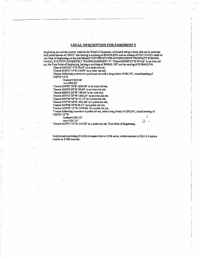
-.--~---------"------_.-.. _ .... -..... -.•........ -- .......................... .
LEGAL DESCRIPTION FOR EASEMENT 5:
Beginning at II survey control point In lhe Ward of Quuyncon, $Qid point· being'n brass disk sel in concrel~ •. Said point known os "DOO" and Iil1v.ihg II northing; of 805443.8964 nnd nn ellllfing of931110.4735 noted as' theP6int of Beginning on the plat Jobeled!'UNITED STATES GOVERNMENT PROPERTY FORMER NAVAL STA nON ROOSEVELT ROADS EASEMENT 5". Thence S63QOJ'Sl"E 9n;62' 10 nn iron rod set,lhe True Point or 13'eg!nJ;ling, hllving II nortliing of 80SI}! ~.1591nnd lin ellStirtg of933946.l774:
ThenccN63~8' !~E s9.67~ 10 a'point not· set; . Thence SI SO 1'1' 14"E II 8.94' toa point not set;. Thence following' a curve 10 n point not sel with a.long. chord af 966.77\ cllord bearing' of' 836"32'12"8.
RndiuS""f53SAS' Arc=9S1.5Q'
Thence 5S4°53 , 1O"E.1634.30' to .on iron rod set, 111CDce 535"OG'SO"W 59.04" to OB iron red set;· Thence S86"03'23~W r49.0'4·· to nn iron rod; Thence S73Q1S'3'S"W 1435.54' tjl on iron rod'sel, Thence NO I ·OO'4S"W 51.13' 10 n paint not set;. Thence N73°15' 3S"!! ) 421.6a1 11>' a point not set; Thence N3S"06'SouE 63.51' to a point not set; Thence NS4u53" lO"W J419.86·' 1e 11 point not set; Thonce followins.~ curve to npojnt nQt set. with 11 long chord of 1003.94', chord bearing of N36"32'l.2"W
Radius-IS94.5Z' Arc!"'1021.31'
Thence N Is011' 14"W 110.29' l(} a point nat set, Troe Point of Beginning •.
• .~
Suid parcel containing 214,2j4,4 square fect' 01' 5.538 ncres; which equntes to 22,411.5 squnre meters or 5.702. cmerdos.
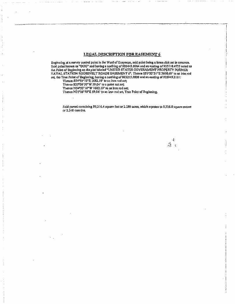
---.~-- ..... -----"'----'--------"----;
LEGAL DESCRIPTION FOREASEMENT (j
Beginning at !l survey control point in the Wnr.d of Gunyaclin. slIid point being II bms~.disk set in concrete. Said point known liS "DOG" nnd havlnlt II northing of 805443.8964 and ll1l. ensting of 93311 0.4735 noted iI$
the Point of Beginning on llie pint Inl:ielcd"UNITED STATES GOVERNMENT PROPERlY FORMER NAVAL STATION ROOSEVELT R.OADS EASEMENT e', TIience 551°,52'31 uS 3608.69' to nn iron rod set, the True Point of BeginnlnlJt having Illlorliling 0(803215.9800 nnd.mi costlng of 935949'.).1 61 t
Thence S54"5YIO"1: 1682.19' 10'lln iron rod set; Thence 835·06' SO"W 59.04' to a point nOf.sct;. Thcncc·NS4QS3'! O"W 1682:.19' to' nit iron rod set: ThenceN3~·06·SO"~ 59.(14.' to an iron 1!)d set, True pqintofBeginning;..
Said parcel cont.1in ing 99,316.4 squnre feet or 2.280 acres, which equates ~ 9,226. 8' sq~nre meten, or 2.348 cuerdas;
\. :J~
<~ \-

· .. __ . __ . _______ . _____ -:-::-_ .. -.----~------_c- .,...-. -..,,-.,...- -----~-. ------.-.. _------.----:---,--. --
LEGAL DESCRIPTION FOR EASEMENT 7
Beginning at II SUNOY control point 'in Ihe Wllrd ofGullyncan, said point being.11 brass-·disk sot In concrolc. Said point also knownns '000' and having II northing of SOS443.89li4 and nn casting of 9~3ll 0.4735 noted 11S the Point of Beginning on the plat labeled "UNITED STATES GOVERNMENT PROPERTY FORMER NAVAL STATION-ROOSI!VELT ROADS EASEMENT T'. Thencc.N84°48'49"E 671t9S' to a iron rod set, tIle Tru~ Point of Beginning, hav.ing ~ no~hing qf 80550.1.2720 imd an casting of 933786.670!h
11lence following II curve to an iron rod set with Il long chord of231.97\ chord'bemng of S85"20'41"B
RildiuS?'7154.61' Arc"234.00'
Thence S84"24'28"B 370.31' to an iron rod sci; Thence following aeurve 10 a point not set with q long chord of 406.50', cfJord bearing of S78°38'46"E
Rad ilis"2024.61·~ Arc..-407.19'
Thence 572"53'04"8 1013.37' (all point not sot; Thence following a curve; to a point rial set Wilh a long chord of 37{1. IT,. e1lord benring of S72°16'21"E
RadiuS?17324.6I' Arc""370,IS'
Thence·S1.1.OJ9~37HE 10;14.77' to. n point no~ set: :! 111encc following a curve to 11 point not set witII n long chord of179.23', chord biliJring of SS2"J1 '33."E . ,'. .
Radius'"'475.39' AFI;\<;!'J08.30'·
ThenceN86·j6'32"E 255.03' to II point ncit set; Thence following acurve·to 11 point not set with a long chord of 1380.42'. chord bearing of S69"39' 13"8
Rlldius=I714.61~ Arc-1420 •. 72'
11lence 545"54' 58"E 670.96' to It point not SCI; Thence ronawing a curve to 11 point. not set with n long chord of 341.13', chard bearing of SS 1"1 o'os"n
RndiUs" 1 B63~39~ Arc-341.62'
TIumca following 11 CUlVo to'n poinl not set with II lon& chord of 365.16'. dlord beorlng of 846"46'26"E
Rndius=I089'.61' Arc"366.90'
111CIlCO 537·07':39"3 ISS.SU' to-.a pCiintrtot sel: Thence, following a CUlVe to il point nat set with 11 long chord of fi44.1W, chord, beadng of 816"29'13"8
. Radlns-914.6I' Arc=6SH.97'
Thence 504"09' nnw', 15.96' to 11 point not-set; Thence following D. curve to. n point not set with a long chord of 3S0.82'~ chord. bearhi.g.of 839·35·'22"E.
Radlus=27S.39' ATC='12Q.SO'
TIle/Ice followinG a c!lrve to; a poillt· not set witlt a long chord of 96.52', cbord bellring of 889°S()'47"E
Radius-42S:39'

·_. __ • ___ .. _._ •• ___ • _______ • _'-__ • _____ -:~ __ • ____ ~-. _. ___ ,:-::-:'~_'--:-" __ 4" __ • _. _~ ____ •• _ •• ~~_. _._._~,,_"--_. _. _-.:.--.--_--::-~::_~~~_ •• -.-•• -.---•• -;
Arc=96.72 ,. TllcnCe N83°38'23"E 1 p .. SO' to 11 ppint nOise!: . Thence.following II curve to II point not set with n long chord of 325; 11 ' .. chord bCl1ringof N81·"34' J I"B:
. Rndius"'4500.J.9' Arc-325.18~
Thence following 11 curie to It point not. set wil!in 'Ipng chord 0{327 ;37', chord bearing of S81"57'14"£
Radius·' 14.61 , Arc"'J33.1S'
Thence following 11 curve to II point not set with Illont:t"chord of 4~7 ;6~', chot'c,t bCI)ring of SSO·OS'07"1:!" .
Radius..g49.6I' Arc=44I.60'
Thence S36"45'41"£ 111.79' to 11 point not sct; 111encc 563"24'52"£ 3 81.6'6' to' a point not set;
, Thence following. a curve to a:point not·set with IIlong'chord of230.00'. chord bellringof S81°15'13"£
Hadius"'375.39' Arc!"233.76'·
Thence N80"S4'26"E 167.83' to an iron rod scI; Thence 809·05'34"£ 49.22' to an iron rod sct; 111ence S800S4'2(j"W J 67.&3 r to n paint not sef; Thence fa /Jowing.ll·curvl' to a point not set with· a long. chord of 260.16, chord: bcaring; of N81ol5'13"W
RQdiu~"24.{j I' Arc"264Al'
TIlenco N63"24'5Z"W·234.68' to 11 point nol sCli 1110ncc S53°14'11"';\I 71.1.6.' 10 IIll iron rod, set; Thence N36°4S'47"W 265.23~ta an iron·rod·set~ Thence folloWing a'curve to nn iron'rod'sctwiUl n. long chord of 4 ~4.9S,.c~ord bearing pf N50~OS'07nw
Rlidius=900.39' Arc-41$.7P
Thence. following 11 curve to nn inm rod set witb Ii long. chord of296,O'. ch'ord bearing of N81°57'14"W
Radius"'46S.39' Arc"'301.29'·
Thencefo Howing 11 curve to. an Iron rod .set with n long chord of 328.61, chord benring of S!uoJ4'1·I"W
Rod!us=4549.61· Arc. ... J28.74~ .
Thence S83'!3S'23"W J 13.5W (a n point not .!!et~ Thence following· a curve 10 u point nolset with n long c/lord of258.88, chard bearing of' N8003P59''W
Rudius-474.6 F' Arc=252.21"
Thence fallowing n curve 10 1I"ppint not set with II long chord of 109.91, chord bearing at; Nno07'44"W .
Rodius=425.39" Arc"lIO.22."
Thence N79"J3'06!'W 66.90' to n point notse!iThencet N08~.57'3T'E 11.l0~ to. II point not sel;' Thence· foHowJng Ii curve'lo a p~Jinl not set"witll·a long chm'd:of 173-.64, chord benring.of N06~3J'25nE
Radius"2011>.':W
1

· .. -----,-----.------~-.----.----:--:-:--~==-:-.. -.. -.-'---.-. ---.. - .. ---:--:--.~-:---:""-:---.------:----.--.------.-~-::---::--"".
Arc" I 73.69.' 111encc N04"09'13"B 130;84' lo.jl point not set; Thence following II curve 10 11 pointnol sel with aJong chordof61U.ll, chord bearing of NI6"29'13"W
. RlldiuS"'1l65.39' Arc"'623.50'
TIlence N3T'07'39"W 155 .. 80' tOil point nolsel; . 11lcncc fortowing it curve to a point.not set: with· a long chord of348.67, chotdbcaring of N46G46'26"W
Radius-I 040.39' Arc"'350J2' .
Thence following n cUrve (Oi( point 110t set wilhn long ellord: 0050.15. chord bellring of N51"IO'05"W
Radius!'" 1912.61' Arc"350.64'
Thence N4S"54'58"W 670.96' EO 11. poinf notset~ 111ence following It curve to n point not sel with n long chQrd of I HO.SO, chord'bearing of N69°39'13"W .
Rndius"'166S.39' ArC'" 1379.93'
111cnee S86~36'32"W 255.03.' \0 II point not seH TIICDce following II curve to n point not set with a long chord (If 197~78. chord b~aring of N82°Jl '33"W
Rndius=S24.6J' Arc-I 98.97'
TIlenco N7.1°39'37"W 1034.71' to It point not set; . ' Thence following D curve to npointnot seLwilh a long chord of369.10, chord bearing of N72°16'21"W
RnditlS"" 1727S.39' Arc=369. 10"
'nlencc N72'S3'04"W 101.3.37' to nniron rod set;: 111cnca tbllowing ~ curve to t1. point not set with along ehord of396.62, crlo"rd bearing of N7SQ38'46"W
Rudlus-J97S.39' Arc=397.29'-
Thence N84"24'28"W 3.70.31' 10.n pointnol set; Thence following a,ctirY.e to 11 point not sel with 11 long chord of 148. 7'J~ chord bearing of" N8so00'27"W'
IUidlus"710S.39' Arc-I 48.75'
Thence.S ISoll'14"a 42!1 .• 70',0 n poInt nol scI;: 'I1lcnce S63"28' 17"W 59,67' 10 D point not se~j: 111em:e N Ison' 14"W .51 !.6a' to nn iron rod sct; Ihe TI'Ue Point of Begi~njng,
Said pnrcel contalning 547774.2 square feet ~r 12.575 neres, which equates to 50890. I squlm: meters- or' 12.94& ctlerdns.
--_._---_ .. -

-----'-"--"---'"--"-"-"-, ,--:--,---~'-:~"-:--"--- "'_,-:'----_-,-, __ -:-: __ ~~_:___:---;'-_-_. __ 0, ___ ,_, ___ , ~~;,...
LEGAL DESCRIPTION FOR EASEMENT 8:
[3eginning illl1' survey control poinl in the Word of Gunyncanj said pointbelng,1l bross disk set in concrete. Said point also Icnown as.'CAMP' nnd hllvjrtgil: northing of"SOO3'S130S9ilnd IIII' casting of 941574.63 ~ I noted as tho Poinl of Beginning' on the) plat labeled "UNlTED STATES GOVERNMENT PROPERTY FORMER: NAVAL STA'nON ROOSEVELT ROADS; EASEMENT 8";,'nlcncc N4S0t 8'42"E 10,6.71' [0
an iron rod set, t1lC~' True Point of Beginning, having !llIorlbing of 80 1527.5.403 and an eluting of 9423J3.9276~
Thence N80oS4'20,iE 4l4.18' to a point liouet;, Thence followingn curve to n point not. set wHIt-a long chord of 461.10', chord bearing of N88°02'26"E
Radins=I 86.4,61 , Aw=464.29'
Thence following 11 curve to Ii poin't not set with a long chorefof 362.68'. chord bearing Qf 373"28'41"8
Rlldiup92,1.6P Arc=365.07'
Thence 862"01'4S"E205.39' to 11. point not'set;: 111elice following'Dcurve 10 a point.not Bet with nlong chord of26728, ,chord bearing of 859°53"37"8
Radius.=3424.61' Arc,,;261.34' I
TIienco SS.7~9~26!tE.142.96' fo npointnot sctl .... :f
Thence following D curve tan point nO"~et witb nlongchord of 168.92', chord b~~rlrigof N72"2S'43"E
Rndius-IIO.39'ArcC"192.34'
Thence N22930'51"~ J41.86"to u poinl not set; Thence following Ii cllrve to ,a' point nat set with a long chord of 140.48", chord bearing' of N27D4J'OI~n
Rndills-174.61' Arc=140.67'
Tli'I~nce N32'SS'j O"E IIS~54' to II' poinl not set;, Thence following a curve 10 a,point no! set with a long chord af88.65.', cbort! b'earing: of NI9QI4~16"E '
Rndius==187,3!1' Arc"89A9~
ll1encc NOs033'22~ 84.7 J I [0 a point. not set; Thence- f9IJowing 11 curve to 11 point not set wiil! a Jong chord of 21, 3.72.1, chord bearing of N43~I'7'24"E
Radlus-174.6I' Arc=229.99'
ThenceN8IdOI'2S"E7j.96~ loa paiJitnot.sct; TIlence following II curve to n point Ilot'set with 1\ long, chord of 3&923', cllord beuring of 883"49'3 P'E '
Rndiuszo744.6) , ArC!"39J.8 r'
'mence 868.°40'26"B 72.89~ to a, point not set. Thence following ncurve ta Ill) iron rod setwitlllt long chord of I I 7;78', ' chord bearing of S4soS7'SJ"1!,
RrtdiuS'" 1 74.6Y Arc=1 20.J 3 ,
Thence S60o«'45"W4922' to' an, iran rod set;
;

... -.----.-.-.--:~--::-----:~-.-. ---------. ----------.-~~.--.. --.. ---.. -.,.-----;"--,-~~",-.---.... -.--..... -, ------.---~.~. - . ..,..
Thence following-,ll "urve to. n p.qint no* set with II long chord of 84·.58!, ,chord bearing of N4S.~S1·51"W
Radiu!l=125·.39' Arc"'86,2.7'
Thence N68°4a'21i"W 72.89' to II point not· set; 111ence, following 11 curve to II point not set wHit a long chord of 363 • .50.'. chord bearing of NS3G49'JJ"W
Radlus=69f.3!>· Arc=367.18'
Thence SS I·OI'2.5"W75.96' to a point not set; Thence following a curve to 11 point not set with n long chord of'153.48', chord benring of S43Q17'24"W
RadiuS'" 125.39' Arc.=16S.16'
Thence SOSQ33'22"W'S4.1I' to!l point not set; Thence following 8 curve to n point not set with 11 long chorq of lll.9j~ chorel benring of SI9°r4'!61'W .
RadillS"'236.61' Arc=113.00'
'nence S32°S5' IO"W 11.5.54' to /1 point nolsel; Thence following II curve to 11 point not set with It long chord of i31.5S.cbord bearing of S27c43'O'''W
Rndius:s72S.39' A~~~Y l
Thence S22"30'51"W 34l.86" to n point not set; ,;.: ~ Thence following a curve to (Ill iron rod se~· with a tong chord of 244.23, chord beii'ring:.of S72~S'4l!'W
RadiuS"" 159.6.),' AfC"'278.09'
Thence N57"39'26"W f42.96' to an iron rod:sel; Thence fol/owing It curve to nil' iron rod. set wilh 1\ 10llg chord of263.44, cherd bearing of N59"S3'37"W
Rndius"'337S.39' Arca263.S0'
Thence N62°07'48"W 205.39' (0 f!1\ iron,rqcl sel; Thence following 11 curve 10 1111 iron rod set with a \ongcitord of 343.32. chord beoring ot N73"28'41"W .
Radius:'"S72.39, Arc=-~45.57'
Thence.followin~ a curve to nn iron rod set with 1\ long chord of 450.87, chord bearing of SSS"02'26"W
Radiiis"IS·15.J9'· Arc=452.04'
Tlience S80c54'26"W 434.18' 10 an iron rod set; Thence N09"OS'34"W 49.22" to an' iron, rod set, Ih6 Tme Point of Beginning,
Snid parcel containing 182,440.5 squnre; feet or 4.18 8 ncrcs, which equates 10 16;949.3 squnre meters or 4.3 12 cuerdils.

· .---~-,-------:-----~.--~.-~---------.•. -. -'-.. ---------------:--------.-------: .• -..
LEGAL DESClUPTION FOR EASEMENT 9
Beginning IIt!l s~rve.y control point in the Ward of Much os; said pointbcing:a brass disk ~e! in concrete. Sold pOiil! also known II! 'MEDIO' nnd.having n northing of 81 I 980240S and 011 casting Qf943 163.074 1 noted as. tile Point of Beginning Oil the plat labeled "UN r'fED STATES aOVERNMENT PROPERTY FORMER NA VAL STA noN ROOSBVELT ROADS EASEMENT 9". Thence S42"23'29"W 232.1.47' to nn' iron rod sel, the TnIC Point ofBeginning, having a norlliing of 8 t 0264,2234' lind an ~DStjng. of 941596.6070:
'rTlence S32"S9'4S"W 82.86' to a point not set;. Thence following-a ,curve to.1l point not set with II long chord of 134.73", chot'd bearing of S071>1 S'20"W
R[ldiw""tS:S.3!l' Arc=139.35'
Thence SIS"23'05"E614.n' (on pohi~notset; Thence following, a curve to n point not set with II long'chord of .5.19.04" chord bearing of S07~II'21"E .
Radius" t336~6 ~' A~=522~35'
THenco following' a curve to Ii point not set with a long chord of 409 ,95 '; chord be!l~ing of S2001 O'31'~E
Rudiua-500.39' Arc=422.3S' ,
:t Thence 544"2V26"E 316-.1 1'10 n point.nouet: ." Thence folhlwlng.a:ctlrve to 1\. point not set with D long chord of279.119'. chord beitring of' 84&Q38' J2"E.
Radius"'·1875.39' Arc""280.IS~
Thence S52D54'58"8 262,43' ton polnl nol set;. 111encc followin~a curve to n point nol set with a long chord of 3-27.97', chord bearing of S44"00'48"E .
Radiua-l059.61' Arc=329.29'
Thence S3s006'38"E 708.85' (0 II point not scl~' Thence following n curve tOll point not set with Ii long chord of 373.98'"chord benringoF S29°JS'03"g
Ri1dhis;= ~941.61' Arc"'374.S6'
'fbence ~24"03'27"B·204.94' to II point not sel~ Thence following n curve to II point n01 set with iI'. long chord of 176~S7', chord benring of S22"O(}' 17"E.
Rndlus=2464.Gl" Arc=J76.61 ~
Thence S I9"S7'D6"E 375.30' toa point not set; Thence following ~,,~t!1lC (0 11 point not sel with n long chord of J63.9.1', chord bearing of 347"48'32"11
Radhl!-l:1S.39' Al'c"'170.5S"
Thence-following,a curv~ to npoiilt not sclwilh along chord 01'222.47', chord bearing of S51"29~26"E
R,lditll.-27 1.6 I ' Aw=229.2I'
Thence 527°f8'54"B 248.18.' (a II point not set; ThencCil following II curve 10 n point not set witlulong chord of 418.53', chord bewing.of SO 1 D.54'OO"E
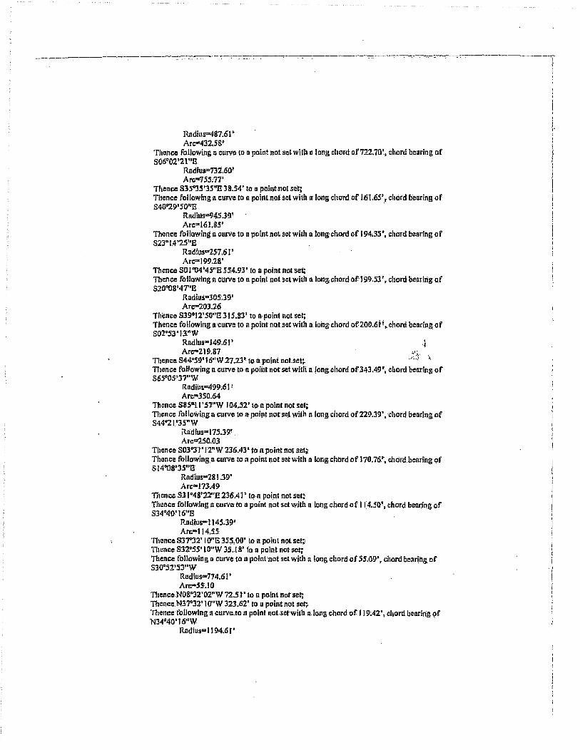
_______ -:-____________ :--::-:::_.-.. --'-;--'--:--:-:::-. -. -. ---,-~-_ - .. ---------:-7-.-.-. -. -~o-.-.. _-. _-.-. -_ .-.--.-.--------
Radius=481.61'· Arc"'432.5S'
Thence following n curve 10 n point.not se~ wHits lang chord of"722.70'., chor~ bearing of S06°02'21"13
Rndfus"731.60' Arc"'75S;71'
Thence S3S"3S'3S"n 38.54' to a paintoo! set; Thence following 11 CUl'VC to a point-not set With a 10ilG chord. of L61.6S', chord bearing of 840"29' 50"13 .
Ratlil!5=94539' Arc.=161.85'
Thence followingll curve to n point not set with a long chord of 194.35', chord bearing of 323"1.4 '25"E
RnoiU5""25-7.61 ' Arc=199.2S'
Thcnce SO l "Il4'45"E 554.93' fa n point not set: TIlence following n curve to R point not ScI with a long chord af-199.53·. chord liearing of S20"08'47"E
Radiu:i"30.s~39' Arc-20l.26.
Thence 83!)012'50"E 315.10' to apein! not set; Thence following Il:curve to n point. not set with a.long chord of 2QO.Iit! ,chord baoring of 802"S3'13"W'
Rndlus=J49.61' ,~ Arc-219.87 ,;~.
'nlencc S44"59'16"W 27.2r 10 n point not. set;. "~-I ;. TIlen.ce following n CUNe lOO poiilt not sel with n long chord of 343049'., chord bearing of S65~OS·'J7 .. W
RndiiJs""49~M P Arc=350.64
Thence S8SGU'.5'''W 104.52' lOll point not set;: 11lcnce followiJ:lg n curve to It point not· SC.t wilh n long chord or229.39', 'chord, bearing of S44"21.'35"W
Radtus-175.39' . Arc=250.03
Thence S03DJ"l'12"W 236.43' to n point not set;; Thence followmgo curve to n point !Jot set with a long chord of 170.76,~, c!lIjl·d.beliring~f S 14"08'J5"E
Radius-281.3!)' Arc"'J73A9
Thence 831°48'22"S 236A) , IQ·n poipt.not set~ Thence following'a ~Urve- to n point not set with n lOng chord of 11:4.50\ chord beoling of S34°40~ 16'iE
RJIdlus-114S;39' Arc"114.55:
Thence S37"32'1 O"E 355,0()' to n point n9l set;' 11ulnce 832."5S' lO"W 35 .. 18' to D point riot·sct~ Thence following D curve to n pointllot set with a long chord of 5S.09', chord bear!og of S30oS2'5J"W
Rudius=774.61' Arc-55. I 0
Thence N08D32'(}2"W 7251' 10 n poin1 botser, Thancc.N37"32' 1 Qnw 323.62' to u point not· set;", 'nlencc' following n curve.to n point not.setwith nlong chord of J 19A2', chord bearing Qf N34'40'16"W
Rodius=1I94.6('
, i r

-------.----_-:--.--,-- .. --- ---------:---.-,--7"7-.'"'-~-.-.--~-..... -. ---r
Ai'c-II9.47 ThenclS NJ.lo48'22"W 236.41' 10 II point.not set~ Thclnclt toUowingn curve to II po!nl nol set Wilb along chord of200.6J'~ chord bearing of NltI"OS'3S"W
Rildills<:330.6I' Arc-20J.!l4
11lence NO~~I'12"ij 236.43' to a poml noi sel~ Tltence following II curve to a point. notsel .willt a long chord of293 .76' •. chord: benrlngof N44"21'3S"ll' .
R!ldilir-224.6J.' Arc-321J.20
Thence N8S"} J'S7"E "lOtl.52' to a' poinl not sel~ Thence following II curve to a point no, set wilh n long cltord ofJ09.65:'. chord bearing of N65"OS'J7"E
Rlldius=450~39' An;"'316.09
Thence N449S9'16"E 21;2Y to n poInl nof set~ Thence fallowing n curve to n !Joint noUet with· a long cborli of 134.61', chord benring of N02"S3'13"B
Rlldlllll-IOG;39' Arc= I 47.53
ThenceN39Q I2'SP"W 3is.83~ to n point not set; Thence following II curve to iI point not.setwilh a.long chord of 23 I .69', 'cltord bellring of' N20·0B'41"W . ..~
Radius;354.6P ,~~~ Arc--'236.02
Thence N I 0"04~4j"W' 554.9),> to II point not set;. Thence following'lI curve to" point.nots~t witl! ,,·ions, chord of 151.22', chord bearingtJf N23°14'2S"W
Radius-20S.3!); Arc'" I 61.21
Thence following II curvo to n point not set with a long chord Qf 170.06', chord bearing,of N40029'SO''W
Radius .. !J94.6 , .. An;=;o170.27
Thence N3so35'J.5"W 38.54' (0 11 point not set;. Thence following lleul'VC. to II point not SC.t with a long chord of 771.2.6-'. chord bearing of N06D02'21"W
Radius=7g 1.8~· Arc-S06.55 '
Thence following II curve to II" poini not set-with II! long chord of 376.29', chord Dearing of NO I Q54'OOl'W
Radllls~438.39' Arcm388.92
Thence N27"IS'S4."W 24g.l8' to II point not set;. 111ence fo.lIowing a curve to n point not set wi!" II fong ch.ord of 182.15'. chord. bearing of NSl "29'25"W
Radlus=222.39' Arc'" I 87.67
Thence following a curve toa point not set WiUl' n long chord of209.9·1 '; c.llord benring of N47°4S'32"W'
RadiuF.224.6I' Arc-2IB.41
Thence N19"S7'06"W 315.3.6' to a point not set; Thence following Ii cUJ'yeLol1 point not set with a'long chord 'of 173.04!~ chor4 bearing of N22"OO'17"W'
! !
':
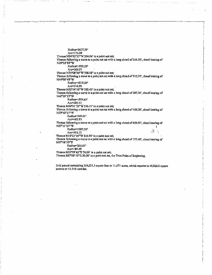
RadiuS=2415.J9' Arccs173.08'
Thence N24·03'27"W 204.94' to II point not sot; Thence following a curve to a poinl.not set with along chord 0064.50'. chord oellring of N29"33 'OJ"W
RadiuS?" 1892.3~ Arc-365m
. Thence N3S·0G'38"W 708.86' 100: point not set; Thence following!1 curve to II point nOBo~ with: a long chord of312.73', chord bearing of N44°QO'4S"W
Rlidius= 1 0 .£0.39" Arc=314.00
Thence NS2nS4.'.58~'W 262.4J'loa point notset~ TIlence following II curv~ to II point not set wilh n long chord of281.:w, chord benring of N48°38 t I2"W
Rndius-I924.61' Arc-287.St
Thence N44"21 '26"W 316.11' Lo II point not sel; Thence following a curve toa point not set. with along chord of 450;28', chord bclU'ing of N20oI0'31"W
Rndills=549.61' Arc=463.93-
Thence following ~ Ollrv\, to n point nol sill with [I long cnord of 499.92\ chord boaring of N07"II '2 P'W\
Rndlus=1287.J9'; Arc=S03.12
Thence N ISQ23'OS"W 614.93' to n point not set: 'nlence following n· curv~ to II point n.Ol sel with n long chord of 17VIO', chord boaring of NI}7"IS'20"B:
Rildius"204.6 I' Arc"'l &3.49'
Thence N32",59' 45"B 74.06' io 11 point not set;. 1nencc 867°08'1 O"IBO.OO' to. a point:not set, the True Point of Beginning.
Said parcel containing 504,031 • .ssqunre feel or 11.571 acres, which equates 10 46,826.2 sqlla~' meters or 11.914 cucrdml.
-'~--.. ,..,~-~--
L ! j

LEGAL DESCRIPTION EASEMENT 10.
----_._-,,--
Beginning ot 11 BUrvey control pointin the Ward of Guayacan, said point being a brass disk sc~ in f;oncrcte. Said point al~o known os 'DOer(' anef having a norlhiilg:of 80 1 006.944~ and nn casting. of!}~ 8162.625 1 noted lIS the Point of Beginning on the plilllnbcled "UNITE!) STATES GOVERNMENT PROPERTY FORMER NAVAL .STA irON ROOSEVELT'!tOADS BASEMENT 10", Thence N82" 180'3J"W 6368.65' to an iron rod set, the Tl1sa Point of Beginning,. having a northiilg of 80 18S9,2585 Q!1d an casting of 931851.2678:;
Thence N210lT II "W'70.94' to' a point·not set, 'TIlence. following a curve to n point noL set with 11 long chord of.544;78', chord bearing of N62°20'Sl"g
Radi~s" 1438.791
Arc·: S4&.09~ Thence N73°15'38"E 791,2S' to II point notsct~ 111encc 816°44'22"8 9.18"to a wiilt not set. Thence N73°IS'38"B 13 SU2' Lo n point nol set; Thence 80"·00'48;'8 51.13' to an iron rod set; Thence S73~JS.·.3S"W 136'(\26' 10 fln iron rod·s~t~ Thence 816°4.4 '22"E 9.18-' to an iron rodsct; 111ence 873"!S'3S"W 7~".2S· to an iron rod set; Thence following EI cllrvefo an Iron rod set, the TruaPoint of Beginning wHit a long .I;hord or 539.87\ chord bc=nring ofSCil"S4'26"W ,
Rndills= 1371.21' T
Are-=S43A2' <~ '. Suid pnrccl conluining 157,993.8 square feet or 3.62.-7 acres, whichequDles tf} 14,678.2 square meters or'J.735 euerdas.

---. -.~-.------.----""--"~.-.. -. ---.-._---' .-.---~----.----
LEGAL DESCIUPTION EASEMENT H
Beginning a~ a survey c~ntrol point In the Ward ofGuaynclUl, said point being /l bmss disk sci in concrete. Said point.also kno-.yn ~ 'DEtICIAS' and having 11 nqrt,hing 9f7!l9143.8531nndlln easting of' 927504.490 J noted lIS the Point of Beginning on the pint labeled "UNJTED STATES GOVERNMENT PROPER1'Y FORMEIt NA v' At STATION ROOSEVELT ROADS EASE~ENT 11". 11ience S83"29' 58"W 1270.45" to lin iron rod set, the-.Truc PolnL ofBeginning; hav.ing.1I. northing of 799000.0249' and an eallting of926242.2090:
11lcnce follow.ing n curve tQ a PQiJ)t n(lt set witb a !otigchord of206.40', chord bearing of S44U37'24"E
Radius.-799152' Arc-206.9S'
Thence S3-7"l2'2S"g 184.72' to 11 point nat set; Thence. faljawing 11 curve to a point Dot 5ct with 11 long chord oflIO.IS'; chord bearin~ of s 16°02'2S"e
Rndlus=429.52' Arc=317.3S'·
Thence SOso07'35"W ]1:1.24' to a point.Dotset; TIIcnec following a curve to n poinlnotsetwiih II long chord of295.16~, chord bearing of 813°33'58"E
Radru5"'46M8' Arc=-300.46'·
Thence 832° lS'-3"1 "E 300.981 to a point not set;. ..~ Thence fbllowing £l curve to l1'point not set with a long chord of 368.15', chord .1i~Qring of SI6°53'22i '2' ."'. '.
Radiusc694.S2' Arc""372.6o·
Thence.SOio31:'l·3"E 874.38' to a point not set; Thence following n curve La 11 point Dol set with. a long.chord of478.71', chord benring of S) I036'S7"E'
RadiUS"" 136SA 8:' Arc-48 1.20'
'flume" following.a cilrve to a'point not set with a long chord of.450,35', chord bearing of 885°44' lO"E
Rlldiu5""2SoA 8' Arc=559.79'
TllimceN30014!21"11582.72' (0 n point not set; Thence NS9°4S'39"W 19.69' La a pointnot SCI; Thence N:looI4'21"E 467.43-' to a point nolset; 11Ience following a curve to n point not set with n long chord of ) 61 0.03'; chord benring of NJ2~O'28"E .
Rnditls .. 2194~;21.' Arc-16I0.4S'
Thence N34"26'3S"E nJ.4l' to' n point noisel;; 11lence following D.curv.e to:n point notselwitb a long cliordof 113&26', chord benring of N39"17' 54"g
Rlldius=6724.21' Arc=1139.63·
Thence rollowing 11 curve loo'pointnOlSBt with n long'chord of684.73', chord bearing of N54"49'22"E
Radius=1849.21' Arc=688.70'
Thence N65"29'32"E 226.98.' to II point not SCI;.
111ence S24°30'2S"E 15.42' to a point. not set;

____ ~_. __ .~ •• M __ •• ~ •• ,. _____ • _________ .. _________ _
.. .
Thence following a curve to It point not sel with It long. chord of577.11', chord lionringof N42°44 '26"E'
Rndiu!I""746.21' Arc:592.63,
11lC:ilce.N J9"59'21"a 655.01:' fa 11 point no~ sel: Thence following II curve 10 II poinl not· scI witb a long,chord of 779.17", chord bellring of N3'S042 '42u l!
Rndiirs= J 43 8~.7!J· Arc-789.65'·
Thence 821°17; nnE 70.94' 10 urdronrod set; TIlence following II curve tei n pointnol set with a long,chordot'722.84·~ chordbenring of' SJSQ16'17''W
Rndhls'" 1 37 L21' Arc=13 1.48'
Thence SI9°59'21'~W 65 L23' to.a poillt'nol set; Thencil following. II cUlYe to a point not set with II long chord of 629.45' i chord bearing of S42°44'26"W
Radiil~813. 79' Arc~646.30'
Thence S24D30'28"B·15A2.' to a point not sei~ Tht.'ncc S6S"29'32~'W 246.98' 'to II point not set;. Thence following a curve to n pointllotsetwith !lIang chord of648.29', chord bearing of SS4°49'221'W
RlIdiils-f7S0,79' .. 1, ArCFb52.0S' .,~ , .
Tflence folloWipg lLcurve to a point not sot with 11 long chord of 1121.60~, chorcHlcuring Qf S39°17'S4"W
Rndius=662S.79' Arc"l J22~95'
Thence-S34"26'35"W 721.41' to n point not set; Thence. fol/owip8 tl' ctirve to II point not set with.a long chord of 1602.81' , chord beatIng of S32"20'2S"W
RlIdius""2·18So.79' Arc= 1603:.21;
Thence: S30'"14~21 "W 46.7.43' to a p~int not set~ TIlence NS9°4S' 39"W' 19.69' I"o'n point not set; TIlencll 5300 14'2 J"W 582.72' 10.11 point not set; Thence follOWing 11 curve.to nn iron rod set willi 11 long chord of 556.51' i chord benring of N8so44'IO"W
Radius=309.52~ Arc"691.74~
Thence toJlowing:1l curve to an iron rod set witl~ II (ong cllord of 499.41'. chord bearing of NI·j Q36'.57"W
Radhl5= 1424.52' Arc=502,O I ,.
Thence NOlo31' 13"W·874.38' 10 lin iron rod set; Thence fo.llowlnga cUlYe toan iron rod·set WiUl a long chord of336.85" chord bearing'or N I 6°53 '22''W
Radius=63S.4S· Arc=340.9Jl
TIl!mCe N32C>IS'31"W 300.98' to lilT iron rod set;" Thence following a curve to nn iron 'rod set with n long chord of333.00';chord.bcnringof NI3~3'58"W
Rndius=S19.52' Arc=338.98'
Thence N05°07'3S'E· t 13.2-1' to lin iron rod sct;
r i

'111enca following n .curve to an iron raclsel with n long chord of 261.55', chord bearing .of N16°02'2S"W
Rlldius=370.48'· Arc=-273.73,
Thence N~7QI2'25'n,yjli4.72'·lo ail iron rod :Sc~: Thence fullowlng a:curvc to nn h'on rod selwith it long chord of201A6', chord bCllI'ing of N4S"Oo' 13"W
Rudius=740.48f Arc""204.l(}~
Tllence N49.°48'.48"B 60.~4~ 10 an iilln rocl sci; tlte True Point of Beginning.
Said parcel containing 869,213.9 square feet or 19.954 dcres, wbich equate.s to 80,572.9 square meters or 20.546cucrdIl9.
, "
· 'j ,

___ --.... --~.~--.--A-----.---'-'---- ... ----.... ---·-----~.----,-"--_.--. ------.---::-------:: ... -. -.... ---.-.. -.7-;
LEGAL DESCRIPTION FOR EASEMENT il
Begi!11!ing at !I survey control point.in.the Ward· of Guayncan, slI!d point being II brasS' disk set in concrete; SlIid point alliO known as 'DELicIAS' and having 11 northing of79!lt 43.8537 and 'iln Cllsting 'of 927504.490 looted os the Point of Beginning on!/te pluLlnbeled ;'UNlTED STATES GOVERNMENT PROPERTY FORMER NAVAL STATION ROOSEVELT ROADS EASEMENT 12", Tlicntc N8cS"OS'59"E.29J6.67i to all irO!1 rod set, Ihe True PolnlofBeglnnlng,:hnving a nonhing'9f199339",7094. ond an casting of 930414.5800:
TIlenCc. fol/owing II curve !Ollll iron rod'set; with a long chord of394.07', aebord bearing of S88"16'14"8,
Radius=- 694.61 I. Arc=399.5S·
TIlenccS lso12'29"W 49.21; Lo a point not set; Thence fo/lowinga curve tOil point noi seti with II long chordof366.14', ncltord ben ring of NBS"16' !4"W, .
Radiu? 645.:W Atc"'l71.24 •
Thellce S75~15'02"W 302.30' 10 n p-Qint not set; Thence rollowingn curve to apoilll nolsel; wilh a long chord of413.0-l'. n chord benring of N79D S.2 "1 O"W,
Rildius" S14 .. ~.; Arc:=,446.92,
Thence N54uSg.'22"W 22.37' to II point not·set;: t
Thence following n curve too poinl not ,sct; with n long chord of49.31', n chord ~.cniing of NJ!l"3!l'44"E~ ,~" i.
Radills· 6625.79' - . Arc=49.37'
Thence SS4°S!J'22"E-18.37' to. a point not'sel~ Thence folJowingn: cllrve·to a painl not sot; with 0 long chord of391.60', a chordbenring of S79°52' 1 O''E,_ .
RadJuF 465.39' Arc=404.IS'
Thence N7soIS'02"E 302.30' to an iron rod set; IheTrue Point of Beginning;
Said parcel contnlning 55,198.0 sqUllre feet or '.28 I' ncres, which equtllcs 105,183.8 square meters or 1.319 cuerdlls.
i r'

,---~---------.~-.----.-.--~---.--------- .. »-- .-------------.-.----.-.-.---.------~
LEGAL DESCRIPTION FOR EASEMENT 13
Beginning at a survey control point in Ihe Wnrd of.Gunyacnn, said point being 11 brass disk set In concrete. Said point. also known as 'DELVIS' and bllving!1 northing of796645.7678 and nn ensling of9~7749.8902 noted as the Polnt bf Beginning on the plnllabeled "UNITED STATUS GOVERNMENT PROPERTY FORMER. NAVAL S1'A nON RQOSEVEL T ROADS EASEMENT 13". Thence 878"52'34"E 168 .• 01·' to nn iron rod ser, the True Point of Beginning" having.o.northing of7.96614.3537 nnd'nn casting of 927914.7410: .
1ilence N30"i4'21"E:SI..03' to' a pohit.not set; Thence S1.S"O~'5t"E 919.53' to apoint nOl.sel;· Thence fbtlowinga curve to n-point notsetj with-a long chord 0(462.99', i1 chord bearing of S29"33 '20"13,
Radlils" 314.61 ' Arc=515.47"'
111cnce 515"S6' Il"W 36(}".72' (0 a point 001'5el;
Thence following a curve to n point not set: with n long chord of 418.0&\ 11 chord liearing Qf SOI,03J'OJ''W,
Radlusa 841.39' Arc=422.51 '
nencCl SI2'50'05"8: 705.02' to (\ point not sel~ Thence following a curve to a' I'0inl lIot'set;" willi II Iring chord of 237:97', a chord ~earing of SIO"24'27"1!; .
Rndius-2809;61' . Arcq 23 S..04~ ,l
Thenc!! S07'SS' 50"8664'.13' 10 n point not set; .,~~ 1.
Tflcm:& fbllowing' It curve' 10' n point Ilot set; with- 11 long coord' of 16J'.35'", a chord bearing of SI2Q03~lS"E,
Radius=- 1135.39' Arc:=16IAS' .
111cnce S 1,6"07'41"8406 .. 15' 10 u'paint not set: Thence following II cUrve to 11 poillt nal ~etj with a long chord of 121.76'. Ii chord benring of 821."04'50"2,
RadiuS"" 705.39' Arc=!21.91'
Tllence S26"OPStV'S 754.37' to 11 point-not set; ·mence·N6J"S8'Ofi"1l29.53' 10 n point not set; Thence fallawing n curve 11;1 lin iron rod set; with n long chord of 243.72', 11 chord benring of S 17°46' SO"E..
Radius" 849:14' ·ArC"'24"4.S1'
TllcnccS09"31'46"E282.37'IO on iron rqd set} Thence following. It curve' to lin iron rod set; with it long chord of 294.29'", a chord bearing of S40"30'35!'E, -
Rndius .. 285.8"6' Arc=.J09.13'·
Thence S lsn30'36"W 29,53' 10 a po iot not S1;lt;
Thence S71"29'24"a 79.41.' to n point not sci: Thence following a curve to n point not set; witlI n long chord of 143.96', !1 chord bearing of S83"20'41"E, .
Radius- 3S0.39? AI'(."?144.99·
Thence N84D48'Q2"E272;81' to lin iron!'D~ set;

--------_._--_._------------_ .. -
TIlence following n. CUr\TC to nn iron rod sel~ with a long chord ofZ4L06', n chord bearing: of 870<>36' 19"E,
Rndius-289;61' Arca248'.6l'
Thence following n. curve to qn iron rocl· set;. witb 1.1 long chord ~f 530.38', 11 chord: benring. of N84°0P4T'E. .
Radius"" 346.39' Arc<=604.07'
TIrence SSS"SS'4S'E 49.22' to a iron rod set; TIlencc following II curve to 11 point not sct; with a long, cllord of 605.14', 11 chord bearing of SS4°01'47"W:
RndiUP' 395.61' Arc=689;90'
TIlence followin'g il curve to a point not set; witb il long chord of 200.09., a chord bearing of N70036~ 19"W,
Radius-240.39! Arc=206.37;
Thence S84°48'02"W 272.81' to 11 point not set; Thence following 11: curve to It point nol set; with along chord' of 164.18',11 chord bcaring of NS3°20'41"W,
Radius- 3 !'Y.6I' Arc=J6S.36'
Thence N71oa9'24"W 79.4 J.' iO'1t poin."!}Ol sct~ Thence fol/owing- 11: curve to a po.int not set; with a long chord of 375.36',. n chord bearing of N4QQ3(}'3~"W~ :~;;
RadiuS'" 364.61' ... ~., Arc.==394.30·
TIlence N09"ll '46"W 282.37'10 II point not set; Thonce folJowilig.!l cllrve to n point not sct; with a long chord of 221.12'. a chord bcaring. of N 17"46' 50"W.
Rndiup 770039' Arc!"'221.8S'
TheneB N26"O I' 54"W 754.37' to n point- not set: 'nlcncB fol/owlng iI. curve to n point not set; wilh n Jeng chord at' 1-30.2S', 1'1 chord bearing of N21"04'SO"W,
Rllditl.F' 154.6 J' Arc= 130.41"
Thenco N 1 O'07'47"W 406. 15' to II polnl not set:. Thence following II curve to II point not ~et; Wilh,1t. long chord 'of t68.34', il chord, bearing of N J2°0S'IS"W, .
Rndills- J I 84.6l' Arc=-168.49'
Thence N01·58~50"W 664.13' loa: point nO'1 set;· Thence following 11 curve to II point not set;. wilh 11 fong chord of 23J.BO~, iI chord bearing of N I 0"24 '27"W~
Rudius= 2760.3.9' Arc=-233.S7"
111ence N 12"SO'OS"W 705.02' /0 R point nouet; Thence following· a, curve to II pefnl not set~ with a lon§ chord of 442.$4\ 11 chord bearing of NOI°33"'OlnE, .
RndlllS- 890.61' Arc-447.22'
TIlcnce N lS"S6"n"n 360;72' to' a point not set;.

Thellce. following a cur:v~ 10 a. poinl not set; with a long chord of 392.79', tl cllDrd bearing; of N29'lJ3 '20"Wj
Rildiu,<a 275.39' Arc=-437.] P
TIlence N75°0:i' 5 j"w 932.99~ 10 nn iron rod set, IheTrue: Poiht of Bagillflillg.
Said parcel cOntaining 394,968,0 square feet or 'iJ.067 acres; which equates to 36.693.9 square meters. or 9,336 cuerdas •.

,._--_._-----------_._--
LEGAL DESCRIPTION FOR EASEMENT 14
Beginningula survey control. point iii lito.Wurd ofOuIlynclin,8uid point being q bmss disk set in concrete, Said point 1I1so known as 'DEL VIS' and hnvlu/& 11 northiitg oJ796646.7678 Dnd an ensting t)f 927749.8902 noled lIS Ihe Point· of Beginning an the plil~ labeled "UNITED STATES GOVERNMENT PROPERTY FORMER NAVAL STATION ROOSEVELT ROADS iMSEMENT 14". Thence S.47l'W47"S 661 O.9~' to' un iron rod selj.lhe True·\'oint· of Beginn ing. having a nor.thing. of 792 I 61. 7895. and nn casting .of 932606.7849!: .
Thence S48°j4'14"W 49:22' to-un il'on rod set;· Thence following aClIrve 10-11 point not set;. with n long chord of 327.40'; n chord.benring ot' NSlo4S'41."W, . .
Radius· 908.39' Arc"329.19'
Thence N62°II'3S"W 204.46' to·a point not set; Thence. folloWing 11. curve to 11. poillt not set; wiilt II long chord of 285.1 '1', n chord bearing of N87°30'SO"W,
Radius,," 333.39' ArC!"'294.67'
Thence S67"09'S5"W 24 9.07~ to n point not set~ Thence following II curve 10 a point not sel; with a long chord 0[273.38', II chord bearing of 850°35' 54"W,.
R£ldills= 479.39' Arc=277.23' ,
Thelice S34°01 '·S3"W J 1296' to'a point not set;: _: .. :;. Thence. fallowing a clIrve to £I point notse~; with a long chord of 157.69",11 chonj:ocotlng of S03DS8'06"W,
Radius'!' 157.39' Arc=165.l7'
Thence S26"OS'42"g, 141.99' to n point not scI; Thence following a clirve to un iron rod sel;' with u tong chord of27S.30'~ II. chord bearing of S03°59' 17"W,
Radius= 274.61' Arc"288.37·'
ThenceN5S0SS'4S"W49.22' to.an iron.rod·set; Thence fa !lowing n curve to a' point not set; wilh II long chord of 225.95" n chord benring of N03 D59'17"E,
Radius" 22S.J9 1
ArC""'236.68' Tflenctl N26"05'42"W 14:1.99' to 11 poinlnot set; TII/mcc following II curve to n p.ointnol sel; with /lIang chord of207.0Q', a·chord bearing of N03°SS'O(i"E,
r{ndius= 206.6" Area 216.82'
Thence N34"OJlS3"E 1 12.9/J.' t9 n point no! set; Thence following '1\' curve to II point not set: wIth n long chorel of 30 IA5', a chord benring of N500J 5 '54"!!.
Radius=' S21t.ul' Arc"30S~69'
Thence-N67"O!)'5S"E 249.07' to 11 point' not set; Thence fol!owing a curve· to a point not set; with a long chord of 327;27', a chord bearing of S87°JO'SO"E,
Radius=' 38261~ Arc"338.17"
Thence S62"11'3S"E 204.46' to n po.int not set;
I •.
J I

- ---------.. --.---.~.------~-.-----:---~-:--:-:---:--.---.. ---- .. '---:-'--. -----.. _-_._--.. --:-:::;---.. -. -
TIlenc~ following It curve to nn iron rod sel; therme Point ofacginning with !lIang chord of 345: 14', n chord bcarihg.afSSlI>4S·'4P'E, .
Radius::o.9S7.61' Arc."'347.03'
Said parcel containing 103 •. 755.2 square feet or2.38211crcs. which equale! IQ 9,639.2sqllnre meters or 2.452 cucrdll!.
\ .. ,
r

·._----_._-------: -----,--. ----.. ~---.-.-.--;__o.:--~~--.-~--. -.. -.. -.
LEGAL DESCRIPTION FOR EASEMENT 15.1-
Beginning nt n survey. control point in the. Ward of Machos, sDld pOint being n. brilss disl, set in concrete. Said point'nlsaltnown as 'CAMP" nnd buving It nortitingof800S51.3059 nnd an eastlng of941·S74~6311 noted as the Point of Beginning on the plllt labeled "EASEMENT IS '''. Thence SSSo IS' 43"W 14 J 5.33' 10, nn iron rod set, the True Point of Beginnins,.hnving II northing of SOO 106.7923 nndaa casting of 9403.70.9503":
Thence S53"34'53"6 189.86'lpon Iron rod sel; Thence·S50043'2S''B 313 .. 99> to an iron rod set~ Thence following a CUIVC to nn fronrod sel with'ulong chord of278.22', chord bearing or 852059'29"13
Rnditls"'35 15.39' Arc;=278.30'
Thence S34~44'26"W 49.22' 10 a point notscl;. Thenca following a curve to a point no( set with a long chord of282.12', chord, bearing of NS2"S9'29''W
Rndius=3S64.6I' Arc;=282.19'
Thence NSO·43'2S"W 313.99' 10 0 pain. not· sel:: Thence NS6"31'o(}nw IBlt12' to II point nol set; Thence N54°S3' 10"W 2578.10'- 10 on iron rodsel: Thence N3S"07'20"tt 59.04' to on iron rod set; 111cnce 35'1·53" 10"82578.09' 10 an iron rod ScI,. the True Point of Beginning.
. .. ~
Said parcel containing 191,623'.6 square. feet tlr4.l99' ocres, whiclr equotes iQ 17,802S square melers or 4.529·cuerdos.

_____ --:-_. ____ . ----______ 0-_-_--'---.-. _._-:--_ ------. -. -"";---... -.-.------.--.-~-----,.---.
LEGAL DESCRIPTION FOR EASEMENT 15U
Beginning al115urvey 'control point,in ·Ihe Ward of Milch os, said point being 11. bras! disk sct in concrete. Said point. nlso known nll 'CAMP.'nnd hQv/ng 11 northlng f!f S00851.3059 un4 aneasting of94 1574'.63 J J noled as tbe Point of Beginning on the plat labeled "UNITED STATES GOVERNMENT PROPERTY F'ORMERNAVALSTATION ROOSEYSLTROADSEASBMENT 15. I)". Tllenc:eN1J"tlS'OI"W 4473.04' to I1n iron rod set, the Trues Point orBcginnlng,.hllving l\ northing o(80224S;3771nild ali casting of 937325.36 1 5:
Thenelt 854"53'1 Q"B 1145;0&·' to an iron rod set; Thcnca·S3S"07'20"W 59.04' to on iron rod set; Thence N54°S3 'lO"W 1145.07" to 11 point no1.set;. Thence N3so06'50~'E 59.04' to nn iron rod.set. True Point of Beginning'
Snid parcel containing 67,605~I.squnre feet or J..552Ilcres, which equDiell to 6,108.7 square met~~ or 1.598 cuerdlls.
.:~~ .. ' r'; '.~

--_._-_._ .. ---_.------- -·~-··--.-·.:_·~---------···--7---·--·---·----.----~·.--... ----.. -~.-~-__:__-;"'--
LEGAL DESCRIPTION FOR EASEMENT 16
Beginning ·at 11 survey control: paint in the Ward afMnchas,.snid point being. a brasS.disk sel in concrete. Said pointldso !tnown as'CA,MP' and having a nQrthlng of800851.3059nnd nn casting of941574.63 t I nOleda! the Point of Beginning. on "the plat labeled "UNITED STATES GOVERNMENT PROPERTY fORMER. NAVAL S'rATION ROOSEVELT ROADS. EASEMENT 16". Thence 825"34 '47"W 1355.43' to n. PI' nail set, the True Point.cfBeginning, hllving a northing of 799621.8270 nndaD IlUsling of 940988·.9671~
Thencc$S5°15'34"E r622~79' ti> n point not set;. Thence following a curve ton point not setwiUllllong chord 01:311.94', chord bearing of S44°08'39"E
Rndius;=824.6I' Arc=3J9.94'
Thence following Ii curil~ to it point nqt set With Ii lorig chord of471.02\ chord benring of 344°S3'41"E
Rndlus"'1145.39' Arc=474.41'
Thence. 856°45'37"£ 453.21' io II' point not set;. l1l(lOCC: following II curve t(} II point not set with along chord of 885.86'",. chord bearing. of 325"20' 19"E
Rndlus"'849.6.1' Arc=93 1.87'
Thenco.SQ6"04~S9"W307a 161 fo n poInt not set; "! Thence tollowing II CUlveto n point Dotsct with It long chord of26l.GB', chord.~.caring. of S47"2S'16"W . . .
Rlldius-199.61' Arc=288.03'
llicnce S8S04S'33"W 199.61." io n point nallier; Thence following Il.CUlve (0 II point not sol with II long chord of512.24', chord benring of SS4°06'01"W
Radius"'450.39' Arc"'S44.87'
'fllencc SI9"26'41"W 326.67' to II point not sel; Thenca following ncurve·to n point·nouet. with II long chord of 80. ISO; chord beilring.of S20"22'22"W
Rndlus=2474.61 ?
Arc=So.l.S' Thcnce·S2l"IS'03"W 174.42' to n pointnotset~ Thence tbllowing.a curve ton point nolsel with along chord 0(ISI",43', chord bearing of N IS"47'S7"W
Rndius=150.39': Arc-194;7(j~
Tlience S52°S3"'57"n 1350.9 t t 10 an .iron rod set; Thencc S37·06'03"W 49.22' 10 an iren rod set; Thence N52°S3'57"W 1:350.91·' to a point not set; Thence following a curve rp 11 'polntnatllcl wiih along chord ot"240.K/', chord·benringoe NI5D4T57"W
Radius" I 99.6 I' Arc;.=25a.5~·
Tlumce N21"IS'03"E 174A2' to n p0.in« not set~ 11umce following D curve to II point not set witllll iong chord of-78,56\ chord bearing of N20"22'22"1l .
Rodius-2425.39.' Arc-7S.56'

-~-"-------. ---_ .. ----¥-----'.:":~.-:---:-----~~---:-------
Thence N 19"26'41"E 325.67' to. n point not sct; Thence following a f::!lrvc to II; point no! set with u long~chord of 568.22·', chord bearing of N.54"06'07"E
Rildius~99.61' Al'c=604.41'
Thence N88°4.s'33~'E 1!)!1.6J '1011 point not.sel; '[hence r:ollowilig~' C)Jrve to n point no! set with nlong chord of 19S.67'. chord bearing of N47"2S'16"g .
Radlus",,150.3!l' Am-217.01'
TIJence N06"(J4'S9"E 307, J 6' to II point mitsct; TIlence followinga'curve to a point not set: witllil long chord of 834.54, chord benring of N2S"20' I C)"W
RadJusc 801}.39' Arc;cSTI.S9'
'nlcnce N56"4S'31"W 453.21' 10 It point not set; 'mence following a curve 10 1\ point nol set with Il long chord of491.26,.cbord bearing of N44°SJ'4l"W .
Radius=1/94.61' Arc=494.79'·
TIlcner: following a cUrve to II point norse! whit n long chord of298.96; chord bearing of N44"OS'39"W
Rndius"'77S.39' Arc-300.84"
TIlcnce NS5"IS'34"W 1622.19' 10 n point not set: 111ence N34°44'26"E 49.22' to II PI' nail sea. r~e Pojnt of Beginning.
, :.~.
Said parcel conlulning 357719.9 square feet or 8.212 ncres, which equates to 33233.4 square meters or 8.455 cucrdl\S'.

· -~'_" ___ ' _____ ~ __ ' __ ""' __ '_W_~""_~ __ '_"' _______ "' __________________ . ____ ._ ... _____ ~.--.--
LEGAL DESCRIPTION EASEMENT 17.
!3 eginning ut a survey control point III ill.: Ward or GuaYllcnn, snl~ pcdnL being q bras!! disk set in ·concr~te. Said point ulso knpwn as 'EMBEACI:l' omllillving II norlhin; of79853J. n 111' lind Qn ensting.of 94326G.8239 noted us Ihe Point of Beginning on the plat labeled "UNITED STATES GOVERNMENT PROPERTY FORMER NAVAL STATlON ROOSEVELT ~OADS EASEMENT 17 .... Thence S70034'51''W J 062.22." to an iron rod set, the:rruc Point of Beginning:. having IJ northing of 798J81.9491 and an eusting.o[942259.0304:
TIltlnce S20"24'39"W 163d7'1<I nn Iron.rodaet; Thencc-S1Soll'24"W 90.57' 10 on iron rod S(ll; Thence S44°07'15"W 22U54' ron poinl not seli ThenceN4So48'061'W 38.83' to II poinlnot set; Thence N44°11' 54"£ 120.58' 10 II poinl not set; Thenco following a curve 10 n point nutset with 0 long' chord of IOOO;'I2~. chord bearing of N05"l j·SO"E
Rndius=65S.1.9' Arc-! 137.67'
Thence SS5"15'3'4"E 344.36' to n point. not set; TIlenceS34~44'26"W 40.66' 10 Q. point not.set; TIlence lalioWing II curvo to n point notsel;Jhe' True Point of Beginning wilb a long chord of 49 t.31 " chord bearing of S05?3S"SJ"E
Radius=704.61' Arc!"'50.t85'
\ :~
Shid parcel containing 54,671.6 square feet or' 1.255 ncr~ which.eq~tnles to 5,019.2 square melers or 1.292 cllerdas~ ....

LEGAL DESCRIPTION FOR EASEMENT 18
Beginning at a survey contral point in the Ward of Qunyncnn, said point being B 'bras! clisk set In concrete. Said point 0150 known DS"DELICIAS' lind having II rwrthing' of .1991 tJ3.a5~7 and nn ensdng of 927504.4901 noted as the Paint of Beginning on Ihe pInt labeled "UNITED STATES GOVERNMENT PROPER.TY FORMER. NAV AL.STATION ROOSEVEL.T RDADS·J:ASEMENT IS", Th!mce S82°02'4S"W 13-21. t6' 10 IlI1 iron rod set, Ihe- True Point of Beginn!ng, baving a northing Q,f79896t0287 and an costing of926196~042Z:
"nience following a curve to n point not set witb a·long chord of 58.01' ~ chord bearing of NSso14'45u W
Radius=740AB.' Arc-58.0S·
Thence. fullowing n curve to a point not set with a long-chord oi749.97', chord bearing of N6soS7'4S"W
Radills-188S.4S' Arc"1'755.0.l"
111ence N80-2o'O!i"W :333.4 (i 10- a point no~ sel;, Thence N02"S3'40"B'59.44' (0 lin iron rod set; Thence S B0"26'05"8 340.32' 10. n point not set; 'mence ibllowing II clJI"Ve.lo II point no~set with D' ioilg chprc;i of773.46', chord benring·Qf S6f!~S7'4B"S .
. RadiupJ944.S2' \ Arc-778.5S' '<
Thence following II curve 10 a point not set with II long chord of, 76.05'. chord ~ti'~ing,of SS4°4S'S6"E
RudiuS"'799-.52' I\rc=76,OS'
Thellce S49~48'46"W 60.43' to an iron rod sef,lhe 'frne Poltil of Be~inning.
Said. parcel containing 69,121.9 squllreJeet 01' 1.587 acres; which equates to 6,421.7 squllre melers or 1.034 Cllerdus.

·._._---_.-_. __ .. _._-- ._-------------------_._-_._---
LEGAL DESCRIPTION FOR EASEMENT 19
BilgiI1ning at 11 survey cont~ol point in Iba Wnrd. ofGuayuCIln, silid point being 11 bms50 disk set in concrete. Said potnt alsO' Icnowri liS; 'DELrC1AS; and bavlng ~ nOI:!hiilg of7.99 J ~3.8537 and lilt ensting of 921504.4901 no(~d'ns the PointofBegirining on the plat labeled "UNITED STATES GOVERNMENT PROPERTY FORMER NAVAL 81'ATION ROOSEVELT ROADS EASEMENT· 19'~. 'Thence N84"23'OO"W2J93.39' (o:nn iro~ rod set, til" True Point. of~eginnil1gj lilivirig (\ northing of799378.0976 and an enstingof!}2SI22.59S2~ .
Thence· S02OSJ' 40"V/ 59.44' tcu~ po~t not se~ TbenceN80"26'OS"W 1000;44' to'U point not set; TIlence. following n curve.ton point not set with a fang· chord of S24.92~, chord bearing of N86~S2'24"W
Rndius-2340.48' Arc"'S26.0r
Thence 886"41' J7"V/ 956.85' to'a point notsel; TIlence SOJ~)8'43"E 19;69' to II point not sct; Thence. fa 1I0w;ing. a C!lfVe to a poinl not set with a long chord of 32a.4S~, chord bearing. of S73G39'SS"W'
Rildius .. n&.79' Arc""3J t .29'
Thence N29"2 P27"W 19.69'lo- n point nol set~ Thence S60"38~3l"W 1014.42' tua paint nol set; . Thence following a curve lo'u point not set with tt long chord of 440.23\ chord. bear~g of S17"37'38"W 'l
Radil1s=153.52! .,.:i Arc=446.74'
Thence N8S"!)') g"W t 05.09' to a point not set;. 'OlenCIi S06"29'OS"W 565.74'10 U point nolsel; Thence following a curve to n pointnot.scl with a long chord of 240.83', chot'd benringof S 12"19! 15"13
RlIdills:=l70.l9' ArI?24S;29'
Thence S31 "27'J4"E 205,67' to n point not setl Thence tbllowing n curve to an iron rod: set with II long· chord of SI2.82.··. chord benring: or S25°12'2S"E
RlIdiits=2354.6 I' ArcmSI3.83'
ThcncoS7·I"02'3B"W 49;22' to all iron rod sel~ Tlience following a.curvelo lin iron rod set with 1l10ngchorciofS02.10'; chord benring.of N25°12'28"W
Ritdius""230S.39' Arc"'S03.09'
Thence NJ 1"!7'34"W 205.67' to un iron rod set; 'mence following 11 curve to n point not ~'CI with a fang chordof.272.84' I chord benring of N 12"2.9' 15"E
Rauius-419.6I' Arc-217.89'
Thence N06"29'OS~'B 488~65' toa point not setl< Thence N'I)")4'04"E 135.3&' [0 Il point not sci;' Thellce S8S"23'18"E 14 L 19' 10 n point not set; Thence following a.curve-to t\ point not set with n long chor.d of40S.74!, chord bearing !;If N77Q37'38."E
R!ldlus-694A&' Arc=411..14'
Thence N60"38'3J·'E· 10 14A2' to n point not set~
. i
j

-----~-------------. ---------------... ---------------... -.----------~----
Thence N29"2 "2T'W ] 9.59' to II point"not set; 'nicnce following II curve to a point notset witll II long chord of372.80~; chord b~nringor N73'39f 5S"E
Rndlus=827.2J .. Arc"376.03 i
Thence S03']8'43"E 19.69' to a point not sel: Thence N86Q4l' 17"g 956:85.' to an iron rod set;. Thence following.lI.curve to un. iron rod set with it long chord of 538.16', CllOrd belll'ing or S86°52'24"13
Radills.=2399:52' Aro;=S39;2!i'
Thence SB0"26'OS"E 993.54' to an iron rod set, the Tn,,: Point of Beginning.
Said parcel contilining 350;976.2 square feet or 8.057 ncre5; which equiltes 10.32,606:9:squore melers or 8.296 cuerdns.
, :.\
----_.,,-_._----
.j ;
i.
~ ..

._-------_._--------_._------_. --- .. -._-_._._-_. __ . __ .. _--_._-_._--.. _. __ ._--
LEGAL DESCIUPTJON FOR EASEMENT 20
l3egi.nnJng nt II survey contfol point, in the Wllrd of Daguua, said pain! being li brass· disk set lil'concl"ete. Sold polntnlso known as 'MANATI' lind hnving 1\ northing of 791 059.1339 Ilnd an easting: of 921'190.57.59 noted as Ihe Point of lleginning on theplllllilbelcd·"UNlTED STATES GOVERNMENT PROPERTY FORMHR NA VAL. STATION ROOSEVELT ROADS EASEMENT 20". Tli·eilce N120012' SU"W 5380.02' to 1I1l" iron rod set,lhc Tme »oint of Beginning, hl)vini.1l. northing. ot·796317.3J 85 und an cllsting of 9203522213:
'menee N07"23'37"W 50.~· to apeint nouel;· Thence following a curve 10 II po~nt.not set. with ~ long chord of262;52\ chord bearing of N60"27 '55" I:
Rodtus=-715.39' Arc-263.93,
Thence N50"f I'DO"E 631.48" to 11 point not sel; Thence following a curve to un iron rod set with a long chord of 443.02'. chord bearfngof N15"36'49"8
RndiUF390.39' Arc=47 1.09'
Thence N71"02'3S"E 49.22' t.o nn iron rod set; . Thence following n curve to a point not se~ with a longc~ord of498.88~, chord benring of SI5"36'49"W·
RlIdfus-439;61' Arc=530.48' ,
Thence S50"t1'OO"W 631.48' to !III iron rod set; :1
Thence following a curve to all iron rod set,lhe True, Po.intor Beginningj. with a..1!i·!lg "hard. of 290.24', chord. bearing of 860"50' 32"W
Rndius"7!!4.6I' Arc=29 1.92' .
Said parcel con!aining69,4D9.9 square feci or 1.593 acre!; which eqnates to 6,448;4 square meters or 1.641 cuerdas.
~ I-i
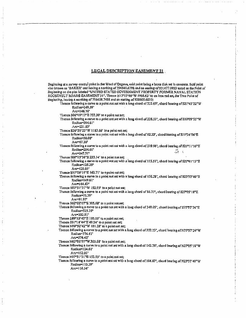
.-------.------.--------------.. ----------....... --.-----.-~._--.. __ .. _-.------------_ .. _-------_._ .. --.,..
LEGAL DESCRIPTION EASEMENT 21 ,
Beginning at u survey can Ita! point in Ihc:Ward afDagunG, saId point being a brns$ disk set fn concrete. Snid point also Jcnown as 'BAKER' and hnvlng.n northing of7~4549.6798 and an cnstingof921077.9933 n'oted as' the Point of Beginning on tha plat fabeled"UNITED STATES GOVERNMENT PROPERTY FORMER NAVAL STATION ROOSEVELT ROAOS EASEMENT21''. TIience N l3°S3'46"W 1966.63' to an jron.ro~Lset. tho Tnle Point of Beginning, having 11 norllling of7964S8.74881l11d an easting.of92060S.6833!.
Thence following 1\ curve to a point not set with n long chord of3J2.6S', chord bearing ofS21 D4S'2X'W Radills~349.39'
Arc=346.70' TIlence S06GtJO'I'7"E ·707.3U' to II point not set:. TIlence foJlowilig a curve to a polll~ nCit lletwitllit 10llg chord of228.51 \ chord bearing ofSIO'U9'33"W
Rauius=J94.6I' Arc=23l.83'
Thenc~S26°59~23"W II a2.66' to' II poil1~ nol set; Thence following n curve 10 n po(nt not set wilh II. fongchord ofli2.J3', chord bearing ofSllo34'06"E
Rndius"SO.OO· Arc=67.30'
Thence raJ/owing II curve !fa point not set willi n long chord of239.96', chord bearing 01"515°11'361'8' Rndius-284.6I' Arc-247.7t'·
Thence' SOoo15'36"E 233.14' 10 II point nol set; . TIlencc following a curve to II poil)tnotset witllli long chord of 1 15.51\ chord benring of 517°4 L'13"E
Radills"'125.39' Arc=120.0S'
ThenceS5SD06'SJ"g 162.71'lo·apolntnotset:: Thence. fonowing II curve to a poin~ not set with II lang chord of 156.28\ chord bearing of 823"37'40"8'
Radius"149.6I' Arc=J64A3!
Thence S07·o51'JI"W 152.93! to il point not set;. Thence {oHowing It Cllrvft to a point not set with n long chord of 86.37', chord bearing of 527"05'18"5
Rndius='7S.39l ' .
Arc=9r.91' Thence S62°02'OT'&30S.68' 10 a point notse!; Thence following.!l curve to n point not set with n long chord of349.0S'~ chord' benring of S7S·S7'24"E
Rndius=72S.39' AI·c"3S2.51·
Thence S8!J052'42"E 180.0S~ to n point not sel; '11lence 5010.18'44"E49.24' to·a poim not set; Thence N89.°S2t42"W 181.28' to n point. not set; Thence following aCllrvc to n point not set with a long chord of372.73', chord benring ofN7S"57'24~'W
Rnciius""774.61' Arc-376.42'
TIlence N62°02 '07"W 30S;68' to a point not set~ Thence following ncurve 10 n point not set with a long chord of 142.76,0, chord benringofN27"OS'1 S"W
Radius"124.6 !' Arc=lS2.01'
'TI!ence N07"SI'J I."E 152.93' to D point.not set; Thence following a curve to a point nol set with !llong chord of 104.87', chord bearing ofN23"J7'40"W
RadiuS"'110.J9' Arc=110.34'

~ ____ .... ___ ~ •• ___ ~ _____ ... __ ~ ____ h __________ ' _________ 'w ______ • __ .• _________ •• ----. -.---..:...~,--~:.--.-:-;-..... - .......... -- ~---------:--.
Thence N55% 'Sl"W 162.71' lo'a point not set; Thence following a curve to a point.nol set witlin long chord of 160.86' .chord,bearingofN21"41'i3"W
Radius-174.61' Arc" I 67.17'
TIienco NOool's'l6"W233. f4' to a point notselj. Tl1ence following a. c!iTVe ~c;i npoin!' not set with' a long chord of 198.46'; chord oellringofN25"11"36"W
Radlus"'235.39~ . Arc"'204.87·
Thence following a curve to II point not set with a long chord ot 12j.69" chord benring ofNllo34'06''W Rndllls.:&99~22' Arc-Ill.54.'
TIlence N26°S9~23"B 1182.66' to 1\ point not set;. 111ence following II curve to a point not setwiUl'IIlong chord. of200.01'. chord bearing ofNIO·09'33n E
Rndius=34S~39.· AJ'c~202.91'
'nlence N06°40''I7''W 707.30' to n point notsel; Thence following II cllrve to n' point not set with a long chord of228.91'. chord bearing oJ'N) O"Ol')O"E
RadillS'"39B~6J ' Arc-232.24 i
Thence toHowlng I! curv" 10 un iron rod set:, the Tnle Pofnt of Beginning. with a long chord of) 59.60'. chord bearing ofN56~ J '16"E
Rndius=71f4.6) , Arc"'IS9.8S'
Said parcel :contnollng 221.548.7 square feet or 5.086 acres;. which equates to.20.S82~~~qu.arc meters or 5.231 cuerdas;. .. • . "
i

____ -------.-------.. ----:----.--.-----" -.-. ---, -:--::."7-:7:"'--. ___ . ___ . ___ ..... ___ 'T"W_. __ .. ___ .--.-:-:-: ______ ;~
LEGAL DESCRIPTION FOR EASEMENT 22
.Beginning ata survey control point in 1he Ward of QUIlYllcan. said P9int. being n bmss' disk set in concrete; Said poInt IIlso known os 'DEL VIS' and hllving n northing of796546.7678 Ilnd an ellSling o.f927749.S902 noted DS tha l'oint ofBeginning on tile;. plat labeled "UNITED STATES GOVERNMENT PROPER.TY FORMER NAVAL STATION ROOSEVELT ROADS EASEMENT 22". TIlcnce S I 0"(4'36"85702.81' to un iron rod set, (lie True Point. of Beginning. )uiving Il north'ing of7!H034.8S02nnd·1lO casting of 928764.0234: .
Thence. 537"21 ' I o"n 56,2l.' to II point nor set; Thence following Il curVe to: n point not set; with n long chord: of 93.66!. It chord bearing of 832Q 3Q', 14"Wi.
Radius'" 3.99'.61' . Arc-93.87.'
ThenceS39~14'OI"W 203',42' tOil pointnor sel; 111ence 53 1"07'OO"W 298.77'1011 point not set, Thence N82"23'22~W 53.67' In Ii point-not sei; Thence N31007'OO''E 323.67" to n point not sct~ TI}(lnCC N39°14'OI"g 206.91' to II point not sot; Thcm:a following.a curve to nn Iron rod set; tlleTma I'oint ofl3eginningwilh II long .chord of 107.31', n chord bClll'ing ofN30"25'29"E,.
ltlldiua=; 3S(}.39~ Arc=(07.74'
Soid pnrcclcontnining30;374.0 SqUllrC feet or 0.697 of an nere, which equlltes to2,sil.8 square. meters Dr 0.718 of II cuerdn. /1~

__ . ________ ~ ________ . _______ . ' ... ~.:__:_-. ___ h_ .--•.. --------.------:-~--:- _· .. _--:---_·_·_--------·-1
LEGAL DESCRIPTION EASEMENT 23
Beginning at 11 survey control pomt in Iha Ward· of Gunyaclln, sllid point being II bross: disk set in concr.el!l.. Said point also known as 'DELVlS' nnd having II nonhjng of796646~7078 nnd an casting of927749.8902 notedns the Point of Beginning on the pill' labeled "UNITED STATES GOVERNMENT PROPERTY FORMER. NAVAL STATION ROOSEVELT.ROADS EASEMENT 23"; Thence NSO~37'43"E 1415.10' to an iron rod set, lh~ True Point of Beginning •. having R northing of 797544.4326 lind nn ensting of 928&43.8370:
ll1ence NS5°3S'041'W 49.22' to a point not set; 111cnce N14°24' 56"8 784.00' to: a point not set; '!11ence following 11 curve to an Iron rod sctwitllll!ong: chord of 14.71', chord bearing of NI0"38'54"W
Rudius-10.39' Arc=16.34'·
Thence N55°42'43"W 262;55' to tlii iron rod selr. Thence. N34c26'35"E 49.22' to npoinl not set; . Thence S5"5°42'43"E 262042' tall poini not set; . Thence following il curve 10 II point not set Willi a iong chord. of 84.40', chordbellring or SI0038'54"E ;~
Rlldiils-59:61' Arr:=93.77'
ll1cncc S34°24'S6"W784.00' to l1Il iron rod set. theTrne Point of Beginning;
Said parcel (lonlnining 54,217.7 square fe~~ or 1-.245 acres, wh Ich equates 10 5,037.0 square melers 01"' 1.282 cuerd!l5.

----------------------------------------:------,--- .-.--~----:-------~---------.--.---.--.--. ----,
LEGAL DESCRIPTION FOR EASEMENT 24
Beginning nlll survey control point iii the Word of Gililynctin; said point being 1\ bnlss disk set in concret~ Snld point also knowllllS 'DBLVIS' and having a northing of796546,7678 nnd nn ensting of927749.8902 notcd as the Point of Beginning on the plullabaled "UNITED STATES GOVERNMENT PROPERTI' FORMER NAVAL STATION ROOSEVELT ROADS EASEMENi.24". Thence S25·06'47"E 5671.51' to an irqn rod set. the True Point of Beginning, having II northing of79 15.11.;3792 nnd nn casting of 9301S6.9lJ9::
ThenccS 18"JO'36"W 166.08' fa II pOint not set;Tlit!lIcl! N71"29'24"W 81.49' (0 11 point not set; Thence following il curve to 11 point not. !lei; with a long chord of :395.0 1',11 chord bearing of N49P3S'14"W,
Rudius" 530,61' Arc=404.7S'
Thence S64"52'27"W 372.81' to Il paint.not set;· Thenca following p curve to R point not sct; with a long chord of 132.1 S', il chord- bearing of N70006'25''W,
Radius· 724.61' Arc=f32..'36'
Thence S75''20'24''W 30 1.47' to !l point not scI; Thence tbllowing D curve 10 p,point nol set; wit.h n long·chord of 167;79:>, lI. chord bearing of S88°16'52"W; "
Rndius"- 374.61' Arc'" I 69,22' :~
Thence N7E!'46' 40"W 162.4 8' (0 a point not set;. .:::;~ ;_ TIlcnce lollowingll curve to n point nor scI; wili! u long chord of 1.57.98', a,cI\onibearing of S37" 18'43"E,
RudilW" 374.39' Arc= I 59.1 It"
Thence.S49"29'31''E 57..'39' to n point not ser, Thence following acurva to II point nor set; with a long chord of 155.14', It. chord bearing of S 18°15'4 J"B;
Radius;: 149.61" Arc"') 63.1 G"
Thence following II curve to n poinl not set; with ~ lonll chord of a 9·. 12' , a chord bearing,of S 19°22'19"W,
Radius'" 399.(jJt' Arc=89.3P'
Thence N37"21"10"W 56.21' to' a point not set; Thence following a curve loa point not selpvitha long cflord of 52.83', II chord beartngof NI7°)'7'J3"a, .
Radius'" 350.39' Arc=S2.88'
Thence following. a cllrve to a point not set; with nlong chord o'f ! 04.1 (}r, -n chptd bearing of Nl8°15'41"W. .
Radius:: 100,39" Arc=!09.44'
Thence N49"29'3 )"W 57.39' to npoint nOlset; Thence following 11 curve to n point· not selj wilh n long chord of 193. t s., tI chord bcnring of N36G 1S'4J"W,
Rudltls-423.61' Arc= 194.89'
111encc N23°07'S4"W 41.33' 10 a poinl not set; 11lence N 1 )0) 3'2{)"E 32.22' to n point not set; Thence S-78~46'4(}"E 234.00' to t1 point not -set;

._-----------_ .. _ .. _._------_ .. __ .. __ .. __ ._------
Tllence following II curVe to II point not scI; with a lOllg chord Qf 145.74" it chord bearing of N88°J6'52"E, .
RadiuS'" 325 . .19' Arc= 146.99-~
Thence N7S."20'24~·E 301.47' loa poin~ not !lel} TIlenes following II curve 10 II point not setJ with II long chord of 123.20', II chord beating of N70006'2S''B,
Radh,s" 675.39' Arc'" 1;23.37'
Thence N64~S2 '27"E 422.09' to II point not set; Thence following.a cnrve to n point not set; with along chord ofAOUI:'; nchard bearing of S46°50':14"E, ..
Rudius= 481.39' Arc=4I4./6'
Tllcnce S71"29"24"E 38.27' to n point not set; Thence N Iso30'J6"E 116.78' 10 a painl nof set; Thence S71"29'24"E 41.15' to II point nat set; Then'clS foliowing.iI' curve to an. iron rod' sel, the. Trne Point of Beginning with n long chord of S.07', a cliord bearing ofS72"04'OS"B; .
Rndius-399.6I' Arc=8.01'
Said parcel containing 112,J45.5: square feet or.2.S79 acres, which equates to 10,437.J square meters or 2.656 cllerdas.
.:.;~
... .;.!

--.--.-....... ---~-------.----.. ::-:--:-~~-"--.--~ ------_. __ .. ..,---- -_._---_._--------------0-_.
LEGAL DESCRIPTION EASEMENT 25:
l3eginning at n survey control point in the Ward of Quebrndll Seca, said point being a brass disk set in concrete; Said poinl olso known liS 'DELICIAS' Ill)d having 11 northing of799 143.8531 nnd an easting o( 927504.490. 1 noted us the Point of Beginninl5 on the plnllubcled "UNITED STATES GOVERNMENT PROPERTY FORMER NAVAL STATION ROOSEVELT ROADS EASEMENT 25''. Thence S65°46'4D."W J 15424' to an iron rod s"t. the True Point of Beginning.. having Il-northi!tg of7~8670.2992 and nn easting of92645 1.8698:
Thence following n CUfVfI to n. point not setwitba long chord of 58.23', chord benring of S32°42'OO'~E
RlIdius=-370.48, Arc=58.29'
Thellce following It curve to n point not set whit nlong chord of422.66' r chord bearing of S69"24'05"W .
Radius=320.39' Arc=461.54'
TIlcnce N71"J5'39"W 15.42' to nn' iron rod set; Thence N21°J8'SJ:"W 43.57' 10 u point notsel; Thence following a curve to 11 point notscl-with.l1long chord of4IS.4V, chord· ~enrlng of N66"36'J4"B
Rndiusa 369.6l' Arc;:444.76'
Thence 837uI2'2S"E. 17.52'· to nn iron: rod.sct the Triia Point of Beginning. , :1'
Said parcel containing 22,596~3 squlIrc, feet or 0.5 19 oftullicre. which equntC!llO:'.2,099,jsqllllFe Ineters or 0.534 ofncuerdn. ..,' ...

-.---.... --.----~------.-.----- ... -------.-. =-:-------.--~-----.--:-.------:--:-:------
LEGAL DESCRIPTION FOR EAsEMENT 26
Beginning nt Q survey control point in the WilrdofDaglll1o;.said point being. a brass disk. set in concrete. Said point known as "COLINA" and having 11 nortlling of7970J 6.8324 and nn ellsti.ng of 916304.6005 noted as the Point of Beginning: on the pInt labeled "UNITED STATES GOVERNMENT PROPERTY FORMER NA VAL STATfON ROOSEVELT ROADS EASEMENT 26"~ Thence N67°SI'3J"n 4952.64" to POINT trltS-'3-A, an Iron rodsef •. lile True, Poilil of-Begilming.lillvingll northing o£79890J . .4095 and nn c[lllting of920892.0277:
Thence N07aS6'34"E 730.47' to Ii point not set; Thence S83°59·OO"E26.33~ to 11 point not set; Thence S06aOl'OO"W 4S0.0(}' fO It poliJtnot setj Thence N83°59'QQ"W J 5.QO~ to II. paint not seti ThenceS06"OI'OO"W 341-.39~ to II point not sct; Thence N8S~3'18"W. 41.58' t{) a point lIorset; Thence N 1 I"14'04"E 62.61' [0 a POINT fJ· 2(j-3A, nn IrQn rod set theThle Point.afbeginning.
81lid parcel containing 26,373.1 square feet or 0.605' i:Jfnllllcre; which equntes to 2.~50.2.squnra meters or 0.623 ofa cuerda.
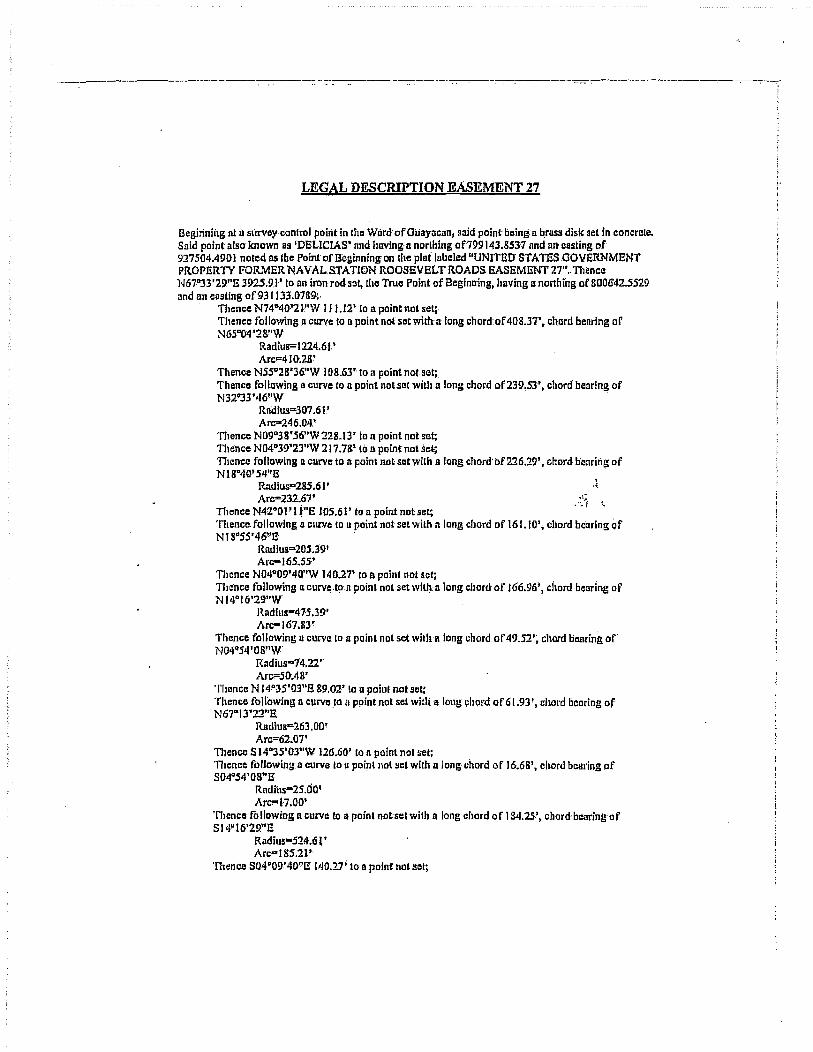
----.. ---------.----- ~--...-.----~---.--. --.-;'.
LEGAL DESCRIPTION EASEMENT 27
Begitiniilg nt il slIrvcy·contro! point in (he Ward oFOilaYilcnnl said point being a brusll disk set In concrete. Said point also' known as 'DELICIAS' nnd having a norlhing of799 143,8537 nnd an casting of 9275{]4.4!)O I noted as the Point of B'cginning on the plat labeled "UNITED STA TESOOVERNMENT PROPERTY FORMER NAVAL. STATION ROOSEVELT ROADS EASEMENT 27 .... Thence N61":33'2!)"E 3915.9.1' to an iron rod set, Ule True Point of Beginning, having a northing of 800642.5529 and an cllsling·of93 I 133.0789:. .
Thence N74"40~2l:"W 111.12' 10 a point not set;. Thence following.n curve to B point not set with a long chord of 40'8.37" chord benring of N 65"04'2 g"W
Radius=1224.6t' Arc"'410;28'
Thence N5so28'36."W 108.63' to a point not set;. Thence following a.curve to a point notset with a long chord of239,53', chord bearing of N32°33'46"W .
Rndlus=3O'7.61.' ArI?246.04.'
Thence N09°3 8' 56"W 22 8_13' to n point not set; 11uince N04°39'23"W 217.7&" to a point nol sel; TIlcncc following a curve-to it point nolsctwith a long chordof226.29', chord benring of NI8D'I(}'54"E . .
Rudius"285.61' '< Arc=232.67' .. ~~ ,_
TIlence N42"OPU"E 105.61' to a point not set; 'nlencc following a curve to u point not set with 11 long chord of 161.10''. cliord benrlng Qf NI8°S5'46"1! .
Radius"'20S.39' AI'c:-165.5S·'
TIlcnce N04°09'4Q"W 140.27' to II paine not set; Thence following u curvc:.ton point not set witl) a long chord' or I G6.96" chord benring of N 14°16'29"W
Rlldlus-475.39' Arc:-167.8r
Thence fonawing a curve 10 a point not set wilha long chord. of 49.52'; chOrd bearing of' N04'l54'08"W'
Radius"14.22 ,. Arc=50AR'
Thence N J4!'JS'O'3"E 89.02' to 11 pain! not set: Thence following n curve.to n ppint not set with a long llhord of G 1.93', chord bearing of N67o.I3'22"E:
RlUJjus"'263.0D~
Arc=62.07' 111encc S 14°35'03"W 126.60" to n point not set; lllence foUowin~ n curve 10 II poinlnot set with along' cbord of 16.68" cllOrd beal'lng of S04"S4'08"E
Rndius"'2S.00· Arc!"17.00'
'nlenc~ following n curve to a point not set with n long chord or 184.25-', chord·bc.1ringuf S14u 16'29"E
Rudius-S24.6 •• Arc"18S.21'
Thence S04"09'40"E 1.40.17; to D point 110t sell

-------------------._._ .. _._ ........•..•.. _ .. _ •. _ ....
111ence fallowing II. curve to n point nol setwitlu long chord of 19!U}', c;:hord bearing of 81 a"S5'46"W
.I~lldiLis=254.6I' Arc=205.22'
TIUlOcC 84;2"0", i;"w t05.61' 1'0 Ii p'ol~t not ~e.t; TIicnCc, following 11; curve to a point n01 set with'lllon~ chord of187~2!)', chord bearing of 8.1 gU40' 54"W
Rndius=23.li.39.! Arc=l92;5S' .
Thence S04°3!i'2J''E 215.04' to II point n(ll liet; Thence S09°38,' 56"E.225,9S' ti) I\. point not set; Thence foIrowing.n Cl1rve to a pointnolsatwitilll long chord of20t:21', chord benring of 832"33'46"E
Radius=Z58.39' Arc""2D5.67'
Thence S55°;!S'36"E 108.63' to' 11 pointnot set; Thence following" curve to II point not set with II (ong chord of 391.95', chord bellring of S65"04'28"E .
Rlldlus=1175.39' Arc-J93.79'
Thence S74"40.'21"E 116.04' 10 n pcintnotset; TIlence S t9·S.9'21"W 12.83' to a point not ~ct; Thence following 11 curve 10 nn iron rod. set, the True Point of Beginning with a (oog.chord of 36.64', chord bearing ofS21"23'4S"W ,1
Radius=146.21' Arc=36,64' .:~:-! '.
Said parcel containing lJO,992.1 square, feet or 2.54& ncres, which equates to 10;311.5 sql10re meters or 2'.624 ctlerd~
·i I
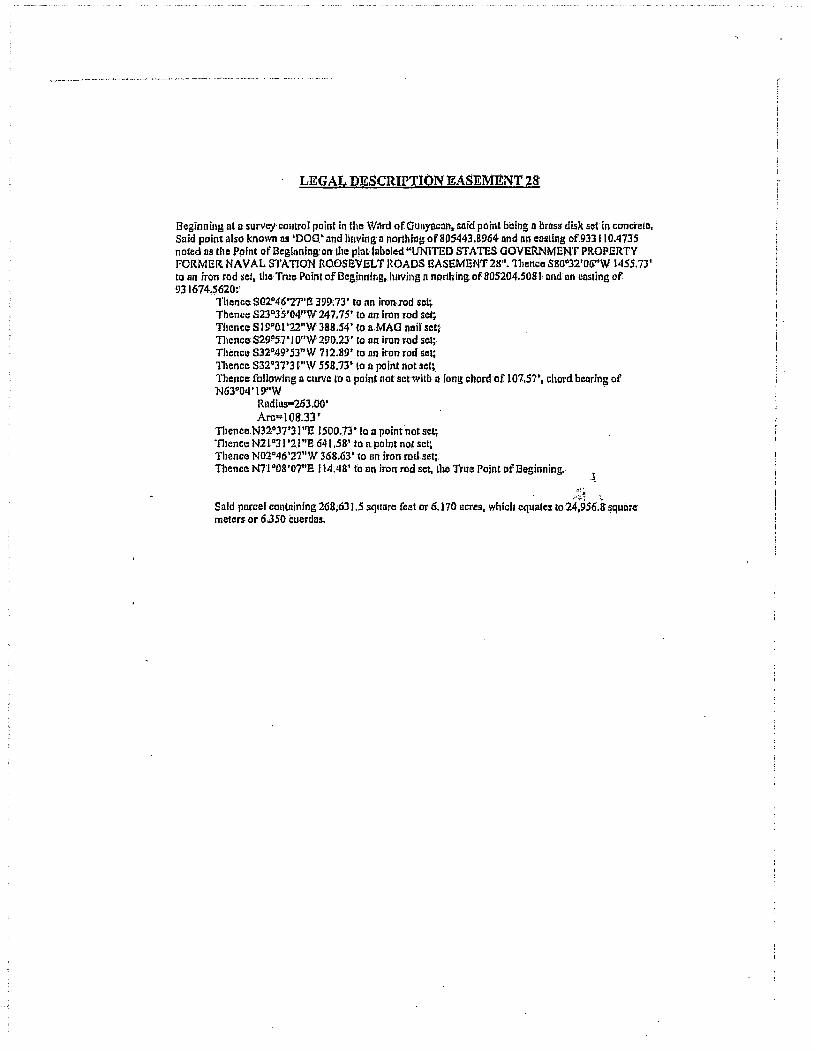
LEGAL DESCRIPTION EASEMENT 28
J3eginning nt a surveyconlro! point in the Ward of QUl\yncan. slIid point being II brass disk set in concreto, Said point also known as 'DOG.' and liuving' It northing of805443.8964 lind nn easling of.933 I 1 0.4735 noted tiS the Point ofBcglnnin!:lon the plat labeled "UNITED STATES GOVERNMENT PROPERTY FORMER. NAVAL STATION ROOSEVELT ROADS EASEMENT2S". 1111mce S80"32'O!i"W 1455.73' to nn iron rod sel, the True Pefot'of Beginning, hllving n northing. of 80S204.50ln. Dnd nn cQSling of 931674.5620:'
.. Thence: S02~46'271>E 399;73' to nn iron·.rod set; Thence SnD3S'04"'W247.75' to on iron rod sotj Thence S 19"Ol'22"W 388.54'(0 a,MAG neifset! Tllence S29~57>1 O"W 290,23" to nn iron rod sot; Themc.: S32P49'SJ"W 712:89' to on iron rod sel; Thence S32c37'31"W 558.73' to 11 point not set~. Thence following a ClJrve 1'0 n point not setwitb a long chard of 107.57', chord bcnring of N63°04'II)!'W .
Rndius!"263.00 ' Arc=1 08.33 r
TIlenceN32°37'll"£ 1500.13' [011 point not sel; 'nlence N21c31'2.l"E 641.58,' to a.point nal SCI; Thence N02°46'27"W 36&.63' to nn iron rod set;. Thence N71 c08'07"E 114.48' to lln iroruodset, Ibo True Pilint of Beginning. . . ~
.:~.~
Said porcel contnining 268;63 1.5 square feet or 6.170 llcres, which equates 10 24:956.~ ~quilre' meters or 6350 Cuerdlls.

· ,
4812-2028-0850.3
Exhibit "D"
FINDING OF SUIT ABILITY TO TRANSFER FOR SALE PARCEL lAND ADDENDUM
FINDING OF SUITABILITY TO TRANSFER
SALE PARCEL I - BUNDY
NAVAL ACTIVITY PUERTO RICO CEIBA, PUERTO RICO
Prepared by:
Department of the Navy Base Realignment and Closure
Program Management Office Southeast 4130 Faber Place Drive, Suite 202
North Charleston, South Carolina 29405
January 2008

1
SECTION
FINDING OF SUITABILITY TO TRANSFER SALE PARCEL I - BUNDY
NAVAL ACTIVITY PUERTO RICO
TABLE OF CONTENTS
1.0 PURPOSE ........................................................................................................................................ 1
2.0 DESCRIPTION OF PROPERTY ...................................................................................................... 1
3.0 PAST USE AND PROPOSED REUSE ........................................................................................... 2
4.0 ENVIRONMENTAL FINDINGS ....................................................................................................... 3 A. Hazardous Substance Contamination ................................................................................ 3 B. Petroleum Contamination ................................................................................................... 4 C. Condition of Property Classification .................................................................................... 4 D. Other Environmental Aspects ............................................................................................. 6
5.0 REQUIREMENTS APPLICABLE TO PROPERTY TRANSFER .................................................... 9 A. NEPA Compliance .............................................................................................................. 9 B. Hazardous Substance Notice ............................................................................................. 9 C. CERCLA Covenant ........................................................................................................... 10 D. CERCLA Access Clause ................................................................................................... 10 E. Land and Groundwater Restrictions ................................................................................. 10 F. Environmental Compliance Agreements I Permits larders ............................................. 10 G. Notification to Regulatory Agencies I Public ..................................................................... 11
6.0 SUITABILITY DETERMINATION .................................................................................................. 11
EXHIBITS
A References B Vicinity Map and Sewer System Map C Parcel Maps D Survey Maps E Tables F CERFA Concurrence G Lead-Based Paint Hazards Advisory Statement H Responses to Comments
110702lP January 2008

FINDING OF SUITABILITY TO TRANSFER SALE PARCELl-BUNDY
NAVAL ACTIVITY PUERTO RICO
1.0 PURPOSE
This Finding of Suitability to Transfer (FOST) summarizes how the requirements and notifications
for hazardous substances, petroleum products and other regulated material on the property have
been satisfied, and documents my determination, as the responsible Department of Defense
(000) component official, that certain real property and associated improvements known as Sale
Parcel I - Bundy (Subject Property) at Naval Activity Puerto Rico (NAPR), Ceiba, Puerto Rico are
environmentally suitable for deed transfer. This decision is based primarily on my review of
information contained in two of the documents listed in Exhibit A (References) - CERFA
Identification of Uncontaminated Property, Former Naval Station Roosevelt Roads, Puerto Rico
(the CERFA Report; Navy, 2006b) and Phase III/ Environmental Condition of Property Report,
Former Naval Station Roosevelt Roads, Ceiba, Puerto Rico (the ECP Report; Navy, 2005).
Factors leading to this decision and other pertinent information related to property transfer
requirements are stated below.
2.0 DESCRIPTION OF PROPERTY
110702/P
NAPR was formerly known as Naval Station Roosevelt Roads (NSRR) until it ceased operation
as an active Naval Station on March 31, 2004, at which point it was designated Naval Activity
Puerto Rico. NAPR is located on the east coast of Puerto Rico adjacent to the municipality of
Ceiba.
The Subject Property is comprised of approximately 1,351 acres located in the southwest section
of the installation, and includes the "downtown" commercial/institutional area, elementary school,
9-hole golf course, office and administrative buildings, theatre, fitness center, a portion of the
ammunition storage area south of the airfield, the Rainbow Hill family housing area (duplex and
apartment-type units), Bachelor Officer Quarters (BOQ) and Bachelor Enlisted Quarters (BEQ),
Navy Lodge, and the Coast Guard pier. As shown on the vicinity map in Exhibit B, the Subject
Property does not include ten non-contiguous areas wholly or partially surrounded by Sale Parcel
I. These areas total approximately 170 acres and are comprised of Area of Concern (AOC) F
(four locations) and Solid Waste Management Units (SWMUs) 1, 2, 54, 61, 62 and 71. These
areas were carved out of Sale Parcel I because they are Resource Conservation and Recovery
Act (RCRA) SWMUs and AOCs with work remaining to be completed under the Administrative
Order on Consent (Consent Order) that sets out the Navy's corrective action obligations under
RCRA. Furthermore, the SWMUs cannot be included in the transfer of Sale Parcel I because all
necessary remedial actions have not been taken prior to transfer as required by
January 2008
FINDING OF SUITABILITY TO TRANSFER SALE PARCEL I - BUNDY
NAVAL ACTIVITY PUERTO RICO
Section 120(h)(3)(A)(ii)(I) of the Comprehensive Environmental Response, Compensation, and
Liability Act (CERCLA). The Navy and the winning bidder in the public auction of Sale Parcel I
will execute a lease in furtherance of conveyance for the carve-out areas. Upon successful
completion of all necessary remedial actions by the Navy, the leased property will be transferred
to the new owner of Sale Parcel I.
The Subject Property is comprised of Sub-Parcels 2,3,17,19,21,22,25 and 27, as shown on
parcel maps (Exhibit C) from the Draft Report. Parcel Map for the Disposal of Naval Activitv
Puerto Rico (GMI, 2005). The areas shown on these maps as having "Cleanup Remaining"
correlate to AOC F and SWMUs 1, 2, 54, 61 (shown as ECP 7), 62 (shown as ECP 8) and 71
(shown as ECP 17), and are not included in the Subject Property. The boundaries of the SWMUs
and AOCs shown on these maps are approximate and have changed since the draft parcel map
report was produced, thus they do not match the current boundaries shown on the vicinity map
(Exhibit 8). Furthermore, since the draft parcel map report was published, the northern boundary
of Sub-Parcel 27 has been shifted approximately 700 feet to the south. The survey maps in
Exhibit D provide the final boundaries for the Subject Property.
Table 1 (Exhibit E) provides the facility number, former user, name or description, area and year
of construction of each of the numbered buildings, structures, and facilities on the Subject
Property.
3.0 PAST USE AND PROPOSED REUSE
110702/P
The Subject Property has been used as a military installation since its acquisition and
development by the Navy in the 1940s. The ECP Report states that most of the arable land on
what is now NAPR was previously used for sugar cane cultivation and cattle grazing. No
significant industrial facilities or environmental concerns were identified with respect to activities
conducted on the former NSRR prior to Navy ownership.
The Navy established NAPR to serve as the caretaker of the real property associated with NSRR
and to assist in the transfer of the property. Since the establishment of NAPR, all industrial and
commercial operations on the Subject Property with a significant potential for environmental
contamination have ceased.
2 January 2008

FINDING OF SUITABILITY TO TRANSFER SALE PARCELl-BUNDY
NAVAL ACTIVITY PUERTO RICO
The Naval Station Roosevelt Roads Reuse Plan (CBRE et ai, 2004) developed by the Puerto
Rico Department of Economic Development and Commerce (acting as the Local Redevelopment
Authority [LRA]) anticipates the following types of land uses for the Subject Property: Moderate
Lodging, Residential, Learning and Training Center, Public Golf Course, Mixed Use (commercial),
University Campus and Public School. The Subject Property will be sold via public auction to the
highest qualified bidder.
4.0 ENVIRONMENTAL FINDINGS
110702/P
All available information concerning the past storage, release, or disposal of hazardous
substances and/or petroleum products on NAPR, as collected through record searches, aerial
photographs, personnel interviews, and on-site visual inspections, is contained in the ECP
Report. The following summarizes the findings as they relate to the Subject Property and the
corresponding Condition of Property Classification assigned to the real property to be transferred.
A. Hazardous Substance Contamination
There are four Resource Conservation and Recovery Act (RCRA) Solid Waste Management
Units (SWMUs) on the Subject Property that have been designated Corrective Action Complete
Without Controls and require no further action.
In December 2007, EPA approved the Corrective Action Complete Without Controls
recommendation for SWMU 16, Waste Explosives Storage, Building 1666 (Baker, 2007). RCRA
Facility Investigation (RFI) sampling indicated no surface or subsurface soil contamination has
resulted from waste explosives storage. Two explosives compounds were detected in
groundwater at concentrations below their reporting limits. Furthermore, groundwater is not
present to a significant extent beneath the site.
An RFI was not required at SWMU 38 (Sanitary and Storm Sewer Systems) based on research,
interviews and visual inspections. Under the Consent Order, this determination is contingent
upon the Navy fully addressing any releases that may have impacted the sanitary and/or storm
sewer systems as part of the corrective action(s) for releases from SWMUs 4, 12, 13 and 14,
which are not in the vicinity of the Subject Property, and/or any other SWMU at the NAPR facility
where releases may have impacted the sewer systems. A map showing the location of the
existing sewer system at NAPR is provided in Exhibit B.
3 January 2008

110702/P
FINDING OF SUITABILITY TO TRANSFER SALE PARCEL I - BUNDY
NAVAL ACTIVITY PUERTO RICO
Sampling at SWMU 26 (Abandoned Engine Oil Drums, Building 544 Area) and SWMU 63
(Former Pistol Range at BEQ) did not identify chemicals of potential concern.
additional investigation or remediation was required at these SWMUs.
Thus, no
Detailed descriptions of SWMUs 16, 26, 38 and 63 are provided in the ECP Report, while
summary descriptions and their current status are provided in Table 2 (Exhibit E). SWMU
locations are shown on the maps in Exhibits Band C. The Subject Property does not include the
areas shown on the parcel maps in Exhibit C as having "Cleanup Remaining" (i.e., SWMUs 1, 2,
54, 61/ECP 7, 62/ECP 8 and 71/ECP 17).
B. Petroleum Contamination
According to the ECP Report, there were five underground storage tanks (USTs) on the Subject
Property at the time of the ECP inspection in March 2005. As shown on Table 3 in Exhibit E, all
five were empty. The ECP Report listed 10 known former USTs on the Subject Property that
were removed between 1993 and 1999. Table 3 lists the known past and present USTs on the
Subject Property along with their location, capacity, material stored and the year removed (or
year installed if still present). The ECP Report and field verification documented 22 operational
aboveground storage tanks (ASTs) and five oil/water separators (OWSs) on the Subject Property.
These ASTs and OWSs are also listed in Table 3. According to the ECP Report, any
contaminated soils identified during past replacement of tanks were excavated and disposed of
off NSRR property, and the replaced tanks were closed in accordance with Title 40 Code of
Federal Regulations Part 280. The records do not indicate there have been any spills or releases
associated with the USTs, ASTS and OWSs on the Subject Property.
C. Condition of Property Classification
The ECP Report divided all property at NAPR into parcels, and classified them into one of the
three following categories:
• Category 1 - Areas where no known or documented releases, or disposal of hazardous substances or petroleum products or their derivatives has occurred, including no migration of these substances from adjacent areas.
• Category 2 - Areas where the release, disposal, or migration, or some combination thereof, of hazardous substances, or petroleum products or their derivatives has occurred, but at concentrations that do not require a removal or remedial action, or all
4 January 2008

110702/P
FINDING OF SUITABILITY TO TRANSFER SALE PARCELl-BUNDY
NAVAL ACTIVITY PUERTO RICO
remedial actions necessary to protect human health and the environment have been taken.
• Category 3 - Areas where a confirmed or suspected release, disposal, or migration, or some combination thereof, of hazardous substances, or petroleum products or their derivatives has occurred, but required investigation and/or response actions have not yet been initiated or are ongoing.
These categories are derived from the Comprehensive Environmental Response, Compensation,
and Liability Act (CERCLA), Community Environmental Response Facilitation Act (CERFA) and
the American Society for Testing and Materials (ASTM) Standard Practice for Conducting
Environmental Baseline Surveys (ASTM Standard D 6008-96), which further incorporates ASTM
D 5746-98 (2002) Standard Classification of Environmental Condition of Property Area Types for
Defense Base Closure and Realignment Facilities.
CERFA stipulates that the federal government must identify "uncontaminated property" scheduled
for transfer, and defines this as " ... real property on which no hazardous substances and no
petroleum products or their derivatives were known to have been released, or disposed of'
[(Section 9620(h)(4)(A)]. In accordance with the property condition classification guidelines
discussed above, the Navy classified the Subject Property, with the exception of SWMU 16
(Category 3), SWMU 26 (Category 2) and SWMU 38 (Category 3), as Category 1
uncontaminated property (including SWMU 63). Following its review of the CERFA Report, the
Puerto Rico Environmental Quality Board (EQB) concurred with this classification and provided a
concurrence statement (Exhibit D) in the Final CERFA Report on 11 August 2006.
The Category 1 and 2 areas on the Subject Property are suitable for transfer because they are
either uncontaminated or all remedial actions necessary to protect human health and the
environment have been taken. SWMU 16, designated Category 3 at the time of the CERFA
Report, has since been determined to be suitable for transfer based on the findings of a Phase I
RFI. The portion of SWMU 38 (Sanitary and Storm Sewer System) on the Subject Property is
transferable because it was designated Corrective Action Complete Without Controls by EPA in
the Consent Order signed on 29 January 2007. This determination is contingent upon the Navy
fully addressing any releases that may have impacted the sanitary and/or storm sewer systems
as part of the corrective action( s) for releases from SWMUs 4, 12, 13 and 14, which are not in the
vicinity of the Subject Property, and/or any other SWMU at the NAPR facility where releases may
have impacted the sewer systems.
5 January 2008
110702/P
FINDING OF SUITABILITY TO TRANSFER SALE PARCELl-BUNDY
NAVAL ACTIVITY PUERTO RICO
D. Other Environmental Aspects
1 . Munitions and Explosives of Concern
According to the ECP Report, there are no heavy (crew-served) weapon ranges,
unexploded ordnance/impact areas, explosive ordnance disposal areas or open
burning/open detonation activities on the Subject Property.
In December 2007, EPA approved the Corrective Action Complete Without Controls
recommendation for SWMU 16, Waste Explosives Storage, Building 1666 (Baker, 2007).
RFI sampling indicates no surface or subsurface soil contamination has resulted from
waste explosives storage. Two explosives compounds were detected in groundwater at
concentrations below their reporting limits. Furthermore, groundwater is not present to a
significant extent beneath the site.
A former pistol range (SWMU 63) was located at the site of the new BEQ. Two of eight
surface soil samples collected at SWMU 63 had lead concentrations greater than base
background, but the lead concentration of all eight samples was less than the soil
screening criterion. SWMU 63 has been designated as Corrective Action Complete
Without Controls in the EPA Consent Order.
Since establishment of the former NSRR, munitions storage magazines have been used
for the storage of various types of munitions, including bombs, missiles, explosive
projectiles, pyrotechnics (e.g., flares), small arms ammunition, and any other ordnance
related items. The majority of these munitions storage magazines are located in a secure
area at the southwest end of the main runway. Twenty-one of the magazines in this area
are located on the Subject Property (see Exhibit E, Table 1). There are also four other
magazines southwest of this area at the end of Guadalcanal Road. A magazine close
out inspection was conducted at the former NSRR by the Naval Ordnance Safety and
Security Activity (NOSSA) in February 2004. This inspection confirmed that all
magazines were completely cleared of all ordnance-related items, and no explosive
residuals or contaminants were present in the magazines.
6 January 2008

110702/P
FINDING OF SUITABILITY TO TRANSFER SALE PARCEL I - BUNDY
NAVAL ACTIVITY PUERTO RICO
2. Asbestos-Containing Materials
According to the June 2005 Final Asbestos Inspection Report for Naval Activity Puerto
Rico. Ceiba. Puerto Rico (Baker, 2005), asbestos-containing material (ACM) was
identified in 17 of 51 non-family housing facilities inspected on the Subject Property, as
summarized in Table 4 of Exhibit E. Friable, accessible and damaged (FAD) ACM was
identified in three of the facilities - Building 296 (20 linear feet of pipe insulation), Building
598 (6 linear feet of pipe insulation) and Building 1686 (1 linear foot of pipe and fitting
insulation). This FAD ACM will be removed prior to transfer. Detailed information about
the materials identified and sampled during the asbestos inspection, including summary
tables, location drawings, photographs and laboratory reports, is included in the report.
An ACM inspection of military family housing in the eight NAPR residential communities
was performed in January and February 2005 in anticipation of property transfer. The
88-unit Rainbow Hill residential community, the only one of these communities on the
Subject Property, is comprised of two, three and four bedroom duplex and apartment
style units constructed in 1975 and renovated between 1998 and 2001. According to the
June 2005 Final Asbestos Inspection Report for Military Family Housing. Naval Activity
Puerto Rico. Ceiba. Puerto Rico (Baker, 2005a), no ACM was identified in the 24
Rainbow Hill units that were inspected. These units were considered representative of
the Rainbow Hill community. Detailed information about the units inspected and the
materials identified and sampled during the asbestos inspection, including summary
tables, location drawings, photographs and laboratory reports is included in the report.
The possibility remains for the presence of undiscovered ACM associated with
underground utilities and miscellaneous building materials at NAPR. While this potential
ACM does not pose a hazard to site users, future demolition and/or subsurface work
performed by the transferee could result in FAD ACM hazards. Thus, the transferee
must comply with all applicable Commonwealth and Federal laws relating to ACM
management in order to ensure future protection of human health and the environment
during any future renovation/demolition activities or underground utility work.
3. Lead-Based Paint
A lead-based paint (LBP) survey and risk assessment was completed at NAPR in 2005
for military family housing only, thus none of the facilities on the Subject Property, other
7 January 2008

110702/P
FINDING OF SUITABILITY TO TRANSFER SALE PARCELl-BUNDY
NAVAL ACTIVITY PUERTO RICO
than the Rainbow Hill housing units, were included in the survey. According to the June
2005 Final Lead-Based Paint Inspection/Risk Assessment Report for Militarv Familv
Housing, Naval Activity Puerto Rico, Ceiba, Puerto Rico (Baker, 2005c), no LBP hazard
of any type was identified in the Rainbow Hill housing community.
Table 1 (Exhibit E) indicates approximately 98 other buildings, structures and facilities on
the Subject Property were constructed prior to 1978, the year in which LBP was banned o
for consumer use. These facilities and any others built before 1978 are presumed to
contain LBP. A Lead-Based Paint Hazards Advisory Statement, Exhibit G to this FOST,
will be provided to the transferee as an attachment to the deed and executed at the time
of transfer.
4. Polychlorinated Biphenyls
Only one polychlorinated biphenyl (PCB) containing-transformer remains at NAPR. The
transformer, located in Building 386, is not on the Subject Property. All other PCB
contaminated transformers and equipment were removed from the former NSRR prior to
1998. Due to the age of the majority of facilities and the size of the station, it is possible
that PCB-contaminated fluorescent light ballasts and other minor PCB sources may be
present on NAPR. There are no other records of PCBs having been stored, released or
disposed of on the Subject Property.
5. Radon
According to the U.S. Geological Survey Open-File Report 93-292-K, Preliminary
Geologic Radon Potential Assessment of Puerto Rico (USGS, 1993), the Commonwealth
of Puerto Rico exhibits generally low indoor radon levels, and a survey of radon
concentrations of offices, housing units, schools and other buildings was conducted by
the DoD between 1989 and 1992 on federal military reservations in Puerto Rico,
including the former NSRR. Indoor radon levels ranged from 0.0 to 1.9 picoCuries/Uter
(pCi/L), well below the current EPA residential indoor radon screening action level of 4
pCi/L. The majority of the reservations, including NAPR, are situated on coastal plains,
so the low indoor radon levels were not unexpected.
8 January 2008
FINDING OF SUITABILITY TO TRANSFER SALE PARCELl-BUNDY
NAVAL ACTIVITY PUERTO RICO
6. Threatened and Endangered Species
As shown on the individual parcel maps in Exhibit C, breeding habitat and
nesting/foraging palms for the endangered yellow-shouldered blackbird have been
identified on the Subject Property. The Commonwealth of Puerto Rico has indicated that
it intends to zone the property in a manner that will implement the planning, development,
maintenance, mitigation and use requirements described on the parcel maps.
In accordance with the Endangered Species Act, the Navy developed a Biological
Assessment (BA) for the former NSRR in 2006 to assess the potential impact on any
federally protected species from the disposal of NSRR. Given the protection measures
addressed in detail in the Biological Assessment for the Disposal of Naval Station
Roosevelt Roads/Naval Activitv Puerto Rico Final Report (Navy, 2006a), the Navy has
determined that the disposal of the former NSRR and transfer of the property to future
owners is not likely to adversely affect federally-listed species and would not result in
adverse modification of designated critical habitat within the project area. The U.S. Fish
and Wildlife Service concurred with this determination in a letter dated April 7, 2006.
5.0 REQUIREMENTS APPLICABLE TO PROPERTY TRANSFER
110702fP
A. NEPA Compliance
In accordance with National Environmental Policy Act (NEPA) requirements, an Environmental
Assessment and Finding of No Significant Impact (FONSI) have been prepared and executed in
connection with the planned disposal and reuse of NAPR. The FONSI was signed on April 10,
2007.
B. Hazardous Substance Notice
In accordance with Section 120(h)(3)(A)(i) of CERCLA, all deeds transferring federal property
must provide notice as to those hazardous substances which it is known, based on a complete
search of agency files, were stored for one year or more, released or disposed on the Subject
Property in excess of those reportable quantities specified under Title 40 CFR Part 373, and all
response actions taken to date to address any such releases or disposals. No hazardous
substances are known to have been stored or released on the Subject Property in excess of their
respective reportable quantities, thus, no deed notice is required in this instance.
9 January 2008

110702/P
FINDING OF SUITABILITY TO TRANSFER SALE PARCEL I - BUNDY
NAVAL ACTIVITY PUERTO RICO
C. CERCLA Covenant
The deed that conveys the Subject Property will contain the covenants provided for under
CERCLA Sections 120(h)(3)(A)(ii)(I) and (II) that all necessary remedial actions have been taken
prior to transfer, and that any response action or corrective action found to be necessary after the
date of transfer shall be conducted by the United States.
D. CERCLA Access Clause
In accordance with CERCLA Section 120(h)(4)(D)(ii), the deed transferring the Subject Property
shall contain a clause granting to the United States, its officers, agents, employees, contractors,
and subcontractors the right to enter upon the transferred property in any case that remedial or
corrective action is found to be necessary after the date of transfer. The right to enter to be set
forth shall include the right to conduct annual physical inspections, tests, investigations, long term
monitoring, 5-year reviews, and surveys, including, where necessary, drilling, test pitting, boring,
and other similar activities. Such right shall also include the right to construct, operate, maintain,
or undertake any other response or remedial action as required or necessary, including, but not
limited to, monitoring wells, pumping wells, and treatment facilities. The United States retains the
authority to enter to conduct investigations on adjacent parcels as well as the parcel subject to
the transfer. These access rights are in addition to those granted to Federal, state, and local
authorities under applicable environmental laws and regulations.
E. Land and Groundwater Restrictions
The Navy will transfer all of the Subject Property without restrictions.
F. Environmental Compliance Agreements I Permits I Orders
On January 29, 2007, the Navy and EPA voluntarily entered into a Consent Order. The Consent
Order set out the Navy's corrective action obligations under RCRA and replaced the 1994 RCRA
permit as the document memorializing these obligations concerning NAPR. The four RCRA
SWMUs on the Subject Property were either designated Corrective Action Complete Without
Controls in the Consent Order or subsequent to the signing of the Consent Order based on
investigations that found no further action would be necessary. Detailed descriptions of the
SWMUs on the Subject Property are provided in the ECP Report, while summary descriptions
and their current status are provided in Table 2 (Exhibit E).
10 January 2008

FINDING OF SUITABILITY TO TRANSFER SALE PARCEL I - BUNDY
NAVAL ACTIVITY PUERTO RICO
Puerto Rico EQB issued a draft Title V Operating Permit, number TV9711-19-0397-0012, for air
emissions at the former NSRR in Spring 2003. This draft permit went into public review on July 8,
2003, where NSRR presented extensive comments/changes due to the relocation of many tenant
commands. A final Title V Operating Permit has not been issued by EQB. NSRR had a wide
variety of small emission sources, which operated intermittently, with no set operation schedule.
Most volatile organic compound and hazardous air pollutant emissions were generated by
combustion sources, which are powered by diesel, JP-5, gasoline or propane gas. Significant
emission units on the Subject Property included boilers at Buildings 729 and 731 and an 8,000-
gallon gasoline AST at the Golf Course. Because of station closure, air emission sources
associated with the Subject Property have been discontinued. There is no documentation of any
current, or previous Notices of Violation issued to the former NSRR as a result of a deviation from
the Title V Permit.
G. Notification to Regulatory Agencies I Public
In accordance with DoD guidance, U.S. EPA Region 2 and the Puerto Rico EQB have been
advised of the proposed transfer of the Subject Property, and copies of the ECP Report, CERFA
Report, and Draft FOST were provided to those agencies for review and comment. Navy
responses to EPA and EQB review comments on the draft version of this FOST are provided in
Exhibit H. The ECP Report was made available for public review upon finalization. Copies of all
transfer documentation will be made available to EPA and EQB representatives upon request
after execution of the same.
6.0 SUITABILITY DETERMINATION
110702lP
NOW THEREFORE, based on my review of the information contained in this FOST and in the
ECP and CERFA Reports, I have determined that the Subject Property is presently suitable for
deed transfer for unrestricted use.
Date I I
11
Dire tor BRAC Program Management Office Southeast North Charleston, South Carolina
January 2008

Exhibit A
References

FINDING OF SUITABILITY TO TRANSFER SALE PARCEL I - BUNDY
NAVAL ACTIVITY PUERTO RICO
REFERENCES
Baker, 2005a. (Michael Baker Jr., Inc.) Final Asbestos Inspection Report for Military Family Housing, Naval
Activity Puerto Rico, Ceiba, Puerto Rico. Moon Township, Pennsylvania. June 2005.
Baker, 2005b. Final Asbestos Inspection Report for Naval Activity Puerto Rico, Ceiba, Puerto Rico. Moon
Township, Pennsylvania. June 2005.
Baker, 2005c. Final Lead-Base Paint InspectionlRisk Assessment Report for Military Family Housing, Naval
Activity Puerto Rico, Ceiba, Puerto Rico. Moon Township, Pennsylvania. June 2005.
Baker,2007. Final Phase I RCRA Facility Investigation Report SWMU 16, Naval Activity Puerto Rico. Moon
Township, Pennsylvania. November 2007.
CBRE et ai, 2004. (CB Richard Ellis Consulting, Cooper Robertson & Partners, Moffatt & Nichol, Puerto Rico
Management & Economic Consultants, Inc.) Naval Station Roosevelt Roads Reuse Plan. December 2004.
EPA, 2007. (U.S. Environmental Protection Agency) RCRA § 7003 Administrative Order on Consent, In the
Matter of United States, The Department of the Navy, Naval Activity Puerto Rico, formerly Naval Station
Roosevelt Roads, Puerto Rico, EPA Docket No. RCRA-02-2007-7301. January 2007.
GMI, 2005 .. (Geo-Marine, Inc.) Draft Report, Parcel Map for the Disposal of Naval Activity Puerto Rico.
Hampton, Virginia. September 2005.
Navy, 2005. (Naval Facilities Engineering Command Atlantic) Phase 1111 Environmental Condition of Property
Report, Former U.S. Naval Station Roosevelt Roads, Ceiba, Puerto Rico. Norfolk, Virginia. July 15, 2005.
Navy, 2006a. (Naval Facilities Engineering Command Atlantic). Biological Assessment for the Disposal of
Naval Station Roosevelt Roads/Naval Activity Puerto Rico Final Report. Norfolk, Virginia. January 2006.
Navy, 2006b. (Department of the Navy, Base Realignment and Closure Program Management Office
Southeast) CERFA Identification of Uncontaminated Property, Former Naval Station Roosevelt Roads, Puerto
Rico. North Charleston, South Carolina, April 27, 2006.
USGS, 1993. (U.S. Geological Survey) Open File Report 93-292-K, Preliminary Geologic Radon Potential
Assessment of Puerto Rico. 1993.

Exhibit B
Vicinity Map and Sewer System Map
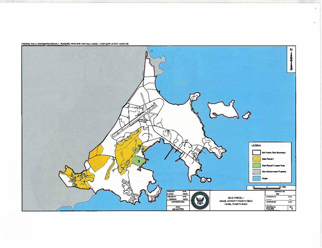
P:\GIS\NA_PlJERTORJCOIMI\y_llIANSFEJl..PROP.APR FOST SI\LE PARCEi.1 FOST NAPR LAYOUT 1=107 SS
~
w
I
&STROZ 12t2tK17
QEICKB) IV CMoTi SALE PARCEl l
LEGEND
D NA Puerto RIco IIcu1cDy
0 --1
O-_I~-o Non-GcMIrnnwIt "'-'Y
O W-... . .. -
"""""""'"" .... """"""BY -- -(i)
~~m W HAVIlL ACTIVIlY PUERTO RICO .......,...BY CEIBA, PUERTO RICO
_NO. AS NOTED I FIGURE
N
i
""'" "",.
I~

~ ~~
\-
~ ~~ \- 'Jil. ~ s~ AREA /'~ 0
~'\ ...
PU8UC FAaUT1ES TUD (PRIMARY ROAD,SEWER I:
WATER TREATMENT PLANT)
55
~
• .. ~ ~ "" 1c . . \....... ...
KEYMAP
~
------ PROJECT BOUNDARY - SHORE UNE
BUILDINGS
ROADS
DIRT OR GRAVEL ROADS
RAIlROAD
AIRFIELD PAVEMENT
NAVY PROPERTY BOUNDARY NAVY PROPERTY BOUNDARY _ / SECI)RITY fENCE
FENCE UN[
>=< CULVERT
.6. ARCHAED SITE
<r> LRA laNES AND SUB- lONES BOUNDARY
• SUBSTATION
I FIRE STATION
c=J SALABLE PARCEL
c=J OTHER PAReEt.
C::::J SAlE PARCEL I BOUNDARY
--- EX. SEWER
Q ; J I:T
FORMER U.S. NA V AI STA TlON ROOSEVELT ROADS
CErnA. PUERTO RICO
PROPOSED PARCELS WI US NAVY PLANMNG ZONES &
INFRASTRUCTURE SALE PARCEll
EXISTING SEWER
.. ". ..... --_~ _ _ I""

Exhibit C
Parcel Maps
NOTE: The parcel maps in this exhibit are from the Draft Report. Parcel Map for the
Disposal of Naval Activitv Puerto Rico (GMI, 2005).
The areas shown on these maps as having "Cleanup Remaining" correlate to Area of
Concern (AOC) F and Solid Waste Management Units (SWMUs) 1, 2, 54, 61 (shown as
ECP 7), 62 (shown as ECP 8) and 71 (shown as ECP 17), and are not included in the
Subject Property.
ECP 9 in Parcel 25 is now known as SWMU 63. The boundaries of the ECP, SWMU and
AOC areas shown on these maps are approximate and have changed since the draft
parcel map report was produced, thus they do not match the boundaries shown on the
vicinity map (Exhibit B), which are also approximate. Furthermore, since the draft parcel
map report was published, the northern boundary of Sub-Parcel 27 has been shifted
approximately 700 feet to the south.
The survey maps in Exhibit D provide the final boundaries for the Subject Property.

Parcel Map for the Disposal of Naval Activity Puerto Rico
THREATENED AND ENDANGERED SPECIES CONSERVATION MEASURES-PARCEL 2
Common Name-Sale Conveyance-Sale Neighboring Parcel(s)-1, 3, 4, 5
GENERAL REQUIREMENTS
Yellow-shouldered Blackbird
• No development is allowed in Parcel 1 and 5 (Conservation).
• All development related activities (new construction, ground clearing, demOlition/remodeling) adjacent to conservation parcels (1, 5) should occur between September 1 and March 15 (nonbreeding season) or be restricted to an area 50 m from the parcel boundary from March 15-August 30 (breeding season).
• Notify the U.S. Fish and Wildlife Service (USFWS) if a yellow-shouldered blackbird nest is found anywhere on the property (787-851-7297).
• Pesticide and herbicide applications must follow Commonwealth of Puerto Rico regulations
Activity Conservation Measures
Development Planning Save as many existing on site palms and trees as possible in new development plans.
New Construction/Clearing If undeveloped yellow-shouldered blackbird habitat is proposed for clearing consult with USFWS a minimum of one year prior to planned project initiation.
Demolition/Remodeling Schedule activity from September 1 through March 14 or conduct outdoor survey of building(s) (ledges, etc.) and nearby trees (within 50 m of the building) for yellow-shouldered blackbird nests prior to start date if the development activity is scheduled to occur between March 15 and August 30. Consult with USFWS if a yellow-shouldered blackbird nest is found.
Grounds Maintenance No trimming or cutting of palms and trees between March 15 and August 30 except in an emergency (Le., downed trees and palms from storms).
Building Maintenance Check for yellow-shouldered blackbird nests prior to any outdoor building maintenance activities between March 15 and August 30. Determine identity of any bird nest found. Notify and consult with USFWS if a yellow-shouldered blackbird nest is found.
General Operations Before moving parked outdoor equipment (e.g., carts, vehicles) check for yellow-shouldered blackbird nests (March 15-August 30). Notify USFWS if a yellow-shouldered blackbird nest is located.
Property Sale/Lease Notify buyer/lessee of all mitigation requirements (see above) and include mitigation with all legal documents.
NOTICE:
Consult with the U.S. Fish and Wildlife Service if you have any questions on the conservation measures. Property owners that cannot adhere to the conservation measures must consult with the U.S. Fish and Wildlife Service to seek a Section 10.0 permit for authorization to modify the identified critical habitat. Failure to comply with the Identified conservation measures violates Section 9.0 and/or Section 10.0 of the Endangered Species Act. The U.S. Fish and Wildlife Service has the authority to prosecute violations under the Endangered Species Act.
Parcel Index 2-1

Parcel Map for the Disposal of Naval Activity Puerto Rico
Parcel Index 2 Common Name: Sale Conveyance: Sale Neighboring Parcel(s): 1, 3, 4, 5
Parcel Index 2-2
Legend
0 -C NIigIIIIariIg P_
VIII __ ICIIII_ IIIKIdIIrd
• -.wForoging Pama Il2l I1mc11ng Ho_
August,8, 2IlOl
z+~ 1 mch equafs 87 ~ Feel
3: 0 550 1,100 ...... .c====~F~
Threatened and Endangered

Parcel Index 2 Common Name: Sale Conveyance: Sale Neighboring Parcel(s): 1, 3, 4. 5
Installation Restoration
Legend r:JParcel C Nelghbortng Parcel BouncIartea CIIo.uplStllll.
Complete with Land Use Controls D CompIate r::JCllleoop Remaining
Parcel Map for the Disposal of Naval Activity Puerto Rico
August 18, 2IICII5
linch equels874 Feel
o~ __ seoE:::==:i'.100 _ • Feet
Parcel Index 2-3
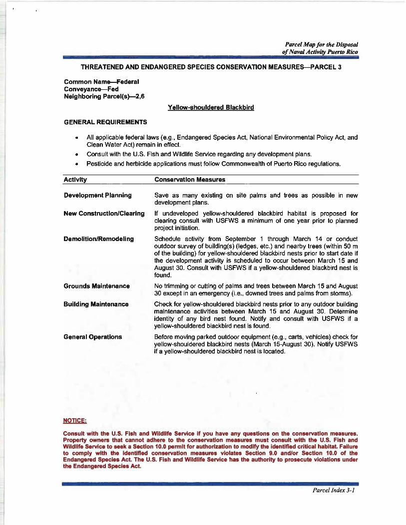
Parcel Map for the Disposal of Naval Activity Puerto Rico
THREATENED AND ENDANGERED SPECIES CONSERVATION MEASURES-PARCEL 3
Common Name-Federal Conveyance-Fed Neighboring Parcel(s)-2,6
GENERAL REQUIREMENTS
Yellow-shouldered Blackbird
• All applicable federal laws (e.g., Endangered Species Act, National Environmental Policy Act, and Clean Water Act) remain in effect.
• Consult with the U.S. Fish and Wildlife Service regarding any development plans.
• Pesticide and herbicide applications must follow Commonwealth of Puerto Rico regulations.
Activity Conservation Measures
Development Planning Save as many existing on site palms and trees as possible in new development plans.
New Construction/Clearing If undeveloped yellow-shouldered blackbird habitat is proposed for clearing consult with USFWS a minimum of one year prior to planned project initiation.
Demolition/Remodeling Schedule activity from September 1 through March 14 or conduct outdoor survey of building(s} (ledges, etc.) and nearby trees (within 50 m of the building) for yellow-shouldered blackbird nests prior to start date if the development activity is scheduled to occur between March 15 and August 30. Consult with USFWS if a yellow-shouldered blackbird nest is found.
Grounds Maintenance No trimming or cutting of palms and trees between March 15 and August 30 except in an emergency (Le., downed trees and palms from storms).
Building Maintenance Check for yellow-shouldered blackbird nests prior to any outdoor building maintenance activities between March 15 and August 30. Determine identity of any bird nest found. Notify and consult with USFWS if a yellow-shouldered blackbird nest is found.
General Operations Before moving parked outdoor equipment (e.g., carts, vehicles) check for yellow-shouldered blackbird nests (March 15-August 3D). Notify USFWS if a yellow-shouldered blackbird nest is located.
NOTICE:
Consult with the U.S. Fish and Wildlife Service if you have any questions on the conservation measures. Property owners that cannot adhere to the conservation measures must consult with the U.S. Fish and Wildlife Service to seek a Section 10.0 permit for authorization to modify the identified critical habitat. Failure to comply with the Identified conservation measures violates Section 9.0 and/or Section 10.0 of the Endangered Species Act. The U.S. Fish and Wildlife Service has the authority to prosecute violations under the Endangered Species Act.
Parcel Index 3-1

Parcel Map for the Disposal of NtI1Ial Activity Puerto Rico
Parcel Index 3 Common Name: Federal Conveyance: Fed Neighboring Parcel(s): 2, 6
Parcel Index 3-2
Legend
Cl-I:J NeIghbOrIng - II«IncI_
V--.IdI .... 8IM:ldtlnl
e ~"'IFGPaImt rl'.ii!I lnod/rv 111_
August.8, 2005
, lnell equals 698 Feet
Threatened and Endangered

Parcel Index 3 Common Name: Federal Conveyance: Fed Neighboring Parcel(s): 2, 5
Installation Restoration
Legend !;;;tParoe1 c:J Neighboring Parcel Boundanes CIGnupStnl.
Complete wlh Lend Ute ContJOIs
8~te Cleanup Remaining
Parcel Map for the Disposal of Naval Activity Puerto Rico
August 11, 2001
1 Inch equals 698 Feel
o 450 800 ___ E::==:::::::i'FeeI
Parcel Index 3-3
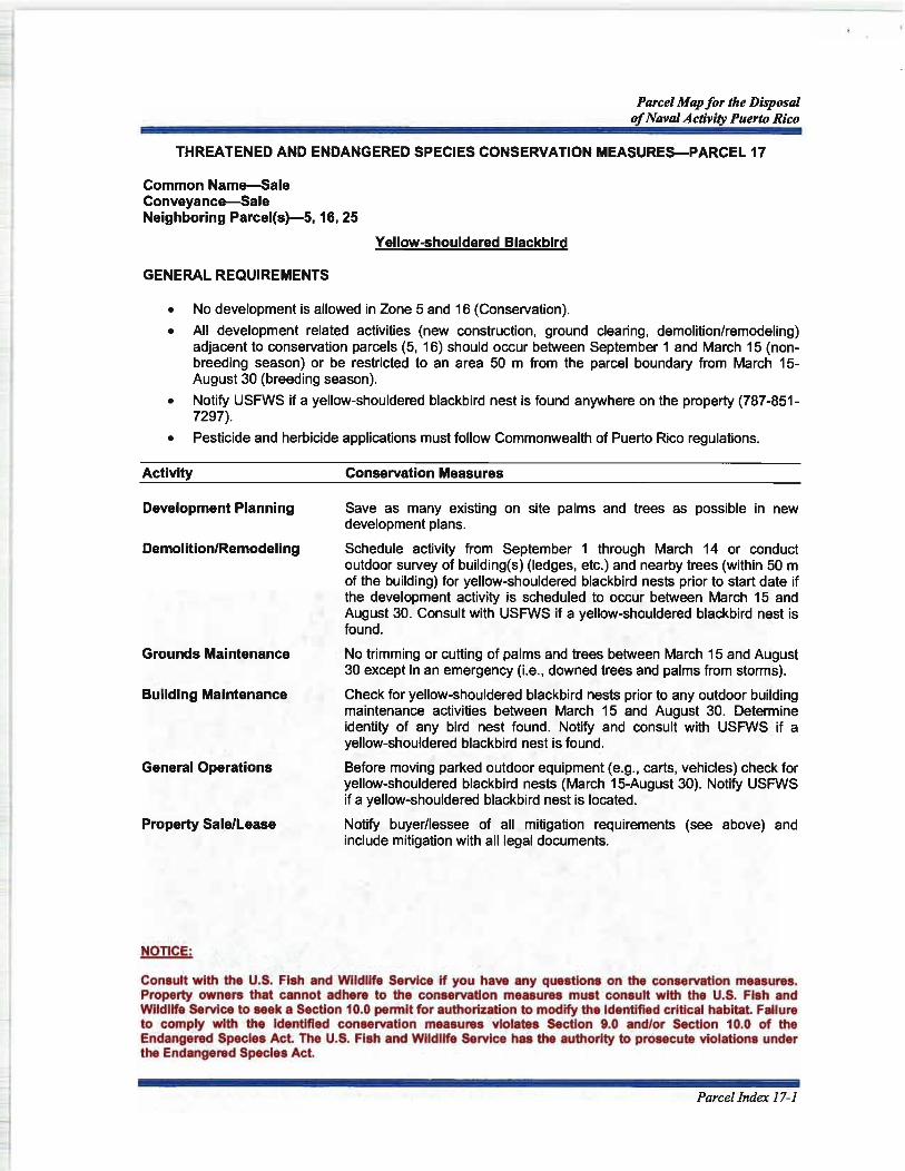
Parcel Map for the Disposal of Naval Activity Puerto Rico
THREATENED AND ENDANGERED SPECIES CONSERVATION MEASURES-PARCEL 17
Common Name-Sale Conveyance-Sale Neighboring Parcel(s)-5,16, 25
Yellow-shouldered Blackbird
GENERAL REQUIREMENTS
• No development is allowed in Zone 5 and 16 (Conservation).
• All development related activities (new construction, ground clearing, demolitionlremodeling) adjacent to conservation parcels (5, 16) should occur between September 1 and March 15 (nonbreeding season) or be restricted to an area 50 m from the parcel boundary from March 15-August 30 (breeding season).
• Notify USFWS if a yellow-shouldered blackbird nest is found anywhere on the property (787-851-7297).
• Pesticide and herbicide applications must follow Commonwealth of Puerto Rico regulations.
Activity Conservation Measures
Development Planning
Demolition/Remodeling
Grounds Maintenance
Building Maintenance
General Operations
Property Sale/Lease
NOTICE:
Save as many existing on site palms and trees as possible in new development plans.
Schedule activity from September 1 through March 14 or conduct outdoor survey of building(s) (ledges, etc.) and nearby trees (within 50 m of the building) for yellow-shouldered blackbird nests prior to start date if the development activity is scheduled to occur between March 15 and August 30. Consult with USFWS if a yellow-shouldered blackbird nest is found.
No trimming or cutting of palms and trees between March 15 and August 30 except in an emergency (Le., downed trees and palms from storms).
Check for yellow-shouldered blackbird nests prior to any outdoor building maintenance activities between March 15 and August 30. Determine identity of any bird nest found. Notify and consult with USFWS if a yellow-shouldered blackbird nest is found.
Before moving parked outdoor equipment (e.g., carts, vehicles) check for yellow-shouldered blackbird nests (March 15-August 30). Notify USFWS if a yellow-shouldered blackbird nest is located.
Notify buyer/lessee of all mitigation requirements (see above) and include mitigation with all legal documents.
Consult with the U.S. Fish and Wildlife Service if you have any questions on the conservation measures. Property owners that cannot adhere to the conservation measures must consult with the U.S. Fish and Wildlife Service to seek a Section 10.0 permit for authorization to modify the Identified critical habitat. Failure to comply with the identified conservation measures violates Section 9.0 and/or Section 10.0 of the Endangered Species Act. The U.S. Fish and Wildlife Service has the authority to prosecute violations under the Endangered Species Act.
ParcelIndex 17-1

Parcel Map for the Disposal of Naval Activity Puerto Rico
Parcel Index 17 Common Name: Sale Conveyance: Sale Neighboring Parcel(s): 5, 16, 25
Parcel Index 17-2
Legend Po ....
C~--1ItI YIIUow·lllould_ Bllcllllllll
. ~ng-
1l'2I-.a-
August 18, 2006
1 Inch equall258 Feel
o 200 <400 ...... -=====~,~
Threatened and Endangered

Parce/lndex 17 Common Name: Sale Conveyance: Sale Neighboring Parcel(s): 5, 16, 25
Installation Restoration
Legend [::JParcel C NeighbOring Parcel Boundaries CIIInupSlalu.
Complete with Land UIe Controls C]CompIete c::J Cleanup Remaining
Parcel Map for the Disposal of Naval Activity Puerto Rico
August 18, 2ID05
1 incn equals 258 Feet
O ........ 200E:======~~~
Parcel Index 17-3

Parcel Map for the Disposal of Naval Activity Puerto Rico
THREATENED AND ENDANGERED SPECIES CONSERVATION MEASURES-PARCEL 19
Common Name-Sale Conveyance-Sale Neighboring Parcel(s)-5, 20
GENERAL REQUIREMENTS
Yellow-shouldered Blackbird
• No development is allowed in Parcel 5 (Conservation).
• All development related activities (new construction, ground clearing, demolition/remodeling) adjacent to conservation parcels (5) should occur between September 1 and March 15 (nonbreeding season) or be restricted to an area 50 m from the parcel boundary from March 15-August 30 (breeding season).
• Notify USFWS if a yellow-shouldered blackbird nest is found anywhere on the property (787-851-7297).
• Pesticide and herbicide applications must follow Commonwealth of Puerto Rico regulations.
Activity Conservation Measures
Development Planning Save as many existing on site palms and trees as possible in new development plans.
New Construction/Clearing If undeveloped yellow-shouldered blackbird habitat is proposed for clearing consult with USFWS a minimum of one year prior to planned project initiation.
Property Sale/Lease Notify buyer/lessee of all mitigation requirements (see above) and include mitigation with all legal documents.
NOTICE:
Consult with the U.S. Fish and Wildlife Service if you have any questions on the conservation measures. Property owners that cannot adhere to the conservation measures must consult with the U.S. Fish and Wildlife Service to seek a Section 10.0 permit for authorization to modify the identified critical habitat. Failure to comply with the identified conservation measures violates Section 9.0 and/or Section 10.0 of the Endangered Species Act. The U.S. Fish and Wildlife Service has the authority to prosecute violations under the Endangered Species Act.
Parcel Index 19-1

Parcel Map for the Disposal of Naval Activity Puerto Rico
Parcel Index 19 Common Name: Sale Conveyance: Sale Neighboring Parcel(s): 5, 20
Parcel Index 19-2
Legend
0 -C NeIgIIbGfIng -.,..,
Vot_lder.s _lobi'" • ~Palmo
Il2l Bted1g HabDt
August 18, 2OCI&
1 inch equals em Feel
O ........ ~~====::5'.~
Threatened and Endangered

Parcel Index 19 Common Name: Sale Conveyance: Sale Neighboring Parcel(s): 5, 20
Installation Restoration
Parcel Map for the Disposal of Naval Activity Puerto Rico
August 18, 2005
1111Ch equals 687 Feel
O ........ ~C:====::51.~
Parcel Index 19-3

Parcel Map for the Disposal of Naval Activity Puerto Rico
THREATENED AND ENDANGERED SPECIES CONSERVATION MEASURES-PARCEL 21
Common Name-Golf Course Conveyance-Sale Neighboring Parcel(s)-5, 22
GENERAL REQUIREMENTS
Yellow-shouldered Blackbird
• No development is allowed in Parcel 5 (Conservation).
• All development related activities (new construction, ground clearing, demolition/remodeling) adjacent to conservation parcels (5) should occur between September 1 and March 15 (nonbreeding season) or be restricted to an area 50 m from the parcel boundary from March 15-August 30 (breeding season).
• Notify USFWS if a yellow-shouldered blackbird nest is found anywhere on the property (787-851-7297).
• Pesticide and herbicide applications must follow Commonwealth of Puerto Rico regulations.
Activity
Development Planning
Grounds Maintenance
General Operations
Property Sale/Lease
NOTICE:
Conservation Measures
Save as many existing on site palms and trees as possible in new development plans.
No trimming or cutting of palms and trees between March 15 and August 30 except in an emergency (Le., downed trees and palms from storms).
Before moving parked outdoor equipment (e.g., carts, vehicles) check for yellow-shouldered blackbird nests (March 15-August 30). Notify USFWS if a yellow-shouldered blackbird nest is located.
Notify buyer/lessee of all mitigation requirements (see above) and include mitigation with all legal documents.
Consult with the U.S. Fish and Wildlife Service if you have any questions on the conservation measures. Property owners that cannot adhere to the conservation measures must consult with the U.S. Fish and Wildlife Service to seek a Section 10.0 permit for authorization to modify the identified critical habitat. Failure to comply with the Identified conservation measures violates Section 9.0 and/or Section 10.0 of the Endangered Species Act. The U.S. Fish and Wildlife Service has the authority to prosecute violations under the Endangered Species Act.
Parcel Index 21-1

Parcel Map for the Disposal of Naval Activity Puerto Rico
Parcel Index 21 Common Name: Golf Course Conveyance: Sale Neighboring Parcel(s): 5, 22
Parcel Index 21-2
Lagend
0 -C I\lllgllloGl1ngPlmlBou_
VII-"'ouldered IIIIcldltnl
. ~Pa"" Il'2l -...HabIIt
August 18, 2005
1 inch equals 1113 Feel
Threatened and Endangered

Parcel Index 21 Common Name: Golf Course Conveyance: Sale Neighboring Parcel(s): 5, 22
Installation Restoration
Legend ClPercel I:] NelghbOrlng Perce! Boundlri .. CIaIIapllllllUs
J Corr'4)lete with Land U8e Control& DCompiete t:JCleanup RemaInIng
Parcel Map for the Disposal of Naval Activity Puerto Rico
August 18, 2IlOl
ll11Ch equalS 613 Feet
Parcel Index 21-3

Parcel Map for the Disposal of Naval Activity Puerto Rico
This page intentionally left blank
Parcel Index 21-4

Parcel Map for the Disposal of Naval Activity Puerto Rico
THREATENED AND ENDANGERED SPECIES CONSERVATION MEASURES-PARCEL 22
Common Name-Sale Conveyance-Sale Neighboring Parcel(s)-5, 21, 33
Yellow-shouldered Blackbird
GENERAL REQUIREMENTS
• No development is allowed in Parcel 5 (Conservation).
• All development related activities (new construction, ground clearing, demolition/remodeling) adjacent to conservation parcels (5) should occur between September 1 and March 15 (nonbreeding season) or be restricted to an area 50 m from the parcel boundary from March 15-August 30 (breeding season).
• Notify USFWS if a yellow-shouldered blackbird nest is found anywhere on the property (787-851-7297).
• Pesticide and herbicide applications must follow Commonwealth of Puerto Rico regulations.
Activity Conservation Measures
Development Planning
Grounds Maintenance
General Operations
Property Sale/Lease
NOTICE:
Save as many existing on site palms and trees as possible.
No trimming or cutting of palms and trees between March 15 and August 30 except in an emergency (Le., downed trees and palms from storms).
Before moving parked outdoor equipment (e.g., carts, vehicles) check for yellow-shouldered blackbird nests (March 15-August 30). Notify USFWS if a yellow-shouldered blackbird nest is located.
Notify buyer/lessee of all mitigation requirements (see above) and include mitigation with all legal documents.
Consult with the U.S. Fish and Wildlife Service if you have any questions on the conservation measures. Property owners that cannot adhere to the conservation measures must consult with the U.S. Fish and Wildlife Service to seek a Section 10.0 permit for authorization to modify the identified critical habitat. Failure to comply with the identified conservation measures violates Section 9.0 and/or Section 10.0 of the Endangered Species Act. The U.S. Fish and Wildlife Service has the authority to prosecute violations under the Endangered Species Act.
Parcel Index 22-1

Parcel Map for the Disposal of Naval Activity Puerto Rico
Parcel Index 22 Common Name: Sale Conveyance: Sale Neighboring Parcel(s): 5, 21. 33
Parcel Index 22-2
Legend ClCJNoIg-....p-
V __ 'deNII _
• ~0f08I0V""'" ~~HaIi1lt
AU\lust 18, 2005
linch equeIs 578 Feet
o 375 750 ___ ii::::==:::i'FeeI
Threatened and Endangered

Parcel Index 22 Common Name: Sale Conveyance: Sale Neighboring Parcel(s): 5, 21, 33
Installation Restoration
Legend c::JPaICet C Ntlgl1boring Parcel SourQaries Cleanup_.
Complete wlU1 Land Uu ConllOla c::J Complete CJ o.arwp R ..... 1nIng
Parcel Map for the Disposal of Naval Activity Puerto Rico
August 18, 2IlOl
linch equals 576 Feel
O~ __ .37C6==:::i760 _ Feet
Parcel Index 22-3

Parcel Map for the Disposal of Naval Activity Puerto Rico
THREATENED AND ENDANGERED SPECIES CONSERVATION MEASURES-PARCEL 25
Common Name-Sale Conveyance-Sale Neighboring Parcel(s)-5, 13,6-18,20,26-29
Yellow-shouldered Blackbird
GENERAL REQUIREMENTS
• No development is allowed in Parcel 5, 13, 16, and 28 (Conservation).
• All development related activities (new construction, ground clearing, demolition/remodeling) adjacent to conservation parcels (5, 13, 16, 28) should occur between September 1 and March 15 (non-breeding season) or be restricted to an area 50 m from the parcel boundary from March 15-August 30 (breeding season).
• Notify USFWS if a yellow-shouldered blackbird nest is found anywhere on the property (787-851-7297).
• Pesticide and herbicide applications must follow Commonwealth of Puerto Rico regulations.
Activity
Development Planning
Demolition/Remodeling
Grounds Maintenance
Building Maintenance
General Operations
Property Sale/Lease
NOTICE:
Conservation Measures
Save as many existing on site palms and trees as possible in new development plans.
Schedule activity from September 1 through March 14 or conduct outdoor survey of building(s} (ledges, etc.) and nearby trees (within 50 m of the building) for yellow-shouldered blackbird nests prior to start date if the development activity is scheduled to occur between March 15 and August 30. Consult with USFWS if a yellow-shouldered blackbird nest is found.
No trimming or cutting of palms and trees between March 15 and August 30 except in an emergency (Le., downed trees and palms from storms).
Check for yellow-shouldered blackbird nests prior to any outdoor building maintenance activities between March 15 and August 30. Determine identity of any bird nest found. Notify and consult with USFWS if a yellow-shouldered blackbird nest is found.
Before moving parked outdoor equipment (e.g., carts, vehicles) check for yellow-shouldered blackbird nests (March 15-August 3D). Notify USFWS if a yellow-shouldered blackbird nest is located.
Notify buyer/lessee of all mitigation requirements (see above) and include mitigation with all legal documents.
Consult with the U.S. Fish and Wildlife Service if you have any questions on the conservation measures. Property owners that cannot adhere to the conservation measures must consult with the U.S. Fish and Wildlife Service to seek a Section 10.0 permit for authorization to modify the identified critical habitat. Failure to comply with the identified conservation measures violates Section 9.0 and/or Section 10.0 of the Endangered Species Act. The U.S. Fish and Wildlife Service has the authority to prosecute violations under the Endangered Species Act.
Parcel Index 25-1

Parcel Map for the Disposal of Naval Activity Puerto Rico
Parcel Index 25 Legend -Common Name: Sale C NolghDof1ng--Conveyance: Sale YII_ ... oul ....... Bllcllblrd
Neighboring Parcel($): 5, 13, 16-18, • ~"IIPa"" 20, 26-29 Il2l BrHdl"ll HI_
Parcel Index 25-2
August 11, 20CII
l inch equals 1,078 Feel
o 7!50 1 ,IlOO ...... .c====~'F~
Threatened and Endangered
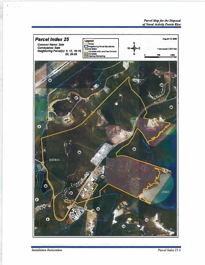
Parcel Index 25 Common Name: Sale Conveyance: Sale Neighboring Parcel(s): 5, 13, 16-18,
20,26-29
Installation Restoration
Legend L:J Paroet c:::JNelghbo~ng Parcel Bounda~ .. ClanupSlDlu. ~- Complete wllh Land Use Controla ClCo"lllete CJ Cteaoop RemainIng
Parcel Map for the Disposal of Naval Activity Puerto Rico
August 18, 2lIOII
t Inch equals 1,078 Feel
o 760 1,500 ...... ~======~'f~t
Parcel Index 25-3

Parcel Map for the Disposal of Naval Activity Puerto Rico
THREATENED AND ENDANGERED SPECIES CONSERVATION MEASURES-PARCEL 27
Common Name-Sale Conveyance-Sale Neighboring Parcel(s)-5, 25, 29, 31, 33
Yellow-shouldered Blackbird
GENERAL REQUIREMENTS
• No development is allowed in Parcel 5 (Conservation).
• All development related activities (new construction, ground clearing, demolition/remodeling) adjacent to conservation parcel 5 should occur between September 1 and March 15 (nonbreeding season) or be restricted to an area 50 m from the parcel boundary from March 15-August 30 (breeding season).
• Notify USFWS if a yellow-shouldered blackbird nest is found anywhere on the property (787-851-7297).
• Pesticide and herbicide applications must follow Commonwealth of Puerto Rico regulations.
Activity
Development Planning
Demolition/Remodeling
Grounds Maintenance
Building Maintenance
General Operations
Property Sale/Lease
NOTICE:
Conservation Measures
Save as many existing on site palms and trees as possible in new development plans.
Schedule activity from September 1 through March 14 or conduct outdoor survey of building(s) (ledges, etc.) and nearby trees (within 50 m of the building) for yellow-shouldered blackbird nests prior to start date if the development activity is scheduled to occur between March 15 and August 30. Consult with USFWS if a yellow-shouldered blackbird nest is found.
No trimming or cutting of palms and trees between March 15 and August 30 except in an emergency (Le., downed trees and palms from storms).
Check for yellow-shouldered blackbird nests prior to any outdoor building maintenance activities between March 15 and August 30. Determine identity of any bird nest found. Notify and consult with USFWS if a yellow-shouldered blackbird nest is found.
Before moving parked outdoor equipment (e.g., carts, vehicles) check for yellow-shouldered blackbird nests (March 15-August 30). Notify USFWS if a yellow-shouldered blackbird nest is located.
Notify buyer/lessee of all mitigation requirements (see above) and include mitigation with all legal documents.
Consult with the U.S. Fish and Wildlife Service If you have any questions on the conservation measures. Property owners that cannot adhere to the conservation measures must consult with the U.S. Fish and Wildlife Service to seek a Section 10.0 permit for authorization to modify the Identified critical habitat. Failure to comply with the Identified conservation measures violates Section 9.0 and/or Section 10.0 of the Endangered Species Act. The U.S. Fish and Wildlife Service has the authority to prosecute violations under the Endangered Species Act.
Parcel Index 27-1

Parcel Map for the Disposal of Naval Activity Puerto Rico
Parcel Index 27 Common Name: Sale Conveyance: Sale Neighboring Parcel(s): 5, 25, 29,
31, 33
Parcel Index 27-2
Legend
0 -C NeIgttIcrIng P ...... -
YII_IIIouI __ rei
• ~ngPaIml
~BrttdirV _I
August 1a. 2001
1 inch equalS 960 Feet
o ....... ~C:====='.~
Threatened and Endangered

Parcel Index 27 Common Name: Sale Conveyance: Sale Neighboring Parcel(s): 5, 25, 29,
31,33
Installation Restoration
Legend c:J Parcel C Nelghborlng Parcel Boundarf .. _up_.
COmplete With Land Use COntrols D COfl1)lele D CIeanJp Remaining
Parcel Map for the Disposal of Naval Activity Puerto Rico
August f8, 2lIOII
1 inch equals 960 Feel
Parcel Index 27-3

Exhibit D
Survey Maps
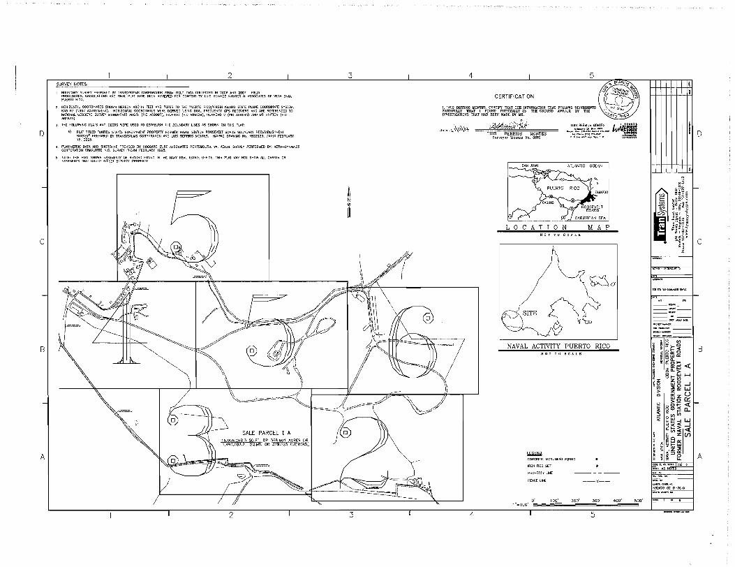
D
c
B
A
2 SURVEY NOTES:
1. BOUNDARY SURVEY PREPARED 8Y TRA'ISYSTE).lS CORPORATION fROM FIELD DATA COllECTED IN 2006 AIID 2007. fiELD PROCEDURES, CALCULATIONS AND FINAL PLAT HAVE BEEN REVIEWED FOR CONTENT BY LUIS BERRlO$ MONTES "" ASSOCIATES OF VEGA BAJA, PUERTO RICO.
2. HORIZONTAL COORDltlATES SHOWN HEREON AA~ IN fEET AND REFER TO THE PUERTO RICOjVlRGIN ISLAND STATE PLANE COORDINATE SYSTEM, II"!) 8J (\997 ADJUSTMENT). HORIZONTAL COOROINATtS WERE DERIVED USING DUAL FREOUENCY GPS RECEIVERS AND ARE REFERENCED TO NATIONAL GEODETIC SURVEY IJONUI.1[NTS ANGEL (PID AD9997). FAJARDO (PIO A89834), HUMACAO 2 (1'10 A89!l46) AND I..!T BRITION (PID A89835).
3. THE FOLLOWING PLATS AND DEEDS WERE USED TO ESTABLISH THE BOUNDARY LINES AS SHOWN ON THiS PLAT:
A) PLAT TITLED 'UNITES STAlES GOVERNIJENT PROPERTY FORMER NAVAL STAllON ROOSEVELT ROADS BOUNDARY REESTABUSHMElH SUfM.Y" PREPARED BY TRANSYSTEMS CORPORATION AND LUIS BERRIOS ~ONTES. NAVfAC DRAWING No. 4522929; DATED fEBRUARY 15,2005.
4. PLANIMETRIC DATA AND SHORELINE PROVIDED BY HOGGARD EURE ASSOCIATES PORTSMOVTH, VA. AERIAL SURVEY PERfORMED BY: A£RD-OYNAIJICS CORPORATION CHARLonE N.C. SURVEY fLOWN fEBRUARY 1998.
5. NOTE: THIS PLAT SHOWS EASEMENTS OF RECORD fOUNO IN THE NAVY REAL ESTATE OffiCE. """,IS PlAT MAY NOT SHOW ALL GRAIHS OR EASEMENTS THAT COULD AfFECT SUBJECT PROPERTY.
., .. , .. ,.
""'-
SALE PARCEL I A 16 056 268.3 SO.F1. OR 368.601 ACRE~ ~S...QJ,iL OR~EROAS
3
~ t
3
\
\"
4 5
CERTIFICATION
J, LUIS BERRIOS MONTES, CERTIFY THAT 'fHE INFORMATION THAT FOLLOWS REPRESENTS FAITHFULLY WHAT 1 FOUND PHYSICAlLY ON TIlE GROUND AND/OR BY THE INVESTIGATIONS THA'f HAD BEEN MADE BY ME.
D"'"~\\'\"'r
"~ j' ~'
/
4
~'fd- """' ...... lI<N .... """
;~~#~?-:~~t:·OP> LUIS BERRIOS MONTES Surveyor Ucense No. 8689
A TLANllC OCEAN
LOCATION MAP
NAVAL ACTIVITY PUERTO RICO NOT TO seA L E
LEliEtill CONCRETE MONVI.4ENT fOUND
IRON ROO SET
PROPERTY UNE
rENCElINE
0' 1""'100'
100' 200'
--x--
300'
5
400' 500'
I ~u§
i ~~:~~ >-. <.J I::> 2
~ m:t ~~~ ):
:; ~ z ~
--~-------~,- ---~---~ <> '" 8 (I)
D
c
I ; "~~I , ~ ~"'o I B ~ :;;:; wW 0::: ~ ~ ~g,~ ~ Qiff:g 4: ... ~~w J-4
n~ ~~ , !Q :lE 0 --' ~ zO::: W C elz U C) >0 a:::::
~ ~gE ~ ~ 0(1) (I)
1:i::~...JW ~« ---1 ~~~ « ~ClZ(/)
~~~ffi t;...JZ~ :1<::::>0:: • ~ ~I I A
:~=~o=
-;::;;:;;;-;;;-N62470-02-D-7619
, • 6

I 2 I 3 i 4 I 5
D
IJI / I //~~;f;f,~ ~'"' '\ MATCHLINE 'G' - SEE SHEET 6 OF 6 / j IRON ROD sa
! // // ~<')!fr ,p ¢ "'",.§~"," !.~~ ! / I " // "~ ~ # .OJ "0_ .. " if).-
I I '" // ~.cf ¢I \.\ / <} :y /, f ~_~_~ .. "'" " .p ~ \ / ... / IRON ROD sa
? ( I _----- .. __ ---::::::'#,"'-!"~6, IRON ROD sa OJ ~.~ \ /.,0;:;' (
/ -,,-- -------- \40 12 rtf ~ 4> .... '\ (1'O/'J'\. __ ~_ // ___ -----:---::--------- ~ a ~ . ~<" '-,"-. ~ c,k ~,,') ____ ::::..::::.---- __________ .. __ // I '---- ---:-._----- ~~" 4 "" I~", ~N ROD sa
--------___ \ \ /,-- ... #" ~&' /c,;,.« ---- - Y"" ¢f 0/ ......... ;j' '~ ,/ St1""{; ... 1I-'
---~" '\ cP # <# ~ < ib~o --~~;;''i~ ~D SET
~'\ \ # f' 4" 'J /' ,,5."
\ \ ¢I # 6 IRfJNRODSa \ I, \ CONSERVAnON ZONE 5 ~cf cf # ' ! \ \ ~ M /:1 \ !
/ I \ ~ / I '\
/ I
-
UNEr~
UN£ LENGTH OJ S8S'40'08'W
'" N60"J,'49'W
I I { I \ I \ I ~'1,._
N3S'Z2'S5'W 46.13 N28"50'f8'W
tt71 55.68 SJO'07'40"£ c
/ \ \ \
'\ ~ \ /1 '" "" ,
, " " " SALE PARCEL I A \ 4 " ~ '\ 16055268.3 SO.FT. OR 368.601 ACRES OR \:# l> ~ '\ 1491 682.2 SQ.MT. OR 379.525 CUERDAS ~.,4;)
\ S .~ INGRESS/EGRESS EASEMENT 21 \ \ \t{)
I "'. I I "'<~ I I ~ I I ~'<'- OJ¢
I I ~¢!:----\ \ \'41
... \ '-... .\.'- ¢ o " '--. ;:,v. #
-
B
~ '""'- ........... UI
Ui ", ", ~~ 4: PARCEL 4
: "'--. '--.'--.'--. ~~--;,.¢'.
l!:1 ' ~ c,¢ ~.g iforF (I) '-. .......... ~rF '"
-I.' "'--. _ ¢I "1~¥;f ¢I . : - -; i=-=-.. ~- ~------:::::'\
A
,-, \ -.. ::::I~·- '\ \ CJ \' \ ~ /~~"" --.p,ti!' -~,~~ \~'?\ \ ~ _::;;;;~ K. '--., f" ~-'f '4_ ~\ , ~ _--:-:;:';'?/ ~""" "';::;;;;;;;,::,,-:;;00---__ '" ~::c-,d' ,--
/0-';;;>''''- "" f\111. N8,~27~~;;;;:;;;;;;;;,"~~,_, 9 \ _~--;;,~;;;:,_4/ "'* NAI-Y 5f:CURITY ,T.NCe .80 ~ - - -- 0 !;;;~~ ~,-_~ _____ . .., /~ !.INK WlTfl8..tP/JW li1A'£ Jl r 1 ,a" ~ jJ ~
- - .. - - -- - t!.8;;:;;'W - - - .. - - ;;;-P;;N; ... - - -=--=-~>-----'------;?="''''-'''''l(C.~~-:;;:'io-::':::::':-----' J:~ ~ .f'$r \OJ ~~~~ ~ Of BEGINNING ~~ - - _N~"W '----::::::~~"~ '" COMMONWEALTH OF PUERTO RICO '''I- f ~ Ji~~~~ .. g~;; 0'rf:~,*- POINT OF 820.00' - - - - _ _ _ _ DEPARTMENT OF NATURAL RESOURCES ~ POINT' 26-43 ,.... BEGINNING _ '\
I~ 2" PIPE FOUNQ SUR~Y CONTROL POINT I 9 -- \~0.
~ ~O~Ng~~~;.7;~ IRON ROD FOUND - -, . ~ "-.~ £921490.5759 ~'\..,
T 2 T 3 I 4
o· 1"",100'
T
100' 200' 300'
5
D
I ,;6 ~ C/.) e~~ § .§ ~~~: ~ §2" ~~~~ 5
~ md ~ I ~ ~
,,~~~ I C ~ ~
-- . ~.-;;;;;;;:-
~-~ -~ ~-
is en ~ii>-CJ g ~~~ I B g~~:
! oig:dl<C § ~I-Gj ~ ~ zen !(ij w8....J
2: ~a:: W o e:i z U () >0 et:::: ~ S0i= « I-:5 Ci:e,,~ CL '< o(I'Jen
~w a:::1-...J W ~~~ ....J 1;:"'< <C ~CJz(/)
rw~ ~<!::w t;;~Z~
~ ~=>~I IA
N62-470-02-0-7619
400' 500'

B
A
$ I
" " '" "~~ ;g~ ~,~
/ "
MATCHLINE 'B' - SEE SHEET 4 OF 6
) IRON ROO SIT
/ /
''':J'\~/ ,4l,:'o'f
~/' .. '
/
IRON ROD sa
2
~ ~ I I
" ·8.1""·<7"W " s ii', ... · "'-92
~
,,·so,,~ _____ ~ __ . ______ \
~. (>
~~~,,/ CONSERVAnON ZONE f
#4 #' N81'20'!iJ"f: r--"":i90,r-
\ \
\ ~~. ~.~
\ 4 ¢1'#
3 4
~ t
SALE PARCEL I A 16056268.3 SOH_ OR 368.601 ACRES OR 1491682.2 SQ.MT. OR 379.525 CUEROAS
5
-~"~,\/ ---_C_~\./ '''':" $!;;:'R:'~~~C;"'R[ <~~~~~~~~~z~~~~~~~ .& q}~!,. ~.~ 'S4~iii'']jr ~~. ' ')~--, . " ,,,,""'" ~ ~';::,') /\,0;, •• { "'I' lJJ\~~& \'~~\,,;~ "'~ ~;~~~ ;.: , / ",./ ",,":F ",til' +, ,~ •
- /1'7 11' 1'" ~'; ,f).' "'"., ~~~ ., ! 1~--- :I'r- • , ~ ,;,. '.'~;;''''-~ _,,_,"-" " ---- /. ~'.,,' '" '~~.. , II ". " _,~ \, ' ; b' ,-__ _ .,
II ~~~'1'~'~:~20~O~'::~~30~O~':::40~O::::~ __ JL~ 1/ ~ '" 'I , __ ,eo " 5 II
2 4 3

D
-
C
-
B
-
A
I I 2 I 3 " I 4 /"Jr.f" ... '" II '~-II ~.~"' '" '" ,m" ~, ' 5 ~i~ O+~I;!J -~"".-/!/'r: 4 '
~
~,""" ,,,- (\ _ '/ < ) ~f/'--""" SfWRm '[NY i "Q "" ~,j';,._ 4>.";'\; ~ . -;;) "-/. CHAIN UNk wm1 BNwm jH"~ ~ .''-' ,,~ F' T ~"" /, c ° ~; <<<4 ,0' ~" / I~ f:;' / ,\~';Q /~, ~<- (3 I/(Y f$' ~
11' ~1. i'fl-/ ~ ',z, ~/ ",/ 11 N ! §t/Y/~-(~~~"' / (yJ ,".:. t '10
h' '~~ '0 / ~ /I,~" I
IRON ROO s£r (~ ~" ~ CJ \"~ ,/:t~"?,"'!'i.,---:!/~q< I'~ ~;£ ~ v~ g~_~~ff'---- J~u--[-=-='':~''=::::===\ I j "'- ( ~ "'-, ~f' I --- _______ .1
I "'-, '-Jl ',,-~ "'- ----\.J/
I / ~.~~// -~~::~" --- _A. ,/ SALE PARCEL I A
I
~'~_____ --~- ----"\ \ -.."'-. 160562683 SO . r ",~. -----~~,,:---------- r,,--;:;-:-------"~ , 49' 682.2 SO':.:' O;R 3J~;6g' ACRES OR
~ ~~._ '- --'--PMiV:--;o- /, ~""'" "'-.._ - 25 CUEROAS
\ ,.,~.. '_____ _____ -~C(0y~R(j;;-- / Q "::::.-, ___ ----fL... ______ / \ J
t
-, -~ '--- ,\
)
' ~ /-:;;;~~7~:';,,:;Ir;,,;,~~~t~'RE ~ , , .# ,0 '---:~:::::::::::------- I '-,.;,,<i ~-----~-I ~ -- -
\1 I --- ~~ f~}J~ 1 ----,.~, --- --- --~~'-~ 'A --::::~-
/ ~, '" ' , '-::Co:-_ , ~-, ~---<:------.
CONSERVATION ZONE , ~ ---...::--------~ ,~ ~ -~ ~ ~~, '-
~. ' " '-, ~--~ ~ \'1., '\'\ ---S
1"=100' 0.,.'=='",00",' =",2~00~'=",3;l,;0~0'=~40~;'" =4; ;I~ 500' "'~ ~
~ MATCHLINE '8' - SEE SHEET 3 OF 6 I
4 5
£ TABLE IGTH BE:ARING r,' ..
T T 3 2
I g~L I-
CIJ -.:;;.L::; E .. .5;3Jeu
-t5 ~~i~ ~ ~ t,.)1:> <I,)
C0 ilt:' .: . m~I .. ~ I ~ ~
;;WIC z ~
~
----------__ 04<T_J ......
.....",." ........... _-~-~ ---
CI1
" ~~I I B ~ w'" ~ ~~ « - "'w • "-> ~ I- LaJ """"" .... z z U1 ~Q wg--.J ~ ~a: W Ci C:: z U u ~Q~I~ ~g~ a... :5 '" CI1 .... oCl1
« ~~:;i ~ ~tii~ «
I
i' ~ Z (f) :g z ~8o:: \'; g ~ I- LaJ ... ~ z:::E ~ ~ I=>e I A COO( t<) """",,"' "1~ 0
<C<ti' I<S NOTED
N62~70-02-D 7619

o
-
c
-
B
-
A
I 2 I 3 ..l 4 I 5
,,,,$ -# ~r§J
~-"""'.,, ~. l~" '-.". ~.\\ I ~~
, " /<-' t,;, / <.""~ • \" I j'/ /:;:/ , ~'" v' / /// : "',,;/ 'P ,
' #//p , ,\, -- '/ . " " " < -~, '.' // • \\ ", . /. " ~\ ~d~ , ~ ,\ ,,,, / // " \ \\ ~"" '/ " ./ \' " e .. , •
""" SWi"'" ""e; -"'R£ ~ ~' .S· ';;; / / 'MHAACCC " , -,,~-,,-. ,. .,y' ,.,,=oo e ,~ \ -" " ~./ / .... ,," I MJ, .~ 'l,,,,, ~.. , ~~'-:='\\.">..: " ",,",,' '/ ' .' ." " //' * , ",# "'~'~ /" /~ </ ~~~'" ~ ,c;#, ----:;:/ //>" / / ~ ,:_=-,,::::::-~ / /~ ,. ......-? /, '/" .. "'''''''" -- ~'~ ... '/ " // ~ ~",~ ,t
4 ""!-'!~"£~--=~-------¥----,,,,~' 7 /;;' )/ // \\ '* ~ ",0 -805 00 ,, ____ , _- _" ! I II /--/ \~ ~--,- - _s~~ ,c;#, _ -- _ -~.: -=--*------ --------- _:.-=-::::-----' Ii //
tf ~/·"'~:::::::;".-:;;;,~-c=::=--~~· II I ..
'\ ---lQ! 7t~1" I ) ':::::::-=:::::_1..,-1 D r & '., t ;;~A ",#0 / <~ , ',p I/v~,< "~~~ ,";<1'
I,f [ciJ""lf1. '~(.~ );1~~~ r{~~ , !"i~:'r ~~~" / °1 '[ ,~. ~("" t JI j ~ ...-:~~'" ,0 f~, \ t., ,.;' II£::,~ .s$
., 'I' • ~~. ,. /J. \I ~"'. ,,) I' ~" " J" h" ....... ,,.,::::~ j "~'lj-" ~ D -\"'.. // "~// ,1", leo," """ ~~_I '()\v0
/ /'/("~" """,- ~~~ . '~'&.;. <- ''''-I' /' , , " ,,>,, " "<. // V .~~. ~~"" "
--J / / /',> 0' ;. ,'¥ //'.'~ "-, " ~,,,O\\" _<,' // 'v/ '/ ""--:::::::::: .. .1- ~",~,<~ ). " ., v, , , / ". ""~, , "'" . . ./;/ . ~ V /:::=:'N8:;]-:J£);-"'--"7~ ~ , / \ ~.::. '''''., \ . ",,' \9" ~('\ V , =>.~.,...., ':: , ~'" ~tt(<f ," [ ,A II • / , ........ \\' ,,\9" tJ I ~, "/ =ceAA"" ". )\ ,
"" ". 'v C o. "'."g&" _ j ""
~ L.Ji;r 16056 268.3 ~%.Mi. OR 379.525 "'w 5~eUH;7, :';,,8£0 ",RE ~t;..\a-t<\ /[ /, '''' .,' '---, '\'Y/ • l\....u
" ~~/;~ ''''I C'J ,:;,'/ '0' _ SEE ABOVE
(
[ ~ "'=""' J fl \ J
MUNICIPALITY OF NAGUABO
_i __ _ MATCHLINE 'c' - SEE SHEET 4 OF 6
2 3 4
0' 1"~100'
I
100' 200' 300'
5
400' 500'
""
o
I j~ l-
e/.) ~~~ § E •• g.o .E3 ~; _ .. Ii ~ ~~~:~
~ md ~~H -~; I C
:z;~
~
F"
---~----"~-------PROJE""""""' __ _ ~~--
-~---
~~>-~ ,~~b::C§1 I B i ~ ~:ta:: ~ 2; Il. 0 t-~ ;ig:;:;j « !i W > '" 0 I- l&J 1--1
I~ ~g--l ~ ~a:: W o ei z U o >0 a:::: r= 00t=: « t~ ~(!)~ a.. ~ a (I) en - ~.., trl--...JW
~c« --I a.~~ «
~ ~oZ(f) l!; is t3 LL1 et::
~ a <~~ ~ '" ~:J a::: o ,~ ~ eooc,gHJJtooo'I$>l(
-..:' IS NOTEO
N62410-02-0-76\9
A

2 3
_ .. _._.:::::-~.~ ~TCHLINE 'F' - SE~\ SHEET THIS SHEET
~ ~/) /,- SURVEY ~ I II POINT 'O~.g~r~?L ~ \'l L N 7962903122 o ~i{C(··'
~~\ \
4 5
~~: \ '\
'"Mo<' ,""'"' "I~ \ \\ /jl~\\ \ (/ iltl \
CONSERVAnON ZONE 5
~ t
III \LC __ \
) 1'-::;",,::::, .' ""C- '\/', / f I (J --~_ -- __ ~1~7:E -;.J j""~ '-- - , ' - --~ j /' ~ -'<~,"~, _~ ,cc.'-- '"'"""7 /1 "~. --===.==" "
/)
/8(1 ~ 16 SALE PARCEL I A /
f
'. ."," " I j ;,' '" ,., ~. ': "'M' ~c .'
/ I; ,,::-....... • """ "'..:; f
jl/' ~,-! I '--- -, 1 II ...:c'--, .;
I //-"- .'
\ \\ ,<,
\ \ ,'q>' \ '},< ' ,0 <fi;'''' /// \~4' \ O~'" ~/// 1 /
<,-"'" ' /// _ ;it ,\2~ :L0
' ~/ /.~' IRON ROD sa VI N,,'D2'''~ ~ /1-- 'i / - ~ _ y".16' ,,/ ;; t: ~ / ,i ~ , '<., I i=::'--'---*' -~ ~/ ~,\., 11 '"' ... . ,, __ ------"'--" "';;; //"""'! 'I'~ ,t" ( IRONRO~J I ""0:
MATCHLINE 'F' \ - SEE SHEET THIS SHEET
GONSERVAnON ZONE 5 til f;! "-..:c~",~>, l I~ -. /
I' II " '~', l' // .""'ffi,",'~"'" ~,
//,/1// ... ~ / / I" • i/I '., / /i ,~--~ \~~~
MATCHLINE 'G' JI $,RON ROD sa - SEE SHEET 2 OF 6 ,~,~ ~'I!i 3 __ ~I"~O' ________ __
4
100' 400' 500' 200' JOO'
5 2

LEGAL DESCRIPTION FOR SALE PARCEL I A
Beginning at a survey control point in the Ward of Daguao, said point being a brass disk set in concrete. Said point also known as 'MANATI' and having a northing of791059.1339 and an easting of 921490.5759 noted as the Point of Beginning on the plat labeled "UNITED STATES GOVERNMENT PROPERTY FORMER NAVAL STATION ROOSEVELT ROADS SALE PARCEL I A". Thence N40026'39"W 2045.54' to point # 26-43 a 2" pipe found, the True Point of Beginning, having a northing of792,615.8677 and an easting of920,163.6158:
Thence N89°19'32"W 978.33' to point # AR-3 a 2" pipe found; Thence N71 °00' 16"W 130.50' to point # AR-4 a 2" pipe found; Thence N57°58'26"W 79.35' to point # AR-5 a 2" pipe found; Thence N42°47'56"W 65.85' to point # AR-6 a 2" pipe found; Thence N56°11 '26"W 131.08' to point # SCN-C5 a 2" pipefound; Thence N56°07'36"W 81.13' to point # SCN-C4 a 2" pipe found; Thence N73°55'56"W 64.38' to point # SCN-C3 a 2" pipe found; Thence N85°06'36"W 166.84' to point # SCN-C2 an iron rod set; Thence S66°29'24"W 28.10' to point # SCN-C1 a 2" pipe found; Thence S85°48'54"W 133.49' to point # 114 a 2" pipe found; Thence N78°37'06"W 74.67' to point # 110 a 2" pipe found; Thence N36°58'36"W 158.99' to point # 107 a 2" pipe found; Thence N29°57'56"W 54.20' to point # 109 a 2" pipe found; Thence S88°03'44"W 358.46' to an iron rod set; Thence NI5°12'47"E 54.17' to an iron rod set; Thence NI0034'42"W 91.78' to an iron rod set; Thence S83°43'09''W 222.44' to an iron rod set; Thence Nll022'22"W 548.80' to an iron rod set; Thence N81°20'53"E 391.79' to an iron rod set; Thence N32°25'40"W 217.55' to an iron rod set; Thence N83°41 '47"W 717.92' to an iron rod set; Thence S89°50'53"W 244.89' to an iron rod set; Thence NIl °06'26"E 123.28' to an iron rod set; Thence N74°18'13"E 79.62' to an iron rod set; Thence N41°30'37"E 410.17' to an iron rod set; Thence N04°18'45"E 132.39' to an iron rod set; Thence N21°43'36"W 148.72' to an iron rod set; Thence N56°08'19"W 1097.24' to an iron rod set; Thence N72°25'35"W 824.78' to an iron rod set; Thence N54°58'40"W 628.94' to an iron rod set; Thence N12°30'34"E 202.42' to point # F85-10 a 2" pipe found; Thence N09°22'44"E 77.71' to point # N-PL-1-A an iron rod set; Thence S56°25'46"E 143.44' to point # N-58-A a 2" pipe found; Thence N37°49'53"E 101.30' to point # 58 an iron rod set; Thence N52°22'24"E 27.21' to point # PL-2 an iron rod set; Thence S51°57'26"E 539.85' to point # PL-3 an iron rod set; Thence N75°36'24"E 456.65' to point # PL-4 a 2" pipe found; Thence N20035' 13"E 801.21' to point # PL-5 an 8" concrete fence post found; Thence N82°35'36"W 230.00' to point # PL-6 an iron rod set; Thence NOl°18'34"E 525.27' to point # PL-7 a 2" pipe found; Thence N67°17'34"E 167.99' to point # PL-8 a 8" concrete fence post found; Thence S58°23'36"E 226.77' to point # PL-9 a 2" pipe found; Thence S41°00'16"E 406.89' to point # PL-I0 an iron rod set; Thence S77°42' 16"E 316.92' to point # PL-ll an iron rod set; Thence S40051 '06"E 257.74' to point # PL-12 a 8" concrete fence post found; Thence S68°30'46"E 359.57' to point # PL-13 an iron rod set; Thence S26°54'16"E 733.46' to point # PL-14 an iron rod set;

Thence S47°00'46"E 258.16' to point # PL-15 an iron rod set; Thence S76°44'46"E 265.45' to point # PL-16 an iron rod set; Thence N84°41 '44"E 805.00' to point # PL 17 an iron rod set; Thence N64°49'14"E 360.96' to point # PL 18 an iron rod set; Thence N45°37'44"E 529.92' to point # PL 19 an iron rod set; Thence N81°02'14"E 391.16' to point # PL 20 an iron rod set; Thence N66°11 '04"E 128.31' to point # PL 21-E a 8" concrete fence post found; Thence S07°23 '37"E 110.15' to an iron rod set; Thence following a curve to an iron rod set with a long chord of290.24', chord bearing of N60050'32''E
Radius=784.61 ' Arc=291.92'
Thence S31°18'42"E 1235.12' to an iron rod set; Thence N89°31 ' 57"E 971.84' to an iron rod set; Thence S26°07'48"W 830.15' to an iron rod set; Thence SI5°34'55"E 161.03' to an iron rod set; Thence S09°38'10"W 138.52' to an iron rod set; Thence S27°40'16"W 126.84' to an iron rod set; Thence S43°10'40"W 143.52' to an iron rod set; Thence S60056'27''W 164.43' to an iron rod set; Thence Sno38'lO"W 155.86' to an iron rod set; Thence S85°40'08"W 36.17' to an iron rod set; Thence N60031 '49"W 57.39' to an iron rod set; Thence N38°22'55"W 95.89' to an iron rod set; Thence N28°50'18"W 46.13' to an iron rod set; Thence N28° 14' l1"W 117.18' to an iron rod set; Thence N50004'49''W 165.20' to an iron rod set; Thence S87°57'20"W 195.91' to an iron rod set; Thence S57°51'11"W 248.88' to an iron rod set; Thence S74°46'28"W 140.72' to an iron rod set; Thence S07°43'22"E 105.67' to an iron rod set; Thence S32°01 '24"E 805.95' to an iron rod set; Thence S30007'40''E 55.68' to an iron rod set; Thence S45°14' 12"E 320.47' to an iron rod set; Thence S22°18'51"E 147.92' to an iron rod set; Thence S02°06'09"E 95.02' to an iron rod set; Thence S71°27'43"W 135.81' to an iron rod set; Thence SOI°18'44"E 165.75' to an iron rod set; Thence N84°32'30"W 185.80' to point # 8 an iron rod set; Thence S00005'23"W 196.16' to point # 9 an iron rod found; Thence N83°34'06"W 820.00' to point # 26-43 a 2" pipe found, the True Point of Beginning.
Said parcel containing 16,056,268.3 square feet or 368.601 acres, which equates to 1,491,682.2 square meters or 379.525 cuerdas.
Said parcel is subject to the following easement as shown on plat titled "UNITED STATES GOVERNMENT PROPERTY FORMER NAVAL STATION ROOSEVELT ROADS EASEMENT 21" prepared by TranSystems Corporation and sealed by Luis Berrios Montes on XX, 2007.

o
c
B
A
SURVEY NOlES:
1. BOUNDARY SURVEY PREPARED BY TRANSYSTEMS CORPORATION fROt,t FIELD DATA COLLECTED IN 2006 AND 2007. FIELD PROCEDURES. CALCULATIONS AND FlI-tAL PLAT HAVE BEEN REVIEWED FOR CONl(NT BY LUIS BERRIOS MONTES &: ASSOCiAl(S Of VEGA BAJA. PUERTO RICO.
2. HORlzmUAL COORDINATES SHOWN HEREml ARE'IN FEET AND REFER TO THE PUERTO RICOjVlRGIN ISLAND STATE PLANE COORDltlATE SYST£M. NAO 83 (1997 AOJUSTlAENT). HORIZONTAL COORDINATES WERE DERNEO USING DUAL FREQUENCY CPS RECEIVERS AND ARE REFERENCED TO NATIONAL GEODETIC SURVEY MONUf.4ENiS ANGEL (PIO A09997). FAJARDO (PID AB9834). HUMACAO 2 (PIO A89846) AND t,tT BRmON (PIO 1189635).
3. THE FOLLOWING PLAiS AND OEmS WERE USED TO ESTABLISH THE BOUNDARY LINES AS SHOWN ON THIS PLAT:
A) PLAT TITlED ·UtIITES STATES GOVERNI,tENT PROPER1Y fORt,tER NAVAL STATION ROOSEVELT ROADS BOUNDARY REESTABLISHMENT SURVEY" PREPARED BY TRANSYSTEMS CORPORATION AND LUIS BERRIOS MONTES. NAVFAC DRAWING No. 4522929; OATEO FEBRUARY 15. 2005.
4. PLANIMETRIC DATA AND SHORElINE PROVIDED BY HOGGARD EURE ASSOCIATES PORTSMOUTH. VA. AERIAL SURVEY PERFORMED BY; AERO-DYNAMICS CORPORATION CHARLOlTE ItC. SURVEY FLOWN FEBRUARY 1998.
5. DUE TO THE SPECIALIZED USAGE OF THE SUBJECT PROPERlY. TERRESTIAL-MARmt,tE REGULATIONS ARE INAPPLICABLE. AS A SINE QUA NON CONDITION, ALL fUTURE RECIPIENTS or THIS SUSJECT PROPERTY BY SUBDMSION. SHAlL RECOGNIZE THE BOUNDARY OF THESE LANDS WITH REGARDS TO THE TtRRESiIAL-MARIT!ME ZONE REGULATIONS. TIlE PUSUC ACCESS TO PROPERlY TRANSfERRED TO OTH£R fEOERAL AGENCIES SHALl REMAIN STATUS QUO.
6. NOTE; THIS PLAT SHOWS EASEMENTS or RECORD fOUND I~j THE NAif( REAL ESTATE OfflCE. THIS PLAT MAY tmT SHOW ALL GRANTS OR EASEMENTS THAT COULD AfFECT SUBJECT PROPERTY.
Wl.EMIl CONCRrTE ~ONUMENT FOUND
IRON ROD SET
PROPERTY UNE
EASEMENT LINE
2 3
2 3
~ t
4
LOCATION
5
MAP
NAVAL ACTIVITY PUERTO RICO
SALE PARCEL I D AREA TO THE APPROXIMATE EDGE OF WATER
34113 952.4 Sg~OR 783.149 ACRES OR 3 169.302.7 SO.Mr. OR 806.357 CUERDAS
CERTIFICATION
I. LUIS BERRIOS MONTES. CER'I'IF'f THAT THE ffiFOR).{ATJON THAT FOlLOWS REPRESENTS FAITHFULLY WHAT I FOUND PHYSICALLY ON THE GROUND AND/OR BY THE INVESTIGATIONS THAT HAD BEEN MADE BY ME.
Do', i\;;"\,"" ~-:.-~ .~~;[~~"" LUIS BERRIOS MONTES SUl"Vcyor License No. B689
4 5
I ~U§
i i~:i~ >.. <.I!~ ..,
C0 ~;:I -;;
. ~~~g ~ ~!:~i ~~~ ~ ~j
--<--
-~--~---~~- ----,~------=-
o
c
~8 U1 ~iiZ>-O ~ gl;;~1 I B eO::WO::
~~~~ g ~g:~O ~z ~~~ H l§l wg....J
;;: ~a::W o ffiZ U () >2 ~ ~ 0°>- <! :5 ~(!)~ 0-
~ ~~~ UJ ~ <C <C .-I a.t;~ « i= Z U'l
~~~a:: < ·.d:: W I;i.JZ:::E ::! <~a:: ~ ~ ~I I A
N62470-02-0-761!1

D
-
c
-
B
-
A
I 2
~ t
I 3 I 4 I 5
"--'// //// , \ \ -------"---' ///_ /_/~/ POINT OF
/////c'" ,,,.,,.,,.. "".,,' ~0:'~NING // //;:> . PO'"' :Ogg~"'Ol
,/ ,,'/ N80"" /"",,, ' "'" .. ,,' TRUE POINT OF BEGINNING NB05167.491Z E931566.2267 IRON ROO SET ./~;.>"
//~
~"'/. • <'(.. IRON ~1'!!' ROD SIT
I \~ '" ,'" ,
\
\l. ~/.<~~ •. ~ ..
/. / ___ .~~~~ IRON ROD SET"
:/-
/ .,1;r.'" / ,,/ .~ IRON ROD sa
/;~t~-S\ //~<y~t...\,
IRON ROO SET //// \ \ ///? "\ :.lff?/ \ \ /{~.. \\
,/ /" \ ~~ \ /.~ IRON ROD sa \' ///~ \ //~-;/~/ ,,/;;;~ / ' /"'-,/,;;;;:;// ~ ~ !)
__ ,,_~~c::;~;;;::;:~-- ,,/ II / ,j
Ij
ll # /1 .-,' ' ,
/, d fi
1/' / '/
j
' I ~ I /' // b 1/ ' ,~/ /' ,/ f- 1/' / /';:/ " I ' ~ ~ W 1/ /" .~~
AIRFIELD PARCEL
,~EI'l S<)l;/
S;/
: / " //;:;:c;;:/ //<;::::----' ._/ '/ ~~ I
//////
/:;:::::;/ SALE PARCEL I D AREA TO THE APPROXIMATE EDGE Of WATER 34 113 952.4 sa.FT. OR 783.149 ACRES OR
.3 169302.7 SO.MT. OR 806.357 CUEROA$
~NRoosa :z w z :0 :I:
~ « '"
//
( I
'~/" ;::: ~
~ ~ I I
\ IRON ROD sa
/ /
,.:.. / j'/
I
~I'~ !"i ~
~ ~
,0
,:'" ¢'
,t) #' .crl
,?i;~J;
,/:ROD,rr .f1~tl~
/-':-
UNIVERSITY PARCEL
D
I g~~ l-
E ~~~~ § * ~~~~ ~ ::::-.. U I ~ V
C/.:I 'd-'; I -;;
. !l~H ~~~. I C ~ ~
--~"----"----"""..."j[JOQO.
.. ".",r ........ , __ _ --- ----~---
< 0 B~ til
~.~~~I I B ~1-a::O
~~~: ~ ~g: ~ 0 g ~t-W H j Z Z til £~ wg-.J ~ ~a:: W Cl ffizU g oi)~~1-5 ~(!)~ CL I- otlltll "" :r~...J W ~~~ -.J ~"'«« 50 Z U1
~I~~ffi to -,z::l:
~ r:>~1 I A ~ootO(l ItO 1I00'I'1= """<..(: AS NOTED
N62470-D2-0-7619
MATCHLINE 'A' o· \ 100' 200' 300' 400' 500' 1 ... 0;'1 2 '" 10 SEE SHEET 3 OF , 0 1":=100'
T 2 I 3 T 4 T 5

D
-
c
-
B
-
A
I 2 I 3 I 4 I 5
MATCHLINE 'B' - SEE THIS SHEET
"" MATCH LINE 'A' - SEE SHEET 2 OF 10
'~;,.~. cP -~~~< #
, if
\~ '~
UNNERSITY PARCeL
\tr. INGRESS/EGRESS EASEMENT 10
SALE PARCEL I D AREA TO THE APPROXIMATE EDGE OF WATER 34 t 13 952,4 son. OR 783 149 ACRES OR 3169302.7 SO.MT. OR 806.357 CUEROA$
\.~
" IRON ROD sa~." j"/C/~-:/
IRON ROD s ''''. ':'.;~ ~/;:/ ,?'~/";-;:;---:::---fJ ,/// //.......-//--
~}::;< /:;/;; / /~~.~-;,:::/
./ -;// // / IRON ROO sa
/'l /:/ c/ // '1
/~/ /'// ~\~ // // '<>1\...3
1/ ///~ 5'~ //,.t< //
//,~'$ 'I
;J S ~ .. iRON ROD sa
/ # ''k
tl
I J' /1 ,:", '" ;1 i/ Z~' CONSERVArlON ZONE 28
INGRESS/EGRESS EASEMENT 11
--- - ---E9::!f.~J'E 14.57.6", __ _
/ !;1 ".! IRON ROO sa
II ; ~/St I I ; "1" j ; !/"
I I /l IRON ROD sa L 1/ I II it ---
1/ /1 ---,j Ii ~ tI;l 1/ I
1/ I !fj'l /
1' I I I
/ // MATCHLINE 'c' - SEE SHEET 4 OF 10
I 2 I 3 r
---
'~ , , \~ 0.
~ i
'\: cr/ 0" ~
UNNERSITY PARCEL
---
4
, '~.s .......
... ~~~
'"" MATCH LINE 'B' - SEE THIS SHEET
---( ~~ / '" \ ~ \ --' '\'}
~~~ ,
<"s~ ;"/!) 11.¥><::'
__ _ q,qJ;".\../",,-.rJ.
-~"Jf.:C-J'E"
," __ I
,\f
1"=100'
f
0'
I
~O.9,r ~~ :g::: % :::C,fgdN
£NSENADA HONDA
100' 200' 300' 400'
5
500'
I ~!t
§5 t::~~ ~ ~ 5:g~~
~ ll~1 ~~
~
------------~"--
--"--__ CHl>'MO</"""
~-'--~-- ---~---
D
I-
c
~8 ((J ~iE>-a
~:::d;;:ClI I B oo::wa:::: ~~g,~
~ ~g:~ 0 ~z ~~~ H
Iii: wg-l ~ ~a:::: W C ei z U goi)g~1-5 ~(!)~ CL ....., 0 ((J ((J
< :t:~...J W ~<c<C-..J
~lii ~ « 50 z Vl
~I~~e; :;;;...Jz~
~ r::>~1 I A
N6Z470-0Z-0-7619

I 2
'<.' 11I1 ',<:: /I I
" ji ~ IJ//
~~>~_ II r ---. ... ,::::---( j/ '-", / /) f; III / , I
/ !~v I ~ /I~j 1
0 SALE PARCEL 10 .lIe; ij
o
I 3
~$ $
" 0 I-~.:s .,
?><g>\,," if ~o. .~11Il -r-
21~ $ ~(', $
)/ \( I ,
I ,
~
;: AREA TO THE APPROXIMATE EDGE OF WATER / 1/+G',3 o 34 113952.4 SO,FT. OR 783.149 ACRES OR / / .. J // o .3 169302.7 SO.MT. OR 806.357 CUERDAS / / ,i/ ~ // / ~ I'll -}'/ :x: INGRESS EGRESS EASEMENT 11 ;:// /-f
S ~,~ ~/'I ~~ .. l -/~{ ~ /' ~ ~ ,/ P
C II~ , ;::'/~/ Ju //-:://-'/ ~.// ~ ..........- ./ -;//// ,./'//)
~ ///////.-'" //~// U /' / ...... /.,../
~ /' /' ~/// //-:;-::- ,/
/'./ ///
,// / //~// ~r/'/ /,,'
/ ,/:/
,,,,'1-1 ::('()~\ "h ~"')q.
.~~/-RODsa
8
" / // //
// "/
4/ r" 1" 't
/
.,.."// p~
. /-~Dsa ,'/
~) ... ;
~ . .,~ g' tJ'
","l f:§~'
IRON ROD SET
IRON ROD sa
CONSERVATION ZONE 26
\"--\
\ )
II 1\ , '. ,
, ~
I I
,}
I
! (
, ,
/ (
)
r' ...
4
MATCHLINE ·C· - SEE SHEET 3 OF 10
SALE PARCEL I 0 AREA TO THE APPROXIMATE EDGE OF WATER 34 113952.4 sa.FT, OR 783.149 ACRES OR J 169302.7 SQ.MT. OR 806.357 CUfRDAS
I', \
,J ....... J
lr-// / /--
c&'$' ' A~' -, ...
Of /,
-,
/ (
;'\ \ , " .i
, J
.. 0...".. ~ "'. ~.s> ... ~<-
'-. \
\
N 800054-.0594-E 9~2165.04tO WITNESS POINT 2" PIPE SET ON UNE AT EOC£ OF MANGROVE'S
\,'\
I I
-4<:'-~ • / '&-1. $., ~~~~.~~ if 'f..
I
;''' if _ :"::::::::::-:...:::":::-=::::::.::.:::::::..--==-~" ".'"~>C"C _______ ~~>~ _ "'""'" . ~:?--<~~-""'~ . .:~:c-- " " -~--"-.<C __ _ i--__ ~ ... "" .. " _. -~-::--z,~ _ .. = ~" ~ '"
A Ir ~'H~C" I,,' n,,, ._<-_> __ ~ "'~""" TO APPROXIMA~~3~1497 ~~~~~A~R 806.35
,--}
" ,-I
I
., \ /") )~ J J .... 1 '-./
1"=100'
I 2 I 3 I 4
I
/-
o· 100'
I
5
j'-
£NS£NAOA HONDA
200' 300'
5
'-rf
400' 500'
o
I g~~ ~
I ~;!H >-,. t.,,:;. V
C/,J ";it: I V; ;fI;'!N ~
~ =~ ~= ~ .ej:~= ;;WIC z~
--~"----<-----~-""""''''"-"--~-- -----'---~8 (I) ~iE>-a ~ g ~ 251 I 8 i~~:
! ~g: ~ 0 .. ~t-~ H
i~ ~8-1 ;;?; ~a::W o e]z U u >2 a:::: ~ 8g~«1-:) 1i: I- a.. ..., 0 (I) (I)
< ~~...J W ~<<(-1
~1i1 ~ « 'I~[;l ~ en ~~t:1.I.I :n...Jz:li ~:;5:Ja:: ~ ~ ~I I A
N62470-02-0-7619
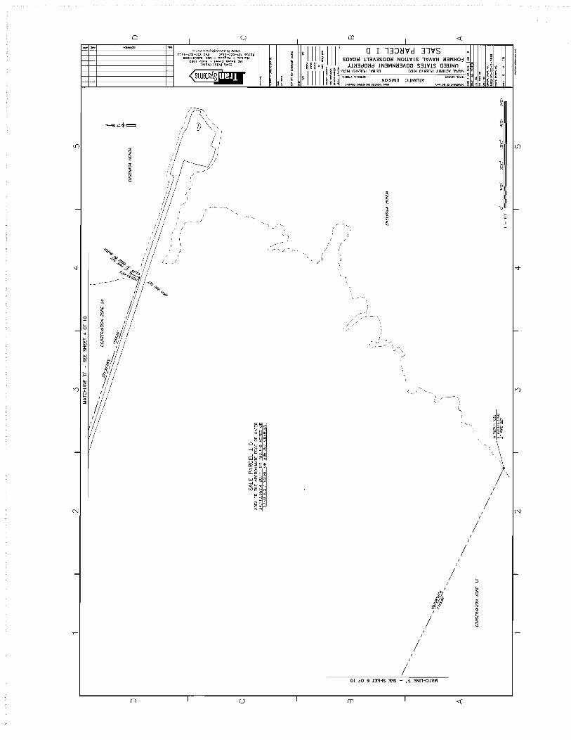
, ,
, I 'J'
-
N
-
o I u I
"-! 'j
I / I
/ I
/ /
/ II .,
, -
-/
// /
/
\
! /
-
--{- --'" '~\
v ,
-' !
/
/ !
!
/
O~ jO 9 133H5 335 ,j, 3NnH~lVri
CD I
'0 I-
I-
I , '.
I-
! !
/ I N
!
/ !
I
/ !
/ :2 -
';! <l
2 " '" iJ! 8

D
-
c
-
B
-
A
I 2 I 3 I 4 I 5
II I~ 'd/;I/ / / / {/ II I I I I IRON ROD sa I #-.-.!RON ROD SET
/1 !~/ //1 y~. ~IRONRODSET
i ' I I /~ ~~1~,,<-
I, '?~ II I,fj d IRON ROD sa "i/' ,
MATCHLINE 'po .. SEE SHEET 5 OF 10
I 1/ / /f~/'o~ (j ;S) " I I fjif'';> ~ / '"
I I "I I I I ''f' '7 ~"',. 1/,'.;' / I / // A.,.<- ~ ">*~H,. II~()' 'I //d'!:Y / // """,
;//.J II INGRESS EGRESS / / I/...,~r.., ~,4/ ... / / ! EASEMENT 23 / / Ii.~..p .~'\f. "./!/
II I II f/l Q}' ,"Y~" <1'~ ,II /1 I ;;!:J ,,"Ii' / I II V;' ",<'; / /
/1 // . "'~~. / ( SALE PARCEL I 0 ! I / N 797544.4:122 .., -:(~ / IRON ROD SET
AREA TO THE APPROXIMATE EDGE OF WATER / / 92884. 8 ".J? ... ~ t<-y 34 113 952.4 SO.FT. OR 783.149 ACRES OR / / I IRON ROD SET 3169 302.7 Sa.MT. OR 806.357 CUEROAS // I '"
I· I: / IRON ROD sa \~ 1 I ~
CONSERVAnON ZONE 13
II I ", \~ II II ~ \ \~ __________ j /1 \ \ \~. ___ _______ INGRESS/EGRESS EASEMENT 11
/1 1/ I) _~RDDsa II II J ------- --
II II / I ''''''~_--
f / ! / / .-J.::-
/ II /?---- ...... ---.-.. IAf I .~ .If -----...... --.... - .. ~ 7~#.p.p _---sJJ'~ ;71
I , '" __ / 1/ INs.p. q." --
I / ' .. / '~:'''E>. ~<f _ - -- /
,//~e ~ II ,//;J;;.;~~ ___ /_~. II // III IRON ROD sa --.....::::~~1-.. ~:::::::..--......... -....... ~ )l' ? '" Sri' - "-_. ----.::::.:-:::) J II"I /"--~_ .. ~ ~~ ..
,1 II /"-.. ~ .......... ) <7 -~-~ ......... __
/ It (C2)i~---- .. -_ .. !!...; V j,{ IRON ROD sa .. ~-~~
Ijll I Ii t!ltI ~
1/ . I SALE PARCEL I D /.{j' , " " / / / AREA TO THE APPROXIMATE EDGE WATER /~/ "" "\
/ I .'i" IRON ROD sa \ \ / /// '''}.~;Ji \ \
/ /~ ,/ c,1~1" \ I ______________ -L~~.~/~(~ ____________________________ ~_L ________ _
S4LE PARCEL 1I A
MATCHLINE 'G' .. SEE SHEET 7 OF 10
I 2 I 3 I 4
0' 1"=:=100'
T
100' 200' 300'
5
400' 500'
I ~n§
~ d!rJl'- ~
~ S~~.:~ CI':) il":l r: . m~I
.g I ~):
~~~ : ~ ~
f
----"-----. --___ """-MO<J'-'
-"~--~-- ----'---~
~8 (f)
D
I-
c
~a::>-O o ,; ",1i:~1 I B
i • ffi UJ '" !lil:~f-~ r&~ G1 0 j '" > i~ ()~~ H
~ ~~ ~ o ffiZ U o >0 a::: ~ ~g~ «I-~ 0:: ..... a.. !;;: g~(/)
O::I-...J W ~.c( c:( ---1 a.ln~ «
! ~oZ(f) ~ ~ ~~ ffi a t; ..... z::E 1 -:J.~:::J a::: , ,~ el I A :.: ~ ;,;. =~J "l(
N62470-02-0-7619

o
-
c
-
B
-
AI
I 2 I 3 I 4 I 5
MATCHLINE 'H' - SEE THIS SHEET MATCHLINE 'G' - SEE SHEET 6 OF 10
MATCHLINE 'J' - SEE SHEET B OF 10
//' .. / // / ,1>/
"l\i\\ /! // ~\~ \ \ INGRESS EGRESS EASEMENT 11 1/ //
_ ROD sa \\~\
\b~~\
",I'?. \1 Jj 1/ IRON ROO S;\\ \\ I; 1/ '\ '\ / //
/ / ~/'/~"
(/ (A~ ROD sa
~ 'i'- \ MENT 11 '%""~ <:l. \ GRESS/EGRESS EASE e~;,\y"
WATER TREATMENT PLANT ---~~'\
/'
/
--1
/
~
~
~
~r"~ \
/'~\ \ / ::L \\
~
'I PARCEL 18 \~
: \ ):1
~~~=l / / H ~\~ 1\\ ?I'? \ ~\. \
1\ \ 1\ \
/ CONSERVATION ZONE 5
MATCHUNE 'H' - SEE THIS SHEET
I 2 T
\0. ~, J/I/ ~ ~, /;/ // "'<~-~-.... ,...--/ / ?~-2 ~------;;/ //-;
~:..:.>)'. ---.--- /' /' '''''..?~ .-//
-:.-:.~.:::/- /'
!' \ '" \2
SALE PARCEL I D AREA TO THE APPROXIMATE EDGE OF WATER 34 113952.4 59.FT OR 783.149 ACRES OR
.3 169 302.7 Sa.Mr. OR 806.357 CUERDAS
, __ / ..... SALE PARCEL ][ A
,~-Jr ~ ,/)7,,'}.. /-~Dsa ~
f!C Il,,\;; "t.1s~ ,// ~
t \ .. /
.~r,'ffl., ,-~'J~
~~~ / ~~~i~ // '\ s,s~.,'!!0aH ROD sa ~2.01.''l.
\
CONS£RVAnON ZONE 5
IRON ROO SET
0' 100' ZOO' 300' 400' 500' 1"",,100' I""'""
3 T 4 T 5
~
.:
i u~
~ ~:j ';E::!a
$X~ I ~ ~ ~~ ~
~ ~ f
E
"" -------------"----<----"""""'"./ ...... ~-.---~-- ---.......,..-,._--
i I ~>-~ u .0""..:( , ,~"'O 5 ~ ~:t a:: I < ~O'" 9 ~g:~O 2 ~ ... w H t Z zen ~~ w 8 --.J ~ ~a:: W
o
I-
c
B
o eJz U
go~~~1-~ ~e,:)~ CL ....., 0 VI (f)
<: li:~...J W ~ c( < ---1 ~ln~ «
E ~ClZV1 ~ i'i twa:: 'i: ~ <!:: t.a.I
~ ; ~~~ ~ ~ ~ f:
H62410-02-0-7619
A

o
c
B
A
MATCH LINE 'K' - SEE THIS SHEET "T
\\ %\~ \
-~--, \,\ \ \
I
2
SALE PARCEL I D \~ ~ I
"', '~ _ROO:' \ \\ ~~ , .• v"
AREA TO THE APPROXIMATE EDGE OF WATER 34 113952.4 SO. FT. OR 783.149 ACRES OR 3.169,302.7 SO.MT. OR 806.357 CUERQA5
.......... +" ·ti;j':)' "~'" ;~ .... , j - " '~'\~~ \
.------ - ¢ <~ ~ 1 cP ..pvo... "-
fI' .q~~o.~ \
IRON ROD sa ,\ \
(~~ ~. " "d>'-;:'. \'-, .~\~ .\ ''''~J.. \ .-.. ) l._ \
/-' .•.. -.. -." ~ /~//-- IRON ROD 'Sir-~ \
/./ /' \ \
C-'-I'~rl/ '{t,; \ / ~. I
// \) 1\
I II IRON ROD sa ~I /: ! ~I
i!~ II c'"i I
~ ~ II IRON ROD S£T I'
" WATER TREATMENT PLANT '\ \ ~
\ \ \\
!,~!, \ ~" \\ ~\~\\
INGRESS/EGRESS EASEMENT 11
MATCHLINE 'J' - SEE SHEET 7 OF 10
2
3
/'
3
4
MATCH~:~ -; SEE SHEET 9 OF 10\ \
IRON ROD sa /:;'{6: \ AIRAELD PARCEL ___ --- 1 \
/' : It
/' ~I~ a'" 'I~ ¢ I 4' .
~ _S,,!"2D'W'Ir - - "D;~ ROO-:/;?=r
&~\/
CONSERVAnON ZONE 5
#""1/
--i/ ./1/
#? i f/! --I
!:l/~1 "/~,; '; ~ 'I,
IRON ROD SET .f:; J I IRON ROO SET g ~I
~!! ~ ~I ~ ~I
IRON ROD sa ~ \ I
1\
~\t ~:\
\~ ]j
MATCHLINE 'K' - SEE THIS SHEET
4
1"=100'
5
f
SALE PARCEL I D AREA TO THE APPROXIMATE EDGE OF WATER 34 113952.4 SO.FT. OR 783.149 ACRES OR 3,169,302.7 SO.MT. OR 806.357 CUEROA5
0' 100' 200' 300' 400' 500'
5
c
B

~~ .~/'
2
~'~ ~/~
~~ ~/
/'
3 4 5
AIRFIELD PARCEL
/ /.------_ ... _ ..... -._-
/:(/--------\(~-- /
MATCHLINE 'M' :)EE THIS SHE\\
/ '\ './ I/~';
7"J~6.o ~ t
;f >~
(
II // ~ I /" ~, ~"'" ' .......... "-, ",,-~~
I ,/ ~~ / // "~
~"'- ~~~~" ";, /r--~=c~==~=~~;"~\'- ?~- /:: II //" 'I ~,'- ,,~/r /1 ,,'" jV/'/-~ ",~'1
1
/ /~' u/ \\ I , ,// 'V'-(/
l
" / "',' // 'C,-"
II ,,"/ ./ // / / jff/o' ;;~
,,','/) / '
'---'" ,-" ~
~~J
AiRFIELD PARCEL
\
// ,/ ,I
r
' , / ;I , / "" ,"::'" '''''''' ! / """" , . .,,,., " /;
\
/ "".,,: ~: ,""i~ um /1/, / ' ,,",' '""" _:::,,(~ ,H,_ jl
"""~ "' !';(!' 1(-~ "'~ /:l '" ruff" "n" ':: I I
" II "1/
/ /</'
0' 100' 200' 300' 400' 500' 1"=100'
2 3
AfRFIELO PARCEL
MATCHLINE 'N' - SEE SHEET 2
IRON~::!I OF 10
///~ ( ""j}/;';:/ '\
"", /j!i-,,,,.,O"/ //' \ ; ~/ ,%/ \\
(/ /7'-)'-'</ ,//~./ /\(/~
,./ ,"" /
" '" ( MATCHLINE 'M - SEE THIS SHEET
4 5

D
c
B
A
0' 1"=100'
100' 200' 300' 400' 500'
2 3
~ t
4
INGRESS/EGRESS EASEMENT 11
5 /'
/' , /'/' /
/' /'/ /'/
// /' /:: /' /' //' /// '//
// / /~// ,1/
/'/ // // /"
/'/ // /' / ,/ /' / /// ////
/," / /' / / / /
/'// ///
;/ .I/'
/' / /' /' ' /'
/'/ //'/' /' .. (I
I I II
I ' "" /1 I ~>~ I I /;~'0~~ _- .:: I I II '-~-__ _-----"-~::-..
/ /,// /~// '\ -- --~~~~~~~~--I I II
// ~I / / /;1 1/ II
/1/ //1 / I I;
SALE PARCEL I D AREA TO THE APPROXIMATE EOGE OF WATER 34 113952.4 SO.FT. OR 783.149 ACRES OR 3169302.7 SO.MT. OR 806.357 CUERDAS
II /; / / '/
/1 /1 I I II
I / /1
II 1/ 1/ /1
/ / ;i/ 1/ I I Ii //
;i/ I'; 1/' I I
1/ / I
;; II
/ / I
I, 1/ /IR~'I/
/ __ -~'-.--__ ~, / I Is <J / /
/ /-----~:;I.,,<l(:1 ;/
// / ) vi.. IRON ROD SU I ' '-
/ I I .. ~ "-/~/ I I ,il .i:t,..",,,~,,-"- /'
/'t)¢?;1 I /1 /~:.t} . ....,,~~ "-4V 1/ I.:.r,~/~f ~ ~ "
INGRESS/EGRESS EASEMENT 23
/ ' / / / IRON ROO SET "'.so \ IRON ROD SET A,fi I, f/~' ~8~~ ~ ~
/ /1 / / / r;; CI I ( / N 798092.7913 / I /~() '\<\ .:y . '/ IRON ROD SET I CURVE: I LtNCfH ["RADIUS
.. / E 9288297J80 I, I~'I.()· ~ ")~ /". Cf /6.J.f 10.J9 / IRON ROO SET / / ;/!\'t}tii 0 ~.I / /;
CURVE; TABLE
;/ / 1/ .Jqf<V .:if "1/1/1
INGRESS/EGRESS EASEMENT 12
II II ~'V /; 1/ / /' / 0 ~// '/
I II I Qj '"~III II if' / '~,,~~s ,/11 I III' II' //1 ~ .. , // II MATCHUNE 'p' - SEE SHEET 6 OF 10
2 3 4 5
~ u. 0
"" ... i!J :I: Vl
w w Vl
I
j.J w Z ::l :I:
~ '" '"
IIIIIII n D
I ~n§
E ,,~, u
~ 3~~:~ c.-:l :9~ 1 -a . !ij~]
~ If: §~~ .,
~ J
----------__ OIIO"..o<j"""'-
.... ,-""""'-----'---"""""''''rott'''' __ _
•
118 Vl ~i'E>Cl ~ ~~~ ~ f5 LrJ a: ",,0-"'0..01-;&g:~ 0 ~I- (;j H
ZVl UJ ° .....J
gz i~
:< o
~ ~ lLJ ffizU
'-'I >00:: ~ ooi= « ~ ~~~ CL ~ ~~(f) ~~~ ~ 0..1->« ~~~(f)
~I~~ ~ t;;-,z:::E ~~:Ja::: H ~
N6Z4700Z07619
c
B
A

LEGAL DESCRIPTION SALE PARCEL I D
Beginning at a survey control point in the Ward of Guayacan, said point being a brass disk set in concrete. Said point also known as 'DOG' and having a northing of 805443.8964 and an easting of933110.4735 noted as the Point of Beginning on the plat labeled "UNITED STATES GOVERNMENT PROPERTY FORMER NAVAL STATION ROOSEVELT ROADS SALE PARCEL I D". Thence S79°51 '07"W 1568.79' to an iron rod set, the True Point of Beginning, having a northing of 805167.4912 and an easting of931566.2267:
Thence S02°46'27"E 590.00' to an iron rod set; Thence S05°53'40"W 271.67' to an iron rod set; Thence S29°31 '45"W 194.85' to an iron rod set; Thence S39°30'31"W 232.03' to an iron rod set; Thence S45°30' 46"W 496.11' to an iron rod set; Thence S07°23 '02"W 253.47' to an iron rod set; Thence S20025'28"E 446.10' to an iron rod set; Thence S45°57'09"E 649.51' to an iron rod set; Thence S27°14'03"E 434.71' to an iron rod set; Thence S19°58'29"E 96.01' to an iron rod set; Thence S21 °l7'll"E 166.07' to an iron rod set; Thence S16°28'24"E 198.53' to an iron rod set; Thence S43°11 '29"W 174.48' to an iron rod set; Thence S19°31'06"W 146.30' to an iron rod set; Thence S79°34'23"E 1457.64' to a point not set, said point referenced by a 2" pipe set at the edge of the mangroves bearing S79°34'23"E 40.93'; Thence Southwest 1481' from said point not set, along the approximate edge of water of Ensenada Honda to a point not set, said point referenced by a 2" pipe with a northing of 800054.0594 and an easting of932165.0410 set at the edge of mangroves and bearing S44°03'52"E 162.91' from point not set; Thence from said point not set, N44°03'52"W 581.55' to an iron rod set; Thence N32°10'38"W 212.43 to an iron rod set; Thence N59°52'22"W 176.42' to an iron rod set; Thence S04°17'25"W 234.59' to an iron rod set; Thence S23°14'43"W 386.08' to an iron rod set; Thence S39°11 '40"W 94.84' to an iron rod set; Thence S47°10'22"W 239.01' to an iron rod set; Thence S63°53'18"W 442.91' to an iron rod set; Thence S43°59'47"W 463.19' to an iron rod set; Thence S14°44'58"E 199.54' to an iron rod set; Thence N75°15'02"E 110.43' to an iron rod set; Thence following a curve to an iron rod set with a long chord of 394.07', chord bearing of S88°16' 14"E
Radius=694.61 ' Arc=399.55'
Thence S71°32'28"E 1543.06' to an iron rod set; Thence N25°50' 42"E 45.93' to a 2" pipe set at the approximate edge of water of Ensenada Honda; Thence Southeast along the approximate edge of water of Ensenada Honda; Thence Southwest along the approximate edge of water of Ensenada Honda 2250' to a 2" pipe set having a northing of797111.1030 and an easting of931373.0768; Thence N63°38'46"W 1745.64' to an iron rod set; Thence S48°34'58"W 613.72' to an iron rod set; Thence SlOo14'29"E 293.26' to an iron rod set; Thence S72°32' 16"W 1288.66' to an iron rod set; Thence N59°48'07"W 125.93' to an iron rod set; Thence S30014'21"W 293.69' to an iron rod set;
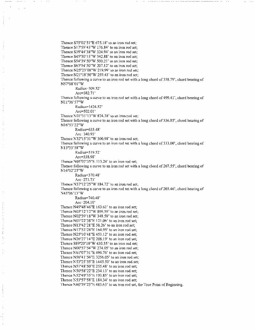
Thence S75°02'51"E 675.18' to an iron rod set; Thence S17°59'43"W 176.84' to an iron rod set; Thence S39°44'38"W 324.94' to an iron rod set; Thence S45°30'15"W 342.88' to an iron rod set; Thence S54°39'50"W 500.21' to an iron rod set; Thence S63°54'50"W 207.12' to an iron rod set; Thence N25°23'08"W 219.99' to an iron rod set; Thence N21°18'50"W 259.43' to an iron rod set; Thence following a curve to an iron rod set with a long chord of 358.79', chord bearing of N57°08'01"W
Radius=309.52' Arc=382.71 '
Thence following a curve to an iron rod set with a long chord of 499.41' , chord bearing of Nll °36' 57"W
Radius=1424.52' Arc=502.01 '
Thence N01°31 '13"W 874.38' to an iron rod set; Thence following a curve to an iron rod set with a long chord of 336.85', chord bearing of N16°53'22"W
Radius=635.48' Arc=340.93 '
Thence N32°15'31"W 300.98' to an iron rod set; Thence following a curve to an iron rod set with a long chord of 333.00', chord bearing of N13°33'58"W
Radius=519.52' Arc=338.98'
Thence N05°07'35"E 113.24' to an iron rod set; Thence following a curve to an iron rod set with a long chord of267.55', chord bearing of N16°02'25"W
Radius=370.48' Arc=273. 73'
Thence N37°12'25"W 184.72' to an iron rod set; Thence following a curve to an iron rod set with a long chord of 203.46', chord bearing of N45°06'13"W
Radius=740.48' Arc=204.1O'
Thence N49°48'46"E 163.61' to an iron rod set; Thence N05°12'12"W 899.59' to an iron rod set; Thence N02°39'18"W 348.58' to an iron rod set; Thence N01 °22'38"E 121.06' to an iron rod set; Thence N13°42'21"E 58.26' to an iron rod set; Thence N17°53'28"E 164.95' to an iron rod set; Thence N25°10'41"E 453.12' to an iron rod set; Thence N26°27'14"E 208.19' to an iron rod set; Thence S89°20'10"W 430.55' to an iron rod set; Thence NOo057'54"W 274.05' to an iron rod set; Thence N61°07'31"E 496.76' to an iron rod set; Thence N56°41 '56"E 3256.05' to an iron rod set; Thence N53°25'55"E 1445.50' to an iron rod set; Thence N51 °48'50"E 255.48' to an iron rod set; Thence N50058'22"E 234.13' to an iron rod set; Thence N52°49'35"E 193.85' to an iron rod set; Thence N53°57'58"E 184.34' to an iron rod set; Thence N60039'23"E 483.63' to an iron rod set, the True Point of Beginning.

Said parcel containing 34,113,952.4 square feet or 783.149 acres, which equates to 3,169,302.7 square meters or 806.357 cuerdas.
Said parcel SALE PARCEL I D does not include the following internal parcels:
Beginning at a survey control point in the Ward of Guayacan, said point being a brass disk set in concrete. Said point also known as 'DELVIS' and having a northing of796646.7678 and an easting of 927749.8902 noted as the Point of Beginning on the plat labeled "UNITED STATES GOVERNMENT PROPERTY FORMER NAVAL STATION ROOSEVELT ROADS BOWLING ALLEY". Thence N36°45'05"E 1804.73' to an iron rod set, the True Point of Beginning, having a northing of798092.7913 and an easting of928829.7380:
Thence following a curve to an iron rod set with a long chord of 186.1 0', chord bearing of N34°11 '56"E
Radius=21850.79' Arc=186.10'
Thence N34°18'35"E 163.30' to an iron rod set; Thence S55°42'43"E 262.55' to an iron rod set; Thence following a curve to an iron rod set with a long chord of 14.71', chord bearing of S10038'54"E
Radius=10.39' Arc=16.34'
Thence S34°24'56"W 337.39" to an iron rod set; Thence N56°02'55"W 272.34' to an iron rod set, the True Point of Beginning;
Said parcel containing 95,112.3 square feet or 2.183 acres, which equates to 8,836.2 square meters or 2.248 cuerdas.
Beginning at a survey control point in the Ward of Guayacan, said point being a brass disk set in concrete. Said point also known as 'DELVIS' and having a northing of796646.7678 and an easting of 927749.8902 noted as the Point of Beginning on the plat labeled "VETERANS HEALTH CLINIC". Thence N50037'43"E 1,415.10' to an iron rod set, the True Point of Beginning, having a northing of 797544.4322 and an easting of928843.8368:
Thence N34°24'56"E 458.65' to an iron rod set; Thence S54°36'53"E 222.75' to an iron rod set; Thence S34°51 '57"W 455.75" to an iron rod set; Thence N55°21 '36"W 219.14' to an iron rod set, the True Point of Beginning.
Said parcel containing 101,012.8 square feet or 2.319 acres, which equates to 9,384.4 square meters or 2.388 cuerdas.
Said parcel SALE PARCEL I D is subject to multiple easements as shown on plats titled "UNITED STATES GOVERNMENT PROPERTY FORMER NAVAL STATION ROOSEVELT ROADS EASEMENT 11" prepared by TranSystems Corporation and sealed by Luis Berrios Montes on XXX 2007, "UNITED STATES GOVERNMENT PROPERTY FORMER NAVAL STATION ROOSEVELT ROADS EASEMENT 12" prepared by TranSystems Corporation and sealed by Luis Berrios Montes on October 2, 2007 and "UNITED STATES GOVERNMENT PROPERTY FORMER NAVAL STATION ROOSEVELT ROADS EASEMENT 23" prepared by TranSystems Corporation and sealed by Luis Berrios Montes on October 2, 2007.

Exhibit E
Tables

Facility # Former User
86 PWD
88A PWD
161 PWD
277 CUSTOMS
292 PWD
296 NBSAFCN
298 PWD
299 PWD
300 WEAPONS
301 WEAPONS
302 WEAPONS
303 WEAPONS
305 WEAPONS
306 WEAPONS
309 WEAPONS
310 WEAPONS
311 WEAPONS
313 WEAPONS
314 WEAPONS
358 WEAPONS
359 WEAPONS
360 AIMD
384 WEAPONS
500 SOCSOUTH
501 SOCSOUTH
502 SOCSOUTH
519 SOCSOUTH
529 MWR
532 NEX
535 PWD
598 MULTI
629 MWR
640 MWR
641 MWR
643 MWR
646 SECURITY
724 MULTI
725 CBQ
726 CBQ
Table 1 Naval Activity Puerto Rico
Sale Parcel I FOST Facilities List Page 1 of 4
Name
WATER STGE TANKS TACAN SITE
MISC STORAGE
GENR BLDG FOR GMOC UHF-VHF
PIER FAC
GENERATOR BUILDING
TELEVISION STUDIO
CISTERN FOR B-296
WATER PUMP STA NORTH DELICIA
SMALL ARMS/PYROTECH MAGAZINE
MAGAZINE/3HT41
MAGAZINE/1Y31
MAGAZINE/1241
FUSE-DETONATOR MAGAZINE
MAGAZINE
FUSE-DETONATOR MAGAZINE
MAGAZINE
HIGH EXPLOSIVE MAGAZINE
HIGH EXPLOSIVES MAGAZINE
HIGH EXPLOSIVES MAGAZINES
PYROTECHNIC MAGAZINE RI
PYROTECHNIC MAGAZINE RI
JET BOOSTER
HIGH EXPLOSIVES MAGAZINE
US ARMY SOUTH
US ARMY SOUTH
SECURITY ADMIN OFFICE
C-3/7TH SFG ADMIN HDQTRS.
MWR-ROOS RDS RIDERS
ADMIN AND MAINTENANCE SHOP
WATER STGE TANKS AT BUNDY
NAVSOUTH/NCIS/PHOTOLAB/SECURITY
THEATRE
PLAYING COURT - TENNIS
BUNDY BASKETBALL COURTS
PLAYING FIELD AND FAC
GATEHOUSE #3
HIDTAlNSGAlDEFENSE COURIER
BOQ TRAN PTY W3-W-5 & 03/ABV
BOQ TRAN W3/W5 & 03/ABOVE
Area Unit Yr Built
- - 1942
378 SF 1944
164 SF 1943
650 SY 1943
- - -6132 SF 1944
- - 1944
109 SF 1961
4000 SF 1943
308 SF 1943
4000 SF 1943
3111 SF 1943
140 SF 1943
70 SF 1943
140 SF 1943
140 SF 1943
1404 SF 1943
1404 SF 1943
1134 SF 1943
1000 SF 1943
1000 SF 1943
1000 SF 1943
1350 SF 1958
6569 SF 1959
1679 SF 1957
3240 SF 1957
15704 SF 1962
18240 SF 1957
- - -5292 - 1957
27088 SF 1962
10060 SF 1957
7200 SF 1957
7200 SF 1957
108900 SF 1961
120 SF 1957
7779 SF 1959
11996 SF 1960
21207 SF 1960

Facility # Former User
727 CBQ
728 CBQ
729 MWR
730 NEX
731 CBQ
732 CBQ
733 CBQ
734 CBQ
735 MULTI
737 NAVCOMTELSTA
748 PWD
760 MWR
761 MWR
763 WEAPONS
764 WEAPONS
765 WEAPONS
766 WEAPONS
773 PWD
784 PWD
789 MWR
894 SURFOPS
1665 WEAPONS
1666 WEAPONS
1667 WEAPONS
1668 WEAPONS
1674 AIMD
1686 FBI
1687 MWR
1688 CBQ
1703 NBSAFCN
1705 PWD
1761 MWR
1762 PWD
1763 PWD
1766 NBSAFCN
1767 AFWTF
1768 AFWTF
1769 AFWTF
1770 AFWTF
Table 1 Naval Activity Puerto Rico
Sale Parcell FOST Facilities List Page 20f4
Name
BOQ TRAN W3/W5 & 03/ABOVE
BOQ TRANS W3/W5 & 03/ABOVE
FINNIGANS OFFICERS CLUB
NEX CENTRAL WHSE
BEQ
UEPH
BEQ
BEQ
SOCSOUTH/ACSS/LIBRARY
NAVCOMMSTA BUILDING
BUS SHL TR SOFTBALL FIELD BUNDY
MISC STGE BY B#760
TOILET AT SOFTBALL FIELD
MAGAZINE
MAGAZINE - 7NC5
MAGAZINE - 7NC6
MAGAZINE - 7NC7
BUS SHL TR LNGLEY/BNGTN S.
TACAN UNIT/GEN BUILDING
GOLF COURSE
RANGE LIGHT TARGET PAD 2
READY ISSUE MAG
READY ISSUE MAG
READY ISSUE MAG
READY ISSUE MAG
GND SUPPORT EQUIPT STORAGE
F. B. I. OFFICE
GYMNASIUM/FITNESS CENTER
BOQ TRANS W1/w2 AND 01/02
AM RADIO TRANSMITTER
SUBSTA BY OLD HOSP B598
PEDESTRIAN CROSSING BRIDGE
BUS SHL TR N.w. TEL EXCH
BUS SHL TR S.w. TEL EXCH
TV STUDIO COMM ANTENNA
ANTENNA POLE SUPPTD/N DELI
ANTENNA POLE SUPPTD/N DELI
ANTENNA POLE SUPPTD/N DELI
ANTNA POLE SUPOTD/NDELI
Area Unit Yr Built
11996 SF 1960
11901 SF 1960
13374 SF 1960
25051 SF 1960
31200 SF 1960
31200 SF 1960
31807 SF 1960
32899 SF 1960
29178 SF 1960
2650 SF 1959
140 SF 1964
220 SF 1962
160 SF 1962
- - -1200 SF 1962
1200 SF 1962 1200 SF 1962
60 SF -484 SF 1966
- - 1966
- - 1966 48 SF 1967 48 SF 1967
48 SF 1967
48 SF 1967 4000 SF 1969
15890 SF 1970
18500 SF 1969
49685 SF 1969
130 - 1970
- - 1960
- - -140 SF 1972
140 SF 1972
- - 1972
- - 1969
- - 1969
- - 1969
- - 1969

Facility # Former User
1771 AFWTF
1796 NEX
1927 WEAPONS
1962 MWR
1964 MWR
1970 NEX
1971 PWD
1991 PWD
1999 PWD
2006 PWD
2016 PWD
2017 PWD
2023 WEAPONS
2045 AIROPS (GED)
2048 PWD
2050 PWD
2082 MWR
2085 ACSS
2143 PWD
2145 PWD
2153 PWD
2177 PWD
2202 FSC
2206 PWD
2224 MWR
2228 AFWTF
2232 PWD
2253 PWD
2256 NBS
2262 U.S. CUSTOMS
2303 NEX
2313 NEX
2317 NEX
2318 PWD
2336 NFCU
2337 CHAPEL
2339 NEX
2357 USMC
2358 USMC
Table 1 Naval Activity Puerto Rico
Sale Parcel I FOST Facilities List Page 3 of 4
Name
ANTNA POLE SUPPTD/N DELI
NAVY EXCHANGE COMPLEX
BOMB BUILD UP AREA
SEC. STAGE BEHIND B504
GOLF DRIVING RANGE
COMMISSARY & COMM WHSE BLDG
SWGE PUMP HSE BY B#1970
STANDBY GENR BY SEC B#504
SEWAGE PUMP STA AT GOLF CSE
GENERATOR BUILDING BY GATE 3
GENR CEN ALARM LS 542
GENER HOUSE BY LS 644/CENT
BOMB BUILD UP AREA
RADAR TWRITURNTABLE TACAN
LIFT STA AT BUNDY TENNIS CTS
SEPTIC TANK/FIELD BY GATE 3
KENNEL
ELEMENTARY SCHOOL GYM
TRANSFORMER STA BY B#1688
TRANSFORMER STA BY B#724
SUB-STA "D" BY LANGLEY DRIVE
ELECTRICAL EQUIPMENT SHELTER
FAMILY SERVICES CENTER
BUS SHL TR N. DELICIAS
LIGHTED COVERED PATIO
STANDBY GENR BY AFCN B#296
LIFT STATION
RECREATION PAVILLION
MEDIA CTR ANNEX TO B-296
U.S. CUSTOMS BLDG
NAVY LODGE (120 UNITS)
McDONALD'S RESTAURANT
PLAYGROUND AREA (NAVY LODGE)
SUB-STA
NAVY FEDERAL CREDIT UNION
CHAPEL
SERVICE STAIMINI-MART
MARCOR RSVE TRAINING BLDG
MARCOR RSVE VEH MAINT BLDG
Area Unit Yr Built
- - 1969
82606 SF 1973
315 SF 1971
396 SF 1977
- - 1970
43688 SF 1979
100 SF 1979
396 SF 1977
- - 1979
- - -320 SF 1982
304 SF 1982 1000 SF 1974
- - 1985
- - 1983
- - 1983
960 SF 1985
10400 SF 1986
- - 1974 300 SF 1962
- - 1976
169 SF -9660 SF 1986 140 SF 1987
64 SF 1985 416 - 1960
- - -471 SF -1092 SF 1986
6000 SF -2000
70911 SF 1991
4500 SF 1985 -200 SY 1991
- - 1991
2880 SF 1993
11856 SF 1993
15927 SF 1993
19200 SF 1994
3500 SF 1994
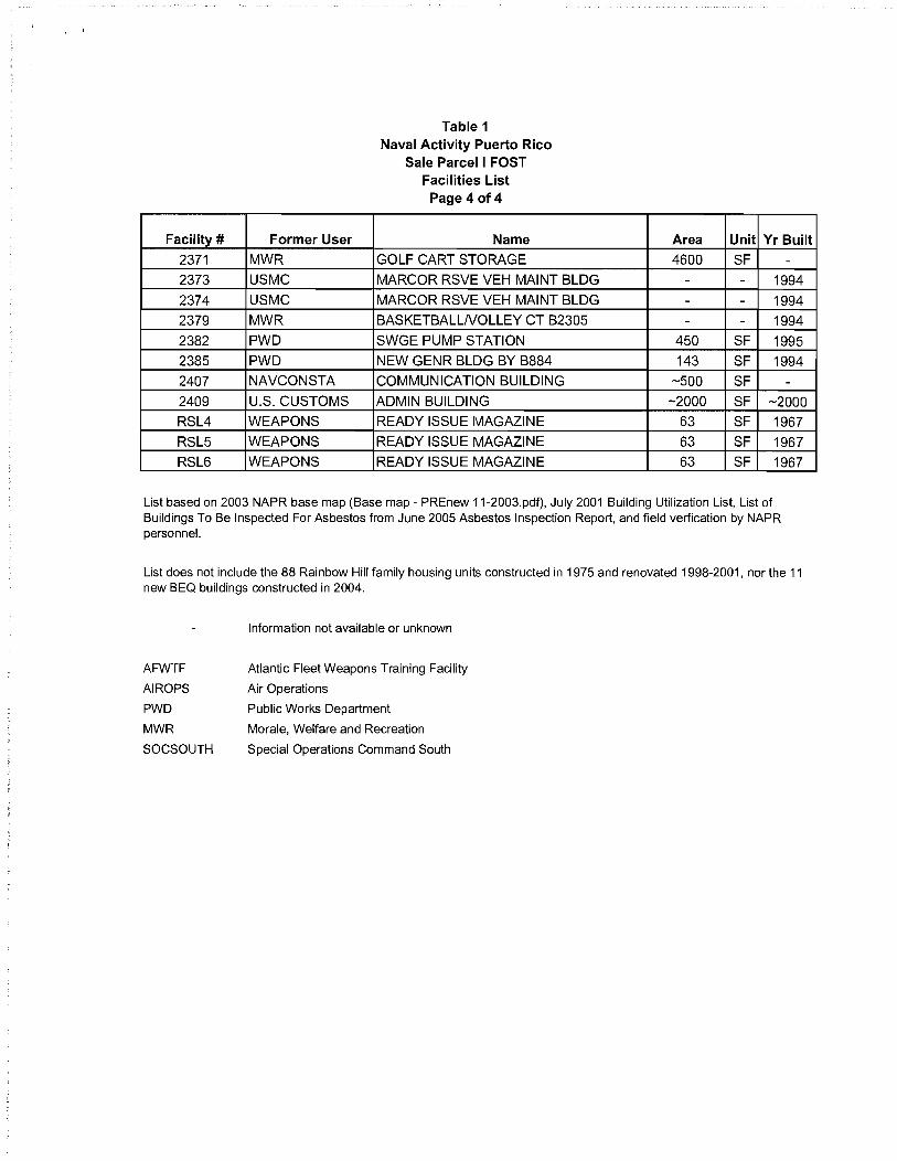
, .
Facility # Former User
2371 MWR
2373 USMC
2374 USMC
2379 MWR
2382 PWD
2385 PWD
2407 NAVCONSTA
2409 U,S, CUSTOMS
RSL4 WEAPONS
RSL5 WEAPONS
RSL6 WEAPONS
Table 1 Naval Activity Puerto Rico
Sale Parcel I FOST Facilities List Page 4of4
Name
GOLF CART STORAGE
MARCOR RSVE VEH MAINT BLDG
MARCOR RSVE VEH MAINT BLDG
BASKETBALLNOLLEY CT B2305
SWGE PUMP STATION
NEW GENR BLDG BY B884
COMMUNICATION BUILDING
ADMIN BUILDING
READY ISSUE MAGAZINE
READY ISSUE MAGAZINE
READY ISSUE MAGAZINE
Area Unit Yr Built
4600 SF -- - 1994
- - 1994
- - 1994
450 SF 1995
143 SF 1994 -500 SF -
-2000 SF -2000
63 SF 1967
63 SF 1967 63 SF 1967
List based on 2003 NAPR base map (Base map - PREnew 11-2003.pdf), July 2001 Building Utilization List, List of Buildings To Be Inspected For Asbestos from June 2005 Asbestos Inspection Report, and field verfication by NAPR personnel.
List does not include the 88 Rainbow Hill family housing units constructed in 1975 and renovated 1998-2001, nor the 11 new BEQ buildings constructed in 2004.
AFWTF
AIROPS
PWD
MWR
SOCSOUTH
Information not available or unknown
Atlantic Fleet Weapons Training Facility
Air Operations
Public Works Department
Morale, Welfare and Recreation
Special Operations Command South

Parcel
1
1
Basewide
1
Table 2 Naval Activity Puerto Rico
Sale Parcell FOST Solid Waste Management Units Summary and Status
SWMU Description CERFA' RCRA Investigation and Remedial Action Summary and Status No. Status
Waste Explosives Storage (Bldg. 1666) Less than 90 3 CAC w/out Inspected during a follow-up VSI conducted in June, 1993. No evidence of releases days accumulation point for waste explosives. Originally a Controls from this building was observed. Building has not been used since operational No Further Action site because it was a restricted access closure in March 2004, and was "explosives clean closed" and "explosives certified area when the naval station was an active facility. clean" by the Naval Ordnance Safety and Security Activity in March 2005.
16 November 2007 Phase I RFI recommended the site be designated as Corrective Action Complete without Controls. No surface or subsurface soil contamination has resulted from waste explosives storage, and groundwater is not present to a significant extent beneath the site. EPA approved the recommendation in December 2007.
Abandoned Engine Oil Drums (Bldg. 544 Area) Open 2 CACw/out No Further Action required based on RFI sampling. area where approximately 25 badly rusted, 55-gallon drums Controls of waste oil, or other substance, were observed to be lying
26 (mostly on their sides) on bare soil during the 1988 VSI. The containers were in very poor condition, and partially overgrown with vegetation. A tar-like substance was observed to be leaking onto the ground.
Sanitary and Storm Water Sewer Systems Below ground 3 CACw/out No Further Action determination from 1994 Part B Permit carried over to Consent sanitary and storm sewer systems. Controls Order. No knowledge or evidence of systematic and routine releases of hazardous
wastes. An RFI was not required. The "CAC w/out Controls" shown for SWMU 38 is contingent, under the 2007 RCRA Consent Order between the Navy and EPA, on
38 the Navy fully addressing any releases that may have impacted the sanitary and/or storm sewer water sewer systems (Le., SWMU 36) as a release(s) from either SWMUs 4, 12, 13 and 14, andlor from any other SWMU at the NAPR facility, where releases have impacted the sanitary and/or storm water sewer systems.
Fonner Pistol Range at BEQ A cleared rectangular area 1 CACw/out Eleven new BEQ housing structures have been constructed at the location of the that appeared to be unused, with ground scarring consistent Controls former pistol range. The recent construction of this area involved earthwork with a small arms range was observed on a 1958 aerial throughout the entire construction site. Due to the amount of soil that had been photograph. The records review (historic maps) identified excavated, samples were collected from the surface soil that remained to determine this area as a former pistol range. Interviews did not confirm if lead potentially present in the surface soil could cause a risk to human health
63 or repudiate use of the area as a pistol range. The ECP receptors living in these quarters. No copes were identified. VVhile two of eight physical site inspection could not detect evidence of a surface soil samples had lead concentrations greater than base background, all former pistol range because the area has been disturbed/ samples had lead concentrations less than the soil screening critera, covered by the new Bachelor Enlisted Quarters (BEQ).
II CERFA categories: 1 - CERFA Clean - areas where no release or disposal of hazardous substances or petroleum products or their derivatives has occurred, 2 - All Actions Complete - areas where the release, disposal, or migration, or some combination thereof, of hazardous substances, or 3 - Additional Action Required - Areas where a confirmed or suspected release, disposal, migration, or some combination thereof, of
Land Use Controls 1 ~ Non-Residential Use Only 2 - Soil and/or Sediment Access and/or Invasive Activity Restriction 3 - Surface Water: Access and/or Use Restriction 4 - Groundwater: Use and WeI/Installation Restriction
Acronyms and Abbreviations
BEQ Bachelor Enlisted Quarters CAC Corrective Action Complete determination CERFA Community Environmental Response Facilitation Act COPC Chemical of Potential Concern ECP Environmental Condition of Property NA Not Applicable NAPR Naval Activity Puerto Rico NFA No Further Action
RCRA Resource Conservation and Recovery Act SWaB Ship Waste Offloading Barge SVOC Semi-Volatile Organic Compound TWFF Tow Way Fuel Farm VSI Visual Site Inspection
Media Affected I Key Contaminants
NA
NA
NA
NA
Exhibit E Table 2 Clean Sale Parcell SWMUs 012808.xls
Site Specific Proposed Navy Navy Stopping Estimated Navy Remaining Work Land Use Stopping Point Point Stopping Time Required Controls
None Phase 1 RFI Completion of RFI NA None
None NFA NA NA None
None NFA NA NA None
None NFA NA NA None

· ,
Number Type 2339-1 OWS 2339-2 OWS 2341 OWS 2373 OWS 2374 OWS 161 AST 296 AST 500 AST 519 AST 542 AST 729 AST 731 AST 732 AST 733 AST 734 AST 737 AST
1211A AST 1211B AST 1796 AST 2017 AST 2228 AST
2303-1 AST 2303-2 AST 2339D AST 2357 AST 2361 AST 2407 AST 1686 UST
2339A UST
2339B UST
2339C UST
2339E UST
298 Former UST
724 Former UST
729 Former UST
730 Former UST
732 Former UST
733 Former UST
760 Former UST
1686 Former UST
1796 Former UST
1970 Former UST
NA Not Applicable
Table 3 Naval Activity Puerto Rico
Sale Parcel I FOST OWS, AST, UST List
Location or User Capacity SERVICE STATION/MINI MART -SERVICE STATION/MINI MART -NEX -PWD -PWD -PWD 500 PWD 500 PWD 1000 PWD 250 PWD 550 PWD 1000 PWD 1000 PWD 1000 PWD 1000 PWD 1000 PWD 250 MWR 1000/1000 MWR 6000 NEX 250 PWD 200 AFWTF 500 PWD 1000 PWD 500 NEX 550 PWD 500 PWD 500 PWD 1000 Bundy Laundry Building 10000
NEX Autoport 10000
NEX Autoport 10000
NEX Autoport 10000 NEX Autoport 500 CISTERN FOR B-296 300
HIDTAlNSGAlDEFENSE COURIER 5000 FINNIGANS OFFICERS CLUB 1000 Building 730 10000 Building 732 1000 Building 733 1000 MISC STORAGE BY B-760 280 FBI OFFICE 10000 NEXCOMPLEX 280 COMMISSARY & COMM WHSE BLDG 1000
Information not available or unknown
Year Year Material Stored Installed Removed
NA - NA NA - NA NA - NA NA 1994 NA NA 1994 NA
Diesel - NA Diesel - NA Diesel - NA Diesel - NA Diesel - NA Diesel - NA Diesel - NA Diesel - NA Diesel - NA Diesel - NA Diesel - NA
Diesel/Mogas - NA Diesel - NA Diesel - NA Diesel - NA Diesel - NA Diesel - NA Diesel - NA Diesel - NA Diesel - NA Diesel - NA Diesel - NA
JP-5/Empty 1996 NA Mogas/Empty 1994 NA Mogas/Empty 1994 NA Mogas/Empty 1994 NA
Waste Oil/Empty 1994 NA Diesel - 1999 Diesel - 1996
Diesel - 1996 Diesel - 1995
Diesel - 1996
Diesel - 1996 Unknown - 1993
Diesel - 1996
Diesel - 1997
Diesel - 1997

Facility # 86
88A 161 277 292 296 298 299 300 301 302 303 305 306 309 310 311 313 314 358 359 360 384 500 501 502 519 529 532 535 598 629 640 641 643 646 724 725 726 727 728 729 730 731 732 733 734
Table 4 Naval Activity Puerto Rico
Sale Parcel I FOST Asbestos-Containing Material Inspection Results
Page 1 of 3
Name ACM Identified WATER STGE TANKS TACAN SITE NI MISC STORAGE NI GENR BLDG FOR GMOC UHF-VHF N PIERFAC NI GENERATOR BUILDING NI
Comments
TELEVISION STUDIO Hazard 20 LF Pipe Insulation CISTERN FOR B-296 NI WATER PUMP STA NORTH DELICIA NI SMALL ARMS/PYROTECH MAGAZINE NI MAGAZINE/3HT41 NI MAGAZINE/1 Y31 NI MAGAZINE/1241 NI FUSE-DETONATOR MAGAZINE NI MAGAZINE NI FUSE-DETONATOR MAGAZINE NI MAGAZINE NI HIGH EXPLOSIVE MAGAZINE NI HIGH EXPLOSIVES MAGAZINE NI HIGH EXPLOSIVES MAGAZINES NI PYROTECHNIC MAGAZINE RI NI PYROTECHNIC MAGAZINE RI NI JET BOOSTER NI HIGH EXPLOSIVES MAGAZINE NI US ARMY SOUTH Y US ARMY SOUTH Y SECURITY ADMIN OFFICE Y C-3/7TH SFG ADMIN HDQTRS. N MWR-ROOS RDS RIDERS Y ADMIN AND MAINTENANCE SHOP NI WATER STGE TANKS AT BUNDY NI NAVSOUTH/NCIS/PHOTOLAB/SECURITY Hazard 6 LF Pipe Insulation THEATRE NI PLAYING COURT - TENNIS NI BUNDY BASKETBALL COURTS NI PLAYING FIELD AND FAC NI GATEHOUSE #3 N HIDTAlNSGAlDEFENSE COURIER Y BOQ TRAN PTY W3-W-5 & 03/ABV N BOQ TRAN W3/W5 & 03/ABOVE N BOQ TRAN W3/W5 & 03/ABOVE N BOQ TRANS W3/W5 & 03/ABOVE N FINNIGANS OFFICERS CLUB N NEX CENTRAL WHSE NI BEQ NI UEPH NI BEQ NI BEQ NI

· ,
Facility # 735 737 748 760 761 763 764 765 766 773 784 789 894 1665 1666 1667 1668 1674 1686 1687 1688 1703 1705 1761 1762 1763 1766 1767 1768 1769 1770 1771 1796 1927 1962 1964 1970 1971 1991 1999 2006 2016 2017 2023 2045 2048 2050
Table 4 Naval Activity Puerto Rico
Sale Parcel I FOST Asbestos-Containing Material Inspection Results
Page 2 of3
Name ACM Identified SOCSOUTH/ACSS/LIBRARY NI NAVCOMMSTA BUILDING Y BUS SHLTR SOFTBALL FIELD BUNDY NI MISC STGE BY B#760 N TOILET AT SOFTBALL FIELD NI MAGAZINE NI MAGAZINE - 7NC5 NI MAGAZINE - 7NC6 NI MAGAZINE - 7NC7 NI BUS SHLTR LNGLEY/BNGTN S. N TACAN UNIT/GEN BUILDING Y GOLF COURSE NI RANGE LIGHT TARGET PAD 2 NI READY ISSUE MAG NI READY ISSUE MAG NI READY ISSUE MAG NI READY ISSUE MAG NI GND SUPPORT EQUIPT STORAGE N
Comments
F. B. I. OFFICE Hazard 1 LF Pipe and Fitting Insulation GYMNASIUM/FITNESS CENTER Y BOQ TRANS W1!W2 AND 01/02 Y AM RADIO TRANSMITTER NI SUBSTA BY OLD HOSP B598 NI PEDESTRIAN CROSSING BRIDGE NI BUS SHLTR N.W. TEL EXCH N BUS SHL TR S.W. TEL EXCH N TV STUDIO COMM ANTENNA NI ANTENNA POLE SUPPTD/N DELI NI ANTENNA POLE SUPPTD/N DELI NI ANTENNA POLE SUPPTD/N DELI NI ANTNA POLE SUPOTD/NDELI NI ANTNA POLE SUPPTD/N DELI NI NAVY EXCHANGE COMPLEX N BOMB BUILD UP AREA N SEC. STAGE BEHIND B504 Y GOLF DRIVING RANGE NI COMMISSARY & COMM WHSE BLDG Y SWGE PUMP HSE BY B#1970 N STANDBY GENR BY SEC B#504 N SEWAGE PUMP STA AT GOLF CSE NI GENERATOR BUILDING BY GATE 3 N GENR CEN ALARM LS 542 Y GENERHOUSEBYLS64~CENT NI BOMB BUILD UP AREA N RADAR TWRITURNTABLE TACAN NI LIFT STAAT BUNDY TENNIS CTS NI SEPTIC TANK/FIELD BY GATE 3 NI
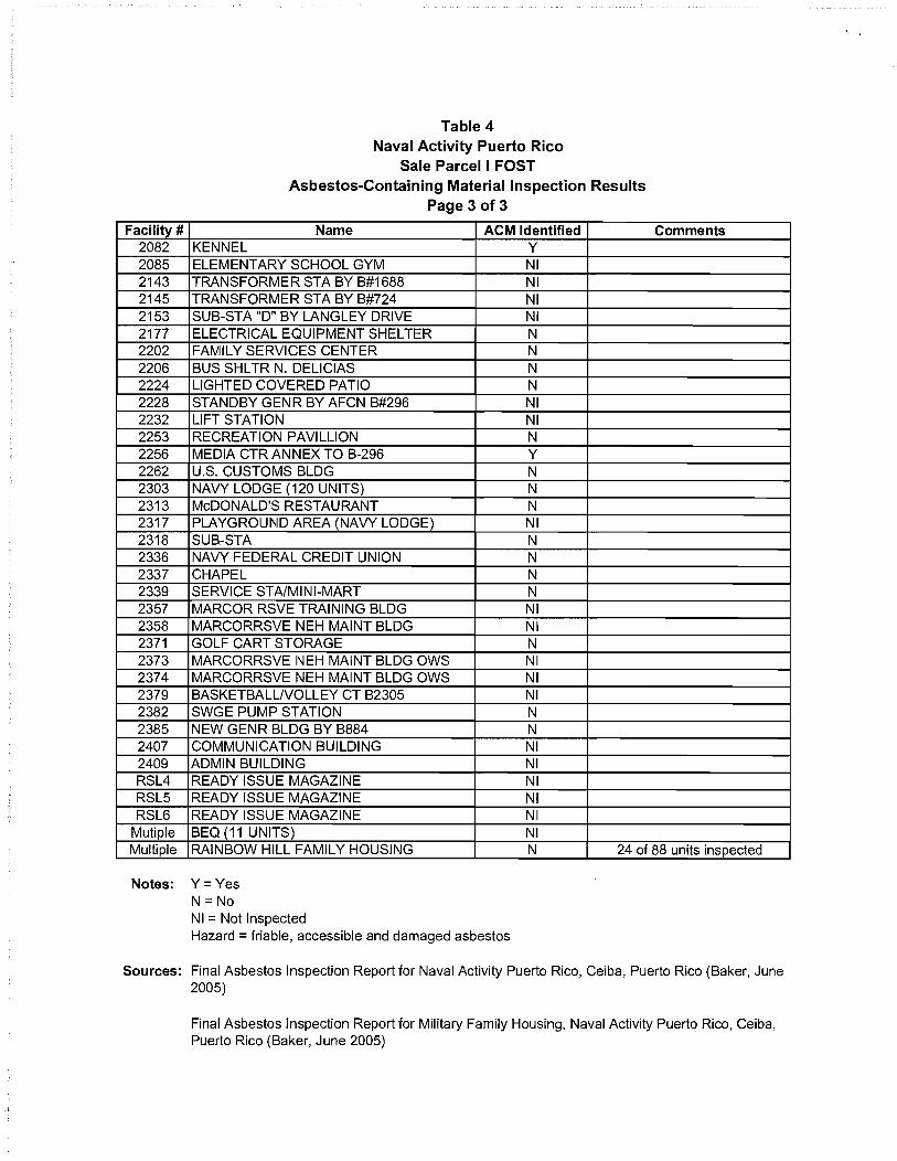
Facility # 2082 2085 2143 2145 2153 2177 2202 2206 2224 2228 2232 2253 2256 2262 2303 2313 2317 2318 2336 2337 2339 2357 2358 2371 2373 2374 2379 2382 2385 2407 2409 RSL4 RSL5 RSL6
Mutiple Multiple
Table 4 Naval Activity Puerto Rico
Sale Parcel I FOST Asbestos-Containing Material Inspection Results
Page 3 of3
Name ACM Identified KENNEL Y ELEMENTARY SCHOOL GYM NI TRANSFORMER STA BY B#1688 NI TRANSFORMER STA BY B#724 NI SUB-STA "0" BY LANGLEY DRIVE NI ELECTRICAL EQUIPMENT SHELTER N FAMILY SERVICES CENTER N BUS SHL TR N. DELICIAS N LIGHTED COVERED PATIO N STANDBY GENR BY AFCN B#296 NI LIFT STATION NI RECREATION PAVILLION N MEDIA CTR ANNEX TO B-296 Y U.S. CUSTOMS BLDG N NAVY LODGE (120 UNITS) N McDONALD'S RESTAURANT N PLAYGROUND AREA (NAVY LODGE) NI SUB-STA N NAVY FEDERAL CREDIT UNION N CHAPEL N SERVICE STAIMINI-MART N MARCOR RSVE TRAINING BLDG NI MARCORRSVE NEH MAINT BLDG NI GOLF CART STORAGE N MARCORRSVE NEH MAINT BLDG OWS NI MARCORRSVE NEH MAINT BLDG OWS NI BASKETBALLNOLLEY CT B2305 NI SWGE PUMP STATION N NEW GENR BLDG BY B884 N COMMUNICATION BUILDING NI ADMIN BUILDING NI READY ISSUE MAGAZINE NI READY ISSUE MAGAZINE NI READY ISSUE MAGAZINE NI BEQ (11 UNITS) NI
Comments
RAINBOW HILL FAMILY HOUSING N 24 of 88 units inspected
Notes: Y = Yes N = No NI = Not Inspected Hazard = friable, accessible and damaged asbestos
Sources: Final Asbestos Inspection Report for Naval Activity Puerto Rico, Ceiba, Puerto Rico (Baker, June 2005)
Final Asbestos Inspection Report for Military Family Housing, Naval Activity Puerto Rico, Ceiba, Puerto Rico (Baker, June 2005)

Exhibit F
CERFA Concurrence

CERF A Identification of Uncontaminated Property Fonner Naval Station Roosevelt Roads, Puerto Rico
Accordingly, this CERF A Uncontaminated Property Report reflects final site categorizations that may differ from those presented in the Final ECP report.
In summary, all NAPR property not otherwise identified as sites belonging to Categories 2 or 3 are classified as "CERFA Clean" (i.e. uncontaminated) as defined in CERFA [§9620 (h)(4)(A)]. The bulk of the NAPR acreage is classified as such. Of the approximately 8,400 acres ofNSRR property, about 7,000 acres have been identified as "CERFA Clean" (Le., Category 1). Figure 1 depicts the results of this classification.
Included in the CERFA Clean classification are a total of 14 SWMUs. Ten of these SWMUs were identified by EPA in the 1994 RCRA Part B permit, and an additional four sites were identified by the ECP. All 14 of these sites were originally identified based on a suspected release or disposal activity, but subsequent investigations determined that no release or disposal activity occurred. EPA has indicated their concurrence with this determination in the draft §7003 Order on Consent by designating each of these sites as having achieved "corrective action complete without controls" designation. The SWMUs and ECP sites designated as CERFA Clean are SWMUs 5, 15,20,21,22,47,48,49,50, 52,63 (ECP 9), 64 (ECP 10),65 (ECP 11), and 66 (ECP 12). These sites are presented in Table 1.
The remaining property has been classified as Category 2 or 3 and as such is not qualified for designation as CERF A Clean.
Submitted
~ BRAC Environmental Coordinator
Concurrence
Concurrence with CERF A Identification of Uncontaminated Property is indicated by signature below. This concurrence applies only to the identification of "CERF A Clean" (i.e. uncontaminated) property, identified in this document as ECP Category 1.
I I
Carlos Lopez Freyt ,President Environmental Qua ity Board Commonwealth of Puerto Rico
Date
7
· '
Exhibit G
Lead-Based Paint Hazard Advisory

LEAD-BASED PAINT HAZARD DISCLOSURE AND ACKNOWLEDGEMENT FORM
LEAD WARNING STATEMENT
YOU ARE ADVISED THAT STRUCTURES CONSTRUCTED PRIOR TO 1978 MAY PRESENT EXPOSURE TO LEAD FROM LEAD-BASED PAINT THAT MAY PLACE YOUNG CHILDREN AT RISK OF DEVELOPING LEAD POISONING. LEAD POISONING IN YOUNG CHILDREN MAY PRODUCE PERMANENT NEUROLOGICAL DAMAGE. YOU ARE FURTHER ADVISED THAT LEAD POISONING ALSO POSES A PARTICULAR RISK TO PREGNANT WOMEN. WORKERS MAY ALSO SUFFER ADVERSE HEALTH EFFECTS FROM LEAD DUST AND FUME EXPOSURE
ACKNOWLEDGEMENT
I acknowledge that:
1. I have read and understand the above stated Lead Warning Statement;
2. I have received from the Federal Government the following document(s): Phase 1/11 Environmental Condition of Property Report, Former Naval Station Roosevelt Roads, Ceiba, Puerto Rico and Finding of Suitability to Transfer, Sale Parcel I -Bundy, Naval Activity Puerto Rico, Ceiba, Puerto Rico representing the best information available to the Government as to the presence of Lead-Based Paint and Lead-Based Paint hazards for the non-family housing buildings covered by this Transfer. I have also received the Final Lead-Based Paint Inspection/Risk Assessment Reportfor Military Family Housing, Naval Activity Puerto Rico, Ceiba, Puerto Rico representing the best information available to the Government as to the presence of Lead-Based Paint and Lead-Based Paint hazards for the family housing buildings covered by this Transfer;
3. I understand that my failure to inspect, or to become fully informed as to the condition of all or any portion of the property offered will not constitute grounds for any claim or demand for adjustment or withdrawal of any bid or offer made after its opening or tender; and
4. I understand that upon execution of this Transfer, I shall assume full responsibility for preventing future lead exposure by properly managing and maintaining or, as required by applicable Federal, state, or local laws or regulations, for abating any lead-based paint hazard that may pose a risk to human health.
Transferee (or duly authorized agent) Date

.' v
Exhibit H
Responses to Comments
(Note: Review comments were received from EPA only.)
Navy Responses to U.S. Environmental Protection Agency (EPA) Comments
Draft Finding of Suitability to Transfer
Sale Parcel I - Bundy
1. Section 2.0 (Description of Property): The term Subject Property needs to be clearly defined. The text in this section needs to be revised to make clear that the Subject Property does not include SWMUs 1, 2, 54, 61, 62 and 71, even though those SWMUs are wholly or partially surrounded by Sale Parcel I. Likewise, the text in this section needs to make clear that the Subject Property does not include the three AOC F areas shown on the parcel Index Map 33- to be included within Parcel 3 (refer to Exhibit C of the FOST). Also, the text should specifically say that all SWMUs and AOCs shown on the Parcel Maps in Exhibit C of the FOST as having "cleanup remaining", are not included in the Subject Property. In addition, please confirm that the area of approximately 1368 acres cited in Section 2.0 accurately reflects the Subject Property boundaries under the Draft FOST, and what is depicted in Exhibit B (see also comment 5.b below).
Navy response:
The following text was added to Section 2 to clarify which SWMUs are not included in the sale parcel-
As shown on the vicinity map in Exhibit B, the Subject Property does not include ten non-contiguous areas wholly or partially surrounded by Sale Parcel I. These areas total approximately 155 acres and are comprised of Area of Concern (AOC) F (four locations) and Solid Waste Management Units (SWMUs) 1, 2, 54, 61, 62 and 71. These areas were carved out of Sale Parcell because they are Resource Conservation and Recovery Act (RCRA) SWMUs and AOCs with work remaining to be completed under the Administrative Order on Consent (Consent Order) that sets out the Navy's corrective action obligations under RCRA. Furthermore, the SWMUs cannot be included in the transfer of Sale Parcel I because all necessary remedial actions have not been taken prior to transfer as required by Section 120(h)(3)(A)(ii)(l) of the Comprehensive Environmental Response, Compensation, and Uability Act (CERCLA). The Navy and the winning bidder in the public auction of Sale Parcel I will execute a lease in furtherance of conveyance for the carve-out areas. Upon successful completion of all necessary remedial actions by the Navy, the leased property will be transferred to the new owner of Sale Parcell.
The following text was added to Section 2 to clarify that all SWMUs and AOCs shown on the Parcel Maps in Exhibit C as having "cleanup remaining" are not included in the Subject Property. -
The areas shown on these maps as having "Cleanup Remaining" correlate to AOC F and SWMUs 1, 2, 54, 61 (shown as ECP 7), 62 (shown as ECP 8) and 71 (shown as ECP 17), and are not included in the Subject Property.
The Subject Property area of approximately 1368 acres cited in Section 2.0 has been revised to approximately 1351 acres based on subtracting the applicable
1

SWMU and AOC acreages (approximately 170 acres) from the total Sale Parcell acreage of 1521 acres.
2. In Sections 4.0 A. (Hazardous Substance Contamination)
a. The text should be revised to specifically say that those SWMUs and AOCs shown on the Parcel Maps in Exhibit C as having "cleanup remaining" (Le., SWMUs 1, 2, 54, 61, 62 and 71, and AOC F), are not included as part of the Subject Property.
Navy response:
The following sentence has been added to this section -
The Subject Property does not include the areas shown on the parcel maps in Exhibit C as having "Cleanup Remaining" (i.e., SWMUs 1, 2, 54, 61/ECP 7, 621ECP 8 and 71/ECP 17).
b. The text needs to indicate that although no RFI was required for SWMU 38 (Sanitary and Storm Sewer System) and a Corrective Action Complete determination was made for that SWMU, under the 2007 RCRA Consent Order these determinations are contingent on the Navy fully addressing any releases that may have impacted the sanitary and/or storm sewer systems as part of the corrective action( s) for releases from SWMUs 4, 12, 13 and 14 and/or any other SWMU at the facility where releases have impacted the sanitary and/or storm water sewer system.
Navy response:
The text now reads as follows -
An RFI was not required at SWMU 38 (Sanitary and Storm Sewer Systems) based on research, interviews and visual inspections. Under the Consent Order, this determination is contingent upon the Navy fully addressing any releases that may have impacted the sanitary and/or storm sewer systems as part of the corrective action(s) for releases from SWMUs 4, 12, 13 and 14, which are not in the vicinity of the Subject Property, and/or any other SWMU at the NAPR facility where releases may have impacted the sewer systems.
3. In Section 4.0 C (Condition of Property Classification), the text in the last paragraph needs to be modified to indicate the transfer of the CERFA Category 3 areas of the Subject Property (Le., portions of SWMU 38, the Sanitary and Storm Sewer System) is appropriate at this time, since under the 2007 RCRA Consent Order between the Navy and EPA, the Corrective Action Complete determination for SWMU 38 is contingent on the Navy fully addressing any releases that may have impacted the sanitary and/or storm water sewer system (Le., SWMU 38) as a release(s) from either SWMUs 4, 12, 13 and 14, and/or from any other SWMU at the NAPR facility where releases have impacted the sanitary and/or storm water sewer system.
2

Navy response:
The text has been modified to read as follows-
The portion of SWMU 38 (Sanitary and Storm Sewer System) on the Subject Property is transferable because it was designated Corrective Action Complete Without Controls by EPA in the Administrative Order on Consent (Consent Order) signed on 29 January 2007. This determination is contingent upon the Navy fully addressing any releases that may have impacted the sanitary and/or storm sewer systems as part of the corrective action(s) for releases from SWMUs 4, 12, 13 and 14, which are not in the vicinity of the Subject Property, and/or any other SWMU at the NAPR facility where releases may have impacted the sewer systems.
4. Exhibit B (Vicinity Map) - the legend on the map needs to be modified to include a color key or symbol which clearly identifies those areas within the boundaries of Sale Parcel I that are not part of the "Subject Property" under the FOST. Also, the figure should be modified to show the approximate locations of SWMUs 26 and 63, which are wholly within the Subject Property, and those portions of SWMU 38 that transect the Subject Property.
Navy response:
The suggested edits to the Vicinity Map have been made. Because the scale of the map is not conducive to display SWMU 38 clearly along with the other SWMUs, a separate map has been inserted that shows the extent of sewer lines in the NAPR sale parcels.
5. Exhibit C (Parcel Maps):
a. The legends on the Parcel Index maps should be modified to make clear that all areas labeled as having "cleanup remaining', are not part of the Subject Property under the FOST.
Navy response:
Modification of the Parcel Index maps is not possible. These maps are from a previous report for which the electronic files are not readily available. We have added the following explanatory text to the Exhibit C cover sheet-
NOTE: The parcel maps in this exhibit are from the Draft Report, Parcel Map for the Disposal of Naval Activity Puerto Rico (GMI, 2005).
The areas shown on these maps as having "Cleanup Remaining" correlate to Area of Concern (AOC) F and Solid Waste Management Units (SWMUs) 1, 2, 54,61 (shown as ECP 7),62 (shown as ECP 8) and 71 (shown as ECP 17), and are not included in the Subject Property.
ECP 9 in Parcel 25 is now known as SWMU 63. The boundaries of the ECP, SWMU and AOC areas shown on these maps are approximate and have changed since the draft parcel map report was produced, thus they do not match
3

the boundaries shown on the vicinity map (Exhibit B), which are also approximate. Furthermore, since the draft parcel map report was published, the northern boundary of Sub-Parcel 27 has been shifted approximately 700 feet to the south.
The survey maps in Exhibit 0 provide the final boundaries for the Subject Property.
b. The outline of the parcels shown on certain of the Parcel Index maps in Exhibit C, for example the map of Parcel 25 (labeled "Parcel Index 25-3"), differ substantially from the depiction of the Sale Parcel I boundaries shown on the map given in Exhibit B (Vicinity Map). Please revise the Parcel Index maps in Exhibit C and/or the map in Exhibit B, so that the outlines of the individual sub-parcels shown in Exhibit C accurately reflect what is the intended Subject Property under this Draft FOST.
Navy response:
See response to Comment 5. a.
6. Please add footnotes to Table 2 (Solid Waste Management Units Summary and Status) of Exhibit E to indicate that:
a. CAC means Corrective Action Complete determination; and
Navy response:
The word "determination" has been added to the definition for CAC in the footnotes of Table 2.
b. The "CAC w/out controls" shown for SWMU 38 (Sanitary and Storm Sewer System) is contingent, under the 2007 RCRA Consent Order between the Navy and EPA, on the Navy fully addressing any releases that may have impacted the sanitary and/or storm water sewer system (Le., SWMU 38) as a release(s) from either SWMUs 4, 12, 13 and 14, and/or from any other SWMU at the NAPR facility, where releases have impacted the sanitary and/or storm water sewer system.
Navy response:
This text has been added to the SWMU 38 description under the Investigation and Remedial Action Summary and Status column of Table 2.
7. References - January 2007 Administrative Order on Consent should be listed in the reference section.
Navy response:
The Consent Order has been added to the reference section.
4

FINDING OF SUITABILITY TO TRANSFER (ADDENDUM)
SALE PARCEL 1- Bundy
NAVAL ACTIVITY PUERTO RICO CEIBA, PUERTO RICO
Prepared by:
Department of the Navy Base Realignment and Closure
Program Management Office Southeast 4130 Faber Place Drive, Suite 202
North Charleston, South Carolina 29405
April 2012

SECTION
FINDING OF SUITABILITY TO TRANSFER (Addendum) SALE PARCEL I- BUNDY
NAVAL ACTIVITY PUERTO RICO
TABLE OF CONTENTS
1.0 REVISIONS ...................................................................................................................................... 1
2.0 SUITABILITY DETERMINATION .................................................................................................... 2
APRIL 2012

1.0 REVISIONS
FINDING OF SUITABILITY TO TRANSFER (Addendum) SALE PARCELl-BUNDY
NAVAL ACTIVITY PUERTO RICO
This document serves as an addendum to the Finding of Suitability to Transfer, Sale Parcel I -
Bundy, Naval Activity Puerto Rico dated 24 January 2008. This document is being revised based
on the recent completion of field activities and review of environmental restoration documentation.
for Solid Waste Management Unit (SWMU) 1, Former Army Cremator Disposal Site located on
the subject property.
The following revisions should be made to the FOST in the sections outlined below
Section 2.0 Description of Property
Add the following paragraph:
Sub-parcel 25 now includes Conservation Zone (CZ) Parcel 69. This parcel was formerly part of
the carve-out parcel SWMU 1. The survey map provided in Exhibit D Addendum provides the
final boundaries for this sub-parcel.
Section 3.0 Past Use and Proposed Reuse
Add the following paragraph:
The property within CZ Parcel 69 will be transferred via a Public Benefit Conveyance to the
Commonwealth of Puerto Rico Department of Natural Resources for reuse as a conservation
area.
Section 4.0 Environmental Findings
Add the following paragraph:
A. Hazardous Substance Contamination
In the RCRA Consent Order, the property within CZ parcel 69 was part of SWMU 1,
however subsequent field investigations and reporting have determined the property has
not been impacted by the past storage, release, or disposal of hazardous substances
and/or petroleum products.
APRIL 2012

FINDiNG OF SUITABILITY TO TRANSFER (Addendum) SALE PARCEll· BUNDY
NAVAL ACTIVITY PUERTO RICO
2.0 SUITABILITY DETERMINATION
NOW THEREFORE, based on my review of the information contained in this FOST addendum,
the notices discussed herein, and the restrictions and covenants that will be contained in the
deed, the Subject Property is suitable for transfer.
_1~ __ !.:!f-~-~~--;?-~-!-~-------------Date
2
~AN~£~~=--"" Director BRAC Program Management Office Southeast North Charleston, South Carolina
APRIL 2012

FINDING OF SUITABILITY TO TRANSFER (Addendum) SALE PARCELl-BUNDY
NAVAL ACTIVITY PUERTO RICO
Exhibit D
(Addendum)
Survey Maps
3 APRIL 2012

D
c
B
A
2 SURVEY NOTES:
1. BOUNDARY SURVEY PREPARED BY TRANSYSTEMS CORPORATION FROM fiELD DATA COlLECTEO IN 2006 AND 2001. fiELD PROCEDURES, CALCULATIONS AND FINAL PLAT HAVE BEEN REVIEWED fOR CotnENT BY lUIS BERRIOS MOIITES lie ASSOCIATES Of VEGA BAJA. PUERTO RICO.
2. HORIZOIlTAL COOROINATES SHOWN HERE:otl ARE IN FEEJ AND REFER TO THE PUERTO RICO/VIRCIN ISWiD STATE PLIJlE COORDINATE S'I'STEM, too 63 (1997 ,A,OJUSTMEHT). HORIZONTAL COORDINATES WERE OERrlED USING DUAL FREQUENCy GPS RECEIVERS AND ARE REFERENCED TO NATIONAL GEODETIC SURVEY MONUMENTS ANGEL (PIO A09997), FAJARDO (PIO AB9aJ4). HUMACAD 2 (PIO "99846) AND 10.11 BRITTON (PIO AB9835).
J. THE FOLLOWING PLATS AND DEEDS WERE USED TO ESTABUSH THE BOUNDARY UNES PS SHOWN ON THIS PLAT:
A) PLAT TITLED ·uNITES STATES GOVERNIAENT PROPERlY fORMER tf"VAL STATION ROOSEVELT ROADS BOUNDARY REE5T,I,aUSHI.\EHT SURVEY" PREPAREO BY TRANSYSTEMS CORPORATION Aim LUIS BERRIOS MONTES. NAVFAC DRAWING No. 4522929; OATEO FEBRUARY 15, 2005.
04. PlANIMETRIC OATA mo SHOREUNE PROVIDED BY HOGGARD EURE IISSOCIATES PORTSMOUTll, VA ,l,ERIAL SURVEY PERFORMED BY: AERO-DYNAMICS CORPORATION CHARLOnE N,C. SURVEY flOWN FEBRUARY 199a,
5. NOTE: THIS PLAT SHOWS EllSEMENTS OF" RECORD FOUND IN THE NAVY REAl ESTATE OFfiCE. THIS PLAT MAY NOT SHOW ALL GRAHTS OR fASEMENTS THAT COULD AFfECT SUBJECT PROPERTY.
.............. " ' .....
' .....
Lr!1EHD. CottCR-ETE MONUMENT FOlmo
IRON ROO SET
PROPERTY UNE
FENCE UNf:
2
1/(;' 0. ~~9" .. ;If'"
~ t
SWMU 28
3
3
4 5
ATLANTIC OCEAN
FAJARDO
LOCATION MAP NOT TO SCALE
NAVAL ACTIVITY PUERTO RICO
7/ /( < i;r-...~-~. ____ ~"- ~-,/'\, .A A'i.7 _ •• _ __'ii'. l:C~'O
NOT TO SCALE
"-~s
'J.~.,-__ 5(~ )~>"'".
/;/(, ---'::-~1""" Ie ~, . '7 : ~~~.
, )~.,... \
i SWMU ~~~,-! z. '~~"'>~ I ..-/"-. " ", J.,.~-;; : -r--', ,/ .-l.... ./ 'y'
"'Z-./ CZ 69
....... ....... ....... ....... " ............... I
"'-.- .'
;/ CERTIFICATION
I, LUIS BeRRIOS t.lONTES, CERTIFY tHAT THE mFORIlATlON THAT FOLLOWS REPRESENTS FAITHFULLY lrHAT 1 FOUND PHYSIC}JJ.Y ON THE GROUND AND/OR BY THE INVES11GATIDNS THAT HAD BEEN IrLADE BY WE.
Dille :\\-z.o;\Ul\('" ~Y2;-LUIS BERRIOS MONTES
Suneyor Ucenlle No. 6669
4
.~~~~~~~k~:~,", J,~O~,,",, (ft1) "'_Alt
,.a. .. • .... V,I .. "' .. '.t.
5
.=
i g~~s
""" "';;;t; 0 E Io.snr-~ .E3 ~~~2 a O'J l.q~.8
c75' 1i~ I ~ ;::~ ~ ~ . ~1b f-& I 'I' ~
~~~ -I
f
-----------------"-----...,-~~---M ___ _ -------
D
c
~8 (f)
I ~ ~~~I I B ~ ~ ffi "" '" ~ ~~g,~Vl ~ ~lf~UJ ~ tlo-~ I-lil ~giii ~ ~'" C "'ZU
""00
~(J 8i;~ <I: ",00- "'-
111111 :::> '< ffil!!-':::t ~~~ ~ !1~Z (/)
zr;l.lJQ:: ~<t-I.LJ ~,.JZ~ n"'el IA I.NO._11111
.. loS NOTED
;;;:;;;:--
":--
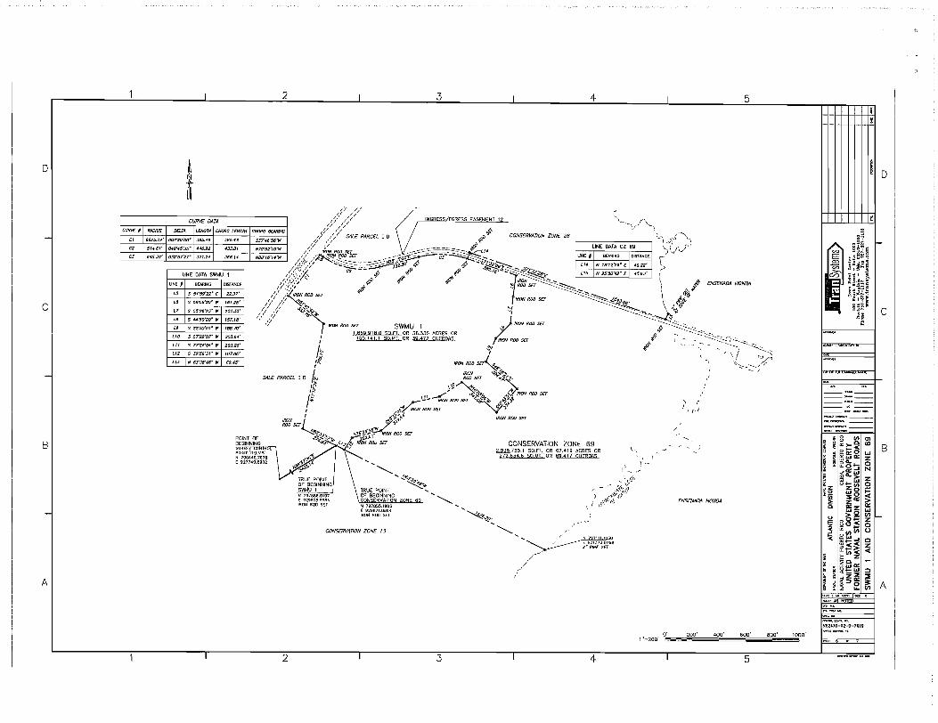
o
CUR\IF I - CI
C'
CJ
CI
B
-
A
! t
i
CHORD LENGTH
-#33.01
366.14
2
CHORD Bf:ARfNG
S3T46'56"W
N7S'S2"O"'W
NSS'16',.f."W
i 3 I 4 I 5
## ~ // /~/ INGRESS EGRESS EASEMENT 12 '-_"', (/,--\
,t,' ',/ ,_ ,
/,;./ /) C'"ALE PARCEL lOr$) ,,0. CONSfRVAnON ZONE 26 'l.,\ <,,{ ...... \,. // ,..,/ ""'" ~ , if; . )
/;? {/ __ -=_-::..~.:::. ___ ~-$ LINE DATA CZ 69 )\,l\../' // "~#Q/:O#o5qu __ -'O~'ij--~;~;2;;;~~1fi/~4 U«E * I BE.f.RIHG IOISTANCE \'
/</v ,~r..s-~;'~ __ :::.:::.~·J..5jO· ..p ..p ... --&"~~ i14 N 18"12'29- E 4922' ".
UNE DATA SWMU 1 /<~~'/' ...... ~=-:?=~ 302. # ~ffJ ..1d"~J'6".J"~~~ us N 25'50'''2- E 4593' ,...-
/-::;;;,:;;; '" 4> ~ p' ~IRON ~~ ""-- \ ~ ENS[NAIJA HONDA UNE I BEARING
L5 S 54"59'22" E
L6 S 08'06'20· It'
L7 S 05"28'23" If
" S 44'"50'20· If
L9 S 22'30'0'" It'
S 57'22'07" It'
LII S 77'26'5." It'
LIZ S .12'56'3'" It'
LIJ N 63'38'46" It'
I
I,'~-'I ~ '0 ROD SIT <:::::::=~ , t..,.'t:' /~/,y// ~ri .... ~~ \ o/oX
/ I ,::/.fRON ROO SET IRON ROD SET -'~Qa. \ h I~/ /? ~.... '" ~~~ \ ~~~
/ I /1 <t.o~';>:, "", ~~" __ ~Irj 't' </ ,;/ '~.:':» I-, IRON ROO SET ~-... ~<:?.:::..:......, ~
" IRON ROD sa SWMU 1 ,,11 4; -"'_ ... --.~ 1 669918.0 sa.FT. OR 38.336 ACRES OR ...... . ~_':::::::-<::'--.'-_.
I 1551411S0MT.OR39.472CtJERDAS fRON ROO sa ~I ~ _ _ ___ -:::---.::...--.~ ___ I !;}I .f - _~,: "-...... ,::::: __ -)
1$ ~' \/ :~:" ~ ---. ~~. , '\P. __ .-IRON 'ti,..(d'.,;.
S4L£ PARCEL I 0 I~ 0 ROO SET .~~/~ ,."1 \..\"A~~ 4. ,~ I .-/''''' ~$f. .q. IRON ROO SET
I::: ~... IRON ROD SET ~o~4,_ ,."Ji".,"-~. r .~." ,A~,·· Y' IRON ROO sa '-J'I 'li
" j$~~"~ IRON ROO sa IRON ~ r"'J'C}' ~os£r ~ ..
DISTANCE
22.37'
161.28'
201.30'
157. IS'
188.70'
200.84'
203.26'
107.06'
69.-45'
~ ; "\1·'
~~"".9' 576'~~~' IRON ROO sa POINT OF ..:> .... 6" ... "'::'H- 22.2. 8EGINNING • .9.}'. (~.". ~ IRON ROD sa CONSERVATION ZONE 69
2936755.1 SO.FT. OR 67.419 ACRES OR 272 834.6 SO.MT. OR ~AS
SURYEY CON R L " POlNT 'OELVIS' N 796646.7678 .... (927749.6902 .... ~ .....
2
~"~'" TRUE POINT ........
~ ~~:~g~:~~~~ g~N~~W~~h~N ZONE 69 ~ IRON ROO SET N 797655.1903 ........
(929871.0894 ~ IRON ROO SET <S;$~
CONSERVATION ZONE 13
I 3
~ . ........ I N 797111.1030
,/,/"
I
................ ~ ~ 2-P/P£S£T
I~--' ,..
4
1·\
\', \, \ ;-
ENS£NADA HONDA
1 "=200' 0',,~==2;;;0,"0_' ="'."0"0·=,,,,,,6,,0"'0·=-"'8:;;00.,·= ..... '000·
I 5
I ~n~
E .~~" E3 'i~i~e ~ UU;'!l
C/J :911 1 ~
~~~=g . ~~~~!!
~I'fe: §~~ ; ~J
1.«;!M'Y-YonSl.llC\Ult
---;;<
-----------------~-------,---------------
o
I--
C
~ 8 CIJ en i p~~ U) I B i g ~ffi~ ~
~ ir2:i!:j 0 ~ ''''", N § ~Q.i::i z ~z u!z(f) Q ~~ ~g ~
:;: z'" > o O::z a:::
~2 ~ I--! o0!c; Z ~uln 8 '< ~~-I C
~~~ ~ 1; z ~o
~I ~ffil => ~ z::E::E d:>~ ~I A
COC>t~. NO.-" ISlIE
~ AS NOTED
N62470-01-0-76IV

EXHIBIT "E"
DEPARTMENT OF DEFENSE INSTRUCTION 4165.72
4812-2028-0850.3

Department of Defense
INSTRUCTION
SUBJECT: Real Property Disposal
References: (a) DoD Directive 4165.6, "Real Property," October 13, 2004
NUMBER 4165.72 December 21, 2007
USD(AT&L)
(b) DoD Directive 4275.5, "Acquisition and Management ofIndustrial Resources," October 6, 1980
(c) DoD Instruction 4165.69, "Realignment of DoD Sites Overseas," April 6, 2005
(d) DoD Directive 5110.4, "Washington Headquarters Services (WHS)," October 19,2001
(e) through (v), see Enclosure 1
1. PURPOSE
This Instruction:
1.1. Implements policy and assigns responsibility pursuant to Reference ( a) for the disposal of real property.
1.2. Re-delegates various statutory and regulatory authorities and responsibilities relating to real property disposal.
2. APPLICABILITY AND SCOPE
This Instruction:
2.1. Applies to the Office of the Secretary of Defense, the Military Departments (including their Reserve components), the Office of the Chairman of the Joint Chiefs of Staff, the Combatant Commands, the Office of the Inspector General of the Department of Defense, the Defense Agencies, the DoD Field Activities, and all other organizational entities in the Department of Defense (hereafter referred to collectively as the "DoD Components").
2.2. Applies to all DoD real property holdings except:
2.2.1. Civil works projects.
DoD! 4165.72, December 21,2007
2.2.2. The acquisition and management of defense industrial plants that are governed by DoD Directive 4275.5 (Reference (b)).
2.3. Does not apply to DoD real property holdings:
2.3.1. Disposed of pursuant to a base closure law, except for paragraphs 5.1.2., 5.5., 5.8., 5.9.,5.10., and 5.11., which do apply.
2.3.2. Outside the United States with regard to those provisions oflaw not having extraterritorial application. (See DoD Instruction 4165.69 (Reference (c))).
3. DEFINITIONS
3.1. Consistent with DoD Directive 5110.4 (Reference (d)), for purposes of the Pentagon Reservation, Washington Headquarters Services shall be considered a Military Department and its Director the secretary thereof.
3.2. Other terms used in this Instruction are defined in Joint Publication 1-02 (Reference ( e)) and section 101 of title 10, United States Code (U.S.c.) (Reference (f)).
4. RESPONSIBILITIES
4.1. The Under Secretary of Defense for Acquisition, Technology, and Logistics (USD(AT &L)) shall establish overarching guidance and procedures regarding the disposal of real property.
4.2. The Deputy Under Secretary of Defense for Installations and Environment (DUSD(I&E)), under the USD(AT&L):
4.2.1. Shall provide additional guidance and procedures for the implementation of DoD real property disposal policy and this Instruction.
4.2.2. Is hereby re-delegated, with authority to re-delegate, all those authorities and responsibilities delegated or re-delegated, as the case may be, to the USD(AT &L) under paragraph 5.1.3. of Reference (a) that relate to the disposal of real property.
4.3. The Secretaries of the Military Departments shall:
4.3.1. Establish programs and procedures to dispose of real property that conform with applicable law and the policies, guidance, and procedures provided by and pursuant to Reference (a) and this Instruction.
2

DoD! 4165.72, December 21,2007
4.3.2. Accurately inventory and account for the real property under their jurisdiction, management, and control in accordance with DoD Instruction 4165.14 (Reference (g)).
4.4. The Heads of the DoD Components shall:
4.4.1. Ensure compliance with this Instruction.
4.4.2. Provide, within 45 days after a Military Department gives notice of the availability of real property for which a DoD Component has a requirement, a fIrm commitment to take real property accountability for the property in the case of a Military Department, or a fIrm commitment from a Combatant Command, Defense Agency, or DoD Field Activity that it requires the property and has secured the agreement of a Military Department to accept real property accountability for the property. A Combatant Command, Defense Agency, or DoD Field Activity that is supported by a specifIc Military Department for its real property requirements will communicate its requirements through that Military Department.
5. PROCEDURES
5.1. Disposal of Real Property. The programs of the Military Departments shall ensure that, after screening with the other DoD Components, real property for which there is no foreseeable military requirement, either in peacetime or for mobilization, and for which the Department of Defense does not have disposal authority, is promptly reported for disposal to the General Services Administration (GSA), or the Department of the Interior in the case ofland withdrawals, in accordance with applicable regulations of those agencies.
5.1.1. Real property may be transferred, at no cost, among the Armed Forces, including the Coast Guard, pursuant to section 2696 of title 10, U.S.C. (Reference (h)). Subject to the authority, direction, and control of the Secretary of Defense with regard to the DoD Components, this transfer authority cannot be precluded, directly or indirectly, by any regulatory, program, or policy restrictions issued by any agency or offIcial within the Executive Branch of the Federal Government.
5.1.2. Subject to Reference (h), ensure compliance with part 373 of title 40, Code of Federal Regulations (CFR), "Reporting Hazardous Substance Activity When Selling or Transferring Federal Real Property" (Reference (i)).
5.1.3. Subject to Reference (h), ensure compliance with the Federal Management Regulation (Reference (j)) dealing with real property disposal, part 1 02-75 of title 41, CFR.
5.1.4. Ensure compliance with chapter 6 of volume 4 of the DoD Financial Management Regulations, DoD 7000. 14-R (Reference (k)) relating to valuation of property assets.
5 .1. 5. Until such time during the disposal process that GSA assumes such responsibility, . the holding Military Department will ensure compliance with the McKinney-Vento Homeless Assistance Act, as amended, section 11411 of title 42, U.S.c., (Reference (1)) with regard to
3

DoD! 4165.72, December 21,2007
identifying unutilized, underutilized, excess, or surplus property that may be suitable for use by the homeless.
5.1.6. Disposal of real property may include disposing of associated interests in real property such as authorized by section 2668a of title 10, U.S.C. (Reference (m)), including those needed to comply with the requirements of the National Historic Preservation Act, section 470 et seq. of title 16, U.S.C. (Reference (n)).
5.1.7. In the case of withdrawn lands not accepted back by the Department ofthe Interior, always address disposition of mineral rights during the disposal process. (See part 2720 of title 43, CFR (Reference (0))).
5.1.8. For granting uses of real property such as outgrants, see DoD Instruction 4165.70 (Reference (p)).
5.1.9. Before disposing of real property containing floodplains or wetlands, ensure compliance with Executive Orders 11988 and 11990 (References (q) and (r), respectively).
5.2. Mobilization Requirements. Real property may be held solely to meet a mobilization requirement.
5.2.1. Such property may be made available for interim use in one of the following ways, provided it will not involve modifying the property in a manner that would prevent its timely use in meeting its mobilization requirements:
5.2.1.1. By permit to another Government agency.
5.2.1.2. By outgranting by license, easement, or lease.
5.2.1.3. By declaring it as excess to GSA for disposal subject to adequate provisions for recapture in accordance with existing regulations, instructions, and statutes.
5.2.2. Any property subject to interim use in accordance with paragraphs 5.2.1.1. and 5.2.1.2. shall have a provision in the granting document requiring immediate return of the property, without cost to the Department of Defense, upon the demand of the holding Military Department, after it determines the property is required for mobilization.
5.3. Release of Reverter and Reuse Rights and of Covenants. The release of reverter and emergency reuse (recapture) rights and of covenants retained by the Government may be effected in response to a petition from the current owner to the Secretary of Defense through the original Federal grantor agency, such as the Departments ofInterior, Health and Human Services, Housing and Urban Development, and Education; the F ederal Aviation Administration; or GSA; ifthere is no current requirement for the right or covenant by any of the Military Departments.
4

DoD! 4165.72, December 21,2007
5.3.1. Upon notification by DUSD(I&E) that such a petition has been received, the holding Military Department shall review:
5.3 .1.1. In the case of reverter or reuse rights, plans covering contemplated use of the facility in light of the current and projected physical condition of the improvements.
5.3.1.2. In the case of a covenant, the original reason for the covenant, State regulatory concurrence if applicable, and changed circumstances.
5.3.2. The holding Military Department shall also notify the other DoD Components that the reverter or reuse rights it has reserved may be extinguished and request they provide, within 45 days, their objections, if any, to the release of such rights along with their rationale for objecting.
5.3.3. The holding Military Department:
5.3.3.1. If it was not the grantor agency, shall then make a recommendation to DUSD(I&E) as to whether the reverter or reuse rights or the covenant should be extinguished.
5.3.3.2. If it was the grantor agency and intends to extinguish the reverter or reuse rights or the covenant, shall advise DUSD(I&E) of its intention and wait 15 days before taking further action.
5.3.4. DUSD(I&E) shall, in the case of paragraph 5.3.3.1., then provide the position of the Department of Defense to the Federal grantor agency as to whether the reverter or reuse rights or the covenant should be extinguished.
5.4. Environmental Impacts. The holding Military Department shall accomplish any environmental analysis, including of the environmental condition of the property, required by law or its regulations prior to disposing of property, whether the disposal is done directly or by transfer to another agency for disposal or reuse.
5.5. Clauses Under section 120(h) of the Comprehensive Environmental Response, Compensation, and Liability Act of 1980 (CERCLA), section 9620(h) of title 42, U.S.c., (Reference (s)).
5.5.1. Reference (s) provides an exception to the prohibitions of the Anti-Deficiency Act by allowing the commitment of a future unfunded obligation, namely the potential return of the United States to conduct a remedial action on former DoD properties. The Department of Defense has no authority to increase or decrease the commitments directed to be provided by section 120(h).
5.5.2. Any deed transferring title to real property shall contain, to the extent they are required by law, the notices, descriptions, assurances, access rights, warranties, and covenants (collectively referred to as "120(h) clauses" in this Instruction) specified in Reference (s) as provided by this Instruction. The 120(h) clauses contained in this Instruction shall not be
5

DoD! 4165.72, December 21,2007
inserted into any other real property transfer documents other than a deed transferring real property, nor shall any other versions of such clauses be inserted into such other documents.
5.5.2.1. Such 120(h) clauses:
5.5.2.1.1. Ensure compliance with Reference (s) when a DoD Component transfers real property to a non-Federal entity.
5.5.2.1.2. Provide uniformity in transaction documents.
5.5.2.1.3. Ensure the liability of the United States is not increased beyond that provided by law.
5.5.2.1.4. Ensure the commitments made by the United States to non-Federal recipients of DoD real property are not less than those required to be provided by Reference (s).
5.5.2.2. Such 120(h) clauses shall contain without change or limitation the applicable language provided in Enclosure 2. Changes or limitations to the language provided in Enclosure 2 are only authorized with the prior written approval of DUSD(I&E).
5.5.2.3. This paragraph 5.5. has limited application:
5.5.2.3.1. It addresses the provision of 120(h) clauses under Reference (s). It does not address all obligations under Reference (s). (See paragraph 5.1.2., for example.)
5.5.2.3.2. Not all property transfers are subject to this paragraph:
5.5.2.3.2.1. Only those transfers by deed (or other agreement in the case of section 120(h)(3)(C)(ii) assurances), i.e., transfer of title outside of the Federal Government, are subject to these 120(h) clauses. Leases and easements are not a transfer of title.
5.5.2.3.2.2. Only those transfers of title that occurred after the enactment of the relevant provisions of paragraphs 120(h)(3) and (4) of Reference (s) would be subject to its provisions relating to 120(h) clauses. For instance, a formerly used defense site transferred before the date of enactment of sections 120(h)(3) and (4) would not have had the 120(h) clauses provided in the deed.
5.5.2.4. No other 120(h) clauses, other than those provided in Enclosure 2, or changed or limited with the permission of DUSD(I&E) pursuant to paragraph 5.5.2.2., shall be used to comply with Reference (s). As a negotiated aspect of a business transaction, the Secretary concerned may agree to other deed provisions that are not inconsistent with the 120(h) clauses in Enclosure 2. Such negotiated provisions shall not increase or reduce the liability of the United States with regard to its section 120(h) obligations. Such negotiated provisions may include, for example, contractual transfer of responsibility for conducting the remedial action in instances of early transfer, contractual agreements relating to insurance to ensure performance of other contractual obligations, and environmental covenants or similar restrictions to ensure
6

DoD! 4165.72, December 21,2007
viability of a remedy. As an aid in applying paragraph 5.5., Enclosure 3 contains a table providing a broad overview as to which 120(h) clauses should be used in various circumstances.
5.5.2.4.1. Property subject to paragraph 120(h)(3) of Reference (s). For property subject to paragraph 120(h)(3) of Reference (s), but excluding property subject to deferral under paragraph 120(h)(3)(C) of Reference (s), the following 120(h) clauses shall be used in the deed:
5.5.2.4.1.1. The appropriate option for the 120(h) clause found at paragraph E2.l.l. of Enclosure 2 entitled "Property Covered by Notice, Description, Access Rights, and Covenants Made Pursuant to Section 120(h)(3)(A) of the Comprehensive Environmental Response, Compensation, and Liability Act of 1980 (42 U.S.C. § 9620(h)(3)(A))";
5.5.2.4.1.2. The appropriate option for the 120(h) clause found at paragraph E2.1.2. of Enclosure 2 entitled "Notices Pursuant to Section 120(h)(3)(A)(i)(I) and (II) of the Comprehensive Environmental Response, Compensation, and Liability Act of 1980 (42 U.S.C. § 9620(h)(3)(A)(i)(I) and (II))";
5.5.2.4.1.3. The appropriate option for the 120(h) clause found at paragraph E2.l.3. of Enclosure 2 entitled "Description of Remedial Action Taken, if Any, Pursuant to Section 120(h)(3)(A)(i)(III) of the Comprehensive Environmental Response, Compensation, and Liability Act of 1980 (42 U.S.C. § 9620(h)(3)(A)(i)(III))";
5.5.2.4.1.4. The 120(h) clause found at paragraph E2.1.4. of Enclosure 2 entitled "Covenant Pursuant to Section 120(h)(3)(A)(ii) and (B) of the Comprehensive Environmental Response, Compensation, and Liability Act of 1980 (42 U.S.C. § 9620(h)(3)(A)(ii) and (B))" [this 120(h) clause shall not be provided in any case in which the person or entity to whom the real property is transferred is a potentially responsible party with respect to such property]; and
5.5.2.4.1.5. The 120(h) clause found at paragraph E2.1.5. of Enclosure 2 entitled "Access Rights Pursuant to Section 120(h)(3)(A)(iii) of the Comprehensive Environmental Response, Compensation, and Liability Act of 1980 (42 U.S.C. § 9620(h)(3)(A)(iii)).
5.5.2.4.2. Property subject to paragraph 120(h)(3)(C) of Reference (s).
5.5.2.4.2.1. For property subject to paragraph 120(h)(3) of Reference (s) but where the requirement to provide the warranty under paragraph 120(h)(3)(A)(ii)(I) of Reference (s) has been deferred pursuant to paragraph 120(h)(3)(C) of Reference (s), the following 120(h) clauses shall be used in the deed (or other agreement addressing the response action assurances in the case of the 120(h) clause addressed in paragraph 5.5.2.4.2.1.5):
5.5.2.4.2.1.1. The appropriate option for the 120(h) clause found at paragraph E2.2.l. of Enclosure 2 entitled "Property Covered by Notice, Description, Assurances, Access Rights, and Covenants Made Pursuant to Section 120(h)(3)(A) ofthe Comprehensive
7

DoD14165.72, December 21,2007
Environmental Response, Compensation, and Liability Act of 1980 (42 U.S.C. § 9620(h)(3)(A) )";
5.5.2.4.2.1.2. The appropriate option for the 120(h) clause found at paragraph E2.1.2. of Enclosure 2 entitled "Notices Pursuant to Section 120(h)(3)(A)(i)(I) and (II) of the Comprehensive Environmental Response, Compensation, and Liability Act of 1980 (42 U.S.C. § 9620(h)(3)(A)(i)(I) and (II))";
5.5.2.4.2.1.3. The appropriate option for the 120(h) clause found at paragraph E2.1.3. of Enclosure 2 entitled "Description of Remedial Action Taken, if Any, Pursuant to Section 120(h)(3)(A)(i)(III) ofthe Comprehensive Environmental Response, Compensation, and Liability Act of 1980 (42 U.S.C. § 9620(h)(3)(A)(i)(III))";
5.5.2.4.2.1.4. The 120(h) clause found at paragraph E2.2.2. of Enclosure 2 entitled "Covenant Pursuant to Section 120(h)(3)(A)(ii)(II) and (B) of the Comprehensive Environmental Response, Compensation, and Liability Act of 1980 (42 U.S.C. § 9620(h)(3)(A)(ii)(II) and (B))" [this 120(h) clause shall not be provided in any"case in which the person or entity to whom the real property is transferred is a potentially responsible party with respect to such property];
5.5.2.4.2.1.5. The 120(h) clause found at paragraph E.2.2.3. of Enclosure 2 entitled "Assurances Pursuant to Section 120(h)(3)(C)(ii) ofthe Comprehensive Environmental Response, Compensation, and Liability Act of 1980 (42 U.S.C. § 9620(h)(3)(C)(ii))"; and
5.5.2.4.2.1.6. The 120(h) clause found at paragraph E.2.1.5. of Enclosure 2 entitled "Access Rights Pursuant to Section 120(h)(3)(A)(iii) of the Comprehensive Environmental Response, Compensation, and Liability Act of 1980 (42 U.S.c. § 9620(h)(3)(A)(iii))" .
5.5.2.4.2.2. When all response action necessary to protect human health and the environment with respect to any substance remaining on the property on the date of transfer has been taken, the following 120(h) clauses shall be provided to the transferee in an appropriate document [these 120(h) clauses shall not be provided in any case in which the person or entity to whom the real property is transferred is a potentially responsible party with respect to such property]:
5.5.2.4.2.2.1. The appropriate option for the 120(h) clause found at paragraph E2.2.1. of Enclosure 2 entitled "Property Covered by Notice, Description, Assurances, Access Rights, and Warranty Made Pursuant to Section 120(h)(3)(A) of the Comprehensive Environmental Response, Compensation, and Liability Act of 1980 (42 U.S.C. § 9620(h)(3)(A))";
5.5.2.4.2.2.2. The 120(h) clause found at paragraph E2.2.4. of Enclosure 2 entitled "Warranty Pursuant to Section 120(h)(3)(C)(iii) of the Comprehensive Environmental Response, Compensation, and Liability Act of 1980 (42 U.S.C. § 9620(h)(3)(C)(iii))".
8

DoDI 4165.72, December 21,2007
5.5.2.4.3. Property subject to paragraph 120(h)( 4) of Reference (s). For property subject to paragraph 120(h)(4) of Reference (s), the following 120(h) clauses shall be used in the deed:
5.5.2.4.3.1. The appropriate option for the 120(h) clause found at paragraph E2.3.1. of Enclosure 2 entitled "Property Covered by Covenant and Access Rights Made Pursuant to Section 120(h)(4)(D) of the Comprehensive Environmental Response, Compensation, and Liability Act of 1980 (42 U.S.C. § 9620(h)(4)(D))";
5.5.2.4.3.2. The 120(h) clause found at paragraph E2.3.2. of Enclosure 2 entitled "Covenant Pursuant to Section 120(h)(4)(D)(i) of the Comprehensive Environmental Response, Compensation, and Liability Act of 1980 (42 U.S.C. § 9620(h)(4)(D)(i))"; and,
5.5.2.4.3.3. The 120(h) clause found at paragraph E2.3.3. of Enclosure 2 entitled "Access Rights Pursuant to Section 120(h)( 4) (D) (ii) of the Comprehensive Environmental Response, Compensation, and Liability Act of 1980 (42 U.S.C. § 9620(h)( 4)(D) (ii) )".
5.5.2.5. If a hazardous substance was not stored for one year or more, known to have been released, or disposed of on the parcel, but a petroleum product or its derivative is known to have been released or disposed of on the property, none of the 120(h) clauses under Reference (s) shall be provided.
5.5.2.6. To the extent a deed contains separately identified parcels at least one each of which is subject to any two or more of paragraphs 120(h)(3), 120(h)(3) with deferral, and 120(h)(4) of Reference (s), the deed shall separately designate those parcels under each of those three categories and provide the applicable 120(h) clauses in Enclosure 2 for each of those groupmgs.
5.5.2.7. Users of the 120(h) clauses found at paragraphs E2.1.2. and E2.l.3. of Enclosure 2 should note that they include the possibility of voluminous attachments. Since the transferee will pay the cost of recording, the transferee should be consulted before voluminous but not necessarily required attachments are included with the deed.
5.6. Release of Leaseholds. Excess leaseholds, if transferable, should be made available to other DoD Components and the Coast Guard as soon as possible.
5.6.1. Immediately upon a determination that a DoD leasehold is no longer required by the DoD Component, the DoD Component concerned shall send a notice of availability to the appropriate offices of the other DoD Components and the Coast Guard, provided the leasehold terms would not prevent their use of the leasehold and there is a reasonable useful life remaining.
5.6.2. Such notices shall include a physical description of the property, terms of the lease, surrender date, and date of contract renewal.
9
DoD! 4165.72, December 21,2007
5.6.3. The DoD Component or Coast Guard interested in acquiring such an excess DoD leasehold shall assume responsibility for continuing the leasehold interest, including payment of all rents.
5.6.4. Ifno DoD or Coast Guard interest is expressed, the DoD Component shall advise GSA of any excess leasehold which has at least 9 months of beneficial occupancy remaining to permit Federal screening.
5.6.5. For GSA leaseholds occupied by DoD Components, the DoD Component will inform GSA as soon as the DoD Component becomes aware that it will no longer require the use of the GSA leasehold.
5.7. Excess Family Housing Units. A Report of Excess Real Property (Standard Form 118) (Reference (t)) to GSA covering mortgaged or unencumbered family housing and related land and improvements or unimproved land acquired for family housing purposes shall include the statement: "Net proceeds from the sale of family housing, including related land and improvements, shall be deposited in the Family Housing Account of the appropriate Military Department. "
5.8. Timberland
5.8.1. Under the authority of section 2665 of title 1 0, U.S.C. (Reference (u)), any forest products produced on land owned or leased by a Military Department may be sold without also selling the underlying land, provided, in the case of leased property, that the lease does not prohibit such sales. Since Reference (u) is used to dispose of the forest products, they are not declared excess under title 40, U.S.C., or its implementing regulations.
5.8.2. If forestlands are being considered for disposal, the forest resources should be evaluated to determine the feasibility of harvesting and sale of forest products before disposal of lands. This evaluation must consider the effects of harvesting on the future use and environmental quality of the property as well as its relative diminution of the property's fair market value. With respect to base realignment and closure property, the evaluation should also consider the impact of harvesting on the redevelopment plans of the local redevelopment authority. Planned harvesting may continue on land reported as excess until actual disposal or transfer, provided that the evaluation determines that harvesting and sale of forest products should proceed and any sales agreement does not provide otherwise.
5.9. Property with Military Munitions
5.9.1. Real property known to contain or suspected of containing explosive or chemical agent hazards shall not be transferred out of DoD control (other than to the Coast Guard) unless appropriate protective measures have been taken to ensure the recipient of the property is both fully informed of the actual and potential hazards relating to the presence or possible presence of explosives or chemical agents and restrictions or conditions have been placed on the use of the property to avoid harm to users due to the presence of explosives or chemical agents. Appropriate notice requirements and restrictions on use will be submitted by the disposing
10

DoD! 4165.72, December 21,2007
Component to the Department of Defense Explosives Safety Board for its approval prior to transfer. An outgrant such as a lease or permit may constitute transfer out of DoD control if the DoD Component does not retain sufficient control over the property to adequately manage exposure to explosive or chemical agent hazards.
5.9.2. Real property being transferred out of DoD control after explosive and chemical agent hazards have been addressed, but which is adjacent to property where such hazards have not been addressed, will have appropriate restrictions and reservations included in the transfer documents to ensure the use of the transferred property does not obstruct addressing the hazards on the adjacent property. DUSD(I&E), after consultation with the Depmiment of Defense Explosives Safety Board, will provide model language for this purpose.
5.10. Retention of Access Rights
5.10.1. Property disposed of but not subject to inclusion of clauses under Reference (s) or paragraph 5.5. should retain a right of entry onto the property for purposes of addressing the possibility of undiscovered contamination. For this purpose, the transfer document should contain a clause similar to or the same as the clause contained at paragraph E.2.3.3., although without including in the clause any reference to Reference (s).
5.10.2. Appropriate access rights should also be retained whenever other laws or provisions of the transfer document could generate an obligation or responsibility on the part of the United States requiring it to return to the property.
5.11. Indemnification Under Section 330 of the National Defense Authorization Act for Fiscal Year 1993 (Reference (v)), as amended. Reference (v) provides for indemnification of transferees of closing DoD properties under circumstances specified in that statute. The authority to implement this provision of law has been delegated by the Secretary of Defense to the General Counsel of the Department of Defense; therefore, this provision of law shall only be referred to or recited in any deed, sales agreement, bill of sale, lease, license, easement, right-ofway, transfer document for real or personal property, or cooperative agreement or grant after obtaining the written concurrence of the Deputy General Counsel (Environment and Installations), Office of the General Counsel, Department of Defense.
7. EFFECTIVE DATE
This Instruction is effective immediately.
8. RELEASABILITY
UNLIMITED. This Instruction is approved for public release. The DoD Components (to include the Combatant Commands), other Federal agencies, and the public may obtain copies of
11
DoD! 4165.72, December 21,2007
this Instruction through the Internet from the DoD Issuances Web Site at http://www.dtic.millwhs/directives.
Enclosures - 3 El. References, continued E2. CERCLA 120(h) Clauses E3. Table of CERCLA 120(h) Clauses
12
DoD! 4165.72, December 21,2007
El. ENCLOSURE 1
REFERENCES, continued
(e) Joint Publication 1-02, "Department of Defense Dictionary of Military and Associated Terms," as amended
(f) Section 101 of title 10, U.S.C. (g) DoD Instruction 4165.14, "Real Property Inventory and Forecasting," March 31,2006 (h) Section 2696 of title 10, U.S.C. (i) Title 40, CFR, Part 373, "Reporting Hazardous Substance Activity When Selling or
Transferring Federal Real Property," current edition G) Title 41, CFR, Part 102-75, "Federal Management Regulation," current edition (k) DoD 7000. 14-R, "DoD Financial Management Regulations," current edition (1) Section 11411 of title 42, U.S.C., "McKinney Vento Homeless Assistance Act" (m) Section 2668a of title 10, U.S.C. (n) Section 470, et seq., of title 16, U.S.C., "The National Historic Preservation Act" (0) Title 43, CFR, Part 2720, "Conveyance of Federally-Owned Mineral Interests," current
edition (P) DoD Instruction 4165.70, "Real Property Management," January 6,2005 (q) Executive Order 11988, "Floodplain Management," May 24, 1977 (r) Executive Order 11990, "Protection of Wetlands," May 24, 1977 (s) Section 120(h) of the Comprehensive Environmental Response, Compensation, and
Liability Act of 1980 (CERCLA) (Section 9620(h) of title 42, U.S.C.) (t) Report of Excess Real Property (Standard Form 118) (u) Section 2665 of title 10, U.S.C. (v) Section 330 of Public Law 102-484, "The National Defense Authorization Act for Fiscal
Year 1993"
13 ENCLOSURE 1

DoD14165.72, December 21,2007
E2. ENCLOSURE 2
CERCLA 120(h) CLAUSES
TEXT OF CLAUSES PROVIDED PURSUANT TO SECTION 120(h) OF CERCLA (Reference (s»
[USER NOTE: UPON USE, DELETE MATERIAL IN SQUARE BRACKETS. THE MATERIAL IN BOLD CURLY BRACKETS IS TO BE FILLED IN OR A SELECTION MADE.]
E2.1-DEPARTMENT OF DEFENSE UNIFORM NOTICE, DESCRIPTION, ACCESS RIGHTS, AND COVENANTS FOR SECTION 120(h)(3) OF THE COMPREHENSIVE ENVIRONMENTAL RESPONSE,
COMPENSATION, AND LIABILITY ACT OF 1980 (42 U.S.C. § 9620(h)(3»
E2.1.1. "_. Property Covered by Notice, Description, Access Rights, and Covenants Made Pursuant to Section 120(h)(3)(A) of the Comprehensive Environmental Response, Compensation, and Liability Act of 1980 (42 U.S.c. § 9620(h)(3)(A»:"
[OPTION #1: FOR USE WHERE THE 12 0 (h) CLAUSES ONLY APPLY TO CERTAIN PARCELS OF THE TOTAL PROPERTY.]
"For parcels of the property, the Grantor provides the following notice, description, and covenants and retains the following access rights:"
[OPTION #2: FOR USE WHERE THE 120(h) CLAUSES APPLY TO THE ENTIRE PROPERTY.]
"For the property, the Grantor provides the following notice, description, and covenants and retains the following access rights:"
E2.1.2. "_. Notices Pursuant to Section 120(h)(3)(A)(i)(I) and (II) of the Comprehensive Environmental Response, Compensation, and Liability Act of 1980 (42 U.S.c. § 9620(h)(3)(A)(i)(I) and (II»:"
[OPTION #1: FOR LENGTHY NOTICES, SET FORTH THE DETAILED INFORMATION IN AN EXHffilT TO THE DEED AND INCORPORATE IT BY THIS REFERENCE.]
"Pursuant to section 120(h)(3)(A)(i)(I) and (II) of the Comprehensive Environmental Response, Compensation, and Liability Act of 1980 (42 U.S.C. § 9620(h)(3) (A) (i) (I) and (II)), available information regarding the type, quantity, and location of hazardous substances and the time at which such substances were stored, released, or disposed of, as defined in section 120(h), is provided in Exhibit _, attached hereto and made a part hereof."
[OPTION #2: FOR BRIEF NOTICES, SET FORTH THE DETAILED INFORMATION IN THE NOTICE ITSELF.]
14 ENCLOSURE 2

DoD! 4165.72, December 21,2007
"Pursuant to section 120(h)(3)(A)(i)(I) and (II) of the Comprehensive Environmental Response, Compensation, and Liability Act of 1980 (42 US.C. § 9620(h)(3)(A)(i)(I) and (II)), notice is hereby provided that {INSERT DESCRIPTION OF TYPE, QUANTITY, AND LOCATION OF HAZARDOUS SUBSTANCES} {was/were} {stored/released/disposed of} on the property on or about {INSERT DATES IF KNOWN FOR SUCH STORAGE, RELEASE, OR DISPOSAL OF HAZARDOUS SUBSTANCES}."
E2.1.3. "_. Description of Remedial Action Taken, if Any, Pursuant to Section 120(h)(3)(A)(i)(III) of the Comprehensive Environmental Response, Compensation, and Liability Act of 1980 (42 U.S.C. § 9620(h)(3)(A)(i)(III):"
[OPTION #1: FOR LENGTHY DESCRIPTIONS, SET FORTH THE DETAILED INFORMATION IN AN EXHffiIT TO THE DEED AND INCORPORATE IT BY THIS REFERENCE.]
"Pursuant to section 120(h)(3)(A)(i)(III) of the Comprehensive Environmental Response, Compensation, and Liability Act of 1980 (42 US.C. § 9620(h)(3)(A)(i)(III», a description of the remedial action taken, if any, on the property is provided in Exhibit _, attached hereto and made a part hereof."
[OPTION #2: FOR BRIEF DESCRIPTIONS, SET FORTH THE DETAILED INFORMATION IN THE NOTICE ITSELF.]
"Pursuant to section 120(h)(3)(A)(i)(III) ofthe Comprehensive Environmental Response, Compensation, and Liability Act of 1980 (42 US.c. § 9620(h)(3)(A)(i)(III», a remedial action consisting of {FILL IN DESCRIPTION OF THE REMEDIAL ACTION} has been taken on the property."
E2.1.4. "_. Covenant Pursuant to Section 120(h)(3)(A)(ii) and (B) of the Comprehensive Environmental Response, Compensation, and Liability Act of 1980 (42 U.S.c. § 9620(h)(3)(A)(ii) and (B»:
"Pursuant to section 120(h)(3)(A)(ii) and (B) of the Comprehensive Environmental Response, Compensation, and Liability Act of 1980 (42 US.C. § 9620(h)(3)(A)(ii) and (B», the United States warrants that-
"(a) all remedial action necessary to protect human health and the environment with respect to any hazardous substance identified pursuant to section 120(h)(3)(A)(i)(I) of the Comprehensive Environmental Response, Compensation, and Liability Act of 1980 remaining on the property has been taken before the date of this deed, and
"(b) any additional remedial action found to be necessary after the date of this deed shall be conducted by the United States."
15 ENCLOSURE 2

DoD! 4165.72, December 21,2007
E2.1.S. "_. Access Rights Pursuant to Section 120(h)(3)(A)(iii) of the Comprehensive Environmental Response, Compensation, and Liability Act of 1980 (42 U.S.C. § 9620(h)(3)(A)(iii)):
"The United States retains and reserves a perpetual and assignable easement and right of access on, over, and through the property, to enter upon the property in any case in which a remedial action or corrective action is found to be necessary on the part of the United States, without regard to whether such remedial action or corrective action is on the property or on adjoining or nearby lands. Such easement and right of access includes, without limitation, the right to perform any environmental investigation, survey, monitoring, sampling, testing, drilling, boring, coring, testpitting, installing monitoring or pumping wells or other treatment facilities, response action, corrective action, or any other action necessary for the United States to meet its responsibilities under applicable laws and as provided for in this instrument. Such easement and right of access shall be binding on the grantee and its successors and assigns and shall run with the land.
"In exercising such easement and right of access, the United States shall provide the grantee or its successors or assigns, as the case may be, with reasonable notice of its intent to enter upon the property and exercise its rights under this clause, which notice may be severely curtailed or even eliminated in emergency situations. The United States shall use reasonable means to avoid and to minimize interference with the grantee's and the grantee's successors' and assigns' quiet enjoyment of the property. At the completion of work, the work site shall be reasonably restored. Such easement and right of access includes the right to obtain and use utility services, including water, gas, electricity, sewer, and communications services available on the property at a reasonable charge to the United States. Excluding the reasonable charges for such utility services, no fee, charge, or compensation will be due the grantee, nor its successors and assigns, for the exercise of the easement and right of access hereby retained and reserved by the United States.
"In exercising such easement and right of access, neither the grantee nor its successors and assigns, as the case may be, shall have any claim at law or equity against the United States or any officer or employee of the United States based on actions taken by the United States or its officers, employees, agents, contractors of any tier, or servants pursuant to and in accordance with this clause: Provided, however, that nothing in this paragraph shall be considered as a waiver by the grantee and its successors and assigns of any remedy available to them under the Federal Tort Claims Act."
E2.2-DEPARTMENT OF DEFENSE UNIFORM 120(h) CLAUSES FOR SECTION 120(h)(3)(C)(iii) OF THE COMPREHENSIVE ENVIRONMENTAL RESPONSE, COMPENSATION, AND LIABILITY ACT
OF 1980 (42 U.S.C. § 9620(h)(3)(C)(iii))
E2.2.1. " __ . Property Covered by Notice, Description, Assurances, Access Rights, and Covenants Made Pursuant to Section 120(h)(3)(A) of the Comprehensive Environmental Response, Compensation, and Liability Act of 1980 (42 U.S.c. § 9620(h)(3)(A)):"
16 ENCLOSURE 2

DoD! 4165.72, December 21,2007
[OPTION #1: FOR USE WHERE THE 120(h) CLAUSES ONLY APPLY TO CERTAIN PARCELS OF THE
TOTAL PROPERTY.]
"For parcels of the property, the Grantor provides the following notice, description, assurances, and covenants and retains the following access rights:"
[OPTION #2: FOR USE WHERE THE 120(h) CLAUSES APPLY TO THE ENTIRE PROPERTY.]
"For the property, the Grantor provides the following notice, description, assurances, and covenants and retains the following access rights:"
E2.2.2. "_. Covenant Pursuant to Section 120(h)(3)(A)(ii)(II) and (B) of the Comprehensive Environmental Response, Compensation, and Liability Act of 1980 (42 U.S.C. § 9620(h)(3)(A)(ii)(II) and (B)):
"Pursuant to section 120(h)(3)(A)(ii)(II) and (B) of the Comprehensive Environmental Response, Compensation, and Liability Act of 1980 (42 U.S.C. § 9620(h)(3)(A)(ii)(II) and (B)), the United States warrants that any additional remedial action found to be necessary after the date of this deed shall be conducted by the United States."
E2.2.3. "_. Assurances Pursuant to Section 120(h)(3)(C)(ii) of the Comprehensive Environmental Response, Compensation, and Liability Act of 1980 (42 U.S.C. § 9620(h)(3)(C)(ii)):
"Pursuant to section 120(h)(3)(C)(ii) of the Comprehensive Environmental Response, Compensation, and Liability Act of 1980 (42 U.S.C. § 9620(h)(3)(C)(ii)), the United States provides the following response action assurances:
{(1) INSERT DESCRIPTION AND ASSURANCE OF ANY NECESSARY RESTRICTIONS ON THE USE OF
THE PROPERTY TO ENSURE THE PROTECTION OF HUMAN HEALTH AND THE ENVIRONMENT;
(2) INSERT DESCRIPTION AND ASSURANCE OF ANY RESTRICTIONS ON USE NECESSARY TO
ENSURE THAT REQUIRED REMEDIAL INVESTIGATIONS, RESPONSE ACTION, AND OVERSIGHT
ACTIVITIES WILL NOT BE DISRUPTED;
(3) INSERT ASSURANCE THAT ALL NECESSARY RESPONSE ACTION WILL BE TAKEN AND IDENTIFY
THE SCHEDULES FOR INVESTIGATION AND COMPLETION OF ALL NECESSARY RESPONSE ACTION
AS APPROVED BY THE APPROPRIATE REGULATORY AGENCY; AND
(4) INSERT ASSURANCE THAT THE DoD COMPONENT WILL SUBMIT A BUDGET REQUEST TO THE
DIRECTOR OF THE OFFICE OF MANAGEMENT AND BUDGET THAT ADEQUATELY ADDRESSES
SCHEDULES FOR INVESTIGATION AND COMPLETION OF ALL NECESSARY RESPONSE ACTION,
SUBJECT TO CONGRESSIONAL AUTHORIZATIONS AND APPROPRIATIONS.}"
17 ENCLOSURE 2

DoD! 4165. 72, December 21, 2007
[USER NOTE: THE FOLLOWING 120(h) CLAUSE GRANTED PURSUANT TO SECTION 120(h)(3)(C)(iii) IS GRANTED WHEN ALL RESPONSE ACTION NECESSARY TO PROTECT HUMAN
HEALTH AND THE ENVIRONMENT WITH RESPECT TO ANY SUBSTANCE REMAINING ON THE PROPERTY ON THE DATE OF TRANSFER HAS BEEN TAKEN:]
E2.2.4. "_. Warranty Pursuant to Section 120(h)(3)(C)(iii) of the Comprehensive Environmental Response, Compensation, and Liability Act of 1980 (42 U.S.C. § 9620(h)(3)(C)(iii»:
"Pursuant to section 120(h)(3)(C)(iii) ofthe Comprehensive Environmental Response, Compensation, and Liability Act of 1980 (42 U.S.C. § 9620(h)(3)(C)(iii», the United States warrants that all response action necessary to protect human health and the environment with respect to any substance remaining on the property on the date of transfer has been taken."
E2.3-DEPARTMENT OF DEFENSE UNIFORM 120(h) CLAUSES FOR SECTION 120(h)(4) OF THE COMPREHENSIVE ENVIRONMENTAL RESPONSE, COMPENSATION, AND LIABILITY ACT OF 1980
(42 U.S.C. § 9620(h)(4»
E2.3.1. "_. Property Covered by Covenant and Access Rights Made Pursuant to Section 120(h)(4)(D) of the Comprehensive Environmental Response, Compensation, and Liability Act of 1980 (42 U.S.C. § 9620(h)(4)(D»:"
[OPTION #1: FOR USE WHERE THE 120(h) CLAUSES ONLY APPLY TO CERTAIN PARCELS OF THE TOTAL PROPERTY.]
"For parcels of the property, the Grantor provides the following covenants and retains the following access rights:"
[OPTION #2: FOR USE WHERE THE 120(h) CLAUSES APPLY TO THE ENTIRE PROPERTY.]
"For the property, the Grantor provides the following covenants and retains the following access rights:"
E2.3.2. "_. Covenant Pursuant to Section 120(h)(4)(D)(i) of the Comprehensive Environmental Response, Compensation, and Liability Act of 1980 (42 U.S.c. § 9620(h)(4)(D)(i»:
"Pursuant to section 120(h)( 4) (D) (i) of the Comprehensive Environmental Response, Compensation, and Liability Act of 1980 (42 U.S.c. § 9620(h)(4)(D)(i», the United States warrants that any response action or corrective action found to be necessary after the date ofthis deed for contamination existing on the property prior to the date of this deed shall be conducted by the United States."
18 ENCLOSURE 2

DoD! 4165.72, December 21,2007
E2.3.3. "_. Access Rights Pursuant to Section 120 (h) (4) (D)(ii) of the Comprehensive Environmental Response, Compensation, and Liability Act of 1980 (42 U.S.C. § 9620(h)(4)(D)(ii»:
"The United States retains and reserves a perpetual and assignable easement and right of access on, over, and through the property, to enter upon the property in any case in which an environmental response or corrective action is found to be necessary on the part of the United States, without regard to whether such environmental response or corrective action is on the property or on adjoining or nearby lands. Such easement and right of access includes, without limitation, the right to perform any environmental investigation, survey, monitoring, sampling, testing, drilling, boring, coring, testpitting, installing monitoring or pumping wells or other treatment facilities, response action, corrective action, or any other action necessary for the United States to meet its responsibilities under applicable laws and as provided for in this instrument. Such easement and right of access shall be binding on the grantee and its successors and assigns and shall run with the land.
"In exercising such easement and right of access, the United States shall provide the grantee or its successors or assigns, as the case may be, with reasonable notice of its intent to enter upon the property and exercise its rights under this clause, which notice may be severely curtailed or even eliminated in emergency situations. The United States shall use reasonable means to avoid and to minimize interference with the grantee's and the grantee's successors' and assigns' quiet enjoyment of the property. At the completion of work, the work site shall be reasonably restored. Such easement and right of access includes the right to obtain and use utility services, including water, gas, electricity, sewer, and communications services available on the property at a reasonable charge to the United States. Excluding the reasonable charges for such utility services, no fee, charge, or compensation will be due the grantee, nor its successors and assigns, for the exercise of the easement and right of access hereby retained and reserved by the United States.
"In exercising such easement and right of access, neither the grantee nor its successors and assigns, as the case may be, shall have any claim at law or equity against the United States or any officer, employee, agent, contractor of any tier, or servant of the United States based on actions taken by the United States or its officers, employees, agents, contractors of any tier, or servants pursuant to and in accordance with this clause: Provided, however, that nothing in this paragraph shall be considered as a waiver by the grantee and its successors and assigns of any remedy available to them under the Federal Tort Claims Act."
19 ENCLOSURE 2

DoD! 4165.72, December 21,2007
E3. ENCLOSURE 3
Table of CERCLA 120(h) Clauses
Categories ofCERCLA 120(h) clause requirements: 120(h)(3)! 120(h)(3)(C) 120(h) (4)
Applicable clauses for each category: E2.1.1. E2.2.1. E2.3.1. E2.1.2. E2.1.2. E2.3.2. E2.1.3. E2.1.3. E2.3.3. E2.1.4.1 E2.2.2.1 E2.1.S. E2.2.3.
E2.1.S. After all response actions
have been taken: E2.2.1.1 E2.2.4.1
I But excluding those properties subject to deferral under paragraph 120(h)(3)(C). 2 These clauses shall not be provided in any case in which the person or entity to whom the real property is transferred is a potentially responsible party with respect to such property.
20 ENCLOSURE 3
h of ) '""