north carolina department of transportation subdivision roads · subdivision roads minimum...
TRANSCRIPT

GENE CONTI
TERRY R. GIBSON, PE
JON NANCE, PE
SECRETARY OF TRANSPORTATION
STATE HIGHWAY ADMINISTRATOR
CHIEF ENGINEER - OPERATIONS
TELEPHONE (919) [email protected]
RALEIGH, NORTH CAROLINA
TELEPHONE (919) [email protected]
RALEIGH, NORTH CAROLINA
TELEPHONE (919) [email protected]
RALEIGH, NORTH CAROLINA
SUBDIVISION ROADSMINIMUM CONSTRUCTION STANDARDS
North Carolina Department of Transportation
JANUARY 2010

1
TABLE OF CONTENTS PAGE # Division of Highways District Offices…………………………………………………………….. 2 Application Requirements…………………………………………………………………………. 8 Subdivision Roads………………………………………………………………………………….. 10 A. Definitions………………………………………………………………………… 10 B. Addition of Subdivision Roads to the System……………………………………. 11 Utility Requirements……………………………………………………………………………….. 14 Minimum Design and Construction Criteria for Subdivision Roads………………………………. 16 I. Construction Requirements………………………………………………………………... 16 A. Drainage…………………………………………………………………………... 16 B. Structures (Bridges, Culverts, Dams and Retaining Walls)………………………. 17 C. Curb and Gutter and Sidewalk……………………………………………………. 21 D. Wheel Chair Ramps………………………………………………………………. 22
E. Pavement Designs……….………………………………………………………... 22 F. Traffic Control……………………………………………………………………. 24 G. Guardrail………………………………………………………………………….. 24
H. Road Intersections………………………………………………………………… 24 I. Islands or Short Medians at Subdivision Entrances………………………………. 25 J. Subdivision Name Markers……………………………………………………….. 25 K. Minimum Design Criteria………………………………………………………….26 1. Residential Local Subdivision Roads……………………………………..26 2. Residential Collector Roads……………………………………………… 27 3. Thoroughfare Plan Roads………………………………………………… 28 4. Industrial Access or Commercial Complex Roads………………………..28 NC General Statute §136-102.6……………………………………………………………………. 29 NC Administrative Code – Highway Obstructions Interfering with Traffic Maintenance………… 32 Petition for Road Addition…………………………………………………………………………. 33 Verification of Compliance with Dept. of Environment & Natural Resources……………………. 35 Street and Driveway Access Permit Application…………………………………………………... 36 Standard Pipe Sizing Chart………………………………………………………………………….38 FIGURE 1: Cross-Section: Shoulder Section……………………………………………………. 39 FIGURE 2: Cross-Section: Curb and Gutter Section…………………………………………….. 40 FIGURE 3: Recommended Road Connection w/Curb & Gutter to Shoulder Section……………. 41 FIGURE 4: Recommended Road Connection with Shoulder Section……………………………. 42 FIGURE 5: Recommended Road Connection with Curb and Gutter……………………………... 43 FIGURE 6: Driveway Turnout Grades……………………………………………………………. 44 FIGURE 7: Symmetrical Cul-De-Sac with Curb and Gutter………………………………………45 FIGURE 8: Symmetrical Cul-De-Sac with No Curb and Gutter…………………………………..46 FIGURE 9: Detail Section View of Interior Island and Sign……………………………………... 47 Updates to January 2000 Subdivision Manual ………………………………………..Appendix A-1 Useful Weblinks ………………………………………………………………………Appendix A-2

2
DIVISION OF HIGHWAYS
DIVISION DISTRICT OFFICES TELEPHONE 1 District 1- (252) 331-4737 1929 North Road Street (252) 331-4739 FAX Elizabeth City, N.C. 27909 Counties- Camden, Currituck, Dare, Gates, Pasquotank, Perquimans District 2- (252) 332-4021 230 NC 42 West (252) 332-3040 FAX Ahoskie, N.C. 27910 Counties- Bertie, Hertford, Northampton District 3- (252) 793-4568 1300 US Hwy 64W (252) 793-2211 FAX Plymouth, N.C. 27962 Counties- Chowan, Hyde, Martin, Tyrrell, Washington 2 District l- (252) 946-3689 1701 West 5th Street (252) 946-7433 FAX Washington, N.C. 27889 Counties- Beaufort, Pitt District 2- (252) 514-4716 209 South Glenburnie Road (252) 514-4894 FAX New Bern, N.C. 28560 Counties- Carteret, Craven, Pamlico District 3- (252) 527-0053 1629 HWY 258 S. (252) 527-7920 FAX Kinston, N.C. 28504 Counties- Greene, Jones, Lenoir
3
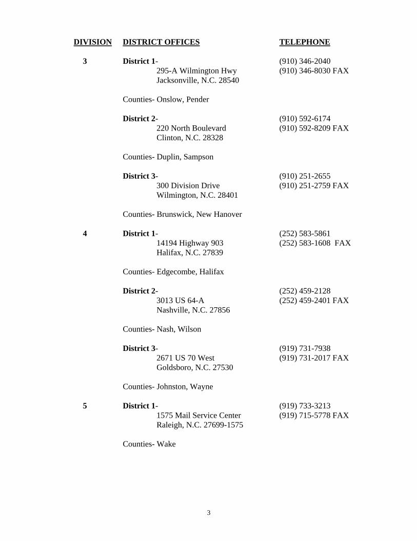
DIVISION DISTRICT OFFICES TELEPHONE 3 District 1- (910) 346-2040 295-A Wilmington Hwy (910) 346-8030 FAX Jacksonville, N.C. 28540 Counties- Onslow, Pender District 2- (910) 592-6174 220 North Boulevard (910) 592-8209 FAX Clinton, N.C. 28328 Counties- Duplin, Sampson District 3- (910) 251-2655 300 Division Drive (910) 251-2759 FAX Wilmington, N.C. 28401 Counties- Brunswick, New Hanover 4 District 1- (252) 583-5861 14194 Highway 903 (252) 583-1608 FAX Halifax, N.C. 27839 Counties- Edgecombe, Halifax District 2- (252) 459-2128 3013 US 64-A (252) 459-2401 FAX Nashville, N.C. 27856 Counties- Nash, Wilson District 3- (919) 731-7938 2671 US 70 West (919) 731-2017 FAX Goldsboro, N.C. 27530 Counties- Johnston, Wayne 5 District 1- (919) 733-3213 1575 Mail Service Center (919) 715-5778 FAX Raleigh, N.C. 27699-1575 Counties- Wake
4
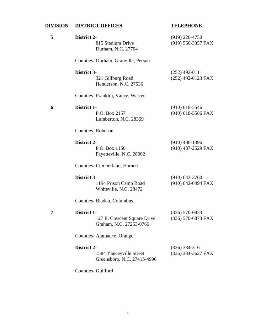
DIVISION DISTRICT OFFICES TELEPHONE 5 District 2- (919) 220-4750 815 Stadium Drive (919) 560-3357 FAX Durham, N.C. 27704 Counties- Durham, Granville, Person District 3- (252) 492-0111 321 Gillburg Road (252) 492-0123 FAX Henderson, N.C. 27536 Counties- Franklin, Vance, Warren 6 District 1- (910) 618-5546 P.O. Box 2157 (910) 618-5586 FAX Lumberton, N.C. 28359 Counties- Robeson District 2- (910) 486-1496 P.O. Box 1150 (910) 437-2529 FAX Fayetteville, N.C. 28302 Counties- Cumberland, Harnett District 3- (910) 642-3760 1194 Prison Camp Road (910) 642-0494 FAX Whiteville, N.C. 28472 Counties- Bladen, Columbus 7 District 1- (336) 570-6833 127 E. Crescent Square Drive (336) 570-6873 FAX Graham, N.C. 27253-0766 Counties- Alamance, Orange District 2- (336) 334-3161 1584 Yanceyville Street (336) 334-3637 FAX Greensboro, N.C. 27415-4996 Counties- Guilford
5
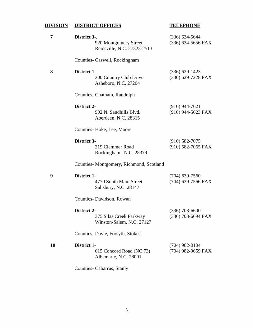
DIVISION DISTRICT OFFICES TELEPHONE 7 District 3-. (336) 634-5644 920 Montgomery Street (336) 634-5656 FAX Reidsville, N.C. 27323-2513 Counties- Caswell, Rockingham 8 District 1- (336) 629-1423 300 Country Club Drive (336) 629-7228 FAX Asheboro, N.C. 27204 Counties- Chatham, Randolph District 2- (910) 944-7621 902 N. Sandhills Blvd. (910) 944-5623 FAX Aberdeen, N.C. 28315 Counties- Hoke, Lee, Moore District 3- (910) 582-7075 219 Clemmer Road (910) 582-7065 FAX Rockingham, N.C. 28379 Counties- Montgomery, Richmond, Scotland 9 District 1- (704) 639-7560 4770 South Main Street (704) 639-7566 FAX Salisbury, N.C. 28147 Counties- Davidson, Rowan District 2- (336) 703-6600 375 Silas Creek Parkway (336) 703-6694 FAX Winston-Salem, N.C. 27127 Counties- Davie, Forsyth, Stokes 10 District 1- (704) 982-0104 615 Concord Road (NC 73) (704) 982-9659 FAX Albemarle, N.C. 28001 Counties- Cabarrus, Stanly

6
DIVISION DISTRICT OFFICES TELEPHONE 10 District 2- (704) 596-6900 7605 District Drive (704) 598-1758 FAX Charlotte, N.C. 28213 Counties- Mecklenburg District 3- (704) 289-1397 130 S. Sutherland Ave. (704) 292-1800 FAX Monroe, N.C. 28112 Counties- Anson, Union 11 District 1- (336) 835-4241 P.O. Box 558 (336) 835-1615 FAX Elkin, N.C. 28621 Counties- Alleghany, Surry, Yadkin District 2- (828) 265-5380 P.O. Box 1460 (828) 265-5414 FAX Boone, N.C. 28607 Counties- Avery, Caldwell, Watauga District 3- (336) 903-9146 P.O. Box 250 (336) 903-9219 FAX North Wilkesboro, N.C. 28659 Counties- Ashe, Wilkes 12 District 1- (704) 480-2080 P.O. Box 47 (704) 480-5438 FAX Shelby, N.C. 28151-0047 Counties- Cleveland, Gaston District 2- (704) 876-3947 124 Prison Camp Rd. (704) 876-0602 FAX Statesville, N.C. 28625 Counties- Alexander, Iredell

7
DIVISION DISTRICT OFFICES TELEPHONE 12 District 3- (704) 748-2400 1031 Gaston St. (704) 748-2403 FAX Lincolnton, N.C. 28092 Counties – Catawba, Lincoln 13 District 1- (828) 652-3344 3931 NC 226 S (828) 652-8391 FAX Marion, N.C. 28752 Counties- Burke, McDowell, Rutherford, Mitchell District 2- (828) 298-2741 11 Old Charlotte Highway (828) 299-3747 FAX Asheville, N.C. 28803 Counties- Buncombe, Madison, Yancey 14 District 1- (828) 891-7911 4142 Haywood Road (828) 891-5026 FAX Mills River, N.C. 28759 Counties- Henderson, Polk, Transylvania District 2- (828) 488-2131 345 Toot Hollow Road (828) 488-3518 FAX Bryson City, N.C. 28713 Counties- Haywood, Jackson, Swain District 3- (828) 321-4105 191 Robbinsville Road (828) 321-3228 FAX Andrews, N.C. 28901 Counties- Cherokee, Clay, Graham, Macon

8
APPLICATION REQUIREMENTS Any person or corporation desiring to construct a new subdivision road which is to be dedicated as public, must submit the following information to the District Engineer for proper evaluation in order to obtain a certificate of approval as required by North Carolina General Statute 136-102.6. (See Page 29 of this document for Statute.) If the new subdivision road (to be dedicated as public or private) will connect to a state system road, a driveway permit/encroachment agreement authorizing construction on State right-of-way must be obtained from the Division of Highways before beginning any construction. Applications should be made to the District Engineer having jurisdiction in the area. The appropriate District Engineer's Office can be determined from the listings beginning on Page 2 of this manual or the following link: https://apps.dot.state.nc.us/srmu/directory/public/EngDirHandler.ashx. 1. Three complete site layouts with vicinity map, including any future expansions
anticipated. Additional copies may be required by the District Engineer’s Office. 2. Horizontal alignment indicating general curve data on site layout plan. 3. Vertical alignment indicated by percent grade, P.I. station, vertical curve length, and k-
value, on site layout plan. Existing ground profile along centerline should also be included.
4. Typical section indicating the pavement design and width of pavement. All slopes shown
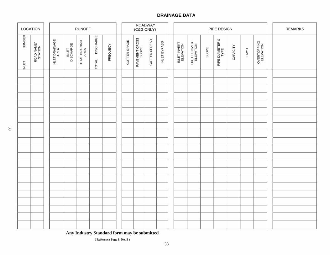
in accordance with drawings on Pages 40 and 41 of this manual. 5. Submission of hydraulics plans and drainage calculations are required. A copy of U.S.
Geodetic Survey or other contour mapping showing drainage areas is also required. (NOTE: A sample standard pipe sizing chart is shown on Page 38 or any generally accepted industry standard containing the same information as shown in the example may be used.)
6. Two copies of the recorded plat are to be furnished to the District Engineer after
certification or upon application for State Maintenance. 7. On new subdivision roads, lot lines should not extend into the right-of-way. See North
Carolina Transportation and Highway Laws, chapter 136, article 7, section 136-102.6 for additional information on right-of-way width and lot lines. (See Page 29 of this document for statute).
8. When property is subdivided along existing state maintained roads, the lot lines may
extend into the right of way subject to the property owners discretion. 9. A minimum of four separate site plans for driveway permits will be required prior to
construction within NCDOT Right of Way. (See Pages 36 and 37 for permit).

9
10. Copy of erosion control plans and permit, approved by Department of Environment and Natural Resources or local government, may be required by the District Engineer. (See Page 35.)
11. Encroachment agreements (utility & non-utility) are required prior to addition of road to
State System. (For agreement forms, please contact District Engineer.)

10
SUBDIVISION ROADS A subdivision road is one that serves a parcel or tract of land that is subdivided into two or more lots, building sites or other divisions for sale or building development for residential purposes where such subdivisions include a new road or change in an existing road.
Subdivision roads shall be designated public or private. Public designations shall be designed and constructed to minimum construction standards of the North Carolina Department of Transportation as required under North Carolina General Statute 136-102.6. and are eligible to be added to the State system of roads. (See Page 29 of this document). Private roads are not eligible to be added to the state system of roads and need not meet minimum construction requirements. Definitions The following definitions shall apply in this manual: 1. Residential Local Subdivision Road - Either cul-de-sacs, loop roads, roads that do not
connect thoroughfares or serve major traffic generators.
A. Dead End Roads - These are roads less than 2,500 feet in length, open at one end only without special provisions for turning around and have no collector characteristics.
B. Short Connecting Roads - These roads are normally one block long or extend on a
block-by-block basis and have no collector characteristics. C. Loop Roads - A road that has its beginning and ending points on the same route.
It is less than one mile in length and has no collector characteristics. D. Other Roads - These roads do not connect thoroughfares or serve major traffic
generators and do not have "collector" characteristics. E. Cul-De-Sacs - These are very short roads, open at one end only, with a special
provision for turning around. They have a "bulb" end design with a specific turning radii and a limited number of lots.
2. Residential collector roads - A road which serves as the connecting street between local
residential roads and the thoroughfare system.
A. Dead End Roads - These roads are more than 2,500 feet in length, open at one end only without special provisions for turning around, and have collector characteristics.
B. Connecting Roads - The roads which serve as the connecting road system
between other roads within the subdivision and the thoroughfare system. C. Loop Roads - A road that has its beginning and ending points on the same route.
It is more than one mile in length and has collector characteristics.
11
D. Other Roads - These are other roads having a "collector" type function in the
thoroughfare system. E. Subdivision Access Road - This is a road built through vacant property to provide
access to the property being developed. This road would not have lots platted along it.
Requirements for Addition of Subdivision Roads to the System:
1. The minimum construction standards and other requirements in this manual must be a
part of the proposal to be reviewed for approval prior to development in order for a plat to be recorded by the County Register of Deeds.
2. A Petition for Addition (DOT Form SR-1) is required from the developer and/or property
owners. (See Pages 33 and 34 of this document.) 3. Developers or property owners must dedicate right-of-way, as indicated in the minimum
design and construction criteria section of this manual, free of charge and clear of all encumbrances, including structural stormwater control (SSC) devices. (See Page 16 of this document.)
4. Existing utilities may remain within the right-of-way of any subdivision road added to
the Secondary Road System provided the location of same meets Division of Highways' approval and the utility owner executes an encroachment agreement on forms furnished by the Division of Highways. Should utility adjustments or relocation to conform to Division of Highways' requirements be required, (See Policy and Procedures for Accommodating Utility on Highway Rights of Way; http://www.ncdot.gov/doh/preconstruct/altern/value/manuals/pap.pdf) they shall be made at no expense to the Division of Highways. As per General Statute 136-102.6, "Utilities are defined as electric power, telephone, television, telegraph, water, sewage, gas, oil, petroleum products, steam, chemicals, drainage, irrigation and similar lines." G. S. 136-102.6 dictates further that "The right of any utility placed or located on a proposed or existing subdivision public road right-of-way shall be subordinate to the road right-of-way, and the utility shall be subject to regulation by the Board of Transportation". NOTE: The developer and/or owners will be required to submit encroachment agreements for all utilities within a subdivision as dictated by G. S. 136-102.6. (See Page 29 of this document for Statute).
5. At least 20 percent of the lots bordering the road must be individually owned. 6. There must be at least two occupied residences for each one-tenth of a mile. A minimum
of four occupied homes is required for the addition of roads less than two-tenths of a mile in length. If four occupied homes are not served, it will be treated as a private drive. An exception may be made if the cul-de-sac is fully developed, serves at least four platted lots, and has four occupied homes that abut the road. A minimum of two homes must have primary access to the cul-de-sacs.

12
7. Subdivision Access Roads must provide ingress and egress for at least five occupied residences for roads less than one mile in length and an average of five occupied residences per mile for roads over one mile in length.
8. The number of platted lots on each road will be reviewed to ensure that the minimum
occupied housing requirements in this manual are served. 9. Connecting roads with less than the required occupied homes for the length involved may
be reviewed as to traffic usage for addition purposes. Traffic usage equivalent to the traffic that would be generated by the correct number of occupied homes will be acceptable.
10. Any subdivision road with a right-of-way dedicated, recorded, or that has preliminary
approval from a county planning board dated after September 30, 1975, will not be added to the State System unless the road is built to the minimum construction standards of the Division of Highways for subdivision roads.
11. Erosion and Sedimentation - All subdivision roads shall have an acceptable permanent
vegetative cover established and other acceptable permanent erosion control measures installed in accordance with Division of Highways' specifications, prior to addition to the State maintained system.
12. Subdivision roads shall meet the minimum design and construction criteria contained herein prior to addition to the State system and shall be in an acceptable state of maintenance prior to addition to the State maintained road system.
13. All pipe culverts, storm sewers and appurtenances shall be free of all debris and silt build-up and shall be structurally and hydraulically sound, and functioning in a normal manner. All drainage structures shall be of sufficient length to accommodate appropriate roadway side slopes, as defined in the minimum construction standards in this manual, with standard height headwalls. Extended height headwalls intended to reduce drainage structure length or to reduce right of way requirements are not acceptable. All drainage ditches shall be of such a width and depth and with such a slope as to carry the anticipated discharges. Paved ditches or Rip Rap shall be required where necessary.
14. Where extenuating circumstances exist, the Division Engineer has the authority to allow
deviations from this manual which are reasonable, and limited only to safety, environmental and maintenance factors. No deviation will be allowed from the typical section requirements except by written approval from the Chief Engineer-Operations.
15. Within a Municipal Extra Territorial Jurisdiction or within Counties having local
ordinances affecting subdivisions, the more restrictive ordinance shall apply if maintenance responsibilities by the NCDOT are not increased beyond normal maintenance by applying the construction standards of this document.
16. Designs using walkable community concepts shall be reviewed by the Chief Engineer - Operations. Traditional Neighborhood Development Street Design Guidelines (walkable community) can be found at: http://www.ncdot.gov/doh/preconstruct/altern/value/manuals/tnd.pdf

13
(Reference to new policy for traffic calming devices added here when completed). 17. For the Policy on Roadway Bridges and Dams, see Page 17. 18. Roads being considered for addition must be clear of highway obstructions as defined in
NCAC 2E.0404. (See Page 32.)
19. The Division of Highways will consider the addition of streets that serve developments with large lots or parcels that are of the size that the occupied housing requirement of two homes per tenth of a mile cannot be met. The number of occupied homes needed shall be a judgment factor based upon the length and the number of lots or parcels involved. The minimum requirement shall be four occupied homes.

14
UTILITY REQUIREMENTS
1. Poles and other above-ground utilities which are to remain inside the right-of-way under
encroachment agreement shall be located at or as near as practical to the right-of-way line. As a minimum, above-ground utilities shall be located outside the clear roadside area for the highway section involved.
Where there are curbed sections, above-ground utilities should be located as far as practical behind sidewalks. There is no single minimum dimension for setback of poles, fire hydrants, etc., behind curbs; however, where there are curbed sections and no sidewalks, 6' will be used as a design safety concept guide.
2. Minimum Depth of Cover for Pipe Lines and Other Utilities
a. Longitudinal pipe lines and electric power primary ......................................3' b. Longitudinal electric power secondary, and trenched communication lines.2' c. Crossings under roadways .............................................................................3' d. Crossings under ditches .................................................................................2' e. Plowed-in communication lines except fiber optic........................................18'' f. Plowed-in fiber optic………………………………………………….…… 24"
3. For residential local subdivision streets, underground utilities may cross under or run
longitudinally under the pavement provided future utility stubouts are installed prior to paving. For all other streets and highways, underground utilities may cross under but not run longitudinally under the pavement except in unusual situations approved by the Division Engineer.
4. Acceptable Materials for Pipeline with Utilities Within the Rights of Way - Materials not
listed shall be referred to the Field Operations Support - Utilities Section.
a. Smooth Wall Steel Pipe meeting API 5L Grade B Specifications b. Spiral Welded Steel Pipe meeting ASTM Specification A-211 c. Circular Black Steel Pipe meeting ASTM Specification A-120 or A-589 d. Galvanized Steel Pipe Meeting ASTM A-120 Specifications e. Ductile Iron Pipe – class 50 Min. Strength f. Concrete Sewer Pipe – Plain and Reinforced Pipe meeting Department of
Transportation Standard with Rubber Gasket Joints g. Reinforced Concrete Pressure Pipe, Steel Cylinder Type for Water and other
Liquids meeting AWWA Specifications C-300, C-301, and C-303 h. ABS (Acrylonitrile – Butadiene – Styrene) Composite Sewer Pipe shall meet
ASTM D-2680 Specifications for Pipe sizes 8” thru 15” and ASTM D-2751 for pipe sizes 4” and 6” for Laterals. ABS Sewer Pipe shall be used for Domestic Sewage only; also, P.V.C. Truss Pipe meeting ASTM D-2321 which has to be specified by registered Professional Engineer.
i. P.V.C. (Polyvinyl Chloride) Water Pipe (pressure only) – SDR 14 (C-900), SDR 18 (C-900) and SDR 21.
j. P.V.C. (Polyvinyl Chloride) Sewer Pipe (Force Main) SDR 14 (C-900), SDR 18 (C-900) and SDR 21.

15
k. P.V.C. (Polyvinyl Chloride) pipe (Gravity Sewer) SDR 14 (C-900), SDR 18 (C-900), SDR 21, SDR 26, SDR 35, ASTM F 794, ASTM F 949 (A-2000) and Schedule 40 and 80.
l. V.C. (Vitrified Clay) Sewer Pipe, Extra Strength meeting ASTM Specifications C-700 with Factory Fabricated Joints meeting ASTM Specifications C-425.
m. P.E. (Polyethylene) Plastic Pipe – SDR 7 meeting ASTM Specifications D-2239 and Plastic Tubing – SDR 9 meeting ASTM Specification D-2737 for sizes ¾” thru 2” only.
n. Polyethylene Plastic Pipe (High Molecular Weight) and (Medium Molecular Weight) SDR 11 meeting Plastic Pipe Institute Material Designation PE 3408 and PE 2406 in sizes up to 6.625” O.D. for gas with maximum operating pressure of 60 PSIG.
o. Type K Copper Pipe meeting ASTM Specification B-88 for sizes ¾” thru 2”. 5. Any utility to be installed within the right-of-way of a state maintained road will require
an encroachment agreement with the North Carolina Board of Transportation in accordance with their publication entitled Policies and Procedures for Accommodating Utilities on Highway Rights of Way. (www.ncdot.org/doh/preconstruct/altern/value/manuals)
6. All non-ferrous pipelines shall be installed with a locating tape. 7. All utility structures (i.e. vaults, manholes, and boxes) shall be load rated for the
appropriate dead load plus an HL-93 live load. Such structures shall be designed and certified by a licensed professional engineer.
8. Electrical power and communication facilities should conform to the currently applicable
National Electrical Safety Code except vertical clearances shall be no less than 18 feet in any case.

16
MINIMUM DESIGN AND CONSTRUCTION CRITERIA FOR SUBDIVISION ROADS
CONSTRUCTION REQUIREMENTS A. DRAINAGE
The Division of Highways shall review all drainage prior to acceptance of any facility to the State System. Drainage, utility, or public easements, are not considered a portion of the highway facility.
All storm drainage shall be adequate so that the road and rights of way may be maintained without excessive cost, and not cause flooding on private property from storm runoff of the design frequency. Permanent drainage easements may be established by the designer; however, the NCDOT does not accept maintenance responsibility for the easement outside of the roadway right-of-way. The minimum design frequency shall be as follows but may be increased at the recommendation of the State Hydraulics Engineer.
1. Storm sewer collector - 10 years 2. Cross drainage for Secondary Routes - 25 years 3. Cross drainage on primary and N.C. routes will be 50 years. 4. Minimum Cross Pipe diameter is 18”, Minimum Driveway Pipes diameter is 15”. 5. All drainage shall be consistent with criteria found in NCDOT - Guidelines for
Drainage Studies and Hydraulic Design. www.ncdot.org/doh/preconstruct/highway/hydro/
Note: Use of hydraulic design forms found in Guidelines for Drainage Studies and Hydraulic Design will expedite the design review process. In areas where ditch grades or quantities of flow deem it impracticable to establish and maintain vegetation, an erosive resistant lining such as paving, matting or rip rap may be required. Subsurface drainage shall be adequate to maintain a stable subgrade. When road crossings are within areas designated as flood hazard areas under the Federal Flood Insurance Program, the design must be approved by the responsible local governing agency for its consistency with local flood zoning ordinances. Structural stormwater controls shall be located outside the right-of-way.
Structural control devices shall be shown on plans. The DOT assumes no responsibility for maintenance nor liability of the stormwater control devices (see Page 17 for Structural Stormwater Controls). Project Materials shall meet NCDOT Standards. Types of approved material shall be consistent with materials listed in “Guidelines for Drainage Studies and Hydraulic Design”.

17
Structural Stormwater Controls The Department of Environment and Natural Resources (DENR) or the local governing agency may require the design and installation of structural stormwater controls (SSC’s) as part of a stormwater management plan for the subdivision. Alternatively, the developer/land-owner may voluntarily install SSC’s. All SSC’s shall be constructed and maintained in accordance with applicable laws, ordinances, regulations, rules and directives of governmental authorities having jurisdiction over stormwater management activities. All SSC's, and any associated drainage easements, shall be located outside of the NCDOT right-of-way. The NCDOT assumes no responsibility for operation, maintenance, or liability of the SSC's. A North Carolina licensed professional engineer shall sign and seal a certification on the plan that all SSC’s meet the stormwater management requirements of the governmental authorities having jurisdiction over stormwater management activities. In addition, the Engineer must provide a certification of completion and verify that all SSC’s are constructed in accordance with applicable regulations. Prior to addition of the subdivision road to the State system, the property owner must execute an operation and maintenance agreement for the SSC’s that shall be binding on all subsequent owners of the property, portions of the property, and lots or parcels served by the SSC’s. The operation and maintenance agreement shall ensure that the SSC’s are operated and maintained so as to preserve and continue their function in controlling stormwater at the degree and amount of function for which the SSC’s were designed; shall require the owner (or homeowners’ association or similar entity) to maintain, repair and, if necessary, reconstruct the SSC’s; and shall state the terms, conditions, and schedule of maintenance for the SSC’s. For SSC’s that are or are to be owned by a homeowners’ association or similar entity, the operation and maintenance agreement shall acknowledge that the association shall continuously operate and maintain SSC’s at no cost to Division of Highways.
All SSC’s and associated access/maintenance easement(s) shall be depicted on a final subdivision plat which is recorded with the county Register of Deeds. The operation and maintenance agreement shall be referenced on the final plat and shall be recorded with the county Register of Deeds upon final plat approval.
B. STRUCTURES (BRIDGES, CULVERTS, DAMS AND RETAINING WALLS)
Bridges
Minimum criteria for bridges to be built by private interest for future acceptance by the Division of Highways.
1. Bridges which are to span streams shall be designed for hydraulic requirements in accordance with Division of Highways criteria, and plans shall be submitted to the Hydraulics Unit for review and approval. Bridge submittals shall include alternate structures considered and reasonable justification for selection of bridge

18
structure and length. Generally, avoidance of individual environmental permits would not be considered reasonable justification for use of excessive hydraulic structures or bridge lengths. Deck drains discharging into open water should be avoided.
Rip Rap will be required as recommended by the Hydraulics Unit. 2. Bridges shall be designed for minimum live load of HL-93 as specified in the
AASHTO LRFD Bridge Design Specifications, and the current edition of the Structure Design Unit Design Manual.
Bridges shall be rated in accordance with the AASHTO Manual for Bridge
Evaluation and the current edition of the Structure Design Unit Design Manual. All design load ratings and legal load ratings shall be greater than 1.0.
Plans shall be submitted for review and approval by the Structure Design Unit. 3. Bridge deck widths and clearances shall be in accordance with the North
Carolina Department of Transportation “Bridge Policy.” For bridges with curb and gutter approaches, the clear bridge width shall be the same as the face to face approach width except where bikeways or sidewalks are carried across the structure. Curb and gutter will be transitioned out in 50 feet to line up the face of curb and bridge rail. For shoulder section roadways, the bridge width should be a minimum of 24'.
4. The following materials are acceptable for bridge construction:
a. For substructures - reinforced concrete, structural steel, pre-stressed
concrete, or steel piles or combination of these materials. b. For superstructures - pre-stressed concrete, reinforced concrete deck slab,
or structural steel I-beams with reinforced concrete deck. c. The type and design of bridge rails shall be as approved by the Structure
Design Unit of the Division of Highways.
5. Guardrail shall be installed at the bridge approaches in accordance with North Carolina Roadway Standard Drawings.
6. All material and workmanship used in construction of the structure shall be in
accordance with North Carolina Standard Specifications for Roads and Structures and North Carolina Roadway Standard Drawings.

19
Culverts
A culvert is a conduit that conveys flow through the embankment. Culvert shapes may include circular, rectangular, elliptical, pipe-arch, and arches. They range in size from large multiple barrel culverts to single 18” pipes.
1. The minimum pipe size for cross pipe drainage is 18”.
2. Culverts in a riverine environment must be designed for hydraulic conveyance needs in accordance with Division of Highways criteria. Use of oversized structures to circumvent environmental permit responsibility creates excessive cost for Division of Highways in perpetual inspection/maintenance and future replacement needs. Therefore, drainage structures that greatly exceed hydraulic requirements for highway purposes will not be accepted for future maintenance unless to refuse would create “considerable and real hardship” for the applicant. Environmental permitting under a Nationwide Permit to avoid Individual Permit does not constitute “considerable or real hardships.” An example of a “considerable and real hardship” would be the presence of “Threatened or Endangered Species” as determined by USFW. Specific locations for use of oversized structures should be coordinated with Division of Highways personnel prior to design and construction of the subdivision.
3. Headwalls are generally used on the inlet end of culverts 36-inch and larger. Maximum height of headwalls shall be one foot above pipe structure. Neither Mechanically Stabilized Earth (MSE) nor Modular Block walls are considered appropriate for culvert headwall applications.
4. Allowable headwater elevation is established based on designers’ evaluation of natural flow depths, potential flooding of upstream structures and land use, as well as proposed roadway elevations. Culverts should be analyzed for both inlet control and outlet control conditions. Where inlet control governs conveyance, headwater depth is also limited to the ratio of headwater depth divided by pipe diameter (rise for arches) equal to 1.2 or 1.5 feet below the shoulder point (at the sag in vertical alignment), whichever results in the lower headwater depth. Where outlet control governs conveyance, the allowable Head (H) should be limited to 2 feet maximum and provide 1.5 feet freeboard below the shoulder point.
5. The slope of a culvert should approximate that of the natural channel. The invert elevation should be slightly below the natural bed ranging from 0.1 +/- feet for small pipes to 1.0 +/- feet for large structures. The normal burial depth for pipes less than or equal to 48” is 20% of the diameter. Pipes larger than 48” are buried 1.0 foot. Where fish passage is a primary consideration, the invert should be a minimum of 1.0 feet below the natural bed. Baffles may be placed in the invert to promote retention of bed material and formation of a low flow channel. If non-erodible rock is found along the entire culvert length at a depth less than 5 feet, a bottomless structure may be constructed on footings which can minimize disturbance of the natural channel bed. NCDOT’s Geotechnical Unit must review subsurface investigation reports provided by applicant to confirm acceptable foundation material prior to final selection of a “bottomless” culvert alternate.

20
6. Culverts must be long enough to accommodate the proposed typical roadway section and a 2:1 fill slope, or flatter, from shoulder point to the crown of structure or roof slab (not headwall).
7. Culverts must be designed to provide for minimum HL-93 live load.
8. Culverts shall be rated in accordance with the AASHTO Manual for Bridge Evaluation and the current edition of the Structure Design Unit Design Manual. All design load ratings and legal load ratings shall be greater than 1.0.
Roadway Dams
1. In those cases, where no other feasible alternatives exist, the utilization of a dam for a roadway may be considered.
2. Where it is determined that a dam will be utilized as a roadway, the following
criteria must be met:
a. When applicable, the dam must have certification from the N. C. Department of Natural Resources and Community Development pursuant to the "Dam Safety Law of 1967," (as amended by the General Assembly of 1977).
b. All pertinent data regarding the design of the embankment as an impoundment structure must be presented to the Division of Highways for review.
c. The top cross section dimension must be the roadway width required (from shoulder point to shoulder point) for the facility plus a minimum of 4 feet.
d. Guardrail will be provided on the impoundment side of the roadway and installed in accordance with North Carolina Roadway Standard Drawings. For safety the District Engineer may require guardrail on both sides of the roadway.
e. Spillway will be designed to provide 2 feet of freeboard at the shoulder for an estimated 50-year design frequency outflow as a minimum.
f. A means of draining the lake completely will be provided.
3. Design acceptance or approval by the Division of Highways is limited to the use of the dam as a roadway and is in no way intended as approval of the embankment as an impoundment structure.
4. Responsibility incurred by the Division of Highways when a section of roadway
crossing a dam is accepted as a part of the state maintenance system is limited to maintenance of the roadway for highway purposes from shoulder point to shoulder point only. Responsibility for the impoundment, any damage that may result there from, and maintenance of the dam or appurtenances as may be required to preserve its integrity as a water impoundment structure, shall remain with the owner of the impoundment. Any such maintenance work will be subject to the provisions of G.S. 136-93.
21
5. Impoundment of water on highway right-of-way may be allowed under the following criteria: a. The impoundment does not adversely affect the right-of-way for highway
purpose. b. Adjustment, as required, flattening slopes, installing rip rap, and any
others, shall be the responsibility of the developer.
6. Structures under, over and/or on Dams shall be designed and plans prepared under the supervision of a Licensed Professional Engineer.
Retaining Walls Rights of way and slope maintenance easements sufficient in width to accommodate appropriate roadway side slopes in accordance with the minimum construction standards in this manual shall be transferred to the Division of Highways. Retaining walls are roadside obstacles and will only be allowed where no other feasible alternatives exist. In the case an exception is warranted and approved by the Division Engineer, retaining wall design must be reviewed by Geotechnical Engineering Unit.
C. CURB AND GUTTER AND SIDEWALK
All curb and gutter and sidewalk sections shall meet Division of Highways standards. 1. The standard 2'-6" concrete curb and gutter is the preferred type to be used. Any
other types of curb and gutter shall be subject to the approval of the District Engineer.
2. Curb inlet spacing and storm system design shall be consistent with criteria found
in NCDOT - Guidelines for Drainage Studies and Hydraulic Design. (www.ncdot.org/doh/preconstruct/highway/hydro/)
3. NCDOT will allow sidewalks by encroachment and will not accept responsibility
for maintenance. Maintenance responsibility of sidewalks shall be noted on plat. All sidewalks shall meet requirements of the “Americans With Disabilities Act”.
4. Catch basins shall be NCDOT standard frame, grates and hood. Where other than
standard 2’ 6” curb is used, an approved transition section before and after the standard frames, grate and hood will be required.
5. Catch basins should be avoided in curb radii.
6. Allowable gutter spread is limited to gutter width plus ½ travel lane for outside
lane. Median gutter spread is limited to gutter width plus 2 feet.
7. Standard minimum depth boxes shall be used when practical to eliminate excessively deep pipe drainage system.

22
8. Pipe drainage system is to be located beneath curb. Longitudinal runs beneath roadway should be avoided. Pipes connecting catch basins to trunk lines on the opposite side of the roadway shall cross as near to perpendicular to the roadway as feasible.
D. WHEEL CHAIR RAMPS
In accordance with General Statute 136-44.14, all street curbs in North Carolina being constructed or reconstructed for maintenance procedures, traffic operations, repairs, correction of utilities or altered for any reason after September 1, 1973, shall provide wheel chair ramps for the physically handicapped at all intersections where curb and gutter is provided and at other major points of pedestrian flow. Wheel chair ramps and depressed curbs shall be constructed in accordance with details contained in the Department of Transportation, Division of Highways' publication entitled, Guidelines, Curb Cuts and Ramps for Handicapped Persons. (North Carolina Roadway Standard Drawings No. 848.05 and 848.06)
E. PAVEMENT DESIGNS
Shown below are minimum thicknesses of base and surface course to be used. Design guidelines should be chosen from Group I or Group II depending on subgrade soil type. The District Engineer may require a subgrade soil test to determine the soil classification type and heavier pavement designs than the minimum designs depending on route classification (local/collector) and traffic loading impacts of planned subdivision phases. A prime coat may be required on ABC.

23
GROUP I Good to Excellent Subgrade Soil Types Base Course Pavement Surface A-1-a, A-l-b, A-3 7" STBC, Type A or C………………2"SF9.5A (1 layer) or S9.5B A-2-4, A-2-5, A-2-6, 9" STBC, Type A or C………………1 ½" SF9.5A A-2-7 8" ABC or STBC, Type B…………..AST 6" ABC or STBC, Type B…………..1 ½" SF9.5A or S9.5B 3" B25.0B…………………………...1 ½" SF9.5A or S9.5B 4" ABC………………………………5" Jointed Concrete
GROUP II Poor to Fair Subgrade Soil Types Base Course Pavement Surface A-44, A-5, A-6, 9" STBC, Type A or C………………2" SF9.5A (1 layer) or S9.5B A-7-5, A-7-6 8" ABC or STBC, Type B…………..1 ½" SF9.5A or S9.5B 10" ABC or STBC, Type B…………AST 4" B25.0B…………………………...1 ½" SF9.5A or S9.5B
4" ABC………………………………6" Jointed Concrete
Decorative pavers may be permitted by encroachment. However, maintenance of decorative pavers will not be performed by NCDOT. NOTE: Subgrade No base course shall be placed on muck, pipe clay, organic matter or other
unsuitable material.

24
ABC Aggregate Base Course STBC Soil Type Base Course AST Asphalt Surface Treatment – Mix design to be approved by District
Engineer SF9.5A Asphalt Concrete Surface Course, Type SF9.5A S9.5B Asphalt Concrete Surface Course, Type S9.5B B25.0B Asphalt Concrete Base Course, Type B25.0B
Other base courses such as various cement-treated materials may be used in lieu of those shown above. These materials shall be of sufficient thickness to provide equivalent strength. However, any design other than those shown above must also be approved prior to use by the District Engineer All materials shall meet the requirements set forth in the latest edition of the North Carolina Standard Specifications for Roads and Structures.
F. TRAFFIC CONTROL
The construction of all subdivision road intersections including those with existing state maintained roadways shall be constructed using traffic control standards as designated in the “Manuals on Uniform Traffic Control Devices”, “North Carolina Supplement to the Manual on Uniform Traffic Control Devices”, and the “North Carolina Highway Design Branch Roadway Standard Drawings,” prior to formal addition to the system. See G.S. 136-30.
G. GUARDRAIL
Guardrail may be required at locations meeting guardrail warrants in accordance with NCDOT Design Standards. Warrant for guardrail may also warrant shoulder berm gutter.
H. ROAD INTERSECTIONS (See Figures 3 & 4 on Pages 41 & 42.)
1. The most desirable intersections are those with angles of 75 to 90 degrees. Intersections with angles from 60 to 75 degrees are acceptable where no other alternatives exist.
2. Minimum sight triangle for stop condition when connecting new local residential
roads or residential collector roads to existing state maintained roads is 70 feet along the existing road right of way and 10 feet along the new road right of way.
3. All internal intersections shall have minimum 30’ radii. Radii less than 30’ must
be approved by the District Engineer. 4. Non-standard design configurations will be reviewed on a case by case basis and
must have approval of the District Engineer prior to formal addition to the state system.
25
I. ISLANDS OR SHORT MEDIANS AT SUBDIVISION ENTRANCES
The Division of Highways will review requests for the allowance of islands or short medians desired for aesthetics on State Highway System Secondary Roads at the entrance to a subdivision. Approval will be with the following understanding:
1. The District Engineer may allow the island or median sections after review on an
individual basis and noted on plans (or encroachment agreement). This shall include all plantings.
2. The Division of Highways will not maintain the island or the median section.
3. The island or the median section will be removed if not properly maintained by someone involved with the subdivision, i.e. developer, homeowners, etc.
4. The minimum lane width at the entrances, excluding curb and gutter, will be 14 feet. Maximum width of island shall be 20 feet. (See Page 47 for detail).
J. SUBDIVISION NAME MARKERS
The Division of Highways will review requests to erect subdivision name markers on an individual basis. The name markers may be allowed to be located within the State Highway System Secondary Road rights-of-way at the beginning of a subdivision road provided the location of such is outside the line of sight and the normal maintenance limits. The name markers may be approved only at locations which will not sacrifice safety to the general traveling public. Approval to erect subdivision name markers will be with the following understanding:
1. All costs will be the responsibility of the requester. 2. The Division of Highways will not maintain the marker or the area around the
marker. 3. The markers may be removed if not properly maintained. 4. The Division Engineer may allow the subdivision name markers on secondary
road rights-of-way after review on an individual basis.
5. If non-breakaway design, a 30-foot set back from the edge of pavement of the existing state maintained road is required. (See Page 47 for typical dimensions associated with marker installation.)

26
K. MINIMUM DESIGN CRITERIA
1. Residential Local Subdivision Roads include: a. Cul-De-Sacs b. Dead End Roads - Less than 2500 feet in length c. Short connecting Roads - One block long or that extend on a block by block basis d. Loop Roads - Less than 1 mile in length
e. Other roads that do not connect thoroughfares or serve major traffic. These roads do not have “collector” characteristics.
TERRAIN CLASSIFICATION LEVEL ROLLING MOUNTAINOUS Terrain Classification Definition
Level - Natural slope range of 0% to 8% Rolling - Natural slope range of 8.1% to 15% Mountainous - Natural slope over 15%
Right of Way Width Curb and Gutter Section 40' 40' 40' Shoulder Section 50' 50' 45' Pavement Width Curb and Gutter Section *26' F-F *26’ F-F *26' F-F Shoulder Section 18' 18' 18'
F-F refers to face to face of standard curb and gutter section., Other types will be reviewed by the District Engineer with the F-F limits applicable
Minimum Shoulder Width Shoulder Section 6' 4' to 6' 4' to 6' Shoulder width between 4' to 6' shall be approved by
the District Engineer considering adjacent land characteristics
Maximum Cut and Fill Slopes 2:1 2:1 1 1/2:l Design Speed 30 mph 25 mph 20 mph Minimum Sight Distance on Vertical Curves 200' 150' 110' Minimum Centerline Radius 230' 150' 90' Minimum Superelevation Rate for Minimum Radius ** .06 ft/ft .04 ft/ft .02 ft/ft Maximum Grade 9% 12% 18% Grades for 100' each way from intersection exceeding 5 percent may be reviewed by District Engineer for consideration. Grades less than 0.5 percent should not be used unless reviewed individually by the District Engineer to determine potential maintenance problems. K = Rate of Vertical Curvature for Minimum Sight Distance. CREST 30 20 10 SAG 30 20 10 STOP 14 9 5 Formula for determination of length of vertical curve required to provide minimum site distance. [L = KA] L = Length of vertical curve in feet K = Rate of vertical curvature in feet per percent of A A = Algebraic difference in grades in percent Minimum Cul-De-Sac Radius Right of Way Curb and Gutter Section 45' 45' 45' Shoulder Section 50' 50' 50' Minimum Cul -De-Sac Radius Curb and Gutter Section 37' to F 37' to F 37' to F Shoulder Section * (See Page 28) 35' 35' 35'

27
2. Residential Collector Roads include:
a. Dead End Roads - More than 2500 feet in length b. Connecting roads between the local residential subdivision roads and the thoroughfare
system c. Loop Roads - More than one (1) mile in length d. Other roads having a "collector" type function in the thoroughfare system
TERRAIN CLASSIFICATION LEVEL ROLLING MOUNTAINOUS Terrain Classification Definition
Level - Natural slope range of 0% to 8% Rolling - Natural slope range of 8.1% to 15% Mountainous - Natural slope over 15%
Right of Way Width Curb and Gutter Section 50' 50' 50' Shoulder Section 50' 50' 50' Pavement Width Curb and Gutter Section 34' F-F 34' F-F 34' F-F Shoulder Section 20' 20' 20'
F-F refers to face to face of standard curb and gutter section. Other types will be reviewed by the Division Engineer with the F-F limits applicable.
Minimum Shoulder Width Shoulder Section 6' 6' 6' Maximum Cut and Fill Slopes 2:1 2:1 1 1/2:1 Design Speed 35 mph 30 mph 25 mph Minimum Sight Distance on Vertical Curves 250' 200' 150' Minimum Centerline Radius 310' 230' 150' Minimum Superelevation Rate for Minimum Radius ** .08 ft/ft .06 ft/ft .04 ft/ft Maximum Grade 6% 9% 12%
Grades for 100' each way from intersection exceeding 5 percent (%) may be reviewed by District Engineers for consideration. Grades less than 0.5 percent should not be used unless reviewed individually by the District Engineer to determine potential maintenance problems.
K = Rate of Vertical Curvature for minimum sight distance CREST 45 30 20 SAG 45 30 20 STOP 20 14 9 Formula for determination of length of vertical curve
required to provide minimum sight distance. [L = KA] L = Length of vertical curve in feet K = Rate of vertical curvature in feet per percent of A A = Algebraic difference in grades in percent

3. Thoroughfare Plan Roads For subdivision developments resulting in the construction of a thoroughfare plan
route by the developer, the subdivision plan will be forwarded through the District Engineer, to the Traffic Engineering Branch for review by appropriate personnel of the Division of Highways in Raleigh, North Carolina.
4. Industrial Access or Commercial Complex Roads
The minimum construction standards for industrial access road requests or for commercial centers and office complexes will be reviewed individually. The construction standards for pavement design will be in line with expected usage. Final pavement design will be approved by the District Engineer.
*NOTE: On cul-de-sacs, a maximum of two-tenths of a mile in length, 18 feet of pavement
will be allowed (not including gutter). (See Pages 45 and 46). Cul-de-sac designs other than the "Bulb" End Design will be subject to the
approval of the Division Engineer after review on an individual basis. **NOTE: The minimum superelevation rates shown for the varying design speeds are for
the minimum radii shown. For radii different from these, use the appropriate table from the 2004 Edition of AASHTO’s Policy on Geometric Design of Highways and Streets for a desirable design. For a minimum design, the superelevation rate can be calculated from the simplified curve formula:
28
e = V2 -f 15R
where e = superelevation rate in foot per foot V = design speed in miles per hour R = Radius of curve in feet f = side friction factor (See Page 147 of the 2004 Policy on Geometric
Design of Highways and Streets)
Short cul-de-sacs and dead end streets 1500 feet or less in length may be accepted without superelevation.
29
Transportation and Highway Laws of North Carolina §136-102.6. Compliance of subdivision streets with minimum standards of the Board of
Transportation required of developers (a) The owner of a tract or parcel of land which is subdivided from and after October 1,
1975, into two or more lots, building sites, or other divisions for sale or building development for residential purposes, where such subdivision includes a new street or the changing of an existing street, shall record a map or plat of the subdivision with the Register of Deeds of the county in which the land is located. The map or plat shall be recorded prior to any conveyance of a portion of said land, by reference to said map or plat.
(b) The right-of-way of any new street or change in an existing street shall be delineated
upon the map or plat with particularity and such streets shall be designated to be either public or private. Any street designated on the plat or map as public shall be conclusively presumed to be an offer of dedication to the public of such street.
(c) The right-of-way and design of streets designated as public shall be in accordance with
the minimum right-of-way and construction standards established by the Board of Transportation for acceptance on the State highway system. If a municipal or county subdivision control ordinance is in effect in the area proposed for subdivision, the map or plat required by this section shall not be recorded by the Register of Deeds until after it has received final plat approval by the municipality or county, and until after it has received a certificate of approval by the Division of Highways as herein provided as to those streets regulated in subsection (g). The certificate of approval may be issued by a District Engineer of the Division of Highways of the Department of Transportation.
(d) The right-of-way and construction plans for such public streets in residential
subdivisions, including plans for street drainage, shall be submitted to the Division of Highways for review and approval, prior to the recording of the subdivision plat in the office of the Register of Deeds. The plat or map required by this section shall not be recorded by the Register of Deeds without a certificate of approval by the Division of Highways of the plans for the public street as being in accordance with the minimum standards of the Board of Transportation for acceptance of the subdivision street on the State highway system for maintenance. The certificate of approval shall not be deemed an acceptance of the dedication of such streets on the subdivision plat or map. Final acceptance by the Division of Highways of such public streets and placing them on the State highway system for maintenance shall be conclusive proof that the streets have been constructed according to the minimum standards of the Board of Transportation.
(e) No person or firm shall place or erect any utility in, over, or upon the existing or
proposed right-of-way of any street in a subdivision to which this section applies, except in accordance with the Division of Highway’s policies and procedures for accommodating utilities on highway rights-of-way, until the Division of Highways has given written approval of the location of such utilities. Written approval may be in the form of exchange of correspondence until such times as it is requested to add the street or streets to the State system, at which time an encroachment agreement furnished by the Division

30
§136-102.6 Continued
of Highways must be executed between the owner of the utility and the Division of Highways.
The right of any utility placed or located on a proposed or existing subdivision public street right-of-way shall be subordinate to the street right-of-way, and the utility shall be subject to regulation by the Department of Transportation. Utilities are defined as electric power, telephone, television, telegraph, water, sewage, gas, oil, petroleum products, steam, chemicals, drainage, irrigation, and similar lines. Any utility installed in a subdivision street not in accordance with the Division of Highways, accommodation policy, and without prior approval by the Division of Highways, shall be removed or relocated at no expense to the Division of Highways.
(f) Prior to entering any agreement or any conveyance with any prospective buyer, the developer and seller shall prepare and sign, and the buyer of the subject real estate shall receive and sign an acknowledgment of receipt of a separate instrument known as the subdivision streets disclosure statement (hereinafter referred to as disclosure statement.) Said disclosure statement shall fully and completely disclose the status (whether public or private) of the street upon which the house or lot fronts. If the street is designated by the developer and seller as a public street, the developer and seller shall certify that the right-of-way and design of the street has been approved by the Division of Highways, and that the street has been or will be constructed by the developer and seller in accordance with the standards for subdivision streets adopted by the Board of Transportation for acceptance on the highway system. If the street is designated by the developer and seller as a private street, the developer and seller shall include in the disclosure statement an explanation of the consequences and responsibility as to maintenance of a private street, and shall fully and accurately disclose the party or parties upon whom responsibility for construction and maintenance of such street or streets shall rest, and shall further disclose that the street or streets will not be constructed to minimum standards, sufficient to allow their inclusion on the State highway system for maintenance. The disclosure statement shall contain a duplicate original which shall be given to the buyer. Written acknowledgment of receipt of the disclosure statement by the buyer shall be conclusive proof of the delivery thereof.
(g) The provisions of this section shall apply to all subdivisions located outside municipal
corporate limits. As to subdivisions inside municipalities, this section shall apply to all proposed streets or changes in existing streets on the State highway system as shown on the comprehensive plan for the future development of the street system made pursuant to G.S. 136-66.2, and in effect at the date of approval of the map or plat.
(h) The provisions of this section shall not apply to any subdivision that consists only of lots
located on Lakes Hickory, Norman, Mountain Island and Wylie which are lakes formed by the Catawba River which lots are leased upon October 1, 1975. No roads in any such subdivision shall be added to the State maintained road system without first having been brought up to standards established by the Board of Transportation for inclusion of roads in the system, without expense to the State. Prior to entering any agreement or any
31
§136-102.6 Continued
conveyance with any prospective buyer of a lot in any such subdivision, the seller shall prepare and sign, and the buyer shall receive and sign an acknowledgment of receipt of a statement fully and completely disclosing the status of and the responsibility for construction and maintenance of the road upon which such lot is located.
(i) The purpose of this section is to insure that new subdivision streets described herein to be
dedicated to the public will comply with the State standards for placing subdivision streets on the State highway system for maintenance, or that full and accurate disclosure of the responsibility for construction and maintenance of private streets be made. This section shall be construed and applied in a manner which shall not inhibit the ability of public utilities to satisfy service requirements of subdivisions to which this section applies.
(j) The Division of Highways and District Engineers of the Division of Highways of the
Department of Transportation shall issue a certificate of approval for any subdivision affected by a roadway corridor official map established by the Board of Transportation only if the subdivision conforms to Article 2E of this Chapter or conforms to any variance issued in accordance with that Article.
(k) A willful violation of any of the provisions of this section shall be a Class I misdemeanor.

32
NORTH CAROLINA ADMINISTRATIVE CODE
HIGHWAY OBSTRUCTIONS INTERFERING
WITH TRAFFIC MAINTENANCE
19A NCAC 2E.0404
Highway obstructions include driveway headwalls, fences, rural mailboxes, newspaper delivery boxes and other roadside obstructions interfering with traffic or maintenance.
1) It shall be unlawful to place any highway obstruction, including a driveway headwall, fence, rural mailbox, newspaper delivery box or other roadside obstruction, so as to interfere with the traffic or maintenance of the roads and highways of the state highway system.
2) If the department determines, that any highway obstruction, including a driveway headwall, fence, rural mailbox, newspaper delivery box, its supports or other roadside obstruction, constitutes an unreasonable roadside collision hazard, the highway obstruction shall be removed by the person responsible for placing the obstruction within the right-of-way within 30 days of receipt of a written notice from the department to the person responsible for placing the obstruction within the right-of-way.
3) Only mailboxes or newspaper delivery boxes with non-rigid type posts, such as a 4” x 4” wooden or a small diameter metal type, are permitted on road additions made to the state highway system after May 3, 1990. The location within the right of way of an addition to the system of any brick columns, mailboxes or newspaper delivery boxes on rigid stands such as block, stone or any other type determined to be a traffic hazard is prohibited.
4) The failure of the person responsible for placing the unlawful obstruction within the right of way, to remove the obstruction within 30 days after written notice by the Department of Transportation shall constitute a misdemeanor. Failure to remove or make safe any mailbox or newspaper delivery its supports or any other obstruction within the specified 30 days of this Rule shall be cause for the Department’s Division Engineer to take action to remove the unacceptable mailbox or newspaper delivery box, its supports or other obstruction installation and also bill the responsible party for the expense of removal if appropriate. (See Page 13, No.18)

33
NORTH CAROLINA DEPARTMENT OF TRANSPORTATION PETITION FOR ROAD ADDITION
FORM SR-1 REVISED Jan-2010 ROADWAY INFORMATION: (Please Print) County: _________________________________________ Road Name:____________________________________________ (Please list additional street names and lengths on the back of this form.) Subdivision Name: _____________________________________________________ Length (miles):_____________________ Number of occupied homes having street frontage: ____________ Location: ______________miles N S E W of the intersection of Route __________________and Route_________________ (Circle one) (SR, NC or US) (SR, NC or US) We, the undersigned, being property owners and/or developer of _________________________________________________ in ____________________________________County, do hereby request the Division of Highways to add the above described road. CONTACT PERSON: Name and Address of First Petitioner. (Please Print) Name: ______________________________________________________________ Phone Number: _____________________ Street Address:__________________________________________________________________________________________ Mailing Address: ________________________________________________________________________________________
PROPERTY OWNERS NAME MAILING ADDRESS TELEPHONE
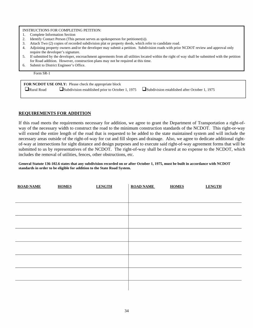
Form SR-1
INSTRUCTIONS FOR COMPLETING PETITION: 1. Complete Information Section 2. Identify Contact Person (This person serves as spokesperson for petitioner(s)). 3. Attach Two (2) copies of recorded subdivision plat or property deeds, which refer to candidate road. 4. Adjoining property owners and/or the developer may submit a petition. Subdivision roads with prior NCDOT review and approval only
require the developer’s signature. 5. If submitted by the developer, encroachment agreements from all utilities located within the right of way shall be submitted with the petition
for Road addition. However, construction plans may not be required at this time. 6. Submit to District Engineer’s Office.
(1) FOR NCDOT USE ONLY: Please check the appropriate block
Rural Road Subdivision established prior to October 1, 1975 Subdivision established after October 1, 1975
ROAD NAME HOMES LENGTH
ROAD NAME HOMES LENGTH
REQUIREMENTS FOR ADDITION If this road meets the requirements necessary for addition, we agree to grant the Department of Transportation a right-of-way of the necessary width to construct the road to the minimum construction standards of the NCDOT. This right-or-way will extend the entire length of the road that is requested to be added to the state maintained system and will include the necessary areas outside of the right-of-way for cut and fill slopes and drainage. Also, we agree to dedicate additional right-of-way at intersections for sight distance and design purposes and to execute said right-of-way agreement forms that will be submitted to us by representatives of the NCDOT. The right-of-way shall be cleared at no expense to the NCDOT, which includes the removal of utilities, fences, other obstructions, etc. General Statute 136-102.6 states that any subdivision recorded on or after October 1, 1975, must be built in accordance with NCDOT standards in order to be eligible for addition to the State Road System.
34
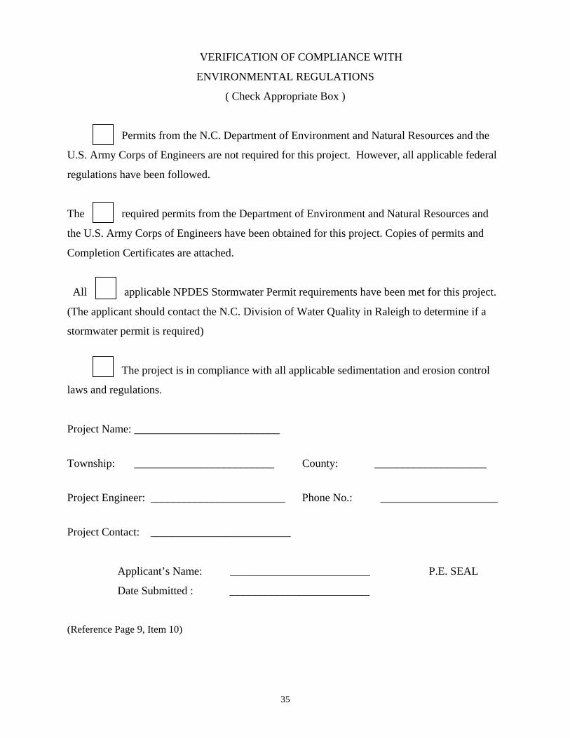
VERIFICATION OF COMPLIANCE WITH
ENVIRONMENTAL REGULATIONS
( Check Appropriate Box )
Permits from the N.C. Department of Environment and Natural Resources and the
U.S. Army Corps of Engineers are not required for this project. However, all applicable federal
regulations have been followed.
The required permits from the Department of Environment and Natural Resources and
the U.S. Army Corps of Engineers have been obtained for this project. Copies of permits and
Completion Certificates are attached.
All applicable NPDES Stormwater Permit requirements have been met for this project.
(The applicant should contact the N.C. Division of Water Quality in Raleigh to determine if a
stormwater permit is required)
The project is in compliance with all applicable sedimentation and erosion control
laws and regulations.
Project Name: __________________________
Township: _________________________ County: ____________________
Project Engineer: ________________________ Phone No.: _____________________
Project Contact: _________________________
Applicant’s Name: _________________________ P.E. SEAL
Date Submitted : _________________________ (Reference Page 9, Item 10)
35
36
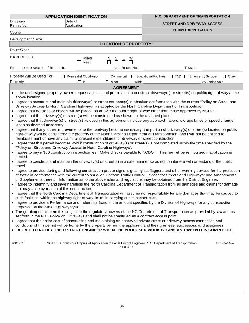
APPLICATION IDENTIFICATION N.C. DEPARTMENT OF TRANSPORTATION
Driveway Permit No. Date of
Application STREET AND DRIVEWAY ACCESS
County: PERMIT APPLICATION
Development Name:
LOCATION OF PROPERTY: Route/Road:
Exact Distance Miles N S E W
Feet From the Intersection of Route No. and Route No. Toward
Property Will Be Used For: Residential /Subdivision Commercial Educational Facilities TND Emergency Services Other Property: is is not within City Zoning Area.
AGREEMENT • I, the undersigned property owner, request access and permission to construct driveway(s) or street(s) on public right-of-way at the
above location. • I agree to construct and maintain driveway(s) or street entrance(s) in absolute conformance with the current “Policy on Street and
Driveway Access to North Carolina Highways” as adopted by the North Carolina Department of Transportation. • I agree that no signs or objects will be placed on or over the public right-of-way other than those approved by NCDOT. • I agree that the driveway(s) or street(s) will be constructed as shown on the attached plans. • I agree that that driveway(s) or street(s) as used in this agreement include any approach tapers, storage lanes or speed change
lanes as deemed necessary. • I agree that if any future improvements to the roadway become necessary, the portion of driveway(s) or street(s) located on public
right-of-way will be considered the property of the North Carolina Department of Transportation, and I will not be entitled to reimbursement or have any claim for present expenditures for driveway or street construction.
• I agree that this permit becomes void if construction of driveway(s) or street(s) is not completed within the time specified by the “Policy on Street and Driveway Access to North Carolina Highways”.
• I agree to pay a $50 construction inspection fee. Make checks payable to NCDOT. This fee will be reimbursed if application is denied.
• I agree to construct and maintain the driveway(s) or street(s) in a safe manner so as not to interfere with or endanger the public travel.
• I agree to provide during and following construction proper signs, signal lights, flaggers and other warning devices for the protection of traffic in conformance with the current “Manual on Uniform Traffic Control Devices for Streets and Highways” and Amendments or Supplements thereto. Information as to the above rules and regulations may be obtained from the District Engineer.
• I agree to indemnify and save harmless the North Carolina Department of Transportation from all damages and claims for damage that may arise by reason of this construction.
• I agree that the North Carolina Department of Transportation will assume no responsibility for any damages that may be caused to such facilities, within the highway right-of-way limits, in carrying out its construction.
• I agree to provide a Performance and Indemnity Bond in the amount specified by the Division of Highways for any construction proposed on the State Highway system.
• The granting of this permit is subject to the regulatory powers of the NC Department of Transportation as provided by law and as set forth in the N.C. Policy on Driveways and shall not be construed as a contract access point.
• I agree that the entire cost of constructing and maintaining an approved private street or driveway access connection and conditions of this permit will be borne by the property owner, the applicant, and their grantees, successors, and assignees.
• I AGREE TO NOTIFY THE DISTRICT ENGINEER WHEN THE PROPOSED WORK BEGINS AND WHEN IT IS COMPLETED. 2004-07 NOTE: Submit Four Copies of Application to Local District Engineer, N.C. Department of Transportation TEB 65-04rev.
61-03419
37
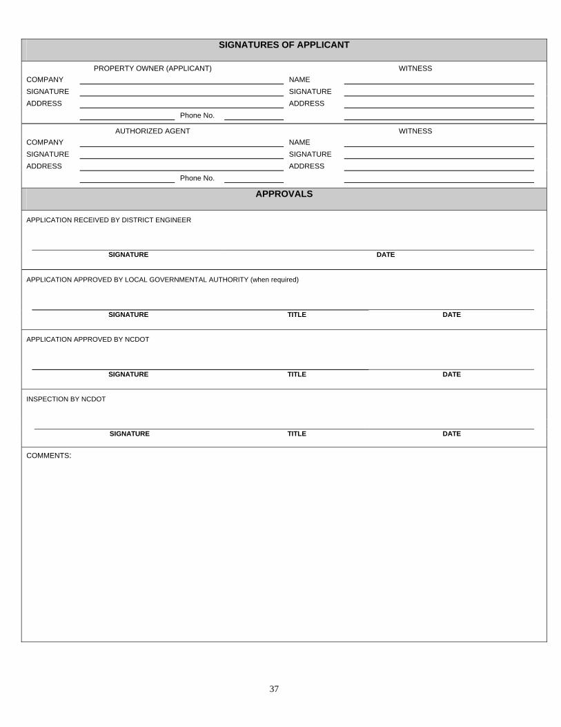
SIGNATURES OF APPLICANT
PROPERTY OWNER (APPLICANT) WITNESS COMPANY NAME SIGNATURE SIGNATURE ADDRESS ADDRESS Phone No.
AUTHORIZED AGENT WITNESS COMPANY NAME SIGNATURE SIGNATURE ADDRESS ADDRESS Phone No.
APPROVALS
APPLICATION RECEIVED BY DISTRICT ENGINEER
SIGNATURE DATE
APPLICATION APPROVED BY LOCAL GOVERNMENTAL AUTHORITY (when required)
SIGNATURE TITLE DATE
APPLICATION APPROVED BY NCDOT
SIGNATURE TITLE DATE
INSPECTION BY NCDOT
SIGNATURE TITLE DATE COMMENTS:
LOCATION RUNOFF
ROADWAY (C&G ONLY)
PIPE DESIGN
REMARKS
INLE
T
N
UM
BER
RO
AD
NA
ME
/ ST
ATIO
N
INLE
T D
RAI
NAG
E
AREA
INLE
T
DIS
CH
ARG
E
TOTA
L D
RAI
NAG
E AR
EA
TOTA
L
DIS
CH
AR
GE
FREQ
UEC
Y
GU
TTER
GR
ADE
PAVE
MEN
T C
RO
SS
SLO
PE
GU
TTER
SPR
EAD
INLE
T BY
PASS
INLE
T IN
VER
T EL
EVAT
ION
OU
TLET
INVE
RT
ELEV
ATIO
N
SLO
PE
PIPE
DIA
MET
ER &
TY
PE
CAP
ACIT
Y
HW
/D
OVE
RTO
PPIN
G
ELEV
ATIO
N
38
Any Industry Standard form may be submitted
( Reference Page 8, No. 5 )
DRAINAGE DATA
38

39

40

41

42

43

44 44

45

46

(SEE PAGE 25)
STOP CONDITION
47

Appendix A-1
UPDATES TO JANUARY 2000 SUBDIVISION MANUAL EFFECTIVE JANUARY 2010
(Note: Page references are Jan 2000 Version) Description
• 1. The date has been changed from January 1, 2000 to January 1, 2010. 2. Title Page updated with names of Secretary, State Highway Administrator and Chief
Engineer. 3. Table of Contents updated. 4. District Office locations and phone numbers displayed; weblink available on Page 8. 5. Page 8, Application Requirements: End of first paragraph – Added “of this document”
following See Page 31. 6. Page 8. #4, changed pages to 42 and 43. 7. Page 8, Application Requirements, # 6: Change to “Two copies…..” instead of four. 8. Page 9, On new subdivision roads lot lines should not extend into the right-of-way. See
North Carolina Transportation and Highway Laws, chapter 136, article 7, section 136-102.6 for additional information on right-of-way width and lot lines. (See page 31 of this document for statute).
9. Page 9, When property is subdivided along existing state maintained roads the lot lines
may extend beyond into the right of way subject to the property owners discretion. 10. Page 9, Application Requirements, # 11: The following clarification has been added.
“Encroachment agreements (utility & non-utility) are required……” 11.
Page 10. Second paragraph… Subdivision roads shall be designated public or private. Public designations shall be designed and constructed…
12.
Page 10. Second paragraph… as required under General Statute 136-102.6 and are eligible to be added to the State system of roads.
13. Page 10. Second paragraph…. Private roads are not eligible to be added to the state
system of roads and… 14.
Page 10, Subdivision Roads, # 1, has been reworded to conform to # 2. “Residential local subdivision road” instead of “Local residential subdivision road,” and is updated throughout the document.
1

Appendix A-1
UPDATES TO JANUARY 2000 SUBDIVISION MANUAL EFFECTIVE JANUARY 2010
(Note: Page references are Jan 2000 Version) Description 15.
Page 11, Subdivision Roads, Requirements for Addition…to the System, # 3: Following phrase added, “including structural stormwater control (SSC) devices. (See Page 16 of this document)”
16. Page 11. #4 Existing and/or relocated utilities 17. Page 11. #4 2nd sentence, Added “should” utility adjustments…”be required, they” shall
be made… 18. Page 12, Subdivision Roads, Requirements, continuation of # 4, last sentence. Added
“of this document” following See page 31. 19.
Page 13, Subdivision Roads, Requirements, # 13, added this statement: “All drainage structures shall be of sufficient length to accommodate appropriate roadway side slopes, as defined in the minimum construction standards in this manual, with standard height headwalls. Extended height headwalls intended to reduce drainage structure length or to reduce right of way requirements are not acceptable without prior approval of the Division Engineer.”
20.
Page 13, Subdivision Roads, Requirements, # 15, added “…if maintenance responsibilities by the NCDOT are not increased beyond normal maintenance in applying the construction standards of this document.
21. Page 13, #18 Roads being considered for addition must be clear of highway
obstructions as defined in NCAC 2E.0404. (See page 34). 22. Page 14, Utility Requirements, # 2.e.: added this phrase “except fiber optic.” 23. Page 14, Utility Requirements, # 2.f. added. 24. Page 14, Utility Requirements, # 4: Changed “Design Services Unit” to “Field
Operations Support.” 25. Page 16, Minimum Design and Construction Criteria, Section A, second paragraph, first
sentence, added the phrase “and rights of way” may be maintained…… 26.
Page 16, Minimum Design and Construction Criteria, Section A, # 5, added the following: “Note: Use of hydraulic design forms found in Guidelines for Drainage studies and Hydraulic Design will expedite the design review process.”
2

Appendix A-1
UPDATES TO JANUARY 2000 SUBDIVISION MANUAL EFFECTIVE JANUARY 2010
(Note: Page references are Jan 2000 Version) Description 27. Page 16. Item A, 5: Provided website for contact information 28. Page 16. Last paragraph Structural stormwater controls Retention/detention basin shall
be located outside the right of way 29. Page 17. First paragraph and Structural control devices shall be shown on plans
where possible. 30. Page 17. Second paragraph basins stormwater control devices (see Page 17 for
Structural Stormwater Controls). 31.
Page 17, Minimum Design and Construction Criteria, Section A, added following sentences at end. “Project Materials shall meet NCDOT Standards. Types of approved material shall be considered with materials listed in “Guidelines for Drainage Studies and Hydraulic Design”.”
32. Page 17, Minimum Design and Construction Criteria, Section A, added new item:
Structural Stormwater Controls (new section) 33.
Page 18, Structures (Bridges, Culverts, Dams and Retaining Walls), Bridges, # 1. Added the following sentences: “Bridge submittals shall include alternate structures considered and reasonable justification for selection of bridge structure and length. Generally, avoidance of individual environmental permits would not be considered reasonable justification for use of excessive hydraulic structures or bridge lengths. Deck drains discharging into open water should be avoided.”
34. Page 18, #2 - Clarification of change from HS-25 to HL-93. 35. Page 18. #3, 2nd sentence. ……same as the face to face curb to curb approach… 36.
Page 19. #4, b. For superstructures - pre-stressed concrete, reinforced concrete deck slab structural steel I-beams with reinforced concrete deck or corrugated metal deck with asphaltic wearing surface.
37.
Page 19, Structures (Bridges, Culverts, Dams and Retaining Walls), Bridges, #5, changed “where required” to “in accordance with North Carolina Roadway Standard Drawings."
38. Page 19, Structures (Bridges, Culverts, Dams and Retaining Walls), Bridges, #6, added
“and North Carolina Roadway Standard Drawings.”
3

Appendix A-1
UPDATES TO JANUARY 2000 SUBDIVISION MANUAL EFFECTIVE JANUARY 2010
(Note: Page references are Jan 2000 Version Description 39. Page 19, Structures (Bridges, Culverts, Dams and Retaining Walls): added new section
“Culverts”. 40. Page 19-20, #3 Headwalls are generally used on the inlet end of culverts 36-inch and
larger. Maximum height of headwalls shall be one foot above pipe structure. 41.
Page 20, Structures (Bridges, Culverts, Dams, and Retaining Walls), Roadway Dams, # 1, changed to read: “In those cases, where no other feasible alternatives exist may be considered, the utilization of a dam for a roadway may be favorably considered.”
42.
Page 21, Structures (Bridges, Culverts, Dams, and Retaining Walls), Roadway Dams, # 2.d. The phrase “and installed in accordance with North Carolina Roadway Standard Drawings” has been added to the first sentence.
43. Page 22, Structures (Bridges, Culverts, Dams, and Retaining Walls), Retaining Walls:
This is a new section. 44.
Page 22, Minimum Design and Construction Criteria, Section C. Curb and Gutter and Sidewalk: # C.1. Following sentence has been added: “Any other types of curb and gutter shall be subject to the approval of the District Engineer.”
45.
Page 22. Item C-#2 Curb inlet spacing and storm system design shall be consistent with criteria found in NCDOT - Guidelines for Drainage Studies and Hydraulic Design. (Contact Special Services Section (919) 250-4128) www.ncdot.org/doh/preconstruct/highway/hydro/
46.
Page 22, Item C, #3 NCDOT will allow sidewalks by encroachment and will not accept responsibility for maintenance. Maintenance responsibility of sidewalks shall be noted on plat.
47. Page 22-23, Minimum Design and Construction Criteria, Curb and Gutter and Sidewalk:
# 4 through 9 are new. 48.
Page 23, Minimum Design and Construction Criteria, Wheel Chair Ramps, Second paragraph. The standard drawing is specified: (North Carolina Roadway Standard Drawings No. 848.05 and 848.06)
4

Appendix A-1
UPDATES TO JANUARY 2000 SUBDIVISION MANUAL EFFECTIVE JANUARY 2010
(Note: Page references are Jan 2000 Version) Description 49.
Page 23, E. Pavement Design - Reword from: “The District Engineer may require a subgrade soil test to determine the soil classification type. Heavier pavement designs may be required based on traffic, truck volumes, etc. and prime coat may be required on ABC.” TO: “The District Engineer may require a subgrade soil test to determine the soil classification type and heavier pavement designs than the minimum designs depending on route classification (local/collector) and traffic loading impacts of planned subdivision phases. A prime coat may be required on ABC.”
50. Page 25, Minimum Design and Construction Criteria, Item G, Guardrail: Added new first
paragraph: “Guardrail may be required at locations meeting guardrail warrants in accordance with NCDOT Design Standards.
51. Page 25, Minimum Design and Construction Criteria, Item G, Guardrail: Added second
paragraph: “Warrant for guardrail may also warrant shoulder berm gutter.” 52. Page 26. Item H, #1. …..are acceptable where no other alternatives exist. under
extreme conditions. 53. Page 26. Item H, #3 All internal intersections shall have minimum 30’ radii. Radii less
than 30' must be approved by the District Engineer. 54.
Page 26, Minimum Design and Construction Criteria, Item H, Road Intersections: #4 has been changed to read: “Non-standard design configurations will be reviewed on a case by case basis and must have approval of the District Engineer prior to formal addition to the state system.”
55.
Page 26. Item I. Islands or Short Medians at Subdivision Entrances, #1: The District Engineer may allow the island or median sections under an encroachment permit after review on an individual basis and noted on plans (or encroachment agreement). This shall include all plantings.
56.
Page 26, Minimum Design and Construction Criteria, Item I, Islands or Short Medians at Subdivision Entrances, #4: Sentence added: “Maximum width of island shall be 20 feet.”
57.
Page 27, Minimum Design and Construction Criteria, Item J, Subdivision Name Markers, #5: “recovery area is desirable” has been changed to “a 30-foot set back from edge of pavement of the existing state maintained road is required.”
58. Page 28, Minimum Design and Construction Criteria, Terrain Classification: Changed
“Hilly” to “Mountainous”
5

Appendix A-1
UPDATES TO JANUARY 2000 SUBDIVISION MANUAL EFFECTIVE JANUARY 2010
(Note: Page references are Jan 2000 Version) Description 59. Page 28, Minimum Design and Construction Criteria, Terrain Classification: Changed
“Cross” slope to “Natural” slope 60. Page 28, Minimum Design and Construction Criteria, Terrain Classification, Right of
Way Width: Changed Level from 45’ to 50’; changed Rolling from 45’ to 50’. 61. Page 28, Minimum Design and Construction Criteria, Terrain Classification, Pavement
Width: Changed “G-G” to “F-F” in all references under this section. 62. Page 28. Minimum Cul-De-Sac Radius….curb and gutter section….37’ to F (not G) 63. Page 29, Minimum Design and Construction Criteria, #2. Residential Collector Roads,
Terrain Classification. Changed “Hilly” to “Mountainous.” 64.
Page 29, Minimum Design and Construction Criteria, #2. Residential Collector Roads, Terrain Classification, Pavement Width: Changed “G-G” to “F-F” wherever it appears.
65. Page 30, Minimum Design and Construction Criteria, # 4. “commercial centers and
apartment complexes” changed to “commercial centers and office complexes.” 66.
Page 30, Minimum Design and Construction Criteria, # 4. *NOTE: Second paragraph, last sentence deleted. (“See Page ## for several examples of minor residential cul-de-sac designs.)
67. Page 30. In **NOTE, 1994 2004 Edition of AASHTO’s Policy….formula legend…f =
side…(See page 143 147 of the 1994 2004 Policy) 68. Page 34, North Carolina Administrative Code. Highway Obstructions Interfering with
Traffic Maintenance. 19A NCAC 2E.0404. This item added at this location. 69. Page 41, Revised Figure 1 Standard Drawings for Shoulder Section 70. Page 42, Revised Figure 2 Standard Drawings for Curb and Gutter Section 71. Page 43, Revised Figure 3 for Road Connection to State Maintained System (Removed
“Permanent” from Drainage Easements) 72. Page 44, Revised Figure 4 for Road Connection to State Maintained System (Removed
“Permanent” from Drainage Easements)
6

Appendix A-1
UPDATES TO JANUARY 2000 SUBDIVISION MANUAL EFFECTIVE JANUARY 2010
(Note: Page references are Jan 2000 Version) Description 73. Page 45, Revised Figure 5 Line types, (Removed “Permanent” from Drainage
Easement) 74. Page 48, Made corrections to 1/8” RAD and ½” RAD on Curb and Gutter Drawing 75. Page 46, Removed 2’-0” Valley Curb Gutter Drawing (See Page 22 C.1 for Committee
recommendation) 76. Deleted Figures 9, 10, 11 77. Page 49, Added “20’ max” dimension to match Driveway Manual and “*Dimensions
Shown are for Breakaway Design”
7

Appendix A-2 USEFUL WEB LINKS Link Description Use
https://apps.dot.state.nc.us/srmu/directory/public/EngDirHandler.ashx
NCDOT Statewide Division Engineer, District Engineer listing with address, phone
numbers http://www.ncdot.gov/doh/preconstruct/altern/value/manuals/pap.pdf NCDOT Utility Manual
http://www.ncdot.gov/doh/preconstruct/altern/value/manuals/tnd.pdf
Traditional Neighborhood Development Street Design
Guidelines
www.ncdot.org/doh/preconstruct/highway/hydro/ NCDOT Hydraulic Unit
Access Drainage Manual
http://www.ncdot.org/doh/operations/secondaryroads/ Secondary Roads Unit
http://www.ncdot.org/doh/preconstruct/altern/value/manuals/pap.pdf
Policies and Procedures for Accommodating Utilities on
Right of Way
http://www.ncdot.org/doh/preconstruct/altern/value/manuals/moh.pdf
Guide for Erecting Mailboxes on Highways
http://www.ncdot.org/doh/preconstruct/altern/value/manuals/pos.pdf
Policy on Street & Driveway Access
Access Driveway Manual
http://www.ncdot.org/doh/preconstruct/ps/std_draw/06english/08/default.html Standard Drawing Library
NCDOT Standard Drawings
http://www.ncdot.org/doh/operations/dp_chief_eng/roadside/design/graphics/PlantingGuidelines.
Guidelines for Planting within Highway Right-of-Way