ngt eshs solutions
TRANSCRIPT
PROJECT TITLE: BASIC ASSESSMENT REPORT FOR THE PROSPECTING RIGHT AND
ENVIRONMENTAL AUTHORISATION APPLICATION FOR KROONSTAD SOUTH SITUATED IN THE FREE STATE PROVINCE
PROJECT REFERENCE NUMBER:
DMR reference numbers: FS 30/5/1/1/3/2/1/10519 EM
DATE OF ISSUE: 17 October 2018
SPECIALIST REPORT:
Heritage Impact Assessment the prospecting right and environmental authorisation application for Kroonstad South situated in the Free State Province.
NGT ESHS Solutions
2
ACKNOWLEDGEMENT OF RECEIPT
CLIENT: SHANGO SOLUTIONS (PTY) LTD
CONTACT PERSON Ms. Zizo Siwendu
TELEPHONE NUMBER 011 678 6504
CELLPHONE 011 678 9731
FAX NUMBER 072 669 6250
E-MAIL ADDRESS: [email protected]
CONSULTANT: NGT HOLDINGS (PTY) LTD
AUTHOR Ms Cherene de Bruyn
REVIEW AND QUALITY CONTROL (INTERNAL) Mr. Nkosinathi Tomose
TELEPHONE NUMBER 011 888 0209
CELL PHONE NUMBER 072 437 1430
E-MAIL ADDRESS: [email protected]
CONTACT PERSON: CHIEF EXECUTIVE OFFICER AND PRINCIPAL CONSULTANT
HAND SIGN:
CONTACT PERSON: DIRECTOR- STRATEGY AND BUSINESS DEVELOPMENT
HAND SIGN:
3
COPYRIGHT
Copyright for this report (including all the associated data, project results and recommendations) whether
manually or electronically produced totally vest with NGT Holdings (Pty) Ltd (hereafter referred to as
NGT). This copyright extends to all documents forming part of the current submission and any other
subsequent reports or project documents such as the inclusion in the Basic Assessment Report (BAR) and
the Environmental Management Programme (EMPr) document for the prospecting right and
environmental authorisation application for Kroonstad South situated in the Free State Province.
Therefore, it is the author’s views that no parts of this report may be reproduced or transmitted in any
form whatsoever for any person or entity without prior written consent and signature of the author or
any other representative of NGT. This limitation is with exception to Shango Solutions (Pty) Ltd (hereafter
also referred to as Shango).
The limitation for the transmission of the report, both manually and electronically without changing or
altering the reports results and recommendations, shall also be lifted for the purposes of submission,
circulation and adjudication purposes by the relevant authorities. These authorities include the Free State
Provincial Heritage Resources Authority (FSPHRA) and the South African Heritage Resources Agency
(SAHRA).
NGT takes full responsibility for the specialists working on the project for all heritage related matters
based on the information provided by the clients. NGT will not be liable for any changes in design or
change of construction of the proposed project. Furthermore, any changes to the scope of works that may
require significant amendments to the current heritage document will result in alteration of the fee
schedule agreed upon with Shango.

4
DECLARATION OF INDEPENDENCE
Cherene de Bruyn for NGT has compiled this report. The views expressed in this report are entirely those
of the author and no other interest was displayed during the decision-making process for the project.
CONSULTANT: NGT Holdings (Pty) Ltd
SPECIALIST NAME Cherene de Bruyn
QUALIFICATIONS • MA Archaeology, University College London
• BSc (Honours) Physical Anthropology, University
of Pretoria
• BA (Honours) Archaeology, University of
Pretoria
• BA General, University of Pretoria
ASSOCIATION/PROFESSIONAL BODY Association of South African Professional
Archaeologists (ASAPA): Professional Membership
YEARS OF EXPERIENCE IN THE INDUSTRY 1 Year
SIGNATURE (HAND SIGNATURE ON APPROVAL
BY CLIENT)
5
EXECUTIVE SUMMARY
NGT was appointed by Shango to conduct an HIA (inclusive of Palaeontological Desktop Assessment) study
for the prospecting right and environmental authorisation application conducted by Shango for Kroonstad
South. The receiving environment is located in the Moqhaka Local Municipality (MLM) in the Fezile Dabi
District Municipality (FDDM), situated in the Free State Province.
This HIA report forms part of the Basic Assessment Report (BAR) and it also informs the EMPr report on
the management and conservation of cultural heritage resources. This study is conducted independently
in terms of Section 38 (3) of the National Heritage Resources Act (NHRA), No. 25 of 1999.
The standard NGT HIA study process entailed conducting a detailed background information search of the
receiving environment. The search assesses among other forms of data, previous studies conducted in
and around the proposed study area or the development area. This also includes conducting an onsite
investigation (survey) to identify and map out any heritage resources on site and assess the impacts of
the proposed development on the identified heritage resources. Recommendations are then made with
regards to how the identified heritage resources should be managed and/or mitigated to avoid being
negatively impacted by development activities. Furthermore, recommendations are made on how the
positive project benefits can be enhanced, to ensure a long-term strategy for the conservation and
promotion of heritage resources, if any are found.
The receiving environment covers a total of 22 202.78 hectares and it involves a combination of invasive
(drilling) and non-invasive prospecting activities. The survey of the proposed prospecting rights area or
receiving environment covered four proposed boreholes, although the literature review process covered
the entire receiving environment and the surrounding area.
The survey of the project area was conducted on Wednesday, 15 August 2018 as part of the farm visit
with the ecological and geological specialists. The survey was conducted by Miss Cherene de Bruyn
(Archaeologist and Heritage Consultant – NGT) and consisted of a foot survey of the area. A vehicle was
also used to access the site.
6
A cemetery with several marked and unmarked graves as well as two historical farm houses were found
within the project area. No other archaeological resources were identified. In terms of the South African
Heritage and Resources Agency (SAHRA) Paleontological Sensitivity Layer the area falls within a region
defined as moderate to very high sensitivity area. Based on the results of literature review, field survey
and the assessment of identified heritage resources the following conclusions and recommendations are
made in terms of the National Heritage Act about the proposed development:
Conclusions:
Based on the results of literature review and the survey results the following conclusions are made:
• It is concluded that the project area near Kroonstad, is located in a region rich in archaeology and
heritage resources.
• During the survey:
o An old farmhouse dating to the 1920’s was identified located on the farm Rondebult. It is
approximately 650m west of the proposed location for the RDB 2 borehole and falls just
outside the 500m zone of influence
o An old farmhouse dating to 1909 was identified located on the farm Amo. It is
approximately 1 km west of the proposed location for the AMO 1 borehole and falls just
outside the 500m zone of influence
o An informal cemetery with several graves were identified on the farm Rondebult. The
cemetery containing approximately 16 graves is located approximately 400m north west
of RDB 3 borehole location and falls within the 500m zone of influence.
• The cemetery and Farm houses identified in the project area are of high significance.
• No other archaeological or historical resources were identified in the project area.
• No other graves or burial grounds were identified in the project area. However, as graves are
subterranean in nature and might not have been identified during the initial site visit and survey.
• In terms of SAHRA Paleontological Sensitivity Layer, the area is within a moderate to very high
sensitivity area. According to the Palaeontological Impact Assessment (PIA) report there are no
previously recorded fossils from the area that are preserved in the overlying rock formations
(dolerites of the Jurassic or in the loose sands of the Quaternary). However, according to the PIA,

7
there is a slight chance of fossil being discovered in the late Permian Adelaide Subgroup (Volksrust
Formation) (See PIA report).
Recommendations:
Based on the Limitations and Conclusions it is recommended that:
• Should the prospecting activities expand in the near future to include areas outside the current
500m zone of influence, a Phase II investigation of the Old Farm House on the Farm Rondebult
should be conducted, where it is mapped, recorded and permit for alterations and demolition
should be applied for in terms of Section 34 of the NHRA, No. 25 of 1999 with the provincial
heritage authority i.e. Free State Provincial Heritage Authority (FSPHRA). However, as the
farmhouse dating to 1909 located on the farm Amo, is still occupied and in a very good condition
it should be preserved in terms of Section 34 of the NHRA, No. 25 of 1999. As such machinery
should avoid the area.
• The historical cemetery and graves were rated as high significance and are protected as a in terms
of Section 36) of the NHRA, No. 25 of 1999. As such it is recommended that no machinery or site
camp associated with the proposed prospecting activities should be established near the graves.
• However, it should be noted that some archaeological material, including artefacts and graves can
be buried underground and as such, may not have been identified during the initial survey and
site visits. In the case where the proposed development activities bring these materials to the
surface, they should be treated as Chance Finds. Should such resources be unearthed it is
recommended that, the prospecting activities be stopped immediately, and an archaeologist be
contacted to conduct a site visits and make recommendations on the mitigation of the finds.
SAHRA and NW-PHRA should also be informed immediately on such finds.
• In terms of the South African Heritage and Resources Agency (SAHRA) Paleontological Sensitivity
Layer the area falls within a region defined as a moderate to very high sensitivity area and it is
recommended that a Fossil Chance Find Protocol be included in the EMPr (See PIA report).
• The proposed development will not have impact on the heritage and archaeological resources in
the broader Kroonstad area.

8
• With regards to the limitations identified for the project, it is recommended that NGT engage in
a Public Participation Programme that entails setting up a meeting between Shango, the
specialists and the landowners along with the Farmers’ Association, Free State Agriculture
(Vrystaat Landbou) with the purpose of sharing information regarding the project as well as
discussing the related environmental and heritage studies that need to be conducted.
9
TABLE OF CONTENTS
ACKNOWLEDGEMENT OF RECEIPT .............................................................................................................. 2
COPYRIGHT ................................................................................................................................................... 3
DECLARATION OF INDEPENDENCE .............................................................................................................. 4
EXECUTIVE SUMMARY ................................................................................................................................. 5
TABLE OF CONTENTS .................................................................................................................................... 9
LIST OF TABLES ........................................................................................................................................... 11
TERMS AND DEFINITIONS .......................................................................................................................... 13
1. INTRODUCTION .................................................................................................................................. 15
1.1. Background Information of Project ........................................................................................... 15
1.2. Limitations .................................................................................................................................. 15
1.3. Description of the Affected Environment ................................................................................. 19
1.4. Terms of Reference for the Appointment of Archaeologist and Heritage Specialist............... 22
1.5. Legal Requirements for Completion of the Study ..................................................................... 22
2. METHODOLOGY .................................................................................................................................. 24
2.1. Approach to the Study ............................................................................................................... 24
2.2. Step I – Literature Review (Desktop Phase) .............................................................................. 24
2.3. Step II – Physical Survey ............................................................................................................. 24
2.4. Step III – Report Writing and Site Rating ................................................................................... 25
2.5. Site Significance Rating .............................................................................................................. 25
3. BACKGROUND LITERATURE REVIEW: ARCHAEOLOGY ...................................................................... 30
3.1. Stone Age .................................................................................................................................... 30
3.2. Iron Age....................................................................................................................................... 31
3.3. Historical Period ......................................................................................................................... 35
3.4. Conclusions on Literature Review ............................................................................................. 36
4. STUDY RESULTS .................................................................................................................................. 38
4.1. Archaeological sites .................................................................................................................... 42
4.2. Built Environment Features ....................................................................................................... 42
4.3. Burial Grounds and Graves ........................................................................................................ 50
4.4. Paleontological Sensitivity ......................................................................................................... 59
4.5. Site Ratings of sites identified ................................................................................................... 59
6. REFERENCES ........................................................................................................................................ 62
10
TABLE OF FIGURES
Figure 1: Google Earth Image with Topographic map (1:50000) overlay, indicating farms of the project
area. ............................................................................................................................................................ 17
Figure 2: Google Earth image showing the Proposed boreholes on the farms Amo (blue rectangle) and
Rondebult (orange rectangle). .................................................................................................................... 18
Figure 3: Google Earth image showing project area location in relation to Kroonstad and Edenville. ...... 20
Figure 4: Google Earth Image indicating access to the site from Johannesburg. ....................................... 21
Figure 5: General site view of the RDB 1 borehole location. ...................................................................... 39
Figure 6: General site view of the RDB 2 borehole location. ...................................................................... 39
Figure 7: General site view of the RDB 3 borehole location. ...................................................................... 39
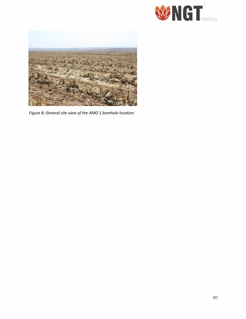
Figure 8: General site view of the AMO 1 borehole location. .................................................................... 40
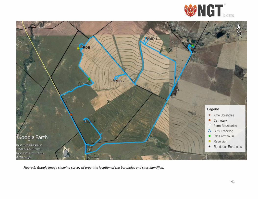
Figure 9: Google Image showing survey of area, the location of the boreholes and sites identified. ....... 41
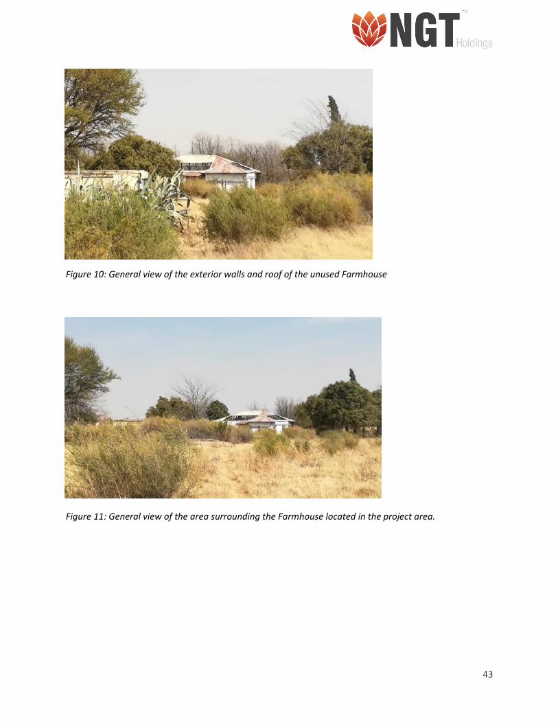
Figure 10: General view of the exterior walls and roof of the unused Farmhouse .................................... 43
Figure 11: General view of the area surrounding the Farmhouse located in the project area. ................. 43
Figure 12: North west facing corner of house ............................................................................................ 46
Figure 13: South west facing corner of house ............................................................................................ 46
Figure 14: North east facing corner of house. Red circle indicates part of house that was added later. .. 47
Figure 15: South east facing corner of house ............................................................................................. 47
Figure 16: Door frame with inscription above it. ........................................................................................ 48
Figure 17: General view of the site and vegetation surrounding the cemetery ......................................... 51
Figure 18: Grave A1, belonging to ‘Jwalane Mamorena’. ........................................................................... 51
Figure 19: Grave A2, with headstone where the date of death is visible ................................................... 52
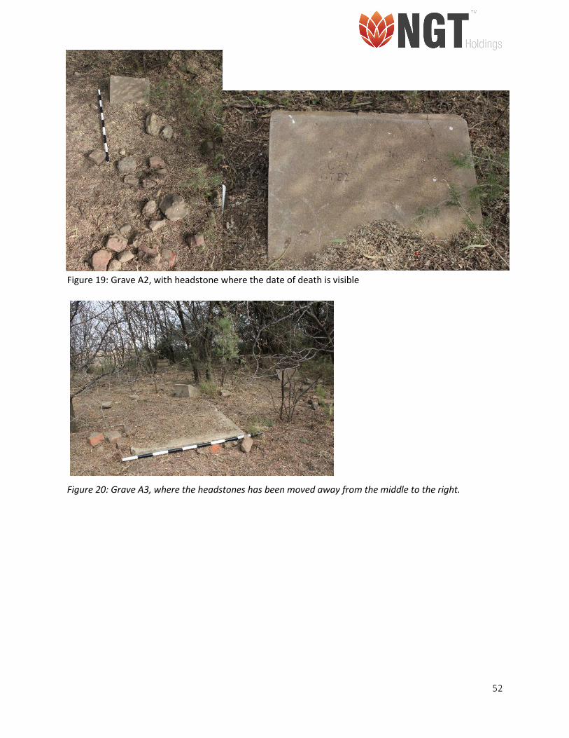
Figure 20: Grave A3, where the headstones has been moved away from the middle to the right. .......... 52
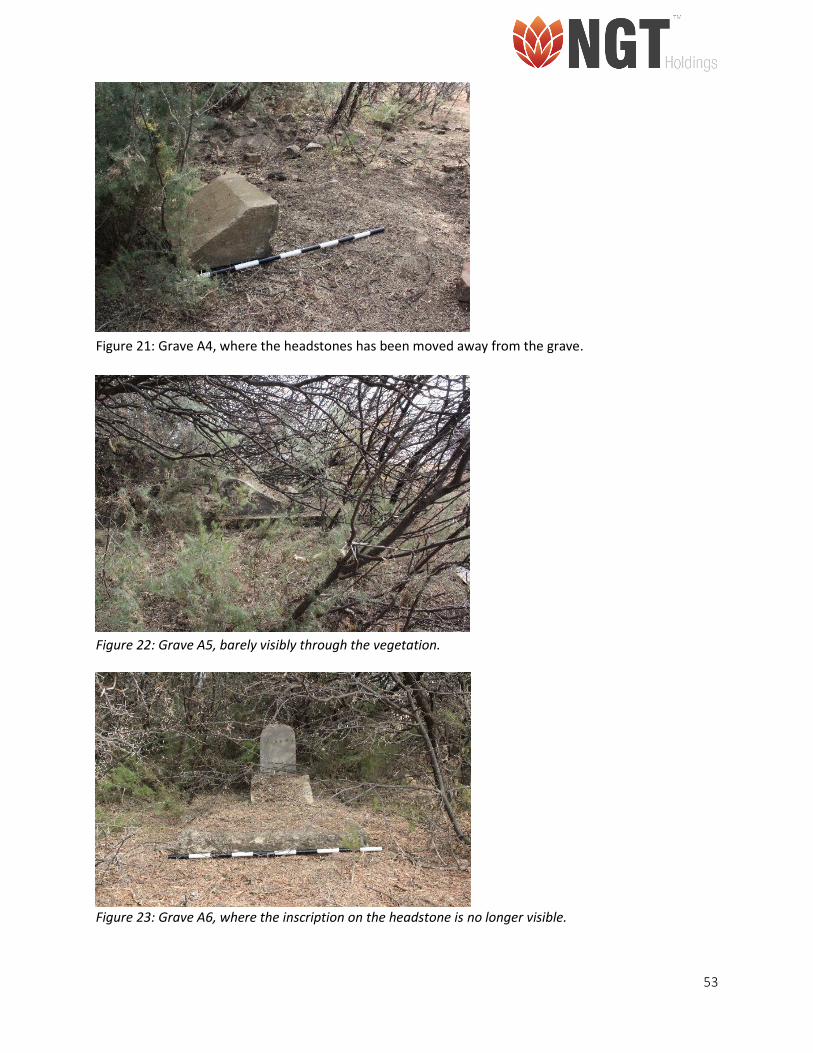
Figure 21: Grave A4, where the headstones has been moved away from the grave. ................................ 53
Figure 22: Grave A5, barely visibly through the vegetation. ...................................................................... 53
Figure 23: Grave A6, where the inscription on the headstone is no longer visible. ................................... 53
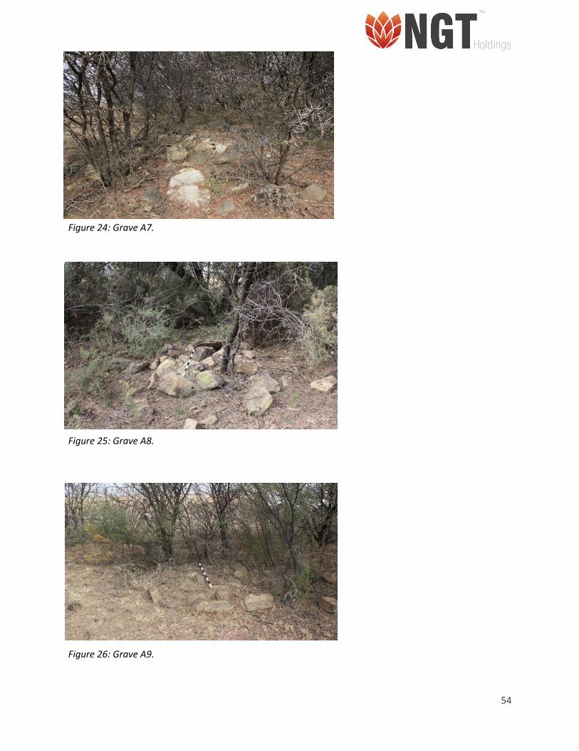
Figure 24: Grave A7. .................................................................................................................................... 54
Figure 25: Grave A8. .................................................................................................................................... 54
Figure 26: Grave A9. .................................................................................................................................... 54
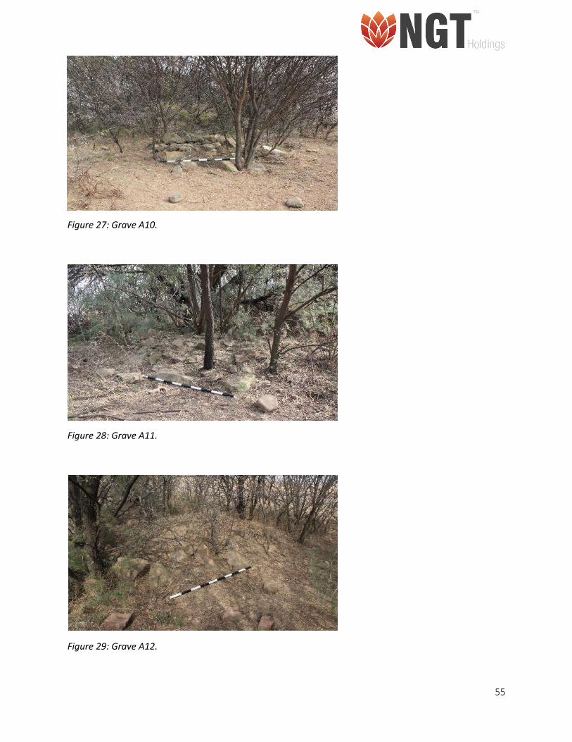
Figure 27: Grave A10. .................................................................................................................................. 55
Figure 28: Grave A11. .................................................................................................................................. 55
Figure 28: Grave A12. .................................................................................................................................. 55
Figure 31: Grave A13. .................................................................................................................................. 56
Figure 30: Grave A14. .................................................................................................................................. 56
Figure 32: Heap of stones, that could possibly be another grave. ............................................................. 57
Figure 33: Palaeo-Sensitivity layer of Kroonstad South (Blue circle) in the Moqhaka Local Municipality
within the Fezile Dabi District Municipality, Free State Province. .............................................................. 59
11
LIST OF TABLES
Table 1: Farms within the project area ....................................................................................................... 16
Table 2: Site Location and Property Information ........................................................................................ 19
Table 3-Legislation and relevance to this HIA Study ................................................................................... 23
Table 4-Site significance classification standards as prescribed by SAHRA ................................................ 25
Table 5– Table indicating the impact significance rating. ........................................................................... 26
Table 6-Impact Rating table with impact mitigation .................................................................................. 28
Table 7-Risk assessment ............................................................................................................................. 29
Table 8: Site Complex- 01 ........................................................................................................................... 42
Table 9: Impact and risk assessment rating for project Planning, Construction and Operational phases in
relation to the identified site (Site Complex 1) ........................................................................................... 44
Table 10: Site Complex- 02 ......................................................................................................................... 45
Table 11: Impact and risk assessment rating for project Planning, Construction and Operational phases in
relation to the identified site (Site Complex 2) ........................................................................................... 49
Table 12: Impact and risk assessment rating for project Planning, Construction and Operational phases in
relation to the identified site (RDB Cem-01) .............................................................................................. 58
Table 13: Site significance classification and ratings for the buildings located in the project area ........... 59
12
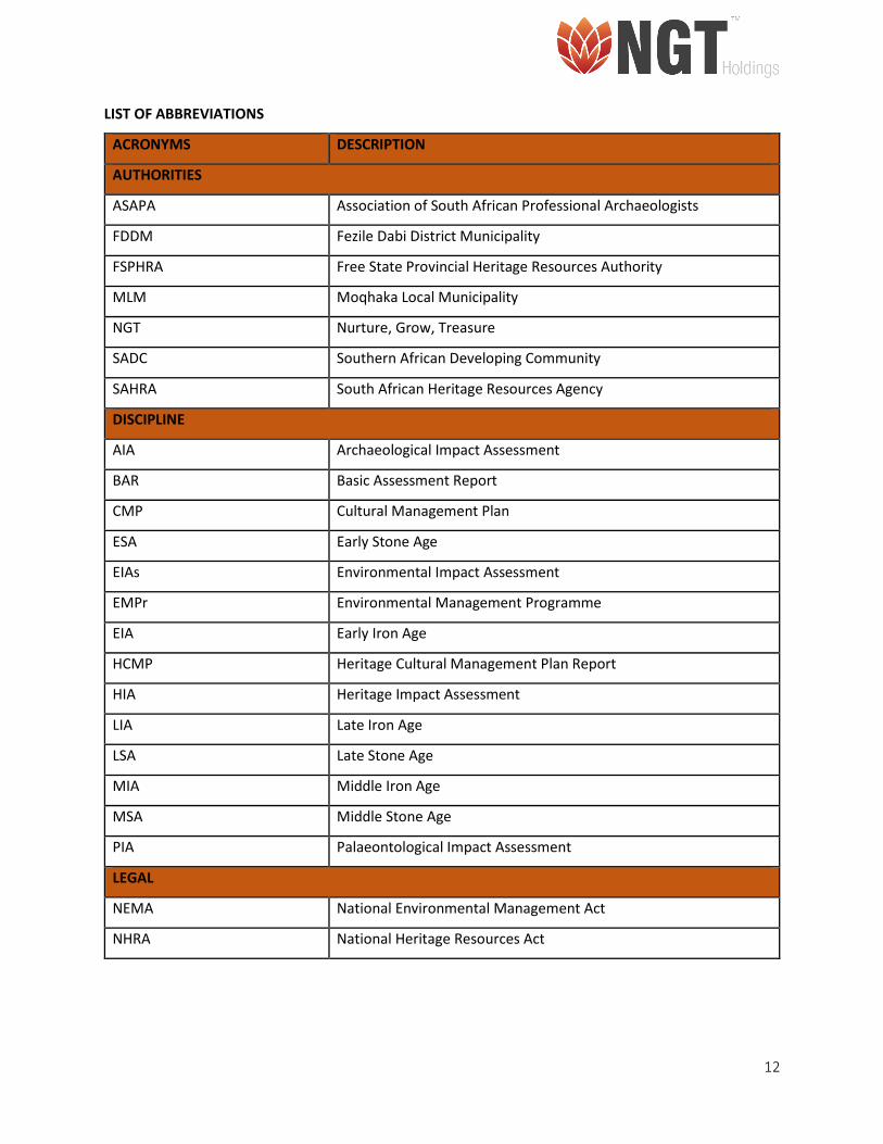
LIST OF ABBREVIATIONS
ACRONYMS DESCRIPTION
AUTHORITIES
ASAPA Association of South African Professional Archaeologists
FDDM Fezile Dabi District Municipality
FSPHRA Free State Provincial Heritage Resources Authority
MLM Moqhaka Local Municipality
NGT Nurture, Grow, Treasure
SADC Southern African Developing Community
SAHRA South African Heritage Resources Agency
DISCIPLINE
AIA Archaeological Impact Assessment
BAR Basic Assessment Report
CMP Cultural Management Plan
ESA Early Stone Age
EIAs Environmental Impact Assessment
EMPr Environmental Management Programme
EIA Early Iron Age
HCMP Heritage Cultural Management Plan Report
HIA Heritage Impact Assessment
LIA Late Iron Age
LSA Late Stone Age
MIA Middle Iron Age
MSA Middle Stone Age
PIA Palaeontological Impact Assessment
LEGAL
NEMA National Environmental Management Act
NHRA National Heritage Resources Act
13
TERMS AND DEFINITIONS
Archaeological resources
These include:
• Material remains resulting from human activities which are in a state of disuse and are in or on
land and which are older than 100 years including artefacts, human and hominid remains and
artificial features and structures;
• Rock art, being any form of painting, engraving or other graphic representation on a fixed rock
surface or loose rock or stone, which was executed by human agency and which is older than 100
years, including any area within 10m of such representation;
• Wrecks, being any vessel or aircraft, or any part thereof which was wrecked in South Africa,
whether on land, in the internal waters, the territorial waters or in the maritime culture zone of
the republic as defined in the Maritimes Zones Act, and any cargo, debris or artefacts found or
associated therewith, which is older than 60 years or which SAHRA considers to be worthy of
conservation;
• Features, structures and artefacts associated with military history which are older than 75 years
and the site on which they are found.
Palaeontological
This means any fossilised remains or fossil trace of animals or plants which lived in the geological past,
other than fossil fuels or fossiliferous rock intended for industrial.
Cultural significance
This means aesthetic, architectural, historical, scientific, social, spiritual, linguistic or technological value
or significance.
Development
This means any physical intervention, excavation, or action, other than those caused by natural forces,
which may in the opinion of the heritage authority in any way result in the change to the nature,
appearance or physical nature of a place or influence its stability and future well-being, including:
• Construction, alteration, demolition, removal or change in use of a place or a structure at a place;
• Carrying out any works on or over or under a place;

14
• Subdivision or consolidation of land comprising a place, including the structures or airspace of a
place;
• Constructing or putting up for display signs or boards; any change to the natural or existing
condition or topography of land;
• And any removal or destruction of trees, or removal of vegetation or topsoil.
Heritage resources: This means any place or object of cultural significance.
15
1. INTRODUCTION
1.1. Background Information of Project
NGT was appointed by Shango to conduct an HIA (inclusive of Palaeontological Desktop Assessment) study
for the prospecting right and environmental authorisation application conducted by Shango for Kroonstad
South. The receiving environment is located in the MLM in the FDDM, in the Free State Province, South
Africa.
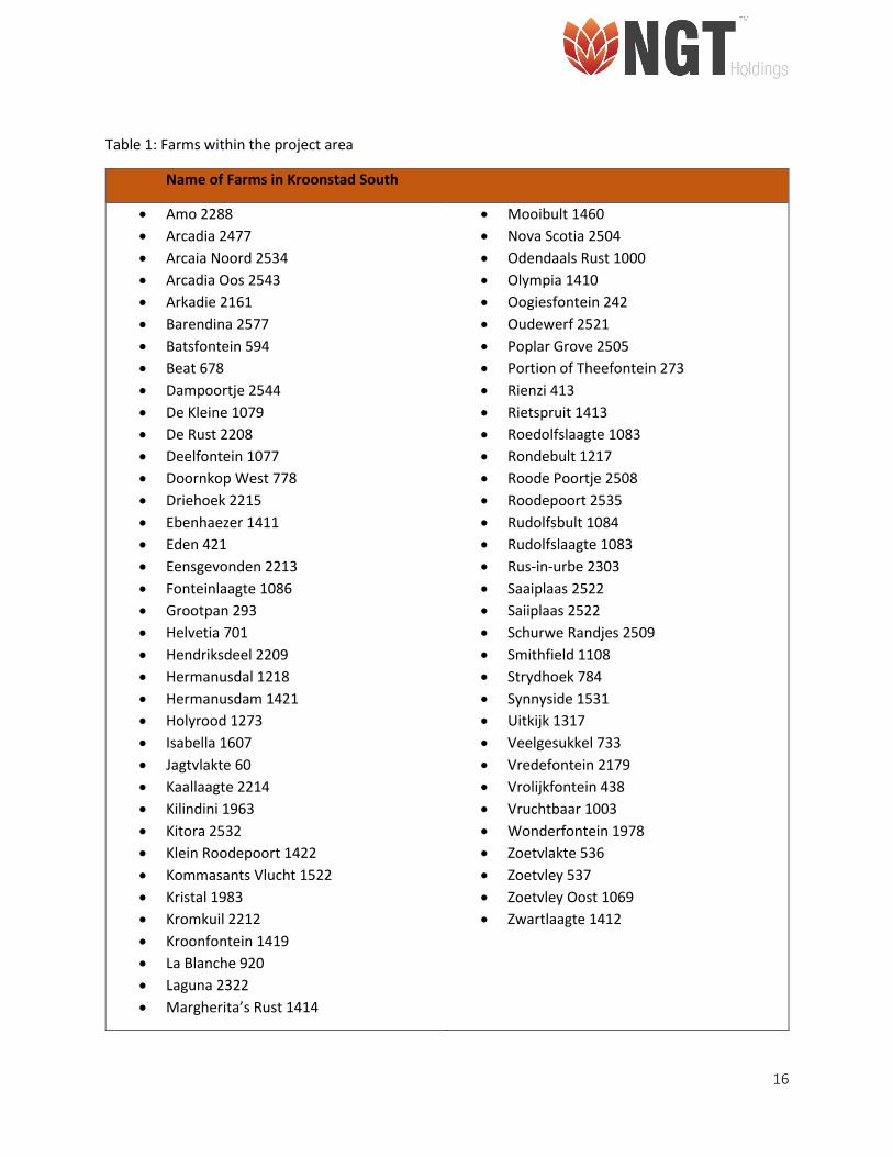
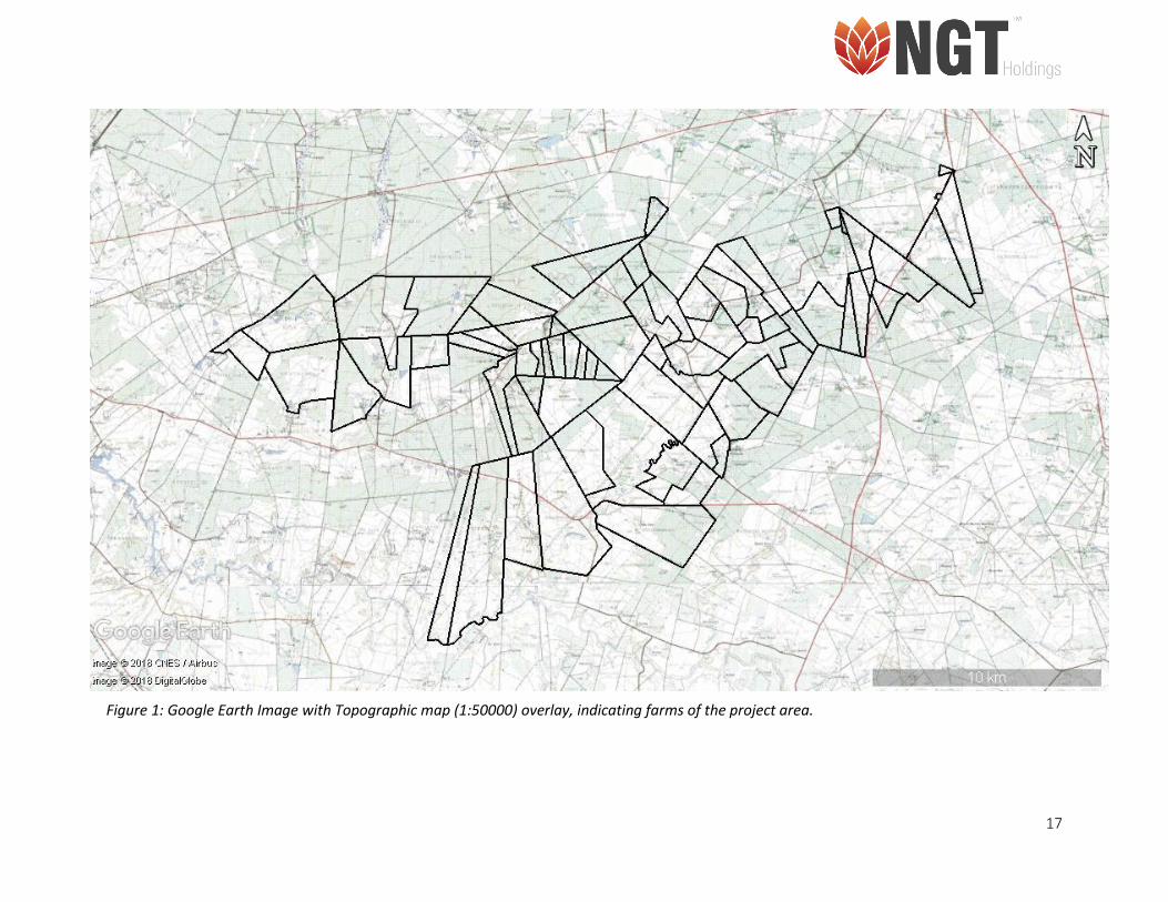
The area proposed for prospecting is distributed over 70 farms located east of Kroonstad (Figure. 1 and
Table. 1). The total size of the area proposed for prospecting is 22 202.78 ha. The objective of the proposed
project is to explore and quantify the potential of mineral resources in the area. Four drill holes were
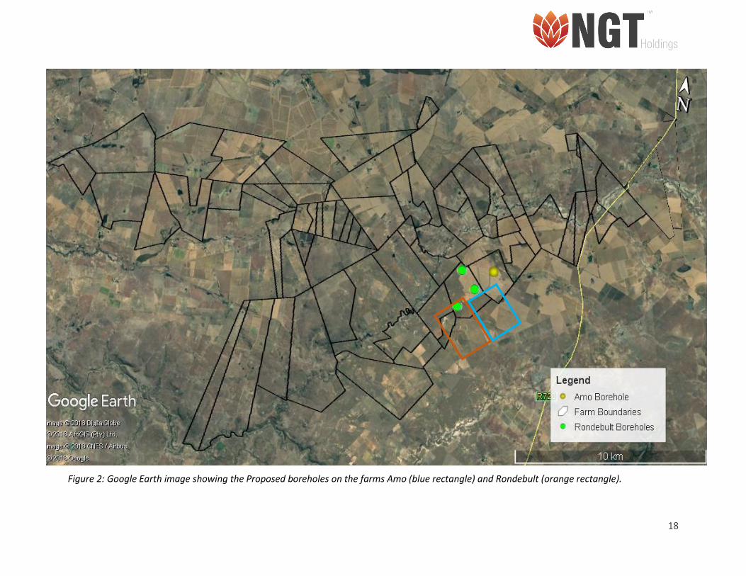
proposed and located on the Farms Amo and Rondebult (Figure. 2). The HIA will investigate the potential
impacts of the proposed prospecting activities on any heritage resources identified within the receiving
environment such as archaeological artefacts, burial grounds and historical features of the built
environment. The study will focus mainly on the area surrounding the four bore holes on the Farms Amo
and Rondebult. The overall objective of the HIA is to give advice on the management of the heritage
resources in and around the proposed project area in terms of known heritage resources management
measures in line with the NHRA, No. 25 of 1999.
1.2. Limitations
• During the initial HIA study of the entire project area several limitations were observed. It was
found that the landowners whose properties are located in the proposed prospecting area, as
identified by the Shango Landowner Database, are upset about the proposed prospecting
activities.
• This resulted in specialists being unable to gain access to the properties to conduct the required
studies. As such this HIA prioritised the farms Amo 2288 and Rondebult 1217 in Kroonstad where
invasive prospecting is planned (Figure. 2).
16
Table 1: Farms within the project area
Name of Farms in Kroonstad South
• Amo 2288
• Arcadia 2477
• Arcaia Noord 2534
• Arcadia Oos 2543
• Arkadie 2161
• Barendina 2577
• Batsfontein 594
• Beat 678
• Dampoortje 2544
• De Kleine 1079
• De Rust 2208
• Deelfontein 1077
• Doornkop West 778
• Driehoek 2215
• Ebenhaezer 1411
• Eden 421
• Eensgevonden 2213
• Fonteinlaagte 1086
• Grootpan 293
• Helvetia 701
• Hendriksdeel 2209
• Hermanusdal 1218
• Hermanusdam 1421
• Holyrood 1273
• Isabella 1607
• Jagtvlakte 60
• Kaallaagte 2214
• Kilindini 1963
• Kitora 2532
• Klein Roodepoort 1422
• Kommasants Vlucht 1522
• Kristal 1983
• Kromkuil 2212
• Kroonfontein 1419
• La Blanche 920
• Laguna 2322
• Margherita’s Rust 1414
• Mooibult 1460
• Nova Scotia 2504
• Odendaals Rust 1000
• Olympia 1410
• Oogiesfontein 242
• Oudewerf 2521
• Poplar Grove 2505
• Portion of Theefontein 273
• Rienzi 413
• Rietspruit 1413
• Roedolfslaagte 1083
• Rondebult 1217
• Roode Poortje 2508
• Roodepoort 2535
• Rudolfsbult 1084
• Rudolfslaagte 1083
• Rus-in-urbe 2303
• Saaiplaas 2522
• Saiiplaas 2522
• Schurwe Randjes 2509
• Smithfield 1108
• Strydhoek 784
• Synnyside 1531
• Uitkijk 1317
• Veelgesukkel 733
• Vredefontein 2179
• Vrolijkfontein 438
• Vruchtbaar 1003
• Wonderfontein 1978
• Zoetvlakte 536
• Zoetvley 537
• Zoetvley Oost 1069
• Zwartlaagte 1412
17
Figure 1: Google Earth Image with Topographic map (1:50000) overlay, indicating farms of the project area.
18
Figure 2: Google Earth image showing the Proposed boreholes on the farms Amo (blue rectangle) and Rondebult (orange rectangle).
19
1.3. Description of the Affected Environment
Description
• The project area is located near Kroonstad in the Moqhaka Local Municipality in the Fezile
Dabi District Municipality, situated in the Free State Province, South Africa (Table.1).
• Project area covers an area of approximately 47273 hectares.
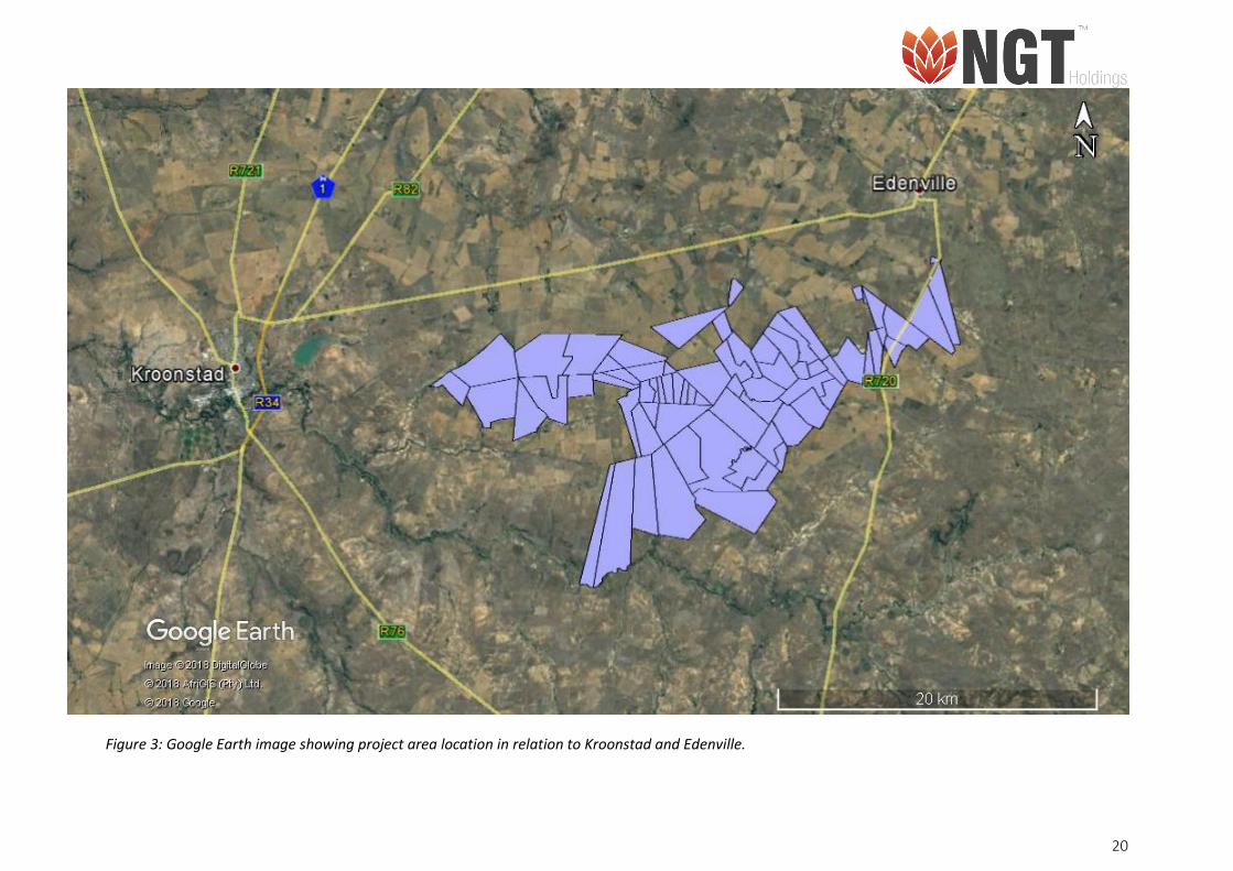
• It is located in between the towns Kroonstad and Edenville (Figure. 3).
Access
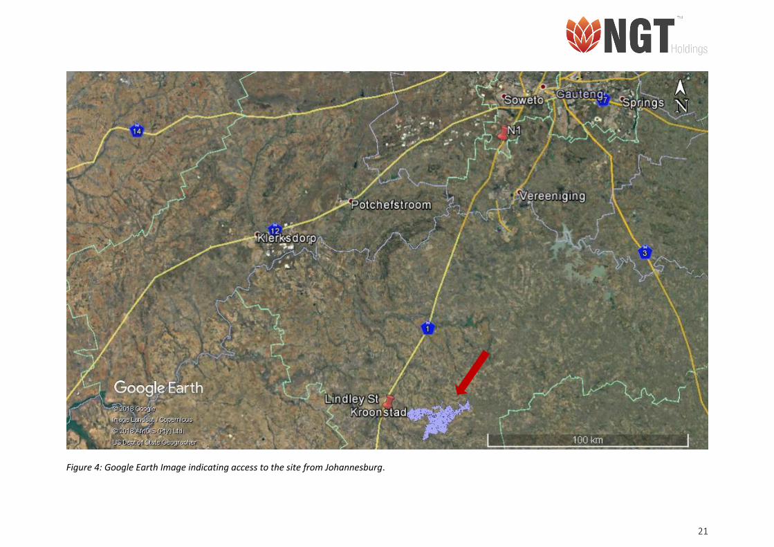
• Follow N1 to Lindley St/Reitz St in Kroonstad (Figure. 4).
• Continue onto N1/N12
• Take exit 398 for Reitz Street toward Kroonstad/Doornkloof/Kroonstad Airport
• Turn left onto Lindley St/Reitz St
• Turn Left onto unnamed road
Table 2: Site Location and Property Information
Location
Name of affected property Kroonstad South
Erf or farm number/s • Amo 2288
• Rondebult 1217
Town Kroonstad
Responsible Local Authority Moqhaka Local Municipality
Ward 2
Magisterial District Fezile Dabi District Municipality
Region Free state Province
Country South Africa
Site centre GPS coordinates Rondebult 1217
• 27°40'50.63"S
• 27°35'10.31"E
Amo 2288
• 27°40'31.30"S
• 27°35'45.75"E
20
Figure 3: Google Earth image showing project area location in relation to Kroonstad and Edenville.
21
Figure 4: Google Earth Image indicating access to the site from Johannesburg.

22
1.4. Terms of Reference for the Appointment of Archaeologist and Heritage Specialist
The HIA is conducted in terms of Sections 38 the NHRA, No. 25 of 1999. This prescript of the Act Section
38:
“the responsible heritage resources authority must specify the information to be provided in a report
required in terms of subsection (3) (a): Provided that the following must be included:
(a) The identification and mapping of all heritage resources in the area affected;
(b) An assessment of the significance of such resources in terms of the heritage assessment
criteria set out in section 6(2) or prescribed under section 7;
(c) An assessment of the impact of the development on such heritage resources;
(d) An evaluation of the impact of the development on heritage resources relative to the
sustainable social and economic benefits to be derived from the development;
(e) The result of consultation with communities affected by the proposed development and
other interested parties regarding the impact of the development on heritage resources;
(f) If heritage resources will be adversely affected by the proposed development, the
consideration of alternatives; and
(g) Plans for mitigation of any adverse effects during and after the completion of the proposed
development.”
Shango appointed NGT as the lead cultural resources management (CRM) consultant to conduct and
manage the HIA process. Cherene de Bruyn, Archaeologist and Heritage Consultant for NGT,
conducted the HIA study for the proposed development. The appointment of NGT as an independent
CRM firm is in terms of the NHRA, No. 25 of 1999.
1.5. Legal Requirements for Completion of the Study
The NHRA, No. 25 of 1999 sets norms and standards for the management of heritage resources in
South Africa. Section 34, 36 and 38 (3) of the NHRA, No. 25 of 1999 informs the current HIA study.
Table 2 below gives a summary of all the relevant legislations that informed the current study.
23
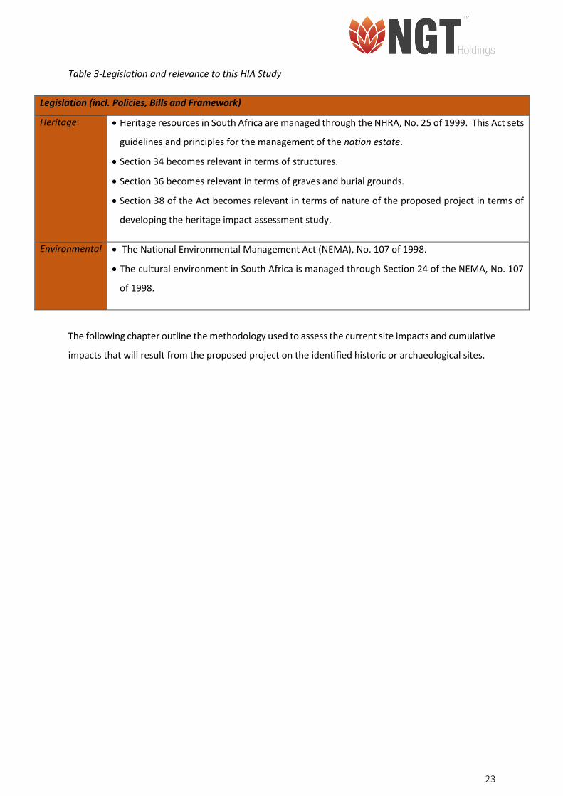
Table 3-Legislation and relevance to this HIA Study
Legislation (incl. Policies, Bills and Framework)
Heritage • Heritage resources in South Africa are managed through the NHRA, No. 25 of 1999. This Act sets
guidelines and principles for the management of the nation estate.
• Section 34 becomes relevant in terms of structures.
• Section 36 becomes relevant in terms of graves and burial grounds.
• Section 38 of the Act becomes relevant in terms of nature of the proposed project in terms of
developing the heritage impact assessment study.
Environmental • The National Environmental Management Act (NEMA), No. 107 of 1998.
• The cultural environment in South Africa is managed through Section 24 of the NEMA, No. 107
of 1998.
The following chapter outline the methodology used to assess the current site impacts and cumulative
impacts that will result from the proposed project on the identified historic or archaeological sites.

24
2. METHODOLOGY
2.1. Approach to the Study
Cherene de Bruyn, Archaeologist and Heritage Consultant for NGT, is responsible for the compilation
of the current HIA report. The Review and Quality Control (RQC) process involved reviewing the First
Draft HIA (Revision 01) and revising the Second Draft (Revision 02); the RQC was completed by Mr
Nkosinathi Tomose, Principal Archaeologist and Heritage Consultant for NGT. The RQC is a standard
process at NGT; in the case that the Director and Principal Consultant is responsible for the report –
another consultant has to undertake the RQC process. This HIA is conducted for a for the prospecting
right and environmental authorisation application for Kroonstad South situated in the Free State
Province, South Africa.
2.2. Step I – Literature Review (Desktop Phase)
Background information search for the proposed development took place following the receipt of
appointment letter from the client. Sources used included, but not limited to published HIA studies,
academic books, academic journal articles and the internet about the site and the broader area in
which it is located. Interpretation of legislation (the NHRA, No. 25 of 1999) and local bi-laws forms,
form the backbone for the study.
2.3. Step II – Physical Survey
The physical survey of the project area (footprint) was conducted on Wednesday 15 August 2018 as
part of the farm visit with the ecological and geological specialists. The survey was conducted by Miss
Cherene de Bruyn (archaeology and Heritage Consultant – NGT). During the survey several graves and
Historical Farm houses were identified. These findings are discussed in detail in this HIA report.
The aim of the survey was to identify archaeological and heritage sites and resources within the area
proposed for the boreholes and within the 500m radius;
• The survey of the proposed mining area was conducted on foot and the site was accessed
using a bakkie;
• The aim of the surveys was to identify archaeological, burial grounds and graves, and built
environment heritage sites and resources in and around the area proposed for development;
• To record and document the sites using applicable tools and technology;
25
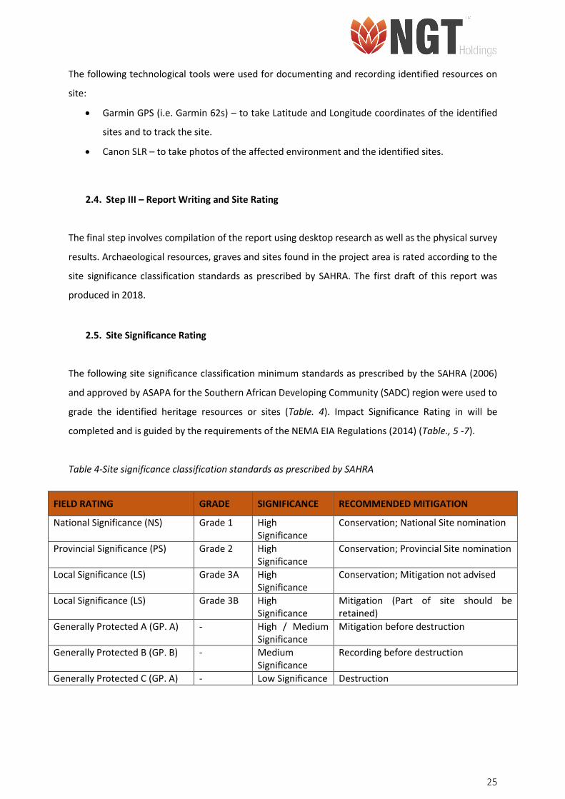
The following technological tools were used for documenting and recording identified resources on
site:
• Garmin GPS (i.e. Garmin 62s) – to take Latitude and Longitude coordinates of the identified
sites and to track the site.
• Canon SLR – to take photos of the affected environment and the identified sites.
2.4. Step III – Report Writing and Site Rating
The final step involves compilation of the report using desktop research as well as the physical survey
results. Archaeological resources, graves and sites found in the project area is rated according to the
site significance classification standards as prescribed by SAHRA. The first draft of this report was
produced in 2018.
2.5. Site Significance Rating
The following site significance classification minimum standards as prescribed by the SAHRA (2006)
and approved by ASAPA for the Southern African Developing Community (SADC) region were used to
grade the identified heritage resources or sites (Table. 4). Impact Significance Rating in will be
completed and is guided by the requirements of the NEMA EIA Regulations (2014) (Table., 5 -7).
Table 4-Site significance classification standards as prescribed by SAHRA
FIELD RATING GRADE SIGNIFICANCE RECOMMENDED MITIGATION
National Significance (NS) Grade 1 High Significance
Conservation; National Site nomination
Provincial Significance (PS) Grade 2 High Significance
Conservation; Provincial Site nomination
Local Significance (LS) Grade 3A High Significance
Conservation; Mitigation not advised
Local Significance (LS) Grade 3B High Significance
Mitigation (Part of site should be retained)
Generally Protected A (GP. A) - High / Medium Significance
Mitigation before destruction
Generally Protected B (GP. B) - Medium Significance
Recording before destruction
Generally Protected C (GP. A) - Low Significance Destruction
26
Table 5– Table indicating the impact significance rating.
Alternative No List Alternative Names
Proposal Development
Alternative 1 Development Area 01
Alternative 2 Development Area 02
Nature -1 Negative
1 Positive
Extent 1 Activity (i.e. limited to the area applicable to the specific activity)
2 Site (i.e. within the development property boundary),
3 Local (i.e. the area within 5 km of the site),
4 Regional (i.e. extends between 5 and 50 km from the site
5 Provincial / National (i.e. extends beyond 50 km from the site)
Duration 1 Immediate (<1 year)
2 Short term (1-5 years),
3 Medium term (6-15 years),
4 Long term (the impact will cease after the operational life span of
the project),
5 Permanent (no mitigation measure of natural process will reduce
the impact after construction).
Magnitude/ Intensity
1 Minor (where the impact affects the environment in such a way that natural, cultural and social functions and processes are not affected),
2 Low (where the impact affects the environment in such a way that natural, cultural and social functions and processes are slightly affected),
3 Moderate (where the affected environment is altered but natural, cultural and social functions and processes continue albeit in a modified way),
4 High (where natural, cultural or social functions or processes are
altered to the extent that it will temporarily cease), or
5 Very high / don’t know (where natural, cultural or social functions or processes are altered to the extent that it will permanently cease).
Reversibility 1 Impact is reversible without any time and cost.
2 Impact is reversible without incurring significant time and cost.
3 Impact is reversible only by incurring significant time and cost.
4 Impact is reversible only by incurring prohibitively high time and
cost.
5 Irreversible Impact
Probability
1 Improbable (the possibility of the impact materialising is very low as a result of design, historic experience, or implementation of adequate corrective actions; <25%),
2 Low probability (there is a possibility that the impact will occur;
>25% and <50%),
3 Medium probability (the impact may occur; >50% and <75%),
4 High probability (it is most likely that the impact will occur- > 75%
probability), or
5 Definite (the impact will occur),
Public feedback 1 Low: Issue not raised in public responses
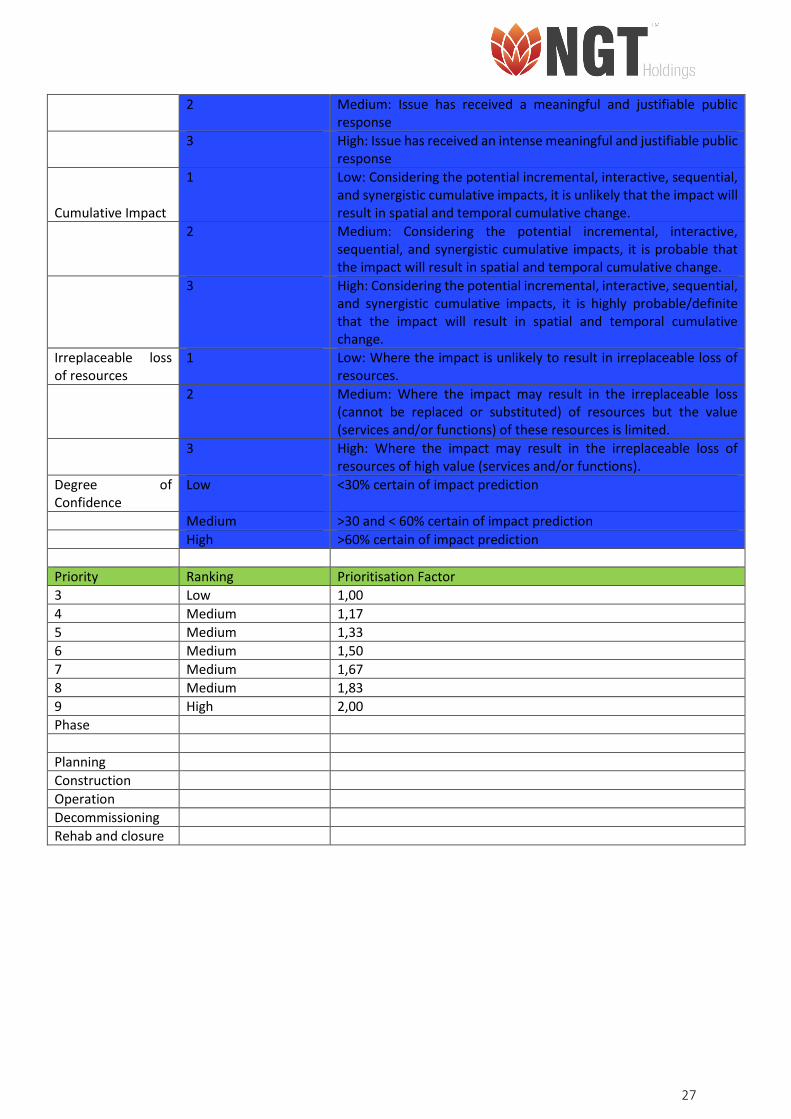
27
2 Medium: Issue has received a meaningful and justifiable public
response
3 High: Issue has received an intense meaningful and justifiable public
response
Cumulative Impact
1 Low: Considering the potential incremental, interactive, sequential, and synergistic cumulative impacts, it is unlikely that the impact will result in spatial and temporal cumulative change.
2 Medium: Considering the potential incremental, interactive, sequential, and synergistic cumulative impacts, it is probable that the impact will result in spatial and temporal cumulative change.
3 High: Considering the potential incremental, interactive, sequential, and synergistic cumulative impacts, it is highly probable/definite that the impact will result in spatial and temporal cumulative change.
Irreplaceable loss of resources
1 Low: Where the impact is unlikely to result in irreplaceable loss of resources.
2 Medium: Where the impact may result in the irreplaceable loss (cannot be replaced or substituted) of resources but the value (services and/or functions) of these resources is limited.
3 High: Where the impact may result in the irreplaceable loss of
resources of high value (services and/or functions).
Degree of Confidence
Low <30% certain of impact prediction
Medium >30 and < 60% certain of impact prediction
High >60% certain of impact prediction
Priority Ranking Prioritisation Factor
3 Low 1,00
4 Medium 1,17
5 Medium 1,33
6 Medium 1,50
7 Medium 1,67
8 Medium 1,83
9 High 2,00
Phase
Planning
Construction
Operation
Decommissioning
Rehab and closure
28
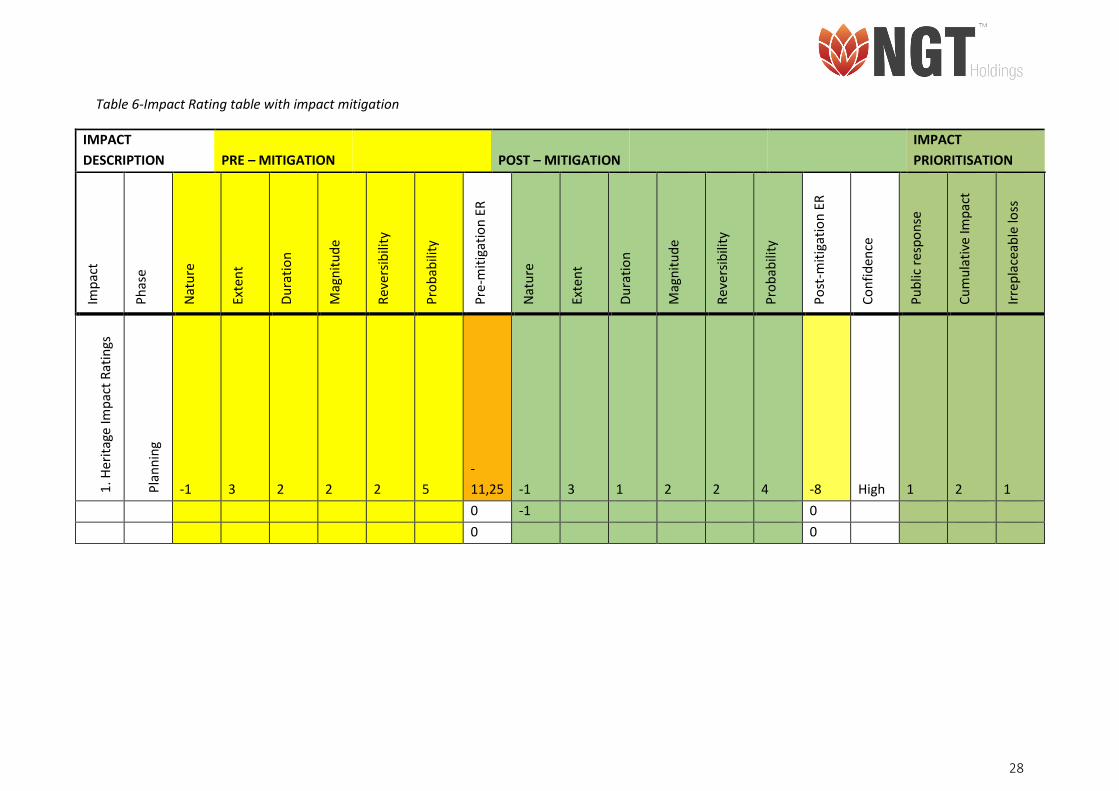
Table 6-Impact Rating table with impact mitigation
IMPACT
DESCRIPTION PRE – MITIGATION POST – MITIGATION
IMPACT
PRIORITISATION
Imp
act
Ph
ase
Nat
ure
Exte
nt
Du
rati
on
Mag
nit
ud
e
Rev
ersi
bili
ty
Pro
bab
ility
Pre
-mit
igat
ion
ER
Nat
ure
Exte
nt
Du
rati
on
Mag
nit
ud
e
Rev
ersi
bili
ty
Pro
bab
ility
Po
st-m
itig
atio
n E
R
Co
nfi
den
ce
Pu
blic
res
po
nse
Cu
mu
lati
ve Im
pac
t
Irre
pla
ceab
le lo
ss
1. H
erit
age
Imp
act
Rat
ings
Pla
nn
ing
-1 3 2 2 2 5
-
11,25 -1 3 1 2 2 4 -8 High 1 2 1
0 -1 0
0 0
29
Table 7-Risk assessment
1. Select Impact from Dropdown List (C2:H2)
A. 1. Transformation of cultural/heritage resource – Proposal
2. (C4:H24)
Impact Name Heritage Impact Assessment
Alternative Proposal
Phase Planning
Environmental Risk
Attribute Pre-mitigation Post-mitigation Attribute Pre-mitigation Post-mitigation
Nature of Impact -1 -1 Magnitude of Impact 2 2
Extent of Impact 3 3 Reversibility of Impact 2 2
Duration of Impact 2 1 Probability 5 4
Environmental Risk (Pre-mitigation) -11,25
Mitigation Measures
Heritage Risks
Heritage Risk (Post-mitigation) -8,00
Degree of confidence in impact prediction: High
Impact Prioritisation
Public Response 1
Low: Issue not raised in public responses
Cumulative Impacts 2
Considering the potential incremental, interactive, sequential, and synergistic cumulative impacts, it is probable that the impact will result in spatial and temporal cumulative change.
Degree of potential irreplaceable loss of resources 1
The impact is unlikely to result in irreplaceable loss of resources.
Prioritisation Factor 1,17
Final Significance -9,33
30
3. BACKGROUND LITERATURE REVIEW: ARCHAEOLOGY
In southern Africa archaeology is divided into the Stone Age, Iron Age and the Historical Period. During
these periods diverse groups of people settled on the southern African landscape. Several archaeological
sites have been identified in the Free State Province. Most of the research on the culture, archaeology
and rock art in and around the Free state Province has been conducted by Churchill et al., (2000); Coplan
(2000); Dreyer (1996, 2000); Huffman (2002, 2007); Mason (1968, 1982, 1986); and Wadley (2000).
Previous HIA’s and AIA’s of the Kroonstad region and broader Free State Province have been conducted
by Dreyer (2005a, b, 2006a, b, 2007a, b, 2008, 2012); Kruger (2018); Naudé (2013); Rossouw (2012a, b);
Sampson (1972); Van der Walt (2013) and Van Vollenhoven (2016).
3.1. Stone Age
The Stone Age is divided into three periods. The Early Stone Age (ESA) (2 million to 250 00 years ago), the
Middle Stone Age (MSA) (250 000 – 22 000 years ago) and the Later Stone Age (LSA) (25 000 to 200 years
ago). The ESA is comprised of the Oldowan stone tool complex (2 and 1.7-1.5 million years ago), and the
Acheulean stone tool complex (1.7-1.5 million years ago and 250-200 thousand years ago) (Klein 2000;
Mitchell 2002). The ESA is comprised of the Oldowan stone tool complex (2 and 1.7-1.5 million years ago),
and is characterized by small flakes, flaked cobbles and percussive tools (Diez-Martín et al., 2015; De La
Torre 2016; Klein 2000; Mitchell 2002). The Acheulean stone tool complex included large hand axes and
cleavers (1.7-1.5 million years ago and 250-200 thousand years ago) (Diez-Martín et al., 2015; De La Torre
2016; Klein 2000; Mitchell 2002).
The transition from the Early to Middle Stone Age includes a change in technology from large stone tools
to smaller blades and flakes. The MSA stone tool assemblage include blades, flakes, scrapers and pointed
tools that could have been hafted and used as spears or arrowheads and is associated with anatomically
modern humans (Wadley, 2007). In the Free State Province, MSA and LSA sites are mainly located near
river drainages such as Doring Spruit north of Kroonstad and the Vals River, as well as the Sand River to
the south of Ventersburg (Rossouw 2012a; Kruger 2018). MSA artefacts have been found to the south
west of Kroonstad at Allanridge (Rossouw 2012a) while LSA and MSA tools have also been found to the
north of Kroonstad, at the Vredefort Dome (Mitchell 2002). At Erfkroon, a site dating to the MSA and LSA
located 60 km from Bloemfontein, animal bone and stone tools have been found (Churchill et al., 2000).
31
While the skull of an archaic Homo Sapiens was found in the MSA layers at Florisbad, an open-air site near
Bloemfontein (Mitchell 2002). MSA and LSA stone tool assemblages have been found at Rose Cottage
cave, which is located a few kilometres from Ladybrand to the south of Kroonstad (Wadley 1995, 1997,
2000). To the south of Ladybrand is the small rock shelter, Leliehoek which contain several faded rock
paintings, retouched stone tools and animal bones (Esterhuysen et al., 1994; Wadley 1995).
LSA rock engravings have between found the Vaal and Wilge Rivers (Bergh 1999; Van Vollenhoven 2016).
Rock art has also been found in Rose Cottage cave and at Tandjiesberg (Wadley 1995). Stone age people
used the Tandjiesberg Rock shelter, situated near the Clocolan District to the South of Kroonstad, during
the last millennium (Wadley 1995). Animal bones as well as several retouched tools, small scrappers and
grinding stones have been found at the site (Wadley 1995).
3.2. Iron Age
The Iron Age is typically referred to the period when the first Bantu speakers started migrating south from
western Africa (Coplan 2000). The Iron Age, according to Huffman (2007) can be divided into the Early
Iron Age (EIA) (AD 200 – 900); the Middle Iron Age (MIA) (AD 900 – 1300); and the Late Iron Age (LIA) (AD
1300 – 1840). The Iron Age is characterized by farming communities who domesticated animals, produced
various ceramic vessels, smelted iron for weapons and manufactured tools.
The EIA communities throughout eastern and southern Africa share a similar Iron Age culture called the
Chifumbaze complex (Phillipson 1994; Huffman 2007). The Chifumbaze complex contains evidence of the
first farmers who cultivated crops, herded domestic animals, used iron, and who made pots (Phillipson
1994). It can furthermore be divided into the Kalundu and Urewe Traditions (Huffman 2007). The Kalundu
Tradition is also referred to as the western stream, while the Urewe Tradition is known as the eastern
stream (Huffman 2007). The Kalundu Tradition can be found in southern Africa where the makers of these
pots lived on wetter and more arable land (Mitchell 2013). In the Orange River Scheme region Sampson
(1972) found Iron Age ceramics (dating from before AD 730 to after AD 1520 or 1620) associated with
stone tools (Thorp 1996). This has been linked to contact between hunter-gather groups and Bantu-
speaking farming groups who migrated into the Free State region (Beaumont & Vogel 1984).
32
During the climatic conditions in southern and eastern Africa, Moloko people migrated from east Africa
to southern Africa (Boeyens 2003). It is argued that these people moved to southern Africa due to drought
in eastern Africa (Taylor et al., 2003). These Sotho-Tswana speaking people migrated north-westwards
until they settled in the Limpopo Province (Taylor et al., 2003). Moloko type ceramics of the Sotho-Tswana
people, replaced earlier Eiland ceramics (AD 1000 – 1300), in the Limpopo Province as well as in Botswana
(Boeyens 2003; Evers 1983; Klapwijk & Evers 1987). The Sotho-Tswana people can be divided into four
clusters; the Fokeng, the Hurutshe, the Kgatla and the Rolong (Huffman 2002, 2007). However, Huffman
later identified that ceramics of the Fokeng cluster do not form part of the Sotho-Tswana tradition, and
that the Fokeng were actually Nguni speakers (Huffman 2007; Sadr & Rodier, 2012).
The Rolong, one of the Sotho Tswana clusters arrived in southern Africa between AD 1200 and 1350 and
includes the Tlhaping groups (Boeyens 2003; Huffman 2002). The Rolong settled in the region between
the Magaliesberg to the Vaal (Huffman 2002; Giliomee & Mbenga 2007; Huffman 2007). Extensive stone
wall sites have also been found to the west of Kroonstad, on the farm Boschpunt 2218 A (Dreyer 2006a).
These sites are associated with Sotho-Tswana speakers (Thlaping and Rolong) who occupied the site from
around 16th century.
The second migration of Sotho-Tswana people was in AD 1350-1450 and is associated with the migration
of Kwena-Hurutshe (Huffman 2002; Boeyens 2003; Taylor et al., 2003). The Hurutshe cluster (includes the
Kwena, Ngwato, Ngwaketse and Tawana) are the descendants of those who claim lineage from Malope
and his father Masilo (who originated from the Lowa waterhole in Botswana) who lived at Rathateng near
Marico and Crocodile confluence in AD 1440 and 1560 (Huffman 2002, 2007). The oral traditions of the
Hurutshe indicates that they settled in the Marico region of the North West Province during the 15th
century AD (Coplan 2000; Boeyens 2003). The Hurutshe exiled the Rolong from the Mosega area south of
Zeerust (Huffman 2002). Around AD 1550 and 1650 the Kwena-Hurutshe migrated south east across the
Vaal river to Ntsuanatsati hill located between the towns of Vrede and Frankfort, to the east of Kroonstad
in the Free State Province (Huffman 2007).
During the 16th to 18th century AD, Sotho-Tswana speaking groups migrated across the Vaal river into the
southern Highveld in the Free State Province (Thorp 1996). During this time the Sotho-Tswana speaking
groups came in contact with LSA hunter-gatherer groups in the region. Archaeological evidence suggesting
contact between these two groups have been found at Rose Cottage Cave, Roosfontein, Mauermanshoek

33
(near Winburg), Rooikrans (near Ladybrand) and Westbury (near Ficksburg), and Tandjiesberg Rock
Shelters (Thorp 1996). The ceramics found at Rooikrans Rock Shelter dates to the 16th to 19th century AD,
while the ceramic assemblage form Tandjiesberg Rock Shelter was dated to the 11th and 13th century AD
(Thorp 1996). Several occupational layers have been observed at Rose Cottage Cave (Wadley 1991; Thorp
1996). Apart from the post-classic Wilton stone tool assemblages, ceramics found at the site suggests
occupation of the site during the 14th Century AD, the 15th century AD and later during the 19th and 20th
century AD (Thorp 1996).
Apart from ceramic being discovered in the Free State Province, several sites also contain large stone
walled settlements. In 1984, Dreyer (1999) concluded excavations at the LIA site found on the farm
Doornpoort 19, near Winburg. LIA stone wall settlements are located on flat topped ridges and hills can
be found throughout the Free State and North West Province. Studies conducted on the LIA classification
of stone wall settlement patterns have been done by Maggs (1976) and Mason (1986). Mason (1968)
focused his research on stone wall sites located in the Magaliesberg and Johannesburg region, it is also in
this area that the 19th century Tswana town, Marothodi is located (Anderson 2009). Mason (1986)
published a review of his stone wall settlement types following more research that was conducted in the
area. His classifications indicated the general chronological development of Sotho-Tswana Settlement
style. According to Mason (1986) earlier Sotho-Tswana settlements had a simple layout that became more
complex during the later periods. Maggs (1976) research focused on stone walls found in the Free State
Province, where his approached included linking the different site types to Sotho oral traditions, history
and identities. Maggs (1976) stone wall types included Type N (associated with the Early Fokeng and
Kwena), V (attributed to the Sotho speaking groups collectively), Z (Kabung, a branch of the Rolong) and
R (associated with bushman pastoralists).
Type N walling, the earliest stone walling south of the Vaal river, is named after Ntsuanatsati hill (Huffman
2007). According to Huffman (2007) Type N walling consists of cattle kraals linked to other walls in the
centre of the settlement surrounded by an outer wall and is associated with the Fokeng cluster. The
Fokeng cluster found at Ntsuanatsatsi Hill in the Free State Province, formed out of the Kwena (of the
Hurutshe cluster) who migrated southeast across the Vaal in AD 1550 and 1650 (Huffman 2002, 2007).
Ceramics of the Ntsuanatsatsi facies (AD 1450 to 1650) of the Blackburn Branch and Urewe Tradition, have
been found around the Vaal River region (Mason 1986; Dreyer 1992; Huffman 2007). The Ntsuanatsatsi
facies is closely related to the oral histories of the Early Fokeng and represent the movement of Nguni-
34
speaking people out of Kwazulu-Natal into the interior of South Africa. Ceramics of the Ntsuanatsatsi
facies are characterised by broad bands of stamping located mostly around the neck of the pot, as well as
stamped arcades on the shoulder (Huffman 2007). To the north of Kroonstad, in the Vredefort Dome,
several LIA stone walled settlements, most likely related to Fokeng settlements have been identified
dating to AD 1450 – 1650 (Huffman 2007; Van Vollenhoven 2016). A later occupation from AD 1700-1840
also occurred in this region (Huffman 2007).
Type V stone walls, named after Vegkop located near the town of Heilbron, developed from Type N walling
(Laidler 1935; Huffman 2007). Heilbron is located to the north-east of Kroonstad. Type V walling is
characterised by cattle kraals surrounded by huts and grain bins enclosed by an outer wall (Huffman
2007). Ceramics associated with this type of walling are the Makgwareng facies, which is characterised
by comb-stamped triangles and finger pinching (Huffman 2007). The Makgwareng facies dates to AD 1700
– 1820 (Huffman 2007).
The Uitkomst facies (AD 1650 – 1820) the Blackburn Branch is seen as the successors to the Ntsuanatsatsi
facies and contains elements of both Nguni (Ntsuanatsatsi facies) and Sotho-Tswana speakers
(Olifantspoort facies) pottery styles (Huffman, 2007). The presence of Moloko type ceramics in the region
around the Vaal river suggests a Sotho-Tswana occupation of the area form AD 1550. While the presence
of ceramics of the Ntsuanatsatsi facies and N- Type walling also suggests the preens of Nguni speakers in
the Free State from AD 1450 to 1650. The presence of ceramics of the Olifantspoort facies (AD 1500-1700)
and Thabeng facies (AD 1700-1840) around the Vaal River region also provide evidence of the contact
between Nguni and Sotho-Tswana speaking groups during the LIA.
Ceramics of the Uitkomst facies have been found mostly in the Gauteng Province as well as in the northern
part of the Free State Province (Huffman 2007). Olifantspoort facies (AD 1500-1700) and Thabeng facies
(AD 1700-1840) of the Moloko Branch have been found at Iron age sites to the south of Potchefstroom
and in the Free state Province, around the Vaal River region (Mason 1986; Mitchell 2002; Huffman 2007).
Olifantspoort pottery is characterised by “multiple bands of fine stamping and narrow incision separated
by colour” (Huffman 2007). Thabeng facies is characterised by “incised triangles, coloured chevrons and
arcades” and is associated with Type Z stone walling (Huffman 2007). Type Z walling, which is
characterized by “bilobial huts” that surround the core of the settlement and dates to the 18th – 19th
centuries (Huffman 2007).

35
Several Iron Age stone wall settlements have been found in the Kroonstad region. A large stone wall
settlement has also been found at Strydfontein between Hennenman and Ventersburg, which is located
to the South of Kroonstad (Rossouw 2012a). Similar settlements have been found from Doringberg
(Maphororong) in the Willem Pretorius game reserve near Ventersburg (Coplan 2008; Van der Walt 2013),
as well as at Sandrivierspoort (Mariba) between Winburg and Ventersburg (Dreyer 2006). Maggs (1976)
also identified stone wall sites on the Renoster River. Dreyer (2006) recorded a LIA stone wall settlement
on the farm Middenspruit 151 located north-west of the town of Kroonstad in Kroonstad.
3.3. Historical Period
The Historical Period dates from AD 1600 and is generally the period related to colonial settlement in
South Africa. During the Anglo-Boer war several battles took place in and around the Kroonstad region.
The Korana were a nomadic Khoikhoi group who left the Cape region during 1661-1668 (Erasmus 2005).
During the 18th century they settled in the Free State region (Van Vollenhoven 2016). Korana rock art is
found scattered at sites in the eastern Free State Province (Ouzman 2005). The rock art is characterized
by their painting techniques which include the use of fingers, macerated sticks or grass bundles (Ouzman
2005). In Korana rock art horses, guns, hunts, human figures, snakes, geometric shapes and smears and
splatters are often depicted (Ouzman 2005).
Following disputes with the British the Dutch-speaking Voortrekkers migrated north into the interior of
southern Africa from the Cape Colony in 1836’s in search of creating a homeland, independent of British
rule. This migration of approximately 12000 – 140000 Voortrekkers is referred to as the Great Trek. The
Voortrekkers migrated north and east into a region that was later called the Orange Free State (Hodge
2008). On their way to what would later be known as the Orange Free State, the Voortrekkers established
Winburg in 1836, the first town north of the Orange River (Dreyer 1992). Windburg is locate 100km south
of Kroonstad. Winburg became the capital of the Orange Free State in 1843 (Dreyer 1992).
During 1815 to 1840 Mzilikazi, a Zulu who departed from Shaka Zulu, migrated with his followers north
and invaded the interior of South Africa. This led to a series of battles and wars between the Zulu’s,
Voortrekkers and Sotho-Tswana communities in the Orange Free State and southern Transvaal
(Gutteridge 2008). The chaos of these battles displaced many indigenous communities in the interior of

36
Southern Africa. In October 1836, the Voortrekkers engaged in a battle with 3000 of Mzilikazi’s warriors
on Vegkop hill (Zvobgo 2009). The Voortrekkers who were assisted by the Sotho-Tswana and Griqua
groups defeated Mzilikazi’s Matabele, who fled to the Limpopo Province and settled in Zimbabwe (Zvobgo
2009). The region between the Orange and Vaal Rivers was proclaimed as British Possession by Sir Harry
Smith in 1848 (Scott-Keltie & Epstein 1925). Several battles and wars were fought between the
Voortrekkers, the Bantu speaking groups and the British in the region. In 1866 Winburg was attached by
Basotho groups who were stealing livestock from farmers (Dreyer 1992).
Kroonstad was officially established in 1854, the same year the Orange Free State was formed (Pistorius
2004). Josias Philip Hoffman was elected as president of the Orange Free State (Theal 1908). Kroonstad
was named after the horse of the Voortrekker Sarel Cilliers (Richardson 2001). The town was established
after an order by the Free State Republic for the establishment of a town in the northern part of the
Republic (Kay 1984; Pistorius 2004). The first erfs were laid out in 1855 near the Vals River banks (Pistorius
2004). The Convention of Sandrivier was signed in 1852 between Great Britain and the Voortrekkers
(Kruger 2018). In the Convention the Voortrekkers were given independence. The Voortrekkers then
established the South African Republic (Transvaal) (Ashman 1996). The Convention was signed at the Sand
River, south of Kroonstad near Ventersburg. During the Anglo Boer War (1899-1902), Kroonstad served
as a seat of the Free State Government (Pistorius 2004). Kroonstad was declared the capital of the Boer
capital of the Orange Free State on 12 March 1900 by President M. T. Steyn (Van der Walt 2013).
Concentration camps for both the Boer and Black South African communities were located in Kroonstad
(Van der Walt 2013). Kroonstad Concentration Camp Cemetery was one of eleven camps in the Free State
during the Anglo-Boer War (1899-1902). In 1900 the Orange Free State was annexed as the Orange River
Colony (Scott-Keltie & Epstein 1925). In 1903 the Kroonstad Concentration Camp was closed. In 1910 the
Orange River Colony merged and formed the province of the Orange Free State in the Union of South
Africa (Scott-Keltie & Epstein 1925).
3.4. Conclusions on Literature Review
It is concluded that the proposed study area is located in a region rich in archaeology, history and heritage.
Several groups have settled in the region, which lead to several conflicts and battles. Kroonstad is
particularly well known for heritage resources related to the Iron Age and Historical Period. Throughout
the Free State Iron Age stone-walled sites and ceramics can be found along flat-topped ridges and hills.

37
These settlement types and ceramics indicate that the region was occupied by Sotho-Tswana speaking
communities from AD 1200 and that Nguni speaking groups later moved into the region. During the 19th
century traders, explorers and missionaries settled in the region. One of these groups were the
Voortrekkers who were moving north away from the control of the Cape Colony. The region surrounding
Kroonstad became Kroonstad played an important role during the Anglo-Boer War (1899-1902).

38
4. STUDY RESULTS
The background information yielded information about known archaeological and heritage resources
located in the Free State Province, and particularly the Kroonstad region. The broader Free State Province
has a long history with Sotho-Tswana speaking people migrating and settling in the area during the Iron
Age. Kroonstad and the surrounding areas are rich in archaeology and history which played a role in
documenting the lives of the Voortrekkers, the British and the Sotho-Tswana speaking people during the
historical period.
The physical survey focused on the area proposed for the prospecting right and environmental
authorisation application in Kroonstad South situated in the Free State Province. The survey specifically
focussed on the areas proposed for the four boreholes. Three areas were proposed as possible location
for boreholes on the Farm Rondebult, they were respectively labelled RDB 1, RDB 2 and RDB 3. On the
Farm Amo one borehole was proposed, it was labelled AMO 1. No archaeological resources, including
artefacts were identified in the areas directly surrounding the proposed borehole locations. All the
proposed locations were situated within the current agricultural fields of the farms, which meant that the
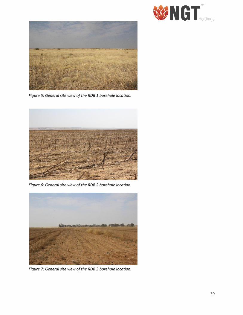
areas were disturbed by agricultural activities (Figure. 5-9).
The study then assessed the region surrounding the proposed development footprint. An old unoccupied
Farmhouse (Site Complex 1) was identified located to the south of RDB 1 and to the west of RDB 2. To the
north-west of RDB 3 a small informal cemetery (RDB Cem-01) was identified with several marked and
unmarked graves. Approximately 1km to the east of AMO 1 an Old Farmhouse (Site Complex 2) dating to
1909 was identified. The house is currently occupied by family of the farm owner.
39
Figure 5: General site view of the RDB 1 borehole location.
Figure 6: General site view of the RDB 2 borehole location.
Figure 7: General site view of the RDB 3 borehole location.
40
Figure 8: General site view of the AMO 1 borehole location.
41
Figure 9: Google Image showing survey of area, the location of the boreholes and sites identified.
42
4.1. Archaeological sites
No archaeological sites or objects were identified during the survey and site visit.
4.2. Built Environment Features
Table 8: Site Complex- 01
Site Name: Site Complex - 01
Type: Built Environment
Density: Medium density
Location/GPS Coordinates: • 27°40'47.61"S
• 27°35'0.68"E
Approximate Age: Historical Period
Applicable Sections of the Relevant Acts: • Section 34 of the NHRA, No. 25 of 1999
Description:
An old farmhouse was identified located on the farm Rondebult. It is approximately 650m west of the
proposed location for the RDB 2 borehole and falls just outside the 500m zone of influence (Figure. 10).
The exterior walls and roof of the farm house appears to be in a relatively poor condition. The paint is
peeling from the walls and the roof appears to have collapsed. The area surrounding the farmhouse is
also overgrown and unkept, indicating that the area has been unoccupied or unused for several years
(Figure. 11).
The farmhouse was most likely constructed during the 1920’s.
43
Figure 10: General view of the exterior walls and roof of the unused Farmhouse
Figure 11: General view of the area surrounding the Farmhouse located in the project area.
44
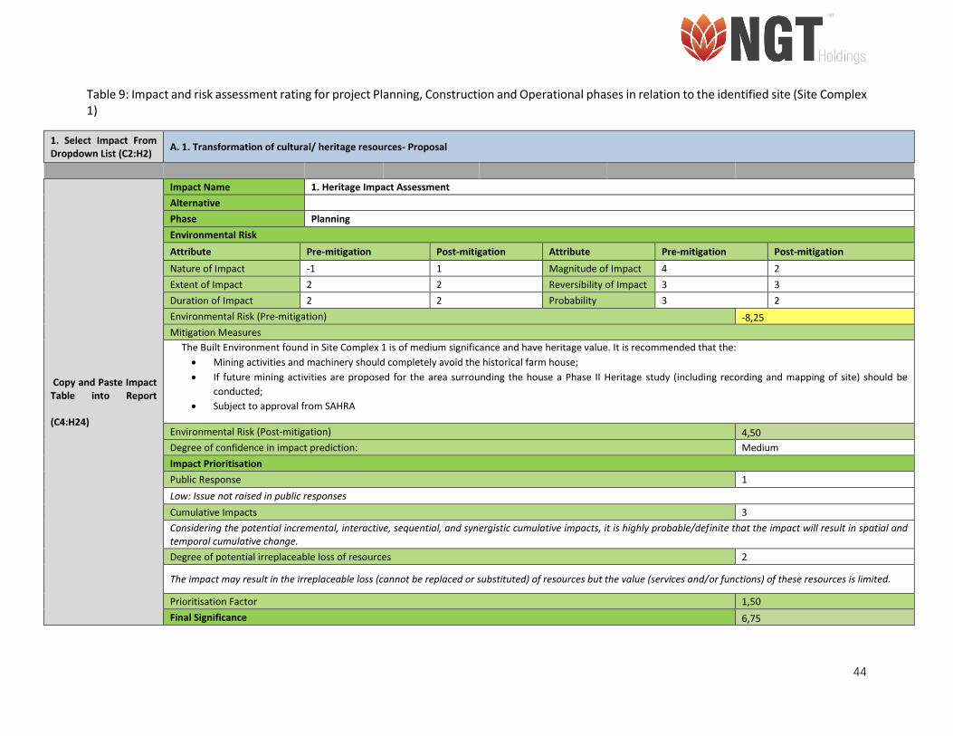
Table 9: Impact and risk assessment rating for project Planning, Construction and Operational phases in relation to the identified site (Site Complex 1)
1. Select Impact From Dropdown List (C2:H2)
A. 1. Transformation of cultural/ heritage resources- Proposal
Copy and Paste Impact Table into Report (C4:H24)
Impact Name 1. Heritage Impact Assessment
Alternative
Phase Planning
Environmental Risk
Attribute Pre-mitigation Post-mitigation Attribute Pre-mitigation Post-mitigation
Nature of Impact -1 1 Magnitude of Impact 4 2
Extent of Impact 2 2 Reversibility of Impact 3 3
Duration of Impact 2 2 Probability 3 2
Environmental Risk (Pre-mitigation) -8,25
Mitigation Measures
The Built Environment found in Site Complex 1 is of medium significance and have heritage value. It is recommended that the:
• Mining activities and machinery should completely avoid the historical farm house;
• If future mining activities are proposed for the area surrounding the house a Phase II Heritage study (including recording and mapping of site) should be
conducted;
• Subject to approval from SAHRA
Environmental Risk (Post-mitigation) 4,50
Degree of confidence in impact prediction: Medium
Impact Prioritisation
Public Response 1
Low: Issue not raised in public responses
Cumulative Impacts 3
Considering the potential incremental, interactive, sequential, and synergistic cumulative impacts, it is highly probable/definite that the impact will result in spatial and temporal cumulative change.
Degree of potential irreplaceable loss of resources 2
The impact may result in the irreplaceable loss (cannot be replaced or substituted) of resources but the value (services and/or functions) of these resources is limited.
Prioritisation Factor 1,50
Final Significance 6,75
45
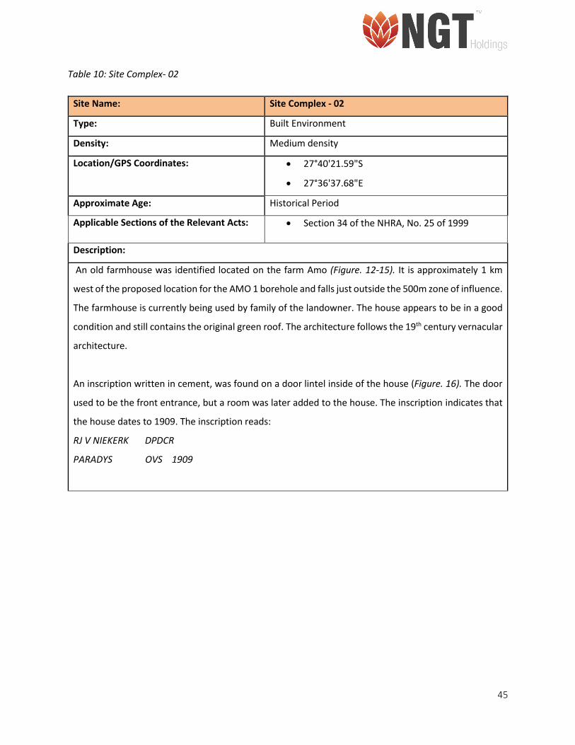
Table 10: Site Complex- 02
Site Name: Site Complex - 02
Type: Built Environment
Density: Medium density
Location/GPS Coordinates: • 27°40'21.59"S
• 27°36'37.68"E
Approximate Age: Historical Period
Applicable Sections of the Relevant Acts: • Section 34 of the NHRA, No. 25 of 1999
Description:
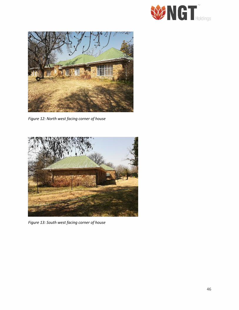
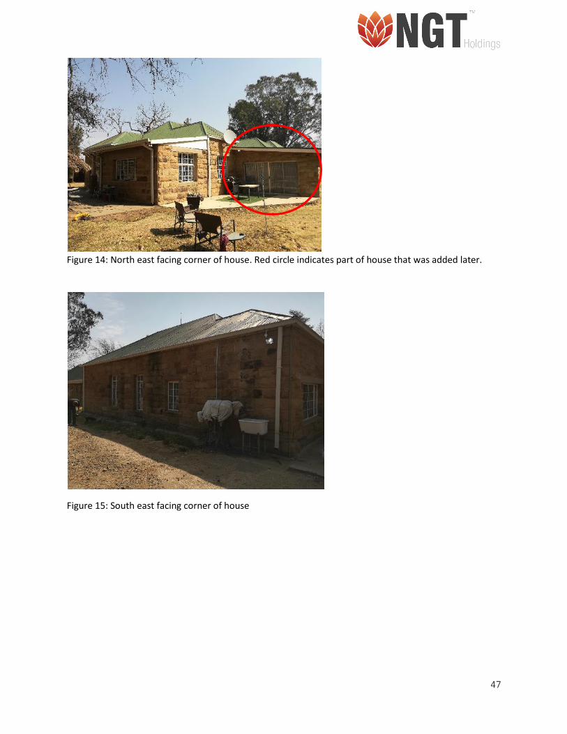
An old farmhouse was identified located on the farm Amo (Figure. 12-15). It is approximately 1 km
west of the proposed location for the AMO 1 borehole and falls just outside the 500m zone of influence.
The farmhouse is currently being used by family of the landowner. The house appears to be in a good
condition and still contains the original green roof. The architecture follows the 19th century vernacular
architecture.
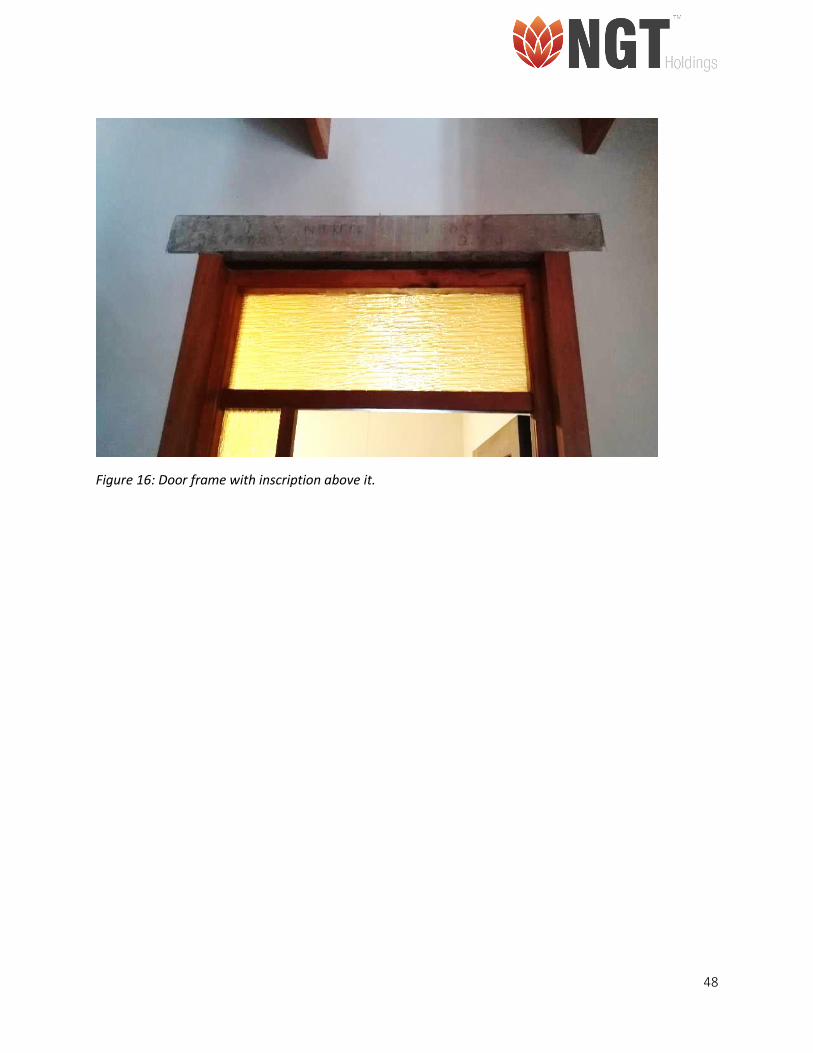
An inscription written in cement, was found on a door lintel inside of the house (Figure. 16). The door
used to be the front entrance, but a room was later added to the house. The inscription indicates that
the house dates to 1909. The inscription reads:
RJ V NIEKERK DPDCR
PARADYS OVS 1909
46
Figure 12: North west facing corner of house
Figure 13: South west facing corner of house
47
Figure 14: North east facing corner of house. Red circle indicates part of house that was added later.
Figure 15: South east facing corner of house
48
Figure 16: Door frame with inscription above it.
49
Table 11: Impact and risk assessment rating for project Planning, Construction and Operational phases in relation to the identified site (Site Complex 2)
1. Select Impact From Dropdown List (C2:H2)
A. 1. Transformation of cultural/ heritage resources- Proposal
2. Copy and Paste Impact Table into Report (C4:H24)
Impact Name 1. •Heritage Impact Assessment
Alternative
Phase Planning
Environmental Risk
Attribute Pre-mitigation Post-mitigation Attribute Pre-mitigation Post-mitigation
Nature of Impact -1 1 Magnitude of Impact 4 2
Extent of Impact 2 1 Reversibility of Impact 4 2
Duration of Impact 5 3 Probability 3 2
Environmental Risk (Pre-mitigation) -11,25
Mitigation Measures
The Built Environment found in Site Complex 2 is of high significance and have heritage value. It is recommended that the:
• Mining activities and machinery should completely avoid the historical farm house;
• If future mining activities are proposed for the area surrounding the house a Phase II Heritage study (including recording and mapping of site) should be conducted;
• Subject to approval from SAHRA
Environmental Risk (Post-mitigation) 4,00
Degree of confidence in impact prediction: High
Impact Prioritisation
Public Response 1
Low: Issue not raised in public responses
Cumulative Impacts 2
Considering the potential incremental, interactive, sequential, and synergistic cumulative impacts, it is probable that the impact will result in spatial and temporal cumulative change.
Degree of potential irreplaceable loss of resources 2
The impact may result in the irreplaceable loss (cannot be replaced or substituted) of resources but the value (services and/or functions) of these resources is limited.
Prioritisation Factor 1,33
Final Significance 5,33
50
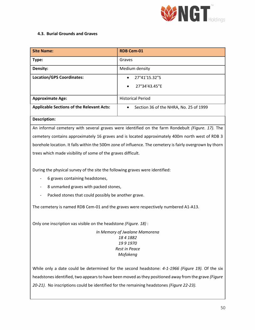
4.3. Burial Grounds and Graves
Site Name: RDB Cem-01
Type: Graves
Density: Medium density
Location/GPS Coordinates: • 27°41'15.32"S
• 27°34'43.45"E
Approximate Age: Historical Period
Applicable Sections of the Relevant Acts: • Section 36 of the NHRA, No. 25 of 1999
Description:
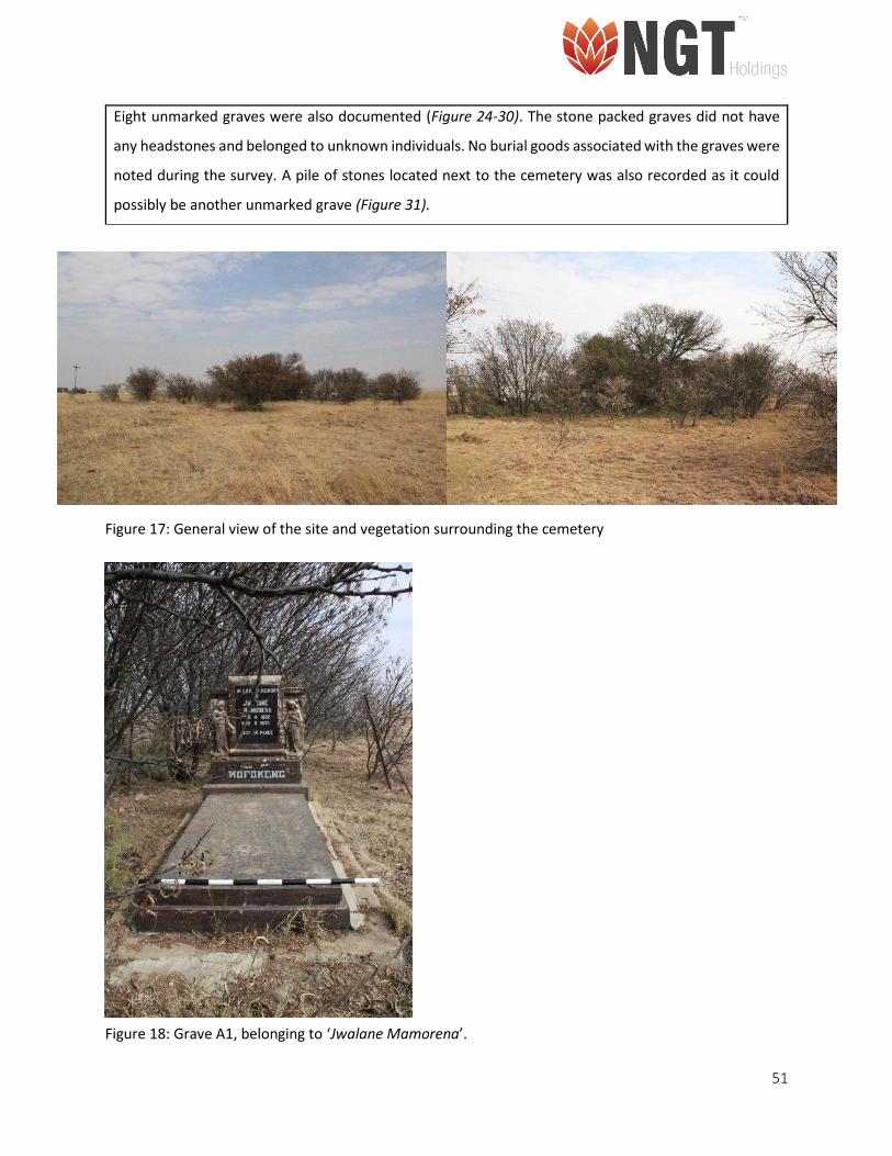
An informal cemetery with several graves were identified on the farm Rondebult (Figure. 17). The
cemetery contains approximately 16 graves and is located approximately 400m north west of RDB 3
borehole location. It falls within the 500m zone of influence. The cemetery is fairly overgrown by thorn
trees which made visibility of some of the graves difficult.
During the physical survey of the site the following graves were identified:
- 6 graves containing headstones,
- 8 unmarked graves with packed stones,
- Packed stones that could possibly be another grave.
The cemetery is named RDB Cem-01 and the graves were respectively numbered A1-A13.
Only one inscription vas visible on the headstone (Figure. 18) :
In Memory of Jwalane Mamorena 18 4 1882 19 9 1970
Rest in Peace Mofokeng
While only a date could be determined for the second headstone: 4-1-1966 (Figure 19). Of the six
headstones identified, two appears to have been moved as they positioned away from the grave (Figure
20-21). No inscriptions could be identified for the remaining headstones (Figure 22-23).
51
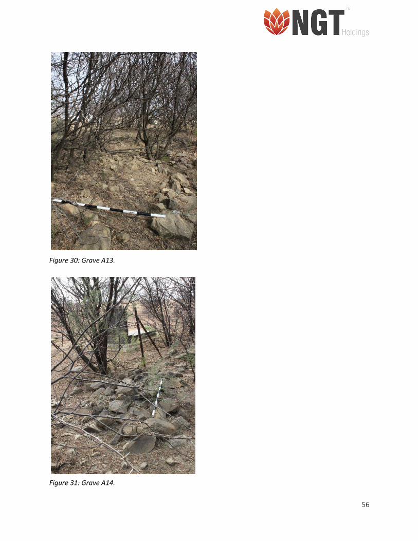
Eight unmarked graves were also documented (Figure 24-30). The stone packed graves did not have
any headstones and belonged to unknown individuals. No burial goods associated with the graves were
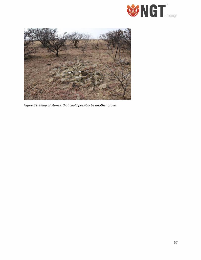
noted during the survey. A pile of stones located next to the cemetery was also recorded as it could
possibly be another unmarked grave (Figure 31).
Figure 17: General view of the site and vegetation surrounding the cemetery
Figure 18: Grave A1, belonging to ‘Jwalane Mamorena’.
52
Figure 19: Grave A2, with headstone where the date of death is visible
Figure 20: Grave A3, where the headstones has been moved away from the middle to the right.
53
Figure 21: Grave A4, where the headstones has been moved away from the grave.
Figure 22: Grave A5, barely visibly through the vegetation.
Figure 23: Grave A6, where the inscription on the headstone is no longer visible.
54
Figure 24: Grave A7.
Figure 25: Grave A8.
Figure 26: Grave A9.
55
Figure 27: Grave A10.
Figure 28: Grave A11.
Figure 29: Grave A12.
56
Figure 30: Grave A13.
Figure 31: Grave A14.
57
Figure 32: Heap of stones, that could possibly be another grave.
58
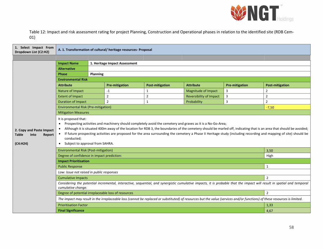
Table 12: Impact and risk assessment rating for project Planning, Construction and Operational phases in relation to the identified site (RDB Cem-01)
1. Select Impact From Dropdown List (C2:H2)
A. 1. Transformation of cultural/ heritage resources- Proposal
2. Copy and Paste Impact Table into Report (C4:H24)
Impact Name 1. Heritage Impact Assessment
Alternative
Phase Planning
Environmental Risk
Attribute Pre-mitigation Post-mitigation Attribute Pre-mitigation Post-mitigation
Nature of Impact -1 1 Magnitude of Impact 3 2
Extent of Impact 2 2 Reversibility of Impact 3 2
Duration of Impact 2 1 Probability 3 2
Environmental Risk (Pre-mitigation) -7,50
Mitigation Measures
It is proposed that:
• Prospecting activities and machinery should completely avoid the cemetery and graves as it is a No-Go-Area;
• Although it is situated 400m away of the location for RDB 3, the boundaries of the cemetery should be marled off, indicating that is an area that should be avoided;
• If future prospecting activities are proposed for the area surrounding the cemetery a Phase II Heritage study (including recording and mapping of site) should be
conducted;
• Subject to approval from SAHRA.
Environmental Risk (Post-mitigation) 3,50
Degree of confidence in impact prediction: High
Impact Prioritisation
Public Response 1
Low: Issue not raised in public responses
Cumulative Impacts 2
Considering the potential incremental, interactive, sequential, and synergistic cumulative impacts, it is probable that the impact will result in spatial and temporal cumulative change.
Degree of potential irreplaceable loss of resources 2
The impact may result in the irreplaceable loss (cannot be replaced or substituted) of resources but the value (services and/or functions) of these resources is limited.
Prioritisation Factor 1,33
Final Significance 4,67
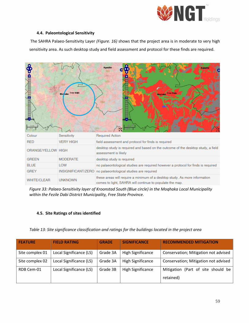
59
4.4. Paleontological Sensitivity
The SAHRA Palaeo-Sensitivity Layer (Figure. 16) shows that the project area is in moderate to very high
sensitivity area. As such desktop study and field assessment and protocol for these finds are required.
Figure 33: Palaeo-Sensitivity layer of Kroonstad South (Blue circle) in the Moqhaka Local Municipality within the Fezile Dabi District Municipality, Free State Province.
4.5. Site Ratings of sites identified
Table 13: Site significance classification and ratings for the buildings located in the project area
FEATURE FIELD RATING GRADE SIGNIFICANCE RECOMMENDED MITIGATION
Site complex 01 Local Significance (LS) Grade 3A High Significance Conservation; Mitigation not advised
Site complex 02 Local Significance (LS) Grade 3A High Significance Conservation; Mitigation not advised
RDB Cem-01 Local Significance (LS) Grade 3B High Significance Mitigation (Part of site should be
retained)
60
5. CONCLUSION AND RECOMMENDATIONS
Based on the results of literature review and the survey results the following conclusions are made:
• It is concluded that the project area near Kroonstad, is located in a region rich in archaeology and
heritage resources.
• During the survey:
o An old farmhouse dating to the 1920’s was identified located on the farm Rondebult. It is
approximately 650m west of the proposed location for the RDB 2 borehole and falls just
outside the 500m zone of influence
o An old farmhouse dating to 1909 was identified located on the farm Amo. It is
approximately 1 km west of the proposed location for the AMO 1 borehole and falls just
outside the 500m zone of influence
o An informal cemetery with several graves were identified on the farm Rondebult. The
cemetery containing approximately 16 graves is located approximately 400m north west
of RDB 3 borehole location and falls within the 500m zone of influence.
• The cemetery and Farm houses identified in the project area are of high significance.
• No other archaeological or historical resources were identified in the project area.
• No other graves or burial grounds were identified in the project area. However, as graves are
subterranean in nature and might not have been identified during the initial site visit and survey.
• In terms of SAHRA Paleontological Sensitivity Layer, the area is within a moderate to very high
sensitivity area. According to the PIA report there are no previously recorded fossils from the area
that are preserved in the overlying rock formations (dolerites of the Jurassic or in the loose sands
of the Quaternary). However, according to the PIA, there is a slight chance of fossil being
discovered in the late Permian Adelaide Subgroup (Volksrust Formation) (See PIA report).
Recommendations:
Based on the Limitations and Conclusions it is recommended that:
• Should the prospecting activities expand in the near future to include areas outside the current
500m zone of influence, a Phase II investigation of the Old Farm House on the Farm Rondebult
61
should be conducted, where it is mapped, recorded and permit for alterations and demolition
should be applied for in terms of Section 34 of the NHRA, No. 25 of 1999 with the provincial
heritage authority i.e. Free State Provincial Heritage Authority (FSPHRA). However, as the
farmhouse dating to 1909 located on the farm Amo, is still occupied and in a very good condition
it should be preserved in terms of Section 34 of the NHRA, No. 25 of 1999. As such machinery
should avoid the area.
• The historical cemetery and graves were rated as high significance and are protected as a in terms
of Section 36) of the NHRA, No. 25 of 1999. As such it is recommended that no machinery or site
camp associated with the proposed prospecting activities should be established near the graves.
• However, it should be noted that some archaeological material, including artefacts and graves can
be buried underground and as such, may not have been identified during the initial survey and
site visits. In the case where the proposed development activities bring these materials to the
surface, they should be treated as Chance Finds. Should such resources be unearthed it is
recommended that, the prospecting activities be stopped immediately, and an archaeologist be
contacted to conduct a site visits and make recommendations on the mitigation of the finds.
SAHRA and NW-PHRA should also be informed immediately on such finds.
• In terms of the South African Heritage and Resources Agency (SAHRA) Paleontological Sensitivity
Layer the area falls within a region defined as a moderate to very high sensitivity area and it is
recommended that a Fossil Chance Find Protocol be included in the EMPr (See PIA report).
• The proposed development will not have impact on the heritage and archaeological resources in
the broader Kroonstad area.
• With regards to the limitations identified for the project, it is recommended that NGT engage in
a Public Participation Programme that entails setting up a meeting between Shango, the
specialists and the landowners along with the Farmers’ Association, Free State Agriculture
(Vrystaat Landbou) with the purpose of sharing information regarding the project as well as
discussing the related environmental and heritage studies that need to be conducted.
62
6. REFERENCES
Anderson, M. 2009. Marothodi: The Historical Archaeology of an African Capital. Northamptonshire:
Atikkam Media Limited
Ashman, P. 1996. Anglo- Boer war, 1880-1881 in Olson, J. S. & Shadle, R. Historical Dictionary of the British
Empire. Westport: Greenwood Publishing, pp45-46
Beaumont, P.B. & Vogel, J.C. 1984. Spatial patterning the ceramic Late Stone Age in the Northern Cape
Province, South Africa. In: Hall, M., Avery, G., Avery, D.M., Wilson, M.L. & Humphreys, A.J.B. (eds)
Frontiers: southern African archaeology today. Oxford: Oxford: British Archaeological Reports
International Series 207, pp. 80-95
Bergh, J. S. 1999. Die geskiendenis atlas van Suid-Afrika. Die vier Noordelike Provinsies. Pretoria: J. L. van
Schaik
Boeyens, J. 2003. The Late Iron Age Sequence in The Marico And Early Tswana History. South African
Archaeological Bulletin, 58(178): 63-78.
Churchill, S.E., Brink, J.S., Berger, L.R., Hutchison, R.A., Rossouw, L., Stynder, D., Hancox, P.J., Brandt, D.,
Woodborne, S., Loock, J.C. and Scott, L., 2000. Erfkroon: a new Florisian fossil locality from fluvial contexts
in the western Free State, South Africa. South African Journal of Science, 96: 161-163.
Coplan, D. B. 2000. A measure of civilisation: Revisiting the Caledon valley frontier. Social Dynamics, 26(2):
116-153.
De La Torre, I. 2016. The origins of the Acheulean: past and present perspectives on a major transition in
human evolution. Philosophical Transactions of the Royal Society, 371(1698): 20150245,
http://dx.doi.org/10.1098/rstb.2015.0245
Diez-Martín, F. & Sánchez Yustos,P. & Uribelarrea, D. & Baquedano, E. & Mark, D. F. & Mabulla, A. & Fraile,
C. & Duque, J. & Díaz, I. & Pérez-González, A. & Yravedra, J. & Egeland, C. P. & Organista, E & Domínguez-
63
Rodrigo, M. 2015. The Origin of The Acheulean: The 1.7 Million-Year-Old Site of FLK West, Olduvai Gorge
(Tanzania). Scientific Reports, 5:17839, DOI: 10.1038/srep17839.
Dreyer, J. 1996. Introduction to Free State Iron Age Archaeology. In: Guide to archaeological sites in the
Free State and Lesotho. Southern African Association of Archaeologists (SA3), 14th Biennial Conference,
Bloemfontein, Post-conference tour 5-8 July 1996. Bloemfontein: National Museum.
Dreyer, J. 1999. Pot lid or initiation drum: a unique ceramic find from a Late Iron Age site near Winburg,
Free State. South African Journal of Ethnology, 22(3): 110-115.
Dreyer, J. 2000. Mountains and Rivers of the Free State - Manual for field research / Berge en Riviere van
die Vrystaat – Handleiding vir veldnavorsing. Bloemfontein: University of the Free State, Department of
Anthropology, Occasional Paper No. 2.
Dreyer, J. 2005a. Archaeological and historical investigation of the proposed new filling station at,
Kroonstad, Free State. Heritage Impact Assessment Report.
Dreyer, J. 2005b. Archaeological and historical investigation of the proposed residential developments at
Van Riebeeck Park, Kroonstad, Free State. Heritage Impact Assessment Report.
Dreyer, J. 2006a. First phase archaeological and cultural heritage assessment of the proposed residential
developments at the farm Boschpunt 2218, Kroonstad, Free State. Heritage Impact Assessment Report.
Dreyer, J. 2006b. First phase archaeological and cultural heritage assessment of the proposed residential
developments at Katdoringfontein 379, Senekal, Free State. Heritage Impact Assessment Report.
Dreyer, J. 2007a. Archaeological and cultural heritage assessment of the proposed residential
developments at Leliehoek, Ladybrand, Free State. Heritage Impact Assessment Report.
Dreyer, J. 2007b. Archaeological and cultural heritage assessment of the proposed residential
developments at Marquard, Free State. Heritage Impact Assessment Report.
64
Dreyer, J. 2008. Archaeological and Cultural Heritage Assessment Of The Proposed Residential
Developments At Matlwantlwang (Steynsrust), Free State. Unpublished Report.
Dreyer, J. 2012. First phase archaeological and cultural heritage assessment of the proposed new waste
disposal site at Senekal, Free State. Heritage Impact Assessment Report.
Erasmus, P. 2005. The ‘Lost’ South African tribe – Rebirth of the Koranna1 in the Free State. New Contree,
50: 77-91
Esterhuysen, A.B. & Behrens, J. and Harper, P. 1994. Leliehoek Shelter: a Holocene sequence from the
eastern Orange Free State. The South African Archaeological Bulletin, 49(160): 73-78.
Evers, T. 1983. 'Oori' or 'Moloko'? The origins of the Sotho- Tswana on the evidence of the Iron Age of the
Transvaal: a reply. South African Journal of Science, 79: 261-265.
Giliomee, H. B. & Mbenga, B. 2007. New History of South Africa. Cape Town: Tafelberg Publishers.
Gutteridge, L. 2008. The South African Bushveld: A Field Guide from the Waterberg. Johannesburg:
Southbound
Hodge, C. C. 2008. Encyclopedia of the Age of Imperialism, 1800-1914: A-K. London: Greenwood Publishing
Group
Huffman, T. 2002. Regionality in the Iron Age: the case of the Sotho-Tswana. Southern African Humanities,
14: 1–22.
Huffman, T. 2007. Handbook to the Iron Age. Pietermaritzburg: University of Kwazulu-Natal Press
Kay, P. 1984. Notre Dame under the Southern Cross. Johannesburg, Ravan Press
Klapwijk, M. & Evers, T. M. 1987. A Twelfth Century Eiland Facies Site in the North-Eastern Transvaal. The
South African Archaeological Bulletin, 42(145):39-44.
65
Klein, R. G. 2000. The Earlier Stone Age of Southern Africa. The South African Archaeological Bulletin,
27(172): 107-122.
Kruger, N. 2018. Archaeological impact assessment of demarcated areas on a portion of portion 1 of the
farm Middenspruit 151 for the proposed Middenspruit rock mine project in the Fezile Dabi District
Municipality, Free State Province. Heritage Impact Assessment Report.
Maggs, T. 1976. Iron Age Communities Of The Southern Highveld. Pietermaritzburg: Natal Museum.
Mason, R. 1968. Transvaal and Natal Iron Age settlements revealed by aerial photography and excavation.
African Studies, 27: 167-180.
Mason, R. 1982. Prehistoric mining in South Africa, and Iron Age copper mines in the Dwarsberg,
Transvaal. Journal of the South African Institute of Mining and Metallurgy, 82: 134-144.
Mason, R. 1986. Origins of black people of Johannesburg and the southern western central Transvaal, AD
350-1880. Occasional Paper No. 16 of the Archaeological Research Unit. Johannesburg: Witwatersrand
University Press.
Mitchell, P. 2002. The Archaeology of Southern Africa. Cape Town: Cambridge University Press.
Mitchell, P. 2013. A regional overview of space, time and ceramics. In Mitchell, P. and Lane, P. The Oxford
Handbook of African Archaeology. Oxford: Oxford University Press. 657-670.
Naudé, M. 2013. Architectural assessment of historical mine management office building at Voorspoed
Mine, Kroonstad (Free State Province). Heritage Impact Assessment Report.
Orford, J. 1981. The Dust of Conflict. Military History Journal, 5(4). Internet:
http://samilitaryhistory.org/vol054jo.html. Accessed: 25 July 2018.
66
Ouzman, S. 2005. The Magical Arts of a Raider Nation: Central South Africa's Korana Rock Art, Further
Approaches to Southern African Rock Art, 9: 101-113.
Phillipson, D. W. 1994. African Archaeology. Cambridge: Cambridge University Press.
Pistorius, J. 2004. A heritage impact assessment (HIA) study for an Emp for the Voorspoed Diamond Mine
near Kroonstad in the Free State Province of South Africa. Heritage Impact Assessment Report.
Richardson, D. 2001. Historic sites of South Africa. Struik Publishers.
Rossouw, l. 2012a. Phase 1 Heritage Impact Assessment of a proposed 10MW Solar Facility at Grootspruit
252/0 near Allanridge, Odendaalsrus district, FS. Heritage Impact Assessment Report.
Rossouw, l. 2012b. Phase 1 Heritage Impact Assessment of a proposed new Solar Facility at Grootspruit
252 near Allanridge, FS. Heritage Impact Assessment Report.
Sadr, K. & Rodier, X. 2012. Google Earth, GIS and stone-walled structures in southern Gauteng, South
Africa. Journal of Archaeological Science, 39: 1034–1042.
Sampson, C.G., 1972. The stone age industries of the Orange River Scheme and South Africa (No. 6).
Memoirs of the National Museum (Bloemfontein), 6:1-288.
Scott-Keltie, J. and Epstein, M. 1925. The Statesman's Year-Book. London: Macmillan and Co Ltd
Taylor, W. & Hinde, G. & Holt-Biddle, D. 2003. The Waterberg: The Natural Splendours and the People.
Cape Town: Struik Publishers.
Theal, G, M. 1908. History of South Africa Since September 1795. London: Swan Sonnenschein & CO
Thorp, C.R. 1996. A preliminary report on evidence of interaction between hunter-gatherers and farmers
along a hypothesised frontier in the eastern Free State. The South African Archaeological Bulletin, 51(164):
57-63.
67
Van der Walt, J. 2013. Archaeological Impact Assessment for the proposed Steynsrus (19.5 MW)
photovoltaic plant, Free State Province. Heritage Impact Assessment Report.
Van Vollenhoven, A. C. 2016. A report on a cultural heritage impact assessment done for the proposed
Botshabelo West Township establishment, Mangaung Metro, Free State Province. Heritage Impact
Assessment Report.
Wadley L. (1991). Rose Cottage Cave: Background and a preliminary reporton the recent excavations. The
South African Archaeological Bulletin 46: 125-130.
Wadley, L. 1995. Review of dated Stone Age sites recently excavated in the eastern Free State, South
Africa. South African Journal of Science, 91: 574-579.
Wadley, L. 1997. Rose Cottage Cave: archaeological work 1987 to 1997. South African Journal of Science,
93(10): 439-444.
Wadley, L. 2000. The Early Holocene Layers of Rose Cottage Cave, Eastern Free State: Technology, Spatial
Patterns and Environment. The South African Archaeological Bulletin, 55(171): 18-31.
Wadley. L., 2007. The Middle Stone Age and Later Stone Age. In Bonner, P. & Esterhuysen, A. & Jenkins,
T. A. Search for Origins: Science, History and South Africa’s ‘Cradle of Humankind’. Johannesburg: Wits
University Press. Pg 122 -135.
Zvobgo, C. J. M. 2009. A History of Zimbabwe, 1890-2000 and Postscript, Zimbabwe, 2001-2008. Tyne:
Cambridge Scholars Publishing.