newark intermodal hub planning study of development... · duke frost, 5th ward doug marmie, ......
TRANSCRIPT
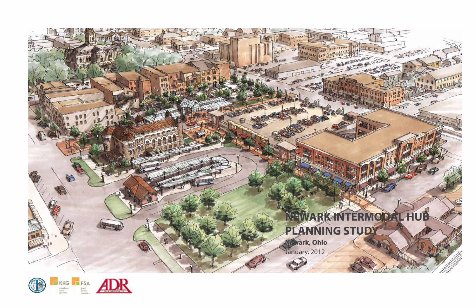
NEWARK INTERMODAL HUB PLANNING STUDYNewark, OhioJanuary, 2012

Chapter 1: Introduction and Context Analysis
Chapter 2: Site Selection and Site Analysis
Appendix B: Public ProcessChapter 3: Conceptual Design
Project Introduction .............................................................................................................2Regional Transportation Systems ......................................................................................3Local Transportation Systems ............................................................................................4Downtown Transportation Systems .................................................................................5Downtown Architectural Vernacular ................................................................................6
Intermodal Hub Site Selection Criteria ............................................................................8Site Selection Matrix .............................................................................................................9Preferred Site ....................................................................................................................... 10 Access to Existing and Planned Transportation Systems ......................................... 11Urban Design Analysis ...................................................................................................... 12
Public Meeting #1 .............................................................................................................. B2Public Meeting #2 .............................................................................................................. B6Public Meeting #3 ............................................................................................................ B10
Project Goals & Program ................................................................................................... 14Intermodal Hub Trip Scenarios ....................................................................................... 15Preliminary Concept Plans ............................................................................................... 16Final Conceptual Master Plan .......................................................................................... 18Illustrative Sketch Rendering .......................................................................................... 19Plan Components Jail Restoration ............................................................................................................. 20
Transit Facilities ............................................................................................................. 22Bicycle Facilities ............................................................................................................ 24Pedestrian Linkages ..................................................................................................... 26Existing Parking Garage Improvements ................................................................. 28Future Mixed Use or Multi-Family Development ................................................. 30
Visual Integration of Historic Rail Station .............................................................. 32
Chapter 4: Development Strategy and Financial Considerations
Appendix A: Precedents and Research
Phasing Strategy ................................................................................................................. 34Preliminary Magnitude of Cost ....................................................................................... 39Funding Strategy ................................................................................................................ 40Funding Sources ................................................................................................................. 42Jail Preservation Economic Feasibility .......................................................................... 46
Transit Center Precedents Akron Downtown Transit Center ............................................................................... A2 Wright Stop Plaza .......................................................................................................... A3 Burien Transit Center .................................................................................................... A4
ACKNOWLEDGEMENTS:
CITY OF NEWARK
MayorJeff Hall
City CouncilDon Ellington, PresidentEd Houdeshell, 1st WardShirley Stare, 2nd WardJeff Rath, 3rd WardRhonda Loomis, 4th WardDuke Frost, 5th WardDoug Marmie, 6th WardCarol Floyd, 7th WardRyan Bubb, At LargeBill Cost Jr., At LargeMarc Guthrie, At LargeDiana L. Hufford, Clerk of Council
City StaffMark Mauter, Development DirectorAaron Schill, Assistant Development Director/City PlannerAnne M. Arnott, Earthworks Transit Operations CoordinatorStuart Moynihan, Economic Development Coordinator
CONSULTANT TEAM
Kinzelman Kline Gossman
Craig Gossman, Principal in ChargeMatthew Leasure, Project ManagerSukirti Ghosh, PlannerJJ Obee, DesignerMatt Kellogg, Designer
Front Street AnalyticsAaron Whittaker
ADR EngineersDoug MillRussell Krock
EXECUTIVE SUMMARY
The City of Newark is undertaking an initiative to expand upon current demand responsive transit service with convenient fixed-route bus service and construction of supporting facilities. The routing and number of fixed-route bus lines is being determined by a separate study performed by another consultant team, but the planning processes have been performed on concurrent timelines by both teams. In addition, the City is working to expand mobility options for residents through construction of bike lanes, improvement of pedestrian routes and public spaces, and planning for better connected parking facilities and policies. This study works to integrate those broader city-wide goals and support the new fixed-route bus service through the planning and conceptual design of an intermodal transit center which supports transit, bike, automotive, and pedestrian mobility. Also, the project works to stoke economic development of adjacent areas through infrastructure and public space improvements as well as additional daily activity.
The project schedule was divided into three general phases. The first phase examined the existing conditions of the downtown and inventoried any existing or planned transportation systems. The consultant team also determined key criteria for selection of the intermodal hub site, which included a minimum site size, proximity to existing and potential transportation facilities, possibility for land acquisition, and economic development opportunities. The consultant team determined three nodes within downtown which satisfied these criteria. This phase was accompanied by a public meeting which collected input on the location, architectural style, program, and amenities of the facility. The outcome of these meetings concluded that the site should be centrally located somewhere in downtown, be generally traditional in its architectural style, and include multiple modes of transportation.
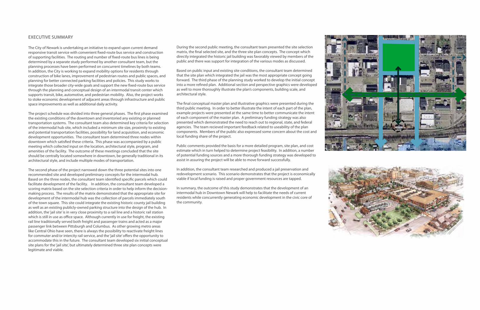
The second phase of the project narrowed down the three potential sites into one recommended site and developed preliminary concepts for the intermodal hub. Based on the three nodes, the consultant team identified specific parcels which could facilitate development of the facility. In addition, the consultant team developed a scoring matrix based on the site selection criteria in order to help inform the decision-making process. The results of the matrix demonstrated that the appropriate site for development of the intermodal hub was the collection of parcels immediately south of the town square. This site could integrate the existing historic county jail building as well as an existing publicly-owned parking structure into the design of the hub. In addition, the ‘jail site’ is in very close proximity to a rail line and a historic rail station which is still in use as office space. Although currently in use for freight, the existing rail line traditionally served both freight and passenger trains and acted as a major passenger link between Pittsburgh and Columbus. As other growing metro areas like Central Ohio have seen, there is always the possibility to reactivate freight lines for commuter and/or intercity rail service, and the ‘jail site’ offers the opportunity to accommodate this in the future. The consultant team developed six initial conceptual site plans for the ‘jail site’, but ultimately determined three site plan concepts were legitimate and viable.
During the second public meeting, the consultant team presented the site selection matrix, the final selected site, and the three site plan concepts. The concept which directly integrated the historic jail building was favorably viewed by members of the public and there was support for integration of the various modes as discussed.
Based on public input and existing site conditions, the consultant team determined that the site plan which integrated the jail was the most appropriate concept going forward. The third phase of the planning study worked to develop the initial concept into a more refined plan. Additional section and perspective graphics were developed as well to more thoroughly illustrate the plan’s components, building scale, and architectural style.
The final conceptual master plan and illustrative graphics were presented during the third public meeting. In order to better illustrate the intent of each part of the plan, example projects were presented at the same time to better communicate the intent of each component of the master plan. A preliminary funding strategy was also presented which demonstrated the need to reach out to regional, state, and federal agencies. The team recieved important feedback related to useability of the plan components. Members of the public also expressed some concern about the cost and local funding share of the project.
Public comments provided the basis for a more detailed program, site plan, and cost estimate which in turn helped to determine project feasibility. In addition, a number of potential funding sources and a more thorough funding strategy was developed to assist in assuring the project will be able to move forward successfully.
In addition, the consultant team researched and produced a jail preservation and redevelopment scenario. This scenario demonstrates that the project is economically viable if local funding is raised and proper government resources are tapped.
In summary, the outcome of this study demonstrates that the development of an intermodal hub in Downtown Newark will help to facilitate the needs of current residents while concurrently generating economic development in the civic core of the community.


CHAPTER 1
INTRODUCTION AND CONTEXT ANALYSIS
INTRODUCTION
This planning study is an initiative by the City of Newark and Earthworks Transit to improve mobility in and around Downtown Newark. Throughout the summer and fall of 2011, three concurrent planning studies have explored separate components of what could be a more cohesive and robust transportation network in and around the City of Newark. The geographic scope of the studies was focused on the cities of Newark and Heath, but also examined improved connections to the adjacent community of Granville as well as future locations throughout Licking County and connections to COTA service in Franklin County.
One study, performed by a separate consultant team, examined developing a fixed-route bus system to expand upon existing on-demand transit service. The second study, also performed by the separate team, examined the opportunity to restore or establishing streetcar service in Downtown Newark.
This study focuses on developing a hub of existing and proposed transit service in Downtown Newark to maximize operability of transit service and optimize passenger comfort and useability. In addition, the intermodal hub will serve as a focal point for a flourishing bike network and potential improvements to the Downtown parking system and vehicular network. Also, a major rail line runs through the south end of Downtown and it is a primary goal of the study to locate the intermodal hub in a location that could integrate a future passenger rail station should commuter or intercity passenger service be restored to the line.
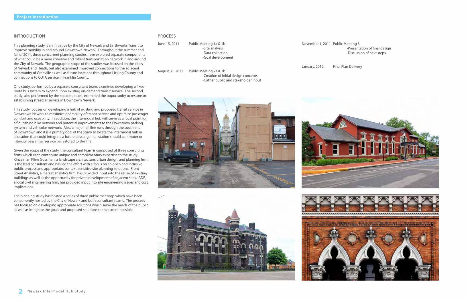
Given the scope of the study, the consultant team is composed of three consulting firms which each contribute unique and complimentary expertise to the study. Kinzelman Kline Gossman, a landscape architecture, urban design, and planning firm, is the lead consultant and has led the effort with a focus on an open and inclusive public process and appropriate, context-sensitive site planning solutions. Front Street Analytics, a market analytics firm, has provided input into the reuse of existing buildings as well as the opportunity for private development of adjacent sites. ADR, a local civil engineering firm, has provided input into site engineering issues and cost implications.
The planning study has hosted a series of three public meetings which have been concurrently hosted by the City of Newark and both consultant teams. The process has focused on developing appropriate solutions which serve the needs of the public as well as integrate the goals and proposed solutions to the extent possible.
PROCESS
June 15, 2011
August 31, 2011
Public Meeting 1a & 1b -Site analysis -Data collection -Goal development
Public Meeting 2a & 2b -Creation of initial design concepts -Gather public and stakeholder input
Public Meeting 3 -Presentation of final design -Discussion of next steps
Final Plan Delivery
November 1, 2011
January, 2012
Newark I ntermodal Hub Study2
Project Introduction

3Introduction and Context Analysis
Regional Transportation Systems
COLUMBUS AND PITTSBURGH METRO AREA CONNECTIONS
Interstate 70 is the major freeway serving east-central Ohio and provides connections between Columbus, Dayton, Pittsburgh and further to Indianapolis as well as points along the East Coast. Both State Route 79 and 13 provide direct connections from I-70 to Downtown Newark. Ohio State Routes 16 and 36 provide access to Interstate 77 to the east which is a major route north into the Akron/Canton and Cleveland metropolitan regions.
Although Newark is not served directly by a major interstate highway, it is in relative proximity to support a future intercity bus connection. In addition, several smaller Ohio cities and towns have leveraged their historic character and cultural facilities into attractions for bus tours and other tourism-based activities. Newark could certainly support such activity with careful planning and provision of amenities for tourists. It is not unusual for these tours to commonly draw from destinations several hours away.
Newark is located on the historic ‘Panhandle’ rail line which currently runs between Downtown Columbus and the panhandle portion of West Virginia. The line historically continued eastward to Downtown Pittsburgh. The Panhandle line has a long history as it once was the main line for the Pittsburgh, Cincinnati, Chicago and St. Louis Railroad which provided service between Pittsburgh and several states from the mid-19th century onward until its eventual absorption into the Pennsylvania Railroad system in the 1920’s. In addition, the Baltimore and Ohio Railroad had a major passenger rail station in Downtown Newark which provided passenger connections to Columbus and points east including Zanesville and Cambridge. The rail station still exists and has been re-purposed into an office use.
Today, these rail lines are mostly still intact and are used by short line freight railroads to service existing industrial clients along the line. In addition, the Panhandle line is now owned by the State of Ohio and is leased to private companies for use. With the anticipated population growth of the Columbus metropolitan region and the national reemergence of Western Pennsylvania as a technology hub, a future rail connection may become desirable. The quasi-public ownership of the line could present a unique opportunity for start-up of intercity passenger service between the two regions. The City of Newark would benefit significantly if a station along such a line were to be included in future planning efforts.
Columbus
Pittsburgh
Zanesville
NewarkCambridge
FREEWAY, RAIL, AND BIKE CONNECTIONS TO COLUMBUS
The recent upgrade of Ohio State Route 161 between Interstate 270 and Granville has helped to turn Newark into a relatively short commute from major job centers in eastern parts of Columbus and New Albany. This has presented an opportunity for Newark to attract new residents through its historic character, various amenities, and attractive small-city lifestyle. This route also could represent a future bus transit connection between Newark and eastern Franklin County.
As the Columbus metropolitan region continues to grow and the additional traffic causes longer commute times, the development of alternative transportation options is inevitable. Other similar growing metro regions such as Austin, Texas and Charlotte, North Carolina have developed regional commuter and light rail systems to enhance mobility through alleviating traffic from the freeway system. With its unique ownership situation and proximity to Port Columbus Airport (CMH) and the Columbus Convention Center, the Panhandle Line is uniquely poised for potential improvement into a future commuter rail line. With strategic planning, Newark could become a future terminus of a start-up commuter line, bringing with it opportunities for transit-oriented development and additional economic activity.
In addition to commuter rail, other large metro regions have seen development of tourism-based excursion trains which offer patrons a unique way to experience scenic landscapes and historical or cultural landmarks. Also, there is potential for an excursion railroad to connect eastward to the historic cities of Zanesville or Cambridge. This route would likely use existing right-of-way that courses through the Blackhand Gorge State Nature Preserve and Dillon State Park. This rail line could be similar to the highly used Cuyahoga Valley Scenic Railroad in northeast Ohio.
In either case, the development of passenger rail should not be intended to preclude the efficiency and functionality of freight rail service in the area. Freight service is critical to the economic success of the Newark area and any passenger options should not inhibit service. In fact, there have been successful partnerships between freight and passenger systems in which the rail infrastructure was improved to enhance service for both passenger and freight rail.
Licking County has been aggressive and effective in developing a recreational trail network along abandoned or under-utilized rail rights-of-way and major watercourses and greenways. This network currently lacks a connection through Downtown Newark, but is in planning and final design stages with final construction to be completed shortly. The recreational trail network lacks a major destination in Downtown Newark. The location of Downtown Newark as the physical center of the trail network could make it the most prominent destination along the line, bringing with it additional users and patrons for downtown businesses.
Port Columbus Airport
Downtown Columbus
Downtown Newark
Panhandle Line Rail Corridor
Interstate 70
Interstate 70
Panhandle Line Rail Corridor
Licking County Bike Trail System
DOWNTOWN BIKE ROUTES
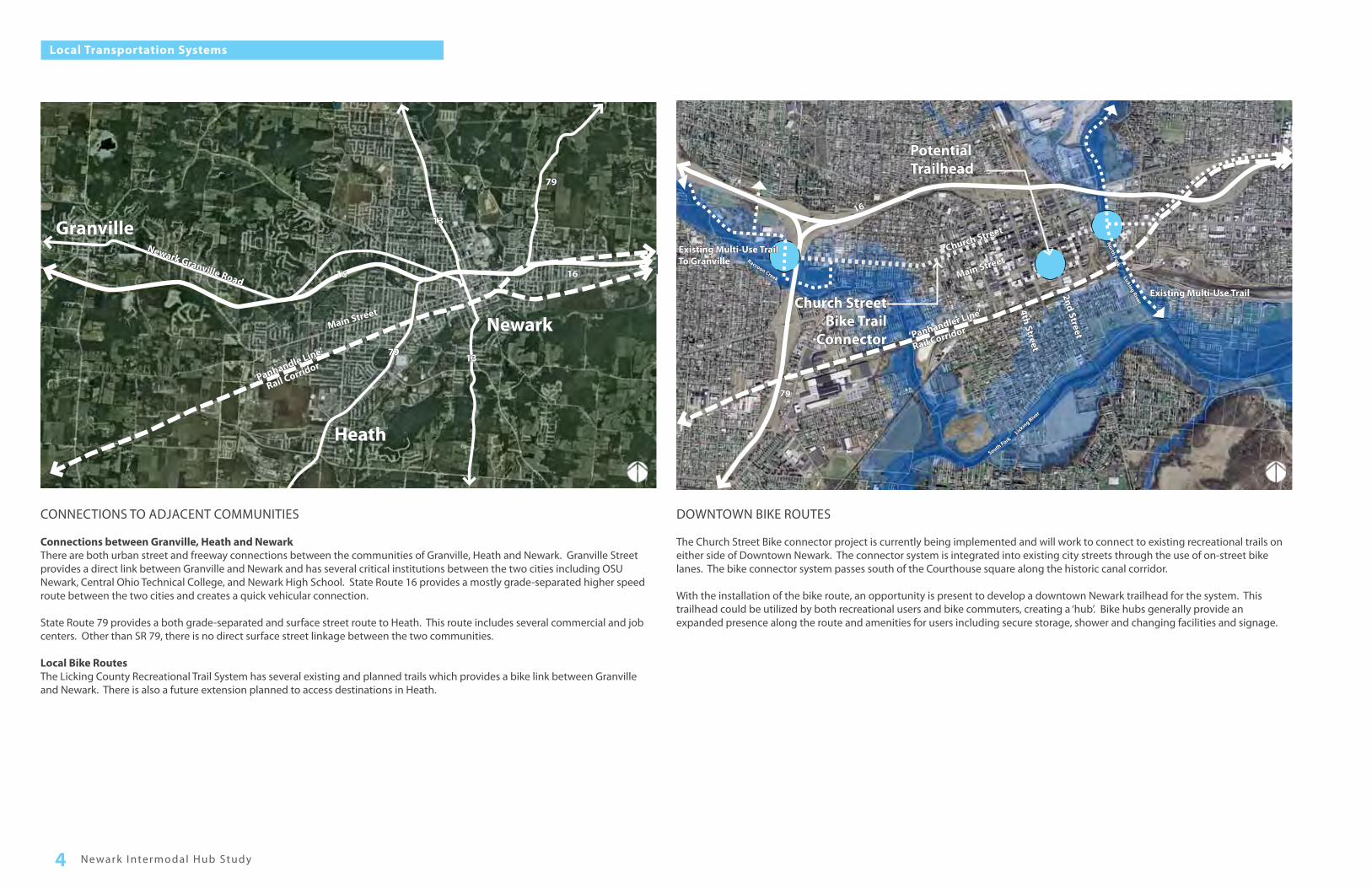
The Church Street Bike connector project is currently being implemented and will work to connect to existing recreational trails on either side of Downtown Newark. The connector system is integrated into existing city streets through the use of on-street bike lanes. The bike connector system passes south of the Courthouse square along the historic canal corridor.
With the installation of the bike route, an opportunity is present to develop a downtown Newark trailhead for the system. This trailhead could be utilized by both recreational users and bike commuters, creating a ‘hub’. Bike hubs generally provide an expanded presence along the route and amenities for users including secure storage, shower and changing facilities and signage.
CONNECTIONS TO ADJACENT COMMUNITIES
Connections between Granville, Heath and NewarkThere are both urban street and freeway connections between the communities of Granville, Heath and Newark. Granville Street provides a direct link between Granville and Newark and has several critical institutions between the two cities including OSU Newark, Central Ohio Technical College, and Newark High School. State Route 16 provides a mostly grade-separated higher speed route between the two cities and creates a quick vehicular connection.
State Route 79 provides a both grade-separated and surface street route to Heath. This route includes several commercial and job centers. Other than SR 79, there is no direct surface street linkage between the two communities.
Local Bike RoutesThe Licking County Recreational Trail System has several existing and planned trails which provides a bike link between Granville and Newark. There is also a future extension planned to access destinations in Heath.
Newark I ntermodal Hub Study4
Local Transportation Systems
Main Street
‘Panhandle Line’
Rail Corridor
16 16
79
79
13
13Granville
Heath
Newark
Newark Granville Road
Potential Trailhead
North Fork
Licking River
South ForkLicking River
Raccoon Creek Main Street
‘Panhandler Line’
Rail Corridor
2nd Street
4th Street
16
To GranvilleExisting Multi-Use Trail
Existing Multi-Use Trail
Church Street
Church Street Bike Trail
Connector
79

DOWNTOWN VEHICULAR & PEDESTRIAN ROUTES
Most Downtown Newark rights-of-way were built prior to the abundance of automotive use and are pedestrian oriented with buildings located directly adjacent to the street. Currently, downtown city streets generally carry a fair amount of traffic but are not overburdened. Many streets have on-street parking spaces which are time-restricted, but not metered. These parking spaces are heavily used throughout the day. A separate and more robust study of downtown on-street parking is being conducted in the near future.
With the exception of alleys, all city streets in the vicinity of the courthouse have sidewalks which are in reasonable condition. Pedestrian mobility in Downtown is good and most streets and crossings convey a sense of safety security. The scale and orientation of the historic downtown buildings provide additional social surveillance and a pleasant experience for pedestrians. There are existing pedestrian barriers on the edges of downtown which limit pedestrian mobility to adjacent neighborhoods. These include the wide rail right-of-way on the south edge of downtown and the over-sized State Route 16 right-of-way on the north side.
The aforementioned bike connector is currently being implemented which will help to establish permanent on-street mobility for bike users. Most side streets in downtown have relatively low vehicular traffic and provide additional opportunity for bike mobility.
DOWNTOWN DESTINATIONS
During the first public meeting, the consultant team presented a map with assumed major Downtown destinations and asked residents for feedback related to the map’s accuracy. The residents generally agreed with most of the assumed locations but also requested several additions. Many of these locations related directly to major generators of demand for public transit. The consultant team took these additional destinations into account for both locating the intermodal hub itself as well as potential routes for the fixed-route bus service.
LegendStreetsPedestrian Barrier
LegendStreets
Pedestrian Barrier
Community Identified Destinations
Consultant team Identified Destinations
5Introduction and Context Analysis
Downtown Transportation Systems
‘Panhandle Line’
Rail Corridor
Church Street
16/79
16/79
Main Street
Canal Street
Granville Street
2nd Street
3rd Street
4th Street
5th Street
Wilw
ood Street
6th Street
Lil’ Bear
DenmanPark
Licking County Library
Newark City Hall
The Arcade
Midland Theater
CourtHouse
Newark Superintendent’s
Office
TheWorks
Reese Adult Day
Care
SalvationArmy
FarmersMarket
Jail
Homeless Shelter
Heath &Hospitals
Festivals/ Shows
‘Panhandle Line’
Rail Corridor
6th Street
Church Street
16/79
Main Street
Canal Street
Granville Street
Wilw
ood Street
2nd Street
4th Street
5th Street
16/79
3rd Street

Newark I ntermodal Hub Study6
Downtown Architectural Vernacular

CHAPTER 2
ANALYSIS AND DEVELOPMENT

A B
C
A Library Site(West Downtown)
B Jail site(Central Downtown)
C Creek Site(East Downtown)
ADJACENCY OF POTENTIAL TRANSIT CENTER LOCATIONS
POTENTIAL SITES FOR INTERMODAL HUB DEVELOPMENT
Several key elements need to be taken into consideration in the planning of an intermodal hub. The primary focus of the project should be to effectively accommodate the needs of all transportation modes while creating a user-friendly and attractive facility for users. The key planning considerations for this project includes the design of the intermodal hub facility itself, its physical location within the community, and its potential to generate economic development.
INTERMODAL HUB DESIGN FORMULA
• Geographically placed within walking distance to major destinations• Centrally located within transit service area• Provide shelter, shade, and clear wayfinding for users• Provide facilities for multiple modes of transportation• Provide parking and pick-up/drop-off facilities• Create a ‘first impression’ gateway for new visitors• Integrate Signage / Wayfinding / Community Branding
KEY SITE SELECTION CRITERIA
• Proximity to key destinations• Ease of access for transit vehicles• Provides for creation of a node for pedestrian, bike, transit, and vehicular
circulation• Highest opportunity to generate additional economic development• Available land
PLANNING FOR TRANSIT ORIENTED DEVELOPMENT
• Proximity to multiple modes of affordable and convenient transportation creates demand for residential and commercial development
• Highest potential for development is immediately adjacent to the transit center• Development style should be compatible with existing Downtown Newark
land uses
5 Minute Walking Distance
AB
C
Newark I ntermodal Hub Study8
Intermodal Hub Site Selection Criteria

SITE SITE INFORMATION SITE EVALUATION
Location Number of Properties& Acreage
Ownership(Public/Private)
Land/Building Available for Commercial
Development
Proximity to Commercial
Development
Proximity to Existing Modes of Transportation and Routes Number of Destinations
within 1/4-Mile Radius (5-Min
Walk)
Ease of Access into
Site
Expansion Potential
TOTAL
Bus Car Bike Rail Pedestrian
ALibrary Site
Downtown Edge; West of Licking County Library between Market & Main Street
6
1.25 Ac
Private
1 3 0 3 2 1 3 3 3 2 21
BJail site
Downtown Core; North of Walnut between 2nd and 3rd Street
5
2.08 Ac
Public/Private
3 2 0 3 1 3 3 9 2 3 29
CCreek Site
Downtown Edge; East of 1st Street between Main Street and Water Dept Office
4
1.78 Ac
Private
1 1 0 3 3 1 3 4 1 1 18
SITE EVALUATION EXPLANATION
Each site (A, B & C) ranked from 1 - 3 on the Site Evaluation components based on subjective evaluation of that specific component for siting of the proposed transit hub, excepting the category “Number of Destinations” wherein the actual number of public destinations are shown, which were identified during the stakeholder input process.
SITE EVALUATION CATEGORY RANKINGSLand/Building Availability1=Least Availability2=Medium Availability3=High Availability
Proximity1=Least Proximity2=Medium Proximity3=High Proximity
Proximity to Existing Modes1=Least Proximity2=Medium Proximity3=High Proximity
Number of Major DestinationsActual numbers indicated; the destinations were identified during stakeholder participation meetings
Ease of Access (The physical barriers in form of easement, railroads, etc.)1=Easiest Access2=Medium Access3=Toughest Access
Expansion Potential1=Least2=Medium3=High
Based on the calculations, SITE B indicates the highest score of 29 and as such is the most preferable option.
9Site Selection and Site Analysis
Site Selection Matrix

SOU
TH 3
RD S
TREE
T
EXISTING BUILDING
EXISTING PARKING GARAGE
EXISTING PARKING LOT
EXISTING HISTORIC JAIL
EXISTING PARK
SOU
TH 2
ND
STR
EET
EXISTING PREFERRED SITE
The preferred existing site is located just south of the Town Square between the historic canal corridor and the existing rail line. This site currently contains several parcels and built components which are either not utilized at all or are significantly underutilized.
Site History and Context The site’s location near the civic center and adjacent to both the historical canal and the existing railroad main line exemplifies its historical importance as a major node of transportation and commerce.
The canal corridor brought goods and products into Newark, helping to establish the downtown core. Following the decline of the canal system, the railroad was built just south of the canal corridor, bringing with it goods and passengers. Both of these systems solidified the south end of downtown was an important gateway for travellers and commerce. At one time, a public market even existed between Market Street and Canal Street.
Historic JailThe historic Licking County Jail is a beautiful stone structure built in the late 19th century and is a major cultural component of Downtown Newark. The building was in service as a jail until about 20 years ago until it was decommissioned and repurposed as county administrative offices. The county recently removed these offices and the jail is currently in use only as storage space for county records. The jail represents a significant opportunity for reuse as potential office space for transit service personnel as well as a compelling landmark and focal point for the intermodal hub.
Existing Parking LotThe surface parking lot to the south of the jail is currently in use and is owned by the private Thomas J Evans foundation. The proximity to the downtown core and the jail site makes this site ideal for a use which best supports downtown vitality and complements the existing urban quality.
Existing ParkThe existing green space on the corner of Third Street and Walnut Street provides well maintained lawn areas, seating, and mature trees for potential users. This is one of only a few green spaces in Downtown and helps to soften some of the more harsh paved areas to the north and west. However, it is somewhat under-utilized because of its lack of programmed spaces and its relative isolation from more densely populated areas of Downtown.
Existing Building and Empty LotThe narrow, small building adjacent to the alley has no identifiable purpose and degrades the aesthetic quality of the adjacent jail building. The remainder of the parcel has been overseeded with lawn and provides limited benefit to Downtown in its current state. This parcel has significant potential for redevelopment into a use which contributes aesthetic quality and economic vitality to Downtown.
Existing Parking GarageThe existing two-level parking garage is owned by Licking County and has spare capacity for additional use. This represents a significant opportunity to improve usage and free up on-street parking to support downtown businesses. However, despite the garage’s frontage on major downtown streets, it has very little aesthetic quality and detracts from the pedestrian experience of adjacent streets.
Adjacent StreetsThe adjacent city streets have wide sidewalks, on-street parking, and relatively tame traffic. This represents an ideal scenario for potential urban commercial development. However, the streetscapes are relatively devoid of street trees and pedestrian amenities, making them harsh environments. Some improvements may be required to facilitate better pedestrian movement and potential development in these areas.
Internal AlleysThe two criss-crossing alleys historically provided service access and some traffic flow to now-demolished buildings. These alleys can potentially be improved to accomodate both building service as well as pedestrian connections within the larger block. One of the more unique aspects of the site is the incredible view corridor down the alley which links the rail station and courthouse. This should be maintained to the extent possible as it is a compelling asset of the site.
Newark I ntermodal Hub Study10
Preferred Site

The preferred site is within close proximity to several key destinations within Downtown Newark.
PedestrianSeveral key downtown destinations are well within a 5-minute walk from the site including the Courthouse, town square retail shop and restaurants, Midland Theater, a downtown grocery store, police station, library, county office buildings, and the Works. All downtown primary streets have sidewalks and are in relatively good condition.
BikeThe site is adjacent to the new downtown bikeway system that is currently under construction. The bikeway system will link together two parts of the broader Licking County Recreational Trail Network. This site is ideally located as a downtown trailhead for accessing the route.
BusThe planning study assumes that startup fixed-route bus service will be implemented with a central transfer point at the intermodal hub.
AutoThe existing parking garage provides much needed centralized parking in Downtown. The garage is easily accessed from several downtown streets and is within a short distance from State Route 16. In addition, a cab stand will be included in the plan to facilitate and support private cab service. This cab service often supplements and complements public transit.
RailAlthough no current passenger rail service exists or is in planning stages, there is the possibility of this in the future based on the experiences of other growing areas. The site selection and hub design should be able to accommodate any future startup passenger rail service should it become a viable option.
11Site Selection and Site Analysis
Existing Rail Infrastructure
Existing Bike Trail
Transportation System Analysis
On-Street Bike Lanes
Intermodal Hub Site
5 M
inut
e W
alki
ng D
ista
nce

COURTHOUSE SqUARE
canal corridor
BIKE ROUTE
RETA
IL S
TREE
T
RETA
IL S
TREE
T
ped
estr
ian
wa
y
EXISTING RAIL STATION
Most Ohio downtowns that were developed in the late 19th or early 20th century were pedestrian-oriented and contained a number of uses located directly in downtown. These often included manufacturing, housing, food and entertainment venues, civic facilities, and cultural institutions. These uses were often clustered around the primary depot of the canal or railroad, thereby affording these uses easy access to points outside the community. As the canals and railroads declined in use, the existing buildings housing these uses were often viewed as unnecesseary and were razed. With the shift to the automobile as the primary mode of transportation in the latter half of the 20th century, much of the new development occurred at the edges of the communities or near freeway interchanges. This in turn reduced the demand for downtown residential or office development, creating challenges for redevelopment of what were historically vibrant sections of downtown. Consequently, to make some use of many of these sites, the land was often converted to surface parking, or even unprogrammed green space.
Much of the current site follows this scenario. The block once contained a machine shop, lumber yard, horse livery, hotel, and beer garden. Unfortunately, with the exception of the jail, all of these buildings were razed at some point in the last 100 years.
Fortunately, the urban skeleton of the site remains in the form of the streets, alleys, sidewalks, and several surrounding buildings. With some careful planning, the original pedestrian-oriented, human-scaled qualities of the site can be restored.
In addition, the existing historic buildings help to frame the public spaces with well-designed and human-scaled vertical edges. These buildings should be maintained and/or restored to best showcase their desirable and authentic historic character. Additional new buildings should be constructed where razed buildings once existed in order to better frame the public spaces. Careful attention should be paid to the thoughtful detailing of these buildings in order to maintain the consistent feel of the public spaces.
StreetsSecond and Third Streets have traditionally served as the primary streets serving the site. They provide direct connections to the Courthouse Square and the residential areas to the south. They also have served as commercial corridors with buildings that contain office and retail space. It is critical to maintain this function of these two streets in order to strengthen pedestrian connections to and from the site.
The internal alleys have served as service corridors and minor pedestrian connections. This function should remain, but the north/south alley connector could be better utilized as a pedestrian spine which visually connects the site to the Courthouse Square and the existing Rail Station.
Building Scale and FormMost buildings in Downtown are between one and four stories and are built directly adjacent to public rights-of-way. The proposed buildings should reinforce this character with generally low building heights and vertical architectural edges framing the streets.
Safety & SecurityWith large windows on the facades of proposed buildings, the adjacent streets will feel more safe because of the perception of visual surveillance. Good lighting, clear delineation of public space, and minimization of visual obstructions will provide additional security to the streets. The transit hub itself should be designed in a way to carefully minimize bus/pedestrian conflicts at proposed curb cut locations.
Newark I ntermodal Hub Study12
Urban Design Analysis

CHAPTER 3
CONCEPTUAL DESIGN

Fixed-route bus service• A design capacity to support 6 idling or parked buses with potential for more in
the future.• Covered bus loading and unloading areas for passenger comfort.• Enclosed and conditioned space for long waiting periods or inclement weather
conditions.• Enclosed ticketing and administrative support area.• Visually appealing and highly functioning signs and wayfinding devices.• ADA-compliant pedestrian areas.
Private Cab Service• On-street pull-off and idling area for cab service to accommodate 3-4 cab
vehicles simultaneously.• Direct pedestrian connection to the primary entrance of the fixed-route bus service.
Pedestrian Connections• Improved pedestrian mobility to and through the intermodal hub through
sidewalk improvements, curb ramps, and vehicular traffic control devices.• Integrated pedestrian amenities such as visually appealing pavements, street
trees, pedestrian scale lighting, and site furnishings.
Bike Facilities• Integrate proposed bike lanes and on-street facilities into the intermodal hub site.• Covered parking for up to 20 bicycles.• Indoor secure bike storage facility or outdoor bike lockers for secure bike
storage.• Shower facilities for users as well as changing facilities and up to 100 total
clothing storage lockers.• Outdoor drinking fountains.• Information station with route maps and interpretive signage.• Staffed information and/or historical center.
Administrative Offices
• Office space for up to 8 transit administrative staff (+/-2500 sf ).• Customer service center.
Rail Station Integration
• Improved visual connections between the site, external downtown spaces and the rail station.
• Pedestrian connections to the rail station from the intermodal hub site. Facilitation of Public Activities
• Facilitation of public markets and other events.• Daily use of the site for passive recreation.
1. Improve downtown vibrancy through enrichment of public spaces and infusion of additional human activity
2. Facilitate successful operation and ease of use of startup fixed-route bus service
3. Encourage pedestrian, bike and transit use in downtown 4. Generate demand for additional private economic development
PROJECT GOALSSite Programming
The following items were identified through the planning process as critical components of the final site design concept.
PUBLIC MEETING #2
The first public meeting gathered basic information about the project and helped to inform the consultant team of the needs of community members. Following this meeting, the consultant team developed more clearly defined goals and objectives. These informed the development of the project goals and intermodal hub site selection. From this, the consultant team developed a set of initial conceptual plans that tested various site circulation and programming scenarios.
The second public meeting reviewed the results from the initial public meeting as well as the site selection methodology and final site. Also, the consultant team unveiled the first take on various site design concepts for public review and discussion.
Members of the public expressed support for the site selection because of the proximity to various downtown destinations. The concepts which incorporated the historic jail received public support because of its current under-utilized state.
In order to best illustrate the programming of the intermodal hub, the consultant team developed a series of graphics describing potential trip scenarios which best utilize the full capability of the intermodal hub. These helped to inform the public of the economic development capability of the hub and generated discussion related all modes of transportation. Several cycling advocates also made suggestions related to bike commuting including secure storage, shower facilities and access to various destinations.
Following the public meeting, the consultant team further developed the scheme that best incorporated the jail structure and a number of other public comments. The consultant team created initial architectural styles of the proposed structures which were compatible with the initial visual preference survey results of public meeting #1.
Newark I ntermodal Hub Study14
Project Goals & Program

ORIGIN
ORIGIN
ORIGIN
ORIGIN
ORIGIN
ORIGIN
KEY
Walk Bike Drive Bus Train
Conventional Trip - Drive from home to parking area at destination, walk to destination entrance
Alternative Trip - Drive from home to Intermodal Hub for parking and complete the trip with a short walk on pedestrian oriented streets
Intermodal Hub
TRIP BY CAR TRIP BY BUS
Alternative Trip - Walk to and from bus stops with a bus ride in between
Alternative Trip - Walk to and from bus stops with a transfer along the route
Intermodal Hub
DESTINATION
TRIP BY BIKE
Alternative Trip - Bike to the Intermodal Hub, secure the bicycle, and walk to the destination
Alternative Trip - Bike to the Intermodal Hub, secure the bicycle, and take a bus the remainder route
Intermodal Hub
Intermodal Hub
Alternative Trip - Use the Intermodal Hub as a stopping / resting point along on a recreational bike trip
Intermodal Hub
FUTURE TRIPS
Alternative Trip - Bike to the bus stop, stow the bike on the bus, and bike the remainder of the trip
Alternative Trip - Take the bus to the Intermodal Hub and a commuter train to destinations outside of Newark
Intermodal Hub
Alternative Trip - Drive, Bike or Walk to the Intermodal Hub to catch a commuter train to destinations outside of Newark
Intermodal Hub
OR OR
DESTINATION
ORIGIN
ORIGIN
ORIGIN
ORIGIN
DESTINATION
DESTINATION
DESTINATION
DESTINATION DESTINATION
DESTINATION
DESTINATION
DESTINATION
DESTINATION
Conceptual Design 15
Intermodal Hub Trip Scenarios

RETAIL3,000 SF
LOBBY2,000 SFTICKETING,
SUPPORT & RESTROOMS
3,000 SF
PARKINGPARKING
BUS LOADINGOVERHEAD CANOPY
ARCHITECTURAL COLUMNS TO REFLECT CONTEXT
PED
ESTR
IAN
WAY
SOU
TH 3
RD S
TREE
T
SOU
TH 2
ND
STR
EET
BIKE FACILITY
The first concept integrates the existing jail building into the functionality of the intermodal transit center and condenses the development footprint providing additional park and open space.
Design Program:• Total Transit Design Capacity: 6 Buses (8 future)• Park and Open Space: 0.5 acres (existing)• Bicycle Infrastructure: On-site outdoor bike storage and rest facilities with
indoor shower and additional secure storage facilities.• Parking and Drop-Off: Direct access to adjacent parking garage and drop-off
area on South Third Street.• Development Potential: 0.5 acres available on southeast corner
This concept maximizes the parking potential of the site and consolidates the proposed transit center within a close proximity to the historic rail station.
Design Program:• Total Transit Design Capacity: 8 Buses• Park and Open Space: 0 acres• Bicycle Infrastructure: On-site outdoor bike storage and rest facilities with
indoor shower and additional secure storage facilities.• Parking and Drop-Off: Direct access to adjacent parking garage and parking lot
north of the transit center• Development Potential: 3,000 sq. ft. located within the transit hub
CONCEPTUAL OPTION A
CONCEPTUAL OPTION B
PED
ESTR
IAN
WAY
SOU
TH 3
RD S
TREE
T
SOU
TH 2
ND
STR
EET
EXISTING PARKFUTURE DEVELOPMENT
.5 ACRE
DRO
P-OFF
OVERHEAD CANOPY
OVERHEAD CANOPY
COURTYARD
BUS LOADING
TICKETING & SUPPORT
650 SF
OVERHEAD CANOPY
BIKE FACILITY
Newark I ntermodal Hub Study16
Preliminary Concept Plans

This concept is similar to Option A by providing an integral connection with the existing jail and also maximizes the marketable space.
Design Program:• Park and Open Space: 0.45 acres• Bicycle Infrastructure: Bike racks and other infrastructure to supplement bike
facility to the south• Parking: On-street parking is incorporated into the redesign of the canal
corridor
CONCEPTUAL OPTION C
CONCEPTUAL EXPANDED SITE IMPROVEMENTS
PED
ESTR
IAN
WAY
SOU
TH 3
RD S
TREE
T
SOU
TH 2
ND
STR
EET
PED
ESTR
IAN
WAY
SOU
TH 3
RD S
TREE
T
SOU
TH 2
ND
STR
EET
OVE
RHEA
D C
AN
OPY
OVERHEAD CANOPY
DROP OFF
STAFFPARKING
TICKETING, SUPPORT &
RESTROOMS
FUTURE DEVELOPMENT.5 ACRE
RETAIL
OVE
RHEA
D C
AN
OPY
STAFFPARKING
OVERHEAD CANOPY
BIKE FACILITY
MARKET STREET
CANAL STREETPARKING
GREEN SPACE GREEN SPACEPAVILION
This concept is similar to Option A by providing an integral connection with the historic jail and also maximizes the marketable space.
Design Program:• Total Transit Design Capacity: 6 Buses• Park and Open Space: 0 acres• Bicycle Infrastructure: On-site outdoor bike storage and rest facilities with
potential indoor shower and additional secure storage facilities.• Parking and Drop-Off: Direct access to adjacent parking garage• Development Potential: 0.5 acres with an additional 3,000 sq. ft. located within
the transit hub
Conceptual Design 17
Preliminary Concept Plans

Master Site Plan Technical Details
The final Intermodal Hub Master Plan concept is based on Conceptual option A presented in the second public meeting. The concept generally utilizes the historic jail and an existing parking garage as the core building blocks for the intermodal hub.
A key issue with this scheme is acquisition of the property just to the south of the jail for the construction of the bus transfer area. This will need to be accomplished in order to construct the core programming of the intermodal hub. The remainder of the core elements are owned by the City of Newark and Licking County which are both supportive of the intermodal hub development.
The major objectives of the site design include:
• Preserve the historic jail structure through incorporation into the intermodal hub.
• Create a comfortable, safe and user-friendly bus transfer facility that supports the functionality of the startup fixed-route transit service.
• Develop a bike hub for commuters and a trailhead for recreational riders.• Maximize the functionality of the existing garage through aesthetic
improvements, increased accessibility and better connections to downtown businesses and civic facilities.
• Increase pedestrian connections to downtown through higher quality public space and reuse of alleys and other less utilized public rights-of-way.
• Plan for future economic development opportunities on adjacent sites.• Visually incorporate the existing rail station building to the south.• Incorporate the potential for future passenger rail into the hub.
The various site elements are described in more depth in subsequent components of the plan.
FINAL MASTER PLAN CONCEPT
PUBLIC MEETING #3
The third and final public meeting was largely composed of presenting the final master plan. Each component was discussed in some detail and precedents were utilized to provide a sense of the scale, use and potential appearance. In addition, the illustrative rendering at right was utilized to present an overall summary of how each component would fit with the existing context as well as the proposed components. A preliminary phasing strategy was also presented which demonstrated how the intermodal hub would be developed in conjunction with fixed-route transit service.
The final plan was generally met with positive feedback and an improved sense of scope and scale of the project. Members of the public provided input toward use of specific elements of the plan including the functionality of the bike hub and transit hub.
There were also a number of questions related to the phasing, cost and funding sources of the project. The consultant team discussed potential opportunities for funding which were all predominantly at the regional, state or federal levels.
Newark I ntermodal Hub Study18
Final Conceptual Master Plan
SOU
TH 3
RD S
TREE
T
SOU
TH 2
ND
STR
EET
MARKET STREET
EAST CANAL STREET
EAST WALNUT STREET

Pavilion
Renovated Jail
Canal St. & Market St.
Corridor Enhancements
PotentialFuture
Development
The Works
Renovated Parking Garage
Historic Rail Station
Licking CountyCourthouse
Covered Bike Parking
Transit Hub
Pedestrian Walk
Open Lawn
Conceptual Design 19
Illustrative Sketch Rendering

JAIL RESTORATION FOR OFFICE AND TRANSIT CENTER USE
The existing historic jail is an opportunity to restore and refurbish the exisitng structure to a new suitable use which can enhance the vibrancy of this proposed transit center development.
Uses for the historic jail could vary with both public and private uses. Public uses could include build out for the proposed transit center offices, a community visitor center, renovations to provide a space for secured bike parking and shower facilities and could also function as an event space. Private development could be accommodated including space for offices, retail and other commercial opportunities which should be furthered explored.
Building HistoryThe historic Licking County Jail is a beautiful and iconic building near the heart of Downtown Newark. The building has a footprint of roughly 4,400 total square feet and is built predominantly of sandstone and steel construction. The building was built in the late 1800’s and has a long history which has been documented by local historical groups. Some of the most newsworthy events in Newark’s history revolved around this structure. This building is one of a few significant historic structures still existing on the south end of Downtown.
The jail has been the subject of recent public interest as several groups have been interested in various aspects of the its history. One such group has collected evidence of paranormal activity within the Jail and have suggested its listing with national paranormal activity groups. While this may not provide much value to a potential tenant, it could prove to be a valuable draw for potential jail tours and other niche tourist activities.
Historic StatusThe jail is not currently listed on the National Register of Historic Places and as such is not eligible for federal or state historic preservation tax credits. The first step for restoring and re-purposing a building such as this is to complete the process of Historic Register attainment. This could potentially be accomplished by altering the boundaries of the Downtown Newark Historic District to include the jail building and site.
INTERNAL BUILDING PROGRAMThe building is generally divided into two halves. The administrative (west) half consists of the jail office administrative space and warden’s quarters. The cell block (east) half contains the secured cell block and inmate areas. Between the two halves is the elevator core which is accessed from the cell block side.
Administrative (West) Half The first floor has lobby area and two office spaces on either side of the building. There is a large staircase to the second floor immediately inside the lobby. There is a secured entrance to the main cell block which also provides access to the elevator. The primary stairway leads to a second floor central room which has large windows facing third street. There are two additional rooms on either side of the main room. A door on the west side of the main room leads to a narrow staircase that provides access to the third floor. The third floor was the primary residential quarters for the warden and his family who lived on-site. There is again a primary central room and two large rooms on either side. This floor has accessibility issues for an office use. There will need to be alternative methods to provide access to this space, potentially by access through the elevator.
Cell Block (East) HalfThe east half of the building contains the cell block and prisoner detainment areas. The cells are still intact with nearly all the hardware still in place. The cell block has been recently used for storage of files and other materials and will require some cleanup. The first and second floor were the housing areas of the male detainees. These have steel toilets and sinks and relatively small and open cells. The cells are organized along a central corridor, but also have external corridors between the cells and the external walls. These provided an extra level of security and access for the prison staff. The third floor of the cell block housed the female inmates and contained some upgraded facilities including porcelain toilets and small windows within the cells.
POTENTIAL REUSEThe jail is such a unique and iconic building that it could present tremendous value for a new private/public tenant or cultural facility. This has been evidenced through past interest by local groups and historical experts in opening the jail to the public for tours and/or a local historical museum. While this concept for reuse certainly has some validity, there are questions related to a cultural use alone being economically sustainable.
Through the public process and working with the City of Newark, the consultant team has developed a strategy to incorporate the jail building into the program of the intermodal hub. The City of Newark has expressed interest in additional office space to house transit-related administrative functions. Also, with the start-up of fixed-route bus service, there will need to be some kind of customer service facility that is prominently located and easily accessible to transit users. Concurrently, as a potential amenity for transit and bike users, the jail could provide conditioned space, vending areas and restrooms to enhance user experience. In addition, several other uses have been discussed for a portion of the jail. These include a business incubator, additional public office space, private office space, a specialty bed-and-breakfast, a museum, and guided tours.
In order to move forward with a potential redevelopment strategy, the design team is suggesting the following program:
Administrative (west) Half: Redevelopment as an office use with a transit-related City and/or County tenant. The primary entrance and first floor lobby would house customer service for the transit agency as well as potential tourism personnel.
Cell Block (east) Basement: Because of its elevation relative to the areas to the south and east of the site, the basement could be made easily accessible from the exterior for use as secure bicycle storage and shower facilities.
Cell Block Half: Because almost all of the jail hardware is intact, the removal the hardware to make room for an alternative use would diminish the architectural character and historical significance of the structure. Removal would also be very time intensive and costly. Therefore, the consultant team suggests that this portion of the structure be left largely intact with only minor improvements to make suitable for public access. This would allow for use as a historical center or cultural use and for public tours and would be a draw for the general public. It would also be a unique landmark and resting point for those using the Licking County Recreational Trail system. The consultant team believes this could complement the programs of surrounding cultural institutions such as The Works.
RESTORATION FOR USE AS AN OFFICE SPACEThe jail represents a tremendous opportunity for restoration and reuse of a significant local cultural icon. However, it presents several challenges for reuse as an office as any renovation would require upgrading all or a portion of the structure to current building code.
Internal Circulation and Emergency Egress: In order to be used for office use, the areas of the building with the offices must have emergency egress. The current stair systems are not fire rated. The building will likely require an addition to provide a fire-rated stairwell. This could be designed to be compatible on the back of the building in a contemporary manner such that it does not visually conflict with the original structure.
ADA Accessibility: The building currently has a ramp from ground level of the south side of the building up to the front porch and west entrance. This provides an acceptable level of accessibility, but is not an ideal scenario for access to the front door. A ramp or sloping walk should be incorporated into any site improvements which provides an accessible route from the street, accessible parking areas, and any adjacent areas.
A second option is to provide an accessible entrance to the current lower level of the structure, which is roughly at grade with the parking lot to the south. The basement has a relatively high ceiling and a fairly large internal lobby area with direct access to the building’s elevator core. The lobby also provides access to adjacent unfinished spaces that could be built-out for other uses. In order to provide access to the lower level, significant excavation would be required on the south side of the building in order to provide a sloping walk and appropriately scaled exterior landing and entrance space.
The jail structure itself currently has an internal elevator core which provides access to the lower-level and upper floors. This elevator will most likely need to be renovated or replaced as part of the building renovation. In addition, it is key that accessible restrooms be provided on each floor.
Newark I ntermodal Hub Study20
Conceptual Master Plan Components
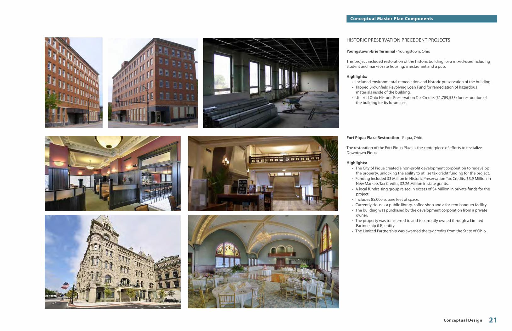
HISTORIC PRESERVATION PRECEDENT PROJECTS
Youngstown-Erie Terminal - Youngstown, Ohio
This project included restoration of the historic building for a mixed-uses including student and market-rate housing, a restaurant and a pub.
Highlights:• Included environmental remediation and historic preservation of the building.• Tapped Brownfield Revolving Loan Fund for remediation of hazardous
materials inside of the building.• Utilized Ohio Historic Preservation Tax Credits ($1,789,533) for restoration of
the building for its future use.
Fort Piqua Plaza Restoration - Piqua, Ohio
The restoration of the Fort Piqua Plaza is the centerpiece of efforts to revitalize Downtown Piqua.
Highlights:• The City of Piqua created a non-profit development corporation to redevelop
the property, unlocking the ability to utilize tax credit funding for the project.• Funding included $3 Million in Historic Preservation Tax Credits, $3.9 Million in
New Markets Tax Credits, $2.26 Million in state grants.• A local fundraising group raised in excess of $4 Million in private funds for the
project.• Includes 85,000 square feet of space.• Currently Houses a public library, coffee shop and a for-rent banquet facility.• The building was purchased by the development corporation from a private
owner.• The property was transferred to and is currently owned through a Limited
Partnership (LP) entity.• The Limited Partnership was awarded the tax credits from the State of Ohio.
Conceptual Design 21
Conceptual Master Plan Components

TRANSIT SHELTERS AND TRANSFER FACILITY
The start-up fixed route bus service being studied as a separate part of this project proposes a radial system of bus routes with a downtown hub. The hub of the system is where passengers would transfer from one route to another to access different parts of town. Additionally, the hub is where drivers would take breaks and/or change buses and would ideally have access to administrative personnel if necessary. Generally there would be a short layover at the hub and any route make-up time would be used there as well.
Therefore, it would not be uncommon for passengers to wait at the hub as they wait for a bus out of downtown or they transfer from one bus to another. It is critical that passenger amenities be provided as the hub will be utilized by nearly all users of the transit system. The comfort and use ability of the facility will play a direct role in the success of the overall transit system.
Transit Vehicle Access and Passenger LoadingThe proposed transit hub would be located in the existing parking lot directly to the south of the jail structure. A new concrete loop drive will need to be constructed to facilitate buses entering the facility from Third Street and circulating to the passenger loading platforms. The loading platforms should be at curb height to accommodate ease of transit vehicle loading. Overhead canopy structures would accommodate passenger comfort through provision of shade and shelter from inclement weather. Overhead heating units or an enclosed vestibule could provide additional comfort for users.
A small enclosed structure is proposed on the west side of the site which is directly accessible from Third Street. This space could house such uses as ticket sales, route information and timetables, food and beverage vending and public restrooms. Some of these uses may also be housed in the jail structure; however, this location on the west side of the site presents a prime opportunity for a retail or other private use as well.
STORMWATER INFILTRATION
PLANTER[21’-0”]
TRANSFER FACILITYDRIVEWAY
[45’-0”]
STORMWATER INFILTRATION
PLANTER[21’-0”]
STORMWATER INFILTRATION
PLANTER[21’-0”]
STORMWATER INFILTRATION
PLANTER[21’-0”]
PEDESTRIAN PROMENADE
CONNECTING TO COURTHOUSE
SqUARE[20’-0”]
DROPOFF
AREA[8’-0”]
WALK[8’-0”]
WALK[8’-0”]
WALK[8’-0”]
WALK[8’-0”]
PEDESTRIANPLAZA[21’-0”]
TRANSFER FACILITY[21’-0”]
WALK[14’-0”]
NORTHBOUND[12’-0”]
SOUTHBOUND[12’-0”]
EXISTING PARKINGGARAGE
ADA ComplianceThe transit hub is located on a fairly flat site and therefore will require minimal grading to meet ADA requirements for sloping surfaces. The boarding areas are raised above the transit vehicle maneuvering area and will require curb ramps. These will be designed in accordance to current ADA standards.
Clear paths of travel shall be provided between and through all boarding areas of the transit hub and amenities provided in these areas should be designed to ADA standards. Any enclosed space in the transit hub shall also be designed to meet ADA standards and should include ease of maneuverability. Access to the jail structure and other adjacent Intermodal Hub areas will need to meet ADA standards as well. The previous section describes accessibility for any transit hub functions contained in the existing Jail structure.
Architectural StyleDuring the first public meeting, members of the public participated in a visual survey to determine appropriate architectural styles for Downtown Newark. Members of the public overwhelmingly expressed a preference for more traditional architectural styles. The conceptual design of the transit hub has more traditional massing and composition. Building materials could potentially include brick, stone, wood timber, steel and glass; all of which are found in Downtown historic structures.
Public Space ImprovementsIn addition to the overhead canopies, the transit hub should have user amenities such as benches, litter receptacles, drinking fountains and wayfinding graphics. The site plan will also be required to accommodate storm water management within the boundaries of the site. The storm water management systems should be integrated into public spaces of the site through surface systems such as infiltration planters, permeable pavements and bioswales.
The design of the pedestrian areas and buildings will be consistent with other areas of the site. This will allow the transit hub to be additive to the overall experience of the southern downtown area, making it a positive experience for transit users and downtown visitors alike. In order to meet this goal, it is critical that the design of the transit hub is consistent with the surrounding pedestrian areas. This will require that the transit hub and the adjacent site areas be designed through the same process or follow the same set of design guidelines.
Newark I ntermodal Hub Study22
Conceptual Master Plan Components

TRANSIT HUB PRECEDENT PROJECTS
Kalamazoo Transportation Center - Kalamazoo, Michigan
Kalamazoo City Population: +/-75,000Kalamazoo County Population: +/-250,000
The Kalamazoo Transportation Center serves as an excellent precedent for the Newark Intermodal hub. Much like Newark, Kalamazoo has a historic rail station on the edge of downtown that has historically served as a center for transportation. The city developed a fixed-route bus system in the late 1960’s and today has more than 20 routes. The transportation center now serves as the hub for the bus system.
Highlights:• Utilizes historic rail station as main part of station.• Served by two daily Amtrak routes; the Blue Water and The Wolverine.• Served by daily private intercity bus service provided by Greyhound.• Is the hub of the Kalamazoo Metro Transit fixed-route bus service.• Has capacity for up to 20 buses.• Includes auto drop-off area near city street.• A parking garage is located across the street.
In addition to having a similar program, the architectural style, public spaces and user amenities of the center serve as a great model for the Newark Intermodal Center.
Conceptual Design 23
Conceptual Master Plan Components

BIKE PARKING FACILITY AND PEDESTRIAN AREA The bike portion of the intermodal hub is a critical component of the transportation center. Unlike other forms of transportation served by the hub, the bike portion of the project will be significantly utilized by recreational users as well as commuters. This presents a unique opportunity to provide amenities that cater to both everyday users as well as potential weekend or first-time cyclists. As seen in other recreational trail systems, a well planned, well maintained trail system can generate significant tourist use with potential users travelling from large distances to use the system. Therefore, this component of the project has two primary goals;
1. Provide user affordable and convenient amenities to facilitate daily bike commuting.
2. Drive tourism through creation of an identifiable landmark, access to downtown businesses, a comfortable and safe facility for resting, a meeting spot for group rides, and a starting/ending point for long bike rides.
Bike ParkingBike parking should accommodate two different types of users, the commuter and the recreational rider. Bike commuters will most likely park their bike all day and, depending on comfort level, may find an exterior bike rack in a highly visible location as a suitable storage option. Other commuters, however, may only be willing to park their bike in an enclosed, secure location. These users will most likely be willing to pay a daily or monthly fee for secure bike storage. This feeling was expressed by bike users during public meetings.
Conversely, recreational riders that stop at the intermodal hub during a ride will generally only need to park their bikes for a short amount of time. Many recreational riders are comfortable locking their bike to a loop rack or other system. Other recreational users are likely to have a touring bike and associated touring equipment that requires more security than a bike rack may provide. In this case, these users may be willing to pay a fee to securely stow their bikes while they break from riding.
In either case, the intermodal hub should accommodate a number of potential users. This can most effectively be achieved by two different types of bike storage:
1. A covered and highly visible bike shelter/corral with bike loop racks or other simple locking system.
2. An indoor bike locker room or individual bike lockers.
The bike shelter, racks and lockers are all relatively affordable and easily installed items manufactured by a number of vendors. The indoor bike facility provides a higher level of security and protection from the elements and may be incorporated into the jail restoration.
Other User Amenities• Several universally accessible drinking fountains should be provided within the
intermodal hub for bike and transit users.• Trail maps and interpretive signage should be incorporated into a highly visible
area of the hub to ensure ease of use.• Include wayfinding information directing people to nearby attractions
including Downtown restaurants and retail, The Arcade, The Works, and The Midland Theater.
Newark I ntermodal Hub Study24
Conceptual Master Plan Components

BIKE HUB PRECEDENT PROJECTS
Dayton Bike Hub - Dayton, Ohio
The Dayton Bike Hub is a recent project in downtown Dayton that was built in conjunction with a riverfront pavilion that is part of a larger Riverscape project.
Highlights:• Indoor bike storage and locker facilities for a monthly membership fee.• Bike hub building incorporates a concession stand and storage facility for
maintenance equipment.• Parks and public activity spaces are a critical component of the hub, creating a
destination and reason to stop for a break along the trail system.
Yellow Springs Bike Hub - Yellow Springs, Ohio
The Yellow Springs Bike Hub in downtown Yellow Springs is another example of a successful bike hub.
Highlights:• Replica rail station placed adjacent to its Rails-to-trails bike system.• Building includes restrooms, an indoor resting space and a tourist station with
maps and information.• Is staffed with park district personnel at peak times.• Is located in close proximity to the downtown commercial core to allow for
easy access to food service and shopping.• Has an iconic and memorable presence along the route.
In addition to secure bike parking in the historic jail, bike rider amenities could be provided in an expanded pedestrian area adjacent to the existing alley including bike racks, tables, bike lockers, and a bike shelter.
Conceptual Design 25
Conceptual Master Plan Components

PEDESTRIAN LINKAGES BETWEEN THE HUB AND DOWNTOWN CORE
A pivotal component of the success of the intermodal hub will be the pedestrian connections of the hub to the rest of downtown. Strong pedestrian linkages between the core downtown business district and the intermodal hub will help to add to the success of both for several core reasons:
1. Currently, a perceived gap exists between the hub site and downtown core because of deteriorating or under-designed sidewalks, a lack of pedestrian amenities, and a lack of existing buildings or effectively utilized building frontages. Improvement of these items will help to assure that users of the intermodal hub perceive the hub to be “downtown”. This is a critical element of the success of the hub.
2. A lack of parking for downtown businesses was discussed during the public input process. This is caused in part because of a lack of metered parking and the use of on-street parking by public employees. Metering the on-street parking is not currently viewed as an effective solution because it could cause potential patrons to seek free parking in other areas of the city. Increasing pedestrian access to the existing garage would enhance potential use by public employees and could provide overflow parking for potential business patrons when on-street parking is fully utilized.
3. Attractive new public spaces and a highly utilized intermodal hub will consistently attract or deliver new people to downtown. This will expand the potential market for downtown businesses, thereby increasing potential sales activity for existing businesses and increasing demand for new retail or office space.
Several strategies have been developed to facilitate these objectives:
The Canal Corridor & Market PavilionThe site within the canal corridor is within the Downtown Newark Historic District, which is bounded roughly by Church St., Second St., Fifth St., and Canal St. The Historic District is listed on the National Register of Historic Places. The character of the park development and any structures should support the aesthetic and urban qualities of the district. The site plan proposes a traditional layout of enhanced, historically compatible pavements, some limited lawn and planting areas, and several locations for public art that may memorialize an important public figure or event.
Additionally, there are farmer’s markets and other public events already occuring that do not have a permanent facility for use. The former canal is of adequate width to accommodate a permanent ‘market’ pavilion structure. This would be compatible with the historical use of the site because a market structure historically existed here.
Adjacent SidewalksThe adjacent sidewalks are mainly composed of concrete pavement and curbs with some limited street trees and occasional site furnishings. Lighting is provided by overhead fixtures which are not of pedestrian scale. Strategic improvements could be made to enhance the pedestrian experience in these areas.
The AlleyThe alley provides a unique visual link between the historic Courthouse and rail station. This under-utilized asset could be improved with signage, lighting, pavements and other improvements to create a dynamic and one-of-a-kind pedestrian link between the Courthouse Square and the Intermodal Hub.
PARKING LANE[8’-0”]
WESTBOUNDROAD
[15’-0”]
CANAL CORRIDOR PAVILION
[47’-0”]
PEDESTRIAN PROMENADECONNECTING TO
COURTHOUSE SqUARE
PARKING LANE[8’-0”]
WALK[5’-0”]
WALK[5’-0”]
EASTBOUNDROAD
[15’-0”]
EXISTING PARKINGGARAGE
Newark I ntermodal Hub Study26
Conceptual Master Plan Components

PUBLIC REALM ENHANCEMENT PRECEDENT PROJECTS
Lexington Streetscape and Cheapside Pavilion - Lexington, Kentucky
This project serves as an excellent example of what could be accomplished in the “canal corridor” portion of Downtown Newark between Market and Canal Streets.
Highlights:• Built in a historic part of Downtown Lexington directly adjacent to the civic
heart of the community.• Helped to increase Downtown vitality through increased restaurant and retail
patronage.• Includes interactive uses for children including a splash pad and various other
site amenities.• Hosts weekly farmer’s markets and outdoor performing arts events.• Project was completed under a rigorous schedule and involved substantial
coordination between local, state and federal agencies.• Utilized a number of public and private funding sources.
Acorn Alley - Kent, Ohio
Acorn Alley is good precedent for narrow circulation spaces in existing downtowns. The project creates a much needed pedestrian connection while concurrently increasing economic development and downtown vitality.
Highlights:• Cleverly reuses a narrow alley-like passage between existing buildings to create
additional retail space and an enhanced pedestrian experience.• Works to connect the primary commercial corridor of Downtown Kent to
existing parking behind the buildings.• Currently includes 12 businesses including several restaurants and retail shops.• Utilizes clear signage, lighting and urban design to facilitate pedestrian
circulation and enhanced safety.
Conceptual Design 27
Conceptual Master Plan Components
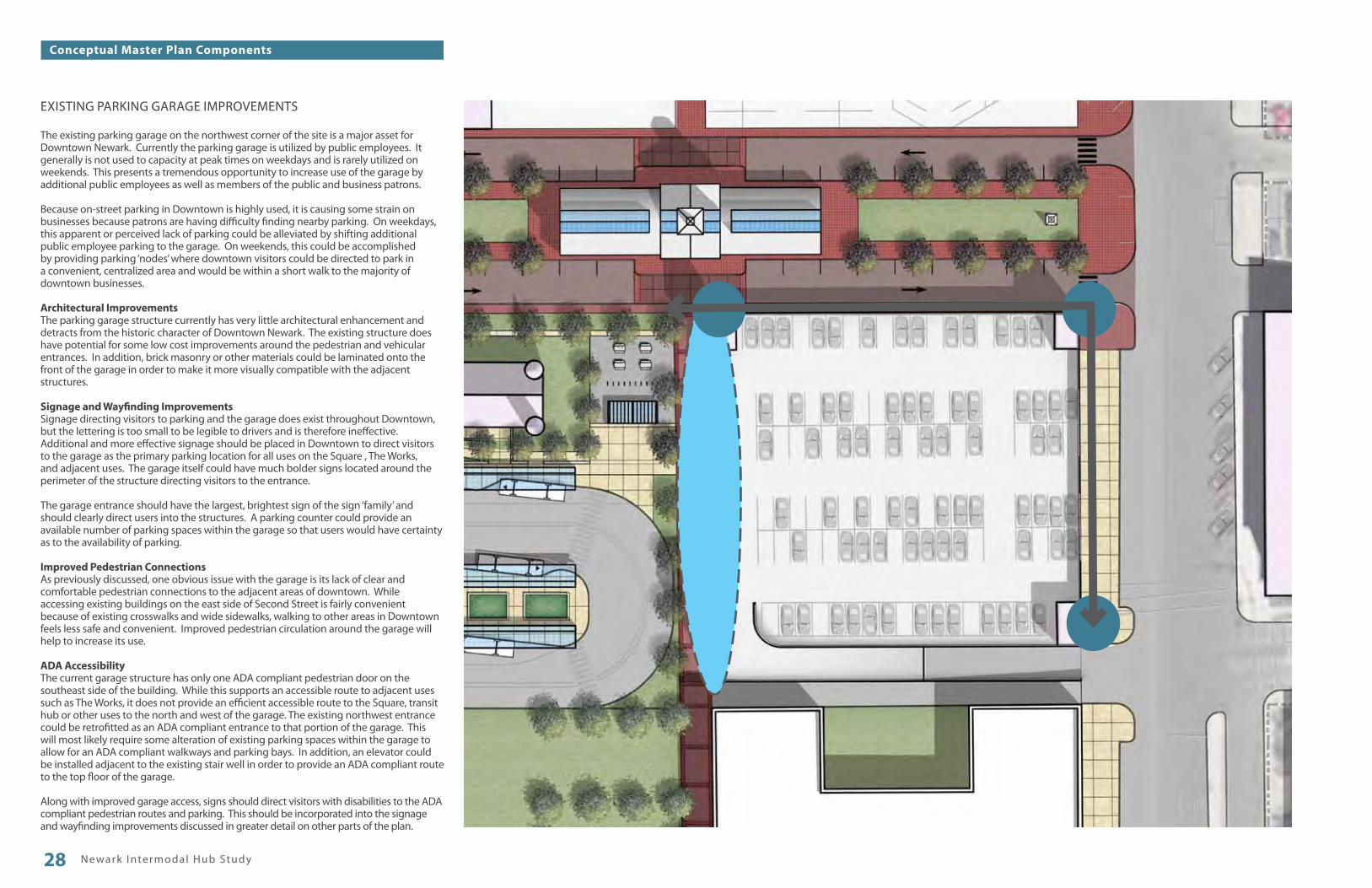
EXISTING PARKING GARAGE IMPROVEMENTS
The existing parking garage on the northwest corner of the site is a major asset for Downtown Newark. Currently the parking garage is utilized by public employees. It generally is not used to capacity at peak times on weekdays and is rarely utilized on weekends. This presents a tremendous opportunity to increase use of the garage by additional public employees as well as members of the public and business patrons.
Because on-street parking in Downtown is highly used, it is causing some strain on businesses because patrons are having difficulty finding nearby parking. On weekdays, this apparent or perceived lack of parking could be alleviated by shifting additional public employee parking to the garage. On weekends, this could be accomplished by providing parking ‘nodes’ where downtown visitors could be directed to park in a convenient, centralized area and would be within a short walk to the majority of downtown businesses.
Architectural ImprovementsThe parking garage structure currently has very little architectural enhancement and detracts from the historic character of Downtown Newark. The existing structure does have potential for some low cost improvements around the pedestrian and vehicular entrances. In addition, brick masonry or other materials could be laminated onto the front of the garage in order to make it more visually compatible with the adjacent structures.
Signage and Wayfinding ImprovementsSignage directing visitors to parking and the garage does exist throughout Downtown, but the lettering is too small to be legible to drivers and is therefore ineffective. Additional and more effective signage should be placed in Downtown to direct visitors to the garage as the primary parking location for all uses on the Square , The Works, and adjacent uses. The garage itself could have much bolder signs located around the perimeter of the structure directing visitors to the entrance.
The garage entrance should have the largest, brightest sign of the sign ‘family’ and should clearly direct users into the structures. A parking counter could provide an available number of parking spaces within the garage so that users would have certainty as to the availability of parking.
Improved Pedestrian ConnectionsAs previously discussed, one obvious issue with the garage is its lack of clear and comfortable pedestrian connections to the adjacent areas of downtown. While accessing existing buildings on the east side of Second Street is fairly convenient because of existing crosswalks and wide sidewalks, walking to other areas in Downtown feels less safe and convenient. Improved pedestrian circulation around the garage will help to increase its use.
ADA AccessibilityThe current garage structure has only one ADA compliant pedestrian door on the southeast side of the building. While this supports an accessible route to adjacent uses such as The Works, it does not provide an efficient accessible route to the Square, transit hub or other uses to the north and west of the garage. The existing northwest entrance could be retrofitted as an ADA compliant entrance to that portion of the garage. This will most likely require some alteration of existing parking spaces within the garage to allow for an ADA compliant walkways and parking bays. In addition, an elevator could be installed adjacent to the existing stair well in order to provide an ADA compliant route to the top floor of the garage.
Along with improved garage access, signs should direct visitors with disabilities to the ADA compliant pedestrian routes and parking. This should be incorporated into the signage and wayfinding improvements discussed in greater detail on other parts of the plan.
Newark I ntermodal Hub Study28
Conceptual Master Plan Components

PARKING GARAGE PRECEDENT PROJECTS
Easton Parking Garage - Columbus, OhioSeveral parking garages in the Easton Town Center are two decks, similar to the existing garage.
Highlights:• Attractive Landscaping• Brick Facade• Well designed adjacent public space• Clear graphics and wayfinding including excellent directional signage at
garage entrances• Excellent lighting• Ornamental metal railing• Signage family
Conceptual Design 29
Conceptual Master Plan Components

FUTURE MIXED-USE OR MULTI-FAMILY DEVELOPMENT
A primary goal of the development of the intermodal hub is to create a driver for additional economic development in and around downtown. Once the intermodal hub is complete, the land immediately adjacent to the hub will have transportation access to a significant portion of the City of Newark and points beyond. This will help to increase value of the land as well as potential demand for development.
The existing property to the south of the proposed hub and parking garage is currently owned by a private foundation. Its adjacency to the hub and proximity to the downtown core make it a prime location for a multi-story mixed-use development.
The consultant team has proposed that this site eventually be developed with some kind of urban infill development. Although market forces and developer interest will ultimately determine what type of development is feasible, this building could be composed of office, retail, residential or civic uses, or a combination thereof.
Regardless of building use or development timeframe, a number of key items should be included in the development in order to best enhance the vitality and economic stability of Downtown Newark:
1. The building should be at least three stories and not more than five to best match the scale of the adjacent buildings and Downtown Newark as a whole.
2. The building should be architecturally compatible with the historic character of the adjacent buildings and be relatively consistent in materials, proportions, and architectural features.
3. The building should be designed to enhance the adjacent public streets through its physical location at the street right-of-way, its inclusion of a significant amount of windows on its facade, and provision of pedestrian entrances directly from the sidewalk.
4. The building should include uses which contribute to the 24/7 vitality of Downtown Newark. For example, a single-use office building would not necessarily be desirable, but a mixed-use building that contained offices as well as restaurant or retail space would.
More generally, this site represents an important opportunity for economic development in downtown and the wrong type of development could adversely affect the success of the intermodal hub and the other existing adjacent uses.
Newark I ntermodal Hub Study30
Conceptual Master Plan Components

URBAN DEVELOPMENT PRECEDENT PROJECTS-
The Annex - Columbus, Ohio
Highlights:• All residential development project completed in 2009.• Includes 4 total buildings; two on each side of Front Street in Downtown
Columbus. • Two buildings are townhouse style with direct access to the adjacent streets. • Two buildings are apartment building style with an interior lobby and a
basement for resident parking.• Initial project included both for-rent apartments and for-sale condominiums,
but was converted completely to apartments just prior to completion.• The project had very fast initial leasing and currently has low vacancy rates.• Both buildings are predominantly wood construction which reduces
construction costs. The basement of the east building has concrete masonry construction allowing for use as parking.
• The project takes full advantage of the size of the site through a zero-lot-line construction technique
• The project was made financially viable in part through reduced land costs made possible by the City of Columbus.
50 South Liberty - Powell, Ohio
Highlights:• Mixed-use development which includes retail and office space.• Two story building with approximately 40,000 total square feet of space.• Building frontages are located directly adjacent to the existing street right-of-
way and enhance the historic character of Downtown Powell.• Wood frame construction reduced initial construction costs.• The architectural style and building scale is complementary to historic
downtown character.• Includes about 175 total parking spaces with on-street parking in front of
building and large parking lot hidden behind the space.• More than 90% leased 4 years after construction is complete.
Conceptual Design 31
Conceptual Master Plan Components

VISUAL INTEGRATION OF HISTORIC RAIL STATION
The Historic Rail Station is located adjacent to the south end of the site. The building is currently occupied by private tenants and as such is not included in the transportation planning portion of this study.
The rail station is listed on the National Register of Historic Places under the name “Pennsylvania Railway Station” and was originally constructed in the late 19th Century. The building is composed predominantly of red brick and has distinctive windows with highly vertical proportions. The building is undoubtedly one of the more distinctive buildings within downtown, but is currently somewhat hidden from view and is surrounded by lower quality structures which detract from its presence.
However, from the project site, the rail station is a highly visible element and its presence will undoubtedly create an implied link between the intermodal hub and the rail station. The goal of the design of the intermodal hub planning study is to help enhance the presence of the rail station by placing complementary uses adjacent to the building. In previous sections of the plan, the planning team has suggested that the existing park space remain and the currently underutilized parcel to the northeast of the rail station be developed as a high quality, mixed-use project. This will leverage the architectural character of the rail station in generating economic development in Downtown Newark.
In addition, the unique alley vista between the front entrance of the rail station and the south entrance of the Courthouse is a tremendously important existing component of the site. The consultant team has worked to preserve and enhance this asset through careful location of site elements and enhancement of the alley corridor. The alley will become a critical pedestrian pathway in the plan, with the primary views of pedestrians directed squarely at the distinctive and ornate entrances of both the Courthouse and rail station.
To further emphasize the importance of the structure in the history of Newark, the consultant team recommends placing interpretive signage near the rail station. This signage could discuss the development and importance of the railroad as well as the original construction of the station. Interpretive signage generally contains some text and images, but additional types of displays could be explored such as interactive electronic displays, dynamic lighting and programmed sound.
Future uses:As discussed in previous sections of the plan, growing metropolitan regions such as Columbus have seen development of commuter or intercity rail lines in order to alleviate traffic congestion on the freeway network and provide additional mobility options for residents. Additionally, other metropolitan regions of similar size have seen successful development of heritage or scenic railroads which offer tourist excursions on a limited basis. The Cuyahoga Valley Scenic Railroad in northeast Ohio is one such example.
Given the unique ownership of the adjacent ‘Panhandle’ line, it is reasonable to assume that the line will eventually be reactivated for some kind of passenger use such as the aforementioned examples. This may present an opportunity to reactivate all or a portion of the rail station as a passenger terminal. The current plan accommodates this through strong pedestrian connections, the proximity of the nearby parking garage, and the connections to other transportation modes. If passenger rail is restarted and the existing station is not used, the intermodal hub concept is still able to accomplish intermodal functionality so long as the passenger platforms are located nearby.
Newark I ntermodal Hub Study32
Conceptual Master Plan Components

CHAPTER 4
DEVELOPMENT STRATEGY AND FINANCIAL CONSIDERATIONS

PHASE 1A - RENOVATE JAIL & CONSTRUCT BIKE FACILITIES
Begin renovations to historic jail• Complete any necessary environmental studies and remediation as required for
reuse• Complete renovations to the jail to allow for west portion of the building to be
used for office use
Install bike parking facilities and supportive site improvements• Complete installation of bike parking facilities and site furnishings• Complete installation of exterior drinking fountains and some limited site
lighting• Perform minor site improvements around the jail building to create clean and
safe appearance• Complete site improvements to the alley corridor to allow for enhanced bike
and pedestrian connections through the site• Continue Design and Funding Procurement of Further Phases• Complete design work and regulatory approvals of the transit hub in
coordination with the startup of transit service
Improve the Existing Parking Garage• Construct improved signage and wayfinding on the exterior of the garage and
throughout Downtown. • Improve the exterior of the garage building with architectural enhancements• Create new ADA compliant entrance on the northwest corner of the building
and enhance accessible routes within the garage and adjacent to the structure
Newark I ntermodal Hub Study34
Phasing Strategy

PHASE 1B - IMPROVE GARAGE & ADJACENT SITE IMPROVEMENTS
Construct Canal Park• Construct Canal Park space
Complete Renovations to Historic Jail
• Renovate interior elevator core to provide ADA compliant access to the upper floors
• Construct necessary fire-rated internal (or external) stairwell• Complete renovations to basement of building to allow for bike use and access• Begin renovations to the Cell Block portion of the building to allow for future
cultural use• Construct right-of-way improvements on the west side of the site to facilitate
enhanced pedestrian connections, on-street parking and auto drop-off/taxicab stand
Development Strategy and Financial Considerations 35
Phasing Strategy

PHASE 2 - BEGIN TRANSIT SERVICE
Construct Phase 1 of Transit Facilities• Perform necessary minimal grading, install infrastructure, and construct bus
maneuvering loop• Construct first set of overhead shelters, site furnishings and other user
amenities• Construct “green” storm water management infrastructure
Newark I ntermodal Hub Study36
Phasing Strategy

PHASE 3 - COMPLETE TRANSIT SERVICE & DEVELOP ADJACENT AREAS
Construct Phase 2 of Transit Facilities• Construct second set of overhead shelters• Construct small shelter on west end of the site
Construct future mixed-used structure as market permits• Remove existing small concrete block building• Provide adjacent alley improvements per the existing plans
Development Strategy and Financial Considerations 37
Phasing Strategy

PHASE 4 - ENHANCE LOCAL AND REGIONAL CONNECTIONS
• Enhance the canal corridor through remainder of downtown area• Continue to develop pedestrian connections to the intermodal hub from the
rest of Downtown Newark• Examine the potential for regional or intercity bus or rail options• Enhance regional bikeway connections
Newark I ntermodal Hub Study38
Phasing Strategy

Conceptual Estimate
Jail Renovation Part 1Front Office Retrofit
Bike Hub / Staging Area
Alley Walk
North Alley Walk
Garage Facade Improvements
Jail Renovation Part 2
Canal ParkSite ImprovementsPavilion
Transit Center Part 1Structures and Site WorkRight-of-Way Work
Transit Center Part 2Structures and Site Work
Total
Soft Costs (20% of total)
Grand total
$0*
$125,000
$185,000
$125,000
$120,000
$0*
$850,000$850,000
$835,000$175,000
$395,000
$3,660,000
$732,000
4,400,000
Phas
e 1a
Phas
e 1b
Phas
e 2
Phas
e 3
Garage Facade Improvements
Shelter
Pavillion
Plaza
Brick Piers
Parking Garage
Future Development
Alley WalkBus Hub /
Staging
Ticketing Office
New Drive
EsixtingOpen Space
Open Space
Parking
Shelter
Jail
Canal Park
Bike Hub / Staging
North Alley Walk
*Assumes renovation costs are handled by outside developer
Development Strategy and Financial Considerations 39
Preliminary Magnitude of Cost

Federal• Federal Historic Preservation Tax Credits• Federal Transit Funds• Federal Transportation Enhancement funds• Federal Competitive Grants• Federal New Markets Tax Credits• Other Federal Departments: EPA, DOE, HUD, etc.
State• State Historic Preservation Tax Credits• ODOT transportation funds• Ohio New Markets Tax Credits• Ohio DOD and EPA Brownfield Loans and Grants• Other Ohio EPA/DOH Grants/Loans
Local• Metro Planning Organization Bike and Transit funding• County and City capital improvement funds• Community Development Block Grants
Private Capital• Opportunities for Private Development and Partnerships• Private Donors • Naming/Advertising Rights
Non-Profit Contributions and Fundraising• Fundraising Campaign• Community Foundation Funds• Volunteerism• In-Kind Professional Labor
THE STRATEGY GOVERNMENTAL RESOURCES
NON-GOVERNMENTAL FUNDS
FUNDING SOURCES
Funding for transportation projects is provided by multiple departments and levels of government
PUBLIC FUNDING SYSTEM BASICS
FUNDINGSOURCES
DEVELOP ABROAD
STRATEGY
Create a project with multiple community benefits
Utilize limited local funds to attract maximum Federal and State investment
Incorporate multiple transportation modes and community uses into the project to unlock maximum number of potential sources of funding
Attract private investment to strengthen local funding match
MAXIMIZE PUBLIC INVESTMENT
Newark I ntermodal Hub Study40
Funding Strategy

POTENTIAL SOURCES OF FUNDING FOR TRANSPORTATION INFRASTRUCTURE AND DEVELOPMENT PROJECTS
This section identifies potential funding sources for projects designated in the Intermodal Hub Plan. These include grants, loans, tax credit programs, and other potential funding sources. These sources may fund planning, design and operational and educational initiatives that related directly to the successful implementation of the Development Plan, in addition to direct capital costs.
The key with all applications for funding is coordination and communication with other public agencies and local stakeholders to demonstrate that the investment of public monies will benefit not only the specific project but also the greater community. When applying for a grant, loan, or other financing mechanism, there are a number of other items to address during the application process as well:
• Work closely with the staff of funding agencies during the preparation of the application to assure that critical items are addressed properly.
• Communication with the funding agency early in the application process to verify the applicability of the program and to confirm a list of critical items needed to increase the strength of the application
• Careful attention and thoroughness with each element of the application• Partnership with various agencies that are affected by or have an interest in the
project in question• Letters of support from various local agencies, adjacent property owners, and
public and community leaders• Listing of other matching funds available to support project implementation• Listing of appropriate contact information with specific knowledge of the
project• Description of the overall mission and goals of Development Plan and how
project directly supports those goals
It is unlikely that all funding applications will be approved or accepted following the initial submittal. The City of Newark should review unsuccessful funding applications with the staff of the agency and modify as necessary to enhance the likelihood of approval in later rounds of applications.
Key Entities for Communication and Funding
Local Governmental AgenciesCity of NewarkLicking CountyLicking County Area Transportation Study
Adjacent Property OwnersThomas J Evans FoundationLicking County Commissioners
Storm Water Management / Environmental EnhancementsOhio EPAOhio Department of Development Office of RedevelopmentUS Environmental Protection Agency
Energy ResourcesOhio Department of Development Office of EnergyUS Department of Energy
Transportation ImprovementOhio Department of Transportation (District 5)Licking County Area Transportation StudyCity of NewarkEarthworks TransitLicking Park DistrictUS Department of Transportation
Historic PreservationOhio Department of Development Office of RedevelopmentOhio Historical SocietyUS National Park Service
Economic Development & PlanningLicking County Convention & Visitor’s BureauLicking County Chamber of Commerce
Arts & CultureOhio Arts CouncilLicking County ArtsThe Works
Institutional, Private & Philanthropic OpportunitiesThomas J Evans FoundationLicking County FoundationAmerican Electric PowerColumbia GasEnergy CooperativeState Farm InsuranceThe Ohio State University at NewarkCentral Ohio Technical College
Development Strategy and Financial Considerations 41
Potential Funding Sources

Funding Source Congestion Mitigation and Air quality Improvement Program (CMAq), Federal Highway Administration
Amount of Fund: Varies
Required Match: Typically 20%
Description: Funding is available for bikeways, pedestrian facilities, roads, traffic signals, transit, and vehicle fleet projects. CMAq projects must demonstrate reductions in emissions of pollutants that contribute to the non attainment, such as carbon monoxide (CO), particulate matter, and ozone precursors (nitrogen oxides and volatile organic compounds).
Eligible Applicants: Local public agencies that can enter into a contract with ODOT, including municipalities, county engineers, transit authorities, and local school districts
Application Deadline: Contact Program Administrator
Contact: Local FHWA Administrator
Website: http://www.fhwa.dot.gov/environment/air_quality/cmaq/
Potential Projects: Sidewalks and bike paths, adjacent street enhancements
TRANSPORTATION & TRANSPORTATION ENHANCEMENT
Funding Source Surface Transportation Program
Amount of Fund: Varies
Required Match: 20% minimum of construction costs. Sponsor typically pays 100% of design costs.
Description: STP funds may be used for projects on any Federal-aid highway projects such as arterial and collector streets (but not local streets), bicycle and pedestrian projects.
Eligible Applicants: Local public agencies that can enter into a contract with ODOT, including municipalities, county engineers, transit authorities, and local school districts
Application Deadline: Contact Program Administrator
Contact: http://www.fhwa.dot.gov/safetealu/factsheets/stp.htm
Website: Local FHWA Administrator
Potential Projects: Adjacent street, bikeway and pedestrian enhancements
Funding Source FTA Major Capital Investments (New Starts & Small Starts)
Amount of Fund: Varies
Required Match: 80 percent Federal, 20 percent local
Description: The Small Starts program provides funds to capital projects that either (a) meet the definition of a fixed guideway for at least 50 percent of the project length in the peak period or (b) are corridor-based bus projects with 10 minute peak/15 minute off-peak headways or better while operating at least 14 hours per weekday. The Federal assistance provided must be less than $75 million and the project must have a total capital cost of less than $250 million, both in year of expenditure dollars
Eligible Applicants: Public bodies and agencies, including states, municipalities, other political subdivisions of states and certain public corporations, boards, and commissions established under state law.
Application Deadline: Contact Program Administrator
Contact: FTA Office of Program Management: (202) 366-2053
Website: http://www.fta.dot.gov/13094_3559.html
Potential Projects: Projects including light rail, rapid rail (heavy rail), commuter rail, automated fixed guideway system (such as a “people mover”), or a busway/high occupancy vehicle (HOV) facility
Funding Source FTA Major Capital Investments (Very Small Starts)
Amount of Fund: Varies
Required Match: 80 percent Federal, 20 percent local
Description: Very Small Start projects are simple, low-risk projects that qualify for a highly simplified project evaluation and rating process by FTA.
Eligible Applicants: Eligible applicants under the New Starts program are public bodies and agencies, including states, municipalities, other political subdivisions of states and certain public corporations, boards, and commissions established under state law.
Application Deadline: Contact Program Administrator
Contact: FTA Office of Program Management: (202) 366-2053
Website: http://www.fta.dot.gov/13094_3559.html
Potential Projects: A project must be a bus, rail or ferry project and contain the following features: -Transit Stations-Signal Priority/Pre-emption (for Bus/LRT)-Low Floor / Level Boarding Vehicles-Special Branding of Service-Frequent Service - 10 min peak/15 min off peak-Service offered at least 14 hours per day-Existing corridor ridership exceeding 3,000/day-Less then $50 million total cost-Less then $3 million per mile (excluding vehicle)
Funding Source Livable Communities Initiative
Amount of Fund: Varies
Required Match: None
Description: The objectives of the Initiative are to improve mobility and the quality of services available to residents of neighborhoods.
Eligible Applicants: Eligible recipients are transit operators, metropolitan planning organizations, city and county governments, states, planning agencies and other public bodies with the authority to plan or construct transit projects. Non-profit, community and civic organizations are encouraged to participate in project planning and development as partners with eligible recipients.
Application Deadline: Contact Program Administrator
Contact: Federal Transit Administration Region V Phone: (312) 353-2789;
Website: http://ntl.bts.gov/DOCS/livbro.html
Potential Projects: Projects that: enhance the effectiveness of mass transportation projects to which they are physically or functionally related, as well as provide non-vehicular, capital improvements in fixed-guideway corridors.
Funding Source Transportation Investment Generating Economic Recovery Program (TIGER)
Amount of Fund: Varies
Required Match: 80 percent Federal, 20 percent local
Description: The objectives of the act is to foster innovative, intermodal and multi-jurisdictional transportation projects that promise significant economic and environmental benefits to an entire metropolitan area, a region, or the nation.
Eligible Applicants: State, local, and tribal governments, including U.S. territories, transit agencies, port authorities, metropolitan planning organizations (MPOs), other political subdivisions of State or local governments, and multi-State or multi-jurisdictional groups applying through a single lead applicant
Application Deadline: Varies
Contact: TIGER Discretionary Grant program manager Robert Mariner at 202–366–8914.
Website: http://www.dot.gov/TIGER
Potential Projects: Projects that are eligible for TIGER Discretionary Grants under the FY 2010 Appropriations Act include, but are not limited to: highway or bridge projects eligible under title 23, United States Code; public transportation projects eligible under chapter 53 of title 49, United States Code; passenger and freight rail projects; and port infrastructure investments.
Newark I ntermodal Hub Study42
Potential Funding Sources

Funding Source Clean Ohio - Green Space Conservation - OPWC District 3
Amount of Fund: Varies
Required Match: Yes - 25%
Description: Provides funding for acquisition and development of open space; protection and enhancement of riparian corridors or watersheds; and construction or enhancement of trails. A conservation easement might potentially be required.
Eligible Applicants: Counties, municipal corporations, townships, conservancy districts, soil and water conservation districts, joint recreation districts, park districts, or other similar park authorities and non-profit corporations
Application Deadline: Contact Program Administrator
Contact: State of Ohio Public Works Commission p: 614 466-0880
Website: http://www.pwc.state.oh.us/default.html
Potential Projects: Bikeways, Pedestrian Facilities, water quality projects.
Funding Source Ohio Public Works Commission (OPWC)
Amount of Fund: Varies
Required Match: Yes - 10% repair/replace & 50% for new/expansion
Description: Provides grants and loans for the construction of roads, bridges, waterlines, sanitary sewers, storm water and solid waste.
Eligible Applicants: County, township, village, or city, sanitary districts
Application Deadline: Contact Program Administrator
Contact: State of Ohio Public Works Commission p: 614 466-0880
Website: http://www.pwc.state.oh.us/default.html
Potential Projects: Road improvements, storm water management and sanitary sewer projects.
Funding Source U.S. Department of Housing and Urban Development’s Section 108 Program
Amount of Fund: Varies (LOAN)
Required Match: Contact program administrator
Description: HUD awards grants to entitlement community grantees to carry out a wide range of community development activities directed toward revitalizing neighborhoods, economic development, and providing improved community facilities and services.
Eligible Applicants: Metropolitan cities and urban counties
Application Deadline: Varies
Contact: HUD Columbus Field Office (614) 469-2540
Website: http://www.hud.gov/offices/cpd/communitydevelopment/programs/entitlement/index.cfm
Potential Projects: Adjacent roadways, demolition and rehabilitation of buildings, resource conservation and renewable energy projects
Funding Source: Ohio Department of Transportation (ODOT) Safe Routes to School Program
Amount of Fund: Varies
Required Match: None
Description: Improve safety, encourage and enable children, including those with disabilities, to walk or ridetheir bikes to school.
Eligible Applicants: Counties, municipalities, townships, school districts
Application Deadline: Contact Program Administrator
Contact: ODOT SRTS Program Administrator: (614) 644-3049
Website: http://www.dot.state.oh.us/Divisions/TransSysDev/ProgramMgt/Projects/SafeRoutes/Pages/default.aspx
Potential Projects: Bikeways, Pedestrian Facilities, School Zone Safety
Funding Source ODOD Urban Redevelopment Loan
Amount of Fund: LOAN for a maximum term of 15 years
Required Match: The maximum loan available is the lesser of $5 million dollars or 40% of eligible costs. The maximum loan term is up to 15 years. The interest is no greater than 50% of the prime rate as determined by the Director of Development.
Description: Economic development. (Awarded to representative governmental entity for infrastructure development - water/sewer, access roads, rail spurs, port improvements, training facilities, building renovations.)
Eligible Applicants: Municipalities or designated nonprofit economic development organizations
Application Deadline: No deadline.
Contact: Need to speak with ODOD Office of Financial Incentives (614) 466-5420 or (800) 848-1300
Website: http://www.development.ohio.gov/Business/loans_grants.htm#URL
Potential Projects: Infrastructure development - water/sewer, access roads, building renovations.
Funding Source Transportation Enhancement Program (ODOT District 5)
Amount of Fund: Varies
Required Match: 20% Minimum
Description: Funding is available for projects that enhance the transportation experience by improving cultural, historic, aesthetic, and environmental components of transportation infrastructure. The primary project categories include Historic and Archeological, Scenic and Environmental, and bicycle and pedestrian. This funding is generally intended for added
Eligible Applicants: Local public agencies that can enter into a contract with ODOT, including municipalities, county engineers, transit authorities, and local school districts
Application Deadline: Contact Program Administrator
Contact: Local ODOT Representative
Website: http://www.dot.state.oh.us/Divisions/Planning/SPPM/LocalPrograms/Pages/TransportationEnhancement.aspx
Potential Projects: Bikeways, Pedestrian Facilities, and Scenic Beautification/Streetscape projects
Development Strategy and Financial Considerations 43
Potential Funding Sources
Funding Source Ohio Historical Preservation Office Certified Local Government Grants
Amount of Fund: Up to 60% of project costs; 40% (CDBG Funds may be used as local match)
Required Match:
Description: This fund is for historic preservation projects and must be administered through a Certified Local Government (CLG).
Eligible Applicants: City of Columbus is currently a CLG.
Application Deadline: Late winter annually
Contact: Ohio Historical Society, 1982 Velma Avenue, Columbus, Ohio 43211-2497
Website: http://www.ohiohistory.org/resource/histpres/toolbox/clg/clg-04.html
Potential Projects: Additional project planning and surveying, Historic Property Registration, Public Outreach, feasibility studies and architectural work, and project development.
Funding Source Ohio Historic Preservation Tax Credits (ODOD)
Amount of Fund: 25% Tax Credit of Rehabilitation fees up to $5 Million
Required Match: Applicants must demonstrate additional funding to strengthen application. Additional project financing can be attained through multiple sources including other tax credit and grant programs
Description: Would require a sale of the historic structure to a non-government agency (typically a Community Development Entity) and they would handle the development. A lease or purchase agreement could be developed for CCS to maintain long-term control of the property.
Eligible Applicants: Private or not-for-profit developers
Application Deadline: Bi-annual, contact program administrator
Contact: Ohio Department of Development, Office of Redevelopment
Website: http://development.ohio.gov/urban
Potential Projects: Restoration of the historic jail
Funding Source Federal Historic Preservation Tax Credits
Amount of Fund: 20% Tax Credit of Rehabilitation fees
Required Match: Applicants must demonstrate additional funding to strengthen application. Additional project financing can be attained through multiple sources including other tax credit and grant programs
Description: Would require a sale of the historic structure to a non-government agency and they would handle the development. A lease or purchase agreement could be developed for City of Newark to maintain long-term control of the property.
Eligible Applicants: Private or not-for-profit developers
Application Deadline: Contact program administrator
Contact: Ohio Historic Preservation Office, 614-297-2300
Website: http://www.ohiohistory.org/resource/histpres/index2.html
Potential Projects: Restoration of the historic jail
Funding Source Ohio Environmental Education Fund
Amount of Fund: GRANT; Up to $50,000 each
Required Match: 10% or in-kind match
Description: The fund must be used to enhance the public’s awareness and understanding about issues affecting environmental quality in Ohio. The program has the flexibility to allow grants to be awarded for creative, innovative projects.
Eligible Applicants: All local subdivisions of government, local schools and school boards, universities, non-profit organizations, for profit companies, state agencies.
Application Deadline: Varies, Contact Program Administrator
Contact: Office of Environmental Education Phone: (614) 644-2873;
Website: http://www.epa.state.oh.us/oee/oeefoverview.aspx
Potential Projects: Educational programs that highlight sustainability and the mission of the campus master plan, limited personnel costs, educational materials
Funding Source ODOD Office of Energy
Amount of Fund: Grants vary
Required Match: None
Description: The Ohio Department of Development’s Office of Energy is seeking applications to implement renewable energy projects limited to solar electric, wind electric, and solar thermal systems for Commercial, Industrial, Institutional and Governmental entities in Ohio.
Eligible Applicants: Commercial, industrial, institutional and governmental customers served by the following investor-owned utilities: AEP, First Energy, Duke Energy, or Dayton Power and Light are eligible for funding.
Application Deadline: None - Program is ongoing
Contact: Ohio Department of Development Office of Energy
Website: http://www.development.ohio.gov/Energy/Incentives/AdvancedEnergyFundGrants.htm
Potential Projects: Solar electric and solar thermal systems
HISTORIC PRESERVATION: ENERGY AND ENVIRONMENT:
Funding Source US National Park Service
Amount of Fund: $700,000 federal share top, average is $233,000Required to be competitive
Required Match: 10% or in-kind match
Description: Save America’s Treasures grants are available for preservation and/or conservation work on nationally significant intellectual and cultural artifacts and nationally significant historic structures and sites.
Eligible Applicants: Federal agencies, units of state and local governments, nonprofit 501(c), U.S. organizations.
Application Deadline:
Contact: Contact program administratorNational Park Service (202) 354-2020
Website: http://www.nps.gov/history/hps/treasures/ProgramDetails.htm
Potential Projects: Historic preservation projects within the master plan
Newark I ntermodal Hub Study44
Potential Funding Sources

Funding Source Ohio Public Works Commission (OPWC)
Amount of Fund: Varies
Required Match: Yes - 10% repair/replace & 50% for new/expansionProvides grants and loans for the construction of roads, bridges, waterlines, sanitary sewers, storm water and solid waste.
Description: Provides funding for acquisition and development of open space; protection and enhancement of riparian corridors or watersheds; and construction or enhancement of trails. A conservation easement might potentially be required.
Eligible Applicants: County, township, village, or city, sanitary districts, and regional
Application Deadline: Contact Program Administrator
Contact: State of Ohio Public Works Commission p: 614 466-0880
Website: http://www.pwc.state.oh.us/default.html
Potential Projects: Road improvements, storm water management and sanitary sewer projects.
Funding Source Ohio EPA Surface Water Improvement Fund (SWIF)
Amount of Fund: Grants
Required Match: Yes
Description: The Surface Water Improvement Fund was created in 2008 with the passage of Ohio House Bill 119 and authorizes the Ohio Environmental Protection Agency to provide grant funding to applicants such as local governments, park districts, conservation organizations and others.
Eligible Applicants: Local municipalities, counties and townships, park districts, county soil & water conservation districts
Application Deadline: Varies, contact program administrator
Contact: Ohio EPA, Division of Surface Water (614) 644-2020
Website: http://www.epa.ohio.gov/dsw/nps/swif.aspx
Potential Projects: Green streets, storm water management projects, green roofs
Funding Source ODOD - Alternative Stormwater Infrastructure Loan Program (ASILP)
Amount of Fund: Varies
Required Match: No Match Required
Description: The Alternative Stormwater Infrastructure Loan Program provides below-market-rate loans for the construction of water development projects (including privately- or publicly-owned infrastructure) as part of economic development projects. The alternative stormwater infrastructure must utilize or incorporate sustainable practices such as bioswales, green roofs, constructed wetlands, and rain gardens.
Eligible Applicants: Governmental Agencies and private entities partnering with a public entity can utilize the program for development projects. Borrowers must own or have access to the property and have the ability to repay.
Application Deadline: Open cycle
Contact: Office of Redevelopment at (614) 995-2292
Website: http://www.development.ohio.gov/urban/ASILP.htm
Potential Projects: The property must be located in currently or previously developed areas. The property must have a plan for redevelopment or improvement that will result in economic benefit and revitalization of the community, such as created or retained jobs, new or rehabilitated housing, leveraged investment, or expansion of community services.
Development Strategy and Financial Considerations 45
Potential Funding Sources

A PRESERVATION AND RENOVATION SCENARIO
Given the previously discussed program of the jail reuse, the consultant team believes that a private or not-for-profit developer will need to be involved in the preservation and renovation of the building in order to utilize tax-credit funding from Federal and State sources. This financing method has been used successfully for several prominent projects throughout the State of Ohio and could provide the financial foundation for moving this project forward.
Therefore, the consultant team assumes that public tenant of the space will pay some reasonable leasing rate for renovated office space within the building. The bike storage and shower component of the project could be partially or completely self-sustaining through user fees. Additionally, the consultant team assumes that a private institution or public entity will facilitate the cultural use/tours and will pay a reduced leasing rate because of the reduced levels of renovation and maintenance required.
This strategy represents one redevelopment scenario based on the requirements of this planning study. There are several other potential scenarios which could be equally viable. In any case, additional study will be required to determine a more refined redevelopment scope and opinion of probable cost.
Economic ModelingThis analysis models the potential revenue based on the preservation and renovation concept. Lease rates are estimated based on existing rates in the Newark and broader Central Ohio market. Total ongoing (stabilized) annual revenue, total estimated annual expense (based on industry averages), and annual net operating income (NOI) are projected.
From a conventional financing perspective, again assuming an NOI projection of $86,856 and conventional debt financing with a 7% interest rate and a 25 year amortization period, the maximum supportable debt is estimated to be approximately $1,335,193. It must be noted that the income approach is based on full stabilization and no lease up period is factored. This scenario would assume the development is pre-leased before construction commences.
Estimate Project Costs This table begins to illustrate estimated vertical construction costs, based on industry averages, for each of the proposed development concept uses. Total “hard costs” for these uses is estimated at $2,032,500. Project soft costs including professional fees, development fees, leasing, financing and construction loan interest is illustrated in this table. Total soft costs are estimated at $423,738.
Cost SummaryInformation from the previous three tables brings the total estimated project cost to $2,456,238. When adding the maximum supportable debt value of $1,335,193 to the potential historic available tax credits value of $884,245, the total available project financing is estimated to be $2,219,439. This shows an economic “gap” of $236,799 that will need to filled by other means including grants, loans, private funds, and other sources.
This brings to light the economic complexities and challenges of historic preservation development projects. This essentially means the “gap” must be funded through alternative means in order for the project to be economically viable and proceed. Potential sources of “gap” funding could include tax increment financing (TIF), new markets tax credits (NMTC), grants, low interest loans, donations, etc.
Next StepsThe building is in need of a Phase 1 Environmental Assessment to determine if there is potential for contaminated materials within the building. If there is the potential for contamination, a Phase 2 Environment Assessment will need to be performed to determine the types and levels of contamination. If contamination is found in Phase 2, there needs to be a determination of potential remediation contingent on levels and types of contaminants as well as the end use of building and/or site. Assessment and cleanup of contaminants could be funded in full or in part through state and federal funding sources.
If there is no potential for contamination, a more thorough study of the building should be performed to determine financial feasibility and future internal programming. This will inform the process of applying for state and federal historic preservation tax credits and other funding sources.
DisclaimerThe financial model described in this section of the plan represents a redevelopment scenario based on limited information and numerous assumptions related to the conditions of the Jail building and site. The model is intended only to demonstrate a potential scenario of economic feasibility. The model is not intended to serve as a basis for any loan, grant, or tax credit application.
Further study of the building and site will be required to determine more precise building preservation requirements and subsequent costs. Additionally, further refinement of potential lease, loan and CAP rates will need to be undertaken once a more accurate sense of project costs is available.
Newark I ntermodal Hub Study46
Jail Preservation Economic Feasibility

Estimated Project Costs Preliminary Annual Revenue Estimate Project Financing Summary
Hard Costs Cost Total Use Size Lease Rate Annual Revenue Financing Item Value
Land Acquisition Lump Sum $0 Office (West) 5,850 $12.50 / sf $73,125 Loan for Maximum Supportable Debt:** $1,335,193
Museum (east) 7,050 $5.00 / sf $35,250
Demolition/Development Prep Basement (east) 2,350 $5.00 / sf $11,750
Interior Demo.* $10.00 / sf $152,500 Total Ongoing Revenue $120,125 State Historic Tax Credit Value (25%) $614,059
Site Work Lump Sum $100,000 Assumed actual value (sold @ 80%)*** $491,247.5
Earth Work Lump Sum $20,000 Estimated Annual Rough Expenses
Utilities Work Lump Sum $50,000 Office/Museum ($1 / sf) $15,250 Federal Historic Tax Credit (20%) $491,248
Internal Building Improvements Vacancy Allowance (5% of gross) $6,006 Assumed actual value (sold @ 80%)*** $392,998.0
Office (west) $150.00 / sf $152,500 Debt Reserve (10% of Gross) $12,013 Total Potential Financing $2,219,439
Museum (east) $100.00 / sf $705,000 Total Expenses $33,269
Basement (east) $150.00 / sf $352,500 Total Required Gap FinancingStair Well/Elevator Lump Sum $250,000 Annual Net Operating Income (NOI) $86,856
Building Shell Improvements
Windows/Doors Lump Sum $100,000
Exterior Masonry Restoration Lump Sum $150,000
Total Hard Costs $2,032,500 **Assumptions - Maximum supportable debt after operating costs.
Rate 5%
Soft Costs Estimate Term (years) 30
Construction Mgmt Fee (3% vertical costs) $60,975.00
Architect / Engineering (8.5%) $172,763 ***Value of tax credits cannot exceed the total tax liability of the
Legal and Prof Fees $15,000 developer. It is assumed that the developer will not have a
Occupancy/Miscellaneous Fees $50,000 high tax liability. Therefore, the developer will need to sell the
Construction Loan Interest (estimate) $125,000 credit for equity at a rate less than the total actual value.
Total Soft Costs $423,738
TOTAL PROJECT COSTS
*Includes interior hvac, electrical, fire suppresion, and plumbing.
Does not include hazardous material remediation.
$236,799
$2,456,238
Development Strategy and Financial Considerations 47
Jail Preservation Economic Feasibility