neighbourhoods: ‘from home to everything you need’ · pdf file0 the vision...
TRANSCRIPT

�0 The Vision
Neighbourhoods: ‘From Home To Everything You Need’
Sherford is made up of four neighbourhoods. Their location is crucial and strongly influenced by the layout of the streets. Equally, the streets are influenced by the concept of neighbour-hoods. It is essential that the two work hand in hand (see Figure 82). The landscape setting will influence both. So the concept of a neighbour-hood is in itself simple but making a series of them work successfully is complex.
The word neighbourhood certainly isn’t new. It is usually a generic term for the area people live, defined in the dictionary as “a district or community within a town or city” and “the area surrounding a particular place, person, or object” They are, therefore, not only defined by the area
Central Neighbourhood
South West Neighbourhood
North East Neighbourhood
Southern Neighbourhood
Figure 82 Sherford’s Neighbourhood Structure.
surrounding a place, but the proximity to the centre point of that place. This is itself central to the specific meaning we give neighbourhoods in the design of sustainable settlements today. See Figure 83.
Neighbourhoods are also not new by the very fact that they allude to traditional towns in al-most every particular in that their dimensions and rules are based on reasonable walking dis-tances; a structure of walkable neighbourhoods where as many residents and visitors as possible are no more than 5 minutes walk from shops, offices and other forms of employment, schools, health care, entertainment, recreation and a range of green spaces (see Figure 84). Nothing will stop residents travelling beyond Sherford but they will not need to do so for their daily needs.

�1
2
Towns before the automobile had to be pedes-trian based. They followed simple rules of ac-cessibility. It is generally accepted that unless on some very special outing, people will walk roughly 400-450 metres to access their daily needs. Anything much more than that and they tend to choose an alternative. That is not a problem if it’s a bicycle, but not everyone rides one. The alternative could be a bus, but even a bus stop can be 400 metres away from some homes.
This is of great importance socially too. Increas-ingly the elderly and the young and those on low incomes are the ‘transport poor’. It is essen-tial to cater for those members of a community, who, if unable to walk, are either disempowered by that fact or have to be driven as passengers by family and friends.
Clearly this 400-metre/5 minute walk rule of thumb is affected by topography, weather, health and age and so it is not an exact science but it does help to structure mixed-use in acces-sible and well-spaced intervals. So much so that Government strongly recommends that neigh-bourhoods and their associated mixed-use are thought of in these increments.
Figure 83 The sustainable neighbourhood, from a government publication entitled ‘Urban Renaissance’.
Figure 84 Neighbourhoods form to make the town. They focus on the most integrated streets.
Figure 85 The logic of connections, centres and walkable neighbourhoods…
Figure 86 …becomes the Town Plan. Fornebu, Scandinavia.
Figure 87 Sherford: Early explorations of the neighbourhood structure.
Neig
hbo
urh
oods
:‘f
rom
hom
e to
eve
ryth
ing
you
need
’
�2 The Vision
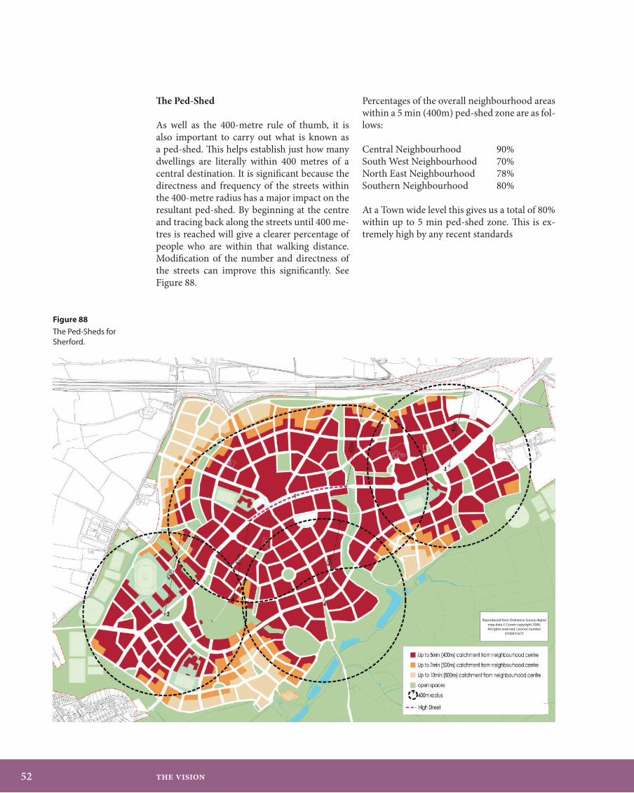
The Ped-Shed
As well as the 400-metre rule of thumb, it is also important to carry out what is known as a ped-shed. This helps establish just how many dwellings are literally within 400 metres of a central destination. It is significant because the directness and frequency of the streets within the 400-metre radius has a major impact on the resultant ped-shed. By beginning at the centre and tracing back along the streets until 400 me-tres is reached will give a clearer percentage of people who are within that walking distance. Modification of the number and directness of the streets can improve this significantly. See Figure 88.
Percentages of the overall neighbourhood areas within a 5 min (400m) ped-shed zone are as fol-lows: Central Neighbourhood 90%South West Neighbourhood 70%North East Neighbourhood 78%Southern Neighbourhood 80% At a Town wide level this gives us a total of 80% within up to 5 min ped-shed zone. This is ex-tremely high by any recent standards
Figure 88
The Ped-Sheds for Sherford.
Reproduced from Ordnance Survey digital map data © Crown copyright 2006.All rights reserved. Licence number
0100031673

��
2
A Neighbourhood’s basic rules are:An interconnected street system with as many direct connections to a central high street spine that is the focus for mixed-use, through traffic and public transportA place that is central to the neighbour-hoodA radius of approximately 400 metres from that centreEach neighbourhood is seamlessly attached to the next neighbourhood unless such landscape elements as flood plains, water meadows existing woodlands, proposed landscape structuring element intervene. If they do so they should always be on the outer boundary of the neighbourhood, not through the middleLarger space uses are located on the edge of the 400-metre radius so as not to disrupt the fine grain of streets.Broadly speaking a density increase from edge to centre, though the density will be varied throughoutThey should contain a range of housing forms and tenures as well as a balanced mix of usesA tendency for retail and employment within the neighbourhood to focus on the central place
•
•
•
•
•
•
•
•
Daily needs
What qualifies as daily needs is itself a com-plex matter and whilst the private motor vehi-cle remains in common use, it will continue to be hard to place all such needs in every neigh-bourhood. Hence the importance of this quota-tion emphasising the responsibility of the Town Plan to set up the conditions for accessibility to evolve over time.
“The neighbourhoods are mixed-use communi-ties balanced to a degree which permits the over-all town plan to become self-sufficient to the ex-tent of extremely high trip capture rates… over a period of a generation, this will provide to all it’s residents the theoretical possibilities of hous-ing, jobs, shopping, entertainment, education and civic institutions within extremely short dis-tances.”— Andres Duany, one of North America’s prin-ciple New urbanists.
Ideally, daily needs should at least cover shop-ping for food, news and general household goods, schools, healthcare and community meeting space, open space, potential work-space, a post office, public transport and a pub or other forms of daytime and evening enter-tainment. They must all be intermingled with housing because the residents are the custodi-ans of these uses every day of the week. See Fig-ures 89 and 90.
Neig
hbo
urh
oods
:‘f
rom
hom
e to
eve
ryth
ing
you
need
’

�� The Vision
Figure 89 ‘From home to everything you need’, a generic diagram.
Figure 90 ‘From home to everything you need’, in Sherford.

��
2
If successful they become High Streets and may themselves be 300 metres long.
If smaller in nature they may be a cluster of buildings at a junction of streets, a square or green. In this instance if they form the centre of something roughly 400 metres in radius the centres will be approximately 800 metres apart. It is marrying this rule of thumb with all the other site based constraints that is the complex design task.
Locating the Neighbourhoods in Sherford
It is usually easier to say where the centre of a neighbourhood is than the edge. The centre matters far more. These local places gain and retain their richness, activity and diversity be-cause they are the moments in the large-scale things.
The new Main Street from Deep Lane to the A379 is crucial to achieving this richness at the local level. This street carries most of the visit-ing traffic as well as being a key public transport route. Therefore three of the four neighbour-hoods have their focus along this alignment.
The Central Neighbourhood has the High Street and is the key location for the town as a whole. It will contain more than the daily needs of its immediate population as all good High Streets do. This is Sherford’s Town Centre. See Figure 91.
In the Central neighbourhood it is customary to take the 400-metre radius from each end of the High Street, because these are the points of arrival. Having got to the High Street then the whole rationale for walking changes as people become engaged in the act of shopping, eating, greeting or business.
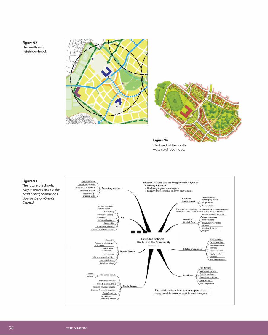
The South West Neighbourhood has the sec-ondary school as it’s main focus bringing many people there, not only of school age, but from all walks of life, as a major educational facility. It is at an important junction of the Main Street and Southern Avenue immediately south of the Quarry next to which the Youth Centre sits. It is also a neighbour to the existing development at Elburton and provides, in the gap between communities, the swimming pool, sports hub, and playing fields making up the managed open space defining their proximity and separation. See Figures 92, 93 and 94.
Figure 91 Sherford’s central neighbourhood walkable catchment.
Neig
hbo
urh
oods
:‘f
rom
hom
e to
eve
ryth
ing
you
need
’
�� The Vision
Figure 92 The south west neighbourhood.
Figure 93 The future of schools. Why they need to be in the heart of neighbourhoods. (Source: Devon County Council)
Figure 94
The heart of the south west neighbourhood.

��
2
The North East Neighbourhood is the first neighbourhood that is encountered upon en-tering Sherford from the A38. As the Park and Ride and then Northern Avenue pass on the right, a formal setback of residential develop-ment announces your arrival (see Figure 95). The land falls away to the left toward the Com-munity Park and more immediately playing fields including the cricket pitch and pavilion. The neighbourhood centre is reached at the junction of the Main Street and Southern Av-enue where the primary school is located.
The Southern Neighbourhood is relatively qui-et in that it is centred at the junction of Brixton Road and Southern Avenue (Figures 96 and 97). A good proportion of this neighbourhood area spills into the Community Park, so its walkable catchment is almost halved. Nevertheless, it is at an important crossroads in a beautiful loca-tion and merits the neighbourhood category.
Sherford’s neighbourhoods are the large-scale jigsaw pieces. All are different yet they fit to-gether to make the Town Plan as efficient as possible for the pedestrian.
Figure 95 The north east neighbourhood.
Figure 96 The southern neighbourhood.
Figure 97 The Brixton Road. Illustrator: Robert Stokes
Neig
hbo
urh
oods
:‘f
rom
hom
e to
eve
ryth
ing
you
need
’