msil: lekhak programme
TRANSCRIPT
MSIL: Lekhak Programme
THE GEOGRAPHY OF KARNATAKA —I
The Landscape The Land
Adapted from the audio-visual presentation The Landscape. The Land.
A two-in-one book.
‘See the other side for Facts & Figures
wet
FS
*
?
Pe
ae
ae
==>
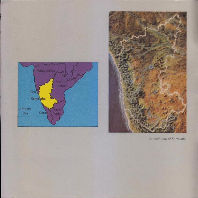
A relief map of Karnataka
Karnataka occupies a prominent position on the western half of the Deccan Plateau with the states of Maharashtra and Goa to the north, Andhra Pradesh to the east, and Tamil Nadu and Kerala to the south.
It forms an irregular crescent, curving inward from the Arabian Sea.
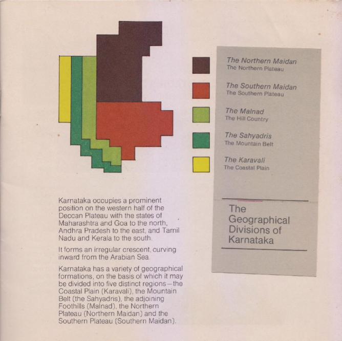
Karnataka has a variety of geographical formations, on the basis of which it may be divided into five distinct regions —the Coastal Plain (Karavali), the Mountain Belt (the Sahyadris), the adjoining Foothills (Malnad), the Northern Plateau (Northern Maidan) and the southern Plateau (Southern Maidan).
The Northern Maidan The Northern Plateau
The Southern Maidan The Southern Plateay
The Mainad The Hill Country
The Sahyadris The Mountain Belt
The Karavali The Coastal Plain
The Geographical Divisions of Karnataka
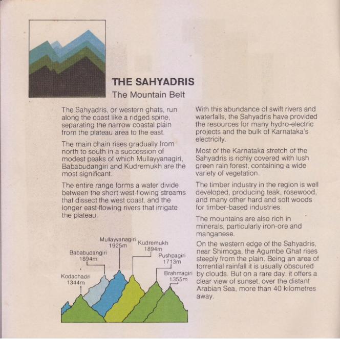
The Mountain Belt
The Sahyadris, or western ghats, run along the coast like a ridged spine, separating the narrow coastal plain from the plateau area to the east.
The main chain rises gradually from north to south in a succession of modest peaks of which Mullayyanagiri, Bababudangiri and Kudremukh are the most significant.
The entire range forms a water divide between the short west-flowing streams that dissect the west coast, and the longer east-flowing rivers that irrigate the plateau,
gies tik Kudremukh 1894m
Pushpagiri 1713m
Bababudangiri 1894m
Kodachadri ise pol
|
THE SAHYADRIS
With this abundance of swift rivers and waterfalls, the Sahyadris have provided the resources for many hydro-electric projects and the bulk of Karnataka's electricity,
Most of the Karnataka stretch of the sahyadris is richly covered with lush green rain forest, containing a wide variety of vegetation.
The timber industry in the region |s well developed, producing teak, rosewood, and many other hard and soft woods for timber-based industries.
The mountains are also rich in
minerals, particularly iron-ore and manganese.
On the western edge of the Sahyadris, near Shimoga, the Agumbe Ghat rises steeply from the plain. Being an area of torrential rainfall it is usually obscured by clouds. But on a rare day, it offers a clear view of sunset, over the distant Arabian Sea, more than 40 kilometres away.
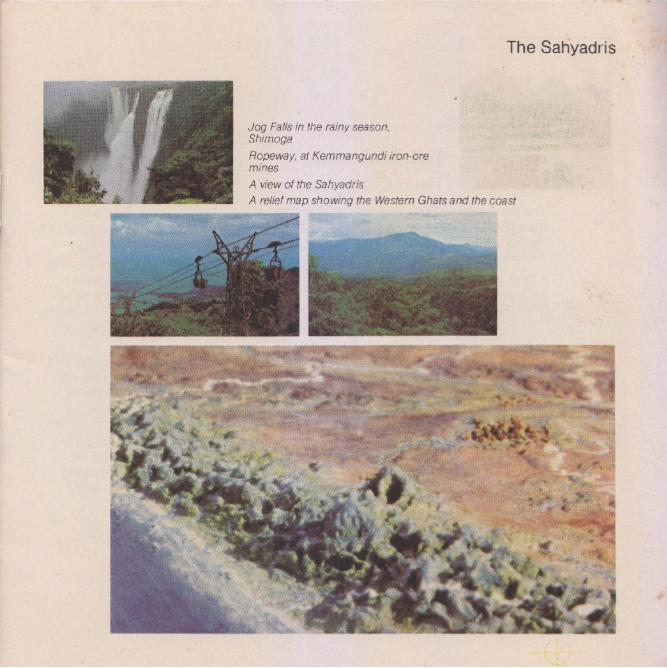
The Sahyadris
Jog Falls in the rainy season, Shimoga
Aopeway, at Kemmangundil iron-ore mines
A view of the Sahyadris
A relief map showing the Western Ghats and the coast Mame ei i aaa : ee
‘hl

THE MALNAD The Hill Country
The Malnad or ‘hill country’ forms a transition between the steep ridge of the Sahyadris, and the lower plateau on the east. |
itruns along the eastern edge of the Sahyadris for about 650 kilometres from north to south, passing through the districts of Belgaum, Dharwar, Uttara Kannada, Shimoga,
' Chikmagalur, Hassan, Dakshina Kannada, Kodagu and Mysore.
ltis a spectacularly beautiful region of hills and valleys, lush green forests and sparkling waterfalls, including the majestic Jog Falls, where the river sharavati thunders into a chasm 252 metres below,
The Mainad could equally well have been called the ma/é nadu, or rain country, for it is an area of heavy rainfall.
Along with the Sahyadris, it forms a watershed in which Karnataka’s numerous rivers originate and gather volume as they flow down to the plains.
lt is a treasure house for botanists, with an unbelievable variety of exquisite wild plants, exotic flowers and rare insects.
The major crop of the Malnad is paddy which is grown on terraced slopes and in the valleys. Every field has its border of coconut trees, and every farm has its
_ fields of arecanut, tall and straight as sentinels.
The Malnad is Karnataka's plantation area. The hill slopes are covered with estates which grow the bulk of India’s coffee, sandalwood, and smaller quantities of spices such as cardamom and pepper.
The population of the Malnad is thin, with a concentration of people along the ghat routes from the plain to the plateau.
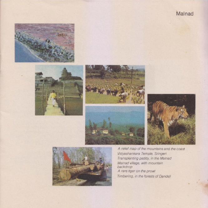
Malinad
A relief map of the mountains and the coast
Vidyashankara Temple, Sringeri
Transplanting paddy, in the Mainad
Mainad village, with mountain backdrop
A rare tiger on the prow!
Timbering, in the forests of Dandeli
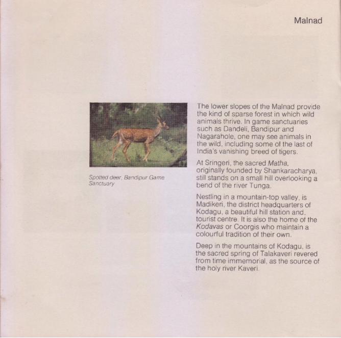
Spolied deer, Bandipur Game Sanctuary
Malnad
The lower slopes of the Malnad provide tne kind of sparse forest in which wild animals thrive. In game sanctuaries such as Dandeli, Bandipur and Nagarahole, one may see animals in the wild, including some of the last of India’s vanishing breed of tigers.
At Sringeri, the sacred Matha, originally founded by Shankaracharya, still stands on a small hill overlooking a bend of the river Tunga.
Nestling in a mountain-top valley, is Madikeri, the district headquarters of Kodagu, a beautiful hill station and. tourist centre. It is also the home of the Koadavas or Coorgis who maintain a colourtul tradition of their own.
Deep in the mountains of Kodagu, is the sacred spring of Talakaveri revered from time: immemorial, as the source of the holy river Kaveri.
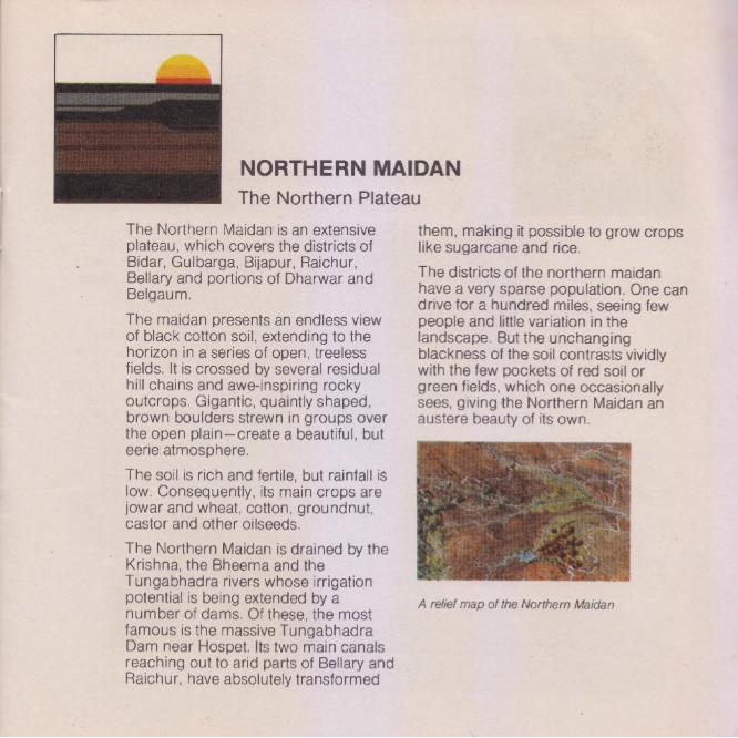
NORTHERN MAIDAN The Northern Plateau
The Northern Maidan is an extensive them, making it possible to grow crops plateau, which covers the districts of like Sugarcane and rice. Bidar, Gulbarga, Bijapur, Raichur, Bellary and portions of Dharwar and The districts of the northern maidan
have a very sparse population. One can Belgaum. | drive for a hundred miles, seeing few
The maidan presents an endless view people and little variation in the of black cotton soil, extending to the landscape. But the unchanging horizon in a series of open, treeless blackness of the soil contrasts vividly fields. It is crossed by several residual with the few pockets of red soil or hill chains and awe-inspiring rocky green fields, which one occasionally outcrops. Gigantic, quaintly shaped, sees, giving the Northern Maidan an brown boulders strewn in groups over austere beauty of its own. the open plain—create a beautiful, but eerie atmosphere.
The soil is rich and fertile, but rainfall is low. Consequently, its main crops are jowar and wheat, cotton, groundnut, castor and other oilseeds.
The Northern Maidan is drained by the Krishna, the Bheema and the Tungabhadra rivers whose irrigation
potential is being extended by a A relief map of the Northern Maidan number of dams. Of these, the most famous is the massive Tungabhadra Dam near Hospet. Its two main canals reaching out to arid parts of Bellary and Raichur, have absolutely transformed

Liar
The houses are square and sturdy, built to withstand heat and dust: and flat- roofed, since rainfall is sparse. In the clothes, the headgear, and lifestyle of the people, one can clearly see the influence of the neighbouring regions— Andhra, Central India and Maharashtra.
The Northern Maidan also provides a home to the exotic lambani tribe who lead a nomadic existence in the northern districts.
Life has always been hard here and the people pride themselves on being active and resourcetul.
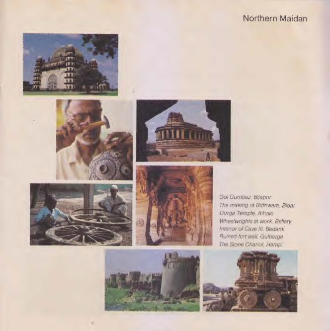
Northern Maidan was the heart of the early Karnataka empires, the Vijayanagar Empire and the great Muslim kingdoms of the South. Relics of their glory remain carved in beautiful brownstone at Aihole, Pattadakal and Badami: in the sprawling ruins at Hampi, the capital city of Vijayanagar: and in the gigantic monuments and forts at Gulbarga, Bijapur and Bidar.
Villagers in a cart, near Gulbarga Northern Maidan
A rare kind of mud found only inthe Bidar fort has made possible fhe delicate inlay of silver on blackened bronze, which is appropriately Known as Bidariware.
Apart from its historic cities, the Northern Maidan has few important towns. Till quite recently the area was comparatively under-developed. But with the building of new roads, bridges, projects like the Tungabhadra Dam and the Upper Krishna Project, the Raichur Thermal Electric Plant and general infrastructural work, the northern maidan is making rapid
-strides towards development.
Lambani women, near Aaichur
Northern Maidan
Gol Gumbaz, Bijapur
The making of Bidriware, Bidar
Durga Temple, Aihole
Wheelwnignts at work, Bellary
Interior of Cave Ill, Badami
Ruined fort wall, Gulbarga
The Stone Chariot, Hampi
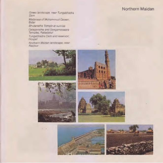
Green landscape, near Tungabhadra Dam
Madarasa of Mohammud Gawan, Bidar
Bhutanatha Temple at sunrise
Galaganatha and Sangameswara Temples, Pattadakal
Tungabhadra Dam and reservoir, Hospet
Northern Maidan landscape, near Raichur
Northern Maidan

The Southern Maidan, as its name suggests, occupies the southern portion of the plateau area. It covers the major portion of the old Mysore State— including the districts of Chitradurga, Tumkur, Mandya, Bangalore and Kolar; and parts of Shimoga, Chikmagalur, Hassan and Mysore.
The bright red soils of the Southern Maidan make a colourful contrast to the dark brown landscapes of the north, It has a typical landscape of isolated hills, with bare rock faces: and massive boulder formations.
The maidan has a substructure of granite, which holds water very well and so it is dotted with as many as 16,000 tanks. Though rainfall is not heavy, agriculture is sustained by tank and well irrigation.
The important crops are rice in the wet lands and ragi in the dry. In the river valleys there are coconut groves, sugarcane and arecanut plantations.
SOUTHERN MAIDAN
The Southern Plateau
The major river system is the Kaveri, with its tributaries. But the Southern Maidan is also drained by the Tunga, the Bhadra, the Vedavati, the Pennar and the Palar rivers. It has some of Karnataka's oldest dams and reservoirs, including the Krishnaraja- Sagar and the Vanivilas Sagar dams.
In a quiet stretch of the river Kaveri, near Mysore, is the Ranganathittu Bird Sanctuary, which attracts rare migratory birds from Europe and Siberia during the seasonal months from June to October.
Aed sol and rocky hills, near Ramanagara
A relief map of the Southern Maidan Southern Maidan
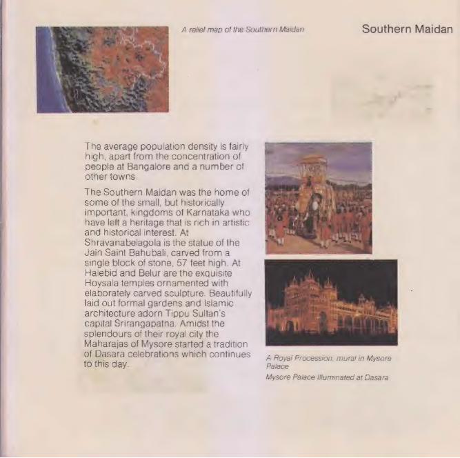
The average population density Is fairly high, apart from the concentration of people at Bangalore and a number of other towns.
The Southern Maidan was the home of some of the small, but historically important, kingdoms of Karnataka who have left a heritage that Is rich in artistic and historical interest. At shravanabelagola is the statue of the Jain Saint Bahubali, carved from a single block of stone, 57 feet high. At Halebid and Belur are the exquisite Hoysala temples ornamented with elaborately carved sculpture. Beautifully laid out formal gardens and Islamic architecture adorn Tippu Sultan's Capital Srirangapatna. Amidst the Splendours of their royal city the Maharajas of Mysore started a tradition of Dasara celebrations which continues 4 Royal Procession, mural in Mysore fo this day. Paiace
Mysore Palace Illuminated at Dasara
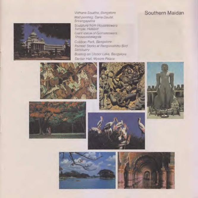
Vidhana Soudha, Bangalore Southern Maidan Wall painting, Daria Dautlat,
orirangapatna
Sculpture from Hoysaleswara Temple, Halebid
Giant statue of Gomateswara, Shravanabelagola
Cubbon Park, Bangalore
Painted Storks at Ranganathittu Bird Sanctuary
Boating on Ulsoor Lake, Bangalore
Darbar Hail, Mysore Palace
Southern Maidan
Merete te saute
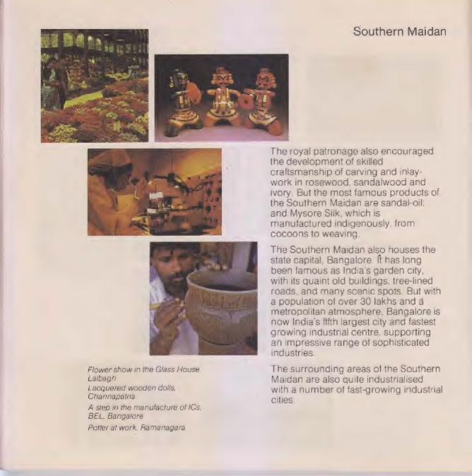
The royal patronage also encouraged the development of skilled craftsmanship of carving and iniay- work in rosewood, sandalwood and ivory. But the most famous products of the Southern Maidan are sandal-oil: and Mysore silk, which is manufactured indigenously, from cocoons to weaving,
The Southern Maidan also houses the state capital, Bangalore. It has long been famous as India's garden city, with its quaint old buildings, tree-lined roads, and many scenic spots. But with a population of over 30 lakhs and a metropolitan atmosphere, Bangalore Is
now India’s fifth largest city and fastest growing industrial centre. supporting an impressive range of sophisticated industries.
Flower show in the Glass House. The surrounding areas of the Southern Lalbagn Maidan are also quite industrialised Lacquered wooden dolls, with a number of fast-growing industrial Channapaina
A step in the manufacture of ICs, BEL, Bangalore
Potter at work, Ramanagara
cities.
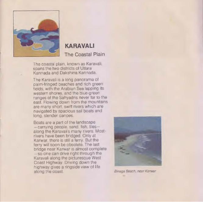
| KARAVALI The Coastal Plain
The coastal plain, known as Karavali, spans the two districts of Uttara Kannada and Dakshina Kannada.
The Karavali is a long panorama of palm-fringed beaches and rich green fields, with the Arabian Sea lapping its western shores, and the blue-green ranges of the Sahyadris never far to the east. Flowing down from the mountains are many short, swift rivers which are navigated by spacious sail boats and long, slender canoes.
Boats are a part of the landscape —carrying people, sand, fish, tiles— along the Karavali’s many rivers. Most: rivers have been bridged. Only at Karwar, there is still a ferry. But the ferry will soon be obsolete. The last bridge near Karwar is almost complete —gso one can drive right through the Karavali along the picturesque West Goast Highway. Driving down the highway gives a ringside view of life along the coast. Binaga Beach, near Karwar
=

With a fertile soil, a humid climate and a heavy assured rainfall, the Karavali agriculture is based on wet land: cultivation. The major crops are rice, arecanuts, cashew and coconuts.
Dakshina Kannada is famous for beedies which constitute a multi-million rupee cottage industry. Tile manufacture also thrives because of the plentiful resources of clay and sand, and rivers for cheap, convenient transport. But with a 300-kilometre coastline, the major activity is fishing,
Kannada is widely spoken in the Karavali but it has two other important languages—Konkani and Tulu. It also has its own traditional dance-drama, Yakshagana, popular with old and young alike.
Crossed by a number of short rivers flowing to the sea, the Karavali has many natural harbours. Mangalore already has a commissioned all- weather port. At Malpe, near Mangalore, there are dry dock facilities. The natural harbour at Karwar is being developed into a second major port.
i Ning
| a] 4 1}
tH 2. a i]
Karavall
® MALPE
\\\\_ MANGALORE
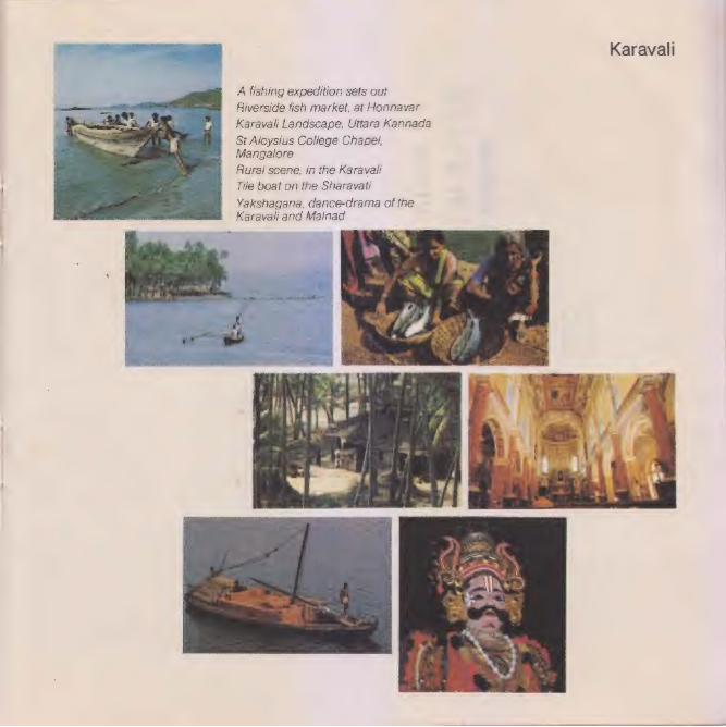
A fishing expedition sets out
Riverside fish market, at Honnavar
Karavall Landscape, Uttara Kannada
ot Aloysius College Chapel, Mangalore
Rural scene, in the Karavali
Tile boat on the Sharavati
Yakshagana, dance-drama of the Karavali and Malnad
4 eter st Unk a r
eh eet et oy 1 pd ae pire adel a,
Karavali
MSIL-Lekhak MSIL, the manufacturers and | | s distributors of Lekhak Notebooks have KNOW YOUR STATE recently initiated a new programme for | students—the MSIL-Lekhak ‘Know- Programme Your-State’ Programme. As its name suggests, the programme Is intended to stimulate the interest of our school students in their home State, by presenting colourful and interesting programmes. | i
Audio-Visual Presentations
For a start, two audio-visuals (slide-tape shows) on the Geography of Karnataka have been produced in English and Kannada. These two audio-visuals are being shown to high school students in different parts of the state.
THE GEOGRAPHY OF KARNATAKA-|
The Landscape. The Land
The Landscape. The Land gives a richly pictorial view of the state with over 320 colour slides shot specially for
the purpose. !

THE GEOGRAPHY OF KARNATAKA-II
Facts & Figures
Facts & Figures is text book Geography, colourfully brought to the screen with the help of pictures, maps and diagrams. It covers the main syllabus prescribed for Geography students.
The two audio-visuals are normally screened together, with a ten-minute interval—making a package of about 1 hour and 15 minutes.
Booklet |
In view of requests from teachers, excerpts from the script and pictures of the two audio-visuals have been combined to make this book.
THE HISTORY OF KARNATAKA
The Story of Karnataka
A third audio-visual, on the History of Karnataka, entitled The Story of Karnataka, is being made ready for screening.
lf you require any further information or have any suggestions in connection with this programme, please write to:
MSIL-Lekhak ‘Know-Your-State’ Programme
Mysore Sales International Ltd MSIL House 36, Cunningham Road Bangalore 560052
This booklet is adapted from the audio-visual presentations The Landscape. The Land and Facts & Figures.
Designed & Produced by: Information & Design Exchange, Bangalore
Printed at: Mytec Process Works, Bangalore
Script & Direction: Peter Colaco
Edited by: H. Jayadeva
Design & Artworks: G.P. Prajapati
Graphics & Maps: Shrikant Lele, D. Radhakrishnan
Photography: D. Radhakrishnan, Peter Colaco,
E. Hanumantha Rao (wildlife).
Sponsored by | Mysore Sales International Ltd.

MSIL: Lekhak
THE GEOGRAPHY OF ‘ KARNATAKA—II | —
Facts & Figures
Adapted from the audio-visual presentation Facts & Figures
A two-in-one book.
See the other side for The Landscape. The Land
4 ie a . Me me is Bs ise = Ss
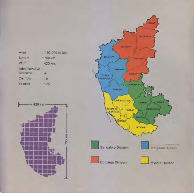
Area
Lenath
Width
Administrative
Divisions
Districts
Talukas
: 1,92,000 sq.km,
: 760 km.
>: 420 km.
: 19
175
i | ee PCE | 1 Ge ee ee “ERERE “EEE
“are
ES Bangalore Division
Ea Gulbarga Division
Belgaum Division
ss Mysore Division

Karnataka extends roughly 760 km from north to south and 420 km from east to west. With an area of 192. thousand square kilometres, itis Indias eighth largest state.
The estimated population of Karnataka, according to the 1981 census, is 37 million people. This means that every eighteenth Indian, and one out of every 122 people in the world, lives in Karnataka
For administrative convenience, Karnataka is divided into 19 districts and 175 talukas. The districts are grouped under 4 administrative divisions: Bangalore, Mysore, Belgaum and Gulbarga.
B INDIA
HOLLAND
tae = saceee = at i _ W. GERMANY SYRIA
| | ea KARNATAKA | Tt] [| | oe | |
Bm WBBM wacan
Karnataka Is only about one- seventeenth the size of India; and yet it is as large, or larger than, some important countries of the world.
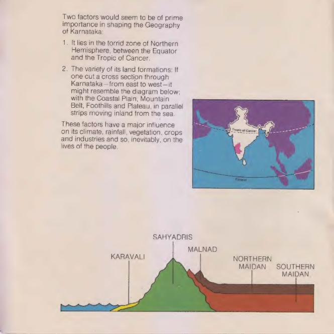
Two factors would seem to be of prime importance in shaping the Geography of Karnataka:
1. It lies in the torrid zone of Northern Hemisphere, between the Equator and the Tropic of Cancer.
2. The variety of its land formations: If one cut a cross section through Karnataka—from east to west—it might resemble the diagram below: with the Coastal Plain, Mountain Belt, Foothills and Plateau, in parallel strips moving inland from the sea.
These factors have a major influence on its climate, rainfall, vegetation, crops and industries and so, inevitably, on the lives of the people.
SAHYADRIS
MALNAD KARAVALI NORTHERN
MAIDAN SOUTHERN MAIDAN.

Karnataka has a semi-tropical climate, moaitied by other geographical factors such as its land formations and its 320-km coastline.
CLIMATE
wea
ret feet its ri foe fil Whe: ene tice “a,
oo Mire Thiet hy
The Karavali: Being near sea level, the Karavaliis | The Sahyadris and the Malnad: The sahyadris
hot and humid. But land and sea breezes keep and the Mainad are cool and temperate because the temperatures fairly even through the year. of high altitudes and heavy rainfall.
The Southern Maidan: The climate of the The Northern Maidan: But in the northern and southern Maidan is comparatively mild, because eastern parts of the state, relatively lower and far of its average elevation of 800 to 900 metres. inland, the summer is long, hot and dry.
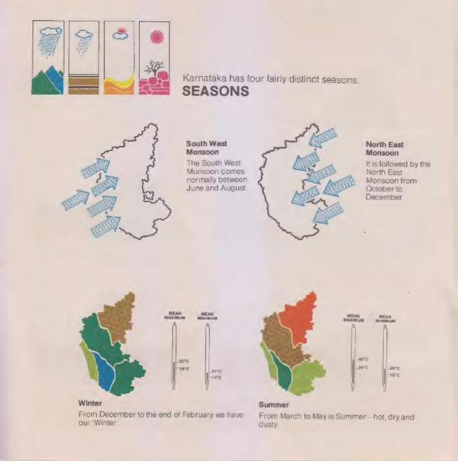
Karnataka has four fairly distinct seasons.
SEASONS
South West North East Monsoon Monsoon
The South West It is followed by the Monsoon comes North East normally between Monsoon from June and August. October to
December.
MAXIMUM = sannnaaties MAXIMUM = Miniastina
32°C ce 24°C 26°C
Winter summer
From December to the end of February we have From March to May is Summer—hot, dry and our ‘Winter’, dusty.
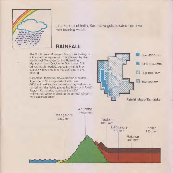
Like the rest of India, Karnataka gets its rains from two rain-bearing winds.
RAINFALL
The South West Monsoon, from June to August, is the major rainy season. It is followed by the North East Monsoon (or the Retreating Monsoon) from October to December. This brings much needed, but scanty rainfall, to eastern Karnataka, and heavier rains in the Malnad,
Be Over 4000 mm
2000-4000 mm
600-1000 mm
Karnataka, therefore, has extremes of rainfall. Agumbe, in Shimoga district with over 7600 millimetres, has the second highest annual rainfall in India. While places like Raichur in North Easlern Karnataka, have less than 500 millimetres, which is close to the annual rainfall in the Rajasthan desert.
£4 500-600 mm
Agumbe 7600 mm
Mangalore 3820 mm Hassan
1010 mm
Bangalore Kolar 777mm 720 mm
Raichur 488 mm
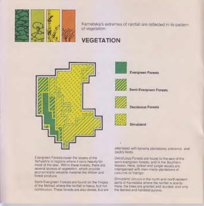
of vegetation.
Evergreen Forests cover the slopes of the sahyadris in regions where it rains heavily for most of the year. Within these forests, there are several storeys of vegetation, which provide economically valuable material like timber and forest produce.
semi-Evergreen Forests are found on the fringes of the Malnad where the rainfall is heavy, but not continuous, These forests are also dense, but are
Karnataka's extremes of rainfall are reflected in its pattern
VEGETATION
Evergreen Forests
Semi-Evergreen Forests
Deciduous Forests
Shrubland
=
alternated with banana plantations, arecanut and paddy fields.
Deciduous Forests are found to the east of the semt-evergreen forests, and in the Southern Maidan, Here, timber and jungle woods are interspersed with man-made plantations of casurina of mango.
shrubland occurs in the north and north eastern parts of Karnataka where the rainfall is scanty: Here, the trees are gnarled and stunted, and only the leanest and hardiest survive.
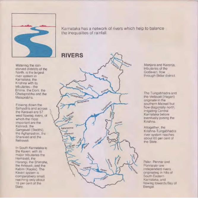
Karnataka has a network of rivers which help to balance the inequalities of rainfall.
RIVERS
Manjara and Karanja, tributaries of the Godavari, flow. through Bidar district.
Watering the rain- starved districts of the North, is the largest river system in Karnataka, the Krishna with its tributaries— the Arigg Bhima, the Doni, the | ed (Gahataprabha and the Gs The Tungabhadra and
Malaprabha. MaDe bis the Vedavati (Hagari) originate in the southern Malnad but Flowing down the >
sahyadris and across . flow diagonally north,
the Karavali are 57 E ot irrigating Central west flowing rivers,of % | \ ts Karnataka before which the most + : eventually joining the important are the i Krishna.
Kalinadi, the as | a ; Aghanashini Altogether, the
ee ee re ge 5 ae Krishna-Tungabhadra
Se ee site river system reaches savas and the : about 60 per cent of
the State.
In South Karnataka is the Kaveri, with its major tributaries the Hemavati, the Harangi, the Shimsha, the Arkavati, and the Kabini (Kapila). The Kaveri system is comparatively small, reaching only about 18 per cent of the State.
Palar, Pennar and Ponnalyar are independent rivers, originating in hills of South Eastern Karnataka, and flowing towards Bay of Bengal.
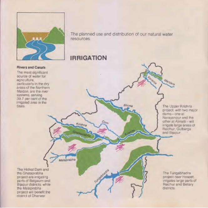
mi = The planned use and distribution of our natural water resources.
IRRIGATION
Rivers and Canals
The most significant source of water for agriculture, Nfs _ particularly in the dry Vrs areas of the Northern 3 Maidan, are the river systems, serving 39.7 per cent of the irrigated area in the State. The Upper Krishna
project, with two major dams—one at Narayanpur and the
8 . other at Almatti—will ——e irrigate large areas of
aaa Raichur, Gulbarga wll | and Bijapur, *
ea = ees :
se
Malaprabha
on,
The Hidkal Dam and the Ghataprabha The Tungabhadra project are irrigating project near Hospet, parts of Belgaum and irrigates large parts of Bijapur districts, while the Malaprabha project will benefit the district of Dharwar.
Raichur and Bellary districts.
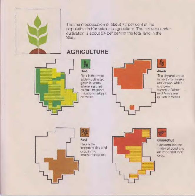
The main occupation of about 72 per cent of the population in Karnataka Is agriculture. The net area under cultivation is about 54 per cent of the total land in the State.
Rice Jowar
Rice is the most The dryland crops widely cultivated in north Karnataka grain in areas are Jowar, which where assured is grown in
summer. Wheat
and Maize are
grown in Winter,
rainfall, or good irrigation makes it
| possible,
a
Ragi Groundnut
Ragi is the Groundnut is the important dry land major oil seed and crop in the an important food southern districts. Crop.

Sugarcane Coconut
Sugarcane, Coconut and another cash crop, arecanul are is grown. on Important irrigated land all plantation crops
over the State, usually found in rice growing regions.
Cottee
Coffee is entirely grown on the eastern slopes of the Southern Malnad, which
provide about 7Q per cent of the total coffee produced in India, plus spices, including pepper and cardamom.
Cotton, an important cash
crop, is grown in the black soil of the north.

Despite its wealth of minerals, Karnataka has no fossil fuels (coal or petroleum). Its main power resource is
ENERGY hydro-electricity.
Power Consumption
in Karnataka
The old State of Mysore was one of the pioneers of hydro electric power in India and Asia, with the construction of the Shivasamudra Power Station (42 mW.
Industries |
72%
Riaichur
Thermal e Upper Plant Krishna
The Mahatma Gandhi Power Station (120 mW) at Jog Falls: was completed in 19572. Alter + independence, the Sharavati : Project (891 mW) was . ge constructed nearby. \n ~“Kehanashini
Domestic
New hydel schemes are 9 underway, of which the Poe Kalinadi Project is the largest 1 ¥ (910 mW).
@ Varahi :
Power Stations are also | Ag oie | installed at large irrigation rae projects notably the Bhadra Netravati Dam (33 mW), the -~ Tungabhadra Dam (31 mW) and the Upper Krishna Dams (250 mW),
A large Thermal Plant is being ~ constructed at Raichur witha generation capacity of 420 mW in the first phase.
ae Shieeaacis | !n 1981, electricity had been |
| brought to about 77 per cent of the villages in the state.
[id
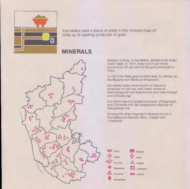
—— MINERALS
Karnataka held a place of pride in the mineral map of India as its leading producer of gold.
Modern mining, in Karnataka, started at the Kolar Gold Fields, in 1874. Kolar and Hutti mines account for 90 per cent of the gold produced in. India.
In 1923 the State gave another lead, by setting up the Mysore Iron Works at Bhadravat..
Karnataka today ranks fourth in India asa producer of iron ore, with major mines at Kemmangundi and Kudremukh and near Hospet and Chitradurga,
Itis India's second largest producer of Magnesite and Chromite and has widespread deposits of
Manganese ore.
Among the other important minerals found in Karnataka are Bauxite, Mica, Copper and
Limestone.
feast Gold 4 Bauxite
®) Silver + Mica
af> iron Ore ee Copper
& Magnesite Ci Limestone
A Chromite Granite
& Manganese

network.
TRANSPORT
| Roads
With a total of about 60,000 kilometres of metalled roads, Karnataka ranks second among the
’ States, in terms of its road transport network.
a
\ CALCUTTA . ¥
BELGAUM \ HYDERABAD maroon
\ x There is one major
@ \ ¢ airportin the State at Bangalore, But there are also airports al .Belgaum and
— | mapras Mangalore, and ‘airstrips at Mysore,
Hassan and Raichur. MANGALORE —_/ BANGALORE
©. COIMBATORE
* FAA WAR
© BELEKCA
RONNAVAR
KUNDAPUA
MALPE
Road, rail, air and sea form Karnataka's transport
Railways
Railways connect Bangalore City with the major cities of India: and most places of industrial or economic importance In the State.
Sea-ports
Karnataka s coastal formation gives it many natural harbours which are now being developed. In the foreseeable future, Karnataka should rank among the major maritime states of India.
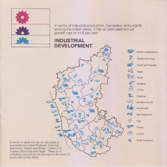
In terms of value the top six industries in Karnataka are Food Products, Electrical Machinery, Metals and Alloys. Cotton and Textiles, Electricity and Paper. These six in industries account for 64 per cent of the vaiue of production in the State.
In terms of industrial production, Karnataka ranks eighth among the Indian states. It has an estimated annual growth rate of 14.8 per cent.
INDUSTRIAL DEVELOPMENT
Electrical Machinery
Metals and Alloys
Cotton and Textiles
Paper
Sugar
Oilseeds
Catfee
ito PALe® Fisheries
‘| Ni 1 i" Sandalwood Oil
Handicrafts
Silk Production
Yarn
Timber
Cement
e£q% 2 &: Small Industries
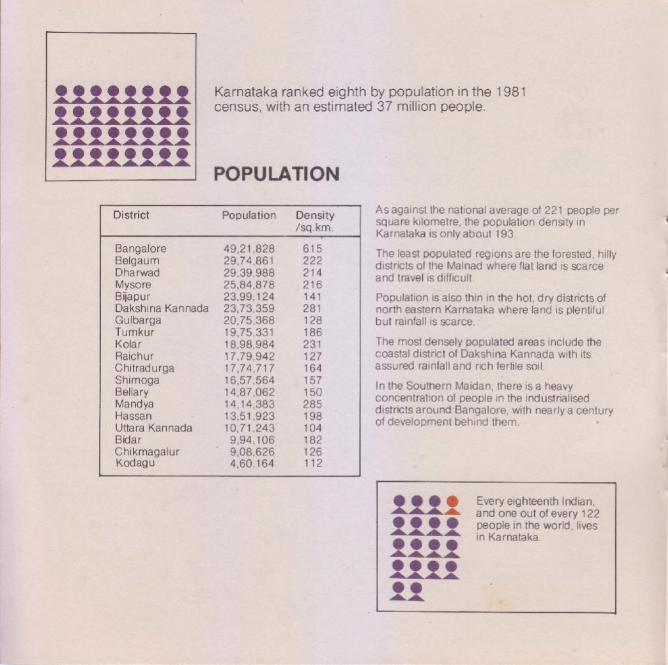
Karnataka ranked eighth by population in the 1981 census, with an estimated 37 million people.
geeecese POPULATION
District
Bangalore Belgaum Dharwad Mysore Bijapur Dakshina Kannada Gulbarga Tumkur Kolar Raichur Chitradurga Shimoga Bellary Mandya Hassan Uttara Kannada Bidar Chikmagalur Kodagu
Population
49,21,828 29,74 861 29,39,988 25,684,878 23,99,124 23,/3,359 20,75,368 19,75,331 18,98,984 ti. 78 342 17,74, 717 16,57,564 14,87 062 14,14,383 13,51,923 10,71,.243 9,94,106 9,08,626 4,.60,164
Density /sq.km.
As against the national average of 221 people per square kilometre, the population density in Karnataka is only about 193.
The least populated regions are the forested, hilly districts of the Malnad where flat land is scarce and travel is difficult.
Population is also thin in the hot, dry districts of north eastern Karnataka where land is plentiful but rainfall is scarce.
The most densely populated areas include the coastal district of Dakshina Kannada with its assured rainfall and rich fertile soil
In the Southern Maidan, there is a heavy concentration of people in the industrialised districts around Bangalore, with nearly a Serer of development behind them.
Every eighteenth Indian, and one out of every 122 people in the world, lives in Karnataka.
ma

se
e
Gulbarga
Biyapur
Raichur «
® Belgaum
Hublie Gadag-y jena Cities of Karnataka
pi ae ck Bellary (with a population of over 1 lakh)
Davangere Bangalore 2913,o0f
Hubli-Dharwar 526,493 Mysore 476,446
se Mangalore 305,513 Shimoga ® : | Belgaum 300,290
hadravatl . Gulbarga 218,621
: Kolar Bellary 201,014 Tumkur @ Gold Fields ol bade gees
. nimoga
Mangalore |® Bangalore © Bijapur 146,808
| ; J | Kolar Gold Fields 144,406 a Mandye Bhadravati 130,159 ~ CS - Raichur 124,600
Mysore — (gadag-Betgeri 116,596 Hospet 114,711 Tumkur 109,231 Mandya 100,264 |
And eight per cent, or one out of every twelve people in Karnataka lives in
| Bangalore.
Three out of four people in the State live in villages, while the remaining one lives in a city.