mineral resources of the whipple mountains and whipple mountains … › bul › 1713d ›...
TRANSCRIPT
Mineral Resources of the Whipple Mountainsand Whipple Mountains AdditionWi Iderness Study Areas,San Bernardino County, California
U.S. GEOLOGICAL SURVEY BULLETIN 1713-D

Chapter D
Mineral Resources of the Whipple Mountains andWhipple Mountains AdditionWilderness Study Areas,San Bernardino County, California
By SHERMAN P. MARSH, GARY L. RAINES, MICHAEL F. DIGGLES, KEITH A. HOWARD, ROBERT W. SIMPSON, and DONALD B. HOOVER U.S. Geological Survey
JAMES RIDENOUR, PHILLIP R. MOYLE, and SPENCEE L. WILLETT U.S. Bureau of Mines
U.S. GEOLOGICAL SURVEY BULLETIN 1713
MINERAL RESOURCES OF WILDERNESS STUDY AREAS:EASTERN CALIFORNIA DESERT CONSERVATION AREA, CALIFORNIA
DEPARTMENT OF THE INTERIOR
DONALD PAUL MODEL, Secretary
U.S. GEOLOGICAL SURVEY
Dallas L. Peck, Director
Any use of trade names and trademarks in this publication is for descriptive purposes only and does not constitute endorsement by the U.S. Geological Survey
UNITED STATES GOVERNMENT PRINTING OFFICE, WASHINGTON : 1988
For sale by theBooks and Open-File Reports SectionU.S. Geological SurveyFederal Center, Box 25425Denver, CO 80225
Library of Congress Cataloging-in-Publication Data
Mineral resources of the Whipple Mountains and Whipple Mountains Addition Wilderness Study Areas, San Bernardino, California.
(U.S. Geological Survey bulletin ; 1713)"Chapter D"Bibliography: p.1. Mines and mineral resources California Whipple
Mountains Wilderness. 2. Mines and mineral resources California Whipple Mountains Addition Wilderness.3. Geology California Whipple Mountains Wilderness.4. Geology California Whipple Mountains AdditionWilderness. 5. Whipple Mountains Wilderness (Calif.)6. Whipple Mountains Addition Wilderness (Calif.)I. Marsh, Sherman P., 1935- . II. Series.QE75.B9 no. 1713-D 557.3 s 88-600376[TN24.C2] [553'.09794'95]
STUDIES RELATED TO WILDERNESS
Bureau of Land Management Wilderness Study Areas
The Federal Land Policy and Management Act (Public Law 94-579, October 21, 1976) requires the U.S. Geological Survey and U.S. Bureau of Mines to conduct mineral surveys on certain areas to determine their mineral resource potential. Results must be made available to the public and be submitted to the President and the Congress. This report summarizes the results of a mineral survey of the Whipple Mountains (CDCA-312) Wilderness Study Area, California Desert Conservation Area, and the Whipple Mountains Addition Wilderness Study Area (AZ-050-010), San Bernardino County, California.

CONTENTSSummary Dl
Abstract DlCharacter and setting DlIdentified resources in the Whipple Mountains Wilderness
Study Area D2 Identified resources in the Whipple Mountains Addition Wilderness
Study Area D3 Mineral resource potential of the Whipple Mountains Wilderness
Study Area D3 Mineral resource potential of the Whipple Mountains Addition Wilderness
Study Area D4 Introduction D5
Area description D5 Previous and present investigations D7
Previous studies D7Investigations by the U.S. Bureau of Mines D7 Investigations by the U.S. Geological Survey D7
Acknowledgments D7 Appraisal of identified resources D7
Methods of evaluation D7 Mining history D8 Appraisal of sites examined in the Whipple Mountains Wilderness
Study Area D8 Appraisal of sites examined in the Whipple Mountains Addition Wilderness
Study Area D9Assessment of mineral resource potential D9
Geology and structure D9 Geochemistry Dll
Sample media and analytical methods Dll Results of study Dll
Geophysics DllAeromagnetics and gravity Dll Geoelectrics D12 Remote sensing D12
Mineral and energy resource potential of the Whipple Mountains Wilderness Study Area D13
Mineralization related to the Whipple Mountains detachment fault copper, lead, zinc, gold, and silver D13
Mineralization related to granitic plutons copper, lead, zinc, gold,and silver D16
Manganese mineralization D17 Decorative building stone D18 Other rock products D18 Uranium D18 Oil and gas D18 Geothermal resources D19
Mineral and energy resource potential of the Whipple Mountains AdditionWilderness Study Area D19
References cited D19
Contents
AppendixesDefinition of levels of mineral resource potential and certainty of
assessment D24 Resource/reserve classification D25 Geologic time chart D26
PLATE [In pocket]
1. Mineral resource potential map of the Whipple Mountains and WhippleMountains Addition Wilderness Study Areas, San Bernardino County, California
FIGURES
1. Index map showing location and generalized geology of the Whipple Mountains and Whipple Mountains Addition Wilderness Study Areas, San Bernardino County, California D2
2. Map showing mineral resource potential of the Whipple Mountains and Whipple Mountains Addition Wilderness Study Areas, San Bernardino County, California D4
3. Map showing location of mines and prospects within and near the Whipple Mountains and Whipple Mountains Addition Wilderness Study Areas, San Bernardino County, California D6
TABLES
1. Identified subeconomic resources D52. Summary descriptions of mines and prospects within and near the Whipple
Mountains and Whipple Mountains Addition Wilderness Study Areas, San Bernardino County, California D27
VI Contents
Mineral Resources of the Whipple Mountains and Whipple Mountains Addition Wilderness Study Areas, San Bernardino County, California
By Sherman P. Marsh, Gary L. Raines, Michael F. Diggles, Keith A. Howard, Robert W. Simpson, and Donald B. Hoover U.S. Geological Survey
James Ridenour, Phillip R. Moyle, and Spencee L. Willett U.S. Bureau of Mines
SUMMARY
Abstract
At the request of the U.S. Bureau of Land Management, approximately 85,100 acres of the Whipple Mountains Wil derness Study Area (CDCA-312) and 1,380 acres of the Whipple Mountains Addition Wilderness Study Area (AZ-050-010) were evaluated for identified mineral re sources (known) and mineral resource potential (undiscov ered). In this report, the Whipple Mountains and Whipple Mountains Addition Wilderness Study Areas are referred to as simply "the study area."
Most of the mines and prospects with identified resources in the Whipple Mountains Wilderness Study Area are within areas designated as having mineral resource potential. The area in and around the Turk Silver mine and the Lucky Green group and the area near the northwest boundary of the study area have high mineral resource potential for copper, lead, zinc, gold, and silver. An area along the west boundary of the study area has moderate resource potential for copper lead, zinc, gold, and silver. An area in the east adjacent to the Whipple Mountains Addition Wilderness Study Area has moderate resource potential for copper, gold, and silver re sources. One area on the north boundary and one on the southeast boundary of the study area have low mineral re source potential for copper, lead, zinc, gold, and silver. Two areas, one on the north boundary and one inside the east boundary of the study area, have moderate resource potential for manganese. A small area inside the south boundary of the study area has high resource potential for decorative building stone, and the entire study area has low resource potential for
Manuscript approved for publication June 29, 1988
sand and gravel and other rock products suitable for con struction. Two areas in the eastern part of the study area have low resource potential for uranium. There is no re source potential for oil and gas or geothermal resources in the Whipple Mountains Wilderness Study Area.
Sites within the Whipple Mountains Wilderness Study Area with identified resources of copper, gold, silver, manga nese and (or) decorative building stone are located at the Stewart mine, New American Eagle mine, Turk Silver mine, Twin Lode mine, decorative stone property, Lucky Green group, Blue Cloud mine, Nickel Plate mine, Crescent mine, Quadrangle Copper group, and the Copper Basin mine.
The Whipple Mountains Addition Wilderness Study Area has moderate resource potential for copper, gold, and silver resources and low resource potential for sand and gravel and other rock products. There is no resource potential for oil and gas or for geothermal energy in the Whipple Mountains Addition Wilderness Study Area.
Although there are no identified resources in the Whipple Mountains Addition Wilderness Study Area, sites within and immediately adjacent warrant further study because of gold assays from widespread, numerous samples.
Character and Setting
The Whipple Mountains and Whipple Mountains Addition Wilderness Study Areas (fig. 1) encompass 86,480 acres in southwestern San Bernardino County, Calif. (U.S. Department of the Interior, Bureau of Land Management, 1980). The study area is located on the east edge of the Mojave Desert 6 mi northwest of Parker, Ariz., and 10 mi south of Lake Havasu City, Ariz., and encompasses a major part of the Whipple Mountains. Major access to the area is from California Highway 62 to the south and from a paved road on the west side of the
Whipple Mountains and Whipple Mountains Addition Wilderness Study Areas, California D1
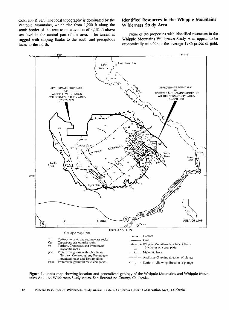
Colorado River. The local topography is dominated by the Identified Resources in the Whipple MountainsWhipple Mountains, which rise from 1,200 ft along the Wilderness Study Areasouth border of the area to an elevation of 4,131 ft abovesea level in the central part of the area. The terrain is None of the properties with identified resources in therugged with sloping flanks to the south and precipitous Whipple Mountains Wilderness Study Area appear to befaces to the north. economically minable at the average 1986 prices of gold,
APPROXIMATE BOUNDARYOF
WHIPPLE MOUNTAINS ADDITIONWILDERNESS STUDY AREA
(AZ-050-010)
APPROXIMATE BOUNDARYOF
WHIPPLE MOUNTAINS WILDERNESS STUDY AREA
(CDCA-312)
Geologic Map Units
Tu Tertiary volcanic and sedimentary rocksKg Cretaceous granodiorite rocksmr Tertiary, Cretaceous and Proterozoic
mylonitic rocks gnd Proterozoic gneiss with subordinate
Tertiary, Cretaceous, and Proterozoic granitoid rocks and Tertiary dikes
Pggr Proterozoic granitoid rocks and gneiss
EXPLANATION
- Contact Fault
-U- _IL Whipple Mountains detachment fault- Hachures on upper plate
/^ Mylonitic front
* t Antiform Showing direction of plunge
* j- Synform Showing direction of plunge
Figure 1. Index map showing location and generalized geology of the Whipple Mountains and Whipple Moun tains Addition Wilderness Study Areas, San Bernardino County, California.
D2 Mineral Resources of Wilderness Study Areas: Eastern California Desert Conservation Area, California
silver, copper, and manganese. The Copper Basin mine just outside the study area is the most likely property to be developed. The highest grade deposit, immediately adja cent to the study area, is the Crescent mine (fig. 3 and tables 1 and 2, No. 43) which has a 17,000-ton resource that is estimated to contain 0.14 ounces per ton (oz/t) gold, valued at approximately $59/t (gold = $424/oz), and 2.4 percent copper, valued at $36/t (copper = $0.77/lb), for a total unit value of $95. However, because of the estimated production costs, the resources at the Crescent mine are subeconomic at the commodity prices specified. Despite the economics of mining at the average 1986 prices of copper and gold, further investigation at four other copper- gold properties would be justified. The properties are the War Eagle mine (outside study area) and the Sleepy Burro group, New American Eagle mine, and the Copper Crest group within the study area (fig. 3 and tables 1 and 2, Nos. 2, 3, 4, and 46). All of these properties are located on or near large faults or fault systems that provided major ave nues for movement of hydrothermal solutions.
Selective mining of manganese outcrops and sloping of underground pods at the Monarch, Manganese King, and Monument King mines (fig. 3 and table 2, Nos. 37, 38, and 39) could yield small quantities of manganese. If the Federal Government institutes a manganese purchase pro gram to build stockpiles of this strategic metal, further exploration of these mines would be warranted. Volumi nous occurrences of common borrow, sand, and gravel are in Quaternary alluvium (see geologic time chart in appen dixes) in canyons and drainages radiating from the core of the study area; however, most of these occurrences are outside of the study area at lower elevations. Because of the high-bulk low unit value of the alluvium and the high transportation costs involved in shipping to distant markets, development is unlikely in the foreseeable future other than for local uses. These same influences of market outlets (demand), low unit value, and high transportation costs also affect the minability of identified decorative stone within the study area.
Identified Resources in the Whipple Mountains Addition Wilderness Study Area
Because the workings at most sites examined were unsafe to enter and the structures exposed by them discontinuous, no resources were identified. However, 46 samples collected from six sites within and immediately adjacent to the Whipple Mountains Addition Wilderness Study Area contain gold that ranges from a trace to 1.56 oz/t; most samples contain less than 0.1 oz/t. In view of the substantial increase in gold mining in the western states during the past 10 years, these factors suggest that the sites warrant further exploration Voluminous occurrences of
common borrow, sand, and gravel are in Quaternary alluvium in and near the Whipple Mountains Addition Wilderness Study Area; however, most of these occurrences are outside of the study area at lower elevations. Because of the high-bulk low unit value of the alluvium and the high transportation costs involved in shipping to distant markets, development is unlikely in the foreseeable future other than for local uses.
Mineral Resource Potential of the Whipple Mountains Wilderness Study Area
There are 12 areas of mineral resource potential within the Whipple Mountains Wilderness Study Area (fig. 2). These are broadly grouped into seven types: (1) copper, gold, and silver with or without lead and zinc in the upper plate of the Whipple Mountains detachment fault (high and moderate mineral resource potential), (2) copper, lead, zinc, gold, and silver in the lower plate of the Whipple Moun tains detachment fault (high, moderate, and low mineral resource potential), (3) copper, lead, zinc, gold, and silver mineralization related to granitic plutons (low mineral re source potential), (4) manganese related to Tertiary vol canic rocks (moderate mineral resource potential), (5) undiscovered decorative stone adjacent to measured re sources of decorative stone (high mineral resource poten tial), (6) sand and gravel and other rock products through out the area (low mineral resource potential), and (7) ura nium in Tertiary lake-bed sediments (low mineral resource potential). The study area has no resource potential for oil and gas or geothcrmal energy.
Most of the known mineralization in the Whipple Mountains Wilderness Study Area occurs in, or is closely related to, the upper plate and chlorite breccia zone of the Whipple Mountains detachment fault, with the exception of mineralization in the lower plate rocks on the west and north sides of the area (fig. 2). There mineralization ap pears more related to near-surface dike swarms localized along late normal faults that cut both upper and lower plate rocks. Geochemically the mineralized zones in the study area indicate an elemental metal suite of copper, lead, and zinc with copper predominating. Gold and silver are asso ciated with this suite, with variations in concentration from area to area. Barium is ubiquitous in both upper and lower plate rocks close to the detachment fault surface but dimin ishes away from it. This supports the concept of redistri bution of minerals by rain and (or) hydrothermal waters along the detachment fault. Manganese appears exclu sively associated with Tertiary volcanic rocks in the upper plate and with alteration. The conceptual model for min eralization in the study area is a low- to moderate-tempera ture hydrothermal system spatially related to the detach ment fault and chlorite breccia zone immediately below it. Most or all of the initial mineralization probably occurred
Whipple Mountains and Whipple Mountains Addition Wilderness Study Areas, California D3
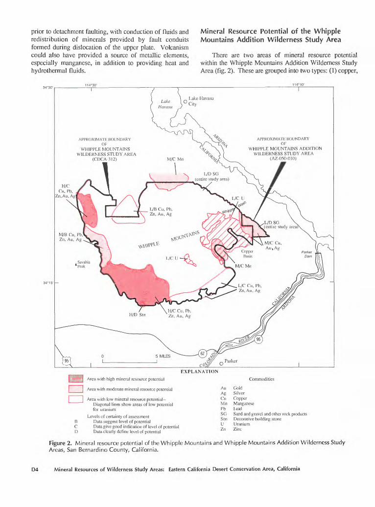
prior to detachment faulting, with conduction of fluids and redistribution of minerals provided by fault conduits formed during dislocation of the upper plate. Volcanism could also have provided a source of metallic elements, especially manganese, in addition to providing heat and hydrothermal fluids.
Mineral Resource Potential of the Whipple Mountains Addition Wilderness Study Area
There are two areas of mineral resource potential within the Whipple Mountains Addition Wilderness Study Area (fig. 2). These are grouped into two types: (1) copper,
Lake Havasu
APPROXIMATE BOUNDARYOF
WHIPPLE MOUNTAINSWILDERNESS STUDY AREA
(CDCA-312)
APPROXIMATE BOUNDARYOF
WHIPPLE MOUNTAINS ADDITION WILDERNESS STUDY AREA
(AZ-050-010)
H/C Cu, Pb,
Zn.Au, Ag
EXPLANATION
Area with high mineral resource potential
Area with moderate mineral resource potential
Area with low mineral resource potential- Diagonal lines show areas of low potential for uranium
Levels of certainty of assessment B Data suggest level of potential C Data give good indication of level of potential D Data clearly define level of potential
Commodities
Au GoldAg SilverCu CopperMn ManganesePb LeadSG Sand and gravel and other rock productsStn Decorative building stoneU UraniumZn Zinc
Figure 2. Mineral resource potential of the Whipple Mountains and Whipple Mountains Addition Wilderness Study Areas, San Bernardino County, California.
D4 Mineral Resources of Wilderness Study Areas: Eastern California Desert Conservation Area, California
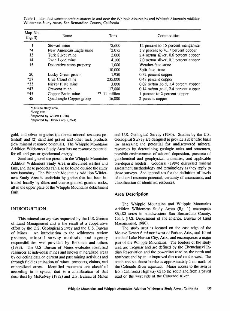
Table 1. Identified subeconomic resources in and near the Whipple Mountains and Whipple Mountain Addition Wilderness Study Areas, San Bernardino County, California
Map No. (fig. 3) Name Tons Commodities
1 Stewart mine ^,600*4 New American Eagle mine 22,07513 Turk Silver mine 2,00014 Twin Lode mine 4,10015 Decorative stone property 1,000
10,000 20 Lucky Green group 1,950
*27 Blue Cloud mine 235,000*33 Nickel Plate mine 3,000*43 Crescent mine 17,000*45 Copper Basin mine 37-l 1 million48 Quadrangle Copper group 16,000
12 percent to 15 percent manganese3.8 percent to 4.17 percent copper2.4 oz/ton silver, 0.6 percent copper7.0 oz/ton silver, 0.1 percent copperWeather-face stoneSplit-face stone0.32 percent copper0.48 percent copper0.02 oz/ton gold, 1.4 percent copper0.14 oz/ton gold, 2.4 percent copper1 percent to 2 percent copper2 percent copper
""Outside study area.'Long tons.Reported by Wilson (1918).3Reported by Dravo Corp. (1974).
gold, and silver in gneiss (moderate mineral resource po tential) and (2) sand and gravel and other rock products (low mineral resource potential). The Whipple Mountains Addition Wilderness Study Area has no resource potential for oil and gas or geothermal energy.
Sand and gravel are present in the Whipple Mountains Addition Wilderness Study Area in alluviated washes and fans, and these products can also be found outside the study area boundary. The Whipple Mountains Addition Wilder ness Study Area is underlain by gneiss that has been in truded locally by dikes and coarse-grained granitic rocks, all in the upper plate of the Whipple Mountains detachment fault.
INTRODUCTION
This mineral survey was requested by the U.S. Bureau of Land Management and is the result of a cooperative effort by the U.S. Geological Survey and the U.S. Bureau of Mines. An introduction to the wilderness review process, mineral survey methods, and agency responsibilities was provided by Beikman and others (1983). The U.S. Bureau of Mines evaluates identified resources at individual mines and known mineralized areas by collecting data on current and past mining activities and through field examination of mines, prospects, claims, and mineralized areas. Identified resources are classified according to a system that is a modification of that described by McKelvey (1972) and U.S. Bureau of Mines
and U.S. Geological Survey (1980). Studies by the U.S. Geological Survey are designed to provide a scientific basis for assessing the potential for undiscovered mineral resources by determining geologic units and structures, possible environments of mineral deposition, presence of geochemical and geophysical anomalies, and applicable ore-deposit models. Goudarzi (1984) discussed mineral assessment methodology and terminology as they apply to these surveys. See appendixes for the definition of levels of mineral resource potential, certainty of assessment, and classification of identified resources.
Area Description
The Whipple Mountains and Whipple Mountains Addition Wilderness Study Areas (fig. 1) encompass 86,480 acres in southwestern San Bernardino County, Calif. (U.S. Department of the Interior, Bureau of Land Management, 1980).
The study area is located on the east edge of the Mojave Desert 6 mi northwest of Parker, Ariz., and 10 mi south of Lake Havasu City, Ariz., and encompasses a major part of the Whipple Mountains. The borders of the study area are irregular and are defined by the Chemehuevi In dian Reservation and the powerline road on the north and northeast and by an unimproved dirt road on the west. The south and southeast border is approximately 1 mi north of the Colorado River aqueduct. Major access to the area is from California Highway 62 to the south and from a paved road on the west side of the Colorado River.
Whipple Mountains and Whipple Mountains Addition Wilderness Study Areas, California D5
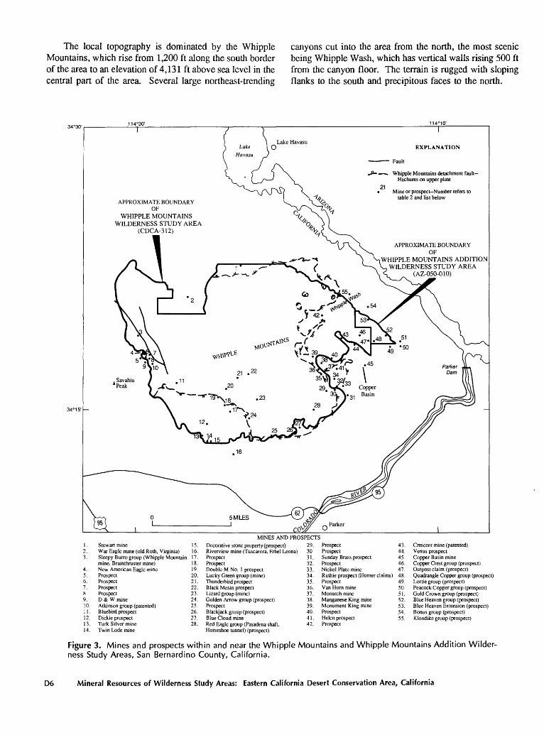
The local topography is dominated by the Whipple Mountains, which rise from 1,200 ft along the south border of the area to an elevation of 4,131 ft above sea level in the central part of the area. Several large northeast-trending
canyons cut into the area from the north, the most scenic being Whipple Wash, which has vertical walls rising 500 ft from the canyon floor. The terrain is rugged with sloping flanks to the south and precipitous faces to the north.
J» «. Whipple Mountains detachment fault Hachures on upper plate
21 Mine or prospect-Number refers to
table 2 and list belowAPPROXIMATE BOUNDARY
OFWHIPPLE MOUNTAINS
WILDERNESS STUDY AREA(CDCA-312)
APPROXIMATE BOUNDARYOF
WHIPPLE MOUNTAINS ADDITIONWILDERNESS STUDY AREA
(AZ-050-010)
6.7. 89.10.11.12.13.14.
Stewartmine 15.War Eagle mine (old Roth, Virginia) 16.Sleepy Burro group (Whipple Mountain 17.mine, Brainthruster mine)New American Eagle mineProspectProspectProspectProspectD & W mineAtkinson group (patented)Bluebird prospectDickie prospectTurk Silver mineTwin Lode mine
18.19.20.21.22.23.24.25.26.27.28.
Decorative stone property (prospect)Riverview mine (Tuscarora, Ethel Leona)ProspectProspectDouble M No. 1 prospectLucky Green group (mine)Thunderhird prospectBlack Mesas prospectLizard group (mine)Golden Arrow group (prospect)ProspectBlackjack group (prospect)Blue Cloud mineRed Eagle group (Pasadena shaft,Horseshoe tunnel) (prospect)
MINES AND PROSPECTS 29. 3031.32.33.34.35.36.
ProspectProspectSunday Brass prospectProspectNickel Plate mine
43.44.45.46.47.
Ruthie prospect (Homer claims) 48.Prospect 49.Van Horn mine 50.Monarch mine 51.Manganese King mine 52.Monument King mine 53.Prospect 54.Helen prospect 55. Prospect
Crescent mine (patented) Venus prospect Copper Basin mine Copper Crest group (prospect) Outpost claim (prospect) Quadrangle Copper group (prospect) Lortie group (prospect) Peacock Copper group (prospect) Gold Crown group (prospect) Blue Heaven group (prospect) Blue Heaven Extension (prospect) Bonus group (prospect) Klondike group (prospect)
Figure 3. Mines and prospects within and near the Whipple Mountains and Whipple Mountains Addition Wilder ness Study Areas, San Bernardino County, California.
D6 Mineral Resources of Wilderness Study Areas: Eastern California Desert Conservation Area, California
Previous and Present Investigations
Previous Studies
This report is a revision of Marsh and others (1982) and was written to assess additional acres within the Whipple Mountains Wilderness Study Area, assess the Whipple Mountains Addition Wilderness Study Area, bring the classification of undiscovered mineral resources up to date, and to compile information on the Whipple Moun tains into one report. In addition to results from this inves tigation, further and detailed information can be found in many studies on the geology (Davis and others, 1980, 1982; Coney, 1980; Evans, 1979; Frost and Martin, 1982; Teel and Frost, 1982; Thurn, 1982), geochemical surveys (Erickson and others, 1987), remote sensing (G.L. Raines, unpub data, 1982), gravity and magnetics (R.W. Simpson, and T.B. Gage, unpub. data, 1982), geoelectrical surveys (D.B. Hoover, unpub. data, 1982) and an investigation of mines and prospects (Ridenour and others, 1982a, 1982b, 1987; Moyle and Gabby, 1985).
Investigations by the U.S. Bureau of Mines
The appraisal of identified mineral resources of the Whipple Mountains and Whipple Mountains Addition Wilderness Study Areas and vicinity was conducted in two parts (Ridenour and others, 1982a; Moyle and Gabby, 1985). The temporal and spatial relationships of mineral deposits and occurrences in the Whipple Mountains and vicinity are discussed by Ridenour and others (1982b). Preliminary work included a search of literature pertaining to geology and mineral resources within and near the study area; mining claim records were compiled from San Ber- nardino County and the U.S. Bureau of Land Management State office; and production records were compiled from U.S. Bureau of Mines files and California State publica tions. Attempts were made to contact all known claimants and owners of patented mining properties for permission to examine their prospects and mines and to obtain any scien tific or historical information that would aid this study. All known mines and prospects were examined and sampled and, if warranted, mapped. Where possible, the limits of the mineralized rock were determined in order to establish tonnages for resource calculations. Resources, where esti mated, are classified by levels of geologic assurance (measured, indicated, and inferred) and by likelihood for development (economic, marginally economic, and sube- conomic).
Investigations by the U.S. Geological Survey
The U.S. Geological Survey, using geologic, geo chemical, and geophysical techniques, investigated the study area to define the genesis of mineralization associated
with mines and prospects, to determine if previously un known mineral resources exist in the area, and to describe, wherever possible, the type and model for the mineralizing events. The defined areas of mineral resource potential (fig. 2) represent an evaluation as of 1981. C.M. Alien and K.A. Howard prepared the geologic base map from the many published geologic maps and reports on the Whipple Mountains. Sampling for a stream-sediment survey and rock sampling of selected mineralized areas were done in the spring of 1980 by S.P. Marsh and D.B. Smith. The geochemical data generated for this report were interpreted by S.P. Marsh. Aeromagnetic and gravity maps were prepared and interpreted by R.W. Simpson and geoelectric data were obtained and interpreted by D.B. Hoover. G.L. Raines interpreted remote-sensing data from LANDSAT images and ground observations.
Acknowledgments
Geologists of the U.S. Geological Survey, the U.S. Bureau of Mines, the University of Southern California, and San Diego State University contributed data and par ticipated in discussions that were instrumental in defining the mineral resource potential of the Whipple Mountains and Whipple Mountains Addition Wilderness Study Areas. J.L. Anderson and G.A. Davis (University of Southern California), E.G. Frost (San Diego State University), and WJ. Carr (U.S. Geological Survey) provided valuable insights to the detailed geology and structural problems of the Whipple Mountains. J.K. Otton (U.S. Geological Sur vey) interpreted National Uranium Resource Evaluation (NURE) data in order to establish the uranium potential. Richard Knox (U.S. Geological Survey and U.S. Bureau of Land Management) participated in the many discussions on the mineral potential of the area.
APPRAISAL OF IDENTIFIED RESOURCES
By James Ridenour, Phillip R. Moyle, and Spencee L Willett U.S. Bureau of Mines
Methods of Evaluation
A total of 693 rock samples, 57 alluvium samples, and 31 petrographic samples were collected from the 55 sites examined in detail by the U.S. Bureau of Mines. Chip samples were collected from mineralized structures when possible, and grab samples were collected from dumps where underground workings were inaccessible; these samples were fire assayed for gold and silver. Quantitative amounts of visible or anomalous minerals or elements were determined by atomic-absorption, colorimetric, or X-ray fluorescence methods. At least one sample from each
Whipple Mountains and Whipple Mountains Addition Wilderness Study Areas, California D7
location was analyzed for 42 elements by semiquantitative spectrometry; elements in anomalous concentrations were then analyzed by one of the appropriate quantitative meth ods listed above. Petrographic examinations were per formed to determine selected rock types, alteration suites, and mineral assemblages. Grab and channel samples of alluvium were collected from major drainages in the study area. These were panned to a rough concentrate and proc essed on a laboratory-size Wilfley table. Selected heavy- mineral fractions were analyzed for mineral content. Fur ther information concerning analytical and other testing methodology, detection limits, and results is available in Ridenour and others (1987) and at the U.S. Bureau of Mines, Western Field Operations Center, E. 360 Third Ave., Spokane, WA 99202.
Mining History
Historic mining activity in the area was recorded by Root (1909), Bancroft (1911), and Jones (1920). Specific descriptions or notations of various mines, prospects, and mineralized areas in the region were given by Bailey (1902), Turner (1907), Aubury (1908), Graeff (1910), Ste- vens (1911), Wilson (1918), Cloudman and others (1919), Tucker (1921), Tucker and Sampson (1930, 1931, 1943), Noble (1931), Trask and others (1943), Eric (1948), Trask (1950), Wright and others (1953), Trengove (1960), and Fleury (1961). An overview of the mining in the California desert was written by Vredenburgh and others (1981).
Early claim records refer to the "Monumental" or "Whipple Mountains" mining districts within the region. The "Monumental" district probably encompassed Copper Basin, most of which lies outside the study area. The "Whipple Mountains" district includes mines and prospects in the vicinity of Savahia Peak, approximately 3 mi west of the study area. This area is referred to as the Chemehuevi district by Vredenburgh and others (1981) and is described as extending 20 to 50 mi inland (west) from the Colorado River. More than 5,000 claims were filed in and around the study area since the late 1800's; eight lode claims were patented. A search of the records did not reveal any placer claims in the vicinity of the study area. U.S. Bureau of Land Management claim recordations indicate approxi mately 165 active claims within the study area in February 1981.
U.S. Bureau of Mines files show 5,123 tons of ore were produced from 56 mines in what Clark (1970) refers to as the Whipple district, from 1906 to 1969 (exclusive of Copper Basin). The Copper Basin mine alone produced more than 40,000 Ib of copper with some by-product gold and silver between 1930 and 1966 (U.S. Bureau of Mines files). Historic value of ore from the 56 mines is estimated at about $84,000; approximately 48 percent of the value is from gold and about 45 percent is from copper. About 2,500 long tons of manganese ore of unknown value was
produced from five manganese mines from World War I to the 1950's in response to Government stockpiling pro grams.
Many of the historic mine names in the Whipple dis trict could not be equated to modern names found in the claim records. Therefore, production from many mines within the study area is undetermined.
Appraisal of Sites Examined in the Whipple Mountains Wilderness Study Area
Mines and prospects with identified resources are listed in table 1; summary descriptions of the 55 properties examined are given in table 2.
None of the properties with identified resources appear to be economically minable at the average 1986 prices of gold, silver, copper, and manganese. In terms of likelihood for development, the Copper Basin mine just outside the study area is the most important property. Although this area was extensively explored by industry, there were no known plans in 1983 to develop the deposit. This may be due to its small size in comparison to copper deposits of south-central Arizona, some of which are at least 10 times larger in terms of contained resources.
The highest grade deposit, immediately adjacent to the study area, is the Crescent mine (pi. 1, fig. 3 and tables 1 and 2, No. 43). The 17,000-ton resource is estimated to contain 0.14 oz/t gold, valued at approximately $59/t (gold = $424/oz), and 2.4 percent copper, valued at $36/t (copper = $0.77/lb), for a total unit value of $96. Such a flat-lying deposit would best be mined by the room-and-pillar method, which would require at least a 4.0-ft mining width and have a 10 to 15 percent loss in pillars; therefore, the unit value would be diluted to approximately $67/t. Because of the high copper content, gold recovery may be as low as 50 percent, further reducing the value to about $46/t. For evaluation purposes (Clement and others, 1979), the mine should have at least a 5-yr life or a minimum of about 100,000 tons for a production rate in the range of 50 to 100 t/d for 250 d/yr. The costs to mine the deposit include a $7.50/t mine capital cost and a $24/t mine operating cost. The least expensive and most effective recovery method, heap leaching (including crushing facilities), would require a minimum $1.5 million capital cost ($65/t) and would cost approximately $15 to $20/t to operate. Alternatively, the material could be treated at the nearest custom mill at Vanderbilt, Calif., 150 mi to the northwest. Haulage would cost approximately $18 to $20/ t, and milling would cost about $25 to $30/t. Therefore, the resources at the Crescent mine are subeconomic at the commodity prices specified.
Despite the economics of mining at the average 1986 prices of copper and gold, available data at four other copper-gold properties are sufficiently encouraging to indi cate further investigation. These are the War Eagle mine
D8 Mineral Resources of Wilderness Study Areas: Eastern California Desert Conservation Area, California
(outside study area) and the Sleepy Burro group, New American Eagle mine, and the Copper Crest group within the study area (pi. 1, fig. 3, and tables 1 and 2, Nos. 2, 3, 4, and 46). All of these properties are located on or near large faults or fault systems that provided major avenues for movement of hydrothermal solutions. Although the War Eagle, New American Eagle, and Sleepy Burro under ground workings were inaccessible at the time of the study, descriptions of the properties by earlier investigators and recent induced polarization (IP) surveys (Marsh and others, 1982) suggest the presence of possibly minable resources. Evaluation of the IP anomalies through drilling would be the most feasible and least costly means to test for re sources. The Copper Crest group, in upper plate rocks, was not explored to the extent of the other three workings, but copper and silver content of selected samples indicate fur ther investigation is warranted.
Selective mining of manganese outcrops and sloping of underground pods at the Monarch, Manganese King, and Monument King mines (pi. 1, fig. 3, and table 2, Nos. 37, 38, and 39) could yield small quantities of manganese. The mining would be labor intensive, and the grade would only be 20 to 30 percent manganese. Because the deposits are classified as ferruginous manganese containing 10 to 35 percent manganese, additional milling would be necessary to upgrade the resources. Manganese ore (minimum 48 percent manganese with low impurities) sold at United States ports for $1.35 to $1.40/long ton unit (Engineering and Mining Journal, Mar. 1987, p. 19). Transportation costs to major consumers in the eastern United Slates were prohibitively high in 1986. If the Federal Governmenl in- slilules a manganese purchase program lo build stockpiles of ihis slralegic metal, further exploration of ihese mines would be warranied. Drilling may reveal additional man ganese pods and lenses al deplh similar lo grades of 25 lo 50 percenl manganese produced in me past.
Certain factors could affect ihe economics of mineral deposits in ihe sludy area and vicinity. For example, tech nological advancements that would decrease mining or milling costs or increase milling recovery, such as improv ing gold recovery from copper-gold resources at the Cres- cenl mine, could result in upgrading the resource classifica tion to economic. Development of a nearby mine and mill, such as at Copper Basin, could provide a cost effective mill for small deposits in and near the study area. Finally, significant increases in commodily prices whether or not accompanied by a concomitant increase in the demand for the raw materials, could lead to further interesi in explora tion wilhin ihe sludy area.
Voluminous occurrences of common borrow, sand, and gravel are in Quaternary alluvium in canyons and drainages radiating from ihe core of ihe sludy area; how ever, most of ihese occurrences are oulside of the sludy area al lower elevations. Thirteen of 56 samples of allu vium collected from ihese occurrences contain no gold.
The gold value in six of the samples was from $.05 lo $1.37/yd3 al a price of $424/oz; in ihe remaining samples il was from $.01 lo $.03/yd3 . Thus, the gold is not in suffi cient quantily to consiilule resources or improve the eco nomics of extracting the alluvium for other purposes. Because of the high-bulk low unii value of the alluvium and ihe high transportation costs involved in shipping to distanl markels, developmenl is unlikely in ihe foreseeable fulure other than for local uses. These same influences of market outlets (demand), low unii value, and high transpor tation costs also affeci ihe minabilily of identified decora- live slone wilhin the study area.
Appraisal of Sites Examined in the Whipple Mountains Addition Wilderness Study Area
Forty-six samples collected from six sites within and immediately adjacent to the Whipple Mountains Addition Wilderness Study Area conlain gold lhat ranges from a trace to 1.56 oz/t; mosl samples conlain less than 0.1 oz/t. Because the workings al most of these sites were unsafe lo enter and the struciures exposed by them discontinuous, no resources were identified. However, al most sites the struc iures are numerous and the gold is apparenlly not confined to a particular set of fractures. Finally, the workings are all in upper plate rocks and have been subjected to intense ground preparation. In view of the substantial increase in gold mining in the western states during the past ten years, ihese factors suggesl that the sites warrant further investi gation, which could lead lo identified resources.
Voluminous occurrences of common borrow, sand, and gravel are in Quaternary alluvium in canyons and drainages in and near ihe Whipple Mounlains Addition Wilderness Sludy Area; however, most of these occur rences are outside of the study area at lower elevations. Because of the high bulk-low unit value of the alluvium and ihe high transportation costs involved in shipping to distant markets, development is unlikely in the foreseeable future oiher lhan for local uses.
ASSESSMENT OF MINERAL RESOURCE POTENTIAL
By Sherman P. Marsh, Gary L Raines, Michael F. Diggles, Keith A. Howard, Robert W. Simpson, and Donald B. Hoover U.S. Geological Survey
Geology and Structure
The Whipple Mountains form one of more than 25 distinctive meiamorphic terranes in the North American Cordillera that have been referred to as "melamorphic core complexes" (Coney, 1980; Crittenden and olhers, 1980).
Whipple Mountains and Whipple Mountains Addition Wilderness Study Areas, California D9
These terranes are characterized by metamorphic-plutonic basement rocks overprinted by low-dipping mylonitic fab rics and overlain on decollements (detachment faults) by a fault-sliced and attenuated unmetamorphosed cover (Coney, 1980). The Whipple Mountains typify this de scription. Numerous recent studies have investigated the geology of the Whipple Mountains (Andcrson and others, 1979; Carr and others, 1980; Dickey and others, 1980; Frost, 1980; Davis and others, 1980, 1982; Anderson and Rowley, 1981; Carr, 1981; Anderson, 1981). These studies show that the structure of the Whipple Mountains is domi nated by a low-angle detachment fault of Tertiary age, which juxtaposes two unlike assemblages of rocks. This fault, the Whipple Mountains detachment fault, separates a footwall or lower plate exposed in the domal core of the range from an upper plate exposed around the flanks.
The lower plate below the fault is comprised largely of Proterozoic metamorphic and plutonic rocks. Below and east of a mylonite front exposed in the western part of the study area and mapped as the contact between mylonitic rocks (mr) and gneiss (gnd) (pi. 1 and fig. 1), the Proterozoic rocks have a gently dipping mylonitic foliation associated with Cretaceous and Tertiary granitic sheet in trusions (Davis and others, 1982; Wright and others, 1976). Petrologic studies suggest that the granitic sheets were emplaced at depths exceeding 6 mi (Anderson and Rowley, 1981; Anderson, 1981). Regionally, deep-seated rocks such as these are generally barren of sulfide mineralization except where affected by younger events. Lower plate crystalline rocks above the mylonite front are intruded by Tertiary dikes of diabase to dacite composition in the dense Chambers Well dike swarm (Davis and others, 1982; Carr and others, 1980).
The upper plate is composed of crystalline rocks over lain by Tertiary volcanic and sedimentary strata (Davis and others, 1980, 1982). Proterozoic igneous and metamorphic rocks forming most of the crystalline assemblage are in truded by one or more Cretaceous granite plutons. A mineralization halo in Proterozoic rocks at Copper Basin, a mile east of the study area, has been related to intrusion of nearby Cretaceous granite by Anderson and Frost (1981) on the basis of like potassium-argon ages of the granite and the altered rocks. Metallic mineralization is common in similar rock assemblages in other parts of southeastern California and Arizona. The upper-plate Tertiary volcanic rocks are andesite, basalt, and tuff, which are typically altered and secondarily enriched in potassium. Interbedded sedimen tary rocks are conglomerate, sandstone, and lacustrine shale and limestone. The upper plate is overlain unconformably by fanglomerate and basalt of Miocene age, estuarine clay, silt, sand, and marl of Miocene and Pliocene age (Bouse Formation), and alluvial and fluvial deposits of Quaternary age (Dickey and others, 1980; Davis and others, 1980; Carr, 1981).
Regional relations demonstrate that a sequence of Paleozoic and Mesozoic strata similar to those now ex posed in northwestern Arizona was once deposited across the area (Hamilton, 1982). These rocks were mostly eroded before middle Tertiary time, probably as a result of Mesozoic deformation and uplift. Mesozoic deformation is recorded not only by mylonites and granitic sheets in the Whipple Mountains lower plate, but also by folds, thrust faults, and metamorphism in areas to the south (Hamilton, 1982; Carr and Dickey, 1980), west (Miller and others, 1982), and east (Reynolds and others, 1980). The Whipple Mountains detachment fault commonly crops out as a ledge of impermeable microbreccia, below which is a zone of alteration, faulting, and brecciation termed the chlorite breccia zone, which is as thick as 400 ft. Contained within this structurally disturbed zone are brecciated clasts with a matrix of chlorite, epidote, silica, and sulfide minerals, especially pyrite; the alteration and mineralization render the zone hard and relatively impermeable (Frost, 1980; E.G. Frost, written commun., 1982). Fracturing and altera tion are typically most intense where the lower plate rocks are mylonitic (Davis and others, 1982). E.G. Frost (written commun., 1982) suggested that ore minerals may have been leached from the areas of most intense fracturing and al teration and that nearby sites, particularly in upper-plate crystalline rocks, may have been favorable for redeposition of ore minerals. Detachment faults below the main detach ment surface in places mark the base of the chlorite breccia zone (Frost, 1980; Davis and others, 1982). Above the Whipple Mountains detachment fault, the upper plate is cut by a series of northeast-dipping normal faults that repeat over and over again the Tertiary section and underlying upper plate crystalline rocks (Davis and others, 1980; Frost, 1980; Dickey and others, 1980). These faults join or bot tom against the detachment fault. The upper plate blocks are rotated to southwest dips along these faults and are locally crushed or broken by antithetic faults as a result of the rotation (Frost, 1980). The oldest Tertiary beds dip more steeply than younger ones, suggesting that detach ment and related normal faulting took place during deposi tion of strata (Frost, 1979; Davis and others, 1980). Much of the mineralization of the area, including redistribution of ore minerals at Copper Basin, occurs in the upper plate and can be related to the Miocene structural disruption and associated hydrothermal alteration (Wilkins and Heidrick, 1982; Ridenour and others, 1982a). The detachment fault defines gentle troughs and ridges that Frost (written com mun., 1982) and Wilkins and Heidrick (1982) have sug gested may partly control sites of ore deposition. Cameron and Frost (1981) interpreted these troughs and ridges as folds. Carr (1981) suggested that horizontal offset along the Whipple Mountains detachment fault probably exceeds 12 mi. Studies in nearby areas suggest that the detachment fault has considerable vertical offset, as well as unknown
D10 Mineral Resources of Wilderness Study Areas: Eastern California Desert Conservation Area, California
horizontal offset, and juxtaposes rocks that were originally at different levels in the crust (Hamilton, 1982; Howard and others, 1982). The lower plate assemblage of rocks in the western part of the study area resembles upper plate rocks 20-25 mi to the northeast in the Mohave Mountains and may be their beheaded equivalent (G.A. Davis, oral com- mun., 1979; Howard and others, 1982). The rocks in the Mohave Mountains are extensively mineralized (Light and others, 1982). These relations raise the possibility that the western part of the Whipple Mountains contains deeper parts of the mineralized system(s) that affected the Mohave Mountains. Thick tilted upper plate blocks in the Mohave Mountains area suggest that the Whipple Mountains fault and its footwall originally lay at depths of several miles, perhaps 7.5 mi or more (Howard and others, 1982). Tec tonic denudation and large uplift apparently have since exposed the fault and lower plate. Locally mineralized faults with postdetachment fault movement occur in the western part of the study area (Dickey and others, 1980; Carr and others, 1980). Virtually undeformed and unmin- eralized rocks deposited unconformably across the de formed terrain demonstrate that most deformation had ended by 13 million years ago (Dicky and others, 1980; Davis and others, 1980; and Carr, 1981).
Geochemistry
Sample Media and Analytical Methods
A reconnaissance geochemical study to assess the mineral resource potential of the Whipple Mountains and Whipple Mountains Addition Wilderness Study Areas was undertaken in 1980. Three sample media were selected as best representing this area in the arid desert environment of southeastern California: stream sediments, panned concen trates, and rocks. Sediments and concentrates were col lected from 154 drainages in the study area, each drainage representing a 1-2 mi2 area. Selected samples were col lected from areas of altered outcrops and from existing mining areas to determine mineral suites and trace-element signatures of mineralized systems. The samples were processed, and the minus-80-mesh fraction of sediment and the nonmagnetic heavy (greater than 2.86 specific gravity) fraction of concentrate were analyzed for 31 elements by the semiquantitative-emission spectrographic method (Grimes and Marranzino, 1968). Rock samples were pul verized and also analyzed by a semiquantitative-emission spectrographic method. Data from these analyses for the study area are listed in Erickson and others (1987). Semiquantitative spectrographic analyses of the nonmag netic fraction of the panned concentrates proved to be the most useful in evaluating the study area. This sample medium contains the common ore-forming sulfide and oxide minerals as well as barite and other nonmagnetic
minerals (zircon, apatite, fluorite, rutile, and some sphene). The concentrate medium also gives a greatly enhanced anomaly pattern, as all of the more common (low specific gravity, less than 2.86) rock-forming minerals (quartz and feldspar) that tend to dilute the anomalies have been re moved. To investigate the relation of limonite occurrences to hydrothermal alteration related to mineralization, the intermediate magnetic fraction of the panned concentrates was analyzed. This sample medium was used because it contain the adsorbed iron and manganese oxides on sedi ments from the representative drainage basins. The iron and manganese oxides were dissolved from the samples using hot aqua regia and were analyzed using the induc tion-coupled plasma spectrograph (ICP) (Church, 1981; and Church and others, 1982) to see if they contain anoma lous concentrations of metals.
Results of Study
The regional geochemical survey in the Whipple Mountains Study Area delineated regions of mineralization, helped identify areas of hydrothermal alteration and helped establish the relation of mineralization to the Whipple Mountains detachment fault. In addition, the survey iden tified geochemical suites of elements characterizing the rocks in the Whipple Mountains.
Geophysics
Geophysical investigations were conducted by the U.S. Geological Survey as part of the multidisciplinary study of the Whipple Mountains and Whipple Mountains Addition Wilderness Study Areas. The work included aeromagnetic, gravity, IP, and remote-sensing studies, vertical electrical soundings, and audiomagnetotelluric readings.
Aeromagnetics and Gravity
Regional aeromagnetic and Bouguer gravity maps both display large positive anomalies in the western part of the study area (R.W. Simpson and T.B. Gage, unpub. data, 1982; U.S. Geological Survey, 1981; Chapman and Riet- man, 1978). The very highest total-field magnetic values occur about 1 mi south-southeast of the War Eagle mine (pi. 1, fig. 3, and table 2, No. 2) over a small gabbro out crop. An arm of the magnetic high extends to the north- northeast where it coincides with outcrops of mafic diorites (G.A. Davis, oral commun., 1982). The coincidence of the broad magnetic and gravity highs requires a source body that is both magnetic and dense, such as gabbro or the Tertiary diorite. The extent of the anomalies suggests occurrence of considerably more of these mafic materials at depth than are seen at the surface. To the west, the major aeromagnetic high joins the north end of a linear north- northwest-trending aeromagnetic high, which parallels the
Whipple Mountains and Whipple Mountains Addition Wilderness Study Areas, California D11
axis of the Chambers Well dike swarm (G.A. Davis, oral commun., 1982). A lower high-amplitude high area contin ues farther to the west and generally matches the westward broader extent of the dike swarm. The steepest gradient on the west side of the linear north-northwest-trending central anomaly passes near the New American Eagle and D & W mines (pi. 1, fig. 3, and tables 1 and 2, Nos. 4 and 9) and may mark a structure that has permitted movement of mineralizing solutions. This possibility is strengthened by the presence of coincident linear gravity gradients trending north-northwest that have been inferred by Healey and Cur- rey (1980) to mark a through-going fault. Mapped faults parallel to this trend also appear nearby (Stone and How ard, 1979). On the north edge of the study area, there are fewer mines and prospects than occur on the west. As previously mentioned, the War Eagle mine lies just north of the highest part of the magnetic high, perhaps indicating the boundary of a mafic body. The north-northeast-trending linear gradient that bounds this high on the northwest (about 0.6 mi south-southeast of the War Eagle mine) is again suggestive of structural control, as is a more diffuse north-northwest-trending magnetic gradient that passes through the location of the War Eagle mine.
Geoelectrics
Within the study area, four IP survey lines were run in the vicinity of the D & W and New American Eagle mines (pi. 1, fig. 3, and tables 1 and 2, Nos. 9 and 4) and two in the vicinity of the War Eagle mine (pi. 1, fig. 3, and table 2, No. 2). These lines were run because the IP method provides a direct indication of polarizable minerals such as clays and sulfides with metallic luster and thus can provide evidence for the possible extent of mineralization at depth in the vicinity of the mines. In addition to the IP surveys, twelve Schlumberger vertical-electrical soundings (VES) and three experimental audio-magnetotelluric (AMT) soundings were made. The VES were made to determine variations in resistivity with depth at selected sites within the core complex and in nearby upper plate rocks.
In the vicinity of the New American Eagle and D & W mines, IP work showed a southeast-trending polarizable zone at least 5,000 ft long passing directly through the New American Eagle mine. The observed ability for polariza tion is low but distinctly above background levels. The polarizable zone is believed to be a direct expression of the mineralized body mined at the New American Eagle. IP data indicate that the body extends at least 980 ft in depth. Where identified by the IP lines, the zone is entirely within the study area and probably continues within the area for some distance. One line crossed the D & W mine, but no polarizable body was observed near the mine. The main polarizable structure is located about 1,900 ft northeast of
the D & W shaft. The apparent lack of a polarizing body at the D & W mine could either represent leakage of min eralizing fluids along a structure or could indicate an al tered body at depth.
At the War Eagle mine the IP data show a polarizable body similar to that observed at the New American Eagle mine. Values for the ability for polarization were slightly larger than observed near the New American Eagle mine and were the largest observed in the study area. The data suggest a broad (320-ft-wide) near-vertical zone of in creased polarization extending to at least 1,000-ft depth near the War Eagle shaft. Because only one IP line crossed the structure, the trend and lateral extent are unknown. The data also suggest that a broad zone of slightly increased fracturing or alteration may extend south of the War Eagle mine, with increased polarizability at depth. One IP line crossed the inferred trace of the detachment fault north of the War Eagle mine. The fault was clearly identified in the data as an abrupt resistivity interface dipping north. Resis tivities ranged from moderate values (100-200 ohm-me ters) associated with the lower plate rocks to low values associated with the upper plate rocks in this area. No polarization anomaly was associated with the detachment fault here, indicating a lack of sulfide mineralization or polarizable clays in the fault zone. In the Whipple Moun tains, mineralization generally associated with the detach ment fault extends only short distances into the lower plate rocks. There is no IP response associated with the detach ment fault near the War Eagle mine, and yet a clear IP response at the War Eagle mine to some depth suggests mineralization well within the lower plate here. It appears that further work is needed before an understanding of the source of mineralization is achieved. Vertical electrical soundings within the lower plate showed near-surface resis tivities of about 100 ohm-meters slowly increasing to about 1,000 ohm-meters at depth. This is interpreted to represent a normal reduction of porosity with depth due to overbur den pressure. A line of six soundings crossed the detach ment fault north of the War Eagle mine and also clearly showed the presence of the fault. The data give a minimum apparent dip of 20 on the detachment surface.
Remote Sensing
As a part of this study, limonitic materials were iden tified in LANDSAT images of the Whipple Mountains and surrounding areas using a color-ratio-composite method (Rowan and others, 1974). This technique was used to map areas of hydrothermal alteration associated with limonitic materials and to help define potential mineralized systems. The term limonite is used as a general term for hydrous iron oxides (Blanchard, 1968) but is modified to include any material with the unique spectral reflectance properties of the ferric oxide minerals such as hematite and goethite
D12 Mineral Resources of Wilderness Study Areas: Eastern California Desert Conservation Area, California
(Hunt, 1980). The minerals pyrite and (or) hematite are commonly associated with hydrothermal alteration that is potentially related to mineralization; these minerals weather to produce limonite, which is detected by this technique. Areas of hydrothermal alteration that lack limonitic mate rials will not be detected by this technique; however, areas of this type, without limonite, are insignificant within the study area. All areas within the study area defined as limonitic from the satellite analysis were visited and sampled selectively to determine if the limonite was asso ciated with hydrothermal alteration and, if so, with what type of alteration and (or) mineralization (pi. 1). The se lected rock samples from limonitic areas were analyzed by a semiquantitative-emission spectrographic method (Grimes and Marranzino, 1968) to determine trace-element assemblages associated with mineralization, in order to help define the type and extent of any mineralizing process that could have produced the observed hydrothermal altera tion. From these hydrothermal-alteration studies, several mineralized areas were identified, and the extent, distribu tion, and type of alteration were mapped.
Mineral and Energy Resource Potential of the Whipple Mountain Wilderness Study Area
Within the Whipple Mountains Wilderness Study Area, most of the mines and prospects and many of the limonitic areas of hydrothermal alteration are spatially re lated to the low-angle Whipple Mountains detachment fault. Most of the mineralization observed is in the upper plate and, although seen in places in lower plate rocks, rarely extends very far below the fault zone. Mineraliza tion related to the fault zone is primarily copper, lead, zinc, gold, and silver with the elemental suite copper-silver-gold predominating. Varying amounts of lead and zinc are also present. The mineralization is also seen in veins and frac tures related to listric and antithetic faults (Ridenour and others, 1982a, 1982b) resulting from dislocation of upper plate rocks. The observed minerals are oxides and carbon ates with rare sulfides. Along the southeast margin of the area, in upper plate rocks, one or several Cretaceous granite bodies have been dislocated by northwest-striking normal faults that repeat much of the upper plate section (Dickey and others, 1980). Concentrations of copper, lead, zinc, gold, and silver minerals are spatially related to these granitic bodies, are also dislocated by the northwest-trend ing faults, and are apparently genetically related to intru sion of the granite. Tertiary volcanic rocks are limited to the upper plate of the Whipple Mountains detachment fault and contain small manganese deposits and prospects. The manganese occurs as psilomelane and pyrolusite in irregu lar masses in areas of solfataric alteration accompanied by silicification.
Barite veins are common throughout the upper plate and also occur in the lower plate. Barite is a common secondary mineral in all the vein systems throughout the area in both upper and lower plate rocks. Tertiary lake bed sediments in the eastern part of the wilderness study area contain anomalous concentrations of uranium, and decora tive sandy limestone was exploited at a small rock quarry near the south boundary.
Mineralization Related to the Whipple Mountains Detachment Fault Copper, Lead, Zinc, Gold, and Silver
The most visible mineralization in the Whipple Moun tains is the ubiquitous, structurally controlled occurrence of chrysocolla (copper silicate) related to the Whipple Moun tains detachment fault. The chrysocolla occurs in rocks from lower plate mylonitic and nonmylonitic assemblages to the upper plate Tertiary section. It occurs as thin coat ings to massive, podiform to lensoid bodies as much as a few inches thick. Lateral extent of the chrysocolla occur rences is commonly limited to a few inches, but several such occurrences can be expected along the strike length of any given fracture system. The chrysocolla is usually accompanied by earthy hematite, quartz, specular hematite, limonite, calcite, barite, chlorite, epidote, and sericite. Barite and calcite associated with the chrysocolla are more prevalent in upper plate rocks. The type of alteration asso ciated with the deposits is a chlorite-dominated propylitic assemblage, although quartz-sericite alteration was also observed. Spotty, low-grade, gold and silver are associated with the chrysocolla-hematite assemblage (Ridenour and others, 1987).
Immediately below the detachment fault lies an altered and highly disturbed zone called the "chlorite breccia zone 1" (Frost, 1980). Chlorite tends to be concentrated in and near this zone and appears to diminish in overall content upward. Pyrite and chalcopyrite as disseminated in the chlorite breccia zone. Disseminated pyrite and chalcopyrite have been reported in drill logs in the upper plate crystal line suite at Copper Basin, just east of the study area boundary (Ridenour and others, 1987). The probable minimum age for the mineral occurrences associated with upper plate fractures that resulted from detachment faulting is middle Miocene, and the probable maximum age is late Oligocene, as suggested by a 24.5 0.7 million year (Ma) potassium-argon age of sericite determined by R.F. Marvin (written commun., 1982). Collectively, field observations and age data indicate a contemporaneous relation between mineralization and detachment in the study area (Ridenour and others, 1982b).
Structural analyses of fractures in mineralized areas above and below the detachment fault indicate crustal lengthening in the lower plate and dislocation in the upper plate. A total of 286 observations of attitudes of mineral-
Whipple Mountains and Whipple Mountains Addition Wilderness Study Areas, California D13
ized structures were separated into lower and upper plate populations and analyzed by computer. A concentration of attitudes in the lower plate were oriented N. 26° W., and dipped 48° ME. Attitudes in the upper plate structures show a dominant cluster at N. 45° W., 28° ME., and a secondary cluster centered about N. 46° W., 66° SW. Upper plate data suggest probable structural control by northeast-dipping listric and normal faults and southwest- dipping antithetic and bedding-plane faults. The pattern of tension fractures in the lower plate is compatible with a N. 50°±10° E. direction of crustal extension, which is also the inferred direction of movement of the upper plate (Ride- nour and others, 1982b).
The upper plate of the Whipple Mountains detachment fault is lithologically varied and contains Proterozoic and Mesozoic crystalline rocks and Tertiary volcanic and sedi mentary rocks that have undergone severe structural disrup tion during the period of detachment faulting (Davis and others, 1980, 1982). Mineralization occurred in this dis turbed upper plate in normal faults, shear zones, and ten sion gashes.
Two areas in orassociated with the Whipple Mountains detachment fault have high potential for copper, lead, zinc, gold, and silver resources (pi. 1, fig. 2): (1) a large area in the south-southwest part of the wilderness study area and (2) a smaller area on the west side of the study area.
Analyses of stream sediments and panned concentrates in these two areas revealed that the southern area was more heavily mineralized than the western area. The boundaries of the southern area extend somewhat beyond the outcrop pattern of upper plate rocks to include some mines and prospects in the chlorite breccia zone that occur at or very near the detachment fault zone and are related to upper plate mineralization. The semiquantitative spectrographic analyses of nonmagnetic panned concentrates show a trace- element suite related to copper, lead, zinc, gold, and silver mineralization. This suite consists of copper greater than or equal to 100 parts per million (ppm) and lead greater than or equal to 200 ppm, with varying amounts of molybdenum (10-50 ppm) and silver (3 ppm). Barium is ubiquitous; most samples contain more than 0.5 percent and reflect the many barite veins seen in the field. The copper-lead anomalies are strongest from areas that drain known min eralized areas, but all samples from both areas of high resource potential show a similar suite of anomalous metal concentrations.
Several areas of limonitic material were defined in the southern area (propylitic alteration, pi. 1) by remote sens ing, and visits to these zones revealed that they are areas of propylitic alteration and structural complexity and are mainly sites of previous mining activity. The intermediate magnetic fraction of panned concentrates from streams draining these areas was analyzed by ICP, and the results
reveal that along with anomalies in copper, lead, and zinc, anomalies in arsenic that range from 30 to over 400 ppm are also present. Spectrographic analyses of rock samples from the Blue Bird prospect in a propylitic (limonitic) zone (pi. 1, fig. 3, table 2, No. 11) identified anomalies in copper (1,000 ppm), lead (as much as 2 percent), zinc (as much as 1 percent), silver (5-20 ppm), molybdenum (15-20 ppm), arsenic (as much as 1 percent), and bismuth (300 ppm). The area around the Blue Bird prospect is the most highly mineralized zone in the study area. Observed mineral assemblages and structural history suggest that mineraliza tion was epithermal and related to middle Tertiary volcan- ism and structural disruption. Remobilization of metals for a few tens of feet along structures into the otherwise barren lower plate probably occurred at the time of detachment faulting.
Two other highly mineralized areas are present within the southern area and were studied in some detail during this investigation. They are at the Turk Silver mine (pi. 1, fig. 3, and tables 1 and 2, No. 13) and the Lucky Green group of claims (pi. 1, fig. 3, and tables 1 and 2, No. 20). The Turk Silver mine lies just inside the south border of the study area in a large area of propylitic (limonitic) alteration in Tertiary volcanic rocks. The mine consists of three shafts and two adits in a fault breccia zone between sedi mentary and volcanic rocks. Eight rock samples were collected from exposed veins, faults, and shear zones, and one soil sample was collected in the vicinity of the mine workings. They were analyzed by semiquantitative spec trographic methods and yielded high values for copper, lead, and zinc: as much as 2,000 ppm silver was recorded from one black calcite vein. High cadmium values (as much as 150 ppm) associated with high zinc values indicate that these are lower temperature veins, probably distant from the source rocks (Levinson, 1980). Barite veins are common and corroborate the finding of high barium (500 to greater than 5,000 ppm) in the rock samples. The soil sample collected near the mine also contains copper, lead, zinc, and silver. WJ. Carr (written commun., 1982) sug gested the Turk mine is on the same fault zone that in the area to the northwest (pi. 1 and fig. 2) is associated with mineralized rocks in the lower plate.
The Lucky Green group lies in the chlorite breccia zone below but very near the Whipple Mountain detach ment fault Mining activity in the Lucky Green group consists of four large open cuts, several smaller cuts, two short adits, and numerous drill holes in the lower plate. The Lucky Green group lies in the chlorite breccia zone. The mineralization is in gneiss that has been intruded by granite. Although no identified pervasive alteration zone was observed, quartz-sericite-chlorite alteration was seen locally on fractures. Two rock samples from the mineral ized area were analyzed by semiquantitative spectrographic
D14 Mineral Resources of Wilderness Study Areas: Eastern California Desert Conservation Area, California
method. All of the elements related to copper, lead, zinc, gold, and silver mineralization are present in detectable amounts, but copper is the most abundant (greater than 2 percent).
The smaller area of high resource potential is on the west side of the study area, but metal concentration is much lower and the low relief of the topography made obtaining representative stream-sediment samples difficult. The en tire area was identified from LANDSAT images as a limo- nitic zone. Field observations identified propylitic altera tion and barite veins; rock samples collected at a prospect pit in the zone contains copper (1,000 ppm), lead (as much as 2 percent), zinc (as much as 1 percent), silver (150 ppm), and arsenic (greater than 1 percent). High cadmium values (300 ppm) paired with greater than 1 percent zinc values indicate that mineralization was epithermal (Goldschmidt, 1954).
Mineralized zones in the western area of high resource potential are associated with faults that strike northwest and that may be part of a postulated regional northwest-trending fault zone defined by a gravity gradient to the north and south of the study area (Healy and Currey, 1980). Miner alized rocks are also apparently associated with the north- northwest-trending hypabyssal dike swarm that intrudes the lower plate rocks but is truncated by the detachment fault. The structural relations in this area indicate that the miner alization occurrs high in the lower plate relatively close to the detachment surface and is possibly associated with displacement within the northwest-trending fault zone along which upper plate rocks were locally mineralized.
Criteria used to assess the mineral resource potential in these two areas (pi. 1, fig. 2) are (1) geologic terrain favor able for mineral deposits consisting of highly faulted host rocks, (2) anomalously high amounts, in various sample media, of copper, lead, and zinc with lesser, though still anomalously high, amounts of gold, silver, arsenic, and molybdenum, (3) presence of several old mines with pos sible production and numerous prospects, and (4) areas of propylitic alteration and barite veining. The two areas are considered to have a high mineral resource potential for copper, lead, zinc, gold, and silver with a certainty level of C.
The aforementioned discussion primarily addresses the upper plate rocks. The lower plate of the Whipple Moun tains detachment fault, however, is also lithologically var ied and contains Proterozoic to Mesozoic and lower Ceno- zoic igneous and metamorphic rocks and their deeper, mylonitic equivalents according to Davis and others (1980, 1982). The lower plate, except as noted above, is mostly barren; where mineralized rock is found, it rarely extends to any great depth. Most mineralized rock observed in the lower plate is in the chlorite breccia zone and is therefore apparently related to the detachment fault. In the lower
plate, mineralized rock seen along the west, north, and east borders of the study area appears to be related to other features such as dike swarms, postdetachment faults, and gravity and aeromagnetic anomalies.
An area of moderate resource potential for copper, lead, zinc, gold, and silver lies on the west edge of the wilderness study area, between the two areas of high re source potential for the same metals (pi. 1 and fig. 2). In this area of moderate potential, the mineralizing processes that took place in the western high potential area seem weaker but were active in this zone to a lesser extent. The mineralizing processes consist of association with north west-trending fault zones defined by a gravity gradient, association with north-northwest-trending hypabyssal dikes, and position in the lower plate in assumed close proximity to the upper plate. Geochemical anomalies in the stream sediments and panned concentrates from this area are sparse, owing partly to the low relief and partly to the localization of mineralization in the north west-trending fault zones, away from stream drainages. Samples of sediment and concentrate collected from drainages cutting the mineralized fault zones contain high values for copper and barium and varying amounts of lead (100-300 ppm), silver (as much as 3 ppm), molybdenum (10-15 ppm), and tungsten (200-500 ppm). This elemental suite is slightly different from that seen in the upper plate (presence of tungsten, absence of zinc), possibly because it is more closely related to primary sulfides than to the secondary carbonates and oxides. No pervasive altered (limonitic) zones were identified in the area, and ICP analyses from the leach of the intermediate magnetic fraction of the panned concentrates reflect this lack of iron and manganese oxides. The ICP analyses revealed only scattered low con centrations of molybdenum and one high copper anomaly, which come from a stream draining one of the mining areas.
A highly mineralized area around the New American Eagle mine (pi. 1, fig. 3, and tables 1 and 2, No. 4), within the area of moderate mineral resource potential, was stud ied in detail during this investigation. This mine lies on the northwest-trending fault zones and is in gneiss that has been intruded by the predetachment hypabyssal dike swarm. This mine consists of two shafts and several pits and cuts. Five rock samples were collected from an out crop at the mine for trace-element geochemistry and were analyzed by a semiquantitative spectrographic method. In addition, one of the samples was analyzed for gold, tung sten, antimony, arsenic, and mercury by atomic-absorption methods (Ward and others, 1959; Welsch and Chao, 1975; Meier, 1980; and Leinz and Grimes, 1978) to see if this area of mineralization contains a gold suite of elements suggestive of epithermal precious-metal vein systems. In this rock sample, gold (12 ppm) and arsenic (20 ppm) are
Whipple Mountains and Whipple Mountains Addition Wilderness Study Areas, California D15
the only elements present in anomalous concentrations, and the existence of an epithermal precious-metal vein system seems unlikely. Spectrographic results of the five rock samples show anomalous amounts of copper (as much as 2 percent) and silver (as much as 300 ppm) with lesser, but still anomalous amounts of bismuth, molybdenum, lead, and zinc. In summary, the mine area is characterized by a metallic elemental suite that comprises copper, lead, zinc, gold, and silver and reflects sulfide mineralization and temperatures higher than the carbonate-oxide deposits typi cal of the upper plate rocks.
The mine area was further investigated by an IP sur vey, results of which suggest the possibility of altered rocks and (or) sulfide mineralization that extends to a depth of several hundred feet from the mine and southeast along a northwest-trending structure for at least a mile. Several other mines and prospects explore the same fault zone and have geologic settings and geochemical expressions similar to those at the New American Eagle mine. These are the Sleepy Burro group, D & W mine, the Atkinson group, and four unnamed prospects (pi. 1, fig. 3, and table 2, Nos. 3, 5, 6, 7, 8, 9, and 10).
The criteria used to define the mineral resource poten tial in this area (pi. 1 and fig. 2) are (1) an inferred exten sion of mineralized fault zones into the area and the pres ence of a dioritic dike swarm that may have provided mineralizing solutions, (2) the known past production of gold, silver, and copper in the area, (3) an aeromagnetic anomaly and coincident electrical data giving evidence of alteration along a north-northwest-trending structure at or near the New American Eagle mine, (4) the position high in the lower plate near the Whipple Mountains detachment fault, making the area favorable for deposition of minerals from solutions migrating along the fault, and (5) anomalous concentrations of metallic elements measured in stream sediments and panned concentrates. The area is considered to have moderate mineral resource potential for copper, lead, zinc, gold, and silver with a certainty level of B.
An area in the eastern part of the study area adjacent to the Whipple Mountains Addition Wilderness Study Area and including the area of the Copper Crest group (pi. 1, fig. 3, and table 2, No. 46) is underlain by gneiss that has been intruded locally by dikes. The prospect area is character ized by a metallic elemental suite that comprises copper, gold, and silver. The criteria used to define the mineral resource potential in this area (pi. 1 and fig. 2) are (1) permissive geologic setting similar to that which hosts mineralized zones in the western part of the study area and the presence of dikes that may have provided mineralizing solutions, (2) anomalously high amounts, in various sample media, of copper and gold, and (3) the presence of a pros pect at which gold-, silver-, and copper-bearing samples were collected. The area is considered to have moderate mineral resource potential for copper, gold, and silver with a certainty level of C.
A poorly defined area that lies astride the north bound ary of the wilderness area is approximately centered on the War Eagle mine (pi. 1, fig. 3, and table 2, No. 2). The area is in the lower plate of the Whipple Mountains detachment fault and may be part of a thin plate above a lower subsidi ary detachment fault of smaller offset (E.G. Frost, oral commun. 1982). Normal faults striking west-northwest have been mapped in this area by WJ. Carr (written commun., 1982). The rock assemblages in the area are similar to those of the area along the west boundary (pre viously discussed); that is, nonmylonitic crystalline rocks intruded by a hypabyssal dike swarm. Small outcrops of gabbro have been mapped in the area, and aeromagnetic and gravity anomalies suggest additional mafic rock at depth. No evidence of pervasive surficial alteration was seen. The mine area is explored by 7 shafts, 5 trenches, and 12 pits. Few geochemical anomalies from stream sedi ments and panned concentrates were observed, owing partly to low relief and partly because exposed indications of mineralization are weak. However, a sample collected from a drainage in the vicinity of the War Eagle mine does contain anomalous concentrations of copper, zinc, arsenic, and molybdenum in the leachate of the intermediate mag netic fraction of panned concentrate and also contains anomalous concentrations of barite and copper in the non magnetic fraction. Analyses of three rock samples col lected at the mine showed a metallic elemental suite of copper, lead, zinc, gold, and silver similar to that observed in the area on the west boundary but at significantly lower concentrations. Anomalous concentrations of molybdenum (30-50 ppm) were measured in two samples.
This area is best defined by geophysical data. Aero magnetic gradients suggest a northwest-trending structure through the mine area and an east-northeast-trending struc ture south of the mine. An IP survey in the mine area indicates alteration to a depth of at least 1,000 ft and sug gests that the alteration may increase with depth.
Criteria used to assess the mineral resource potential in the area (pi. 1 and fig. 2) are (1) an inferred extension of mineralized fault zones into the area and the presence of a dioritic dike swarm that may have provided mineralizing solutions, (2) aeromagnetic, gravity, and IP anomalies suggesting fault zones, mafic rocks, and alteration at depth, and (3) limited production from mines. The area is consid ered to have low mineral resource potential for copper, lead, zinc, gold, and silver with a certainty of B.
Mineralization Related to Granitic Plutons Copper, Lead/ Zinc, Gold, and Silver
Small outcrop areas of a Cretaceous granitic pluton occur along the southeast side of the study area. Copper- bearing rocks are present in or near several of these pluton
D16 Mineral Resources of Wilderness Study Areas: Eastern California Desert Conservation Area, California

outcrops, and it is probable that at the time of detachment faulting a mineral deposit related to the Cretaceous granite pluton overrode lower plate rocks. This dislocation broke up both the mineralized areas and the granite pluton along listric normal faults. Mineralization was probably associ ated with the detachment fault tectonic episode, as the geochemical suites observed are very similar to those in the previously discussed areas of high mineral resource poten tial. In addition, preexisting mineralization may have been remobilized at the time of detachment faulting.
An area of low resource potential for copper, lead, zinc, gold, and silver defines the area of dislocated granites that extends east and west from the vicinity of the Blue Cloud mine (pi. 1, fig. 3, and tables 1 and 2, No. 27) and continues to Copper Basin on the northeast. At Copper Basin, just east of the study area boundary, an extensively explored mineral deposit occurs in altered rocks adjacent to an offset portion of the pluton. Detachment faulting also appears to have provided a mechanism for redistribution and concentration of ore minerals originally emplaced with the pluton (Wilkins and Heidrick, 1982; E.G. Frost, written commun., 1982). Mineralized zones are present in altered crystalline rocks of the upper plate adjacent to outcrop areas of the granite pluton and extend downward into an intensely altered zone (chlorite-breccia zone) just below the detachment fault, indicating redistribution of metals during or after dislocation.
The granite pluton also crops out along the southeast boundary of the wilderness study area. The southernmost outcrop is near the Blue Cloud mine and the other outcrop is approximately 1 mi east-northeast of the Blue Cloud area. Semiquantitative spectrographic analyses of stream sediments, panned concentrates, and ICP analyses of the leachate from the intermediate magnetic fraction of the panned concentrates show molybdenum, copper, lead, and zinc anomalies with molybdenum being the dominant metal. Small localized areas of remobilized mineral con centrations can occur in both upper and lower plate rocks adjacent to the dislocated granite pluton. Three zones of alteration (limonitic) were identified in this area (pi. 1), possibly related to exposures of the chlorite breccia zone.
The Blue Cloud mine, which consists of 1 shaft, 4 adits, 2 trenches, and 10 prospect pits (pi. 1, fig. 3, and tables 1 and 2, No. 27), lies in the central part of this area in a hydrothermally mineralized and altered shear zone in mylonitic gneiss, near the detachment surface and high in the lower plate.
The criteria used to assess the mineral resource poten tial in the area (pi. 1, fig. 2) are (1) exposures of the dis located granite pluton, (2) geochemical anomalies in mo lybdenum, copper, lead, and zinc, (3) presence of altered rock, and (4) existence of mining activity with production of silver and copper. This area has low mineral resource potential for copper, lead, zinc, gold, and silver with a C certainty level.
Manganese Mineralization
Manganiferous deposits in the study area are limited to upper plate Tertiary rocks and generally occur as lenticular, podiform, and irregular masses in limestone, sandstone, and volcanic breccia and as fissure filling in fanglomerate. Manganese mineralization occurs in association with the other hydrothermal alteration features and may be related to Tertiary volcanism.
There are two areas with moderate resource potential for manganese (pi. 1, fig. 2). One is centered around manganese occurrences just inside the east border of the wilderness study area. The other, which contains the Ste- wart mine, is a large area of hydrothermal alteration along the north border of the study area.
The manganese deposits near the east border of the study area (pi. 1, fig. 3, and table 1, Nos. 36 through 39), are in the upper plate in northwest-striking bedding and bedding-plane faults in Tertiary volcanic and sedimentary rocks that dip moderately to steeply southwest. The len ticular to podiform bodies are generally less than 8 ft wide and 25 ft long. The deposits are generally concordant with bedding, but narrow discordant stringers are common. Massive psilomelane is the dominant manganiferous min eral, but it also occurs in botryoidal form where fractures were incompletely filled. Earthy pyrolusite and hematite are also important constituents. Common gangue minerals include barite and calcite. ICP analysis of the leachate from the intermediate-magnetic fraction of panned concen trates collected in the area show a range of from 0.15 to 0.9 percent manganese.
The second manganese area is located along the north border of the wilderness study area in volcanic fanglomer- ates that appear to have undergone solfataric alteration. This alteration seems to be related to hot volcanic water mixing with ground water and percolating through the fanglomerates. This altered area contains from 0.2 to 0.3 percent manganese in stream-sediment samples and from 0.7 to 1.2 percent manganese in the leachate of the interme diate magnetic fraction of panned concentrates. Zinc, arse nic, lead, copper, and barium were also anomalously high in these samples, suggesting an epithermal mineralizing event. Bedrock of two types was sampled: siliceous man ganese ore, and red and brown iron-oxide-stained jasperoid, both from fanglomerates. Semiquantitative spectrographic analysis of the manganese-rich sample shows anomalous amounts of silver (50 ppm), arsenic (300 ppm), barium (greater than 0.5 percent), beryllium (10 ppm), copper (3,000 ppm), molybdenum (100 ppm), lead (2,000 ppm), tungsten (100 ppm), and zinc (300 ppm) a suite of ele ments related to epithermal hot-spring-type manganese deposits elsewhere (Marsh and Erickson, 1974). The jas peroid sample contains a similar suite excluding the silver, beryllium, and tungsten, but concentrations were signifi cantly lower.
Whipple Mountains and Whipple Mountains Addition Wilderness Study Areas, California D17
At the Stewart mine (pi. 1, fig. 3, and table 1, No. 1), the manganese occurs as fissure fillings of pyrolusite with subordinate psilomelane. Hematite, limonite, and calcite are common gangue minerals. The thickest part of this deposit measures 3.5 ft. Fractures that localized the min eralization strike from N. 15° to N. 40° and dip southwest; they can be traced only a few tens of feet. Associated alteration appears to be of dominantly siliceous character.
The criteria used to assess the mineral resource poten tial in these areas (pi. 1, fig. 2) are (1) mines and prospects exposing manganese minerals, (2) solfataric alteration, and (3) proximity to Tertiary volcanic rocks. These areas have moderate mineral resource potential for manganese with a certainty level of C.
Decorative Building Stone
Thin-bedded to very thin bedded limestone, cherty limestone, and sandy limestone crop out in many places in the study area. Sandy limestone has been quarried only in the southern part of the study area. The deposit covers an estimated 250 acres (pi. 1, fig. 3, and table 1, No. 15). The flagstone-like material is commonly tan to gray with occa sional reddish-stained laminae and partings. Individual fragments range in size from a few square inches to rare fragments larger than 2 sq ft and in thickness from less than 0.5 in. to 4 in. Two varieties of the stone occur in this area; a weathered-face surficial type consisting of a rough, iron- oxide-stained, cherty variety, and a split-face type that is obtained from unweathered material beneath the surface. Because the present quarry extends to a depth of 10 ft, more of the split-face type exists than weathered-face type, although the latter may be more desirable as a decorative facade than the split-face type. The split-face stone could also be used decoratively, but larger fragments would probably be more widely used as flagstones. At least one attempt has been made to extract this material, apparently without commercial success (Ridenour and others, 1982a).
The criteria used to assess the mineral resource poten tial in this area are (1) suitable rock type of thin-bedded, cherty limestone and sandy limestone and (2) an identified resource of 11,000 tons of building stone. This area has a high mineral resource potential for decorative building stone with a certainty of D.
Other Rock Products
Sand and gravel are present in the study area in allu- viated washes and fans, and they are potential resources for local construction, such as in the Lake Havasu area. Rock useful for riprap for dam or other local water projects is found throughout the central part of the study area in the lower plate of the Whipple Mountains detachment fault, east of the mylonitic front and below the chlorite breccia zone. Most of these products can also be found outside the wilderness study area boundary. The entire area has a low
mineral resource potential for accumulations beyond the extent of known occurrences of sand and gravel and other rock products suitable for construction with a certainty level of D.
Uranium
Two areas of potential uranium mineralization occur in the eastern part of the study area and enclose areas that contain Tertiary sedimentary rocks (including lacustrine sedimentary rocks) and volcanic rocks of the upper plate of the Whipple Mountains detachment fault (pi. 1, fig. 2). Coney and Reynolds (1980) discuss uranium in these types of rocks. Two formations permissive for hosting uranium deposits are present: the Gene Canyon Formation and the Copper Basin Formation (Davis and others, 1980). These formations are predominantly red sandstone, conglomer ates, and siltstones, with interbedded andesitic volcanic rocks a permissive environment for sandstone uranium deposits (Turner-Peterson and Hodges, 1986). Alteration in the volcanic rocks appears to be solfataric and could have provided a mechanism for redistribution and localiza tion of any uranium concentrations. Ground scintillometer readings taken at sample-collection sites during this study were anomalously high in these areas and anomalously high concentrations of uranium were detected in the Na tional Uranium Resource Evaluation (NURE) aeroradiom- etric data (J.K. Otton, written commun., 1982). The NURE aeroradiometric data generally show moderate potassium and high uranium concentrations which in this region commonly characterize uranium-enriched sedimentary rocks. Geochemical analyses do not support high or moderate resource potential.
Criteria used to assess the mineral resource potential in these areas (pi. 1, fig. 2) are (1) favorable NURE data, (2) favorable host rocks, (3) ground scintillometer readings, and (4) solfataric alteration. These areas have a low min eral resource potential for uranium with a certainty level of C.
Oil and Gas
Although the Whipple Mountains are along the ex trapolated trend of the western overthrust belt, which else where in the Cordillera contains oil and gas in Paleozoic and Mesozoic strata, the study area is considered unfavor able for oil and gas. Scott (1983) determined the oil and gas potential to be low to zero in this study area. Exposed relations in the Whipple Mountains and surrounding ranges suggest little likelihood that Paleozoic or Mesozoic strata are present in the study area beneath thrusts; even if such rocks were present, they would undoubtedly be metamor phosed and barren of oil or gas. The Whipple Mountains Wilderness Study Area has no resource potential for oil and gas with a certainty level of D.
D18 Mineral Resources of Wilderness Study Areas: Eastern California Desert Conservation Area, California
Geothermal Resources
The crystalline and volcanic rocks in the study area, as well as the mineralizing fluids, were heated by sources that have been cool for over 20 million years. There is no geo- thermal energy resource potential in the Whipple Moun tains Wilderness Study Area (Blankenship and Bentall, 1965; Higgins, 1981; Muffler, 1979) with a certainty level of D.
Mineral and Energy Resource Potential of the Whipple Mountains Addition Wilderness Study Area
An area around the Blue Heaven and Blue Heaven Extension group of prospects and extending over the entire Whipple Mountains Addition Wilderness Study Area (pi. 1, fig. 3, and table 2, Nos. 52 and 53) is underlain by gneiss that has been intruded locally by dikes. The prospect areas are characterized by a metallic elemental suite that com prises copper, gold, and silver. The criteria used to define the mineral resource potential in this area (pi. 1 and fig. 2) are (1) permissive geologic setting similar to that which hosts mineralized zones in the Whipple Mountains Wilder ness Study Area and the presence of dikes that may have provided mineralizing solutions, (2) anomalously high amounts, in various sample media, of copper and gold, and (3) the presence of prospects at which gold-, silver-, and copper-bearing samples were collected. The entire Whipple Mountains Addition Wilderness Study Area has moderate mineral resource potential for copper, gold, and silver with a certainty level of C.
Sand and gravel are present in the Whipple Mountains Addition Wilderness Study Area in alluviated washes and fans, and they are potential resources for local construction, such as in the Lake Havasu area. These products can also be found outside the study area. The entire Whipple Mountains Addition Wilderness Study Area has a low mineral resource potential for accumulations beyond the extent of known occurrences of sand and gravel and other rock products suitable for construction with a certainty level of D.
Exposed geology in the Whipple Mountains and sur rounding ranges suggest little likelihood that Paleozoic or Mesozoic strata are present in the study area beneath thrusts; even if such rocks were present, they would un doubtedly be metamorphosed and barren of oil or gas. The Whipple Mountains Addition Wilderness Study Area has no resource potential for oil and gas with a certainty level of D.
The crystalline and volcanic rocks in the study area, as well as the mineralizing fluids, were heated by sources that have been cool for over 20 million years. There is no geo- thermal energy resource potential in the Whipple Moun tains Addition Wilderness Study Area (Blankenship and
Bentall, 1965; Higgins, 1981; Muffler, 1979) with a cer tainty level of D.
REFERENCES CITED
Anderson, J.L., 1981, Conditions of mylonitization in a Cordille- ran metamorphic complex, Whipple Mountains, California, in Howard, K.A., Carr, M.D., and Miller, D.M., eds., Tectonic framework of the Mojave and Sonoran Deserts, California and Arizona: U.S. Geological Survey Open-File Report 81-503, p. 1-3.
Anderson, J.L., and Rowley, M.C., 1981, Synkinematic intrusion of two-mica and associated metaluminous granitoids, Whipple Mountains, California: Canadian Mineralogist, v. 19, p. 83-101.
Anderson, J.L., Davis, G.A., and Frost, E.G., 1979, Field guide to regional Miocene detachment faulting and early Tertiary(?) mylonitization, Whipple-Buckskin-Rawhide Mountains, southeastern California and western Arizona; in Geologic Ex cursions in the southern California area, Abbott, P.L., ed., San Diego State University, San Diego, California.
Aubury, L.E., 1908, The copper resources of California: Califor nia Mining Bureau Bulletin 50, 366 p.
Bailey, G.E., 1902, The saline deposits of California: California State Mining Bureau Bulletin 24, 216 p.
Bancroft, Rowland, 1911, Reconnaissance of the ore deposits in northern Yuma County, Arizona: U.S. Geological Survey Bulletin, 451, 130 p.
Beikman, H.M., Hinkle, M.E., Frieders, Twila, Marcus, S.M., and Edward, J.R., 1983, Mineral surveys by the Geological Sur vey and the Bureau of Mines of Bureau of Land Management Wilderness Study Areas: U.S. Geological Survey Circular 901, 28 p.
Blanchard, Roland, 1968, Interpretation of leached outcrops: Nevada Bureau of Mines, Bulletin 66, p. 7.
Blankenship, R.R., and Bentall, Ray, 1965, Thermal springs of the United States and other countries of the world a summary: U.S. Geological Survey Professional Paper 492, 383 p.
Cameron, T.E., and Frost, E.G., 1981, Regional development of major anitforms and synforms coincident with detachment faulting in California, Arizona, Nevada, and Sonora: Geo logical Society of America Abstracts with Programs, v. 13, no. 7, p. 421^22.
Carr, W.J., 1981, Tectonic history of the Vidal-Parker region, California and Arizona, in Howard, K.A., Carr, M.D., and Miller, D.M., eds., Tectonic framework of the Mojave and Sonoran Deserts, California and Arizona: U.S. Geological Survey Open-File Report 81-503, p. 18-20.
Carr, W.J., and Dickey, D.D., 1980, Geologic map of the Vidal, California and Parker SW, California-Arizona quadrangles: U.S. Geological Survey Miscellaneous Investigations Map 1-1125, scale 1:24,000.
Carr, W.J., Dickey, D.D., and Quinlivan, W.D., 1980, Geologic map of the Vidal NW, Vidal Junction, and parts of the Savahia Peak SW and Savahia Peak quadrangles, San Bernardino County, California: U.S. Geological Survey Miscellaneous Investigations Map 1-1126, 1:24,000.
Chapman, R.H., and Rietman, J.D., 1978, Bouguer gravity map of
Whipple Mountains and Whipple Mountains Addition Wilderness Study Areas, California D19
California, Needles Sheet: California Division of Mines and Geology, scale 1:250,000.
Church, S.E., 1981, Multi-element analyses of fifty-four geo- chemical reference samples using inductively coupled plasma- atomic emission spectrometry: Geostandards Newsletter, v. V, no. 2, October 1981, p. 133-160.
Church, S.E., Motooka, J.M., Bigelow, R.C., Van Trump, George, Jr., 1982, Application of an ICP-AES system to exploration research, in Bames, R.M., Winter conference on plasma spectro-chemistry, Orlando, Florida: Amherst, University of Massachusetts Press, p. 45-46.
Clark, W.B., 1970, Gold districts of California: California Divi sion of Mines and Geology Bulletin 193, 186 p.
Clement, G.K., Jr., Miller, R.L., Avery, Louis, and Siebert, P.A., 1979, Capital and operating cost estimating system hand book mining and beneficiation of metallic and nonmetallic minerals except fossil fuels in the United States and Canada (revised): U.S. Bureau of Mines Open-File Report 10-78, 374P-
Cloudman, H.C., Huguenin, E., and Merrill, F.J.H., 1919, San Bemardino County, in Mines and mineral resources of Cali fornia: Report XV of the State Mineralogist, Part VI, Califor nia State Mining Bureau, p. 775 889.
Coney, P.J., 1980, Cordilleran metamorphic core complexes: An overview: Geological Society of America Memoir 153, p. 7-31.
Coney, P.J., and Reynolds, S.J., 1980, Cordilleran metamorphic core complexes and their uranium favorability: U.S. Depart ment of Energy Report GJBX-258(80), 627 p.
Crittenden, M.D., Coney, P.J., and Davis, G.H., 1980, eds., Cor dilleran metamorphic core complexes: Geological Society of America Memoir 153, 490 p.
Davis, G.A., Anderson, J.L., Frost, E.G., and Shackelford, T.J., 1980, Mylonitization and detachment faulting in the Whipple- Buckskin-Rawhide Mountains terrane, southeastern California and western Arizona: in Crittenden, M.D., Davis, G.A., and Coney, P.J., eds., 1980, Cordilleran metamorphic core com plexes, Geological Society of America Memoir 153, p. 79-129.
Davis, G.A., Anderson, J.L., Martin, D.L., Krummenacher, D., Frost, E.G., and Armstrong, R.L., 1982, Geologic and geo- chronologic relations in the lower plate of the Whipple de tachment fault, Whipple Mountains, southeastern California: A progress report, in Frost, E.G., and Martin, D.L., eds., 1982, Mesozoic-Cenozoic Tectonic Evolution of the Colorado River Region, California, Arizona, and Nevada (Anderson-Hamilton Volume): San Diego, Cordilleran Publishers, p. 408-432.
Dickey, D.D., Carr, W.J., and Bull, W.B., 1980, Geologic map of the Parker NW, Parker and parts of the Whipple Mountains SW and Whipple Wash quadrangles, California and Arizona, U.S. Geological Survey Miscellaneous Investigations Map 1-1124, scale 1:24,000.
Dravo Corporation, 1974, Feasibility study, Copper Basin project, for The Louisiana Land and Exploration Company: unpub lished report, partial copy on file at Western Field Operations Center, Spokane, WA.
Elliott, R., 1943, Virginia Copper Group (War Eagle Claims), San Bemardino County, California: U.S. Bureau of Mines prop
erty file report, 6 p.Eric, J.H., 1948, Tabulation of copper deposits in California, in
Copper in California: California Division of Mines Bulletin 144, Part 3, p. 199-429.
Erickson, M.S., Marsh, S.P., Detra, D.E., and Arbogast, B.F., 1987, Analytical results and sample locality map of stream sediment, heavy-mineral-concentrate, rock, and soil samples from the Whipple Mountains Wilderness Study Area (CDCA-312) and Whipple Mountains Addition Wilderness Study Area, San Bemardino County, California: U.S. Geo logical Survey Open-File Report 87-631, 38 p.
Evans, K.V., 1979, Structural geology of the eastern Whipple Mountains, San Bemardino County, California: unpublished M.S. thesis, University of Southern California, 128 p.
Fleury, Bruce, 1961, The geology, origin, and economics of manganese at Roads End, California: unpublished M.A. thesis, University of Southern California, 96 p.
Frost, E.G., 1979, Growth-fault character of Tertiary detachment faulting, Whipple Mountains, southeastern California, and Buckskin Mountains, western Arizona: Geological Society of America Abstracts with Programs, v. 11, no. 7, p. 429.
Frost, E.G., 1980, Appraisal design data, structural geology and water-holding capability of rocks in the Whipple Wash area, San Bemardino County, California: unpublished report for United States Water and Power Resources Service Lower Colorado Regional Office, Boulder City, Nevada, June 1980, P.O. 0-01-30-07110, 88 p.
Frost, E.G., and Martin, D.L., eds., 1982, Mesozoic-Cenozoic tectonic evolution of the Colorado River region, California, Arizona and Nevada (Anderson-Hamilton volume): San Diego, Cordilleran Publishers, 608 p.
Goldschmidt, V.M., 1954, Geochemistry: Oxford, Clarendon Press, 730 p.
Goudarzi, G.H., 1984, Guide to preparation of mineral survey reports on public lands: U.S. Geological Survey Open-File Report 84-787, 51 p.
Graeff, F.W., 1910, Nitrate deposits of southern California: Engineering and Mining Journal, v. 90, p. 173.
Grimes, D.J., and Marranzino, A.P., 1968, Direct-current arc and alternating current spark emission spectrographic field meth ods for the semiquantitative analysis of geologic materials: U.S. Geological Survey Circular 591, 6 p.
Hamilton, Warren, 1982, Structural evolution of the Big Maria Mountains, northeastern Riverside County, southeastern California, in Frost, E.G., and Martin, D.L., eds., Mesozoic- Cenozoic tectonic evolution of the Colorado River region, California, Arizona, and Nevada: San Diego, Cordilleran Publishers, p. 1-28.
Healey, D.L., and Currey, F.E., 1980, Complete Bouguer gravity anomaly map of the Vidal area, California and Arizona: U.S. Geological Survey Open-File Report 80-619, 16 p, scale 1:125,000.
Higgins, C.T., compiler, 1981, Geothermal resources of Califor nia: California Division of Mines and Geology, Geologic Data Map No. 4, scale 1:750,000.
Holmes, G.H., Jr., I954a, Stewart mine: U.S. Bureau of Mines review of examination report, on file at Western Field Opera tions Center, Spokane, WA, 2 p.
D20 Mineral Resources of Wilderness Study Areas: Eastern California Desert Conservation Area, California

___1954b, Manganese King mine: U.S. Bureau of Mines review of examination report, on file at Western Field Opera tions Center, Spokane, WA, 9 p.
Howard, K.A., Goodge, J.W., and John, B.E., 1982, Detached crystalline rocks of the Mohave, Buck, and Bill Williams Mountains, western Arizona, in Frost, E.G., and Martin, D.L., eds., Mesozoic-Cenozoic tectonic evolution of the Colorado River region, California, Arizona, and Nevada: San Diego, Cordilleran Publishers, p. 377-392.
Hunt, G.R., 1980, Electromagnetic radiation: the communication link in remote sensing, in Siegal, B.S., and Gillespie, A.R., Remote sensing in geology: New York, John Wiley and Sons, p. 5-45.
Jones, E.L., Jr., 1920, Deposits of manganese ore in southeastern California: U.S. Geological Survey Bulletin 710-E, p. 185-208.
Leinz, R.W., and Grimes, D.J., 1978, Spectrochemical determina tion of submicrogram amounts of tungsten in geologic mate rials: U.S. Geological Survey Journal of Research, v. 6, p. 259-262.
Levinson, A.A., 1980, Introduction to exploration geochemistry, 2nd edition: Wilmette, 111., Applied Publishing, Ltd., 924 p.
Light, T.D., Marsh, S.P., and Raines, G.L., 1982, Mineralization in the Crossman Peak area, Mohave Mountains, Arizona: Geological Society of America Abstracts with Programs, v. 14, no. 4, p. 180.
Marsh, S.P., and Erickson, R.L., 1974, Integrated geologic and geochemical studies, Edna Mountains, Nevada, in Elliot, I.L., and Fletcher, W.K., eds.: Geochemical Exploration 1974, Elsevier Scientific Publishing Company, p. 239-250.
Marsh, S.P., Ridenour, James, Raines, G.L., Howard, K.A., Simpson, R.W., Moyle, P.R., Willett, S.L., and Hoover, D.B., 1982, Mineral-resource potential of the Whipple Mountains Wilderness Study Area (CDCA-312), San Bemardino County, California: U.S. Geological Survey Open-File Report 82-956, 36 p.
McKelvey, V.E., 1972, Mineral resource estimates and public policy: American Scientist, v. 60, p. 32-40.
Meier, A.L., 1980, Flameless atomic-absorption determination of gold in geologic materials: Journal of Geochemical Explora tion, v. 13, p. 77-S5.
Miller, C.F., Howard, K.A., and Hoisch, T.D., 1982, Mesozoic thrusting, metamorphism, and plutonism, Old Woman-Piute Range, southeastern California, in Frost, E.G., and Martin, D.L., eds., Mesozoic-Cenozoic tectonic evolution of the Colo rado River region, California, Arizona, and Nevada: San Diego, Cordilleran Publishers, p. 561 581.
Morse, R.R., and Hudson, F.S., 1918, Hidden Cross manganese properties: unpublished report for the Hidden Cross Manga nese Mining Company, on file at Western Field Operations Center, Spokane, WA, 4 p.
Moyle, P.R., and Gabby, P.N., 1985, Mineral resources of part of the Whipple Mountains Wilderness Study Area (CDCA-312), San Bemardino County, California: U.S. Bureau of Mines Mineral Land Assessment Open-File Report MLA 39-85.
Muffler, L.J.P., ed., 1979, Assessment of geothermal resources of the United States 1978: U.S. Geological Survey Circular 790, 163 p.
Noble, L.F., 1931, Nitrate deposits in southeastern California: U.S. Geological Survey Bulletin 820, 108 p.
Reynolds, S.J., Keith, S.B., and Coney, P.J., 1980, Stacked over- thrusts of Precambrian crystalline basement and inverted Paleozoic sections emplaced over Mesozoic strata, west-cen tral Arizona: Arizona Geological Digest, v. 12, p. 45-52.
Ridenour, James, Moyle, P.R., and Willett, S.L., 1982a, Mineral resources of the Whipple Mountains Wilderness Study Area, San Bemardino County, California: U.S. Bureau of Mines Open-File Report MLA 29-82, 34 p.
___1982b, Mineral occurrences in the Whipple Mountains Wilderness Study Area, San Bemardino County, California, in Frost, E.G., and Martin, D.L., eds., Mesozoic-Cenozoic tec tonic evolution of the Colorado River region, California, Arizona, and Nevada: Cordilleran Publishers, San Diego, Calif., p. 69-75.
Ridenour, James, Moyle, P.R., Willett, S.L., and Gabby, P.N., 1987, Mineral resources of the Whipple Mountains Study Area and vicinity, San Bemardino County, California: U.S. Bureau of Mines Open-File Report MLA 50-87, 90 p.
Root, W.A., 1909, Mining in western Arizona and eastern Califor nia: The Mining World, v. 30, p. 929-932.
Rowan, L.C., Wetlaufer, P.H., Goetz, A.F.H., Billingsley, F.C., and Stewart, J.H., 1974, Discrimination of rock types and detection of hydrothermally altered areas in south-central Nevada by the use of computer enhanced ERTS images: U.S. Geological Survey Professional Paper 883, 35 p.
Scott, E.W., 1983, Petroleum potential of wilderness lands, Cali fornia: U.S. Geological Survey Miscellaneous Geologic In vestigations Map 1-1538, scale 1:1,000,000.
Stevens, H.J., 1911, The Copper Handbook, v. 10: H.J. Stevens, Houghton, Michigan, 1,902 p.
Stone, Paul, and Howard, K.A., 1979, Compilation of geologic mapping in the Needles 1° by 2° sheet, California and Ari zona: U.S. Geological Survey Open-File Report 79-388, scale 1:250,000.
Teel, D.B., and Frost, E.G., 1982, Synorogenic evolution of the Copper Basin Formation in the eastern Whipple Mountains, San Bemardino County, California, in Frost, E.G., and Mar tin, D.L., eds., Mesozoic-Cenozoic tectonic evolution of the Colorado River region, California, Arizona, and Nevada: San Diego, Cordilleran Publishers, p. 275-286.
Thum, L., 1982, Interpretation of age relationships and deforma- tional history, southeastern Whipple Mountains, California, in Frost, E.G., and Martin, D.L., eds., Mesozoic-Cenozoic tec tonic evolution of the Colorado River region, California, Arizona, and Nevada: San Diego, Cordilleran Publishers, p. 511-517.
Trask, P.D., 1950, Geologic description of the manganese depos its of California: California Division of Mines Bulletin 152, 378 p.
Trask, P.O., Wilson, I.F., and Simons, F.S., 1943, Manganese deposits of California a summary report, in Manganese in California: California Division of Mines Bulletin 125, p. 51-215.
Trengove, R.R., 1958, Examination of the Van Horn (Barnett, Hilltop) manganese deposit, San Bemardino County, CA: U.S. Bureau of Mines property file, on file at Western Field
Whipple Mountains and Whipple Mountains Addition Wilderness Study Areas, California D21
Operations Center, Spokane, WA, unpaginated. _1960, Reconnaissance of California manganese deposits:
U.S. Bureau of Mines Report of Investigations 5579, 46 p.Tucker, W.B., 1921, Los Angeles field division, in Mining in
California during 1920: California State Mining Bureau, Report XVE of the State Mineralogist, p. 263 390.
Tucker, W.B., and Sampson, R.J., 1930, San Bernardino County, Los Angeles Field Division, in Mining in California: Report XXVI of the State Mineralogist, v. 26, no. 3, California Division of Mines, p. 202-325.
___1931, San Bernardino County, Los Angeles Field Division, in Mining in California: Report XXVII of the State Mineralo gist, v. 27, no. 3, California Division of Mines, p. 243-^406.
.1943, Mineral resources of San Bernardino County, inQuarterly chapter of State Mineralogist's Report XXXIX: California Journal of Mines and Geology, v. 39, no. 4, p. 421-609.
Turner, H.W., 1907, The sodium nitrate deposits of the Colorado: Mining and Science Press, v. 94, p. 634-635.
Turner-Peterson, C.E., and Hodges, C.A., 1986, Descriptive model of sandstone U, in Cox, D.P., and Singer, D.A., eds., Mineral deposit models: U.S. Geological Survey Bulletin 1693, p. 209-210.
U.S. Bureau of Mines and U.S. Geological Survey, 1980, Prin ciples of a Resource/Reserve classification for minerals: U.S. Geological Survey Circular 831, 5 p.
U.S. Department of the Interior, Bureau of Land Management, 1980, Final Environmental Impact Statement and proposed plan, California Desert Conservation Area, volume B., Ap pendix IE: Wilderness, p. 557-562.
U.S. Geological Survey, 1981, Aeromagnetic map of the Needles 1° by 2° quadrangle, California and Arizona: U.S. Geological Survey Open-File Report 81-85.
Vredenburgh, L.M., Shumway, G.L., and Hartill, R.D., 1981, Desert fever an overview of mining in the California Desert: Canoga Park, Calif., Living West Press, 323 p.
Ward, F.N., Nakagawa, H.M., Harms, T.F., and Van Sickle, G.H., 1959, Atomic absorption methods of analysis useful in geo- chemical exploration: U.S. Geological Survey Bulletin 1289, 45 p.
Welsch, E.P., 1979, Determination of As in geologic materials with silver diethyldithiocarbamate: U.S. Geological Survey Open-File Report 79-1442, 10 p.
Welsch, E.P., and Chao, T.T., 1975, Determination of trace amounts of antimony in geological materials by atomic-ab sorption spectometry: Analytica Chimica Acta, v. 76, p. 65-69.
Wilkins, J., and Heidrick, T.L., 1982, Base and precious metal mineralization related to low-angle tectonic features in the Whipple Mountains, California and Buckskin Mountains, Arizona, in Frost, E.G., and Martin, D.L., eds., Mesozoic- Cenozoic tectonic evolution of the Colorado River region, California, Arizona, and Nevada: San Diego, Cordilleran Publishers, p. 182-204.
Wilson, P.D., 1918, American Eagle mine: unpublished private report for the Eagle Sulphide Copper Company, on file at Western Field Operations Center, Spokane, WA, lip.
Wright, I.E., Anderson, J.L., and Davis, G.A., 1976, Timing of plutonism, mylonitization, and decompression in a metamor- phic core complex, Whipple Mountains, California: Geologi cal Society of America Abstracts with Programs, v. 18, p. 208.
Wright, L.A., Stewart, R.M., Gay, T.E., Jr., and Hazenbush, G.C., 1953, Mines and mineral deposits of San Bernardino County, California, in California Division of Mines, v. 49, nos. 1 and 2, p. 49-192.
D22 Mineral Resources of Wilderness Study Areas: Eastern California Desert Conservation Area, California
APPENDIXES; TABLE 2
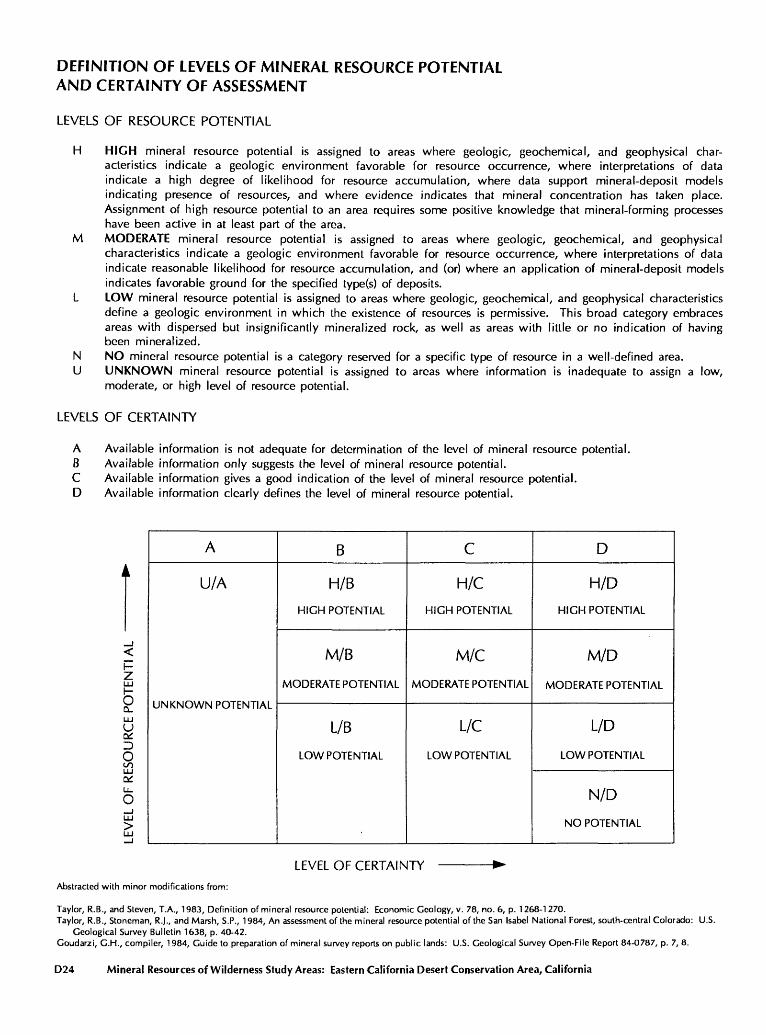
DEFINITION OF LEVELS OF MINERAL RESOURCE POTENTIAL AND CERTAINTY OF ASSESSMENT
LEVELS OF RESOURCE POTENTIAL
H HIGH mineral resource potential is assigned to areas where geologic, geochemical, and geophysical char acteristics indicate a geologic environment favorable for resource occurrence, where interpretations of data indicate a high degree of likelihood for resource accumulation, where data support mineral-deposit models indicating presence of resources, and where evidence indicates that mineral concentration has taken place. Assignment of high resource potential to an area requires some positive knowledge that mineral-forming processes have been active in at least part of the area.
M MODERATE mineral resource potential is assigned to areas where geologic, geochemical, and geophysical characteristics indicate a geologic environment favorable for resource occurrence, where interpretations of data indicate reasonable likelihood for resource accumulation, and (or) where an application of mineral-deposit models indicates favorable ground for the specified type(s) of deposits.
L LOW mineral resource potential is assigned to areas where geologic, geochemical, and geophysical characteristics define a geologic environment in which the existence of resources is permissive. This broad category embraces areas with dispersed but insignificantly mineralized rock, as well as areas with little or no indication of having been mineralized.
N NO mineral resource potential is a category reserved for a specific type of resource in a well-defined area.U UNKNOWN mineral resource potential is assigned to areas where information is inadequate to assign a low,
moderate, or high level of resource potential.
LEVELS OF CERTAINTY
A Available information is not adequate for determination of the level of mineral resource potential.B Available information only suggests the level of mineral resource potential.C Available information gives a good indication of the level of mineral resource potential.D Available information clearly defines the level of mineral resource potential.
2LUU
oCO LU
o_lLJJ >
A
U/A
UNKNOWN POTENTIAL
B
H/B
HIGH POTENTIAL
M/B
MODERATE POTENTIAL
L/B
LOW POTENTIAL
C
H/C
HIGH POTENTIAL
M/C
MODERATE POTENTIAL
L/C
LOW POTENTIAL
D
H/D
HIGH POTENTIAL
M/D
MODERATE POTENTIAL
L/D
LOW POTENTIAL
N/D
NO POTENTIAL
LEVEL OF CERTAINTY
Abstracted with minor modifications from:
Taylor, R.B., and Steven, T.A., 1983, Definition of mineral resource potential: Economic Geology, v. 78, no. 6, p. 1268-1 270.Taylor, R.B., Stoneman, R.J., and Marsh, S.P., 1984, An assessment of the mineral resource potential of the San Isabel National Forest, south-central Colorado: U.S.
Geological Survey Bulletin 1638, p. 40-42. Goudarzi, G.H., compiler, 1984, Guide to preparation of mineral survey reports on public lands: U.S. Geological Survey Open-File Report 84-0787, p. 7, 8.
D24 Mineral Resources of Wilderness Study Areas: Eastern California Desert Conservation Area, California
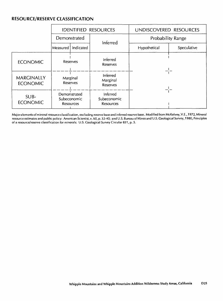
RESOURCE/RESERVE CLASSIFICATION
ECONOMIC
MARGINALLY ECONOMIC
SUB-
ECONOMIC
IDENTIFIED RESOURCES
Demonstrated
Measured
Rese
Indicated
;rves
I Marginal Reserves
Demonstrated Subeconomic
Resources
Inferred
Inferred Reserves
Inferred Marginal Reserves
Inferred Subeconomic
Resources
UNDISCOVERED RESOURCES
Probability Range
Hypothetical Speculative
1I
Major elements of mineral resource classification, excluding reserve base and inferred reserve base. Modified from McKelvey,V.E., 1972, Mineral resource estimates and public policy: American Scientist, v. 60, p. 32-40; and U.S. Bureau of Mines and U.S. Geological Survey, 1980, Principles of a resource/reserve classification for minerals: U.S. Geological Survey Circular 831, p. 5.
Whipple Mountains and Whipple Mountains Addition Wilderness Study Areas, California D25
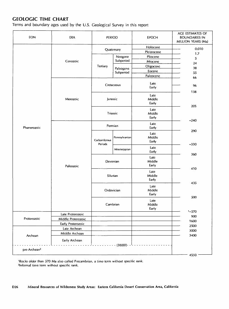
GEOLOGIC TIME CHARTTerms and boundary ages used by the U.S. Geological Survey in this report
EON
Phanerozoic
Proterozoic
pre-Archean2
ERA
Cenozoic
Mesozoic
Paleozoic
Late Proterozoic
Middle Proterozoic
Early Proterozoic
Late Archean
Middle Archean
Early Archean
PERIOD
NeogeneSubperiod
Tertiary _ ,
Jurassic
Triassic
Permian
Pennsylvanian Carboniferous
Mississippian
Devonian
Silurian
Ordovician
Cambrian
/ "3 Qf\f\7\
EPOCH
Holocene
Pleistocene
Pliocene
Miocene
Oligocene
Eocene
Paleocene
LateEarly
Late Middle
Early
Late Middle
Early
Late Early
Late Middle
Early
Late Early
Late Middle
Early
Late Middle
Early
Late Middle
Early
Late Middle
Early
AGE ESTIMATES OF BOUNDARIES IN
MILLION YEARS (Ma)
0.010
1.7
51 A
ia
55 66
96
1 id
205
290
,-330
360
410
A 1 f"
*>/ U
1600
£.J\J\J
3400
ACCC\
'Rocks older than 570 Ma also called Precambrian, a time term without specific rank. 2 lnformal time term without specific rank.
D26 Mineral Resources of Wilderness Study Areas: Eastern California Desert Conservation Area, California
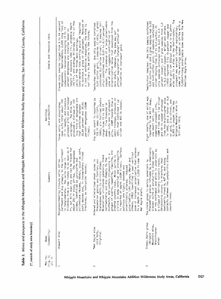
Tab
le 2
. M
ines
and
pro
spe
cts
in t
he W
hip
ple
Mounta
ins
and
Wh
ipp
le M
ounta
ins
Ad
diti
on
Wild
ern
ess
Stu
dy A
reas
and
vic
inity,
San
Bern
ard
ino C
ou
nty
, C
alif
orn
ia
[*,
outs
ide
of s
tudy
are
a bo
unda
ry]
Q.
Q.
Map
no.
Name
(fig.
3;
(com
modi
ty)
pi.
1)
Work! ngs
Summ
ary
and
production
Samp
le and
resource data
Stewart
mine
*War Eagle
mine
(Old Roth,
VIrginia)
Sleepy Burro
group
(Whi
pple
Mountain mine,
Brai
ntru
ster
mine)
Manganese-bearing
fiss
ure
veins
stri
kenorthwest
and
dip
steeply
to the
nort
heas
t in
fanglomerate.
The
veins
range
in
thic
knes
s fr
om a
few
inch
es to as
much as
5 ft
, but
thin down dip
and
can
be tr
aced
for
about
200
ft along
strike.
The
mang
anes
e oxides,
iden
tifi
ed as py
rolu
site
an
d ps
ilom
elan
e (Holmes, I954a),
occur
as soft,
sooty
masses an
d,
in incompletely filled
frac
ture
s, as botryoidal ma
sses
.
Alte
red
and
mineralized
shear
zones
in
Precambrian
gnei
ss and
Tertiary an
d Cr
etac
eous
mafic
to silicic
dikes.
Mine
rali
zed
stru
ctur
es generally
trend
northwesterly
and
dip
steeply
to th
e so
uthw
est,
and
contain
chrysocolla
in a
gangue of quartz,
hematite,
limo
nite
, an
d sh
eare
d country
rock.
Minor
pyri
te is
vi
sibl
e in
dump material an
d chalcopyrite
is re
port
ed at depth
(USBM
files).
Surface
outc
rops
ar
e highly leached
and
chloriticaIly
altered.
Indu
ced
polarization (IP) surveys
(Mar
sh and
others,
1982
) identified a
near vertical
zone of
increased
pola
riza
tion
th
at extends
to a
depth
of at
least
1,000
ft near th
e War
Eagle
shaft.
The
claim
group
is ma
inly
un
derl
ain
byPr
ecam
bria
n gn
eiss
intruded by a
chemically
bimodal
suite
of porphyritic
dikes
exce
pt
at th
e northwest
end
which
is un
derl
ain
by
a kl
ippe
of Te
rtia
ry volcanic rocks.
Chrysocolla
occu
rs in fr
actu
res
that
dominantly trend
N. 40°
W. and
along
cont
acts
be
twee
n th
e po
rphy
riti
c dikes
and
country
rock.
Three
adits
and
asso
ciat
ed
open
cuts total
about
190
ft in le
ngth
, an
d numerous
pros
pect
pits an
d bu
lldo
zer
scra
ping
s.
The
mine
has
produced a
minimum
of 126
long to
ns of manganese
ore
that
contained
betw
een
35.84
percent
and
39.66
perc
ent
manganese
(USBM
files).
The
main shaft
is re
port
ed as
15
0 ft deep (E
l Iiott,
1943
); si
x in
clin
ed shafts
range
from
15
to 90 ft
deep.
Five tr
ench
es or
open cuts and
12 prospect
pits.
USBM
records
show
a
small
tonn
age,
pr
oduc
ed in
1957,
that
contained
1 oz
silv
er an
d 46
5 Ib
copper.
Eight
shafts,
one
of which
was
repo
rted
to be 80 ft deep,
one
short
adit,
and
numerous prospect pits.
USBM
files
show
1 oz
si
lver
and
69
Ib co
pper
produced
from
th
e Br
aint
rust
er mi
ne
in 19
49,
and
a total
of 4.4
oz gold,
2 oz si
lver
, and
6,905
Ib co
pper
from th
e Whipple
Moun
tain
mi
ne in
191
1 an
d 19
13.
Eleven ch
ip sa
mple
s ranged fr
om 6 to
64
percent
manganese.
Approximately
2,600
long to
ns of
sube
cono
mic
resources
averaging
12 to
15
percent
manganese
are
infe
rred
based
on
leng
th of exposure (2
00 ft), pr
obab
le depth
(90
ft),
an
d av
erag
e th
ickn
ess
(2 ft
) of the
veins
at th
e three
main wo
rkin
gs.
Cons
ider
able
ha
nd sorting
would
be required
to ac
hiev
e a
grade
of 35
pe
rcen
t.
Beca
use
of
a lack of
ex
tens
ive
reso
urce
s, th
e mi
ne is
not
like
ly to
be
active in
th
e fu
ture
.
Twenty-two sa
mple
s:
One
chip
sa
mple
co
ntai
ned
0.01
oz
/ton
gold,
3 sa
mple
s (2 chip,
1 grab)
cont
aine
d 0.2
oz/t
on si
lver
; 12 sa
mple
s (all
chip)
cont
aine
d fr
om 0.
01 to
0.
17 pe
rcen
t co
pper
. Th
e pr
esen
ce of
a
large
polarizable
zone at depth
suggests co
ntin
uati
on of
mineralization below
that
de
velo
ped
from
th
e main shaft.
Howe
ver,
th
e zone ma
y not
attr
act
exploration
inte
rest
wi
thou
t an
indication of
coproduct
gold.
Twen
ty-f
our
samp
les:
On
e ch
ip sa
mple
co
ntai
ned
0.02 o
z/ton
gold
and
2 gr
ab samples
had
0.03
and
0.45 oz/ton gold;
12 samples
cont
aine
d si
lver
ra
ngin
g fr
om 0.
2 to
0.
4 oz/ton;
10
chip
sa
mple
s co
ntai
ned
from
0.01 to
2.
5 percent
copper,
and
7 grab samples
from 1.
2 to 6.2
perc
ent
copp
er.
Wrig
ht and
others
(1953) re
port
ed
5 to 10
pe
rcen
t copper and
$8/ton gold (a
t $35/oz)
from
a
1- to 2-
ft-
wide
zone
in a
dike
on th
e Br
aint
rust
er.
The
pros
pect
ma
y warrant
furt
her
exploration;
some of
th
e wo
rkin
gs appear on
st
rike
with a
5,00
0-ft
-lon
g po
lari
zabl
e zone ac
ross
the
New
Amer
ican
Eagle
mine
.
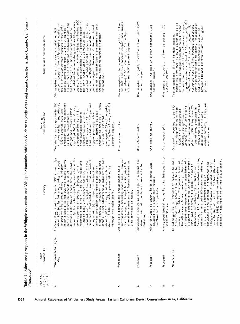
Tabl
e 2.
M
ines
and
pro
spec
ts i
n th
e W
hip
ple
Mou
ntai
ns a
nd W
hip
ple
Mou
ntai
ns A
dditi
on W
ilder
ness
Stu
dy A
reas
and
vic
inity
, S
an B
erna
rdin
o C
ount
y, C
alif
orn
ia
/"V
in/V
m i
£vV
Cont
inue
d
Map
no.
Name
(fig.
3;
(commodity)
pi.
1)
Work
! ng
sSu
mmar
y an
d production
Samp
le an
d resource da
ta
*New
Am
eric
an Eagle
mine
*Prospect
Pros
pect
Prospect
Prospect
*D &
W mi
ne
E o1 3 5"
A mi
nera
lize
d fa
ult
stri
kes
N. 35
° W. and
dips
abou
t 80
° SW.
in fo
liat
ed gn
eiss
in
trud
ed
by porphyritic
bimodal
dike
s.
A hi
ghly
ch
lori
tize
d di
ke fo
llow
s the
faul
t; quartz
seri
cite
alteration extends
a short
dist
ance in
to the
wall
rock
fr
om the
fault
zone
. Py
rite
, chaIcopyrite,
and
chalcocite
were
repo
rted
at
de
pth.
St
even
s (1
911)
re
ported a
main
vein 10 to
20 ft wi
de and
2,00
0 ft long wi
th se
vera
l smaller,
parallel ve
ins.
Wr
ight
and
othe
rs (1953)
reported
a
20-f
t-th
ick
lens that ex
tend
s to
a
depth
of 120
ft fr
om ju
st below
the
surf
ace
and
which
was
trac
ed for
50 ft
along
stri
ke.
IP su
rvey
li
nes
(Mar
sh an
d others,
1982
) identified a
polarizable
zone
about
5,00
0 ft lo
ng,
that
extends
to a
dept
h of
98
0 ft,
which
pass
es directly
thro
ugh
the
main sh
aft.
Gnei
ss is altered
along
and
adjacent to
a
nort
hwes
terl
y trending shear
zone
. Th
e 6-
ft-thick zo
ne is
li
moni
tic
with
chloritic
alterati
on above
and
siliceous
alteration
with
chrysocolla
belo
w.
Chrysocolla
occurs as coatings
in a
hema
titi
c sh
ear
zone that tr
ends
no
rthw
este
rly
in
felsite.
Minor
chrysocolla
occurs in
an altered
zone
adjacent to
a
shear
that tr
ends
northwesterly
in gn
eiss
.
A chrysocolla-stained
mafic
dike in
trud
ed in
to
gran
ite
gnei
ss.
Foliated gneiss is
intruded by fe
lsic
to
mafic
dike
s that range
from
a
few
inch
es to
severa
l fe
et th
ick.
Th
e ge
nera
l trend
of
the
dike
swarm
is no
rthw
este
rly.
De
posi
ts
at de
pth
are
repo
rted
to
be as
soci
ated
with
a quartz
po
rphy
ry di
ke (W
righ
t an
d ot
hers
, 19
53)
and
a po
rphy
riti
c dike in
diorite
(Clo
udma
n an
d ot
hers
, 1919;
Tuck
er an
d Sampson,
19
31).
Th
e or
e contained
azurite,
malachite, and
gold
(C
loud
man
and
othe
rs,
1919
).
Smal
l, scattered
pods of
chry
soco
lla
are
pres
ent
in fractures
and
along
cont
acts
be
twee
n dikes
and
coun
try
rock
in
th
e ma
in ad
it.
IP li
nes
(Mar
sh an
d ot
hers,
1982
) detected no
polarizable
bodi
es in
the
vici
nity
of the
D &
W sh
aft.
Two
shaf
ts,
one
repo
rted
ly 30
0 ft de
ep (W
righ
t an
d ot
hers,
1953
); se
vera
l cuts and
prospect pi
ts;
and
conc
rete
mi IIs
ite
foundations.
Wrig
ht an
d others (1953)
re
port
ed 70
0 tons of or
e,
prod
uced
prior
to 19
18,
that
averaged about
8 pe
rcen
t co
pper
. Er
ic
(194
8) reported 571
tons
that contained
10.7
perc
ent
copper produced prior
to1918.
USBM
files
show
pr
oduc
tion
from 19
12,
1918
,1919.
and
1935
that
averaged 0.
05 oz/ton go
ld,
0.12
oz
/ton
si
lver
, an
d 6.
2 pe
rcen
t co
pper
.
Four prospect pi
ts.
One
27-f
oot
adit.
One
shaI
low sh
aft.
One
pros
pect
pit.
One
shaft
repo
rted
to
be 75
0 feet de
ep wi
th more than
5,000
ft of underground
work
ings
(Wright
and
othe
rs,
1953), on
e 60
0 ft
ad
it,
and
seve
ral
prospe
ct
pits
. US
BM fi
les
show 75
tons of or
e, pr
oduc
ed in
19
13,
that yielded
7.98 oz
gold an
d 2 oz
si
lver
; copper co
nten
t,
if an
y, wa
s no
t re
cord
ed.
Six
samples:
one
grab
sa
mple
contained
0.9
percent
copp
er;
four ch
ip sa
mple
s contained
from
1.
0 to 2.9
percent
copper;
thre
e ch
ip
samp
les
cont
aine
d fr
om 0.2
to 1.4 oz/ton
silver;
two
chip
samples
contained
0.03 an
d 0.44 oz
/ton
gold.
No resources
could
be
calc
ulat
ed be
caus
e un
derg
roun
d wo
rkin
gs we
re
unsa
fe to
enter.
Wilson (1918) es
tima
ted
900
tons
of or
e av
erag
ing
4.17
percent
copp
er in
th
e main shaft, an
d 1,
175
tons
of dump
material of 3.61 percent
copp
er.
Eric (1948)
reported a
90,0
00-t
on resource wi
th 3.
8 pe
rcen
t copper.
Beca
use
of the
leng
th and
depth
of the
pola
riza
ble
stru
ctur
e an
d pa
st
prod
ucti
on,
the
mine
wa
rran
ts fu
rthe
r ex
plor
at ion.
Thre
e sa
mple
s:
two
contained
no gold or
silver,
and
0.01 an
d 0.27 percent
copp
er;
one
sample
contained
0.05 oz/ton go
ld,
0.4
oz/t
on
silver,
and
0.91 pe
rcen
t co
pper
.
One
sample:
no go
ld,
2 oz/ton silver,
and
2.25
pe
rcen
t copper.
One
sample:
no gold or
si
lver
de
tect
ed;
0.01
perc
ent
copper.
One
sample:
no gold or si
lver
de
tect
ed;
1.70
percent
copper.
Twel
ve sa
mple
s:
Six
of
11 ch
ip samples
contained
from
0.
01 to
0.16 oz/ton go
ld;
11
chip
sa
mple
s ra
nged
fr
om 0.
2 to
0.
4 oz
/ton
silver,
and
from 0.
01 to
1.7
perc
ent
copp
er;
1 gr
ab sa
mple
co
ntai
ned
1.03 oz/ton go
ld,
0.2
oz/t
on si
lver
, an
d 5.2
percent
copper.
No
resources
were defined
beca
use
unde
rgro
und
work
ings
we
re unsafe to enter.
Vredenburgh
and
othe
rs (1981) re
port
ed or
e valued at
be
twee
n $10
and
$14/ton
at $20.67/oz
gold
pric
es.
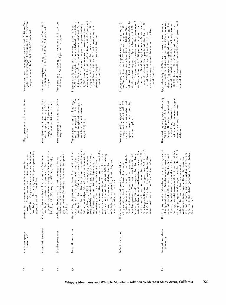
10 12
Atki
nson
group
Gnei
ss is
intruded by fe
lsic
and
mafic
(pat
ente
d)
dike
s.
Shear
zone
s an
d dikes
trend
abou
t N. 40
° W.
Chrysocolla
occu
rs as
fr
actu
re
coat
ings
in
is
olat
ed,
smal
l po
ds ge
nera
lly
associat
ed with he
mati
te.
Bluebird pr
ospe
ct
Chry
soco
lla
and
hema
tite
occur
as fracture
coat
ings
in my
loni
tic
gnei
ss.
Two
disc
onti
nuous
shear
zones
stri
ke an
d di
p N.
10°
E.,
45°
SE.
and
N. 80°
W.,
60°
NE.
Dick
ie prospect
A disconti
nuous
veinlet
of Chrysocolla
as
thic
k as
0.
4 ft trends no
rthw
este
rly
in
gnei
ss and
mafi
c dikes
intr
uded
by quartz
d io
rite
.
Eigh
t prospect pits an
d thre
e sh
afts
.
One
75-ft
adit and
a ve
rtical
shaft
approximately
30 ft
de
ep;
abou
t 17 prospect
pits and
bull
doze
r cuts.
One
prospect pit
and
a 10
-ft-
deep sh
aft.
Seve
n samples:
one
grab sample had
0.18
oz/ton
gold
; si
lver
ranged fr
om no
ne to
1.0 oz/ton;
copper ranged fr
om 1.
3 to
6.95 percent.
Thirteen samples:
no gold to
0.
04 oz/ton;
0.2
to 0.8
oz/t
on silver,
0.2
to 5.4
perc
ent
copp
er.
Two
samples:
trac
e go
ld;
trace
and
1.6
oz/ton
silver;
0.04
an
d 1.3
percent
copp
er.
13
^ n o 3
14
Turk
Si
lver
mi
ne
Malachite,
Chrysocolla, he
mati
te,
and
bari
te
occu
r as
ve
inle
ts,
pods
, an
d fr
actu
re
coat
ings
in 1- to 3-ft-thick breccia
of a
listric
faul
t.
The
faul
t, which
stri
kes
N.
60°
W. an
d dips 60
° NE
., can
be tr
aced
fo
r ap
prox
imately
450
ft an
d oc
curs
be
twee
n am
ygda
loidal andesite and
brec
cia
flow
s,
and
lime
ston
e, all
of Te
rtia
ry age.
A secondar
y structure, which
marks
the
contact
betw
een
the
lime
ston
e an
d overlying
sandston
e, ra
nges
from 2 to 4.
5 ft
thick
and
can
be tr
aced
fo
r about
100
ft along
stri
ke.
This zo
ne contains ba
rite
veinlets
, drusy
quar
tz,
limo
nite
, an
d brecciat
ed country
rock
.
Twin Lode mi
ne
Pods an
d ve
inle
ts of
qu
artz
, ma
lach
ite,
Ch
ryso
colla, ba
rite
, he
mati
te,
and
pyrolusi
te occur
in br
ecci
a of a
list
ric
faul
t an
d associated fault
spla
ys an
d tension
gashes.
The
faul
t strikes
N. 60
° W. an
d di
ps 60°
NE.,
separating Tertiary
volc
aniclastic and
sedimentary
rock
s.
The
faul
t contact
can
be tr
aced
fo
r ab
out
400
ft alon
g st
rike
and
rang
es from 0.
2 ft to
3
ft th
ick.
This fa
ult
appears
to be th
e sa
me fa
ult
as at
th
e Tu
rk Si
lver
mine.
Thre
e small
shaf
ts,
2 ad
its,
and
21 prospect pi
ts.
The
tota
l length of undergro
und
workings
is es
tima
ted
at
about
550
ft.
One
main ad
it,
abou
t 140
ft
long
, and
a short
adit
(?)
or cu
t on
a
separate fault
spla
y; on
e trench and
two
prospect pi
ts.
Eighteen chip samples:
one
sample co
ntai
ned
0.02
oz
/ton
go
ld,
nine
contained
from
0.
8 to
4.
4 oz/ton silver,
and
seve
n co
ntai
ned
from
0.
04 to
3.5
perc
ent
copper.
Appr
oxim
atel
y 2,
000
tons
of
su
beco
nomi
c resources
that
av
erag
e 2.
4 oz
/ton
of
si
lver
an
d 0.6
perc
ent
copper ar
e inferred
in the
main zo
ne.
It
is
to un
like
ly th
at su
ffic
ient
re
sour
ces
are
pres
ent
at depth
to wa
rran
t further
i nvest igation.
Eleven sa
mple
s:
One
grab sample co
ntai
ned
4.0
oz/t
on si
lver
an
d 0.
07 pe
rcen
t co
pper
; 10
chip
samples
cont
aine
d 0.3
to 10.8 oz/ton
silver;
9 of th
ese
samp
les
cont
aine
d 0.
04 to
0.
10 percent
copper.
Approximately
4,10
0 to
ns of subeconomic
resources
that
av
erag
e 7
oz/ton si
lver
an
d 0.
10 percent
copper ar
e inferred.
Cons
ider
ing
the
erra
tic
natu
re of
the
most
mi
nera
lize
d parts
of th
e fault,
it
is un
like
ly th
at su
ffic
ient
ad
diti
onal
resources
are
present
to wa
rran
t further
inve
stig
atio
n.
15De
cora
tive
stone
Buff
, gray
, and
rust-colored pl
aty
poly
gons
of
property
cherty an
d sandy
Iime
ston
e occur
over
an
ar
ea of
ab
out
250
acre
s.
The
individual
pieces,
deem
ed usable as
a
decorative
facing,
shou
ld measure
0.5
ft on two
sides
of an
y po
lygo
n and
rang
e fr
om 0.1
to 0.
3 ft
thick.
Two
vari
etie
s ar
e pr
esen
t:
a we
athe
red-
face
ty
pe wi
th an ir
on-o
xide
stained,
ch
erty
surface, and
a split-face
type
in
slabs
which
gene
rall
y oc
cur
below
the
surf
ace.
One
smal
l qu
arry
ap
prox
imat
ely
30 ft long an
d 10 ft
deep
. No
kn
own
reco
rd of
production;
howe
ver,
pa
llet
s in
the
area su
gges
t so
me ro
ck ma
y have be
en
ship
ped.
Approximately
1,00
0 to
ns of
us
able
weathered-
face ro
ck is inferred for
the
250-acre area;
depe
ndin
g upon the
depth
of we
athe
ring
, th
e am
ount
of
usable sp
lit-
face
ro
ck may
exce
ed
10,000 tons.
The
site
ma
y attract
future
interest de
pend
ing
on market de
velo
pmen
t and
competition.
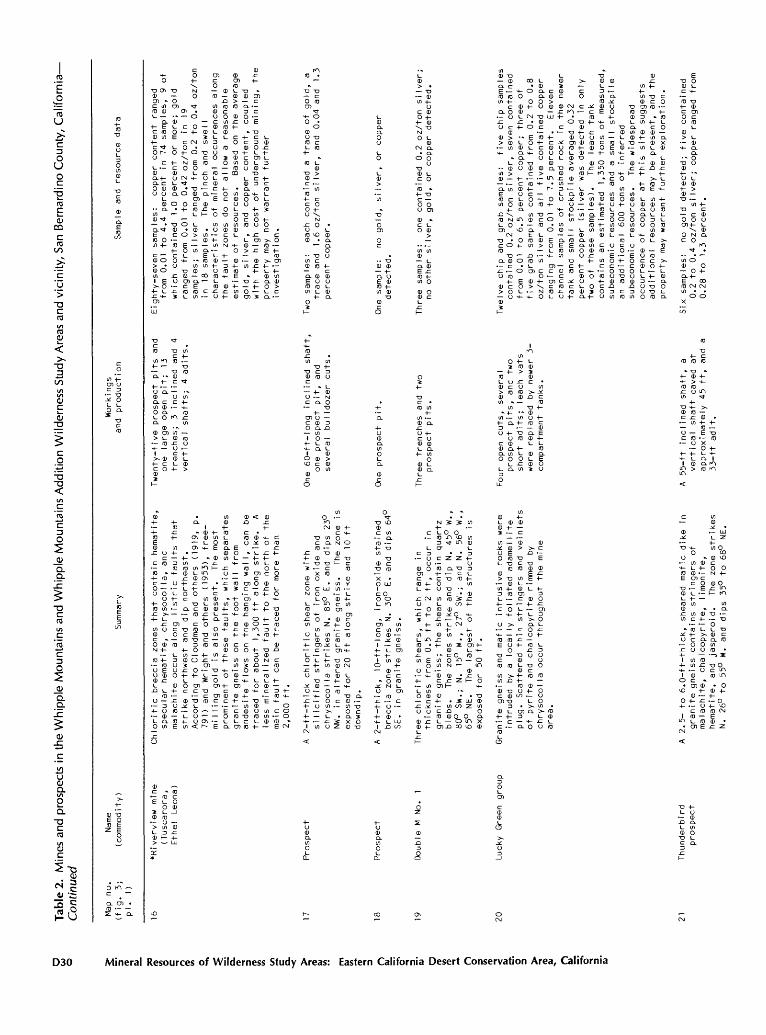
Tabl
e 2.
M
ines
and
pro
spec
ts i
n th
e W
hip
ple
Mou
ntai
ns a
nd W
hip
ple
Mo
un
tain
s A
dditi
on W
ilder
ness
Stu
dy A
reas
and
vic
inity
, S
an B
erna
rdin
o C
ount
y, C
alif
orn
ia
Contin
ued
Map
no.
(fig
. 3;
pi.
1)
Name
(com
mod ity
)Su
mmar
yWorkings
and
production
Sample and
resource da
ta
16*Riverview mi
ne
(Tus
caro
ra,
Ethe
l Le
ona)
18 19
Pros
pect
Pros
pect
Double M
No.
1
20Lucky
Gree
n gr
oup
21Th
unde
rbir
d pr
ospe
ct
Chloritic
brec
cia
zone
s th
at co
ntai
n he
mati
te,
specular
he
mati
te,
chrysocolla, an
d malachite
occu
r al
ong
list
ric
faul
ts that
strike no
rthw
est
and
dip
nort
heas
t.
Acco
rding
to Cl
oudm
an an
d others (1
919,
p.
791) and
Wrig
ht and
othe
rs (1953),
free
- milling
gold
is
also present.
The
most
prominen
t of these
faults,
which
sepa
rate
s gr
anit
e gneiss on the
foot wall from
andesite fl
ows
on th
e ha
ngin
g walI,
can
be
traced fo
r about
1,30
0 ft
along
strike.
A le
ss mine
rali
zed
faul
t to
the
nort
h of the
main
fa
ult
can
be tr
aced
for
more than
2,000
ft.
A 2-ft-thick
chloritic
shear
zone
with
silicifi
ed stringers
of iron oxide
and
chrysocolla
stri
kes
N. 85
° E. and
dips
23
° NW
. in
altered
granite
gnei
ss.
The
zone is
ex
pose
d fo
r 20
ft along
stri
ke and
10 ft
do
wnd
i p.
A 2-ft-th!
ck,
10-f
t-lo
ng,
iron-oxide st
aine
d br
ecci
a zo
ne st
rike
s N.
30
° E. an
d di
ps 64
° SE.
in granite
gnei
ss.
Three
chlo
riti
c sh
ears
, which
range
inthicknes
s fr
om 0.
5 ft to
2
ft,
occu
r in
gr
anit
e gn
eiss
; the
shea
rs co
ntai
n quartz
bleb
s.
The
zones
stri
ke and
dip
N. 45
° W.,
80°
SW.; N.
15°
W.,
27°
SW.;
and
N. 56
° W.,
65°
NE.
The
largest
of th
e st
ruct
ures
is
ex
pose
d for
50 ft.
Gran
ite
gnei
ss and
mafi
c in
trus
ive
rock
s we
re
intr
uded
by a
locally
foli
ated
ad
amel
lite
plug.
Scattered
thin st
ring
ers
and
vein
lets
of pyri
te an
d chalcopyrite ri
mmed
by
chrysoco
lla
occu
r throughout th
e mi
ne
area
.
A 2.
5- to 6.
0-ft
-thi
ck,
shea
red
mafic
dike
in
granite
gnei
ss contains stringers
of
malachit
e, ch
alco
pyri
te,
limo
nite
, hematite
, and
jasp
eroi
d.
The
zone
strikes
N. 26
° to 55
° W. and
dips
35
° to 68
° NE
.
Twen
ty-f
ive
prospect pits an
d on
e la
rge
open pit;
13
tren
ches
; 3
inclined an
d 4
vertical shafts;
4 ad
its.
One
60-ft-long inclined sh
aft,
on
e prospect pi
t, and
several
bulldozer
cuts.
One
prospect pit.
Thre
e tr
ench
es and
two
pros
pect
pi
ts.
Four
open cuts,
several
prospect pits,
and
two
short
adit
s; te
ach
vats
we
re re
plac
ed by newer
3-
compartment
tank
s.
A 55
-ft
incl
ined
shaf
t, a
vert
ical
shaft
caved
at
approximately
45 ft,
and
a 33-ft
adit.
Eighty-seven samples:
copper content
ranged
from 0.01 to
4.
4 pe
rcen
t in
74
sa
mple
s, 9
of
which
cont
aine
d 1.
0 pe
rcen
t or
mo
re;
gold
ranged from 0.01 to
0.
42 oz/ton
in 19
samp
les;
silver ra
nged
fr
om 0.
2 to
0.
4 oz/ton
in 18 sa
mple
s.
The
pinch
and
swell
char
acte
rist
ics
of mineral
occu
rren
ces
alon
g th
e fault
zones
do no
t al
low
a re
ason
able
es
tima
te of re
sour
ces.
Based
on the
aver
age
gold
, si
lver
, an
d co
pper
co
nten
t, coupled
with th
e high co
st of underground
mini
ng,
the
prop
erty
ma
y no
t warrant
further
i nve
stig
at ion.
Two
samples:
each co
ntai
ned
a tr
ace
of go
ld,
a tr
ace
and
1.6 oz
/ton
si
lver
, an
d 0.04 an
d 1.
3 percent
copp
er.
One
sample:
no go
ld,
silv
er,
or copper
dete
cted
.
Thre
e samples:
one
cont
aine
d 0.2
oz/ton silver;
no ot
her
silv
er,
gold,
or copper detected.
Twelve chip an
d grab samples:
five
ch
ip samples
cont
aine
d 0.2
oz/t
on silver,
seven
cont
aine
d fr
om 0.
01 to 6.
5 percent
copper;
thre
e of
fi
ve gr
ab sa
mple
s co
ntai
ned
from
0.2
to 0.8
oz/t
on si
lver
an
d all
five co
ntai
ned
copper
ranging
from
0.
01 to
7.5
perc
ent.
Eleven
channel
samp
les
of cr
ushe
d ro
ck in th
e newer
tank
an
d small
stoc
kpil
e av
erag
ed 0.
32
percent
copper (silver
was
dete
cted
in only
two
of th
ese
samp
les)
. Th
e leach
tank
contains an
es
tima
ted
1,35
0 to
ns of
me
asur
ed,
sube
cono
mic
resources
and
a small
stoc
kpil
e an
additional 60
0 to
ns of
inferred
sube
cono
mic
reso
urce
s.
The
wide
spre
ad
occurrence of copper at
th
is si
te su
gges
ts
additional resources
may
be pr
esen
t, an
d the
prop
erty
ma
y wa
rran
t fu
rthe
r exploration.
Six
samples:
no gold de
tect
ed;
five
co
ntai
ned
0.2 to
0.4
oz/t
on si
lver
; copper ra
nged
fr
om
0.28
to
1.3
perc
ent.
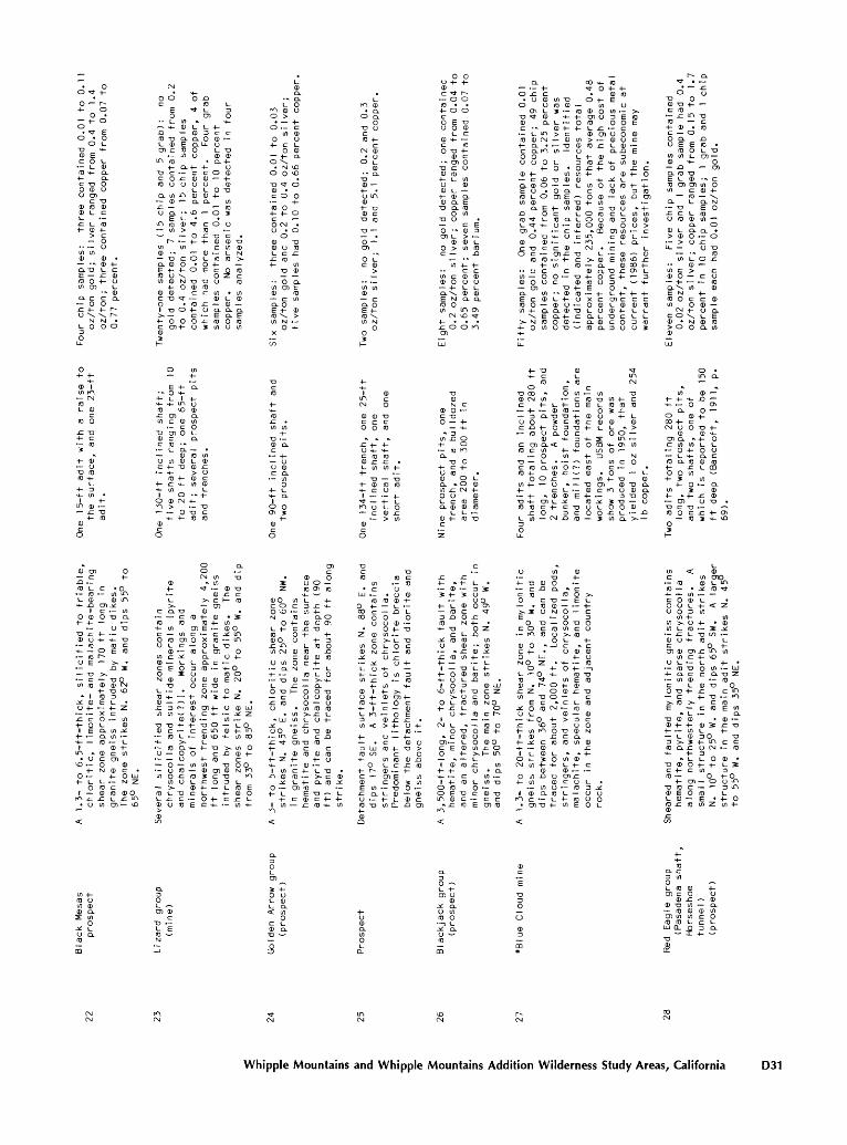
s: three contained 0.01 to 0. silver ranged from 0.4 to 1.4 contained copper from 0.07 to
0 0 .. 0CL "O L. E x:ro O -Hm CO
CL c c 0 0 x: -H -H0 ^ \
LOO3o
LL.
0-H -H
<B 1in m rsiroL 0
(D O
x: -o-H c ID2
-H 0 O-a roID *-
!_-H 3 <- in
1 -Hm 0 x: -o
-H ro0
5
CD CO
XI (D 1_ C ro i_ 0* -Q CO
1 CO 0 O
-H -H
0 O *- (D <- O (D l~~0 E
"O >- C t/> ro CD
-H« 1 ro
-* 0 EO -H Xx: c O-1- O L
1 E a.-H CL-*- ro
in 0. O c
\O o-H N
O -H 1- L.
O ro1 0
fO x: x: o in
es (15 chip and 5 grab): no ; 7 samples contained from 0.2
silver; 15 chip samples
1 to 4.6 percent copper, 4 of e than 1 percent. Four grab
ined 0.01 to 10 percent
rsenic was detected in four
zed.
-H
0Ol_0CL
r-r-
o
O-H
oin m0 in
i/i o Q. o "o
<4- "O(D CE ro>^ .
-Q 3:
oo0 iSi o ^o
L_ .+- -z. in
0in -* L.0 -H
cn<B
0 c .-H O LU N Zcro (B Oi_ x: mcnH- ID
ncQ. 0 OS -H -H ro o \in 0 N
H O0 0c -a *s
\ -o o>. H O Oc cn-H02
H-
O
E -H - O <-
-H L. 1**- *4_ inro ID-c enin c 0
c-o en O0 Cc ro « L. CL 0O 10 CDc -H -a +-
ro -H-H x: <-* - in
1 0o 0 rsin > O
<- -H0
<§
0 H
L-
C CL -O.~ c(D ro
-H inc i/)O ro enO l_ c0 in c -*(B l_c E OO 'SN 0
-O
l_ *ro <- 0 ~x; 3 <^-in i/) -
0"O "O 4-0 C ro L
ro CLo-o o o O roin 0 -c
in o >.ro i_ -al_ x: cCD o ro
O L. ro ro >- O -H
O E c O ro O Z c
o "a o ro0 roc x: i/) « i/i
0 L- 0ro x: 0
-H O CL CL CLc E CL EO x: (D O roO $ in O 10
in+-
Q.
-HO0CLinO!_CL
.ro i/)l_ CD0 x:> 00 cin 0
l_ - -H
-H -a-o cro ro
0 CLOCM I/) -o
» l/>*t 0 -O
0 x: c^ c H- ro CO0
ro -H 0 3:ro -H in
CO E 0Oc c -* inO x ro m O i_ "oID L en O
CL O -HL. CL c r> ro -<- Oo ro oO CD 0 E CMO c -o
o o -H N $ -H Zin 0 CO-H O 0 LUL- C <- .* Z0 . in .
-H "O O k_ Oc cm 0 -H m 0 10 *- i/i co
i_ <- -H -O >~ 10 OO c -0 0 -H
-H ro cto i/i "o O O 0 CO CD N fO
i_ x: o 3 i_0 -H I- ro EC L- -H 0 O O -H c x: l_E c ^- i/j <-
0 a.
- CL L- O
1*1 0 Oo > -H
O c in 0
O 0 -H c l_
O CD -H CL O ^
N VOo o ^o-o *t o 0 c o o
-H (D O -H -H O c O CM . 0 0
o 0 -a 0 -a ro Lex:x: ID-H (n
-a 0
O CLin co E0 ro c inCL O E -H CD(0 ^ >in N
O *-X
00
ocro-H*4-(Dx: .in in
-H-a 0 CLc -H OO 0c CL in
o-H l_ <- CL
AoOi 2
-H0
O
02 oZ (D
0O in i_ c O c 3O vo </>N ro
O -H 0l_ -H c x:(D O -H0O Ox: in i_in (NJ 0 ro
o in O c CL N-H ro -o CD l_ x: O -a H- O c ox: ID Oo LO
. in >~ LU in i_
.* x:OO 0O in cx: ^t co TD-H c
1 0 ro-H Z -H <- 0
1 in c -Hin 0 ro
-X L -HO co ro
-H L E-H c 0
1 in x:
CO
Oo O\ (D
-Hx: <--HCLO<D IT.-13
-H-H 3ro O
XJ0 ro-H
'L- O
CLO -aO 0 oro rox: !_O -H
"O 0
roc
0 ro-H 0
>~ c 0CL ro -^
"O *^ k-c -H -H(D »- in
gold detected; 0.2 and 0.3 ; 1.1 and 5.1 percent copper.
o i_C 0
in in0
11(D \in N 0O3
H-
-H
1in(XJ
0 <D
0 0
-C -HO -t-c roCD x:L- OT
-H13
-H 0
1 .-
fO o c0 "~
O
-a
(Dt/)
LU (D
CO c00 O
O
Z <D
l/l O0 N
V
L- 0-H in x:
0 YO -Hro -<-
-<- 1
3in <-H
3 LUro to
O-H f-
0 ~E 10x: CLO ro ~o
0cO oc(D
-H
rox: .to -H
T3ro IDo -H-H L-L- O0 x:> in
T3(D C roO
O CDro 0 -H
XI l_0 0O0 O -H T3in .
i_ o cx: (DO x:0 -H
O in 3 (D
i/i <--H >-
CD CO -H O cc 0 O E0 x: x:> -H 0 (D-a -H
c 0(D -H T3
ct/) (D CDL. c x:0 4-cn E
T3 OL- 0 -H L- CDt/) Q- -Q
,^._
<D
O
(D
inin
0
CO
no gold detected; one containec Iver; copper ranged from 0.04 1 seven samples contained 0.07 1
bar i urn.
-in -H -H
c cin c <D 00 O o o -H L L.CL\ 0 0E N Q. CLro O t/> in as
CM ID *-H x: O O fOCO
LU
o0N C
0O c -aO -H
» 3in X) o
-H O ID l""lCL
-a O-H c -HO (D 0 O L_CL O 0in x: CM -HO O 0i_ c ro ECL 0 0 ro
l_ L- 0 -H ro T3
Z
c
x: x:-H -H L 0 3 S$ -H 2 O O O
-H L CD O CT> ro c <*3 XI O x:ro N -H .
<- -a O Zc L -Q
j£ ro (D inO 0 » 0 > x: 0 .*x: ro i/i -H
I -0 L -H-H O CD (D in «- O L -Q .I O 3 0 LU
vo </> (- -a c z>~ o c O
O L ro ro N O-H x: L o
o <- ro c r~I
CM i_ . ro OO "a O E -H
c 0 oCO I- O CDOc E CD in x: oO -H >-( in « L.
I 0 (D x: in-H -H O CL
I -H ro L, in -oo ro O o E "a c 0 -ain 0 c c c x: ro E co ro
One grab sample contained 0.01 nd 0.44 percent copper; 49 chip
ined from 0.06 to 3.25 percent gnificant gold or silver was
he chip samples. Identified d inferred) resources total
235,000 tons that average 0.4f r. Because of the high cost of ining and lack of precious mete e resources are subeconomic at
) prices, but the mine may
er investigation.
(Dro -Hc>-0EiniDx:-Ht/) (D CL 0CO-H
-ac c 0a.-ox:o^i_ in OO -a-HOc-H 30OOC 0IDO3 ^-<- CO ~O -H E O CL in--0rO -HL+--H-HEC0L-HOXCCOCCCroo 00 O0t-00ro in-HCLCL0-oi_ocD-Ht-i_
^Ea--Hca.!_-oci_!_>. N 10 O 0) CL0 CO 3(D-HOmo'o^rocL3o o$
LL.
-H -0 0 *-<- c i_ in
ro ro CM0 c c
ooo- O in in -o0CMin c (D "o in -H cc -HL-HOEl_rororo -)- 0 (D o $ x: 3CLT3'O-HCDO -HLOO $crox:00 0CX1-HO3-0-HI_1- - > ro O CL O c OO
(B ><- 3 -<- S in CCOCL< oOCQ-t-ONinrocin -H-t- coo O in -H => N
o L ̂ in incoc ID a. i/) O (*- ID c «ro-H 0x:^0.O L
OOx: in-HTr 0t/) -H O T3 CD 0T3CL-H cL_ 0crOOCDQ. -H -00E-H 3"dO o-t-coL-^ ro -^ $ T3 ororoc-HC-ooi-OOCD
x:O 3COO-CL. -QL in CM X3 ro $ incL>~ 3O
LL.
o in 0 "o -H-H -0 0 O c -Q CL » cc ro ro O >-O c -a E t- . ro 0 -t->~S O N O CE - 0 3
O "o O "o Oc O c ro in c O ro 10 o >- ID
0O - -> x: . "cc -H O 0 0O LU -HON O Z *- ro
0 -H O -H >
ro ^t in E ro0 . !~~ O -H 0x: Z o 0 x: -ain -o o c
EC « c i_ ro-^ O ro CM roo i_ 0 0 <- O -H > 3 cx: vo 3 o O-H I/I fl O T3 0 N10 XI c CL
-H -* c (D ro in 0 4- 0 x:
1 1_ 0 L- « « -Ho -H $ O in 0CM t/) -H *- L -H c
0 <D O in -Q -a co x;-H t/) 0 C O L- . i/i u ro 3 j£
1 0 a. ro L o orOc L--HIDOO
co'o-HinEOL.
o~ -g a o 0 -a -t- c ro x: in -o ro c
-H 0 . ro c OO CL XIO E E ID
ro O l_ T3I/) I/) L CO (B -*- o XJ CO CL ro T3 E I- 0 « c ro CD co in O in c IB -H ID \
a. i_ a. N -o E O -c c i_ ID o ro 0 in
CL O 0 l_ a. CL > 0 O O > 0 x: LL, o T3 « roin L. O x:0
in c > x: 0 O c o -(_ IDCL^ in 0EN +.ID O C C (Bin O (B
CM -H O CLC 0 ^ i_ E0 N (B ro> o o a. in0
LU
o in CL
* ^I/) (B
-H -H t- -O <- O CT>
CL O O (B +-00 -1- cCM o O -0 -H
0 0 <-CO CL « -H Oc in in i_ i_ O -H O 0 l_ s- Q. Cro CL ro 0 (D-H x: i_ CDO O in
-H $ in-H O CL
in $ 0-H « -H x: (B CD O T3 . a c -a ro O c x: -1- ON ro 5 **- 10
O3
l_in < (Bc in coo ro CB L inID .* ro *t H in c O 0 L O O 1_ -H < Zo o 3 to
t/> -H int/> >~ o -H 010 L- (D f X.
0 o s- ro L.C O -Hco 0 co x: m m
in c -H ^o0 l_ l_ -H ID "D O m LU-H CL c c CL -o Z t/> 0 roc i_ 0 -a OO -a -t- x: cm c -H 'a fi
r ro >- c ro c (D E m
l_ . CL-000 . 0 CD -H -H 0 'S x: -0-H in i_ -H l_ 0 3O -03 >~ $ -H m c cID CL -C o CM . ro
<- -1-3 L L. O 0
O (B O -H -H L 3:c -H c in 3ro O -H O
-H CO O o l^ o ro c 3 mCD E O ro t-t- 0 E '-HOro x: ro in Z t/> -H
.CO c O O
CD x: CD0) -o in Q. (0 CD CD inen in in c O10 10 k- c L.
LU CL O 3 CL ± -H
Whipple Mountains and Whipple Mountains Addition Wilderness Study Areas, California D31
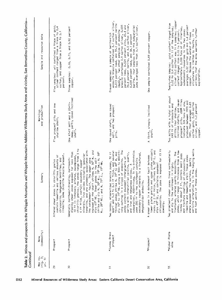
Tabl
e 2.
M
ines
and
pro
spec
ts i
n th
e W
hip
ple
Mou
ntai
ns a
nd W
hip
ple
Mo
un
tain
s A
dd
itio
n W
ilder
ness
Stu
dy A
reas
and
vic
inity
, S
an B
erna
rdin
o C
ounty
, C
alif
orn
ia
Contin
ued
Map
no.
(fig.
3;pi.
1)
Name
(com
mod it
y )
Work
ings
Su
mmar
y an
d production
Samp
le an
d re
sour
ce da
ta
29 30
Prospect
Pros
pect
Altered
shea
r zones
in chloritic
gnei
ss
cont
ain
hematite and
various
amounts
of
chry
soco
lla, ma
ngan
ese
dend
rite
s, and
limo
nite;
some chlorite br
ecci
a pr
esen
t.
Generally
northwest-trending,
northeast-
dipp
ing
shear
zone
s exposed
for
less th
an
10 ft in
in
tens
ely
altered, de
comp
osed
, chloriti
c gneiss;
the
zone
s range
from
3 to
6
ft th
ick,
contain
secondary
copp
er
minerals
, iron oxides in
clud
ing
specular
hema
tite
, an
d are
prob
ably
as
soci
ated
wi
th
the
deta
chment fa
ult.
Th
e shear
zone
exposed
at the
shaf
t strikes
N. 50°
W. an
d di
ps 65°
NE.
Shear
zone
s in
th
e ad
it
strike an
d di
p N. 30°
W.,
75°
SW.;
N.
50
° W.,
28°
NE.; an
d N.
75
° E.,
15°
NW.
Five pr
ospe
ct pits and
one
shallow
shaf
t.
One
47-ft
adit and
a 20-ft-
deep
, pa
rtly
caved
incl
ined
shaf
t.
Five samples:
all
cont
aine
d a
trac
e of go
ld;
silver content
rang
ed fr
om a
trac
e to
0.
4 oz/ton,
and
copper from a
trac
e to
2.
1 pe
rcen
t.
Thre
e sa
mple
s:
copp
er.
0.16
, 0.
71,
and
0.92
pe
rcen
t
=) n31
"Sun
day
Bras
s pr
ospe
ct
32 33
*Pro
spec
t
*Nickel
Plate
mi ne
Two
band
ed,
mineralized
brec
cia
zone
s, 50 ft
apart
and
5.3
to 6.
5 ft th
ick,
and
several
thin
ner
zones
stri
ke N.
35
° to 40
° W. an
d dip
70°
to 75°
NE.
along
a 30
0- to 400-ft-
long outc
rop
in a
klip
pe of an
desi
te.
The
zones
contain
abundant intergrowths of
ba
rite
with in
ters
titi
al ca
lcit
e, qu
artz
, an
d iron an
d ma
ngan
ese
oxides.
A su
bpar
allel, 40
0-ft
-lon
g,
5- to 6-ft-thick
zone
200
ft to
th
e so
uthw
est
cont
ains
se
cond
ary
copp
er minerals
in a
fractured,
amyg
dalo
idal an
desi
te.
A sh
ear
zone
in
a
detachment fa
ult
betw
een
lower
plate
gnei
ss and
upper
plate
volcanic
rocks
is 2
ft th
ick,
strikes
N. 70°
E. and
dips
45°
SE,
and
contains abundant
chry
socolla.
The
zone
is exposed
for
15 ft
down
d i p
.
Two
prominen
t sh
ear
zone
s trend
northwesterly
and
dip
to the
northeast
in hi
ghly
fr
actu
red, altered
quartz mo
nzon
ite.
Th
e zo
nes,
wh
ich
rang
e in
thickness
from a
few
inches to
about
2 ft,
contain
smaI
I pods
and
frac
ture co
atin
gs of
chrysocolla;
limo
nite
an
d hematite st
ain
these
zone
s wh
ere
expo
sed
on the
surface.
Quar
tz
sericite
al
tera
tion
is
in
the
hang
ing
walls
and
foot walls
of th
ese
zone
s.
One
caved
shaf
t, on
e caved
adit
, and
two
prospect
pits
.
A 15
-ft,
st
eepl
y in
clin
ed
shaf
t.
Two
adits
with
a
tota
l of about
640
ft of cr
ossc
uts
and
drif
ts;
four
sh
allo
w,
inclined sh
afts
; an
d seve
n prospect pits.
USBM fi
les
indicate 32
6 tons of ore,
produced be
twee
n 19
29 and
1941
, that av
erag
ed 0.
83
oz/t
on go
ld,
0.09
oz/ton
si
lver
, an
d 1.2
percent
copp
er.
Eleven samples:
a sample of
ba
rite
-ric
han
desi
te breccia
cont
aine
d 4.
7 oz/ton silver,
0.01
3 pe
rcen
t le
ad,
and
35.2 percent
barite
(BaS
O^).
Two
othe
r sa
mple
s of an
desi
te
breccia
cont
aine
d 0.
9 oz
/ton
si
lver
, 0.
035
perc
ent
lead
, 0.
024
percent
zinc
, 20.4 an
d 20.4 percent
barite,
and
4.0
oz/ton silver,
0.02
8 pe
rcen
t le
ad,
and
38.1
percent
bari
te.
Four
samples
from the
subp
aral
lel
zone averaged le
ss than 0.1
oz/ton si
lver
.
One
sample co
ntai
ned
0.69
percent
copper.
Twenty-two samples:
gold co
nten
t ra
nged
fr
om
0.02
to
0.
4 oz
/ton
in
11 of th
e sa
mple
s;
silv
er (0.2 oz
/ton
) wa
s in 6
samp
les;
co
pper
co
nten
t ranged from 0.
10 to 5 percent.
Appr
oxim
atel
y 3,
000
tons
of of
inferred,
sube
cono
mic
reso
urce
s in
the
two
zones
aver
ages
0.02 oz/ton gold an
d 1.4
percent
copp
er.
Beca
use
the
extent of
these
stru
ctur
es is limited
by faults,
it
is
unli
kely
th
at th
e mi
ne wa
rran
ts fu
rthe
r expI ora
tion
.
34*R
uthi
e pr
ospe
ct
(Hom
er cI
a i ms)
35 36
Pros
pect
*Van Horn mi
ne
ta a.
37,
38,
and
39
^Mon
arch
,^Manganese King,
and
Monu
ment
King mines
Foliated,
lowe
r pl
ate,
chlorite schist an
d gn
eiss
with randomly oriented veins
and
zone
s of
hy
drot
herm
ally
altered
rock
contain
one
or more of
the
following:
earthy li
moni
te an
d he
mati
te,
specular
hematite,
and
epid
ote.
Th
e zo
nes
range
from
1.0 to 4.
2 ft
th
ick,
are
expo
sed
for
10 to
20
ft,
and
trend
N. 30°
E. to N. 35
° W.
A
klip
pe of
an
desi
te co
ntai
ns a
40-f
t-
long
by
3.
1-ft
-thi
ck exposure of co
pper
silica
tes
and
iron ox
ides
wh
ich
strikes
N.
25°
E. an
d di
ps 15
° SE.
A 0.25-ft-
thick, ne
arly
horizontal zone th
at
cont
ains chrysocolla
occu
rs in
chlorite
brec
cia
just
be
low
the
contact
betw
een
upper
and
lower
plate
rock
s.
Psil
omel
ane
and
pyrolusite in
a
gangue of
ba
rite
, ca
lcit
e, li
moni
te,
hematite,
quar
tz,
and
brec
ciat
ed country
rock oc
cur
along
an an
tith
etic
be
ddin
g pl
ane
faul
t in
Tertiary sedimentary
stra
ta,
main
ly
Iimeston
e.
Lens
es an
d po
ds of
manganese
from
2 to 8
ft thick
crop
ou
t ma
inly
along
the
ridg
e cr
est
in th
e vicinity of
th
e ma
in
workings
. The
faul
t, which
strikes
N. 40
° W. an
d dips fr
om 45° to 75°
SW.,
ca
n be
traced for
approximately
1,50
0 ft
along
the
surface.
Seve
n prospect pi
ts.
Mass
ive
to botryoidal ps
ilom
elan
e occurs along
bedd
ing
plane
faul
ts in
Te
rtia
ry
sedi
ment
ary
stra
ta,
main
ly li
mest
one.
Lenses
an
d po
ds of ma
ngan
ese
1 to
10 ft
wide
an
d 50
to 10
0 ft lo
ng,
are
comm
only
associated with ba
rite
, ca
lcit
e, qu
artz
, brecciat
ed li
mest
one,
an
d hematitic
jasp
er.
The
main limestone
unit strikes
N.
20° to
50
° W.,
dips
fr
om 50
° to 80
° SW
.,
and
crop
s out
for
approximately
7,00
0 ft as
a
prominent
ridg
e.
Towa
rd the
southeast
part
of
this outcrop, the
limestone
splits
into two
narr
ow,
para
llel
un
its.
One
prospect pi
t.
Workings consist
of three
stop
es to
the
surface
from
a
drift
which
is connected
by a
winz
e to
a
crosscut
adit
that once se
rved
as a
hauI age
wa
y.
A sm
aI I
headframe, st
ulls
, an
d air
pipes
are
located
near
the
stop
e openings.
Appr
oxim
atel
y 20
prospe
ct
pits
and
mino
r ex
cava
tions
lie along
strike of the
faul
t.
Morse
and
Huds
on
(191
8, p.
3)
report 60
lo
ng
tons of
45
percent
manganese
ore
were
read
y fo
r shipment
in 19
18.
USBM
property files
(Trengov
e,
1958
) in
dica
ted
appr
oxim
atel
y 70
0 long tons
of ore
with manganese
content
rang
ing
from
25 to
42
percent
was
ship
ped
to
the
Wend
on,
Ariz
.,
stockpile
from
1953 to
19
55.
Seven
adit
s and
unde
rgro
und
stop
es,
7 trenches,
and
18
pits
, cu
ts,
and
shallow
shaf
ts.
Conflicting,
inco
mple
te records
show 16
0 to
ns of
46
percent
manganese
prod
uced
in
19
17-
1918 (Trask,
1950
; Wrig
ht
and
others,
1953;
Holm
es,
1954b) an
d 20
0 to
ns of
45
percent
manganese
(yea
rs
unspecified) (Tucker
and
Sampson, 19
43).
Trengove
(196
0) re
port
ed the
Mona
rch
prod
uced
1,100 tons that
ra
nged
fr
om 29.8 to 42
.1
percent
and
the
Mangan
ese
King
-Mon
umen
t King 600
tons
that ra
nged
from 29
to 46
percent
duri
ng World
War
I an
d in
term
itte
ntly
into th
e early
1950
's.
Seve
n samples:
one
sample of an
desi
te co
ntai
ned
0.05
oz
/ton
silver an
d 0.
53 pe
rcen
t copper;
thre
e sa
mple
s of
gneiss an
d schist co
ntai
ned
from
0.0043 to
0.
05 percent
copper.
One
sample contained
a tr
ace
of go
ld,
0.2
oz/t
on
silver,
and
1.95 pe
rcen
t copper.
Nineteen samples:
Eigh
teen
chip sa
mple
s contained
between
0.1
and
28.8
percent
manganese
(mos
t co
ntai
ned
less
th
an
1 pe
rcen
t manganese).
Because
the
structure
appears
to
dimi
nish
to
th
e north, th
e pr
oper
ty ma
y no
t wa
rran
t fu
rthe
r exploration.
Twen
ty-f
ive
samples:
Twenty-four
chip
sa
mple
s contained
between
0.03
an
d 22.8 percent
mang
anes
e, only
1 of which
had
greater
than
20 percent
mang
anes
e.
Because
of the
leng
th
and
persistence
of the
manganese-bearing
zone
, th
ese
prop
erti
es ma
y wa
rran
t further
expI ora
tion
.
Tabl
e 2.
M
ines
and
pro
spec
ts i
n th
e W
hip
ple
Mou
ntai
ns a
nd W
hip
ple
Mou
ntai
ns A
dditi
on W
ilder
ness
Stu
dy A
reas
and
vic
inity
, S
an B
erna
rdin
o C
ount
y, C
alif
orn
ia
Contin
ued
Map
no.
(fig
. 3;
pi
))
Name
(commod it
y )
Workings
Summary
and
production
Sample and
resource da
ta
40Prospect
41*H
elen
pr
ospe
ct
42Prospect
One- to 2-ft-thick, intensely
sheared,
chlorite breccia
zone strikes northeast to
east and
dips
30° to 50°
N. along
the
contact between
uppe
r an
d lower
plate
rock
s.
The zone is ex
pose
d for
100
ft and
is composed of gr
een
to br
own,
iron-oxide-
stained
metamorphosed granitic rock with
minor
secondary copper minerals an
d calcite.
At the collar of
th
e larger of
the tw
o in
clin
ed sh
afts
, th
e zone strikes
N. 69°
W. and
dips
35°
NE.
Localized
pegmatite dikes
and
siliceous zones
para
llel
to foliation in
chloriticaIly
altered
crystalline rocks.
The
zones
strike N. 50° to 80
° W. an
d di
p 70
° SW
. to
vertically,
range fr
om 3 to 10 ft
thick,
and
are
exposed for
up to 100
ft of
le
ngth
. A
few
dissected al
luvi
al fa
ns an
d po
orly
so
rted
fl
uvia
l deposits ar
e pe
rche
d along
the flanks of ridges.
Chlorite br
ecci
a be
low
contact wi
th overlying
volcanic br
ecci
a.
Chrysocolla occurs
most
ly
in po
ds an
d veinlets in
the chlorite
breccia; chrysocolla an
d hematite occur in
a 5-ft-thick sh
ear
zone
in
an
upper
pit
in
volcanic rocks.
Two inclined sh
afts
, on
e about
100
ft lo
ng and
the
other
10 ft long.
Two pi
ts an
d a
10-f
t-lo
ng
placer dr
ift.
Two smaII
pits
.
Four
samples:
two samples contained 0.06 and
0.01
oz
/ton
go
ld,
and
0.35 and
0.48 percent
copper.
Four
lode samples and
one pl
acer
sample
contained no significant amounts of
gold or
si Iver.
Two
samples:
both
contained a trace of gold and
siIv
er,
and
0.44 an
d 0.
43 percent copper.
43
^Crescent mine
Most
workings ar
e situated
in localized,
(pat
ente
d)
intensely
silicified, sericitized quartz
monzodiorite an
d metasedimentary gneiss
(Fro
st,
1980
).
Mineralized zones
(fau
lts
and
shears)
range in thickness from 1.8 to
5.2
ft and
cont
ain
one
or more of
the
following:
pyri
te,
limo
nite
, ea
rthy
hematite,
magnetite, chrysocolla,
malachite, quartz,
calc
ite,
chalcedony, an
d antigorite.
The
main zone averages 2.9
ft
thick an
d is exposed for
approximately 27
5 ft
al
ong
strike and
for
70 ft
do
wn di
p.
44
*Venus prospect
Localized
outcrops of quartz veins
and
fels
icin
trus
ive
lens
es ar
e present in up
per
plate
gnei
ss.
A quartz outcrop is 0.
5 to 0.7
ft
thick, 50 ft
long,
strikes N. 50
° W.,
and
dips
vertically.
An aplite outcrop is 20
ft
wi
de by
50 ft
lo
ng an
d contains zones
of
gray,
translucent quartz with limonite
pseudomorphs after pyrite.
Four
adits range
in le
ngth
fr
om 10 to 135
ft,
2 in
clin
ed sh
afts
, and
11
prospect pi
ts.
USBM
records sh
ow 55 tons of
ore,
pr
oduc
ed
in 1917
and
1943
, that contained 7 oz
go
ld,
6 oz si
lver
, an
d 8,615 Ib co
pper
.
None.
Thir
ty samples:
Twenty-one of
26
ch
ip samples
contained gold ra
ngin
g fr
om 0.0038 to 0.
71
oz/ton; copper content ranged fr
om 0.
07 to
7.9
perc
ent
in 26
chip sa
mple
s; silver
content ra
nged
fr
om 0.
014
to 0.4
oz/ton
in 25
of
the ch
ip sa
mple
s.
Approximately 17,000
tons
of id
enti
fied
(i
ndic
ated
inferred)
resources containing an average of 0.
14
oz/ton gold and
2.4
percent copper are
estimated
in the
main zo
ne.
Because of
the
limited
resources and
high
co
st of
underground mining,
the
resources are
considered subeconomic at current (1
986)
prices of go
ld an
d co
pper
.
Three
samples:
one sample of
fr
actu
red
granite
contained 0.01 percent thorium.
45*C
oppe
r Basin
mi ne
46 47
Copp
er Cr
est
group
(prospect)
Outp
ost
claim
(prospect)
48^Quadrangle
Copp
er
group
(pro
spec
t)
A chaI cop
yite-, bo
rnit
e-,
and
chalcocite-
bear
ing
porp
hyry
-cop
per-
type
deposit
capp
ed
by a
seco
ndar
y copper-
and
iron
-bea
ring
go
ssan (m
ostl
y ma
lach
ite
and
limo
nite
).
The
deposit
may
be related
to an in
trus
ion
of ad
amel
lite
in
to granite
gnei
ss (A
nder
son
and
Fros
t, un
pub.
data,
198)
).
Nort
hwes
t-tr
endi
ng shear
zone di
ps 34
° to
83°
SW.
in gn
eiss
. Th
e zo
ne ranges fr
om 3.
5 to
4.
0 ft
th
ick,
contains limonite and
chryso
colla
with minor
barite,
and
is
disc
ontinuously
exposed
for
0.5
mi.
Nort
hwes
t-tr
endi
ng altered
shear
zone di
ps
southw
esterly
in gneiss and
crystalline
pIutonic ro
cks.
The
zone ra
nges
fr
om 2.
0 to
4.7
ft th
ick,
contains ch
ryso
coll
a an
d sp
ecular hematite an
d ba
rite
, and
is
inte
rmit
tent
ly exposed
for
about
1,00
0 ft.
The
zone is on
strike with (and ma
y be
an
extension
of)
a zo
ne explored by
pros
pect
pi
ts along
the
west
ern
edge of
the
Quadrangle Co
pper
cl
aim
grou
p.
Geol
ogical
ly co
mple
x area consisting of
meta
sedimentary
gneiss an
d metagranite
intrud
ed by granitic rocks
and
fels
ic to
mafic
dike
s.
Abun
dant
ch
ryso
coll
a oc
curs
in
se
ams,
pods,
and
veinlets pa
rall
el to,
and
in,
frac
ture
s that ar
e concordant to
the
northwest
trend
of ro
ughl
y parallel
listric
faul
ts that bound
the
area to
the
east
and
west
.
Nume
rous
sh
afts
, ad
its,
pi
ts,
dril
l pa
ds,
and
buildi
ngs
thro
ugho
ut th
e mi
ne ar
ea.
Two
pits
, on
e 15-ft
inclin
ed
adit,
and
two
shafts 20
and
25 ft deep.
Two
shal
low
shafts.
Five sh
afts
(m
ostl
y in
clined),
4 ad
its,
3 tr
ench
es,
and
28prospect pi
ts.
Eighteen samples:
Nine
of
10 ch
ip sa
mple
sco
ntai
ned
from
0.
0007
to
0.11 percent
copp
er;
8 ot
her
samp
les
contained
as much as
1.8
percent
copper.
From 7 to
11 million
tons
of
1 to
2
perc
ent
copp
er ar
e es
tima
ted
(Dra
vo
Corp., 1974); th
ese
resources
are
located
outs
ide
the
study
area and
are
curr
entl
y (1986) subeconomic.
Thre
e samples:
two
contained
a tr
ace
and
0.04
2 oz
/ton
gold.
The
samples
also
contained
0.2,
0.6, an
d 1.4
oz/t
on silver,
and
0.22
, 2.10,
and
2.85 pe
rcen
t co
pper
. Be
caus
e of
th
e en
cour
agin
g le
ngth
of
th
e indicated
structure
and
some fa
vora
ble
samp
le analyses,
the
prospect ma
y wa
rran
t fu
rthe
r investigation.
Four
samples:
thre
e contained
a tr
ace
to 0.
363
oz/t
on go
ld an
d from 0.07 to
4.
40 pe
rcen
t co
pper
. Be
caus
e of
the
favo
rabl
e gold
analyses
in th
e samples, th
e prospect
warrants fu
rthe
r in
vest
igat
ion.
Twenty-nine
samp
les:
Ni
ne of
31 ch
ip sa
mple
s co
ntai
ned
between
a tr
ace
and
0.35
oz
/ton
gold;
most ch
ip sa
mple
s co
ntai
ned
0.2
to 0.
6 oz
/ton
si
lver
(2
co
ntai
ned
1.8
and
4.0
oz/ton); copper content
ranged from 0.
01 to
6.
9 pe
rcen
t.
Appr
oxim
atel
y 16,000 t
ons
of
sube
cono
mic
reso
urce
s co
ntai
ning
2
percent
copp
er are
infe
rred
in the
larg
er of
tw
o st
ruct
ures
on
th
e pr
oper
ty.
Beca
use
of th
e le
ngth
of
th
e structure
and
favo
rabl
e sa
mple
analyses,
the
prop
erty
may
warrant
furt
her
i nvest igation.
49 50 51
*Lor
tie
group
(pro
spec
t)
*Pea
cock
Co
pper
group
(pro
spec
t)
*Gold
Crow
n group
(pro
spec
t)
Most
wo
rkings ar
e lo
cate
d near a
contact
betw
een
mafi
c in
trus
ive
rock
s, porphyritic
gran
ite,
an
d gneiss.
Shea
red
zone
s contain
vary
ing
amounts
of chrysocolla
as fracture
coat
ings
, he
mati
te,
and
jasp
er.
Most
volc
anic
rocks
and
altered
(ser
icit
ic)
gneiss
ic rocks
are
chloritized.
Chrysoco
lla
occu
rs as
fracture coatings
in
granit
e gneiss and
an altered
mafic
intrusive
body;
an ir
regu
lar
bari
te-f
iI Ied
frac
ture zo
ne is also in
the
gnei
ss.
Most
of th
e occurrences
are
moderately to
heavil
y st
aine
d wi
th he
mati
te.
A shear
zone in
silicic
to intermediate
intrus
ive
rock
s co
ntai
ns chrysocolla, as
fr
actu
re coatings,
and
abun
dant
he
mati
te
stai ns.
Seve
n pr
ospe
ct pi
ts an
d a
shallow
shaft
on the
main
zone;
one
isol
ated
pr
ospect
pit.
Two
short
adit
s, on
e pros
pect
pi
t, an
d ruins
of a
loading
ramp
.
One
shal
low
incl
ined
ad
it,
three
prospect pi
ts,
and
ruin
s of
a
load
ing
ramp
.
Five samples:
thre
e contained
a tr
ace
of go
ld,
two
cont
aine
d 0.007
and
0.174
oz/ton gold;
silv
er ra
nged
fr
om 0.
4 to 1.
0 oz
/ton
(f
our
samples);
copper ranged fr
om 0.
30 to 3.
90
percent.
Thre
e samples:
two
contained
0.01
8 and
0.04
5 oz/ton gold;
thre
e co
ntai
ned
0.2, 0.4, and
1.0
oz/ton si
lver
; one
sample had
0.43
pe
rcen
t copper an
d on
e co
ntai
ned
36.2 percent
barite.
The
prop
erty
ma
y warrant
further
inve
stig
atio
n because
of fa
vora
ble
gold
content
in th
e two
samples.
One
composite
grab sample fr
om the
dump
sco
ntai
ned
0.39
2 oz/ton gold an
d 2.
17 pe
rcen
t copper.
The
prop
erty
ma
y wa
rran
t further
stud
y because
of the
gold co
nten
t in
th
e sample.
Tabl
e 2.
M
ines
and
pro
spec
ts i
n th
e W
hip
ple
Mou
ntai
ns a
nd W
hip
ple
Mou
ntai
ns A
dditi
on W
ilder
ness
Stu
dy A
reas
and
vic
inity
, S
an B
erna
rdin
o C
ount
y, C
alif
orn
ia-
Con
tinued
Map
no.
(fig
. 3;
pi.
1)
Name
(com
mod
i ty
)Wo
rk! ngs
Summ
ary
and
production
Sample and
reso
urce
da
ta
S
a.
52*BIue
Heaven group
(pro
spec
t)
n SL
53*BIue
Heav
en
Exte
nsio
n (prospect)
Meta
sedi
mentary
gnei
ss an
d metagranite
is
intruded
by fe
lsic
to
mafic
dikes
and
gran
itic pl
ugs(
?).
Chry
soco
lla
and
hematite
occur
as pods,
stri
nger
s, an
d ve
inle
ts ge
nera
lly
para
llel
to
th
e northwest
trend
of li
stri
c fa
ults
in
the
area
. The
main zone is ap
prox
imat
ely
1,00
0 ft
lo
ng.
Scattered
workings
in pl
uton
ic,
volc
anic
, and
metamorphic
rock
s.
Mineralized
structures
(gen
erally shear
zone
s) within and
along
cont
acts be
twee
n dissimilar ro
cK types
cont
ain
chrysocolla
and
hema
tite
, and
in
plac
es ba
rite
.
Two
major
groups of
wo
rkin
gs
total ing
10 ad
its,
10
shaf
ts,
2 trenches,
and
29
pros
pect
pits.
USBM
files
show
17
tons of
or
e,
shipped
from
the
Black
Meta
l mine (at
the
northwest
corn
er of the
clai
m gr
oup)
in
19
41 an
d 19
42;
the
ore
cont
aine
d 5
oz gold,
2 oz
si
lver
, and
1,36
6 Ib
co
pper
.
Five pi
ts,
one
tren
ch,
thre
e short
adit
s, one
collap
sed
adit
, an
d two
inclined
shaf
ts.
Fort
y-fi
ve sa
mple
s:
Twenty-one of
38 ch
ip
samples
cont
aine
d fr
om 0.
006
to 1.56 oz
/ton
go
ld;
34 ch
ip samples
contained
from
0.
02 to
2.
75 pe
rcen
t copper;
1 chip sample co
ntai
ned
0.7
oz/ton silver wh
ile
others ge
nera
lly
had
from 0.
2 to
0.4
oz/ton si
lver
. Be
caus
e of
th
e la
rge
numb
er of
samples
with fa
vora
ble
gold content, th
e pr
oper
ty warrants further
inve
stig
atio
n.
Fifteen
samp
les:
gold ra
nged
fr
om a
trac
e to
0.976
oz/ton in 10
samples, an
d av
erag
ed
appr
oxim
atel
y 0.
17 oz/ton;
silv
er ra
nged
fr
om
0.2
to 0.6
oz/t
on
in 10 sa
mple
s; copper
ranged fr
om 0.
02 to
4.
70 percent
in 7
samples.
Beca
use
of th
e nu
mber
of
sa
mple
s with fa
vora
ble
gold co
nten
t, th
e property
warrants further
inve
stig
atio
n.
54*B
onus
group
(pro
spec
t)
55^K
lond
ike
group
(pro
spec
t)
Chrysocolla
and
malachite
occu
r in
a
gangue of
hematite,
quar
tz,
and
faul
t gouge
in sh
ears
an
d fa
ults
of a
quar
tzo-
feld
spat
hic
gneiss.
The
prominent
shear
and
fault
zones, which
range
from
1 to 5
ft th
ick
and
have
er
ratic
lengths
of ex
posu
re,
strike
nort
hwesterly
and
dip
to the
southwest.
Most
co
ntai
n chrysocolla
and
hematite.
Quartz blebs
and
fracture fi
llin
gs oc
cur
in
shear
zone
s that st
rike
northwesterly
and
dip
to the
southwest
in qu
artz
o-fe
ldsp
athi
c gneiss in
trud
ed by ma
fic
dike
s.
The
shear
zone
s co
ntai
n li
moni
te an
d he
mati
te with
occasional fl
ecks
of
ma
lach
ite
and
chry
socolla, an
d oxides of
ma
ngan
ese.
The
zones
trend
northwesterly
with
th
e re
gion
al
stru
ctural gr
ain,
ar
e discontinuous
along
stri
ke,
and
rang
e fr
om a
few
inch
es to 5
ft
thic
k.
One
incl
ined
sh
aft,
se
ven
adits
and
associated cuts
to
tal
about
300
ft lo
ng;
three
pros
pect
pits.
Three
groups of workings to
tal
5 ad
its,
12 sh
afts
, an
d 13
pros
pect
pits.
USBM
re
cord
s sh
ow the
Klondi
ke
Mine pr
oduc
ed 99
tons of
or
e, intermittently be
tween
1906 an
d 1941,
that
cont
aine
d 43
oz
gold and
13
oz si
Ive
r.
Fift
een
samp
les:
Six
of
10 chip samples
contained
from 0.
005 to 0.687
oz/ton go
ld;
9 chip samples
cont
aine
d fr
om 0.
12 to
1.6
percent
copp
er;
silver in all
samples
was
greater
than
or eq
ual
to 0.
6 oz
/ton
. Th
e fa
vora
ble
gold content
of so
me of
th
e sa
mple
s in
dica
tes
the
prop
erty
may
warrant
furt
her
i nvest iga
tion
.
Seventeen
samples:
thre
e of
ni
ne chip sa
mple
s co
ntai
ned
0.02
, 0.
06,
and
0.53 oz
/ton
gold;
eigh
t ch
ip sa
mple
s co
ntai
ned
betw
een
0.03 and
0.52
percent
copp
er;
five of seven
grab
samples
cont
aine
d 0.006, 0.01,
0.22
8, 0.
260,
an
d 0.88 oz
/ton
gold.
A fe
w fa
vora
ble
gold
anal
yses
in
dica
te the
prop
erty
ma
y wa
rran
t fu
rthe
r investigation.
Mineral Resources of Wilderness Study Areas: Eastern California Desert Conservation Area, California
This volume was published as separate chapters A-D
U.S. GEOLOGICAL SURVEY BULLETIN 1713
DEPARTMENT OF THE INTERIOR
DONALD PAUL MODEL, Secretary
U.S. GEOLOGICAL SURVEY
Dallas L. Peck, Director
CONTENTS
[Letters designate the separately published chapters]
(A) Mineral Resources of the Castle Peaks Wilderness Study Area, San Bernardino County, California, by David A. Miller, James G. Frisken, Robert C. Jachens, and Diann D. Gese.
(B) Mineral Resources of the Turtle Mountains Wilderness Study Area, SanBernardino County, California, by Keith A. Howard, Jane E. Nielson, Robert W. Simpson, Richard W. Hazlett, Henry V. Alminas, John K. Nakata, and John R. McDonnell, Jr.
(C) Mineral Resources of the Fort Piute Wilderness Study Area, San BernardinoCounty, California, by Jane E. Nielson, James G. Frisken, Robert C. Jachens, and John R. McDonnell, Jr.
(D) Mineral Resources of the Whipple Mountains and Whipple Mountains Addition Wilderness Study Areas, San Bernardino County, California, by Sherman P. Marsh, Gary L. Raines, Michael F. Diggles, Keith A. Howard, Robert W. Simpson, Donald B. Hoover, James Ridenour, Phillip R. Moyle, and Spencee L. Willett.


GPO 585-045/9767