mineral resources of the - usgs · mineral resources of the big hatchet mountains wilderness study...
TRANSCRIPT

Mineral Resources of theBig Hatchet Mountains Wilderness StudyArea, Hidalgo County, New Mexico
U.S. GEOLOGICAL SURVEY BULLETIN 1735-C
- * i-***v*fc«$ ,Jjr
,YNEW MEXICO


Chapter C
Mineral Resources of theBig Hatchet Mountains Wilderness StudyArea, Hidalgo County, New Mexico
By HARALD DREWES, H.N. BARTON, andW.F. HANNAU.S. Geological Survey
D.C. SCOTTU.S. Bureau of Mines
U.S. GEOLOGICAL SURVEY BULLETIN 1735
MINERAL RESOURCES OF WILDERNESS STUDY AREAS- SOUTHWESTERN NEW MEXICO

DEPARTMENT OF THE INTERIOR
DONALD PAUL MODEL, Secretary
U. S. GEOLOGICAL SURVEY
Dallas L Peck, Director
UNITED STATES GOVERNMENT PRINTING OFFICE: 1988
For sale by theBooks and Open-File Reports SectionU.S. Geological SurveyFederal CenterBox 25425Denver, CO 80225
Library of Congress Cataloging-ln-Publicatlon Data
Mineral resources of the Big Hatchet Mountains Wilderness Study Area, Hidalgo County, New Mexico.
(Mineral resources of wilderness study areas southwestern New Mexico ; ch. C) (U.S. Geological Survey bulletin ; 1735-C) (Studies related to wilderness)
Bibliography: p.Supt. of Docs, no.: I 19.3:1735-C1. Mines and mineral resources New Mexico Big Hatchet Mountains
Wilderness. 2. Big Hatchet Mountains Wilderness ( N.M.) I. Drewes, Harald, 1927- . II. Series. III. Series: U.S. Geological Survey bulletin ; 1735-C IV. Series: Studies related to wilderness wilderness areas. QE75.B9 no. 1735-C 557.3 s [553'.09789'693] 88-600014 [TN24.N6]

STUDIES RELATED TO WILDERNESS
Bureau of Land Management Wilderness Study Areas
The Federal Land Policy and Mangement Act (Public Law 94-579, October 21,1976) requires the U.S. Geological Survey and the U.S. Bureau of Mines to conduct mineral surveys on certain areas to determine the mineral values, if any, that may be present. Results must be made available to the public and be submitted to the President and the Congress. This report presents the results of a mineral survey of a part of the Big Hatchet Mountains (NM-030-035) Wilderness Study Area, Hidalgo County, New Mexico.


CONTENTS
Summary ClAbstract Cl Character and setting Cl Identified mineral resources C4 Mineral resource potential C4
Introduction C5 Appraisal of identified resources C6
Present investigation C6 Mining history C7 Commodities C7
Base and precious metals C7 Sheridan mine C7 Lead queen mine C9 Stream-sediment samples C9
Carbonate rocks Cll Gypsum Cll Sand and gravel Cll
Assessment of mineral resource potential Cll Geology Cll Geochemistry C14 Geophysics C15 Mineral resource potential C20
References cited C21 Appendix C23
PLATE
[Plate is in pocket]
1. Mineral resource potential and geologic map of the Big Hatchet Mountains Wilderness Study Area, Hidalgo County, New Mexico
FIGURES
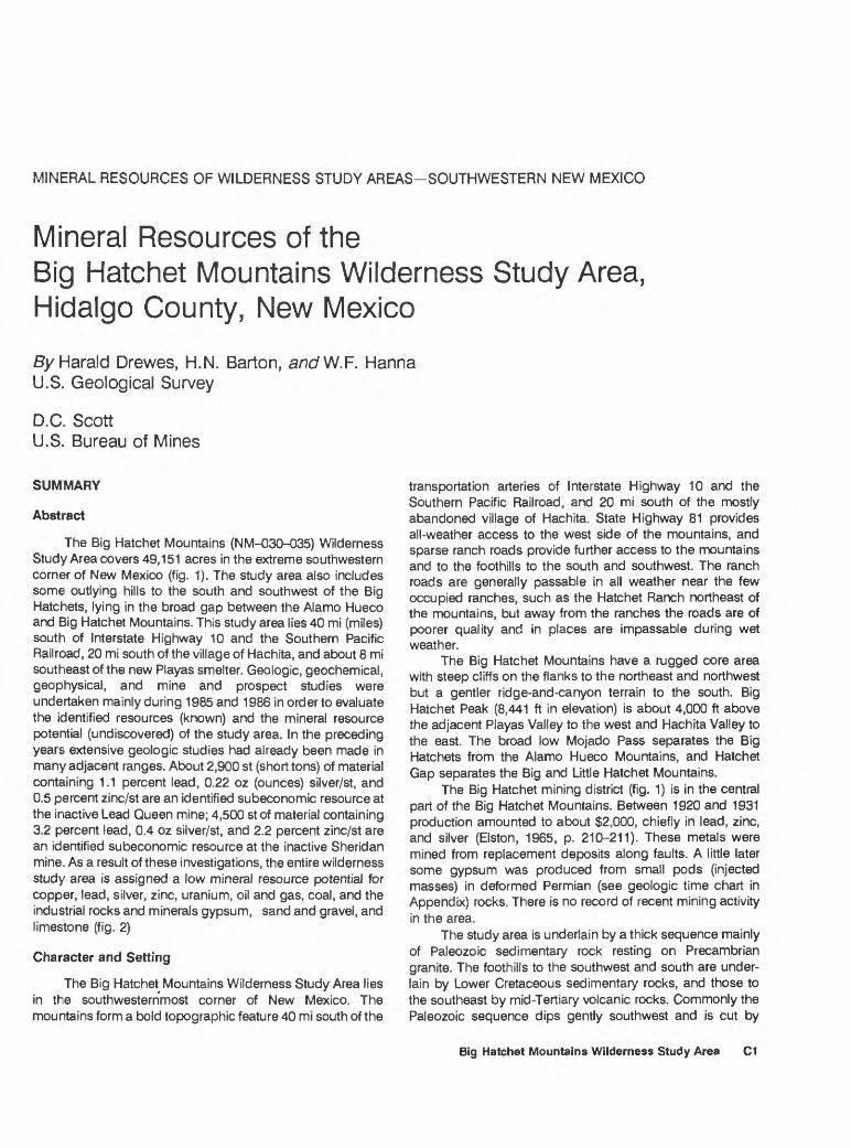
1. Index map showing location of Big Hatchet Mountains Wilderness Study Area C2
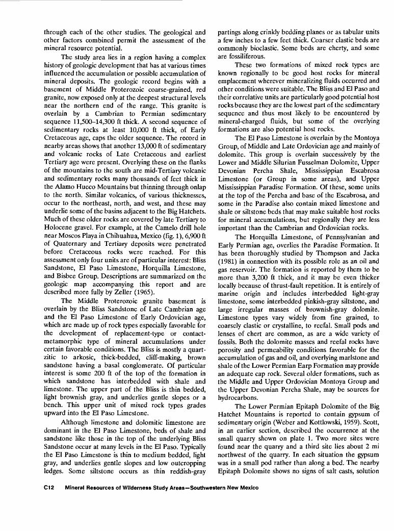
2. Summary map showing sites of subeconomic identified resources and mineral resource potential in the Big Hatchet Mountains Wilderness Study Area C3
3. Mine, prospect, and claim map of a part of the Big Hatchet Mountains Wilderness Study Area C8
4. Distribution of oil and gas leases in and near the Big Hatchet Mountains Wilderness Study Area CIO
Contents

5. Bouguer gravity anomaly map of the Big Hatchet Mountains Wilderness Study Area C17
6. Aeromagnetic anomaly map of the Big Hatchet Mountains Wilderness Study Area CIS
7. Map showing terranes inferred to be underlain by rocks having distinctive magnetizations and compositions C19
VI Contents
MINERAL RESOURCES OF WILDERNESS STUDY AREAS-SOUTHWESTERN NEW MEXICO
Mineral Resources of theBig Hatchet Mountains Wilderness Study Area,Hidalgo County, New Mexico
SyHarald Drewes, H.N. Barton, a/7c/W.F. Hanna U.S. Geological Survey
D.C. ScottU.S. Bureau of Mines
SUMMARY
Abstract
The Big Hatchet Mountains (NM-030-035) Wilderness Study Area covers 49,151 acres in the extreme southwestern corner of New Mexico (fig. 1). The study area also includes some outlying hills to the south and southwest of the Big Hatchets, lying in the broad gap between the Alamo Hueco and Big Hatchet Mountains. This study area lies 40 mi (miles) south of Interstate Highway 10 and the Southern Pacific Railroad, 20 mi south of the village of Hachita, and about 8 mi southeast of the new Playas smelter. Geologic, geochemical, geophysical, and mine and prospect studies were undertaken mainly during 1985 and 1986 in order to evaluate the identified resources (known) and the mineral resource potential (undiscovered) of the study area. In the preceding years extensive geologic studies had already been made in many adjacent ranges. About 2,900 st (short tons) of material containing 1.1 percent lead, 0.22 oz (ounces) silver/st, and 0.5 percent zinc/st are an identified subeconomic resource at the inactive Lead Queen mine; 4,500 st of material containing 3.2 percent lead, 0.4 oz silver/st, and 2.2 percent zinc/st are an identified subeconomic resource at the inactive Sheridan mine. As a result of these investigations, the entire wilderness study area is assigned a low mineral resource potential for copper, lead, silver, zinc, uranium, oil and gas, coal, and the industrial rocks and minerals gypsum, sand and gravel, and limestone (fig. 2)
Character and Setting
The Big Hatchet Mountains Wilderness Study Area lies in the southwesternmost corner of New Mexico. The mountains form a bold topographic feature 40 mi south of the
transportation arteries of Interstate Highway 10 and the Southern Pacific Railroad, and 20 mi south of the mostly abandoned village of Hachita. State Highway 81 provides all-weather access to the west side of the mountains, and sparse ranch roads provide further access to the mountains and to the foothills to the south and southwest. The ranch roads are generally passable in all weather near the few occupied ranches, such as the Hatchet Ranch northeast of the mountains, but away from the ranches the roads are of poorer quality and in places are impassable during wet weather.
The Big Hatchet Mountains have a rugged core area with steep cliffs on the flanks to the northeast and northwest but a gentler ridge-and-canyon terrain to the south. Big Hatchet Peak (8,441 ft in elevation) is about 4,000 ft above the adjacent Playas Valley to the west and Hachita Valley to the east. The broad low Mojado Pass separates the Big Hatchets from the Alamo Hueco Mountains, and Hatchet Gap separates the Big and Little Hatchet Mountains.
The Big Hatchet mining district (fig. 1) is in the central part of the Big Hatchet Mountains. Between 1920 and 1931 production amounted to about $2,000, chiefly in lead, zinc, and silver (Elston, 1965, p. 210-211). These metals were mined from replacement deposits along faults. A little later some gypsum was produced from small pods (injected masses) in deformed Permian (see geologic time chart in Appendix) rocks. There is no record of recent mining activity in the area.
The study area is underlain by a thick sequence mainly of Paleozoic sedimentary rock resting on Precambrian granite. The foothills to the southwest and south are under lain by Lower Cretaceous sedimentary rocks, and those to the southeast by mid-Tertiary volcanic rocks. Commonly the Paleozoic sequence dips gently southwest and is cut by
Big Hatchet Mountains Wilderness Study Area C1

108°30'
32°00' -
31°30'
LittleHatchet
Mountains
UNITED STATES MEXICO
PlantSite
(Approximate)
Hachita Dome No. 1 Tidball-
KCM NO. Forest Federal
Big Hatchet Mountains
Animas Mountains
Pemex No. 1 YCamello
APPROXIMATE BOUNDARY OF BIG HATCHET MOUNTAINS WILDERNESS STUDY
Pemex No.JL Chinos
AlamoHueco
Mountains
Pemex No. Espia
EXPLANATIONMountain areas
MAP LOCATION
Exploratory oil and gas well
Mining districts Approximately located1 Sylvanite district2 Fremont district3 Animas district4 Big Hatchet Mountains district
Figure 1. Index map showing location of Big Hatchet Mountains Wilderness Study Area, Hidalgo County, New Mexico.
C2 Mineral Resources of Wilderness Study Areas Southwestern New Mexico

31°45'108°30' 1D8°15'
31° 30' -
Little Hatchet\ Mountains
APPROXIMATE BOUNDARY OF BIG HATCHET MOUNTAINS WILDERNESS STUDY AREA (NM-030-035)
Lead Queen Mine
EXPLANATIONs)c Subeconomic identified resource (lead, zinc, silver)
L/B Geologic terrane having low mineral resource potential for copper, lead, silver, and zinc, at certainty level B
L/C Geologic terrane having low mineral resource potential for copper, lead, silver, zinc, uranium; the industrial com modities gypsum, sand and gravel, and limestone; and energy sources including coal and oil and gas, at cer tainty level C Applies to entire study area, except as noted above by L/B
Figure 2. Summary map showing sites of subeconomic identified resources and mineral resource potential in the Big Hatchet Mountains Wilderness Study Area, Hidalgo County, New Mexico.
Big Hatchet Mountains Wilderness Study Area C3

assorted high- and low-angle faults; locally it is warped into small fairly tight folds, particularly near certain low-angle faults. The Cretaceous rocks, in contrast, are folded into large, open structures plunging gently southeastward. A major northeast-dipping reverse fault or thrust fault places the Paleozoic sequence against and upon the Cretaceous rocks. The Tertiary volcanic rocks rest depositionally upon these older rocks and structures. Gravel deposits form onlapping aprons on all flanks of the Big Hatchet Mountains.
The wilderness study area has few geologic features considered favorable for the occurrence of undiscovered mineral resources, except perhaps at a great (and unknown) depth. Some base- and precious-metals enrichment (copper, lead, zinc, and silver) occurs at the surface in small veins and as replacement bodies in limestone. Silver is probably the metal of greatest interest in both kinds of deposits. Among industrial minerals, the known occurrences of gypsum are of no interest, but limestone for cement making is available in large quantity.
The key geologic features for this assessment of metallic mineral potential are rock sequences of alternating or mixed limestone, dolomite, shale, and sandstone, vertical faults and inferred geologic relations at great depth. Young volcanic cover at the south end of the study area and the few small dikes along the east side are found to have no association with known mineral occurrences. Volcanic rocks which were previously mapped with Cretaceous rocks are herein believed to be mid-Tertiary and of little economic interest.
Most of the observed mineral occurrences are of the base metals lead, copper, and zinc, and the precious metal silver. These occur in vein deposits with calcite and rarely quartz as the gangue (waste) minerals, or as replacements of fault gouge or of the limestone adjacent to faults and nearby fractures. This assemblage of elements and these kinds of deposits are typical of the Late Cretaceous to early Tertiary (Laramide) mineral deposits of the region, but are also known in some older and younger mineral deposits. The mineral- related faults are high-angle northwest-trending features mainly along the range crest where they commonly cut broadly arched Permian formations.
Other mineral occurrences are on calcite veins, either along the fault system or away from obvious faults (pi. 1). The veins in the southeastern part of the mountains lie near a few small basaltic andesite dikes which are unaltered and unmineralized.
Together, the fault-related mineral occurrences and veins are believed to form part of a weakly developed hydrothermal system. Igneous rocks genetically related to the hydrothermal system are not known, nor can any be detected in the subsurface from geophysical evidence, so there is a strong possibility that the mineral-bearing fluids were generated far away and migrated, perhaps laterally, to the mineral-enriched sites within the Big Hatchet Mountains.
Cretaceous limestone probably suitable for cement making is abundant in the foothills southwest of the Big Hatchet Mountains, and sand and gravel are also abundant around the mountains. Impure gypsum is present in small quantities. Gypsum occurring in tectonic pods rather than in
bedded occurrences indicates that other larger deposits are either entirely absent or accessible only at great depth.
Identified Mineral Resources
Two mineralized areas in the central part of the Big Hatchet Mountains Wilderness Study Area contain indicated subeconomic mineral resources. Both areas are sites of small adits, shafts, and prospect clusters along steep faults.
At the Sheridan mine, on two patented mining claims (fig. 3), an identified resource of about 4,500 st of material has average grades of 3.2 percent lead, 0.4 oz silver/st, and 2.2 percent zinc. The Lead Queen mine at the southern site is also patented. Calculations on an unpatented claim at the Lead Queen mine show an identified resource of about 2,900 st of material with a weighted average of 1.1 percent lead, 0.22 oz silver/st, and 0.5 percent zinc. In neither case was the combination of tonnage and grade sufficient to identify a mineral resource of more than subeconomic value. However, exploration downdip or along strike could define additional tonnages.
In addition to the presence of metallic mineral resources, inferred subeconomic resources of limestone suitable for cement production, and sand and gravel occur in the wilderness study area. The gypsum occurrences are not classified as an identified resource.
Mineral Resource Potential
The entire wilderness study area is evaluated as hav.ng a low mineral resource potential for copper, lead, silver, zinc, uranium, oil and gas, coal, and industrial rocks and minerals.
A few indications of base metals (lead, copper, zinc) and silver were found at widely dispersed prospects along faults or calcite veins, and at the Sheridan and Lead Queen mines. In general, the amounts of the base metals and silver, combined, was less at the dispersed sites than at the two small mines. A wider dispersal is not indicated by a geoche- mical study of stream sediments. The mineral occurrences are therefore believed to reflect deposition from a hydro- thermal system (metal-bearing hot waters) too small or too weak to lead to many or large concentrations. The possible presence of more favorable conditions at depth is not supported by any available evidence.
The resource potential for industrial minerals and rocks is also low. The presence of limestone possibly suitable for cement is noted, and gypsum occurs in small quantity and impure condition. Sand and gravel deposits are widespread around all of the mountain ranges of the region, and are classified as a subeconomic resource; the likelihood of additional deposits being present is low.
The resource potential for hydrocarbons coal, and oil and gas is also low for the shallower targets thus far pursued by explorationists and is unknown for a deeper target than any tested thus far. The study area is not known to contain possibly coal-bearing rocks and is far from known oil or gas fields. Geologic features are only mildly favorable relative to assessment of oil and gas potential. Porosity and permeability conditions of certain Paleozoic formations are probably favorable for hydrocarbon reservoir conditions, but these rocks lie mainly at or near the surface and thus offer
C4 Mineral Resources of Wilderness Study Areas Southwestern New Mexico

almost no conditions for entrapment, if any hydrocarbons were present. Drill holes within a few miles of the study area were either barren or showed only a trace of hydrocarbons. Furthermore, the rocks at these drill sites are in "valley blocks" and thus are probably less fractured than those in the adjacent uplifted "mountain blocks" such as the Big Hatchet block. Consequently, in the study area, oil and gas are even less likely to have been retained than in the "valley blocks." In recent years fairly deep structural traps of oil and gas have been postulated. Should they exist, the rocks at these greater depths may be even more intensely fractured and faulted than the surface rocks. Exploration for such alternative sites would therefore require more extensive knowledge of very deep structural conditions in order to locate concealed traps. Such information is not available for this assessment.
INTRODUCTION
The Big Hatchet Mountains Wilderness Study Area (NM-030-035) covers virtually all the Big Hatchet Mountains and much of the foothills southwest and south of the mountains. At the request of the U.S. Bureau of Land Management (BLM), the U.S. Bureau of Mines (USBM) and the U.S. Geological Survey (USGS) studied 49,151 acres of the wilderness study area which lies in Hidalgo County, in the southwest corner of New Mexico alongside the south-trending part of the international border with Chihuahua, Mexico (fig. 1). The area lies 40 mi south of Interstate Highway 10 and the main transcontinental line of the Southern Pacific Railroad, and 20 mi south of the partly deserted village of Hachita. The county seat of Lordsburg is 50 mi to the northwest and Deming is 60 mi to the northeast. In this report the area studied is called the "wilderness study area" or simply the "study area."
The Big Hatchet Mountains are reached from Interstate Highway 10 by State Highway 81 (fig. 1). South of Hachita village, this road runs along the Hachita Valley, which lies east of the mountains. The highway crosses to the Playas Valley west of the mountains at the broad low gap between the Big Hatchet Mountains and the Little Hatchet Mountains. From Highway 81 several ranch roads provide access around the mountains and into the lower reaches of the main canyons. The focal point for the ranch roads on the east flank of the mountains is the Hatchet ranch. Access along the west flank is mostly from an abandoned ranch area toward the south end of the range. The track joining the eastern and western network of ranch roads crosses through the broad low Mojado Pass, but it is exceedingly rough and is treacherously muddy in wet weather.
A new copper smelter (Playas smelter) lies along the southwest side of a playa in the Playas Valley about 8 mi from the north end of the study area (fig. 1). A
railroad spur line and paved highway service this plant and its support community of Playas village.
The Big Hatchet Mountains comprise a high rugged massif, the central range of a chain of north- trending ranges. To the north beyond Hatchet Gap are the lower Little Hatchet Mountains. To the south beyond Mojado Pass are the low and broad Alamo Hueco Mountains. To the west across Playas Valley lies the long range of the Animas Mountains, and to the east across the Hachita Valley is a chain of ranges that includes the Sierra Rica on the U.S. side of the border and the Sierra Alta-Sierra de los Chinos and others on the Mexican side.
Both valleys adjacent to the Big Hatchet Mountains have internal drainage. The local streams end in playas that contain shallow lakes during wet periods. A small part of the Playas Valley drainage crosses through the Hatchet Gap and joins the Hachita Valley drainage, which ends in the Moscos Playa. The main part of the Playas Valley drainage flows north into its own playa.
The northern half of the Big Hatchet Mountains is rugged but the south half is gentler. Big Hatchet Peak, reaching an elevation of 8,441 ft, dominates the range and is visible even from the distant interstate highway. This part of the mountains is characterized by limestone cliffs among which foot access is difficult. Farther south the cliffs gradually descend, are fewer and smaller, and access there is better. Many of these topographic features are controlled by differential erosion of geologic features.
Scrubby pinyon pine, juniper, and mountain mahogany cover the north-facing slopes. The other slopes are mostly covered by shrubs, sparse cactus growth, and grass. Low mesquite growth dominates the valley bottoms and alluvial aprons flanking the range. The area is sufficiently arid so that natural sources of water are absent.
This report presents an evaluation of the mineral endowment (identified resources and mineral resource potential) of the study area and is the product of several separate studies by the USBM and the USGS. Identified resources are classified according to the system of the USBM and USGS (1980) which is shown in the Appendix of this report. Identified resources are studied by the USBM. Mineral resource potential is the likelihood of occurrence of undiscovered metals and nonmetals, industrial rocks and minerals, and of undiscovered energy sources (coal, oil, gas, oil shale, and geothermal sources). It is classified according to the system of Goudarzi (1984) which is shown in the Appendix. The potential for undiscovered resources is studied by the USGS.
This assessment of the mineral resource potential is the product of several separate studies. Geological, geochemical, and geophysical studies were undertaken by the U.S. Geological Survey, and an evaluation of mines, prospects, and known mineralized areas was done
Big Hatchet Mountains Wilderness Study Area C5

by the U.S. Bureau of Mines. While the geologic map (Drewes, in press) was made available to all participants at early stages of their work, their studies lead to independent results, which were then blended into a jointly derived evaluation of the mineral resource potential. The mines, prospects, and mineralized-area study is presented by Scott (1986, 1987).
The geophysical study includes regional gravity and detailed aeromagnetic surveys. Gravity data are in the form of a terrain-corrected Bouguer gravity anomaly map. Aeromagnetic data are in the form of a gradient- enhanced anomaly map made from a survey flown about 1,000 ft above the ground. The combined results of these studies are explained in terms of the geology seen at the surface and the geology that may be projected into the subsurface from nearby ranges.
The geochemical study was based mainly on stream-sediment samples, supplemented by chip samples taken from prospect dumps, veins, and a few mineralized outcrops. The stream-sediment samples were first pan- concentrated, and the heavy fractions were analyzed for 31 elements by the semiquantitative emission spectrogra- phic method (Grimes and Marranzino, 1968). These results provided information on a limited number of elements in rock material eroded from the drainage basin upstream from each sample site. The selective concentration permits the determination of some elements that are not easily detected in unprocessed stream-sediment samples.
Additional geochemical samples of mineralized rock were collected in connection with the geological investigation. Typically, these samples were taken from veins, altered rocks, and the dumps of prospects that do not appear in records or on the topographic maps but were found on the geological traverses and are added to plate 1. Results of this study thus supplement the range- wide geochemical study of alluvial samples in that they identify the kinds of mineral occurrences in particular drainage basins, if not identify the actual source of the anomalous concentrations that were found in the alluvium. The results of this rock-chip geochemical study also extend, in reconnaissance fashion, the mineral resource study done by the U.S. Bureau of Mines near two small mines. The slight overlap in these several geochemical studies enables the results to be more effectively blended.
The geologic mapping of the Big Hatchet Mountains was carried out mainly in the conventional manner of ground traverses so designed as to delineate rock types, geologic structures, and subtle signs of mineral occurrences. The resultant geologic map (Drewes, in press) and data from other studies provide the basis of a local geological history, including an understanding of the age and environment of mineral enrichment. Through these studies projections may be
made to other possible sites in concealed situations. This ground mapping was supported by sampling igneous rocks for thin-section examination. It was also supported through extensive mapping experience in the surrounding region and the completion of regional syntheses (Drewes, 1980, 1981; and Drewes and others, 1985).
Previous geologic mapping in the study area by Zeller (1965, 1975) was useful in the present reexamination of the range, and enabled Drewes to focus rapidly on key geologic formations and stuctures. Although generally of excellent quality, this older work was modifed, particularly in the identification of some formations and in the interpretation of some structural features.
The study of mines, prospects, and mineralized areas was initiated with a review of the mining literature and records and of oil and gas lease records. Accessible mine workings were then mapped and mines and nearby prospects sampled, along with alluvial sites near the mineralized areas. These samples were tested by semi- quantitative optical emission and inductively coupled plasma/atomic absorption methods. Gypsum was sampled and tested chemically for suitability for commercial use. Likewise, limestone and dolomite of selected formations were analyzed by the inductively coupled plasma method to determine their suitability for industrial use.
APPRAISAL OF IDENTIFIED RESOURCES
By D.C. ScottU.S. Bureau of Mines
Present Investigation
This study by the U.S. Bureau of Mines includes two small subeconomic identified resources of lead, silver, and zinc, as well as a review of the mining and oil exploration records.
A thorough search for pertinent literature on mining in the region was done prior to field examination. Patented mining claims, as recorded with the BLM, are shown on figure 3. Oil and gas lease records were examined and leases as of November 1985 are shown on figure 4.
Two USBM geologists spent a total of 34 field days investigating the study area. Accessible mine workings were mapped by the compass-and-tape method and sampled. A total of 152 samples was taken (Scott, 1986, 1987). Fifty-three chip samples and eight select samples were assayed for gold and silver by fire assay and for
C6 Mineral Resources of Wilderness Study Areas Southwestern New Mexico

copper, lead, and zinc by inductively coupled plasma/a tomic absorption methods. Thirty-four of these samples were analyzed by semiquantitative optical emission spec- trographic methods for 40 elements. Five gypsum samples were taken and analyzed by chemical methods to determine if the gypsum would be suitable for industrial use. Twelve limestone and two dolomite samples were analyzed by the inductively coupled plasma method to determine their suitability for industrial use. Seventy-two stream-sediment samples were assayed by inductively coupled plasma/atomic absorption methods for cadmium, copper, lead, and zinc. Analyses of all USBM samples were performed by the Bureau of Mines, Reno Research Center, Reno, Nev. Detailed information is available from the U.S. Bureau of Mines, Intermountain Field Operations Center, Building 20, Denver Federal Center, Denver, CO 80225.
Mining History
The Big Hatchet Mountains mining district (T. 15 W., R. 31 S., precise boundary unknown) is within the Big Hatchet Mountains Wilderness Study Area.
Prospecting in the region began around 1870(Elston, 1965, p. 210). Production records are ambiguous and in most cases nonexistent. From 1920 to 1931, production from the Big Hatchet Mountains district amounted to about $2,000 (1920 to 1931 actual dollars). Commodities included gypsum from the Lower Permian Epitaph Dolomite, and lead-silver-zinc from small limestone-replacement deposits of Tertiary age (Elston, 1965, p. 210-211).
Three mining districts, the Sylvanite, Fremont, and Animas are 6 mi northwest, 6 mi northeast, and 6 mi west of the wilderness study area respectively (fig. 1). Lead, silver, and zinc in contact metasomatic, hypothermal vein, and limestone-replacement deposits of Laramide age were mined in the Sylvanite and Fremont districts. Only the limestone-replacement deposits would be similar to deposits in the wilderness study area. The Animas district contains deposits similar to those in the area. The value of the production from the three districts through 1958 is less than $350,000 (dollars through!958). Although incomplete, these figures reflect the general amount of production of the region surroun- dingthe wilderness study area (Elston, 1965, p. 212). There is no indication of any type of recent mining activity within the study area.
More than 90 percent of the Big Hatchet Mountains Wilderness Study Area is currently (1985) included in oil and gas leases and lease applications (fig. 4). Oil and gas leases cover most of the wilderness study area, and six wildcat wells were drilled within 12 mi of its boundary. The two wells (plate 1) closest to the study
area had only minor shows of oil and gas from drilling targets, probably anticlines, at relatively shallow structural levels. Other wells (fig. 1) are also fairly shallow in the context of regional tectonic inter-pretations. They were not designed to test the possibility of targets beneath major thrust plates. More recent exploration work has been oriented on possible deeper targets, but the extensive seismic lines that have been run in the region to test for these deep targets are not available for this assessment.
Commodities
A detailed literature search indicated base- and precious-metal deposits and industrial rocks were known or could be expected in the wilderness study area. The commodities are discussed and evaluated separately.
Base and Precious Metals
Two areas within the wilderness study area (at the Sheridan and Lead Queen mines) contain identified resources of lead, silver, and zinc; each area is evaluated separately. Other data related to base and precious metals elsewhere are reported by Scott (1986, table 1). Stream-sediment samples were taken near the mines to more fully delineate the known base- and precious-metal deposits.
Sheridan Mine
Workings at the Sheridan mine consist of an adit, a shaft, a prospect adit, and three prospect pits, all situated on or near the Carbonate King 1 and 2 patented mining claims. The claims are entirely within the wilderness study area. A jeep trail provides access to within about Va mi of the workings (pi. 1, fig. 3).
In the adit, lead-silver-zinc sulfide and oxide minerals occur with calcite and limonite-manganese- stained gouge apparently along a bedding-plane fault in the Pennsylvanian and Lower Permian Horquilla Limestone. Smithsonite and galena can be found in samples taken from the fault in the adit. The 9- to 48-in.-wide, northeasterly trending fault can be traced continuously along strike for about 160 ft underground; surface exposure is not well defined. The prospect pits, shaft, and prospect adit were apparently dug to further expose the fault.
Twenty-one samples were taken in the adit and 6 samples from the nearby workings (Scott, 1986). Samples in the adit contain as much as 0.39 percent cadmium, 16.6 percent lead, 1.8 oz (troy) silver/st, and 36.1 percent zinc. Cadmium is associated with zinc in the smithsonite as indicated by analytical results; the greater the zinc
Big Hatchet Mountains Wilderness Study Area C7

Carbonate King 1 and 2 claims
Hatchet Mountains Wilderness Study Area
CONTOUR INTERVAL 200 FEET
Figure 3 (above and facing page). Mine, prospect, and claim map of a part of the Big Hatchet Mountains Wilderness Study Area. Entire area shown is in the Big Hatchet mining district
C8 Mineral Resources of Wilderness Study Areas Southwestern New Mexico

content, the greater the cadmium content. Silver is apparently associated with lead minerals as indicated by sample results. Samples containing greater values of zinc and cadmium generally contain lesser values of lead and silver, and vice versa.
Resource estimates for lead, silver, and zinc were made from detailed measurements. Only samples and measurements from along the fault were used to calculate grade and tonnage. One sample in the adit consisted entirely of chips of smithsonite and was taken to evaluate the zinc content of that mineral (29.2 percent zinc) and was not used in figuring grade.
For estimating indicated resources, the fault was projected 40 ft updip and 40 ft downdip (Vz the measured strike length of the fault) and 80 ft along strike beyond the exposure in the adit. The weighted average of the samples taken across the fault was used to esimate the resources. A tonnage factor of 10.0 cu ft/st was used.
The indicated resource, based on eight samples with a mineralized thickness of 2.3 ft, and a strike length of 241 ft, is approximately 4,500 st with average grades of 3.2 percent lead, 0.4 oz silver/st, and 2.2 percent zinc. Because of both the low tonnage identified at the Sheri dan mine and the generally low metal content throughout the fault, the resources are classed as indicated subeco- nomic resources. Exploration downdip and along strike of the fault could define additional tonnages.
Lead Queen Mine
The Lead Queen mine is in Mine Canyon inside the study area. A jeep trail provides access to the mine (pi. 1, fig. 3). The adit follows two northwest-trending faults along bedding planes in Horquilla Limestone. Workings consist of one adit and six prospect pits. The prospect pits were apparently dug to further expose these faults. Lead-silver-zinc oxide and sulfide minerals occur with calcite and limonite-manganese-stained gouge in these faults. Mineralization of these faults was similar to the mineralization at the Sheridan mine. However, at the Lead Queen mine there is less calcite, more galena, and greater values of cadmium, lead, silver, and zinc occurring together than at the Sheridan mine. Samples in the adit contain as much as 0.12 percent cadmium, 0.01
EXPLANATIONApproximate boundary of the Big Hatchet Mountains
Wilderness Study Area
Patented mining claim
Jeep trail
< Adit
X Prospect pit
B Shaft
percent copper, 33.2 percent lead, 7.4 oz silver/st, and 16.9 percent zinc. As at the Sheridan mine, there is a positive correlation between silver and lead, and zinc and cadmium.
Individual resource estimates were made for three separate faults in the adit. These faults are designated as A, B, and C (Scott, 1986). The weighted average of samples taken across each fault was used to estimate the resources in each fault. A tonnage factor of 10.0 cu ft/st was used.
For estimating indicated resources in fault A, the fault was projected 29 ft updip and 29 ft downdip (Yz the measured strike length of the fault) and 58 ft along strike beyond the exposure in the adit. Indicated resources, based on eight samples with a mineralized width of 1.4 ft, and a strike length of 174 ft, are approximately 1,400 st at average grades of 2.1 percent lead, 0.4 oz silver/st, and 1.1 percent zinc.
For estimating indicated resources in fault B, the fault was projected 21 ft updip and 21 ft downdip (Yz the measured strike length of the fault) and 83 ft along strike of the fault. Indicated resources, based on three samples with a mineralized width of 1.9 ft, and a strike length of 83 ft, are approximately 700 st at average grades of 1.1 percent lead, 2.2 oz silver/st, and 0.05 percent zinc.
For estimating indicated resources in fault C, the fault was projected 22 ft updip and 22 ft downdip (Yi the measured strike length of the fault) and 44 ft along strike beyond the exposure in the adit. Indicated resources, based on three samples with a mineralized width of 1.9 ft, and a strike length of 132 ft, are approximately 800 st at average grades of 0.2 percent lead, 0.05 oz silver/st, and 0.05 percent zinc.
The greatest silver value (7.4 oz/st) is from a sample taken from a fault crosscutting faults A and B. No resources can be calculated for this fault because of the short length and lack of samples.
Because of both the low tonnages defined at the Lead Queen mine and the generally low base-metal and silver values in the faults, the indicated resources are sub economic. Additional exploration downdip and on strike along the faults could prove additional tonnages.
Stream-Sediment Samples
Seventy-two stream-sediment samples were collected from major drainages and drainages near mines and prospects and analyzed by inductively coupled plasma analysis to determine the "cold extractable" metal content. This method was employed to further delineate known base and precious metal deposits. All samples were analyzed for cadmium, copper, lead, and zinc, with analytical detection limits of 0.4 ppm, 2.0 ppm, 30.0 ppm, and 1.0 ppm for each element, respectively. Values were below detection limits for all but two
Big Hatchet Mountains Wilderness Study Area C9

31°45'108°30' R16W R15W R14W 108°15'
APPROXIMATE BOUNDARY OF BIG HATCHET MOUNTAINS WILDERNESS STUDY ARE A
EXPLANATION Approximate boundary of the Big Hatchet Mountains
Wilderness Study Area
i y V Oil and gas leases Information from U.S. Bureau of Land Management; current as of November 1985
Figure 4. Distribution of oil and gas leases in and near the Big Hatchet Mountains Wilderness Study Area, Hidalgo County, New Mexico
samples. (Note that these samples were not pan-concentrated and so results of this study and those of
the U.S. Geological Survey stream-sediment geoche- mical study from similar localities may differ.) Cadmium
C10 Mineral Resources of Wilderness Study Areas Southwestern New Mexico

and copper were not detected in any of the samples. Two samples, collected below the Lead Queen mine, contained 240 ppm and 340 ppm lead, and less than 1 ppm and 240 ppm zinc. The values in the rest of the samples were below detection limits for those elements (Scott, 1986). These data indicate that only near the known base-metal deposits are base-metal values above detection limits, and no further delineation of known base-metal deposits is possible from these data.
Carbonate Rocks
Except for clastic rocks, some small outcrops of granite and volcanic rocks, and two small occurrences of gypsum, the study area is underlain by inferred subeco- nomic resources of limestone and dolomite. These carbonate rocks are the basic building blocks of the construction industry, the material from which aggregate, cement, lime, and dimension stone are produced (Carr and Rooney, 1983, p. 833, and table 2).
Limestone and dolomite have a large number of uses; however, certain uses have special chemical requirements, which specify the quantity of calcium oxide and magnesium oxide, or both, in the rock, along with the maximum percentage of impurities that can be tolerated.
Kottlowski (1962, p. 51) reports that high-calcium limestone probably occurs in the Big Hatchet Mountains within the Mississippian Escabrosa Limestone, Pennsylvanian and Lower Permian Horquilla Limestone, Lower Permian Colina Limestone, and in the thick sequence of Lower Cretaceous strata. The Horquilla Limestone crops out over most of the study area.
To determine the suitability for industrial uses of the limestone and dolomite in the study area, the USBM collected twelve limestone and two dolomite samples and analyzed them to determine both calcium oxide and magnesium oxide, and various oxides that are considered to be impurities (Scott, 1986, 1987). Only the Horquilla Limestone has a high enough calcium oxide (57.1 percent) content to be considered a high-calcium limestone. Most of the Horquilla Limestone sampled in the study area would be suitable for cement, lime, steel flux, road metal, general chemical and agricultural use, paint, and filler. Various consuming industries have their own chemical requirements for limestone and would have to do detailed sampling of the Horquilla Limestone for their specific uses. There is currently no demand for limestone near the study area and similar grade limestone resources are present outside the study area, nearer population centers and more readily accessible for development.
Gypsum
Gypsum has been reported in the southwestern part of the Big Hatchet Mountains (Weber and Kott lowski, 1959, p. 49-50). A small quarry exposes gypsum
in an area near Little Tank covered by ten unpatented claims known as the Proverbial gypsum claims (Scott, 1986; Drewes, in press). Bureau of Land Management records show that these claims had annual assessment work performed for 1985. Mahlon Everhart (oral com- mun., 1985) of the Hatchet Ranch, claim owner, reports that several truckloads of agricultural-grade gypsum were mined in the late 1950's to early 1960's. No further production was reported.
The gypsum occurs in an outcrop area of Epitaph Dolomite. In the quarry the gypsum is contorted and forms a dome-like structure with a thickness of 30 ft exposed. Five samples of the gypsum were collected from the outcrop to determine its suitability for industrial use (Scott, 1986).
Deposits of gypsum commonly contain anhydrite and impurities in the form of clay, dolomite, limestone, and shale. Minimum purity for classification as gypsum is 70 percent CaSO4 -2H2O; most gypsum is between 85 to 95 percent pure. However, gypsum suitable for agricultural purposes is generally between 50 and 70 percent CaSO4 -2H2 O (see Schroeder, 1970, p. 1040). The five samples collected by the Bureau contained from 60 to 80 percent gypsum and indicate that the gypsum is only suitable for use in agricultural applications.
The single most important factor in the evaluation of a gypsum deposit is its location with respect to markets. The deposits in and near the study area are small and too far from any market to be commercially attractive and are not classified as identified resources. The likelihood of development is low until markets improve.
Sand and Gravel
Inferred subeconomic resources of sand and gravel occur along the flanks and drainages of the study area. The most common uses for these materials are as aggregate in concrete, road metal, and fill. Trans portation costs limit the economic marketing range of the materials; therefore, only local uses such as road fill or surfacing material would be economically feasible for these commodities.
ASSESSMENT OF MINERAL RESOURCE POTENTIAL
By Harald Drewes, H.N. Barton, andW.F. HannaU.S. Geological Survey
GeologyThe geology of the Big Hatchet Mountains
Wilderness Study Area provides a common thread
Big Hatchet Mountains Wilderness Study Area C11
through each of the other studies. The geological and other factors combined permit the assessment of the mineral resource potential.
The study area lies in a region having a complex history of geologic development that has at various times influenced the accumulation or possible accumulation of mineral deposits. The geologic record begins with a basement of Middle Proterozoic coarse-grained, red granite, now exposed only at the deepest structural levels near the northern end of the range. This granite is overlain by a Cambrian to Permian sedimentary sequence 11,500-14,300 ft thick. A second sequence of sedimentary rocks at least 10,000 ft thick, of Early Cretaceous age, caps the older sequence. The record in nearby areas shows that another 13,000 ft of sedimentary and volcanic rocks of Late Cretaceous and earliest Tertiary age were present. Overlying these on the flanks of the mountains to the south are mid-Tertiary volcanic and sedimentary rocks many thousands of feet thick in the Alamo Hueco Mountains but thinning through onlap to the north. Similar volcanics, of various thicknesses, occur to the northeast, north, and west, and these may underlie some of the basins adjacent to the Big Hatchets. Much of these older rocks are covered by late Tertiary to Holocene gravel. For example, at the Camelo drill hole near Moscos Playa in Chihuahua, Mexico (fig. 1), 6,900 ft of Quaternary and Tertiary deposits were penetrated before Cretaceous rocks were reached. For this assessment only four units are of particular interest: Bliss Sandstone, El Paso Limestone, Horquilla Limestone, and Bisbee Group. Descriptions are summarized on the geologic map accompanying this report and are described more fully by Zeller (1965).
The Middle Proterozoic granite basement is overlain by the Bliss Sandstone of Late Cambrian age and the El Paso Limestone of Early Ordovician age, which are made up of rock types especially favorable for the development of replacement-type or contact- metamorphic type of mineral accumulations under certain favorable conditions. The Bliss is mostly a quart- zitic to arkosic, thick-bedded, cliff-making, brown sandstone having a basal conglomerate. Of particular interest is some 200 ft of the top of the formation in which sandstone has interbedded with shale and limestone. The upper part of the Bliss is thin bedded, light brownish gray, and underlies gentle slopes or a bench. This upper unit of mixed rock types grades upward into the El Paso Limestone.
Although limestone and dolomitic limestone are dominant in the El Paso Limestone, beds of shale and sandstone like those in the top of the underlying Bliss Sandstone occur at many levels in the El Paso. Typically the El Paso Limestone is thin to medium bedded, light gray, and underlies gentle slopes and low outcropping ledges. Some siltstone occurs as thin reddish-gray
partings along crinkly bedding planes or as tabular units a few inches to a few feet thick. Coarser clastic beds are commonly bioclastic. Some beds are cherty, and some are fossiliferous.
These two formations of mixed rock types are known regionally to be good host rocks for mineral emplacement wherever mineralizing fluids occurred and other conditions were suitable. The Bliss and El Paso and their correlative units are particularly good potential host rocks because they are the lowest part of the sedimentary sequence and thus most likely to be encountered by mineral-charged fluids, but some of the overlying formations are also potential host rocks.
The El Paso Limestone is overlain by the Montoya Group, of Middle and Late Ordovician age and mainly of dolomite. This group is overlain successively by the Lower and Middle Silurian Fusselman Dolomite, Upper Devonian Percha Shale, Mississippian Escabrosa Limestone (or Group in some areas), and Upper Mississippian Paradise Formation. Of these, some units at the top of the Percha and base of the Escabrosa, and some in the Paradise also contain mixed limestone and shale or siltstone beds that may make suitable host rocks for mineral accumulations, but regionally they are less important than the Cambrian and Ordovician rocks.
The Horquilla Limestone, of Pennsylvanian and Early Permian age, overlies the Paradise Formation. It has been thoroughly studied by Thompson and Jacka (1981) in connection with its possible role as an oil and gas reservoir. The formation is reported by them to be more than 3,200 ft thick, and it may be even thicker locally because of thrust-fault repetition. It is entirely of marine origin and includes interbedded light-gray limestone, some interbedded pinkish-gray siltstone, and large irregular masses of brownish-gray dolomite. Limestone types vary widely from fine grained, to coarsely clastic or crystalline, to reefal. Small pods and lenses of chert are common, as are a wide variety of fossils. Both the dolomite masses and reefal rocks have porosity and permeability conditions favorable for the accumulation of gas and oil, and overlying marlstone and shale of the Lower Permian Earp Formation may provide an adequate cap rock. Several older formations, such as the Middle and Upper Ordovician Montoya Group and the Upper Devonian Percha Shale, may be sources for hydrocarbons.
The Lower Permian Epitaph Dolomite of the Big Hatchet Mountains is reported to contain gypsum of sedimentary origin (Weber and Kottlowski, 1959). Scott, in an earlier section, described the occurrence at the small quarry shown on plate 1. Two more sites were found near the quarry and a third site lies about 2 mi northwest of the quarry. In each situation the gypsum was in a small pod rather than along a bed. The nearby Epitaph Dolomite shows no signs of salt casts, solution
C12 Mineral Resources of Wilderness Study Areas Southwestern New Mexico

features, or solution breccias to suggest that the gypsum was derived from a sedimentary deposit in the Epitaph. Apparently these four gypsum pods are tectonic pods- small masses presumably injected from below where they would have an association with unknown sedimentary rocks. Under these circumstances it is unlikely that large masses of gypsum occur near the surface.
The Lower Permian Earp Formation overlies the Horquilla Limestone and consists mainly of poorly indurated marlstone, mudstone, and siltstone and some thin interbedded units of limestone. In turn, the Earp is overlain by the Colina Limestone, Epitaph Dolomite, thin Scherrer Formation (sandstone), Concha Limestone, all of Early Permian age, and some of the Lower and Upper Permian Rainvalley Formation. With the Rainvalley, the record of Paleozoic marine deposition comes to an end.
The Lower Cretaceous Bisbee Group overlies various of the Lower Permian formations without apparent change in attitude of bedding between them. The Bisbee Group is another unit of assessment interest for several commodities. It comprises a basal conglomerate; a thick mostly shale part known as the Hell-to-Finish Formation in which gyspum has been reported (Weber and Kottlowski, 1959); a medial reefal limestone that at several distant locations is the source of cement rock; and an upper, thick, mostly shale unit.
The Hell-to-Finish Formation association with gypsum is apparently an error; neither Scott nor Drewes were able to find a 30-ft-thick bed of gyspum at the reported locality of sec. 10 and the southwestern corner of sec. 3, T. 32 S., R. 15 W. At that site, about half a mile north of Pit tank (pi. 1), there is, indeed, Hell-to-Finish Formation, comprising shale, sandstone, and marine calcarenite. Nowhere else nearby does the Hell-to-Finish have gypsum, although some pre-Glance conglomerate (Early Cretaceous) rocks in the Little Hatchet Mountains resemble the Hell-to-Finish and contain bedded gyspum. Although our search near Pit tank was not exhaustive, it seems likely that this reference was meant to cover the gypsum occurrence in the Epitaph already mentioned by Scott in this report and further described below.
The medial limestone, known as the U-Bar Formation, crops out boldly and comprises a fine-grained to fragmental reef limestone almost completely free of chert. At Cuidad Juarez near El Paso, Tex., about 100 mi to the east, and near Douglas, Ariz., about 100 mi to the west, a correlative of this formation is quarried for cement making. Additionally, in Chihuahua and other localities far to the southeast, this limestone and others similar to it in age and composition are apparent oil and gas target formations. The U-Bar Formation at the surface in the study area is not likely to have retained any oil and gas, should they have been present, because its
capping unit, the Mojado Formation, has been removed. The Bisbee may also occur in structurally lower positions beneath the major thrust faults that may be present.
The ultimate source of the gypsum in these plugs and in similar occurrences in southeastern Arizona and southwestern New Mexico, while of little interest in locating large mineral deposits, does have a bearing on possible deep oil and gas exploration targets. Tectonic pods of gypsum occur in southeastern Arizona (Drewes, 1981) and southwestern New Mexico (Drewes, 1986) in thrust-faulted terranes. These pods may have been derived from Mesozoic rocks known to be gypsiferous in Chihuahua and that may have been overridden by thrust plates. If this is the case, there may be oil and gas exploration targets at greater depths than thus far explored. Access to deep seismic records and possibly deeper drilling is needed to assess this possibility.
The basement rocks and overlying sequences of sedimentary and volcanic rocks are variously deformed through uplifts, compressional erogenic events, and tensional events. Unconformities separate the major rock sequences from each other and also break the continuity of the Paleozoic sequence. Regionally, some of these unconformities are also sites of faulting; consequently, the sparsely exposed unconformities above and below the Paleozoic sequence may prove to have had more complications than now known. Such fault movement along unconformities is particularly hard to pick up from drill hole data.
Folds in the sedimentary sequences reflect the compressional stress of the Cordilleran orogeny (or Laramide, in many reports), here probably of Paleocene age. Folds in the Paleozoic rocks (pi. 1) are mostly small, tight, and closely associated with thrust faults, and consequently offer little likelihood of entrapping any oil and gas that may have been present. However, folds in the Lower Cretaceous rocks (pi. 1) are large, more open, and internally unfaulted or little faulted, although their base upon the Paleozoic sequence may prove to be faulted. Such folds offer better structural traps for passing fluids, provided that sites of structural closures along anticline axes can be located. Apparently, the wildcat oil and gas wells near the wilderness study area focused on such structural arches or domes.
Three wells drilled in Mexico (Thompson and others, 1978, p. 338), provide evidence of major structural complications (reviewed by Drewes, written commun.) The Pemex No. 1 Espia hole (fig. 1) bottomed at a depth of 18,500 ft in the Lower Permian Epitaph Dolomite and encountered a show of gas. The Pemex No. 1 Camello hole bottomed in Lower Cretaceous Hell-to- Finish Formation (below the U-Bar Limestone) at a depth of 18,300 ft and had no show of oil or gas. The deep occurrence here of a formation so high in the sequence in the nearby Big Hatchets suggests in part the presence of
Big Hatchet Mountains Wilderness Study Area C13

thick basin fill and in part the presence of a fault in the underlying rocks. This inferred fault was reported as a reverse fault but is equally likely to be the steep frontal part of a thrust fault of the sort reported along strike in the Sierra Rica (Zeller, 1965) and in other ranges to the north. The Pemex No. 1 Chinos hole bottomed at 14,200 ft in Precambrian rock after penetrating a full Paleozoic section. It lies east of this zone of thrust or reverse fault complications, which apparently dips southwestward and thereby underlies the Big Hachet Mountains at great depth (Drewes, in press).
Faults provide other assessment aspects than do folds or unconformities. Commonly, abundant high- angle faults reduce the likelihood of entrapping oil and gas. Thus, the general block faulting of the Basin and Range geologic province in which the study area lies is a negative factor. Locally, basin areas are viewed as more favorable for oil and gas entrapment than range sites because range areas are smaller and their internal normal faults are thought to be more closely spaced.
On the other hand, high-angle faults provide places for mineralizing fluids to move, and many mineral deposits of the region, as well as intrusive rocks, occur along or near faults. The chief set of faults of the region that has influenced the movement of such fluids are northwest-trending high-angle faults, segments of which have been variously and even recurrently reactivated (Drewes, 1981; Drewes and others, 1985).
In the Big Hatchet Mountains, northwest-trending high-angle faults are abundant along the range crest and are also visible or inferred along the range flanks (pi. 1). The range-crest faults are the sites of most of the mineral occurrences, including the small Sheridan and Lead Queen mines. Clearly, the hydrothermal solutions that brought in the base and precious metals (chiefly copper, lead, zinc, silver, and barite) and the indicator elements utilized the fractured rock along these main faults and branch faults leading from the main faults. This fault system, therefore, provides an important guide to the search for additional mineral deposits and, given other favorable evidence, possibly to richer mineral deposits than those presently known.
Low-angle faults, probably thrust faults rather than glide or gravity structures, were recognized in the Big Hatchet Mountains by Zeller (1965, 1975) to cut the Paleozoic and Lower Cretaceous formations. This study not only confirms their presence but extends their occurrence from the southwest flank of the mountains to the central part and possibly to the northeast flank as well (pi. 1). The thrust faults of the southwest flank and central part mostly involve imbricate small plates of repeated Permian formations not requiring particularly large amounts of movement. Probably this movement was directed to the southwest, as is reflected by the
inclination of nearby folds and the assumption that the principal stress was horizontal. However, the thrust faults of the northeast flank involve older rocks at deeper structural levels.
One of these deeper level faults appears to have duplicated a large thickness of Horquilla Limestone and to have tectonically emplaced a slice of Upper Cambrian Bliss Sandstone, a coarse-grained quartzitic and arkosic sandstone and grit. In all readily visible respects it is identical to the Bliss exposed in normal stratigraphic position a few miles to the north. Also, in all readily visible respects the Bliss differs from the interbedded siltstone and shale common mainly in the upper part of the Horquilla nearby and elsewhere throughout southwestern New Mexico and southeastern Arizona. Coarser clastic beds have not been recognized in Pennsylvanian and Permian rocks except at places as much as 100 mi or more to the northeast, where however, they are sufficiently different in other ways to be given another name, the Abo Formation. As a final point on the question of identity of this slice of quartzitic arkosic sandstone and grit and its mode of occurrence, the rocks of part of the slice and some adjacent limestone are brecciated as along a fault contact; yet elsewhere the rock within a few feet of the otherwise covered contact is undeformed, a situation common to other, better exposed, thrust faults of the region.
The point to this analysis is that the probable presence of such major thrust faults supports the hypothesis of regional overthrusting, suggests that these are the dominant low-angle structures and that the other structures on the southwest flank are subordinate back- thrusts, and lends support to the possibility that another plate of Paleozoic or Mesozoic rocks may underlie the presently exposed sequences. In this case, additional oil and gas exploration targets may be available, which would require verification through deep seismic studies or drilling to deeper levels than those penetrated so far. Further analysis and description of this hyopthesis is offered by Drewes (in press).
In conclusion, the geologic study offers some support for the presence of a hydrothermal system of enrichment of base metals and silver, and it offers an unconventional exploration target for oil and gas. However, the presence of resources of industrial rocks and minerals does not seem as promising.
Geochemistry
Heavy-mineral concentrates from stream sediments were the major sample media for the regional geochemical survey conducted during April of 1985 and were supplemented by rock samples. Unconcentrated stream-sediment samples were collected for archival
C14 Mineral Resources of Wilderness Study Areas Southwestern New Mexico

storage but were not analyzed. Details on sample preparation and analysis, data, and sample sites are available from H.N. Barton (USGS, written commun., 1987). Heavy-mineral concentrates and rock samples were analyzed for 31 elements by the semiquantitative emission spectrographic method of Grimes and Marran- zino (1968). Heavy-mineral-concentrate and stream- sediment samples were collected from 82 stream-bed sites, either from within the wilderness study area or from outside in basins draining the area, giving a sampling density of approximately 1.1 samples/mi2 .
Samples of heavy-mineral concentrates represent an enrichment of a mineral assemblage that includes ore-forming and ore-related minerals such as pyrite, galena, cassiterite, sphalerite, chalcopyrite, stibnite, free gold, barite, scheelite, and others. The selective concentration of such minerals permits the deter mination of some elements that are not easily detected in bulk stream-sediment samples. Rock samples were collected from unaltered outcrops to provide information on geochemical background values. Analyses of altered or mineralized rocks provide useful geochemical information about the major- and trace-element assemblages associated with a mineralizing system. Only 14 of the 82 heavy-mineral-concentrate samples collected yielded enough sample (5 mg) for spectrographic analysis of the nonmagnetic fraction. Approximately 7 pounds of stream-sediment material was panned in the field and subsequently was further refined in the laboratory by separation with bromoform (specific gravity 2.86). The portion of the sample with specific gravity greater than 2.86 was further separated on the basis of magnetic susceptiblity to give three fractions: magnetic, slightly magnetic, and nonmagnetic. The predominant carbonate rocks underlying the area contained little in the way of high-density nonmagnetic minerals.
In an attempt to gain more data, the slightly magnetic fraction was analyzed. This fraction was sufficiently large for analyses for all 82 samples and had higher mean values for certain elements (iron, titanium, manganese, boron, beryllium, cobalt, chromium, copper, niobium, nickel, vanadium). Elements that can be pathfinder or ore elements (arsenic, copper, molyb denum, lead, antimony, tungsten, zinc) were detected more frequently in this fraction, but their area! distribution showed no apparent pattern and their values showed little correlation with analyses of the nonmagne tic fraction. The use of these data was not pursued further.
Four heavy-mineral-concentrate and three rock samples contained anomalous concentrations of pathfinder, base-, or precious-metal elements. On the basis of long experience with analyses from this region, these samples were defined to be anomalous by inspection of the data. An alternative procedure of
determining what is anomalous, using statistical analysis, was impractical because of the low number of samples with data (14 heavy-mineral concentrate and 4 rock) and because some elements had only a few reportable values.
Mineralization near the Lead Queen mine in Mine Canyon and the Sheridan mine in Sheridan Canyon is shown by both heavy-mineral-concentrate and rock samples containing high concentrations of arsenic, cadmium, lead, silver, and zinc and lesser amounts of copper and molybdenum. Two other heavy- mineral-concentrate and two other rock samples from sites scattered throughout the study area and not related to known mineralization or to past mining activity contained anomalous concentrations of the same elements.
Geophysics
The Big Hatchet Mountains Wilderness Study Area is covered by regional gravity (ground) surveys and by aerial gamma-ray and detailed aeromagnetic surveys. Gravity data are in the form of a terrain-corrected Bouguer gravity anomaly map (Cordell and others, 1982) and are based largely on about 30 observation points within or adjacent to the wilderness study area. Aero- magnetic data are in the form of a gradient-enhanced anomaly map contoured from measurements made along flight lines in an east-west direction, spaced 0.5 mi apart, and at an average altitude of 1,000 ft above ground. The aeromagnetic surveys have sufficient resolution to define anomalies of 0.4 or more square miles in areal extent.
The gravity-anomaly data show a saddle-shaped high (A, fig. 5) east of the central part of the Big Hatchet Mountains, reflecting the greatest thickness of carbonate-rich sedimentary rocks which arch along the axis of the mountains. On the basis of petrophysical measurements made elsewhere in southern New Mexico (Bath, 1976; Klein and Wynn, 1984), these sedimentary rocks are probably as much as 0.5 g/cm3 (grams/cubic centimeter) denser on average than sedimentary rocks and alluvium which fill much of the adjacent basins of Playas Valley to the west and Hachita Valley to the northeast. The resulting saddle-shaped gravity high is flanked by major lows to the east (B) and west (C) and by highs to the north (D) and south (E). The low (C) which trends north-northeastward over that part of Playas Valley near the western margin of the wilderness study area is about three times greater in amplitude than the low (B) which trends northwestward over that part of Hachita Valley near the eastern margin of the area. This difference in amplitude implies that in these specific areas the fill of Playas Valley is considerably thicker and perhaps a little less dense than the fill of Hachita Valley. A broad gravity high (D) immediately north of the
Big Hatchet Mountains Wilderness Study Area C15

wilderness study area has a southern flank with a west- northwestward trend, suggesting that high-density rocks underlying the Little Hatchet Mountains may be similar to high-density rocks underlying the Sierra Rica (fig. 1). The inferred density of these rocks is commensurate with either Precambrian granite rocks or with Cretaceous to Tertiary intrusive rocks. The broad gravity high (E) which covers part of the southern extremity of the area is associated with a terrane of Tertiary volcanic rocks, isolated exposures of which occur several kilometers east of Mojado Pass (pi. 1). Although both rhyolite and quartz latite are exposed in this region, the extrusive rock package, on average, appears to be more intermediate than felsic in composition at depth, on the basis of the amplitude of the gravity anomaly
The Big Hatchet Mountains Wilderness Study Area has overall low radioactivity with concentrations of 0-1.9 percent potassium, 1.7-2.2 ppm (parts per million) equivalent uranium, and 0-8 ppm equivalent thorium (J.S. Duval, written commun., 1987). There are no anomalies within or near the study area.
The aeromagnetic anomaly data (fig. 6) show a remarkable negative correlation between anomaly and topography, especially over the Big Hatchet Mountains and adjacent Hachita Valley. The absence of any significant anomaly over the Big Hatchet Mountains indicates that mapped slivers of andesite and basalt have no feeders beneath the mountains and that Precambrian rocks underlying the sedimentary ones are either non magnetic and largely metasedimentary or are weakly magnetic, granitic, and buried at great depth. The presence of significant anomalies over Hachita Valley indicates that the southwestern third of the valley is underlain by weakly magnetic Precambrian granitic rocks at moderate depth and that the northeastern two-thirds of the valley is underlain by strongly magnetic Tertiary volcanic rocks at shallow depth. If this is the case, then there must be a major fault between this part of Hachita Valley and the nearby Camello drill hole, with its Cretaceous rocks present beneath the deep surficial deposits.
As an aid to discussing features of the aeromagne tic anomaly data, the sketch map of figure 7 shows regions of distinctively magnetized terranes in the vicinity of the wilderness study area. Region 1, covering the Big Hatchet Mountains and eastern extremity of Playas Valley, is characterized by a smooth, gently inclined gradient, increasing to the northeast. This gradient is an expression of the increase in crustal magnetization beneath most of Hachita Valley, rather than of a shal lowing of basement rocks in a northeast direction. Subtle highs of very low amplitude, shown generally by flexures of contours, are associated with one small patch of rhyolite, part of one sliver of andesite, and one small
exposure of granitic rocks, indicating that none of these blocks of igneous rock has appreciable vertical extent.
Region 2, a few miles east of Mojado Pass, is inferred to be underlain by moderately magnetic Tertiary volcanic rocks of intermediate composition (as also suggested by gravity data) partly exposed but mostly buried at shallow depth.
Region 3, covering much of the southwestern third of Hachita Valley, is inferred to be underlain by weakly to possibly moderately magnetic basement which is composed of granitic rocks (presumably Precambrian) at moderate depth.
Region 4, covering much of the northeastern two- thirds of Hachita Valley, is inferred to be underlain by volcanic rocks (Tertiary) which are strongly magnetic, intermediate to mafic in composition, and buried at shallow depth.
Region 5, occupying a part of Hachita Valley immediately south of Sierra Rica and about 5 mi northeast of the wilderness study area boundary, is possibly underlain by intrusive rocks (presumably Cretaceous or Tertiary) which are strongly magnetic, probably intermediate to mafic in composition, and buried at shallow to moderate depth.
Region 6, covering the southern end of the Little Hatchet Mountains, 12 mi north of the wilderness study area boundary, is associated with exposed Precambrian granitic rocks. The high amplitude of the magnetic high covering region 6, like that of the anomaly covering region 5, is more suggestive of a subsurface occurrence of presumably Cretaceous or Tertiary intrusive rocks than an occurrence of unintruded Precambrian granitic rocks alone. This conclusion is drawn on the basis of rock magnetization data from other areas of southern New Mexico (Bath, 1976; Klein and Wynn, 1984) which indicate that Laramide intrusive rocks are much more strongly magnetized than most Precambrian ones.
Region 7, filling a narrow corridor extending eastward from the Little Hatchet Mountains to the Sierra Rica, has low magnetic relief only slightly greater than that of region 1. This feature suggests that Precambrian granitic rocks underlying this strip across Hachita Valley and the Sierra Rica are weakly magnetic. This region, thus, marks the northern limit of strongly magnetized Tertiary volcanic rocks underlying Hachita Valley.
These regions of distinctive magnetic rocks, characterized by contrasting anomaly patterns, have boundaries which undoubtedly have structural significance. Two of the boundaries transect the wilderness study area one along the northeastern margin and the other at the southeastern end of the area (fig. 7). The first boundary, which separates regions 1 and 3, is suggestive of a nearly linear, steeply dipping fault along the northeastern front of the Big Hatchet Mountains. The second, which separates regions 1 and 2,
C16 Mineral Resources of Wilderness Study Areas Southwestern New Mexico

108°15'
APPROXIMATE BOUNDARY OF BIG HATCHET MOUNTAINS WILDERNESS STUDY AREA
EXPLANATION Gravity contour Contour interval 5 milligals; A Gravity anomaly Referred to in text
hachures indicate closed contours of gravity low X Approximate location of gravity observation
Figure 5. Bouguer gravity anomaly map of the Big Hatchet Mountains Wilderness Study Area, New Mexico (Cordell and others, 1982)
Big Hatchet Mountains Wilderness Study Area C17

APPROXIMATE BOUNDARY OF BIG HATCHET MOUNTAINS WILDERNESS STUDY AREA ' .
EXPLANATIONCC>/ Magnetic contour Contour interval 25 and 100 nannoteslas; hachures indicate " closed contours of magnetic low. (Flight elevation 1,000 ft above terrain along
east-west flight lines spaced 0.5 mi apart)
Figure 6. Aeromagnetic anomaly map of the Big Hatchet Mountains Wilderness Study Area, New Mexico
C18 Mineral Resources of Wilderness Study Areas Southwestern New Mexico

108°15'
APPROXIMATE BOUNDARY OF BIG HATCHET MOUNTAINS WILDERNESS STUDY AREA
31°30'
Figure 7. Map showing terranes inferred to be underlain by rocks having distinctive magnetizations and compositions. Regions I-VII are discussed in text.
may be either fault controlled or erosional, or both, but, whatever the origin, it marks the edge of a depression into which Tertiary volcanic rocks were emplaced. A short distance northeast of the wilderness study area the boundary separating regions 3 and 4, subparallel in part to the front of the Big Hatchet Mountains, is probably
also fault controlled, as may be the southern boundary of region 7, which links the terrane of the Little Hatchet Mountains to that of the Sierra Rica, in conformity to the gravity anomaly data.
With regard to the likelihood of occurrence of mineral deposits, neither of the two boundaries transect-
Big Hatchet Mountains Wilderness Study Area C19

ing the Big Hatchet Mountains Wilderness Study Area has known or inferred significance. A key question prior to acquisition of the detailed aeromagnetic data was whether or not hidden monzonite or quartz monzonitic rocks underlie the area, for these types of rock are known to be related to mineralization in the nearby Little Hatchet Mountains and the Sierra Rica (Zeller, 1975). The anomaly data conclusively indicate that no bodies of these intrusive rocks occur beneath the Big Hatchet Mountains but that such a body of rocks may underlie Hachita Valley immediately south of the Sierra Rica, 5 mi northeast of the wilderness study area. Thus, the geophy sical data show no subsurface evidence linking igneous rocks to mineralization in the wilderness study area.
Mineral Resource Potential
The combined results of the geological, geophys ical, and geochemical factors studied by the U.S. Geological Survey together with the evidence obtained by the U.S. Bureau of Mines on mining history, mines, and major mineralized areas indicates that the entire Big Hatchet Mountains Wilderness Study Area has a low potential for copper, lead, silver, zinc, and uranium resources; oil and gas, coal; and industrial rocks and minerals. The confidence level for this evaluation is good (level C) over most of the study area, but for copper, lead, silver, and zinc resources it is only suggestive (level B) over a small central part of the area (pi. 1, fig. 1).
The overall low potential rating reflects the nearly total absence of specific favorable signs. Past mining activity for metals was brief and fruitless, probably resulting in only small production of copper, lead, zinc, and silver from two small mines.
While the entire wilderness study area lacks evidence for more than low mineral resource potential for deposits of metals, the confidence level of that assessment varies (pi. 1). The available data suggest that the confidence is good (see appendix) in the terrane labeled L/C (pi. 1). This comparatively high degree of confidence reflects the fact that all studies have led to a low-potential assessment and there are no conflicting data. Concentrations of metals are low and widely dispersed in terrane L/C. While geologic controls along faults or veins is recognized, their effect is minimal and the likelihood of locating additional occurrences of relatively low concentrations or a single occurrence of high metal concentrations is low.
In a small central part, terrane L/B, of the wilderness study area the concentration (both number of occurrences and grade) of copper, lead, zinc, silver, and some other elements is sufficiently great to suggest the presence of a hydrothermal system. The degree of this concentration is not great enough to warrant a moderate
potential assessment. Furthermore, there is no support that igneous rocks such as commonly are associated with hydrothermal systems are present. No igneous rocks are found at the surface and none are indicated in the subsurface by the available geophysical data. There is, therefore, a strong possibility that the mineral-bearing fluids were generated far away and migrated to the mineral-enriched sites within the Big Hatchet Mountains. Less commonly, concealed igneous rocks generate no geophysical anomalies and such a situation could occur in terrane L/B. Other geophysical studies or actual drilling might show a more favorable situation. In order to cover this relatively unlikely situation, the low-potential assessment is given a comparatively low confidence rating.
The possible presence of more favorable conditions at depth is not supported by any available evidence. Geologic observations show that the only intrusive rocks present are small dikes of the wrong age, composition, and location to be genetically related to a more favorable Laramide hydrothermal system. Both the dikes and the hydrothermal system are probably mid-Tertiary or late Tertiary, and they may not be related to each other. The steep faults are also likely to be tighter, or narrower, downdip. Furthermore, geophysical observations indicate an absence of any anomalies of a kind commonly found to mark buried igneous masses associated with mineral deposits of the region.
Industrial rocks and minerals do occur but are either scarce locally or impure. The gypsum in the area is impure and occurs at several small sites consisting mostly of small injected pods. Sand and gravel is abundant along both the flanks of the Big Hatchet Mountains and all others nearby, and has been classified as a subeconomic resource. The likelihood of additional deposits being present is low. Cement rock (limestone) is also present, including occurrences in the Cretaceous U-Bar Formation whose correlative formations supply the rock for cement plants both 100 mi to the east and west. The overall mineral resource potential for these industrial rocks and minerals (gypsum, limestone, and sand and gravel) is considered to be low, at certainty level C, for the whole study area.
Combinations of structural features (folds) and sedimentary rock conditions (porosity, permeability, and kerogen types), particularly of the Horquilla Limestone, have received most attention in connection with oil and gas exploration in and near the Big Hatchet Mountains. Six wildcat holes have been drilled within 13 mi of the wilderness study area (fig. 1), but the oil field nearest the study area is approximately 200 mi to the east (Ryder, 1983, p. 16).
In late 1974 and early 1975 the KCM No. 1 Forest Federal well, approximately 12 mi west of the western
C20 Mineral Resources of Wilderness Study Areas Southwestern New Mexico

boundary, was drilled to a depth of 4,464 ft. No significant shows of oil or gas were encountered; the well is classified as a dry wildcat (Thompson, 1977, p. 5). The Humble Oil and Refining Company No. 1 N.M. State "BA" test well, approximately 4a/2 mi southwest of the southwestern boundary, drilled to a depth of 14,585 ft in 1958, had only slight shows of oil and gas and was abandoned. From 1954 to 1957, the 2,726-ft-deep Hat- chita Dome Company No. 1 Tidball-Berry "Federal" well, drilled about 2¥i mi northeast of the northeast boundary, had minor shows of oil and gas (Zeller, 1965, p. 116-119).
The other three wells are in Mexico (Thompson and others, 1987, p. 338). The Pemex No. 1 Espia hole (fig. 1) bottomed at a depth of 18,500 ft in the Lower Permian Epitaph Dolomite and encountered a show of gas. The Pemex No. 1 Camello hole bottomed in Lower Cretaceous Hell-to-Finish Formation at a depth of 18,300 ft and did not have a show of oil or gas. The Pemex No. 1 Chinos hole bottomed at 14,200 ft in Precambrian rock after penetrating a full Paleozoic section.
Both oil and gas shows have been reported in drill holes (Humble No. 1, BA and No. 1 Tidball-Berry "Federal"); however, hydrocarbons generated are very prone to leakage and destruction owing to the presence of several generations of faults and plutons in the region, both of which commonly postdate the major phase of oil and gas generation and migration (Ryder, 1983, p. 25). Kerogen types in the Pennsylvanian black shale and limestone near the study area favor the generation of gas instead of oil (Thompson and Jacka, 1981, p. 5).
Oil and gas exploration targets at shallow levels have been tested a few miles southwest, west, and northeast of the wilderness study area as well as a few tens of miles southeast of the area in Mexico, and were all barren or produced only a trace of oil or gas. Alternative oil and gas exploration targets at deeper levels remain untested. In any case, such deep targets remain unidentified or speculative, and they would require either additional and costly study or access to seismic data not presently available. The oil and gas potential is low from all available signs, at certainty level C.
Coal and uranium are unknown in the study area, and possibly coal-bearing rocks and possibly uraniferous rocks are not known to be present. The resource potential is classed as low, at certainty level C, in that the data indicate geologic environment and suggest the given level of resource potential.
REFERENCES CITED
Bath, G.D., 1976, Interpretation of magnetic surveys in inter- montane valleys of Nevada and southern New Mexico: U.S. Geological Survey Open-File Report 76-440, 37 p.
Carr, D.D., and Rooney, L.F., 1983, Limestone and dolomite, in Lefond, S.J., ed., Industrial minerals and rocks (nonmetals other than fuels) (5th ed.): New York, Society of Mining Engineers of the American Institute of Mining, Metallurgical, and Petroleum Engineers, v. 2, p. 833-837.
Cordell, L.E., Keller, G.R., and Hildenbrand, T.G., 1982, Complete Bouguer gravity anomaly map of the Rio Grande rift, Colorado, New Mexico, and Texas: U.S. Geological Survey Geophysical Investigations Map GP-949, scale 1:1,000,000.
Drewes, Harald, 1980, Tectonic map of southeastern Arizona: U.S. Geological Survey Miscellaneous Geologic Investigations Map 1-1109, scale 1:125,000.
____ 1981, Tectonics of southeastern Arizona: U.S. Geological Survey Professional Paper 1144, 96 p.
____ 1986, Geology and structure sections of part of the northern Animas Mountains, Hidalgo County, New Mexico: U.S. Geological Survey Miscellaneous Investi gations Series Map 1-1686, scale 1:24,000.
, in press, Geologic map of and some geochemical datafrom the Big Hatchet Mountains BLM Wilderness Study Area (NM-030-035), Hidalgo County, New Mexico: U.S. Geological Survey Miscellaneous Field Studies Map, scale 1:50,000.
Drewes, Harald, Houser, B.B., Hedlund, D.C., Richter, D.H., Thorman, C.H., and Finnell, T.L., 1985, Geologic map of the Silver City I°x2° quadrangle, New Mexico and Arizona: U.S. Geological Survey Miscellaneous Investi gations Series Map 1-1310-C, scale 1:250,000.
Elston, W.E., 1965, Guidebook of southwestern New Mexico II: New Mexico Geological Society, Skteenth Field Conference, p. 210-214.
Goudarzi, G.H., 1984, Guide to preparation of mineral survey reports on public lands: U.S. Geological Survey Open- File Report 84-787, 42 p.
Grimes, D.J., and Marranzino, A.P., 1968, Direct-current arc and alternating-current spark emission spectrographic field methods for the semiquantitative analysis of geologic materials: U.S. Geological Survey Circular 591, 6 p.
Klein, D.P., and Wynn, J.C., 1984, Density, porosity and magnetic susceptibility of rocks from the Silver City I°x2° quadrangle, Arizona and New Mexico: U.S. Geological Survey Open-File Report 84-017, lip.
Kottlowski, F.E., 1962, Reconnaissance of commercial high- calcium limestones in New'Mexico: New Mexico Bureau of Mines and Mineral Resources Circular 60, 77 p.
Ryder, R.T., 1983, Petroleum potential of wilderness lands in New Mexico, in Miller, B.M., ed., Petroleum potential of wilderness lands in the western United States: U.S. Geological Survey Circular 902-1, 33 p.
Scott, D.C., 1986, Mineral resources of a part of the Big Hatchet Mountains Wilderness Study Area (NM-030-035), Hidalgo County, New Mexico: U.S. Bureau of Mines Open File Report MLA 16-86, 31 p.
____ 1987, Mineral investigation of additional parts of the Big Hatchet Mountains Wilderness Study Area (NM-030-035), Hidalgo County, New Mexico: U.S. Bureau of Mines Open File Report MLA 61-87, 9 p.
Big Hatchet Mountains Wilderness Study Area C21

Schroeder, H.J., 1970, Gypsum, in Mineral facts and problems, 1970: U.S. Bureau of Mines Bulletin 650, p. 1039-1048.
Thompson, S., Ill, 1977, Geology, petroleum source rocks, and thermal metamorphism in KCM No. 1 Forest Federal well, Hidalgo County, New Mexico: New Mexico Bureau of Mines and Mineral Resources Circular 152, 62 p.
Thompson, S., Ill, and Jacka, A.D., 1981, Pennsylvanian stra tigraphy, petrography, and petroleum geology of Big Hatchet Peak section, Hidalgo County, New Mexico: New Mexico Bureau of Mines and Mineral Resources Circular 176, 125 p.
Thompson, S., Ill, Tovar, J.C., and Conley, J.N., 1978, Oil and gas exploration wells in the Pedregosa Basin, in Call- ender, J.F., Wilt, J.C., and demons, R.E., eds., Land of Cochise: New Mexico Geological Society Guidebook, 29th Field Conference, p. 331-342.
U.S. Bureau of Mines and U.S. Geological Survey, 1980, Principles of a resource-reserve classification for minerals: U.S. Geological Survey Circular 831, 5 p.
Weber, R.H., and Kottlowski, F.E., 1959, Gypsum resources of New Mexico: New Mexico Bureau of Mines and Mineral Resources Bulletin 68, 68 p.
Teller, R.A., Jr., 1959, Reconnaissance geologic map of the Dog Mountains quadrangle: New Mexico Bureau of Mines and Mineral Resources Geologic Map 8, scale 1:62,500.
____ 1965, Stratigraphy of the Big Hatchet Mountains area, New Mexico: New Mexico Bureau of Mines and Mineral Resources Memoir 16, 128 p.
____ 1975, Structural geology of Big Hatchet Peak quadrangle, Hidalgo County, New Mexico: New Mexico Bureau of Mines and Mineral Resources Circular 146, 23 p.
C22 Mineral Resources of Wilderness Study Areas Southwestern New Mexico

APPENDIX

DEFINITION OF LEVELS OF MINERAL RESOURCE POTENTIAL AND CERTAINTY OF ASSESSMENT
Definitions of Mineral Resource Potential
LOW mineral resource potential is assigned to areas where geologic, geochemical, and geophysical charac teristics define a geologic environment in which the existence of resources is unlikely. This broad category embraces areas with dispersed but insignificantly mineralized rock as well as areas with few or no indications of having been mineralized.
MODERATE mineral resource potential is assigned to areas where geologic, geochemical, and geophysical characteristics indicate a geologic environment favorable for resource occurrence, where interpretations of data indicate a reasonable likelihood of resource accumulation, and (or) where an application of mineral-deposit models indicates favorable ground for the specified type(s) of deposits.
HIGH mineral resource potential is assigned to areas where geologic, geochemical, and geophysical charac teristics indicate a geologic environment favorable for resource occurrence, where interpretations of data indicate a high degree of likelihood for resource accumulation, where data support mineral-deposit models indicating presence of resources, and where evidence indicates that mineral concentration has taken place. Assignment of high resource potential to an area requires some positive knowledge that mineral-forming processes have been active in at least part of the area.
UNKNOWN mineral resource potential is assigned to areas where information is inadequate to assign low, moderate, or high levels of resource potential.
NO mineral resource potential is a category reserved for a specific type of resource in a well-defined area.
Levels of Certainty
cc
I
U/A
UNKNOWN
POTENTIAL
H/B
HIGH POTENTIAL
M/B
MODERATE POTENTIAL
L/B
LOW
POTENTIAL
H/C
HIGH POTENTIAL
M/C
MODERATE POTENTIAL
L/C
LOW
POTENTIAL
H/D
HIGH POTENTIAL
M/D
MODERATE POTENTIAL
L/D
LOW POTENTIAL
N/D
NO POTENTIAL
B C
LEVEL OF CERTAINTY
A. Available information is not adequate for determination of the level of mineral resource potential.B. Available information suggests the level of mineral resource potential.C. Available information gives a good indication of the level of mineral resource potential.D. Available information clearly defines the level of mineral resource potential.
Abstracted with minor modifications from:
Taylor, R. B., and Steven, T. A., 1983, Definition of mineral resource potential: Economic Geology,v. 78, no. 6, p. 1268-1270.
Taylor, R. B., Stoneman, R. J., and Marsh, S. P., 1984, An assessment of the mineral resource potentialof the San Isabel National Forest, south-central Colorado: U.S. Geological Survey Bulletin 1638, p.40-42.
Goudarzi, G. H., compiler, 1984, Guide to preparation of mineral survey reports on public lands: U.S.Geological Survey Open-File Report 84-0787, p. 7, 8.

RESOURCE/RESERVE CLASSIFICATION
IDENTIFIED RESOURCES
Demonstrated
Measured IndicatedInferred
UNDISCOVERED RESOURCES
Probability Range (or) Hypothetical i Speculative
ECONOMIC
MARGINALLY
ECONOMIC
SUB-
ECONOMIC
1
Reserves Inferred Reserves
Marginal Reserves
Demonstrated Subeconomic Resources
Inferred Marginal Reserves
InferredSubeconomic
Resources
+Major elements of mineral resource classification, excluding reserve base and inferred reserve base. Modified from U. S. Bureau of Mines and U. S. Geological Survey, 1980, Principles of a resource/reserve classification for minerals: U. S. Geological Survey Circular 831, p. 5.

GEOLOGIC TIME CHART Terms and boundary ages used in this report
EON
Phanerozoic
Proterozoic
Archean
pre-Arc
ERA
Cenozoic
Mesozoic
Paleozoic
Late Proterozoic
Middle Proterozoic
Early Proterozoic
Late Archean
Middle Archean
Eerly Archean
:hean 2
PERIOD
Quaternary
Neogene
Subperiod
Tertiary
Paleogene
Subperiod
Cretaceous
Jurassic
Triassic
Permian
Pennsylvanian Carboniferous
Periods " " """ Mississippian
Devonian
Silurian
Ordovician
Cambrian
3800? -
EPOCH
Holocene
Pleistocene
Pliocene
Miocene
Oligocene
Eocene
Paleocene
Late Early
Late Middle Early
LateMiddle Early
LateEarly
Late Middle Early
Late Early
Late Middle Early
LateMiddle Early
Late Middle Early
Late Middle Early
-
BOUNDARY AGE IN
MILLION YEARS
- 0.010
- 1.7
- 5
- 24
00
- 55
- 66
- 96
_ 1-SQ
- A< 240
- 410
- 500
-~ 570'
- 900
- 1600
- 2500
- 3000
- 3400
1 Rocks older than 570m.y. also called Precambrian, a time term without specific rank.
1 Informal time term without specific rank.
U.S. GOVERNMENT PRINTING OFFICE: 1988 573-047/66,045 REGION NO. 8