mine water and the environment - wolkersdorfer · 2005. 11. 1. · at shaft sinkers centex office...
TRANSCRIPT
Mine Water and the Environment
8TH INTERNATIONAL MINE WATER ASSOCIATION CONGRESS
Johannesburg, Republic of South Africa, 19 – 22 October 2003
Published by IMWA
At Shaft Sinkers
Centex Office Park
Cnr. Katherine Street & Centex Close, Sandton, 2148, South Africa
PO Box 783501, Sandton, 2146
Telephone (011) 445 4300
Facsimile (011) 444 4410
IMWA SHAFT SINKERS
(Pty) Ltd
8th International Congress on Mine Water & the Environment, Johannesburg, South Africa
1

Natural attenuation of iron rich mine water by a surface brook
Christian Wolkersdorfer, Sylvana Tamme, Andrea Hasche
Technische Universität Bergakademie Freiberg, Lehrstuhl für Hydrogeologie, D-09596 Freiberg/Sachsen, Germany
E-mail: [email protected]
#$564#%6
In the 1980’s the fluorspar mine “Hohe Warte” near Gernrode in the German Harz Mountains had to close down due to economic reasons. Since then the mine water is flowing out freely of the dewatering adit and is impacting the receiving stream: the Hagental brook and also two lakes.
To test the potential for a passive treatment system, a monitoring programme was drawn up and the mine water discharge as well as the brook up to 1.5 km downstream from the point of discharge, were monitored. Besides the on-site parameters the base anions and cations as well as several trace elements were analyzed regularly and the flow was measured. Furthermore, a tracer test with Na-fluorescein was conducted in the Menzingteich lake to evaluate the mean residence time of the water.
The results clearly show that the mine water quality gradually improves from the discharge point to the Hagental Lake and that the mine water can be treated with a passive system.
+0641&7%6+10 #0& 5+6' &'5%4+26+10
Gernrode is located at the northern boundary of the German Harz Mountains. From 1974 to 1985 the “VEB Harzer Fluß- und Schwerspatbetrieb Werk Rottleberode” mined there for fluorspar at the “Hohe Warte” underground mine, which is situated in the Hagentalbach (also referred to as Steinbach) valley, 1.5 km south west to the village centre. During the production phase, three underground levels above the dewatering adit were mined using a shrinkage stoping method, by which 200.000 tons of fluorite were extracted. Economic reasons caused the mine owner to stop production in 1985 and in 1987 the mine was finally closed (Pfeiffer & Wilke 1984, Stolle 1984, Bodemann 1987). Since then the 1.4 km long Hagental adit (Fig. 1) dewaters the mine without any treatment and discharges between 20 and 30 L/s of mine water. All the mine water is discharged into the Hagentalbach (discharge between 5 and 30 L s-1) and significantly changes the natural quality of the brook downstream from the discharge point (Fig. 3). 600 meters downstream from the mine site, the Hagentalbach flows through a lake, the Menzingteich, with a volume of 900—1.000 m³ and 1.400 meters downstream flows
8th International Congress on Mine Water & the Environment, Johannesburg, South Africa
433
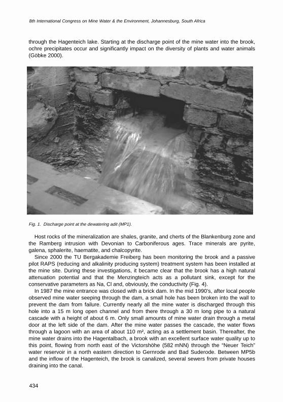
through the Hagenteich lake. Starting at the discharge point of the mine water into the brook, ochre precipitates occur and significantly impact on the diversity of plants and water animals (Göbke 2000).
Fig. 1. Discharge point at the dewatering adit (MP1).
Host rocks of the mineralization are shales, granite, and cherts of the Blankenburg zone and the Ramberg intrusion with Devonian to Carboniferous ages. Trace minerals are pyrite, galena, sphalerite, haematite, and chalcopyrite.
Since 2000 the TU Bergakademie Freiberg has been monitoring the brook and a passive pilot RAPS (reducing and alkalinity producing system) treatment system has been installed at the mine site. During these investigations, it became clear that the brook has a high natural attenuation potential and that the Menzingteich acts as a pollutant sink, except for the conservative parameters as Na, Cl and, obviously, the conductivity (Fig. 4).
In 1987 the mine entrance was closed with a brick dam. In the mid 1990’s, after local people observed mine water seeping through the dam, a small hole has been broken into the wall to prevent the dam from failure. Currently nearly all the mine water is discharged through this hole into a 15 m long open channel and from there through a 30 m long pipe to a natural cascade with a height of about 6 m. Only small amounts of mine water drain through a metal door at the left side of the dam. After the mine water passes the cascade, the water flows through a lagoon with an area of about 110 m², acting as a settlement basin. Thereafter, the mine water drains into the Hagentalbach, a brook with an excellent surface water quality up to this point, flowing from north east of the Victorshöhe (582 mNN) through the “Neuer Teich” water reservoir in a north eastern direction to Gernrode and Bad Suderode. Between MP5b and the inflow of the Hagenteich, the brook is canalized, several sewers from private houses draining into the canal.
8th International Congress on Mine Water & the Environment, Johannesburg, South Africa
434
�
�
�
�
����
���
������
�
�� ���� ���� ���� ���� ������ ������������
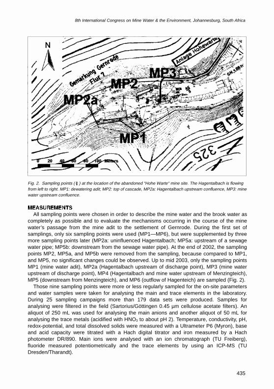
Fig. 2. Sampling points (xx) at the location of the abandoned “Hohe Warte“ mine site. The Hagentalbach is flowing from left to right. MP1: dewatering adit; MP2: top of cascade, MP2a: Hagentalbach upstream confluence, MP3: mine water upstream confluence.
/'#574'/'065
All sampling points were chosen in order to describe the mine water and the brook water as completely as possible and to evaluate the mechanisms occurring in the course of the mine water’s passage from the mine adit to the settlement of Gernrode. During the first set of samplings, only six sampling points were used (MP1—MP6), but were supplemented by three more sampling points later (MP2a: uninfluenced Hagentalbach; MP5a: upstream of a sewage water pipe; MP5b: downstream from the sewage water pipe). At the end of 2002, the sampling points MP2, MP5a, and MP5b were removed from the sampling, because compared to MP1, and MP5, no significant changes could be observed. Up to mid 2003, only the sampling points MP1 (mine water adit), MP2a (Hagentalbach upstream of discharge point), MP3 (mine water upstream of discharge point), MP4 (Hagentalbach and mine water upstream of Menzingteich), MP5 (downstream from Menzingteich), and MP6 (outflow of Hagenteich) are sampled (Fig. 2).
Those nine sampling points were more or less regularly sampled for the on-site parameters and water samples were taken for analysing the main and trace elements in the laboratory. During 25 sampling campaigns more than 179 data sets were produced. Samples for analysing were filtered in the field (Sartorius/Göttingen 0.45 µm cellulose acetate filters). An aliquot of 250 mL was used for analysing the main anions and another aliquot of 50 mL for analysing the trace metals (acidified with HNO3 to about pH 2). Temperature, conductivity, pH, redox-potential, and total dissolved solids were measured with a Ultrameter P6 (Myron), base and acid capacity were titrated with a Hach digital titrator and iron measured by a Hach photometer DR/890. Main ions were analysed with an ion chromatograph (TU Freiberg), fluoride measured potentiometrically and the trace elements by using an ICP-MS (TU Dresden/Tharandt).
8th International Congress on Mine Water & the Environment, Johannesburg, South Africa
435
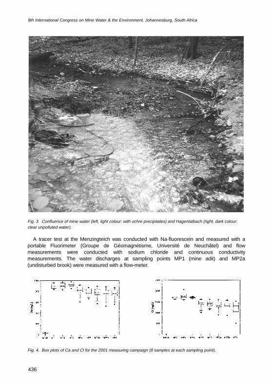
Fig. 3. Confluence of mine water (left, light colour: with ochre precipitates) and Hagentalbach (right, dark colour: clear unpolluted water).
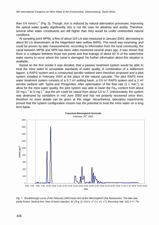
A tracer test at the Menzingteich was conducted with Na-fluorescein and measured with a portable Fluorimeter (Groupe de Géomagnétisme, Université de Neuchâtel) and flow measurements were conducted with sodium chloride and continuous conductivity measurements. The water discharges at sampling points MP1 (mine adit) and MP2a (undisturbed brook) were measured with a flow-meter.
Fig. 4. Box plots of Ca and Cl for the 2001 measuring campaign (8 samples at each sampling point).
���� ��� ��� ��� ��� ��� ���� ���� ���
��"����$
�
���
���
���
���
����
���� ��� ��� ��� ��� ��� ���� ���� ���
��"����$
�
���
����
����
����
����
8th International Congress on Mine Water & the Environment, Johannesburg, South Africa
436
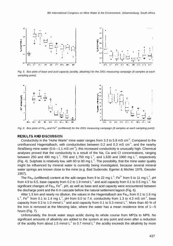
Fig. 5. Box plots of base and acid capacity (acidity, alkalinity) for the 2001 measuring campaign (8 samples at each sampling point).
Fig. 6. Box plots of Fetot and Fe2+ (unfiltered) for the 2001 measuring campaign (8 samples at each sampling point).
4'57.65 #0& &+5%755+10
Conductivity in the “Hohe Warte” mine water ranges from 3.3 to 5.8 mS cm-1. Compared to the uninfluenced Hagentalbach, with conductivities between 0.2 and 0.3 mS cm-1, and the nearby Straßberg mine water (0.6—1.1 mS cm-1), this increased conductivity is unusually high. Chemical analyses proved that the conductivity is a result of the Na, Ca and Cl concentrations, ranging between 250 and 490 mg L-1, 700 and 1,750 mg L-1, and 1,630 and 1960 mg L-1, respectively (Fig. 4). Sulphate is relatively low, with 60 to 80 mg L-1. The possibility, that the mine water quality might be influenced by mineral water is currently being investigated, because several mineral water springs are known close to the mine (e.g. Bad Suderode; Egerter & Michler 1976, Giessler 1957).
The Fetot (unfiltered) content at the adit ranges from 9 to 22 mg L-1, Fe2+ from 5 to 11 mg L-1, pH from 4.9 to 6.5, base capacity from 0.2 to 1.9 mmol L-1 and acid capacity from 0.1 to 0.5 mg L-1. No significant changes of Fetot, Fe2+, pH, as well as base and acid capacity were encountered between the discharge point and the 6 m cascade before the natural settlement lagoon (Fig. 6).
After 1.5 km and nearly no dilution, the values in the Hagentalbach are Fetot from 0.1 to 1.6 mg L-1, Fe2+ from 0.1 to 1.4 mg L-1, pH from 6.0 to 7.4, conductivity from 1.3 to 4.3 mS cm-1, base capacity from 0.3 to 1.0 mmol L-1 and acid capacity from 0.1 to 0.3 mmol L-1. More than 40 % of the Iron is removed at the Menzing lake, where the water has a mean residence time of 1—5 hours (Fig. 7).
Unfortunately, the brook water stays acidic during its whole course from MP2a to MP6. No significant amounts of alkalinity are added to the system at any point and even after a reduction of the acidity from about 1.5 mmol L-1 to 0.7 mmol L-1 the acidity exceeds the alkalinity by more
���� ��� ��� ��� ��� ��� ���� ���� ���
�������"������$
���
���
���
���
���
���
���
���
���� ��� ��� ��� ��� ��� ���� ���� ���
�������������������"����$
�
�
�
�
�
��
��
��
��
��
��
���� ��� ��� ��� ��� ��� ���� ���� ���
�������"������$
���
���
� ��
� ��
���
���� ��� ��� ��� ��� ��� ���� ���� ���
���������������"����$
�
�
�
�
�
��
8th International Congress on Mine Water & the Environment, Johannesburg, South Africa
437
than 0.6 mmol L-1 (Fig. 5). Though, iron is reduced by natural attenuation processes, improving the optical water quality significantly, this is not the case for alkalinity and acidity. Therefore, several other water constituents are still higher than they would be under undisturbed natural conditions.
At sampling point MP5b, a flow of about 110 L/s was measured in January 2003, decreasing to about 60 L/s downstream, at the Hagenteich lake outflow (MP6). This result was surprising, and could be proven by later measurements. According to information from the local community, the canal between MP5b and MP6 has been video monitored several years ago. It was shown that there is a collapse between those two points and that leakage of about 50 % of the water/mine water seems to occur where the canal is damaged. No further information about this situation is available.
Based on the first results it was decided, that a passive treatment system would be able to treat the mine water to acceptable standards of water quality. A combination of a settlement lagoon, a RAPS system and a constructed aerobic wetland were therefore proposed and a pilot system installed in February 2003 at the place of the natural cascade. The pilot RAPS mine water treatment system consists of a 0.7 m³ settling basin, a 0.6 m³ RAPS system and a 1 m² aerobic wetland with Typha and Phragmites. After optimisation of the flow rate (1 L min-1), to allow for the mine water quality, the pilot system was able to lower the Fetot content from about 20 mg L-1 to 5 mg L-1 and the pH could be raised from about 5.5 to 7. Unfortunately, the system was destroyed by vandalism in mid June 2003 and has not properly recovered since then, therefore no more details can be given at this stage. Nevertheless, laboratory experiments proved that the system configuration chosen has the potential to treat the mine water on a long term basis.
Fig. 7. Breakthrough curve of the February 2003 tracer test at the Menzingteich (Na-fluorescein). The lake was partly frozen. Vertical line: time of tracer injection. M: 25 g, Q: 33,5 L s-1 (+/- 3 L s-1); Recovery rate: 101.5 +/- 7%.
Tracertest Menzingteich GernrodeFebruary, 25th 2003
0
200
400
600
800
1000
1200
1400
1600
1800
8:00 8:30 9:00 9:30 10:00 10:30 11:00 11:30 12:00 12:30 13:00 13:30 14:00 14:30 15:00 15:30 16:00 16:30 17:00 17:30 18:00 18:30 19:00
time
Ura
nin,
µg
L-1
8th International Congress on Mine Water & the Environment, Johannesburg, South Africa
438
%10%.75+105
Natural attenuation of high Fe concentrations can be observed at the Hagentalbach near Gernrode/Harz. This situation occurs, because the Hagental brook has very good water quality, two natural lakes act as settlement lagoons and the plants as a natural wetland. Though iron is significantly reduced, the brook stays net acidic during the whole water course investigated(1.5—2km), partly due to the local geologic conditions. As a result, the pH only increases from about 5.5 to 6 and consequently, only small amounts of trace elements are co-precipitated with the ochre.
Due to the high Ca, Na, and Cl-concentrations and the net acidity of the mine water, the cascade is not able to oxidize the iron in the mine water. Therefore, precipitation of ochre occurs up to 3km downstream from the mine water discharge. Only a comparatively small amount of iron is precipitated within a small settling lagoon following the natural cascade.
To strengthen the natural processes already occurring, the mine water should be treated passively with a 600 m³ RAPS followed by a 900—1200 m² constructed aerobic wetland.
#%-019.'&)'/'065
We would like to express our gratitude to the BST Mansfeld, the local community, the district government of Magdeburg, the local forestry, and the Gernrode rifle association. This work was partly financed by the EU projects PIRAMID (EVK1-CT-1999-00021) and also contributed as a case study to the EU project ERMITE (EVK1-CT-2000-00078).
.+6'4#674'� Bodemann H. 1987. Verwahrungsdokumentation vom Grubenrevier Hohenwarte in der Betriebsabteilung Straßberg.
Rottleberode [unpublished]: VEB Fluß- und Schwerspatbetrieb Werk Rottleberode: 12. � Egerter H-G, Michler W. 1976. Über einige Mineralwasservorkommen am Harznordrand. Hercynia; 13 (NF):340—352. � Giessler A. 1957. Beiträge zur Geohydrologie der Mineralwässer des NE-Harzrandgebietes. Zeitschrift der Deutschen
Geologischen Gesellschaft; 109:199—206. � Göbke A. 2000. Sonderuntersuchungen des Hagentalbaches 1999. Magdeburg [unpublished]: Staatliches Amt für
Umweltschutz Magdeburg, Dezernat 3.3.2: 15. � Kappe H, Scheffler H. 1990. Im Harz, Übertage – Untertage. Haltern: Bode: 143. � Pfeiffer D, Wilke U. 1984. Hydrogeologisches Gutachten zur Grubenverwahrung des VEB Fluß- und
Schwerspatbetriebes Rottleberode, Grubenrevier Hohe Warte bei Gernrode. Nordhausen [unpublished]: VEB
Hydrogeologie Nordhausen: 24. � Stolle P. 1984. Bergschadenkundliche Analyse vom Grubenrevier Hohenwarte (WA Strassberg). Rottleberode
[unpublished]: VEB Fluß- und Schwerspatbetrieb Werk Rottleberode: 26.
8th International Congress on Mine Water & the Environment, Johannesburg, South Africa
439