maryport conservation area appraisal...of religious beliefs, with the roman gods, mithraism,...
TRANSCRIPT
Maryport Conservation Area Character Appraisal
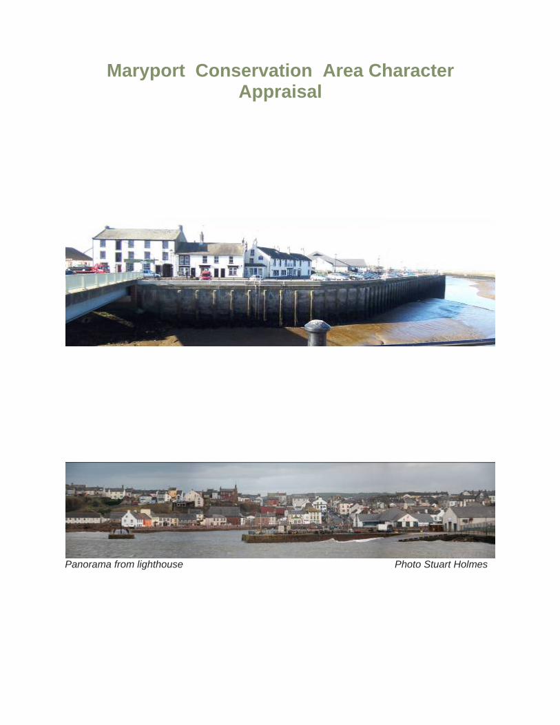
Panorama from lighthouse Photo Stuart Holmes
Summary: What is special about Maryport:
Maryport’s historic character derives from:
• The hilltop Roman fortress of Alavna and associated Vicus; • The town’s early origins as a medieval fortress on the Ellen estuary (Mote Hill); • The grid plan street layout and topography of the bluff; • Its C18 & C19 planned street layout; • The mixture of colourful stuccoed property in the earlier grid plan town and the
terraces of the late C19 suburb; • The harbour and docks; • Attractive sea views across the harbour and docks and to the coast of Dumfries and
Galloway; • The use of simple raised stone and stucco door and window architraves; • Cumbrian slate roofing laid to diminishing courses; • C19 coursed rock-faced harbour walls with large stone copings; • Fine cast iron railings produced by local foundries; • Sounds and smells of the sea and seagulls.
In particular its Architectural and Historic character is made up of: • C18 quayside buildings; • Fleming Square, once the historic market place now a Georgian civic showpiece,
plus Fleming Street, High Street, Eaglesfield Street and Kirkby Streets with early C19 simple stuccoed 2 & 3 storey town houses and a few detached villas;
• Lighthouse at entrance to harbour erected in 1846 (the first cast iron lighthouse); • Netherhall country house with Pele Tower, C19 outbuildings, remains of Ionic lodge,
and park walls; • Larger early C19 housing at the high northern & southern ends of planned town with
extensive sea views. In particular, the southern end of High Street & Fleming Place together with the southern and eastern sides of Fleming Square;
• The architectural unity of the late C19 development of the suburbs to the east of Curzon Street with their rock faced red sandstone and ashlar dressings;
• C19 churches including the Parish Church of St Mary (1898), Christ Church Old Harbour (1872), and Crosby Street (1888) designed in Gothic derived styles and faced in red sandstone;
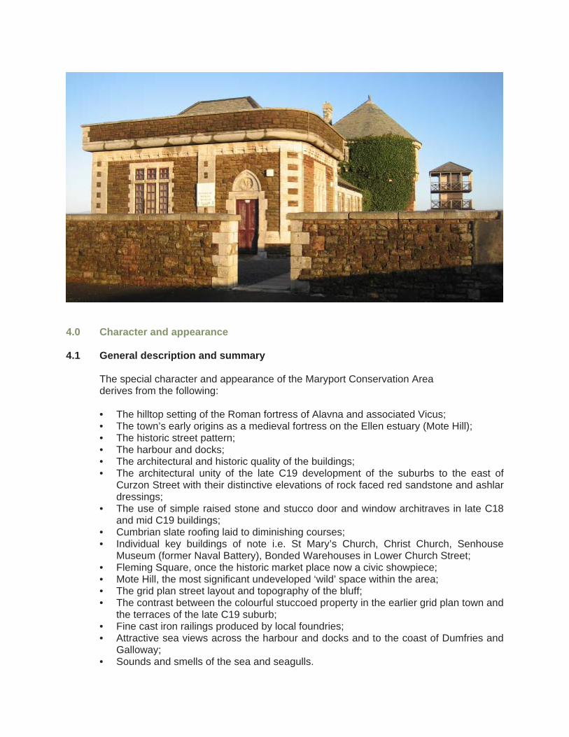
• Senhouse Museum/former naval battery buildings (1885) at Sea Brows in Baronial style, faced in red sandstone with cream limestone dressings beneath an unusual green slate roof.
• Senhouse Street (east end), Curzon Street, Lawson Street, Station Street and Selby Terrace characterised by 2 & 3 storey late Victorian terraces (1875-1885) and parades of shops with consistent architectural features of rock-faced coursed red sandstone and painted sandstone window and door surrounds;
• Period shop fronts with high quality joinery, principally in Senhouse Street and Crosby Street;
• C19 public houses set on corner plots, often with splayed corner entrances; • Bonded warehouses (1842) of red sandstone ashlar with distinctive gables, of 2
storeys plus basement on corner of John Street /Lower Church Street; • Early C20 Police Station and Magistrates Court, Eaglesfield Street;

Part 1: Conservation Area Appraisal 1.0 Introduction
The Maryport Conservation Area was designated in 1978 under section 69 of the Planning (Listed Buildings & Conservation Areas) Act 1990. This document attempts to define the special architectural and historic interest of the Maryport Conservation Area and to identify opportunities for enhancement. A conservation area is designated as “an area of special architectural or historic interest the character or appearance of which it is desirable to preserve or enhance”. Section 71 of the same Act requires local planning authorities to formulate and publish proposals for the preservation and enhancement of any parts of their area which are conservation areas. Section 72 specifies that, in making a decision on an application for development in a conservation area, special attention shall be paid to the desirability of ‘preserving or enhancing the character or appearance of that area’. This document is a response to these statutory requirements, taking account of the English Heritage guidance set out in “Guidance on Conservation Area Appraisals” (August 2005) and “Guidance on the management of conservation areas” (August 2005). Government guidance regarding the management of historic buildings and areas is set out within Planning Policy Guidance 15 (PPG15): Planning and the Historic Environment”
This document seeks to:
• Define the special interest of the area; • Identify the issues which threaten the special qualities, provide guidelines to prevent
harm and enhance the area. The guidelines will provide a basis for the assessment of development proposals.
The document exists under the umbrella of the development plan framework produced by Allerdale Borough Council. Documents which form part of this framework include:
• Allerdale Local Plan (Adopted Nov 1999). This document contains planning policies
and proposals for the use and development of land for the period 1996-2006; • Allerdale Local Plan, First Alteration, First Deposit Consultation (September 2002).
This sets out revisions to the adopted local plan policies; • Maryport Design Guide: This provides guidance regarding the repair of traditional
buildings and the reinstatement of architectural features; • Cumbria and Lake District Joint Structure Plan (1991-2006). Provides the main
strategic planning context for the local plan. The main principles of the structure plan are embodied in the planning policies. In particular Policy 2 – Conserving the natural and Built Environment which states inter-alia that the quality of the built environment will be protected from inappropriate development;
2.0 The location and setting of the conservation area Map – location & shape of town
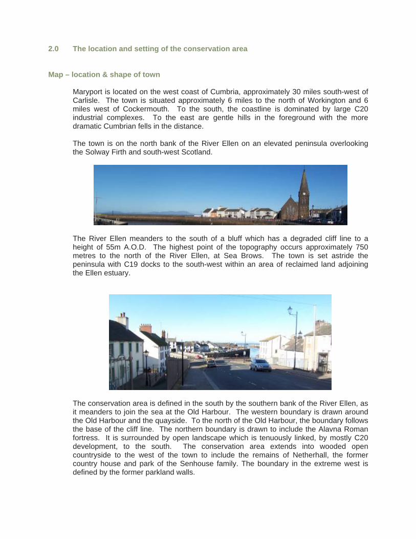
Maryport is located on the west coast of Cumbria, approximately 30 miles south-west of Carlisle. The town is situated approximately 6 miles to the north of Workington and 6 miles west of Cockermouth. To the south, the coastline is dominated by large C20 industrial complexes. To the east are gentle hills in the foreground with the more dramatic Cumbrian fells in the distance.
The town is on the north bank of the River Ellen on an elevated peninsula overlooking the Solway Firth and south-west Scotland.
The River Ellen meanders to the south of a bluff which has a degraded cliff line to a height of 55m A.O.D. The highest point of the topography occurs approximately 750 metres to the north of the River Ellen, at Sea Brows. The town is set astride the peninsula with C19 docks to the south-west within an area of reclaimed land adjoining the Ellen estuary.
The conservation area is defined in the south by the southern bank of the River Ellen, as it meanders to join the sea at the Old Harbour. The western boundary is drawn around the Old Harbour and the quayside. To the north of the Old Harbour, the boundary follows the base of the cliff line. The northern boundary is drawn to include the Alavna Roman fortress. It is surrounded by open landscape which is tenuously linked, by mostly C20 development, to the south. The conservation area extends into wooded open countryside to the west of the town to include the remains of Netherhall, the former country house and park of the Senhouse family. The boundary in the extreme west is defined by the former parkland walls.
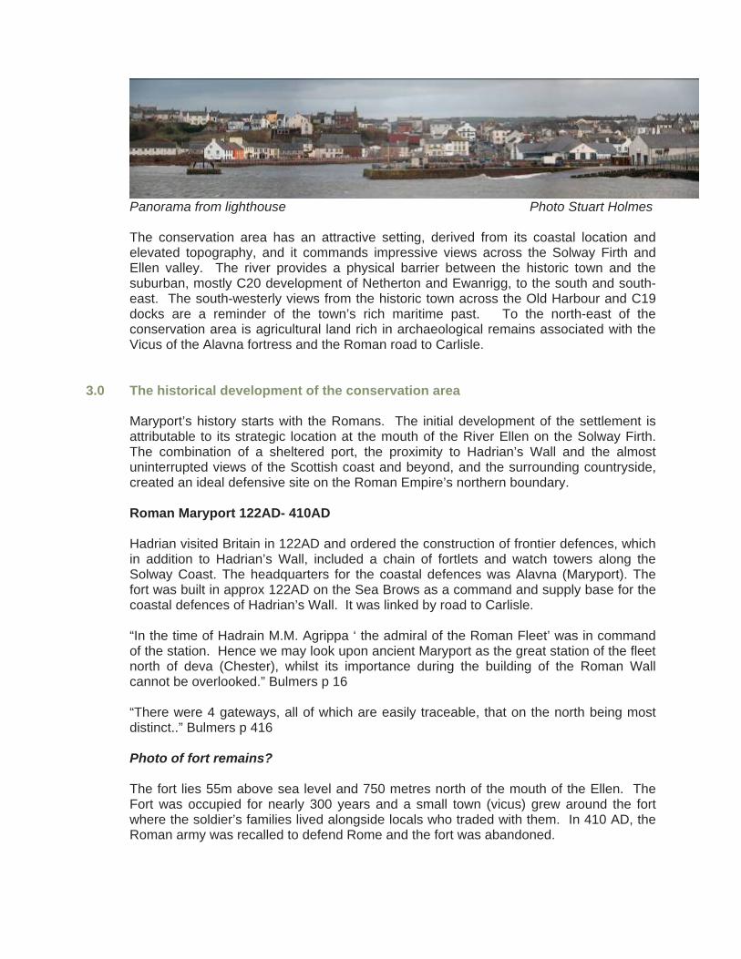
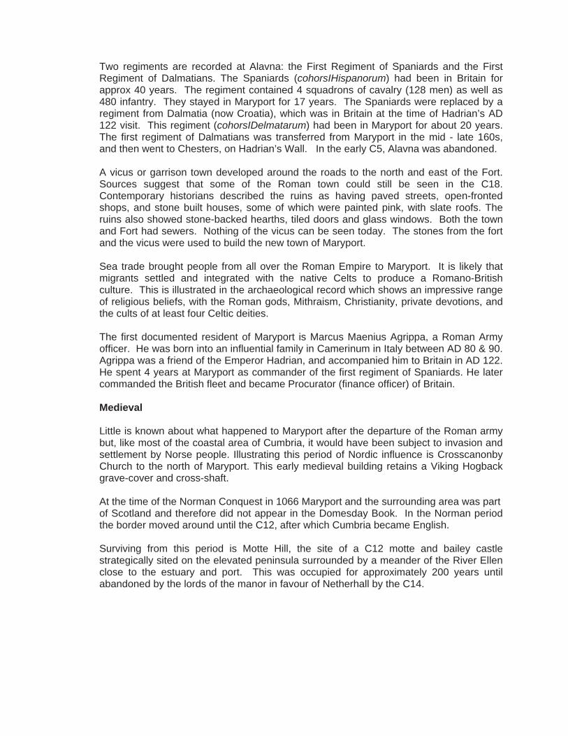
Panorama from lighthouse Photo Stuart Holmes The conservation area has an attractive setting, derived from its coastal location and elevated topography, and it commands impressive views across the Solway Firth and Ellen valley. The river provides a physical barrier between the historic town and the suburban, mostly C20 development of Netherton and Ewanrigg, to the south and south-east. The south-westerly views from the historic town across the Old Harbour and C19 docks are a reminder of the town’s rich maritime past. To the north-east of the conservation area is agricultural land rich in archaeological remains associated with the Vicus of the Alavna fortress and the Roman road to Carlisle.
3.0 The historical development of the conservation area
Maryport’s history starts with the Romans. The initial development of the settlement is attributable to its strategic location at the mouth of the River Ellen on the Solway Firth. The combination of a sheltered port, the proximity to Hadrian’s Wall and the almost uninterrupted views of the Scottish coast and beyond, and the surrounding countryside, created an ideal defensive site on the Roman Empire’s northern boundary. Roman Maryport 122AD- 410AD Hadrian visited Britain in 122AD and ordered the construction of frontier defences, which in addition to Hadrian’s Wall, included a chain of fortlets and watch towers along the Solway Coast. The headquarters for the coastal defences was Alavna (Maryport). The fort was built in approx 122AD on the Sea Brows as a command and supply base for the coastal defences of Hadrian’s Wall. It was linked by road to Carlisle. “In the time of Hadrain M.M. Agrippa ‘ the admiral of the Roman Fleet’ was in command of the station. Hence we may look upon ancient Maryport as the great station of the fleet north of deva (Chester), whilst its importance during the building of the Roman Wall cannot be overlooked.” Bulmers p 16 “There were 4 gateways, all of which are easily traceable, that on the north being most distinct..” Bulmers p 416 Photo of fort remains? The fort lies 55m above sea level and 750 metres north of the mouth of the Ellen. The Fort was occupied for nearly 300 years and a small town (vicus) grew around the fort where the soldier’s families lived alongside locals who traded with them. In 410 AD, the Roman army was recalled to defend Rome and the fort was abandoned.
Two regiments are recorded at Alavna: the First Regiment of Spaniards and the First Regiment of Dalmatians. The Spaniards (cohorsIHispanorum) had been in Britain for approx 40 years. The regiment contained 4 squadrons of cavalry (128 men) as well as 480 infantry. They stayed in Maryport for 17 years. The Spaniards were replaced by a regiment from Dalmatia (now Croatia), which was in Britain at the time of Hadrian’s AD 122 visit. This regiment (cohorsIDelmatarum) had been in Maryport for about 20 years. The first regiment of Dalmatians was transferred from Maryport in the mid - late 160s, and then went to Chesters, on Hadrian’s Wall. In the early C5, Alavna was abandoned. A vicus or garrison town developed around the roads to the north and east of the Fort. Sources suggest that some of the Roman town could still be seen in the C18. Contemporary historians described the ruins as having paved streets, open-fronted shops, and stone built houses, some of which were painted pink, with slate roofs. The ruins also showed stone-backed hearths, tiled doors and glass windows. Both the town and Fort had sewers. Nothing of the vicus can be seen today. The stones from the fort and the vicus were used to build the new town of Maryport. Sea trade brought people from all over the Roman Empire to Maryport. It is likely that migrants settled and integrated with the native Celts to produce a Romano-British culture. This is illustrated in the archaeological record which shows an impressive range of religious beliefs, with the Roman gods, Mithraism, Christianity, private devotions, and the cults of at least four Celtic deities. The first documented resident of Maryport is Marcus Maenius Agrippa, a Roman Army officer. He was born into an influential family in Camerinum in Italy between AD 80 & 90. Agrippa was a friend of the Emperor Hadrian, and accompanied him to Britain in AD 122. He spent 4 years at Maryport as commander of the first regiment of Spaniards. He later commanded the British fleet and became Procurator (finance officer) of Britain. Medieval Little is known about what happened to Maryport after the departure of the Roman army but, like most of the coastal area of Cumbria, it would have been subject to invasion and settlement by Norse people. Illustrating this period of Nordic influence is Crosscanonby Church to the north of Maryport. This early medieval building retains a Viking Hogback grave-cover and cross-shaft. At the time of the Norman Conquest in 1066 Maryport and the surrounding area was part of Scotland and therefore did not appear in the Domesday Book. In the Norman period the border moved around until the C12, after which Cumbria became English. Surviving from this period is Motte Hill, the site of a C12 motte and bailey castle strategically sited on the elevated peninsula surrounded by a meander of the River Ellen close to the estuary and port. This was occupied for approximately 200 years until abandoned by the lords of the manor in favour of Netherhall by the C14.

The manor of Ellenborough, formerly called Alneburgh, was possessed by Simon de Sheftling in whose family it remained until the reign of Edward I (1272-1307), when it was purchased by the Eaglesfields. In 1528 Elizabeth, sister and co-heiress of Richard Eaglesfield of Alneburgh Hall (later Netherhall) married John Senhouse of Seascale. The Senhouse family had resided at Seascale for several generations. The younger son of John Senhouse settled at Netherhall and this became the principal family home from the mid C16 to mid C20. The Senhouse family is inextricably linked with the development of Maryport in the C18 & C19. The family had antiquarian interests and assembled the internationally important collection of Roman antiquities displayed at the Senhouse Museum (to the north of the town). Camden, writing in 1599, after his visit to Netherhall, records: “I could not but make an honourable mention of the gentleman I just now spoke of (Mr. J. Senhouse). . . . because he has a great veneration for antiquities (wherein he is well skilled), and with great diligence preserves such inscriptions as these, which by other ignorant people in those parts are presently broke to pieces, and turned to other uses, to the great damage of these studies.” Eighteenth century At the beginning of the C18 Maryport, (then Ellenfoot), was hardly more than a fishing creek at the mouth of the River consisting of a few huts and a farmhouse (Valentine’s farmhouse of c1718 which was later incorporated into The Golden Lion Hotel). In 1747 there were only 64 families living in the village. Humphrey Senhouse (1705-1770) secured an Act of Parliament in 1749 to develop a new town to be laid out on a grid street plan and served by a harbour. The grid street plan enclosed a series of rectilinear blocks of land, each of approximately two acres. The 1749 Act was entitled “for repairing, enlarging & preserving the harbour of Ellenfoot in the county of Cumberland”. Voluntary subscriptions were sought for works, including the erection of a pier. In 1756 Humphrey Senhouse II changed the name of the village known as Ellenfoot to Maryport, renaming the new town after his wife, Mary (nee Fleming). Mary Fleming was the Bishop of Carlisle’s daughter. This change of name was later to be confirmed by Act of Parliament in 1791. Pennant, visited the town in 1774, and records - “Maryport is another new erection, the property of H. Senhouse, Esq., and so named by him in honour of his lady.” By 1774 the number of houses had increased to 100 with a population of 1,300. By 1792 the town had approximately 200 properties. Hutchinson, writing in 1795, observed “Within forty years last past, this place has risen to importance; being before that time the mere resort of fishermen, who had a few miserable cabins along the beach.”

Maryport 1815
The Napoleonic War produced a short recession in the early C19, evidenced by the closure of many businesses, notably the glassworks, and cotton factory in 1817. Food shortages in the winter led to rioting which was quelled by troops. The planned town of Maryport continued to expand rapidly throughout the C19 from a population of 2,932 in 1801 to 12,536 in 1891. The population had grown to 20,000 inhabitants by the beginning of the C20. The population is shown below: Year Population Year Population 1774 1,300 1851 5,698 1801 2,932 1861 6,037 1811 3,134 1871 7,137 1821 3,514 1881 8,126 1831 3,877 1891 12,536 1841 5,311 The town had an important association with master mariners, 91 of which are listed in the 1856 Town Directory. There is a cluster around Fleming Square. The Royal Naval Reserve station (‘the Battery’) opened in 1886 and trained up to 200 reservists annually. The battery also housed the coastguard station. The town has an important association with shipping magnate Thomas Henry Ismay, founder of the White Star Line and the Titanic. Ismay was born in 1836 at Ropery House, Ellenborough Place, Elizabeth Dock. The Docks

The export of coal began in the early C18. A broadsheet of 1719 advertises the town as being the ideal location for the expansion of the coal trade with Dublin. In 1781, coal was still brought to the port in panniers on donkeys and ‘galloways’, and was exported by a fleet of 22 small vessels. By 1791 the fleet had increased to approximately 90 vessels, each of about 120 tons. These sailed into the mouth of the Ellen, and were loaded with coal directly from packhorses. In 1816 wooden piers were constructed for the easier handling of coal. The management of the harbour was the sole responsibility of the Senhouse family as Lord of the Manor. A harbour master was appointed as collector of the dues from the shipping, as well as rates from the town.
In 1833, the port was placed under the management of a Board of Trustees by Act of Parliament. The Coal trade had rapidly increased after the abandonment of the pack-load system of shipping and the substitution of horse and cart. The Trustees initiated the development of the harbour and dock. In 1836 a tidal dock, known as the clock basin was created with a swing bridge across the entrance. It covered nearly one hectare. The arrival of the railway in 1841 allowed coal to be delivered directly to the pier heads. Ships were first registered at Maryport in 1838, coincident with the construction of the former Custom House and the Old Harbour office in Strand Street. The latter was replaced in 1890 by the Town Hall in Senhouse Street. On February 3rd, 1842, the Port became independent from Whitehaven, to which it had been subordinate. In the same year the first Bonded Warehouse was constructed in Lower Church Street. In 1898, a new Custom House was built in Curzon Street, and the port was the chief Customs port on the coast throughout the early C20.
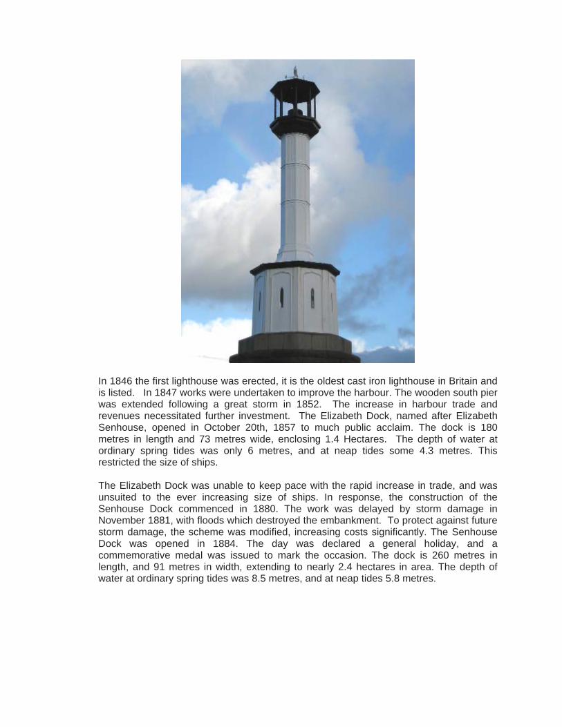
In 1846 the first lighthouse was erected, it is the oldest cast iron lighthouse in Britain and is listed. In 1847 works were undertaken to improve the harbour. The wooden south pier was extended following a great storm in 1852. The increase in harbour trade and revenues necessitated further investment. The Elizabeth Dock, named after Elizabeth Senhouse, opened in October 20th, 1857 to much public acclaim. The dock is 180 metres in length and 73 metres wide, enclosing 1.4 Hectares. The depth of water at ordinary spring tides was only 6 metres, and at neap tides some 4.3 metres. This restricted the size of ships. The Elizabeth Dock was unable to keep pace with the rapid increase in trade, and was unsuited to the ever increasing size of ships. In response, the construction of the Senhouse Dock commenced in 1880. The work was delayed by storm damage in November 1881, with floods which destroyed the embankment. To protect against future storm damage, the scheme was modified, increasing costs significantly. The Senhouse Dock was opened in 1884. The day was declared a general holiday, and a commemorative medal was issued to mark the occasion. The dock is 260 metres in length, and 91 metres in width, extending to nearly 2.4 hectares in area. The depth of water at ordinary spring tides was 8.5 metres, and at neap tides 5.8 metres.
The principal export had been coal to Ireland, but the new Senhouse Dock facilitated a large increase in revenue with iron ore and pig iron, and later steel rails, replacing coal as the principal exports in the late C19. Stone, lime, stone bar bolts, and cast iron from the Solway Iron Works and local collieries and general merchandise were also significant exports. Shipbuilding yards were common. Maryport had the largest docks on the west Cumbrian coast until 1927. A profitable herring fleet operated from the port throughout the C19 and the port hosted fleets from Scotland and Ireland. The herrings were processed, preserved in barrels of brine and exported.
The Maryport and Carlisle Railway In 1836 the Golden Lion Hotel hosted a meeting which led to the commissioning of George Stephenson to construct the Maryport and Carlisle Railway, from Maryport to Aspatria. It was opened on July 15th, 1840. The first engine, the “Ellen,” was floated to Maryport on a raft. The first section of the line between Maryport and Arkleby came into use in 1841 and carried coal from the west Cumberland pits. Carlisle to Wigton was opened in May 1844 and the remainder was opened on 10 May 1845. It was originally proposed that the line should be called the “Carlisle and Whitehaven Railway Co”, but this was not adopted, although an extension to Whitehaven was opened in 1847. In 1855, approval to double the line between Maryport and Carlisle was given. The railways fuelled an exponential increase in exports from the Docks. Exports of coal trebled between 1830 and 1857 to 340,000 tons/yr. It also proved a lucrative investment, paying dividends of between 9 &10% in its first 50 years. Industry During the C18 & C19, Maryport developed a variety of industries including glass, salt, cotton, (at the former premises of Carr’s Flour Mill); paper, (Paper Mill Green) and lead pencils (Ellengrove). The glassworks was established in 1752 by Lancelot Atkinson of Newcastle in association with George Monkhouse, a Penrith wine merchant. The successful Maryport Brewery Company was established in 1780 and had a chain of sixty tied public houses by the end of the C19. State control of the brewing industry during WW1 initiated the decline of the firm which ceased trading in 1921. During the first half of the C19 Maryport boomed. A gas supply was connected in 1834, the railway was built, ships were registered for the first time and the first bonded warehouse was built in 1842. The town quickly developed as an industrial centre with an iron foundry and other manufactories. The shipyards, such as Ritson’s were famous for launching ships broadside into the river Ellen due to its restricted width.
Iron was traditionally the most significant product of Maryport. A company was formed and a 50 year lease was granted in 1752 on land near Mote Hill. The lease was granted to “…erect furnaces and forges, with power to deepen the river Ellen between the works and the harbour”. The works in 1784 included a blast furnace. In addition, there were: “three large coal houses, which will contain charcoal or coke sufficient for a year’s blast; three commodious houses for the storing of iron ores; three houses for workmen; a large casting house with a very good furnace, by which the foundry branch may be carried on to the greatest extent; 17 ovens for charring coals, built on an improved plan, and which make a cinder superior to any other method; and a well built dwelling house, most agreeably situated, and very convenient for the works.” The failure of the enterprise in 1784 has been attributed to an unreliable water supply. Several other iron furnaces are recorded in the C19. These included the Maryport Haematite Iron Co, formed in 1868. This had 6 furnaces, but closed in 1882. The Solway Iron Co, formed in 1870, which had 4 furnaces, but closed in 1894. This was revived by Messrs. Cammell’s, and operated until the early C20. Shipbuilding began in the port in the mid C18. The first shipyard was opened in 1765 by William Wood of Whitehaven. A second yard was opened in the early 1780’s by John Peat. Shipbuilding had become a significant employer in the C19. In particular, the shipyards of Wood, Ritson, Peat & Middleton, produced wooden ships, described as being ‘of a superior class’. By the beginning of the C19 John Peat was an established shipbuilder. The firm under the management of John Ritson became the premier ship builder in the town. Ship building took place on the south west bank of the Ellen, to the south of the old harbour. By the end of the C19, the industry was in decline. Only Ritson’s shipyard, by then producing iron ships, remained in business. Most of the ships produced had to be launched broadside. This is thought to be almost unique. Flour, iron founding, sail making, tanning and brewing remained significant industries until the early C20. Places of worship The town was well served by places of worship of various denominations. Some of these have been demolished and others adapted to new uses: St. Mary’s Church, originally built in 1760 with the tower built in 1847. In 1891 the church was rebuilt, with the exception of the tower, but underwent considerable alteration.
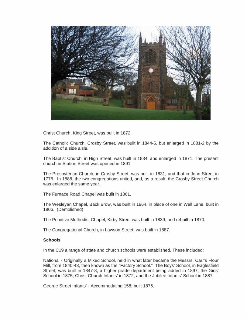
Christ Church, King Street, was built in 1872. The Catholic Church, Crosby Street, was built in 1844-5, but enlarged in 1881-2 by the addition of a side aisle. The Baptist Church, in High Street, was built in 1834, and enlarged in 1871. The present church in Station Street was opened in 1891. The Presbyterian Church, in Crosby Street, was built in 1831, and that in John Street in 1776. In 1888, the two congregations united, and, as a result, the Crosby Street Church was enlarged the same year. The Furnace Road Chapel was built in 1861. The Wesleyan Chapel, Back Brow, was built in 1864, in place of one in Well Lane, built in 1806. (Demolished) The Primitive Methodist Chapel, Kirby Street was built in 1839, and rebuilt in 1870. The Congregational Church, in Lawson Street, was built in 1887. Schools In the C19 a range of state and church schools were established. These included: National - Originally a Mixed School, held in what later became the Messrs. Carr’s Flour Mill, from 1840-48, then known as the “Factory School.” The Boys’ School, in Eaglesfield Street, was built in 1847-8, a higher grade department being added in 1897; the Girls’ School in 1875; Christ Church Infants’ in 1872; and the Jubilee Infants’ School in 1887. George Street Infants’ - Accommodating 158; built 1876.

British School - Accommodating 474 pupils, originally a Mixed School, in High Street, 1845 to 1883. This school was used as a Higher Grade School from 1888-97, and later as an Infants’ School for 190. The school in North Street (mixed) was built in 1882-3. Catholic School - Accommodating 355, was built as a mixed School in 1871, an Infants’ Department being added in 1876-7. Church of England School: Established in 1866, to accommodate 92. It was enlarged in 1888, 1891, and again in 1896, to meet demand. Twentieth Century By the early C20 the town was suffering from economic recession. All but one of the ship yards had closed and trade declined because the new Senhouse Dock was not wide enough to accommodate new ships. The Holme Line, a fleet of 16 merchant ships also succumbed to the recession late C19. On a more positive note, the Empire Theatre opened in 1911 and provided entertainment for the town until 1974. During the Great Depression of the 1930’s, unemployment peaked at over 30%. By 1934 the town’s population had dwindled to 10,000 (from 12,750 in 1898). The Carlton re-opened as a Cinema in 1934, the bank having closed in the 1920’s. The town experienced a brief economic recovery during WWII but failed to recover its status as an industrial port. Evidence of economic decline is widespread, but the historic building fabric is largely in tact, such that the town has retained its character in a way that may not have happened had it been prosperous throughout the C20.
Netherhall, the historic home of the Senhouse family suffered a disastrous fire in 1973. It was subsequently demolished, apart from the C16 pele tower which was uncovered within the C18 & C19 house. Photo of Pele Tower The collection of Roman antiquities had already been removed from the house. In 1990 the Senhouse Roman Museum opened in the former naval battery buildings (1885) at Sea Brows, adjoining the site of the Alavna fortress.
4.0 Character and appearance 4.1 General description and summary
The special character and appearance of the Maryport Conservation Area derives from the following: • The hilltop setting of the Roman fortress of Alavna and associated Vicus; • The town’s early origins as a medieval fortress on the Ellen estuary (Mote Hill); • The historic street pattern; • The harbour and docks; • The architectural and historic quality of the buildings; • The architectural unity of the late C19 development of the suburbs to the east of
Curzon Street with their distinctive elevations of rock faced red sandstone and ashlar dressings;
• The use of simple raised stone and stucco door and window architraves in late C18 and mid C19 buildings;
• Cumbrian slate roofing laid to diminishing courses; • Individual key buildings of note i.e. St Mary’s Church, Christ Church, Senhouse
Museum (former Naval Battery), Bonded Warehouses in Lower Church Street; • Fleming Square, once the historic market place now a civic showpiece; • Mote Hill, the most significant undeveloped ‘wild’ space within the area; • The grid plan street layout and topography of the bluff; • The contrast between the colourful stuccoed property in the earlier grid plan town and
the terraces of the late C19 suburb; • Fine cast iron railings produced by local foundries; • Attractive sea views across the harbour and docks and to the coast of Dumfries and
Galloway; • Sounds and smells of the sea and seagulls.

4.2 Present character: activities and uses The historic town centre is predominantly residential with retail uses concentrated on Senhouse Street. A secondary retail area is Crosby Street between Senhouse and Kirkby Streets. The virtual absence of chain stores allows for local distinctiveness. Further retail uses are found on the west side of Curzon Street, immediately to the south of Senhouse Street. The imposing former Co-op premises provide a focal point for this broad and distinctive late C19 street. Residential use dominates, mostly in the form of C18 & C19 terraces and detached villas. There are some flats converted from large commercial buildings. The converted former Bonded Warehouses on Lower Church Street are a good example. There is little use of flats above shop units. This is particularly evident at the east end of Senhouse Street, where upper floor redundancy and disrepair is very evident. However, residential use is growing in part due to the implementation of housing schemes which have yielded a number of property refurbishments. There are some less architecturally successful blocks of flats, often occupying prominent corner sites.
The conservation area contains all of the town’s retail floor area, including the only supermarket. There has been an absence of public entertainment since the closure of the Carlton cinema and Empire Theatre in 1974. The only entertainment is now provided by public houses but there are several of these which are closed on Crosby Street.
Within the conservation area there are a number of locally significant civic buildings including the Police Station and Magistrates Court on Eaglesfield Street and the former Town Hall (now Tourist Information) on Senhouse Street. The town lacks the hotels and boarding houses usually associated with the seaside. The only purpose built hotels are The Golden Lion (Senhouse St) and the Waverley (Station St). This is due to both the industrial history and geographic isolation of the town.

Former Town Hall, now Tourist Information
4.3 Development of street pattern
The street pattern of Maryport reflects the C18 & C19 development. The earliest development occurred around the Old Harbour. North Quay, King Street and Strand Street were developed by the mid C18. There are no significant industrial uses surviving within the conservation area. Car repair workshops are to be found on secondary frontages. The Act of 1749 gave impetus to development and by the mid C18 plots were being laid out at the western end of Senhouse Street. The former Queens Head (Museum) was the first plot to be let in 1749 on what was known as Shipping Brow. To the south of the Old Harbour, Irish Street records the coal trade. This area was also developed in the mid C18 with multipurpose warehouses, including those of William Blennerhassett, Lord of the Manor of Flimby of 1763-1785. Nelson Street developed by end of C18 accessing a number of foundries and other industrial works at its north end.
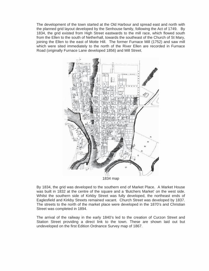
The development of the town started at the Old Harbour and spread east and north with the planned grid layout developed by the Senhouse family, following the Act of 1749. By 1834, the grid existed from High Street eastwards to the mill race, which flowed south from the Ellen to the south of Netherhall, towards the southeast of the Church of St Mary, joining the Ellen to the east of Motte Hill. The former Furnace Mill (1752) and saw mill which were sited immediately to the north of the River Ellen are recorded in Furnace Road (originally Furnace Lane developed 1856) and Mill Street.
1834 map
By 1834, the grid was developed to the southern end of Market Place. A Market House was built in 1832 at the centre of the square and a ‘Butchers Market’ on the west side. Whilst the southern side of Kirkby Street was fully developed, the northeast ends of Eaglesfield and Kirkby Streets remained vacant. Church Street was developed by 1837. The streets to the north of the market place were developed in the 1870’s and Christian Street was completed in 1894. The arrival of the railway in the early 1840’s led to the creation of Curzon Street and Station Street providing a direct link to the town. These are shown laid out but undeveloped on the first Edition Ordnance Survey map of 1867.

1867 OS Map
The development of the town to the west of the mill race in the late C19 resulted from the culverting of the mill race in the 1870s. This allowed growth to the east, which was built in a rock-faced, coursed red sandstone. The eastern end of Senhouse Street, marked by the widening of the street and appearance of parades of shops is contemporary with Curzon Street and took place in 1874-5. Selby Terrace, overlooking the River Ellen was developed shortly afterwards in 1877. This was followed by the western end of Wood Street and Lawson Street in 1880. The development of Station Road in 1892 completed the block. Mill Street was not developed until 1887. This eastward extension of the town with the long terraces has created a suburb of cohesive and distinctive character.
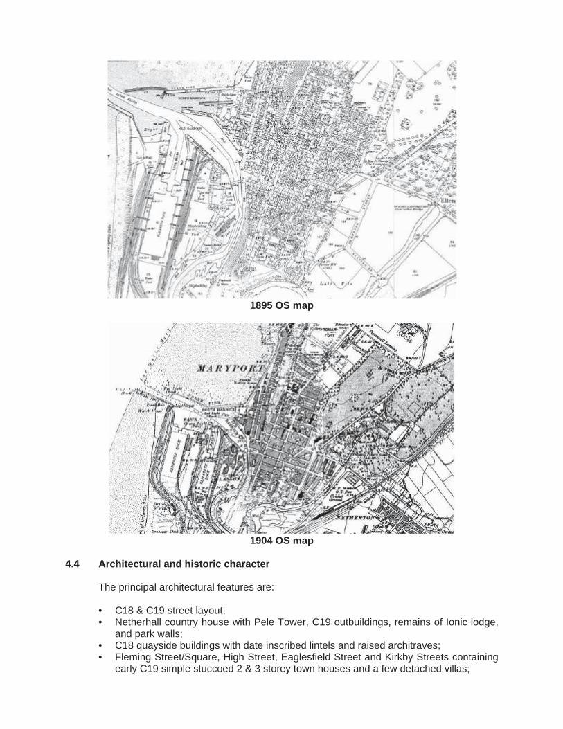
1895 OS map
1904 OS map
4.4 Architectural and historic character
The principal architectural features are: • C18 & C19 street layout; • Netherhall country house with Pele Tower, C19 outbuildings, remains of Ionic lodge,
and park walls; • C18 quayside buildings with date inscribed lintels and raised architraves; • Fleming Street/Square, High Street, Eaglesfield Street and Kirkby Streets containing
early C19 simple stuccoed 2 & 3 storey town houses and a few detached villas;

• Larger early C19 housing at the high northern & southern ends of the planned town with extensive sea views. In particular, the southern end of High Street & Fleming Place together with the southern and eastern sides of Fleming Square;
• Senhouse Street (east end), Curzon Street, Lawson Street, Station Street and Selby Terrace characterised by 2 & 3 storey late Victorian terraces (1875-1885) and parades of shops with consistent architectural features of rock-faced coursed red sandstone and painted sandstone window and door surrounds;
• Early C20 Police Station and Magistrates Court, Eaglesfield Street; • Bonded warehouses (1842) of red sandstone ashlar with distinctive gables, of 2
storeys plus basement on corner of John Street /Lower Church Street; • Period shop fronts with high quality joinery, principally in Senhouse Street and
Crosby Street; • C19 public houses prominently set on corner plots, often with splayed corner
entrances; • C19 coursed rock-faced harbour walls with large stone copings; • Lighthouse at entrance to harbour erected in 1846 of cast iron; • C19 churches including the Parish Church of St Mary (1898), Christ Church Old
Harbour (1872), and Crosby Street (1888) designed in Gothic derived styles and faced in red sandstone;
• Senhouse Museum/former naval battery buildings (1885) at Sea Brows in Baronial style, faced in red sandstone with cream limestone dressings beneath an unusual green slate roof.
Buildings in the conservation area reflect all the main phases of development. A few architecturally modest C18 buildings survive from the first phase of the town’s development in the quayside area. They are united by the use of raised ashlar window and door architraves and rendered elevations with local roof slates laid to diminishing courses. A cyma recta moulded eaves cornice (now concealed beneath gutters) is a distinctive feature of this period. Most original multi-paned, hornless sash windows have been replaced by later windows.
A simple early C19 style characterises the planned grid streets to the east. House size varies, but most are 2 or 3 storeys, often with basements.
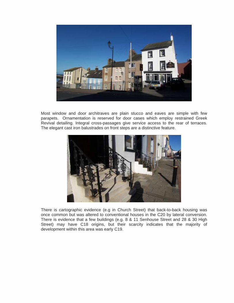
Most window and door architraves are plain stucco and eaves are simple with few parapets. Ornamentation is reserved for door cases which employ restrained Greek Revival detailing. Integral cross-passages give service access to the rear of terraces. The elegant cast iron balustrades on front steps are a distinctive feature.
There is cartographic evidence (e.g in Church Street) that back-to-back housing was once common but was altered to conventional houses in the C20 by lateral conversion. There is evidence that a few buildings (e.g. 8 & 11 Senhouse Street and 28 & 30 High Street) may have C18 origins, but their scarcity indicates that the majority of development within this area was early C19.
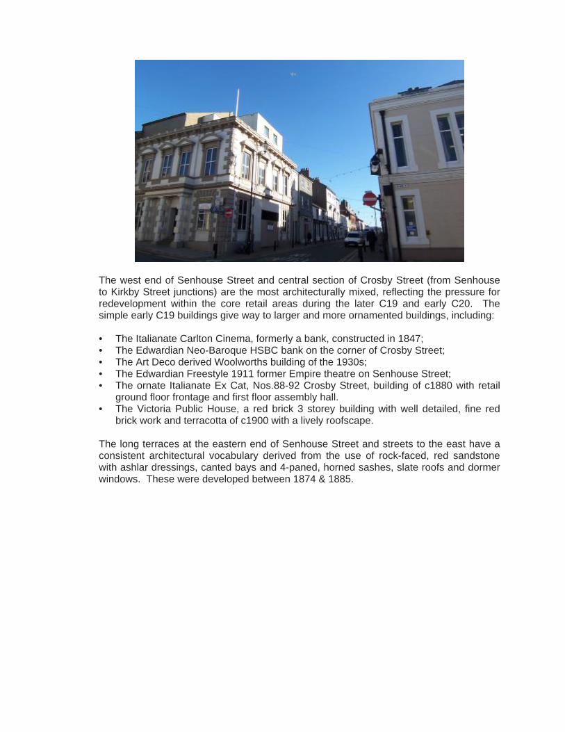
The west end of Senhouse Street and central section of Crosby Street (from Senhouse to Kirkby Street junctions) are the most architecturally mixed, reflecting the pressure for redevelopment within the core retail areas during the later C19 and early C20. The simple early C19 buildings give way to larger and more ornamented buildings, including: • The Italianate Carlton Cinema, formerly a bank, constructed in 1847; • The Edwardian Neo-Baroque HSBC bank on the corner of Crosby Street; • The Art Deco derived Woolworths building of the 1930s; • The Edwardian Freestyle 1911 former Empire theatre on Senhouse Street; • The ornate Italianate Ex Cat, Nos.88-92 Crosby Street, building of c1880 with retail
ground floor frontage and first floor assembly hall. • The Victoria Public House, a red brick 3 storey building with well detailed, fine red
brick work and terracotta of c1900 with a lively roofscape. The long terraces at the eastern end of Senhouse Street and streets to the east have a consistent architectural vocabulary derived from the use of rock-faced, red sandstone with ashlar dressings, canted bays and 4-paned, horned sashes, slate roofs and dormer windows. These were developed between 1874 & 1885.

The Northern end of the conservation area, including Curzon Street, Christian Street and environs is characterised by 2 storey Victorian terraces (c1890) with dormer windows and original cast iron light-well railings.
4.5 Building plots, types and prevalent building form
The conservation area is mostly a dense grain of rows and terraces. Within the central grid the shallower southern street blocks achieve the highest densities with little space to the rear. The deeper blocks between John Street and Fleming Street to the north have some rear yards, although many of these have been in-filled. C20 development often includes communal courtyards and parking areas, eg at the east end of Eaglesfield Street and Kirkby Street. Plot sizes reflect land use and social status. Larger plots are on the former Butchers Market and Old Court House on the eastern side of Fleming Square. Other large properties are on Fleming Place and Square. The narrowest plot frontages are artisan houses at the east end of John Street. A similar pattern of plot width is found within the later C19 development along Curzon Street and the streets to the east. Curzon Street was originally a high status no-through- road, and is set in more generous plots than the secondary frontage on Lawson Street. The north end of Selby Terrace marks a return to more generous plots.
The largest plots are the detached villas set in garden plots on the periphery of the grid streets and in the late C19 suburban extension, at the northern end of Camp Road: • The Settlement, a large early C19 villa set at the end of High Street with commanding
views from Motte Hill across the harbour, docks and Netherton. The Settlement was allegedly the dower house to the Netherhall Estate;
• Solway House, Solway Terrace. A large sea-facing late C19 Italianate villa with campanile (bell tower);
• Northgrove House, Park Hill and Camp Hill. A symmetrical 3 storey Italianate building with twin campanile. The properties are sited immediately to the east of the site of the Alavna fortress and are surrounded by open countryside.

Within the area are the following principal building types: (i) Housing
Housing exists throughout. Most is terraced and built onto the footpath within the grid plan town
Houses are sited behind shallow forecourts in the Victorian suburbs. Within the grid, housing was developed speculatively as individual and pairs of plots. This explains the variety of scale and design, which adds considerably to the quality of the street. Most are 2 storeys often with 3 storey ‘book ends’ on the corners.
The extension of the grid plan town to the east and north from 1870-1880 led to long, identical terraces of rock faced sandstone. These are mostly of 2/3 storeys with attic dormers (some of which break the eaves). In contrast to the grid streets, the wider streets and railed forecourts of the Victorian houses enabled canted bays which contrast with the flat fronted terraces of the earlier town.

High status detached villas and C19 suburbs are located on the periphery of the grid. These are on elevated ground with sea views at the south end of High Street, Fleming Place, Solway Terrace and at the north end of Camp Road.
(ii) Shops
The architecture of the shops reflects the pattern in residential terraces. Within the grid, shops are either purpose built or residential conversions. These were developed as single plots with varying scale and architecture.
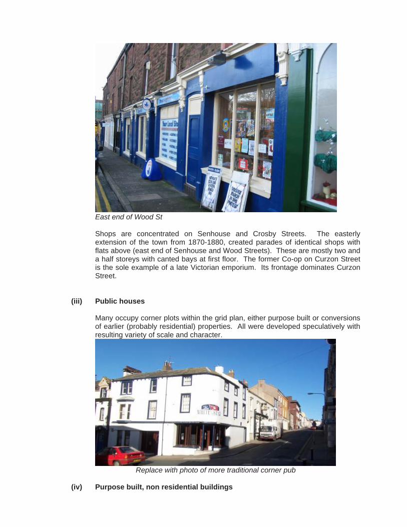
East end of Wood St Shops are concentrated on Senhouse and Crosby Streets. The easterly extension of the town from 1870-1880, created parades of identical shops with flats above (east end of Senhouse and Wood Streets). These are mostly two and a half storeys with canted bays at first floor. The former Co-op on Curzon Street is the sole example of a late Victorian emporium. Its frontage dominates Curzon Street.
(iii) Public houses
Many occupy corner plots within the grid plan, either purpose built or conversions of earlier (probably residential) properties. All were developed speculatively with resulting variety of scale and character.
Replace with photo of more traditional corner pub
(iv) Purpose built, non residential buildings

These fall into two main categories, community facilities (churches, town hall, civic hall, library, police station, former Naval Battery) and commercial buildings (banks, warehousing, brewery, telephone exchange). Churches vary greatly in scale from the modest Gospel Chapel on Furnace Road (1861) to the traditional Parish Church of St Mary’s (rebuilt 1891) and the prominent spire of Christ Church (1872). In the grid town they do not have churchyards, but outside they have yards surrounding them (St Mary’s, Church St).
photos
There are a variety of places of former entertainment and assembly, most of which are redundant or have new uses. These include: • Former Carlton Cinema, Senhouse Street (converted from a bank in 1934
with the addition of a roof top fly tower); • Former Empire Theatre, Senhouse Street (1914), purpose built with a retail
frontage and utilitarian fly tower on its John Street frontage • The former Town Hall, Senhouse Street (c.1880), now Tourist Information; • The former Naval Battery, Sea Brows (1885) now the Senhouse Roman
Museum; • The Civic Hall, Lower Church Street, an inter-war utilitarian shed.
Community Facilities The area retains a variety of community facilities. These include the Police Station on Eaglesfield Street, the Library (Lawson Street) and the Doctor’s Surgery (Selby Terrace). The Police Station is a typical Edwardian suburban police station. The 1930s Doctor’s Surgery (1930s and late C20) and Library are modest and suburban in scale and type. Commercial Buildings The earliest surviving example of a specialist commercial building in the area is the former 3 storey warehouse at 2 and 3, South Quay. This was constructed in the mid-late C18 for William Blennerhassett, for the export of coal to Ireland and import of potatoes. It is one of few surviving elements from the town’s industrial history. The former brewery at 68 Wood Street is a good example of a late C19 factory. The 2 storey frontage buildings were for the offices, with workshops around its rear yard, accessed via a carriageway from the street. Opposite is the 3 storey C20 telephone exchange. Senhouse Street contains a number of banks occupying purpose built premises and converted former shops. The most noteworthy purpose built bank is the prestigious Edwardian HSBC on the corner of Senhouse Street and Crosby Street.
4.6 Materials, local details and architectural styles The buildings which predate the railways are of local sandstone with Cumbrian slate roofs (laid to diminishing courses) in a late Georgian ‘Cumbrian vernacular’. This is characterised by plain raised window and door architraves which project from the smooth rendered face of the rubble-cored walls.
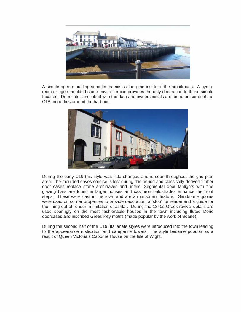
A simple ogee moulding sometimes exists along the inside of the architraves. A cyma-recta or ogee moulded stone eaves cornice provides the only decoration to these simple facades. Door lintels inscribed with the date and owners initials are found on some of the C18 properties around the harbour.
During the early C19 this style was little changed and is seen throughout the grid plan area. The moulded eaves cornice is lost during this period and classically derived timber door cases replace stone architraves and lintels. Segmental door fanlights with fine glazing bars are found in larger houses and cast iron balustrades enhance the front steps. These were cast in the town and are an important feature. Sandstone quoins were used on corner properties to provide decoration, a ‘stop’ for render and a guide for the lining out of render in imitation of ashlar. During the 1840s Greek revival details are used sparingly on the most fashionable houses in the town including fluted Doric doorcases and inscribed Greek Key motifs (made popular by the work of Soane). During the second half of the C19, Italianate styles were introduced into the town leading to the appearance rustication and campanile towers. The style became popular as a result of Queen Victoria’s Osborne House on the Isle of Wight.

Domestic architecture remained simple throughout the C19, but commercial buildings were influenced by Victorian styles. Commercial buildings are ornamented with Gothic and classical motifs formed in stucco. Style was principally derived from the use of applied detail on hood-moulds, window surrounds and eaves. The railways brought the cheaper Welsh slate in, which then superseded local slate as the dominant roofing material. Expansion of the town during the 1870s was in Victorian style with rock faced red sandstone replacing render. Single pane sash windows and canted ashlar bays are typical. Gothic motifs appear, including stop chamfered lintels, door and window jambs and quatrefoil fanlights, often found in conjunction with classical details such as segmental window heads with imposts and keystones. Dormers became common, with hipped dormers above the eaves and gabled dormers often breaking the eaves.
Throughout the C18 & C19, the timber sash window was the only window type, set within deep reveals to give protection from the weather and provide depth to the façade. Few examples of multi-paned, hornless Georgian sashes survive, most having been replaced by later Victorian horned, four or two paned sashes. The vertical proportions of all sash windows are a principal architectural feature and should be retained. Their repetition throughout terraced development gives the strong architectural rhythm. Brickwork is an alien facing material in the Conservation Area. It only exists on the Gothic style factory at 68 Wood Street and the Neo-Georgian inter-war post office on High Street. Traditionally, brick is only seen on chimney stacks.
4.7 Listed buildings
A listed building is one that is included on the Government’s Statutory List of Buildings of Special Architectural or Historic Interest. These buildings are protected by law and consent is required from Allerdale District Council before any works of alteration, extension or demolition can be carried out. Listed buildings are marked on the Townscape Appraisal map. Within the area there are approximately 50 listed buildings varying in character from simple terraced Georgian housing to the former Naval Battery (Senhouse Roman Museum) and St Mary’s Church.
4.8 Buildings of Townscape Merit
Many unlisted buildings have been identified on the Townscape Appraisal map as being “Buildings of Townscape Merit”. They are generally good examples of relatively unaltered buildings where their style, detailing and materials provides the streetscape with interest and variety and so contribute positively to the special interest of the conservation area. Buildings which have been altered beyond likely restoration are not included. The l presumption is strongly in favour of retaining buildings which make a positive contribution to the character or appearance of the conservation area.
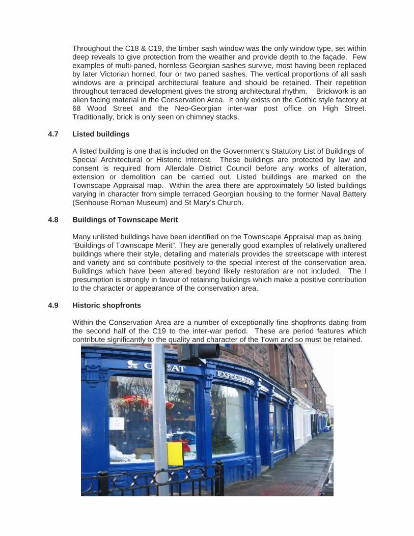
4.9 Historic shopfronts
Within the Conservation Area are a number of exceptionally fine shopfronts dating from the second half of the C19 to the inter-war period. These are period features which contribute significantly to the quality and character of the Town and so must be retained.
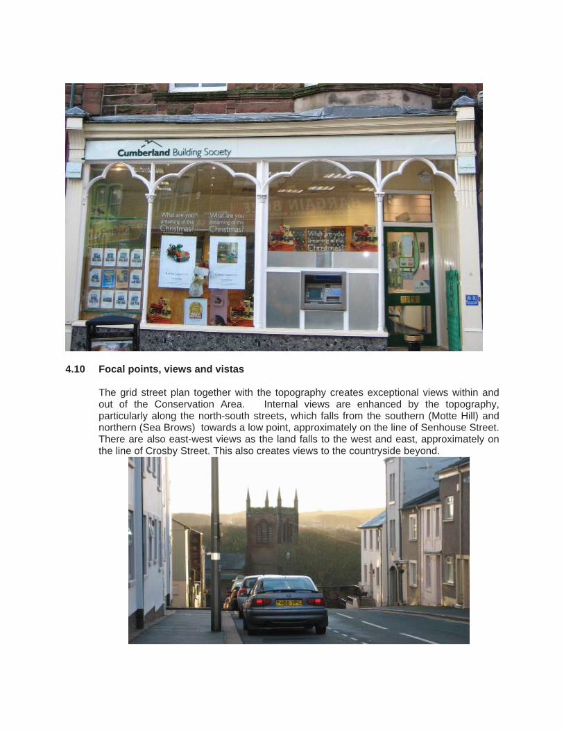
4.10 Focal points, views and vistas
The grid street plan together with the topography creates exceptional views within and out of the Conservation Area. Internal views are enhanced by the topography, particularly along the north-south streets, which falls from the southern (Motte Hill) and northern (Sea Brows) towards a low point, approximately on the line of Senhouse Street. There are also east-west views as the land falls to the west and east, approximately on the line of Crosby Street. This also creates views to the countryside beyond.

Seascape views are created by the bluff which connects Motte Hill in the south with Sea Brows in the north. Fine views of the docks & harbour area and the coastline south towards Workington are gained from The Settlement and Motte Hill. From Brow Street and the western ends of Kirkby and Eaglesfield Streets and Fleming Place there are unrestricted views of the port and west and north to Dumfries and Galloway. From the northern end are views of the remote and unspoilt Solway Coast.
There are both built and natural focal points. Built focal points are principally provided by buildings which terminate views through the town and across the Docks/harbour. These include: • The tower of St Mary’s Church; • The spire of Christ Church; • The lighthouse; • The Senhouse Roman Museum; • The campanile of Park Hill/Camp Hill House, Camp Road; • The campanile of Solway House, Solway Terrace; • Ellenborough Terrace. Natural focal points are provided by the topography. Motte Hill rises dramatically from the low land on the estuary of the River Ellen. The cliff to the north of the Motte serves as a back-drop to the harbour area. The hilly coastline of Dumfries and Galloway provides a focal point on the north western horizon from the bluff and the end of North Quay.
4.11 Historic associations
Thomas Ismay

Thomas Henry Ismay, founder of the White Star Line, was born at Ropery House, Ellenborough Place (nr Elizabeth Dock) in 1836. The White Star Line was established in 1869 when the Oceanic Steam Navigation Company was founded in Liverpool by Thomas Ismay. An important relationship was soon forged between White Star and the Belfast shipbuilders, Harland and Wolff. This steamship company was an offshoot of the original White Star fleet of sailing clippers and the white star on red pennant flown on early clippers became the house flag of the new company. By the end of the C19 the White Star Line was the most powerful British shipping company with ships trading to the American continent, Australia and South Africa. Ismay had amassed capital of £2,000 by the time of his marriage at the age of 22 and within a decade this had grown to nearly £500,000. When he died in 1899 his estate was valued at £1.75 million. The Senhouse Family The Senhouse family acquired the estate through marriage in 1528. Netherhall became the principal home of the family from the mid C16 to the mid C20. The Senhouse family is inextricably linked with the development of Maryport in the C18 & C19. The family had antiquarian interests and assembled the internationally important collection of Roman antiquities displayed at the Senhouse Museum.
4.12 Open Spaces and green area
Maryport Conservation Area is a dense urban form contrasting with the openness of the coast, the river estuary to the west and countryside to the east. Formal open spaces The former market place, set at the northern end of the late C18 grid, now known as Fleming Square, provides a space of unexpected quality. The rectangular space is defined on four sides by 2 & 3 storey town houses of late Georgian character. The space is unified by the granite cobbled surface with shade provided by the (recently introduced) plane trees around the perimeter. The recent obelisk reinforces the Square’s formality. Informal spaces A chain of informal open spaces surrounds the dense urban townscape of the grid town. These provide a setting for the town as well as recreation space: i) Motte Hill, the degraded cliff line and the Ellen estuary. The steep bank leading
down from Motte Hill to the River Ellen is used informally as a recreation space. The land at the base of the hill, bordered by the River provides informal recreation.
. ii) The Old Harbour. The North and South Quay provide an attractive outlook over
the Old Harbour. The historic quayside and uninterrupted sea views provide a popular area for walking and relaxing;
(iii) St Mary’s churchyard. The walled enclosure provides a peaceful retreat from the town and the traffic. The mature trees provide a valuable green canopy terminating views down Wood Street, Kirkby Street and Curzon Street;
(iv) The War Memorial Gardens and Netherhall Park. Set prominently on the corner of the A594 and A596 the War Memorial Gardens provides a quiet public space on the edge of the old Town. To the north and east, the parkland of Netherhall is enclosed by a high stone wall. Although it is unmanaged and in private ownership, it is picturesque with fine specimen trees, and the River meandering through. It is used for coarse fishing and informally as a wilderness area.
4.13 Public Realm
There is little historic paving or furniture remaining. It is likely that large slabs of St. Bees Sandstone or Caithness Stone would have been used for paving. The scarcity of historic finishes gives added significance to the few remaining areas of granite and beach cobbles most notably in Fleming Square and back lanes such as Little Camp Street and between North Street and Christian Street. The best example of historic floorscape, (though not all original), is in Fleming Square. Intermittent lengths of stone kerbs still exist, many re-set after road works, such as along the west ends of Eaglesfield and Kirkby Streets, the northern end of High Street and along Fleming Place. Street lighting and street furniture in the area are modern and out of keeping with the historic town. There are some old cast iron railings and bollards at the western end of Eaglesfield Street alongside the flight of stone steps leading down to Wallace Lane, and C19 boundary railings at the north end of Camp Road. The decorative cast iron handrails on the front steps are a particular feature of the High Street.
5.0 Maryport Character areas
Analysis has identified 7 distinct areas of townscape character (although of course the boundaries overlap in reality). The 7 areas identified are: • Area 1: The Old Harbour
The C18 Old Harbour, North and South Quays together with Shipping Brow;
• Area 2: The grid plan town The C18 street blocks laid out by Humphrey Senhouse and developed in the early C19 with predominantly terraced, housing;
• Area 3: The commercial centre The commercial hub of Maryport includes Senhouse Street, Crosby Street (part) and Curzon Street. This area was partly developed in the late C18/early C19 and later as the eastward expansion of the town from 1874-1880;
• Area 4: The eastern suburb This was an eastward (and northerly) extension of the town in 1874-5 towards the station, following the infilling of the millrace which formerly terminated Senhouse St;
• Area 5: Netherhall Park
Undeveloped walled parkland with medieval origins with Pele Tower, service yard and lodges of the former Netherhall country house, the Senhouse family seat;
• Area 6: The Roman Fortress of Alavna
Alavna is a Scheduled Ancient Monument, comprising a grassed field enclosed by stone boundary wall and occupies an elevated site at Sea Brows. The site of the fort and small vicus contains a series of earthworks. The fort was built in c122 AD and abandoned in 410 AD. It served as the command and supply base for the coastal defences of Hadrian’s Wall.
• Area 7: Proposed Senhouse and Elizabeth Dock Extension C19 docks constructed on reclaimed land at the mouth of the Ellen. Historically integral to the town’s development and an important part of its setting.
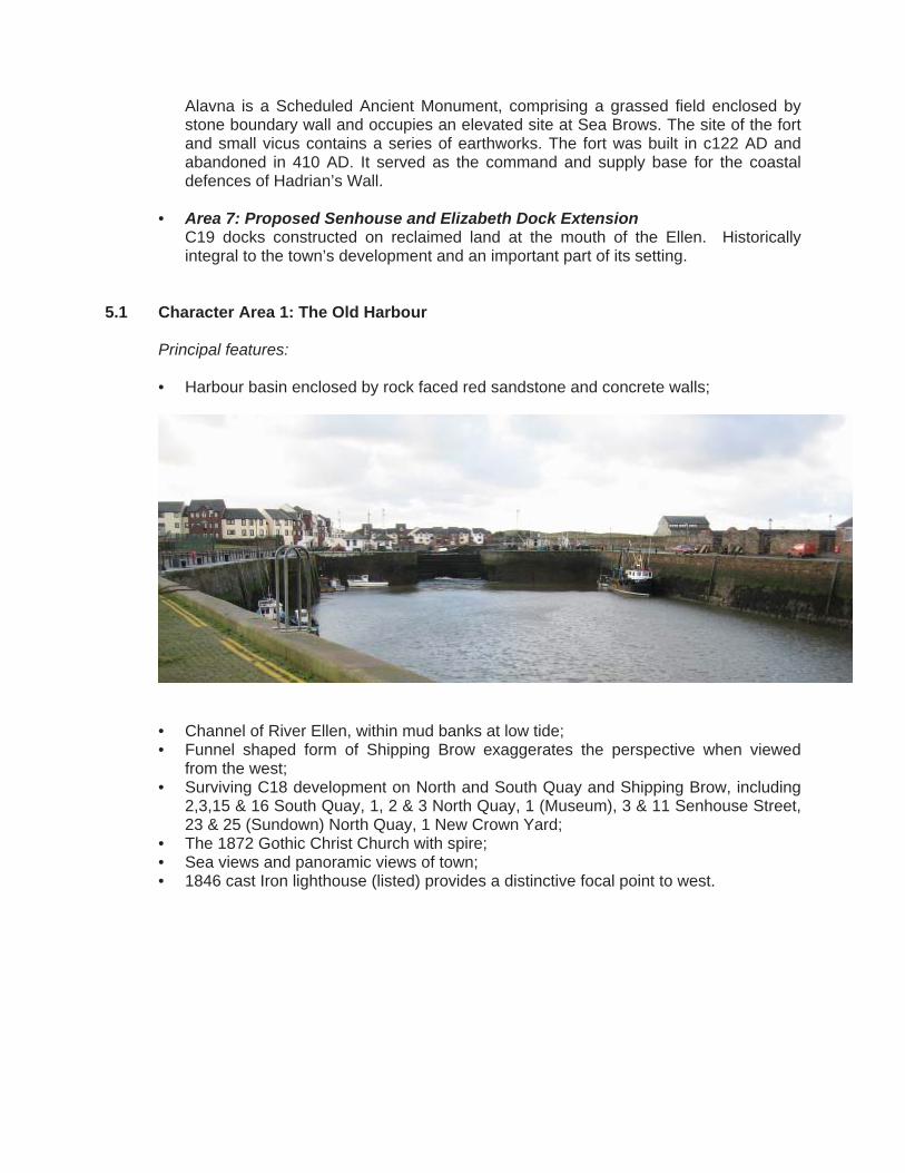
5.1 Character Area 1: The Old Harbour
Principal features: • Harbour basin enclosed by rock faced red sandstone and concrete walls;
• Channel of River Ellen, within mud banks at low tide; • Funnel shaped form of Shipping Brow exaggerates the perspective when viewed
from the west; • Surviving C18 development on North and South Quay and Shipping Brow, including
2,3,15 & 16 South Quay, 1, 2 & 3 North Quay, 1 (Museum), 3 & 11 Senhouse Street, 23 & 25 (Sundown) North Quay, 1 New Crown Yard;
• The 1872 Gothic Christ Church with spire; • Sea views and panoramic views of town; • 1846 cast Iron lighthouse (listed) provides a distinctive focal point to west.

Location and topography: The Old Harbour comprises the Old harbour Basin, North and South Quay, the west end of Senhouse and Bridge Streets including the C20 bridge over the Ellen estuary. The land rises steeply from sea level to the east, leading up to the town astride the bluff, via a degraded cliff line breached by Senhouse Street. Historical development: • A natural harbour at the mouth of the Ellen, which was upgraded during the C18, C19
& C20; • During the early C18 the Town consisted of a single farmstead (Valentine’s Farm on
the site of the Golden Lion) and a few fishermen’s huts. The coal trade to Ireland led to growth throughout the C18;
• Until the late C18, ships sailed into the mouth of the Ellen and were loaded with coal directly from packhorses;
• In 1749 an Act of Parliament was granted for “repairing, enlarging and preserving the harbour of Ellenfoot in the county of Cumberland”. It sought to develop a new town laid out on a grid plan and served by a harbour. Voluntary subscriptions were sought for works including the erection of a pier. The first plot was let at the western end of Senhouse Street in 1754, this building, now the Museum and former Victoria public house, survives (although modified in the late C19);
• In 1816 wooden piers were constructed around the harbour mouth to simplify the handling of coal. In 1836 a tidal dock, known as the ‘clock basin’, was formed, with a swing bridge across the entrance extending to almost a hectare in area. The arrival of the railway in 1841 allowed coal to be delivered directly to the pier heads in wagons. In 1847, further improvements were undertaken to the harbour. The original timber south pier was extended after a major storm in 1852.
Uses: South Quay is commercial in character with public houses, restaurants and Offices. This contrasts with the residential North Quay. The south end of King Street and the western end of Senhouse Street are mixed in character with residential, public houses, restaurants and the local history museum.

Townscape and architectural character: The character of the area is derived from the openness of the Old Harbour basin, sea views to the west and the significant number of C18 quayside buildings. The largest of these is the three storey house and warehouse at 2 and 3 South Quay which is characteristic of the west Cumbrian vernacular. The style is typified by Cumbrian slate roofing laid to diminishing courses, smooth rendered elevations with plain raised stone window and door architraves, hornless multi paned sash windows set in reveals and a modest stone cyma-recta eaves cornice. The later C18 buildings are of similar scale and detailing and as such form a cohesive group.
At the southern end of South Quay is a small group of vernacular buildings which turn the corner to the bridge, stepping up from 2 to 3 storeys. Opposite, across the bridge to the east, the southern end of Senhouse Street is composed of similar properties arranged in semi-detached pairs and short terraces on the southern side and as an organic terrace on the north. These properties step down the steep incline of Shipping Brow creating an varied roofline punctuated by large chimney stacks. The short terrace of double fronted cottages on North Quay is of modest scale with a variable ridge line and heavy, steeply pitched slate roof at the western end.
On the southern corner of King Street, the tall red sandstone spire of Christ Church (1872) is a landmark feature and orientation point within the town and across the docks to the south. Development on the eastern side of King Street at the end of the Old Harbour, steps up in scale from 2 low storeys to 3 tall storeys at the corner of Senhouse Street. The 1840 3 bay corner property with quoins and a splayed corner, is now in residential use but was formerly a ships chandlers. The short terrace of which this property forms part has regrettably suffered extensive window replacement. Positive features: • Late C19 century mosaic tiling on corner of local history museum depicting head of
Queen Victoria; • Dated and initialled door lintels on South Quay; • Late C20 figurative group sculpture by local artist adjoining bridge; • Masonry base of former swing bridge set immediately to south of present bridge. Negative features: • Late C20 streetscape especially concrete setts on Shipping Brow; • Loss of architectural detailing particularly sash windows and Cumbrian slate roofing; • Modern safety railings around harbour walls; • Sea defence walls around quayside; • Derelict property ‘Sundown’ (No.25 King Street) on east side of Old Harbour.
5.2 Character Area 2: The grid plan town
Principal features: • Grid iron street plan; • Dense blocks of mainly early C19 terraced housing; • Flat fronted terraced housing (mostly 2 storey) set on the back edge of the footpath; • Fleming Square, the former market place with cobbled surfacing and fine terraced
late Georgian style townhouses; • Sea and harbour views from western edge of grid; • Long views down principal streets aligned on north-south axis; • Dramatic change in level immediately to the west associated with former cliff line; • Views of St Mary’s Church tower to the east down Kirkby Street; • High status villas at southern and northern ends of High Street, Fleming Place and
across eastern and southern sides of Fleming Square; Location and topography: This character area includes part of High Street and Crosby Streets together with Fleming Street, Fleming Place and Square, Eaglesfield Street, Kirkby Street, Wood Street, Catherine Street, Queen Street, George Street and Furnace Road/Lane. The grid plan town is set astride a bluff defined to the south and south-west by the River Ellen. The southern end of the area is dramatically marked by Motte Hill, which affords commanding views across the Ellen estuary and the coastal lowlands to the south. To the west, the area is constrained by the dramatic change in level associated with the degraded cliff line. The eastern boundary of the area is defined in the north by the western frontage of Church Street, whilst to the south of Senhouse Street the eastern boundary follows the historic line of the millrace which is now recalled by Mill Street.
The topography is locally complex, but as a general rule falls from the northern and southern ends of the grid towards John Street. A ridge also runs along the spine aligned along an approximately north-south axis along the bluff, in a position approximating to the line of Kirkby Street. The land falls to the east and west of this north-south ridge. Historic development: • Earliest development of the area is associated with the erection of a medieval motte
and bailey fortress overlooking the Ellen estuary from the Motte Hill peninsula in the C12, which was finally abandoned in the C14;
• The grid plan town was essentially a planned town facilitated by Act of Parliament in 1749. Although the street plan was laid out soon after the Act, it is thought that development occurred sporadically at the southern end of the grid, spreading east and north on a piecemeal basis;
• Plots were leased by the Senhouse Estate and developed individually and more rarely as pairs or short terraces. Development appears to have faltered initially but gaining pace in the early C19.
Uses: The area is principally residential in character, with some retail uses spilling over from the commercial centre to the east. Also are the Police Station and a number of churches. Townscape and architectural character: The area has a cohesive character resulting from a consistent form of development and architectural detailing. Development is set on the back edge of the pavement and comprises terraces composed of individual town houses. These are variable in scale and generally of 2 or 3 stories (often at corners). The houses are simple and generally single fronted. Higher status, double fronted units occur at the southern and northern ends of High Street and along Fleming Place. Roofs are low pitched with verge detailing and generally covered in Welsh slate. The use of dormers is rare. Chimneys are generally constructed in exposed red brick. Short plain terracotta pots are the norm. The houses are of a late Georgian style with smooth rendered elevations, often lined out in imitation of ashlar with quoins. Eaves are simple and parapets rare. The cyma-recta cornices found in mid-late C18 development around the Old Harbour are also rare. Hornless multi-paned sash windows (or later horned replacements) set on stone cills provide a strong rhythm along the terraces. Windows and doors are defined by plain raised architraves which further emphasise the modulation of the façades. Simple plaster door cases with plain entablature or reed mould architraves with paterae (rose shaped ornamentation) are also found. Larger detached villas may incorporate Doric doorcases and more elaborate stucco detailing, such as string courses and rustication. Basements rarely have lightwells on the front elevation. Changes in level sometimes expose the lower ground floor at the rear. Houses are painted in a variety of colours, with contrasting architraves. This is a modern aesthetic. Originally, a light ochre, off-white limewash or oil paint would have been used to imitate of Bath Stone. Positive features: • Decorative cast iron balustrades on the front elevations of houses with steps; • Red sandstone or granite kerbs and granite setts; • Cast iron railings and bollards along former cliff line defining west boundary of area; • Early C19 cast iron street name plaques fixed on stone quoins. Negative features:
• Use of some modern garish colour combinations applied to render and stone details; • Loss of architectural detail, particularly sash windows and panelled doors and the
installation of inappropriate replacements; • Stripping of render to expose rubble masonry (particularly at south end of Church St); • Inappropriate alterations, especially additions at roof level (flat roofed or large
dormers) and alterations to window openings; • Bland inappropriate street finishes including Tegula paviours; • Crudely detailed replacement railings and balustrades; • Loss of the fine grain townscape as a result of plot coalescence and redevelopment
with large blocks, particularly on corner sites.
5.3 Character Area 3: The commercial centre Principal features: • Main shopping frontage centred on Senhouse Street; • Important secondary frontage along Crosby Street; • C19 shops, many with fine period shopfronts; • Rendered early and mid C19 shops and public houses developed as single plots at
western end of Senhouse Street and along Crosby Street; • Mid C19 frontages with stucco detailing including The Carlton, Golden Lion, former
town hall, 34-6, 33 and 67 Senhouse Street and 88-92 Crosby Street; • Rock faced red sandstone parades of shops (1874-1880) of predominantly two and a
half storeys with canted bays at first floor (east of. 69/70 Senhouse Street); • Large former late C19 Co-op Emporium on Curzon Street with grand 3 storey red
sandstone frontage; • The Edwardian Baroque HSBC bank, faced in red sandstone ashlar with arcaded,
rusticated ground floor and fine lead-dressed corner feature; • The fine brick detailing and lively roofscape of the Royal Victoria public house (1899)
and adjacent 70 Crosby Street. Location and topography: Located on Senhouse Street, Crosby Street and part of Curzon Street. Senhouse Street rises steeply from Shipping Brow and the Old Harbour to a plateau between High Street and Furnace Lane. To the east of Furnace Lane, Senhouse Street falls to join Curzon Street. Crosby Street slopes gently from Senhouse Street down to its junction with John Street; it then ascends consistently northwards towards Fleming Square Historic development: • Crosby Street and the western end of Senhouse Street (terminated formerly by the
millrace at its eastern end until 1874) are principal streets of the grid plan town, laid out following the enabling Act of Parliament of 1749;
• Surviving development dates from the early and mid C19; • The infilling of the millrace in the later C19 facilitated the eastward extension of the
street. This is marked by the widening of the street towards the east end and the change in character to terraces of identical properties.
Uses: Independent retailers dominate the ground floors with residential units above. Public houses and cafés only exist at the western end of Senhouse and Crosby Streets. Townscape and architectural character:
The western end of Senhouse Street is defined by of 2 & 3 storey development of variable scale and plot width. These variations, together with individual ornamentation, create considerable townscape interest. The townscape is unified by the consistent use of stucco, slate roofs and sash windows set in reveals. Parapets are rare although the former Town Hall and The Carlton are exceptions. Bracketed eaves, hood-moulds, rustication and other ornament formed in stucco create a solid mid C19 character. A hierarchy of scale and detail exists along Crosby Street and between Crosby and Senhouse Streets. Most of the buildings are simpler and smaller towards the northern end of Crosby Street (with the exceptions of the Royal Victoria public house, 70 Crosby and 88-92 Crosby Street). The individuality found at the west end of Senhouse Street and along Crosby Street contrasts with the parades of shops defining the east end of Senhouse Street. They are faced in coursed rock-faced red sandstone with ashlar window surrounds. Canted bays and engaged sashes at first floor level, with dormers breaking through the eaves. The terraces step down the slope towards Curzon Street creating an architectural rhythm. Positive features: • Independent retailers provide individuality and distinctiveness; • Fine period shop fronts; • Fine stucco detailing at western end of Senhouse Street; • Brick and terracotta detailing on the Royal Victoria and No.70 Crosby Street. Negative features: • Loss of architectural detail especially canted bays at eastern end of Senhouse Street; • On-street parking; • Modern cluttered public realm in Senhouse Street including paving, bollards and
street lights • Derelict buildings eg the Golden Lion and shops and public houses on Crosby Street;
5.4 Character Area 4: The Eastern Suburb
Principal features: • Composed late C19 terraces of identical housing; • Cast iron boundary railings on Curzon Street frontage; • Coursed, rock-faced red sandstone elevations; • Single and two storey canted bays; • Dormers set immediately above or breaking the eaves; • Smooth sandstone window and door surrounds (now painted); • 2/3 storey buildings; • Sash windows set in deep reveals often engaged (double?) at first floor level • Slate roofs with large, rectangular plan, axial chimneys with terracotta pots. Location and topography: This area is on the south-eastern corner of the conservation area. It is bounded by the River Ellen, the A594 and Mill Street. The topography is gentle and falls towards the parish church at the north end of Curzon Street and also down Lawson Street. Historic development: The character area was developed during the last quarter of the C19. Curzon Street and Station Street were existing streets associated with the railway station to the southeast.

Uses: The area is almost exclusively residential in character, with the exception of the doctor’s surgery and library on Lawson Street and Selby Terrace. Townscape and architectural character: The area has a strong, cohesive character derived from the use of consistent facing materials, scale and detail. Curzon Street is broad and straight with fine late C19 terraces on the east side. The terraces are of 3 storeys south of the junction with Senhouse Street and two and a half storeys to the north. The surviving cast iron front boundary railings are particularly noteworthy. The Church of St Mary and its trees provide an attractive focal point at the north end of the street. The southern end of the street is fragmented in character and lacks a focal point. The C20 road bridge rises to cross the River Ellen and partially closes southern views out of the area. At the extreme southern end of Curzon Street, there is a supermarket of uninspiring design at the rear of a car park on the west and an inter-war vehicle repair workshop opposite. To the north, the C20 Trinity Church poorly defines the corner of Station Street and detracts from the integrity of the late C19 townscape. The streets to the east of Curzon Street are also composed of long terraces of houses of consistent height, facing materials and detailing. Lawson Street is a crescent shaped street with houses set behind shallow front gardens with dwarf front boundary walls topped by modern railings. The terraces are 2 storeys, each with a canted bay to the ground floor and engaged sashes above with a single dormer window (which breaks or sits close to the eaves). The painted ashlar door cases with stone hoods on simple corbels are a typical feature of the area. The terrace on the east side at the north end of the street (1-27 odd) has two storey canted bays. Selby Terrace has a single frontage on the west side of the street. The terrace is set behind a shallow front garden edged with a dwarf rock faced boundary wall. At its northern end, 1-12 Selby Terrace define the eastern edge of the area. The terrace has a strong composition of two storeys punctuated by twin central gabled bays. These are forward of the remainder of the terrace. The terrace has fine detailing and retains its pedimented dormers, moulded stone eaves cornice with wrought iron brackets and coped gables with kneelers. At the north end of the grid, Christian Street and North Street share the same townscape qualities and architectural character. Christian Street is composed of uniform terraces on both sides, faced in red sandstone with painted ashlar window surrounds. The front boundaries are enclosed by dwarf boundary walls. The terraces are of two and a half storeys canted bays at ground floor at the west end. The north side is a short terrace, the end properties have gabled bays which are set forwards of the remainder. The eaves line is broken by gablets. From the east end, there are long views down Church Street and to the east over later suburban development to open countryside and hills beyond.
North Street is distinguished by its rendered elevations. The terraced housing is of two storeys plus attic. The south side is set on the footpath whilst the northern frontage is set behind a shallow forecourt with dwarf walls. The southern frontage is architecturally simpler with flat fronted terraces with double sashes at ground and first floor. The north side is more ornate with canted ground floor bays and double sashes within an arched recess at first floor. The gablet attic dormers have fretted bargeboards with turned finials. Ornately moulded corbels support plain shallow doorhoods. An unbroken view is gained along the street to the western horizon. North Street is narrower than Christian Street and consequently has a greater sense of enclosure. Positive features: • Cast iron front boundary railings set on dwarf walls of rock faced stone; • Cobbled back lanes; • Rear boundary walling; • Rock faced red sandstone facing and walling stone. Negative features: • Noise, vibration & visual intrusion on Curzon Street associated with heavy traffic; • Loss of architectural detail in particular plastic windows; • Street clutter including traffic lights and pedestrian railings; • Loss of distinctive public realm with replacement Tegula paving and motorway style
lamp columns.
5.5 Character Area 5: Netherhall Park
Principal features: • Medieval pele tower (A Scheduled Ancient Monument); • Service courtyard complex of former Netherhall country house; • Rubble estate boundary walling; • Early C19 former lodges; • Ionic summerhouse; • River Ellen; • Mature parkland trees; • Ha-ha to boundary with Rugby Club. Location and topography: Netherhall Park is set between the A594 and the A596 immediately to the north of the Eastern Suburb character area. The area has gently rolling topography with the channel of the River Ellen running through its centre. Historic development: • At the end of the C13 the estate was purchased by the Eaglesfield family; • The Senhouse family acquired the estate through marriage in 1528 when Elizabeth,
sister and co-heir of Richard Eaglesfield of Alneburgh Hall (later Netherhall) married John Senhouse of Seascales;
• Netherhall was the principal home of the family from mid C16 to mid C20. Netherhall suffered a disastrous fire in 1973 and was then demolished with the exception of the medieval Pele Tower;
• The early C19 service court and lodge survives together with a derelict ashlar Ionic summerhouse from the same period.
Uses:
The estate remains in private ownership with no public access. The local coarse fishing club uses the attractive River Ellen for sport. Townscape and architectural character: The area retains a remote rural quality which is reinforced by the apparent absence of any management. The pele tower stands as an impressive isolated fragment of the former country house. The remaining structures are small and simple. The parkland is overgrown with the feeling of abandonment. Negative features: • Partially collapsed estate boundary walling; • Dilapidated historic buildings especially Ionic Summerhouse; • Fallen trees and lack of effective management of parkland.
5.6 Character Area 6: The Roman Fortress of Alavna Principal features: • Scheduled Monument comprising a field enclosed by stone boundary wall; • Archaeologically interesting series of earthworks defining the fort and small vicus; • Impressive sea views to north/west across Solway Firth to Scotland; • The Senhouse Roman Museum occupying the former Naval Battery building (1885); • Viewing tower of the Roman Museum overlooking the site of the fortress; • Substantial villas set in large garden plots along the north-east side of Camp Road • Stone boundary walls around site of Roman fortress. Location and topography: The character area forms the northern head of the conservation area. The area is elevated by a 55m high sea cliff. The highest point is approximately 750 metres to the north of the River Ellen. Camp Road rises gently from Christian Street to the south. Historic development: • The Roman fort was initially developed around 122 AD and abandoned by 410 AD. It
served as the command and supply base for the coastal defences of Hadrian’s Wall; • The villas on Camp Road date from the last quarter of the C19; • The Naval Battery was constructed in 1885 for gun training of the Royal Navy Artillery
Reserve; it was subsequently used by the Territorial Army until 1966. Uses: The principal use of the area is residential. The Senhouse Roman Museum is a low key visitor attraction in an area of informal recreation. The cliff top footpath is enjoyed at all times of the year. The children’s playground to the south of the fort site is a popular local facility close to the dense blocks of housing. Townscape and architectural character:
The area has a rural quality derived from its open character and the surrounding undeveloped countryside. The low density of development surrounding the site of the fort is an important part of its setting. The area to the west of Camp Road is free from trees and the Roman Museum stands in isolation on the cliff top. The two storey villas at the northern end of Camp Road stand in generous plots and the mature sycamore trees surrounding Park/Camp Hill are a focal point. The west side of Camp Road is defined by a low mortared rubble boundary wall with the remains of mid C19 railings set into coping stones. There are panoramic views over the fort site to the sea. The large villas have an Italianate style with stuccoed elevations and twin campanile. The former Naval Battery is designed in a Baronial style with Gothic influences reflecting the work of William Burges. Positive features: • Twin, three storey campanile of Camp Hill/Park Hill villas; • Fine cast iron front boundary railings of villas on east side of Camp Road; • Tall red sandstone gate piers at end of Camp Road • Rubble stone field boundary walling; • Timber ‘watch tower’ of Roman Museum; • Remains of railings on west side of Camp Road with anthemion finials to stanchions. Negative features: • Lack of public access to site of fort; • Lack of interpretation of Roman archaeology; • Eroded/missing railings on west side of Camp Road • Camp Road School intrudes into the setting of the area.
5.7 Character Area 7: Proposed Senhouse and Elizabeth Dock Extension
Principal features: • The Elizabeth Dock is composed of twin basins, the outer basin is tidal whilst the
inner is controlled by dock gates; • The Senhouse Dock comprises a single large basin controlled by dock gates on the
western side of the docks; • Sea wall on the west side of Senhouse Dock which protects the harbour mouth; • Listed cast iron Lighthouse erected in 1846 at northern end of sea wall • Twin mid C19 harbour master’s offices on west side of each basin of Elizabeth Dock; • Gun emplacement and guardhouse on north end of the sea wall protecting the
harbour entrance; • Terraced C19 2 &3 storey houses defines the southern edge of the area. Location and topography: The area comprises low lying reclaimed land to the south-west of the Ellen estuary, approximately 3.5 metres above sea level. The area is bounded by the sea wall to the west, the River Ellen to the east and the South Quay and Old Harbour to the north. Historic development: • Construction started on Elizabeth Dock (named after Elizabeth Senhouse) in 1854; • The Dock opened in October, 1857; • The dock is 180 metres in length, and 73 metres wide, enclosing an area of 1.4
hectares. The depth of water on the sill at ordinary spring tides was 6 metres, and at neap tides 4.3 metres, thus restricting the size of ship that could use the port;
• The Elizabeth Dock was unable to keep pace with the rapid increase in trade, and was unsuited to the ever increasing size of ships. In response, the construction of the Senhouse Dock commenced in 1880;
• The work was delayed by significant storm damage in November 1881, which caused extensive flooding and the destruction of the embankment. To protect against future storm damage, the scheme was modified, increasing costs significantly;
• The Senhouse Dock was opened in 1884. The day was declared a holiday, and a commemorative medal was issued. The dock is 260 metres in length, 91 metres in width and nearly 2.4 hectares in area. The depth of water on the sill at ordinary spring tides was 8.5 metres, and at neap tides 5.8 metres.
Uses: The Elizabeth Dock is still used by the small fishing fleet whose nets are seen on the west side of the dock. The Senhouse Dock is now a popular marina for private boats. A boat repair yard operates from the east side of Senhouse Dock. The coast guard station is located to the north-west of the Elizabeth Dock. Townscape and architectural character: This is principally derived from the impressive dock structures themselves and associated C19 quayside structures including: • The small twin harbourmaster’s offices on the west of Elizabeth Dock, with lime-
washed elevations and distinctive pyramidal slate roofs; • Cast iron lighthouse set on north end of sea wall, which is a focal point to the west; • Red sandstone ashlar retaining walls; • Lifeboat station to north-west of Elizabeth Dock; • Boat repair shed/yard to south-east of Senhouse Dock; • C20 defensive structures at north end of sea wall. • Cast iron capstans along dock edge. The area to the west and north of the docks is open in character following much clearance in late C20. The recent Aquarium dominates the north-eastern edge of the area. The large pyramidal roof and deep plan form is not typical of harbourside buildings. The west side of Elizabeth Dock retains a small group of C19 maritime structures including harbour masters offices, lifeboat station and bits of stone walling from former warehousing. The forest of masts created by moored boats within the marina is a distinctive feature, particularly when viewed from the higher ground to the east. The important space between the two docks is now vacant and awaiting redevelopment. The eastern and southern side of the Elizabeth Dock is defined by late C20 3 & 4 storey flats. The rendered elevations, use of raised architraves and slate roofing with a varied roof line is of appropriate scale and takes some references from the West Cumbrian vernacular. Most importantly, the quayside remains a public space, although the car park to the east of Ritson Wharf is unattractive.
The southern edge of the area is defined by the terraced 2 storey frontage to Ellenborough Place. This is set on slightly higher ground and can be seen from the north and west across the flat undeveloped land, to the south of Motte Hill. The frontage is of two principal phases of development: the rendered housing at the south-east end is the earliest and much altered, the end terrace was the birth place of Henry Ismay in 1836. The majority of the terrace dates from the late C19 consisting of single fronted houses in rock-faced red sandstone with painted ashlar architraves, flat door canopies on consoles and with Cumbrian slate roofs. The terrace is set back with a shallow front garden enclosed by dwarf walls of large ashlar blocks with gate piers. The northern frontage is enclosed by coursed red sandstone walls.
Gilmour Street to the rear (south) of Ellenborough Place is a cohesive two storey terraced frontage in roughcast with painted architraves. The terrace has original openings. There are views along the street to the western horizon. Hutton Place, along the western ends of both streets, is a 2, rising to 3 storey mid C19 terrace of smooth, lined-out render beneath slate roofs. Positive features: • Red sandstone ashlar walls; • Slate roofs; • Raised window and door architraves; • Flat topography; • Sea gulls and fishing boats. Negative features: • Large Victoriana lamp standards; • Guard rails around docks; • Vacant sites through the loss of traditional quayside buildings; • Prominent car parking.
6.0 Issues: Positives and Negatives
Positives • Architectural quality of the buildings; • Cohesive townscape; • Historic environment; • Local shopping centre; • Proximity of harbour to town centre; • Fine sea and harbour views; • Closely knit townscape with few vacant sites; • Intimate streets and interesting topography; • Fine shopfronts and surviving independent retailers; • Close proximity of Station to town centre. Negatives • The Crosby Street and High Street areas suffer from low retail vitality and many
buildings are in a poor state of repair; • A small number of vacant shops create a bad impression and spoil the appearance of
the conservation area, especially when boarded up; • Poor state of repair of certain key historic buildings, most notably the Golden Lion; • Adverse visual impact of the Telephone Exchange which towers above historic
buildings of architectural merit;
• Inappropriate and uncoordinated street surfaces; • Loss of architectural details (e.g. windows, doors and other joinery) and loss of
original materials (e.g. Cumbrian slate, ashlar detailing, front boundary railings); • Insensitive modern developments especially C20 blocks of flats (Queen Street,
George Street and Kirkby Street) which are out of scale and character with neighbouring historic properties;
• Vacant properties and vacant upper floor space (especially along Senhouse Street); • Loss of historic identity in docks as a result of late C20th redevelopment; • Inaccessibility of harbour area from east and north; • Heavy traffic along Curzon Street, Senhouse Street and Wood Street; • Loss of original stone slab paving and kerbs. .
7.0 Recommendations 7.1 Loss of architectural detail & Article 4 Directions
Within the area the following alterations frequently impoverish the streetscape: - loss of timber windows and doors; - loss of slate roofing; - alterations to window/door openings; - loss of render from rubble stone buildings; - removal of chimney stacks; - loss of front boundary walls and railings. Certain minor works and alterations to buildings. These minor alterations can cumulatively have an adverse effect on the character and appearance of a conservation area. Most Permitted Development Rights (allowing minor works to houses) have been removed in Maryport, by an ‘Article 4 Direction’ and as such most changes need permission. However this fact appears not to be widely known. There is much evidence of unauthorised works which have had a detrimental effect upon the townscape and eroding the special qualities which justified the conservation area designation. It is recommended that an awareness campaign be carried out in the area to explain the purpose and scope of the Article 4 Direction and to secure community support.
7.2 Use of Colour
The majority of buildings within the area are simple in character and the local materials have an inherent richness of colour. The high quality fabric and cohesive nature of the townscape is dependent upon the consistent scale and detailing of buildings which comprise the townscape. The application of garish colours or gloss paint can distract from the more subtle and detailed architectural qualities of the town. It is recommended that the Council produce guidance on the use of appropriate paint type and colour.
7.3 Boundary treatments: railings and walls
Throughout much of the Georgian grid town, buildings open onto the pavement. However later Victorian terraces of the eastern suburbs and at the north end of the grid, have shallow forecourts with dwarf boundary walls and cast iron railings. These enrich the street scene and are a key element of local character. Effort should be made to repair existing front boundary walls and railings and to secure their accurate reinstatement wherever possible. The Council could encourage owners with guidance on materials and suppliers, and where possible with grant assistance.
7.4 Floorscape and local distinctiveness
Old photos and surviving fragments confirm the quality and simplicity of the historic public realm. Whilst granite cobbles and stone kerbs survive in Fleming Square/Place and a few back lanes, the majority of the area has been resurfaced using artificial materials including Tegula blocks, small concrete slabs and kerbs. Traditionally, the footpath surfaces were large sandstone slabs with granite kerbs. The retention of surviving stones is essential and all new work should use the same natural materials in order to recreate the high quality public realm of the past.
7.5 Retail floor area & re-use of redundant shops
Demand is relatively buoyant for retail and related uses in Senhouse Street. However, there is evidence that there may be an over-provision of retail floor area on secondary frontages especially towards the northern end of Crosby Street and High Street. Good quality shopfronts are a particularly important feature of the conservation area and if changes of use of shops are considered, it is essential that the retention of period shop fronts is secured.
7.6 Upper floor uses
It is apparent from street level that many of the upper floors of commercial premises are unused, or under-used. This is particularly evident on the south side of Senhouse Street, where serious disrepair is evident. It is therefore important that upper floors are brought back into some use to ensure their maintenance. Their re-use will also add to the vitality and sustainability of the area.
7.7 Parking & traffic management
Access to the quayside is currently unresolved causing increased traffic in the narrow Georgian streets. Wood Street and Senhouse Street are badly affected by traffic en- route to the Old Harbour. Measures are needed to ensure that A596(T) and Irish Street are used to access the harbourside. The dense grain of the grid with relatively narrow streets, makes parking difficult. On-street parking needs to be managed to prevent harm to the character and appearance of the area. The recent removal of parking in Fleming Square has significantly enhanced its quality. Convenient alternatives to the car are needed to discourage car use within the town. The station is within easy walking distance of the town centre and Old Harbour visitors should be encouraged to make use of public transport.
7.8 Conservation area boundary review
A proposed extension includes the Senhouse and Elizabeth Docks (shown on the townscape analysis plan). The justification for this is the historic importance of the docks to the town’s evolution as well as their contribution to the setting of the town. The surviving built heritage has significant character and is worthy of statutory protection.
7.9 Gap and Opportunity Sites
The townscape analysis plan identifies gap sites and buildings which detract from the character and/or appearance of the conservation area. This is makes explicit that the redevelopment of these sites will be encouraged (in accordance with the Key Design Principles set out within the Management Strategy).
8.0 Opportunities for enhancement
The following list, drawn out of the list of negatives in Section 5, identifies where, and how, the qualities that provide the special interest of the conservation area can be reinforced: • Grant aid is needed to assist the regeneration of the area by promoting the
appropriate repair of traditional buildings and the accurate reinstatement of lost features. The Crosby Street/High Street area contains several vacant shops and displays other signs of low economic vitality;
• Review of design and materials of paving/streetscape throughout the area with
a view to publication of a streetscape manual setting out principles for public space design. English Heritage’s ‘Streets For All’ publication sets out general principles for a co-ordinated approach that can help provide an environment that is safe, enjoyable and appropriate to its surroundings.
• Restoration of architectural detail which is essential to the design and character of
key historic buildings (where there is historical evidence), especially shopfronts, timber windows and doors, terracotta detailing, chimney stacks and roof slates.
• Promote understanding and awareness of existing Article 4(1) direction by
production of publicity leaflet. Carry out a photographic survey for assessment of all relevant houses, to be reviewed regularly.
• Allied to the possible extension of the area is the extended use of an Article 4(2)
direction to prevent removal of original features on elevations facing the highway, such as: • the removal of front boundary walling; • alterations to door or window openings and the replacement of timber windows
with alternative materials or different detailing; • the painting of dressed stonework; • replacement of natural slate roofing with alternative materials; • removal of chimneys; • the installation of rooflights.
• Bringing vacant floor area back into use. Vacant premises and vacant upper floors deteriorate rapidly and look unsightly. Residential (or other) conversions, making use of vacant floors would provide accommodation and enhance the character and appearance of the area.
• Reinstatement of traditional paving. Only small areas of historic floorscape still exist, but they are an important part of the area’s special interest. This appraisal has identified the most important examples of these surfaces which should be protected and repaired as necessary, using traditional techniques and materials. Existing granite and sandstone kerbs must be retained in any improvement scheme.
• Promotion and encouragement of structural and external repairs, and routine
maintenance, of all the ‘Buildings of Townscape Merit’. A number of historic buildings, mostly on the fringe of the commercial area, are in a poor state of repair. Grant aid may be needed to assist repair and restoration;
• Protecting items of streetscape merit.
Small items such as cast iron railings, step balustrades, stone steps and old street name plaques add considerably to the Town’s distinct local identity but often are not statutorily protected from removal or demolition. Owners and those responsible for their upkeep should be informed of each item’s importance and provided with advice and assistance.
8.1 Summary of Recommendations
• Publicise/Review Article 4(1) direction; • Provide guidance on appropriate paints; • Provide guidance on boundary treatments; • Produce a public realm strategy for streetscape; • Provide design guidance regarding the conversion of shops to new uses; • Review traffic flows and produce traffic management strategy; • Promote the repair/restoration of traditional buildings/details; • Extend designation to include historic docks.