ma on shan area - pland.gov.hk
TRANSCRIPT
TERM CONSULTANCY FOR AIR VENTILATION ASSESSMENT SERVICES Cat. A1 – Term Consultancy for Expert Evaluation and Advisory Services on Air Ventilation Assessment (PLNQ 37/2007)
Report Page 1 of 37 19 February 2009
TERM CONSULTANCY FOR AIR VENTILATION ASSESSMENT SERVICES
Cat. A1– Term Consultancy for Expert Evaluation and Advisory
Services on Air Ventilation Assessment (PLNQ 37/2007)
Final report – Ma On Shan Area
February 2009
……………………………………….
by Professor Edward Ng Department of Architecture, CUHK, Shatin, NT, Hong Kong T: 26096515 F:26035267 E: [email protected] W: www.edwardng.com

TERM CONSULTANCY FOR AIR VENTILATION ASSESSMENT SERVICES Cat. A1 – Term Consultancy for Expert Evaluation and Advisory Services on Air Ventilation Assessment (PLNQ 37/2007)
Report Page 2 of 37 19 February 2009
The Study Area

TERM CONSULTANCY FOR AIR VENTILATION ASSESSMENT SERVICES Cat. A1 – Term Consultancy for Expert Evaluation and Advisory Services on Air Ventilation Assessment (PLNQ 37/2007)
Report Page 3 of 37 19 February 2009
Expert Evaluation Report of Ma On Shan Executive summary 0.1 Wind Availability: The annual wind of the study area is mainly from the east and north-east. The summer wind is mainly coming from the East and the Southerly quarters. 0.2 Existing conditions: (a) Compare to some metro areas in Hong Kong, the study area has large greenery coverage. Utilizing the green areas appropriately to enhance the air paths through the study area is possible and should be attempted. (b) On the whole, the ground coverage and the building bulk of the study area are not high. Building bulks in the study area are mostly in clusters. Air ventilation can find ways to pass through them. (c) There is a useful network of breezeways and air paths through the study area, they should be respected and reinforced. (d) All in all, as is, Ma On Shan seems to have been well planned from an air ventilation point of view. 0.3 The Initial Planned Scenario (a) The building height restriction proposed is more or less similar to the existing building heights. The plot ratio restriction proposed is also more or less similar to the existing condition. With careful design and disposition of buildings within respective individual site, there should be no adverse air ventilation issues. (b) To further improve the air path network for better air ventilation of the study area, it is recommended that a few strips of non building / low building areas may be strategically specified. This will further improve air ventilation of the study area and should be optionally considered. 0.4 Focus Areas and Further Studies There is no focus area of concern in the study area. Further AVA studies are not necessary.

TERM CONSULTANCY FOR AIR VENTILATION ASSESSMENT SERVICES Cat. A1 – Term Consultancy for Expert Evaluation and Advisory Services on Air Ventilation Assessment (PLNQ 37/2007)
Report Page 4 of 37 19 February 2009
Expert Evaluation Report of Ma On Shan 1.0 The Assignment 1.1 In order to provide better planning control on the building height and plot ratio/gross floor area (GFA) upon development/redevelopment, the draft Ma On Shan Outline Zoning plan (OZP) No. S/MOS/14 (the Plan) is being reviewed with a view to incorporating appropriate development restrictions in the Notes for various development zones of the OZP to guide future development/redevelopment. It is necessary to conduct an expert evaluation to assess the broad Air Ventilation impacts of the proposed building height restrictions. 1.2 This expert evaluation report is based on the materials given by Planning Department to the Consultant including:
The draft Ma On Shan Outline Zoning Plan No. S/MOS/14 and its Explanatory
Statement; The proposed plot ratio and building height restrictions (in mPD) for commercial
and residential sites in Ma On Shan; The proposed building height restrictions (in no. of storey or mPD) for “G/IC”
and “OU” zones in Ma On Shan; The height (in metres above ground level) of the existing building towers and
podiums; The height (in metres above ground level) of the existing and proposed/planned
building towers and podiums; The rezoning proposals for free-standing GIC buildings in public housing sites.
1.3 The consultant has studied the above mentioned materials, and has conducted site inspection. During the writing of the report, the consultant has working sessions with colleagues at Planning Department. 2.0 Background 2.1 Planning Department study: “Feasibility Study for Establishment of Air Ventilation Assessment System” has recommended that it is important to allow adequate air ventilation through the built environment for pedestrian comfort. 2.2 Given Hong Kong’s high density urban development, the study opines that: “more air ventilation, the better” is the useful design guideline. 2.3 The study summarises 10 qualitative guidelines for planners and designers. For the OZP level of consideration, breezeways/air paths, street grids and orientations, open spaces, non-building areas, waterfront sites, scales of podium, building heights, building dispositions, and greeneries are all important strategic considerations. 2.4 The study also suggests that Air Ventilation Assessment (AVA) be conducted in 3 stages: Expert Evaluation, Initial Studies, and Detailed Studies.

TERM CONSULTANCY FOR AIR VENTILATION ASSESSMENT SERVICES Cat. A1 – Term Consultancy for Expert Evaluation and Advisory Services on Air Ventilation Assessment (PLNQ 37/2007)
Report Page 5 of 37 19 February 2009
The suggestion have been adopted and incorporated into HPLB and ETWB Technical Circular no. 1/06. The key purposes of Expert Evaluation are to:
(a) Identify good design features. (b) Identify obvious problem areas and propose some mitigation measures. (c) Define “focuses” and methodologies of the Initial and/or Detailed studies. (d) Determine if further study should be staged into Initial Study and Detailed
Study, or Detailed Study alone.
2.5 To conduct the Expert Evaluation systematically and methodologically, it is necessary to undertake the following information analyses:
(a) Analyse relevant wind data as the input conditions to understand the wind environment of the study area.
(b) Analyse the topographical features of the study area, as well as the surrounding areas.
(c) Analyse the greenery/landscape characteristics of the study area, as well as the surrounding areas.
(d) Analyse the land use and built form of the study area, as well as the surrounding areas.
Based on the analyses: (e) Estimate the characteristics of the input wind conditions of the study area. (f) Identify the wind paths and wind flow characteristics of the study area
through slopes, open spaces, streets, gaps and non building areas between buildings, and low rise buildings; also identify stagnant/problem areas, if any.
(g) Estimate the need of wind for pedestrian comfort. Based on the analyses of the EXISTING urban conditions: (h) Evaluate the strategic role of the area in air ventilation term. (i) Identify problematic areas which warrant attention. (j) Identify existing “good features” that needs to be kept or strengthened. Based on an understanding of the EXISTING urban conditions: (k) Compare the prima facie impact, merits or demerits of the building height
restrictions as proposed by Planning Department on Air Ventilation. (l) Highlight problem areas, if any. Recommend improvements and mitigation
measures if possible. (m) Identify focus areas or issues that may need further studies. Recommend
appropriate technical methodologies for the study if needed. 3.0 The wind environment 3.1 Hong Kong Observatory (HKO) stations provide useful and reliable data of the wind environment in Hong Kong (Figure 3.1). Together, they allow a very good general understanding of the wind environment especially close to ground level.

TERM CONSULTANCY FOR AIR VENTILATION ASSESSMENT SERVICES Cat. A1 – Term Consultancy for Expert Evaluation and Advisory Services on Air Ventilation Assessment (PLNQ 37/2007)
Report Page 6 of 37 19 February 2009
Figure 3.1 Some of the HKO stations in Hong Kong. This is a screen capture at 15:20 on 15 Nov 2008 from the HKO website. The arrows show the wind directions and speeds of the time. The case study illustrates that the local wind environment is affected by the topography, as well as the thermally induced sea breezes
Figure 3.2 The HKO stations at 1: Waglan Island (WGL) and 2: Shatin (SHA) 3.2 Refer to Figure 3.2, the HKO station at Waglan Island (WGL) is normally regarded by wind engineers as the reference station for wind related studies (Figure 3.3). The station has a very long measuring record, and it is unaffected by Hong Kong’s complex topography. Unfortunately, it is known not to be able to

TERM CONSULTANCY FOR AIR VENTILATION ASSESSMENT SERVICES Cat. A1 – Term Consultancy for Expert Evaluation and Advisory Services on Air Ventilation Assessment (PLNQ 37/2007)
Report Page 7 of 37 19 February 2009
capture the thermally induced local wind circulation like sea breezes too well. Based on WGL wind data, studies are typically employed to estimate the site wind availability taking into account the topographical features around the site.
Figure 3.3 Wind rose of WGL 1998-2007 (annual) 3.3 Examining the annual wind rose of WGL, it is apparent that the annual prevailing wind in Hong Kong is from the east. There is also a major component of wind coming from the north-east; and there is a minor, but nonetheless observable component from the south-west. Around 70% of the time, WGL has weak to moderate wind (0.1m/s to 8.2 m/s). 3.4 For the study, it is important to understand the wind environment seasonally or monthly (Figure 3.4 and 3.5). In the winter months of Hong Kong, the prevailing wind comes from the north-east. In the summer months, they come from the south-west. As far as AVA is concerned, in Hong Kong, the summer wind is very important and beneficial to thermal comfort. Hence, based on WGL data, it is very important to plan our city, on the one hand, to capture the annual wind characteristics, and on the other hand, to maximize the penetration of the summer winds (mainly from the south-west) into the urban fabric.

TERM CONSULTANCY FOR AIR VENTILATION ASSESSMENT SERVICES Cat. A1 – Term Consultancy for Expert Evaluation and Advisory Services on Air Ventilation Assessment (PLNQ 37/2007)
Report Page 8 of 37 19 February 2009
Figure 3.4 Monthly wind roses of WGL 1998-2007
Figure 3.5 Wind roses of WGL 1998-2007 (Jan and July)

TERM CONSULTANCY FOR AIR VENTILATION ASSESSMENT SERVICES Cat. A1 – Term Consultancy for Expert Evaluation and Advisory Services on Air Ventilation Assessment (PLNQ 37/2007)
Report Page 9 of 37 19 February 2009
3.5 Refer to Figure 3.2, the HKO station at Shatin (SHA) is nearest to the study area. The annual and monthly wind roses are illustrated in Figure 3.6, 3.7 and 3.8. Annually, there are strong east and north-east wind components; in the summer months, a strong south-west prevailing wind is apparent.
Figure 3.6 Wind rose of SHA 2007 (annual)
Figure 3.7 (as an example) monthly wind roses of SHA 2007

TERM CONSULTANCY FOR AIR VENTILATION ASSESSMENT SERVICES Cat. A1 – Term Consultancy for Expert Evaluation and Advisory Services on Air Ventilation Assessment (PLNQ 37/2007)
Report Page 10 of 37 19 February 2009
Figure 3.8 (as an example) Wind roses of SHA 2007 (Jan and July)
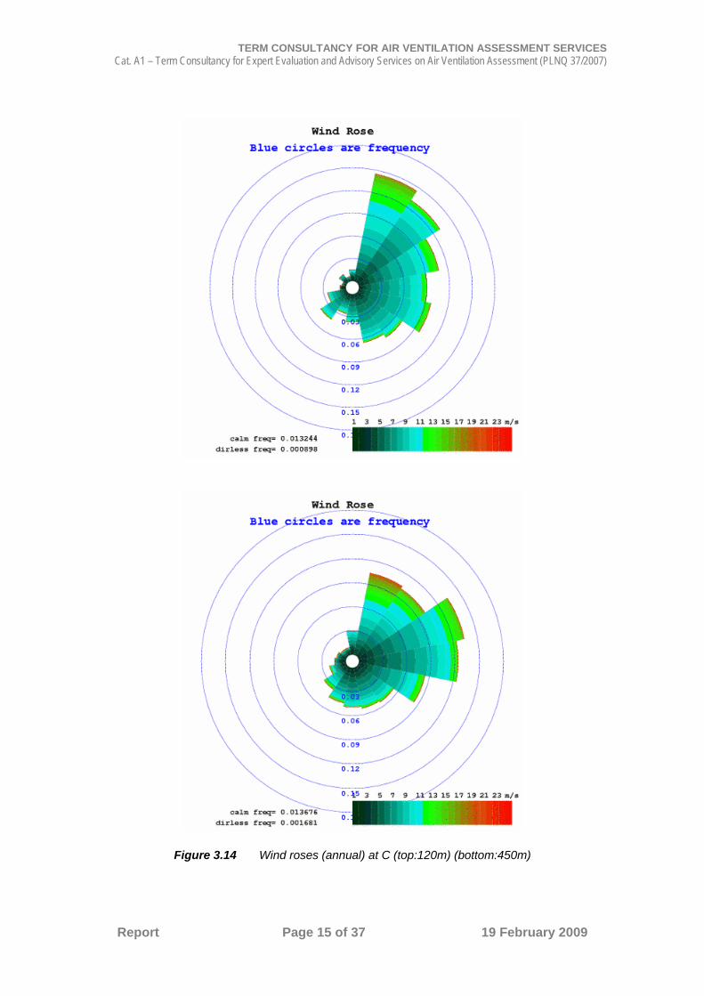
3.6 Researchers at Hong Kong University of Science and Technology (HKUST), Prof Alexis Lau and Prof Jimmy Fung, have simulated a set of wind data at 100m grid using the Pennsylvania State University / National Center for Atmospheric Research Mesoscale Model (MM5) prognostic simulation with coupled diagnostic California Meteorological Model (CALMET) simulation. The data period cover the whole year of 2004. Based on this dataset, wind roses of 3 locations of the study area are extracted at 120m and 450m above ground (Figures 3.9 to 3.15).
Figure 3.9 The 3 locations of MM5 extracted data

TERM CONSULTANCY FOR AIR VENTILATION ASSESSMENT SERVICES Cat. A1 – Term Consultancy for Expert Evaluation and Advisory Services on Air Ventilation Assessment (PLNQ 37/2007)
Report Page 11 of 37 19 February 2009
Figure 3.10 Wind roses (annual) at A (top:120m) (bottom:450m)

TERM CONSULTANCY FOR AIR VENTILATION ASSESSMENT SERVICES Cat. A1 – Term Consultancy for Expert Evaluation and Advisory Services on Air Ventilation Assessment (PLNQ 37/2007)
Report Page 12 of 37 19 February 2009
Figure 3.11 Wind roses (summer) at A (top:120m) (bottom:450m)

TERM CONSULTANCY FOR AIR VENTILATION ASSESSMENT SERVICES Cat. A1 – Term Consultancy for Expert Evaluation and Advisory Services on Air Ventilation Assessment (PLNQ 37/2007)
Report Page 13 of 37 19 February 2009
Figure 3.12 Wind roses (annual) at B (top:120m) (bottom:450m)

TERM CONSULTANCY FOR AIR VENTILATION ASSESSMENT SERVICES Cat. A1 – Term Consultancy for Expert Evaluation and Advisory Services on Air Ventilation Assessment (PLNQ 37/2007)
Report Page 14 of 37 19 February 2009
Figure 3.13 Wind roses (summer) at B (top:120m) (bottom:450m)
TERM CONSULTANCY FOR AIR VENTILATION ASSESSMENT SERVICES Cat. A1 – Term Consultancy for Expert Evaluation and Advisory Services on Air Ventilation Assessment (PLNQ 37/2007)
Report Page 15 of 37 19 February 2009
Figure 3.14 Wind roses (annual) at C (top:120m) (bottom:450m)

TERM CONSULTANCY FOR AIR VENTILATION ASSESSMENT SERVICES Cat. A1 – Term Consultancy for Expert Evaluation and Advisory Services on Air Ventilation Assessment (PLNQ 37/2007)
Report Page 16 of 37 19 February 2009
Figure 3.15 Wind roses (summer) at C (top:120m) (bottom:450m)
TERM CONSULTANCY FOR AIR VENTILATION ASSESSMENT SERVICES Cat. A1 – Term Consultancy for Expert Evaluation and Advisory Services on Air Ventilation Assessment (PLNQ 37/2007)
Report Page 17 of 37 19 February 2009
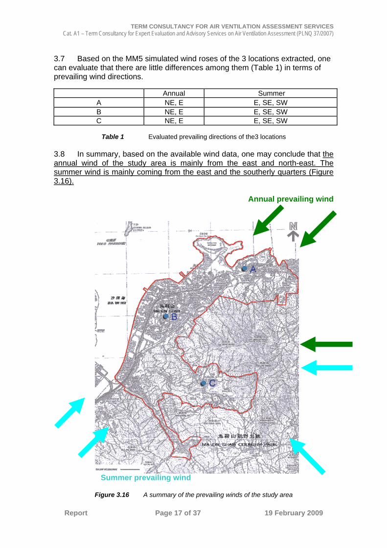
3.7 Based on the MM5 simulated wind roses of the 3 locations extracted, one can evaluate that there are little differences among them (Table 1) in terms of prevailing wind directions.
Annual Summer A NE, E E, SE, SW B NE, E E, SE, SW C NE, E E, SE, SW
Table 1 Evaluated prevailing directions of the3 locations
3.8 In summary, based on the available wind data, one may conclude that the annual wind of the study area is mainly from the east and north-east. The summer wind is mainly coming from the east and the southerly quarters (Figure 3.16).
Annual prevailing wind
Summer prevailing wind
Figure 3.16 A summary of the prevailing winds of the study area
TERM CONSULTANCY FOR AIR VENTILATION ASSESSMENT SERVICES Cat. A1 – Term Consultancy for Expert Evaluation and Advisory Services on Air Ventilation Assessment (PLNQ 37/2007)
Report Page 18 of 37 19 February 2009
4.0 Topography and the Wind Environment 4.1 Ma On Shan to the study area’s south-east (Figure 4.2) affects wind coming from the east and south-east. The wind profiles and characteristics will be affected by the hills. Turbulence and re-circulation of wind when it moves downhill towards the study area is expected. In general, the easterly wind arriving at the study area will be slowed and weakened by the shielding effects of the hills. As explained later in section 4.3 below, this should be not a major issue for the study area. 4.2 The 3 dimensional flow patterns of wind crossing the hills can be very complicated depending on a number of factors, e.g. the speed of the incoming wind [Appendix A]. In moderate wind conditions, it is predicted that a lee-wave will be generated, a number of eddies will form, and some re-circulation will be expected. To fully understand the wind characteristics to the study area from the hill ranges to its east and northerly directions will require a detail topographical study using wind tunnel. A more precise wind profiles and turbulence intensity profiles can be better understood. 4.3 In the summer months of Hong Kong, the background prevailing (at recorded at WGL) is from the south west. The important south-westerly summer prevailing wind flows from Shing Mun River Channel unobstructed into the south-westerly end of the study area (Figure 4.1). This is the most important for the study area as far as urban thermal comfort and air ventilation is concerned. 4.4 Apart from the background wind, due to the vegetated topography, at night and in the morning of the summer months, the cooler air mass on the west facing vegetated slopes of Ma On Shan that forms overnight can be advected to the study area. This can bring cool and refreshing air ventilation. This cooler air mass can be a few degrees lower than the ambient air temperature and is beneficial to the study area. [Rural vegetated area is normally cooler than city areas. Cool air forms in these vegetated areas. On sloped surfaces, the heavier cooler air will move down slope creating a blanket of cool air mass movement. The speed of this cool air mass movement depends on a number of factors including the gradient of the slope, the size of the vegetated area and the temperature differences between the rural areas and the urban areas. In this particular case, it is estimated that the cool air area can travel downward towards the study area at around 1 m/s and at a few degree cooler than the urban areas.] 4.5 However, as the sun rises, by late morning, the benefits described in section 4.4 above will disappear as the sun shines onto the western slopes of Ma On Shan and heats it up. When this happens, and when the background wind is weak, an anabatic wind movement may form thus draws air from the study area eastward up the hill. This air movement may re-circulate. The phenomenon creates some thermal air movement. 4.6 Refer to Figure 4.2, two valleys can bring cool air mass into areas of Chevallier Garden and Kam Tai Court.

TERM CONSULTANCY FOR AIR VENTILATION ASSESSMENT SERVICES Cat. A1 – Term Consultancy for Expert Evaluation and Advisory Services on Air Ventilation Assessment (PLNQ 37/2007)
Report Page 19 of 37 19 February 2009
4.7 The water body of Tolo Harbour can create some ‘south east / north west’ land and sea breeze effects to the study area due to the differences in air temperature above the water and above the ground. [The effects of the possible land breezes have been described in section 4.4 and 4.5 above. Furthermore, it is expected that the sea breezes from Tolo Harbour can benefit the study area, but due to the limited size of the water body, it is estimated that the benefit will not be too significant. In general, the on set of sea breezes is from around 10 to 11am in the morning (or a few hours after sun rises); and subsided at around 5 to 7pm in the evening (when the sun set).] 4.8 In a nutshell, due to Ma On Shan to the study area’s south east, and the water body to its north west, there can be a “slight” east-west thermally driven air movement across the study area. This can be beneficial and it is useful to respect that. Nonetheless, it is evaluated that the north east and the south west prevailing winds dominate the study area.
Figure 4.1 Summer (top) and annual (bottom) wind roses of HKO stations. The different wind roses are due mainly to the topography. Referring to the Shatin station, the south west and
north east channeling effects is apparent.

TERM CONSULTANCY FOR AIR VENTILATION ASSESSMENT SERVICES Cat. A1 – Term Consultancy for Expert Evaluation and Advisory Services on Air Ventilation Assessment (PLNQ 37/2007)
Report Page 20 of 37 19 February 2009
Figure 4.2 A digital elevation map of the study area

TERM CONSULTANCY FOR AIR VENTILATION ASSESSMENT SERVICES Cat. A1 – Term Consultancy for Expert Evaluation and Advisory Services on Air Ventilation Assessment (PLNQ 37/2007)
Report Page 21 of 37 19 February 2009
5.0 The Existing Scenario
Figure 5.1 The Existing (and Planned) Condition of the study area

TERM CONSULTANCY FOR AIR VENTILATION ASSESSMENT SERVICES Cat. A1 – Term Consultancy for Expert Evaluation and Advisory Services on Air Ventilation Assessment (PLNQ 37/2007)
Report Page 22 of 37 19 February 2009
5.1 Greenery, Open Spaces and Landscaping 5.1.1 Based on an examination of a greenery image of the study area, it has, relatively speaking compare to some metro areas in Hong Kong, a large green coverage (Figure 5.2). Utilizing the green areas appropriately to maintain the air paths in this study area is recommended.
Figure 5.2 A greenery map of the study area

TERM CONSULTANCY FOR AIR VENTILATION ASSESSMENT SERVICES Cat. A1 – Term Consultancy for Expert Evaluation and Advisory Services on Air Ventilation Assessment (PLNQ 37/2007)
Report Page 23 of 37 19 February 2009
Figure 5.3 A greenery map of the study area – town centre
5.1.2 As shown in Figure 5.3, the town centre has greenery areas in close proximity along the north-west and south-east axis. This can create a very desirable air path through the town centre for the land and sea breezes, which can be important especially when the background wind is weak. At the moment, however, it has been interrupted by a few rows of buildings along its path.

TERM CONSULTANCY FOR AIR VENTILATION ASSESSMENT SERVICES Cat. A1 – Term Consultancy for Expert Evaluation and Advisory Services on Air Ventilation Assessment (PLNQ 37/2007)
Report Page 24 of 37 19 February 2009
Figure 5.4 A greenery map of the study area – green fingers
5.1.3 As shown in Figure 5.4, there are two useful green fingers across the study area. They are beneficial. More of this kind of green fingers across the study area is desirable.

TERM CONSULTANCY FOR AIR VENTILATION ASSESSMENT SERVICES Cat. A1 – Term Consultancy for Expert Evaluation and Advisory Services on Air Ventilation Assessment (PLNQ 37/2007)
Report Page 25 of 37 19 February 2009
5.2 Land use and Urban Morphology 5.2.1 Refer to section 5.1on Greenery, Open Spaces and Landscaping above, due to the fact that the greenery coverage of the study area is large; the corresponding ground coverage is low.
Figure 5.5 Ground Coverage Ratio map of the study area resolved to 100mx100m cell area (include roads, open spaces and ground area covered by buildings and podiums)
[Ground cover ratio is the % of the ground occupied by buildings. The maximum is 100% for a 100mx100m grid fully occupied by buildings.]
D
TERM CONSULTANCY FOR AIR VENTILATION ASSESSMENT SERVICES Cat. A1 – Term Consultancy for Expert Evaluation and Advisory Services on Air Ventilation Assessment (PLNQ 37/2007)
Report Page 26 of 37 19 February 2009
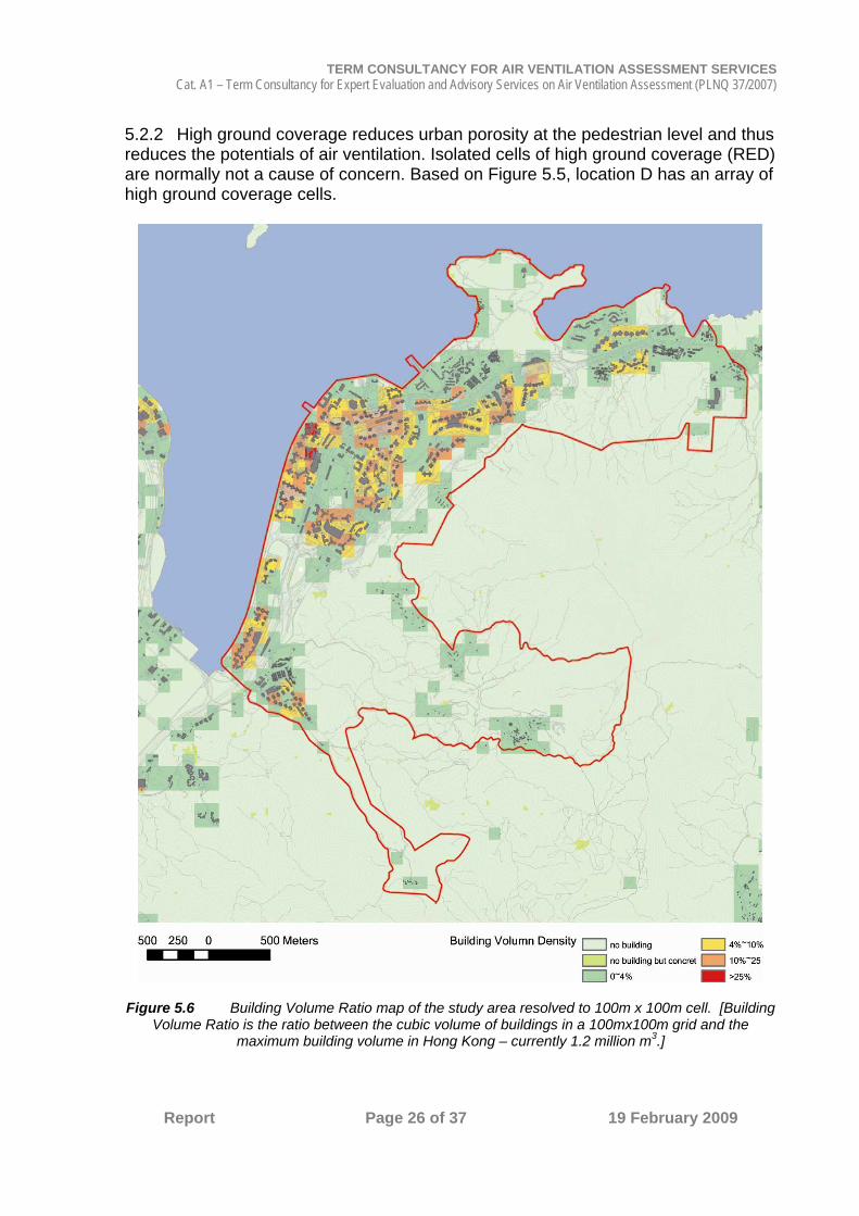
5.2.2 High ground coverage reduces urban porosity at the pedestrian level and thus reduces the potentials of air ventilation. Isolated cells of high ground coverage (RED) are normally not a cause of concern. Based on Figure 5.5, location D has an array of high ground coverage cells.
Figure 5.6 Building Volume Ratio map of the study area resolved to 100m x 100m cell. [Building Volume Ratio is the ratio between the cubic volume of buildings in a 100mx100m grid and the
maximum building volume in Hong Kong – currently 1.2 million m3.]

TERM CONSULTANCY FOR AIR VENTILATION ASSESSMENT SERVICES Cat. A1 – Term Consultancy for Expert Evaluation and Advisory Services on Air Ventilation Assessment (PLNQ 37/2007)
Report Page 27 of 37 19 February 2009
5.2.3 High building volume increases the thermal capability. This creates higher thermal stress in the summer months and the need for higher air ventilation to mitigate the negative thermal effects. On the whole the building volume density of the study area is not high (Figure 5.6). 5.3 Impervious road surfaces 5.3.1 Based on research works done in CUHK using ground based mobile measurement of the study area, it is noted that in the afternoon of the summer months, the impervious and tarmac paved main roads along the MTR line of Sai Sha Road and Ma On Shan Road can have an intra-urban air temperature of 3-4 degree C higher than the ambient air temperature. This is due to the heating up of the road surfaces. A mitigation measure is to plant more trees and to repave the road surfaces with lighter colour materials. 5.4 Air Paths 5.4.1 On the whole, the study area is long (along its south-west to north-east direction) and thin (across its south-east and north-west direction). 5.4.2 For the summer south-west prevailing wind, Ma On Shan Road and Sai Sha Road are the main breezeways through the study area (Figure 5.7). Save the observation in section 5.3 above, these two main breezeways are very useful for air ventilation of the study area. 5.4.3 For the summer east wind and for the land and sea breezes, there are air paths through the study area (Figure 5.8). They are useful. 5.4.4 At Ma On Shan Sports Ground, various air paths converge (Figure 5.8). This is an important air lung of the urban areas. Further tree planting can improve its usefulness. 5.4.5 For the annual north-east prevailing wind, Ma On Shan Road and Sai Sha Road are also the main breezeways through the study area (Figure 5.9). Due to the planned development (Lok Wo Sha Project) along Lok Wo Sha Lane, the efficacy of the Sai Sha Road breezeway near Wu Kai Sha MTR station may be reduced. There will also be a possible wind wake (as shown in Figure 5.9) behind the planned development. In general, a building of height H can have a wind wake of a distance 1 to 2 H from it. Currently, this wake area is covered by a piece of woodland and few village houses. According to the latest approved MLP for the Lok Wo Sha Project, there are 4 view corridors passing through the development. These view corridors will help maintaining the efficacy of the Sai Sha Road breezeway near Wu Kai Sha MTR Station and thus reduce the wind wake area.

TERM CONSULTANCY FOR AIR VENTILATION ASSESSMENT SERVICES Cat. A1 – Term Consultancy for Expert Evaluation and Advisory Services on Air Ventilation Assessment (PLNQ 37/2007)
Report Page 28 of 37 19 February 2009
Figure 5.7 Air paths of the study area. The green areas are useful for air paths to converge

TERM CONSULTANCY FOR AIR VENTILATION ASSESSMENT SERVICES Cat. A1 – Term Consultancy for Expert Evaluation and Advisory Services on Air Ventilation Assessment (PLNQ 37/2007)
Report Page 29 of 37 19 February 2009
Figure 5.8 South east – North west direction air paths of the study area useful for the land and sea breezes. The green areas are useful for air paths to converge

TERM CONSULTANCY FOR AIR VENTILATION ASSESSMENT SERVICES Cat. A1 – Term Consultancy for Expert Evaluation and Advisory Services on Air Ventilation Assessment (PLNQ 37/2007)
Report Page 30 of 37 19 February 2009
Figure 5.9 Air paths of the study area. The green areas are useful for air paths to converge
5.5 Community Buildings 5.5.1 Although most of the buildings in the study area are high rise, the study area has a good number of low rise, low density and low site coverage GIC sites. Some of them, especially those next to the existing major breezeways and air paths can be useful for air ventilation of its surrounding areas. GIC sites around Ma On Shan MTR station should as much as possible be kept. Limiting the building heights, reduce the ground coverage of the buildings, align the buildings not to block the air movement, and further greenery are useful considerations.

TERM CONSULTANCY FOR AIR VENTILATION ASSESSMENT SERVICES Cat. A1 – Term Consultancy for Expert Evaluation and Advisory Services on Air Ventilation Assessment (PLNQ 37/2007)
Report Page 31 of 37 19 February 2009
6.0 Expert evaluation of the Initial Planned Scenario
Figure 6.1 The Initial Planned Scenario (building height restriction)

TERM CONSULTANCY FOR AIR VENTILATION ASSESSMENT SERVICES Cat. A1 – Term Consultancy for Expert Evaluation and Advisory Services on Air Ventilation Assessment (PLNQ 37/2007)
Report Page 32 of 37 19 February 2009
Figure 6.2 The Initial Planned Scenario (plot ratio restriction)
6.1 It must be stressed that given Hong Kong’s tall building urban morphology, on the whole, building height restriction (or minor changes of building heights) is not the most effective method for maintaining and/or improving air ventilation. Breezeways, air paths, open spaces, gaps between buildings and building permeability – especially at near ground level, are more effective.

TERM CONSULTANCY FOR AIR VENTILATION ASSESSMENT SERVICES Cat. A1 – Term Consultancy for Expert Evaluation and Advisory Services on Air Ventilation Assessment (PLNQ 37/2007)
Report Page 33 of 37 19 February 2009
6.2 On the whole, based on Figure 6.1, it appears that the building height restriction proposed is more or less similar to the existing building heights. With careful design and disposition of buildings on site, this should not result in adverse air ventilation issues. 6.3 On the whole, based on Figure 6.2, it appears that the plot ratio restriction proposed is more or less similar to the existing condition. With careful design and disposition of buildings on site, this should not result in adverse air ventilation issues. 6.4 To further improve the air path network for better air ventilation of the study area, it is recommended that a few strips of non building / low building areas may be strategically specified, as in Figure 6.3. The maximum building height of the low building area is about 1 to 2 storey. The air paths can be in the order of 25 to 40m wide and as far as possible landscaped.
Figure 6.3 Suggested air paths / zones that can be optionally considered.
A
B
E
F
G
D
C

TERM CONSULTANCY FOR AIR VENTILATION ASSESSMENT SERVICES Cat. A1 – Term Consultancy for Expert Evaluation and Advisory Services on Air Ventilation Assessment (PLNQ 37/2007)
Report Page 34 of 37 19 February 2009
6.4.1 Air paths A and B will further improve the usefulness of Sai Sha Road breezeway. This can be optionally considered. In general, wider the air path in terms of non building area, better its usefulness. In this case, a wide of 25 to 40m can be “optionally” considered. According to the approved MLP for the Lok Wo Sha Project, there are view corridors that are free of building and should be maintained. 6.4.2 Air path C will improve the usefulness of Kam Ying Road air path. A strip of non-building area is recommended. 6.4.3 As shown in Figure 6.3, it is useful to have a long term strategic view to connect the green finger from Ma On Shan to the water front so as to benefit from the south east and north west land and sea air movements. It is recommended that the areas between D and E be as free of building (for example, consider relocating the few building towers of Kam Ying Court upon future re development), or as permeable as possible (for example, include large voids in podiums at the town centre). It is also very important to continue and intensify the greenery as much as possible in this area. 6.4.4 Air paths F over Heng On Estate will improve the usefulness of Ma On Shan Road breezeway towards Ma On Shan Sport Ground. This should be considered upon future re development. A strip of non building area (same width as Hang Tai Road) is recommended. 6.4.5 Air paths G will improve the usefulness of Hang Hong Street air path. This area should be maintained free of building upon future redevelopment. 6.4.6 A minor strip of non building area in between Ocean View and STTL 548 can be considered (Figure 6.4). This adds to the collection of south-east and north-west air paths (as shown in Figure 5.8) in the area.
Figure 6.4 Suggested air path

TERM CONSULTANCY FOR AIR VENTILATION ASSESSMENT SERVICES Cat. A1 – Term Consultancy for Expert Evaluation and Advisory Services on Air Ventilation Assessment (PLNQ 37/2007)
Report Page 35 of 37 19 February 2009
7.0 7.1 There is no focus area of concern in the study area. Further AVA studies are not necessary.

TERM CONSULTANCY FOR AIR VENTILATION ASSESSMENT SERVICES Cat. A1 – Term Consultancy for Expert Evaluation and Advisory Services on Air Ventilation Assessment (PLNQ 37/2007)
Report Page 36 of 37 19 February 2009
_____________________________________ Date: 19 February 2009
Professor Edward Ng On behalf of technical experts in the term consultant term
Department of Architecture, CUHK, Shatin, NT, Hong Kong T: 26096515 F:26035267 E: [email protected]
Consultant team
Expertise
Professor Edward Ng (Coordinator) CUHK, Hong Kong
Architect, Environmental and sustainable studies
Miss Betty Ho
Planner,
Mr K S Wong
Architect,
Professor Jimmy Chi-Hung Fung HKUST, Hong Kong
Mathematician, Meso-scale wind field modeling, CFD

TERM CONSULTANCY FOR AIR VENTILATION ASSESSMENT SERVICES Cat. A1 – Term Consultancy for Expert Evaluation and Advisory Services on Air Ventilation Assessment (PLNQ 37/2007)
Report Page 37 of 37 19 February 2009
Appendix A: Wind over a hill.
For a strongly stable environments, i.e. where the buoyancy affects are strong, and Fr ≈ 1, the air flows around the hill ((a)) and a stagnant mass of air builds up before the hill. At a slightly faster wind (Fr ≈ 0.4) some of the air flows over the hill ((b)) while the air at lower altitudes separate to flow around the hill. The natural wavelength of the air that flows over the top is much smaller than the hill size and the flow is perturbed by the hill to form lee waves. A lee wave separation occurs from the top and flows above the air that flows around the hill. A column of air with the same height as the hill approaches the hill and a fraction of it flows above the hill. At higher wind speeds and Fr ≈ 1.0, the stability is weaker and the wavelength of the gravity waves (lee waves) approaches the size of the hill ((c)). A natural resonance forms the large amplitude lee waves or mountain waves. If there is sufficient moisture, lenticular clouds can form along the crests of the waves downstream of the hill. For stronger winds with Fr ≈ 1.7 ( (d)) the natural wavelength is longer than the hill dimensions, thus causing a boundary layer separation at the lee of the hill. Neutral stratification ((e)) occurs for strong winds with neutral stability (no convection) and Froude number approaching infinity. The streamlines are disturbed upwind and above the hill out to a distance of about 3 times the hill length WH. Near the top of the hill the streamlines are packed closer together, causing a speed-up of the wind. Immediately downwind of the hill is often a cavity associated with boundary layer separation. This is the start of a turbulent wake behind the hill. The height of the turbulent wake is initially the same order as the size of the hill and grows in size and diminishes in turbulent intensity downwind. Eventually the turbulence decays and the wind flow returns to its undisturbed state.
Froude number (Fr)
[courtesy Sykes, R.I., 1980, “An asymptotic theory of incompressible turbulent boundary-layer flow over a small hump”, J. Fluid Mech.101: 647-670.]1