looking ahead: a visioning and strategic planning …swot) analysis of the site conducted multiple...
TRANSCRIPT

Executive SummaryThe Town of Huntsville has partnered with students in the Ryerson University Master of Planning program to provide a vision and strategic plan for Brendale Square (the Site). A vision is needed because the Site is underutilized: many stores are vacant; the large expanse of surface parking is marked by potholes; and the Site is constrained by regular floods and potential soil contamination. Both the Provincial Policy Statement (2014) and the Town of Huntsville Official Plan (2006) promote intensification at this Site.
A Vision for Brendale SquareThe regeneration and intensification of Brendale Square builds on a strong connection to the Muskoka River and downtown Main Street. The Square is a vibrant and sustainable community hub in the heart of Huntsville.
Brendale Square, Town of HuntsvilleBrendale Square is in a central part of the Town of Huntsville, and is approximately 3.9 hectares in size. It is a short walk from the Muskoka River and the downtown shopping area (the Business Improvement Area outlined in purple and the Community Improvement Plan Area shaded in purple in Figure 1 below).
Figure 1: Map of Downtown Huntsville and the Site Figure 2: The Concept Plan for Brendale Square
The Conceptualization Process
ORBIS PLANNING GROUPMASTER OF PLANNING STUDENTS, RYERSON UNIVERSITY
1. SITE VISITS 2. POLICY REVIEW 3. PUBLIC ENGAGEMENT 4. SWOT ANALYSIS
A review of provincial, district and municipal policies, regulations, and other documents
Engagement with local business owners and a public
consultation with residents and stakeholders of
Brendale Square
A strengths, weaknesses,opportunities, and threats(SWOT) analysis of the site
Conducted multiple site visits to Brendale Square
Looking Ahead: A Visioning and Strategic Planning Studyfor the Future of Brendale Square in Huntsville, Ontario
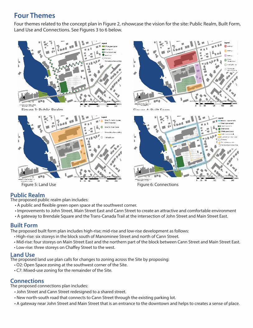
Four themes related to the concept plan in Figure 2, rshowcase the vision for the site: Public Realm, Built Form, Land Use and Connections. See Figures 3 to 6 below.
Figure 3: Public Realm Figure 4: Built Form
Four Themes
Figure 5: Activity and Use
Figure 6: Connections
Public Realm The proposed public realm plan includes: • A public and flexible green open space at the southwest corner. • Improvements to John Street, Main Street East and Cann Street to create an attractive and comfortable environment • A gateway to Brendale Square and the Trans-Canada Trail at the intersection of John Street and Main Street East.
Built Form The proposed built form plan includes high-rise; mid-rise and low-rise development as follows: • High-rise: six storeys in the block south of Manominee Street and north of Cann Street. • Mid-rise: four storeys on Main Street East and the northern part of the block between Cann Street and Main Street East. • Low-rise: three storeys on Chaffey Street to the west.
Land Use The proposed land use plan calls for changes to zoning across the Site by proposing: • O2: Open Space zoning at the southwest corner of the Site. • C7: Mixed-use zoning for the remainder of the Site.
Connections The proposed connections plan includes: • John Street and Cann Street redesigned to a shared street. • New north-south road that connects to Cann Street through the existing parking lot. • A gateway near John Street and Main Street that is an entrance to the downtown and helps to creates a sense of place.
Figure 5: Land Use

Implementation Strategy The following implementation plan for Brendale Square provides a blueprint for action. It outlines the primary action items that should be undertaken by the Town of Huntsville to achieve the vision and concepts presented, through a phasing plan.
DRAFT