legislative council west kowloon cultural district … · west kowloon cultural district project ....
TRANSCRIPT

1
For information on
25 February 2013
Legislative Council
Panel on Home Affairs and Panel on Development
Joint Subcommittee to Monitor the Implementation of the
West Kowloon Cultural District Project
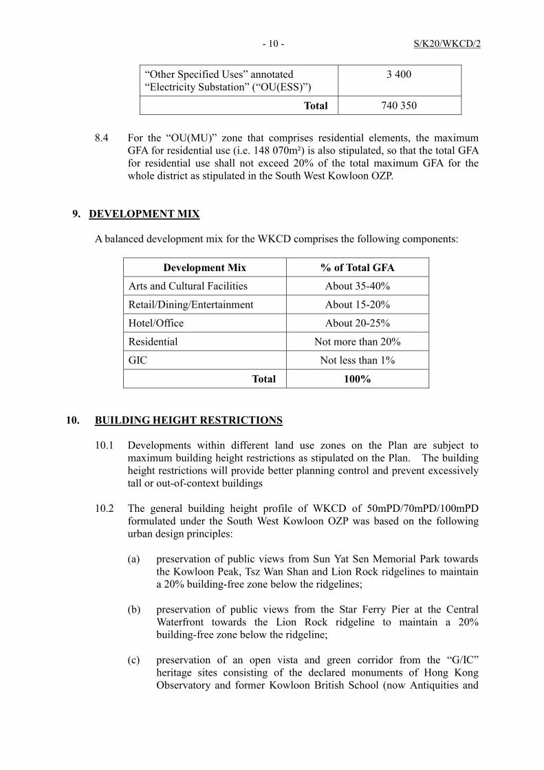
The Approved Development Plan of
the West Kowloon Cultural District
PURPOSE
This paper informs Members of the process and status
of the West Kowloon Cultural District (WKCD) Development Plan
(DP) submission, as well as the implementation progress of the
DP.
APPROVAL OF THE WKCD DP
2. The WKCD is planned to be developed by means of the
DP prepared under section 21 of the West Kowloon Cultural
District Authority Ordinance (Cap. 601) (WKCDAO). The DP
intends to set apart the area for the development of arts and
cultural facilities, entertainment, commercial, residential and
other ancillary uses to facilitate the WKCD development.
3. On 4 March 2011, the Board of the West Kowloon
Cultural District Authority (WKCDA) selected the Conceptual Plan
“City Park” designed by Foster + Partners (F+P CP) as the preferred
option for the WKCD development.
4. The WKCDA prepared the DP for the WKCD based on
the F+P CP and submitted it to the Town Planning Board (TPB) on
30 December 2011 in accordance with the WKCDAO. Deemed as
suitable for publication by the TPB, the draft DP was gazetted
under section 5 of the Town Planning Ordinance (Cap. 131) (TPO)
LC Paper No. CB(2)658/12-13(01)

2
on 30 March 2012. Upon completion of consideration of the
representations and comments on 28 September 2012, the TPB
decided not to uphold any of the representations to the DP. On 8
January 2013, the Chief Executive in Council, under section
9(1)(a) of the TPO approved the draft WKCD DP . The approved
DP, including the Notes and the Explanatory Statement, is
attached at Annex.
THE APPROVED DP
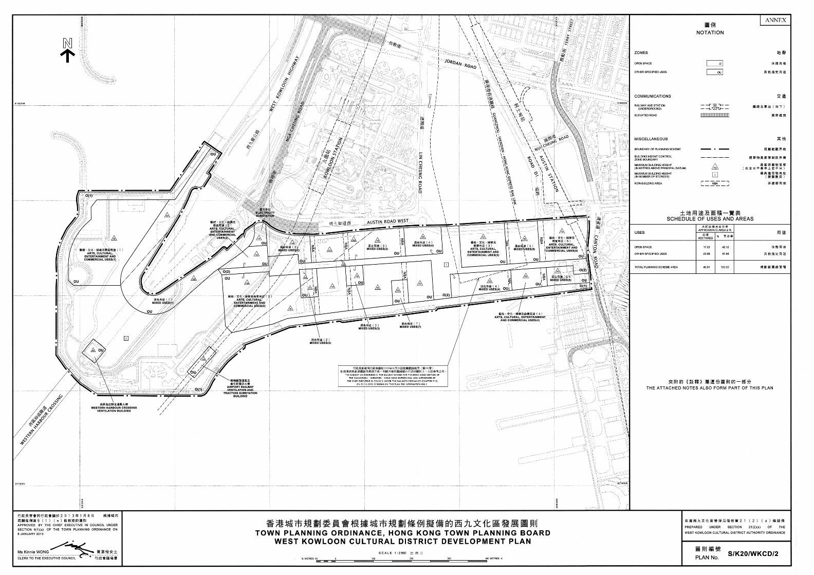
5. The approved DP covers an area of 40.91 hectares to
the south of Austin Road West and the Western Harbour Crossing
Toll Plaza. It is intended to be developed into an arts, cultural,
entertainment and commercial district with a distinguished
identity. The DP illustrates the broad principles of development
within the plan area, and indicates the location and nature of the
proposed land uses, building heights, distribution of open space,
landscape concept, urban design framework, public transport
network, parking and pedestrian facilities, and Government,
Institution or Community facilities within the WKCD.
Specifications of arts and cultural facilities, e.g. gross floor area
(GFA), seating capacity, etc. are included. The broad land use
zonings and major development restrictions for the WKCD as
shown on the DP are to put development and redevelopment of
land within the plan area under statutory planning control.
6. The DP also examines the relationship and integration
of the WKCD with the neighbouring areas. WKCD is well served
by various existing and planned railway and road networks such
as the existing West Kowloon Highway as well as the planned
Express Rail Link and Lin Cheung Road - Austin Road West
Underpass currently under construction. The pedestrian
circulation will be designed to maximize accessibility to the WKCD
from the hinterland and mobility within WKCD through an
integrated network of at-grade connections, footbridges and
subways as well as the vehicle-free tree-lined avenue. Berthing
facilities are also proposed for leisure activities and possible
marine connections. As such facilities are subject to the
3
Protection of the Harbour Ordinance (Cap. 531), the availability of
service providers and agreement with relevant government
bureau/ departments, further investigation and feasibility study
are required.
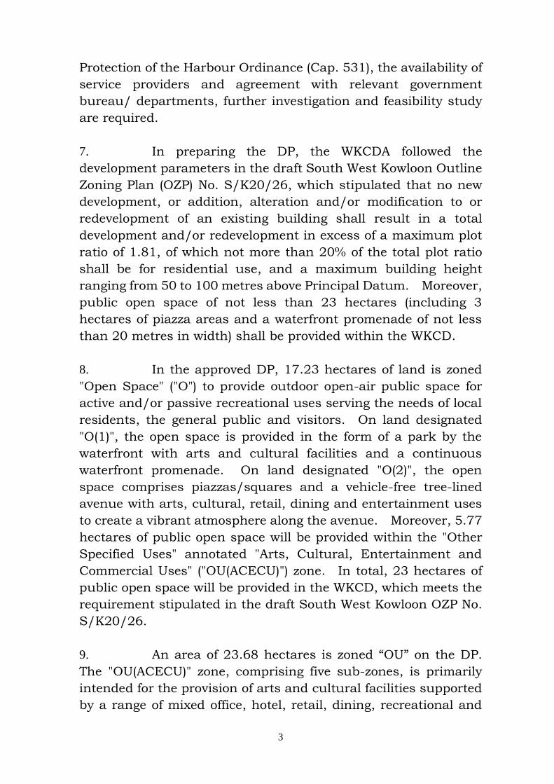
7. In preparing the DP, the WKCDA followed the
development parameters in the draft South West Kowloon Outline
Zoning Plan (OZP) No. S/K20/26, which stipulated that no new
development, or addition, alteration and/or modification to or
redevelopment of an existing building shall result in a total
development and/or redevelopment in excess of a maximum plot
ratio of 1.81, of which not more than 20% of the total plot ratio
shall be for residential use, and a maximum building height
ranging from 50 to 100 metres above Principal Datum. Moreover,
public open space of not less than 23 hectares (including 3
hectares of piazza areas and a waterfront promenade of not less
than 20 metres in width) shall be provided within the WKCD.
8. In the approved DP, 17.23 hectares of land is zoned
"Open Space" ("O") to provide outdoor open-air public space for
active and/or passive recreational uses serving the needs of local
residents, the general public and visitors. On land designated
"O(1)", the open space is provided in the form of a park by the
waterfront with arts and cultural facilities and a continuous
waterfront promenade. On land designated "O(2)", the open
space comprises piazzas/squares and a vehicle-free tree-lined
avenue with arts, cultural, retail, dining and entertainment uses
to create a vibrant atmosphere along the avenue. Moreover, 5.77
hectares of public open space will be provided within the "Other
Specified Uses" annotated "Arts, Cultural, Entertainment and
Commercial Uses" ("OU(ACECU)") zone. In total, 23 hectares of
public open space will be provided in the WKCD, which meets the
requirement stipulated in the draft South West Kowloon OZP No.
S/K20/26.
9. An area of 23.68 hectares is zoned “OU” on the DP.
The "OU(ACECU)" zone, comprising five sub-zones, is primarily
intended for the provision of arts and cultural facilities supported
by a range of mixed office, hotel, retail, dining, recreational and
4
entertainment uses. The core arts and cultural venues will be
accommodated in sites zoned "OU(ACECU)". The "OU" annotated
"Mixed Uses" ("OU(MU)") zone, comprising seven sub-zones, is
intended for mixed arts, cultural, commercial (including hotel and
office), residential, recreational and entertainment developments
to create vibrancy for the WKCD. Other "OU" zones cover the
existing ventilation buildings and a proposed electricity
substation. Development restrictions on GFA and building
heights are stipulated for each of above zonings.
10. According to the DP, a balanced development mix will
be adopted for the WKCD, comprising arts and cultural facilities
(35% to 40% of total GFA); retail/dining/entertainment uses (15%
to 20% of total GFA); hotel/office uses (20% to 25% of total GFA);
residential uses (not more than 20% of total GFA) and Government,
institution or community uses (not less than 1% of total GFA).
WAY FORWARD – IMPLEMENTATION OF THE WKCD DP
11. F+P CP, on which the DP is based, emphasizes the
provision of “the Park” at the western headland of the WKCD and
concentrates most of the building developments in a city fabric
located at the east as an extension of the existing urban area. All
arts and cultural facilities, retail, dining and entertainment
facilities, as well as hotel, office and residential developments in
the WKCD will be accommodated in a mixed use setting, both
vertically and horizontally. Buildings involved are all physically
linked up by “the Avenue”, a vibrant tree-lined pedestrian
boulevard conducive to a wide range of activities. All vehicular
traffic, parking and loading/unloading activities will be confined
in an integrated basement, creating a pedestrian-friendly
environment at ground level and allowing direct connections
among various facilities at stage level.
12. The above development pattern will lead to a mix of
land uses within the same parcel of land or building. The
WKCDA will commission a consultancy study to formulate an

5
appropriate development approach to implement the integrated
design as envisaged in F+P CP.
13. The WKCDA has embarked on the design process for
the future facilities in the WKCD, the first batch being the park,
Xiqu Centre and M+, for the commencement of construction as
soon as possible. The design competition for the Xiqu Centre was
concluded in December 2012 while that for the M+ is scheduled
for completion by mid-2013. To support the future soft
landscaping works of the park, the construction of a tree nursery
is about to commence. Some advance works, such as site
investigation, underground utility diversion and site preparation
works, are underway.
West Kowloon Cultural District Authority
February 2013

APPROVED WEST KOWLOON CULTURAL DISTRICT DEVELOPMENT PLAN NO. S/K20/WKCD/2
(Being an Approved Plan for the Purposes of the Town Planning Ordinance
prepared by the West Kowloon Cultural District Authority under section 21 of the West Kowloon Cultural District Authority Ordinance)
NOTES
(N.B. These form part of the Plan)
(1) These Notes show the uses or developments on land falling within the boundaries of the Plan which are always permitted and which may be permitted by the Town Planning Board, with or without conditions, on application. Where permission from the Town Planning Board for a use or development is required, the application for such permission should be made in a prescribed form. The application shall be addressed to the Secretary of the Town Planning Board, from whom the prescribed application form may be obtained.
(2) Any use or development which is always permitted or may be permitted in accordance with these
Notes must also conform to any other relevant legislation, the conditions of the Government lease concerned, and any other Government requirements, as may be applicable.
(3) (a) No action is required to make the existing use of any land or building conform to this Plan
until there is a material change of use or the building is redeveloped.
(b) Any material change of use or any other development (except minor alteration and/or modification to the development of the land or building in respect of the existing use which is always permitted) or redevelopment must be always permitted in terms of the Plan or, if permission is required, in accordance with the permission granted by the Town Planning Board.
(c) For the purposes of subparagraph (a) above, “existing use of any land or building” means –
(i) before the publication in the Gazette of the notice of the first statutory plan covering
the land or building (hereafter referred as ‘the first plan’),
a use in existence before the publication of the first plan which has continued since it came into existence; or
a use or a change of use approved under the Buildings Ordinance which relates to
an existing building; and
(ii) after the publication of the first plan, a use permitted under a plan which was effected during the effective period of that
plan and has continued since it was effected; or

- 2 - S/K20/WKCD/2
a use or a change of use approved under the Buildings Ordinance which relates to an existing building and permitted under a plan prevailing at the time when the use or change of use was approved.
(4) Except as otherwise specified by the Town Planning Board, when a use or material change of use
is effected or a development or redevelopment is undertaken, as always permitted in terms of the Plan or in accordance with a permission granted by the Town Planning Board, all permissions granted by the Town Planning Board in respect of the site of the use or material change of use or development or redevelopment shall lapse.
(5) Road junctions, alignments of roads, railway tracks and/or environmental friendly transport
system, and boundaries between zones may be subject to minor adjustments as detailed planning proceeds.
(6) Temporary uses (expected to be 5 years or less) of any land or building are always permitted as
long as they comply with any other relevant legislation, the conditions of the Government lease concerned, and any other government requirements, and there is no need for these to conform to the zoned use or these Notes. For temporary uses expected to be over 5 years, the uses must conform to the zoned use or these Notes.
(7) The following uses or developments are always permitted on land falling within the boundaries
of the Plan except where the uses or developments are specified in Column 2 of the Notes of individual zones:
(a) provision, maintenance or repair of plant nursery, amenity planting, open space, rain shelter,
refreshment kiosk, road, people mover, bus/public light bus stop or lay-by, cycle track, Mass Transit Railway station entrance, Mass Transit Railway structure below ground level, taxi rank, nullah, public utility pipeline, electricity mast, lamp pole, telephone booth, telecommunications radio base station and automatic teller machine; and
(b) geotechnical works, local public works, road works, sewerage works, drainage works, environmental improvement works, marine related facilities, waterworks (excluding works on service reservoir) and such other public works co-ordinated or implemented by Government and/or West Kowloon Cultural District Authority.
(8) In any area shown as ‘Road’, all uses or developments except those specified in paragraph (7)
above and those specified below require permission from the Town Planning Board: on-street vehicle park and railway track.
(9) Unless otherwise specified, all building, engineering and other operations incidental to and all uses directly related and ancillary to the permitted uses and developments within the same zone are always permitted and no separate permission is required.
(10) In these Notes, “existing building” means a building, including a structure, which is physically existing and is in compliance with any relevant legislation and the conditions of the Government lease concerned.
APPROVED WEST KOWLOON CULTURAL DISTRICT DEVELOPMENT PLAN NO. S/K20/WKCD/2
Schedule of Uses
Page
OPEN SPACE 1 OTHER SPECIFIED USES 5
- 1 - S/K20/WKCD/2
OPEN SPACE
Column 1 Column 2 Uses always permitted Uses that may be permitted with or
without conditions on application to the Town Planning Board
For “Open Space (1)” only
Aviary Educational Institution (related to arts and
culture only) Government Refuse Collection Point
(underground only) Park and Garden Pavilion Pedestrian Area Picnic Area Playground/Playing Field Place of Recreation, Sports or Culture Promenade Public Convenience Public Utility Installation (underground only) Public Vehicle Park (excluding container
vehicle) (underground only) School (related to arts and culture only) Sitting Out Area Training Centre (related to arts and culture
only) Utility Installation for Private Project
(underground only)
Eating Place Educational Institution (not elsewhere specified) Exhibition or Convention Hall Government Refuse Collection Point
(not elsewhere specified) Government Use (not elsewhere specified) Marina Pier Place of Entertainment Private Club Public Utility Installation (not elsewhere specified) Public Vehicle Park (excluding container vehicle)
(not elsewhere specified) School (not elsewhere specified) Shop and Services Training Centre (not elsewhere specified) Utility Installation for Private Project
(not elsewhere specified)
(Please see next page)

- 2 - S/K20/WKCD/2
OPEN SPACE (Cont’d)
Column 1 Column 2 Uses always permitted Uses that may be permitted with or
without conditions on application to the Town Planning Board
For “Open Space (2)” only
Eating Place Government Refuse Collection Point
(underground only) Park and Garden Pavilion Pedestrian Area Playground/Playing Field Place of Entertainment Place of Recreation, Sports or Culture Public Convenience Public Utility Installation (underground only) Public Vehicle Park (excluding container
vehicle) (underground only) Shop and Services Sitting Out Area Utility Installation for Private Project
(underground only)
Government Refuse Collection Point (not elsewhere specified)
Government Use (not elsewhere specified) Public Utility Installation (not elsewhere specified) Public Vehicle Park (excluding container vehicle)
(not elsewhere specified) Utility Installation for Private Project (not elsewhere
specified)
(Please see next page)
- 3 - S/K20/WKCD/2
OPEN SPACE (Cont’d)
Planning Intention
This zone is intended primarily for the provision of outdoor open-air public space for active and/or passive recreational uses serving the needs of local residents, the general public as well as visitors. On land designated “Open Space (1)” (“O(1)”), the open space is provided in the form of a park by the waterfront with arts and cultural facilities and a continuous waterfront promenade. On land designated “O(2)”, the open space comprises piazzas / squares and a vehicle-free tree-lined avenue, with arts, cultural, retail, dining and entertainment uses to create a vibrant atmosphere along the avenue.
Remarks (1) The total public open space provided within this zone and the “Other Specified Uses” annotated
“Arts, Cultural, Entertainment and Commercial Uses” zone shall be not less than 23 hectares (including 3 hectares of piazza areas). Within this zone, a waterfront promenade of not less than 20 metres in width shall be provided.
(2) On land designated “O(1)” and “O(2)”, no new development, or addition, alteration and/or
modification to or redevelopment of an existing building shall result in a total development and/or redevelopment in excess of the maximum building heights in terms of number of storeys as stipulated on the Plan, or the height of the existing building, whichever is the greater.
(3) On land designated “O(1)”, no new development, or addition, alteration and/or modification to or
redevelopment of an existing building shall result in a total development and/or redevelopment in excess of a maximum total gross floor area (GFA) of 10 900m² for arts, cultural, retail, dining and entertainment uses, or the GFA of the existing building, whichever is the greater.
(4) On land designated “O(2)”, no new development, or addition, alteration and/or modification to or
redevelopment of an existing building shall result in a total development and/or redevelopment in excess of a maximum total GFA of 300m² for arts, cultural, retail, dining and entertainment uses, or the GFA of the existing building, whichever is the greater.
(5) In determining the relevant maximum number of storey(s) for the purposes of paragraph (2) above,
any basement floor(s) may be disregarded.
(Please see next page)

- 4 - S/K20/WKCD/2
OPEN SPACE (Cont’d)
Remarks (Cont’d)
(6) In determining the maximum GFA for the purposes of paragraphs (3) and (4) above, any floor space that is constructed or intended for use solely as car park, loading/unloading bay and plant room, provided such uses and facilities are ancillary and directly related to the development or redevelopment within the “O” zone, may be disregarded. Any floor space that is constructed or intended for use solely as public transport and underground railway facilities, as required by the Government, may also be disregarded.
(7) In determining the maximum GFA for the purposes of paragraphs (3) and (4) above, any
underground floor space that is constructed or intended for use solely as car park, plant room and vent shaft, provided such uses and facilities are ancillary and directly related to other development or redevelopment in the West Kowloon Cultural District, may be disregarded.
(8) In determining the maximum GFA for the purposes of paragraphs (3) and (4) above, any covered
area and floor space that are constructed or intended for use solely as covered walkway, pavilion, public convenience and park management office, provided such uses and facilities are supporting facilities for public enjoyment of the open space, may be disregarded.
(9) Based on the individual merits of a development or redevelopment proposal, minor relaxation of
the building height and GFA restrictions stated in paragraphs (2) to (4) above may be considered by the Town Planning Board on application under section 16 of the Town Planning Ordinance.
(10) Notwithstanding paragraph (9) above, relaxation of the building height restrictions may be
considered by the Town Planning Board on application under section 16 of the Town Planning Ordinance for any free-standing arts and cultural facilities on individual merits.
(Please see next page)
- 5 - S/K20/WKCD/2
OTHER SPECIFIED USES
Column 1 Column 2 Uses always permitted Uses that may be permitted with or
without conditions on application to the Town Planning Board
For “Arts, Cultural, Entertainment and Commercial Uses” Only
Eating Place Educational Institution Exhibition or Convention Hall Government Use (Fire Station, Police
Reporting Centre/Police Post, Post Office only)
Government Refuse Collection Point Hotel Information Technology and Telecommunications Industries Institutional Use (not elsewhere specified) Library Mass Transit Railway Vent Shaft and/or
Other Structure above Ground Level other than Entrances (non-free-standing only)
Office Park and Garden Pavilion Place of Entertainment Place of Recreation, Sports or Culture Private Club Public Convenience Public Transport Terminus or Station
(underground only) Public Utility Installation Public Vehicle Park (excluding
containervehicle) (underground only) Recyclable Collection Centre Religious Institution School (related to arts and culture only) Shop and Services Sitting Out Area Training Centre (related to arts and culture
only) Utility Installation for Private Project
Government Use (not elsewhere specified) Helicopter Landing Facility Mass Transit Railway Vent Shaft and/or Other
Structure above Ground Level other than Entrances (not elsewhere specified)
Public Transport Terminus or Station (not elsewhere specified)
Public Vehicle Park (excluding container vehicle) (not elsewhere specified)
School (not elsewhere specified) Social Welfare Facility Training Centre (not elsewhere specified)
(Please see next page)
- 6 - S/K20/WKCD/2
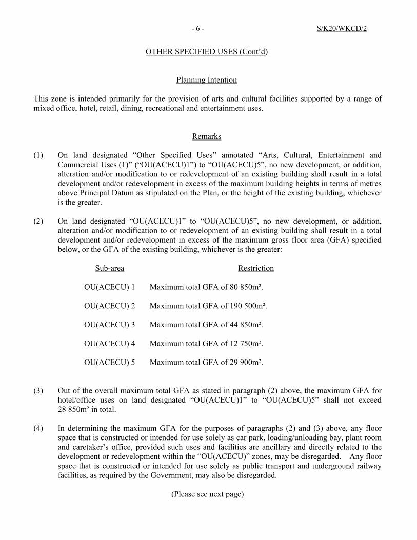
OTHER SPECIFIED USES (Cont’d)
Planning Intention
This zone is intended primarily for the provision of arts and cultural facilities supported by a range of mixed office, hotel, retail, dining, recreational and entertainment uses.
Remarks (1) On land designated “Other Specified Uses” annotated “Arts, Cultural, Entertainment and
Commercial Uses (1)” (“OU(ACECU)1”) to “OU(ACECU)5”, no new development, or addition, alteration and/or modification to or redevelopment of an existing building shall result in a total development and/or redevelopment in excess of the maximum building heights in terms of metres above Principal Datum as stipulated on the Plan, or the height of the existing building, whichever is the greater.
(2) On land designated “OU(ACECU)1” to “OU(ACECU)5”, no new development, or addition,
alteration and/or modification to or redevelopment of an existing building shall result in a total development and/or redevelopment in excess of the maximum gross floor area (GFA) specified below, or the GFA of the existing building, whichever is the greater:
Sub-area Restriction
OU(ACECU) 1 Maximum total GFA of 80 850m².
OU(ACECU) 2 Maximum total GFA of 190 500m².
OU(ACECU) 3 Maximum total GFA of 44 850m².
OU(ACECU) 4 Maximum total GFA of 12 750m².
OU(ACECU) 5 Maximum total GFA of 29 900m².
(3) Out of the overall maximum total GFA as stated in paragraph (2) above, the maximum GFA for
hotel/office uses on land designated “OU(ACECU)1” to “OU(ACECU)5” shall not exceed 28 850m² in total.
(4) In determining the maximum GFA for the purposes of paragraphs (2) and (3) above, any floor
space that is constructed or intended for use solely as car park, loading/unloading bay, plant room and caretaker’s office, provided such uses and facilities are ancillary and directly related to the development or redevelopment within the “OU(ACECU)” zones, may be disregarded. Any floor space that is constructed or intended for use solely as public transport and underground railway facilities, as required by the Government, may also be disregarded.
(Please see next page)

- 7 - S/K20/WKCD/2
OTHER SPECIFIED USES (Cont’d)
For “Arts, Cultural, Entertainment and Commercial Uses” Only (Cont’d)
Remarks (Cont’d)
(5) In determining the maximum GFA for the purposes of paragraphs (2) and (3) above, any underground floor space that is constructed or intended for use solely as car park, plant room and vent shaft, provided such uses and facilities are ancillary and directly related to other development or redevelopment in the West Kowloon Cultural District (WKCD), may be disregarded.
(6) In determining the maximum GFA for the purposes of paragraphs (2) and (3) above, any floor
space that is constructed or intended for use solely as above-ground vent shafts for the Express Rail Link, with a total GFA of not more than 3 600m², may be disregarded. Any floor space that is constructed or intended for use solely as above-ground vent shafts for underground vehicular access and servicing facilities of the WKCD, with a total GFA of not more than 1 000m², may also be disregarded.
(7) In determining the maximum GFA for the purposes of paragraphs (2) and (3) above, any covered
area and floor space that are constructed or intended for use solely as covered walkway and pavilion may be disregarded.
(8) On land designated “OU(ACECU)1” to “OU(ACECU)5”, public open space of not less than
57 700m² in total shall be provided. (9) Based on the individual merits of a development or redevelopment proposal, minor relaxation of
the building height and GFA restrictions stated in paragraphs (1) to (3) and (6) above may be considered by the Town Planning Board on application under section 16 of the Town Planning Ordinance.
(10) Notwithstanding paragraph (9) above, relaxation of the building height restrictions may be
considered by the Town Planning Board on application under section 16 of the Town Planning Ordinance for any free-standing arts and cultural facilities on individual merits.
(11) Under exceptional circumstances, for developments and/or redevelopments, minor relaxation of
the non-building area restrictions as shown on the Plan may be considered by the Town Planning Board on application under section 16 of the Town Planning Ordinance.
(Please see next page)

- 8 - S/K20/WKCD/2
OTHER SPECIFIED USES (Cont’d)
Column 1 Column 2 Uses always permitted Uses that may be permitted with or
without conditions on application to the Town Planning Board
For “Mixed Uses” Only
Eating Place Educational Institution Exhibition or Convention Hall Government Use (Fire Station, Police
Reporting Centre/Police Post, Post Office only)
Government Refuse Collection Point Hotel Information Technology and Telecommunications Industries Institutional Use (not elsewhere specified) Library Mass Transit Railway Vent Shaft and/or
Other Structure above Ground Level other than Entrances (non-free-standing only)
Office Place of Entertainment Place of Recreation, Sports or Culture Private Club Public Convenience Public Transport Terminus or Station
(underground only) Public Utility Installation Public Vehicle Park (excluding container
vehicle) (underground only) Recyclable Collection Centre Religious Institution School (related to arts and culture only) Shop and Services Training Centre (related to arts and culture
only) Utility Installation for Private Project
Flat (except on land designated “OU(MU)1”) Government Use (not elsewhere specified) Helicopter Landing Facility House (except on land designated “OU(MU)1”) Mass Transit Railway Vent Shaft and/or Other
Structure above Ground Level other than Entrances (not elsewhere specified)
Public Transport Terminus or Station (not elsewhere specified)
Public Vehicle Park (excluding container vehicle) (not elsewhere specified)
School (not elsewhere specified) Social Welfare Facility Training Centre (not elsewhere specified)
(Please see next page)
- 9 - S/K20/WKCD/2
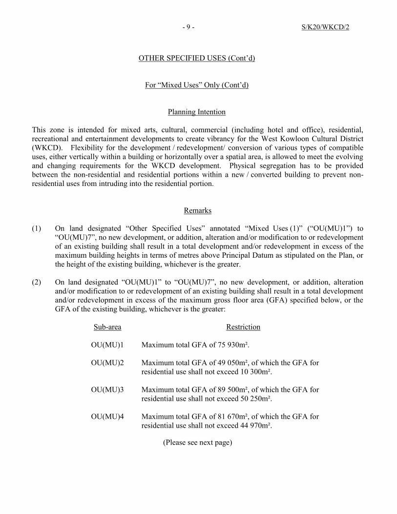
OTHER SPECIFIED USES (Cont’d)
For “Mixed Uses” Only (Cont’d)
Planning Intention
This zone is intended for mixed arts, cultural, commercial (including hotel and office), residential, recreational and entertainment developments to create vibrancy for the West Kowloon Cultural District (WKCD). Flexibility for the development / redevelopment/ conversion of various types of compatible uses, either vertically within a building or horizontally over a spatial area, is allowed to meet the evolving and changing requirements for the WKCD development. Physical segregation has to be provided between the non-residential and residential portions within a new / converted building to prevent non-residential uses from intruding into the residential portion.
Remarks
(1) On land designated “Other Specified Uses” annotated “Mixed Uses (1)” (“OU(MU)1”) to “OU(MU)7”, no new development, or addition, alteration and/or modification to or redevelopment of an existing building shall result in a total development and/or redevelopment in excess of the maximum building heights in terms of metres above Principal Datum as stipulated on the Plan, or the height of the existing building, whichever is the greater.
(2) On land designated “OU(MU)1” to “OU(MU)7”, no new development, or addition, alteration
and/or modification to or redevelopment of an existing building shall result in a total development and/or redevelopment in excess of the maximum gross floor area (GFA) specified below, or the GFA of the existing building, whichever is the greater:
Sub-area Restriction
OU(MU)1 Maximum total GFA of 75 930m².
OU(MU)2 Maximum total GFA of 49 050m², of which the GFA for
residential use shall not exceed 10 300m².
OU(MU)3 Maximum total GFA of 89 500m², of which the GFA for residential use shall not exceed 50 250m².
OU(MU)4 Maximum total GFA of 81 670m², of which the GFA for residential use shall not exceed 44 970m².
(Please see next page)
- 10 - S/K20/WKCD/2
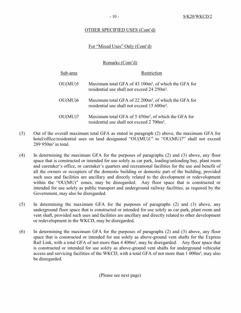
OTHER SPECIFIED USES (Cont’d)
For “Mixed Uses” Only (Cont’d)
Remarks (Cont’d)
Sub-area Restriction
OU(MU)5 Maximum total GFA of 43 100m², of which the GFA for residential use shall not exceed 24 250m².
OU(MU)6 Maximum total GFA of 22 200m², of which the GFA for residential use shall not exceed 15 600m².
OU(MU)7 Maximum total GFA of 5 450m², of which the GFA for residential use shall not exceed 2 700m².
(3) Out of the overall maximum total GFA as stated in paragraph (2) above, the maximum GFA for
hotel/office/residential uses on land designated “OU(MU)1” to “OU(MU)7” shall not exceed 289 950m² in total.
(4) In determining the maximum GFA for the purposes of paragraphs (2) and (3) above, any floor
space that is constructed or intended for use solely as car park, loading/unloading bay, plant room and caretaker’s office, or caretaker’s quarters and recreational facilities for the use and benefit of all the owners or occupiers of the domestic building or domestic part of the building, provided such uses and facilities are ancillary and directly related to the development or redevelopment within the “OU(MU)” zones, may be disregarded. Any floor space that is constructed or intended for use solely as public transport and underground railway facilities, as required by the Government, may also be disregarded.
(5) In determining the maximum GFA for the purposes of paragraphs (2) and (3) above, any
underground floor space that is constructed or intended for use solely as car park, plant room and vent shaft, provided such uses and facilities are ancillary and directly related to other development or redevelopment in the WKCD, may be disregarded.
(6) In determining the maximum GFA for the purposes of paragraphs (2) and (3) above, any floor
space that is constructed or intended for use solely as above-ground vent shafts for the Express Rail Link, with a total GFA of not more than 4 400m², may be disregarded. Any floor space that is constructed or intended for use solely as above-ground vent shafts for underground vehicular access and servicing facilities of the WKCD, with a total GFA of not more than 1 000m², may also be disregarded.
(Please see next page)
- 11 - S/K20/WKCD/2
OTHER SPECIFIED USES (Cont’d)
For “Mixed Uses” Only (Cont’d)
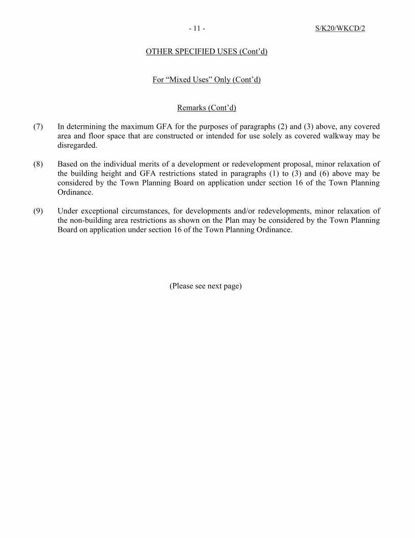
Remarks (Cont’d) (7) In determining the maximum GFA for the purposes of paragraphs (2) and (3) above, any covered
area and floor space that are constructed or intended for use solely as covered walkway may be disregarded.
(8) Based on the individual merits of a development or redevelopment proposal, minor relaxation of
the building height and GFA restrictions stated in paragraphs (1) to (3) and (6) above may be considered by the Town Planning Board on application under section 16 of the Town Planning Ordinance.
(9) Under exceptional circumstances, for developments and/or redevelopments, minor relaxation of
the non-building area restrictions as shown on the Plan may be considered by the Town Planning Board on application under section 16 of the Town Planning Ordinance.
(Please see next page)
- 12 - S/K20/WKCD/2
OTHER SPECIFIED USES (Cont’d)
Column 1 Column 2 Uses always permitted Uses that may be permitted with or
without conditions on application to the Town Planning Board
For “Airport Railway Ventilation and Traction Substation Building” Only
As Specified on the Plan
Government Use Public Utility Installation Utility Installation for Private Project
Planning Intention
This zone is intended primarily to provide land for the ventilation and traction substation building of the Airport Railway.
Remarks (1) No new development, or addition, alteration and/or modification to or redevelopment of an
existing building shall result in a total development and/or redevelopment in excess of the maximum building height in terms of metres above Principal Datum as stipulated on the Plan, or the height of the existing building, whichever is the greater.
(2) Based on the individual merits of a development or redevelopment proposal, minor relaxation of
the building height restriction stated in paragraph (1) above may be considered by the Town Planning Board on application under section 16 of the Town Planning Ordinance.
(Please see next page)
- 13 - S/K20/WKCD/2
OTHER SPECIFIED USES (Cont’d)
Column 1 Column 2 Uses always permitted Uses that may be permitted with or
without conditions on application to the Town Planning Board
For “Western Harbour Crossing Ventilation Building” Only
As Specified on the Plan
Government Use Public Utility Installation Utility Installation for Private Project
Planning Intention
This zone is intended primarily to provide land for the ventilation building of the Western Harbour Crossing.
Remarks
(1) No new development, or addition, alteration and/or modification to or redevelopment of an existing building shall result in a total development and/or redevelopment in excess of the maximum building height in terms of metres above Principal Datum as stipulated on the Plan, or the height of the existing building, whichever is the greater.
(2) Based on the individual merits of a development or redevelopment proposal, minor relaxation of
the building height restriction stated in paragraph (1) above may be considered by the Town Planning Board on application under section 16 of the Town Planning Ordinance.
(Please see next page)

- 14 - S/K20/WKCD/2
OTHER SPECIFIED USES (Cont’d)
Column 1 Column 2 Uses always permitted Uses that may be permitted with or
without conditions on application to the Town Planning Board
For “Electricity Substation” Only
As Specified on the Plan
Government Use Public Utility Installation Utility Installation for Private Project
Planning Intention
This zone is intended primarily to provide land for the development of an electricity substation.
Remarks (1) No new development, or addition, alteration and/or modification to or redevelopment of an
existing building shall result in a total development and/or redevelopment in excess of the maximum building height in terms of metres above Principal Datum as stipulated on the Plan, or the height of the existing building, whichever is the greater.
(2) No new development, or addition, alteration and/or modification to or redevelopment of an
existing building shall result in a total development and/or redevelopment in excess of a maximum total gross floor area (GFA) of 3 400m².
(3) Based on the individual merits of a development or redevelopment proposal, minor relaxation of
the building height and GFA restrictions stated in paragraphs (1) and (2) above may be considered by the Town Planning Board on application under section 16 of the Town Planning Ordinance.
APPROVED WEST KOWLOON CULTURAL DISTRICT
DEVELOPMENT PLAN NO. S/K20/WKCD/2
EXPLANATORY STATEMENT
APPROVED WEST KOWLOON CULTURAL DISTRICT
DEVELOPMENT PLAN NO. S/K20/WKCD/2
Contents Page
1. Introduction
1
2. Authority for the Plan and Procedures
1
3. Object of the Plan
3
4. Notes of the Plan
3
5. Area Covered by the Plan
3
6. Population
4
7. Planning Themes and Urban Design Framework
4
8. Development Intensity 9 9. Development Mix 10
10. Building Height Restrictions
10
11. Air Ventilation Assessment 12
12. Land Use Zonings
12
12.1 Open Space
12
12.2 Other Specified Uses
13
13. Communications
17
14. Marine Facilities 20
15. Utility Services
20
16. Implementation
22
Index of Figures 23
APPROVED WEST KOWLOON CULTURAL DISTRICT
DEVELOPMENT PLAN NO. S/K20/WKCD/2
(Being an Approved Plan for the Purposes of the Town Planning Ordinance
prepared by the West Kowloon Cultural District Authority under section 21 of the West Kowloon Cultural District Authority Ordinance)
EXPLANATORY STATEMENT
Note: For the purposes of the Town Planning Ordinance, this statement shall not be deemed to constitute a part of the Plan.
1. INTRODUCTION
This Explanatory Statement is intended to assist an understanding of the approved West Kowloon Cultural District (WKCD) Development Plan No. S/K20/WKCD/2. It reflects the planning intention and objectives of the Town Planning Board (the Board) for the area covered by the Plan.
2. AUTHORITY FOR THE PLAN AND PROCEDURES
2.1 On 11 July 2003, an area located to the south of Austin Road West and the Western Harbour Crossing (WHC) Toll Plaza was rezoned to “Other Specified Uses” (“OU”) annotated “Arts, Cultural, Commercial and Entertainment Uses” on the draft South West Kowloon Outline Zoning Plan (OZP) No. S/K20/14 to facilitate the planning of the WKCD.
2.2 On 18 April 2008, the Board exhibited the draft South West Kowloon OZP No.
S/K20/21 to revise the annotation of the “OU” zone for the WKCD site to “Arts, Cultural, Entertainment, Commercial and Other Uses” (“ACECOU”) and incorporate development restrictions for the WKCD as follows:
a maximum plot ratio of 1.81;
not more than 20% of the total plot ratio shall be for residential use;
the provision of not less than 23 hectares (ha) of public open space
(including 3 ha of piazza areas and a waterfront promenade of not less than 20m in width); and
building height restrictions ranging from 50 metres above Principal Datum
(mPD) to 100mPD.
2.3 In July 2008, the Legislative Council enacted the West Kowloon Cultural District Authority Ordinance (WKCDAO), which is an Ordinance to establish the West Kowloon Cultural District Authority (WKCDA) to develop the land

- 2 - S/K20/WKCD/2
leased to the WKCDA into an integrated arts and cultural district and to provide, operate, manage, maintain or otherwise deal with, arts and cultural facilities and related facilities in, and ancillary facilities outside, the WKCD; to provide for the powers and functions of the WKCDA; to provide for planning and financial matters; and to provide for connected matters.
2.4 On 10 March 2009, the Chief Executive in Council approved the draft South
West Kowloon OZP, which was subsequently renumbered as S/K20/22. Since then, the OZP has been amended a few times, but none of the amendments are related to the WKCD, with the zoning boundary and development restrictions for the WKCD remain unchanged.
2.5 On 8 October 2009, the WKCDA launched the Stage 1 of its Public
Engagement exercise (PE exercise) to consult the public and stakeholders on their expectations and aspirations for the WKCD and the views of stakeholders on their requirements for facilities in the arts and cultural venues in WKCD. Taking into consideration the views received during the Stage 1 PE exercise, three Conceptual Plan (CP) Options for the WKCD were prepared.
2.6 On 20 August 2010, the WKCDA launched the Stage 2 PE exercise to solicit
public views on the three CP Options. On 4 March 2011, the WKCDA Board endorsed the recommendation made by the Selection Panel and selected a preferred option, which has gained the most public support in the Stage 2 PE exercise.
2.7 The selected CP, incorporating desirable features from the other two CP
Options and various enhancements in light of design, technical and financial considerations, was modified (Modified CP) subsequently. Based on the Modified CP, a Development Plan was prepared to serve as the basis for implementation of the WKCD development.
2.8 On 9 September 2011, the WKCDA consulted the Yau Tsim Mong District
Council on the proposed Development Plan. On 30 September 2011, the WKCDA launched the Stage 3 PE exercise and consulted the public on the proposed Development Plan before finalizing it for submission to the Board for consideration.
2.9 On 30 December 2011, the WKCDA submitted the WKCD Development Plan
to the Board for consideration under section 21(6) of the WKCDAO.
2.10 On 9 March 2012, the Board, under section 21(7)(a) of the WKCDAO, deemed the WKCD Development Plan as being suitable for publication, which in turn, is deemed to be a draft plan prepared by the Board for the purposes of the Town Planning Ordinance (the Ordinance) under section 21(8) of the WKCDAO.
2.11 On 30 March 2012, the draft WKCD Development Plan No. S/K20/WKCD/1
(the Plan) was exhibited under section 5 of the Ordinance. By virtue of section 21(9) of the WKCDAO, the Plan has from that date replaced the draft South West Kowloon OZP No. S/K20/27 in respect of the area delineated and described herein. During the exhibition period, 10 representations were

- 3 - S/K20/WKCD/2
received. Three comments were received when the representations were published for public comment. Upon consideration of the representations and comments on 28 September 2012, the Board decided not to uphold the representations.
2.12 On 8 January 2013, the CE in C, under section 9(1)(a) of the Ordinance,
approved the draft WKCD Development Plan, which was subsequently re-numbered as S/K20/WKCD/2. On 18 January 2013, the approved WKCD Development Plan S/K20/WKCD/2 (the Plan) was notified in the Gazette under section 9(5) of the Ordinance.
3. OBJECT OF THE PLAN
3.1 The object of the Plan is to indicate the broad land use zonings and major development restrictions for the WKCD so that development and redevelopment of land within the WKCD can be put under statutory planning control.
3.2 The Plan is to illustrate the broad principles of development within the
boundary of the Plan. As it is a small-scale plan, the boundaries between land use zones may be subject to minor adjustments as detailed planning proceeds.
4. NOTES OF THE PLAN
4.1 Attached to the Plan is a set of Notes which shows the types of uses or developments which are always permitted within the WKCD and in particular zones and which may be permitted by the Board, with or without conditions, on application. The provision for application for planning permission under section 16 of the Ordinance allows greater flexibility in land use planning and better control of development to meet changing needs.
4.2 For the guidance of the general public, a set of definitions that explains some of
the terms used in the Notes may be obtained from the Technical Services Division of the Planning Department and can be downloaded from the Board’s website at http://www.info.gov.hk/tpb.
5. AREA COVERED BY THE PLAN
5.1 In formulating the Plan, the boundary of the “OU(ACECOU)” zone as shown on the latest approved South West Kowloon OZP No. S/K20/24, which covers the piece of land where the WKCD now locates, has been taken into account. To follow the Board’s convention that the plan / zoning boundary on the waterfront should follow the high watermark, and to enhance the waterfront environment by enabling better land-water interface and facilitate better planning between the land area and the harbour, seawalls along the coastline of the WKCD have been included as an integral part of the Plan. The boundary of the “OU(ACECOU)” zone on the South West Kowloon OZP has also been
- 4 - S/K20/WKCD/2
adjusted to tally with the WHC tunnel area, which is zoned “OU” annotated “WHC Toll Plaza” on the OZP, and exclude areas which form part of Canton Road and Austin Road West.
5.2 The WKCD boundary, which is shown in a heavy broken line on the Plan,
covers a total area of about 40.91 ha. It is bounded by Austin Road West and the WHC Toll Plaza to the north, Canton Road to the east, and the Victoria Harbour to the south and west. The development area and boundary of WKCD may be subject to minor adjustments during detailed setting out of land at the land grant stage.
5.3 The WKCD covers land on the waterfront of Victoria Harbour. For any
development proposal affecting such land, due regard shall be given to the Vision Statement for Victoria Harbour published by the Board, the concerned provisions of the Protection of the Harbour Ordinance (Cap. 531) and the Harbour Planning Principles published by the former Harbour-front Enhancement Committee. Water-based development proposals such as piers, landing steps, art pontoons and viewing platforms which have interface with the Harbour shall be subject to the requirements stipulated under Cap. 531.
6. POPULATION It is estimated that the planned residential population within the WKCD will be about
4 000. 7. PLANNING THEMES AND URBAN DESIGN FRAMEWORK
7.1 Planning Themes and Design Principles
7.1.1 The WKCD is to be developed into a world-class integrated arts and cultural district comprising local, traditional as well as international elements, to enrich the arts and cultural life, to create job opportunities and benefit the tourism industry, and to make Hong Kong an international cultural metropolis.
7.1.2 The WKCD will accommodate arts and cultural venues both for
performing and visual arts. Besides, a variety of retail, dining and entertainment uses as well as office, hotel and residential developments are planned for to create synergy and vibrancy to the district. Other arts and cultural facilities for arts education, resident companies as well as arts and craft studios are also included.
7.1.3 The design of the WKCD adopts a city park concept, with a new park
at the western end as the focal point of the district serving as a green hub not only for WKCD but also for Hong Kong as a whole. The WKCD is mainly designed to be vehicle-free and pedestrian friendly, with vehicular access, ancillary parking including loading/unloading facilities to be mainly provided in the basement levels.

- 5 - S/K20/WKCD/2
7.1.4 The planning and design principles for the WKCD development are as follows:
(a) Creativity – WKCD should embrace a creative and innovative
spirit in the layout and design of the district, which can be adaptive to future changes in arts and culture and in socio-economic needs; and make creative use of the harbour-front and adjoining water bodies for enjoyment of the public;
(b) Accessibility – WKCD should provide for easy and convenient access for all walks of life, from different parts of Hong Kong to and within the WKCD;
(c) Connectivity – WKCD should optimize access to the harbour;
connect to other parts of Hong Kong and beyond as well as to the lives of the people; and complement the neighbouring old areas;
(d) Integration – WKCD should be an integrated arts and cultural
district with intrinsic arts and cultural components in public space, in the inside and outside of individual arts and cultural facilities, in infrastructure as well as in greenery;
(e) Vibrancy – WKCD should provide for a diversity of functions
and activities for all walks of life to interact, to converse, to create, to work, to educate and to relax;
(f) Uniqueness – WKCD should project a unique identity as a place
that embraces the cultural richness of both East and West, and as a haven for the city’s traditions, memories, inspirations and aspirations; and
(g) Sustainability – WKCD should adopt sustainable planning and
design with a commitment to low carbon emission, low energy consumption and low cost maintenance.
7.2 Urban Design and Landscape Framework
7.2.1 The design of the arts and cultural facilities will be architecturally distinguished within WKCD. Clustering of arts and cultural facilities with retail, dining and entertainment facilities is encouraged. Given the scale of WKCD, efficient transport and pedestrian linkages will be provided within the WKCD as well as with the surrounding areas to facilitate easy public access.
7.2.2 The overall identity for WKCD shall be defined by its most prominent attribute, i.e. the unique views of the Victoria Harbour, its world-class integrated arts and cultural venues (Figure 1), as well as its open spaces covering the headland and running continuously along the waterfront and within the urban fabric. The total amount of open

- 6 - S/K20/WKCD/2
space for public use in WKCD shall be not less than 23 ha. It will be provided in various forms and at different levels on or above ground, including a waterfront promenade of not less than 20 metres in width, piazza areas of not less than 3 ha, and terrace gardens of not more than 5 ha.
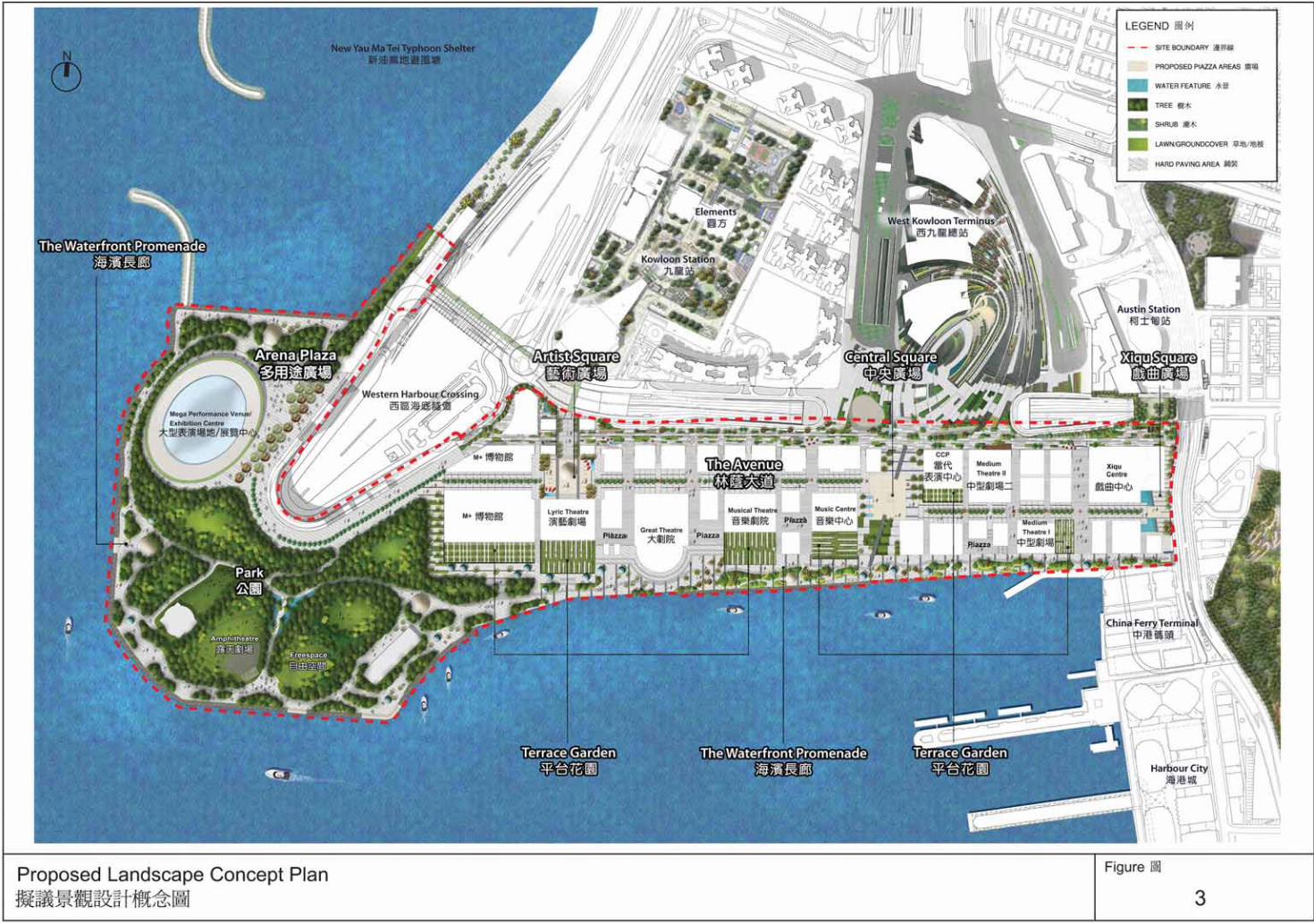
7.2.3 The Urban Design Framework and Landscape Concept Plans for
WKCD are illustrated in Figures 2 and 3 respectively. Different sub-areas, including the Park and promenade, the Avenue and piazza areas, as well as various clusters of arts and cultural venues with rich mix of uses, are linked by the well-integrated open space system (Figure 4) within WKCD. The following urban design and landscape principles are adopted in the Plan:
(a) Creating a “green hub” (Figures 2, 3 and 4)
Built upon a city park concept with a rich mix of uses and activities, the landscape design of WKCD aims to create a green hub not only for the district but also for Hong Kong as a whole. The WKCD should be designed with a green setting with a hierarchical landscape network of park, avenue, piazzas/civic squares, waterfront promenade, and terrace gardens for integrating arts, cultural, commercial (including hotel and office), residential, recreational and entertainment activities. A continuum of interconnected and easily accessible public open spaces within WKCD is formed, comprising an extensive network of greening, special landscape and water features. A minimum green coverage of 30% and 60% shall be provided for the whole WKCD and the Park respectively. It will be endeavoured to increase the overall green coverage within WKCD during the preparation of the Outline Development Plan (ODP) and at the detailed design stage. Extensive tree planting will be provided within the Park, along the Waterfront Promenade, the Avenue and pedestrian walkways. The landscape strategy aims at creating an oasis amidst the hustle and bustle of Kowloon district.
(b) Creating a rich mixed-use district To bring vibrancy and diversity to WKCD, it is essential to encourage a rich mix of uses including arts and cultural facilities, residential, office, hotel, dining, retail and entertainment uses within the same development or group of developments throughout the entire district. Arts and cultural facilities should aim to be part of the urban fabric and be integrated with other compatible uses. Buildings should have a rich mix of arts and culture, living, working, recreation and entertainment spaces to create a vibrant environment at all times.

- 7 - S/K20/WKCD/2
(c) Creating landmarks and activity nodes (Figures 1 and 2) It is critical to create landmarks and activity nodes or focal points within the district to activate the public realm. City landmarks include major cultural facilities earmarked for iconic design which may comprise the Xiqu Centre, M+ as well as the free standing Mega Performance Venue. District landmarks may include the Music Centre and the Centre for Contemporary Performance, both located near the Central Square. Other arts and cultural facilities such as the outdoor venue located in the park area would also contribute as focal points.
(d) Coherent building design The WKCD is to be developed into a world-class integrated arts and cultural district with a rich mix of retail, dining, entertainment, hotel, office and residential uses. While the design of the core arts and cultural facilities should be architecturally distinguished to create landmarks and a distinctive outlook for the Victoria Harbour, different developments within the district should be coherent in design so that the WKCD would have a distinguished identity, notwithstanding that there will be different development agents for individual development sites.
(e) Creating a dynamic skyline respectful of Kowloon’s ridgeline WKCD will be composed of buildings of different scales and types, varying building heights and selective signature arts and cultural facilities, which will parade a dynamic and exciting waterfront for Hong Kong. Yet this dynamism will respect and retain views towards the natural heritage of the Kowloon ridgeline from vantage points at Sun Yat Sen Memorial Park and Central Pier No. 7. The overall height profile starts from the west with the rolling mounds of the Park and the U-shape hotel and commercial development in the background, and continues with the M+ marking the high point of the profile. It then gradates towards the east following the Kowloon ridgeline towards the Xiqu Centre to mark the gateway to WKCD from the neighbouring areas. A stepped height profile towards the waterfront allows existing developments and new buildings in the WKCD to share the view of the Victoria Harbour, and creates an interesting scene from the opposite side of the harbour.
(f) Celebrating the views (Figure 2) Views beyond the district are critical to maintain one’s orientation within the city. There is a strong emphasis on views to and from the mountains (the Victoria Peak, Kowloon

- 8 - S/K20/WKCD/2
ridgeline), the harbour and the city beyond (Hong Kong Island, Kowloon hinterland). The view corridor extending from the West Kowloon Terminus (WKT) of Express Rail Link (XRL) into Central Square up to the waterfront creates a sequence of spatial experience towards the views over the Victoria Harbour. Vantage points throughout the site should allow the public to enjoy those views.
(g) Creating a pedestrian-friendly environment The “vehicle-free” design concept, where all streets within the district are entirely dedicated to the pedestrians (Figure 5) and the servicing mainly happens below ground, would enhance air quality and create a leisure and safe pedestrian environment. The Avenue level being raised in relation to the level at the waterfront promenade, referred to as a ‘raised terrace concept’, would enhance view corridors and create interesting streetscape. The pedestrian experience is further enhanced by the continuous waterfront promenade, the Avenue and the main path winding through the Park area (Figure 3) as well as a series of vibrant side streets stepping down to the waterfront.
(h) Creating an all-weather urban streetscape and landscape The “all-weather” design concept of the tree-lined Avenue (Figure 3) with its shaded arcades will create an urban environment, reduce energy consumption within the WKCD and provide an outdoor weather protected street environment within WKCD. The weather protected arcades will also extend to the Central Square, the Artist Square and the Xiqu Square and finally connected with the waterfront. The tree canopy will take the relay along the waterfront and throughout the Park to offer a continuous shaded environment throughout the district.
(i) Activating the harbour-front To bring life and vibrancy to the waterfront, it is necessary to introduce a variety of activities ranging from holding of arts and cultural events, to casual strolls along the waterfront promenade, as well as an active waterfront lined with arts and cultural venues, restaurants, cafes, bars, arts pavilions, teahouses and floating art pontoons.
(j) Celebrating the gateways (Figure 2) Gateways can take a variety of forms and types in WKCD ranging from access points at different levels to visual markers in the form of iconic buildings. Among all, five gateways identified in WKCD are more important. In the north, the Central Square serves as a gateway which links up the WKT of
- 9 - S/K20/WKCD/2
the XRL all the way down to the waterfront. Other gateways include the Artist Square which connects to the footbridge from The Elements in the west, and the Xiqu Centre abutting Canton Road in the east. From the harbour, two possible piers will be the points of entry.
(k) Connecting the neighbouring areas (Figures 5 and 6) Connecting the WKCD with its neighbouring areas is crucial. Easy access for both pedestrians and vehicles, as well as the provision of various modes of public transport such as the possible Environmentally Friendly Transport System (EFTS) including environmentally-friendly bus (e-bus), travellator and/or people mover, will help integrate the WKCD with its neighbouring areas. In particular, a network of pedestrian connections, including at-grade walkways, landscaped decks, footbridges and subways, will be provided (see paragraph 13.5 below), taking account of the existing and planned activity nodes.
8. DEVELOPMENT INTENSITY
8.1 In planning for the WKCD, the plot ratio restrictions stipulated in the South West Kowloon OZP for the WKCD area should be adhered to. According to the Notes for the “OU(ACECOU)” zone under the previously approved OZP, no new development, or addition, alteration and/or modification to or redevelopment of an existing building shall result in a total development and/or redevelopment in excess of a maximum plot ratio of 1.81, of which not more than 20% of the total plot ratio shall be for residential use.
8.2 With a development area of about 40.91 ha, the maximum gross floor area
(GFA) permissible for the whole district is about 740 350m² based on the maximum plot ratio of 1.81. The area and boundary of WKCD, however, may be subject to minor adjustments during detailed setting out of land at the land grant stage.
8.3 In order to conform to the maximum GFA permissible for the whole district,
maximum GFA restrictions are stipulated for the following land use zones on the Plan, which shall add up to a total not exceeding the maximum GFA permitted for the whole district (i.e. about 740 350m²):
Zoning Maximum GFA (m²)
“Open Space” 11 200
“Other Specified Uses” annotated “Arts, Cultural, Entertainment and Commercial Uses” (“OU(ACECU)”)
358 850
“Other Specified Uses” annotated “Mixed Uses” (“OU(MU)”)
366 900
- 10 - S/K20/WKCD/2
“Other Specified Uses” annotated “Electricity Substation” (“OU(ESS)”)
3 400
Total 740 350
8.4 For the “OU(MU)” zone that comprises residential elements, the maximum GFA for residential use (i.e. 148 070m²) is also stipulated, so that the total GFA for residential use shall not exceed 20% of the total maximum GFA for the whole district as stipulated in the South West Kowloon OZP.
9. DEVELOPMENT MIX
A balanced development mix for the WKCD comprises the following components:
Development Mix % of Total GFA
Arts and Cultural Facilities About 35-40%
Retail/Dining/Entertainment About 15-20%
Hotel/Office About 20-25%
Residential Not more than 20%
GIC Not less than 1%
Total 100% 10. BUILDING HEIGHT RESTRICTIONS
10.1 Developments within different land use zones on the Plan are subject to maximum building height restrictions as stipulated on the Plan. The building height restrictions will provide better planning control and prevent excessively tall or out-of-context buildings
10.2 The general building height profile of WKCD of 50mPD/70mPD/100mPD
formulated under the South West Kowloon OZP was based on the following urban design principles:
(a) preservation of public views from Sun Yat Sen Memorial Park towards
the Kowloon Peak, Tsz Wan Shan and Lion Rock ridgelines to maintain a 20% building-free zone below the ridgelines;
(b) preservation of public views from the Star Ferry Pier at the Central
Waterfront towards the Lion Rock ridgeline to maintain a 20% building-free zone below the ridgeline;
(c) preservation of an open vista and green corridor from the “G/IC”
heritage sites consisting of the declared monuments of Hong Kong Observatory and former Kowloon British School (now Antiquities and

- 11 - S/K20/WKCD/2
Monuments Office), the grade II St. Andrew’s Church, through Kowloon Park and along the WKCD waterfront promenade towards the western Victoria Harbour;
(d) avoidance of unduly tall buildings with wall effect and enhancement of
visual permeability from the harbour by lowering of building height at waterfront locations;
(e) introduction of variation in building height for a coherent building height
profile across the WKCD; and (f) introduction of visual relief to soften the building masses clustering
around the Kowloon Station.
10.3 Notwithstanding the building height restrictions on OZP which stipulates the maximum height, a stepped height profile descending towards the waterfront is also proposed under the Urban Design Framework to create height variation.
10.4 Based on the individual merits of a development or redevelopment proposal,
minor relaxation of the building height restrictions may be considered by the Board on application under section 16 of the Ordinance. In order to allow greater design flexibility for the arts and cultural facilities, relaxation of the building height restrictions may be considered by the Board on application under section 16 of the Ordinance for the free-standing arts and cultural facilities within the “O” and the “OU(ACECU)” zones, on individual merits.
Non-Building Areas
10.5 Non-building areas (NBAs) of different widths are designated in various zones
to serve primarily as pedestrian ways, which also help facilitate air ventilation and improve visual permeability.
10.6 A total of five NBAs are designated on the Plan:
(a) a 15m-wide strip of land along the western boundary of the
“OU(ACECU)5” zone and the eastern boundary of the “OU(ACECU)4” zone between Road D1 and the waterfront;
(b) a 8m-wide strip of land along western boundary of the “OU(MU)5” zone
and the eastern boundary of the part of the “OU(MU)4” zone to the south of the Avenue linking up the podium of WKT and the waterfront; and
(c) three 12m-wide strips of land cutting across the “OU(ACECU)2”,
“OU(MU)2”, “OU(MU)3” and “OU(MU)7” zones between Austin Road West and the waterfront.
10.7 As the designation of NBAs is primarily for above-ground pedestrian
circulation and promoting visual and air permeability, the NBA restriction will not apply to underground developments. To facilitate better connection between different developments, minor structure for footbridge connection on
- 12 - S/K20/WKCD/2
and over the NBAs are allowed. Moreover, a minor relaxation clause has been incorporated into the Notes of the relevant zones to allow minor relaxation of the NBA restrictions as shown on the Plan under exceptional circumstances.
11. AIR VENTILATION ASSESSMENT
11.1 Good wind availability at the pedestrian level within WKCD is anticipated due to the elongated nature of the site and open exposure to the waterfront.
11.2 An Air Ventilation Assessment (AVA) was conducted. According to the findings of the AVA, the annual and summer prevailing wind is coming from the east and south-west directions respectively. The summer wind is very important for urban thermal comfort and air ventilation. Taking into account the findings of the AVA and other relevant factors, such as the provision of pedestrian ways and improvement on visual permeability, a total of five NBAs have been incorporated on the Plan as mentioned in section 10 above.
11.3 Apart from the NBAs, the open space provided at the Central Square, which is
zoned “O(2)” on the Plan, also facilitates wind penetration from the waterfront area to Lin Cheung Road.
11.4 The Avenue, which is also zoned “O(2)” on the Plan, is linked up with the
Artist Square, Central Square and Xiqu Square. The east-west orientation of the Avenue helps facilitate annual prevailing wind flow from the east through the WKCD site and facilitate wind penetration through the north-south running roads and NBAs.
11.5 In addition to the NBAs and the open space network, buildings with permeable
design are encouraged during the detailed design and implementation stage.
12. LAND USE ZONINGS
12.1 “Open Space” (“O”) : Total Area 17.23 ha 12.1.1 This zoning is intended primarily for the provision of outdoor
open-air public space for active and/or passive recreational uses serving the needs of local residents, the general public as well as visitors. On land designated “O(1)”, the open space is provided in the form of a park by the waterfront with arts and cultural facilities and a continuous waterfront promenade of not less than 20 metres in width. A cycle track/path will also be provided within the Park. On land designated “O(2)”, the open space comprises piazzas/squares and a vehicle-free tree-lined avenue with arts, cultural, retail, dining and entertainment uses to create a vibrant atmosphere along the avenue.
- 13 - S/K20/WKCD/2
12.1.2 Developments and redevelopments within the “O(1)” and “O(2)” sub-zones are subject to a maximum total GFA of 10 900m² and 300m² for arts, cultural, retail, dining and entertainment uses, or the GFA of the existing building, whichever is the greater. Accommodation of such uses should integrate with and enhance open space design without compromising general public enjoyment of the open space.
12.1.3 Developments and redevelopments within the “O(1)” and “O(2)”
sub-zones are subject to maximum building height restrictions of 3 storeys and 1 storey (both excluding basement floor(s)) respectively, or the height of the existing building, whichever is the greater.
12.1.4 Minor relaxation of GFA and building height restrictions may be
considered by the Board on application under section 16 of the Ordinance. Each application will be considered on its own merits.
12.1.5 To provide supporting facilities for public enjoyment of the open
space, any covered area and floor space that are constructed or intended for use solely as covered walkway, pavilion, public convenience and park management office, may be disregarded.
12.1.6 In addition to the open space provision in the “O” zone (17.23 ha), a
network of interconnected and accessible open spaces of not less than 57 700m² are also provided within the various “OU(ACECU)” sub-zones for public enjoyment. The total amount of public open space provided within these two zones shall be not less than 23 ha.
12.1.7 The design of the open space at different levels will be coherent, well
connected and integrated with the arts and cultural buildings. All open spaces will be open to public at reasonable hours.
12.2 “Other Specified Uses” (“OU”) : Total Area 23.68 ha
12.2.1 This zoning covers land allocated for the following specific uses.
“OU(ACECU)” Zone 12.2.2 The planning intention of this zone is primarily for the provision of
arts and cultural facilities supported by a range of mixed office, hotel, retail, dining, recreational and entertainment uses.
12.2.3 A total of seventeen core arts and cultural venues will be
accommodated in sites zoned “OU(ACECU)”. The Mega Performance Venue, being the most sizable performing arts venue in WKCD will have a seating capacity up to around 15 000. Five additional large scale venues with more than 1 000 seats and nine small to medium scale venues with seating capacities ranging from 150 to 800 will be developed, each with specific focus on particular
- 14 - S/K20/WKCD/2
art forms including Xiqu, music, dance and drama. 12.2.4 The M+ with a GFA of about 60 000m² will focus on the collection,
curation and preservation of arts and cultural artefacts from visual arts, design, moving image and popular culture. Additional exhibition space of around 10 000m² is allowed for the development of an Exhibition Centre. Final scale and capacities of individual venues will be subject to detailed design at the implementation stage.
12.2.5 Developments and redevelopments within various “OU(ACECU)”
sub-zones are subject to the following maximum GFA restrictions, or the GFA of the existing building, whichever is the greater:
Sub-area Restriction
OU(ACECU)1 Maximum total GFA of 80 850m².
OU(ACECU)2 Maximum total GFA of 190 500m².
OU(ACECU)3 Maximum total GFA of 44 850m².
OU(ACECU)4 Maximum total GFA of 12 750m².
OU(ACECU)5 Maximum total GFA of 29 900m². 12.2.6 Out of the overall maximum total GFA of 358 850m² as stated in
paragraphs 8.3 and 12.2.5 above, the maximum GFA for hotel/office uses within “OU(ACECU)1” to “OU(ACECU)5” sub-zones shall not exceed 28 850m² in total.
12.2.7 On land designated “OU(ACECU)1” to “OU(ACECU)5”, any floor
space that is constructed or intended for use solely as above-ground vent shafts for the XRL and above-ground vent shafts for underground vehicular access and servicing facilities of WKCD, with a total GFA of not more than 3 600m² and 1 000m² respectively, may be disregarded. Any covered area and floor space that are constructed or intended for use solely as covered walkway and pavilion may also be disregarded.
12.2.8 Developments and redevelopments within the “OU(ACECU)1” to
“OU(ACECU)5” sub-zones are subject to maximum building height restrictions in terms of mPD as stipulated on the Plan, or the height of the existing building, whichever is the greater.
12.2.9 On land designated “OU(ACECU)1” to “OU(ACECU)5”, public
open space of not less than 57 700m² in total shall be provided. 12.2.10 Minor relaxation of the GFA and building height restrictions may be
considered by the Board on application under section 16 of the Ordinance. Each application will be considered on its own merits.

- 15 - S/K20/WKCD/2
12.2.11 To allow greater flexibility in the design of arts and cultural facilities,
particularly for the design and functional needs of the M+ Phase 2, two sites on both sides of the Avenue have been paired up as one sub-zone “OU(ACECU)2”, so that the GFA could be flexibly distributed within this sub-zone according to the final phasing arrangement.
“OU(MU)” Zone
12.2.12 This zone is intended for mixed arts, cultural, commercial (including
hotel and office), residential, recreational and entertainment developments to create vibrancy for the WKCD. Flexibility for the development/ redevelopment/ conversion of various types of compatible uses, either vertically within a building or horizontally over a spatial area, is allowed to meet the evolving and changing requirements for the WKCD development. Physical segregation has to be provided between the non-residential and residential portions within a new/converted building to prevent non-residential uses from intruding into the residential portion.
12.2.13 Developments and redevelopments within various “OU(MU)”
sub-zones are subject to the following maximum GFA restrictions, or the GFA of the existing building, whichever is the greater:
Sub-area Restriction
OU(MU)1 Maximum total GFA of 75 930m².
OU(MU)2 Maximum total GFA of 49 050m², of which the GFA for residential use shall not exceed 10 300m².
OU(MU)3 Maximum total GFA of 89 500m², of which the GFA for residential use shall not exceed 50 250m².
OU(MU)4 Maximum total GFA of 81 670m², of which the GFA for residential use shall not exceed 44 970m².
OU(MU)5 Maximum total GFA of 43 100m², of which the GFA for residential use shall not exceed 24 250m².
OU(MU)6 Maximum total GFA of 22 200m², of which the GFA for residential use shall not exceed 15 600m².
OU(MU)7 Maximum total GFA of 5 450m², of which the GFA for residential use shall not exceed

- 16 - S/K20/WKCD/2
Sub-area Restriction 2 700m².
12.2.14 Out of the overall maximum total GFA of 366 900m² as stated in
paragraphs 8.3 and 12.2.13 above, the maximum GFA for hotel/ office/residential uses on land designated “OU(MU)1” to “OU(MU)7” shall not exceed 289 950m² in total.
12.2.15 Developments and redevelopments within the “OU(MU)1” to “OU(MU)7” sub-zones are subject to maximum building height restrictions in terms of mPD as stipulated on the Plan, or the height of the existing building, whichever is the greater.
12.2.16 On land designated “OU(MU)1” to “OU(MU)7”, any floor space that
is constructed or intended for use solely as above-ground vent shafts for the XRL and above-ground vent shafts for underground vehicular access and servicing facilities of the WKCD, with a total GFA of not more than 4 400m² and 1 000m² respectively, may be disregarded. Any covered area and floor space that are constructed or intended for use solely as covered walkway may also be disregarded.
12.2.17 Minor relaxation of the GFA and building height restrictions may be
considered by the Board on application under section 16 of the Ordinance. Each application will be considered on its own merits.
12.2.18 To allow greater flexibility in the design of office, hotel and
residential developments, especially for those smaller sub-zones to the south of the Avenue, and to allow a better scope to mitigate the potential traffic noise impact along Austin Road West to future residential developments, sites on both sides of the Avenue have been paired up into “OU(MU)2”, “OU(MU)3” and “OU(MU)4” sub-zones so that the GFA could flexibly be distributed within each of these sub-zones.
Other “OU” Zones
12.2.19 Other specified uses include the existing ventilation and traction
substation building of the Airport Railway and the existing ventilation building of the WHC, which are subject to a maximum building height of 30mPD and 40mPD respectively as stipulated on the Plan, or the height of the existing building, whichever is the greater. Minor relaxation of the building height restrictions may be considered by the Board on application under section 16 of the Ordinance. Each application will be considered on its own merits.
12.2.20 The proposed electricity substation (ESS) within the “OU” annotated
“Electricity Substation” zone is subject to a maximum GFA restriction of 3 400m² and a maximum building height of 33mPD as stipulated on the Plan, or the height of the existing building,
- 17 - S/K20/WKCD/2
whichever is the greater. Minor relaxation of the GFA and building height restrictions may be considered by the Board on application under section 16 of the Ordinance. Each application will be considered on its own merits.
13. COMMUNICATIONS (Figures 5-6)
13.1 Roads 13.1.1 WKCD being located in West Kowloon Reclamation area is well
served by numerous existing and planned road networks. 13.1.2 West Kowloon Highway runs from north to south providing a
strategic transport link to the WKCD. It forms part of a major road link extending from the airport at Chek Lap Kok to Hong Kong Island through the WHC.
13.1.3 The planned road network in West Kowloon Reclamation area
includes:
Lin Cheung Road – Austin Road West Underpass; Upgrading of elevated Nga Cheung Road (at its junction with
Jordan Road) plus new connection from Hoi Po Road to West Kowloon Highway (Northbound);
New link road from elevated Nga Cheung Road to WHC; New road linking West Kowloon Highway (Southbound) to
at-grade Nga Cheung Road; and Canton Road /Austin Road West Junction Improvement.
13.1.4 All roads and servicing facilities within the eastern and middle
portions of WKCD are to be provided underground (Figure 6) to enable a vehicle-free environment at ground level. For the western portion, a northern perimeter road around the WHC portal is provided at ground level. The vehicular access points for WKCD are summarized in paragraph 13.1.5 below.
13.1.5 Vehicular access points and drop-off lay-bys planned for the WKCD
include:
Vehicular Ingress/Egress (Figure 6) Canton Road Access (At-grade) at Canton Road; Lin Cheung Road Access (Underground) at Junction Lin
Cheung Road/Austin Road West; Nga Cheung Road Access (At-grade) at Junction Nga Cheung
Road/Austin Road West (At grade); Nga Cheung Road Access (Elevated) at Junction Nga Cheung
Cheung Road/ Austin Road West (Elevated); and Austin Road Bridge (Elevated) at Junction Nga Cheung Road/

- 18 - S/K20/WKCD/2
Austin Road West (Elevated).
Drop-off lay-bys East Gate at Austin Road West (opposite to WKT); and West Gate at Austin Road West (opposite to Kowloon Station).
13.2 Car Parking and Loading/Unloading Facilities
13.2.1 Car parking facilities will be provided at basement level to enable a
vehicle-free environment in WKCD at ground level. 13.2.2 Loading/unloading facilities will be provided both at basement level
and at grade to facilitate the daily operations within the WKCD.
13.3 Environmentally Friendly Transport System (EFTS)
There will be a possible EFTS in WKCD. The mode of operation and routing of the EFTS will be subject to further study. The EFTS could be in various possible transport modes such as e-bus, travellator and people mover (i.e. an automated mechanical system that conveys passengers and baggage, for example, between passenger terminal and concourse). The system will connect the eastern and western ends of WKCD to facilitate pedestrian movement within WKCD (Figure 5). Any floor space that is constructed or intended for use solely as the EFTS will not be accountable to the maximum GFA permissible for the whole district.
13.4 Railways
13.4.1 The WKCD is served by the Airport Railway, which provides two
services: an Airport Express Line between the airport at Chek Lap Kok and Hong Kong Island, and a local domestic Tung Chung Line between Tung Chung and Hong Kong Island. The Airport Railway Kowloon Station is located to the north of WKCD.
13.4.2 The WKCD is also served by the West Rail Line which is a
passenger line connecting Tuen Mun Centre to Hung Hom (and East Rail Line) via Austin Station and East Tsim Sha Tsui Station. The Austin Station is located to the north of WKCD.
13.4.3 The WKCD will also be served by the XRL, which is a
cross-boundary passenger line, now under construction. The proposed WKT located at a site bounded by Lin Cheung Road, Jordan Road, Road D1 and Austin Road West to the north of WKCD will be the gateway for Hong Kong to connect to the national high speed rail network. Construction of the Hong Kong section of XRL has commenced in 2010 and is scheduled for completion in 2015.
13.5 Pedestrian Connections and Circulation (Figure 5)
13.5.1 WKCD is bounded by major roads such as Canton Road and Austin

- 19 - S/K20/WKCD/2
Road West. The pedestrian circulation will be designed to maximize accessibility to the area from the hinterland and mobility within WKCD through an integrated network of open space, at-grade connections, footbridges and subways.
13.5.2 Existing/planned connections between WKCD and surrounding areas
include:
Existing footbridge across WHC Toll Plaza; and WKT Deck: a landscaped deck allows pedestrian circulation
over Austin Road West connecting WKCD and the plaza in front of WKT.
13.5.3 Indicative future possible connections between WKCD and the
surrounding areas subject to agreement with various stakeholders and future demand justifications include:
Kowloon Station Connection (Anchorage Bridge): this will be formed as a footbridge linking the Kowloon Station concourse of Tung Chung Line to the northern tip of WKCD. The bridge provides direct connection into The Elements Shopping Centre;
Kowloon Park Connection (Kowloon Park Bridge): a fully landscaped deck will be provided over Canton Road to connect between WKCD and Kowloon Park;
The Elements West Connection (ICC Bridge): a footbridge connecting from ICC / The Elements with WKCD and the Artist Square;
Extension of Existing Austin Road Subway: extension of the existing subway to connect Austin Station with WKCD;
Austin Station Connection (Possible Landscaped Deck Connection): a landscaped deck is planned across Austin Road West for noise mitigation purpose. It is proposed to make use of this landscaped deck to link up WKCD and Austin Station; and
China Ferry Terminal (CFT) Connection (CFT Bridge): a new connection to the CFT retail mall will be provided above ground.
13.6 Other Public Transport Facilities
13.6.1 Existing and future public transport terminuses in the surrounding
areas include Kowloon Station Public Transport Interchange (PTI), Jordan Temporary Bus Terminus (To Wah Road), CFT PTI and the proposed WKT PTI near Jordan Road, which is scheduled for completion in around 2015.
13.6.2 Bus lay-bys in WKCD are proposed. One is located at Austin Road
West near the at-grade Austin Road West / Nga Cheung Road roundabout. Another possible one will be located near the Mega Performance Venue. The planning and design of such public
- 20 - S/K20/WKCD/2
transport facilities will be subject to the design of the Mega Performance Venue.
14. MARINE FACILITIES
14.1 Two possible piers are proposed at the southern and western edge of WKCD for leisure activities and possible marine connections subject to availability of service providers. Possible art pontoon and viewing platform for functions like outdoor performances, viewing platforms, floating stages or exhibitions may also be considered. These marine facilities, however, are subject to the requirements under the Protection of Harbour Ordinance (Cap. 531) and agreements with relevant government bureaux/departments, and therefore require further investigation and feasibility study.
14.2 The existing fireboat pier located directly north of the CFT along WKCD
waterfront promenade is proposed to be relocated to a suitable location in the northwest waterfront of the WKCD, subject to further investigation and feasibility study.
14.3 Landing steps will be provided at suitable location(s) mainly for public amenity
purpose. The exact location will be subject to further investigation and feasibility study.
15. UTILITY SERVICES
15.1 Water 15.1.1 Water mains will generally be laid below the waterfront promenade
and connected to existing and future water mains at Austin Road West and at the waterfront promenade at the north-west corner of the WKCD. Fresh water for the WKCD is served by existing service reservoirs.
15.1.2 Possibility to relocate the existing Water Supplies Department’s
Kowloon South No. 2 Salt Water pumping station will be explored to enhance the waterfront promenade.
15.2 Gas
15.2.1 A gas pipeline will be laid below along the waterfront promenade
and connected to existing gas pipelines at Austin Road West. 15.2.2 A site for a gas pigging station has been reserved near the approach
roads of WHC outside WKCD.
15.3 Electricity 15.3.1 An ESS will be constructed near the junction of Austin Road West
- 21 - S/K20/WKCD/2
and Nga Cheung Road. The ESS would be subject to the setting out of site boundary at land grant stage. The ESS will be dually fed from 132kV electricity cables from Nga Cheung Road and from Austin Road West.
15.3.2 11kV electricity cables from the new ESS will be laid below the Avenue and below the waterfront promenade. Existing electricity cables from other ESS will also be extended to WKCD to provide backup power supply to WKCD.
15.4 Telephone
Telephone cables will be laid below the Avenue and connected to the existing telephone cables at Austin Road West.
15.5 District Cooling System
15.5.1 District Cooling System (DCS) is more energy efficient and can
provide substantial energy savings compared to conventional air-cooled chilling system. It avoids the need for chiller plants at individual buildings, thereby removing environmental nuisances such as noise, vibration and thermal plumes while also freeing up rooftop space that would otherwise have been occupied by rooftop chiller plants.
15.5.2 Existing seawater pump houses at the south of the WKCD will be
used for the seawater intake. A centralised chiller plant will be constructed at the basement level(s) of the WKCD basement adjacent to the existing seawater pump houses.
15.5.3 The DCS cooling pipes will be laid below the waterfront promenade
and below the basement level(s). Appropriate measures should be taken to avoid interfacing issues and ensure proper integration with the open space/waterfront promenade.
15.6 Sewerage and Drainage
15.6.1 An existing box culvert at the east of WKCD will be retained.
Drainage reserve of this box culvert should be kept free of building works.
15.6.2 An existing 1375mm diameter drain pipe at the east end of the
WKCD will be diverted and re-connected to the existing box culvert at the promenade.
15.6.3 A new box culvert will be constructed as a replacement of an existing
1350mm diameter drain pipe crossing the WKCD. The box culvert will be constructed within the WKCD basement and a new outfall will be constructed.

- 22 - S/K20/WKCD/2
15.6.4 New drain pipes will be laid in the Park at the south-west corner of the WKCD to collect surface runoffs. New outfalls will be constructed.
15.6.5 A trunk gravity sewer will be laid at the future footway at the north
of the WKCD adjacent to Austin Road West. 15.6.6 Rising mains will be laid from Xiqu Centre to the existing sewer at
Canton Road.
15.7 Vent Shafts within the WKCD
15.7.1 It was planned that the WKCD will accommodate the vent shaft structures for the XRL at a location to the south of the WKT across Austin Road West. The vent shaft structures, however, will be integrated with the above-ground developments in WKCD to avoid free-standing massive vent shaft structures.
15.7.2 Similarly, the vent shaft structures for underground vehicular access
and servicing facilities of the WKCD will also be integrated with the above-ground developments.
16. IMPLEMENTATION
16.1 The Plan provides a broad land use framework within which a more detailed
departmental ODP will be prepared in consultation with government departments concerned. The ODP is a non-statutory plan which will be used as the basis for public works planning and site planning purpose. It will include information on detailed land uses, development parameters and boundaries of individual sites, green coverage, waterworks and drainage reserves, site formation levels, road alignment and dimensions, location of pedestrian facilities, public utility facilities as well as other building and engineering requirements. The ODP will serve as a guide for land transaction as well as to facilitate the development of WKCD.
16.2 The arts and cultural facilities in WKCD will be implemented in phases. This
is in line with the public aspiration for an organic growth of the WKCD development. The Board should be consulted on the design and development of major arts and cultural venues.
16.3 Part of the Park with associated arts and cultural facilities as well as the Xiqu
Centre are scheduled as the first batch of facilities in Phase 1. The timing and construction of distributor roads, drainage and installation of utilities will be programmed to meet the demand for development in the WKCD.
16.4 Possible interface issues between the WKCD development and other
developments in the immediate surrounding area will be well co-ordinated among parties and government departments concerned during the detailed

- 23 - S/K20/WKCD/2
design and implementation stage.
16.4.1 The existing Tsim Sha Tsui Fire Station Complex (except the fireboat pier cum fireboat station) at Canton Road will be relocated in stages upon identification of suitable site(s) outside the WKCD. The first-stage exercise is contemplated to involve relocation of the non-essential operational facilities to a “G/IC” site at To Wah Road. The existing fireboat pier cum fireboat station will be re-provisioned to a suitable location in the northwest waterfront of the WKCD to be identified. The relocations are subject to relevant study. The WKCDA should be consulted for ensuring the location will not compromise the overall planning and design integrity of the WKCD at large.
16.4.2 The possible piers and marine related facilities currently not included
within the boundary of the Plan, requires further investigation and feasibility study to ensure that the Protection of the Harbour Ordinance is complied with.
16.4.3 Locations of the proposed pedestrian connections and circulation are
indicative. Their exact alignments and implementation will be subject to the need in future and agreement with relevant government departments and parties.
16.4.4 Works for WKCD development shall take into account the operation
and maintenance of WHC and the tunnel users to avoid causing safety hazards to WHC; avoid or minimise traffic disruption in the WHC tunnel area; to protect the WHC structures; and to ensure safe operation of the WHC.
16.4.5 The interface issue with the existing sea water cooling system
serving The Elements and the cross-boundary coach terminus would be co-ordinated among MTR Corporation Limited and other parties and relevant government departments concerned during detailed design and implementation stage, with a view to minimising and mitigating impacts on any utility services located within the WKCD area.
Index of Figures (All figures are for indication purpose only) Figure 1 - Proposed Core Arts and Cultural Facilities Plan Figure 2 - Proposed Urban Design Framework Figure 3 - Proposed Landscape Concept Plan Figure 4 - Proposed Public Open Space Figure 5 - Proposed Pedestrian and Connectivity Plan Figure 6 - Proposed Vehicular Access Points TOWN PLANNING BOARD JANUARY 2013