lassics lupine listing petition - center for biological diversity · 2016-07-05 · lassics lupine...
TRANSCRIPT

PETITION TO THE STATE OF
CALIFORNIA FISH AND WILDLIFE COMMISSION TO LIST THE
LASSICS LUPINE (LUPINUS CONSTANCEI) AS ENDANGERED UNDER
THE CALIFORNIA ENDANGERED SPECIES ACT
JULY 5, 2016
DAVID IMPER
CENTER FOR BIOLOGICAL DIVERSITY

i
Notice of Petition
For action pursuant to Section 670.1, Title 14, California Code of Regulations (CCR) and
Sections 2072 and 2073 of the Fish and Game Code relating to listing and delisting endangered
and threatened species of plants and animals.
I. SPECIES BEING PETITIONED:
Common Name: Lassics lupine
Scientific Name: Lupinus constancei
II. RECOMMENDED ACTION
To list as Endangered under the California Endangered Species Act
Dave Imper and the Center for Biological Diversity submit this petition to the California Fish
and Wildlife Commission to list the Lassics lupine (Lupinus constancei) as “endangered” in
California, under the California Endangered Species Act (California Fish and Game Code §§
2050 et seq.) (“CESA”). This petition demonstrates that the Lassics lupine clearly warrants
listing under CESA based on factors specified in the statute. We look forward to the
Commission’s response to this petition and processing of it pursuant to the procedures and
timelines established at California Fish and Game Code §§ 2073 et seq.
III. AUTHORS OF PETITION
Name: Dave Imper
Address: 4612 Lentell Road
Eureka, CA 95503
Phone: (707) 444-2756
Email: [email protected]
Name: Center for Biological Diversity
Address: PO Box 220
Phone: Shelter Cove, CA 95589
Email: [email protected]
I hereby certify that, to the best of my knowledge, all statements made in this petition are true
and complete.
Date: July 5, 2016 Signature: /s/ David Imper
David Imper, M.Sc.,
4612 Lentell Road, Eureka, CA 95503
ii
TABLE OF CONTENTS
EXECUTIVE SUMMARY .......................................................................................................................... 1
INTRODUCTION ....................................................................................................................................... 1
RANGE ......................................................................................................................................................... 3
LAND OWNERSHIP AND MANAGEMENT DIRECTION ..................................................................... 4
CHRONOLOGY OF PAST INVESTIGATION .......................................................................................... 5
CONSERVATION STATUS ...................................................................................................................... 6
Regulatory .............................................................................................................................................. 6
Draft conservation agreement ................................................................................................................. 6
Past conservation actions ........................................................................................................................ 6
POPULATION STATUS ............................................................................................................................. 7
Demographics ......................................................................................................................................... 7
Population record .......................................................................................................................8
NATURAL HISTORY ................................................................................................................................. 9
Taxonomy and genetics .......................................................................................................................... 9
Species description ...................................................................................................................10 Habitat ......................................................................................................................................10 Pollination ................................................................................................................................12 Small mammals ........................................................................................................................12 Geology and soils .....................................................................................................................13 Climate .....................................................................................................................................13
THREATS .................................................................................................................................................. 16
Modification or curtailment of habitat or range ................................................................................... 16
Overutilization ..................................................................................................................................... 18
Disease and Predation .......................................................................................................................... 18
Existing Regulatory Mechanisms ......................................................................................................... 19
Other Factors ........................................................................................................................................ 20
SUMMARY AND JUSTIFICATION ........................................................................................................ 21
RECOMMENDED MANAGEMENT AND RECOVERY ACTIONS ..................................................... 22
Priority Category 1: Tasks needed to avoid imminent species extinction ............................................ 24
Priority Category 2: Tasks needed to maintain a viable population .................................................... 25
INFORMATION SOURCES ...................................................................................................................... 26
Literature Cited ..................................................................................................................................... 26

1
EXECUTIVE SUMMARY
The Lassics lupine (Lupinus constancei) is an herbaceous perennial flowering member of the legume
family (Fabaceae) endemic to the Lassics mountain range of Humboldt and Trinity counties, in
northwestern California. This attractive lupine exhibits striking pink-rose tinged flowers above white-
silver foliage, in contrast to the surrounding black or reddish barren slopes. Its total global range consists
of less than four acres of mostly barren, shallow serpentine-influenced soils, with a scattered assemblage
of shrubs and forbs. Only two occurrences of Lassics lupine have been documented since it was
described in 1983, both located above 5,000 feet elevation on the slopes of Mt. Lassic and Red Lassic,
within Six Rivers National Forest (SRNF). Both sites were negatively impacted by the Lassics Fire in
July and August of 2015. Extensive monitoring and research over the past 13 years indicated the species
is trending toward extinction. Events over the past two years have significantly increased that concern.
The Lassics lupine is threatened by four general factors, and thus warrants state protection. The species is
threatened with significant curtailment of habitat, as a result of climate change, forest encroachment, and
the recent fire. It is also threatened by predation; a very high rate of seed predation and herbivory by
wildlife has caused a high rate of mortality, significantly impairing its reproductive potential. Regulatory
mechanisms are inadequate to protect the species. The Lassics lupine is classified a Sensitive species by
the Forest Service. However, that status and other State and Federal regulations have been ineffective.
SRNF has been slow in implementing measures necessary to counter the imminent threats, in part because
the majority of the species distribution occurs within designated wilderness. Finally, the species is
threatened by other factors; recent and severe mortality related to climate extremes, representative of
longer term regional climate trends, indicate if the species is to survive, a greater proportion of the
population must occupy habitat more immune to climate extremes. Such habitat formerly occupied by the
species has succumbed to forest encroachment over the past 60 years. The SRNF has not pursued the
necessary restoration. Without protection under CESA, and the enhanced status, agency prioritization,
urgency, and hopefully, funding, that formal listing will facilitate, all available evidence indicates the
species is in immediate danger of extinction.
Currently there are no regulatory mechanisms to protect the Lassics lupine from extinction. The
petitioners have petitioned the U.S. Fish and Wildlife Service to protect the Lassics lupine under the
Endangered Species Act and it is currently under federal status review (80 Fed. Reg. 19,259 (Apr. 10,
2015)).
INTRODUCTION
There is no more appropriate icon symbolizing the beauty and exceptional floristic diversity associated
with the Lassics Mountain Range than the Lassics lupine. Named after the Athabascan Lassik tribe,
forcibly removed from the region in 1862 (Carothers 2008), the mountain range and its unique lupine
have been, and hopefully will continue to be, a permanent memorial to the original occupants of this truly
exceptional landscape.
The Lassics lupine is likely the rarest, and based on a recent population viability analysis (PVA), arguably
the most threatened plant species in northwestern California. It is substantially more imperiled than any

2
of the six plant species listed as endangered under the ESA within the jurisdiction of the U.S. Fish and
Wildlife Service (USFWS) Arcata Field Office (Carothers 2015a, 2015b; Imper 2015; Kurkjian 2012).
The Lassics lupine PVA (Kurkjian 2012a), which was based on nearly a decade of monitoring and
research data, indicated that in the absence of aggressive protection and management measures, the
species has a greater than 50 percent risk of going extinct within 50 years.
The decline predicted by that analysis was primarily driven by a high rate of seed mortality due to
predation by small mammals (Kirkjian 2012). The PVA model did not account for three additional
factors threating the population (Imper 2012): 1) occupied habitat at Mt. Lassic is shrinking rapidly due
to forest encroachment, 2) prolonged climate extremes, and 3) the Red Lassic colony, one of the two
existing colonies, is threatened with extirpation as a result of the loss of shading provided by nearby trees,
which subsequently burned in the 2015 Lassic fire (Imper 2012, 2015, 2016).
Lassics lupine at Mt. Lassic

3
RANGE
The Lassics Mountain Range is located approximately 80 miles southeast of Eureka, on the Mad River
Ranger District, and includes three principle peaks: Mt. Lassic, Red Lassic, and Black Lassic, straddling
the Humboldt/Trinity County line (see map below). The Lassics lupine is endemic to Mt. Lassic and Red
Lassic, at elevations between 5,200 and 5,700 feet. The largest colony is located near the top of the
westernmost of three peaks comprising Mt. Lassic (referred to hereafter as Signal Peak), and on the
adjacent saddle (i.e, the lower west-facing slope of the second peak of the three. A second colony,
occupying less than 2,500 square feet, is located on the west slope of Red Lassic, approximately 3,000
feet southeast of the Mt. Lassic colony. Various targeted surveys of potential habitat within the Lassics
since 1991 have failed to identify any additional sites (Imper 2015). In their description of the species,
Nelson and Nelson (1983) cite a voucher specimen collected in 1972 by Nelson (#1017) from “Mt. Lassic
and the two smaller peaks to the east.” As the name Mt. Lassic is interpreted here, that would suggest the
lupine may have previously occurred on the easternmost peak of the three making up Mt. Lassic.
However, Imper (2015) did not observe the lupine growing on the easternmost peak in 1982, nor has
anyone reported it since. That peak does exhibit a small area of unique soil type on its north face that is
identical to that supporting the lupine on Signal Peak, and which has not been documented anywhere else
in the Lassics (Alexander 2008). Therefore, it is conceivable the lupine occurred there historically.
Several lupine individuals also occurred at the top of the second peak of Mt. Lassic between 2005 and
2012, although these are no longer extent.

4
Based on annual monitoring, the total area occupied by the species was under four acres in 2014, but has
since declined somewhat after four years of drought, coupled with absence of snowpack in 2014, extreme
winter and summer conditions in 2015, and to lesser extent, the Lassic Fire of 2015 (Imper 2015). The
current occupied range has rebounded temporarily after recent germination of seed in the natural seed
bank, but will likely recede again by late summer, 2016, due to a very high mortality rate affecting new
seedlings.
LAND OWNERSHIP AND MANAGEMENT DIRECTION
The distribution of Lassics lupine lies entirely within the Lassics Botanical and Geologic Special Interest
Area (SIA) of SRNF. The Mt. Lassic colony is also located within the Lassics Wilderness, designated in
2006.
The Lassics lupine is listed as “Sensitive” by the Forest Service, and as such, the agency is responsible to
ensure its viability and to preclude trends toward endangerment that would result in the need for Federal
listing as a result of agency actions (Forest Service Manual [FSM] Chapter 2670: Threatened, Endangered
and Sensitive Plants and Animals, September 2005).
As a part of the Northern California Coastal Wild Heritage Wilderness Act, approximately 7,000 acres
(11 square miles) of the Mt. Lassic Range was incorporated into the Mt. Lassic Wilderness. The
orientation of the 2006 Act is in keeping with the earlier wilderness bills to preserve wild and natural
features of the landscapes, protect the diverse array of ecosystems (plants, animals, geologic/hydrologic
structures), retain and enhance scientific research and promote the recovery of Threatened and
Endangered Species (SRNF 2012a).
A portion of Lassics lupine habitat is considered early successional, and very likely was maintained
historically by fire (see Habitat – Mt. Lassic – Fire section). The wilderness area is bordered by private
lands to the west and north, and National Forest timber lands to the south and east. Political and
economic considerations severely limit the feasibility of allowing lightning-caused fires that ignite outside
the wilderness to burn, and the likelihood is small for ignition within such a small wilderness. After
decades of fire suppression, it is clear that some level of manual treatment, followed by routine prescribed
fire is necessary to restore and maintain a portion of Lassics lupine habitat. Unfortunately that same
portion of its habitat happens to offer the species the best available refuge from climate extremes.
Abundant Forest Service guidance is available to justify the necessary habitat restoration, caging efforts,
and other intervention needed to conserve the species. Specific to designated wilderness areas, FSM 2300
Recreation, Wilderness and Related Resource Management, under Chapter 2320 Wilderness
Management, 2323.32 Policy, the agency shall apply the Policies and Guidelines for Fish and Wildlife
Management in Wilderness and Primitive Areas, developed jointly by the Forest Service, Bureau of Land
Management, and the International Association of Fish and Wildlife Agencies in a practical, reasonable,
and uniform manner in all National Forest wilderness units (Association of Fish and Wildlife Agencies
2006). Those policies include a specific process for undertaking habitat restoration needed to conserve
endangered species (formal listing is not technically necessary) within wilderness (including mechanical
use and tree removal), to wit: “actions necessary to conserve or recover threatened or endangered

5
species, including habitat manipulation and special conservation measures, that involve uses generally
prohibited under Section 4 (c) of the Wilderness Act, will be considered and may be authorized by the
Federal administering agency through application of the MRDP as outlined in Section E., General
Policy.” Relevant to state listing, the Association of Fish and Wildlife Agencies Policies and Guidelines
clearly recognizes the state’s authority to manage fish and wildlife resources in wilderness areas, and also
provides a framework for cooperation upon which fish and wildlife projects and management are
implemented by the state and federal agencies for future generations.
Forest Service manual policy states the agency shall “manage wilderness to protect known populations of
federally listed threatened or endangered species where necessary for their perpetuation and aid in their
recovery in areas of previous habitation.” Yet, the SRNF has not implemented habitat restoration to
benefit the lupine, nor has it been aggressive in pursuing recovery actions. U.S. Fish and Wildlife
(USFWS) staff repeatedly urged SRNF to give higher priority to recovery of the species for more than a
decade, in order that Federal listing might be precluded. The reasons given for the agency’s inaction
generally included: conflicts with Wilderness values or other administrative roadblocks, lack of funding
and staff, and conflicting Forest priorities (Carothers 2005; SRNF 2012b; Imper 2015). Maintenance of
wilderness values was also cited by the Forest Supervisor in his 2012 decision requiring removal of cages
protecting the lupine, within months after a PVA (Kurkjian 2012a) indicated that to do so would very
likely lead to extinction of the species (Imper 2015).
CHRONOLOGY OF PAST INVESTIGATION
2002 – Initiation of Lassics lupine demographic monitoring.
2003 – Lassics lupine pollination study (Crawford and Ross 2003); Initiation of seasonal caging at Red
Lassic to preclude browsing; first in situ lupine seed germination trials, expanded in 2005, 2009; boulder
placement to block vehicle access.
2004 - Draft conservation strategy for the botanical area (Carothers 2004); Forest closure order to
preclude OHV use; trail relocation to reduce pedestrian impacts; genetics study; first ex situ seed
germination study (Gile 2004); plant cage design modified to prevent seed loss to rodents and cages
installed at Mt. Lassic.
2005 – Lupine seed stored in seed bank at Berry Botanic Garden (currently the Rae Selling Berry Seed
Bank, Portland, Oregon; habitat, soils and micro-climate studies initiated; initial population introduction
efforts, expanded in 2008, 2012, 2014; small mammal monitoring initiated.
2006 - Lassics Wilderness designated.
2007 – Second germination study (Guerrant 2007).
2008 - Buried seed study to assess seed bank longevity; expanded soil survey and chemical analysis to
characterize Lassics lupine soils and identify potential introduction sites (Imper 2012); vegetation study to
assess historical vegetation dynamics and fire history (Carothers 2008).
2010/2011 – Multiple-year lupine seed predation and production studies initiated, and seed production
model developed (Kurkjian 2010; 2011; 2012b).
2012 – Population viability analysis completed (Kurkjian 2012a).
2013 – Humboldt State University wildlife studies initiated, focused on identifying principle seed
predators and relationships between seed predation rate and vegetation encroachment.

6
CONSERVATION STATUS
Regulatory
Lassics lupine is included on California Rare Plant Rank 1B.1, of the California Native Plant Society
(CNPS) Inventory of Rare, Threatened, and Endangered Plants of California, maintained by the California
Natural Diversity Database and California Native Plant Society, indicating it is rare, threatened, or
endangered (CNPS 2015). The species is covered under the California Environmental Quality Act (14
Cal. Code Reg. §15380). It is not listed under the California Endangered Species Act. Lassics lupine is
included on the Sensitive Plant list maintained by SRNF. The California Natural Diversity Database
(2015) and NatureServe (2015) rank Lassics lupine as critically imperiled (G1/S1).
The Lassics lupine was proposed by SRNF staff (1995) for Federal candidate status in 1995, based
primarily on Factor A (destruction of habitat) and Factor C (inadequacy of regulatory mechanisms). The
major threats cited were cattle grazing, recreational use (primarily hunters), and inadequate funding by the
Forest Service to control those impacts. The petition was denied by the USFWS, citing insufficient
information (Fuller 1995).
Draft conservation strategy
A draft conservation agreement was developed in 2012 between the USFS and USFWS to define near-
term conservation measures, research needs and timeline, and the respective responsibilities of agencies
and other partners involved in the conservation effort (USFWS 2014). Among other tasks, the strategy
calls for seasonal caging of plants as an interim measure, continuation of ongoing research, and
experimental vegetation manipulation. Reintroduction of disturbance is needed to 1) counter conifer
succession, which has reduced habitat suitability for Lassics lupine and potentially attracted small
mammals and, 2) counter increased chaparral cover which provides habitat for small mammals. Proposed
research would focus on discerning the extent to which chaparral adjacent to lupine areas affects seed
predation. Research outcomes would help guide management aimed at reducing the impacts of seed
predation on Lassics lupine viability. The strategy has not been finalized by the two agencies at this time.
Past conservation efforts
Plant caging: In response to observations of high rates of predation on nearly-mature lupine seeds,
approximately 20 wire mesh cages were placed on lupine individuals at Red Lassic in 2003. The effort
was expanded in 2004 to include roughly 60 cages at Mt. Lassic. The simple capped tube cage design
was ineffective at excluding small mammals, resulting in loss of virtually all seed produced that year.
Based on an experimental program, the cage was redesigned in 2005 to include both an upper and lower
fabric bonnet extending out from the central barrel. When installed properly, the cages are usually 100
percent effective (Kurkjian 2012c).
Population viability analysis: The PVA (Kurkjian 2012a) was conducted to help identify the most
critical life transition stages for the lupine and to assess the species’ risk of extinction. The model was
based on nine years of demographic data from three monitoring transects and related research, and
predicted the annual population growth rate (lambda) under various conditions. The results indicated that
if all reproductive plants were left uncaged and exposed to a constant 95 percent seed predation rate, the
probability of quasi-extinction (defined as 10 adult plants or fewer remaining) within the next 50 years

7
would range between 68.4 and 100 percent across the three monitoring transects. If all reproductive plants
were caged, and therefore protected from seed predation, the probability of quasi-extinction in the next 50
years across all sites dropped to between 0 and 1.8 percent. Even with the current caging effort, the
model suggests that stochastic events over the next decade will move the species closer to extinction.
Population expansion: Three attempts have been made to introduce Lassics lupine to new locations
isolated from the existing colonies. Based on soils analysis conducted within and adjacent to the two
lupine colonies, 44 unscarified seed were planted at four new locations in 2005 (Imper 2012). Weather
stations were also installed at the sites. Three of the four sites exhibited germination, but only one site
retained live lupine plants after June 2007. This site was on the north side of the easternmost peak of Mt.
Lassic (i.e., ML Peak#1). Additional research on potential introduction sites was conducted, this time
taking into account physical site factors that may help to mitigate a drier and warmer climate. A total of
310 unscarified seed were planted at five locations in October 2012 (Imper 2012). The cumulative
germination rate as of June 2014 for those sites ranged 3-18 percent. In November 2014 additional seed
were planted at the two sites that had yielded the best germination and survival in the previous effort
(Lower Mule Ridge and ML Peak#1). However, other than the ML Peak#1 site, plant survival for more
than one year was negligible at all sites.
The results for the ML Peak #1 site were encouraging. Other than the north slope of Signal Peak,
approximately 1,000 feet west of ML Peak #1 (supports a large proportion of the lupine population), this
site was the only location within Alexander’s (2008) study area in which he mapped the presence of the
CM map unit soil (i.e. clastics mixed with serpentine; see Geology and soils section). The similarity was
supported by laboratory analysis. That and its location on a north-faced slope suggested it offered the
best opportunity for introduction of the lupine population. Indeed, the seeding effort as of June 2014
appeared to have succeeded; the 311 seed planted there since 2005 had produced a colony consisting of
four reproductive plants, which had produced four juveniles and three new seedlings. Regrettably,
following the warm and largely snow-free winter of 2014-15 (see Habitat – Climate section), all of the
reproductive plants died and only two juvenile plants remained as of June. The near extirpation of this
colony is not surprising, given the severe losses suffered by the lupine population in general, but it does
emphasize the urgent need to restore existing habitat, or locate new habitat that provides greater refuge
from climate extremes.
POPULATION STATUS
Demographics
Seed bank: The Lassics lupine produces a relatively large thick-coated seed, and maintaining a reserve of
dormant seed in the soil (i.e., seed bank) appears to be an important strategy for the species. A buried
seed bag study conducted between 2008 and 2013 (Carothers 2013a, 2013b) indicated an early decline in
the percentage of dormant seed in the soil. Approximately 50 percent of the initial seed remained intact
and viable after 1 year, 25 percent after 2 years, and an average of 22 percent for each of the succeeding 3
years of the study. The missing seed each year either germinated or died due to other causes.
Germination and early survival: Under optimum conditions germination of well-formed Lassics lupine
seed can approach 100 percent. A greenhouse propagation study by Guerrant (2007) resulted in 98

8
percent germination when seed were scarified (5 percent germination without scarification). Multiple in
situ germination trials conducted since 2003 using mostly unscarified seed generally yielded a relatively
low rate of germination and early survival, with a maximum 20 percent germination rate observed after 7
years, and as high as 8 percent survival at 6 years for those seed that did germinate. In most cases the
germination rate was much lower, and fell dramatically after the first year or two (Carothers 2013a; Imper
2015).
Based on the monitoring transects, new seedlings generally comprise 20-50 percent of total plants
(Kurkjian 2012c), but that likely is an overestimate due to the enhanced seed productivity and survival
due to the caging effort. Both monitoring data and anecdotal evidence suggest that much or all of the
increase in lupine population observed during the 5 years prior to 2014 was the result of caging
reproductive plants (Figure 1).
Mortality: Loss of seed to predation by small mammals during most years since 2003 has been very high,
in many years approaching 100 percent of seed produced. Kurkjian (2010) observed an 86 percent
predation rate of fruit in uncaged plants, compared to 5 percent for caged plants. In addition, Kurkjian
(2010) noted the occurrence of small mammals collecting lupine seed from the soil surface after dispersal,
also noted by Imper (2015), with an unknown rate of loss.
Annual mortality rates for the lupine are quite variable, but are normally high. Between 2003 and 2011,
August to August adult mortality averaged 26 percent (range 10-50 percent) for the three transects.
Annual seedling mortality was higher, ranging 48-64 percent (Imper 2015). The relationship between
climate and lupine mortality has not been straight forward, and clearly is confounded by other factors
such as wildlife browsing. Nevertheless, monitoring has indicated that climate-induced lupine mortality
is most closely associated with lack of summer rainfall, in combination with high summer temperatures,
the effects of both being exacerbated by early snowmelt dates. For example, lupine mortality in the Mt.
Lassic colony was extremely high in 2015, a year in which winter and summer temperatures were near
record highs, and winter snowpack was negligible. In contrast, lupine mortality in 2005 was very low
during the growing season, when summer rainfall appeared to be the most plentiful observed since 2000,
and served to replenish summertime soil moisture readings to saturated levels (Imper 2012). The
snowpack that year also extended well into May, and the June-August mean temperature was the coolest
recorded since 2000. The combination of these factors appears to have been optimal for the lupine. The
degree to which site conditions mitigate for summer climate extremes undoubtedly explains much of the
difference in lupine mortality, plant density and reproductive vigor observed across the site in any one
year (Imper 2012).
In summary, multiple factors contribute to the generally low reproductive potential of the lupine. These
include: relatively high mortality rates due to desiccation, animal browsing and excavation around the
rootstock; severe seed predation combined with predation from the soil surface after dispersal; typically
low in situ germination rates, and apparent rapid decline in seed longevity in the seedbank.
Population Record
Demographic monitoring of the Lassics lupine has been conducted annually along 2 permanent transects
since 2003; one transect encompasses the entire colony at Red Lassic and a second transect encompasses

9
most of the plants on the saddle between Signal Peak and the second peak of Mt. Lassic. A third
permanent transect was established in 2005 in the forest habitat on the lower slope of Signal Peak.
Location in reference to the transect tape, life stage, plant size, number of inflorescences, number of
fruits, evidence of herbivory and/or seed predation, predation intensity, and whether the plant is caged are
recorded for each plant during each monitoring period.
The three transects along which Lassics lupine demographic data and location coordinates are recorded
are estimated to represent roughly half of the entire population. Total population has been variously
estimated at between 500 and 1,000 plants over the past 12 years. The majority of the north slope of
Signal Peak itself is too steep to traverse without damage to the soil, and surveys of the lupine there have
generally been limited to counts
of adult plants from a trail
bisecting the colony, using
binoculars. With the exception
of a relatively small flat near the
summit, which exhibits robust
and dense lupine plants, the
average density across the slope
is relatively low.
At the time the PVA was
completed, the lupine population
was estimated on the order of
800 total plants with fewer than
400 reproductive plants
(Kurkjian 2012a; Carothers 2014). In June 2015, following two very warm winters and virtually no
winter snow accumulation, monitoring indicated the overall population had fallen to some 390 plants,
including an estimated 103 reproductive plants (Carothers 2015a; Carothers 2014; Imper 2015). At that
time the mortality since the previous year was approximately 48 percent (Carothers 2015a). In late July
and August 2015, the Lassic Fire burned a portion of the Mt. Lassic colony, and burned through the entire
Red Lassic colony with stand-replacing severity. In addition, unusually dry and warm conditions
continued through the summer. As a result, monitoring conducted in late September suggested as much
as 80 percent mortality had occurred just since the June 2015 sampling (Carothers 2015b), potentially
reducing the population of Lassics lupine to as few as 60 individuals (i.e., 7% of the estimated population
when the PVA was completed) (Figure 1). Inventory data are not available yet, but initial assessments
conducted in May 2016 indicate the population may have declined even more than that projection (Imper
2016). No adult plants appear to have survived at the Red Lassic site, and survival in at least a portion of
the Mt. Lassic population appears worse than expected.
NATURAL HISTORY
Taxonomy and Genetics
The Lassics lupine is a member of the caespitose lupine complex of western North America, and was
described in 1983 based on specimens from Mt. Lassic (Nelson and Nelson 1983)(Integrated Taxonomic

10
Information System Taxonomic Serial Number [TSN] 503578). The Lassics lupine appears most closely
related, but bears little obvious resemblance to the more widespread L. sellulus var. ursinus (Nelson and
Nelson 1983). The species was briefly reduced to a variety of L. lepidus (L. l. var. constancei [T.W.
Nelson & J.P. Nelson] Isely) by Isely (1998) but was maintained as L. constancei in the 2012 Jepson
manual (Baldwin et al. 2012). No closely related lupines with which the Lassics lupine may be confused
occur in the vicinity of the Lassics.
Isozyme analysis was used to assess the amount of genetic differentiation between the two Lassics lupine
colonies at Mt. Lassic and Red Lassic (Wilson and Hipkins 2004). Overall genetic diversity within the
species was judged to be very low, and differentiation between the colonies was a small component of
total variation observed.
Species Description
The species is easily distinguished from other members of the caespitose lupine complex by its short erect
stem, short thick inflorescence, white and pink-rose bicolored flowers, glabrous keel, and several other
characteristics (Nelson 1980; Nelson and Nelson 1983). The Lassics lupine is a short-lived perennial,
although individual plants have been observed to live up to 12 years. Plants are tap rooted with a woody
caudex, grow close to the ground in a matted habit, and may reach a diameter of 12 inches or more. A
mature plant growing under optimal conditions may produce 20 or more inflorescences (flowering stalks);
more typical is one to three inflorescences (LUCO database - Kurkjian 2012c). A single flowering stalk
can produce up to 20 or more fruits (legumes) per stalk, but usually fewer, each containing from one to
four seeds (Carothers 2012, Kurkjian 2012a). At maturity, the fruits split along the suture and seeds have
been observed to be projected to a distance of four feet or more away (Imper 2015).
Habitat
Red Lassic: Although soil characteristics and geology are similar between the Red Lassic and Mt. Lassic
lupine sites, the lupine habitat at Red Lassic is an anomaly. In contrast to the Mt. Lassic colony,
generally confined to a north slope, the Red Lassic colony is situated on a southwest aspect at the crest of
a slope, and appears entirely dependent on two potentially temporary conditions: overstory shading and
snowmelt. Large Jeffrey pines (Pinus jeffreyi) provide partial shelter from the south and southeast. In
addition, a topographic depression formed by a mass failure on the lower slope of Red Lassic is located
adjacent to the colony, and during normal years retains snow or water into the early summer. The
combination of those two factors appears to mitigate what otherwise would be conditions too hot and dry
to sustain the lupine (Imper 2012). Species typically associated with the lupine include Jeffrey pine,
pinemat manzanita (Arctostaphylos nevadensis), sandwort (Minuartia nuttalii) wintergreen (Pyrola picta)
and a few others (Carothers 2004).
The distribution of Lassics lupine at Red Lassic surrounds a core area where the lupine is absent, and
which is more exposed than the surrounding area due to the lack of tree cover. An investigation was
conducted from 2007-2009 on the relationship between solar radiation, soil temperature, and distribution
of the lupine. Soil temperatures were recorded across a grid encompassing the lupine distribution.
Vertical 180 degree photographs taken at the same grid points were analyzed with Winscanopy software
to calculate mean daily understory radiation. As expected, the understory radiation levels for June, July
and August were significantly correlated with monthly mean and maximum soil temperatures. The

11
results also indicated levels of light and soil temperature rose dramatically within the central area that is
devoid of lupines. When one of the six pine trees providing shelter to the lupine colony was removed
digitally from the images, the results suggested that August maximum soil temperatures in occupied
lupine habitat would rise on the order of 10 degrees F., sufficient to eliminate the lupine (Imper 2012).
All six trees were charred in the 2015 Lassic fire and their viability is not yet known.
Mt. Lassic: Lassics lupine habitat at Mt. Lassic in general is open, with scattered buckbrush (Ceanothus
cuneatus), whitethorn (C. cordulatus), stunted Jeffrey pine and incense cedar (Calocedrus decurrens)
trees, and a variety of herbs including Allium hoffmani, A. falcifolium, Phacelia corymbosa, and Galium
grayanum (Carothers 2004). Slope angle ranges from nearly flat on the saddle east of Signal Peak, to 80
percent or more on the north slope of Signal Peak. The habitat may be divided into three basic types, with
ramifications for lupine density, reproductive vigor and mortality. These general habitats include: steep
barren slopes, barren flats, and Jeffrey-pine forest. The majority of plants occur on moderate to steep
north or west-faced slopes, with a large proportion of gravel or cobble at the surface, high insolation and
no litter layer. Snow tends to melt earlier, and soils tend to dry out earlier than in the other occupied
habitat. In this habitat the lupine generally exhibits low density, and intermediate growth and
reproductive vigor (Imper 2012).
Two areas of what appears to be optimum habitat for the lupine occur on flat to moderate slopes, in
micro-sites that in normal years hold snow later in the season, and as a result retain soil moisture near the
surface later into the summer. These sites include: 1) a bench near the top of Signal Peak, and 2) the east
side of the Mt. Lassic saddle just as it breaks onto a northerly aspect. Though open, these sites also
receive a relatively high degree of orographic shading, and exhibit intermediate soil temperatures
compared with other lupine habitat (Imper 2012). The lupine here occurs in greater density, and is the
most robust with respect to size and reproductive vigor.
The least favorable habitat for the lupine, from the standpoint of reproductive vigor and growth rate, is
found lower on the slope at the edge or within the Jeffrey pine/incense cedar forest. At Mt. Lassic, this
habitat generally is intermediate with respect to soil moisture retention in late spring and summer, but
exhibits distinctly lower insolation and soil temperatures in summer (Imper 2012). Based on the
unprecedented lupine mortality observed following the warm, dry winter of 2014-15, this habitat appears
to provide some degree of refuge from climate extremes; lupine mortality was somewhat lower in the
forest than on the open slopes (Carothers 2015a; Imper 2015).
The forested lupine habitat occurs in two areas: 1) a monitoring transect located on the northwest side
below Signal Peak, with a relatively small concentration of Lassics lupine, and 2) an area of forest
encroachment to the northeast below Signal Peak and north of the saddle area. The latter area supports a
small number of lupine under a relatively closed canopy of Jeffrey pine, and among mats of prostrate
buckbrush (Ceanothus prostratus). This area is the focus of future habitat restoration efforts involving
tree removal or girdling (see Factor A).
Solar radiation: Similar to the study described above for Red Lassic, an analysis was conducted to
determine how average daily radiation levels in June vary around the lupine distribution perimeter (Imper
2012). The radiation levels ranged from less than 40 moles per meter squared per day (mol/m2/day), on

12
the northern slope within the forest canopy, to 63.3 mol/m2/day in the open at the south boundary. The
maximum theoretical June radiation for this location (calculated for a due south aspect at about 40 percent
slope) is 64 mol/m2/day, suggesting that June radiation (and likely soil temperatures) probably is not a
major factor limiting the lupine. Average daily radiation was then recalculated for the colony perimeter
photo-points for the month of August, and compared with the maximum theoretical input (62
mol/m2/day). Radiation levels at or within the lupine distributions did not rise above 53.1 mol/m2/day,
suggesting that late summer radiation levels (i.e., soil temperatures) after the soils had dried out may be a
critical determining factor, at least for the southern boundary of the colony.
Fire: While fire suppression records date back to 1910 on SRNF, aggressive suppression of fires in
remote areas of the Forest did not begin until the end of World War II. Prior to 2015, only three natural
fires have been recorded in the vicinity of the Lassics peaks themselves, all in 1953. Of course fires
further from the Lassics could well have spread into lupine habitat, were it not for fire suppression.
Estimated fire intervals range from 13-20 years for most of the Mad River District (Carothers 2008) but
may be longer for open habitat with low understory fuels. The Lassics were within the territory of the
Athabascan Lassik tribe, and it is likely that they periodically burned to keep forests clear of undergrowth
for hunting and travel (Carothers 2008). Such fires would have been understory burns that consumed the
duff and young trees that characterize the forest today.
Past fire suppression is considered to be the most likely factor leading to the forest encroachment
observed on the lower face of Signal Peak, and which is currently degrading Lassics lupine habitat. The
supporting evidence includes the complete absence of stumps or other evidence of a previous stand in this
habitat, and the frequent presence of fire scars on old-growth trees near and below the young stand.
Pollination
Crawford and Ross (2003) investigated pollination of the Lassics lupine, and in the process incidentally
made the first observation of the very extreme level of seed predation suffered by the lupine. The
majority of lupine pollination was by two widespread bumble bee species, Bombus vosnesenskii, and
Bombus melanopygus. The rate of pollinator visitation was high, and the three most frequent bee species
appear to be effective pollinators, as they are large enough to trigger the mechanism that releases pollen
and presents the stigma.
Small mammals
Based on small mammal trapping conducted since 2005, small mammal fauna within and near the lupine
habitat is dominated by two species of deer mice (Peromyscus boylii and P. maniculatus), and two species
of chipmunk (Tamias senex, and T. sonomae) (Falxa 2015). Small mammal abundance estimates have
varied substantially among years, and are generally highest in the chaparral type, which on average has
small mammal abundance 1.6 times greater than in the open habitat, and more than twice the abundance
found in forest on the north slope of Signal Peak. The trap data also indicates that late spring
precipitation (April-June total) is negatively correlated with small mammal abundance in general, and in
particular, in the open habitat type. The regression RSQD (0.70) using precipitation to predict open trap
rate is highly significant (F statistic P value < 0.005) if the atypical weather years 2014 and 2015 are
excluded, and still significant (P value < 0.05) when they are included (Imper 2015).

13
Geology and Soils
Alexander (2008) described soil map units in detail over an area of approximately 250 hectares,
comprising the majority of exposed serpentinized peridotite, and colluvium predominantly composed of
serpentinized peridotite, within a six square mile area enclosing the Lassics. Non-serpentine soils were
not included, except one unique map unit (clastic sedimentary rock-based soil), which supports a portion
of the Lassics lupine population. The majority of the Lassics lupine occurs on soils (map unit CS)
described by Alexander (2008) as barren/very shallow Entisols/clastic metasedimentary rock colluvium
over serpentinite, with moderately steep slopes (12-30 percent). The distribution of this soil is primarily
limited to a portion of the north slope of Mt. Lassic. A second soil type (map unit CM), supports perhaps
20 percent of the aerial extent of the population, and also is limited to the north slope of Mt. Lassic.
Alexander described this soil as rocky, very shallow Entisols/clastic sedimentary rocks, with very steep
slopes (60-75 percent), with sparse conifer trees and deciduous shrubs. The remainder of the lupine
population was mapped on a widespread soil type (map unit SD), described as moderately deep
Hyampom variant, cold, and deep to very deep Hungry family complex/serpentinite, with steep slopes
(25-60 percent) and open forest. Only a very small portion of this soil type actually supports the lupine.
Mineralogical and physical analysis of soils appeared to distinguish those areas supporting the lupine
from the map unit in general.Macro- and micronutrient and heavy metal concentrations, and other
parameters were characterized in soils collected across the range of ultramafic-soils, and selected other
soils present in the Lassics between 2005 and 2009 (Imper 2012). The initial investigation was designed
to distinguish Lassics lupine soils from the immediate surrounding habitat. With little exception, the soils
supporting the lupine were similar in several key indicators, particularly soil texture; also carbon,
nitrogen, magnesium, lead and nickel concentrations, compared to adjacent habitat not occupied by the
lupine. Further soils analysis beginning in 2009 focused on identification of potential sites for lupine
introduction. The results were analyzed with Principal Component Analysis (PCA) to select the variables
that best characterized soils supporting the lupine. Among the 52 samples collected, pH and sand content
were generally intermediate in soils supporting the lupine, with pH ranging 5.7-6.8 and sand content
ranging 81-91 percent. The totally barren, green-gray serpentine soils typical of much of Mt. Lassic were
similar in many respects, but differed from lupine soils in higher sand content and pH, and also lower lead
levels.
PCA and polynomial multiple regression were then used to rank the different collection sites for lupine
suitability (Imper 2012). Several suitable locations were indicated on the north slope of Mt. Lassic below
the existing lupine distribution, as well as on the easternmost peak of Mt. Lassic, Mule Ridge, and near
Red Lassic. From those, five sites that appeared to offer greater refuge from warming temperatures, such
as northerly aspects, were planted with lupine seed in late fall 2012 (see Conservation Status - Past
conservation efforts section).
Climate
Regional: The Zenia Forest Service Guard Station is the closest formal weather station to the Lassics,
located at 4,000 feet elevation, 8 miles south and approximately 1,500-1,700 feet lower than the
distribution of Lassics lupine. Precipitation and air temperature data have been recorded there since 2000
(California Data Exchange Center 2015a). Average annual precipitation for the 16-year period is 71
inches (range 32 – 102 inches). The coldest and wettest month at Zenia over the record period was

14
December, with a daily temperature
mean of 40.5 degrees F. (range 35.8 -
44.5), and total December
precipitation average of 18.0 inches
(range 1.27 – 38.9 inches). The
hottest month was consistently July;
average daily temperature for the
recorded period was 69.3 degrees F.
(range 64.0 – 72.6), with average
precipitation for the month at 0.3
inches (range 0 – 2.5 inches).
While annual and monthly
precipitation at Zenia in 2014 was
generally average for the record
period, data for 2015 indicate near
record lows for January, March and
May. As a result, the total January-
April precipitation was third lowest in
the 16-year period, and precipitation
for those months exhibit a distinct
drying trend over the period, as does
December and January precipitation
(Figure 2). Temperature data for
Zenia also exhibit strong warming
trends. Mean temperature for the
period January-March, and June-
August of 2015, as well as June-
August of 2014 were among the two
warmest during the 16-year period
(Figures 3 and 4).
In order to determine if the 16-year
climate record for Zenia reflects
localized, short term trends or more
widespread, longer term trends,
temperature data for the Big Flat
weather station approximately 60
miles to the northeast in the Trinity
Alps, were compared. Weather data
at Big Flat, 5,100 feet elevation, have
been collected since 1985 (California
Data Exchange Center 2015b).
Although monthly averages range up

15
to 10 degrees F. lower in winter compared to Zenia, the data are likely more representative of conditions
on Mt. Lassic, and the monthly fluctuations observed over the 16-year overlap period are remarkably
similar (Figures 3 and 4). Similar to Zenia, mean temperature from January-March of 2015 was the
warmest of the 31-year record, and for June-August of both 2014 and 2015 was among the warmest on
record. The strong correlation between Zenia and the longer record period suggests the recent climate
extremes experienced at Mt. Lassic are indicative of longer term trends.
Climate at Mt. Lassic: In such an extreme environment as the summit of Mt. Lassic, which is under
snow for up to 8 months a year, subject to hot, dry summers, extreme soil temperatures, and soils that are
well-drained, infertile and potentially toxic, it is not surprising that climate factors (both above and
below-ground) play an important role in the distribution and life history of the Lassics lupine.
The combination of snowmelt date, summer precipitation, late summer temperatures and specialized soils
characteristics, all appear to be critical factors affecting the Lassics lupine distribution, mortality,
reproduction and recruitment. Weather data recorded at Zenia in many cases are good indicators of
spring conditions in Lassics lupine habitat, particularly the date of average snowmelt. Those data were
also correlated with lupine mortality rates, particularly summer temperatures and rainfall (Imper 2012).
Above and below ground climate conditions were investigated within lupine habitat between 2005 and
2012 to assess: 1) spatial and seasonal variability in date of snowmelt, and ways to predict it remotely; 2)
spatial and seasonal variability in soil temperature and moisture, and how it influences Lassics lupine
distribution and demographics; and 3) how spatial variability in solar radiation is moderated by canopy,
topographic shading, aspect, and slope; and how those factors are related to Lassics lupine mortality.
Soil temperature, available soil moisture, and solar radiation measured as photosynthetically active
radiation (PAR), were recorded for various periods at 14 sites within and near Lassics lupine habitat
between 2005 and 2012. The influence of solar radiation on lupine demographics and distribution was
also investigated using Winscanopy software, similar to the Red Lassic study. In this case, the primary
focus was on late spring and summer radiation levels, in order to investigate the influence of radiation
inputs on the snowmelt date, and its influence on heat and soil moisture stress and how those factors
influence the south boundary of the lupine.
A rain recorder was also installed at the top of Mt. Lassic between October 2009 and June 2012. Monthly
totals averaged 61 percent of that recorded at Zenia over the entire period (Zenia recorded 241 inches
over the three full winters the recorder was installed at Mt. Lassics). The discrepancy in recorded
precipitation was undoubtedly influenced by the much higher proportion falling as snow at Mt. Lassic
(except 2013 and 2014), for the most part not recorded by the rain recorder. The total June-September
precipitation was as much as 0.7 inches less than recorded at Zenia, and was 3.4 and 2.3 inches in 2010
and 2011, respectively. Both the stations recorded rain on about 37 percent of the days between October
2009 and June2012, with about 70 percent of those days in common between the two recorders. The
commonality increased to nearly 80 percent for the summer months.
The duration of snowpack was (and continues to be) monitored with Onset Hobo temperature loggers
buried at four inches in the soil, which exhibit an abrupt rise in temperature above freezing within a few

16
days following snowmelt. The
accuracy of this method for
determining snowpack duration
is in good accordance with
fluctuation in solar radiation
readings (PAR sensors placed 12
inches above the ground), which
provided a second direct
indication of snow cover. An
index of snowmelt date was
derived from the average of four
Hobo sensors buried within
Lassic lupine habitat on Mt.
Lassic and Red Lassic (Imper
2003). Between 2005 and 2013,
the index of snow pack duration
ranged from 4 to 7 months (mean 5.5 months); snow was virtually absent in 2014 and 2015 (intermittent
snow covered the ground surface less than 2 weeks total throughout the winter. Data for the coldest site
of the four monitored, on the north side of the Mt. Lassic saddle, are shown in Figure 5. The date of
snowmelt varied somewhat among different lupine habitats, with the Red Lassic and top of the saddle at
Mt. Lassic melting earliest, followed by open areas on the north slope, and finally the forested habitat
(Imper 2012).
Until 2014 and 2015, when winter snowpack was negligible, April and May average temperatures, and
March-April total precipitation recorded at Zenia were able to predict the date of annual snowmelt to
within a few days each year (regression RSQD 0.93).
THREATS
The Lassics lupine is vulnerable to a wide variety of threats. Seed predation and browsing by wildlife
severely limit reproductive capability. Forest encroachment into lupine habitat is eliminating plants and,
more importantly, is reducing the availability of habitat most resistant to climate extremes. Finally, recent
extreme climate conditions have resulted in both loss of habitat and a severe decline in the population.
Added to this, wilderness designation in 2006 has made it extremely difficult to implement urgently
needed recovery actions in a timely manner. Because of its severely limited range, recent population
declines, and the high magnitude and imminent nature of the threats it faces, the Lassics lupine is in
danger of becoming extinct in the foreseeable future.
Modification or curtailment of habitat or range
Habitat loss and modification is a primary and urgent threat to the survival of Lassics lupine.
Range contraction of the Mt. Lassic colony: The canopy analysis using Winscanopy software indicated
the south and east boundaries of the Mt. Lassic colony are limited by a maximum level of solar radiation
17
in August (Imper
2012), which is
mitigated in more
exposed areas of the
habitat by orographic
shading and/or tree
canopy. Above a
maximum level of
solar radiation, the
lupine cannot survive
due to heat and/or
moisture stress.
Population monitoring
began at the Mt.
Lassic saddle transect
in 2002. By 2005,
with the exception of
only a few plants, the
southern boundary of
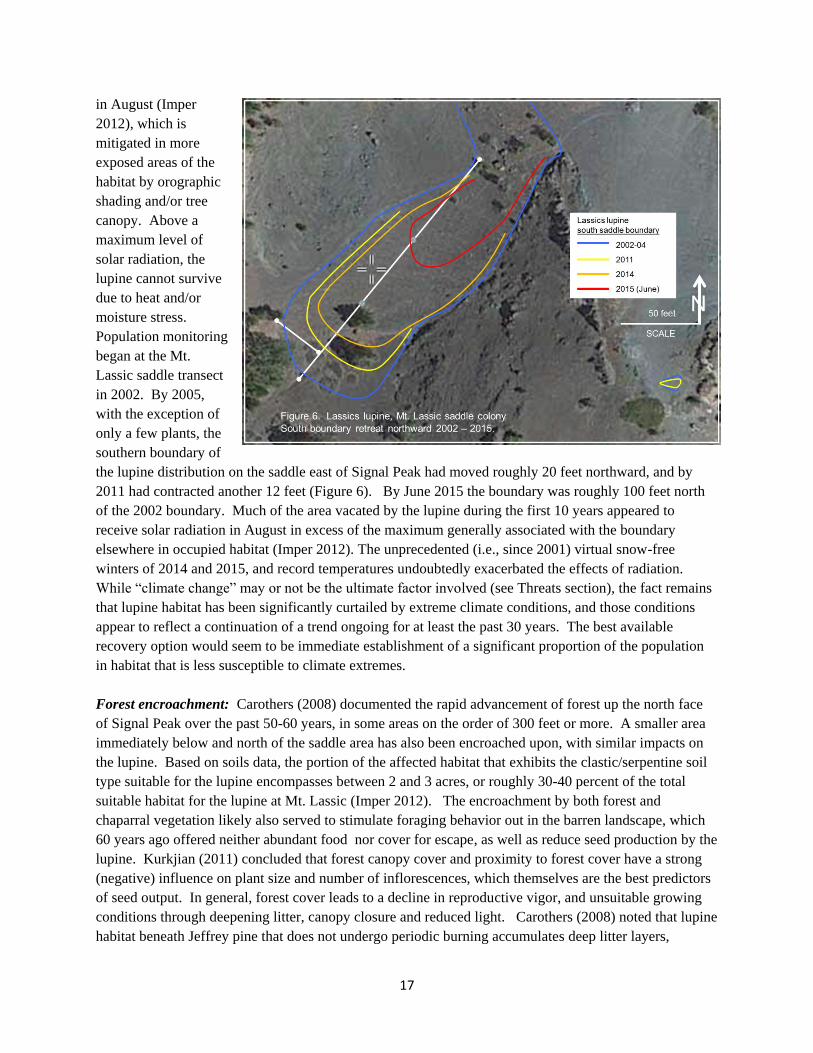
the lupine distribution on the saddle east of Signal Peak had moved roughly 20 feet northward, and by
2011 had contracted another 12 feet (Figure 6). By June 2015 the boundary was roughly 100 feet north
of the 2002 boundary. Much of the area vacated by the lupine during the first 10 years appeared to
receive solar radiation in August in excess of the maximum generally associated with the boundary
elsewhere in occupied habitat (Imper 2012). The unprecedented (i.e., since 2001) virtual snow-free
winters of 2014 and 2015, and record temperatures undoubtedly exacerbated the effects of radiation.
While “climate change” may or not be the ultimate factor involved (see Threats section), the fact remains
that lupine habitat has been significantly curtailed by extreme climate conditions, and those conditions
appear to reflect a continuation of a trend ongoing for at least the past 30 years. The best available
recovery option would seem to be immediate establishment of a significant proportion of the population
in habitat that is less susceptible to climate extremes.
Forest encroachment: Carothers (2008) documented the rapid advancement of forest up the north face
of Signal Peak over the past 50-60 years, in some areas on the order of 300 feet or more. A smaller area
immediately below and north of the saddle area has also been encroached upon, with similar impacts on
the lupine. Based on soils data, the portion of the affected habitat that exhibits the clastic/serpentine soil
type suitable for the lupine encompasses between 2 and 3 acres, or roughly 30-40 percent of the total
suitable habitat for the lupine at Mt. Lassic (Imper 2012). The encroachment by both forest and
chaparral vegetation likely also served to stimulate foraging behavior out in the barren landscape, which
60 years ago offered neither abundant food nor cover for escape, as well as reduce seed production by the
lupine. Kurkjian (2011) concluded that forest canopy cover and proximity to forest cover have a strong
(negative) influence on plant size and number of inflorescences, which themselves are the best predictors
of seed output. In general, forest cover leads to a decline in reproductive vigor, and unsuitable growing
conditions through deepening litter, canopy closure and reduced light. Carothers (2008) noted that lupine
habitat beneath Jeffrey pine that does not undergo periodic burning accumulates deep litter layers,
18
producing an environment that (especially when coupled with overstory shading) results in lower lupine
plant density, reduced size and lower reproductive vigor, and reduced seedling germination (Carothers
2008; Imper 2012).
The majority of the encroachment is Jeffrey pine ranging from 5-15 inches diameter at breast height
(dbh), 10-50 feet tall, and based on increment cores in 2008, was relatively even-aged at about 45 years.
Incense cedar is scattered in the understory ranging up to 3 inches dbh, and 15 feet tall.
2015 Lassic fire: The Lassic fire of July and August 2015 appears to have significantly curtailed Lassics
lupine habitat. The fire burned approximately 18,200 acres, centered roughly on Mt. Lassic. Many
Lassics lupine individuals in the lower northern reach of the Mt. Lassic colony and all but a few of the
individuals at the Red Lassic colony may have been killed. The fire severity was not adequate within
lupine habitat at Mt. Lassic to kill a significant number of trees, and scorching of the litter layer was
spotty, and thus did not appear to materially improve the forest habitat for the lupine, beyond the short-
term benefit from a nutrient flush. In contrast, the fire burned exceedingly hot over the entire Red Lassic
colony, eliminating the protective litter layer and burning 40 feet or more up into the pine trees. Research
on the influence of canopy shading on lupine distribution at Red Lassic, described in the Habitat section,
suggests the loss of just one tree there likely would lead to significant mortality in what was already a
very small (perhaps now extirpated) colony (Imper 2012).
The impacts of past Forest management on the lupine: The available evidence indicates that historical
fire suppression is the most important anthropogenic factor, if not the only factor contributing to
expansion of chaparral and forest vegetation, both reducing the distribution of the lupine, and likely
increasing small mammal densities in close proximity to the lupine (see Habitat section). At 11 square
miles, the Mt. Lassic Wilderness is far too small to maintain anything close to a natural fire regime by
itself, given that it is surrounded by Forest matrix lands which are managed for timber production to the
east and south, and private lands to the west and north.
Past indifference by SRNF management to the plight of the lupine is discussed under Regulatory threats.
Off-road vehicles and recreation: Off-road vehicle use historically impacted the Mt. Lassic colony of
Lassics lupine, as recently as 2003 (Carothers 2004). In order to reduce both vehicle and pedestrian
impacts to the lupine, a formal trail was built that bypasses the colony, and a forest closure order was
implemented in 2004 prohibiting vehicle use within the area. Designation as wilderness in 2006
permanently eliminated the use of vehicles. Current impacts from recreational use are relatively minor
compared to the other threats cited.
Overutilization
Illegal removal for horticultural purposes is not known to be a threat to the Lassics lupine.
Disease and predation
The Lassics lupine does not appear to be threatened by disease.

19
Predation is a primary threat to the species. Severe pre-dispersal (prior to fruits dehiscing) seed predation
has been observed in most years since 2003, when virtually the entire seed crop was taken (Crawford and
Ross 2003; Imper 2015). It is considered unlikely, and there is no evidence available indicating, that
lupine seed predated by small mammals are cached or otherwise survive. In addition, the lupine is subject
to frequent deer and/or rabbit herbivory and in some cases excavation of the root crown, resulting in loss
of reproductive capability or death. Carothers (2015b) reported a severe rate of seed predation, as well as
foliar browsing leading to death at the Mt. Lassic colony in 2015. While caging is generally quite
effective in reducing seed predation, it is labor intensive, and careful installation is necessary to avoid
failure. Carothers (2015b) noted a high rate of cage failure in 2015, which allowed predation even on the
caged plants.
The magnitude of the threat posed by seed predation shown by the PVA would suggest that habitat
features that lead to increased seed predation pressure must have changed dramatically in the recent past,
or the species would not have survived. The most likely change, consistent with small mammal trapping
conducted since 2005, is that pressure from seed predation has risen as a consequence of forest and
chaparral encroachment within and close to lupine habitat. Small mammal abundance varies between
years, but on average, potential seed predators are 40 percent less abundant in the open lupine habitat
compared to adjacent chaparral (Falxa 2015). California ground squirrels (Spermophilus beecheyi)
appear to have expanded in the lupine area since 2005, and because of their large size (compared to mice
and chipmunks), a few individuals can take many seeds. The link between seed predation and vegetation
encroachment was also made by Kurkjian (2010), in her investigation of seed predation within and near
Lassics lupine habitat, using surrogate species. Seeds of Vicia sp. were predated at a greater rate from
screens set within or near chaparral, compared to forest, and rates were highest close to the vegetation
edge.
Existing regulatory mechanisms
Existing regulatory mechanisms are not adequate to ensure the continued existence of Lassics lupine. The
lupine is classified as a Sensitive species by the U.S. Forest Service. The only protection provided by
classification as a Sensitive species is that the Forest Service is required to assess, and if warranted,
mitigate impacts to Sensitive species as part of the planning process for agency projects, but this does not
abate the current threats to the lupine.
Various Forest Service policies both allow and require the agency to maintain viable populations and
preclude a species trend toward Federal listing, even within designated wilderness. In this case, actions
taken by SRNF have been treated as discretionary and been given low priority, in regards to proactively
safeguarding the lupine.
As a California Rare Plant Rank 1B species, Lassics lupine is covered under the California Environmental
Quality Act, but that offers no protection, since the current threats are not due to projects under which
CEQA, or its Federal equivalent, the National Environmental Policy Act (NEPA), apply. Designation of
the Lassics Wilderness in 2005, a factor contributing to the current threats to this species, was a
congressional action, and therefore not subject to analysis under NEPA. It is primarily natural processes

20
(seed predation, vegetation succession and its effects on habitat loss and potentially seed predation, and
climate extremes), in absence of historical disturbance regimes and adequate human intervention, that are
the primary threats. In part, the agency may have been slow to recognize the need for immediate actions
due to the principle threats being largely insidious and until recently, relatively chronic in nature.
If nothing else, the mere fact that the Forest Supervisor in 2012 was able to order the removal of all
protective cages, within months following completion of a PVA indicating that the caging was critical to
maintain the species, illustrates the inadequacy of current regulatory mechanisms to protect even a species
as threatened as the Lassics lupine.
Lassics lupine warrants protection under both the CESA and Federal ESA because it is at high risk of
becoming extinct in the foreseeable future from high magnitude, imminent threats to its continued
existence and there are no regulatory mechanisms that ensure its continued existence in the face of these
threats.
Other factors (climate change)
Climate change is a primary threat to the Lassics lupine. Although some specifics about how global
climate change will affect the Lassics are as yet unknown, the general consensus is for warmer winter
temperatures, diminished snowpack, and drier summer and autumn seasons (Wilkinson and Rounds
1998). In particular, the enhanced risk of extinction for mountaintop species related to climate change is
well recognized (Cochran 2011). Such species tend to be more susceptible to warming temperatures,
shortened snowpack duration and earlier snowmelt than the environments and their biota found at lower
elevations, through altered phenology, energy balance, exposure to predators and numerous other
ramifications. Notably, species such as the Lassics lupine, relatively unsuited for long distance dispersal
(heavy, unwinged seed), and already situated at the highest elevations of suitable terrain in the Lassics,
have no place to migrate upwards. Thus they are largely dependent on fortuitous escape to suitable
micro-climates nearby, or assisted migration in order to escape extinction.
The high sensitivity of the Lassics lupine to climate extremes has been described (see Conservation status
- Population expansion; Habitat - Red Lassic and Solar radiation; and Curtailment of habitat sections),
clearly illustrated by the dramatic die-off in 2015. Climate data most applicable to the Lassics only date
to 2000, but a strong correlation was demonstrated with the 30-year record available for the Big Flat
CDEC weather station (see Climate section), suggesting the recent climate extremes (30-year record high
temperatures and shortened snowpacks) may become more frequent in the future. It is reasonable to
conclude that long term regional climate changes present a significant threat to the lupine.
Due to the current small population of Lassics lupine, even prior to the recent severe mortality (less than
1,000 plants), loss of genetic diversity due to inbreeding and/or random genetic drift are potential
significant threats to the species. No assessment has been made of the minimum population necessary to
avoid these effects. However, given the restricted amount of habitat available to the species, at least
within the Lassics, the population likely has not been substantially larger than that for some time. At the
current population level (on the order of 60 plants), environmental stochasticity poses an imminent threat
to the species.

21
SUMMARY AND JUSTIFICATION
The PVA by Kurkjian (2012a) indicated the Lassics lupine is trending toward extinction. Without any
protection of reproductive plants, and at the current rate of seed predation, the PVA predicted a greater
than 68 percent chance of species extinction within 50 years. Even with the current caging effort
(approximately 60-80 reproductive plants annually), the model suggested that stochastic events over the
next decade would move the species closer to extinction.
The PVA did not account for several major threats:
The smaller of the two colonies of Lassics lupine, located at the western base of Red Lassic, was severely
burned during the 2015 Lassic Fire (Imper 2015). That colony may have been extirpated, or may be
extirpated in the near future, either due to incineration of the majority of plants, or death of one or more of
the pine trees that provide critical shade to the colony (Imper 2012).
The larger lupine colony, at Mt. Lassic, has been severely impacted by several years of extreme warm
temperatures, declining snowpack, and the recent fire. A portion of the southern boundary of the colony
has retreated northward as much as 100 feet over the past 12 years. At the same time forest dominated by
Jeffrey pine and incense-cedar has encroached southward on the Mt. Lassic site over the past 60 years,
eliminating the lupine from habitat believed to be more sheltered from the effects of drought conditions.
As a result, the lupine has nowhere to escape warming and drying conditions. The species already occurs
on the uppermost extent of suitable soils on the north slope of Mt. Lassic, and currently is prevented from
moving further down slope into a more favorable microclimate due to encroachment on that habitat by
conifers.
While past efforts to enhance the population through protective caging were successful, most noticeably
between 2010 and 2013 (Figure 1), the gains appear to have been negated over the past two years. Efforts
to introduce the lupine to new sites, begun in 2003 had limited success until 2015, when all but a few of
the new plants died.
As a result of the above factors, the current population of Lassics lupine is estimated to be fewer than 60
adults (7 percent of the estimated population when the PVA was completed). While some of the plants
that appeared to have died as of early spring 2016 may re-sprout, the situation will not likely change
significantly for the better. Although portions of the Lassics did retain snow until early April this year, if
summer conditions are again warm and dry, the population surviving into 2017 may well be on the verge
of extinction.
There is an immediate need for prioritization of Lassics lupine conservation by the SRNF, and infusion of
resources to implement management actions within the wilderness aimed at reducing threats and
increasing the lupine population. State listing as endangered will help it gain the attention it needs. To
survive, the lupine needs both short and long-term agency attention. Both of the SRNF staff botanists
will soon be retiring, and the USFWS Arcata field office has not, nor does it intend to, refill the plant
recovery position vacated in 2012, which carried out a significant portion of the past investigation and
recovery efforts for this species. Therefore, in addition to other critical needs, federal and state listing

22
will help ensure that this species will not fall off the regulatory radar, and that both agencies will continue
to focus attention on the plight of this species.
We believe the information provided in this petition indicates beyond question that the Lassics lupine
warrants protection under the California Endangered Species Act.
RECOMMENDED MANAGEMENT AND RECOVERY ACTIONS
There are multiple urgent, specific actions available and needed to ensure the long-term survival of this
species. Given the past inability of SRNF to accomplish certain of these tasks, we anticipate State and
Federal listing will facilitate their implementation in a more timely manner.
While the caging effort appeared, at least until 2015, effective at forestalling a trend toward extinction of
the lupine, it is only effective at mitigating the threat of seed predation and wildlife browsing. It was an
emergency measure necessary to provide seed to maintain and perhaps expand the lupine population, and
buy critical time for research on the various threats to the species. The recent curtailment of occupied
habitat and the population as a result of climate extremes, and to lesser extent, forest encroachment, pose
their own significant threats for the species, and point directly to the urgent need to restore habitat lost to
forest encroachment, grow the population, and establish a significant portion of the population in habitat
where the species as a whole is able to survive prolonged climate extremes such as occurred in 2014 and
2015.
Evidence described by Imper (2012) indicated that between two and three acres of forested habitat
(Figure 7, Area 1 primarily) suitable for the lupine are located downslope from the lupine on Mt. Lassic.
We know this habitat was formerly open (Carothers 2008), but it has been encroached upon by Jeffrey
pine and incense cedar over the past 60 years, resulting in a thick litter layer, and in areas, relatively dense
canopy. Climate and soils data collected by Imper (2012, 2015) indicate that at least in portions of this
habitat, seasonal fluctuation in soil temperature and moisture are more conducive to growth of the lupine
than the more exposed locations of its current occupied habitat. The major difference between the
forested habitat and its current habitat is that light levels in the forested habitat are generally 40 - 50
percent less.
Due to its close proximity to the main concentration of Lassics lupine and scattered residual lupine
individuals, Area 1, and to lesser extent Area 2, represent the best opportunity to expand the population
through partial removal of the tree canopy and litter layer (Figure 7). The restoration effort there could be
approached in two ways:
Experimental approach:
The western portion of Area 1 (Figure 7) below Signal Peak and west of the saddle measures
approximately 260 feet (up-downslope) by 320 feet across slope, or approximately two acres in size. One
or more test plots would be treated, measuring 60 feet across slope by 200 feet downslope from the
current tree line, each of which would involve removal (either manual removal or by girdling) of an
estimated 40-50 trees ranging 3-15 inches dbh, along with many small incense-cedar trees. Trees larger
than 15 inches dbh would be retained. The litter layer would be partially removed. Lupine seed and/or
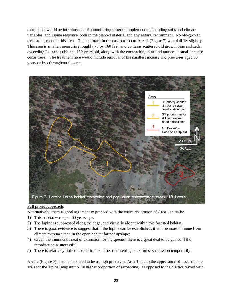
23
transplants would be introduced, and a monitoring program implemented, including soils and climate
variables, and lupine response, both in the planted material and any natural recruitment. No old-growth
trees are present in this area. The approach in the east portion of Area 1 (Figure 7) would differ slightly.
This area is smaller, measuring roughly 75 by 160 feet, and contains scattered old growth pine and cedar
exceeding 24 inches dbh and 150 years old, along with the encroaching pine and numerous small incense
cedar trees. The treatment here would include removal of the smallest incense and pine trees aged 60
years or less throughout the area.
Full project approach:
Alternatively, there is good argument to proceed with the entire restoration of Area 1 initially:
1) This habitat was open 60 years ago;
2) The lupine is suppressed along the edge, and virtually absent within this forested habitat;
3) There is good evidence to suggest that if the lupine can be established, it will be more immune from
climate extremes than in the open habitat farther upslope;
4) Given the imminent threat of extinction for the species, there is a great deal to be gained if the
introduction is successful;
5) There is relatively little to lose if it fails, other than setting back forest succession temporarily.
Area 2 (Figure 7) is not considered to be as high priority as Area 1 due to the appearance of less suitable
soils for the lupine (map unit ST = higher proportion of serpentine), as opposed to the clastics mixed with

24
serpentine soils of Area 1 (map unit CS), throughout much of the area. Area 2 does exhibit tree
encroachment and thick litter, which if removed would undoubtedly support more than the few lupine
there now, but the degree to which the lupine density may be increased is considered more limited than in
Area 1.
Imper (2012) identified numerous locations isolated from the existing population that exhibited soils
similar to those occupied by the lupine, and which were situated on northerly aspects that might meet the
other ecological requirements of the species. The most promising of those was ML Peak#1, located east
of Signal Peak (Figure 7, Area 3). The initial results of seed out-planting were encouraging, but the
extreme climate conditions between 2013 and 2015 eliminated all but a few of the surviving lupine. A
renewed search for suitable transplant sites in locations more protected from climate extremes should be
pursued as soon as possible.
Of course any experimental introduction efforts entail inherent risk from removing seed from the current
colonies. Therefore, efforts should be implemented immediately to propagate Lassics lupine, both for
producing seed and to experimentally test methods for growing planting stock ex situ, to be available for
the population introduction efforts. Although attempts to establish colonies elsewhere in the Lassics (or
beyond) or immediately downslope from Signal Peak in what appears to be suitable habitat may fail, the
effort may be the only good recovery option available at this time to maintain a native population of
Lassics lupine in the Lassics.
A checklist of suggested immediate specific recovery actions, in order of priority, includes the following:
Priority Category 1: Tasks needed to avoid imminent species extinction
1) Initiate all planning efforts needed to proceed with implementation of habitat restoration in the high
priority area (Area 1, Figure 7) on the north face of Signal Peak as soon as possible.
2) Until the immediate threat of extinction subsides, expand the caging effort to include protection of all
accessible Lassics lupine adult plants and as many seedlings as feasible at both colonies.
3) In 2016 and until the immediate threat of extinction subsides, capture a significant proportion of the
annual lupine seed production and allocate to: a) shallow burial in order to augment the seed bank in
optimal lupine habitat, and b) focused out-planting in optimal lupine habitat, combined with
subsequent caging protection and monitoring of germinants. Maximizing the rate of seed recruitment
into the population may be crucial to saving the species, given the demonstrated high mortality of
naturally dispersed seed.
4) Initiate further investigation (along the lines of that conducted by Imper 2012) to locate suitable
habitat for the lupine, in locations less susceptible to mortality from extreme climate conditions.
Additional detailed soils inventory by a soils scientist, with greater focus on specific soils
characteristics favored by the lupine than Alexander (2008) was, would greatly assist in the effort.
Early installation of soil moisture sensors in potential out-planting sites will help confirm whether
they are suitable for the lupine, prior to significant investment of lupine seed to the effort. Implement
plant introduction efforts in conjunction with routine monitoring and caging as soon as adequate seed

25
are available.
5) Continue and expand both in situ, and ex situ propagation of the lupine. Offsite propagation is needed
to provide both planting stock and seed available for augmentation of the existing colonies, and
introduction to new sites. Virtual year-round protection (except during snowpack) from browsing and
seed predation by caging will be needed to protect any resulting plants until the critical threat of
extinction is mitigated.
Priority Category 2: Tasks needed to maintain a viable population
6) As a pre-emptive measure, reduce the extent of chaparral vegetation surrounding and within lupine
habitat on Mt. Lassic, based on the logical premise that clearing will reduce the resident small
mammal populations and their seed predation impacts.
7) Continue research in order to confirm whether or not the encroaching chaparral increases the risk of
seed predation for lupine plants.
8) Continue the small mammal monitoring trapping effort, providing the baseline abundance data for
interpreting the results of item 7.
9) Continue to (a) monitor snowpack duration and melt date (e.g., the current four Hobo sensors used as
a snowmelt index), (b) monitor climate data for the Zenia weather station, and (c) explore
relationships with the trapping results from item 8. As described (Natural history - Small mammals
section), total spring rainfall at Zenia since 2005 is negatively correlated with the small mammal
abundance data from monitoring. That relationship, or other environmental indicators, should be
investigated for their ability to predict small mammal populations prior to the field season. The
caging effort is labor intensive, costly and unsustainable in the long term. A reliable method for
predicting the threat from seed predation during the approaching season, if such exists, would be
invaluable if it enabled suspension of caging during low-threat years.
10) Continue the seed predation monitoring and research to further document the relationship between the
primary seed predators and vegetation encroachment; initiate research to identify the primary lupine
browser species; investigate their relationship to encroaching vegetation; and quantify impacts on the
lupine. Unless it is feasible to utilize a surrogate attractant species in lieu of exposing Lassics lupine,
this research must be delayed until the immediate threat of lupine extinction subsides.
11) Continue the demographic-based monitoring of Lassics lupine at the three existing monitoring sites.
12) Add to the offsite conservation seed bank as appropriate.
13) Update and maintain the Lassics lupine database, commissioned by SRNF, but not updated since
2011.

26
INFORMATION SOURCES
See the Literature Cited section below for a list of references cited in this petition and persons providing
unpublished information. Copies of references are also being provided to the Commission in electronic
format on a disk.
Literature Cited
Alexander, E.B. 2008. A soil survey of serpentine landscapes in the Lassics area. Unpublished report
submitted to Six Rivers National Forest, Eureka, California.
Association of Fish and Wildlife Agencies USDI/USDA. 2006. Policies and guidelines for fish and
wildlife management in National Forest and Bureau of Land Management Wilderness (as amended June
2006). Available at “http://www.wilderness.net/index“.
Baldwin, B.G., D.H. Goldman, D.J. Keil, R. Patterson, T.J. Rosatti and D.H. Wilken, editors. 2012. The
Jepson manual: vascular plants of California, second edition. University of California Press, Berkeley.
California Data Exchange Center 2015a. Weather data for Zenia weather station; website:
“http://cdec.water.ca.gov/cgi-progs/staMeta?station_id=ZEN”, downloaded October 2015.
California Data Exchange Center 2015b. Weather data for Big Flat weather station; website:
“http://cdec.water.ca.gov/cgi-progs/staMeta?station_id=BFL”, downloaded October 2015.
California Department of Fish and Wildlife, Natural Diversity Database. 2015. Special vascular plants,
bryophytes, and lichens list. Quarterly publication. Sacramento, California.
California Native Plant Society, Rare Plant Program. 2015. Inventory of Rare and Endangered Plants of
California (online edition, v8-02). California Native Plant Society, Sacramento, CA. Website
http://www.rareplants.cnps.org.
Carothers, S. 2004. Draft Conservation strategy for the Lassics Botanical and Geologic Area, Mad River
Ranger District, Six Rivers National Forest. Unpublished document prepared for Six Rivers National
Forest.
Carothers, S. 2005. Meeting discussion notes recorded July 27, 2005 at Mt. Lassic; in attendance were
Sydney Carothers, David Imper (USFWS) and Lisa Hoover (SRNF). On file, Six Rivers National Forest,
Eureka, California.
Carothers, S. 2013a. Brief Summary of monitoring results for 2012 field visits to Lupinus constancei
(T.W. Nelson & J.P. Nelson) monitoring sites in the Lassics Botanical and Geologic Area. Unpublished
document dated April 1, 2013, on file Six Rivers National Forest, Supervisor’s Office, Eureka CA.
Carothers, S. 2013b. Brief Summary of monitoring results for 2013 field visits to Lupinus constancei

27
(T.W. Nelson & J.P. Nelson) monitoring sites in the Lassics Botanical and Geologic Area. Unpublished
document dated September 28, 2013, on file Six Rivers National Forest, Supervisor’s Office, Eureka CA.
Carothers, S. 2014. Brief Summary of monitoring results for 2014 field visits to Lupinus constancei
(T.W. Nelson & J.P. Nelson) monitoring sites in the Lassics Botanical and Geologic Area. Unpublished
document dated December 28, 2014, on file Six Rivers National Forest, Supervisor’s Office, Eureka CA.
Carothers, S. 2015a. Email dated June 24, 2015 to Lisa Hoover; cc to Dave Imper, describing results for
initial June16/17 2015 monitoring of Lupinus constancei. On file Six Rivers National Forest,
Supervisor’s Office, Eureka CA.
Carothers, S. 2015b. Email dated September 23, 2015 to Dave Imper, describing results for initial
June16/17 2015 monitoring of Lupinus constancei. On file Six Rivers National Forest, Supervisor’s
Office, Eureka CA.
Crawford, J. and J. Ross. 2003. Report on the pollination system and fruit predation of Lupinus
constancei, the Lassic’s lupine. Unpublished report submitted to the U.S. Fish and Wildlife Service
Arcata Field Office, Arcata, California.
Cochrane, M. 2011. "The Fate of Alpine Species in the Face of Climate Change: A Biogeographic
Perspective,"Macalester Reviews in Biogeography: Vol. 2, Article 1.
Available at: http://digitalcommons.macalester.edu/biogeography/vol2/iss1/1
Falxa, G. 2015. Small mammal trap data for 2005-2015, Lassics lupine project. Excel file maintained at
the U.S. Fish and Wildlife Service Arcata Field Office, Arcata, California.
Fuller, K. 1995. Biologist, Sacramento Field Office USFWS: Note to file regarding denial of candidate
status for Lassics lupine, dated April 15, 1995. On file U.S. Fish and Wildlife Service Arcata Field
Office, Arcata, California.
Guerrant, E.O. 2007. Propagation of Lassics lupine (Lupinus constancei): Investigations into the need
for seed scarification for germination and effects of soil innoculants on growth. Unpublished report
submitted to the U.S. Fish and Wildlife Service Arcata Field Office, Arcata California.
Hickman, J. C. 1993. Jepson Manual: Higher Plants of California i–xvii, 1–1400. University of California
Press, Berkeley.
Imper, D.K. 2003. Lassics lupine (Lupinus constancei) monitoring transects, photopoints and seed plot
monitoring 2003. Unpublished report, U.S. Fish and Wildlife Service Arcata Field Office, Arcata,
California.
Imper, D.K. 2009. Soil investigation report: Lassics lupine (Lupinus constancei) habitat and a
comparison to surrounding soils (draft). Unpublished report, U.S. Fish and Wildlife Service Arcata Field
Office, Arcata, California.

28
Imper, D.K. 2012. Revised data summary and conclusions: Lassics lupine (Lupinus constancei) soils and
climate study, The Lassics, Six Rivers National Forest (draft). Unpublished report, U.S. Fish and
Wildlife Service Arcata Field Office, Arcata, California.
Imper, D.K. 2015. Lassics lupine (Lupinus constancei) monitoring and research field and file notes
collected at Mt. Lassic 2002-2015. Unpublished. Eureka, California.
Imper, D.K. 2016. Lassics lupine (Lupinus constancei) field observations May 31, 2016 and recovery
team meeting notes June 2, 2016. Unpublished. Eureka, California.
Isely, D. 1998. Native and naturalized Leguminosae (Fabaceae) of the United States (exclusive of Alaska
and Hawaii). Monte L. Bean Life Science Museum, Brigham Young University; MLBM Press, Provo,
Utah.
Kurkjian, H. 2010. Seed predation study on Mount Lassic. Unpublished report submitted to the U.S.
Fish and Wildlife Service Arcata Field Office, Arcata California.
Kurkjian, H. 2011. Lassics lupine production model update. Unpublished report dated June 23, 2011
submitted to the U.S. Fish and Wildlife Service Arcata Field Office, Arcata California.
Kurkjian, H. 2012a. A population viability analysis of the Lassics lupine (Lupinus constancei). Thesis
presented to the faculty of Humboldt State University in partial fulfillment of the requirement for the
Degree of Master of Science in Biology, Arcata, California.
Kurkjian, H. 2012b. Lassics lupine seed production study, 2010-2011. Unpublished report submitted to
the U.S. Fish and Wildlife Service Arcata Field Office, Arcata California.
Kurkjian H. 2012c. Lassics lupine database: compilation of demographic data 2003-2011 into Adobe
database format. Developed under contract with Six Rivers National Forest, Eureka, California.
NatureServe 2015. An online encyclopedia of life:
website: “http://explorer.natureserve.org/servlet/NatureServe?init=Species”. Accessed October 2015.
Nelson, T.W. 1980. A Flora of the Lassics. Thesis presented to the faculty of Humboldt State
University in partial fulfillment of the requirement for the Degree of Master of Science in Biology.
Arcata, California.
Nelson, T.W and J.P. Nelson. 1983. Two new species of Leguminosae from serpentine of Humboldt
County, California. Brittonia 35(2):180-183.
Six Rivers National Forest. 1995. Category and priority assignment form for the Lassics lupine (Lupinus
constancei). Document dated April 11, 1995 on file, U.S. Forest Service, Eureka, California.
29
Six Rivers National Forest. 2004. Draft conservation strategy for the Lassics Botanical and Geological
Area, Mad River Ranger District, Six Rivers National Forest. Unpublished report on file, U.S. Forest
Service, Eureka, California.
Six Rivers National Forest. 2012a. Forest Service Manual direction, wilderness and other policies.
Briefing statement submitted by the Forest Botanist to management, dated April 6, 2012.
Six Rivers National Forest. 2012b. Forest Service role and options for the Lassics Lupine. Position
statement submitted by the Forest Botanist to management, dated April 6, 2012.
Wilkinson, R. and T. Rounds. 1998. Climate Change and Variability in California; White Paper for the
California Regional Assessment. National Center for Ecological Analysis and Synthesis, Santa Barbara,
California Research Paper No. 4. Available at "http://www.nceas.ucsb.edu/papers/climate.pdf".
Wilson, B.L, and V. Hipkins. 2004. Genetic variation in Lupinus constancei: Implication for seed
transfer between colonies. Unpublished report submitted to U.S. Fish and Wildlife Arcata Field Office,
Arcata, California.