lake, thurston county integrated aquatic …
TRANSCRIPT
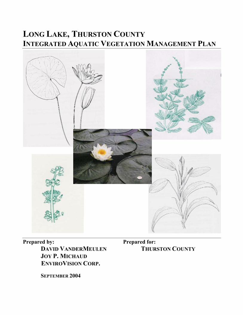
LONG LAKE, THURSTON COUNTY INTEGRATED AQUATIC VEGETATION MANAGEMENT PLAN
Prepared by: Prepared for: DAVID VANDERMEULEN THURSTON COUNTY
JOY P. MICHAUD ENVIROVISION CORP.
SEPTEMBER 2004

Long Lake, Thurston County Integrated Aquatic Vegetation Management Plan
EnviroVision Corp. September 2004
TABLE OF CONTENTS
FOREWORD ---------------------------------------------------------------------------------------------------- 1
PROJECT OVERVIEW------------------------------------------------------------------------------------------ 2
PUBLIC INVOLVEMENT --------------------------------------------------------------------------------------- 4
LAKE AND WATERSHED CHARACTERISTICS --------------------------------------------------------------- 5
AQUATIC PLANT MANAGEMENT GOALS------------------------------------------------------------------19
PLANT MANAGEMENT HISTORY AND CONTROL OPTIONS ----------------------------------------------20
RECOMMENDED AQUATIC PLANT CONTROL PLAN ------------------------------------------------------24
PUBLIC EDUCATION PROGRAM ----------------------------------------------------------------------------35
PLAN ELEMENTS, COSTS, AND FUNDING -----------------------------------------------------------------37
MONITORING, EVALUATION AND IMPLEMENTATION----------------------------------------------------40
SUMMARY AND CONCLUSIONS-----------------------------------------------------------------------------43
REFERENCES -------------------------------------------------------------------------------------------------45
LIST OF TABLES
TABLE 1: PHYSICAL CHARACTERISTICS OF LONG LAKE --------------------------------------------- 5
TABLE 2: TROPHIC STATE CLASSIFICATION------------------------------------------------------------9
TABLE 3: FISH SPECIES COMPOSITION----------------------------------------------------------------- 11
TABLE 4: AQUATIC PLANT SURVEY RESULTS---------------------------------------------------------14
TABLE 5: SUMMARY OF AQUATIC PLANT CONTROL METHODS ------------------------------------21
TABLE 6: ESTIMATED COST FOR IMPLEMENTATION OF THE LONG LAKE IAVMP----------------27
LIST OF FIGURES
FIGURE 1: HENDERSON INLET WATERSHED------------ ------------------------------------------------ 3
FIGURE 2: LONG LAKE AQUATIC PLANT COMMUNITIES, 2003--------------------------------------- 6
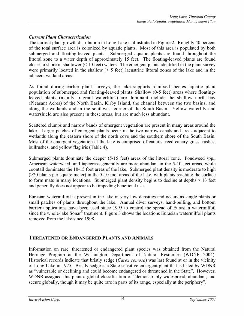
FIGURE 3: EURASIAN WATERMILFOIL LOCATIONS 1998-2003---------------------------------------16
FIGURE 4: CHARACTERISTIC USE AREAS---------------------------------------------------------------18
FIGURE 5: LMD NEIGHBORHOODS AND 2003 HARVESTING AREAS-------------------------------- 31
Long Lake, Thurston County Integrated Aquatic Vegetation Management Plan
EnviroVision Corp. September 2004
LIST OF APPENDICES
APPENDIX A: RECORD OF PUBLIC MEETINGS
APPENDIX B: AQUATIC PLANT CONTROL METHODS
APPENDIX C: PERMITTING AND HERBICIDE INFORMATION
APPENDIX D: PUBLIC COMMENT ON THE DRAFT PLAN
LIST OF ATTACHMENTS
ATTACHMENT I: 1995 INTEGRATED MANAGEMENT PLAN FOR LONG LAKE – THURSTON COUNTY, WASHINGTON
ATTACHMENT II: HARVESTING AND PHOSPHORUS CONTROL IN LONG LAKE - TECHNICAL MEMORANDUM, THURSTON COUNTY, WASHINGTON
Long Lake, Thurston County Integrated Aquatic Vegetation Management Plan
EnviroVision Corp. September 2004
HOW TO READ THIS PLAN This 2004 Integrated Aquatic Vegetation Management Plan for Long Lake updates the 1995 plan; however, we have included the 1995 plan (Attachment I) in this document for two key reasons: 1. The 1995 plan gives readers an historical perspective of efforts to manage plants in Long
Lake; and 2. Sections of the 1995 plan pertaining to water quality still apply today. These sections
begin on Page 60 of Attachment I, and they address topics such as stormwater management, alum treatments and dredging. The 1995 plan also includes a more in-depth discussion of water-quality issues than the 2004 plan. (Traditionally, Integrated Management Plans focus on aquatic plant-management issues, while lake restoration studies focus on water-quality concerns. Accordingly, the Department of Ecology provided funding for the 2004 plan with the intent that the plan focus on managing aquatic plants.)
Readers are encouraged to review the water-quality portions of the 1995 plan, beginning on page 60 of Attachment 1.
Long Lake, Thurston County Integrated Aquatic Vegetation Management Plan
EnviroVision Corp. September 2004 1
FOREWORD
This plan is designed to meet the requirements of the Washington State Department of Ecology (referred to as Ecology hereon) and Thurston County’s Integrated Aquatic Vegetation Management Policies. This document serves as an update to the aquatic plant management portion of the 1995 Integrated Management Plan for Long Lake. The 1995 Integrated Management Plan is provided as an attachment to this document. The 1995 Integrated Management Plan encompasses both aquatic plant management and water quality issues. Historically, water quality issues for lakes in Washington are addressed through Lake Restoration studies, while plant management issues are the focus of Integrated Aquatic Vegetation Management Plans. Ecology provided funding for this project to address aquatic plant management. However, this plan also provides information on some recent water quality data and lists actions that may improve water quality, but does not serve as a formal plan to begin large-scale lake restoration efforts (e.g. not a feasibility study for dredging, alum treatment, etc.) At the wishes of the Long Lake Steering Committee and Thurston County Staff, where possible, original text from the 1995 Integrated Management Plan was carried over to this document as a cost-cutting and timesaving measure. The majority of text in this updated plan is original work. The Lake and Watershed section of this document contains a significant amount of text from the 1995 plan. Where necessary, more recent studies were cited, verb tense is changed, some inconsistencies were corrected from the 1995 plan, clarifications were made, extraneous information was omitted, and some areas were reorganized. Some original citations were retained from the 1995 plan and are included in the References section of this document.

Long Lake, Thurston County Integrated Aquatic Vegetation Management Plan
EnviroVision Corp. September 2004 2
PROJECT OVERVIEW
Long Lake is a 330 acre lake located partly in the City of Lacy in Thurston County and lies within the 5,280 acre Henderson Inlet Watershed (Figure 1). Long Lake has an unnamed inlet stream connecting it to Pattison Lake and discharges through Woodland creek to the Puget Sound. The lake is heavily used for recreation and has the only formal public swimming beach in the urban area. There is a Washington State Fish and Wildlife boat launch on the western shore, as well as several private community access locations with boat launches, picnic facilities, and designated swimming areas. Most of the shoreline of Long Lake has residential development. However, some areas are maintained as Habitat Reserves to provide habitat for fish and wildlife. Several State-listed noxious weed species exist in the lake. Noxious weeds are non-native plants that lack natural predators, out-compete native plants, can be difficult to control, and are destructive to the natural environment. These weeds include: Eurasian watermilfoil (Myriophyllum spicatum), fragrant waterlily (Nymphaea odorata), yellow flag iris (Iris pseudacorus), and Japanese knotweed (Polygonum cuspidatum). Native aquatic plants provide beneficial uses such as fish and wildlife habitat, shoreline stabilization, and water filtration. However, an overabundance of these plants at Long Lake has reduced beneficial uses such as fishing, swimming, boating and aesthetics. The Long Lake Management District (LMD) and Thurston County staff has taken the responsibility of coordinating all large-scale aquatic plant management activities at the lake. These activities are in accordance with Thurston County’s Pest and Vegetation Management Policy, which emphasizes the use of pesticides only as a portion of the overall plant control prescription. To date, the LMD and Thurston County have only used an herbicide in Long Lake on one occasion (1991) when Eurasian watermilfoil threatened to overtake the lake. Mechanical harvesting of submerged native plants (and to a lesser extent fragrant waterlilies) has taken place at Long Lake on a somewhat annual basis since 1983. However, lake residents have been dissatisfied with the results. Harvesting has brought only short-term relief, and can be particularly ineffective for some plants in Long Lake (e.g. Najas). This, in combination with the high cost, has driven the need to evaluate other control options. It is important to understand that recent aquatic plant control activities are entirely funded by the LMD and not by public agencies. The LMD was formed in 1987 and lake residents have continued to supply volunteer time and financial resources for lake management activities. In 2002 the LMD and staff from the Thurston County Department of Water and Waste Management applied for and were awarded a grant to develop an Integrated Aquatic Vegetation Management Plan (IAVMP) for long-term control of aquatic plants. The purpose of developing this IAVMP was to perform a comprehensive review of all aquatic plant control methods approved for use in the State and Thurston County in the context of current plant management goals at the lake. A lake management plan was also produced in 1995 (Attachment 1). The 1995 plan included actions for addressing both water quality and aquatic plant problems. This IAVMP serves as an update to the sections of the 1995 plan that are pertinent to aquatic plant control. It is not intended to supercede any of the management actions selected for addressing water quality problems. In other words, lake restoration activities identified in the 1995 plan (e.g. dredging) remain unchanged.

Long Lake, Thurston County Integrated Aquatic Vegetation Management Plan
EnviroVision Corp. September 2004 3
Figure 1. Henderson Inlet Watershed.
Source: 1995 Integrated Management Plan for Long Lake (Attachment I)
Long Lake
Long Lake, Thurston County Integrated Aquatic Vegetation Management Plan
EnviroVision Corp. September 2004 4
This report provides a description of the aquatic plant control plan developed for Long Lake. The elements of this plan were developed through a public involvement process with the residents of the lake, Thurston County staff, and State agencies. The basic recommendations selected for aquatic plant control in Long Lake are:
• Use of an herbicide (glyphosate) for the eradication of fragrant waterlily and yellow flag iris.
• Use of an herbicide (glyphosate) for spot-control of cattails to maintain access in areas where they impede navigation and access to the lake.
• Continuation of the diver survey and hand-pulling program to control Eurasian watermilfoil.
• Continuation of the mechanical harvesting program to control native submerged plants. • Continued use of small-scale plant control efforts (hand-pulling, raking, bottom barriers,
etc.) in front of residents’ homes and in community access locations. • Track the status of aquatic plants and monitor for the introduction of new noxious weeds
during the Eurasian watermilfoil surveys. • Continue to support the Aquatic Plant Advisory Committee for the lake whose function is
to make decisions annually about controls needed and review aquatic plant management goals.
• Promote lake and watershed stewardship education with an emphasis on identifying noxious weeds and protecting habitat for fish and wildlife.
• Enhance water quality in the lake by controlling excessive aquatic vegetation.
The Long Lake LMD with Thurston County as a sponsor should have a strong competitive advantage for being awarded a grant to implement this plan. The lake group has already taken the most difficult step of establishing a long-term funding source (formation of a LMD), it has an established record for accomplishing aquatic plant management goals, and also some of the steps required for plan implementation are related to management of invasive or noxious plant species.
PUBLIC INVOLVEMENT Public involvement for this project has included steering committee meetings and public meetings. Each element is described below. The Long Lake LMD has been in existence since 1987. The LMD is represented by a steering committee that typically meets monthly. One of the primary topics of discussion during meetings held early in 2003 was how to guide the development of an updated IAVMP for Long Lake. The steering committee reviewed past plant control efforts and management goals, organized public meetings, selected aquatic plant control alternatives, and reviewed funding options during meetings held in 2003-2004. The feasibility of dredging was also discussed. The following are members of the steering committee: Doug Karman, John Baxter, Burt Pride, Rod Egolf, Jerry Bennett, Tim Whipple, Victor Bourque, Ronald Lyse, Julie McBride, Rocky Van Scyoc, Joe Daniels, Steve Kalenius, Kathleen Emmett, Tiffany and Gary Cyras, Bill Joplin,

Long Lake, Thurston County Integrated Aquatic Vegetation Management Plan
EnviroVision Corp. September 2004 5
and Janet Boyd – Long Lake Steering Committee, and Jim Bachmeier and Ryan Langan - Thurston County Water and Waste Management. Three public meetings were held from September 2003 to January 2004 as part of the process to update the Long Lake IAVMP. These meetings were sponsored by the Long Lake LMD steering committee and the Thurston County Department of Water and Waste Management. Public notices for these meetings were sent to all lake residents, agency representatives from Washington Department of Fish and Wildlife, and staff at Thurston County and the City of Lacey. The first public meeting was held on September 25, 2003. The first meeting was devoted to providing general information on the lake and existing plant control efforts and to agreeing on aquatic plant management goals and objectives, generating a problem statement, and seeking comments and questions from the public. A second public meeting was held on November 29, 2003 to review aquatic plant control alternatives. A few aquatic plant control alternatives were selected at this second meeting for further review as preferred over mechanical harvesting. The final public meeting was held on January 14, 2004. At this meeting a few plant control scenarios and their associated costs were presented in more detail and a preferred plant control scenario was selected. Appendix A contains copies of the public meeting agendas and lists of attendees.
LAKE AND WATERSHED CHARACTERISTICS PHYSICAL CHARACTERISTICS General Long Lake is located partially in the City of Lacy in Thurston County and lies within the 5,280 acre Henderson Inlet Watershed (Figure 1). The lake has a total surface area of 330 acres and a total lake volume of 3,900 acre-feet. It is divided into two distinct basins (referred to throughout the rest of this document as the North and South Basins) connected by a narrow channel (Figure 2). Physical characteristics of the lake are summarized in Table 1.
Table 1. Physical characteristics of Long Lake and its watershed. Watershed area 5,280 acres Surface area 330 acres Lake volume 3,900 ac-ft Maximum depth 21 feet Mean depth 12 feet Shoreline length 37,488 feet

�
��
�
������������������ ���������������������������������������������������������������
�����������������
� � � � � ! � " # $����
���%���� ���������������&�'(%���)�����������%����
Long Lake, Thurston County Integrated Aquatic Vegetation Management Plan
EnviroVision Corp. September 2004 7
Geology The recent geologic history of the Henderson Inlet Watershed is typical of the Southern Puget Sound area. During the past million years, at least four glacial advances and retreats have occurred in the area, leaving deposits of glacial till behind and a gently rolling topography from glacial scouring and compaction. Huge ice chunks created depressions that eventually became lakes like Long Lake and the other lakes in the region. In the vicinity of Long Lake, the local glacial till stratum retards downward flow of groundwater causing a local shallow aquifer. Entranco (1987) estimated that 10% of the water input to Long Lake came directly from groundwater, with about 8% of the water budget output returning to ground water. Groundwater also significantly influences Long Lake indirectly via water flow from Pattison Lake: 75% of Pattison Lake water is from groundwater. Surface water flow from Pattison Lake in turn provides about 3/4 of the water to Long Lake. Thus, groundwater constitutes the majority of the water supply to Long Lake. More recent studies (City of Olympia 1994) indicate that there are at least two significant aquifers in the Long Lake area. The lake receives and supplies groundwater into the upper aquifer, which flows northwesterly following the Woodland Creek basin. A deeper aquifer below the glacial till layer flows easterly toward McAllister Creek. Long and Pattison Lakes are outside the revised estimated zone of contribution to McAllister Springs. Hydrology Long Lake is the largest of the four-lake chain (Hicks, Pattison, Long and Lois lakes) that drains into Woodland Creek and Henderson Inlet in Puget Sound. Most of the water in Long Lake enters from Pattison Lake. The creek, which flows through a wetland between the two lakes, was channelized nearly 100 years ago to float logs to Union Mills on Long Lake but has not been maintained since the 1930’s. The outlet to Woodland Creek is at the north end of Long Lake. The water budget for the lake developed by Entranco Engineers (Entranco 1982) indicates that the water sources for Long Lake are:
76% Surface water from Pattison Lake 10% Groundwater 13% Direct precipitation 1% Runoff from the lakeshore area
Water outputs in the Entranco estimate are:
86% Surface water into Woodland Creek 7.5% Groundwater 7.5% Evaporation
Residence time of water in Long Lake is estimated at 146 days; in other words, the lake water is replenished about 2 1/2 times in an average year (Entranco 1982.)

Long Lake, Thurston County Integrated Aquatic Vegetation Management Plan
EnviroVision Corp. September 2004 8
WATER QUALITY "Eutrophication" is a term used to describe the physical, chemical, and biological changes associated with enrichment of a lake due to increases in nutrients and sediment over time. Although eutrophication occurs over time as a natural process, it can be greatly accelerated by human activities in a watershed. Natural eutrophication processes occur on a time scale of hundreds to thousands of years and are generally not observable in a single human lifetime. Human induced or "cultural" eutrophication can result from activities within the watershed including development, forestry, resource extraction (i.e., peat mining) landscaping, gardening, and animal keeping. All of these activities contribute nutrients and sediment to surface waters. Sediment inputs from watershed activities results in the slow filling in of lakes which also accelerates the overall eutrophication process. Cultural eutrophication can result in observable changes within a few decades, or less. The most common way lakes are classified is by their trophic state, which defines a lake in relation to the degree of biological productivity. Lakes with low nutrients, low algae levels, and clear water are classified as nutrient poor or "oligotrophic". Lakes with high nutrients, high algae levels, and low water clarity are classified as nutrient rich or "eutrophic". "Mesotrophic" lakes have water quality characteristics between these two classifications. Classifying a lake based on its trophic state is a useful way to describe changes in a lakes' water quality over time and assess the potential sensitivity of a specific lake to additional nutrient loading. Total phosphorus, chlorophyll a, and transparency are the three water quality parameters most often used to rate the overall trophic condition of a lake. Phosphorus is one of the essential nutrients for plant growth. Total phosphorus includes all soluble, organic, and particulate forms of phosphorus. Chlorophyll a is one of a family of green pigments that allows green plants to perform photosynthesis. Chlorophyll a concentration is correlated to the abundance of algae in a lake. Water transparency is commonly measured as the depth at which a black-and-white disk (i.e., Secchi disk), when lowered into the water, ceases to be visible. Algal growth, organic acids, and suspended solids all influence Secchi depth transparency. Nutrients, algae, oxygen, temperature, visibility and. other parameters have been monitored on Long Lake annually since 1987 by Thurston County staff. Entranco Engineers collected water quality data at the lake in 1977 and 1984-85 as part of their water quality studies. An online database (see: http://www.geodata.org/swater/strm.asp?strm=HENLOL) is maintained by the Thurston County Department of Environmental Health that supplies all available water quality data. Carlson’s (1977) trophic state indices (TSI) for Chlorophyll a, total phosphorus, and Secchi disk depth were used to calculate TSI values for Long Lake from 1989 to 2002 (Table 2). The data consistently indicate that the North Basin is eutrophic in terms of chlorophyll a concentration, and borderline eutrophic in terms of total phosphorus concentration and Secchi Disk depth. The South Basin is eutrophic for all parameters used in the TSI calculations. Phosphorus originating from sediments and the inlet from Pattison Lake are the main culprits associated with high phosphorus levels. The lake has recently been included in the 2002/2004 Section 303(d) list of impaired waters of the federal Clean Water Act (WDOE 2004) due to elevated phosphorus.
Long Lake, Thurston County Integrated Aquatic Vegetation Management Plan
EnviroVision Corp. September 2004 9
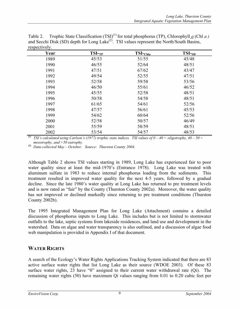
Table 2. Trophic State Classification (TSI)(1) for total phosphorus (TP), Chlorophyll a (Chl a ) and Secchi Disk (SD) depth for Long Lake(2). TSI values represent the North/South Basins, respectively.
Year TSI-TP TSI-Chla TSI-SD 1989 45/53 51/55 45/48 1990 46/55 52/64 48/51 1991 47/51 67/62 43/47 1992 49/54 52/55 47/51 1993 52/58 59/58 53/56 1994 46/50 55/61 46/52 1995 45/55 52/58 48/51 1996 50/58 54/58 48/51 1997 61/65 54/61 52/56 1998 47/57 56/61 45/53 1999 54/62 60/64 52/56 2000 52/58 50/57 46/49 2001 55/59 58/59 48/51 2002 53/54 54/57 48/53
(1) TSI’s calculated using Carlson’s (1977) trophic state indices. TSI values of 0 – 40 = oligotrophy, 40 – 50 = mesotrophy, and >50 eutrophy.
(2) Data collected May – October. Source: Thurston County 2004. Although Table 2 shows TSI values starting in 1989, Long Lake has experienced fair to poor water quality since at least the mid-1970’s (Entranco 1978). Long Lake was treated with aluminum sulfate in 1983 to reduce internal phosphorus loading from the sediments. This treatment resulted in improved water quality for the next 4-5 years, followed by a gradual decline. Since the late 1980’s water quality at Long Lake has returned to pre treatment levels and is now rated as “fair” by the County (Thurston County 2002a). Moreover, the water quality has not improved or declined markedly since returning to pre treatment conditions (Thurston County 2002b). The 1995 Integrated Management Plan for Long Lake (Attachment) contains a detailed discussion of phosphorus inputs to Long Lake. This includes but is not limited to stormwater outfalls to the lake, septic systems from lakeside residences, and land use and development in the watershed. Data on algae and water transparency is also outlined, and a discussion of algae food web manipulation is provided in Appendix I of that document. WATER RIGHTS A search of the Ecology’s Water Rights Applications Tracking System indicated that there are 83 active surface water rights that list Long Lake as their source (WDOE 2003). Of these 83 surface water rights, 23 have “0” assigned to their current water withdrawal rate (Qi). The remaining water rights (50) have maximum Qi values ranging from 0.01 to 0.20 cubic feet per
Long Lake, Thurston County Integrated Aquatic Vegetation Management Plan
EnviroVision Corp. September 2004 10
second. It is unknown how many of these water rights truly are in use. The State of Washington Department of Ecology issues a disclaimer associated with water rights that states “Because of unauthorized changes or non-use, Ecology cannot guarantee the validity of Permits, and Certificates.” Prior to a whole-lake herbicide treatment in 1991, Thurston County staff conducted detailed interviews with lake residents to determine current water usage from the lake (Clingman, T. Pers. Comm). An extensive public involvement campaign was conducted prior to the herbicide treatment to insure that residents were aware of the water use restrictions associated with the herbicide. Through the results of that effort, it was estimated that approximately 62 acre-feet of water is annually withdrawn from the lake for irrigation. FISH AND WILDLIFE COMMUNITY Fish Long Lake contains a varied fish population and is a popular fishing area. Long Lake has a public boat launch owned by the Washington Department of Fish and Wildlife (WDFW), which is used for both launching and shore fishing. The WDFW manages the lake as a mixed species fishery, which provides angling opportunity for both warm and coldwater species (WDFW 2000). According to the 1995 plan, fish species that naturally maintain themselves in the lake include: perch, crappie, blue gill and pumpkinseed sunfish, largemouth bass, bullheads, catfish, and suckers (these species are all non-native but have become widespread in this region.) Rainbow trout are planted annually by the WDFW. In 2003, approximately 15,000 rainbow trout were stocked in Long Lake in early spring. The WDFW has conducted electrofishing studies on Long Lake from 1990 to 1993 and again in 2000. The intent of the earlier three-year study was to track the impact of the changes in aquatic vegetation from the 1991 Sonar® treatment on fish populations. Baseline data was collected in 1990, with post-treatment surveys in 1992 and 1993. Largemouth bass and yellow perch were the principal species tracked in the survey, as these are the main warmwater sportfishing species in the lake. These species are also suitable to the electrofishing technique, which is generally less suitable for fish population studies of trout and catfish. The 1995 plan describes post-treatment surveys conducted in 1992 and 1993 that showed a distinct pattern of reduction in perch and crappie, with an increase in largemouth bass. This was anticipated as the cover for the prey fish was drastically reduced, allowing increased predation by piscivorous fish and diving ducks. The warmwater fishery at Long Lake was rated as “poor” in 2000 by WDFW (WDFW 2000). The researchers concluded that recruitment for most warmwater gamefish to older age classes appeared to be limited. Only rock bass were rated as abundant with a good size class structure. Additionally, the researchers stated that an increase in aquatic vegetation would improve the warmwater fishery at the lake (WDFW 2000). A total of 890 fish representing 11 species and the family Cottidae (i.e. sculpins) were sampled from Long Lake (Table 3).

Long Lake, Thurston County Integrated Aquatic Vegetation Management Plan
EnviroVision Corp. September 2004 11
Table 3. Fish species composition summary for fish sampled (age 1 year and older) for Long Lake in the spring of 2000 (revised from WDFW 2000).
by Weight by Number Size Range
(mm) Fish species kg % No. % Min. Max.
Common carp 62.3 33.3 20 2.2 160 790 Largescale sucker 42.5 22.7 46 5.2 117 605 Largemouth bass 29.6 15.8 96 10.8 78 550 Rainbow trout 19.2 10.2 177 19.9 63 460 Rock bass 15.7 8.4 194 21.8 69 269 Yellow perch 4.4 2.4 164 18.4 28 221 Brown bullhead 4.4 2.3 10 1.1 210 385 Brown trout 3.7 2.0 2 0.2 425 570 Pumpkinseed 1.9 1.0 45 5.1 90 150 Sculpin 1.9 1.0 106 11.9 15 154 Bluegill 0.8 0.4 8 0.9 115 177 Warmouth 0.7 0.4 22 2.5 85 153
Waterfowl Waterfowl use Long Lake during migration, with smaller numbers nesting at the lake. Nesting waterfowl include wood ducks, mallards and Canada geese. Waterfowl were monitored before and after the 1991 Sonar® treatment for Eurasian watermilfoil, to track the impact on the anticipated drastic change in aquatic vegetation on waterfowl. An increase in diving ducks (fish eaters) was observed compared to a control site at Hicks Lake, with a corresponding decrease in dabbling ducks at Long Lake (insect and other bottom organism eaters.) While changes were observed in broods, it appeared that variables other than aquatic vegetation may have produced these results, including feeding, low boat activity during the 1991 treatment compared to normal years, extreme low water at the Hicks Lake control site, etc. (Coot Company 1993 and 1994). AQUATIC PLANT COMMUNITY Historic Aquatic Plant Community Long Lake has historically supported a typical, mixed-species aquatic plant population of submerged and floating-leaved plants. Surveys conducted in 1982 and 1983 (prior to the harvesting program and infestation with Eurasian watermilfoil) indicated coverage of about 90 acres, with waterlilies (Nymphaea and Nuphar spp.) in the shallow areas and pondweed (Potamogeton) waterweed (Elodea spp.), coontail (Ceratophyllum spp.) and other submerged

Long Lake, Thurston County Integrated Aquatic Vegetation Management Plan
EnviroVision Corp. September 2004 12
species in other locations. The shallow north bay (Pleasant Acres) was estimated to contain about 32 acres of aquatic plants, mainly waterlilies. Holmes Island area had about 23 acres of mixed Potamogeton and Elodea. The mid-channel/Kirby Island area had about 11 acres of waterlilies and other aquatic plants. The south end of the lake (Afflerbaugh) had about 6 acres of aquatic plants (waterlilies near the shore and coontail and other plants in deeper water.) About 12 acres of aquatic plants were estimated along the remainder of the shoreline (Entranco 1982). Eurasian watermilfoil (Myriophyllum spicatum) was first identified in 1987 and began spreading through the lake, displacing native plant communities and creating dense growth of plants in sites which formerly had lower densities of beneficial pondweeds and other submerged aquatic plants. At the time of the 1991 Sonar® treatment, there were over 100 acres infested with Eurasian watermilfoil. The 1991 treatment was very effective: Only a handful of plants with any degree of viability were found in 1992 and two plants in 1993. In 1994, no milfoil plants were found but in 1995 an area of Eurasian watermilfoil was discovered in the vicinity of Holmes Island (Thurston County 1995b). This area was covered with bottom barrier material. From 1996 to present, the Long Lake LMD through Thurston County has worked to remove Eurasian watermilfoil through diver hand-pulling and the use of bottom barriers. The Sonar® treatment in 1991 decreased native aquatic plants as well as virtually eliminating Eurasian watermilfoil. Waterlily acreage in Long Lake was reduced about 28% from 1991 to 1992 (RMI 1992). About 1/3 of the waterlily areas reduced in the treatment recovered by the time the 1993 survey was done (RMI 1993). In one location - the west half of the Pleasant Acres basin - there was a distinct increase in area and density of waterlilies by 1993 compared to pre-treatment levels. Waterlily coverage had likely been somewhat controlled by frequent mechanical harvesting conducted in this area from 1983 to 1990. Aquatic vegetation gradually recovered from the 1991 treatment and by 1994 was approaching pretreatment coverage, with 90-100 acres of submerged plants and up to 40 acres of floating-leaved plants. Qualitative plant surveys from 1994 to 2003 revealed that total plant coverage in the lake was basically the same from one year to the next, with minor differences due to variable environmental conditions. Emergent Wetlands There are 59 acres of emergent wetlands which are directly associated with Long Lake, in five principal areas: East and west of Afflerbaugh in the South Basin; Patricia Court at the end of the embayment west of Holmes Island; the North Basin of Long Lake (Pleasant Acres); and downstream wetlands between Long Lake and Lois Lake. There are also narrow bands of emergent growth along various stretches of the lake shoreline which have not been altered with bulkheads, including cattails, bulrushes, and reed canary grass. In addition, a large wetland (119 acres in total) encompasses the area between Pattison Lake and Long Lake, centered along the channelized stream flowing from Pattison Lake to Long Lake. The channel was originally created to float logs and was maintained up to the 1930’s. Additional information on the wetlands in and around Long Lake is included in the 1991 Draft Environmental Impact Statement for the Milfoil Eradication Program (Thurston County 1991).

Long Lake, Thurston County Integrated Aquatic Vegetation Management Plan
EnviroVision Corp. September 2004 13
2003 Aquatic Plant Survey The aquatic plant community was surveyed by Thurston County staff on June 17 and July 2, 3, and 9 in 2003 to document plant coverage. Global positioning satellite (GPS) equipment was used to log sampling locations. A small boat was used to conduct a surface survey of the entire littoral zone of the lake. In deeper areas where plants were not visible from the surface, a weighted rake with a rope attached was used to bring up plant samples for identification. Detailed notes on plant species, density, and coverage were recorded with GPS equipment and on a hardcopy map throughout the year during diver surveys. A complete list of aquatic plants found during the survey and their relative density and abundance is included as Table 4.

Long Lake, Thurston County Integrated Aquatic Vegetation Management Plan
EnviroVision Corp. September 2004 14
Table 4. Aquatic plant survey results for Long Lake, 2003 (Source: Thurston County 2004a). Scientific Name Common Name Type Distribution/Density(1) Elodea spp. Unidentified elodea Submerged 3 Ceratophyllum demersum Coontail Submerged 4 Myriophyllum sibericum Northern milfoil Submerged 1 Myriophyllum spicatum Eurasian watermilfoil(2) Submerged 1 Najas guadalupensis Common water-nymph Submerged 4-5 Potamogeton zosteriformis Flat-stemmed pondweed Submerged 2 Potamogeton crispus Curlyleaf pondweed Submerged 2 Potamogeton epihydrus Ribbonleaf pondweed Submerged 1 Potamogeton amplifolius Bigleaf pondweed Submerged 3-4 Potamogeton pectinatus Sago pondweed Submerged 1 Potamogeton praelongus White-stem. pondweed Submerged 2-3 Potamogeton foliosus Leafy pondweed Submerged 2 Vallisneria Americana Tapegrass (Water celery) Submerged 2-3 Utricularia vulgaris Common bladderwort Submerged 2 Alisma triviale American water plantain Emergent 1 Carex camosa Bearded sedge Emergent 1 Cicuta douglasii Western Water-hemlock Emergent 2 Dulichium arundinaceum Three-way sedge Emergent 1 Eleocharis spp. Spikerush Emergent 3 Equisetum spp. Water horsetail Emergent 2 Hydrocotyle ranunculoides Water pennywort Emergent 1 Iris pseudacorus Yellow flag iris(2) Emergent 3 Lysinachia thyrsiflora Tufted loosestrife Emergent 1 Mimulus guttatus Monkey flower Emergent 2 Myosotis laxa Forget-me-not spp. Emergent 2 Myosotis scorpioides Forget-me-not spp. Emergent 2 Phalaris arundinacea Reed Canary Grass(2) Emergent 4 Polygonum amphibium Water smartweed Emergent 3 Polygonum cuspidatum Japanese knotweed(2) Emergent 1 Polygonum hydropiperoides Waterpepper Emergent 2 Potentilla palustris Marsh cinquefoil Emergent 2 Sagitaria latifolia Duck Potato Emergent 1 Scirpus acutus Hardstem bulrush Emergent 2 Scirpus/Juncus spp. unidentified rushes Emergent 3 Typha latifolia Cattail Emergent 3 Spirea douglasii Douglas spirea Emergent 2 Lemna minor Lesser duckweed Free-floating 3 Lemna trisulca Star duckweed Free-floating 3 Brasenia scherberi Watershield Floating-leaf 1 Nuphar polysepala Spatterdock Floating-leaf 3 Nymphaea odorata Fragrant waterlily(2) Floating-leaf 3 Chara spp. Chara or Muskgrass Algae 3 Nitella spp. Nitella Algae 2
1: Ecology distribution value definitions as follows: 1 = few plants in only one or a few locations, 2 = few plants, but with a wide patchy distribution, 3 = plants growing in large patches and co-dominant with other plants, 4 = plants in nearly mono-specific patches and dominant, 5 = thick growth covering the substrate at the exclusion of other species 2: State-listed noxious weeds.
Long Lake, Thurston County Integrated Aquatic Vegetation Management Plan
EnviroVision Corp. September 2004 15
Current Plant Characterization The current plant growth distribution in Long Lake is illustrated in Figure 2. Roughly 40 percent of the total surface area is colonized by aquatic plants. Most of this area is populated by both submerged and floating-leaved plants. Submerged aquatic plants are found throughout the littoral zone to a water depth of approximately 15 feet. The floating-leaved plants are found closer to shore in shallower (< 10 feet) waters. The emergent plants identified in the plant survey were primarily located in the shallow (< 5 feet) lacustrine littoral zones of the lake and in the adjacent wetland areas. As found during earlier plant surveys, the lake supports a mixed-species aquatic plant population of submerged and floating-leaved plants. Shallow (0-5 feet) areas where floating-leaved plants (mainly fragrant waterlilies) are dominant include the shallow north bay (Pleasant Acres) of the North Basin, Kirby Island, the channel between the two basins, and along the wetlands and in the southwest corner of the South Basin. Yellow waterlily and watershield are also present in these areas, but are much less abundant. Scattered clumps and narrow bands of emergent vegetation are present in many areas around the lake. Larger patches of emergent plants occur in the two narrow canals and areas adjacent to wetlands along the eastern shore of the north cove and the southern shore of the South Basin. Most of the emergent vegetation at the lake is comprised of cattails, reed canary grass, rushes, bullrushes, and yellow flag iris (Table 4). Submerged plants dominate the deeper (5-15 feet) areas of the littoral zone. Pondweed spp., American waterweed, and tapegrass generally are more abundant in the 5-10 feet areas, while coontail dominates the 10-15 foot areas of the lake. Submerged plant density is moderate to high (>20 plants per square meter) in the 5-10 foot areas of the lake, with plants reaching the surface to form mats in many locations. Submerged plant density begins to decline at depths > 13 feet and generally does not appear to be impeding beneficial uses. Eurasian watermilfoil is present in the lake in very low densities and occurs as single plants or small patches of plants throughout the lake. Annual diver surveys, hand-pulling, and bottom barrier applications have been used since 1995 to control the spread of Eurasian watermilfoil since the whole-lake Sonar® treatment. Figure 3 shows the locations Eurasian watermilfoil plants removed from the lake since 1998. THREATENED OR ENDANGERED PLANTS AND ANIMALS Information on rare, threatened or endangered plant species was obtained from the Natural Heritage Program at the Washington Department of Natural Resources (WDNR 2004). Historical records indicate that bristly sedge (Carex comosa) was last found at or in the vicinity of Long Lake in 1975. Bristly sedge is a State-sensitive emergent plant that is listed by WDNR as “vulnerable or declining and could become endangered or threatened in the State”. However, WDNR assigned this plant a global classification of “demonstrably widespread, abundant, and secure globally, though it may be quite rare in parts of its range, especially at the periphery”.
�
���� �
�
�
�
�
����
��
����� ��
�����
����
��������
������
��
�
�
���� ���
����
��
���
��
��
���
��
�����������
��
�
��
�
��
�
�
���� ����� ��
����
���
�� � �
���
�
�
���
� � �� �
��
�
��
�
��
��
��
���
���
����
�����
���
��
���
�
���
�
� ��
�� ��
��
�
�
���
�������
�
����
������
�� ������
��
������
��������
��
�
���
���
�
���
��
��
��
��
����
�
��
�� �
�
�
�
��
�
�
����
�
��
�����
�
��
���
�
��
� ��� � ��� � ����
�
��
�
� ��� �� ����� ����� ����� �������������������
����������������
��������������������� ������������������� ���!�����
Long Lake, Thurston County Integrated Aquatic Vegetation Management Plan
EnviroVision Corp. September 2004 17
Two small patches of this plant were discovered at Long Lake during the survey effort in 2003. Their locations were mapped with GPS and their positions reported to staff at WDNR Natural Heritage Program. Information on rare, threatened or endangered animal species was obtained from the Priority Habitats and Species Program of the WDFW (WDFW 2004). There were two bird species listed in the Priority Habitats and Species Report: bald eagle and wood duck. Each documented occurrence was listed as a "breeding occurrence". According to the report, Long Lake is included as bald eagle territory based on “observed aerial survey observations, local knowledge, and information on basic eagle behavior”. The lake was also described as wood duck breeding territory based on “routine field visits over seventeen combined years of observations”. The WDFW report also states that Woodland Creek (the outlet of Long Lake) has both priority anadromous and resident fish present. Anadromous fish species listed by WDFW include: chum and coho salmon, searun cutthroat, and winter steelhead. Resident fish species listed by WDFW include: resident cutthroat, largemouth bass, and rainbow trout. More recent surveys (WSCC 1999) have indicated that only coho salmon and winter steelhead have been found throughout the entire length of the creek. Woodland creek often is dry between Lake Lois (downstream of Long Lake) and Martin Way during the summer, and there are other impediments to fish passage (i.e. culverts) that limit anadromous fish use. Lake residents have reported that they have not observed salmon in the lake for many years. CHARACTERISTIC USE The lake is heavily utilized for recreation by the public and by shoreline residents and their guests (Figure 4). The lake is one of only five in Thurston County available to the public for water skiing, jet skiing and other boating exceeding 5 mph. It also has the only formal public swimming beach in the Lacey urban area. The City of Lacey Park at Long Lake is visited by an estimated 30,000 lake-users per year for swimming and shoreline activities. The WDFW ramp provides public boat access. In 1990, Thurston County Public Works identified 2,700 boats using the ramp with a total of approximately 6,000 users. A total of 795 boaters were engaged in fishing, 968 were waterskiing and 397 were recreational boaters. An additional 542 boats were not identified as to lake use (Thurston County Public Works, 1990, unpublished report). About 260 homes exist along the Long Lake shoreline. In addition, approximately 1,000 upland properties have common ownership and access to community lakefront areas. While the 13 community access sites (plus others serving 4 or fewer lots) on Long Lake vary widely in degree of development, they are a significant source of active and passive recreational opportunity at Long Lake.

�
�
�
�
�
�
�
�
�
�
�
��
��
�
�
�
��
�
�
�
�
�
�
�
�
�
� �
�
�
�
�
��
��
�
� � �
� �
�
� �
� ��� ��� ��� ��� � ���
�� ���������� ��������������������������
�
��
�
������������������� �������� �� ����!������� "� #��$#%��� ���&��!�
� �%
'�����(���������#�

Long Lake, Thurston County Integrated Aquatic Vegetation Management Plan
EnviroVision Corp. September 2004 19
AQUATIC PLANT MANAGEMENT GOALS The following list of aquatic plant related problems was developed by the Long Lake Steering Committee and lake residents:
• The lake has lost some of its aesthetic value; this has negatively impacted property values and there is a long-term public financial and recreational loss.
• Dense aquatic plants pose a safety hazard to swimmers and skiers who might get entangled in the vegetation.
• Aquatic plants restrict the portion of the lake where people can fish. It is no longer possible to troll through many areas of the lake. Plants foul fishing gear, motors, and oars.
• There are suspected water quality impacts from the plants, especially increased rates of sediment accumulation from decaying plants.
• The aquatic plants cause problems for the swimming areas associated with the community lake access locales and private boat launches
The list of problems was used to create a problem statement for Long Lake. The purpose of the problem statement is to describe as clearly as possible how the lake and its inhabitants are being negatively impacted by aquatic plants. The following problem statement was developed for the lake:
Long Lake provides important wildlife habitat and offers many recreational opportunities, including; swimming, fishing, boating, and shoreline related activities. The lake is one of only five lakes with public access in Thurston County and is heavily used by lake residents and the public for recreation. Beneficial uses of the lake have been severely impacted from dense, prolific growth of aquatic plants, largely native “nuisance” plants. The shallow shoreline area provides an excellent habitat for aquatic plants. Dense stands of native submerged aquatic plants (i.e., “nuisance” plants) are impacting recreational uses. Unfortunately these plants grow at their densest in the nearshore zone, which is also the portion of the lake that is valued and utilized most by lake residents and visitors. The lake community is concerned about the impacts those plants are having on recreational use, water quality, safety to swimmers and boaters, and the commensurate loss in property values. There are also concerns with non-native plants. A long-term eradication effort has been in place for Eurasian watermilfoil, but it is still a threat. Several other non-native plants impacting beneficial uses at the lake include fragrant waterlily, yellow flag iris, and Japanese knotweed. These plants have the potential for rapid dense growth that may limit recreation and degrade habitat for fish and wildlife. Lake residents seek a better balance between beneficial plant habitat and excessive plant habitat that negatively impacts use.
Before beginning development of a plant control plan, lake management goals were defined. Setting project goals is an important step because they are used to determine the effectiveness of

Long Lake, Thurston County Integrated Aquatic Vegetation Management Plan
EnviroVision Corp. September 2004 20
control strategies, and will ultimately be used to evaluate whether plan implementation has been successful. The following list of lake management goals was developed by the steering committee and lake residents. A group rating process was used to rank the priority goals for plant control. The process resulted in the following priority goals:
• Consider all reasonable means to significantly reduce emergent, floating-leafed, and submerged aquatic plants, especially in those areas where they reduce beneficial uses such as swimming, fishing, and boating
• Continue the long-term Eurasian watermilfoil control efforts • Prevent future infestations of Eurasian watermilfoil and other invasive exotic
aquatic plants • Provide intense level of control of aquatic plants in community swimming
beaches • Maintain and enhance important habitat such as wetlands and vegetated shoreline
to support balanced populations of fish, waterfowl and wildlife • Provide information to residents on options for controlling plants in the nearshore
areas in front of their homes • Continue an educational program that promotes lake and watershed stewardship
and provides a greater awareness of the continual threat of noxious weeds and the importance of homeowner Best Management Practices (BMPs) for the long-term protection of Long Lake
PLANT MANAGEMENT HISTORY AND CONTROL OPTIONS
PLANT MANAGEMENT HISTORY The residents of Long Lake have managed aquatic plants since 1983. The first Long Lake LMD was formed in 1987. A summary of aquatic plant management efforts is shown in Table 5. There are two primary plant control activities that have taken place annually at Long Lake; mechanical harvesting and diver hand-pulling of Eurasian watermilfoil. Mechanical harvesting is used to control native submerged vegetation and noxious fragrant waterlilies. In a typical year, two, 15-acre harvests are conducted in front of residential areas and the channel connecting the two basins to improve beneficial uses such as swimming, boating, and fishing. They take place just before the 4th of July and just prior to Labor Day. A third harvest is conducted at the end of September and is used primarily to control phosphorus contained in plant biomass (Entranco 1994). This harvest is normally 30 acres in size and takes place in both residential and habitat reserve areas. From 1991–1993 mechanical harvesting was minimal as the 1991 Sonar® treatment to control a large infestation of Eurasian watermilfoil also dramatically reduced other plant populations. In 1994 aquatic weed harvesting resumed and is conducted annually at the lake. However, lake residents have been dissatisfied with the results. Harvesting has brought only short-term relief, and can be particularly ineffective for some plants in Long Lake (e.g. Najas). This, in combination with the high cost, has driven the need to evaluate other control options.
Long Lake, Thurston County Integrated Aquatic Vegetation Management Plan
EnviroVision Corp. September 2004 21
Table 5. Summary of aquatic plant control methods by plant community (1)
Year Native Submerged Plants (2)
Eurasian Watermilfoil
Fragrant Waterlily
1983 Mech. Harvesting Not Applicable Mech. Harvesting 1984 Mech. Harvesting Not Applicable Mech. Harvesting 1985 Mech. Harvesting Not Applicable Mech. Harvesting 1986 Mech. Harvesting Not Applicable Mech. Harvesting 1987 Mech. Harvesting Harvesting Mech. Harvesting 1988 Mech. Harvesting Harvesting Mech. Harvesting 1989 Mech. Harvesting Harvesting Mech. Harvesting 1990 Mech. Harvesting Harvesting Mech. Harvesting 1991 None(3) Herbicide (Sonar®)(4) None(3) 1992 None Hand-pulling/Bottom Barrier(5) None 1993 None No Plants Found Rotovation (6) 1994 Mech. Harvesting No Plants Found Mech. Harvesting 1995 Mech. Harvesting Hand-pulling/Bottom Barrier Mech. Harvesting 1996 Mech. Harvesting Hand-pulling Mech. Harvesting 1997 Mech. Harvesting Hand-pulling Mech. Harvesting 1998 Mech. Harvesting Hand-pulling Mech. Harvesting 1999 Mech. Harvesting Hand-pulling Mech. Harvesting 2000 Mech. Harvesting Hand-pulling Mech. Harvesting 2001 Mech. Harvesting Hand-pulling/Bottom Barrier Mech. Harvesting 2002 Mech. Harvesting Hand-pulling Mech. Harvesting 2003 Mech. Harvesting Hand-pulling Mech. Harvesting
(1) Does not include plant control (e.g. pulling, raking, bottom barriers, limited herbicide use) by lake residents or contractors hired by lake residents
(2) Typically two, 15 acre and one, 30 acre harvest (3) Native submerged plants were significantly reduced and fragrant waterlily somewhat reduced from 1991-1993
as a result of whole-lake herbicide treatment in 1991. (4) A clamshell bucket was used to dig out milfoil in inlet channel due to ineffectiveness of herbicide (5) Hand-pulling and/or bottom barrier installation performed by SCUBA divers from 1992– present. (6) A pilot study demonstrating rotovation in fragrant waterlily beds took place in 1993. Long-term control of
fragrant waterlily not obtained. The technique appeared to be causing the spread of fragrant waterlily and increasing turbidity due to sediment disruption.
Divers surveyed Long Lake for Eurasian watermilfoil from 1992-1995 following the Sonar® herbicide treatment in 1991 (Thurston County 1995a). Remnant Eurasian watermilfoil plants were removed by hand or covered with bottom barriers by the divers during these surveys. By 1994, no viable Eurasian watermilfoil plants were found in the lake. The divers also documented the recovery of native plants and mapped their locations. In 1995, new Eurasian watermilfoil plants were found between the public boat ramp and Holmes Island. It was surmised by the LMD steering committee that the plants were introduced by a boater due to their proximity to the boat ramp. These plants were covered with bottom barrier material by divers after a few plants were hand-pulled for positive identification. Divers continue to perform surveys and Eurasian watermilfoil hand-pulling. Although these efforts have taken place since 1991, data on Eurasian watermilfoil removal is only available from
Long Lake, Thurston County Integrated Aquatic Vegetation Management Plan
EnviroVision Corp. September 2004 22
1997 to present. From 1997 to 2003 (excluding 2001) divers have removed an average of 23 wet pounds (range 5 – 43 wet pounds) of Eurasian watermilfoil per year (Thurston County 2003). However, in 2001 divers removed just over 90 wet pounds, and approximately 1000 ft2 of bottom screening (burlap) was placed on a patch of Eurasian watermilfoil located along the eastern shore of Kirby Island (Thurston County 2003).
PLANT CONTROL OPTIONS The main areas of concern with the aquatic plant community in Long Lake are the native submerged native plants and overabundance of fragrant waterlilies. The presence of Eurasian watermilfoil, albeit at very low level, is also a concern. Other concerns include; the encroachment of emergent vegetation into open water areas, degradation of shoreline habitat by noxious emergent plants, preserving aquatic vegetation in habitat reserve areas, keeping individual homeowners informed on how to perform small-scale plant control efforts, and maintaining low levels of aquatic plants in community and public swim beaches. The Long Lake LMD aquatic plant subcommittee will continue to monitor the different aquatic plant control methods used in the lake and work with Thurston County staff to keep lake residents notified of plant management activities. As part of a comprehensive review of plant management techniques, all control alternatives described and approved by Ecology (WDOE 1994)
(also see: http://www.ecy.wa.gov/programs/wq/plants/management/index.html) were initially considered for use in Long Lake. These included the use of various herbicides, harvesting, rotovation, sediment dredging, stocking grass carp, and other techniques. The process for selection of the preferred control option(s) began with presenting the entire range of control alternatives typically available to Washington State residents. The advantages and disadvantages of each were described as well as a discussion of their appropriateness for use in the lake. Appendix B provides information on the aquatic plant control methods that were presented at a public meeting and through a newsletter. (Appendix C provides information on permitting requirements for the different aquatic plant control methods.) The most feasible control alternatives were selected and combined to form different strategies that met some or all aquatic plant management goals. Two control methods for eradication of fragrant waterlily were considered. These control methods included:
• Annual applications of the systemic herbicide glyphosate (Rodeo®) until eradication is achieved.
• Continued harvesting. (Note: This technique was selected for further review even though lake residents understood that it did not meet the goal of fragrant waterlily eradication)
Only one management technique for the control of native and non-native emergent vegetation (cattails and yellow flag iris, respectively) was considered since other control methods were deemed to be ineffective and/or not feasible. The control method was:
Long Lake, Thurston County Integrated Aquatic Vegetation Management Plan
EnviroVision Corp. September 2004 23
• Limited applications of the systemic herbicide glyphosate (Rodeo®) to control
native emergent plants (i.e. cattails) when they impede beneficial uses (e.g. boat navigation, lake access) and to eradicate yellow flag iris.
Three methods for controlling 30 – 40 acres of native submerged plants were presented (Note: Although approximately 60 acres of plants are harvested annually, some areas are harvested on more than one occasion. Harvesting only takes place in 30 – 40 acres of the lake. Submerged and floating leaved plants typically colonize approximately 140 surface acres). These were:
• Continue the harvesting program. • Use of grass carp for long-term control. • Annual use of contact herbicides (diquat or endothall).
Initially there was some concern expressed about the use of chemicals in an aquatic environment. Discussions of the toxicity of the selected herbicides and the herbicide approval process helped to alleviate some of these concerns. Toxicity information for glyphosate, diquat, and endothall (Rodeo®, Reward® and Aquathol®, respectively) is provided in Appendix C. The following summary of the herbicide approval process is provided for clarification. To be approved for use in aquatic environments, an herbicide must pass stringent toxicity testing by the federal government. These tests are designed to assess impacts to the target population (plants) as well as non-target populations such as fish, aquatic insects, and other organisms. The tests also examine what happens to the chemical over the long term to insure the chemical quickly breaks down into a non-toxic form or becomes unavailable for uptake by aquatic organisms. Washington State, has in turn set more stringent standards. Therefore, some of the aquatic herbicides approved for use in the United States are not approved for use in the State. The relatively low toxicity of the herbicides (Rodeo®, Reward® and Aquathol®) considered for use in this plan warranted their acceptance as three of the handful of aquatic herbicides allowed for use in Washington State. However, Thurston County has adopted a Pest and Vegetation Management Policy (Thurston County 2004b) with additional standards that must be met prior to the use of herbicides to control vegetation as part of a County program. Thurston County is involved with operations and provides advice related to vegetation management for the Long Lake LMD. Thus, aquatic plant control activities at Long Lake must comply with guidelines set forth in the Thurston County Pest and Vegetation Management Policy. According to this policy “It is the intent of the county to set an example in implementing integrated pest and vegetation management programs that minimize the use of pesticides”. Long Lake is designated as a Sensitive Area under this policy. Any proposal to apply pesticides (including herbicides) to the lake must undergo public review and be approved by the Thurston County Board of Health and Thurston County Board of Commissioners. Only pesticides meeting the review criteria and approved for use by the Thurston County or as specifically allowed by the Thurston County Board of Health can be used in Long Lake as part of the LMD-sponsored IAVMP. Glyphosate (Rodeo®) is an herbicide that is currently approved for use by Thurston County. The herbicide Reward® considered in this plan contains the active

Long Lake, Thurston County Integrated Aquatic Vegetation Management Plan
EnviroVision Corp. September 2004 24
ingredient diquat dibromide. Diquat dibromide failed a pesticide review in 1991 (Thurston County 2004b). Some Thurston County’s concerns associated with diquat dibromide included:
• Yellow perch suffer significant respiratory stress when herbicide concentration in water is similar to what is normally present during aquatic vegetation control.
• Diquat also contains ethylene dibromide as an inert ingredient, which is considered to be an animal positive carcinogen.
• Persists in the soil for years with little degradation even though not biologically or chemically active.
• EPA requested additional testing for possible adverse effects in gene mutation and DNA damage.
• There were some effects to male reproductive capacity in mice.
• Cows were especially sensitive to treated waters.
• Respiratory equipment was recommended for applicators. Aquathol® (active ingredient endothall) also failed a pesticide review conducted in 2000 (Thurston County 2004b). Some of the County’s concerns associated with Aquathol® included:
• Salmonid smoltification and gill injury are significant.
• Potential dermal and eye irritation, and 24-hour swimming restrictions after treatment.
• High mobility, and may persist in low oxygen environments.
RECOMMENDED AQUATIC PLANT CONTROL PLAN The following control strategies were agreed upon after lengthy discussion. However, it should be emphasized that residents have not been satisfied with using harvesting as a control method for submerged and floating-leaved plants. Harvesting was simply the only option available to them. Many of the residents would prefer to use other control methods such dredging and/or approved herbicides to control submerged aquatic plants. A detailed discussion of plant control methods is provided in Appendix B. Permitting requirements and herbicide toxicity information are provided in Appendix C. FRAGRANT WATERLILY CONTROL Fragrant waterlily is a floating-leaved noxious aquatic plant that has been found at the lake since at least the early 1980’s (Lakes Improvement Association 1989). Long Lake currently has approximately 40 acres of floating-leaved plants, the majority of which are fragrant waterlilies. These plants grow in nearshore areas (<10 feet deep) and favor areas with deep mucky sediment.
Long Lake, Thurston County Integrated Aquatic Vegetation Management Plan
EnviroVision Corp. September 2004 25
Most of the fragrant waterlilies are located in the northern cove of the North Basin, the northwestern cove west of Holmes Island, near Kirby Island, and in smaller bays and coves in the South Basin (Figure 2) The management objective for fragrant waterlilies is eradication. While fragrant waterlilies are the dominant floating-leaved plant in the lake they co-exist with others such as yellow waterlilies and watershield. It is desirable to retain these other plants because of their habitat and recreational value. To meet these needs, targeted applications of an herbicide with the active ingredient glyphosate (e.g. Rodeo®) is recommended. Glyphosate was selected for the herbicide treatment because of effectiveness, duration, low cost, and negligible environmental impact. Glyphosate is a systemic herbicide that is absorbed by foliage and passed throughout the plant. Since it kills the rhizomes, it results in long-term control of the plant community. This herbicide has low toxicity to bottom-dwelling organisms, fish, birds, and other mammals and dissipates quickly; therefore it is considered to have a low environmental impact. Unlike mechanical harvesting, glyphosate can also be used to control fragrant waterlilies inside of lake residents’ docks, providing more relief from these noxious weeds. Although LMD-sponsored applications of this herbicide have not occurred at Long Lake, it has been highly effective in controlling fragrant waterlilies at Lake Lawrence, Thurston County since 1996. Fragrant waterlilies were reduced from approximately 80 acres to less than 1 acre at Lake Lawrence using a fragrant waterlily Integrated Plant Management (IPM) prescription adopted by the Lake Lawrence LMD. Prior to treatment a detailed aquatic plant survey and GPS mapping effort would be conducted to identify all the fragrant waterlilies (individual plants and patches of plants) in the lake. Glyphosate would then be applied to these patches and single plants where they occur. The first treatment should take place late enough in the season to ensure that all fragrant waterlilies have reached the surface of the lake. It is relatively common for some plants to survive the initial treatment as they are either not identified by the applicator or herbicide is washed off by waves. Thus a second treatment conducted a few weeks later would result in improved control. Care should be taken by the applicators to avoid collateral damage to the native floating-leaved plants such as yellow waterlilies and watershield. The herbicide would be re-applied annually until fragrant waterlilies are eradicated. Smaller patches of plants and single plants will be completely treated the first year this plan is implemented. However, due to the size of the larger patches of plants, those areas will be gradually eliminated over three to four years by spraying the outer edges of the patch. The amount of fragrant waterlilies will steadily decrease through continued annual treatments until eradication is achieved. This program of gradual elimination should help to alleviate the potential for decomposing waterlily material to float to the surface and become a nuisance for lake users. It is estimated that fragrant waterlilies will be eradicated or at undetectable levels after five consecutive years of treatment. Native submerged aquatic plants might become established in areas of the lake where fragrant waterlilies are eradicated. These plants may need to be controlled if they colonize this shallow water habitat and impede beneficial uses (see Native Submerged Plant Control section).
Long Lake, Thurston County Integrated Aquatic Vegetation Management Plan
EnviroVision Corp. September 2004 26
The cost of using glyphosate typically ranges from $250 - $350 per acre treated if at least 10 acres are treated. For smaller treatment areas this unit cost does not apply since most applicators charge a minimum fee to cover costs such as public notification and plant surveys. For example, at Lake Lawrence approximately 2 acres of fragrant waterlilies were treated in 2003. The treatments took place on two separate occasions, included public notification and a survey, and cost approximately $5,000. It is estimated that approximately 20 acres of fragrant waterlilies (approximately half of the total amount of fragrant waterlilies in the lake) would be treated the first year at a cost of $8,000, and 10 acres the following year with a cost of $5,000. Treatments of 1 – 3 acres are likely for the next few years at a cost of $4000 annually. Although annual costs may change slightly as the plants near eradication, over the 10-year period of this plan glyphosate treatment has been estimated to cost $25,000 (Table 6). By implementing this eradication strategy, it is possible that eventually only a few (single plants) fragrant waterlilies will be found during the annual plant survey. It may not be cost-effective to hire an applicator to spray only a few plants. Although difficult, alternative methods such as hand-pulling or diver hand-removal could be used to control low numbers of these plants. It should also be emphasized that lakeside residents are allowed to locally remove fragrant waterlilies by handpulling, installing bottom barriers, or other physical methods. Although this requires time and energy on the part of the residents, it compliments the lake-wide eradication effort. EMERGENT PLANT CONTROL There are two problem categories associated with emergent aquatic plants at Long Lake: the noxious weeds’ yellow flag iris and Japanese knotweed; and native cattails that are impacting navigation and lake access. Noxious Emergent Plants Yellow flag iris is a noxious aquatic plant that is targeted for eradication from the lake. This emergent plant inhabits the shoreline of the lake and often exists in locations above the waterline. It is a fast-growing plant that can quickly spread throughout shoreline and wetland areas, displacing native vegetation. This plant is not susceptible to herbivory by vertebrates and invertebrates, and may even cause gastroenteritis if eaten by cattle (Sutherland 1990). Because yellow flag iris mainly propagates through rhizomes, it is very difficult to control through physical methods on a large scale. As with fragrant waterlilies, all yellow flag iris will be identified and mapped during the annual plant survey. Although overall abundance of this plant is still low, several large patches of this plant exist at the lake. Glyphosate will be used to treat it at the same time that fragrant waterlilies are sprayed. Eradicating this plant before it becomes even more abundant is a priority; all yellow flag iris identified are allowed (encouraged) for treatment under this plan. Lake residents are strongly urged to contact Thurston County staff if they have yellow flag iris on their property, and if possible permission to treat these plants should be obtained from homeowners. The cost to spot treat the lake edge with glyphosate to eradicate these plants is dependant on getting permission from lakefront property owners to spray the yellow flag iris.
Long Lake, Thurston County Integrated Aquatic Vegetation Management Plan
EnviroVision Corp. September 2004 27
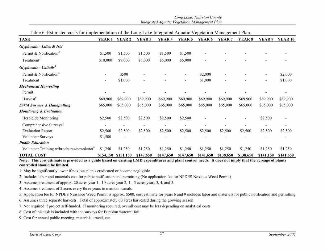
Table 6. Estimated costs for implementation of the Long Lake Integrated Aquatic Vegetation Management Plan. TASK YEAR 1 YEAR 2 YEAR 3 YEAR 4 YEAR 5 YEAR 6 YEAR 7 YEAR 8 YEAR 9 YEAR 10
Glyphosate - Lilies & Iris1 Permit & Notification2 $1,500 $1,500 $1,500 $1,500 $1,500 - - - - - Treatment3 $10,000 $7,000 $5,000 $5,000 $5,000 - - - - - Glyphosate - Cattails4 Permit & Notification5 - $500 - - - $2,000 - - - $2,000 Treatment - $1,000 - - - $1,000 - - - $1,000 Mechanical Harvesting Permit - - - - - - - - - - Harvest6 $69,900 $69,900 $69,900 $69,900 $69,900 $69,900 $69,900 $69,900 $69,900 $69,900 EWM Surveys & Handpulling $65,000 $65,000 $65,000 $65,000 $65,000 $65,000 $65,000 $65,000 $65,000 $65,000 Monitoring & Evaluation Herbicide Monitoring7 $2,500 $2,500 $2,500 $2,500 $2,500 - - - $2,500 - Comprehensive Surveys8 - - - - - - - - - - Evaluation Report $2,500 $2,500 $2,500 $2,500 $2,500 $2,500 $2,500 $2,500 $2,500 $2,500 Volunteer Surveys $1,500 - - - - - - - - - Public Education Volunteer Training w/brochures/newsletter9 $1,250 $1,250 $1,250 $1,250 $1,250 $1,250 $1,250 $1,250 $1,250 $1,250 TOTAL COST $154,150 $151,150 $147,650 $147,650 $147,650 $141,650 $138,650 $138,650 $141,150 $141,650Note: This cost estimate is provided as a guide based on existing LMD expenditures and plant control needs. It does not imply that the acreage of plants controlled should be limited. 1: May be significantly lower if noxious plants eradicated or become negligible 2: Includes labor and materials cost for public notification and permitting (No application fee for NPDES Noxious Weed Permit) 3: Assumes treatment of approx. 20 acres year 1, 10 acres year 2, 1 - 3 acres years 3, 4, and 5. 4: Assumes treatment of 2 acres every three years to maintain canals 5: Application fee for NPDES Nuisance Weed Permit is approx. $500, cost estimate for years 6 and 9 includes labor and materials for public notification and permitting6: Assumes three separate harvests. Total of approximately 60 acres harvested during the growing season 7: Not required if project self-funded. If monitoring required, overall cost may be less depending on analytical costs. 8: Cost of this task is included with the surveys for Eurasian watermilfoil. 9: Cost for annual public meeting, materials, travel, etc.

Long Lake, Thurston County Integrated Aquatic Vegetation Management Plan
EnviroVision Corp. September 2004 28
Residents should be contacted if yellow flag iris is found on their property and permission gained, if possible, to treat the plants. The annual cost to treat yellow flag iris may be highly variable but is estimated to not exceed $2,000 for the first two years, and approximately $1,000 annually for the next three years. The total cost over the 10-year period of this plan has been estimated to be $7,000 (Table 6). If residents chose to not treat their yellow flag iris, they should remove all the seed pods after the plant flowers to prevent it from spreading by seeds. Japanese knotweed is another noxious weed that only exists in a few locations on the lake. It is a shrub with greenish white flowers, large oval leaves, and a reddish brown woody stem. It can reach heights of four to eight feet and grows in riparian and wetland areas. This plant is considered highly aggressive (Hitchcock and Cronquist 1964) and is capable of crowding out all other vegetation (Ahrens 1975). Thurston County recently developed an Integrated Plant Management (IPM) Prescription to control Japanese knotweed. The IPM calls for eradication of the plant wherever it is discovered due to its potential to severely degrade native habitat. Manual control is identified as an effective method to control this plant but only while it is at pioneering levels. Because Japanese knotweed only occurs in a few isolated locations on Long Lake, Thurston County staff should immediately control it where it occurs on County property and if possible, obtain permission to control it on residents’ property. The few isolated plants should be cut down and removed, and the stumps should be covered by a heavy plastic tarp. Frequent checks should be made throughout the year to ensure that side shoots are not growing around the edges of the tarp(s). In accordance with the Thurston County IPM, if this plant appears to be spreading or not effectively controlled using manual methods, strong consideration should be given to using spot applications of glyphosate. The herbicide treatment could take place through foliar application, wicking, or stem injection. Although Japanese knotweed is present at Long Lake it currently exists in one known location of only a few plants. Therefore, it is likely that Thurston County staff could manually control these plants during normal lake management activities at no extra cost to the LMD. Because both yellow flag iris and Japanese knotweed are shoreline plants that may be considered attractive by homeowners, an ongoing education program that emphasizes the negative aspects of these plants is critical to the success of the program. Annual handpulling events should occur if yellow flag iris populations decrease to the point at which herbicide treatments are no longer cost effective, however residents should use gloves since yellow flag iris contains toxins. The use of herbicides should be reinstated if at any time the population appears to be increasing or if handpulling is not deemed effective. Native Emergent Plants Native emergent plants such as cattails are currently reducing beneficial uses in the lake in a few locations. More specifically, the prolific growth of cattails in front of homes adjacent to wetlands and along the two small channels is impacting boat navigation and access to the lake.
Long Lake, Thurston County Integrated Aquatic Vegetation Management Plan
EnviroVision Corp. September 2004 29
One of the small channels is located in the Pleasant Lake/Timber Lake neighborhood in the North Basin, and the other is located in the Afflerbaugh neighborhood in the South Basin. The two small channels are approximately 800 feet long and 40 to 80 feet wide. These channels have a maximum depth of about 4 feet. Cattails have begun to encroach into the channels and are starting to impede boat traffic. The cattails are also accelerating filling of the canals. This is occurring due to two mechanisms: through trapping sediment in the water column and their annual contribution of material to the lake bottom through plant decay. The selected strategy to control cattails is to use glyphosate to control them in areas where navigation and lake access is being impaired while leaving a buffer zone of emergent plants to support fish and wildlife habitat. Prior to treatment a detailed aquatic plant survey and GPS mapping effort would be conducted to identify the overall abundance and density of the cattails in the canals and in front of homes near wetlands. Glyphosate would be applied only to sections of the canals or shoreline areas where the vegetation is impeding navigation and access. Those areas will be determined by Thurston County, the LMD steering committee, and regulatory agencies by comparing a current plant survey with prior qualitative survey results. A minimum emergent vegetation buffer zone of 2 feet should be maintained in the canal areas between the open water mid-canal and actual shoreline. Where cattails are restricting access to the lake in front of residents’ homes, glyphosate can be used to maintain access for boating and swimming. This control will not occur unless specific permission is obtained from the property owners. More extensive control of cattails in front of lake residents’ homes will have to be negotiated among the property owners, Thurston County staff, and Ecology. Controlling the cattails should take place at the same time the fragrant waterlilies and yellow flag iris are treated, followed by further control a few weeks later. Areas where glyphosate will be used should be flagged prior to treatment. Care should be taken by the applicators to avoid collateral damage to native vegetation. The applicator should cover desirable plants adjacent to treatment areas to minimize damage to non-target vegetation. Areas with State-listed sensitive plants (i.e. bristly sedge) should be identified and placed off limits prior to control of emergent vegetation. Spot control of cattails using glyphosate is likely to last up to three years before they grow back and re-treatment is necessary. It is estimated that up to 2 acres of cattails will be sprayed in a treatment season at a cost of approximately $1,000 and will take place three times in a 10-year period. The total cost over the 10-year period of this plan is estimated to be $3,000 (Table 6). EURASIAN WATERMILFOIL CONTROL The management objective for Eurasian watermilfoil is to continue the diver surveys and use hand-pulling and bottom barriers to control the milfoil when necessary. This Eurasian watermilfoil control program has been in existence since the whole-lake Sonar® treatment in 1991 and has been successful in maintaining milfoil at extremely low levels.
Long Lake, Thurston County Integrated Aquatic Vegetation Management Plan
EnviroVision Corp. September 2004 30
Under the current Eurasian watermilfoil control program, the LMD and Thurston County use diver surveys to find and remove milfoil from the lake. The location of the Eurasian watermilfoil is marked with GPS. The locations of all Eurasian watermilfoil plants found since 1998 is shown in Figure 3. It is evident that where Eurasian watermilfoil is found is highly variable among the different years and that it has been located in all areas of the lake. Once the plants are pulled they are weighed and disposed of by Thurston County. Thurston County also tracks the amount of milfoil removed from lake and reports that information to the LMD through newsletters and steering committee meetings. The lake residents are generally pleased with the current Eurasian watermilfoil control program, especially those that resided at the lake when the milfoil was abundant. Most residents understand that without annual survey and control efforts Eurasian watermilfoil has the potential for explosive growth and could be much more expensive to control after only a few years. A side benefit of the Eurasian watermilfoil survey efforts is that divers are continually looking for infestations of other noxious weeds. This ensures that new noxious weeds will be targeted before they become a much bigger problem (see Invasive Plant Prevention and Detection Program). The LMD currently dedicates approximately $65,000 per year to fund the Eurasian watermilfoil diver survey and control program. This includes an annual contingency fund of $5,000 in the event that bottom barriers need to be used to control milfoil. The total cost over the 10-year period of this plan has been estimated to cost $650,000 (Table 6). NATIVE SUBMERGED PLANT CONTROL Although lake residents are not satisfied with harvesting as a control option, it was selected by default because preferred options (e.g., herbicides or grass carp) were not feasible. A description of the harvesting option follows. However, if in the future a State-approved herbicide is approved for use by Thurston County that is effective for controlling the plants in Long Lake, it is recommended for consideration under this plan. Under the current program, three separate harvests take place; approximately 15 acres just before the July 4th and Labor Day holidays, and a final 30-acre harvest at the end of September. Therefore, in a typical year a total of approximately 60 acres of plants are harvested. These harvests typically are conducted along the western shoreline and channel of the northern cove, the shoreline of reflection point, within the northwest cove west of Holmes Island, the mid-channel and Kirby Island area, and select areas along the southern and eastern shore of the South Basin (Figure 5). The first two harvests are designed to reduce aquatic plants that impact recreational uses (i.e. swimming, boating, and fishing) in the lake. The purpose of the final harvest has been to remove phosphorus from the lake in the form of plant biomass.

��������������� ����������������������������������������
� ��� ��� ��� ��� � �� ��
�
��
�
!�"��#�����������$������������ ������%&����#��&����'' ��������� �'����(� ���)%*+����� ��������!������� ������������!���)��,� ���� #���-� ���& �������� �%.�#��� � ���+���/��
������
0����,�����1�"�
Long Lake, Thurston County Integrated Aquatic Vegetation Management Plan
EnviroVision Corp. September 2004 32
The harvesters target both submerged and floating-leaved plants starting at the end of residents’ docks and continuing out into deeper areas of the lake. The first two harvests are concentrated in residential and high use (e.g. mid-channel connecting the two basins) areas. The last harvest also includes residential and high use areas but also takes place in designated Habitat Reserve Areas (see Habitat Reserve Areas section). Although harvesting occurs on three separate occasions during the growing season, each harvest is relatively small compared to the total amount of aquatic plants in the lake. This leaves a substantial amount of plant material in the lake both in the harvested and unharvested areas throughout the summer months. Under the current harvesting program, members of the LMD Steering Committee and Thurston County staff conduct an annual inspection of the areas designated for harvest. These areas are reviewed and approved annually by the steering committee. The LMD budget, level of plant growth, and areas to be maintained as conservation areas are some of the factors weighed when the steering committee members choose harvesting areas. The LMD Steering Committee will continue to lead annual evaluations and discussions on harvesting strategy. One recommended change in the strategy is to discontinue the late season harvest that was aimed at controlling phosphorus loading. Because the majority of phosphorus in the lake is derived from internal sources such as lake sediments, it was determined that removal of phosphorus through plant biomass could not significantly reduce overall phosphorus loading in the lake (Attachment II). It is expected that Thurston County staff will continue to provide oversight and direction to the harvesting contractor during each harvesting event. More specifically, the County will direct where the harvesting will take place, track the amount of acres harvested, estimate harvesting and plant fragment collection efficiency, approximate the amount of plant biomass removed, coordinate with lake residents on specific harvesting requests, and report results to the LMD Steering Committee during and after the harvesting takes place. The 10-year estimate for continuation of the harvesting program is approximately $699,000. This assumes an annual cost of $69,900 to harvest approximately 60 acres per year (Table 6). However, this plan does not limit either the frequency of harvesting or the size of the harvested area (outside of the habitat reserves). SMALL-SCALE PLANT CONTROL The current mechanical harvesting program only takes place beyond the end of residents’ docks. Some LMD-sponsored activities (spraying fragrant waterlilies and yellow flag iris) should take place within lake residents’ docks. However, for the most part lake residents are responsible for managing aquatic plants in the nearshore areas of their waterfront and are encouraged to do so. The strategies outlined above do not preclude lake residents from any small-scale physical control methods (e.g. raking or cutting) in areas of the lake adjacent to their properties. Additionally, representatives from the residential developments are not precluded from using these plant control methods (e.g. bottom barriers in swimming areas) to manage vegetation in front of their community access points. Lastly, this plan does not preclude lakeside residents
Long Lake, Thurston County Integrated Aquatic Vegetation Management Plan
EnviroVision Corp. September 2004 33
(individuals or groups) from contracting directly with an applicator and spraying State-approved herbicides in front of their residences. HABITAT RESERVES Several stretches of undeveloped shoreline exist at Long Lake; the two main areas are located in the northeastern corner of the North Basin and the southeastern shore of the South Basin (Figure 4). These areas have been designated as Habitat Reserves. Areas designated as Habitat Reserves are subjected to minimal plant management activities in an effort to preserve or re-establish undeveloped shoreline. These areas serve as important habitat for fish and wildlife in the lake. Most of the areas designated as Habitat Reserves are owned by Thurston County and the City of Lacey. The remaining Habitat Reserve areas are large wetlands, or shallow waters surrounding the two islands in the lake. A small portion of the Habitat Reserves is located along the shoreline in developed areas. The following criteria must be met before a shoreline in developed areas receives this designation:
• Aquatic plants must extend out into the lake for 25 feet from the shoreline, • Emergent upland vegetation must extend 25 feet inland from the shoreline and enhance
habitat value, • Habitat Reserves must extend for a minimum of 50 contiguous shoreline feet on single
or adjacent properties, and • Property owners agree to not harvest aquatic plants in their Habitat Reserve areas.
Residents who maintain Habitat Reserves in developed areas are charged a reduced rate by the LMD. Current and proposed Habitat Reserve areas are periodically reviewed by the LMD Steering Committee and Thurston County staff. INVASIVE PLANT PREVENTION AND DETECTION PROGRAM The use of herbicide treatments (or hand pulling) in Long Lake will effectively eliminate fragrant waterlily, yellow flag iris, and Japanese knotweed. However, these plants could return to the lake through introduction by boat activity or wildlife. The focus of control efforts for non-native plants is a prevention and detection program. There are a number of other non-native plants that are more destructive and difficult to control than the Eurasian watermilfoil, fragrant waterlily and yellow flag iris currently in Long Lake. Other non-native, highly invasive plants of concern that are already present in Washington State include; Parrotfeather (Myriophyllum aquaticum), Brazilian Elodea (Egeria densa), Hydrilla (Hydrilla verticillata), Fanwort (Cabomba caroliniana), and Water Hyacinth (Eichhorinia crassipes). These plants grow in the littoral zones of lakes, ponds, or rivers. A pro-active program to prevent their introduction or detect them before they become widespread is critical. Shoreline (emergent) noxious plants are also destructive and difficult to control. Examples of these plants include Purple loosestrife (Lythrum salicaria) and Garden loosestrife (Lysimachia
Long Lake, Thurston County Integrated Aquatic Vegetation Management Plan
EnviroVision Corp. September 2004 34
vulgaris). Thurston County has developed IPM prescriptions to control certain emergent noxious weeds. These IPM plans should be used at Long Lake if any new noxious shoreline plants are discovered. To be effective this program should include both a source control component (prevention) and a detection program. The objective of source control is to prevent non-native aquatic plants from entering the lake. The objective of the detection program is to be able to quickly identify noxious plants in the lake before they become widespread and more costly to control. The public boat launch represents an area where there is a high potential for introduction or re-introduction of invasive plants. The addition of a boat and trailer wash facility is sometimes recommended to enhance plant fragment removal. However, these can be expensive to install and they require continual oversight and maintenance. Furthermore, it is difficult to regulate their use and therefore their effectiveness is questionable. For these reasons it is not recommended. Lake residents should also receive informative brochures or newsletter articles on an annual basis reminding them of plant invasion problems and the importance of keeping their own equipment free of plants. It is also recommended that the lake community continue the public information campaign for opening day of the fishing season and a few other key weekends. Simply having volunteers hand out exotic plant identification cards for a few hours and help with boat and trailer checks will emphasize the importance of the effort and remind boaters of their responsibility to check equipment. Early detection is the next step to protect against new infestations. While an infestation is still small there are options for control that are much less expensive than the whole-lake treatment methods. Early detection, if done properly, requires both a trained group of lake volunteers who are responsible for occasional patrol of the lake, and periodic diver surveys to assess the plant community. The main purpose of these surveys is to search for non-native aquatic plants. However, it will also provide a means for monitoring the native plant communities and determining where future control efforts should be focused. Volunteers would be trained each year in plant identification and survey techniques and each would be given the responsibility for surveying a certain section of shoreline once a month during the growing season. Their purpose would be to note any substantial changes in the plant community and to look for new invasions of nuisance species. Professional divers would perform more complete surveys while they inspect the lake for Eurasian watermilfoil. (While divers are surveying the lake they can determine whether new infestations can be handled by handpulling the plants or whether, for example, bottom barrier should be installed in a few places to ensure complete control.) The primary advantage of controlling small infestations is that it reduces the chance that a large area would need to be controlled by a more intensive and expensive technique. Drawbacks of controlling small infestations are the high costs associated with diver surveys and hand pulling. Costs for hand pulling by contract divers range from $500 to $2,500 per day depending upon plant type, acreage, and density. Although the volunteer survey program should have no long-term cost, a training workshop would be necessary the first year. A volunteer training workshop cost of $1,500 has been included in plan implementation cost estimates (Table 6).
Long Lake, Thurston County Integrated Aquatic Vegetation Management Plan
EnviroVision Corp. September 2004 35
The exotic plant control plan complements the plan for the eradication of fragrant waterlily, yellow flag iris, Japanese knotweed, and control of Eurasian watermilfoil. The surveys would be relied upon to detect new infestations of existing noxious weeds and allow immediate removal of the plants. If another exotic plant is found, immediate action should be taken and a survey should be planned for later in the same year to insure there were no surviving colonies. If the area infested is too large to control by handpulling, or if after two follow-up surveys the exotic plant is still found, bottom barriers would be placed in all areas where the plant was detected. Treatment with herbicide is recommended as a final resort if these efforts do not result in eradication of the exotic plant. These additional surveys, bottom barrier installation, and herbicide treatments are contingency elements to the overall aquatic plant control plan for the lake. Since these costs would only accrue in the event of another infestation by noxious weeds that currently reside in the lake, or another exotic plant, the costs could possibly be covered through an "early infestation grant" by the Department of Ecology. PLANT CONTROL ADVISORY COMMITTEE Proper implementation of this plan relies upon the continuation of a plant control advisory committee for the lake. This committee, which is comprised of area residents, Thurston County staff, and other interested agencies, has the following responsibilities:
• Review annual plant survey information and track potential problem areas. • Insure permit requirements are met. • Review exotic plant problems and determine the appropriate control strategy and urgency
of control needed. • Recruit and direct volunteers for annual surveys. • Select and hire contractors when necessary for tasks such as training, hiring aquatic plant
control contractors, monitoring, etc. • Provide information and newsletters to lake residents and act as spokespeople for
answering questions on plant control problems and supporting long-term implementation of this plan.
PUBLIC EDUCATION PROGRAM The public education program for Long Lake consists of three parts; the exotic plant prevention plan previously described, lakeside stewardship education, and watershed protection/pollution prevention for protecting the lakes' water quality.