lake mcmurray 2018 aquatic plant control program...lake mcmurray 2018 aquatic plant control program...
TRANSCRIPT

Northwest Aquatic Eco-Systems 1
Lake McMurray
2018 Aquatic Plant Control Program
Prepared By
Northwest Aquatic Eco-Systems
855 Trosper Road SW #108-313
Tumwater, WA 98512
360-357-3285
December 2018
www.nwaquaticecosystems.com
Northwest Aquatic Eco-Systems 2
Project Overview
This was Northwest Aquatic Eco-Systems (NWAE) sixth year of providing aquatic weed
control services for the Lake McMurray LMD#2. Our 2018 effort was influenced by a
number of events that directed the outcome of certain components of the project. Lily pad
and yellow flag iris chemical weed control was performed outside of a ¼ mile radius of
the McHaven potable water intake. No cutting of the lily pads occurred. This distance
once again provided an adequate buffer zone from the treatment sites to the intake
resulting in no herbicide residue being detected at the McHaven potable water intake.
No nuisance submersed weed control was undertaken during 2018. Use of diquat
(material with the ability to control elodea) during 2014 produced residual drift that
reached the McHaven intake. With the unfavorable drift results obtained during 2014 no
further use of diquat was permitted. Since 2014, some residential areas of the lake are
plagued with pondweeds that can be controlled with Aquathol K. Use of this product
would require the same water sampling procedure implemented for past diquat and
present glyphosate use. The half-life for Aquathol K is 24 hours.
McHaven is the only registered potable water intake lake-wide. This intake supplies
potable water to a small community located just north of the boat launch. The McHaven
system has the ability to store water on site for a few days, depending on water usage.
Lake McMurray is 160 acres and is approximately 9 miles to the Southeast of Mount
Vernon. The lake is the headwaters of the Nookachamps Creek, tributary of the Skagit
River. Nearly 50% of the shoreline is developed with over 90% of the development
occurring along the western and southern shorelines. Water skiing and high speed motor
boat use are prohibited. Currently the Lake McMurray program format still emphasizes
milfoil control but also includes fragrant waterlily and yellow flag iris control. Native
plant communities have increased in densities throughout various shoreline areas of the
lake, reducing recreational opportunities. Lake McMurray supports shoreline swimming,
a healthy recreational fishery and small boat use.
Survey Protocol
2018 sonar data was collected similar to those noted during 2016 & 2017. Electronic
data was collected on a chart recorder utilizing sonar and structure scan transducers.
Milfoil, when identified, was recorded as a waypoint during the survey. Surveying was
terminated once plants were no longer detected on the chart graph recorder’s monitor.

Northwest Aquatic Eco-Systems 3
No Macrophyte Growth Macrophyte Growth
Once collected, the SD card was uploaded via cloud based technology and the processing
of the data was finalized. Not only is a well defined map produced but a sonar log of the
survey is saved allowing a complete review and evaluation of the survey to occur in-
house. The survey entails a surface vehicle transecting the lake along the littoral zone.
Boat tracks are designed to be approximately 100 feet apart. To ensure the efficacy of
the survey, a bottom sampling rake was thrown from the boat at various locations lake-
wide. The rake was then drawn across the lake bottom, brought to the surface and into
the boat. Plants attached to the rake were identified and confirmed as being the same
species as noted through the structure scan or visually through the water column. The
system automatically stores the position of every transect data point enabling the
mapping of thousands of data points on a daily basis.
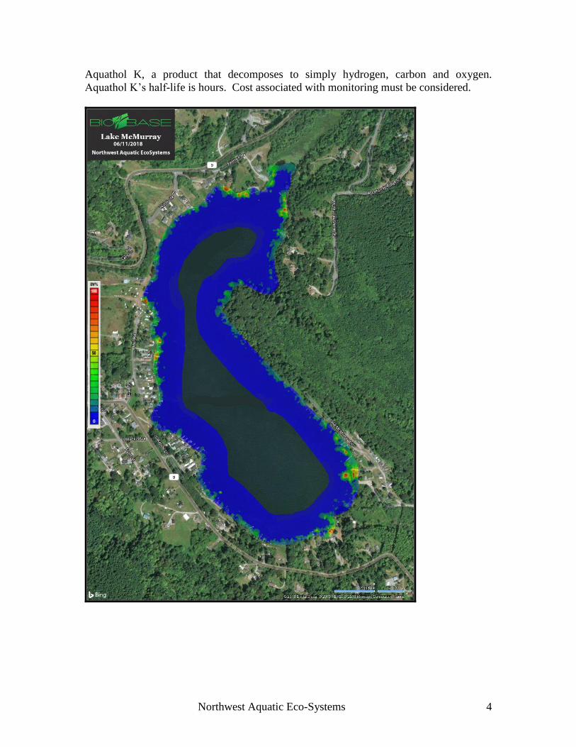
Lake McMurray Spring Survey Results
Lake McMurray was surveyed on June 11, 2018. Water clarity exceeded 15 feet. No
milfoil plants were identified as was similar to years past. Also similar to previous years
spring surveys were the locations of native weed species and composition of macrophytes
throughout the lake. No pattern existed related to plant densities lake-wide. Some areas
appeared less dense while others exhibited thicker growth. Most yellow flag iris
infestations were small, less than 15 square feet in area. Approximately 40-50 sites were
noted. Fragrant water lily plants were noted lake-wide with the largest infestations
occurring at the outlet portion of the lake and in the southeast corner just north of the
public boat launch. This species is no longer increasing in range as past glyphosate
applications have been successful. Pondweeds and elodea species continue to dominate
the lake’s macrophyte composition. Pondweeds have established themselves as
problematic in some shoreline areas of the lake and a discussion associated with potential
treatment has been initiated. These pondweed infestations can be controlled with
Northwest Aquatic Eco-Systems 4
Aquathol K, a product that decomposes to simply hydrogen, carbon and oxygen.
Aquathol K’s half-life is hours. Cost associated with monitoring must be considered.

Northwest Aquatic Eco-Systems 5
2017 Spring Macrophyte Survey 2018 Spring Macrophyte Survey
Blue areas indicate no submersed macrophyte growth.
Green areas indicate moderate growth.
Red areas indicate 100 % coverage
Major
Lily
Pad
Locations

Northwest Aquatic Eco-Systems 6
Treatment
Lake McMurray received treatment for lily pads and yellow flag iris on August 6, 2018.
Notice was provided to the LMD prior to treatment and the shoreline was posted just
prior to treatment. The same areas targeted for control during 2017 were again
considered for the 2018 project. Only infestations more than 1/4 mile from the
McHaven potable water intake were targeted. An 18 foot aluminum boat equipped with
one 25 gallon spray tank was utilized during this spray event. The 25 gallon tank was
filled with lake water. Glyphosate and surfactant were then added directly to the tank.
Once mixed, the application boat drove along the shoreline identifying targeted species.
The spray mixture was then discharged directly onto the plants’ leaf structures using a
spray gun. When emptied, the tank was refilled and discharged as needed. Spray
mixture consisted of a 1% solution of glyphosate.
Pad infestations continue to decline with some prior targeted sites not requiring treatment
during 2018.
No spraying occurred at the “Friends of Norway” park located along the northwest
shoreline of the lake. At the time of posting, a husband and wife present at the park
protested the use of herbicides at the lake. NWAE made contact with one of the park
representatives via cell phone in order to determine what action should be taken. After a
lengthy conversation with a club representative and the concerned parties, a
determination to not spray was made by the representative.
Northwest Aquatic Eco-Systems 7
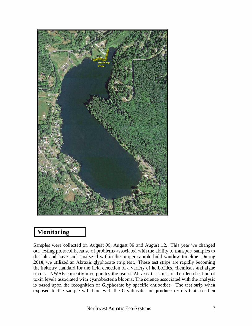
Monitoring
Samples were collected on August 06, August 09 and August 12. This year we changed
our testing protocol because of problems associated with the ability to transport samples to
the lab and have such analyzed within the proper sample hold window timeline. During
2018, we utilized an Abraxis glyphosate strip test. These test strips are rapidly becoming
the industry standard for the field detection of a variety of herbicides, chemicals and algae
toxins. NWAE currently incorporates the use of Abraxis test kits for the identification of
toxin levels associated with cyanobacteria blooms. The science associated with the analysis
is based upon the recognition of Glyphosate by specific antibodies. The test strip when
exposed to the sample will bind with the Glyphosate and produce results that are then

Northwest Aquatic Eco-Systems 8
evaluated photoelectrically. During each sampling event one sample was collected at the
treatment (#3) site just below the surface, one sample was collected approximately 300 feet
from the treatment (#2) site and one sample was taken directly above the McHaven water
intake (#1). All of the samples collected except for the August 6 sample taken at the
treatment site returned glyphosate levels below the detectable limits of the equipment. The
sample taken at the treatment site on the day of treatment registered a concentration of 3.2
ppb glyphosate.
Glyphosate Concentrations ppb
August 6 August 9 August 12
SS #1 3.2 ppb 0.00 0.00
SS #2 0.00 0.00 0.00
SS #3 0.00 0.00 0.00
Sample
Stations

Northwest Aquatic Eco-Systems 9
No manual lily pad removal occurred during 2018.
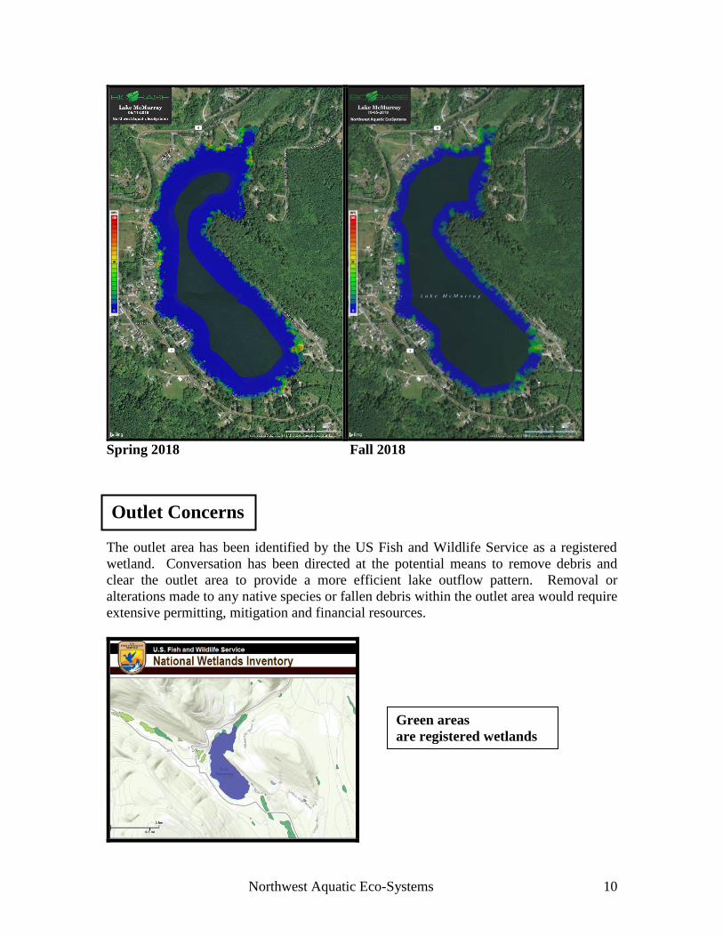
The fall survey was performed on October 5, 2018. The survey resulted again in no
milfoil plants identified lake-wide. The 2018 fall survey was typical of past historically
surveys undertaken during the same timeframe. Weed densities declined as had been
typically observed in the past. Targeted lily pad sites continued to show herbicide
damage when compared with the Friends of Norway site that had not been included this
year in the spraying event.
Fall Survey
Fall
Survey
2018
Lily Pad Manual Removal
Northwest Aquatic Eco-Systems 10
Spring 2018 Fall 2018
The outlet area has been identified by the US Fish and Wildlife Service as a registered
wetland. Conversation has been directed at the potential means to remove debris and
clear the outlet area to provide a more efficient lake outflow pattern. Removal or
alterations made to any native species or fallen debris within the outlet area would require
extensive permitting, mitigation and financial resources.
Outlet Concerns
Survey
Green areas
are registered wetlands

Northwest Aquatic Eco-Systems 11
1. LMD officials, the consultant and the McHaven Inc. (potable water right holder)
need to continue to work in harmony in developing treatment protocol that will
provide the greatest degree of control lake-wide while ensuring the integrity of the
McHaven water supply. The ¼ mile buffer continues to provide an adequate
distance that ensures no herbicide residue will reach the potable intake. Sampling
conducted during 2013, 2014, 2015, 2016, 2017 and 2018 has documented that the
use of the herbicide glyphosate resulted in no active ingredient detected at the
community’s potable water intake.
2. Diquat is the only material registered in Washington State that will control elodea,
the dominant species identified in the lake. Diquat residues were detected at the
McHaven potable water intake during 2014. Levels were below the EPA guidelines
for potable systems, .02 mg/L. Such levels were not expected even with the ½ mile
imposed no treatment zone. The established criteria for the use of any herbicide
within the waters of Lake McMurray is to ensure the McHaven population that NO
herbicide is detected at the community’s water intake. Diquat was eliminated from
further use on Lake McMurray during 2015.
3. Aquathol K can be used to control only the pondweed species found in the lake. In
the past, the pondweeds were a component of the elodea population. Control of the
pondweeds in these portions of the lake would not bring about relief to property
owners because the elodea species would still be problematic. There are now some
shoreline areas of the lake where the only species present are pondweeds and
Aquathol K could be a potential control agent. The same approach related to water
testing following treatment would be required. The Aquathol K label requires a
minimum 600 foot setback from potable water intakes. Aquathol K degrades faster
in the water than diquat with byproducts consisting of only carbon, hydrogen and
oxygen. 4. Continue use of glyphosate in the control of lily pads, yellow flag iris and
loosestrife. 5. Explore manual control of submersed weeds within residential properties. This
approach is the most expensive means to remove submersed plant growth. Due to
submersed logs and debris this process is slow and only a few properties can be
serviced per day. 6. Re-evaluate the use of manual control for lily pads within the no spray zone. Pads
that resurfaced were smaller in diameter after each cut. The length of time between
cuts should not exceed three weeks. A single seasonal cutting would not be
worthwhile, although it would provide short term relief. 7. Continue use of the new mapping technology. Such technology will provide an
easily understood macrophyte map. Mapping can then be used as baseline data in
evaluating the success of future weed control activities.
Recommendations

Northwest Aquatic Eco-Systems 12
LMD Program Expenses
NPDES Permit Fees
Fees for 2019 will be approximately $675.00. Ecology raises the permit fee about
$50.00 per year.
Annual Report
$500.00
Meetings and Communication
$500.00
Lily Pad Removal (Per Cutting Event)
1. All pads cut within residential properties within ¼ mile of the McHaven intake. This
does not include any of the property within the McHaven development.
$3,000.00
2. Lily pad cutting within the McHaven development approximately 17,000 square feet.
$3,000.00

Northwest Aquatic Eco-Systems 13
Chemical Control of Lily Pads and Iris Outside the ¼ Mile Buffer Zone
(per event)
Mailing Notice $500.00
Posting $300.00
Application $500.00
Laboratory Testing $1,500.00
Manual Submersed Weed Removal Per Lot
$ 500.00
Spot Treatment Milfoil
$1,000.00
Pre Treatment Survey
$1,500.00
Post Treatment Survey
$1,500.00