aquatic vegetation of leech lake
TRANSCRIPT
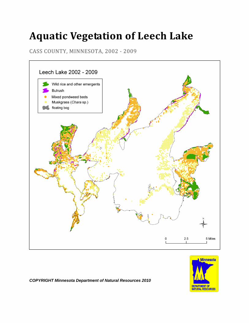
Aquatic Vegetation of Leech Lake CASS COUNTY, MINNESOTA, 2002 - 2009
COPYRIGHT Minnesota Department of Natural Resources 2010
Aquatic vegetation of Leech Lake, 2002-2009 August 2010 Page 2 of 109
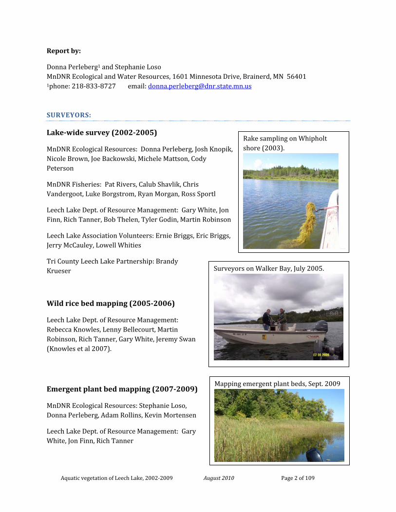
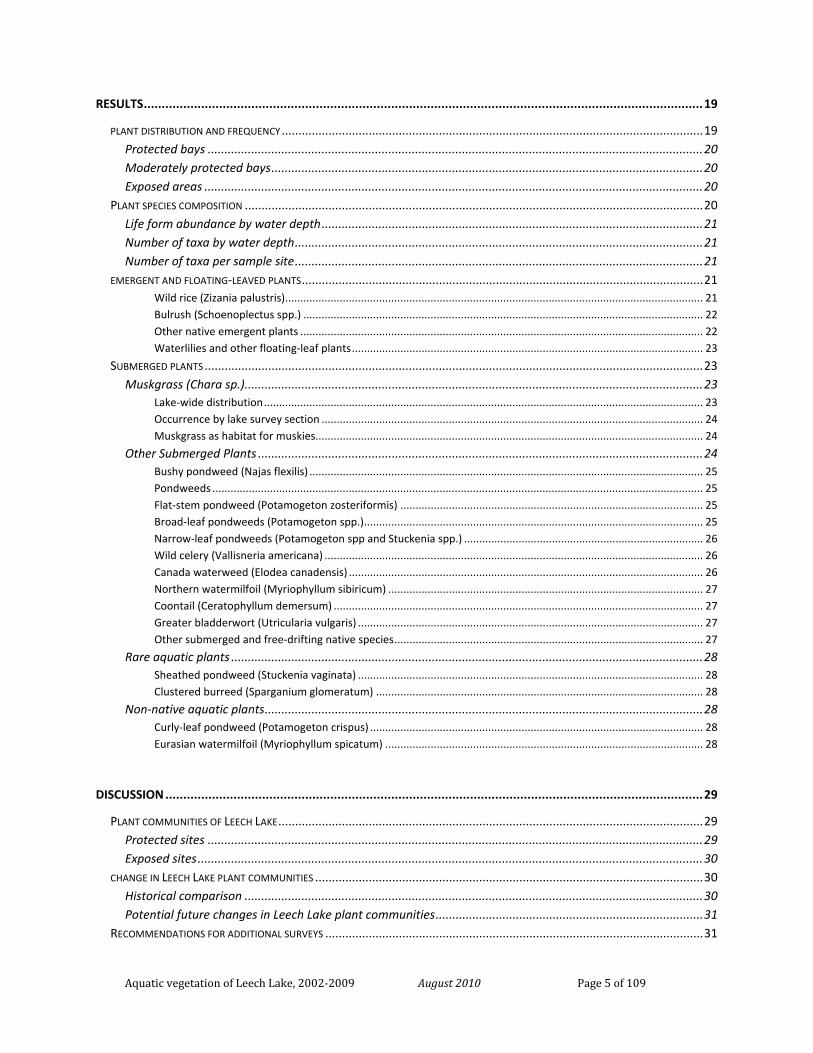
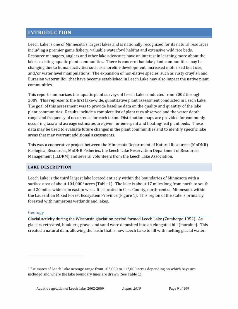
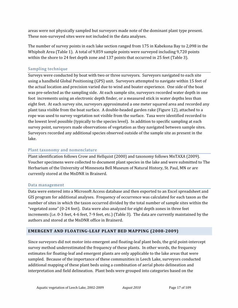
Rake sampling on Whipholt shore (2003).
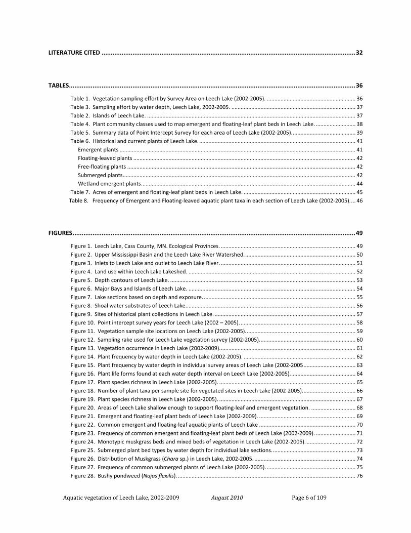
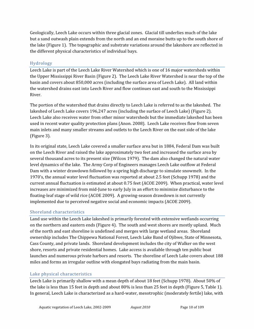
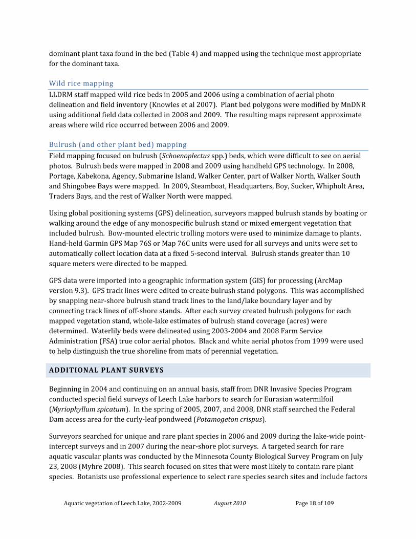
Surveyors on Walker Bay, July 2005.
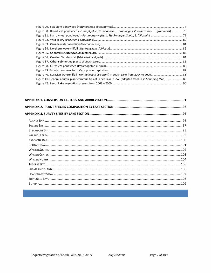
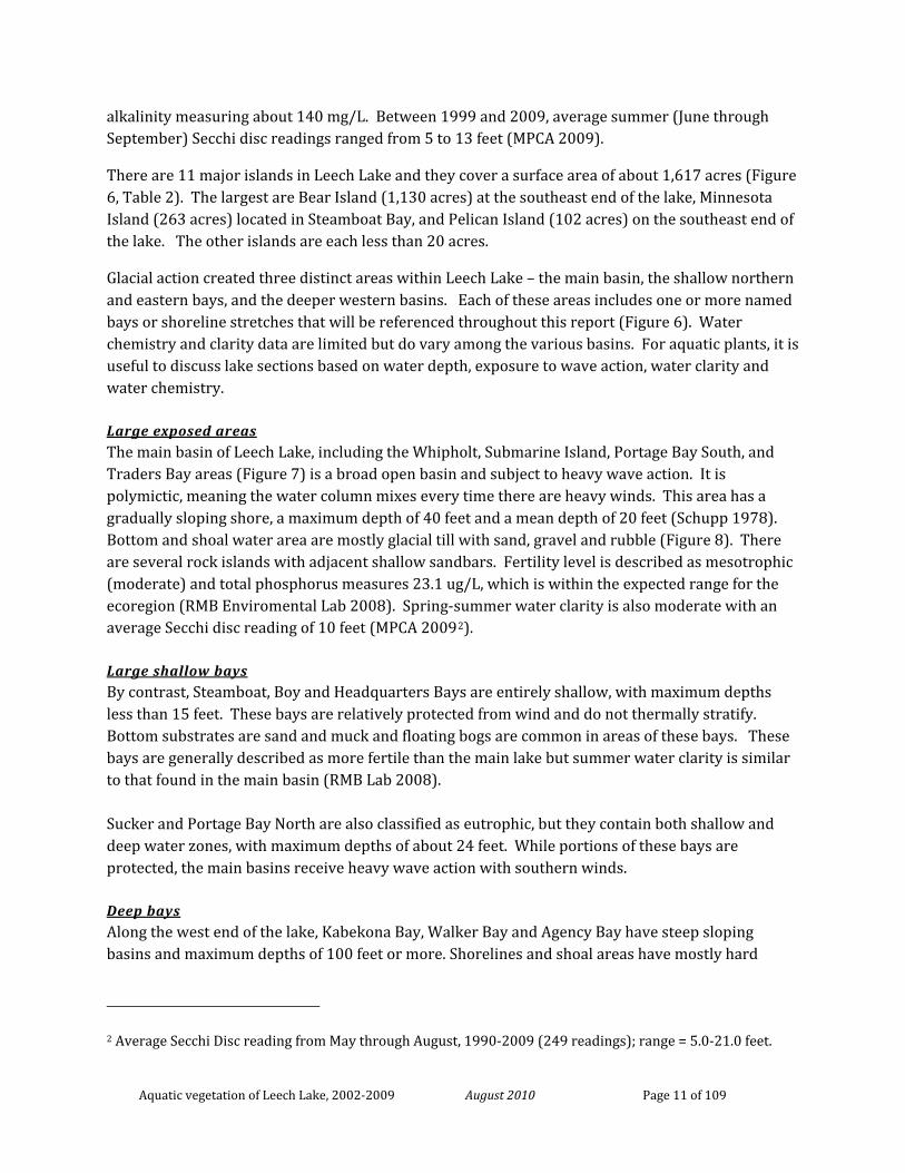
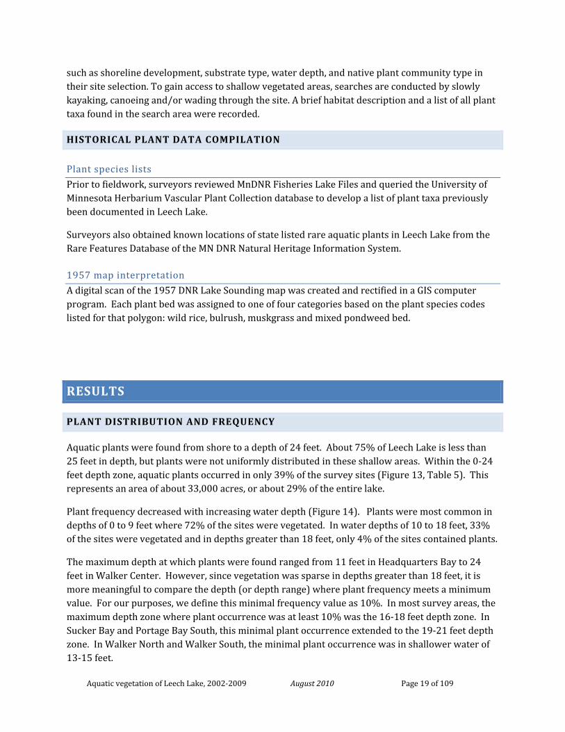
Mapping emergent plant beds, Sept. 2009
Report by:
Donna Perleberg1 and Stephanie Loso MnDNR Ecological and Water Resources, 1601 Minnesota Drive, Brainerd, MN 56401 1phone: 218-833-8727 email: [email protected]
SURVEYORS:
Lake-wide survey (2002-2005)
MnDNR Ecological Resources: Donna Perleberg, Josh Knopik, Nicole Brown, Joe Backowski, Michele Mattson, Cody Peterson
MnDNR Fisheries: Pat Rivers, Calub Shavlik, Chris Vandergoot, Luke Borgstrom, Ryan Morgan, Ross Sportl
Leech Lake Dept. of Resource Management: Gary White, Jon Finn, Rich Tanner, Bob Thelen, Tyler Godin, Martin Robinson
Leech Lake Association Volunteers: Ernie Briggs, Eric Briggs, Jerry McCauley, Lowell Whities
Tri County Leech Lake Partnership: Brandy Krueser
Wild rice bed mapping (2005-2006)
Leech Lake Dept. of Resource Management: Rebecca Knowles, Lenny Bellecourt, Martin Robinson, Rich Tanner, Gary White, Jeremy Swan (Knowles et al 2007).
Emergent plant bed mapping (2007-2009)
MnDNR Ecological Resources: Stephanie Loso, Donna Perleberg, Adam Rollins, Kevin Mortensen
Leech Lake Dept. of Resource Management: Gary White, Jon Finn, Rich Tanner
Aquatic vegetation of Leech Lake, 2002-2009 August 2010 Page 3 of 109
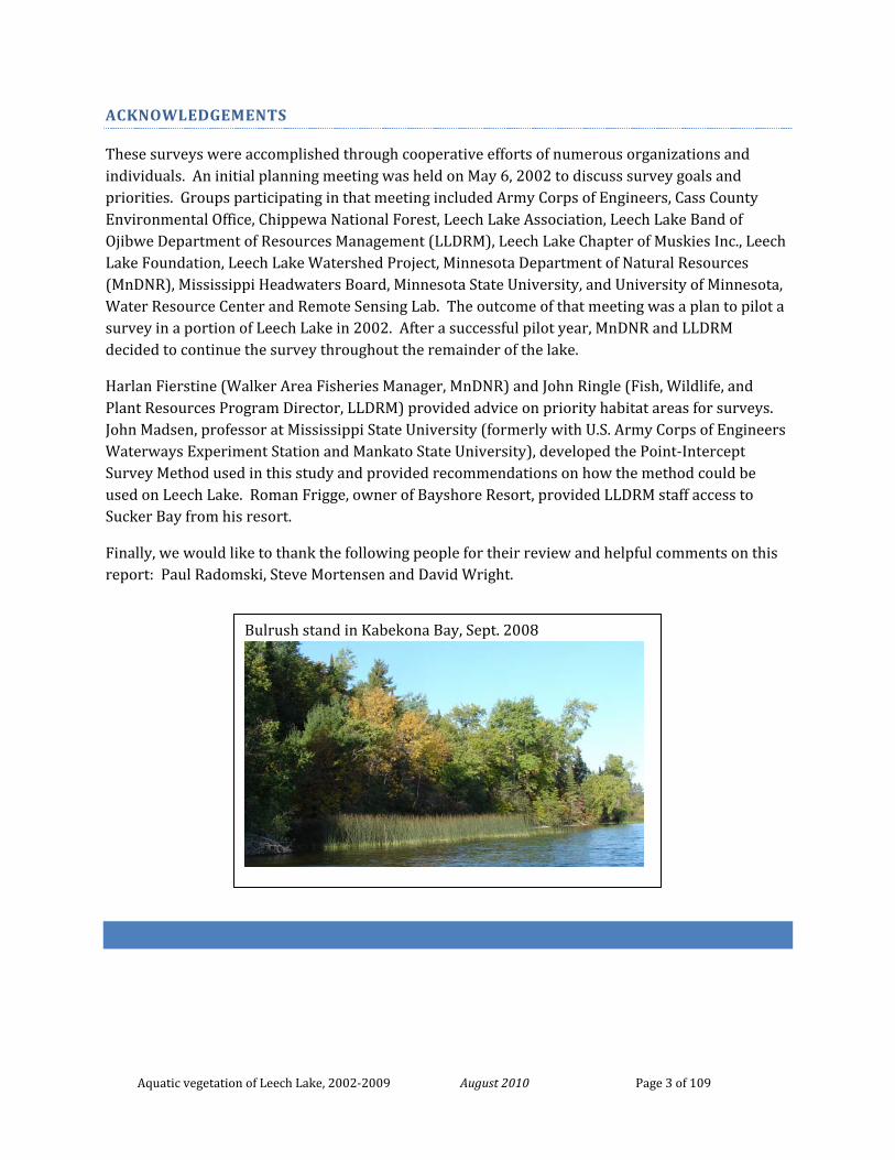
Bulrush stand in Kabekona Bay, Sept. 2008
ACKNOWLEDGEMENTS
These surveys were accomplished through cooperative efforts of numerous organizations and individuals. An initial planning meeting was held on May 6, 2002 to discuss survey goals and priorities. Groups participating in that meeting included Army Corps of Engineers, Cass County Environmental Office, Chippewa National Forest, Leech Lake Association, Leech Lake Band of Ojibwe Department of Resources Management (LLDRM), Leech Lake Chapter of Muskies Inc., Leech Lake Foundation, Leech Lake Watershed Project, Minnesota Department of Natural Resources (MnDNR), Mississippi Headwaters Board, Minnesota State University, and University of Minnesota, Water Resource Center and Remote Sensing Lab. The outcome of that meeting was a plan to pilot a survey in a portion of Leech Lake in 2002. After a successful pilot year, MnDNR and LLDRM decided to continue the survey throughout the remainder of the lake.
Harlan Fierstine (Walker Area Fisheries Manager, MnDNR) and John Ringle (Fish, Wildlife, and Plant Resources Program Director, LLDRM) provided advice on priority habitat areas for surveys. John Madsen, professor at Mississippi State University (formerly with U.S. Army Corps of Engineers Waterways Experiment Station and Mankato State University), developed the Point-Intercept Survey Method used in this study and provided recommendations on how the method could be used on Leech Lake. Roman Frigge, owner of Bayshore Resort, provided LLDRM staff access to Sucker Bay from his resort.
Finally, we would like to thank the following people for their review and helpful comments on this report: Paul Radomski, Steve Mortensen and David Wright.
Aquatic vegetation of Leech Lake, 2002-2009 August 2010 Page 4 of 109
TABLE OF CONTENTS
TABLE OF CONTENTS .......................................................................................................................................... 4
SUMMARY ......................................................................................................................................................... 8
INTRODUCTION.................................................................................................................................................. 9
LAKE DESCRIPTION ......................................................................................................................................................... 9 Geology ................................................................................................................................................................. 9 Hydrology ............................................................................................................................................................ 10 Shoreland characteristics .................................................................................................................................... 10 Lake physical characteristics ............................................................................................................................... 10
Large exposed areas .................................................................................................................................................... 11 Large shallow bays ....................................................................................................................................................... 11 Deep bays .................................................................................................................................................................... 11
Fish and Wildlife .................................................................................................................................................. 12 HISTORICAL AQUATIC VEGETATION DATA ......................................................................................................................... 12 POTENTIAL THREATS TO NATIVE PLANTS ........................................................................................................................... 13
Shoreland development ...................................................................................................................................... 13 Motorboat activity .............................................................................................................................................. 14 Water level changes ............................................................................................................................................ 14 Invasive species ................................................................................................................................................... 14
Non-native aquatic animals ......................................................................................................................................... 14 Non-native emergent plants ........................................................................................................................................ 15 Non-native submerged plants ..................................................................................................................................... 15
SURVEY OBJECTIVES ...................................................................................................................................................... 15
METHODS ......................................................................................................................................................... 16
LAKE-WIDE PLANT SURVEY USING A GRID SURVEY (2002-2005) ........................................................................................... 16 Number of survey points per lake section ........................................................................................................... 16 Sampling technique ............................................................................................................................................. 17 Plant taxonomy and nomenclature ..................................................................................................................... 17 Data management .............................................................................................................................................. 17
EMERGENT AND FLOATING-LEAF PLANT BED MAPPING (2008-2009) ..................................................................................... 17 Wild rice mapping ............................................................................................................................................... 18 Bulrush (and other plant bed) mapping .............................................................................................................. 18
ADDITIONAL PLANT SURVEYS........................................................................................................................................... 18 HISTORICAL PLANT DATA COMPILATION ............................................................................................................................ 19
Plant species lists ................................................................................................................................................ 19 1957 map interpretation ..................................................................................................................................... 19
Aquatic vegetation of Leech Lake, 2002-2009 August 2010 Page 5 of 109
RESULTS ............................................................................................................................................................ 19
PLANT DISTRIBUTION AND FREQUENCY .............................................................................................................................. 19 Protected bays .................................................................................................................................................... 20 Moderately protected bays ................................................................................................................................. 20 Exposed areas ..................................................................................................................................................... 20
PLANT SPECIES COMPOSITION ......................................................................................................................................... 20 Life form abundance by water depth .................................................................................................................. 21 Number of taxa by water depth .......................................................................................................................... 21 Number of taxa per sample site .......................................................................................................................... 21
EMERGENT AND FLOATING-LEAVED PLANTS ........................................................................................................................ 21 Wild rice (Zizania palustris) .......................................................................................................................................... 21 Bulrush (Schoenoplectus spp.) .................................................................................................................................... 22 Other native emergent plants ..................................................................................................................................... 22 Waterlilies and other floating-leaf plants .................................................................................................................... 23
SUBMERGED PLANTS ..................................................................................................................................................... 23 Muskgrass (Chara sp.) ......................................................................................................................................... 23
Lake-wide distribution ................................................................................................................................................. 23 Occurrence by lake survey section .............................................................................................................................. 24 Muskgrass as habitat for muskies................................................................................................................................ 24
Other Submerged Plants ..................................................................................................................................... 24 Bushy pondweed (Najas flexilis) .................................................................................................................................. 25 Pondweeds .................................................................................................................................................................. 25 Flat-stem pondweed (Potamogeton zosteriformis) .................................................................................................... 25 Broad-leaf pondweeds (Potamogeton spp.) ................................................................................................................ 25 Narrow-leaf pondweeds (Potamogeton spp and Stuckenia spp.) ............................................................................... 26 Wild celery (Vallisneria americana) ............................................................................................................................. 26 Canada waterweed (Elodea canadensis) ..................................................................................................................... 26 Northern watermilfoil (Myriophyllum sibiricum) ........................................................................................................ 27 Coontail (Ceratophyllum demersum) .......................................................................................................................... 27 Greater bladderwort (Utricularia vulgaris) .................................................................................................................. 27 Other submerged and free-drifting native species ...................................................................................................... 27
Rare aquatic plants ............................................................................................................................................. 28 Sheathed pondweed (Stuckenia vaginata) .................................................................................................................. 28 Clustered burreed (Sparganium glomeratum) ............................................................................................................ 28
Non-native aquatic plants ................................................................................................................................... 28 Curly-leaf pondweed (Potamogeton crispus) .............................................................................................................. 28 Eurasian watermilfoil (Myriophyllum spicatum) ......................................................................................................... 28
DISCUSSION ...................................................................................................................................................... 29
PLANT COMMUNITIES OF LEECH LAKE ............................................................................................................................... 29 Protected sites .................................................................................................................................................... 29 Exposed sites ....................................................................................................................................................... 30
CHANGE IN LEECH LAKE PLANT COMMUNITIES .................................................................................................................... 30 Historical comparison ......................................................................................................................................... 30 Potential future changes in Leech Lake plant communities ................................................................................ 31
RECOMMENDATIONS FOR ADDITIONAL SURVEYS ................................................................................................................. 31
Aquatic vegetation of Leech Lake, 2002-2009 August 2010 Page 6 of 109
LITERATURE CITED ............................................................................................................................................ 32
TABLES .............................................................................................................................................................. 36
Table 1. Vegetation sampling effort by Survey Area on Leech Lake (2002-2005). .......................................................... 36 Table 3. Sampling effort by water depth, Leech Lake, 2002-2005. ................................................................................. 37 Table 2. Islands of Leech Lake. ........................................................................................................................................ 37 Table 4. Plant community classes used to map emergent and floating-leaf plant beds in Leech Lake. .......................... 38 Table 5. Summary data of Point Intercept Survey for each area of Leech Lake (2002-2005). ......................................... 39 Table 6. Historical and current plants of Leech Lake. ...................................................................................................... 41
Emergent plants .......................................................................................................................................................... 41 Floating-leaved plants ................................................................................................................................................. 42 Free-floating plants ..................................................................................................................................................... 42 Submerged plants ........................................................................................................................................................ 42 Wetland emergent plants ............................................................................................................................................ 44
Table 7. Acres of emergent and floating-leaf plant beds in Leech Lake. ......................................................................... 45 Table 8. Frequency of Emergent and Floating-leaved aquatic plant taxa in each section of Leech Lake (2002-2005). ... 46
FIGURES ............................................................................................................................................................ 49
Figure 1. Leech Lake, Cass County, MN. Ecological Provinces. ........................................................................................ 49 Figure 2. Upper Mississippi Basin and the Leech Lake River Watershed. ........................................................................ 50 Figure 3. Inlets to Leech Lake and outlet to Leech Lake River. ........................................................................................ 51 Figure 4. Land use within Leech Lake Lakeshed. ............................................................................................................. 52 Figure 5. Depth contours of Leech Lake. ......................................................................................................................... 53 Figure 6. Major Bays and Islands of Leech Lake. ............................................................................................................. 54 Figure 7. Lake sections based on depth and exposure. ................................................................................................... 55 Figure 8. Shoal water substrates of Leech Lake. .............................................................................................................. 56 Figure 9. Sites of historical plant collections in Leech Lake. ............................................................................................ 57 Figure 10. Point intercept survey years for Leech Lake (2002 – 2005). ........................................................................... 58 Figure 11. Vegetation sample site locations on Leech Lake (2002-2005). ....................................................................... 59 Figure 12. Sampling rake used for Leech Lake vegetation survey (2002-2005). .............................................................. 60 Figure 13. Vegetation occurrence in Leech Lake (2002-2009). ........................................................................................ 61 Figure 14. Plant frequency by water depth in Leech Lake (2002-2005). ......................................................................... 62 Figure 15. Plant frequency by water depth in individual survey areas of Leech Lake (2002-2005 .................................. 63 Figure 16. Plant life forms found at each water depth interval on Leech Lake (2002-2005). .......................................... 64 Figure 17. Plant species richness in Leech Lake (2002-2005). ......................................................................................... 65 Figure 18. Number of plant taxa per sample site for vegetated sites in Leech Lake (2002-2005). .................................. 66 Figure 19. Plant species richness in Leech Lake (2002-2005). ......................................................................................... 67 Figure 20. Areas of Leech Lake shallow enough to support floating-leaf and emergent vegetation. ............................. 68 Figure 21. Emergent and floating-leaf plant beds of Leech Lake (2002-2009). ............................................................... 69 Figure 22. Common emergent and floating-leaf aquatic plants of Leech Lake ............................................................... 70 Figure 23. Frequency of common emergent and floating-leaf plant beds of Leech Lake (2002-2009). .......................... 71 Figure 24. Monotypic muskgrass beds and mixed beds of vegetation in Leech Lake (2002-2005). ................................ 72 Figure 25. Submerged plant bed types by water depth for individual lake sections. ...................................................... 73 Figure 26. Distribution of Muskgrass (Chara sp.) in Leech Lake, 2002-2005. .................................................................. 74 Figure 27. Frequency of common submerged plants of Leech Lake (2002-2005). .......................................................... 75 Figure 28. Bushy pondweed (Najas flexilis). .................................................................................................................... 76
Aquatic vegetation of Leech Lake, 2002-2009 August 2010 Page 7 of 109
Figure 29. Flat-stem pondweed (Potamogeton zosteriformis). ....................................................................................... 77 Figure 30. Broad-leaf pondweeds (P. amplifolius, P. illinoensis, P. praelongus, P. richardsonii, P. gramineus). ............. 78 Figure 31. Narrow-leaf pondweeds (Potamogeton friesii, Stuckenia pectinata, S. filiformis). ........................................ 79 Figure 32. Wild celery (Vallisneria americana). ............................................................................................................... 80 Figure 33. Canada waterweed (Elodea canadensis). ....................................................................................................... 81 Figure 34. Northern watermilfoil (Myriophyllum sibiricum). ........................................................................................... 82 Figure 35. Coontail (Ceratophyllum demersum) .............................................................................................................. 83 Figure 36. Greater Bladderwort (Utricularia vulgaris) ..................................................................................................... 84 Figure 37. Other submerged plants of Leech Lake .......................................................................................................... 85 Figure 38. Curly-leaf pondweed (Potamogeton crispus) ................................................................................................. 86 Figure 39. Eurasian watermilfoil (Myriophyllum spicatum) ............................................................................................ 87 Figure 40. Eurasian watermilfoil (Myriophyllum spicatum) in Leech Lake from 2004 to 2009. ....................................... 88 Figure 41. General aquatic plant communities of Leech Lake, 1957 (adapted from Lake Sounding Map). .................... 89 Figure 42. Leech Lake vegetation present from 2002 – 2009 .......................................................................................... 90
APPENDIX 1. CONVERSION FACTORS AND ABBREVIATION ................................................................................. 91
APPENDIX 2. PLANT SPECIES COMPOSITION BY LAKE SECTION. ......................................................................... 92
APPENDIX 3. SURVEY SITES BY LAKE SECTION .................................................................................................... 96
AGENCY BAY ............................................................................................................................................................... 96 SUCKER BAY ................................................................................................................................................................ 97 STEAMBOAT BAY .......................................................................................................................................................... 98 WHIPHOLT AREA ........................................................................................................................................................... 99 KABEKONA BAY.......................................................................................................................................................... 100 PORTAGE BAY............................................................................................................................................................ 101 WALKER SOUTH ......................................................................................................................................................... 102 WALKER CENTER ........................................................................................................................................................ 103 WALKER NORTH ........................................................................................................................................................ 104 TRADERS BAY ............................................................................................................................................................ 105 SUBMARINE ISLAND .................................................................................................................................................... 106 HEADQUARTERS BAY .................................................................................................................................................. 107 SHINGOBEE BAY ......................................................................................................................................................... 108 BOY BAY ................................................................................................................................................................... 109
Aquatic vegetation of Leech Lake, 2002-2009 August 2010 Page 8 of 109
SUMMARY
This report summarizes the first quantitative, lake-wide assessment of Leech Lake’s aquatic plant communities. Data collected during these surveys will serve as baseline data, which can be used to set up specific monitoring projects to track changes in plant community composition and distribution. Surveys were conducted between 2002 and 2009 using a variety of methods. Submerged plants were sampled at 9,720 sample sites within the shore to 24 feet depth zone. Emergent beds of wild rice and bulrush were mapped using a combination of aerial photograph interpretation and field mapping with hand-held GPS units.
About 30% of Leech Lake supports plant growth and aquatic plants were found to a depth of 24 feet. Vegetation occurred in only 39% of the survey sites and was influenced by water depth and turbulence. Plant growth was concentrated in protected, shallow bays and the shallow, windswept, main basin was mostly un-vegetated.
Forty-nine native plant taxa were identified including 15 emergent, three free-floating, four floating-leaved and 27 submerged taxa. The greatest number of plant taxa occurred in depths of six feet and less. About one-third (5,800 acres) of these shallows were occupied by wild rice (Zizania palustris), bulrush (Schoenoplectus spp.) or other emergent and floating-leaf plants.
The submerged plant muskgrass (Chara sp.) was the most frequently recorded taxa and was found in 26% of all sample sites. Other important submerged taxa included bushy pondweed (Najas flexilis), flat-stem pondweed (Potamogeton zosteriformis), northern watermilfoil (Myriophyllum sibiricum), a variety of broad-leaf pondweeds (Potamogeton spp.), greater bladderwort (Utricularia vulgaris), wild celery (Vallisneria americana), Canada waterweed (Elodea canadensis) and coontail (Ceratophyllum demersum). Distribution maps and water depth profiles were created for each of the commonly found taxa.
Comparison of the current survey with historical notes, species lists and maps does not reveal major declines in the plant communities. However, extensive off-shore beds of muskgrass were mapped for the first time and several smaller plant beds that were delineated in historical surveys were not observed in recent years.
Potential threats to the native plant communities include competition with non-native plants, predation by rusty crayfish, water level manipulation, changes to water clarity, and direct destruction of plant beds. Monitoring at a finer scale is needed to address such specific concerns.
Aquatic vegetation of Leech Lake, 2002-2009 August 2010 Page 9 of 109
INTRODUCTION
Leech Lake is one of Minnesota’s largest lakes and is nationally recognized for its natural resources including a premier game fishery, valuable waterfowl habitat and extensive wild rice beds. Resource managers, anglers and other lake advocates have an interest in learning more about the lake’s existing aquatic plant communities. There is concern that lake plant communities may be changing due to human activities such as shoreline development, increased motorized boat use, and/or water level manipulations. The expansion of non-native species, such as rusty crayfish and Eurasian watermilfoil that have become established in Leech Lake may also impact the native plant communities.
This report summarizes the aquatic plant surveys of Leech Lake conducted from 2002 through 2009. This represents the first lake-wide, quantitative plant assessment conducted in Leech Lake. The goal of this assessment was to provide baseline data on the quality and quantity of the lake plant communities. Results include a complete list of plant taxa observed and the water depth range and frequency of occurrence for each taxon. Distribution maps are provided for commonly occurring taxa and acreage estimates are given for emergent and floating-leaf plant beds. These data may be used to evaluate future changes in the plant communities and to identify specific lake areas that may warrant additional assessments.
This was a cooperative project between the Minnesota Department of Natural Resources (MnDNR) Ecological Resources, MnDNR Fisheries, the Leech Lake Reservation Department of Resources Management (LLDRM) and several volunteers from the Leech Lake Association.
LAKE DESCRIPTION
Leech Lake is the third largest lake located entirely within the boundaries of Minnesota with a surface area of about 104,0001 Table 1 acres ( ). The lake is about 17 miles long from north to south and 20 miles wide from east to west. It is located in Cass County, north-central Minnesota, within the Laurentian Mixed Forest Ecosystem Province (Figure 1). This region of the state is primarily forested with numerous wetlands and lakes.
Geology Glacial activity during the Wisconsin glaciation period formed Leech Lake (Zumberge 1952). As glaciers retreated, boulders, gravel and sand were deposited into an elongated hill (moraine). This created a natural dam, allowing the basin that is now Leech Lake to fill with melting glacial water.
1 Estimates of Leech Lake acreage range from 103,000 to 112,000 acres depending on which bays are included and where the lake boundary lines are drawn (See Table 1).
Aquatic vegetation of Leech Lake, 2002-2009 August 2010 Page 10 of 109
Geologically, Leech Lake occurs within three glacial zones. Glacial till underlies much of the lake but a sand outwash plain extends from the north and an end moraine butts up to the south shore of the lake (Figure 1). The topographic and substrate variations around the lakeshore are reflected in the different physical characteristics of individual bays.
Hydrology Leech Lake is part of the Leech Lake River Watershed which is one of 16 major watersheds within the Upper Mississippi River Basin (Figure 2). The Leech Lake River Watershed is near the top of the basin and covers about 850,000 acres (including the surface area of Leech Lake). All land within the watershed drains east into Leech River and flow continues east and south to the Mississippi River.
The portion of the watershed that drains directly to Leech Lake is referred to as the lakeshed. The lakeshed of Leech Lake covers 196,247 acres (including the surface of Leech Lake) (Figure 2). Leech Lake also receives water from other minor watersheds but the immediate lakeshed has been used in recent water quality protection plans (Anon. 2008). Leech Lake receives flow from seven main inlets and many smaller streams and outlets to the Leech River on the east side of the lake (Figure 3).
In its original state, Leech Lake covered a smaller surface area but in 1884, Federal Dam was built on the Leech River and raised the lake approximately two feet and increased the surface area by several thousand acres to its present size (Wilcox 1979). The dam also changed the natural water level dynamics of the lake. The Army Corp of Engineers manages Leech Lake outflow at Federal Dam with a winter drawdown followed by a spring high discharge to simulate snowmelt. In the 1970’s, the annual water level fluctuation was reported at about 2.5 feet (Schupp 1978) and the current annual fluctuation is estimated at about 0.75 feet (ACOE 2009). When practical, water level increases are minimized from mid-June to early July in an effort to minimize disturbance to the floating-leaf stage of wild rice (ACOE 2009). A growing-season drawdown is not currently implemented due to perceived negative social and economic impacts (ACOE 2009).
Shoreland characteristics Land use within the Leech Lake lakeshed is primarily forested with extensive wetlands occurring on the northern and eastern ends (Figure 4). The south and west shores are mostly upland. Much of the north and east shoreline is undefined and merges with large wetland areas. Shoreland ownership includes The Chippewa National Forest, Leech Lake Band of Ojibwe, State of Minnesota, Cass County, and private lands. Shoreland development includes the city of Walker on the west shore, resorts and private residential homes. Lake access is available through ten public boat launches and numerous private harbors and resorts. The shoreline of Leech Lake covers about 188 miles and forms an irregular outline with elongated bays radiating from the main basin.
Lake physical characteristics Leech Lake is primarily shallow with a mean depth of about 18 feet (Schupp 1978). About 50% of the lake is less than 15 feet in depth and about 80% is less than 25 feet in depth (Figure 5, Table 1). In general, Leech Lake is characterized as a hard-water, mesotrophic (moderately fertile) lake, with
Aquatic vegetation of Leech Lake, 2002-2009 August 2010 Page 11 of 109
alkalinity measuring about 140 mg/L. Between 1999 and 2009, average summer (June through September) Secchi disc readings ranged from 5 to 13 feet (MPCA 2009).
There are 11 major islands in Leech Lake and they cover a surface area of about 1,617 acres (Figure 6, Table 2). The largest are Bear Island (1,130 acres) at the southeast end of the lake, Minnesota Island (263 acres) located in Steamboat Bay, and Pelican Island (102 acres) on the southeast end of the lake. The other islands are each less than 20 acres.
Glacial action created three distinct areas within Leech Lake – the main basin, the shallow northern and eastern bays, and the deeper western basins. Each of these areas includes one or more named bays or shoreline stretches that will be referenced throughout this report (Figure 6). Water chemistry and clarity data are limited but do vary among the various basins. For aquatic plants, it is useful to discuss lake sections based on water depth, exposure to wave action, water clarity and water chemistry.
Large exposed areas The main basin of Leech Lake, including the Whipholt, Submarine Island, Portage Bay South, and Traders Bay areas (Figure 7) is a broad open basin and subject to heavy wave action. It is polymictic, meaning the water column mixes every time there are heavy winds. This area has a gradually sloping shore, a maximum depth of 40 feet and a mean depth of 20 feet (Schupp 1978). Bottom and shoal water area are mostly glacial till with sand, gravel and rubble (Figure 8). There are several rock islands with adjacent shallow sandbars. Fertility level is described as mesotrophic (moderate) and total phosphorus measures 23.1 ug/L, which is within the expected range for the ecoregion (RMB Enviromental Lab 2008). Spring-summer water clarity is also moderate with an average Secchi disc reading of 10 feet (MPCA 20092
Large shallow bays
).
By contrast, Steamboat, Boy and Headquarters Bays are entirely shallow, with maximum depths less than 15 feet. These bays are relatively protected from wind and do not thermally stratify. Bottom substrates are sand and muck and floating bogs are common in areas of these bays. These bays are generally described as more fertile than the main lake but summer water clarity is similar to that found in the main basin (RMB Lab 2008). Sucker and Portage Bay North are also classified as eutrophic, but they contain both shallow and deep water zones, with maximum depths of about 24 feet. While portions of these bays are protected, the main basins receive heavy wave action with southern winds.
Deep bays Along the west end of the lake, Kabekona Bay, Walker Bay and Agency Bay have steep sloping basins and maximum depths of 100 feet or more. Shorelines and shoal areas have mostly hard
2 Average Secchi Disc reading from May through August, 1990-2009 (249 readings); range = 5.0-21.0 feet.
Aquatic vegetation of Leech Lake, 2002-2009 August 2010 Page 12 of 109
bottom substrates of gravel, rubble and boulder, but soft bottom areas of muck are also found. Total phosphorus ranges from about 13 ug/L in Kabekona and Walker Bays to about 16 ug/L in Agency Bay (RMB Lab 2008). Water clarity in these bays is generally higher than shallower areas of the lake, with spring-summer Secchi disc readings averaging 12 to 13 feet (MPCA 2009). Shingobee Bay is more fertile than the other western bays, as indicated by the 2008 phosphorus concentration (18 ug/L) (RMB Labs 2008). Summer algae growth is commonly reported and the spring-summer Secchi disc reading is lower (mean = 10 feet) than other deep bays (RMB Labs 2008).
Fish and Wildlife Leech is an important recreational and fishing lake. Walleye, northern pike, muskellunge and yellow perch populations are abundant throughout the lake; white sucker, cisco, lake whitefish and rock bass are common in the mesotrophic areas; and brown and black bullhead, black crappie, pumpkinseed and bluegill can be found in the eutrophic bays (Strand 1986).
Leech Lake is also an important lake for waterfowl and wild rice. Resource managers, anglers and other lake advocates have an interest in learning more about the existing aquatic plant communities of the lake. Local anglers and resort owners have perceived a loss of submerged plant beds at several sites in the lake. There is also a concern that increasing shoreland development and motorized boat use in shallow water might directly and indirectly impact aquatic plant beds.
HISTORICAL AQUATIC VEGETATION DATA
Between 1927 and 1999, botanists conducted periodic surveys in selected bays or along selected shorelines of Leech Lake (Figure 9) (Hanson 1927, Smith 1936, Moore and Butters 1940, MnDNR 1950, Wagner and Trana 1975, Ownbey 1976, Wagner and Clements 1977, Ownbey 1978, Perleberg 1993-1999). Most of these reports are from botanists who collected selected plant taxa and did not attempt to assess the plant community on a lake wide basis. Nevertheless, combined, these individual plant collections help generate a record of the historical and present plant communities of Leech Lake. Some of these surveys also include descriptive estimates of taxa abundance, or hand-drawn maps (DNR Lake Sounding Map 1957), but quantitative data were not collected. The earliest, and most descriptive vegetation survey for Leech Lake is from 1924 (Shunk and Manning 1924), when biologists from the U.S. Department of Agriculture conducted a survey of portions of the lake, including Kabekona, Steamboat, Sucker, Portage, Boy and Headquarters bays.
“Leech Lake is considered the best duck lake in Cass County and in the general immediate vicinity. Most of the feed and ducks also are localized in the Eastern and Northern Bays, the remainder of the lake being almost all open water. There are some breeders of ducks as mallards and bluebills around Pelican Island and in the above-mentioned bays. We saw a number of black ducks and mallards especially in Steamboat Bay. About half a dozen hunting camps are located on points of the lake. A few summer resorts are located along
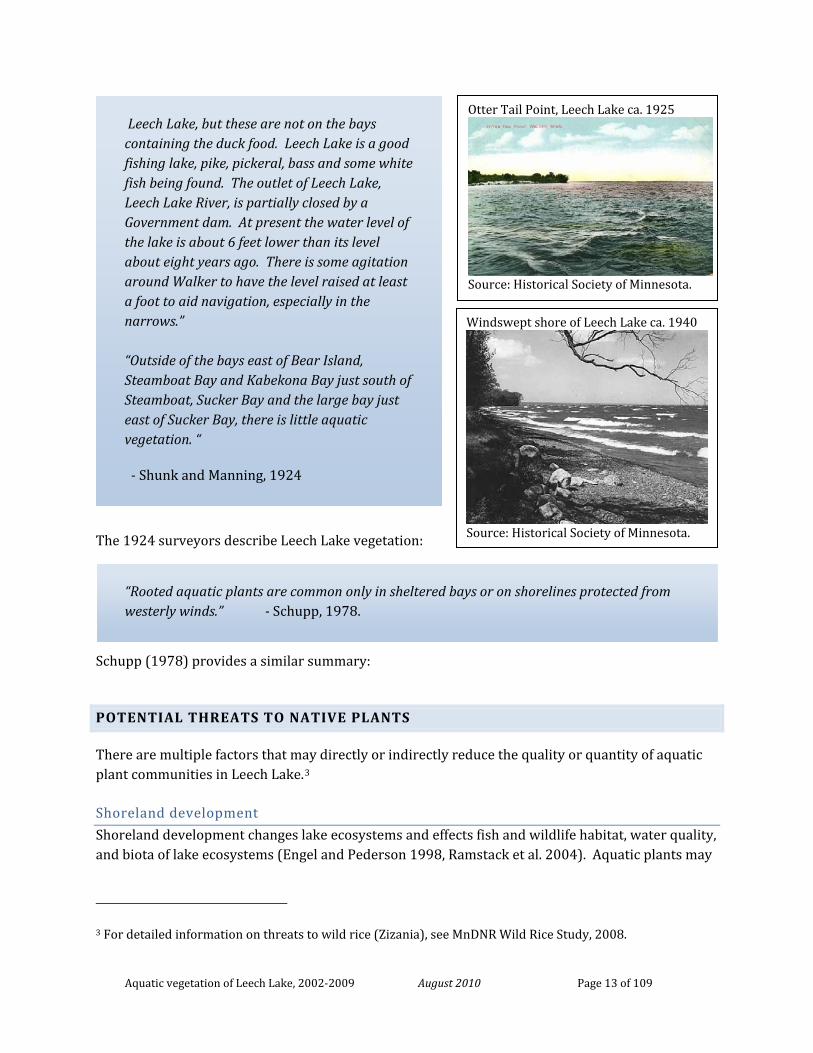
Aquatic vegetation of Leech Lake, 2002-2009 August 2010 Page 13 of 109
Otter Tail Point, Leech Lake ca. 1925
Source: Historical Society of Minnesota.
Windswept shore of Leech Lake ca. 1940
Source: Historical Society of Minnesota.
The 1924 surveyors describe Leech Lake vegetation:
Schupp (1978) provides a similar summary:
POTENTIAL THREATS TO NATIVE PLANTS
There are multiple factors that may directly or indirectly reduce the quality or quantity of aquatic plant communities in Leech Lake.3
Shoreland development
Shoreland development changes lake ecosystems and effects fish and wildlife habitat, water quality, and biota of lake ecosystems (Engel and Pederson 1998, Ramstack et al. 2004). Aquatic plants may
3 For detailed information on threats to wild rice (Zizania), see MnDNR Wild Rice Study, 2008.
“Rooted aquatic plants are common only in sheltered bays or on shorelines protected from westerly winds.” - Schupp, 1978.
Leech Lake, but these are not on the bays containing the duck food. Leech Lake is a good fishing lake, pike, pickeral, bass and some white fish being found. The outlet of Leech Lake, Leech Lake River, is partially closed by a Government dam. At present the water level of the lake is about 6 feet lower than its level about eight years ago. There is some agitation around Walker to have the level raised at least a foot to aid navigation, especially in the narrows.” “Outside of the bays east of Bear Island, Steamboat Bay and Kabekona Bay just south of Steamboat, Sucker Bay and the large bay just east of Sucker Bay, there is little aquatic vegetation. “
- Shunk and Manning, 1924
Aquatic vegetation of Leech Lake, 2002-2009 August 2010 Page 14 of 109
be indirectly affected by increased nutrient and sediment loading and decreased water clarity. Studies that compared developed and undeveloped lake sites found less plants and lower diversity at developed sites (Elias and Meyer 2003, Byran and Scarnecchia 1992, Jennings et al. 2003). Decreases in water clarity can also restrict aquatic plants to only shallow depths where they can obtain sufficient sunlight.
Shoreland development can also directly impact aquatic plants if developers and landowners destroy vegetation to create beach areas adjacent to the shore. Emergent plants, such as bulrush, are particularly susceptible to this type of activity because they often do not regenerate after initial cutting. Radomski (2006) determined that floating-leaf and emergent vegetative cover in central Minnesota lakes was negatively affected by development for the period from 1939 to 2003.
Motorboat activity Motorboats can harm aquatic habitat by cutting and/or uprooting plants (Asplund 2000) and by increasing turbidity (Yousef et al 1980) and increasing wave action (Vermaat and de Bruyne 1993). At sites that are repeatedly disturbed (ex. boat channels), changes to sediment type may further prevent or slow recolonization (Zieman 1976). Both emergent plants, like wild rice (Tynan 2000), and submerged plants (Asplund 2000) can be harmed by motorboats.
Water level changes Naturally occurring water level fluctuations are important for the plant communities of Leech Lake. Artificially high and stable water levels may result in increased erosion, loss of fish spawning and foraging habitat, loss of wild rice beds, loss of aquatic vegetation, loss of open beach habitat, and the loss of wildlife due to winter drawdown (ACOE 2009). Water level increases can uproot wild rice plants and the floating-leaf stage of wild rice is particularly sensitive to water level changes.
Invasive species Several new non-native species have recently become established in Leech Lake but it is difficult to predict how they may interact with native plants. Certain management activities to control invasive plants also have the potential to impact native plants, particularly if native plants occur within control areas.
Non-native aquatic animals Non-native aquatic animals that have become established in Leech Lake include rusty crayfish and banded mystery snails. These species may have direct and indirect impacts on aquatic vegetation.
Rusty crayfish (Orconectes rusticus) were first documented in Leech Lake in 1990 (Helgen 1990) but their distribution and abundance within the lake has not been quantitatively assessed. Crayfish, in general, and rusty crayfish in particular, can directly impact aquatic macrophytes by cutting and eating plants (Lodge and Lorman 1987). Crayfish also clip or uproot macrophytes as they burrow or feed on epiphytic snails. Crayfish activity may have both negative and positive impacts to the plant community (Pintor and Soluk 2006). Large numbers of crayfish may not lead to high plant consumption because, for example, the presence of snails may provide a supplemental food source (Olson, et al. 1991). Maezo (2010) also suggests that in some lakes, specifically large lakes with
Aquatic vegetation of Leech Lake, 2002-2009 August 2010 Page 15 of 109
high amounts of cobble, plant beds may not be a preferred habitat for crayfish (and thus there may be little opportunity for grazing within those beds despite a lake-wide abundance of crayfish). When rusty crayfish do graze plants, resulting impacts to aquatic plant communities may include overall decreased plant abundance, decreased plant species richness, and shifts in plant community composition.
Banded mystery snails (species in the Bellamya/Cipangopaludina) are native to southeastern United States. They have been found in Leech Lake and appear to be increasing rapidly. In 2009, they were observed scattered along a beach but by 2010, small windrows were observed in some areas (S. Mortensen, pers. communication). These non-native snails can form dense aggregations but their specific impacts to vegetation have not been examined.
Non-native emergent plants Several non-native emergent aquatic plants occur on the shoreline of Leech Lake and/or in adjacent wetlands. These plants have the potential to crowd out native wetland plants. Purple loosestrife (Lythrum salicaria) has primarily been documented along the western shores and islands of Leech Lake, but also occurs in wetland at the southeast shore. Biological control insects appear to be slowing its spread, but monitoring of this invasive can be difficult in remote wetlands.
Broad-leaf cattail (Typha latifolia) is native to the Leech Lake area but is being displaced by narrow-leaf cattail (Typha angustifolia) and hybrid cattail, species that were not historically present in central and northern Minnesota. They are more aggressive and will grow into much deeper water than broad-leaf cattail. As narrow-leaved cattails expand in distribution around Leech Lake, they displace plants such as sedges, broad-leaf cattails, and possibly wild rice.
Non-native submerged plants Eurasian watermilfoil (Myriophyllum spicatum) was first found in Leech Lake in 2004. Fragments of the non-native submerged plant, curly-leaf pondweed (Potamogeton crispus), were first located in Leech Lake in 2005 but, to date, rooted plants have not been located. These plants have the ability to grow abundantly in shallow water and could potentially out-compete native plants.
SURVEY OBJECTIVES
The 2002-2009 surveys represent the first quantitative assessment of Leech Lake’s aquatic plant communities. It describes the current aquatic plant community by meeting the following objectives:
1. Compile a list of all plant taxa found in the lake.
2. Estimate the maximum depth of plant colonization.
3. Estimate the percentage of the lake bottom that supports aquatic vegetation
4. Estimate the abundance (frequency of occurrence) of the commonly occurring plant taxa
Aquatic vegetation of Leech Lake, 2002-2009 August 2010 Page 16 of 109
5. Compare submerged plant abundance and community composition at different depths
6. Map the general distribution of aquatic vegetation and selected taxa
General comparison of current data and historical descriptive data are also discussed.
METHODS
LAKE-WIDE PLANT SURVEY USING A GRID SURVEY (2002-2005)
The vegetation of Leech Lake was surveyed between 2002 and 2005 using a grid point-intercept method described by Madsen (1999). Surveys were conducted between mid June and August of each year. For logistical reasons, the lake was divided into 14 different sections for survey. Where present, natural delineations, such as bays, were used to designate survey sections. Each lake section was surveyed once over the four year period. Agency Bay and Sucker Bay were surveyed in 2002, Steamboat Bay, Whipholt Area and Kabekona Bay in 2003, Portage Bay in 2004, and Walker Areas, Traders Bay, Submarine Island Area, Headquarters Bay, Boy Bay and Shingobee Bay in 2005 (Figure 10). In 2002, staff from both agencies surveyed Agency and Sucker Bays to help ensure consistent sampling between the two agencies. Results from each agency were similar (surveyors found same species, similar number of species per site, similar maximum depth of vegetation growth). LLDRM staff surveyed Steamboat Bay and Boy Bay and MnDNR staff surveyed the remaining sections.
Number of survey points per lake section A Geographic Information System (GIS) computer program was used to establish aquatic plant survey points in a grid pattern across the lake. Sample points were evenly spaced within each lake section. Spacing varied among each lake section in order to establish a minimum of 175 survey points within the littoral zone (vegetated area) of each lake section. Distance between sample points was determined by littoral area and littoral zone width. For most lake sections, sample points were spaced on a 200 meter by 200 meter grid. In lake sections with narrow littoral zones, a 200 meter spacing would have resulted in too few sample points. Therefore, grid spacing was reduced to 100 meters in Agency and Kabekona Bays, 70 meters in Walker Center and Walker South, and to 40 meters in Shingobee Bay (Table 1, Figure 11). The grid spacing of 200 meters, used in most lake sections, resulted in approximately one survey point for every 10 acres of littoral area. In lake sections with narrow littoral zones and a smaller grid spacing, survey effort ranged from one point per 0.5 acres to one point per 3 acres.
Survey points were established across the entire lake basin but initial field investigations determined that vegetation was sparse beyond a depth 20 feet and therefore, water depths greater than 24 feet were not always sampled. To avoid unnecessary damage to vegetation, surveyors did not motor into emergent and/or floating-leaf plant beds. Survey sites that occurred within these
Aquatic vegetation of Leech Lake, 2002-2009 August 2010 Page 17 of 109
areas were not physically sampled but surveyors made note of the dominant plant type present. These non-surveyed sites were not included in the data analyses.
The number of survey points in each lake section ranged from 175 in Kabekona Bay to 2,098 in the Whipholt Area (Table 1). A total of 9,859 sample points were surveyed including 9,720 points within the shore to 24 feet depth zone and 137 points that occurred in 25 feet (Table 3).
Sampling technique Surveys were conducted by boat with two or three surveyors. Surveyors navigated to each site using a handheld Global Positioning (GPS) unit. Surveyors attempted to navigate within 15 feet of the actual location and precision varied due to wind and boater experience. One side of the boat was pre-selected as the sampling side. At each sample site, surveyors recorded water depth in one foot increments using an electronic depth finder, or a measured stick in water depths less than eight feet. At each survey site, surveyors approximated a one meter squared area and recorded any plant taxa visible from the boat surface. A double-headed garden rake (Figure 12), attached to a rope was used to survey vegetation not visible from the surface. Taxa were identified recorded to the lowest level possible (typically to the species level). In addition to specific sampling at each survey point, surveyors made observations of vegetation as they navigated between sample sites. Surveyors recorded any additional species observed outside of the sample site as present in the lake.
Plant taxonomy and nomenclature Plant identification follows Crow and Hellquist (2000) and taxonomy follows MnTAXA (2009). Voucher specimens were collected to document plant species in the lake and were submitted to The Herbarium of the University of Minnesota Bell Museum of Natural History, St. Paul, MN or are currently stored at the MnDNR in Brainerd.
Data management Data were entered into a Microsoft Access database and then exported to an Excel spreadsheet and GIS program for additional analyses. Frequency of occurrence was calculated for each taxon as the number of sites in which the taxon occurred divided by the total number of sample sites within the “vegetated zone” (0-24 feet). Data were also analyzed for eight depth zones in three feet increments (i.e. 0-3 feet, 4-6 feet, 7-9 feet, etc.) (Table 3). The data are currently maintained by the authors and stored at the MnDNR office in Brainerd.
EMERGENT AND FLOATING-LEAF PLANT BED MAPPING (2008-2009)
Since surveyors did not motor into emergent and floating-leaf plant beds, the grid point-intercept survey method underestimated the frequency of these plants. In other words, the frequency estimates for floating-leaf and emergent plants are only applicable to the lake areas that were sampled. Because of the importance of these communities in Leech Lake, surveyors conducted additional mapping of these plant beds using a combination of aerial photo delineation and interpretation and field delineation. Plant beds were grouped into categories based on the
Aquatic vegetation of Leech Lake, 2002-2009 August 2010 Page 18 of 109
dominant plant taxa found in the bed (Table 4) and mapped using the technique most appropriate for the dominant taxa.
Wild rice mapping LLDRM staff mapped wild rice beds in 2005 and 2006 using a combination of aerial photo delineation and field inventory (Knowles et al 2007). Plant bed polygons were modified by MnDNR using additional field data collected in 2008 and 2009. The resulting maps represent approximate areas where wild rice occurred between 2006 and 2009.
Bulrush (and other plant bed) mapping Field mapping focused on bulrush (Schoenoplectus spp.) beds, which were difficult to see on aerial photos. Bulrush beds were mapped in 2008 and 2009 using handheld GPS technology. In 2008, Portage, Kabekona, Agency, Submarine Island, Walker Center, part of Walker North, Walker South and Shingobee Bays were mapped. In 2009, Steamboat, Headquarters, Boy, Sucker, Whipholt Area, Traders Bays, and the rest of Walker North were mapped.
Using global positioning systems (GPS) delineation, surveyors mapped bulrush stands by boating or walking around the edge of any monospecific bulrush stand or mixed emergent vegetation that included bulrush. Bow-mounted electric trolling motors were used to minimize damage to plants. Hand-held Garmin GPS Map 76S or Map 76C units were used for all surveys and units were set to automatically collect location data at a fixed 5-second interval. Bulrush stands greater than 10 square meters were directed to be mapped.
GPS data were imported into a geographic information system (GIS) for processing (ArcMap version 9.3). GPS track lines were edited to create bulrush stand polygons. This was accomplished by snapping near-shore bulrush stand track lines to the land/lake boundary layer and by connecting track lines of off-shore stands. After each survey created bulrush polygons for each mapped vegetation stand, whole-lake estimates of bulrush stand coverage (acres) were determined. Waterlily beds were delineated using 2003-2004 and 2008 Farm Service Administration (FSA) true color aerial photos. Black and white aerial photos from 1999 were used to help distinguish the true shoreline from mats of perennial vegetation.
ADDITIONAL PLANT SURVEYS
Beginning in 2004 and continuing on an annual basis, staff from DNR Invasive Species Program conducted special field surveys of Leech Lake harbors to search for Eurasian watermilfoil (Myriophyllum spicatum). In the spring of 2005, 2007, and 2008, DNR staff searched the Federal Dam access area for the curly-leaf pondweed (Potamogeton crispus).
Surveyors searched for unique and rare plant species in 2006 and 2009 during the lake-wide point-intercept surveys and in 2007 during the near-shore plot surveys. A targeted search for rare aquatic vascular plants was conducted by the Minnesota County Biological Survey Program on July 23, 2008 (Myhre 2008). This search focused on sites that were most likely to contain rare plant species. Botanists use professional experience to select rare species search sites and include factors
Aquatic vegetation of Leech Lake, 2002-2009 August 2010 Page 19 of 109
such as shoreline development, substrate type, water depth, and native plant community type in their site selection. To gain access to shallow vegetated areas, searches are conducted by slowly kayaking, canoeing and/or wading through the site. A brief habitat description and a list of all plant taxa found in the search area were recorded.
HISTORICAL PLANT DATA COMPILATION
Plant species lists Prior to fieldwork, surveyors reviewed MnDNR Fisheries Lake Files and queried the University of Minnesota Herbarium Vascular Plant Collection database to develop a list of plant taxa previously been documented in Leech Lake.
Surveyors also obtained known locations of state listed rare aquatic plants in Leech Lake from the Rare Features Database of the MN DNR Natural Heritage Information System.
1957 map interpretation A digital scan of the 1957 DNR Lake Sounding map was created and rectified in a GIS computer program. Each plant bed was assigned to one of four categories based on the plant species codes listed for that polygon: wild rice, bulrush, muskgrass and mixed pondweed bed.
RESULTS
PLANT DISTRIBUTION AND FREQUENCY
Aquatic plants were found from shore to a depth of 24 feet. About 75% of Leech Lake is less than 25 feet in depth, but plants were not uniformly distributed in these shallow areas. Within the 0-24 feet depth zone, aquatic plants occurred in only 39% of the survey sites (Figure 13, Table 5). This represents an area of about 33,000 acres, or about 29% of the entire lake.
Plant frequency decreased with increasing water depth (Figure 14). Plants were most common in depths of 0 to 9 feet where 72% of the sites were vegetated. In water depths of 10 to 18 feet, 33% of the sites were vegetated and in depths greater than 18 feet, only 4% of the sites contained plants.
The maximum depth at which plants were found ranged from 11 feet in Headquarters Bay to 24 feet in Walker Center. However, since vegetation was sparse in depths greater than 18 feet, it is more meaningful to compare the depth (or depth range) where plant frequency meets a minimum value. For our purposes, we define this minimal frequency value as 10%. In most survey areas, the maximum depth zone where plant occurrence was at least 10% was the 16-18 feet depth zone. In Sucker Bay and Portage Bay South, this minimal plant occurrence extended to the 19-21 feet depth zone. In Walker North and Walker South, the minimal plant occurrence was in shallower water of 13-15 feet.
Aquatic vegetation of Leech Lake, 2002-2009 August 2010 Page 20 of 109
Protected bays Plant frequency was highest in the shallow, protected bays (Steamboat, Headquarters, and Boy Bays) where more than 80% of all sites were vegetated (Table 5). In protected bays that contained a deep zone (>15 feet) (Sucker, Kabekona and Shingobee Bays) vegetation was abundant in shallow water (0-15 feet), with at least 75% of sites containing vegetation (Table 5) and decreased with increasing water depth (Figure 15). Maximum depth of plant growth ranged from nine feet in Steamboat Bay to 19 feet in Sucker and Shingobee Bays. Plants were evenly distributed around the shores of these basins.
Moderately protected bays In bays that receive moderate exposure to wind and waves (Portage Bay North, Agency Bay, Walker Bay Areas), plant frequency ranged from 47% to 61% within the 0-15 feet depth zone (Table 5). Although the southwest side of Portage Bay North is shallow (<15 feet), vegetation in this area was sparse. In the Walker Bay Areas and in Agency Bay, shorelines with steep depth contours lacked vegetation. Maximum depth of plant growth ranged from 15 feet in Walker Bay North to 18 feet in Portage Bay North and Agency Bay.
Exposed areas The main basin of Leech Lake (including the Whipholt, Traders Bay, Submarine Island and Portage Bay South survey areas) contains the least amount of vegetation with 12-30% of the shallow area (0-15 feet) vegetated and fewer than 30% of all sites (0-24 feet) vegetated (Table 5). Maximum depth of plant growth ranged from 17 feet in the Submarine Island Area to 22 feet in the Whipholt Area. The largest area of plant growth occurred off the west side of Bear Island and extending north along the east shore of Portage Bay (Figure 11). Other areas of plant growth were in two small bays on the southern Whipholt shore, the Trader’s Bay Area, and to the southwest of Pelican Island (Figure 13).
PLANT SPECIES COMPOSITION
Between 1924 and 1999, 36 taxa of aquatic plants were recorded in Leech Lake, including 10 emergent, 3 floating-leaved, 3 free-floating and 20 submerged taxa (Table 6). During the current survey (2004-2009), 49 taxa of native aquatic plants were identified including 15 emergent, four floating-leaved, three free-floating and 27 submerged taxa (Table 6). Nearly half of these taxa (8 emergent, 1 floating-leaved and 14 submerged plants) were identified for the first time in the lake. New native plants found in recent years were likely due to increased surveyor effort.
Two rare species, Sheathed pondweed (Stuckenia vaginata) and Clustered burreed (Sparganium glomeratum) were not relocated during this current survey. These species may still be present in the lake but may have not been detected if they occur at low frequencies.
Two non-native submerged taxa, curly-leaf pondweed (Potamogeton crispus) and Eurasian watermilfoil (Myriophyllum spicatum) were observed during the surveys.
Aquatic vegetation of Leech Lake, 2002-2009 August 2010 Page 21 of 109
Life form abundance by water depth Emergent and floating-leaf taxa were restricted to depths of 13 feet and less (Figure 16) but were most often found in depths of six feet and less where they occurred in 17% and 7% of the sites, respectively. Submerged plants were the most frequently occurring plant life form at each water depth and accounted for 87% of all plants found in depths less than three feet and for 99% of all plants found in depths greater than three feet. Free-floating plants were found to 21 feet but were most common in depths of 6 feet and less.
Number of taxa by water depth The greatest number of plant taxa was found in water depths from zero to six feet, where emergent, floating-leaf, free-floating and submerged plants co-occurred. As water depth increased, fewer plant taxa were found. Only submerged and free-floating plants occurred in depth greater than 13 feet and only seven taxa were found beyond the 20 feet depth (Figure 17).
Number of taxa per sample site Although 49 different plant taxa were found in the lake, most sample sites that contained plants had only one or two taxa. The number of plant taxa found per site (richness) ranged from one to nine. For vegetated sites, the mean number of plant taxa per site was two. Mean taxa richness was greatest (three taxa) in the 0-3 feet water depth zone and decreased with increasing water depth (Figure 18). In depths greater than 15 feet, most vegetated sites contained only one taxon.
Sites in shallow protected bays contained the highest number of taxa. As many as nine taxa per site were found in Shingobee Bay, Kabekona Bay, Steamboat Bay, Headquarters Bay, Boy Bay, the north end of Sucker Bay, and the north end of Portage Bay (Figure 19). Outside of these protected bays, sites typically contained only one plant taxon or no vegetation.
EMERGENT AND FLOATING-LEAVED PLANTS
Emergent and floating-leaved plants were primarily restricted to water depths of six feet and less and about 18,000 acres (or 17% of the surface area of Leech Lake) are within this depth zone (Figure 20). Based on in-lake mapping and aerial photography review, about 5,800 acres, or one-third of this shallow area contain emergent and/or floating-leaf plants (Table 7, Figure 21). Major sites of emergent and floating-leaf vegetation were Steamboat Bay (1,644 acres), Headquarters Bay (1,201 Acres), Portage Bay (1,104 acres) and Boy Bay (943 acres).
Wild rice (Zizania palustris) Wild rice (Zizania palustris) (Figure 22a) is an annual plant that germinates each year from seed that fell to the lake bottom in the previous fall. The plant begins growth underwater and then forms a floating-leaf stage before becoming fully emergent.
Wild rice is found in water depths of up to six feet and prefers soft substrates of muck or silt (Voss 1972, Lee 1986, Nichols 1999). It grows best in shallow water, where there is at least a slight current and little competition from other plants (Voss 1972, MnDNR 2008b). In addition to its
Aquatic vegetation of Leech Lake, 2002-2009 August 2010 Page 22 of 109
ecological value as habitat and food for wildlife, wild rice has important cultural and economic values in Minnesota (MnDNR 2008b).
This valuable plant is increasingly threatened by factors such as lakeshore development and increased water recreational use (MnDNR 2008b). Wild rice is susceptible to disturbance from storms and motorboats because it is weakly rooted to the lake bottom. It is also vulnerable to water level fluctuations, particularly during the floating-leaf stage in Spring and early Summer.
Wild rice was the most frequently found emergent in Leech Lake and covered about 4,540 acres (Table 6). This includes about 4,223 acres that was dominated by wild rice as well as 319 acres of “mixed wild rice”. Mixed wild rice stands included other emergent plants, such as bulrush, giant cane or cattails and/or floating-leaf plants, such as white waterlily, yellow waterlily and floating-leaf pondweed.
Wild rice formed extensive beds in Boy, Headquarters and Steamboat Bays as well as the northern ends of Sucker, Portage and Kabekona Bays (Figure 21). It was not found along shallow sandy shores, such as the southeast shore of Portage Bay or in Trader’s Bay.
Wild rice occurred to a maximum depth of 13 feet but was most common in the 0-3 feet depth zone where it was found in 22% of the sites (Figure 23).
Bulrush (Schoenoplectus spp.) Bulrushes (Schoenoplectus spp.) (Figure 22b) are perennial rooted emergent plants that may occur to depths of 5 to 13 feet on sand, gravel, marl or peat (Nichols 1999). It may grow in pure stands or with other emergents and waterlilies. Bulrush spreads by rhizomes and regeneration is most successful on very shallow sites. This plant absorbs nutrients that reduce water quality, reduces erosion from waves, and provides important fish cover for nesting and juvenile nursery areas. Restoration of bulrush beds can be very difficult, making established beds particularly unique and valuable. Approximately 1,315 acres of bulrush were mapped in Leech Lake (Table 7), included 841 acres dominated by bulrush, 474 acres of mixed bulrush and wild rice, and 17 acres of mixed bulrush and other emergent and/or floating-leaf species. The majority (66%) of sites that contained bulrush also contained submerged plants, of which muskgrass (Chara sp.) was the most common taxa. Extensive stands of bulrush were found in Portage Bay, the southeast shore of Sucker Bay, and Steamboat Bay (Figure 21). Bulrush occurred to a depth of 6 feet but was most frequent in the 0-3 feet depth zone where it was found in 12% of the sites (Figure 23).
Other native emergent plants Other emergent plants covered about 17 acres and included giant cane (Phragmites australis), burreed (Sparganium spp.) spikerush (Eleocharis spp.), cattail (Typha spp.) and arrowhead (Sagittaria spp.) (Figure 22 c-g). These plants were mostly found in depths of 5 feet and less.
Aquatic vegetation of Leech Lake, 2002-2009 August 2010 Page 23 of 109
Waterlilies and other floating-leaf plants In Leech Lake, floating-leaved plants occurred in protected bays such as Shingobee, Kabekona and the far northern portion of Portage Bay (Figure 21). Floating-leaf plants included white waterlily (Nymphaea odorata), yellow waterlily (Nuphar variegata), floating-leaf pondweed (Potamogeton natans) and floating-leaf burreed (Sparganium sp.) (Figure 22h-k). They were most common in depths from 0-3 feet where yellow waterlily was found in 12% of the sites, white waterlily in 5% and floating-leaf pondweed in 5% (Figure 23).
Ninety-five percent of sites that contained floating-leaved plants also contained at least one submerged or emergent taxa. Most sites that contained white waterlily or yellow waterlily also contained wild rice and submerged plants such as coontail (Ceratophyllum demersum) and bladderworts (Utricularia spp). Floating-leaf pondweed often co-occurred with muskgrass (Chara sp.) and bushy pondweed (Najas flexilis).
SUBMERGED PLANTS
Submerged plants included non-flowering plants such as large algae as well as rooted flowering plants. Most of the submerged plants grew entirely beneath the water surface but some formed flower stalks and/or floating leaves that emerged above the water. Submerged plants included a wide variety of forms, from low-growing plants that formed “carpets” on the lake bottom, to upright plants with stems that may reach the water surface in shallow depths. This group includes plants that are anchored to the lake bottom as well as plants that drift freely with water currents.
Submerged plants occurred to a depth of 24 feet in Leech Lake but were sparse (frequency less than 10%) in depths greater than 18 feet. The large algae, muskgrass (Chara sp.) was the most frequently occurring submerged plant and accounted for 37% of all plants recorded. Of the other 26 native submerged, only 8 occurred with a lake-wide frequency of 2% or more.
Three general types of submerged plant communities can be described in Leech Lake: monotypic beds of muskgrass, mixed beds of muskgrass and flowering submerged plants, and beds of flowering submerged plants with no muskgrass (Figure 24).
Muskgrass (Chara sp.) Muskgrass (Chara sp.) is a submerged algae that grows in large colonies and resembles higher plants. Unlike higher plants, it does not form true roots, stems or flowers. Muskgrass is named for the “musky” odor and can also be recognized by its rough, brittle texture. Muskgrass grows well on sandy or sandy-silty lake bottoms and can withstand moderate to heavy wave activity. In Leech Lake, muskgrass grows as a low-growing “carpet” along the lake bottom and does not typically reach the water surface. Beds of muskgrass provide critical cover and food, particularly for young fish. Invertebrates found within beds of muskgrass provide additional grazing for fish and waterfowl.
Lake-wide distribution Muskgrass occurred in 26% of the sample sites within the shore to 24 feet depth zone (Table 8, Figure 24). It was found to a maximum depth of 24 feet and a median depth of nine feet (Figure
Aquatic vegetation of Leech Lake, 2002-2009 August 2010 Page 24 of 109
17). It was the most frequent occurring plant at all water depths but was most common in the 3-9 feet zone, where it occurred 44% of the sample sites. Muskgrass was found throughout the vegetated areas of Leech Lake either in monotypic beds or within mixed beds of other plants. In the majority (48%) of sites that contained vegetation, muskgrass was the only plant present (Figure 24).
Occurrence by lake survey section Within individual lake survey sections, muskgrass frequency ranged from 3% to 59% (Table 8). It was most frequent in Headquarters, Boy and Kabekona Bays, where it occurred in more than 50% of sites, most often co-occurring with other submerged plants. Monotypic stands of muskgrass were found in eastern lake areas that received heavy to moderate wind/wave exposure (Portage Bay South, Whipholt, Traders Bay, Submarine Island Areas), where it was often the only plant found, particularly in depths greater than 9 feet (Figure 25a). In these heavily exposed sites, muskgrass frequency was similar (often 20-30%) at most vegetated depths and vegetation did not increase in shallow water as found in other lake areas. One of the largest monotypic beds of muskgrass occurred on the east side of Leech Lake, extending along the east shore of Portage Bay, the west side of Bear Island and continuing southwest of Pelican Island (Figure 22). The bed occupied an area of about 6,000 acres (about 15 miles in length and up to 1 mile in width), including some open patches (non-vegetated areas) west of Bear Island. Mean water depth in this area was 15 feet.
In the western half of the lake, muskgrass was found to be the only taxa present in most sites within moderately exposed (the Walker areas, Agency Bay) areas (Figure 25b).
Mixed stands of muskgrass and other vegetation occurred in 19% of the vegetated sites. Mixed beds of vegetation were common in Headquarters and Boy Bays, the north end of Portage and Sucker Bays, Steamboat Bay, Kabekona Bay and the Walker North area. (Figure 25 c,d) Muskgrass was infrequent in Shingobee Bay and shallow areas of other bays where other plants dominated.
Muskgrass as habitat for muskies In Leech Lake, muskgrass beds occurring in depths of 3-6.5 feet have been identified as optimal habitat for muskellunge spawning (Strand 1986). Within this depth zone, muskgrass occurred in 45% of the survey sites, either as pure beds or mixed with other vegetation (Figure 26). Areas of mixed muskgrass beds in depths of 3-6.5 feet include portions of Steamboat, Headquarters, Boy and Kabekona Bays. Pure beds of muskgrass in 3-6.5 feet of water included the north end of Agency Bay, the west shore of Walker Area, and the east shore of Portage Bay.
Other Submerged Plants Leech Lake contained a relatively high number of other submerged plants and their distribution was mostly concentrated in protected or moderately protected lake areas.
Aquatic vegetation of Leech Lake, 2002-2009 August 2010 Page 25 of 109
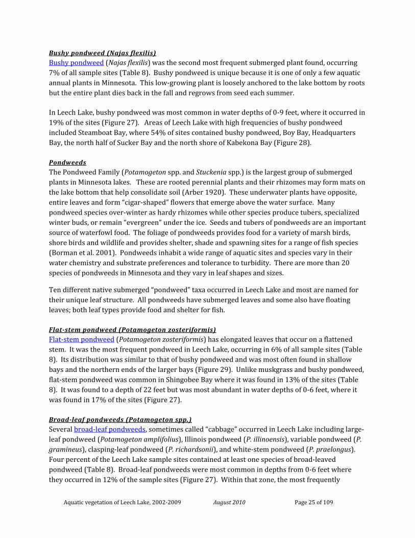
Bushy pondweed (Najas flexilis) Bushy pondweed (Najas flexilis) was the second most frequent submerged plant found, occurring 7% of all sample sites (Table 8). Bushy pondweed is unique because it is one of only a few aquatic annual plants in Minnesota. This low-growing plant is loosely anchored to the lake bottom by roots but the entire plant dies back in the fall and regrows from seed each summer.
In Leech Lake, bushy pondweed was most common in water depths of 0-9 feet, where it occurred in 19% of the sites (Figure 27). Areas of Leech Lake with high frequencies of bushy pondweed included Steamboat Bay, where 54% of sites contained bushy pondweed, Boy Bay, Headquarters Bay, the north half of Sucker Bay and the north shore of Kabekona Bay (Figure 28).
Pondweeds The Pondweed Family (Potamogeton spp. and Stuckenia spp.) is the largest group of submerged plants in Minnesota lakes. These are rooted perennial plants and their rhizomes may form mats on the lake bottom that help consolidate soil (Arber 1920). These underwater plants have opposite, entire leaves and form “cigar-shaped” flowers that emerge above the water surface. Many pondweed species over-winter as hardy rhizomes while other species produce tubers, specialized winter buds, or remain “evergreen” under the ice. Seeds and tubers of pondweeds are an important source of waterfowl food. The foliage of pondweeds provides food for a variety of marsh birds, shore birds and wildlife and provides shelter, shade and spawning sites for a range of fish species (Borman et al. 2001). Pondweeds inhabit a wide range of aquatic sites and species vary in their water chemistry and substrate preferences and tolerance to turbidity. There are more than 20 species of pondweeds in Minnesota and they vary in leaf shapes and sizes.
Ten different native submerged “pondweed” taxa occurred in Leech Lake and most are named for their unique leaf structure. All pondweeds have submerged leaves and some also have floating leaves; both leaf types provide food and shelter for fish.
Flat-stem pondweed (Potamogeton zosteriformis) Flat-stem pondweed (Potamogeton zosteriformis) has elongated leaves that occur on a flattened stem. It was the most frequent pondweed in Leech Lake, occurring in 6% of all sample sites (Table 8). Its distribution was similar to that of bushy pondweed and was most often found in shallow bays and the northern ends of the larger bays (Figure 29). Unlike muskgrass and bushy pondweed, flat-stem pondweed was common in Shingobee Bay where it was found in 13% of the sites (Table 8). It was found to a depth of 22 feet but was most abundant in water depths of 0-6 feet, where it was found in 17% of the sites (Figure 27).
Broad-leaf pondweeds (Potamogeton spp.) Several broad-leaf pondweeds, sometimes called “cabbage” occurred in Leech Lake including large-leaf pondweed (Potamogeton amplifolius), Illinois pondweed (P. illinoensis), variable pondweed (P. gramineus), clasping-leaf pondweed (P. richardsonii), and white-stem pondweed (P. praelongus). Four percent of the Leech Lake sample sites contained at least one species of broad-leaved pondweed (Table 8). Broad-leaf pondweeds were most common in depths from 0-6 feet where they occurred in 12% of the sample sites (Figure 27). Within that zone, the most frequently
Aquatic vegetation of Leech Lake, 2002-2009 August 2010 Page 26 of 109
occurring species were clasping-leaf pondweed and large-leaf pondweed, which were found in 5% and 4% of the sites, respectively.
Broad-leaf pondweed occurred in mixed beds, often found with flat-stem pondweed and northern watermilfoil. Sites with broad-leaf pondweeds included all of the shallow bays, the north half of Sucker Bay, the northwest shore of Portage Bay and the east shore of Bear Island (Figure 30).
Narrow-leaf pondweeds (Potamogeton spp and Stuckenia spp.) Narrow-leaf pondweeds occurred in 1% of the survey sites (Table 8) and did not dominate at any water depth. These include species that can be difficult to identify if not found in flower or fruit. Fries’ pondweed (Potamogeton friesii), small pondweed (P. pusillus), straight-leaved pondweed (P. strictifolius), sago pondweed (Stuckenia pectinata) and filiform pondweed (S. filiformis) were positively identified in the lake, but additional narrow-leaf species may have also been present. Narrow-leaf pondweed plants were found to a depth of 20 feet (Figure 17) but were not common at any depth zone. Areas where narrow-leaf pondweeds were found include the north end of Shingobee Bay and the northern ends of Portage and Sucker Bays (Figure 31).
Wild celery (Vallisneria americana) Wild Celery (Vallisneria americana) is a rooted, perennial submerged plant with long, grass-like leaves. It is strongly rooted in the lake bottom and its leaves may extend six feet or more, depending on water depth (Korschgen and Green 1988). This plant forms winter buds that remain dormant until spring. Wild celery can produce seeds but it is capable of extensive clonal growth and a single plant can produce up to 30 new clones in a single growing season (Catling et al., 1994, Lokker et al., 1994.) Beds of wild celery provide food and shelter for fish and all parts of the plant are consumed by waterfowl, shorebirds and muskrats (Borman et al. 1997). Winter buds are a particularly important food source for canvasback ducks (Varro 2003).
Lake-wide, this species occurred in only 3% of all sample sites (Table 8) but was locally common in the protected areas of Headquarters, Boy, Sucker, Steamboat and Kabekona Bays (Figure 32). Water celery occurred to a depth of 21 feet and was most frequent depth of 4 to 9 feet where it occurred in 8% of the sites (Figure 27).
Canada waterweed (Elodea canadensis) Canada waterweed (Elodea canadensis) is a rooted, perennial submerged species that is widespread throughout Minnesota and is adapted to a variety of conditions. It is tolerant of low light and prefers soft substrates. This species can over winter as an evergreen plant and spreads primarily by fragments. The branching stems of this plant can form thick underwater plant beds that are valuable habitat for a variety of fish and invertebrates.
In Leech Lake, it occurred in 3% of all sample sites (Table 8) and occurred from shore to a depth of 21 feet but was most common in depths less than 7 feet (Figure 27). It was most often found within the shallow areas of the protected bays (Figure 33).

Aquatic vegetation of Leech Lake, 2002-2009 August 2010 Page 27 of 109
Northern watermilfoil (Myriophyllum sibiricum) Northern watermilfoil (Myriophyllum sibiricum) is a perennial, rooted submerged plant with spike-like flowers that extend above the water surface. The numerous finely divided leaves of this plant provide habitat for aquatic invertebrates and fish. Northern watermilfoil is often mistaken for the non-native invasive Eurasian watermilfoil (Myriophyllum spicatum). Northern watermilfoil has 5-10 leaflet pairs compared to 12-21 leaflet pairs for Eurasian watermilfoil. Northern watermilfoil prefers soft sediments of clearer water lakes (Borman et al. 1997). Northern watermilfoil occurred in 5% of the Leech Lake sites (Table 8) and was most frequent in depths of 0-6 feet (Figure 27). Northern milfoil was common in all of the shallow bays as well as the western shores of Portage and Walker areas (Figure 34).
Coontail (Ceratophyllum demersum) Coontail (Ceratophyllum demersum) is the most common submerged flowering plant in Minnesota lakes. It grows entirely submerged and is adapted to a broad range of lake conditions, including turbid water. Coontail is a perennial and can overwinter as a green plant under the ice and then begins new growth early in spring. Because it is only loosely rooted to the lake bottom it may drift between depth zones (Borman et al. 1997). Coontail provides important cover for young fish, including bluegills, perch, largemouth bass and northern pike. It also supports aquatic insects beneficial to both fish and waterfowl.
In Leech Lake, coontail occurred in only 3% of all survey sites (Table 8) but was the dominant submerged plant in Shingobee Bay where it occurred in 42% of the sites. Coontail was found to a depth of 23 feet (Figure 17) and, in addition to Shingobee Bay, it was primarily found along north shores of the lake (Figure 35) where its loosely anchored stems are blown into near-shore sites by prevailing winds.
Greater bladderwort (Utricularia vulgaris) Bladderwort is an entirely submerged plant except during bloom when its small, showy yellow flower extends above the water. Bladderwort often floats freely in the water column and may accumulate in sheltered bays. It reproduces by fragments and winter buds that can float to new areas of the lake. Bladderwort is an insectivorous plant and uses its small “bladders” to trap invertebrates. This species is weakly rooted to the substrate and often drifts freely through the water column.
Greater bladderwort (Utricularia vulgaris) occurred in 4% Leech Lake sites (Table 8). It was most common in depths of 0-6 feet of water (Figure 27). Its distribution was mostly limited to Kabekona Bay and Shingobee Bay (Figure 36).
Other submerged and free-drifting native species Lake-wide, all other native submerged species occurred in less than 3% of the sample sites and were not common within any lake section (Table 9). Stonewort (Nitella sp.) (Figure 37a) is a large algae similar to muskgrass but lacking a distinctive musky odor. It is not coarse in texture but resembles very fine hair and is often bright green in color. In Leech Lake it was the plant with the
Aquatic vegetation of Leech Lake, 2002-2009 August 2010 Page 28 of 109
highest median depth of occurrence of 16 feet (Figure 17). Other non-flowering plants included watermoss (Figure 37b) and a fern-like plant, quillwort (Isoetes sp.) (Figure 37c).
Rooted plants like mare’s tail (Hippuris vulgaris) (Figure 37d) and white water buttercup (Ranunculus aquatilis) (Figure 37e) were found in depths less than six feet. Free-drifting plants like small bladderworts (Utricularia sp.) (Figure 37f) and duckweeds (Lemna sp.) (Figure 37g) were also present, but infrequently found.
Rare aquatic plants Two rare (Special Concern) species have previously been documented in Leech Lake but were not found during recent surveys.
Sheathed pondweed (Stuckenia vaginata) Sheathed pondweed (Stuckenia vaginata) (Figure 37h) is a submerged plant that is closely related to Sago pondweed and the other narrow-leaf pondweeds that were found in the 2002-2009 surveys. It was reported in Leech Lake in 1927 but was not relocated during recent surveys. Look-a-like plants, sago pondweed (Stuckenia pectinata) and filiformis pondweed (Stuckenia filiformis) were found. Without fruits, S. vaginata can be difficult to identify. The original report did not include information on the abundance of the plant, so it is difficult to know whether the plant has declined in Leech Lake or if it has always been uncommon in the lake and therefore difficult to locate during surveys.
Clustered burreed (Sparganium glomeratum) Clustered burreed (Sparganium glomeratum) is an emergent aquatic plant that grows to about one to two feet in height with at least some of the leave emerging above the water surface. There are eight species of bur-reed in Minnesota and all of them are rather similar in appearance. Flowers are often needed to determine the exact species. Clustered bur-reed was located along a shoreline of Leech Lake in the early 1990’s but was not found during recent surveys. It may be present in wetland areas adjacent to the lake that were not searched during the aquatic plant surveys.
Non-native aquatic plants Curly-leaf pondweed (Potamogeton crispus) Curly-leaf pondweed (Potamogeton crispus) (Figure 38) is a non-native, submerged plant and fragments of the plant were first documented in Leech Lake in 2005. During the 2005 survey of Leech Lake, curly-leaf pondweed was found floating near docks at the Federal Dam Access, at the northeastern end of Portage Bay. No rooted plants were observed. Curly-leaf pondweed reaches its maximum growth during the spring and typically dies back by early summer. A spring searches for this species were conducted in 2006 and 2008 but no plants were found. In 2009, curly-leaf pondweed was found and removed from a harbor near Whipholt Beach.
Eurasian watermilfoil (Myriophyllum spicatum) The non-native species, Eurasian watermilfoil (Myriophyllum spicatum). (Figure 39) was first documented in Leech Lake in 2004 in several harbors along the western shore of Whipholt Area. During the lake-wide plant survey, it was not found in any of the survey sites, indicating its
Aquatic vegetation of Leech Lake, 2002-2009 August 2010 Page 29 of 109
abundance in the lake was relatively low. By 2009, it was located in harbors on both the north and south shores (Figure 40) but still remained a relatively minor component of the plant community. The Minnesota DNR arranged for control of Eurasian watermilfoil in all harbors where it was found from 2004 through 2009. This non-native species is adapted to survive in lower light levels than many native aquatic plants. It is not expected to grow in areas of high wave action, where native rooted plants cannot grow.
DISCUSSION
PLANT COMMUNITIES OF LEECH LAKE
Leech Lake supports a very high number of aquatic plant species, as expected for a north central Minnesota lake with relatively high water clarity and a diversity of physical habitats. The types of plants that occur in Leech Lake can be grouped into at least four general plant communities: wild rice, bulrush, mixed submerged, and muskgrass beds. But, these different plant communities are not distributed equally throughout the littoral zone (Figure 42).
Site conditions strongly influence the location and size of these plant communities. Light availability is often limiting factor in lake plant distribution (Dale 1986) and secondary factors may include water chemistry, sediment type, and wave action (Spence 1981, Wetzel 1975, Hutchinson 1975). In Leech Lake, all shallow water areas receive sufficient light. The water clarity / Secchi disc data summarized on page 11 documents some variability associated with the morphology of various sub-basin but average summer Secchi disc reading are 10 feet or better. Light limitation, if it occurs, is associated with plant coverage in deep-water areas. Plant growth is limited by heavy waves. Those patterns are striking and are described below. The location of individual species within a water body also depends on their initial ability to colonize the site and on their range of tolerance to any particular set of environmental conditions (Davis and Brinson 1980). This study did not collect data at a scale that would facility identifying site-specific patterns associated with a localized impact, e.g. aquatic plant management activity or motor boat use patterns.
Protected sites Three of the four plant communities (wild rice, bulrush and mixed submerged beds) are mostly restricted to relatively protected lake areas and factors like water depth and substrate type further determine species composition. These protected sites contained more vegetation and a higher number of plant taxa than other areas of Leech Lake. The plant communities of these lake areas provide critical habitat for fish, waterfowl and other aquatic life as well as water quality protection and shoreline stabilization.
Plant communities in these sites are particularly vulnerable to disturbance by motorboats and water level changes. Non-native plant species, like Eurasian watermilfoil, are also most likely to
Aquatic vegetation of Leech Lake, 2002-2009 August 2010 Page 30 of 109
grow in these protected sites, where they may out-compete native plants. High numbers of rusty crayfish could also harm native plants in these sites, though they may prefer areas with hard substrates.
Exposed sites Only muskgrass beds are well adapted to grow in highly exposed sites. As a primitive plant, muskgrass does not require oxygen for root systems and may thus be better adapted for growth in deep water (Dale 1986). Perhaps more importantly in Leech Lake, the low-growing Chara may be better able to withstand heavy wave activity than are the taller, branching species such as the broad-leaved pondweeds.
The extensive mats of muskgrass in Leech Lake provide habitat for fish and invertebrates and also help stabilize the bottom sediments and may help maintain, or increase water clarity. These beds may restrict the re-suspension of bottom sediments while still allowing sediment from the water layer to filter to the lake bottom (Van den Berg et al. 1997). This effect may be particularly important on Leech Lake where high wind has the potential to stir up exposed (un-vegetated) bottom sediments.
There are some mixed submerged plant beds in moderately exposed sites and disturbance in beds in these areas is particularly problematic because once removed re-establishment of these plants is unlikely.
CHANGE IN LEECH LAKE PLANT COMMUNITIES
Historical comparison The distribution of aquatic plants recorded in 1957 appears similar to that found in the recent survey. During both surveys, plants were most abundant in shallow bays and plant bed types (ie. Wild rice, bulrush, mixed pondweed, muskgrass) were found in the same general locations (Figures 41 and 42). Because of the different methods used to generate these maps, it is most appropriate to compare locations of plant beds and not aerial extent. This comparison is useful for detecting large changes in plant communities.
First, new areas of plant beds were recorded in 2008-2009 (such as the extensive muskgrass bed along the eastern shore) but these submerged plants may have been present in 1957 but not detectable from the water surface.
Second, several submerged plant beds were delineated in 1957 that were not observed in 2002-2009 surveys. In the Whipholt Area, pondweed beds were recorded on the southwest end of Bear Island, the north end of Pelican Island and south end of Pipe Island; a wild celery bed was found south of Bear Island (Figure 41). These sites were had no vegetation or only scattered muskgrass beds in 2002-2005. (Figure 42). Likewise, several bulrush beds were recorded in 1957 that were not mapped in this survey (Figure 41-42).
Aquatic vegetation of Leech Lake, 2002-2009 August 2010 Page 31 of 109
Third, wild rice locations appeared to be different between the two surveys, particularly in Boy, Headquarters and Sucker Bays. Additionally, the large floating bogs observed in 1957 in Headquarters Bay appear to have decreased in size.
Potential future changes in Leech Lake plant communities The annual abundance, distribution and composition of aquatic plant communities may change due to environmental factors, predation, the specific phenology of each plant taxa, introductions of non-native plant or animal taxa, and human activities in and around the lake. Multiple factors can influence plant communities at the same time. While it may be possible to detect a change in plant communities, it may not be possible to determine the cause or causes.
Many submerged plants are perennial and regrow in similar locations each year. However, a few species such as wild rice (Zizania palustris) and bushy pondweed (Najas flexilis) are annuals and are dependent on the previous year’s seed set for regeneration. These species are both relatively common in Leech Lake and annual changes in these species may also result in changes to other species (for example if bushy pondweed declines another species may invade the vacated area).
Non-native aquatic plant species that have been documented in Leech Lake include Purple loosestrife, narrow-leaf cattail, hybrid cattail, Eurasian watermilfoil and curly-leaf pondweed. The emergent plants have spread. The submerged are currently minor components of the plant communities. The presence of healthy native plant communities may help mitigate the harmful effects of these exotics, but some increase in the non-native plants may be likely. The non-native rusty crayfish and banded mystery snails may also impact plant communities in Leech Lake. In sites with high crayfish numbers, plant occurrence may decrease and/or there may be shifts in plant species composition. Impacts of banded mystery snails on vegetation is unknown.
Humans can impact aquatic plant communities directly by destroying vegetation with herbicide or by mechanical means. Motorboat activity in vegetated areas can be particularly harmful for species such as bulrush and wild rice. Shoreline and watershed development can also indirectly influence aquatic plant growth if it results in changes to the overall water quality and clarity. Limiting these types of activities can help protect native aquatic plant species. Water level management may also impact aquatic vegetation but the effects can be difficult to predict and may vary among different plant species.
RECOMMENDATIONS FOR ADDITIONAL SURVEYS
This lake-wide survey of Leech Lake provides a basic framework of knowledge from which additional detailed and site-specific surveys may be designed. The coarse-resolution monitoring of a large, complex, lake like Leech is unlikely to detect or provide explanations for subtle changes that may occur. Instead, we recommend that site-specific monitoring occur to address specific issues. We expect that this lakewide summary will provide a sufficiently comprehensive framework of aquatic plant communities in Leech Lake so that the key questions/information needs can be identified and future monitoring program can be effectively designed.
Aquatic vegetation of Leech Lake, 2002-2009 August 2010 Page 32 of 109
LITERATURE CITED
Anon. 2008. Leech Lake Lakeshed Assessment. 2008. RMB Environmental Laboratories, Inc.
Arber, A. 1920. Water plants: a study of aquatic angiosperms. Cambridge University Press. 436. pp.
Asplund, T. R. 2000. The effects of motorized watercraft on aquatic ecosystems. Wisconsin Dept. of Natural Resources, Bureau of Integrated Science Services and Univ. of Wisconsin – Madison, Water Chemistry Program. PUBL-SS-948-00.
Borman, S., R. Korth and J. Temte. 2001. Through the looking glass: A field guide to aquatic plants. The Wisconsin Lakes Partnership, Stevens Point, Wisconsin. 248 pp.
Byran, M.D., and D.L. Scarnecchia. 1992. Species richness, composition, and abundance of fish larvae and juveniles inhabiting natural and developed shorelines of a glacial Iowa lake. Environmental Biology of Fishes 35:329-341.
Catling, P.M., K.W. Spicer, M.Biernacki, and J. Lovett-Doust. 1994. The biology of Canadian weeds. 103. Vallisneria americana Michx. Canadian Journal of Plant Science 74:883-897.
Crow, G.E. and C.B. Hellquist. 2000. Aquatic and wetland plants of Northeastern North America. Vol. 1 and 2. The University of Wisconsin Press, Madison.
Dale, H.M., 1986. Temperature and light: the determining factors in maximum depth distribution of aquatic macrophytes in Ontario, Canada. Hydrobiologia 133, 73-77.
Davis, G.J. and M.M. Brinson. 1980. Responses of submersed vascular plant communities to environmental changes: summary. U.S. Fish and Wildlife Service, Biological Services Program. Report no. FWS/OBS-80/42.
Elias, J.E., and M.W. Meyer. 2003. Comparisons of undeveloped and developed shorelands, northern Wisconsin, and recommendations for restoration. Wetlands 23:800-816.
Engel, S., and J.L. Pederson, Jr. 1998. The construction, aesthetics, and effects of lakeshore development: a literature review. Wisconsin Department of Natural Resources, Research Report 177, Madison.
Hanson, H. A. 1927. Herbarium specimens collected August 12, 22-26, 1927 and deposited at the University of Minnesota. (Survey included Steamboat, Walker and Agency bays.)
Helgen, J. 1990. The distribution of crayfish in Minnesota. Section of Fisheries Investigational Report Number 405. Minnesota Department of Natural Resources. 106 pp.
Hotchkiss, N. 1932. Marsh and aquatic vegetation of Minnesota and its value to waterfowl. U.S. Dept. of Agriculture. Bureau of Biological Survey. Division of Food Habits. Washington D.C.

Aquatic vegetation of Leech Lake, 2002-2009 August 2010 Page 33 of 109
Jennings, M.J., E.E. Emmons, G.R. Hatzenbeler, C. Edwards, and M.A. Bozek. 2003. Is littoral habitat affected by residential development and land use in watersheds of Wisconsin lakes? Lake and Reservoir Management 19:272-279.
Knowles, R., Ringle, J. and Mortensen, S. 2007. Wildlife habitat assessment with an emphasis on rare and culturally important species. Final Project Report. Tribal Wildlife Grants Program, Project W-3-03-023, US Fish and Wildlife Service.
Korschgen, C.E. and W.L. Green. 1988. Amerian wildcelery (Vallisneria americana): Ecological considerations for restoration. U.S. Fish and Wildlife Service, Fish and Wildlife Technical Report 19. 24 pp.
Lodge, D.M. and J.G. Lorman. 1987. Reductions in submersed macrophytes biomass and species richness by the crayfish Orconectes rusticus. Can. J. Fish. Aquat. Sci. 44: 591-597.
Lokker, C., D. Susko, L. Lovett-Doust, and J. Lovett-Doust. 1994. Population genetic structure of Vallisneria americana, a dioecious clonal macrophytes. American Journal of Botany 81: 1004-1012.
Madsen, J. D. (1999). “Point intercept and line intercept methods for aquatic plant management.” APCRP Technical Notes Collection (TN APCRP-M1-02). U.S. Army Engineer Research and Development Center, Vicksburg, MS. www.wes.army.mil/el/aqua.
Maezo, M.J., H. Fourneir, and B.E. Beisner. Potential and realized interactions between two aquatic invasive species: Eurasian watermilfoil (Myriophyllum spicatum) and rusty crayfish (Orconectes rusticus). Can. J. Fish. Aquat. Sco. 67: 684-700.
MDNR. 2001. Minnesota Dept. of Natural Resources. Section of Fisheries. Lake Survey files. Leech Lake Management Survey.
MDNR. 1950. Minnesota Dept. of Natural Resources. Section of Fisheries. Lake Survey files. Leech Lake survey conducted July 16-28, 1950.
Moore, J.W. and F.K. Butters. 1940. Herbarium specimens collected September 5, 1940 during survey of south shore of Leech Lake, one half mile east of Whipholt. Specimens deposited at the University of Minnesota Herbarium.
MPCA. 2009. Minnesota Pollution Control Agency. St. Paul, MN. Lake Water Quality Assessment Program. Lake Water Quality Data Search website: http://www.pca.state.mn.us/water/lkwqSearch.cfm (accessed April 2010)
Nichols, S. 1999. Distribution and habitat descriptions of Wisconsin aquatic plants. Wisconsin Geological and Natural History Survey. Bulletin 96. 266 pp.
Olsen, T.M. and D.M. Lodge. 1991. Mechanisms of imipact of an introduced crayfish (Orconectes rusticus) on littoral congener, snails, and macrophytes. Can. J. Fish. Aquat. Sci. 48: 1853-1861.

Aquatic vegetation of Leech Lake, 2002-2009 August 2010 Page 34 of 109
Ownbey, G.E. 1976. Herbarium specimens collected August 3, 1976 and deposited at the University of Minnesota. Survey included south and east ends of channel separating Ottertail Point from peninsula, T143N R31W NE1/4 NE1/4 Sec. 23.
Ownbey, G.E. 1978. Herbarium specimens collected June 18, 1978 and deposited at the University of Minnesota. Survey included isthmus, just north of south end of Ottertail Point, just back of beach ridge at east side of isthmus near boat dock.
Perleberg, D.J. 1993-1999. Minnesota Dept. of Natural Resources, Division of Ecological Resources, Exotic Species Program files. Plant specimens recorded during purple loosestrife control work on Leech Lake shores.
Pintor, L.M. and D.A. Soluk. 2006. Evaluating the non-consumptive, positive effects of a predator in the persistence of an endangered species. Biological conservation. 130 (4): 584-591.
Radomski, P. 2006. Historical changes in abundance of floating-leaf and emergent vegetation in Minnesota lakes. North American Journal of Fisheries Management 26:932-940.
Ramstack, J.M., S.C. Fritz, and D.R. Engstrom. 2004. Twentieth century water quality trends in Minnesota lakes compared with presettlement variability. Canadian Journal of Fisheries and Aquatic Sciences 61:561-576.
RMB Environmental Lab. 2008. Leech Lake water quality report on Cass Co. Enviromental Services website.
Schupp, D. H. 1978. Walleye abundance, growth, movement, and yield in disparate environments within a Minnesota lake. Am. Fish. Soc. Spec. Publ. 11:58-65.
Shunk, I.V. and W.E. Manning. 1924. Leech Lake, Cass County, Minnesota. U.S. Dept. of Agriculture, Bureau of Biological Survey, Division of Food Habits Research, Washington, D.C.
Strand, R.F. 1986. Identification of principal spawning areas and seasonal distribution and movements of muskellunge in Leech Lake Minnesota. Am. Fish. Soc. Spec. Publ. 15:62-73
Smith, L.L., 1936. Herbarium specimens collected on September 3, 1936 and deposited at the University of Minnesota. Survey included Sucker Bay.
Tynan, T. 2000. Testing the effects of motorboats on wild rice (Zizania palustris var. interior). Pp. 192-205. IN: Proceedings of the Wild Rice Research and Management Conference. Great Lakes Indian Fish and Wildlife Commission, 7-8 July 1999, Carlton, Minnesota, USA.
Van den Berg, M., H. Coops, M-L. Meijer, M. Scheffer and J. Simons. 1997. Clear water associated with a dense Chara vegetation in the shallow and turbid Lake Veluwemeer, The Netherlands. IN: The structuring role of submerged macrophytes in Lakes. Eds. E. Jeppesen, M. Sondergaard, M. Sondergaard, and K. Christoffersen. 1997. Ecological studies v. 131. Springer-Verlag. New York.
Varro, F. 2003. The interactions between Aythya valisneriea (Canvasback duck) and Vallisneria americana (wild celery): effects on restoration in the Upper Mississippi River. Restoration and
Aquatic vegetation of Leech Lake, 2002-2009 August 2010 Page 35 of 109
Reclamation Review. Student on-line journal. Univ. of Minnesota, St. Paul. 8 pp. http://horticulture.coafes.umn.edu/vd/h5015/03papers/varro.pdf
Vermaat, J.E., and R. J. de Bruyne. 1993. Factors limiting the distribution of submerged waterplants in the lowland river Vecht (The Netherlands). Freshwater Biology 30:147-157.
Voss, E.G. 1972. Michigan Flora. Part 1. Gymnosperms and monocots. Cranbrook Institute of Science and University of Michigan Herbarium.
Wagner, W.H. and S. E. Clements. 1977. Herbarium specimens deposited at the University of Minnesota. Survey includes Bear Island and Pelican Island Bog.
Zieman, J.C. 1976. The ecological effects of physical damage from motor boats on turtle grass beds in sourthern Florida. Aquatic Bot. 2:127-139.
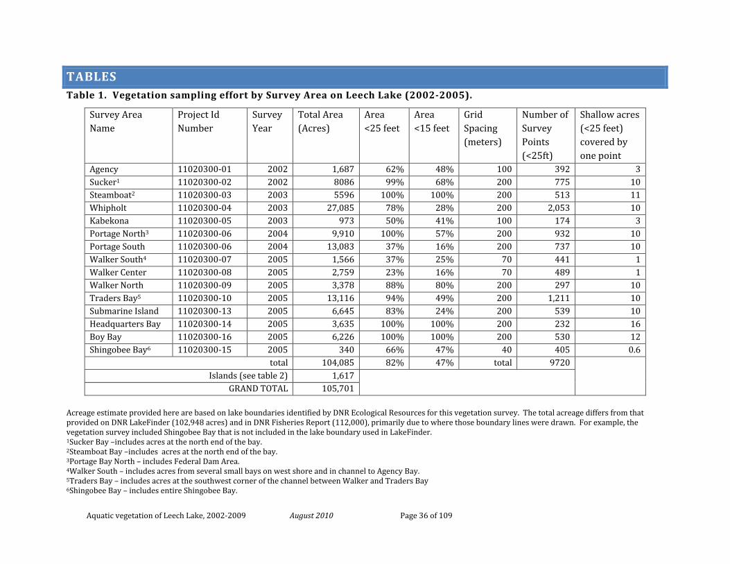
Aquatic vegetation of Leech Lake, 2002-2009 August 2010 Page 36 of 109
TABLES Table 1. Vegetation sampling effort by Survey Area on Leech Lake (2002-2005).
Acreage estimate provided here are based on lake boundaries identified by DNR Ecological Resources for this vegetation survey. The total acreage differs from that provided on DNR LakeFinder (102,948 acres) and in DNR Fisheries Report (112,000), primarily due to where those boundary lines were drawn. For example, the vegetation survey included Shingobee Bay that is not included in the lake boundary used in LakeFinder. 1Sucker Bay –includes acres at the north end of the bay. 2Steamboat Bay –includes acres at the north end of the bay. 3Portage Bay North – includes Federal Dam Area. 4Walker South – includes acres from several small bays on west shore and in channel to Agency Bay. 5Traders Bay – includes acres at the southwest corner of the channel between Walker and Traders Bay 6Shingobee Bay – includes entire Shingobee Bay.
Survey Area Name
Project Id Number
Survey Year
Total Area (Acres)
Area <25 feet
Area <15 feet
Grid Spacing (meters)
Number of Survey Points (<25ft)
Shallow acres (<25 feet) covered by one point
Agency 11020300-01 2002 1,687 62% 48% 100 392 3 Sucker1 11020300-02 2002 8086 99% 68% 200 775 10 Steamboat2 11020300-03 2003 5596 100% 100% 200 513 11 Whipholt 11020300-04 2003 27,085 78% 28% 200 2,053 10 Kabekona 11020300-05 2003 973 50% 41% 100 174 3 Portage North3 11020300-06 2004 9,910 100% 57% 200 932 10 Portage South 11020300-06 2004 13,083 37% 16% 200 737 10 Walker South4 11020300-07 2005 1,566 37% 25% 70 441 1 Walker Center 11020300-08 2005 2,759 23% 16% 70 489 1 Walker North 11020300-09 2005 3,378 88% 80% 200 297 10 Traders Bay5 11020300-10 2005 13,116 94% 49% 200 1,211 10 Submarine Island 11020300-13 2005 6,645 83% 24% 200 539 10 Headquarters Bay 11020300-14 2005 3,635 100% 100% 200 232 16 Boy Bay 11020300-16 2005 6,226 100% 100% 200 530 12 Shingobee Bay6 11020300-15 2005 340 66% 47% 40 405 0.6
total 104,085 82% 47% total 9720 Islands (see table 2) 1,617
GRAND TOTAL 105,701
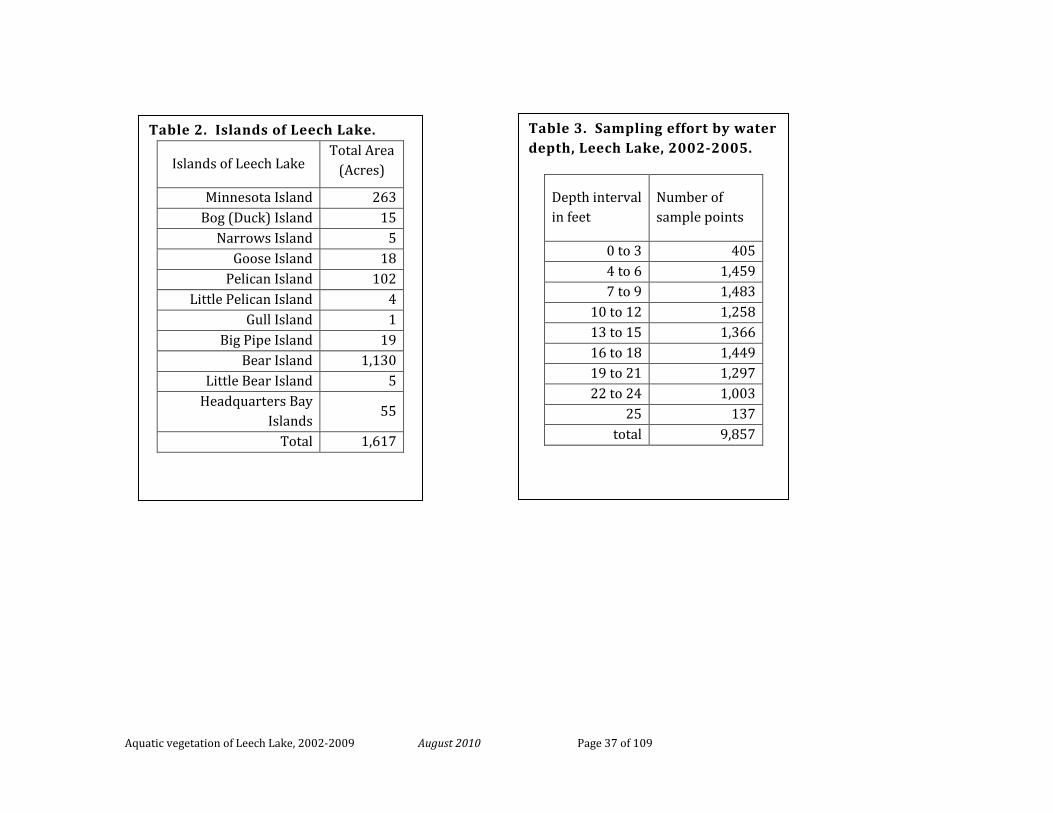
Aquatic vegetation of Leech Lake, 2002-2009 August 2010 Page 37 of 109
Table 3. Sampling effort by water depth, Leech Lake, 2002-2005.
Depth interval in feet
Number of sample points
0 to 3 405 4 to 6 1,459 7 to 9 1,483
10 to 12 1,258 13 to 15 1,366 16 to 18 1,449 19 to 21 1,297 22 to 24 1,003
25 137 total 9,857
Table 2. Islands of Leech Lake.
Islands of Leech Lake Total Area
(Acres)
Minnesota Island 263 Bog (Duck) Island 15
Narrows Island 5 Goose Island 18
Pelican Island 102 Little Pelican Island 4
Gull Island 1 Big Pipe Island 19
Bear Island 1,130 Little Bear Island 5
Headquarters Bay Islands
55
Total 1,617
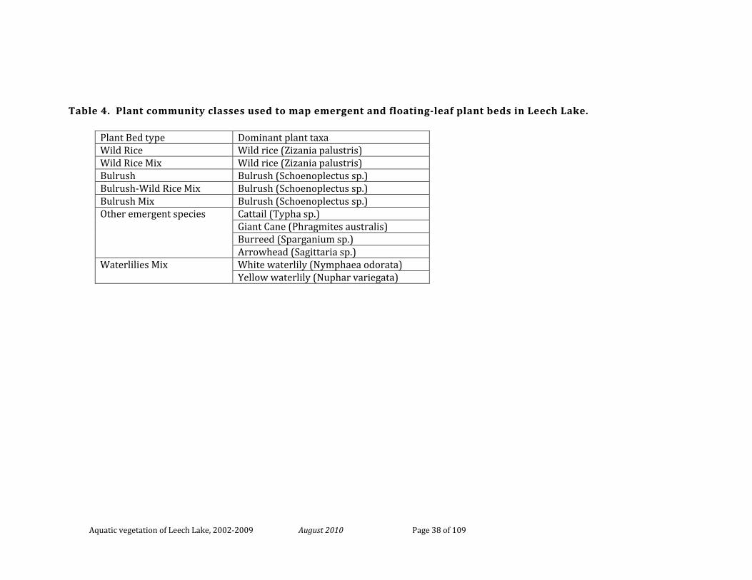
Aquatic vegetation of Leech Lake, 2002-2009 August 2010 Page 38 of 109
Table 4. Plant community classes used to map emergent and floating-leaf plant beds in Leech Lake.
Plant Bed type Dominant plant taxa Wild Rice Wild rice (Zizania palustris) Wild Rice Mix Wild rice (Zizania palustris) Bulrush Bulrush (Schoenoplectus sp.) Bulrush-Wild Rice Mix Bulrush (Schoenoplectus sp.) Bulrush Mix Bulrush (Schoenoplectus sp.) Other emergent species Cattail (Typha sp.)
Giant Cane (Phragmites australis) Burreed (Sparganium sp.) Arrowhead (Sagittaria sp.)
Waterlilies Mix White waterlily (Nymphaea odorata) Yellow waterlily (Nuphar variegata)
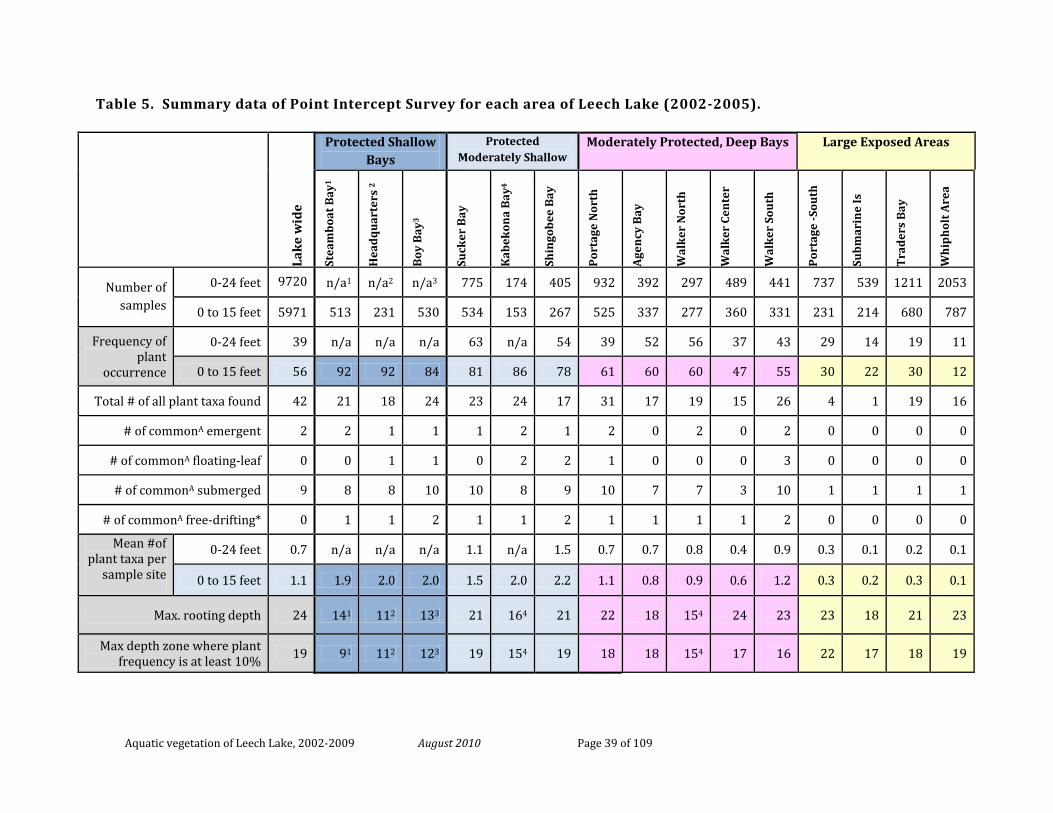
Aquatic vegetation of Leech Lake, 2002-2009 August 2010 Page 39 of 109
Table 5. Summary data of Point Intercept Survey for each area of Leech Lake (2002-2005).
Lak
e w
ide
Protected Shallow Bays
Protected Moderately Shallow
Moderately Protected, Deep Bays Large Exposed Areas
Stea
mb
oat
Bay
1
Hea
dq
uar
ters
2
Boy
Bay
3
Suck
er B
ay
Kab
ekon
a B
ay4
Shin
gob
ee B
ay
Por
tage
Nor
th
Age
ncy
Bay
Wal
ker
Nor
th
Wal
ker
Cen
ter
Wal
ker
Sou
th
Por
tage
-Sou
th
Sub
mar
ine
Is
Tra
der
s B
ay
Wh
iph
olt
Are
a
Number of samples
0-24 feet 9720 n/a1 n/a2 n/a3 775 174 405 932 392 297 489 441 737 539 1211 2053
0 to 15 feet 5971 513 231 530 534 153 267 525 337 277 360 331 231 214 680 787
Frequency of plant
occurrence
0-24 feet 39 n/a n/a n/a 63 n/a 54 39 52 56 37 43 29 14 19 11
0 to 15 feet 56 92 92 84 81 86 78 61 60 60 47 55 30 22 30 12
Total # of all plant taxa found 42 21 18 24 23 24 17 31 17 19 15 26 4 1 19 16
# of commonA emergent 2 2 1 1 1 2 1 2 0 2 0 2 0 0 0 0
# of commonA floating-leaf 0 0 1 1 0 2 2 1 0 0 0 3 0 0 0 0
# of commonA submerged 9 8 8 10 10 8 9 10 7 7 3 10 1 1 1 1
# of commonA free-drifting* 0 1 1 2 1 1 2 1 1 1 1 2 0 0 0 0
Mean #of plant taxa per
sample site
0-24 feet 0.7 n/a n/a n/a 1.1 n/a 1.5 0.7 0.7 0.8 0.4 0.9 0.3 0.1 0.2 0.1
0 to 15 feet 1.1 1.9 2.0 2.0 1.5 2.0 2.2 1.1 0.8 0.9 0.6 1.2 0.3 0.2 0.3 0.1
Max. rooting depth 24 141 112 133 21 164 21 22 18 154 24 23 23 18 21 23
Max depth zone where plant frequency is at least 10% 19 91 112 123 19 154 19 18 18 154 17 16 22 17 18 19
Aquatic vegetation of Leech Lake, 2002-2009 August 2010 Page 40 of 109
Table 5 continued.
1max depth of Boy Bay is 13 ft; insufficient number of samples in depths >12 ft. 2max depth of Steamboat Bay is 14 ft; insufficient number of samples in depths >9 ft. 3max depth of Headquarters Bay is 22 ft; insufficient number of samples in depths >12 ft. 4 Kabekona Bay - insufficient number of samples in depths >15 ft ACommonly occurring taxa are defined as those that occur in at least 2% of the sites within 0-15 feet depth zone *duckweeds (Lemna, Spirodela) , bladderworts (Utricularia), and watermoss)
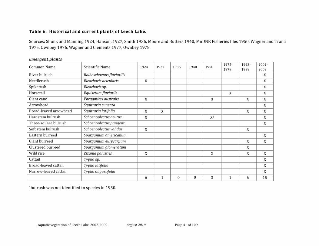
Aquatic vegetation of Leech Lake, 2002-2009 August 2010 Page 41 of 109
Table 6. Historical and current plants of Leech Lake.
Sources: Shunk and Manning 1924, Hanson, 1927, Smith 1936, Moore and Butters 1940, MnDNR Fisheries files 1950, Wagner and Trana 1975, Ownbey 1976, Wagner and Clements 1977, Ownbey 1978.
Emergent plants
Common Name Scientific Name 1924 1927 1936 1940 1950 1975-1978
1993-1999
2002-2009
River bulrush Bolboschoenus fluviatilis X Needlerush Eleocharis acicularis X X Spikerush Eleocharis sp. X Horsetail Equisetum fluviatile X X Giant cane Phragmites australis X X X X Arrowhead Sagittaria cuneata X Broad-leaved arrowhead Sagittaria latifolia X X X X Hardstem bulrush Schoenoplectus acutus X X1 X Three-square bulrush Schoenoplectus pungens X Soft stem bulrush Schoenoplectus validus X X Eastern burreed Sparganium americanum X Giant burreed Sparganium eurycarpum X X Clustered burreed Sparganium glomeratum X Wild rice Zizania palustris X X X X Cattail Typha sp. X Broad-leaved cattail Typha latifolia X Narrow-leaved cattail Typha angustifolia X 6 1 0 0 3 1 6 15
1bulrush was not identified to species in 1950.
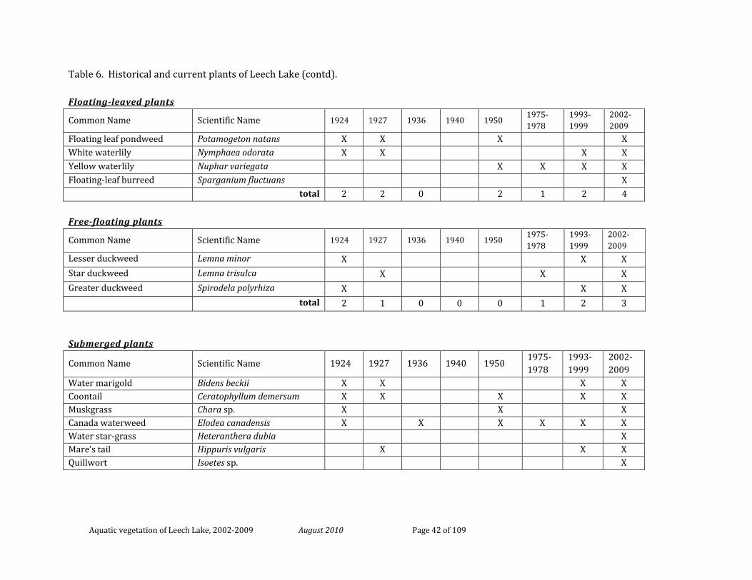
Aquatic vegetation of Leech Lake, 2002-2009 August 2010 Page 42 of 109
Table 6. Historical and current plants of Leech Lake (contd).
Floating-leaved plants
Common Name Scientific Name 1924 1927 1936 1940 1950 1975-1978
1993-1999
2002-2009
Floating leaf pondweed Potamogeton natans X X X X White waterlily Nymphaea odorata X X X X Yellow waterlily Nuphar variegata X X X X Floating-leaf burreed Sparganium fluctuans X
total 2 2 0 2 1 2 4
Free-floating plants
Common Name Scientific Name 1924 1927 1936 1940 1950 1975-1978
1993-1999
2002-2009
Lesser duckweed Lemna minor X X X Star duckweed Lemna trisulca X X X Greater duckweed Spirodela polyrhiza X X X total 2 1 0 0 0 1 2 3
Submerged plants
Common Name Scientific Name 1924 1927 1936 1940 1950 1975-1978
1993-1999
2002-2009
Water marigold Bidens beckii X X X X Coontail Ceratophyllum demersum X X X X X Muskgrass Chara sp. X X X Canada waterweed Elodea canadensis X X X X X X Water star-grass Heteranthera dubia X Mare’s tail Hippuris vulgaris X X X Quillwort Isoetes sp. X
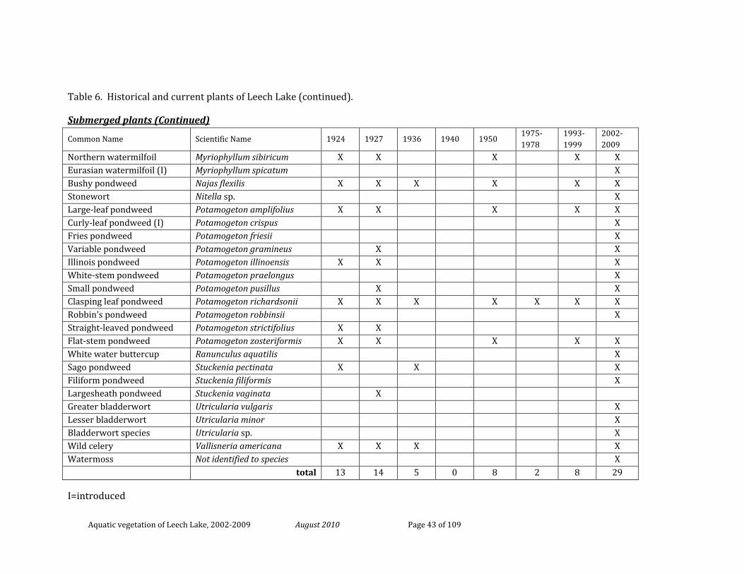
Aquatic vegetation of Leech Lake, 2002-2009 August 2010 Page 43 of 109
Table 6. Historical and current plants of Leech Lake (continued).
Submerged plants (Continued)
Common Name Scientific Name 1924 1927 1936 1940 1950 1975-1978
1993-1999
2002-2009
Northern watermilfoil Myriophyllum sibiricum X X X X X Eurasian watermilfoil (I) Myriophyllum spicatum X Bushy pondweed Najas flexilis X X X X X X Stonewort Nitella sp. X Large-leaf pondweed Potamogeton amplifolius X X X X X Curly-leaf pondweed (I) Potamogeton crispus X Fries pondweed Potamogeton friesii X Variable pondweed Potamogeton gramineus X X Illinois pondweed Potamogeton illinoensis X X X White-stem pondweed Potamogeton praelongus X Small pondweed Potamogeton pusillus X X Clasping leaf pondweed Potamogeton richardsonii X X X X X X X Robbin’s pondweed Potamogeton robbinsii X Straight-leaved pondweed Potamogeton strictifolius X X Flat-stem pondweed Potamogeton zosteriformis X X X X X White water buttercup Ranunculus aquatilis X Sago pondweed Stuckenia pectinata X X X Filiform pondweed Stuckenia filiformis X Largesheath pondweed Stuckenia vaginata X Greater bladderwort Utricularia vulgaris X Lesser bladderwort Utricularia minor X Bladderwort species Utricularia sp. X Wild celery Vallisneria americana X X X X Watermoss Not identified to species X total 13 14 5 0 8 2 8 29
I=introduced
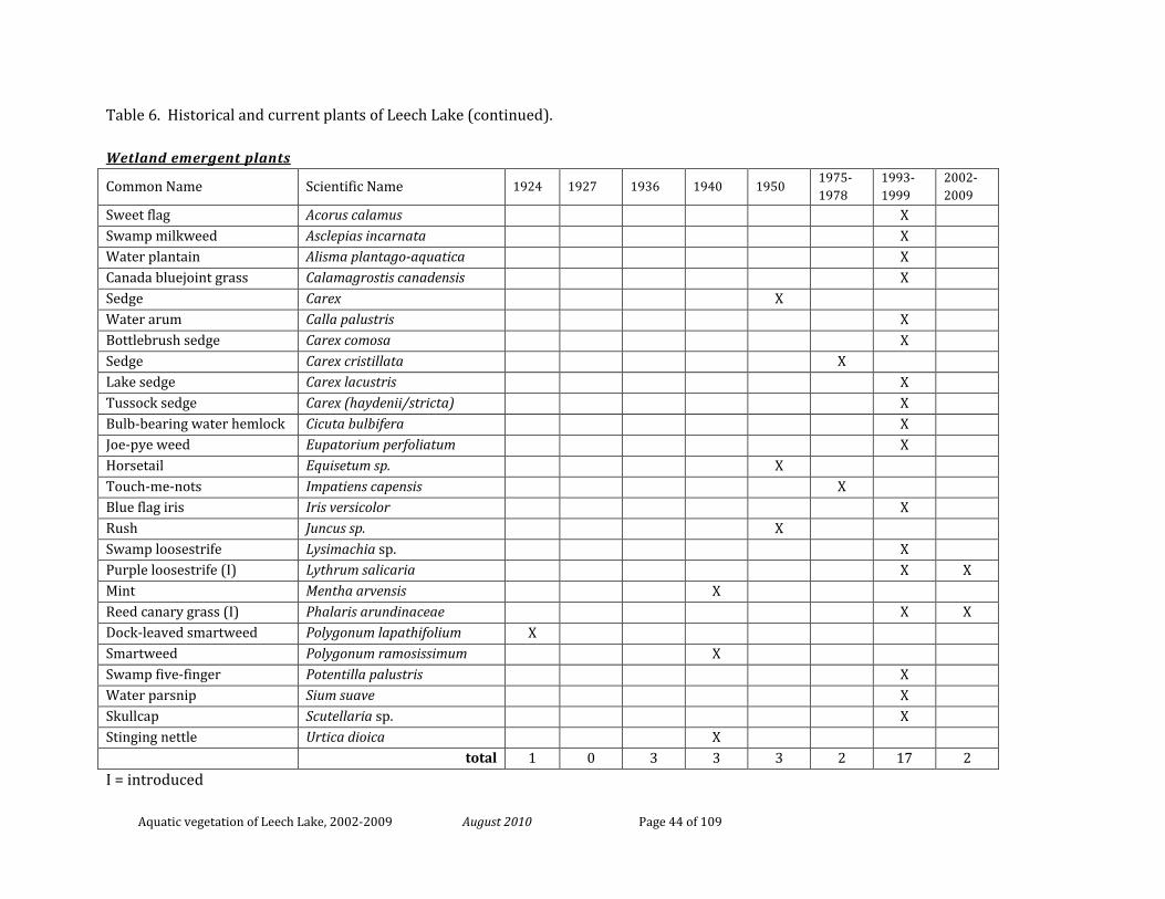
Aquatic vegetation of Leech Lake, 2002-2009 August 2010 Page 44 of 109
Table 6. Historical and current plants of Leech Lake (continued).
Wetland emergent plants
Common Name Scientific Name 1924 1927 1936 1940 1950 1975-1978
1993-1999
2002-2009
Sweet flag Acorus calamus X Swamp milkweed Asclepias incarnata X Water plantain Alisma plantago-aquatica X Canada bluejoint grass Calamagrostis canadensis X Sedge Carex X Water arum Calla palustris X Bottlebrush sedge Carex comosa X Sedge Carex cristillata X Lake sedge Carex lacustris X Tussock sedge Carex (haydenii/stricta) X Bulb-bearing water hemlock Cicuta bulbifera X Joe-pye weed Eupatorium perfoliatum X Horsetail Equisetum sp. X Touch-me-nots Impatiens capensis X Blue flag iris Iris versicolor X Rush Juncus sp. X Swamp loosestrife Lysimachia sp. X Purple loosestrife (I) Lythrum salicaria X X Mint Mentha arvensis X Reed canary grass (I) Phalaris arundinaceae X X Dock-leaved smartweed Polygonum lapathifolium X Smartweed Polygonum ramosissimum X Swamp five-finger Potentilla palustris X Water parsnip Sium suave X Skullcap Scutellaria sp. X Stinging nettle Urtica dioica X total 1 0 3 3 3 2 17 2 I = introduced
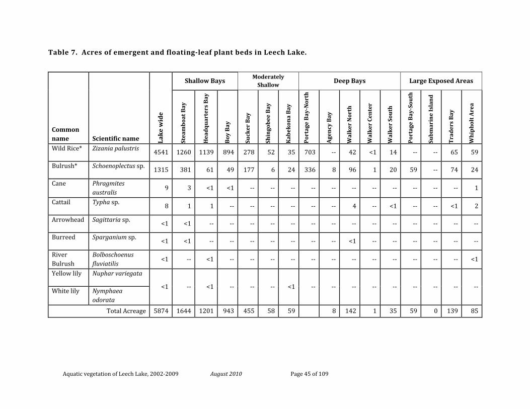
Aquatic vegetation of Leech Lake, 2002-2009 August 2010 Page 45 of 109
Table 7. Acres of emergent and floating-leaf plant beds in Leech Lake.
Common name Scientific name La
ke
wid
e
Shallow Bays Moderately
Shallow Deep Bays Large Exposed Areas
Stea
mb
oat
Bay
Hea
dq
uar
ters
Bay
Boy
Bay
Suck
er B
ay
Shin
gob
ee B
ay
Kab
ekon
a B
ay
Por
tage
Bay
-Nor
th
Age
ncy
Bay
Wal
ker
Nor
th
Wal
ker
Cen
ter
Wal
ker
Sou
th
Por
tage
Bay
-Sou
th
Sub
mar
ine
Isla
nd
Tra
der
s B
ay
Wh
iph
olt
Are
a
Wild Rice* Zizania palustris 4541 1260 1139 894 278 52 35 703 -- 42 <1 14 -- -- 65 59
Bulrush* Schoenoplectus sp. 1315 381 61 49 177 6 24 336 8 96 1 20 59 -- 74 24
Cane Phragmites australis
9 3 <1 <1 -- -- -- -- -- -- -- -- -- -- -- 1
Cattail Typha sp. 8 1 1 -- -- -- -- -- -- 4 -- <1 -- -- <1 2
Arrowhead Sagittaria sp. <1 <1 -- -- -- -- -- -- -- -- -- -- -- -- -- --
Burreed Sparganium sp. <1 <1 -- -- -- -- -- -- -- <1 -- -- -- -- -- --
River Bulrush
Bolboschoenus fluviatilis
<1 -- <1 -- -- -- -- -- -- -- -- -- -- -- -- <1
Yellow lily Nuphar variegata
<1 -- <1 -- -- -- <1 -- -- -- -- -- -- -- -- -- White lily Nymphaea odorata
Total Acreage 5874 1644 1201 943 455 58 59 8 142 1 35 59 0 139 85
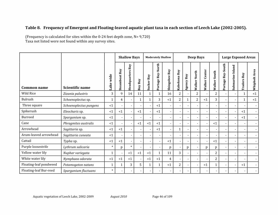
Aquatic vegetation of Leech Lake, 2002-2009 August 2010 Page 46 of 109
Table 8. Frequency of Emergent and Floating-leaved aquatic plant taxa in each section of Leech Lake (2002-2005).
(Frequency is calculated for sites within the 0-24 feet depth zone, N= 9,720) Taxa not listed were not found within any survey sites.
Common name Scientific name Lak
e w
ide
Shallow Bays Moderately Shallow Deep Bays Large Exposed Areas
Stea
mb
oat
Bay
Hea
dq
uar
ters
Bay
Boy
Bay
Suck
er B
ay
Por
tage
Bay
-Nor
th
Shin
gob
ee B
ay
Kab
ekon
a B
ay
Age
ncy
Bay
Wal
ker
Nor
th
Wal
ker
Cen
ter
Wal
ker
Sou
th
Por
tage
Bay
-Sou
th
Sub
mar
ine
Isla
nd
Tra
der
s B
ay
Wh
iph
olt
Are
a
Wild Rice Zizania palustris 3 9 14 11 1 1 16 2 - 2 - 2 - - 1 <1 Bulrush Schoenoplectus sp. 1 4 - 1 1 3 <1 2 1 2 <1 3 - - 1 <1 Three square Schoenoplectus pungens <1 - - - - <1 - - - - - - - - - - Spikerush Eleocharis sp. <1 <1 - <1 - <1 - - - - - - - - <1 - Burreed Sparganium sp. <1 - - - - - - - - - - - - - <1 - Cane Phragmites australis <1 - - <1 <1 <1 - - - - - <1 - - - - Arrowhead Sagittaria sp. <1 <1 - - - <1 - 1 - - - - - - - - Arum-leaved arrowhead Sagittaria cuneata <1 - - - - - - - - - - - - - - - Cattail Typha sp. <1 <1 - - - - <1 - - - - <1 - - - - Purple loosestrife Lythrum salicaria * p * - - - p - p - p p - - - - Yellow water lily Nuphar variegata 1 - <1 <1 <1 1 11 3 - - - 2 - - - - White water lily Nymphaea odorata <1 <1 <1 - <1 <1 4 - - - - 2 - - - - Floating-leaf pondweed Potamogeton natans 1 1 3 5 1 1 <1 2 - - <1 1 - - <1 - Floating-leaf Bur-reed Sparganium fluctuans * - - - - - - - - - - - - - - -
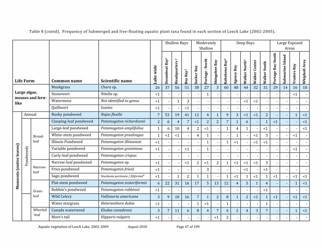
Aquatic vegetation of Leech Lake, 2002-2009 August 2010 Page 47 of 109
Table 8 (contd). Frequency of Submerged and free-floating aquatic plant taxa found in each section of Leech Lake (2002-2005).
Life Form Common name Scientific name Lak
e w
ide
Shallow Bays Moderately Shallow
Deep Bays Large Exposed Areas
Stea
mb
oat
Bay
1
Hea
dq
uar
ters
2
Boy
Bay
3
Suck
er B
ay
Por
tage
–N
orth
Shin
gob
ee B
ay
Kab
ekon
a B
ay4
Age
ncy
Bay
Wal
ker
Nor
th5
Wal
ker
Cen
ter
Wal
ker
Sou
th
Por
tage
Bay
-Sou
th
Sub
mar
ine
Isla
nd
Tra
der
s B
ay
Wh
iph
olt
Are
a
Large algae, mosses and fern-like
Muskgrass Chara sp. 26 37 56 51 38 27 3 60 48 44 32 31 29 14 16 10 Stonewort Nitella sp. <1 - - - - 1 - - - - - - - - <1 - Watermoss Not identified to genus <1 - 1 3 - - - - - <1 <1 - - - - - Quillwort Isoetes <1 - - <1 - - - - - - - - - - - -
Mon
ocot
s (e
nti
re le
aves
)
Annual Bushy pondweed Najas flexilis 7 53 19 41 12 4 1 9 3 <1 <1 2 - - 1 <1
Pond
wee
ds
Broad-leaf
Clasping-leaf pondweed Potamogeton richardsonii 2 6 4 7 <1 2 2 7 1 6 - 1 <1 - - <1 Large-leaf pondweed Potamogeton amplifolius 1 6 10 4 2 <1 - 1 4 1 - <1 - - - <1 White-stem pondweed Potamogeton praelongus 1 <1 <1 - 4 1 - - 1 - <1 3 - - <1 - Illinois Pondweed Potamogeton illinoensis <1 - - - - 1 - 1 <1 - <1 <1 - - - - Variable pondweed Potamogeton gramineus <1 - - <1 - 1 - - - - - - - - <1 - Curly-leaf pondweed Potamogeton crispus - - - - - - - - - - - - - - - -
Narrow-leaf
Narrow-leaf pondweed Potamogeton sp. <1 - - <1 2 <1 2 1 <1 <1 <1 3 - - - - Fries pondweed Potamogeton friesii <1 - - - - 3 - - - <1 - <1 - - - - Sago pondweed Stuckenia pectinata / filiformis4 <1 - 1 2 1 1 - 1 <1 1 <1 1 <1 - <1 <1
Grass-leaf
Flat-stem pondweed Potamogeton zosteriformis 6 22 31 16 17 5 13 12 4 5 1 4 - - 1 <1 Robbin’s pondweed Potamogeton robbinsii <1 - - - - - - - - - - <1 - - - -
Wild Celery Vallisneria americana 3 9 18 16 7 1 2 8 1 2 <1 1 <1 - <1 <1 Water stargrass Heteranthera dubia <1 - - - 1 <1 - 1 - - - 1 - - - -
Whorled-leaf
Canada waterweed Elodea canadensis 3 7 11 6 8 4 7 6 2 4 3 7 - - 1 <1 Mare’s tail Hippuris vulgaris <1 - - - - - <1 2 - - - - - - - -
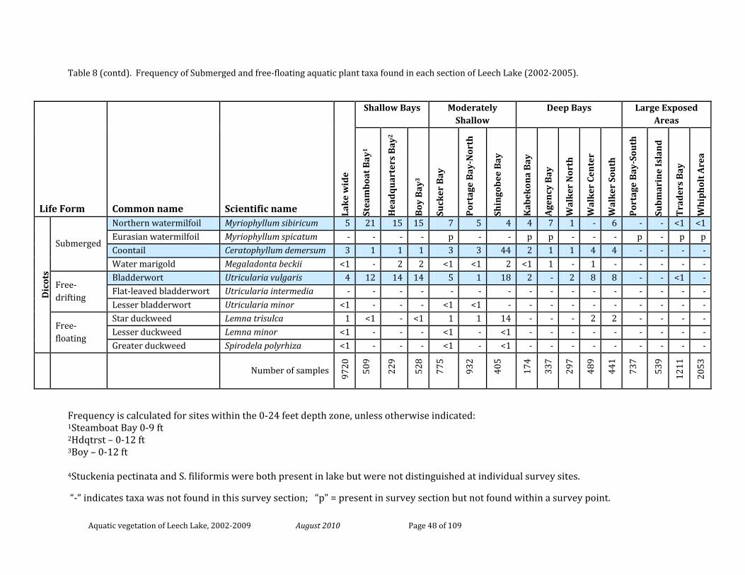
Aquatic vegetation of Leech Lake, 2002-2009 August 2010 Page 48 of 109
Table 8 (contd). Frequency of Submerged and free-floating aquatic plant taxa found in each section of Leech Lake (2002-2005).
Frequency is calculated for sites within the 0-24 feet depth zone, unless otherwise indicated: 1Steamboat Bay 0-9 ft 2Hdqtrst – 0-12 ft 3Boy – 0-12 ft 4Stuckenia pectinata and S. filiformis were both present in lake but were not distinguished at individual survey sites.
“-“ indicates taxa was not found in this survey section; “p” = present in survey section but not found within a survey point.
Life Form Common name Scientific name Lak
e w
ide
Shallow Bays Moderately Shallow
Deep Bays Large Exposed Areas
Stea
mb
oat B
ay1
Hea
dq
uar
ters
Bay
2
Boy
Bay
3
Suck
er B
ay
Por
tage
Bay
-Nor
th
Shin
gob
ee B
ay
Kab
ekon
a B
ay
Age
ncy
Bay
Wal
ker
Nor
th
Wal
ker
Cen
ter
Wal
ker
Sou
th
Por
tage
Bay
-Sou
th
Sub
mar
ine
Isla
nd
Tra
der
s B
ay
Wh
iph
olt A
rea
Dic
ots
Submerged
Northern watermilfoil Myriophyllum sibiricum 5 21 15 15 7 5 4 4 7 1 - 6 - - <1 <1 Eurasian watermilfoil Myriophyllum spicatum - - - - p - - p p - - - p - p p Coontail Ceratophyllum demersum 3 1 1 1 3 3 44 2 1 1 4 4 - - - - Water marigold Megaladonta beckii <1 - 2 2 <1 <1 2 <1 1 - 1 - - - - -
Free-drifting
Bladderwort Utricularia vulgaris 4 12 14 14 5 1 18 2 - 2 8 8 - - <1 - Flat-leaved bladderwort Utricularia intermedia - - - - - - - - - - - - - - - - Lesser bladderwort Utricularia minor <1 - - - <1 <1 - - - - - - - - - -
Free-floating
Star duckweed Lemna trisulca 1 <1 - <1 1 1 14 - - - 2 2 - - - - Lesser duckweed Lemna minor <1 - - - <1 - <1 - - - - - - - - - Greater duckweed Spirodela polyrhiza <1 - - - <1 - <1 - - - - - - - - -
Number of samples 97
20
509
229
528
775
932
405
174
337
297
489
441
737
539
1211
2053
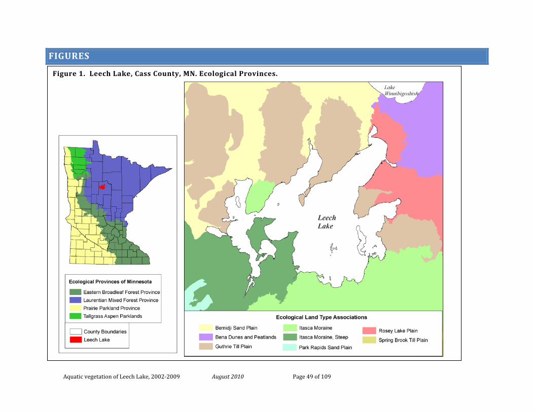
Aquatic vegetation of Leech Lake, 2002-2009 August 2010 Page 49 of 109
FIGURES
Figure 1. Leech Lake, Cass County, MN. Ecological Provinces.
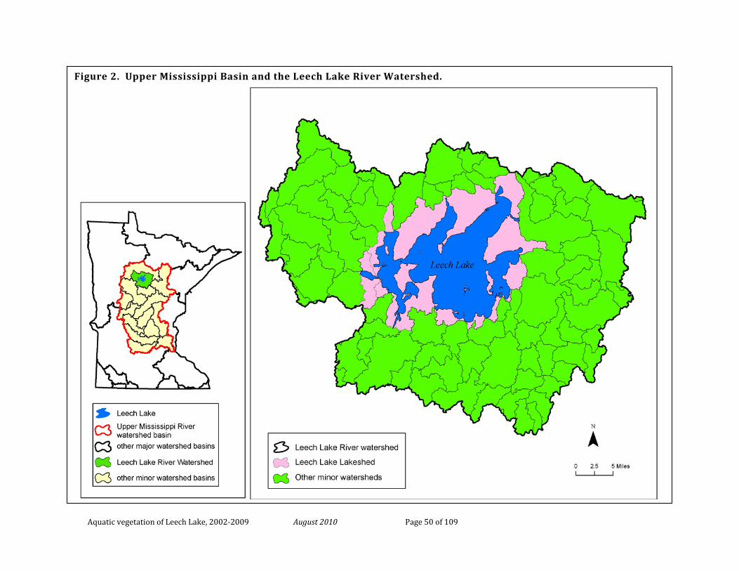
Aquatic vegetation of Leech Lake, 2002-2009 August 2010 Page 50 of 109
Figure 2. Upper Mississippi Basin and the Leech Lake River Watershed.
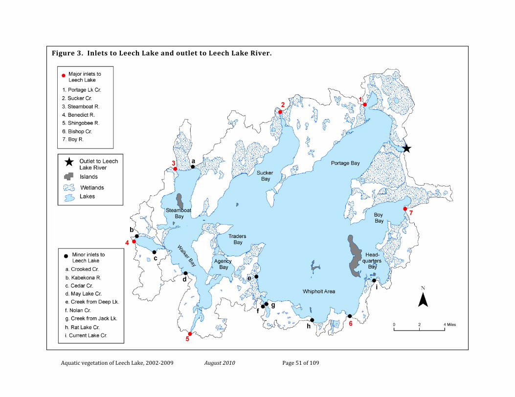
Aquatic vegetation of Leech Lake, 2002-2009 August 2010 Page 51 of 109
Figure 3. Inlets to Leech Lake and outlet to Leech Lake River.
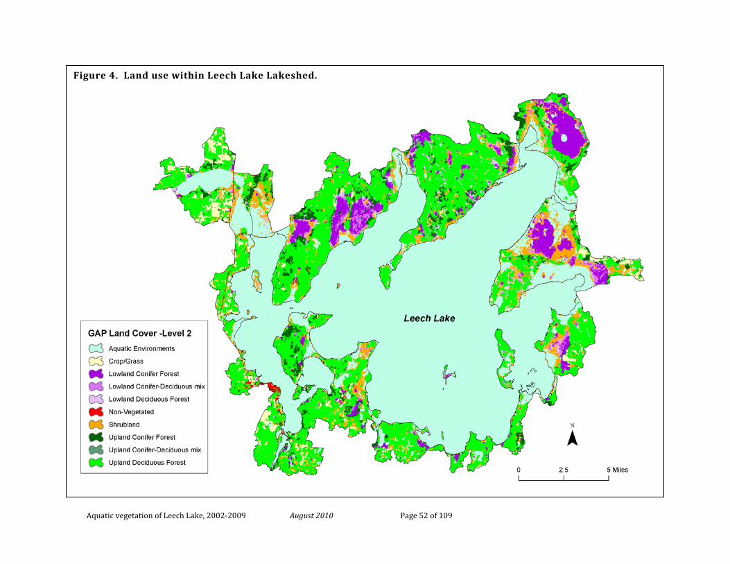
Aquatic vegetation of Leech Lake, 2002-2009 August 2010 Page 52 of 109
Figure 4. Land use within Leech Lake Lakeshed.
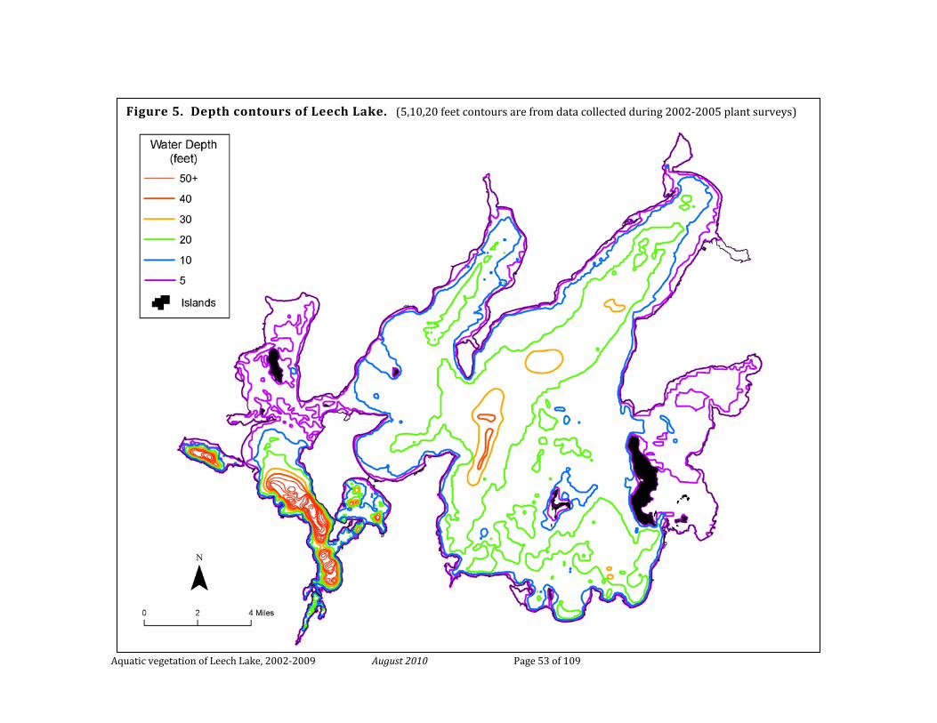
Aquatic vegetation of Leech Lake, 2002-2009 August 2010 Page 53 of 109
Figure 5. Depth contours of Leech Lake. (5,10,20 feet contours are from data collected during 2002-2005 plant surveys)
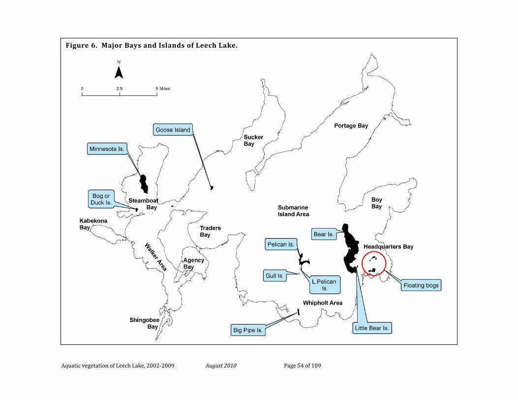
Aquatic vegetation of Leech Lake, 2002-2009 August 2010 Page 54 of 109
Figure 6. Major Bays and Islands of Leech Lake.
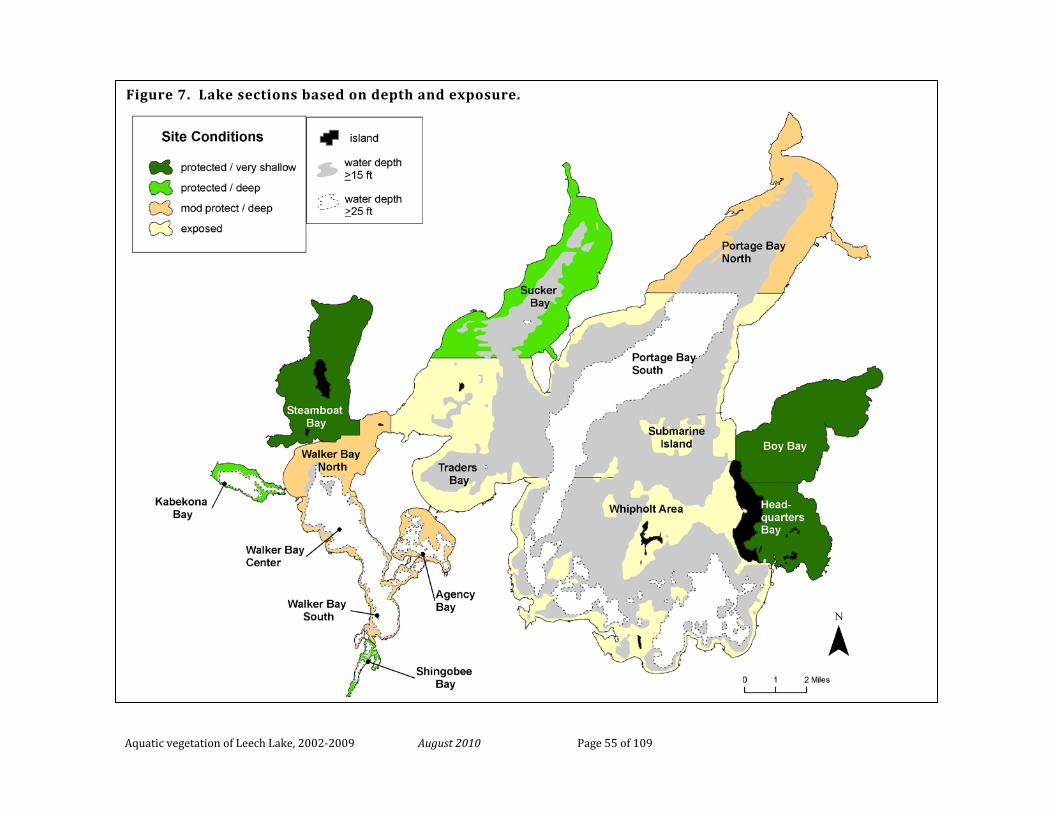
Aquatic vegetation of Leech Lake, 2002-2009 August 2010 Page 55 of 109
Figure 7. Lake sections based on depth and exposure.
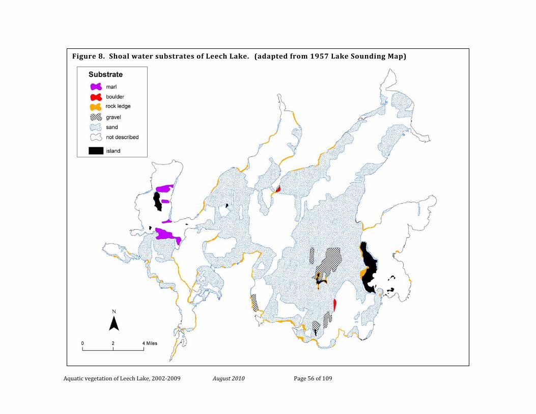
Aquatic vegetation of Leech Lake, 2002-2009 August 2010 Page 56 of 109
Figure 8. Shoal water substrates of Leech Lake. (adapted from 1957 Lake Sounding Map)
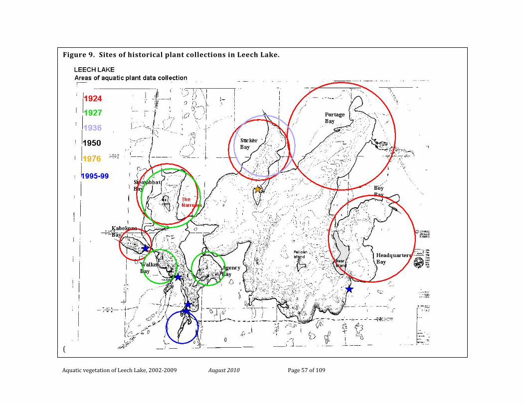
Aquatic vegetation of Leech Lake, 2002-2009 August 2010 Page 57 of 109
Figure 9. Sites of historical plant collections in Leech Lake.
(
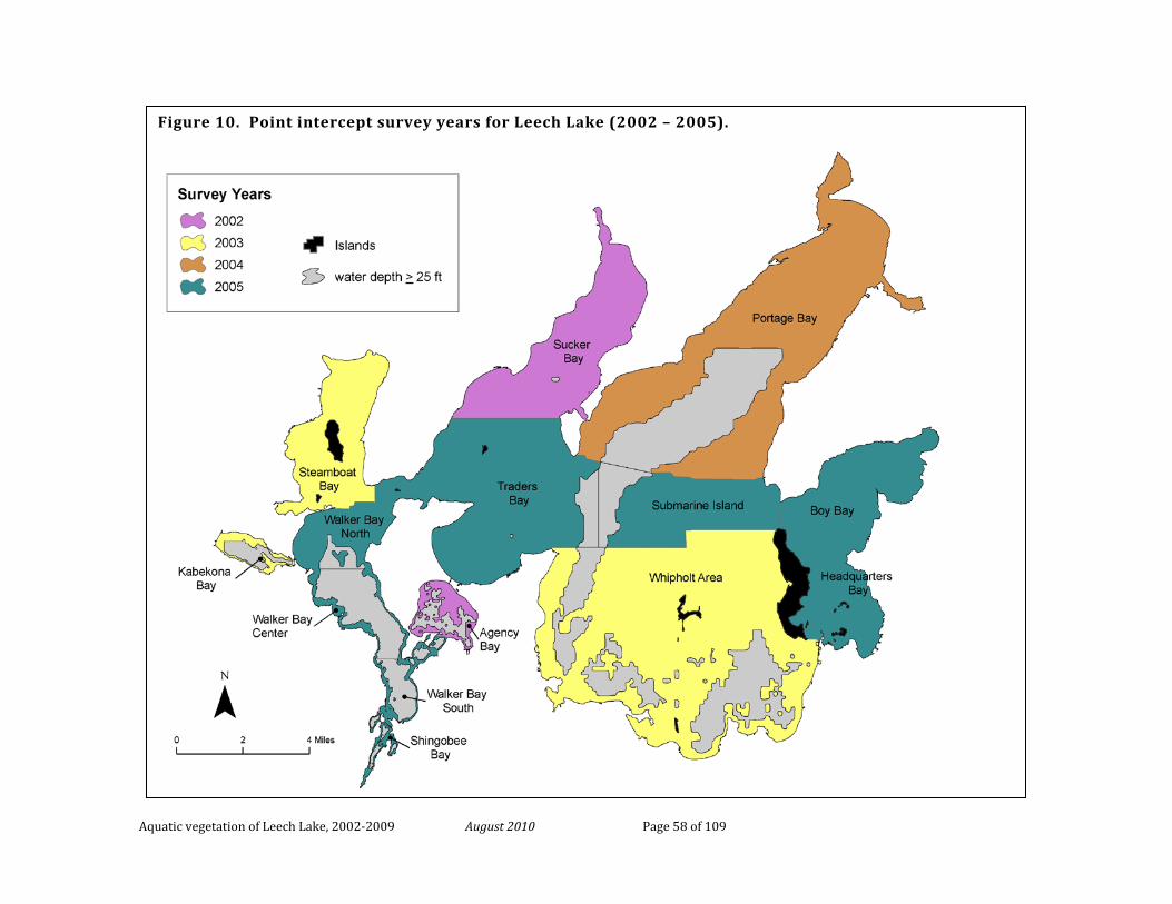
Aquatic vegetation of Leech Lake, 2002-2009 August 2010 Page 58 of 109
Figure 10. Point intercept survey years for Leech Lake (2002 – 2005).
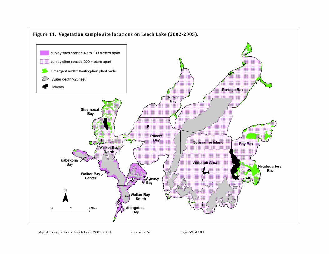
Aquatic vegetation of Leech Lake, 2002-2009 August 2010 Page 59 of 109
Figure 11. Vegetation sample site locations on Leech Lake (2002-2005).
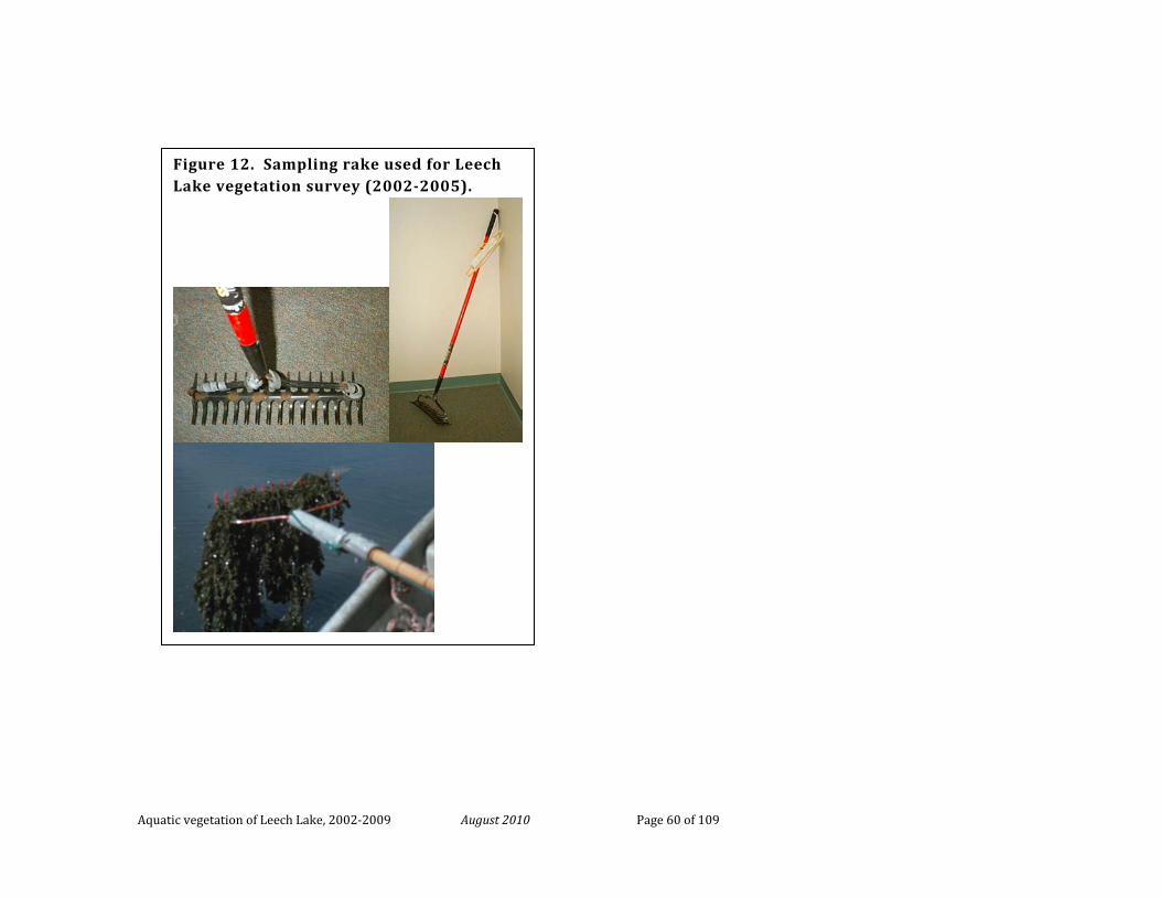
Aquatic vegetation of Leech Lake, 2002-2009 August 2010 Page 60 of 109
Figure 12. Sampling rake used for Leech Lake vegetation survey (2002-2005).
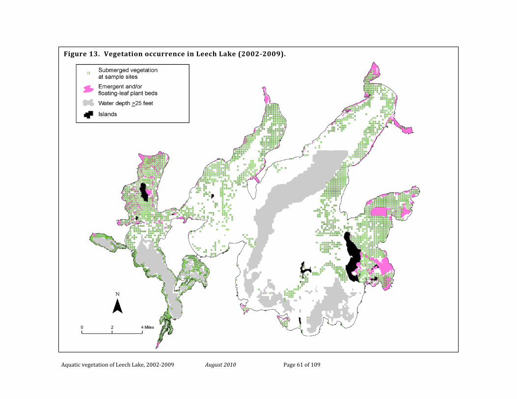
Aquatic vegetation of Leech Lake, 2002-2009 August 2010 Page 61 of 109
Figure 13. Vegetation occurrence in Leech Lake (2002-2009).
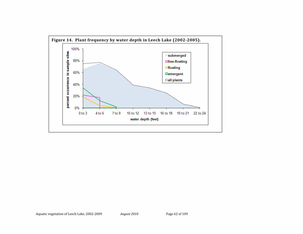
Aquatic vegetation of Leech Lake, 2002-2009 August 2010 Page 62 of 109
Figure 14. Plant frequency by water depth in Leech Lake (2002-2005).
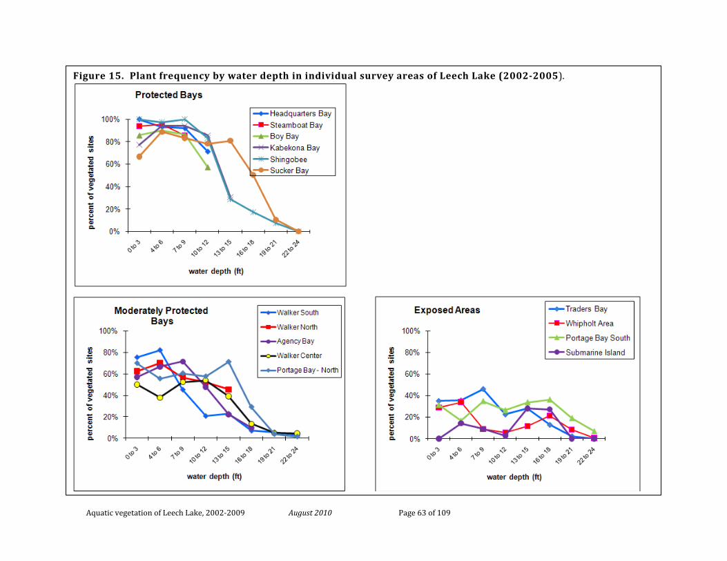
Aquatic vegetation of Leech Lake, 2002-2009 August 2010 Page 63 of 109
Figure 15. Plant frequency by water depth in individual survey areas of Leech Lake (2002-2005).
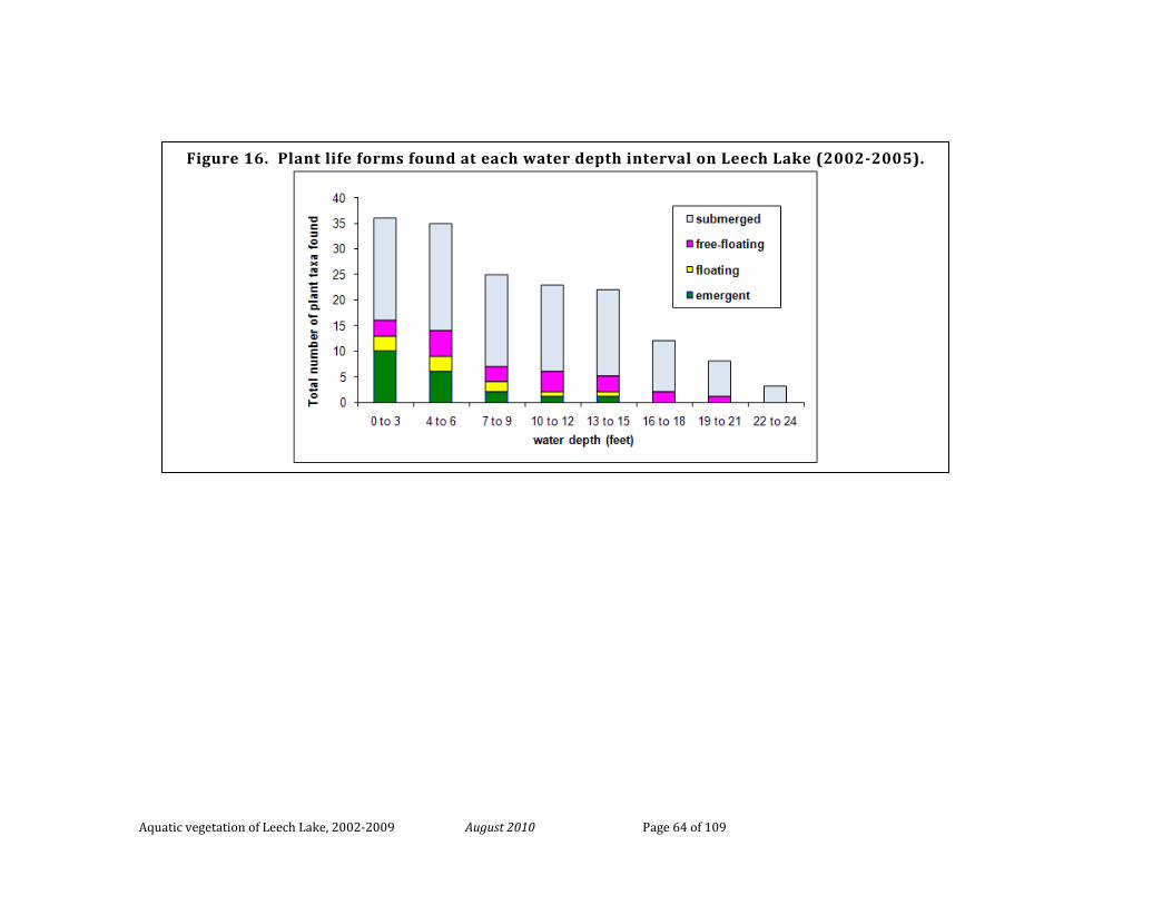
Aquatic vegetation of Leech Lake, 2002-2009 August 2010 Page 64 of 109
Figure 16. Plant life forms found at each water depth interval on Leech Lake (2002-2005).
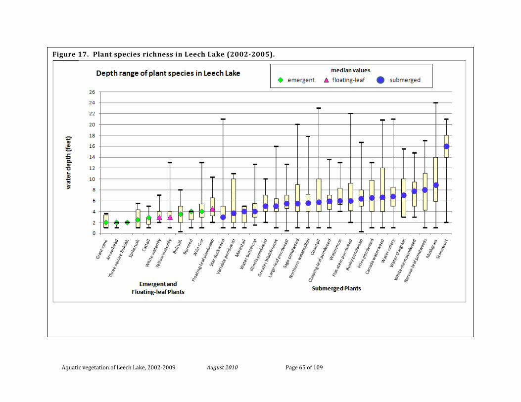
Aquatic vegetation of Leech Lake, 2002-2009 August 2010 Page 65 of 109
Figure 17. Plant species richness in Leech Lake (2002-2005).
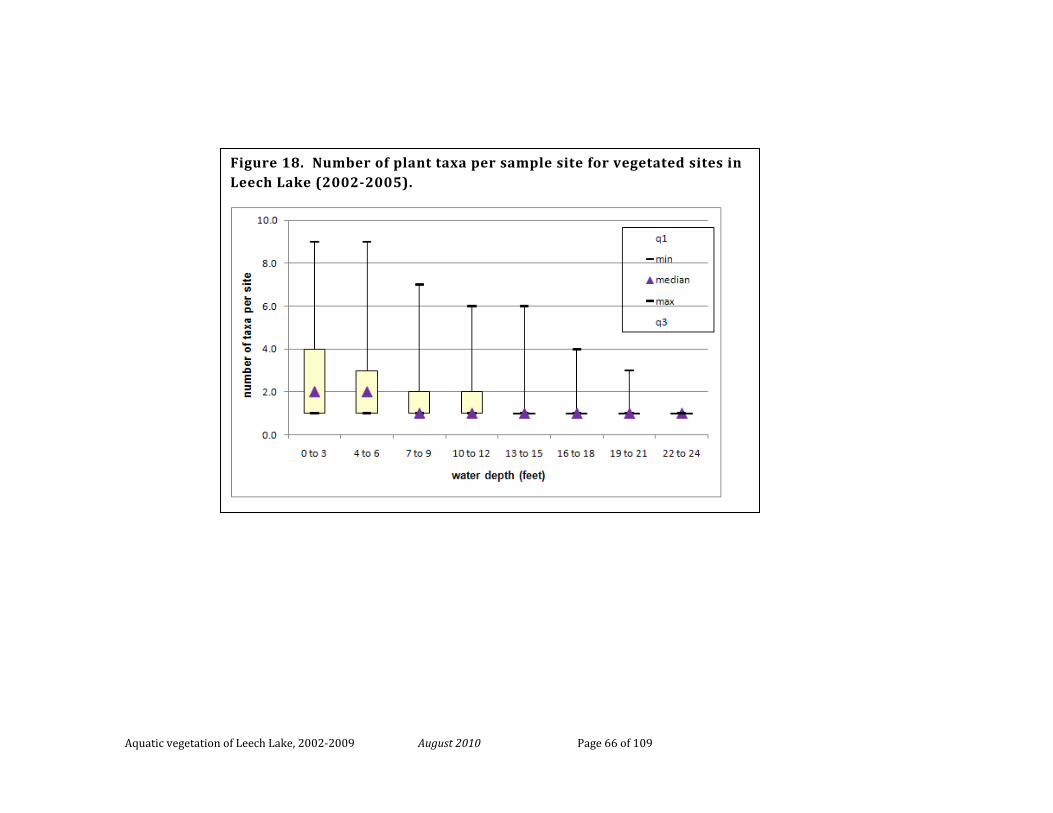
Aquatic vegetation of Leech Lake, 2002-2009 August 2010 Page 66 of 109
Figure 18. Number of plant taxa per sample site for vegetated sites in Leech Lake (2002-2005).
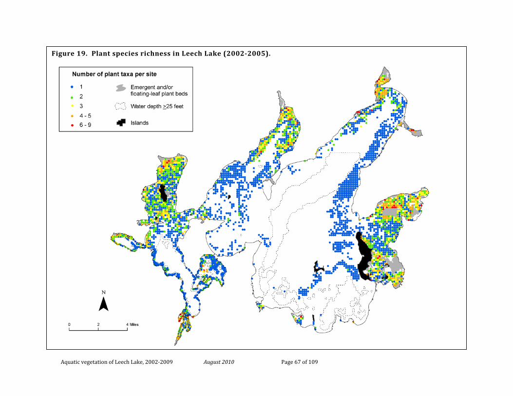
Aquatic vegetation of Leech Lake, 2002-2009 August 2010 Page 67 of 109
Figure 19. Plant species richness in Leech Lake (2002-2005).
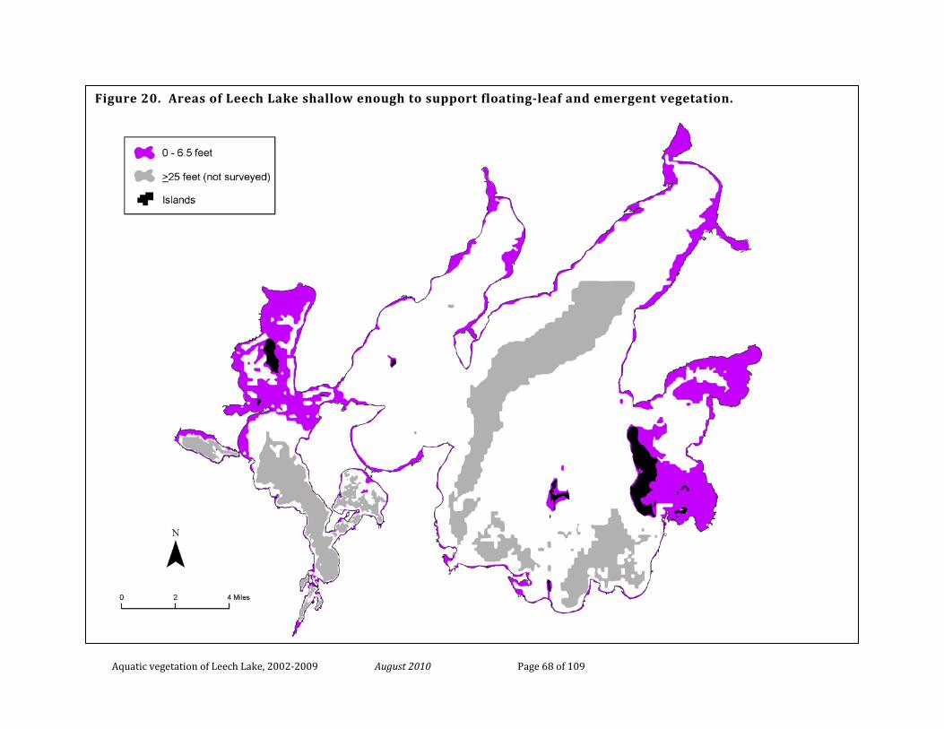
Aquatic vegetation of Leech Lake, 2002-2009 August 2010 Page 68 of 109
Figure 20. Areas of Leech Lake shallow enough to support floating-leaf and emergent vegetation.
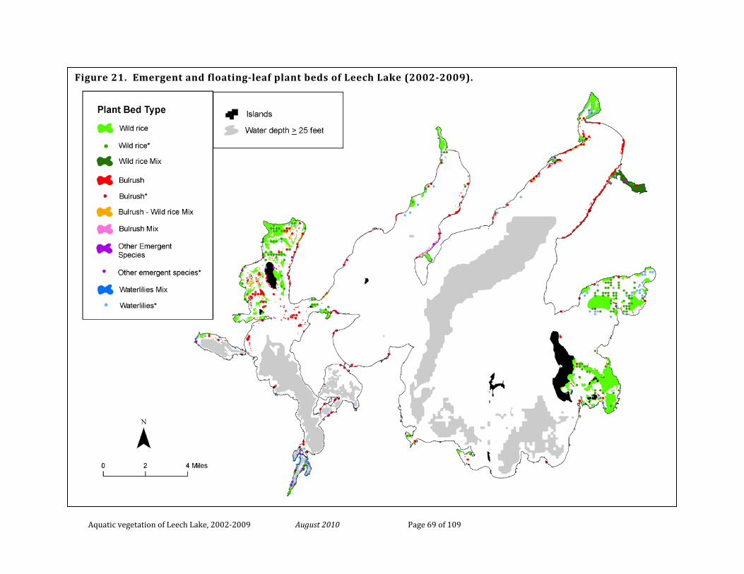
Aquatic vegetation of Leech Lake, 2002-2009 August 2010 Page 69 of 109
Figure 21. Emergent and floating-leaf plant beds of Leech Lake (2002-2009).
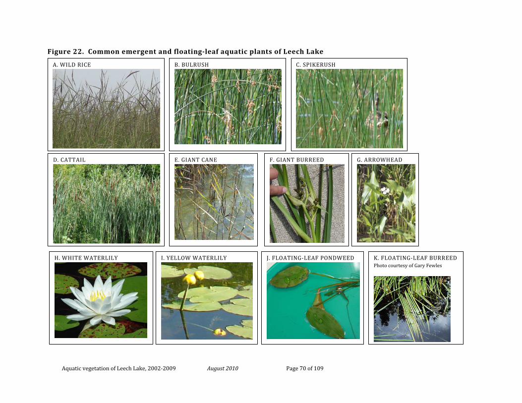
Aquatic vegetation of Leech Lake, 2002-2009 August 2010 Page 70 of 109
Figure 22. Common emergent and floating-leaf aquatic plants of Leech Lake
A. WILD RICE
B. BULRUSH
C. SPIKERUSH
D. CATTAIL
H. WHITE WATERLILY
E. GIANT CANE
J. FLOATING-LEAF PONDWEED
I. YELLOW WATERLILY
F. GIANT BURREED
G. ARROWHEAD
K. FLOATING-LEAF BURREED Photo courtesy of Gary Fewles
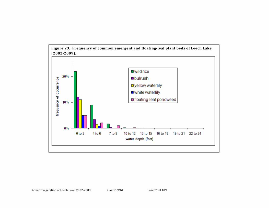
Aquatic vegetation of Leech Lake, 2002-2009 August 2010 Page 71 of 109
Figure 23. Frequency of common emergent and floating-leaf plant beds of Leech Lake (2002-2009).
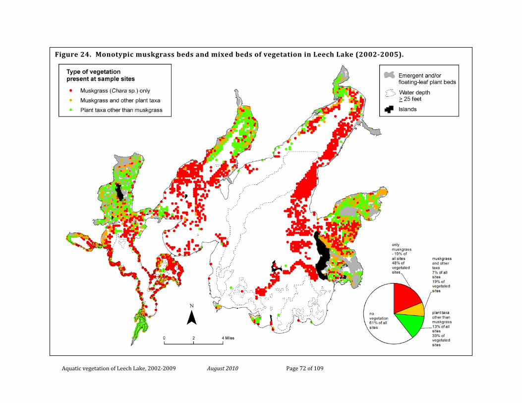
Aquatic vegetation of Leech Lake, 2002-2009 August 2010 Page 72 of 109
Figure 24. Monotypic muskgrass beds and mixed beds of vegetation in Leech Lake (2002-2005).
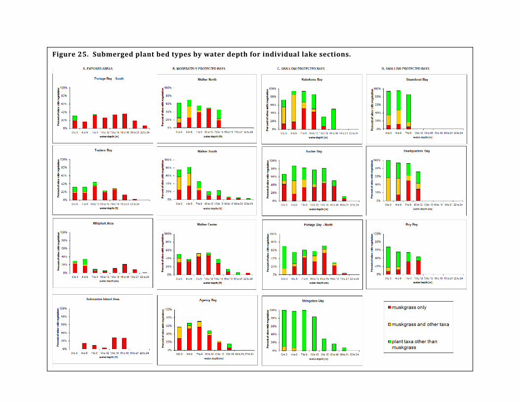
Aquatic vegetation of Leech Lake, 2002-2009 August 2010 Page 73 of 109
Figure 25. Submerged plant bed types by water depth for individual lake sections.
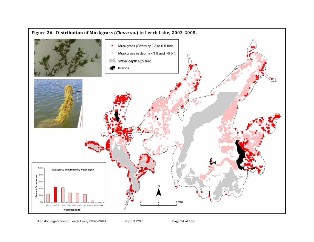
Aquatic vegetation of Leech Lake, 2002-2009 August 2010 Page 74 of 109
Figure 26. Distribution of Muskgrass (Chara sp.) in Leech Lake, 2002-2005.
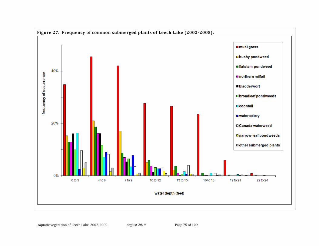
Aquatic vegetation of Leech Lake, 2002-2009 August 2010 Page 75 of 109
Figure 27. Frequency of common submerged plants of Leech Lake (2002-2005).
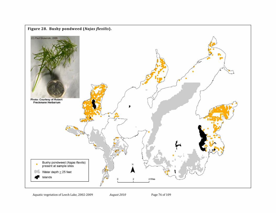
Aquatic vegetation of Leech Lake, 2002-2009 August 2010 Page 76 of 109
Figure 28. Bushy pondweed (Najas flexilis).
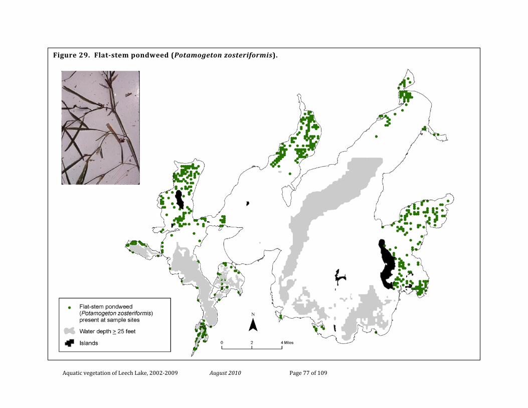
Aquatic vegetation of Leech Lake, 2002-2009 August 2010 Page 77 of 109
Figure 29. Flat-stem pondweed (Potamogeton zosteriformis).
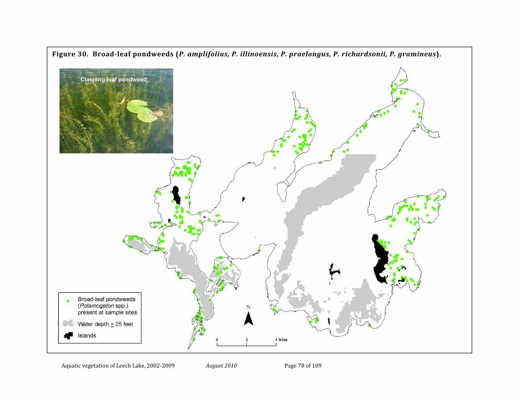
Aquatic vegetation of Leech Lake, 2002-2009 August 2010 Page 78 of 109
Figure 30. Broad-leaf pondweeds (P. amplifolius, P. illinoensis, P. praelongus, P. richardsonii, P. gramineus).
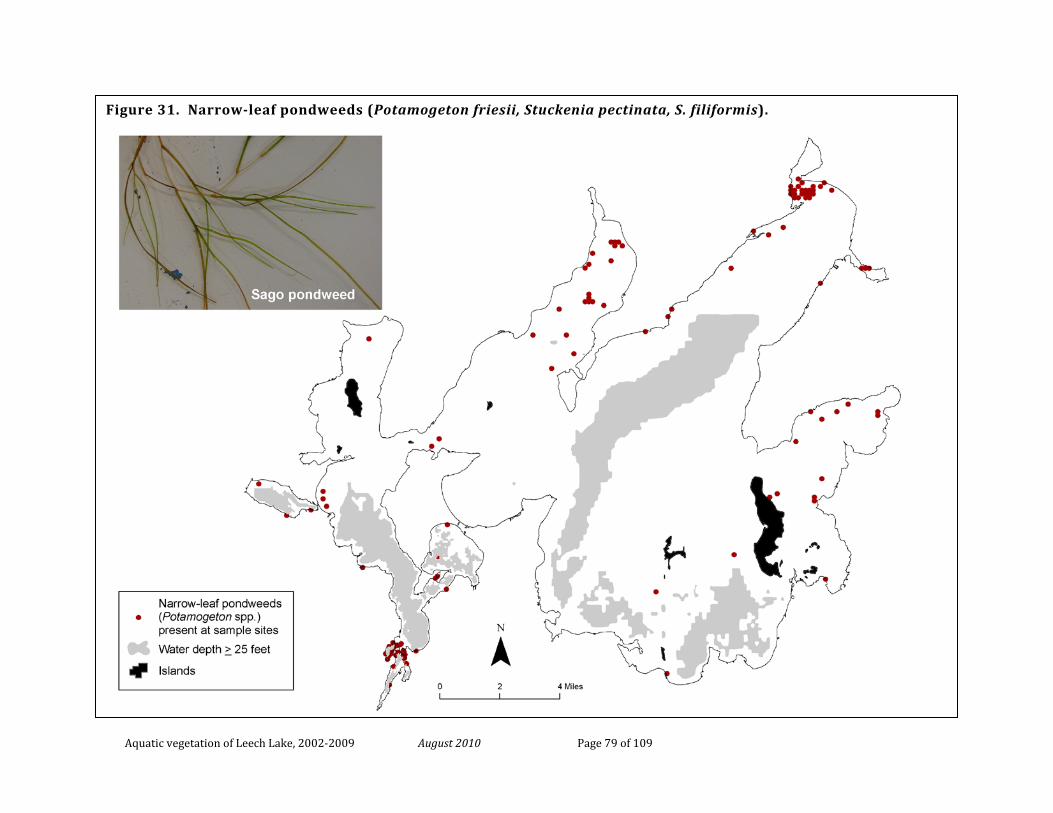
Aquatic vegetation of Leech Lake, 2002-2009 August 2010 Page 79 of 109
Figure 31. Narrow-leaf pondweeds (Potamogeton friesii, Stuckenia pectinata, S. filiformis).
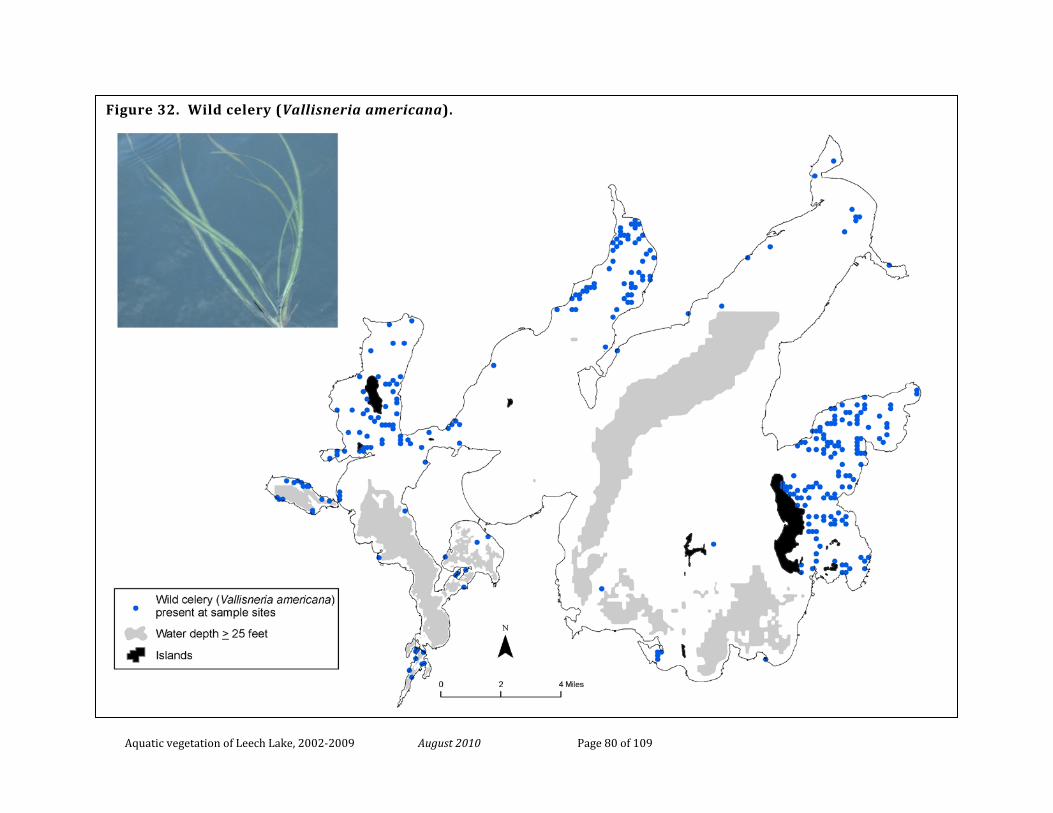
Aquatic vegetation of Leech Lake, 2002-2009 August 2010 Page 80 of 109
Figure 32. Wild celery (Vallisneria americana).
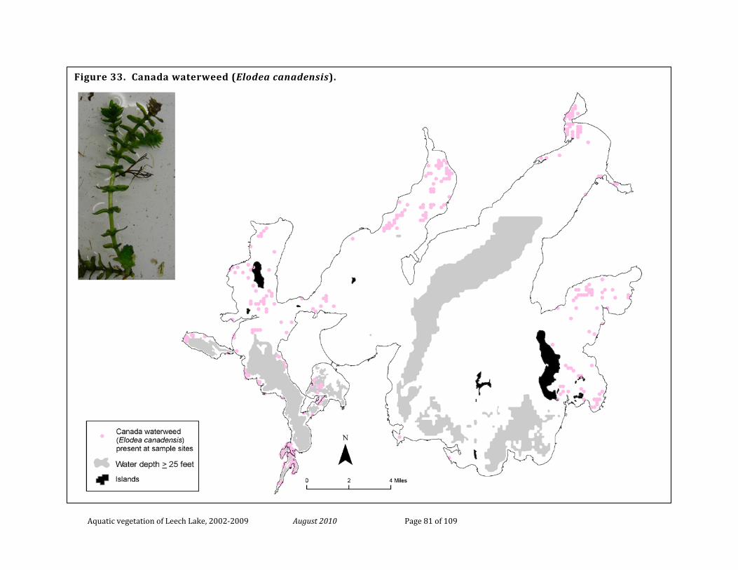
Aquatic vegetation of Leech Lake, 2002-2009 August 2010 Page 81 of 109
Figure 33. Canada waterweed (Elodea canadensis).
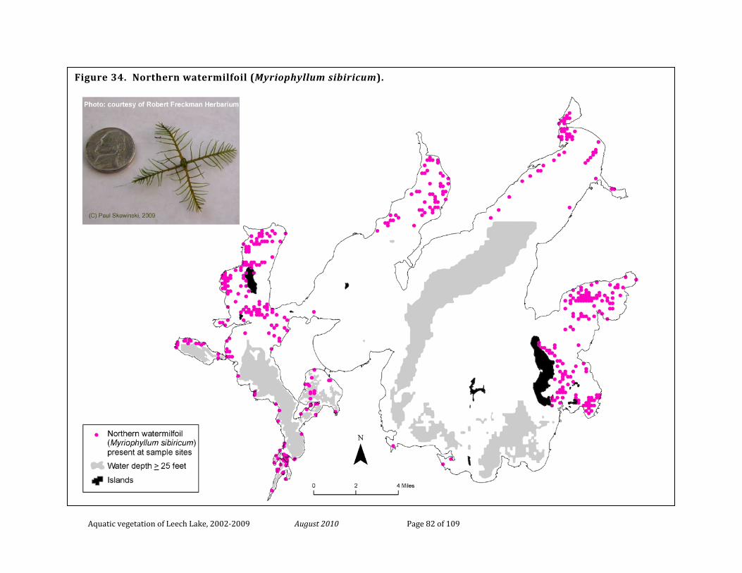
Aquatic vegetation of Leech Lake, 2002-2009 August 2010 Page 82 of 109
Figure 34. Northern watermilfoil (Myriophyllum sibiricum).
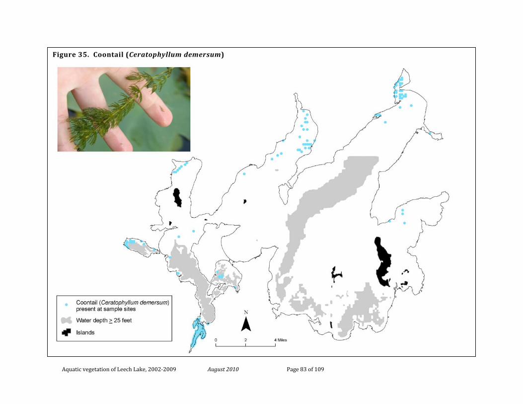
Aquatic vegetation of Leech Lake, 2002-2009 August 2010 Page 83 of 109
Figure 35. Coontail (Ceratophyllum demersum)
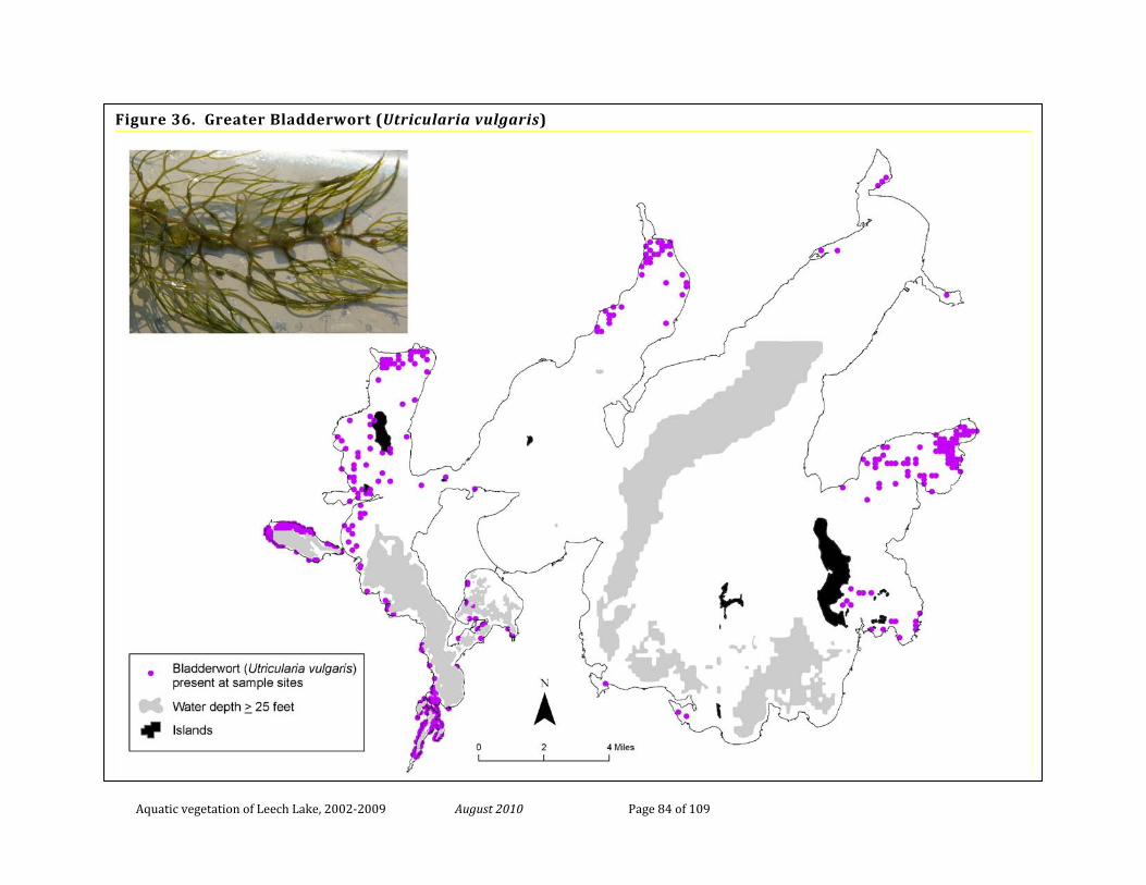
Aquatic vegetation of Leech Lake, 2002-2009 August 2010 Page 84 of 109
Figure 36. Greater Bladderwort (Utricularia vulgaris)
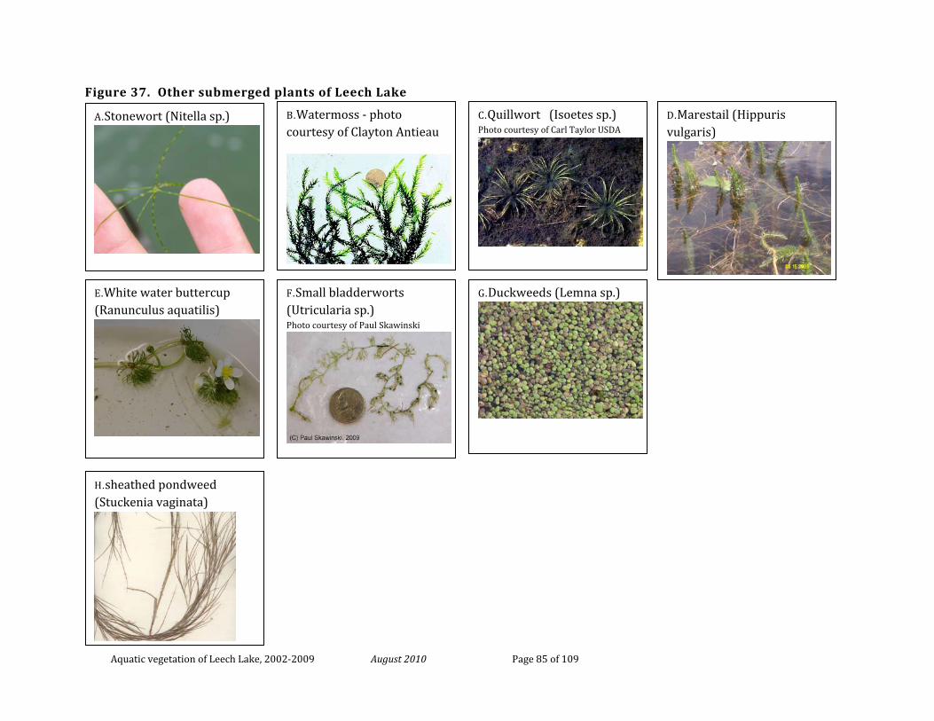
Aquatic vegetation of Leech Lake, 2002-2009 August 2010 Page 85 of 109
Figure 37. Other submerged plants of Leech Lake
A.Stonewort (Nitella sp.)
B.Watermoss - photo courtesy of Clayton Antieau
C.Quillwort (Isoetes sp.) Photo courtesy of Carl Taylor USDA
D.Marestail (Hippuris vulgaris)
E.White water buttercup (Ranunculus aquatilis)
F.Small bladderworts (Utricularia sp.) Photo courtesy of Paul Skawinski
G.Duckweeds (Lemna sp.)
H.sheathed pondweed (Stuckenia vaginata)
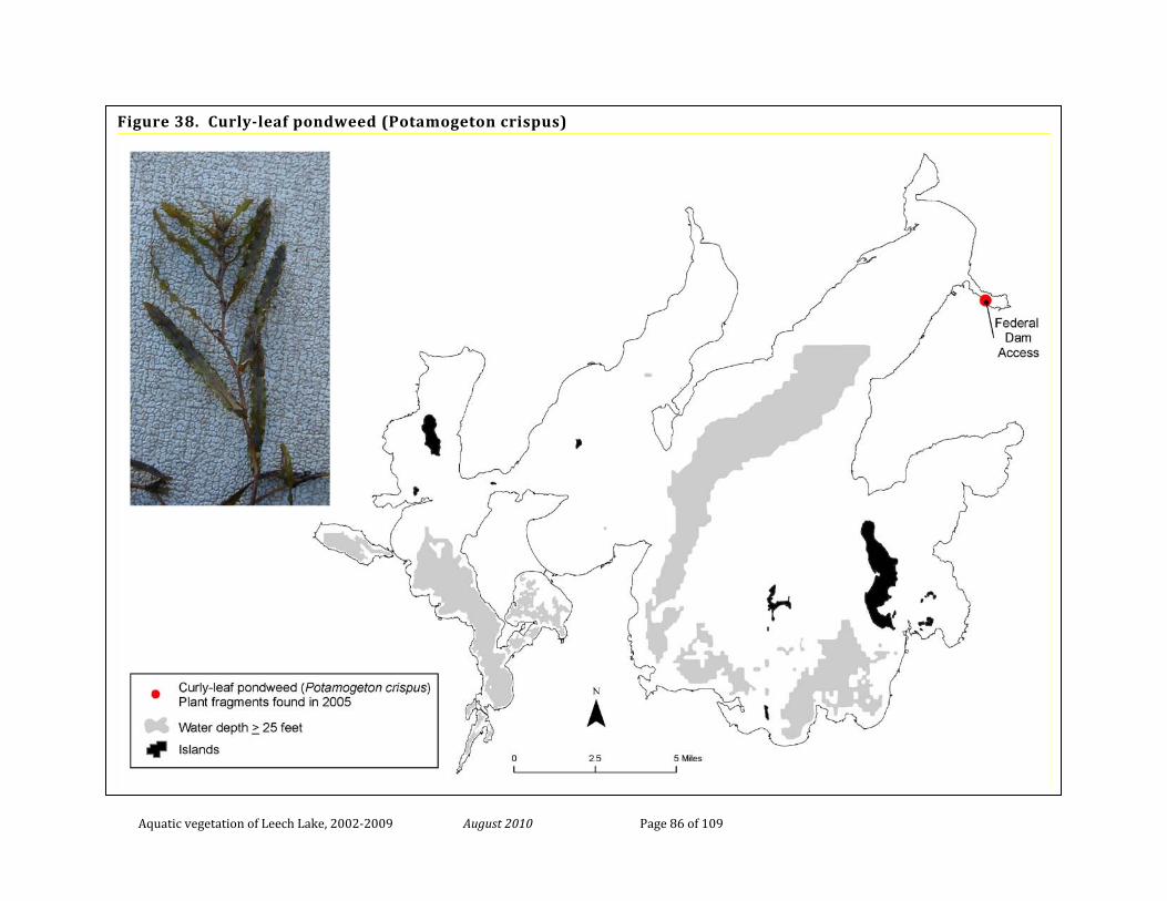
Aquatic vegetation of Leech Lake, 2002-2009 August 2010 Page 86 of 109
Figure 38. Curly-leaf pondweed (Potamogeton crispus)
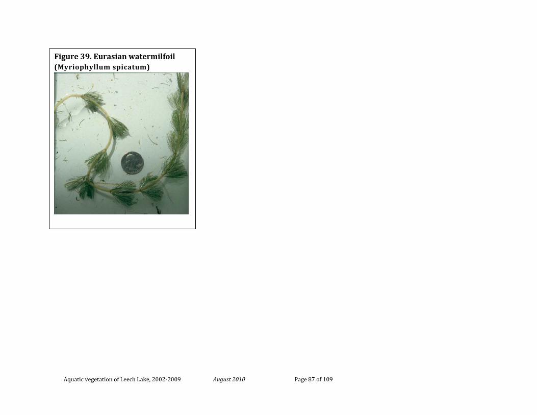
Aquatic vegetation of Leech Lake, 2002-2009 August 2010 Page 87 of 109
Figure 39. Eurasian watermilfoil (Myriophyllum spicatum)
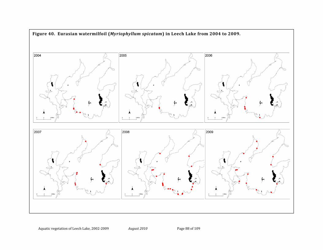
Aquatic vegetation of Leech Lake, 2002-2009 August 2010 Page 88 of 109
Figure 40. Eurasian watermilfoil (Myriophyllum spicatum) in Leech Lake from 2004 to 2009.
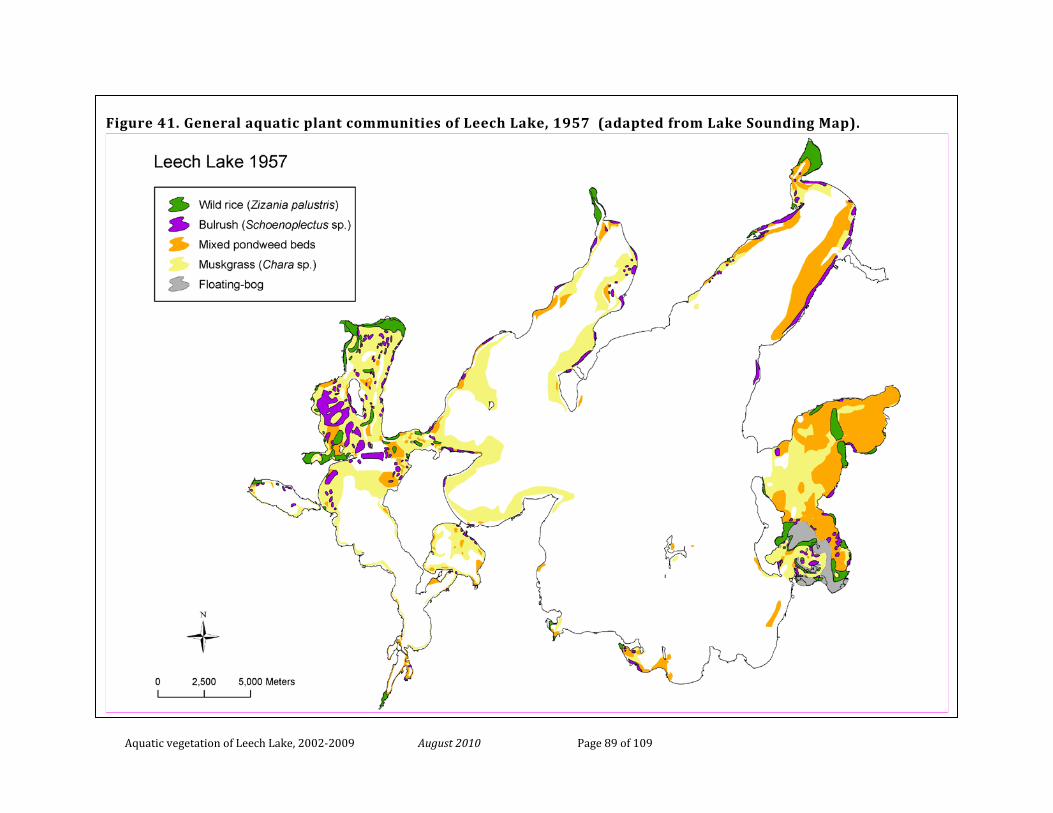
Aquatic vegetation of Leech Lake, 2002-2009 August 2010 Page 89 of 109
Figure 41. General aquatic plant communities of Leech Lake, 1957 (adapted from Lake Sounding Map).
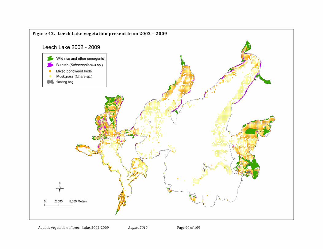
Aquatic vegetation of Leech Lake, 2002-2009 August 2010 Page 90 of 109
Figure 42. Leech Lake vegetation present from 2002 – 2009
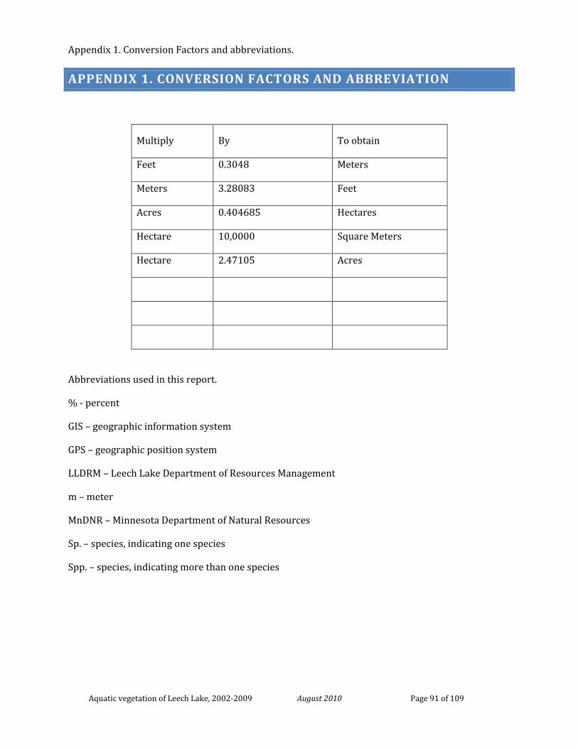
Appendix 1. Conversion Factors and abbreviations.
Aquatic vegetation of Leech Lake, 2002-2009 August 2010 Page 91 of 109
APPENDIX 1. CONVERSION FACTORS AND ABBREVIATION
Multiply By To obtain
Feet 0.3048 Meters
Meters 3.28083 Feet
Acres 0.404685 Hectares
Hectare 10,0000 Square Meters
Hectare 2.47105 Acres
Abbreviations used in this report.
% - percent
GIS – geographic information system
GPS – geographic position system
LLDRM – Leech Lake Department of Resources Management
m – meter
MnDNR – Minnesota Department of Natural Resources
Sp. – species, indicating one species
Spp. – species, indicating more than one species
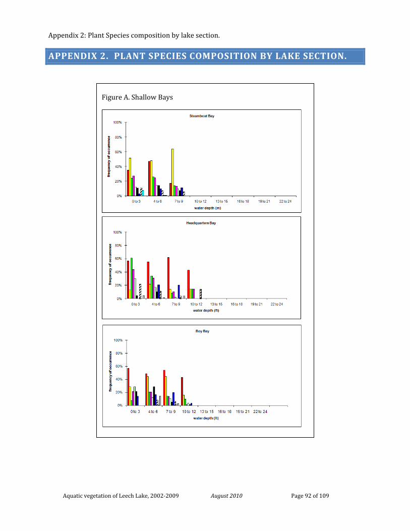
Appendix 2: Plant Species composition by lake section.
Aquatic vegetation of Leech Lake, 2002-2009 August 2010 Page 92 of 109
APPENDIX 2. PLANT SPECIES COMPOSITION BY LAKE SECTION.
Figure A. Shallow Bays
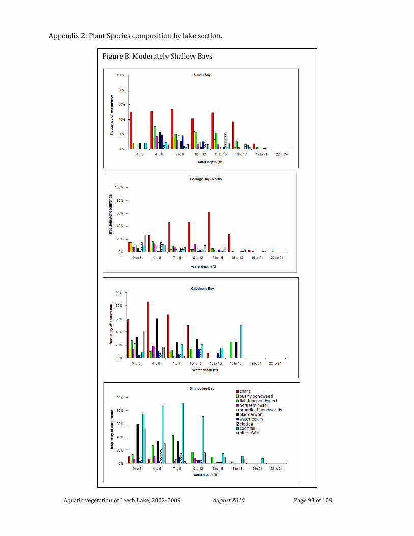
Appendix 2: Plant Species composition by lake section.
Aquatic vegetation of Leech Lake, 2002-2009 August 2010 Page 93 of 109
Figure B. Moderately Shallow Bays
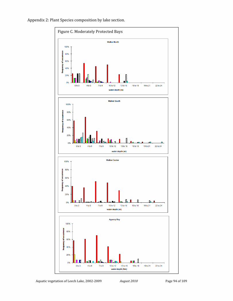
Appendix 2: Plant Species composition by lake section.
Aquatic vegetation of Leech Lake, 2002-2009 August 2010 Page 94 of 109
Figure C. Moderately Protected Bays
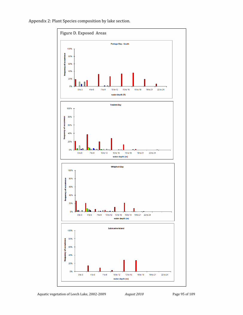
Appendix 2: Plant Species composition by lake section.
Aquatic vegetation of Leech Lake, 2002-2009 August 2010 Page 95 of 109
Figure D. Exposed Areas
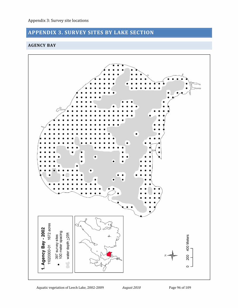
Appendix 3: Survey site locations
Aquatic vegetation of Leech Lake, 2002-2009 August 2010 Page 96 of 109
APPENDIX 3. SURVEY SITES BY LAKE SECTION
AGENCY BAY
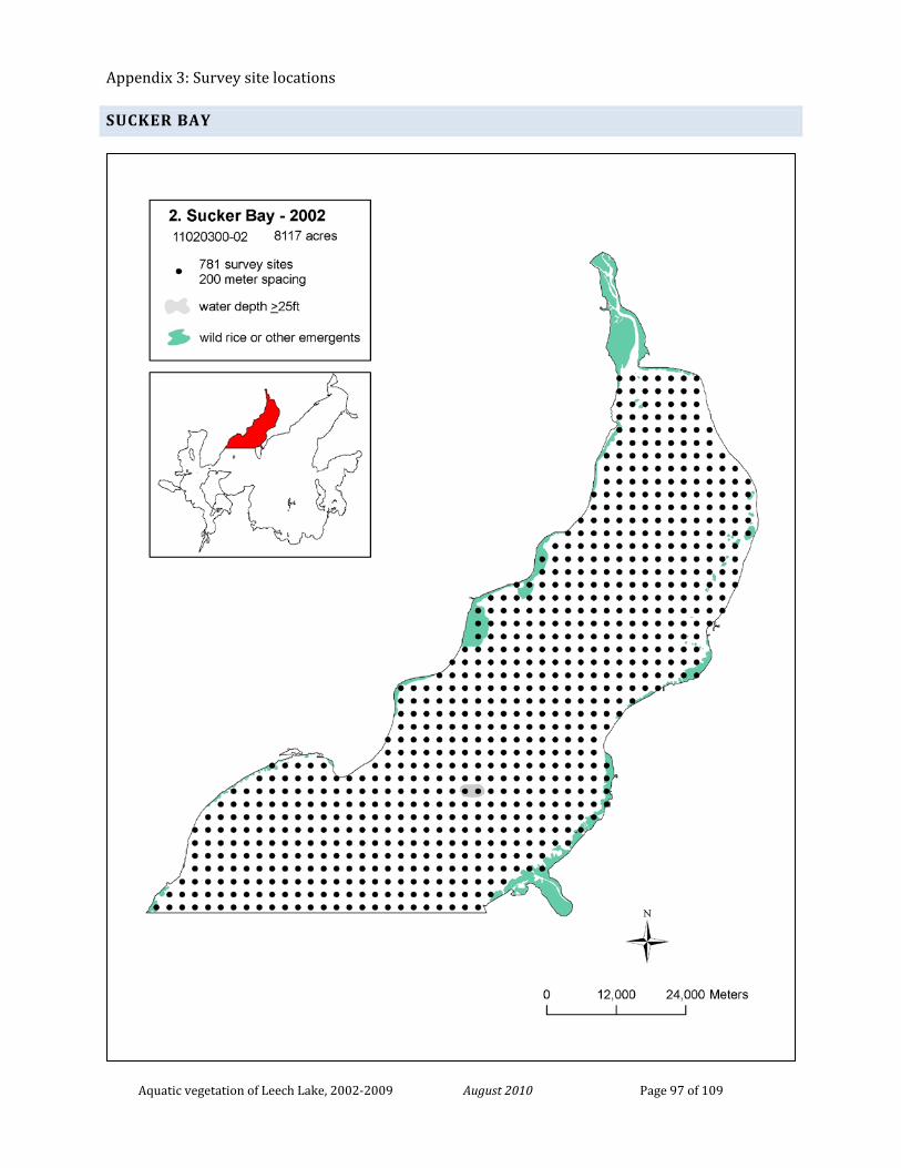
Appendix 3: Survey site locations
Aquatic vegetation of Leech Lake, 2002-2009 August 2010 Page 97 of 109
SUCKER BAY
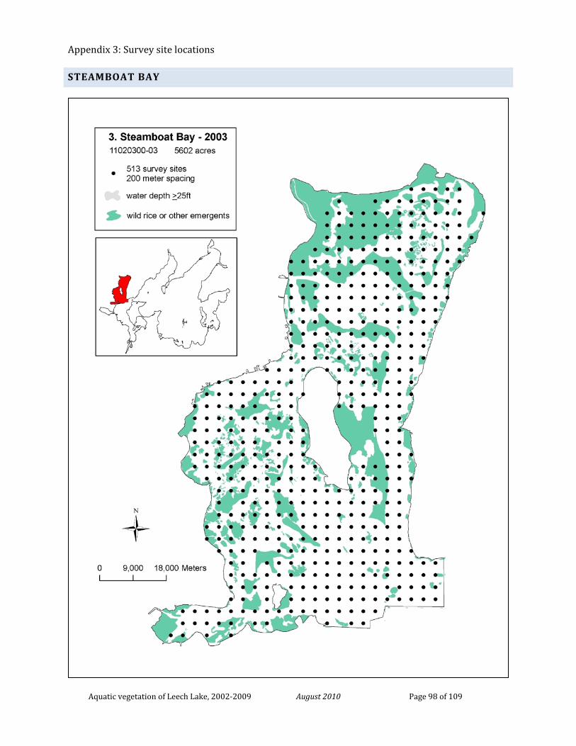
Appendix 3: Survey site locations
Aquatic vegetation of Leech Lake, 2002-2009 August 2010 Page 98 of 109
STEAMBOAT BAY
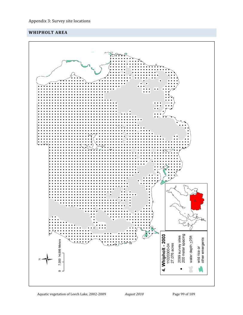
Appendix 3: Survey site locations
Aquatic vegetation of Leech Lake, 2002-2009 August 2010 Page 99 of 109
WHIPHOLT AREA
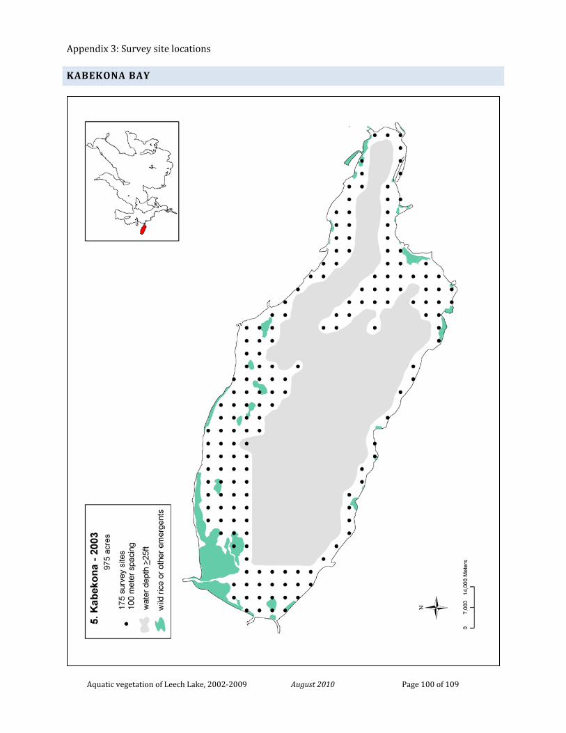
Appendix 3: Survey site locations
Aquatic vegetation of Leech Lake, 2002-2009 August 2010 Page 100 of 109
KABEKONA BAY
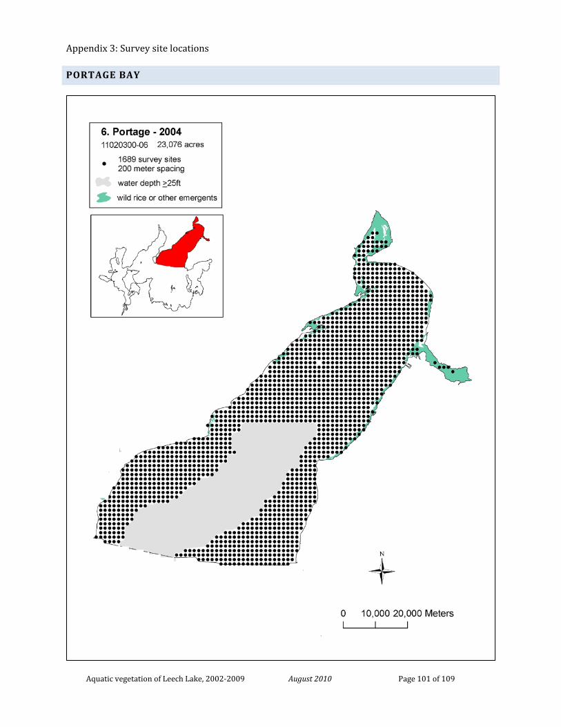
Appendix 3: Survey site locations
Aquatic vegetation of Leech Lake, 2002-2009 August 2010 Page 101 of 109
PORTAGE BAY
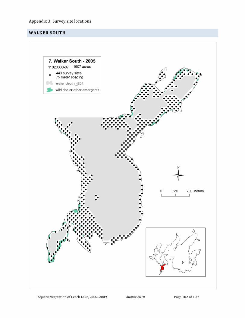
Appendix 3: Survey site locations
Aquatic vegetation of Leech Lake, 2002-2009 August 2010 Page 102 of 109
WALKER SOUTH
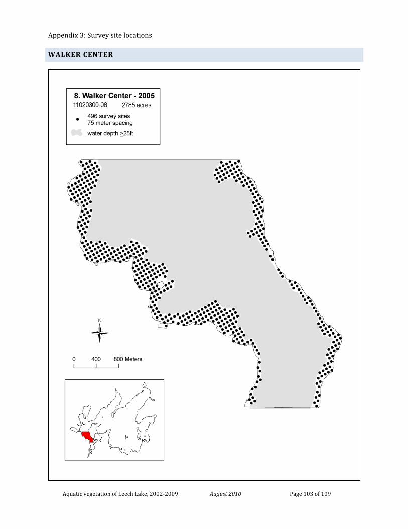
Appendix 3: Survey site locations
Aquatic vegetation of Leech Lake, 2002-2009 August 2010 Page 103 of 109
WALKER CENTER
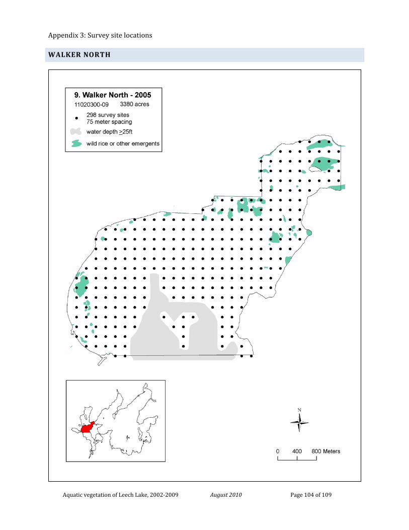
Appendix 3: Survey site locations
Aquatic vegetation of Leech Lake, 2002-2009 August 2010 Page 104 of 109
WALKER NORTH
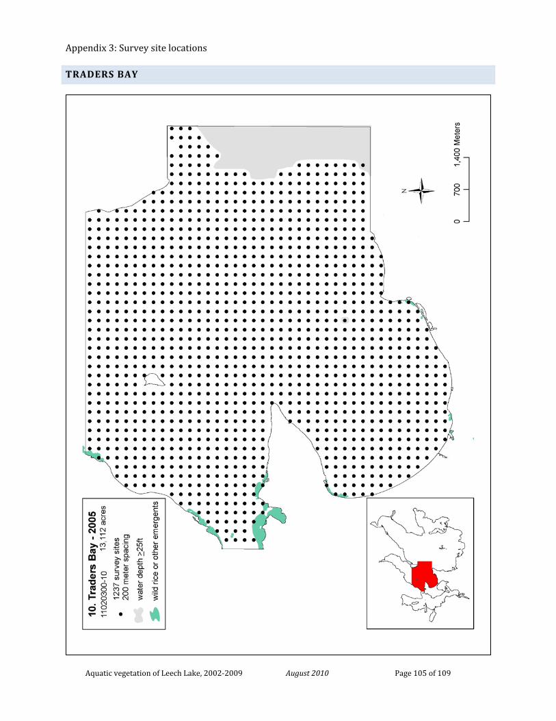
Appendix 3: Survey site locations
Aquatic vegetation of Leech Lake, 2002-2009 August 2010 Page 105 of 109
TRADERS BAY
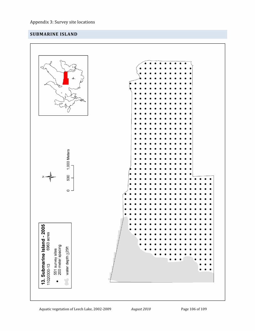
Appendix 3: Survey site locations
Aquatic vegetation of Leech Lake, 2002-2009 August 2010 Page 106 of 109
SUBMARINE ISLAND
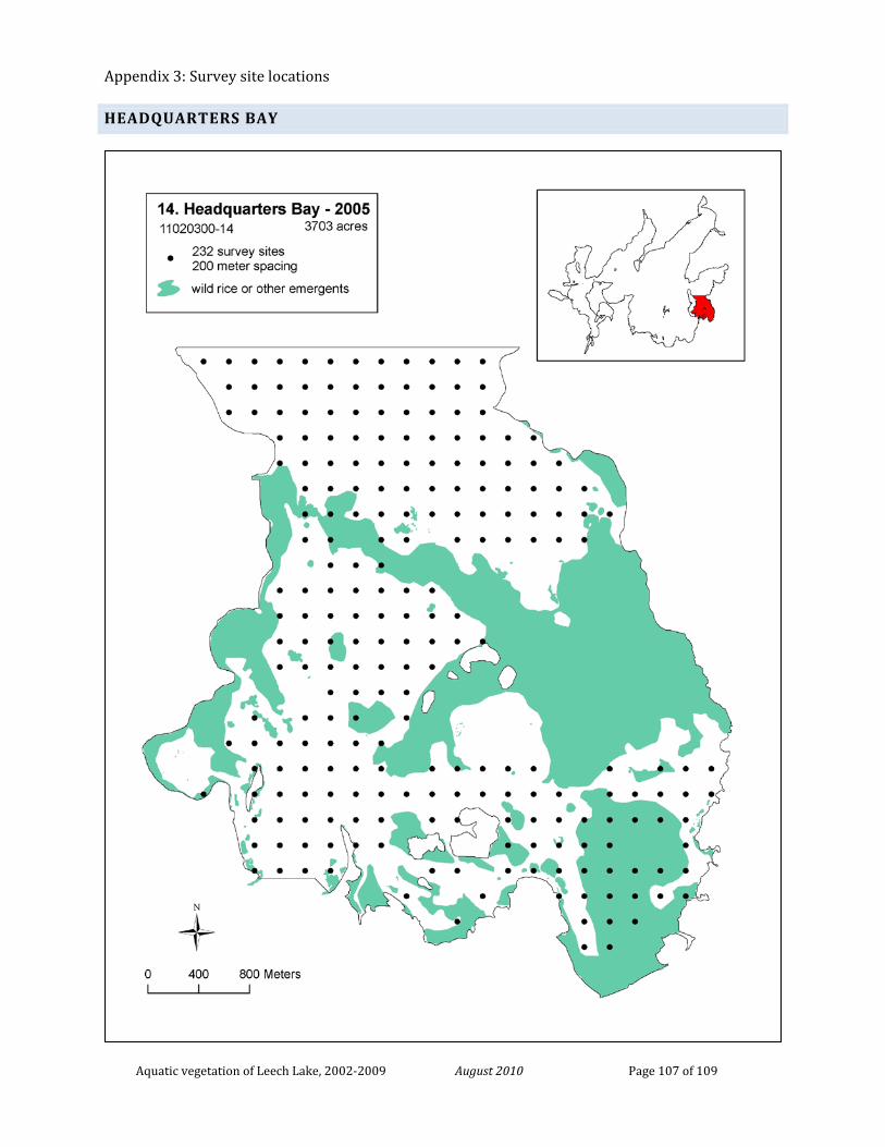
Appendix 3: Survey site locations
Aquatic vegetation of Leech Lake, 2002-2009 August 2010 Page 107 of 109
HEADQUARTERS BAY
Appendix 3: Survey site locations
Aquatic vegetation of Leech Lake, 2002-2009 August 2010 Page 108 of 109
SHINGOBEE BAY
Appendix 3: Survey site locations
Aquatic vegetation of Leech Lake, 2002-2009 August 2010 Page 109 of 109
BOY BAY