lake region community hybrid...the lake region community hybrid (lrch) project is a small solarwind...
TRANSCRIPT

November30,2017
LAKEREGIONCOMMUNITYHYBRID
PROJECTSUMMARYTheLakeRegionCommunityHybrid(LRCH)projectisasmallSolarWindHybridprojectthatisbeingdevelopedbyJuhlEnergyDevelopment,Inc.(JEDI),incooperationwithLakeRegionElectricCooperative(LREC). TheprojectwillutilizethelatesttechnologyfromGeneralElectric(GE),includingtheirWindIntegratedSolarEnergy(WiSE)systemwhichallowssolarenergytobeconvertedand/orcurtailedviathesameinverterandcontrolsystemusedbytheturbine. LRECwillbethepurchaserofthepowerfromtheprojectandhavetheoptiontobetheeventualownersoftheproject.ThissmallprojectwillallowLREC an option to purchase locally generated renewable energy for immediatedistributionandusethroughtheirlocalinfrastructure,helpingthemandtheirmembershedge long-term energy costs, with energy generated with no fuel, no emissions, nowaste,nowaterandnotransmissioncosts.
A. LocalEconomicImpact
i. IncooperationwithLREC thisproject isdesignedwith theirRateStabilizationplan inmind,allowingLRECtonotonlypurchasetheenergygeneratedbytheproject for the next 20 years, for a reduced rate compared to other purchaseoptions, but alsowith a purchase option planned for LREC to be the eventualowneroftheprojectandtheirowngeneration.
ii. DunnTownshipwillbenefitdirectlyfromtheprojectthroughthevalueoflocalandstatetaxespaidtotheminadditiontothepositiveimpactandreducedenergycostsresultingfromlocallygeneratedRenewableEnergysuppliedbytheproject.
iii. Otter Tail County – The County will receive annual tax value for energyProductionTaxappliedtotheprojectassetbytheStateofMinnesota.AspartoftheRateStabilizationPlanforLRECtheprojectwillhelpachieveandmaintainlowerenergycoststoCountyresidentswhoareservicedbyLREC.Additionally,thebenefitoflocallystationedLRECandthecontinuationofjobsandresidencyandothereconomicbenefitsofhavingLRECemployeesinOtterTailCounty.
B. NamesofProjectApplicant/Contact
JuhlEnergyDevelopment,Inc.Attn:AaronThibert470West78thSt.,Suite250Chanhassen,MN55317

2
C. NameofProjectOwner
LakeRegionCommunityHybrid,LLC
D. ProjectSite–PropertyInformation
i. PropertyOwner:DavidL.Johnson48242215thAve.PelicanRapids,MN56572-7094
ii. ParcelNumbers–17000190250000and17000190244000iii. LegalDescription–Section19,Township137,Range042–N½NW¼andS½
NW¼iv. E-911Address:NoneDesignatedtotheseparticularparcelsyet.A911Address
willberequired/registeredforthespecificprojectlocation.
E. ProjectDescription
TheprojectwillincludeoneGE2.0MWPlatformturbine,witha116-meterrotordiameteranda90meterthreesectiontower.Totalheightoftheturbinewillbe486’,tothetipofthebladeinverticalorientation.TheWindandSolarresourcein thePelicanRapids area is very suitable for aprojectof this size,withwindspeedsathubheightaveraging7.24meterspersecond.Interconnectionwill be direct into the LREC 12.5kV underground distributionlinerunningadjacenttotheprojectsite,alongtheeastsideof215thAvenue.Giventheabilitytotiedirectlyintothedistributionlevellinetherewillbenoneedforanyneworadditionaloverheadwiringortheconstructionofaspecificprojectsubstation on site. Electric power from the project will supply power to anyimmediateloadonthe12.5kVdistributionline,orruntotheLRECPelicanLakeSubstationandbefedouttootherconnectedloads.A Power Purchase Agreement (PPA) will be executed between the LRCH andLREC,withatermof20years.LREChasbeeninexistenceforapproximately80years and they serve approximately 27,000 customers. The power purchasedfrom the projectwill fulfill about 2% of LREC’s annual energy sales. LREC isallowed to self-produce up to 5% of its energy sales annually, therefore thisprojectwillprovideapproximately40%oftheirannuallimit.Estimatedannualenergyproductionis8,500megawatthours(8,500,000kilowatthours),roughlyenough topower770homes(11,000kilowatthoursannualaveragehomeuseaccordingtotheU.S.EnergyInformationAdministration’s2016report).

3
AprojectaccessroadfortheprojectwillbeconstructedandmaintainedbytheprojectforthelifeoftheprojectandhavenoeconomicimpactonDunnTownship.Aroaduseagreementbetweentheprojectandthe localTownshipandCountywillbeexecuted,toensurethatanyeffectsordamagesresultingfromprojectuseof local roadswill be repaired to previous or better conditions. Materials forconstructionwillbesourcedlocallywhenfeasibleandtherewillbenohazardousmaterialsbroughtonsite.Proposedprojectwillbesitedonexistingabandonedgravelpit, turningunusedarea intoanactiveandbeneficialsite forrenewableenergy production. Existing approaches will be used for the project andnecessaryaccessroadupgradeswillbemade.Totalprojectcostswillbeapproximately$4.5M,andhaveaphysicalfootprintofroughly3.5acresbetweenthetwo(2)80acreparcelsitwillbesitedon,includingturbine foundation, solar array, project access road, required electricalequipmentandasmallcontrolenclosureifrequired.
F. SiteLayout
i. Manyaspectsareconsideredwhendeterminingpotentialprojectsiting,includingbutnotlimitedtoProximitytoInterconnectingSubstation,LocalAirports,LayoutofUtilityDistributionLines,MinimalimpactonnearbydwellingsandagriculturalpracticesandParticipatingLandOwnerspreferences.
ii. Seeattacheddrawings,LakeRegionCommunityHybridSiteMaps,AttachmentsA1throughA3,forsitelayoutreferenceanddetails.
G. DocumentofLandOwnershiporLegalControlofProperty
i. SeeAttachmentB,OptionforLandLeaseandWind/SolarEasement
H. TurbineLocation/ElevationDetails
i. GPSCoordinates–ProposedLocation1. Latitude-46°40'16.45"N,Longitude-96°02'33.98"W
ii. AboveGroundLevel1. TotalHeight–486’
a. The highest point, above ground level, reached by a rotor tip or anyotherpartoftheWECS.
I. WrittenRegistrationVerification
i. Forthcoming-MNDepartmentofTransportation,AeronauticsDivision

4
1. FAADeterminationmustbereceivedpriortoApplicationandRegistrationwithMNDOT
J. SiteTopographicalMap
i. SeeAttachmentsC1(MNDNR)andC2(USGS),ProjectSiteTopographyMaps1. Nootherturbineslocatedwithin10rotordiametersofproposedWECS
K. SiteSurroundingsMap
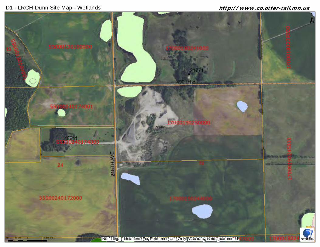
i. SeeAttachmentsD1(OtterTailCountyMap)andD2(SiteMap),LRCHDunnSiteMaps, for indication of wetlands, scenic and natural areas (including bluffs)within1,320feetoftheproposedWECS.
L. FAAPermitApplication
TheLRCHprojecthasappliedforthenecessaryauthorizationsfromtheFederalAviationAdministration. FAA Determination process takes into consideration feedback andcomments from multiple divisions and organizations when making the finaldetermination of project impact to local airports and airfields. Divisions providingfeedbackinFAASiteDeterminationinclude:USAirForce,Navy,Army,DoDEnergySitingClearinghouse, Department of Homeland Security, Office of Flight Procedures, FlightStandard,andAirportsandTechnicalOperationsFrequencyManagement.
1. SeeAttachmentE,FAAPermitApplicationrecorda. FAA–AeronauticalStudyNumber(ASN):2017-WTE-9462-OE
M. LocalCommunicationTowers
i. There are no Communication Towers within a 2-mile radius of the proposedWECS,resultinginnoexpectedimpacttoanylocalcommunicationnetworks.
N. Engineer’sCertification
i. JEDI only works with experienced, certified and licensed professionals on allaspects of project development. Engineer’s Certification is available uponrequest.
O. LocalImpactofProject
i. Public Lands: The Projectwill avoid any impact onNature Conservancy Land,WildlifeManagementAreas,ScientificandNaturalAreas,WaterfowlProductionAreas,and/orpublicparks.
ii. LocalWECS:ThenearestoperatingCommercialWECSislocatedover100rotordiametersaway.AtthisdistancetheLRCHprojectwillhavezeroimpactonany

5
other WECS. There is no expected impact to the wind resources on adjacentproperties.
iii. AcousticImpact:Presently,noiseintheproposedProjectareaisdominatedbytrafficonlocalroadsandagriculturalandequipmentoperations.Secondarynoiseintheareapersistsfromgenerallow-density,lakesarearuralneighborhoodsandfarming-relatedactivities.AmbientnoiselevelsintheproposedProjectareaaretypicalofnoiselevelsexperiencedwithinapredominantlyruralarea.1. AfullAcousticAnalysisoftheprojectandimpactonnearbydwellingswill
be conducted to ensure all local and state requirements are met orexceeded.JEDIaimstomaintainacousticlevelsof45A-weighteddecibels(dBA)orlessfornearbydwellings.MNStateNoiseStandardsfornighttimerequirethata50dBAlevelmaynotbeexceededformorethan50percentofaonehoursurvey,and65dBAnotbeexceededformorethan10percentofaonehoursurvey.
2. The Minnesota Pollution Control Agency (MCPA) has a statewide noiseregulation(Minn.Rule7030.0050)whichspecifiesdaytimeandnighttimenoise levels that cannotbeexceededbyany source.These standardsareconsistent with speech, sleep, annoyance, and hearing conservationrequirements for receivers within areas grouped according to landactivities by the noise area classification (NAC). The NAC for householdunits (including farmhouses) is identifiedasNAC1.TheL50 is thenoiselevelexceededfor50percentofthetimeduringanymeasurementduration,andrepresents themediansound level.TheL10 is thesound levelexceedfor 10 percent of the time during any measurement duration. The windturbineswillcreatesourcesofadditionalnoise.PleaserefertoAttachmentFforareferencetodBAcomparisonsandMinn.Rule7030.0050.
3. Thewindturbineswillemitaperceptiblesoundwheninmotion.Thelevelof this noise varieswith the speed of the turbine and the distance of thelistener from the turbine. The turbines create more noise on relativelywindy days; however, the ambient natural wind noise levels tend tooverridetheturbinenoiseasdistancefromtheturbineincreases.
iv. Visual Impact: The Project site is visually dominated by agricultural fields,farmsteads, fallow fields, largeopenvistas, andgently rolling topography.Thelandscapecanbeclassifiedas ruralopenspace.Localvegetation in thearea ispredominantlyagriculturalfieldsandwoodedlots.1. Atadistance,thewindturbinescanbedistinguishedfromverticalformsin
thelandscape,suchasoverheadtransmissionlinesortrees.Theaestheticeffectisprimarilybasedonasubjectivehumanresponse.Thewindpowerplant will most likely have a combination of effects on the visualquality/ruralcharacterofthearea.From one perspective, the proposed Project sitemight be perceived as avisual intrusion on the natural aesthetic value of the landscape,

6
characterized as tubular steel structures, standing on formerlyundisturbed hilltops. On the other hand, wind plants have their ownaesthetic quality, distinguishing them from other non-agricultural landuses.First, thewindplantdoesnotgeneratemuchtrafficorsignificantlyincreaseday-to-dayhumanactivityinthearea.Therefore,theProjectsitewillretaintheruralnatureofthearea.Second, although “industrial” in form and purpose, wind turbines areessentially“farming”thewindforenergy.Theproposedlandusewouldnotinvolveanyongoinguseofnon-renewableresourcesoremissionsintotheenvironment.Fossilfuelswillnotberefined,transported,orburnedfortheproduction of electricity. Emissions or toxic substances will not beproduced by the wind plant. Although the turbines are “hi-tech” inappearance,theyarecompatiblewiththenaturalenvironmentandruralarea.
P. ProjectTechnology
i. GE’sWiSEtechnologywillallowtheseamlessintegrationof500kWDCofSolarPVpanelswithtwooftheone2.0MWwindturbine.WiSEwillenablethewindturbine’sconvertertoserveastheinverterforthePVpanels,andthesolarenergygenerated by the panelswill augment thewind energy produced through theconverteruptothewindturbines’fullnameplatecapacity.Theeffectofthesolarenergy integration will result in an increase of the projects’ annual energyproduction and net capacity factor without changing the turbine’s overallnameplate capacity rating. The Solar facilitywill be comprised of PVmodulesmounted on fixed tilt ground mount racking. This facility will include GE’ssupervisory control and data acquisition (SCADA) systems and meteringequipment. A perimeter security and safety fence (6’ tall) will surround theProjectsolarcomponentswithaccess throughasecuredgate.ThePVmoduleswillhaveapproximatedimensionsofroughly6.5feetlong,3.5feetwide,and2inchesthick,andwillbegroupedintoasinglearray.
ii. PleaseseeAttachmentGforageneraloverviewoftheGEWiSESystem
Q. DecommissioningPlan
i. RefertoAttachmentHfordetailsontheLRCHDecommissioningPlan.

7
ATTACHMENTS
A1-LRCHSiteLayout–Turbine,Solar&AccessRoad
A2–LRCHSiteLayout–OtterTailCountySetbacks
A3–LRCHSiteLayout–DwellingClearanceDetail
B-OptionforLandLeaseandWind/SolarEasement
C1-ProjectSiteTopographicMap–MNDNRSourced
C2–ProjectSiteTopographicMap–USGSSourced
D1-SiteWetlandsMap–OtterTailCountySourced
D2–SiteWetlandsMap–ProjectDetailMap
E-FAAPermitApplication
F-AcousticdBAReferenceChartandMinn.Rule7030.0050
G-GeneralElectric–WiSEProductOverview
H–LRCHDecommissioningPlan
Foradditionalprojectinformationpleasecontact:
AaronThibert
VPProjectDevelopment
E-mail:[email protected]
Cell:(218)684-5814

A1-LRCHDunnSiteMapTurbine,SolarandAccessRoad
LegendT1-AccessRoad-16'x1,350'WideCornerAddition-AccessRoad(IfRequired)
800ftN
➤➤
N©2017Google
©2017Google
©2017Google

A2-LRCHDunnSiteMapOTCWECSOrdinanceSetbackReference
LegendOTC-DwellingSetback-750'OTC-LakeBuffer-1,000'OTC-PropertyLineSetback-1.1xTotalHeight-535'OTC-RoadROWSetback-486'OTC-WetlandsSetback-600'OTC-Wetlands/Scenic/NaturalAreas-1,320'
1000ftN
➤➤
N©2017Google
©2017Google
©2017Google

A3-LRCHDunnSiteMapTurbine-1Mile-DwellingClearanceDetail
3000ftN
➤➤
N©2017Google
©2017Google
©2017Google

0 0.035 0.07 0.1050.0175 MilesThe State of Minnesota and the Minnesota Department of Natural Resources makes no representationsor warranties expres sed or implied, with respect to the use of maps or geographic data provid edherewith regard les s of its format or the means of its transmis sion. There is no guarantee or representation to the user as to the accuracy, currency, s uitability, or reliability of this d atafor any purpose. The user accepts the data “as is." The State of Minnesota assumes no responsibility for los s or d amage incurred as a result of any user reliance on this d ata. All maps and other material provid ed herein are protected by copyright. Extreme care was used d uring the compilation of this prod uct. However, d ue to changes in ownership and the need to rely on outsid e information, errors or omissions may exist. If you should d iscover an oversight, we encourage you to let us know by calling the DNR at 1-888-646-6367 or by e-mail at info.d [email protected]: Elevation images and contours were generated from LiDAR derived elevation surfaces acq uired 2007-2012.
³Created on 11/30/2017
C1 - LRCH Site Topo Map
1:4,752Scale:

C2-LRCHTopoMapUnitedStatesGeographicalSurvey-TopoOverlay
1000ftN
➤➤
N©2017Google
©2017Google
©2017Google
GIS Dept
±
0.095 0 0.0950.0475 Mi les
D1 - LRCH Dunn Site Map - Wetlands
Not a legal document. For Reference Use Only. Accuracy is not guaranteed.
http://www.co.otter-tail.mn.us

D2-LRCHDunnSiteMapWetlands/Scenic/NaturalAreaswithin1,320'
Legend-SeasonallyFloodedBasin-ShallowMarshOTC-WetlandsSetback-600'OTC-Wetlands/Scenic/NaturalAreas-1,320'
1000ftN
➤➤
N©2017Google
©2017Google
©2017Google

11/30/17, 12)38 PMNotice of Proposed Construction or Alteration - Off Airport
Page 1 of 1https://oeaaa.faa.gov/oeaaa/external/eFiling/locationAction.jsp?action=showLocationForm&locationID=4095807&row=0
« OE/AAA
Add a new Case Off Airport - Desk Reference Guide V_2017.4.0Add a New Case Off Airport for Wind Turbines - Met Towers - Desk Reference Guide V_2017.4.0
Notice of Proposed Construction or Alteration - Off Airport
Project Name: JUHL -000443387-17 Sponsor: Juhl Energy Development, Inc.
Details for Case : LRCH T1 - Johnson (Dunn)Show Project Summary
Case Status
ASN: 2017-WTE-9462-OE
Status: Work In Progress
Public Comments: None
Date Accepted: 11/28/2017
Date Determined:
Letters: None
Documents: None
Project Documents:None
Construction / Alteration Information Structure Summary
Notice Of: Construction
Duration: Permanent
if Temporary : Months: Days:
Work Schedule - Start: 05/01/2018
Work Schedule - End: 11/30/2018
*For temporary cranes-Does the permanent structure require separate notice to the FAA?To find out, use the Notice Criteria Tool. If separate notice is required, please ensure it is filed.If it is not filed, please state the reason in the Description of Proposal.
State Filing: Not filed with State
Structure Type: Wind Turbine
Structure Name: LRCH T1 - Johnson (Dunn)
FDC NOTAM:
NOTAM Number:
FCC Number:
Prior ASN:
Structure Details Proposed Frequency Bands
Latitude: 46° 40' 16.45'' N
Longitude: 96° 2' 33.98'' W
Horizontal Datum: NAD83
Site Elevation (SE): 1392 (nearest foot) PASSEDStructure Height (AGL): 486 (nearest foot)
Current Height (AGL): * For notice of alteration or existing provide the currentAGL height of the existing structure. Include details in the Description of Proposal
(nearest foot)
Minimum Operating Height (AGL): * For aeronautical study of a crane or construction equipment the maximum height should be listed above as the Structure Height (AGL). Additionally, provide the minimumoperating height to avoid delays if impacts are identified thatrequire negotiation to a reduced height. If the Structure Height and minimum operating height are the same enter the same value in both fields.
(nearest foot)
Requested Marking/Lighting: Dual medium catenary
Other :Recommended Marking/Lighting:
Current Marking/Lighting: N/A Proposed Structure
Other :
Nearest City: Dunvilla
Nearest State: Minnesota
Description of Location:On the Project Summary page upload any certified survey.
Abandoned gravel pit area.
Description of Proposal: Single Turbine project.
Select any combination of the applicable frequencies/powers identifiedin the Colo Void Clause Coalition, Antenna System Co-Location,Voluntary Best Practices, effective 21 Nov 2007, to be evaluated bythe FAA with your filing. If not within one of the frequency bands listedbelow, manually input your proposed frequency(ies) and power usingthe Add Specific Frequency link.Add Specific Frequency
Low Freq High Freq Freq Unit ERP ERP Unit
Previous Back toSearch Result Next

ATTACHMENT F – Acoustic dBA Reference Chart and Minn. Rule 7030.0050
State of Minnesota Noise Standards – MPCA – Minn. Rule 7030.0050
https://www.pca.state.mn.us/sites/default/files/p-gen6-01.pdf

ATTACHMENT G
GENERAL ELECTRIC - WISE PRODUCT OVERVIEW

ATTACHMENT H - Lake Region Community Hybrid – Decommissioning Plan Decommissioning and restoration activities will adhere to the requirements of appropriate governing authorities, and will be in accordance with applicable federal, state, and local permits. The Applicant will follow the erosion and sedimentation control measures and other requirements currently in place for construction of the Project, except as modified in a plan submitted to and approved by the Department prior to commencing removal activities. The decommissioning and restoration process comprises removal of above-ground structures; removal of below-ground structures to a depth of four (4) feet; grading, to the extent necessary; restoration of topsoil and seeding. The process of removing structures involves evaluating and categorizing all components and materials into categories of recondition and reuse, salvage, recycling and disposal. In the interest of increased efficiency and minimal transportation impacts, components and material may be stored on-site in a pre-approved location until the bulk of similar components or materials are ready for transport. The components and material will be transported to the appropriate facilities for reconditioning, salvage, recycling, or disposal. Above-ground structures include the turbine, pad mount transformer, control building (if any), solar array components, and wind farm-owned portions of the interconnection facilities (if any). Below-ground structures include turbine and pad mount transformer foundations; collection system conduit and cable; fiber optic facilities; and subterranean drainage structures (if any). The above-ground structures and below-ground structures are collectively referred to herein as the "Wind Farm Components". In connection with the decommissioning of the Wind Farm Components and removal as further set forth below, in the event that on or prior to decommissioning owner provides evidence of a plan of continued beneficial use of any of the Wind Farm Components, such items shall be excepted from the requirements of decommissioning and the existing license shall be amended to reflect such revisions. Turbine removal: Access roads and crossings to turbines will be widened to a sufficient width to accommodate movement of appropriately sized cranes, trucks, and other machinery required for the disassembly and removal of the turbines (if necessary). Control cabinets, electronic components, and internal cables will be removed. The rotor, nacelle and tower sections will be lowered to the ground where they may be transported whole for reconditioning and reuse, or disassembled/cut into more easily transportable sections for salvageable, recyclable, or disposable components. Solar Array removal: Solar array removal will include, but not be limited to, perimeter fencing, solar racking, and solar system collection cables. Turbine and substation foundation removal: Topsoil will be removed from an area surrounding the foundation and stored for later replacement, as applicable. Turbine foundations will be excavated to a depth sufficient to remove all anchor bolts, rebar, conduits, cable, and concrete to a depth of four (4) feet below grade. The remaining excavation will be filled with clean sub-grade material of quality comparable to the
immediate surrounding area. The sub-grade material will be compacted to a density similar to surrounding sub-grade material. All unexcavated areas compacted by equipment used in decommissioning shall be de-compacted in a manner to adequately restore the topsoil and sub-grade material to the proper density consistent and compatible with the surrounding area. Underground collection cables: The cables and conduits contain no materials known to be harmful to the environment. As part of the decommissioning, these items will be cut back to a depth of four (4) feet. All cable and conduit buried greater than 24 inches will be left in place and abandoned or removed and recycled or scrapped if value justifies such. Interconnection facilities: Disassembly of the interconnection facilities will include only the areas owned by the Applicant. Components (including steel, conductors, switches, transformers, fencing, control building, etc.) will be removed from the site and reconditioned and reused, sold as scrap, recycled, or disposed of appropriately at the Applicant's sole discretion. To the extent possible to remove foundations and underground components without damaging or impacting adjacent facilities, such foundations and underground components will be removed to a depth of four (4) feet and the excavation filled, contoured, and re-seeded. Access roads: Unless requested otherwise by the underlying landowner, permanent access roads constructed to accommodate the Project will remain in place. Ditch crossings connecting access roads to public roads will be removed unless required that they remain by the landowner. Improvements to Town and County roads that were not removed after construction will remain in place. Site Restoration Process Description: Topsoil will be removed prior to removal of structures from all work areas and stockpiled, clearly designated, and separate from other excavated material. The topsoil will be de-compacted to match the density and consistency of the immediate surrounding area. The topsoil will be replaced to original depth, and original surface contours re-established where possible. Any topsoil deficiency and trench settling shall be mitigated with imported topsoil consistent with the quality of the affected site. Following decommissioning activities, the sub-grade material and topsoil from affected areas will be de-compacted and restored to a density and depth consistent with the surrounding areas to a maximum depth of four (4) feet. The affected areas will be inspected, thoroughly cleaned, and all construction-related debris removed. Disturbed areas will be reseeded to promote re-vegetation of the area to a condition reasonably similar to the original condition, reasonable wear and tear excepted. In all areas restoration shall include, as reasonably required, leveling, terracing, mulching, and other necessary steps to prevent soil erosion, to ensure establishment of suitable grasses and forbs, and to control noxious weeds and pests. The project understands that it is solely responsible for all costs related to the decommissioning and removal of the project related facilities at the proposed site.