kysite fall meeting november 14, 2014 carol callan-ramler, p.e. kytc district 6 planning supervisor...
TRANSCRIPT

KYSITE Fa l l Meet ingNovember 14 , 2014
Caro l Ca l lan-R amler, P.E .K Y T C D i s t r i c t 6 P l a n n i n g S u p e r v i s o r
KYTC PlanningNot Just Traffic Counts & Models

KYTC Planning: Not Just Traffic Counts & Models
Data…more data…and more data Unscheduled projects to development of prioritized
plans Air Quality Intermodal and Freight The obvious: Forecast and Modeling! Bike / Ped Transportation Systems … maps & more maps! Traffic Counts – the other obvious Data Management
GPS - HIS - Asset Management

KYTC Planning: Not Just Traffic Counts & Models
Why do much data: 23 CFR 420.111 and other federal actions
State functions and activities Metropolitan Planning Organizations (9 MPOs) Area Development Districts (15 ADDs)
Performance Measures Reports to State and Federal Officials Collaboration and provision of information amongst
various state agencies, divisions with the Transportation Cabinet and the public
Asset Management Projects

KYTC Planning: Not Just Traffic Counts & Models
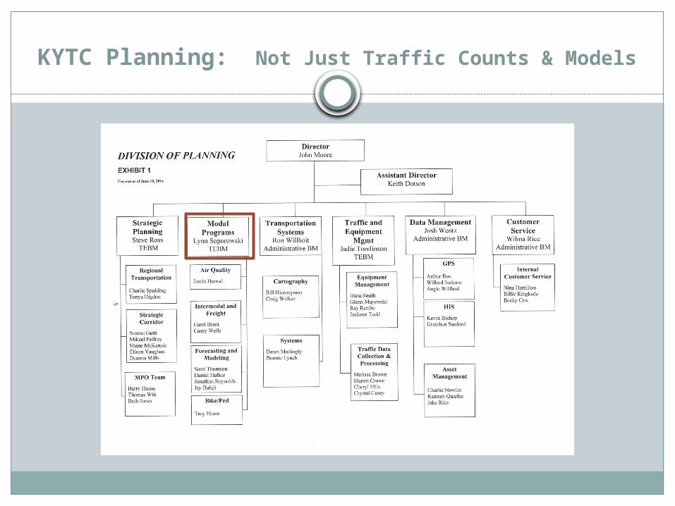
The Division of Planning is charged with the responsibility for recommending, advising, and assisting the chief administrators of the KYTC in the development of the overall goals, policies, project priorities and procedures relating to the total transportation program of the Cabinet.
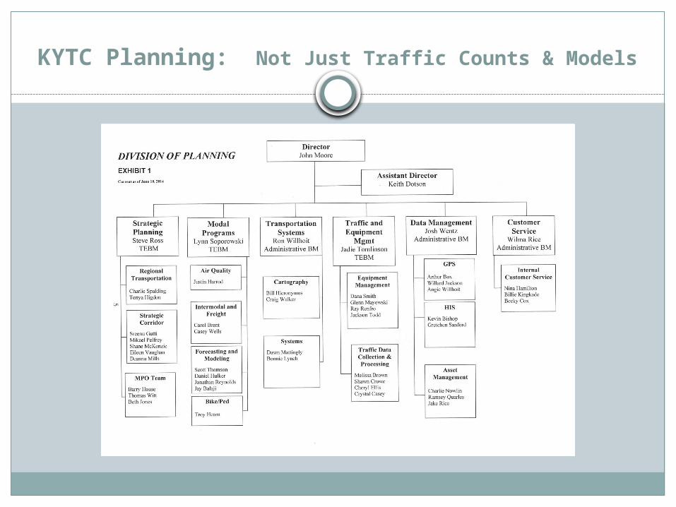
KYTC Planning: Not Just Traffic Counts & Models
KYTC Planning: Not Just Traffic Counts & Models
KYTC Planning: Not Just Traffic Counts & Models
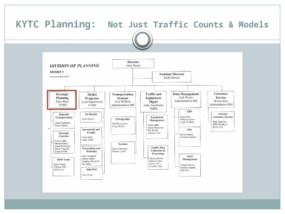
Strategic Planning / Regional Transportation Primary Deliverables:
Prioritized Highway Plan Long Range Statewide Transportation Plan
Development of performance measures per MAP -21 Annual Work Programs for ADDs Biennial District Transportation Plans - coordination
Primary Database: Project Identification Forms (PIFs) aka Unscheduled Needs List (UNL)
Unscheduled Priority List (UPLs) Planning Studies
KYTC Planning: Not Just Traffic Counts & Models
Strategic Planning: Metropolitan Planning Organizations Primary Deliverables:
Compliant & consistent Transportation Improvement Programs (TIPs), Metropolitan Transportation Plans
Statewide Transportation Improvement Program (STIP) Contracts with MPOs & LPAs to carry out planning
activities Primary activities are reviewing, updating &
evaluating all aspects of current or upcoming legislatively approved projects, including funding of respective phases (D / R / U/ C) and the respective fiscal years in which the amounts are to be awarded.
KYTC Planning: Not Just Traffic Counts & Models
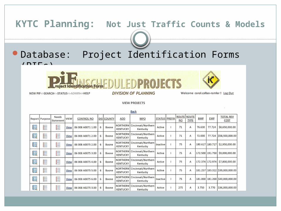
Database: Project Identification Forms (PIFs)

KYTC Planning: Not Just Traffic Counts & Models
Database: Project Identification Forms (PIFs) Project Location / length Purpose and Need | Regional Goal Network Elements (e.g. NKS, Coal, Scenic, Bike) Right-of-way: existing & proposed | current land use Utilities: existing and those potentially impacted Economic Impact (zoning | how might local & regional
economy be affected | access to points of interest | access to major generators)
Multimodal Bikes, Walks, Shared Use Paths, Park & Rides Access to airports, RRs, river ports, trucking routes, transit
Social Impact (neighborhood, travel patterns, relocations, environmental justice groups)
KYTC Planning: Not Just Traffic Counts & Models
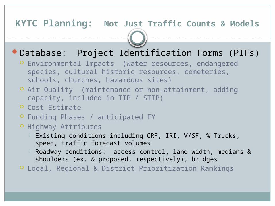
Database: Project Identification Forms (PIFs) Environmental Impacts (water resources, endangered species,
cultural historic resources, cemeteries, schools, churches, hazardous sites)
Air Quality (maintenance or non-attainment, adding capacity, included in TIP / STIP)
Cost Estimate Funding Phases / anticipated FY Highway Attributes
Existing conditions including CRF, IRI, V/SF, % Trucks, speed, traffic forecast volumes
Roadway conditions: access control, lane width, medians & shoulders (ex. & proposed, respectively), bridges
Local, Regional & District Prioritization Rankings

KYTC Planning: Not Just Traffic Counts & Models
Planning Studies and Reports (located on Planning Page / Navigation)

KYTC Planning: Not Just Traffic Counts & Models
Data Needs Analysis (DNA Form)

KYTC Planning: Not Just Traffic Counts & Models
Data Needs Analysis (DNA Form)

KYTC Planning: Not Just Traffic Counts & Models
Data Needs Analysis (DNA Form) – Other Elements:
Transportation Demand Capacity Safety Roadway Deficiencies Preliminary Environmental Overview:
Air Quality | Archaeology / Historic Resources | Threatened and Endangered Species | Hazardous Materials |Permitting | Noise | Socioeconomic | Section 4(f) and 6 (f) Resources
Scoping and Need Draft Project Purpose Cost Estimate Potential Utilities Impacts
KYTC Planning: Not Just Traffic Counts & Models

KYTC Planning: Not Just Traffic Counts & Models
Modal Programs:Air Quality Intermodal & FreightForecasting & ModelingBike / Ped
Over-arching Activity: Moving Ahead for Progress in the 21st Century (MAP-21) … Performance Measures

KYTC Planning: Not Just Traffic Counts & Models
Modal Programs: Performance Measures to Develop & Maintain:Freight: annual hours of truck delay (AHTD) and
Truck Reliability Index (RI80) both on InterstatesSystem Performance: annual hours of delay (AHD)
and reliability Index (RI80) both on Interstates and on National Highway System corridors
Congestion Mitigation / Air Quality (CMAQ):Criteria Pollutant Emissions (VOC, NOx, PM, CO)
reduced by latest annual program of CMAQ projects
Annual Hours of Delay (AHD) reduced by latest annual program of CMAQ projects
KYTC Planning: Not Just Traffic Counts & Models
Modal Programs: Air Quality Primary Deliverables:
Ozone and PM2.5 regional conformity analysis as required
Conforming statewide and MPO planning documents
Data to Division of Air Quality as requestedEmission calculations for CMAQ, GHG/CC as
requestedVIN / Fleet data for use with MOVES (Motor
Vehicles Simulator for EPA)

KYTC Planning: Not Just Traffic Counts & Models
Modal Programs: Air Quality Primary Deliverables Continued:
Provides support to the Office of Local Government and local agencies for CMAQ issues
Webpage:KY Air Quality DesignationsLinks to EPA, FHWA for transportation
conformanceLink to Energy & Environmental Cabinet – Air
Quality Division, Dept. for Environ. ProtectionBiennial Air Quality Conferences
KYTC Planning: Not Just Traffic Counts & Models
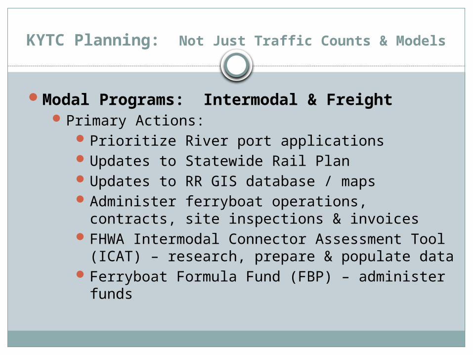
Modal Programs: Intermodal & FreightPrimary Actions:
Prioritize River port applicationsUpdates to Statewide Rail PlanUpdates to RR GIS database / mapsAdminister ferryboat operations, contracts, site
inspections & invoicesFHWA Intermodal Connector Assessment Tool
(ICAT) – research, prepare & populate dataFerryboat Formula Fund (FBP) – administer funds

KYTC Planning: Not Just Traffic Counts & Models
Modal Programs: Intermodal & FreightActions Continued :
KY Shortline Railroad Assistance administrationWater Transportation Advisory Board staff
supportFreight movement: provide tech. assistance /
info to MPOs, ADDs, HDOs & project teamsFreight Data: evaluate, receive, update &
disseminateVisit intermodal sites & communicate with rail,
water, & road modes to identify freight-related needs and concerns involving highways

KYTC Planning: Not Just Traffic Counts & Models
Modal Programs: Intermodal & Freight (located at Planning / Multimodal Freight Transportation / Freight / Freight Maps)

KYTC Planning: Not Just Traffic Counts & Models
Modal Programs: Intermodal & Freight (located at Planning / Multimodal Freight Transportation / Freight / Intermodal Freight Plan and Maps / Exhibit Maps)

KYTC Planning: Not Just Traffic Counts & Models
Modal Programs: Intermodal & Freight (located at Planning / Multimodal Freight Transportation / Freight / Intermodal Freight Plan and Maps / Exhibit Maps)

KYTC Planning: Not Just Traffic Counts & Models
Modal Programs: Intermodal & Freight (located at Planning / Multimodal Freight Transportation / Freight / Intermodal Freight Plan and Maps / Exhibit Maps)

KYTC Planning: Not Just Traffic Counts & Models
Modal Programs: Intermodal & Freight (located at Planning / Multimodal Freight Transportation / Freight / Intermodal Freight Plan and Maps / Exhibit Maps)

KYTC Planning: Not Just Traffic Counts & Models
Modal Programs: Forecasting and ModelingPrimary Actions: besides the obvious…
Website provides link to Planning and Zoning Contact Information throughout state
Website: within Traffic Demand Modeling page – links to Resources on forecasting, travel estimate techniques & Toll Road demand & revenue
Website: links to Model Users Groups

KYTC Planning: Not Just Traffic Counts & Models
Modal Programs: Forecasting and ModelingCongestion Toolbox

KYTC Planning: Not Just Traffic Counts & Models
Modal Programs: Bike / PedPrimary Actions:
Develop a statewide bikeway & pedestrian systemCollaborates with various state Cabinets
Cabinets of Tourism (incl. Adventure)Arts & Heritage Governor’s Depart. for Local GovernmentHealth and Family ServicesOffice of Local Programs (OLP)Office of Hwy SafetyKY Pedestrian Action Safety CommitteeFHWA Pedestrian Fatality Focus Study

KYTC Planning: Not Just Traffic Counts & Models
Modal Programs: Bike / PedActions Continued:
Expand active transportation opportunitiesOLP: various funding programs
Scenic Byways | Transportation Alternative Program (TAP) | Recreational Trail Programs | CMAQ
Prepare, assist and promote bicycle and ped programs to projects teams for highway projects
Secretary to the KY Bicycle and Bikeway Commission
KYTC Planning: Not Just Traffic Counts & Models
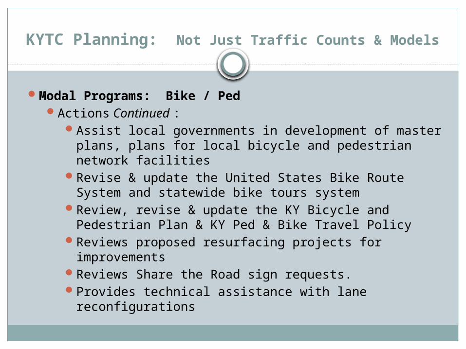
Modal Programs: Bike / PedActions Continued :
Assist local governments in development of master plans, plans for local bicycle and pedestrian network facilities
Revise & update the United States Bike Route System and statewide bike tours system
Review, revise & update the KY Bicycle and Pedestrian Plan & KY Ped & Bike Travel Policy
Reviews proposed resurfacing projects for improvements
Reviews Share the Road sign requests.Provides technical assistance with lane reconfigurations

KYTC Planning: Not Just Traffic Counts & Models
Modal Programs: Bike / PedActions Continued :
GIS: develop & maintain a GIS of bicycle and pedestrian network facilities and plans statewide
Actively coordinating with ADDs to obtain dataProvide training on how to conduct walkability
and bikeability audits.Works with local law enforcement to promote
education and enforcement of ped & bike lawsDevelop and maintain a clearinghouse of
information concerning active transportation

KYTC Planning: Not Just Traffic Counts & Models
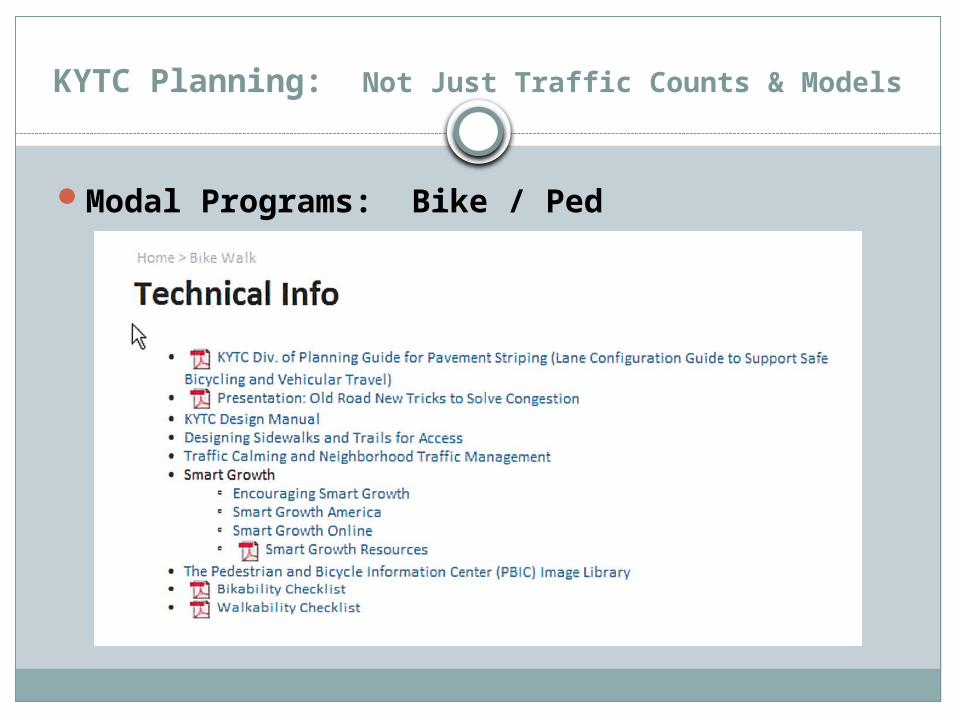
Modal Programs: Bike / Ped
KYTC Planning: Not Just Traffic Counts & Models
Modal Programs: Bike / Ped

KYTC Planning: Not Just Traffic Counts & Models
Modal Programs: Bike / Ped

KYTC Planning: Not Just Traffic Counts & Models
Modal Programs: Bike / Ped

KYTC Planning: Not Just Traffic Counts & Models
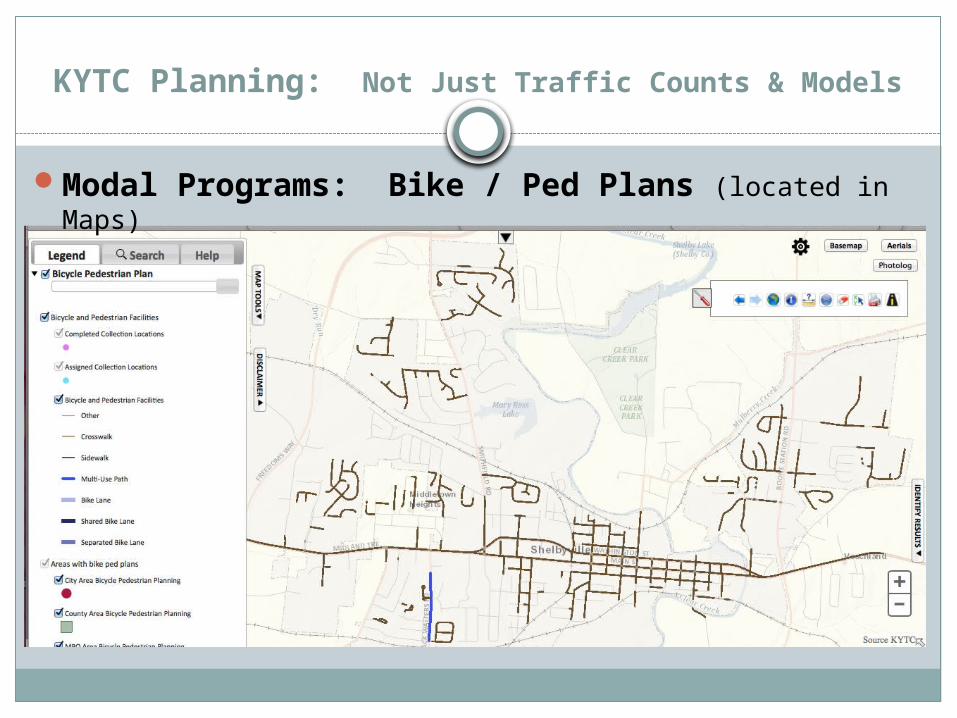
Modal Programs: Bike / Ped Plans (located in Maps)
KYTC Planning: Not Just Traffic Counts & Models
Modal Programs: Bike / Ped Plans (located in Maps)

KYTC Planning: Not Just Traffic Counts & Models
KYTC Planning: Not Just Traffic Counts & Models
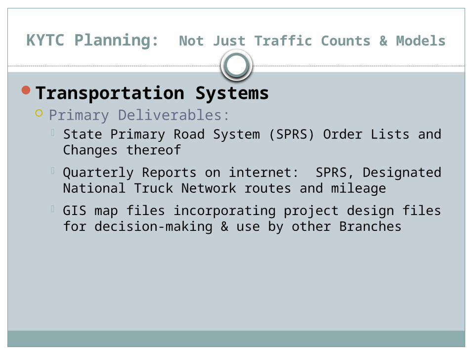
Transportation Systems Primary Deliverables:
State Primary Road System (SPRS) Order Lists and Changes thereof
Quarterly Reports on internet: SPRS, Designated National Truck Network routes and mileage
GIS map files incorporating project design files for decision-making & use by other Branches

KYTC Planning: Not Just Traffic Counts & Models
Transportation Systems Deliverables Continued :
Coal Haul System Report with maps & datasets to Department of Local Government, KYTC Budgets & Bridge Maintenance
Requests to FHWA for changes to National Truck Network
Requests to FHWA for modification of National Highway System
Requests to FHWA for permission to relinquish interstate frontage road to local government

KYTC Planning: Not Just Traffic Counts & Models
Transportation Systems Activities:
Track roadway construction/maintenance projects to identify changes in roadways their effect on roadway system designations
Adapt project design plans & use GIS to generate maps for resolving issues of roadway system & ownership designations
Go between for data exchange between HDO, CO & Data Management
Ensure the SPRS reflects roadways of significance, and correlates with the functional classification system & electronic base map coverage.

KYTC Planning: Not Just Traffic Counts & Models
Transportation Systems Activities Continued :
Review the functional classification and coordinate with others
Prepare & submit request for significant changes to routing of a US numbered Highway
Provide all system revisions to Data Management Branch & others

KYTC Planning: Not Just Traffic Counts & Models
Transportation Systems: Cartography Primary Deliverables:
Official Highway Map
State Primary Road System Maps
Functional Classification Maps
Other Highway Data Maps: traffic counts, National Highway System, etc.
Cabinet and Planning Project Exhibit Maps / Displays
GIS Analyses of various data for decision-making
GIS electronic files

KYTC Planning: Not Just Traffic Counts & Models
KYTC Planning: Not Just Traffic Counts & Models
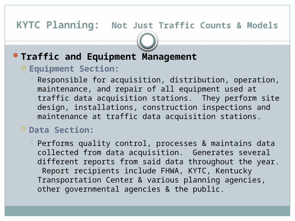
Traffic and Equipment Management Equipment Section:
Responsible for acquisition, distribution, operation, maintenance, and repair of all equipment used at traffic data acquisition stations. They perform site design, installations, construction inspections and maintenance at traffic data acquisition stations.
Data Section: Performs quality control, processes & maintains data
collected from data acquisition. Generates several different reports from said data throughout the year. Report recipients include FHWA, KYTC, Kentucky Transportation Center & various planning agencies, other governmental agencies & the public.
KYTC Planning: Not Just Traffic Counts & Models
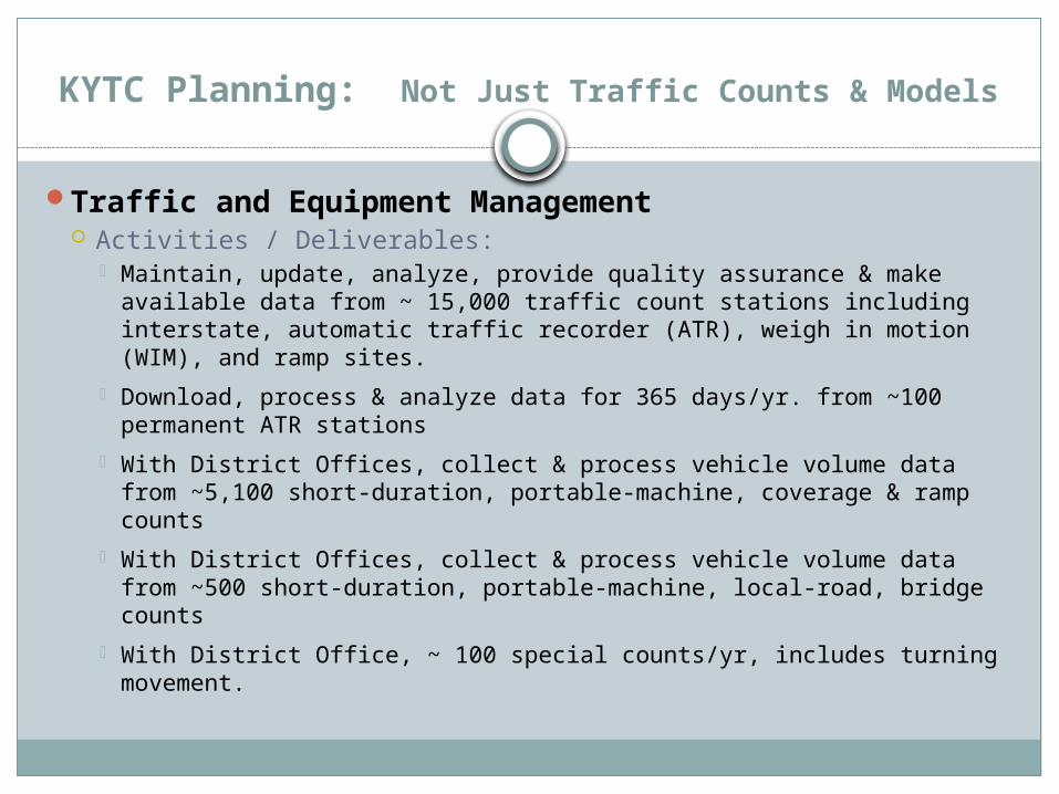
Traffic and Equipment Management Activities / Deliverables:
Maintain, update, analyze, provide quality assurance & make available data from ~ 15,000 traffic count stations including interstate, automatic traffic recorder (ATR), weigh in motion (WIM), and ramp sites.
Download, process & analyze data for 365 days/yr. from ~100 permanent ATR stations
With District Offices, collect & process vehicle volume data from ~5,100 short-duration, portable-machine, coverage & ramp counts
With District Offices, collect & process vehicle volume data from ~500 short-duration, portable-machine, local-road, bridge counts
With District Office, ~ 100 special counts/yr, includes turning movement.

KYTC Planning: Not Just Traffic Counts & Models
Traffic and Equipment Management Activities / Deliverables Continued :
Comply with FHWA Traffic Monitoring Guide, recommends 25% - 30% (~1,400 stations)
Monthly report to FHWA: hourly ATR records
Provides traffic data for annual FHWA required Highway Performance Monitoring System report
Update axle & monthly factors used in adjusting short term counts from ATRs & vehicle classification stations.
Update databases to include new stations/roadway alignment changes
Correct beginning/ending mile points to better represent generators
Grow / maintain WIM data program. Periodically calibrate system.

KYTC Planning: Not Just Traffic Counts & Models
Traffic and Equipment Management Activities / Deliverables Continued :
Certify, repair & maintain ~800 traffic data recorders
Inspect, repair & maintain ~570 vehicle sensor locations
Administer/oversight to contracts for ATR & semi-permanent for repair & maintenance
Track upcoming highway projects & produce plans/specs for new & replacement sensor locations
Provide construction oversight & final inspections of new / replaced sensor installations

KYTC Planning: Not Just Traffic Counts & Models

KYTC Planning: Not Just Traffic Counts & Models
Data Management: GPS | HIS | Development and Support | Asset Management Activities / Deliverables:
New roadway centerlines obtained through GPS and CAD design files & updates to both the GIS layers & HIS database
New roadway inventory either through field collections or extracted from CAD design files to update GIS / HIS
New roadway inventory extracted through photo van software
Routines to extract better road info from GPS (e.g. vertical grades, horizontal curves)
Queries/routines for quality control of database concerning asset items and road information
Database & GIS upgrades

KYTC Planning: Not Just Traffic Counts & Models
Data Management: GPS | HIS | Development and Support | Asset Management Activities / Deliverables Continued :
Other agency information loaded / linked to HIS
Contributes / coordinates with KYTC Asset Management program by providing up-to-date route network of asset locations for other divisions & provides asset extraction capabilities
Coordinate with Office of Technology (OIT) for upgrades & to deploy to other data owners within the Cabinet
Process & submit annual Highway Performance Monitoring System Report
Assist in processing/reporting of the FHWA 536 Report – Local Highway Finance Report
Coordinate changes of NHS/Strategic Highway Network with FHWA & Department of Defense
KYTC Planning: Not Just Traffic Counts & Models
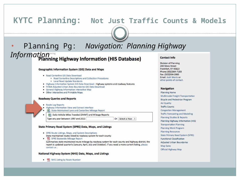
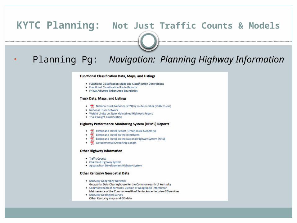
• Planning Pg: Navigation: Planning Highway Information
KYTC Planning: Not Just Traffic Counts & Models
• Planning Pg: Navigation: Planning Highway Information

KYTC Planning: Not Just Traffic Counts & Models
• Planning Pg: Navigation: Planning Highway Information | Highway Information Extract and Interface

KYTC Planning: Not Just Traffic Counts & Models
• Planning Pg: Navigation: Planning Highway Information | Highway Information Extract and Interface

KYTC Planning: Not Just Traffic Counts & Models
• Planning Pg: Navigation: Planning Highway Information | Highway Information Extract and Interface

KYTC Planning: Not Just Traffic Counts & Models
• Planning Pg: Navigation: Planning Highway Information | Highway Information Extract and Interface

KYTC Planning: Not Just Traffic Counts & Models
• Planning Pg: Navigation: Planning Highway Information | Highway Information Extract and Interface

KYTC Planning: Not Just Traffic Counts & Models
Data Management– Roadway Photo Viewer (located in Maps)
KYTC Planning: Not Just Traffic Counts & Models
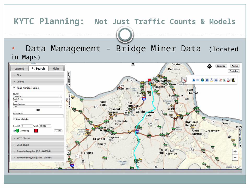
• Data Management – Bridge Miner Data (located in Maps)

KYTC Planning: Not Just Traffic Counts & Models
• Data Management – Bridge Miner Data (located in Maps)
KYTC Planning: Not Just Traffic Counts & Models
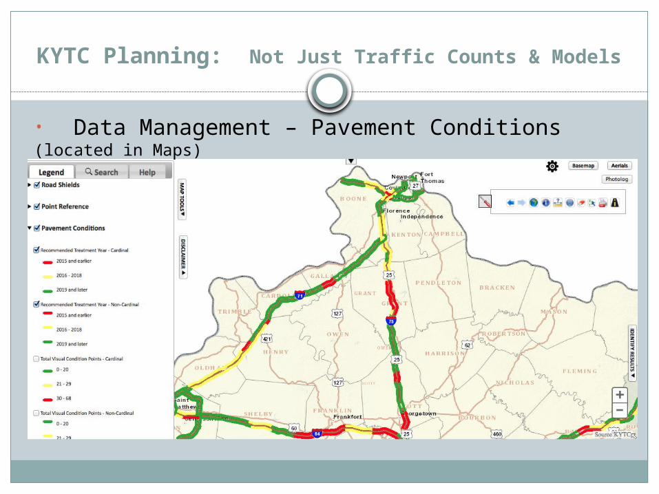
• Data Management – Pavement Conditions (located in Maps)
KYTC Planning: Not Just Traffic Counts & Models
Thank You
Carol Callan-Ramler, P.E.KYTC District 6 Planning Supervisor
421 Buttermilk PikeCovington, KY 41017859.341.2707 x 272