jasper county eagle trails & greenways plan county eagle trails & greenways plan 4 location,...
TRANSCRIPT

2009
Produced in cooperation with Illinois
Department of Natural Resources (IDNR)
through the Greenways & Trails Planning
Program
Jasper County Eagle Trails & Greenways Plan

Jasper County Eagle Trails & Greenways Plan
1
Acknowledgements
PRODUCED IN COOPERATION WITH THE ILLINOIS DEPARTMENT OF NATURAL RESOURCES THROUGH THE GREENWAYS AND TRAILS PLANNING PROGRAM Special Thanks to: State and Local Agencies
University of Illinois Extension-Jasper County, Ken Larimore, Tammy Ochs, Sharon Kuhns, Ginger Boas Illinois Department of Transportation, Todd Hill & Sherry Phillips Illinois Department of Natural Resources, Marla Gursh Jasper County Health Department, Louise Lybarger Trails Recreation Effingham County, Frank Brummer Sam Parr Fish & Wildlife Area, Jim Gillespie Prairie Ridge Natural Area, Terry Esker & Scott Simpson Newton Lake Fish & Wildlife Area, David Miller Local Government Entities
Linda Huth, Jasper County Board Bill Weber, Jasper County Board Ed Mitchell, Jasper County Board Brian Leffler, Jasper County Board Jerry Kinder, Jasper County Board Denise Meinhart, Jasper County Highway Department Dick Patterson, Jasper County Engineer Mark Bolander, City of Newton Alice Addis, City of Newton Jean Ghast, City of Newton Dr. Scott Bloomberg, City of Newton Harold Bolander, City of Newton Larry Brooks, City of Newton Roger Kinder, City of Newton Bill Hartrich, Village of Ste. Marie Annette Kirts, Village of Ste. Marie Frank Miller, Village of Ste. Marie Joe Boehl, Village of Ste. Marie Kent Beavers, Wade Township Community Organizations
Newton Rotary Club Jasper County Community & Economic Development Cooperative Ste. Marie Community Foundation Jasper County Chamber of Commerce, Lisa Meyer Embarras River Tourism Council, Larry Casey & Dick
Grogg
Media Representatives
Newton Press Mentor, Vanette King Jasper County Unit 1 School District
Ron Alburtus, Superintendent Individual Greenways & Trails Enthusiasts
Dr. Brett Tarr, Tarr Chiropractic Scott & June Bierman, Personal Service Realty Mark Dougherty, Peoples State Bank Travis Farley, First National Bank of Dieterich Mark Hartrich, Hartrich Meats Bruce & Beverly Lewis, Lewis Trucking Jordan Ping Katelyn Pless Rein Schmidt Ed Webb, NAPA Illene Woods Don Hartrich Eufala Bigard Susan Phillips Karen Boehl Judy McClure’s Signs and Graphics, Inc.
Judy McClure, Logo Design

Jasper County Eagle Trails & Greenways Plan
2
Jasper County Eagle Trails & Greenways Plan
November 2009
Prepared for the Jasper County Board
By
TBM Consulting and the Eagle Trails
Coalition
Produced in cooperation with
Illinois Department of Natural Resources
Through the Greenways & Trails
Planning Program
Framework 1 Background & Planning Process 3 Location, Demographics & Economy 4 Land Use Characteristics 5 Outdoor Recreation Opportunities &
Conservation Areas 6
Eagle Trails & Greenways 2 Alternative Transportation Definitions 9 Benefits of Alternative Transportation & Greenway Systems 11 Plan Concepts 13 Plan Vision 14 Proposed Trails & Greenways 17 Proposed Trails 19 Proposed Greenways 29 Facility Descriptions & Guidelines 30 Public Opinions & Suggestions 40
Plan of Action 3 Strategy for Implementation 41 Policy & Stakeholder Roles 51
Appendix 4
Jasper County Eagle Trails & Greenways Plan
3
BACKGROUND & PLANNING PROCESS
Demographic data, physical conditions, economic trends, previous planning reports and on-going studies, stakeholder involvement, and public input all contributed to the Jasper County Eagle Trails & Greenways Plan. The Eagle Trails Coalition participated in the seven-month planning process. It is intended that the Eagle Trails Coalition members will be champions of this plan and continue their involvement with its implementation and alternative transportation projects in Jasper County. In addition to the Eagle Trails Coalition involvement, a public survey was conducted, two public meetings were facilitated, and stakeholder interviews and meetings were conducted. The planning team reviewed neighboring counties, Clark and Effingham’s comprehensive trails and greenways plans. These plans, along with the research conducted by the planning team, provided the necessary baseline information for the Jasper County Eagle Trails & Greenways Plan and its recommendations. The Jasper County Eagle Trails & Greenways Plan was formally adopted by the Jasper County Board on November 12, 2009. Notes from the public survey, stakeholder interviews and public meetings are documented in the Appendix. This planning approach and information provides the framework and physical, economic, and social context for the Jasper County Eagle Trails & Greenways Plan’s vision, goals, objectives, and recommendations.

Jasper County Eagle Trails & Greenways Plan
4
LOCATION, DEMOGRAPHICS & ECONOMY
Jasper County is in east central Illinois and 24 miles east of Effingham, Illinois. Neighboring counties to the north include Cumberland and Clark; counties to the west include Effingham and Clay; counties to the south include Richland and Clay; Crawford County borders it to the east. The County has a total area of 494.4 sq. miles of land area and is accessible by State Highways 130, 33 and 49, along with county highways, township roads, and city streets. Newton is the Jasper County seat and is the County’s most populated municipality. Source: Indiana Business Research Center, Kelley School of Business, Indiana University (www.stats.indiana.edu), US Census (www.census.gov)
Jasper County’s 2008 population of 9,698 comprised .08 percent of the State of Illinois’ total population of 12,901,563 (2008). Villages within the County include: Hidalgo, Rose Hill, Ste. Marie, West Liberty, Wheeler, Willow Hill and Yale. Nearly 32
percent of Jasper County residents reside in Newton, nearly 3 percent reside in Ste. Marie, 2.5 percent reside in Willow Hill and the other villages account for less than 2 percent of the population each. The remaining population lives in unincorporated areas throughout the County, which includes areas within 11 townships. There is one public school system in Jasper County: Jasper County Unit School District #1.
The median age is 41.2 years. In comparison, the median age for the State of Illinois is 35.9 years (2007). In 2000, 40.6 percent of Jasper County residents have graduated from high school or earned the equivalent. This rate is much higher than the State high school graduation rate of 37.7 percent (2000). Nearly 11.2 percent of all Jasper County residents have earned a Bachelor’s degree or higher, which is below the State college graduation rate of 26 percent (2000). Both the per capita and median household incomes for Jasper County are below the per capita and median household incomes for the State of Illinois. In 2007, the Jasper County per capita income was $29,332 annually (State of Illinois, $41,012 annually) and the median household income was $42,723 (State of Illinois, $54,141). In 2000, more than 3,098 residents lived and worked in Jasper County. Nine hundred nineteen Jasper County residents (34 percent) commuted to Effingham, Illinois to work. Source: Indiana Business Research Center, Kelley School of Business, Indiana University (www.stats.indiana.edu), US Census (www.census.gov)

Jasper County Eagle Trails & Greenways Plan
5
Jasper County was once comprised largely of grasslands
that still make up parts of the County. Photo courtesy of TBM Consulting.
Jasper County’s strong agricultural base is easily seen by
the thousands of acres of farmland. Photo courtesy of TBM Consulting.
LAND USE CHARACTERISTICS
The Jasper County area has long been appreciated for its natural resources. For centuries Native Americans lived and fished along the Embarras River and hunted in nearby woodlands. French settlers, who arrived in eastern Illinois in the 1770s and lived among the local Piankashaw Indians, also enjoyed the area’s natural bounty. Jasper County is a predominantly rural county, with agriculture as a major industry. Topography in Jasper County is relatively flat, with unique hills, cliffs and quite a bit of topography change near the waterways. The areas surrounding waterways are considered to have environmental and scenic value and could potentially become education and/or recreation destinations. The major waterway in Jasper County is the Embarras River. It flows into the north part of the county from Cumberland County heading south into Newton, where it begins to head southeast toward Ste. Marie then south to exit the County into Richland County. Development and urbanization within Jasper County is concentrated primarily along State Routes 130 and 33 within or near the City of Newton. Little development is occurring outside Newton’s municipal boundaries. Jasper County is home to three state wildlife areas: Sam Parr State Fish & Wildlife Area, Newton Lake Fish & Wildlife Area, and Prairie Ridge State Natural Area and several other open spaces.

Jasper County Eagle Trails & Greenways Plan
6
OUTDOOR RECREATION OPPORTUNITIES & CONSERVATION AREAS
Parks, conservation areas, trails, and other open spaces within Jasper County provide many recreational, educational and other open space benefits. These sites can be linked through trails and greenway systems to offer site users the opportunity to access multiple sites and attract additional users. Some of these parks and conservation areas could serve as trail heads. At these locations users could access the trails and pre-existing support facilities. Trail heads usually have vehicular parking, rest rooms and access to drinking water. They may also include a shelter, maps and brochures, or even visitor or interpretative centers. The following are public and not-for-profit parks, conversation areas and other open spaces in the county. Community Parks Peterson Park, located in Newton, is a wonderful community facility containing several play areas, tennis courts, a basketball court, miniature golf, batting cages, and soon-to-be-constructed, state of the art aquatic center. Peterson Park also contains two pavilions for patrons, restroom facilities and access to the Embarras River with a canoe ramp. Picquet Park is located inside the Village of Ste. Marie and offers playground equipment, tennis courts, pavilions, a baseball diamond, and restroom facilities. Willow Hill Community Park is located inside the Village of Willow Hill and offers patrons plenty of outdoor recreation space and playground equipment.
The community parks in Jasper County are well-
maintained and offer many opportunities for outdoor family fun. Pictured above is a play structure at
Peterson Park. Photo courtesy of TBM Consulting.
Peterson Park has several amenities for community residents and tourists, such as the basketball court
and tennis courts. Photo courtesy of TBM Consulting.
Peterson Park allows access to the Embarras River
with the canoe ramp. Photo courtesy of TBM Consulting.

Jasper County Eagle Trails & Greenways Plan
7
Photo courtesy of TBM Consulting.
Photo courtesy of TBM Consulting.
Photo courtesy of TBM Consulting.
State Conservation & Recreation Sites
Sam Parr State Fish & Wildlife Area, a 1,800-acre park, is surrounded by timberland and is popular with hunters and fishermen. It has a 180-acre lake, 840 huntable acres, several picnic and playground areas, a 13-mile equestrian trail and a 2-mile hiking trail, trailer camping and tent sites. Visitors will enjoy driving or walking through the park at dusk to view the many deer and other wildlife. Newton Lake Fish & Wildlife Area is a 2,350-acre fish and wildlife area and is home to a variety of wildlife, including the state-protected prairie chicken and river otter. The 1,775-acre lake, known for its healthy population of bass and its shoreline, are perfect for bank and boat fishing, picnicking and hiking. Besides fishing, visitors can boat at the lake. There are more than 22 miles of trails that run along the lake for hiking or equestrian use as well as cross country skiing in the winter months. A five-mile mountain biking trail exists and has received many positive reviews. Hunting, wildlife observation, and picnicking are also popular activities with park visitors. This park sees 223,000 visitors each year. Newton Lake is a power plant lake fishable year round. Producing both numbers and large bass, the combination has made Newton Lake one of the premier bass fishing destinations in America. The average size bass in this lake is 3 to 5 lbs, with occasional 6 to 8 lbs being pretty common. The Prairie Ridge State Natural Area is located southwest of Newton. This 3,300-acre site is unique in Illinois, dedicated to conserving the rarest members of Illinois' native tall grass prairie and marsh communities. It offers one of the most spectacular viewing opportunities for grassland wildlife in Illinois. The park is home to the largest breeding population of

Jasper County Eagle Trails & Greenways Plan
8
northern harriers and short-eared owls, as well as prairie chickens.
The Illinois Audubon Society's environmental educational area, known as the Robert Ridgway Grassland Nature Preserve, is open daily for wildlife viewing and hiking. This area has been restored to prairie and has a self guided interpretive trail and a wildlife viewing platform over- looking a wetland surrounded by native prairie plants. Trails Sam Parr, hiking and equestrian trails Newton Lake, multi-purpose and biking trails Robert Ridgway Grassland Nature Preserve, walking trails Greenways No greenways have been formally designed in the County but corridors along the Embarras River and its tributaries serve as greenways, providing open space and wildlife habitat. These spaces are also found within the state conservation and wildlife areas.
Photo courtesy of TBM Consulting.
The existing trails located within the wildlife and
recreation facilities are well marked and maintained. Pictured above is the entrance to the Newton Lake
multi-purpose trail. Photo courtesy of TBM Consulting.
Pictured above is the hiking trail at Sam Parr. Photo
courtesy of TBM Consulting.

Jasper County Eagle Trails & Greenways Plan
9
Common trail signage and construction found in Jasper County currently. Photo courtesy of TBM
Consulting.
Walking path found at the Robert Ridgway Grassland Nature Preserve. Photo courtesy of TBM Consulting.
Equestrian trail found at Sam Parr. Photo courtesy of
TBM Consulting.
ALTERNATIVE TRANSPORTATION DEFINITIONS
Trails and greenways are becoming a common element within municipalities, counties and states. Even so, terminology is not standardized and can lead to confusion. Within this report, the following terminology will be used. Trails Trails are routes designated for use of non-motorized transportation. They can be surfaced with asphalt or concrete, gravel, or left as mowed pathways. Trails are often used for walking, running or bicycling. In urban areas they are too used for roller blading, tricycle riding, stroller use and other specialized activities. Trails are often located on abandoned railroad rights-of-way and along streets or highways. Along roadways, they are often built on the right-of-way, separated from traffic lanes. Were right-of-way is not available, however, bicycle lanes can be provided on the outside of traffic lanes. Where these options are not available or for low traffic areas, trails can share roadways with motorized vehicles and signage signifying this use can be posted. Walking Paths Paths are walking routes, indeed for slow pedestrian speeds and more passive uses. They are narrower than trails and surfaced with hard-packed soil or wood chips. Walking paths are often located in parks and natural areas, where people can walk leisurely, study nature or enjoy quiet time. Paths also are used to interconnect facilities within sites, and to connect sites to nearby trails.

Jasper County Eagle Trails & Greenways Plan
10
Equestrian Trails Often trails utilized for horseback riding are separate from roadways and hiking/bicycling trails. They are not paved, and are often located in undeveloped areas where they can wind through woods, over hills or along creeks. Equestrian trails can be associated with hiking and bicycling trails in rural areas. Designated Bike Routes Designated Bike Routes utilize existing roadways selected for their attractive qualities, such as topography, vegetation, nearby waterways, or ability to connect locations of interest. Also attractive are cultural characteristics like historic sites, appealing structures (houses, farms, churches, businesses), or cemeteries. Greenways Greenways are corridors of land and/or water that provide a variety of benefits from erosion protection to ground water preservation to improved biodiversity. They can provide habitats for wildlife and migration corridors. They can provide recreational opportunities and improve the visual quality of the landscape. Depending on their characteristics, greenways may include trails or designated bike routes. Land uses along greenways are future park sites, nature areas or other compatible land uses. Land uses however should not include anything generating pollution or other environmentally adverse affects. Greenways can aid in establishing municipal growth boundaries and provide a buffer for adjacent land uses.

Jasper County Eagle Trails & Greenways Plan
11
BENEFITS OF ALTERNATIVE TRANSPORTATION & GREENWAYS SYSTEMS
The benefits of alternative transportation are numerous. The US Department of Transportation and the Federal Highway Administration are advocates and promoters of alternative transportation and its related benefits. Alternative transportation serves as a critical link throughout the overall transportation network, providing pedestrian and bicycle access to home, work, education, commerce, transit, and recreation. Because alternative transportation systems provide such fundamental services to the public, they should be designed to meet the needs of the maximum number of potential user groups. People with disabilities who live in areas without accessible alternative transportation networks and do not have access to automobiles face a greater risk of becoming isolated from the community and unnecessarily dependent upon others to perform routine activities such as grocery shopping. An all-inclusive approach to alternative transportation facility design will ensure that the needs of all potential users are addressed, including people with disabilities. Alternative transportation systems, trails and greenways, can enrich the livability of a community; they provide opportunity for a population that does not have, or chooses not to have, access to a vehicle. Commercial districts with alternative transportation access will have a larger customer base. In addition, all people will be able to participate more easily in the community if a system is available because they can reach their desired destinations more easily. Neighborhoods that incorporate and are connected to an alternative transportation system that encourages walking or biking become safer
because there are more people on the street. A broader range of consumer, social, and recreational opportunities is available in areas that connect to an alternative transportation network. The mindset of those who plan, design, develop, and construct private sector improvements is evolving to recognize the human and economic benefits of alternative transportation systems. The mindset is shifting away from including facilities because of regulatory requirements and towards including facilities as a response to customer demand. Benefits of alternative transportation and greenway systems, as presented at the three Public Meetings and Eagle Trails Coalition Meetings, include: Trails promote healthy and livable communities: by creating new opportunities for outdoor recreation, by creating cost-effective places for exercise, by creating an alternative mode of transportation, by connecting people to places in the community, and by providing a means for trail users to interact with other members of the community. Trails stimulate economic development: by becoming a focus of tourist activities that generates revenue in general and tourist related businesses, by adding to the quality of life, a factor for people and business seeking to relocate, by bringing job growth, by improving the appearance of a community, and by increasing property values. Trails protect the environment: by improving air and water quality by providing a transportation option that does not produce pollutants, by protecting, preserving, and linking important habitats and natural areas, and by acting as outdoor classrooms reconnecting trail users to natural areas. Trails preserve local culture and history: by preserving historic transportation corridors, by highlighting local jewels of the

Jasper County Eagle Trails & Greenways Plan
12
community, and by acting as catalysts for increased efforts of preservation along the trail as well as other parts of the community. Trails create community partnerships: by creating the opportunity for many organizations to join forces and work together, by forming a county trails network that can link to a larger system, by providing physical infrastructure that encourages social events between the connected communities, and by starting conversations among community members, creating a connected group for further understanding of community needs. Additional benefits of trails and greenways include: Smart growth by constructing inclusive transportation systems that encourage lack of dependence on personal automobiles and allows a community to grow in an economically, environmentally, and socially responsible way where reliance on non-renewable resources is limited. Economic development spurred in response by user demographics. Six Indiana communities were studied to determine that, on average 47 percent of trail users earned $40,000 to $80,000 per year and 20 percent earned more than $80,000 per year. Source:
Percentage Distribution of Trail Users, Indiana Trails Study, 2001 Mobility improved by the systems creating independence and transportation options for those who do not drive, whether due to health, environmental stewardship, age, disability, or preference. These options should be available to all as a basic choice.

Jasper County Eagle Trails & Greenways Plan
13
PLAN CONCEPTS
The Jasper County Eagle Trails & Greenways Plan is based on three overarching concepts.
1. Incorporating Jasper County’s many natural recreation areas and existing trails. Jasper County is home to four outdoor recreation sites: Newton Lake State Fish and Wildlife Area, Sam Parr State Fish and Wildlife Area, Robert Ridgway Grassland Nature Preserve and Prairie Ridge State Natural Area. These sites are regularly used by not only local residents but by tourists as well. By connecting these natural recreation areas you give users the opportunity to visit more than one of these sites and create an entirely new experience.
2. Incorporation of local heritage into Jasper County trails and greenways. Jasper County has distinct historic sites and structures that are unique features of this area’s historic development. This heritage should be celebrated and available for public enjoyment. Historic points of interest include the Embarras River Bridge that was constructed in 1890, the Burl Ives grave site at the Mound Cemetery, the Ste. Marie Foundation house and several beautiful historic homes and buildings. There are also many beautiful cemeteries scattered throughout the County. With interpretative signage and educational features, these historic sites could become destinations and accessing these destinations by ways of trails and greenways would become a unique part of the experience.
3. Connectivity/Loops. Environmental, recreational, historic/cultural, and tourist/commerce sites are key destinations along trails. These are destinations that someone using a trail for recreation or transportation may want to see or patronize. By connecting these destinations, a network is created that will serve all users, whether they are interested in the parks, natural areas or historic sites. The intent is to provide a seamless recreation and alternative transportation experience for all users in Jasper County, while drawing tourists from other communities. Connectivity is also meant to not just include destinations within Jasper County, but to also extend the trails and greenways system into other counties, such as Effingham and Clark counties, creating a regional trail network. Both Effingham and Clark counties have identified the Old National Road in their plans to be utilized for trails and greenways developments. The Eagle Trails Coalition found this to be an opportunity to provide connectivity amongst the three counties.

Jasper County Eagle Trails & Greenways Plan
14
PLAN VISION
This vision is a description of how Jasper County’s trails and greenways initiatives will advance over the long-term. The Jasper County Eagle Trails & Greenways System Plan Vision Statement: The Jasper County Eagle Trails and Greenways will provide an integrated, diverse, and connected system of multi-modal access routes accessible to all Jasper County residents and visitors, as well as lending opportunities to extend into adjoining counties to better connect the regional recreational opportunities available. The system will result in an increased quality of life for residents, cross-jurisdictional coordination, tourism and recreation opportunities, improved environmental conditions, and encourage new residents and businesses to locate in the County.
GOALS & OBJECTIVES
These goals and objectives where intentionally created to be broad, in order to allow flexibility and opportunity for revisions as conditions change in Jasper County over time. Facilities & Users Goal: Increase opportunities for users to safely and efficiently recreate and commute throughout Jasper County. Objectives:
a. Clearly mark individual routes and the overall system. b. Conduct regular educational and awareness programs for users. c. Prepare alternative transportation facility maps and make them available to the public. d. Promote user health and fitness. e. Establish a land acquisition program for trails and greenways that is equivalent in
importance to roadway construction projects.
Connectivity Goal: Establish a network of convenient, safe, and well-designed trails, routes, and greenways systems that connect key destinations inside and outside the County. Objectives:
a. Link key destinations within the County’s borders. b. Link Jasper County’s trails and greenways to those of surrounding counties creating a
regional network. c. Establish themes along each route. d. Use facilities to link and support tourist destinations. e. Communities along trails should promote trails by providing a local bicycle and
pedestrian network that connects communities to the larger network.
Funding Goal: Fiscally plan for the development and maintenance of an alternative transportation and greenways system and place its funding priority equal to that of roadways. Objectives:
a. Identify and track funding opportunities. b. Maintain a constant funding source to aid with implementation.

Jasper County Eagle Trails & Greenways Plan
15
c. Coordinate local projects. d. Incorporate bicycle and pedestrian facilities in all applicable roadway projects. e. Concentrate funds to maximize results.
Maintenance Goal: Maintain and upgrade the alternative transportation and greenways system on a regular basis so it is safe and accessible for all users throughout the year. Outside of local departments additional funding sources will be necessary. Objectives:
a. Maintain condition of pathways and bikeways. b. Maintain visibility of routes. c. Maintain records for tracking and budgeting maintenance needs.
Economic Development Goal: Promote the alternative transportation and greenways system as a distinguishing feature of Jasper County to attract and retain quality residents, businesses, and industry. Objectives:
a. Enhance the local economy by reducing commuter costs and increasing property values. b. Market the system to retain and attract businesses. c. Encourage businesses to participate and assist with plan implementation. d. Conduct regular educational and awareness programs for users. e. Prepare alterative transportation facility maps and make them available to the public. f. Collect and analyze benefits of alternative transportation, trails and greenways systems.
Tourism Goal: Add facilities to the system to cater to distance cyclists, family vacations, adventurists, naturalists, and other tourism-focused groups. Objectives:
a. Market Jasper County as a community that supports trails and greenways options. b. Establish themes along each route. c. Use facilities to link and support tourist destinations. d. Encourage businesses to participate and assist with plan implementation. e. Conduct regular educational and awareness programs for users. f. Prepare trails and greenways facility maps and make them available to the public. g. Promote user fitness and health. h. Concentrate funds to maximize results.
Environment Goal: Promote and enhance the integrity of the natural environment through the sensitive development of trails and greenway corridors. Objectives:
a. Establish greenways along major streams and tributaries where appropriate. b. Require environmentally sensitive design techniques and materials for trail construction
and placement. c. Provide opportunities for users to explore natural areas off the trail. d. Design informational signage on trails. e. Promote responsible use of greenways.

Jasper County Eagle Trails & Greenways Plan
16
Design Goal: Establish a community standard for good design that encourages creativity, interest, and variety, and that builds upon local heritage and character to create efficient, sustainable, and livable places while ensuring compliance with applicable state and federal design standards. Objectives:
a. Develop design standards for the county to utilize in discussions with developers and partners.
b. Develop a wayfinding and signage system in coordination with adjoining jurisdictions to provide safe facilities, clear direction, and that identifies key features.
c. Encourage design that features local heritage and character to create an identity and sense of place for the systems.
d. Encourage designs that utilizes sustainable, high performance, efficient, and environmentally responsible construction materials and that provides a comfortable and safe environment for the user.
Governance Goal: Establish an organization, department, agency, or group to ensure that recreation and transportation initiatives developed throughout this plan are undertaken in Jasper County and are coordinated and integrated. Jasper County Eagle Trails Coalition has served as a leader for trails planning in Jasper County and has potential to continue in a leadership role. Objectives:
a. Establish a means to manage trails and greenways initiatives. b. Ensure that recommendations from the Jasper County Eagle Trails & Greenways Plan
are implemented. c. Integrate alternative transportation considerations into emerging development plans and
projects. d. Organize and supervise safety, patrolling, and maintenance efforts along trails and
greenway routes. e. Advocate for alternative transportation considerations in the planning for vehicular
transportation routes. f. Partner with the County’s local jurisdictions, adjacent counties, and other constituency
groups to ensure a linked, diverse, and complementary trails and greenways system that serves a wide range of users.
g. Update Jasper County Eagle Trails & Greenways Plan as demographics shift and growth occurs.
h. Incorporate alternative transportation projects into annual work programs, capital improvement programs, and transportation improvement programs for the Jasper County Highway Department and the Jasper County Board.

Jasper County Eagle Trails & Greenways Plan
17
PROPOSED TRAILS AND GREENWAYS
Through the seven-month planning process, Jasper County Eagle Trails Coalition and Jasper County stakeholders provided input on possible trail and greenway routes and the types of facilities that would accommodate alternative transportation users. These routes and facilities were recorded and located on a map based on current and future land uses, development patterns, vehicular traffic patterns, road capacities and conditions, topography and natural features, and access to destinations. These routes and facilities are named on the map labeled Eagle Trails & Greenways on the following page. These routes and facilities are what comprise the Jasper County Eagle Trails & Greenways system and were identified with current knowledge and abilities in mind. As circumstances change, priorities shift, and development occurs, it is expected that these opportunities will be modified and expanded. It is the intent of the Jasper County Eagle Trails & Greenways Plan to outline the possibilities for the community. These possibilities, or opportunities, will become realistic projects if and when appropriate conditions are favorable. The opportunities are a product of a planning process and of the previously identified three plan concepts and nine plan goals, with supporting objectives. Jasper County Stakeholders decided to theme their trail and greenways system after their local school mascot, the eagle. The County takes pride in their mascot and foster strong support for their schools and children. The County residents are identified as the Eagles across Illinois as the Newton Community High School Marching Band and local athletic teams are known champions.

Jasper County Eagle Trails & Greenways Plan
18

Jasper County Eagle Trails & Greenways Plan
19
PROPOSED TRAILS
All but one of the Proposed Trails would lie along or near existing roadways that provide connectivity amongst the assets in the County. Many trails were planned along roadways that could be utilized as designated bike routes with additional signage prior to obtaining more substantial funding and support to construct an actual trail alongside the roadway. This allows for the trails to remain connected as they are constructed in sections while still gaining community support and use. By utilizing the roadways as designated routes, sharing existing roadways with vehicular traffic prior to constructing physical separate trails, planners can too evaluate which routes or trails are most popular and use this
knowledge to aid them in their decision on which trail project to tackle first. The Illinois Department of Transportation Bicycle Maps where used in conjuncture with public knowledge of current popular bike
routes and assessment of road conditions to construct these routes. These trails where constructed to showcase the many cultural and historical elements as well as providing connectivity between the conservation areas found within the County. One trail highlights Burl Ives’ sites. Burl Ives is the local Jasper County celebrity who is known worldwide. The Ives family resided in rural Jasper County during his early years, moving to Hunt City when he was a small child. Burl lived in Hunt City until he left the County in his late teenage years. Burl Ives was then buried in the Mound
Cemetery near Hunt City after his death in 1995. This story and many others can be learned about at the Jasper County Museum found in the Newton Public Library. Other trails showcase some of Jasper County’s communities. One trail showcasing one of Jasper County’s jewels, Ste. Marie. This small town of 300 people is always clean and tidy and welcomes visitors with open arms. The community lends many opportunities for trails which would be enjoyed by the many walkers you will find in town each day. Just north of Ste. Marie, the trail system passes through the community of Willow Hill. Willow HIl was originally founded as Liberty Hill, then later named New Liberty. It was changed to Willow Hill in April of 1851when the U.S. located a post office there and discovered there was already a New Liberty, Illinois. This town came to life in the late 1800s when the railroad came to town and the town doubled in size. Inside the little community is a beautiful park as shown on the map as the Willow Hill Park but its true name is Edison Park. It was given to the town by Edison descendants in return for the care of the Edison Family Cemetery that lies nearby. The county seat, Newton, is showcased by the Embarras River Walk. This trail gives users an alternative route to visit Peterson Park where the new aquatic center will be housed. The trail also passes by the Embarras River Bridge which was constructed in 1890 and once served as the main entrance into town. The bridge was published in the National Register of Historic Places in 1998. While in 1999 an engineering study was performed deeming the structure unsound for both vehicular and pedestrian traffic, there are current and future technologies for rehabilitating structures that make future pedestrian use a possibility.

Jasper County Eagle Trails & Greenways Plan
20
GOLDEN EAGLE TRAIL The Golden Eagle Trail would extend from Newton Community High School past Stone’s Throw Golf Course, the AmerenCIPS Power Plant and the Newton Lake State Fish & Wildlife Area. Then it would connect with the Little Eagle Trail to go back to Newton Community High School, forming a 35 mile loop. The trail would provide access to the North Entrance of the Newton Lake State Fish & Wildlife Area where the 22.5 miles of existing multi-purpose trails begin, as well as the 4.6 mile bike trail begins. This trail would also provide access to the South and East Boat Ramps. LITTLE EAGLE TRAIL The Little Eagle Trail would extend from Newton Community High School past the Prairie Ridge Natural Area and the Robert Ridgway Grassland Nature Preserve back to Newton, forming a nearly 7 mile loop. The trail would provide access to both of these wildlife areas and the existing trail in the Robert Ridgway Grassland Nature Preserve.

Jasper County Eagle Trails & Greenways Plan
21
BALD EAGLE TRAIL The Bald Eagle Trail would extend from Peterson Park in Newton to Sam Parr State Fish & Wildlife Area and on toward Mound Cemetery, Burl Ives’ burial site, then on through Willow Hill and back toward Newton, forming a 26.25 mile loop. The route would provide access to the 2 miles of hiking trails and 13 miles of equestrian trails, as well as several picnicking and resting facilities within Sam Parr. This route would connect with another trail in Willow Hill, giving users the opportunity to head south on County Road 9 to Ste. Marie on the Long-crested Eagle Trail. This trail does cross State Route 33 in two different locations which could use identifying signage alerting all traffic of the crossing.

Jasper County Eagle Trails & Greenways Plan
22
LONG-CRESTED EAGLE TRAIL The Long-crested Eagle Trail would extend from Peterson Park in Newton through the beautiful countryside toward Picquet Park in Ste. Marie before heading toward Willow Hill and connecting with the Bald Eagle Trail to either head back to Peterson Park, in Newton, or to go on past the Mound Cemetery and Sam Parr. The route would be 16.25 miles in length. This trail does cross State Routes 130/33 within the Newton City limits and cautionary signage to alert vehicular traffic of this intersection would increase safety for both vehicles and multi-purpose trails users.

Jasper County Eagle Trails & Greenways Plan
23
STELLAR’S SEA EAGLE TRAIL The Stellar’s Sea Eagle Trail would extend from Peterson Park along the shoreline of the Embarras River connecting to Water Street near the Embarras River Bridge, a historical bridge constructed in 1890, before heading out of Newton toward County Road 3, then continuing on to Effingham County to connect with the National Road in Montrose or to Jewett to connect with the National Road. This route is comprised of winding roads and a mix of flat and hilly landscape and totals 20.50 miles in length heading to Montrose and 17 miles in length heading to Jewett.

Jasper County Eagle Trails & Greenways Plan
24
EMBARRAS RIVER WALK The Embarras River Walk would begin in Peterson Park in Newton and extend along the Embarras Riverfront to the Embarras River Bridge, then heading south toward the Newton Public Square and continue down South Van Buren Street going West at Curtis Street and North on Lafayette Street past many beautiful historic homes and back toward the square. The trail totals a little over 2.5 miles in length. This trail does cross Illinois Route 33 in two locations where cautionary signage would increase safety for both path and roadway users.

Jasper County Eagle Trails & Greenways Plan
25
Existing Trails
Existing Trails are trails currently in use within the confines of the wildlife and recreation areas currently in Jasper County. Sam Parr Lakeside Foot Trail The Sam Parr Lakeside Foot Trail stretches 2 miles along the shoreline of Sam Parr Lake and begins at the White Oak Recreation Area. The Sam Parr Equestrian Trail The Sam Parr Equestrian Trail begins at the east side of the Park and loops around the North and West side of the park totaling 13 miles.

Jasper County Eagle Trails & Greenways Plan
26
The Newton Lake Trail System The Newton Lake Trail System begins at the North Entrance large parking area. The main trail follows the lake shoreline winding its way south to a total distance of 11.9 miles. Returning to the trailhead by retracing the original route increases the total distance to 22.6 miles. As a convenience for trail users, a short cut return loop permits visitors to return to the trailhead by a more direct route. The Newton Lake Bike Trail The Newton Lake Bike Trail begins at the North Entrance just west of the large parking area. The trail is only suitable for mountain bikes and is nearly five miles in length. The trail winds along the northwest side of the Lake and loops back to the starting point.

Jasper County Eagle Trails & Greenways Plan
27
Robert Ridgway Grassland Nature Preserve Walking Path The Robert Ridgway Grassland Nature Preserve Walking Path is located within the designated Audubon Society area and winds through the site past various habitats where visitors can view the different birds and wildlife throughout the area. The trail totals approximately one mile.

Jasper County Eagle Trails & Greenways Plan
28
Trail Heads
Trail Heads are sites with facilities for trail users. Facilities usually include restrooms, drinking water and shelter from the weather. Vehicle parking should be provided for those accessing the trail by motor vehicles. Other facilities that could be provided are trail maps and interpretative information, bike racks or lockers, vending machines, concessions, etc. Trail Heads are often located at parks and other public areas where some or all the necessary facilities are already available. Eagle Trails Designated Trail Heads: Peterson Park-Restrooms, Drinking Water, Parking, Shelter Sam Parr-Restrooms, Drinking Water, Parking, Shelter Newton Lake-Restrooms, Drinking Water, Parking Newton Community High School-Parking Picquet Park-Parking, Shelter, Restrooms Trail Hubs Trail Hubs are locations where more than one trail or recreational route meet, forming a junction and offering users a choice of routes and experiences. Willow Hill Prairie Ridge State Natural Area

Jasper County Eagle Trails & Greenways Plan
29
PROPOSED GREENWAYS
Embarras River Greenway. This greenway opportunity follows the Embarras River from Peterson Park to the Embarras River Bridge. It is recommended this greenway include a multi-use path. There is also a canoe ramp that currently exists within this greenway which opens up further opportunity for canoe usage. This Greenway could too be expanded to follow the Embarras River into Crawford County where it would connect with Clark County Trail Coalition’s proposed Westfield-Embarras Greenway included in their Clark County, Illinois Trails & Greenways Vision Plan 2006. State Highway 130, 33, & 49 Corridor Greenways. All State Highways crossing Jasper County have been identified as Greenways as well as potential trail opportunities. If any of the stated Highways are expanded or resurfaced in the future, then the Eagle Trails Coalition and the Jasper County Board ask that the Illinois Department of Transportation take into consideration these potential trails in their planning. These greenways are identified on the Eagle Trails & Greenways map on page 18. Trail Greenways. Although improvements have been recommended along new trails in the county, trail corridors also can be considered as Trail Greenways. Rather than being simply exposed strips of pavement, trails can become greenways by being planted with trees, shrubs and/or grasses. For trail users, planting provides barriers from motor vehicles, shade, wind screening and visual interest. In urban areas, planting creates a linear green space that provides relief from a landscape of paved surfaces and buildings. And for nearby residents and land owners, trail greenways provide an attractive feature that can increase land values.

Jasper County Eagle Trails & Greenways Plan
30
FACILITY DESCRIPTIONS & GUIDELINES
The Jasper County Eagle Trails & Greenways Plan identifies opportunities for several types of multi-modal facilities. The following guidelines are intended to assist the County in establishing common standards for a unified and consistent alternative transportation system. The type of facility implemented will vary based on the opportunities and constraints of the particular corridor or district. While site conditions and circumstances often make applying specific solutions difficult, it is intended that these guidelines reduce the need for ad hoc decisions. However, it is acknowledged that the guidelines are schematic and will require application and judgment by a qualified design professional. Even when the specific guideline cannot be fully met, the implementing agency or designer should attempt to find the solution that best meets the goals and objectives of the plan and ensure that designs are consistent with American Association of State Highway and Transportation Officials (AASHTO) and Manual on Uniform Traffic Control Devices (MUTCD). Note that specific references to facility dimensions are recommendations. Current ordinances may need to be updated to meet these guidelines. These guidelines are organized as follows:
Multi-Use Trail
Multi-Use and Equestrian Trail
Water Trail/Unimproved Trail
Signed Bike Route
Bike Lane
Multi-Use Path

Jasper County Eagle Trails & Greenways Plan
31
MULTI-USE TRAIL Benefits:
Provides connectivity between destinations.
Creates, shares, or preserves continuous corridors that provide regional/countywide connectivity.
Utilizes off-road corridors that may otherwise experience dumping and illicit activity.
Provides access to and sense of open space or “green space.”
Recommendations:
Encourage use of sustainable, high performance, efficient and environmentally responsible construction materials.
Utilize consistent identity and wayfinding systems across jurisdictional boundaries.
Require new utility easements to share right-of-way with bicycle and pedestrian paths and develop amendments to existing utility easements to allow shared use.
Key Design Guidelines Notes
CZ 3' min - 6' max horizontal clearance N/A
Clear Zone
PCZ 8' min vertical clearance by trail width where open to the sky
Vertical clearance should be greater for bridge underpasses or tunnels.
Pedestrian Clear Zone
PT 10' min - 12' desirable width
Asphalt pavement recommended to accommodate bicycles. Crushed stone optional. Consistency throughout recommended. Paved Trail
RB Width varies
Naturalized meadow ground cover to reduce maintenance or for habitat.
Rural Buffer
SH 2' min width Crushed stone or mown turf.
Shoulder
UB Width varies
Mown turf and shade trees where maintainable and in context.
Urban Buffer Source: Storrow Kinsella Associates inc. Clark County, Illinois Trails & Greenways Vision Plan 2006
Jasper County Eagle Trails & Greenways Plan
32
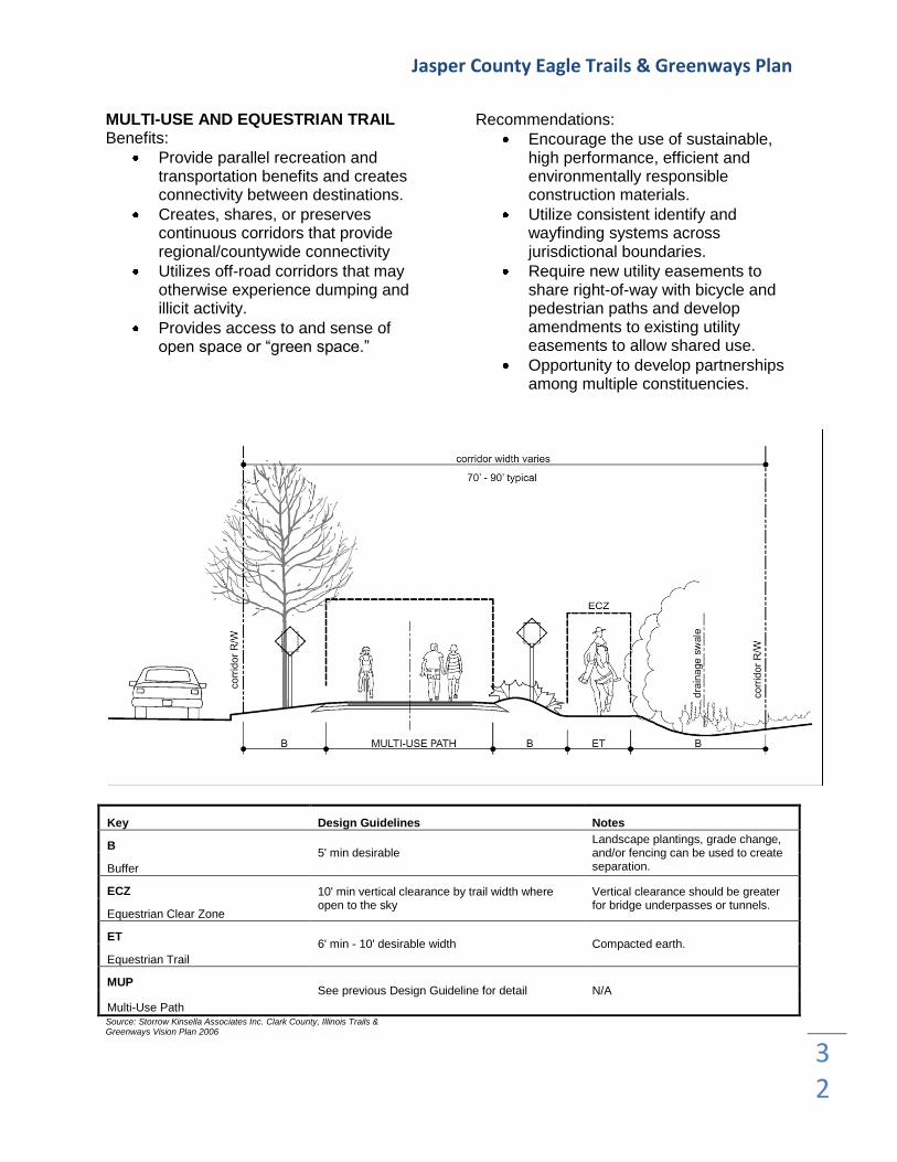
MULTI-USE AND EQUESTRIAN TRAIL Benefits:
Provide parallel recreation and transportation benefits and creates connectivity between destinations.
Creates, shares, or preserves continuous corridors that provide regional/countywide connectivity
Utilizes off-road corridors that may otherwise experience dumping and illicit activity.
Provides access to and sense of open space or “green space.”
Recommendations:
Encourage the use of sustainable, high performance, efficient and environmentally responsible construction materials.
Utilize consistent identify and wayfinding systems across jurisdictional boundaries.
Require new utility easements to share right-of-way with bicycle and pedestrian paths and develop amendments to existing utility easements to allow shared use.
Opportunity to develop partnerships among multiple constituencies.
Key Design Guidelines Notes
B 5' min desirable
Landscape plantings, grade change, and/or fencing can be used to create separation. Buffer
ECZ 10' min vertical clearance by trail width where open to the sky
Vertical clearance should be greater for bridge underpasses or tunnels.
Equestrian Clear Zone
ET 6' min - 10' desirable width Compacted earth.
Equestrian Trail
MUP See previous Design Guideline for detail N/A
Multi-Use Path Source: Storrow Kinsella Associates Inc. Clark County, Illinois Trails & Greenways Vision Plan 2006

Jasper County Eagle Trails & Greenways Plan
33
UNIMPROVED TRAIL Benefits:
Provides primarily recreational use; allows alternative transportation system to potentially include horses, boats, snowmobiles, and ATVs.
Allows access and utilization of a corridor.
May be transitional. As connections are made and development occurs, the trail may take on a different transportation role.
Protects natural corridors and environmentally sensitive areas.
Creates, shares, or preserves continuous corridors that provide regional/countywide connectivity.
Recommendations:
May be paired with bicycle/pedestrian trails and paths if appropriate separation is provided and there is sufficient right-of-way.
Encourage environmental stewardship.
Natural corridors should be wide enough to include continuous sensitive areas such as wetlands or riparian corridors.

Jasper County Eagle Trails & Greenways Plan
34
SIGNED BIKE ROUTE Benefits:
Provides bicycle connectivity between destinations.
Incorporated into the design and layout of roads. Can utilize existing roadway facilities if the travel lane is sufficiently wide, if accident rate is low, and the area does not have a high crash history.
Low-cost and low-maintenance facility.
Recommendations:
Work well as short transition facilities to connect discontinuous segments of bike lanes, sidepaths, and multi-use trails.
Suitable for streets and roads with low traffic volume.
Work well as a transition trail or Phase I designated path to be utilized while obtaining funding to construct a multi-use path along the existing roadway.
Key Design Guidelines Notes
CZ 8' min vertical clearance by pedestrian way (PW) width where open to the sky
Vertical clearance may be greater at buildings.
Clear Zone
SZ 5' min - 10' max
If doubles as a parking lane, corner curb extensions can accommodate utilities and amenities.
Separation Zone
PW 4' min - 6' max desirable width Varies, should be consistent.
Pedestrian Way
FZ 6" minimum width for furnishings, maintain clear pedestrian way (PW)
Wider frontage zones can accommodate sidewalk cafes, flower pots and other amenities.
Frontage Zone
VTL Wider to accommodate shared bicycle use, recommended 14' minimum
N/A
Vehicle Travel Lane Source: Storrow Kinsella Associates Inc. Clark County, Illinois Trails & Greenways Vision Plan 2006

Jasper County Eagle Trails & Greenways Plan
35
Urban Bike Lane Benefits:
Provides bicycle connectivity between destinations.
Incorporated into the design and layout of roads.
Has a channelizing effect on traffic and allows for more predictable movements of cars and bicycles.
Recommendations:
Less experienced bicyclists are more confident in a bike lane versus a signed bike route.
Recommend five-foot bike lanes for roadways with vehicular speeds greater than 40 miles per hour and/or with a curb and gutter.
Key Design Guidelines Notes
BL 5' min width recommended, varies depending on traffic speed and condition
Provide distinct signage and pavement markings. Bike lanes travel in the same direction as vehicular traffic.
Bike Lane
CZ 8' min vertical clearance by bike lane width where open to the sky
Vertical clearance should be greater for bridge underpasses or tunnels.
Clear Zone
FZ Separation between roadway and furnishings/utilities. 3' recommended min.
N/A
Frontage Zone
UB Width varies
Mown turf and shade trees where maintainable and in context.
Urban Buffer
VTL Width varies. Can reduce to 10 1/2' to accommodate alternative transportation modes.
Varies.
Vehicle Travel Lane Source: Storrow Kinsella Associates Inc. Clark County, Illinois Trails & Greenways Vision Plan 2006

Jasper County Eagle Trails & Greenways Plan
36
Rural/Suburban Bike Lane Benefits:
Provides bicycle connectivity between destinations.
Incorporated into the design and layout of roads.
Has a channelizing effect on traffic and allows for more predictable movements of cars and bicycles.
Recommendations:
Less experienced bicyclists are more confident in a bike lane versus a signed bike route.
Recommend four-foot bike lanes for roadways with 30 to 40 miles per hour traffic and/or without curb and gutter.
Recommend five-foot bike lanes for roadways with vehicular speeds greater than 40 miles per hour and/or with curb and gutter.
Key Design Guidelines Notes
BL 5' min width recommended, varies depending on traffic speed and condition
Provide distinct signage and pavement markings. Bike lanes travel in the same direction as vehicular traffic.
Bike Lane
CZ 8' min vertical clearance by bike lane width where open to the sky
Vertical clearance should be greater for bridge underpasses or tunnels.
Clear Zone
FZ Separation between roadway and furnishings/utilities. 3' recommended min.
N/A
Frontage Zone
SH Roadway shoulder can be shared as bike lane N/A
Shoulder
VTL Width varies. Can reduce to 10 1/2' to accommodate alternative transportation modes.
Varies.
Vehicle Travel Lane
B Width varies Landscape development or naturalized plantings.
Buffer Source: Storrow Kinsella Associates Inc. Clark County, Illinois Trails & Greenways Vision Plan 2006

Jasper County Eagle Trails & Greenways Plan
37
MULTI-USE PATH Benefits:
Provides pedestrian and bicycle connectivity between destinations.
Incorporate into the design and layout of roads.
Recommendations:
Utilize consistent identity and wayfinding systems across jurisdictional boundaries.
Multi-use paths are generally more comfortable for less experienced or recreational bicyclists since they are
physically separated from vehicular traffic.
Provide connections to adjacent destinations such as schools, shopping, and government services.
Consider the dedication of public right-of-ways or easement as a requirement for obtaining a building permit or land use approval.
Competing needs for space within a corridor can be resolved by acquisition or additional right-of-way, public walkway easements, narrowing vehicular travel lanes or reducing their number.
Key Design Guidelines Notes
BL 5' desirable width. Recommended, but may not be needed if sidepath is 10' wide.
Keep swept clean of debris.
Bike Lane
CZ 8' min vertical clearance by trail width where open to the sky
Vertical clearance should be greater for bridge underpasses or tunnels.
Clear Zone
PW 8' min width if bike lane provided; 10' width desirable for shared bike/pedestrian use
Should be consistent width and provide connectivity to adjacent destinations.
Pedestrian Way (Multi-Use Path)
U/DE Varies in width. 5' min separation desirable between vehicle travel lane (VTL) and 2-way pedestrian way (PW).
N/A Utility/Drainage Easement
VTL Width varies
Vehicle travel lane (VTL) width may be reduced to accommodate bike lanes (BL). Vehicle Travel
Lane Source: Storrow Kinsella Associates Inc. Clark County, Illinois Trails & Greenways Vision Plan 2006

Jasper County Eagle Trails & Greenways Plan
38
GENERAL DESIGN & MAINTENANCE CONSIDERATIONS Crossings Recommendations:
Mode of transportation, traffic volume and speed, and form of barriers determine specific crossing techniques.
Clear signage and pavement markings alert users of potential conflicts.
Ensure adequate separation and warning devices at mid-block crossings for trails.
Use refuge islands for users to pause until they can safely cross busy streets.
Places to Pause & Amenities Description: Places to pause accommodate conflict between a mix of user modes by having opportunities for pausing out of the traffic stream and to access amenities such as benches, water fountains, public art, interpretive signage or bicycle parking. Trash receptacles and pet stations are furnishings that assist with facility cleanliness and maintenance. Identity & Wayfinding Description: System identity and wayfinding are parallel concepts. Alternative transportation corridors achieve linear identity and continuity through naming, repetition of signature elements, use of a color palette, furnishings, landscape, and signage. Maps can locate pedestrians near the corridor and trailheads as well as describe the overall system.

Jasper County Eagle Trails & Greenways Plan
39
TRAILS MATERIALS CONSTRUCTION & COST ASSOCIATIONS When constructing trails, there are many types of surfacing options and construction guidelines to follow. These guidelines are recommendations from the IDNR Recreation Facilities Guide: Drainage: Surface gradients should ideally range between 1-3% with a 1% optimal slope. Accessibility: Maximum 8% slope and a maximum 2% cross slope. Maintenance: Each year the asphalt trails should be resealed. Surfacing: Asphalt
Anticipated cost: $22.00/square yard Decomposed Granite
Anticipated cost: $265.00/cubic yard
Limestone Screenings
Anticipated cost: $2.75/square foot Hardwood Mulch
Anticipated cost: $3.50/square foot

Jasper County Eagle Trails & Greenways Plan
40
PUBLIC OPINIONS AND SUGGESTIONS
During the course of the trails and greenways planning process, the Jasper County Trails Coalition met several times to establish goals and criteria contribute information and ideas, review preliminary information and coordinate further efforts. Two public meetings were held during the course of the project. The first meeting was hosted to solicit residents’ interests, desires and concerns about trails and greenways in the county. Nearly 20 people attended the meeting, where the initial ideas and project timeline was presented and questions where allowed to be asked and answered. Concerns and questions were answered and more excitement was generated. Many in attendance where familiar with trail systems in other parts of the state and the country. They believed that trails would be very popular with county residents as well as can be used to help attract new residents and businesses. Many of the attendees of this meeting then chose to meet again to mark up large maps of the county with ideas for trails. Many existing roadways where identified during the meeting that attendees where currently using to bike, jog, or walk on. During this meeting all trails were identified based on safety, road conditions, and the ability to provide connectivity to the County’s assets and natural recreation areas.
The second Public Meeting was held to present the preliminary trails and greenways plan for community response. This meeting took place in Ste. Marie. Nearly 20 people filled the room while the plan was presented and the audience was given a chance to ask questions. Most questions where centered on liability. Many constructive ideas came from this meeting and new assets not previously identified where then for inclusion in the plan. Another means of collecting input from the general public during the Jasper County Eagle Trails & Greenways Plan process was through an online survey. This survey was created and sent to all members of the Eagle Trails Coalition who in turn forwarded the survey to their personal and professional network connections. These responses where utilized during the planning process to assist in guiding the Eagle Trails Coalition while planning.

Jasper County Eagle Trails & Greenways Plan
41
STRATEGY FOR IMPLEMENTATION
This plan proposes many trails and greenways, each serving a specific function. The trails and greenways form a network that relates to the natural and cultural resources of the County facilities. To achieve this plan, the greenways and trails will be developed section-by-section as the critical components of community support, lands and funding become available. For some sections, these critical components may not come together in a timely manner. When this occurs, alternate routes should be evaluated, especially when an important aspect of the developing system would otherwise be missing. At the very least, the process of implementing this plan will take time and require considerable coordination. The following five steps outline how to approach and promote the development of the trail and greenway system. The steps are:
1. Organize and develop community support. 2. Target individual projects (develop intergovernmental agreements) 3. Secure funding, acquire land and rights-of-way 4. Build trails and encourage supplementary business developments 5. Manage and promote facilities
1. Organize and Develop Local Support The first step in designating greenways and creating trails is to form a group which will promote their development. People who enjoy walking, riding bikes, canoeing, and other recreational activities are obvious recruits for membership. Those who are involved in environmental study and preservations would be supportive as well. Others, such as community leaders who want improvements for area residents, business people who see the possibilities for expansion, developers who understand the value of trail facilities, would be important members who could expand the support. The Eagle Trails Coalition was organized for the purpose of developing this plan and is a great core for this group. During the last seven months they have held meetings, spoke to special interest groups, and promoted the trail development in many other ways. Those types of activities need to continue. As the following steps of targeting projects and proceeding with development occur, the group will need to provide overall project leadership and coordination. Initially, many of the chores delineated in this report can be accomplished through a volunteer organization consisting of committed community members. In the long term, however, a properly developed and maintained trail system will probably require the assistance of public bodies. Specifically, the Jasper County Board and the municipal governments located within Jasper County are encouraged to consider how they might be involved and thereby assist in the development and maintenance of the trail system. This assistance might take the form of financial participation, technical advice, public safety help, and/or promotion of trail-related events.

Jasper County Eagle Trails & Greenways Plan
42
2. Target Individual Projects Because the entire system cannot be developed at once, individual projects need to be targeted. Initially, the projects should be those which have the greatest opportunities for success. The projects should be those that are located either on public lands or on property where easements or acquisitions are feasible. For popular support, the initial projects should also appeal to a large population and provide various uses. These characteristics also tend to be attractive priorities for grant funding. The Eagle Trails Coalition has listed the projects by priority in which they plan to tackle to bring the Jasper County Eagle Trails system to implementation. Although this prioritized list is most appropriate during the time this plan was created, it does not mean that these priorities will not change with time and if so, the projects will be reprioritized to meet feasibility. The prioritized project listing is as follows:
1. Embarras River Walk completion 2. Bald Eagle Trail 3. Long-crested Eagle Trail 4. Little Eagle Trail 5. Golden Eagle Trail 6. Stellar’s Sea Eagle Trail
All phases of the targeted project need to be planned. At the outset consideration should be given to the following:
What lands to acquire or easements to obtain, what jurisdictions are affected and what input and consents are needed?
What environmental concerns or limitations exist?
Where and how are funds available?
What uses will the trail have?
What maintenance will be required and who will provide it?
What is the implementation schedule? In this way, tasks can be identified and pursued in a logical and timely manner. 3. Secure Funding and Acquire needed Rights- of-Way Once a specific project has been planned, funding and available lands are the critical questions. Acquiring land can be a sensitive matter. Since each landowner’s situation is different, it is often helpful to have people involved in negotiations that know the owners and understand their particular situations. Often discussing the project’s vision, its practical aspects and the need for a landowner’s cooperation is effective. Where acquisition of lands from several owners may be necessary, a meeting for the group may be useful. Whenever possible, options should be offered for landowners’ consideration. Options may include combinations of easements or title, accomplished by outright purchase, land trade, donation allowing tax deductions, etc. See below for additional ownership and acquisition strategies.

Jasper County Eagle Trails & Greenways Plan
43
COMPARATIVE OWNERSHIP STRATEGIES FOR GREENWAYS & TRAILS Method Explanation Advantages Disadvantages
Private Ownership
Individual Landowners
Adjacent landowners retain full title to the land and provide for greenways through easements.
Property owners retain title to land. Large amount of funds for land purchase not needed. Land remains on the tax rolls.
Easements can restrict certain types of greenway activities, depending on the landowner's wishes.
Land Trusts and Nonprofit Organizations
A national or regional nonprofit organization can acquire and hold land until a local land trust has been established or is able to finance acquisition.
A nonprofit organization can finance an immediate acquisition and hold property until a land trust has been established or has acquired necessary funds for purchase.
If a land trust does not exist, a community must establish one. A land trust needs solid support, funding, and the ability to manage land.
Corporate Landowners
A corporation may provide for greenways as part of the development of a corporate site.
Greenway is provided at no expense to local taxpayer. Managed by corporation.
Corporation may restrict use of greenway to the public or may choose to deny access.
Public Ownership
Local Governments Acquisition by county or municipality.
Local government can be more flexible about the type of open space it acquires.
Limited local funds and expertise limit the number and type of acquisitions.
State Government Acquisition by state agencies.
Statewide bond acts can provide significant funding resources for important open space acquisitions throughout a state. Provides revolving loan funds to leverage nonprofit activity.
Government may miss acquisition opportunities due to long time frame for acquisition approvals.
Federal Government
Acquisition by National Park Service, Forest Service, U.S. Fish and Wildlife Service or Bureau of Land Management.
Acquisition is at federal level, eliminating financial obligation for locality.
Acquisitions are limited due to agencies' specific criteria for acquisition. Needs congressional authorization.
Mixed Ownership
Private-Public Ownership
A private nonprofit organization can help to implement government programs by acquiring and holding land until a public agency is able to purchase it.
A nonprofit organization can enter the real estate market more easily than government and can often sell to government at less than fair market value if property was acquired through bargain sale.
Must have public agency willing and able to buy within reasonable time frame.
Public-Public Ownership
Multi-jurisdictional partnership between local, state and federal agencies. Inter-agency projects.
Combining strengths of agencies enables greenway development to occur.
Development and management structure can be cumbersome. Partnership may not be equal.
Public-Private Ownership
Government works with private sector to implement greenway.
Private sector can realize tax benefits from participation. Cost share good for public.
Cost equity and management could be cumbersome.
Source: The Conservation Fund, Greenways: A Guide to Planning, Design, and Development, 1993, p. 113 McClean County Regional Greenways Plan

Jasper County Eagle Trails & Greenways Plan
44
SUMMARY OF ACQUISITION AND PRESERVATION STRATEGIES FOR GREENWAYS Fee Simple Acquisition
Method Explanation Advantages Disadvantages
Fee Simple Purchase Outright purchase of full title to land and all rights associated with its use.
New landowner has full control of land. Allows for permanent protection and public access.
Cost of purchase may be outside local ability. Removes land from tax rolls.
Donations and Gifts A donation by landowner of all or partial interest in the property.
Provides permanent protection without public expenditures. Tax benefits to donor-charitable gift.
Receiving agency must be able to accept donation and be capable of managing land.
Purchase and Lease Back Purchase of full title, then lease back to previous owner subject to restrictions.
Essentially land banking. Income deprived from lease payments. Owner is not displaced.
Lease may restrict public access. Land must be leased for appropriate uses.
Bargain Sale
Part donation/part sale because property is sold at less than fair market value.
Tax benefits to seller, difference in sale price is considered charitable gift.
Seller must be agreeable to terms of sale. Bargain price may be initiated.
Condemnation/Eminent Domain
The right of government to take private property for public purpose upon payment of just compensation. Can be exercised for recreational purposes in some states.
Provides tool for acquiring essential or endangered properties, if other techniques not workable.
Costly. Also creates a negative attitude about government and potentially the greenway concept. Only recommended as last resort.
Installment Sale Allows buyers to pay for property over time.
If seller-financed, can lower taxes for seller, buyer can negotiate better sales terms.
Long term financial commitment (30 years). Mortgage lien.
Land Exchange Swapping of developable land for property with high conservation value.
Relatively cost-free if trade parcel is donated. Reduces capital gains tax for original owner.
Owners must be willing to swap. Property must be of comparable value. Can be time consuming.
Acquisition of Partial Interest
Method Explanation Advantages Disadvantages
Purchase of Development Rights
Local or state government purchases the rights of more intensive land use from current landowner.
Landowner derives financial benefit from selling rights and has reduced taxes. Government pays only for the rights it needs.
Can be costly to purchase development rights.
Management Agreement Agreements between agency and landowner for a specific purpose.
Avoid purchase and other options, gain desired rights with minimal red tape.
Only applicable with current landowner, and could be revoked at any time.
Land Leases Short- and/or long-term rental of land.
Low cost use of land. Landowner receives income and retains property control.
Lease doesn't provide equity and affords limited control. Does not assure protection.
Right of Public Access Easements
Provides the public with the right to access and use of a parcel of land for a specified purpose, limited to defined land area.
Can avoid need to purchase land from owner, may provide right of public access and use. Excellent for greenways.
Can be time limited, usually restricts other uses, doesn't prevent owner from exercising other property rights.
Conservation Easements
A partial interest in property generally for expressed purpose of protecting natural resources. Public access is not always a component.
Inexpensive method for protection of natural resources. Landowner retains all other property rights, land remains on tax rolls.
Public access is usually restricted. Easement must be enforced. Easement may lower resale value.
Preservation Easements Same as conservation easement, most useful for historic landscapes.
Defines protection of historic elements of landscape.
Can restrict public access. Must be enforced.
Joint Use Easements
Accommodates multiple uses within one easement type: for example, sanitary sewer routing and public access. Should be one of the preferred methods for many greenways.
Provides opportunity to combine several public interests with one agreement. Easier for landowner to understand complete request rather than several different requests.
Can be difficult for all landowners to agree to multiple uses along an entire greenway corridor. If one objects, the entire multiple use potential can be jeopardized.

Jasper County Eagle Trails & Greenways Plan
45
SUMMARY OF ACQUISITION AND PRESERVATION STRATEGIES FOR GREENWAYS Regulatory Control
Method Explanation Advantages Disadvantages
Exaction
As a condition of obtaining subdivision approval, local government requires developers to pay a fee or dedicate land to a municipal trust for open space.
New construction and development pays for its impact on open space. Good method during high growth periods.
Acquisition funds dependent on specific development. Difficult to calculate fair costs. Not effective during recessionary periods.
Transfer of Development Rights
Under legally established program, owner can transfer development rights from one property to another property designated to support increased density.
Cost of preservation absorbed by property owner who purchases rights. Allows local government to direct density and growth away from sensitive landscapes.
Difficult to implement. Very controversial. Often hard to identify areas where increased density is desirable. Must be established by legislation.
Cluster Development
Permits higher density development in parts of subdivision to protect sensitive lands.
Flexible and negotiable with landowner-developer. Can reduce construction and infrastructure costs. Open space may not be linked.
Performance Zoning
Zoning district uses defined by permitted impacts as opposed to permitted uses.
Development occurs based on comprehensive, environmentally based strategy.
Criteria are hard to establish. Development plans more expensive to prepare.

Jasper County Eagle Trails & Greenways Plan
46
Funds for development of trails and greenways can be obtained from a variety of sources. For many projects, a combination of funds can be targeted. See below for a listing and requirements for government grants and related programs. Each grant has specific eligibility and application requirements. Most require a local match of funds either by direct funding or donation of land, easements, labor, etc. Since these grants are very competitive, research and careful preparation of grant applications is critical. Also worth noting is that securing a grant can take considerable time because the application and award cycles are often lengthy.
FEDERAL AND STATE TRAIL FUNDING OPTIONS
FEDERAL PROGRAM INTERMODAL SURFACE TRANSPORTATION EFFICIENCY ACT (1) LAWCON N/A HISTORIC
PRESERVATION FUND
STATE ADMIN AGENCY IDOT IDNR IHPA
FUNDING PROGRAMS ITEP CMAQ SCENIC FTA SYMMS Boat Access LAWCON Illinois Certified
ISTEA ENHANCEMENT CATEGORIES
Illinois Transportation Enhancement Program (2)
Congestion Mitigation & Air Quality
Improv Pgm
BYWAYS Federal Transit Act
(3)
National Recreational Trails Funds
Area Development
Program
Land and Water
Conservation Program
(W/DSLAD) (4)
Bicycle Path Grant Program
Local Governments Program (5)
Provision of Facilities for Pedestrians and Bicycles
80% Fed $ 80% Fed $ 80% Fed $ 80% Fed $ 100% Fed $ 50% Fed $ 50% State
$
20% Loc $ 20% Loc $ 20% Loc $ 20% Loc $ FFY93 50% Fed $ 50% Loc $
Acquisition of Scenic Easements and Scenic or Historic Sites
80% Fed $
20% Loc $
Scenic or Historic Highway Programs
80% Fed $ 80% Fed $
20% Loc $ 20% Loc $
Landscaping and Other Scenic Beautification
80% Fed $
20% Loc $
Preservation of Abandoned Railway Corridors (Including
Conversions and Use for Pedestrian or Bicycle Trails)
80% Fed $ 80% Fed $ 100% Fed $ 50% Fed $ 50% State
$ 60% Fed $
20% Loc $ 20% Loc $ FFY93 50% Fed $ 50% Loc $ 40% Loc $
Water Frontage Land Acquisition
Up to 100%
State $

Jasper County Eagle Trails & Greenways Plan
47
Funding For Greenway Preservation Purpose
Program Contact Term Minimum
Acres
Natural area, habitat preservation
Open space, recreation
Forestry
Wetland, water resources protection
Soil conservation
Farmland preservation
Cost Share Programs Ag Conservation Program ASCS 10 years 1 acre
X
X
Ag Loans State
Treasurer
X
Conservation Reserve ASCS 10-30 years 1 acre
X
X
Forest Stewardship IDNR 10 years 5 acres
X
X Forestry Incentive Program ASCS 10 years 10 acres
X
IL Forestry Dev. Act IDNR 10 years 5 acres
X
Partners for Wildlife USFWS/IDN
R 10 years 1 acre
X X X
Stewardship Initiatives IDNR 10 years 5 acres X X X X
Trees, Shrubs, Seedlings IDNR
X
X
Wetland Reserve ASCS permanent 2 acres X X
Technical Programs Emergency Conservation ASCS
X X
Forest Mgmt. Assist. Program IDNR
X
X X X
Natural Heritage Landmark IDNR
X
Private Land Habitat IDNR
1 acre* X
Private Waters IDNR
X
X
Register of Land & Water Reserves IDNR X
Tax Incentives Assessment with Easements SA
X
Conservation Easements IDNR
X
Forestry Mgmt. Plan IDNR 10 years 5 acres
X X X Illinois Nature Preserves IDNR permanent
X
Open Space Assessment SA
10 acres X X
X X
Preferential Assessment of Farmland SA
X
Tax Cert. for Livestock Waste Mgmt. IEPA X
Abbreviations: ASCS Agricultural Stabilization and Conservation Service
IDNR Illinois Department of Natural Resources
USFWS United States Fish and Wildlife Services
SA Supervisor of Assessments
IEPA Illinois Environmental Protection Agency
* minimum of one acre for rural areas, 1/4 acre for urban areas

Jasper County Eagle Trails & Greenways Plan
48
Private/public funding options and local matches can be made in many ways. Grant matches can be made with general revenue, cash donations, and proceeds from fundraising. Matches can be of land values or easement values which are donated to the project. Finally, construction materials and labor can be structured as a donation for this purpose. In cases where businesses or individuals are making donations, many options are available to suit particular needs of the donors.
PRIVATE SECTOR FUNDING
Method Explanation Advantages Disadvantages
Foundation Grants Foundations, usually private or corporate, provide grant money for greenway related projects.
Variety of foundations creates a wealth of possible funding opportunities.
Foundation grants may have strict guidelines regarding use of funds and project scope.
Company Grants
Corporations provide grants of funds and resources for greenway related projects. Corporations provide financial support and often volunteer employee time as well.
Many corporations love community service projects such as greenways.
Corporate giving funds are often committed quickly, and there may be competition for funds.
Individual Donors and Memberships
Funding derived from individual fund-raising campaigns or through membership drives through nonprofit organizations which solicit members as a way to raise money and support projects.
Excellent method for raising funds and building support for a greenways organization and its projects.
Membership or nonprofit organizations may require a great deal of time and effort on the part of its members in order to succeed.
Planned Giving, Life-Income Gifts, and Bequests
Planned giving and life-income gifts allow the donor to give away some land, receive some continued use privileges and benefit financially through charitable tax write-offs.
These techniques can be useful in protecting private land that has important greenway features. In addition, these techniques can offer tax and investment advantages to the donor and recipient nonprofit organizations or land trust.
Can be complex issues. Require financial and legal expertise.
Service Clubs
Organizations that perform community service activities or sponsor projects such as greenways. Examples of service clubs include the Lions Club, Rotary Club or Kiwanis organization.
Service clubs can sponsor fundraising activities and provide volunteers and publicity.
Getting commitment from service clubs to help in a greenways project can be difficult.
Special Events and Fundraisers These events are designed to raise funds through activities such as benefit dinners, races, tours, and related activities.
Special events and fundraisers can be very successful in raising money and creating publicity for greenways.
These activities can require significant time and resources and may not provide a significant return.

Jasper County Eagle Trails & Greenways Plan
49
PUBLIC SECTOR FUNDING
Source Explanation
Special Tax A special tax can include a special sales tax, a sales tax on specific goods, hotel/motel tax, or a special tax on real estate transactions.
Improvement Districts Method of raising revenue for a greenway by establishing a special tax district. The property tax is levied within the district and revenues are then used for funding improvements in a specific geographic region.
Special Assessment Districts Mainly used for projects such as street improvements, outdoor plazas or landscaping and park improvements.
Selling Bonds Common finance approach; public sector borrows money. Most communities have limits on the amount of debt that can be incurred.
General Obligation Bonds These bonds are repaid with general revenue income that a community receives through tax revenues.
Revenue Bonds Revenues that are generated by financed projects pay for these bonds. These are best used when financing greenway amenities such as fee-for-use facilities.
Tax Increment Financing (TIF) A TIF pays off a bond from the increased revenue on property adjacent to a public improvement such as a greenway.
Cost Share Assistance
One unit of government, such as a city can provide cost share assistance through another agency such as the county soil and water conservation district for improvements such as stream bank stabilization, sediment ponds and nutrient management practices.
4. Building Trails and Encourage Development of Business When the rights-of-way and funding become available, the trail must be designated. Consideration must be given to safety of trail users, intersecting with other transportation routes, means of access/egress, conveniences along the route, connection with community services, amenities along the trail, and blending with surrounding environments. All aspects need to be designed with an eye to:
Safety and security
Attractive facilities which enhance adjacent lands and contribute to good environmental quality
Future maintenance responsibilities At this time, too, business owners should be encouraged to provide important goods/services for trail users. Typical needs of trail users included bike rental and repair, canoe/boat rental, fishing tackle and bait, food service and groceries, camping and lodging, shuttle service. Existing businesses may wish to encourage the patronage of trail users by expanding product lines, establishing locations near trails perhaps on a seasonal basis, or even starting new businesses. 5. Manage and Promote The success of a system, of course, will be its long term use. Initially, the public must be made aware of the existence of a new route. Hand-out maps can be offered at locations in the community. The trail can be listed in the brochures printed by state and local centers for tourism and in directories published by publishing companies. A trail can be promoted with special events, races, fundraisers, etc. These can be sponsored by a local group, a unit of government, a regional or national organization or business enterprise.

Jasper County Eagle Trails & Greenways Plan
50
Feedback from users should be encouraged. The information can be used to make modifications in the trail if needed, and it can help to guide future projects. Maintenance of the corridor is essential. Maintenance provides a clean and wholesome environment which users will want and expect. A well maintained environment will also encourage users to not litter, damage the area, or break trail rules. Routine maintenance of minor erosion or pavement deterioration can arrest what can become a safety hazard or a larger problem that is expensive to repair. Summary This section discussed a process of targeting a project, getting it built, and working toward its popularity and success. This process would repeat itself. With each successful targeted project, interest and support would increase. Each repeat would, in some significant ways, be easier to accomplish. Additionally, as the trail system grows, its attraction will increase. The longer distances and variety of opportunities tend to attract users from greater distances. The system could become a destination facility for tourists. For other it could be a strong draw when combined with other sites and events in the area.
Jasper County Eagle Trails & Greenways Plan
51
POLICIES & STAKEHOLDER ROLES
Implementation of a comprehensive, connected trails and greenways system will require commitments and partnerships among several entities within and outside of Jasper County. The Governance Goal addresses the responsibility of the plan’s management and project integration. Champion of the Plan Identifying the agencies and/or organizations within Jasper County to be the primary advocates and implementers of the Jasper County Eagle Trails & Greenways Plan will be instrumental in the realization of the Plan. Whoever accepts the responsibility for coordinating the trails endeavors in the County will be responsible for planning and facilitating the trails and greenways plan in accords with current and future planning. The Eagle Trails Coalition is currently acting as the leader of the Jasper County trails initiative and has the potential for being the champion of the Plan, although this group is not an incorporated entity which is necessary when soliciting funds for construction. A Planning Brochure contains a summary of the plan, explaining the Mission Statement of the plan, the Concepts of the plan and illustrates the Plan Maps. This brochure is intended to educate the community and spur interest in future trail initiatives as well as serve as a quick reference of the Plan. As Jasper County’s trails and greenways systems mature, the lead coordinators should consider other options for management, such as a quasi-public taxing authority, that would generate continuous funds and provide sustainability. Role of County Government Additionally, Jasper County Government should advance alternative transportation and trails and greenways in Jasper County through current and long range planning activities. All future planning efforts in the County should provide alternative transportation recommendations. County government should review ordinances and, when necessary, create ordinances to ensure they support, encourage, and when appropriate, require the inclusion of alternative transportation facilities in the development or redevelopment of property. These facilities are important both within a site as well as external connections to adjacent land uses. Role of County Highway Department The Jasper County Highway Department will be one of the critical implementers of this plan and the alternative transportation projects within the road right-of-way. The Maintenance Department, within the Highway Department, should be responsible for maintenance of the County-owned sections of the systems, which includes resurfacing, cleaning, snow removal, and repairs. There may be opportunities for the Maintenance Department to partner with other entities to enable a connected system. A policy decision to be adopted by the County government and administered by the Highway Department that is very important for the early stages of this Plan’s implementation would be to accommodate bicycles and pedestrian traffic as a signed walking/bike route or with a dedicate walking/bike lane and, when feasible, accommodate bicycles and pedestrians with a multi-use path on routes, assuming the road would be safe for both motorists and bicyclists.

Jasper County Eagle Trails & Greenways Plan
52
Role of Newton City Park District The Newton Park District should also contribute to the alternative transportation network through the planning and development of the Embarras River Walk along with future path and trail developments that are within the City Park District. The City Park District should lead the design, development, and maintenance of multi-use and unimproved trails. In addition to the key implementers, several other critical partnerships should be established and maintained with entities of Jasper County. This includes partnerships with state and local government, the private sector, nonprofits, and schools and institutions.
Illinois Department of Transportation (IDOT). Three State routes, Illinois Route 130, 33, and 49 pass through Jasper County. It was determined through the planning process, that all three Routes could be potential route connections; however, the conditions of these routes are not ideal for bicyclists. It is recommended that the County partner with IDOT to plan for and accommodate bicycles, at a minimum, as a signed bike route, with wide shoulders, or with a dedicated bike lane, and, when feasible accommodate bicyclists and pedestrians with a multi-use trail along State routes in the County.
Local Government. City of Newton, Village of Ste. Marie, Village of Willow Hill, Village of Hidalgo, all eleven townships, Effingham County, Cumberland County, Clark County, Crawford County, Richland County, and Clay County. The Jasper County Eagle Trails & Greenways Plan identifies points where connections should be made to destinations, municipalities, and systems in adjacent counties.
Local Economic Development Entities. One of the purposes of this effort is to enhance the local economy through the development of a trails and greenways system. Generally these alternative transportation systems improve property values, introduce new customer bases to established businesses and increase development of new businesses and industry.
University of Illinois Extension Office. The University of Illinois Extension Office is a community outreach program dedicated to education. The Extension Office, along with the Jasper County Economic Development Cooperative, has served in a leadership role in the development of the Eagle Trails Coalition and trail planning initiatives including this study. It is anticipated that the University of Illinois Extension Office continue to be a partner and leader among trail planning in Jasper County.
Nonprofit Organizations. Nonprofit organizations will be most relevant in the development of the greenway/recreational facilities. This type of organization could assume the responsibility of planning, financing, constructing, maintaining, and managing of a trail, through an agreement or cooperative effort with Jasper County.
Park and Recreation Organizations. There are two park and recreation organizations in Jasper County, the City of Newton Park District and Illinois Department of Natural Resources (IDNR). IDNR may be the most experienced in terms of trail planning and implementation, but the local park and recreation organization could work with the state organization to leverage funding and coordinate other planning projects. The Illinois Greenways and Trails Council serves as Illinois’ State Trails Advisory Board. Becoming affiliated with this council would be a great partnership. This council is statewide and plays a role in selecting state funded projects and influencing state pedestrian and bicycle policies. Another statewide organization to become affiliated with is the Illinois League of Bicyclists. This organization is a statewide advocate for Illinois bicyclists, promoting bicycle access, education, and safety.
Conservation and Environmental Organizations. The State Department of Natural Resources, Division of Conservation and County Forest Preserve Districts may be the

Jasper County Eagle Trails & Greenways Plan
53
most appropriate avenue for implanting conservation corridors. Another organization, The Illinois Conservation Foundation, may be an important partner as well. Their mission is to “preserve and enhance our precious natural resources by supporting and fostering ecological, educational, and recreational programs for the benefit of all people now and for generations to come.”
School Systems. There is one public school system in Jasper County, Jasper County Unit School District 1. Administrators of this school district should be educated on the plans for and benefits of trails and greenways in Jasper County. There is federal funding for the Safe Routes to School (SR2S) program, which can be used for construction projects, as well as programming. Through this program, local school administrators intend to promote physical activity and reduce childhood obesity, decrease traffic congestion and reduce automobile emissions, improve community safety and access, reduce school transportation costs, and build stronger, healthier communities and families.
In summary, all stakeholders in Jasper County should be considered partners and be well-versed on the social, environmental, economic, and health benefits of alternative transportation system. The long-term underlying intention of this effort is to start thinking about opportunities in Jasper County and to start providing additional recreation and transportation amenities.