city of fort smith trails and greenways master...
TRANSCRIPT
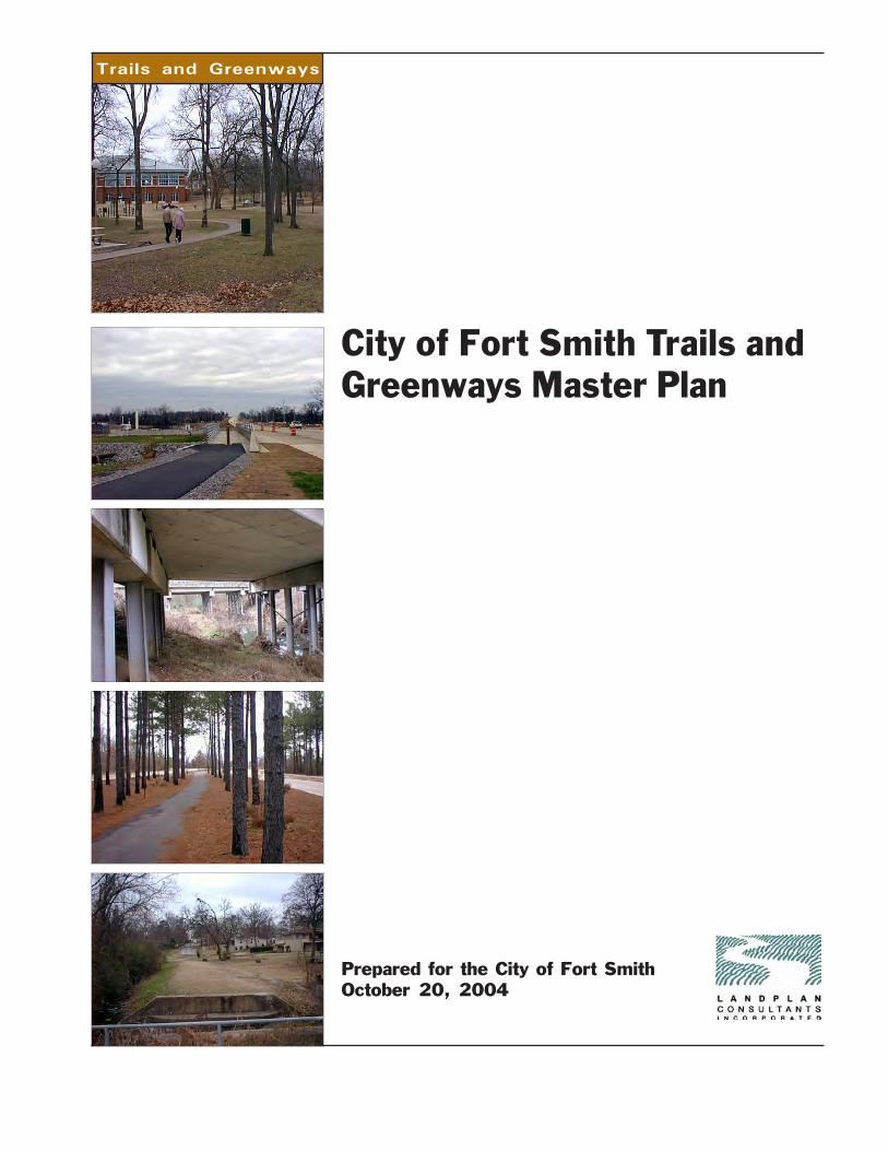
Prepared for the City of Fort SmithOctober 20, 2004
City of Fort Smith Trails andGreenways Master Plan
Trails and Greenways

Trails and Greenways
Trails and Greenways MasterPlan Advisory Committee
Bob RobinsonBrian KinseyCharles SmetsDaniel ReikesDonna RobinsonMike SmetsNancy RaneyRick WadeShirley WadeStan Vlademar
Fort Smith PlanningCommission
Dr. Randy Bridges, ChairCinda RusinDarrell CunninghamDon HutchingsEileen KradelMary Lou PointonPat KelleySusan FloydSteve Griffin
Fort Smith Parks andRecreation Commission
Susan Barry, ChairBilly Bob WilliamsConaly BedellPeggy WeidmanRobert E. YoesVirginia WaldonWilliam M. (Mike) Smets
Fort Smith Board of Directors
Alaric ParrishBen H. ShipleyC. Ray Baker, Jr., MayorDr. Cole GoodmanGary W. CampbellJoe W. DavisKenneth PyleNan Bartlett
Fort Smith City Administration
Bill Harding, City AdministratorDean Kruithof, Deputy City AdministratorMike Alsup, Parks and Recreation
DirectorRay Gosack, Deputy City Administrator
Trail Planning Consultant
LandPlan Consultants, Inc.
Keith Franklin, ASLARachel HagEstad, ASLA
City of Fort Smith Trails andGreenways Master Plan

Trails and Greenways
Acknowledgments
From the very beginning, the overriding goal of this master planning endeavorhas been to facilitate the actual construction of as many trails and greenwaysin Fort Smith as possible; to ensure those corridors are safe and locatedwhere they are needed and will be used; and to connect the major destinationswithin the city. This was a tall order from the start, and could not have beenaccomplished without the support, cooperation, hard work, and enthusiasm forthe citywide trails concept that we received throughout the development of theFort Smith Trails and Greenways Master Plan. The enthusiasm for the projectdid not come from just one group or entity. It received across the boardsupport from citizens and city representatives, so many in fact, that it will bedifficult to single out all the individuals whose extra effort and involvementfanned the flame to give the concept its wide spread support and momentum.
The 4 advisory committee workshops, 2 public workshops and the presenta-tions to the Parks and Recreation Commission and City Board of Directorswere attended by over 250 citizens throughout Fort Smith. We would like toexpress our appreciation to these people who contributed their insight, ideas,and suggestions. Community input is the backbone of the plan and hasprovided the impetus and vision that will make these planned trails a reality,improving the quality of life for all concerned.
Another thank you goes to the 10 member advisory committee, whose clearunderstanding of the needs of the diverse trail user groups was invaluable tothe direction and development of the trails and greenways master plan. Manyof these members spent time well beyond the scheduled meetings to furtherthe cause of safe trail development within Fort Smith.
We must applaud the City of Fort Smith and its exceptionally talented staff whoworked closely with the consultant throughout the master planning process.This group provided a thorough evaluation of the our work during the planningprocess helping to ensure the final result was a realistic plan.
Two outstanding citizens and advisory committee members that have made acommitment to improving the quality of life in Fort Smith deserve special
City of Fort Smith
AcknowledgmentsTrails and Greenways
recognition. Mike Smets and Dan Reikes shared their enthusiasm and insightinto the citywide trail and greenway system with the advisory committee andthe public. These dedicated public servants offered advice and input atcritical phases during the master planning process and receive our specialthanks for their contributions.
Finally, for his outstanding contribution to the project, we would like to thankMike Alsup, Director of Parks and Recreation. His efforts were above andbeyond the call of duty. He attended the meetings conducted in the planningprocess, provided final editing on all written material, reviewed master planmaps, coordinated the many meetings and provided the consultant with all theinformation we requested in a timely fashion. Mike’s commitment and dedica-tion to this project helped ensure the master plan will become a living docu-ment.
Trails and Greenways
Table of Contents
Table of Contents
Executive Summary iOverview .............................................................................................. iHow This Plan Was Developed ............................................................... iKey Recommendations of the Plan ..................................................... iiiHow Much Will It Cost to Develop the Trails and Greenways System .. ivWhat’s the Next Step in the Process ................................................... v
Chapter 1The Benefits of Trails and Greenways 1
Introduction ........................................................................................ 1Transportation Benefits ....................................................................... 1Air Quality Benefits ............................................................................. 2Health & Recreation Benefits .............................................................. 2Economic Benefits .............................................................................. 2Water Quality & Water Quantity Benefits ............................................. 3Plant & Animal Benefits ...................................................................... 3Quality of Life Benefits ....................................................................... 4Safety Benefits ................................................................................... 4Education Benefits .............................................................................. 4
Chapter 2Evaluation of Existing Conditions 5
Introduction ......................................................................................... 5Description of the Study Area ............................................................... 5Existing Attractors .............................................................................. 6Transportation System ...................................................................... 17Pipeline Systems .............................................................................. 17Existing Trails and Bicycle Facilities ................................................. 17
City of Fort Smith
Tr a i l s Mas t e r P l an Table of Contents
Chapter 3Vision, Goals & Objectives 21
Introduction ...................................................................................... 21Vision ................................................................................................ 21Goals & Objectives ........................................................................... 21
Chapter 4Design Guidelines 25
Introduction ...................................................................................... 25Trail and Greenway Development Corridors ...................................... 25Regional Trail Types .......................................................................... 29Trail/Greenway Components ............................................................. 32Signage ............................................................................................ 39Additional Guideline Sources ............................................................. 41
Chapter 5Description of Proposed Trailand Greenway System 43
Introduction ...................................................................................... 43Proposed Trails and Greenways ........................................................ 43
Chapter 6Funding Sources 51
Introduction ...................................................................................... 51Federal Public Funding Sources ........................................................ 51State Public Funding Sources ........................................................... 55Local Sources of Public Funding ....................................................... 55Local Private Funding Sources.......................................................... 57Foundations ...................................................................................... 59
Chapter 7Implementation Plan 61
Overview .......................................................................................... 61Building the Fort Smith Trails and Greenways System ....................... 61Phasing Strategy for the Fort Smith Trails and Greenways System ... 62Trail Phasing ..................................................................................... 63Estimated Costs for Facility Development ......................................... 64Typical Costs for Off-Road Trail Facilities ......................................... 67Developing the Trails and Greenways Master Plan ............................ 68Operations and Management ............................................................ 69Fort Smith Trails and Greenways System Governance Structure ....... 70Public Private Partnerships ............................................................... 71
Tr a i l s Mas t e r P l an Table of Contents
Map IndexMap ES.1 - Trails and Greenways Route Plan .................................... viiMap ES.2 - Trail Phasing Plan ............................................................ ixMap 2.1 - Existing Conditions .............................................................. 7Map 2.2 - Land Use .......................................................................... 11Map 2.3 - 2000 Population Density .................................................... 13Map 5.1 - Trails and Greenways Route Plan ...................................... 45Map 5.2 - Trail Coverage Plan .......................................................... 47Map 7.1 - Trail Phasing ..................................................................... 65
Chapter 8Operations, Maintenance & Management 73
Overview .......................................................................................... 73Fort Smith Trails and Greenways System Map Policy ........................ 73Public Access Easement Policy ......................................................... 73Private Construction of Trails Policy ................................................. 74Right of Public Access and Use of Trail/Greenway Lands Policy ....... 74Trail Naming Policy ........................................................................... 74Fencing and Vegetative Screening Policy .......................................... 74Adopt-a-Trail Program Policy ............................................................. 75Management Agreements ................................................................. 75Cross Access Agreements Policy ...................................................... 75Land Management ............................................................................ 76Safety and Security .......................................................................... 77Trail/Greenway Rules and Operation Regulations .............................. 78Trail/Greenway Ordinance ................................................................ 78Emergency Response Plan ................................................................ 80Risk Management Plan ...................................................................... 80Risk Management .............................................................................. 81

i
Trails and Greenways
City of Fort SmithExecutive Summary
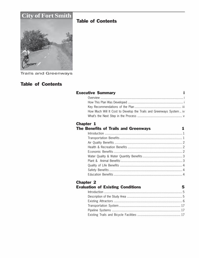
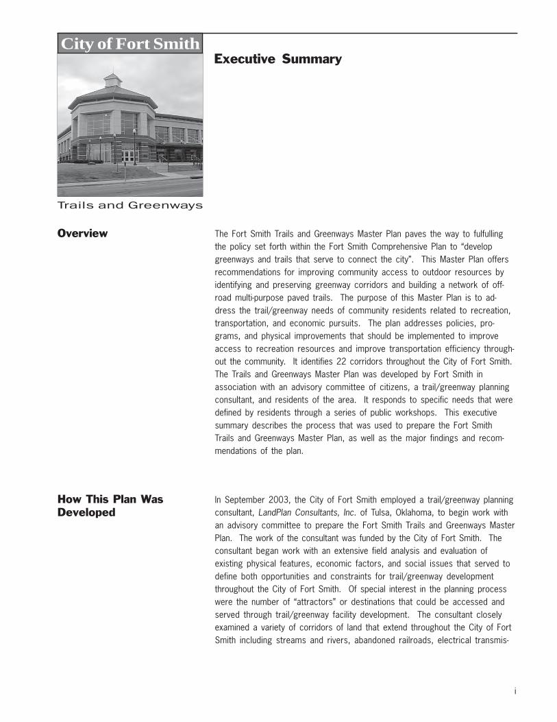
Overview The Fort Smith Trails and Greenways Master Plan paves the way to fulfullingthe policy set forth within the Fort Smith Comprehensive Plan to “developgreenways and trails that serve to connect the city”. This Master Plan offersrecommendations for improving community access to outdoor resources byidentifying and preserving greenway corridors and building a network of off-road multi-purpose paved trails. The purpose of this Master Plan is to ad-dress the trail/greenway needs of community residents related to recreation,transportation, and economic pursuits. The plan addresses policies, pro-grams, and physical improvements that should be implemented to improveaccess to recreation resources and improve transportation efficiency through-out the community. It identifies 22 corridors throughout the City of Fort Smith.The Trails and Greenways Master Plan was developed by Fort Smith inassociation with an advisory committee of citizens, a trail/greenway planningconsultant, and residents of the area. It responds to specific needs that weredefined by residents through a series of public workshops. This executivesummary describes the process that was used to prepare the Fort SmithTrails and Greenways Master Plan, as well as the major findings and recom-mendations of the plan.
How This Plan WasDeveloped
In September 2003, the City of Fort Smith employed a trail/greenway planningconsultant, LandPlan Consultants, Inc. of Tulsa, Oklahoma, to begin work withan advisory committee to prepare the Fort Smith Trails and Greenways MasterPlan. The work of the consultant was funded by the City of Fort Smith. Theconsultant began work with an extensive field analysis and evaluation ofexisting physical features, economic factors, and social issues that served todefine both opportunities and constraints for trail/greenway developmentthroughout the City of Fort Smith. Of special interest in the planning processwere the number of “attractors” or destinations that could be accessed andserved through trail/greenway facility development. The consultant closelyexamined a variety of corridors of land that extend throughout the City of FortSmith including streams and rivers, abandoned railroads, electrical transmis-
ii
Executive SummaryTrails and Greenways
sion lines, and roadways. Of particular interest to local residents was theissue of safety, especially as it applies to trail/greenway uses on trails thatparallel roadways.
Involving Fort Smith Residents
The consultant worked very closely with the Fort Smith Trails and GreenwaysAdvisory Committee during the past nine months in preparing this master plan.The consultant has also conducted public workshops, public meetings, and hasworked very closely with Fort Smith to ensure the proposed trail/greenwaysystem enhances the quality of life for city residents.
In November 2003, the first of two public workshops was facilitated by theconsultant to invite the public to participate in the planning process. Meetingswere held in the Creekmore Park Community Center. At these meetings,residents defined appropriate goals, objectives and policies for improvingaccess to outdoor resources throughout the city. Participants were asked todescribe issues and concerns related to trail/greenway development. Theywere also provided with an opportunity to define, on maps of the city, specificareas where they currently walk, ride a bike, hike, and rollerblade, as well asareas where they would like to see trail/greenway improvements made. Theresults of this workshop and the consultant’s efforts were summarized in aseries of reports termed “Draft Chapters” and provided to Fort Smith and theadvisory committee for review and comment. Results were also described ina series of newsletters that were published by the consultant and widelydistributed throughout the City of Fort Smith.
In January 2004, a second public workshop was conducted to present theresults of the November meeting. The consultant also presented a draftnetwork of trail/greenway corridors that would serve as the basis for a city-wide trails/greenways system. Workshop participants were asked to com-ment on the results of the prior meeting and carefully critique the initialnetwork of trail/greenway corridors. In addition, a draft phasing plan wasalso presented for review and comment. The results of these workshopswere again summarized in “Draft Chapters”.
On October 12, 2004, a final public presentation was made to the Fort SmithBoard for an overview of the public workshops to date. The Board and thepublic were asked to review and comment on the draft trail/greenway routeplan, draft phasing plan, design guidelines, and operations and maintenance ofthe citywide trails system. The City Board adopted the Trails and GreenwaysMaster Plan on October 19, 2004.
Defining the Fort Smith Trails and Greenways System
Using the information gathered during the public workshops and other availableinformation, the consultant worked for four months to define a comprehensive
iii
Executive SummaryTrails and Greenways
citywide system of trail/greenway corridors that would support a variety oftrail/greenway uses and meet the needs that were described by residents. Adraft of this Proposed Trail System Plan was presented in May 2004 to theadvisory committee for initial review and comment. Drafts of the plans andchapters were also reviewed by Fort Smith staff. From the comments re-ceived, the consultant revised aspects of the initial draft Trails and GreenwaysSystem Plan, and produced a final implementation plan and this executivesummary.
Key Components of this Plan
The “draft chapters” produced by the consultant during the past nine monthsmake up the eight chapters of this Plan. Chapter One, The Benefits of Trailsand Greenways, defines the wide range of benefits to the City of Fort Smiththat would come as a result of implementing the trails/greenways plan.Chapter Two, Evaluation of Existing Conditions, defines the background datacollected by the consultant. Chapter Three, Vision, Goals and Objectives,reflects the input of city residents and establishes the basis for many of therecommendations provided within the Plan. Chapter Four, Design Guidelines,offers development criteria for building various types of trail/greenwayfacilities recommended throughout the Plan. Chapter Five, Description ofProposed Trail System, describes the corridors that make up the Fort SmithTrails and Greenways System. Chapter Six, Funding Resources, describes avariety of local, state and federal sources of funding for developing bicycleand pedestrian facilities. Chapter Seven, Implementation Plan, recommendshow the Fort Smith Trails and Greenways System should be developed.Chapter Eight, Operations and Management, describes the needed elements tosuccessfully manage and maintain the Fort Smith Trails and Greenways system.
Key Recommendations ofthe Plan
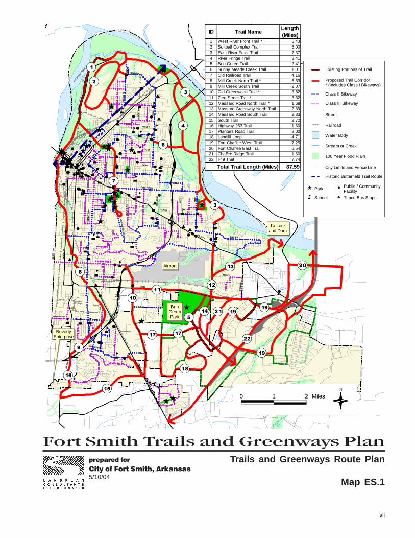
This Plan recommends the implementation of a 87.59 mile network of off-roadmulti-purpose trails throughout City of Fort Smith as depicted on the Trails andGreenways Route Plan (Map ES.1). The system is extensive and comprehen-sive, and at the same time provides a realistic program for satisfying theneeds of local residents regarding access to outdoor resources and linkage topopular destinations. Building the system will take many years. The overallsystem is divided into three phases as depicted in the Trail Phasing Plan (MapES.2). In the Near-Term phase (0-5 years), it is envisioned that local govern-ment agencies will work in partnership with neighborhoods and private sectororganizations to develop an estimated 27.46 miles of trail/greenway projects.Near-Term projects would begin development in Calendar Year 2005. Duringthe Mid-Term phase (5-10 years), an additional 37.76 miles of trail/greenwayprojects would be developed, and the Long-Term (10-15 years) phase envisionsthat the remaining 22.37 miles of trail/greenway projects would be imple-mented.
iv
Executive SummaryTrails and Greenways
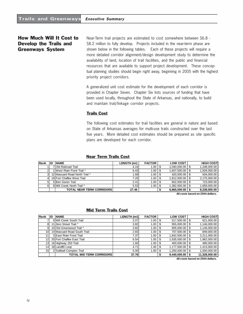
How Much Will It Cost toDevelop the Trails andGreenways System
Near-Term trail projects are estimated to cost somewhere between $6.8 -$8.2 million to fully develop. Projects included in the near-term phase areshown below in the following tables. Each of these projects will require amore detailed corridor alignment/design development study to determine theavailability of land, location of trail facilities, and the public and financialresources that are available to support project development. These concep-tual planning studies should begin right away, beginning in 2005 with the highestpriority project corridors.
A generalized unit cost estimate for the development of each corridor isprovided in Chapter Seven. Chapter Six lists sources of funding that havebeen used locally, throughout the State of Arkansas, and nationally, to buildand maintain trail/linkage corridor projects.
Trails Cost
The following cost estimates for trail facilities are general in nature and basedon State of Arkansas averages for multi-use trails constructed over the lastfive years. More detailed cost estimates should be prepared as site specificplans are developed for each corridor.
Mid Term Trails Cost
Near Term Trails CostRank ID NAME LENGTH (mi) FACTOR LOW COST HIGH COST
1 7 Old Railroad Trail 4.16 1.00 1,040,000.00$ 1,248,000.00$ 2 1 West River Front Trail * 6.43 1.00 1,607,500.00$ 1,929,000.00$ 3 12 Massard Road North Trail * 1.68 1.00 420,000.00$ 504,000.00$ 4 19 Fort Chaffee West Trail 7.25 1.00 1,812,500.00$ 2,175,000.00$ 5 5 Ben Geren Trail 2.41 1.00 602,500.00$ 723,000.00$ 6 8 Mill Creek North Trail * 5.53 1.00 1,382,500.00$ 1,659,000.00$
TOTAL NEAR TERM CORRIDORS 27.46 6,865,000.00$ 8,238,000.00$ All costs based on 2004 dollars.
Rank ID NAME LENGTH (mi) FACTOR LOW COST HIGH COST7 9 Mill Creek South Trail 2.07 1.00 517,500.00$ 621,000.00$ 8 11 Zero Street Trail * 3.82 1.00 955,000.00$ 1,146,000.00$ 9 10 Old Greenwood Trail * 3.82 1.00 955,000.00$ 1,146,000.00$
10 14 Massard Road South Trail 2.83 1.00 707,500.00$ 849,000.00$ 11 3 East River Front Trail 7.37 1.00 1,842,500.00$ 2,211,000.00$ 12 20 Fort Chaffee East Trail 6.54 1.00 1,635,000.00$ 1,962,000.00$ 13 16 Highway 253 Trail 1.60 1.00 400,000.00$ 480,000.00$ 14 18 Landfill Loop 4.71 1.00 1,177,500.00$ 1,413,000.00$ 15 2 Softball Complex Trail 5.00 1.00 1,250,000.00$ 1,500,000.00$
TOTAL MID TERM CORRIDORS 37.76 9,440,000.00$ 11,328,000.00$ All costs based on 2004 dollars.
v
Executive SummaryTrails and Greenways
What’s the Next Step inthe Process
This master plan will be reviewed and approved by the Fort Smith Park andRecreation Commission, Planning Commission, and Fort Smith Board ofDirectors. Once it becomes an official component of the Comprehensive Plan,the projects that are defined herein will be eligible for development. FortSmith encourages local governments, private businesses and residents tobecome partners in the development of the Fort Smith Trails and GreenwaysSystem.
You can show your support for this Plan by encouraging the implementation ofspecific trail/greenway segments. For further information on how you canbecome involved, you can contact the Fort Smith Parks Department, the FortSmith Planning Department, your local public officials, running club, walkingclub, or cycling club.
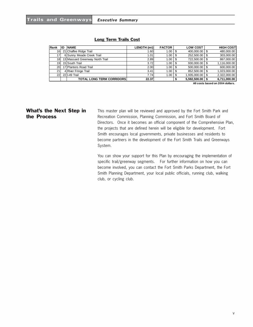
Long Term Trails Cost
Rank ID NAME LENGTH (mi) FACTOR LOW COST HIGH COST16 21 Chaffee Ridge Trail 1.60 1.00 400,000.00$ 480,000.00$ 17 6 Sunny Meade Creek Trail 1.01 1.00 252,500.00$ 303,000.00$ 18 13 Massard Greenway North Trail 2.89 1.00 722,500.00$ 867,000.00$ 19 15 South Trail 3.72 1.00 930,000.00$ 1,116,000.00$ 20 17 Planters Road Trail 2.00 1.00 500,000.00$ 600,000.00$ 21 4 River Fringe Trail 3.41 1.00 852,500.00$ 1,023,000.00$ 22 22 I-49 Trail 7.74 1.00 1,935,000.00$ 2,322,000.00$
TOTAL LONG TERM CORRIDORS 22.37 5,592,500.00$ 6,711,000.00$ All costs based on 2004 dollars.

Fort Smith Trails and Greenways Planprepared for
City of Fort Smith, Arkansas5/10/04
vii
$
$
$
$
$
$
$
$
$
$
$
$
$
$$
$
$$
$
åå
å
åå
å
å
å
å
å
åå
å
å
å
åå
å
åååå å
å
å
åå
å
å
å
å
åå
åå
å å å
å
å
Ê
Ê
Ê
ÊÊ
ÊÊ
Ê
ÊÊÊÊ
Ê
ÊÊÊ ÊÊ
ÊÊ
Ê
Ê Ê
Ê
Ê
Ê
Ê
Ê
Ê
#
#
#
##
#
#
#
#
#
#
#
##
#
#
#
#
#
#
###
#
#
#
#
#
#
##
##
#
#
#
#
#
##
#
#
##########
#
#
#
##
#
#
###
#
#
#
#
##
####
####
#
#
#
##
#
#
#
##########################
#
##
#
#
#
#
#
BeverlyEnterprise
MU
SS
ETT
NEWLON
MID
LAND
CLA
YT
ON
AL
BE
RT
PIK
E
50T
H
O ST
KELLEY
GRAND
5TH
10TH
14TH
GR
EE
NW
OO
D
JE
NN
Y L
IND
OL
D G
RE
EN
WO
OD
WH
EE
LER
ST
AT
E L
INE
ZERO
HE
ND
RIC
KS
28T
H
CAVANAUGH
BROOKEN HILL
AR
253 U
S 71
AR
45
MOODY
PA
INT
ER
DALLAS
MA
SS
AR
D
ROGERS
540
74T
H
66T
H
EUPER
540
WA
LD
RO
N
FREE FERRY
540
Arkan
sas R
iver
Airport
To Lockand Dam
BenGerenPark
"!19
"!19
"!17
"!20
"!18
"!21
"!22
"!19
"!17
"!15"!16
"!14
"!13
"!12"!11"!10
"!9
"!8
"!6
"!7
"!5
"!4
"!3
"!3"!2"!1
0 1 2 MilesN
Trails and Greenways Route Plan
Map ES.1
City Limits and Fence Line
Proposed Trail Corridor* (Includes Class I Bikeways)
Class II Bikeway
Class III Bikeway
Street
Railroad
Water Body
Stream or Creek
100 Year Flood Plain
Historic Butterfield Trail Route
ParkÊ
Schoolå
#Public / Community Facility
Timed Bus Stops$
Existing Portions of Trail
ID Trail NameLength (Miles)
1 West River Front Trail * 6.432 Softball Complex Trail 5.003 East River Front Trail 7.374 River Fringe Trail 3.415 Ben Geren Trail 2.416 Sunny Meade Creek Trail 1.017 Old Railroad Trail 4.168 Mill Creek North Trail * 5.539 Mill Creek South Trail 2.0710 Old Greenwood Trail * 3.8211 Zero Street Trail * 3.8212 Massard Road North Trail * 1.6813 Massard Greenway North Trail 2.8914 Massard Road South Trail 2.8315 South Trail 3.7216 Highway 253 Trail 1.6017 Planters Road Trail 2.0018 Landfill Loop 4.7119 Fort Chaffee West Trail 7.2520 Fort Chaffee East Trail 6.5421 Chaffee Ridge Trail 1.6022 I-49 Trail 7.74
87.59Total Trail Length (Miles)


Fort Smith Trails and Greenways Planprepared for
City of Fort Smith, Arkansas5/10/04
ix
$
$
$
$
$
$
$
$
$
$
$
$
$
$$
$
$$
$
åå
å
åå
å
å
å
å
å
åå
å
å
å
åå
å
åååå å
å
å
åå
å
å
å
å
åå
åå
å å å
å
å
Ê
Ê
Ê
ÊÊ
ÊÊ
Ê
ÊÊÊÊ
Ê
ÊÊÊ ÊÊ
ÊÊ
Ê
Ê Ê
Ê
Ê
Ê
Ê
Ê
Ê
#
#
#
##
#
#
#
#
#
#
#
##
#
#
#
#
#
#
###
#
#
#
#
#
#
##
##
#
#
#
#
#
##
#
#
##########
#
#
#
##
#
#
###
#
#
#
#
##
####
####
#
#
#
##
#
#
#
##########################
#
##
#
#
#
#
#
BeverlyEnterprise
MU
SS
ETT
NEWLON
MID
LAND
CLA
YT
ON
AL
BE
RT
PIK
E
50T
H
O ST
KELLEY
GRAND
5TH
10TH
14TH
GR
EE
NW
OO
D
JE
NN
Y L
IND
OL
D G
RE
EN
WO
OD
WH
EE
LER
ST
AT
E L
INE
ZERO
HE
ND
RIC
KS
28T
H
CAVANAUGH
BROOKEN HILL
AR
253 U
S 71
AR
45
MOODY
PA
INT
ER
DALLAS
MA
SS
AR
D
ROGERS
540
74T
H
66T
H
EUPER
540
WA
LD
RO
N
FREE FERRY
540
Arkan
sas R
iver
Airport
To Lockand Dam
BenGerenPark
"!1
"!2
"!3
"!3
"!4
"!5
"!7
"!6
"!8
"!9
"!10"!11
"!12
"!13
"!14
"!16
"!15
"!17
"!19
"!22
"!21
"!18
"!20
"!17
"!19
"!19
0 1 2 MilesN
Trail Phasing Plan
Map ES.2
City Limits and Fence Line
Proposed Trail (10+ Years)
Class II Bikeway
Class III Bikeway
ParkÊ
Schoolå
#Public / Community Facility
Timed Bus Stops$
Street
Railroad
Water Body
Stream or Creek
100 Year Flood Plain
Historic Butterfield Trail Route
Proposed Trail (5-10 Years)
Proposed Trail (0-5 Years)
Existing Portions of Trail
ID Trail NameLength (Miles)
1 West River Front Trail * 6.432 Softball Complex Trail 5.003 East River Front Trail 7.374 River Fringe Trail 3.415 Ben Geren Trail 2.416 Sunny Meade Creek Trail 1.017 Old Railroad Trail 4.168 Mill Creek North Trail * 5.539 Mill Creek South Trail 2.0710 Old Greenwood Trail * 3.8211 Zero Street Trail * 3.8212 Massard Road North Trail * 1.6813 Massard Greenway North Trail 2.8914 Massard Road South Trail 2.8315 South Trail 3.7216 Highway 253 Trail 1.6017 Planters Road Trail 2.0018 Landfill Loop 4.7119 Fort Chaffee West Trail 7.2520 Fort Chaffee East Trail 6.5421 Chaffee Ridge Trail 1.6022 I-49 Trail 7.74
87.59Total Trail Length (Miles)

1
Trails and Greenways
The Benefits of Trails and GreenwaysChapter 1
Introduction A multi-objective trail and greenway system for Fort Smith can address and resolvemany community issues that affect the future environmental and economic healthof the area. Trails and greenways have been implemented by other communitiesto provide recreation and alternative transportation, control flooding, improve waterquality, protect wetlands, conserve habitat for wildlife, and buffer adjacent landuses. Greenways typically incorporate varying types and intensities of human use,including trails for recreation and alternative transportation. Trails and greenwayshave also been shown to increase the value of adjacent private properties as anamenity to residential and commercial developments. These, and other benefits ofa Fort Smith trail and greenway network are described in the following text.
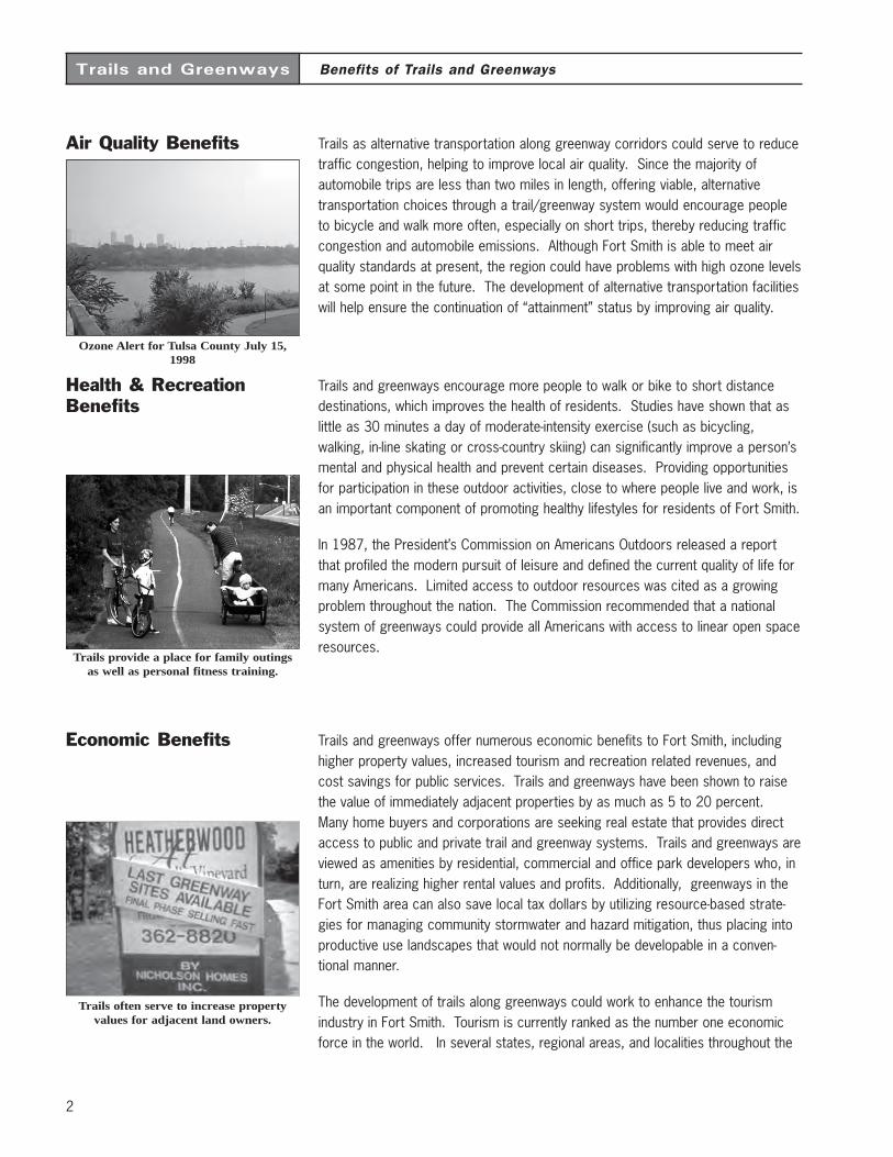
Transportation Benefits In past years, most American communities have grown in a sprawling, suburbanform as a result of dependence upon the automobile as the sole means of trans-portation. Americans have abandoned some traditional forms of transportation(such as passenger train service), and have been slow to improve other forms oftransportation (bicycle and pedestrian networks, bus systems, local train service).In order to provide relief from congested streets and highways in Fort Smith, andair quality problems associated with congestion, future transportation planning anddevelopment should focus on providing a choice in the mode of travel to localresidents. These mode choices should offer the same benefits and appealcurrently offered by the automobile: efficiency, safety, comfort, reliability andflexibility.
Multi-use trail corridors via greenways throughout Fort Smith can serve as exten-sions of the roadway network, offering realistic and viable connections betweenorigins and destinations such as offices, schools, libraries, parks, shopping areas,and tourist attractions. Off-road trail facilities are most effective for certain traveldistances. National surveys by the Federal Highway Administration have shownthat Americans are willing to walk as far as two miles to a destination, and bike asfar as five miles. It is easily conceivable that destinations can be linked to multipleorigins throughout the region through a system of greenways and off-road trails.
Bicycling and walking can take the placeof short automobile trips to work as well
as other destinations such as ATMs.
2
Trails and Greenways Benefits of Trails and Greenways
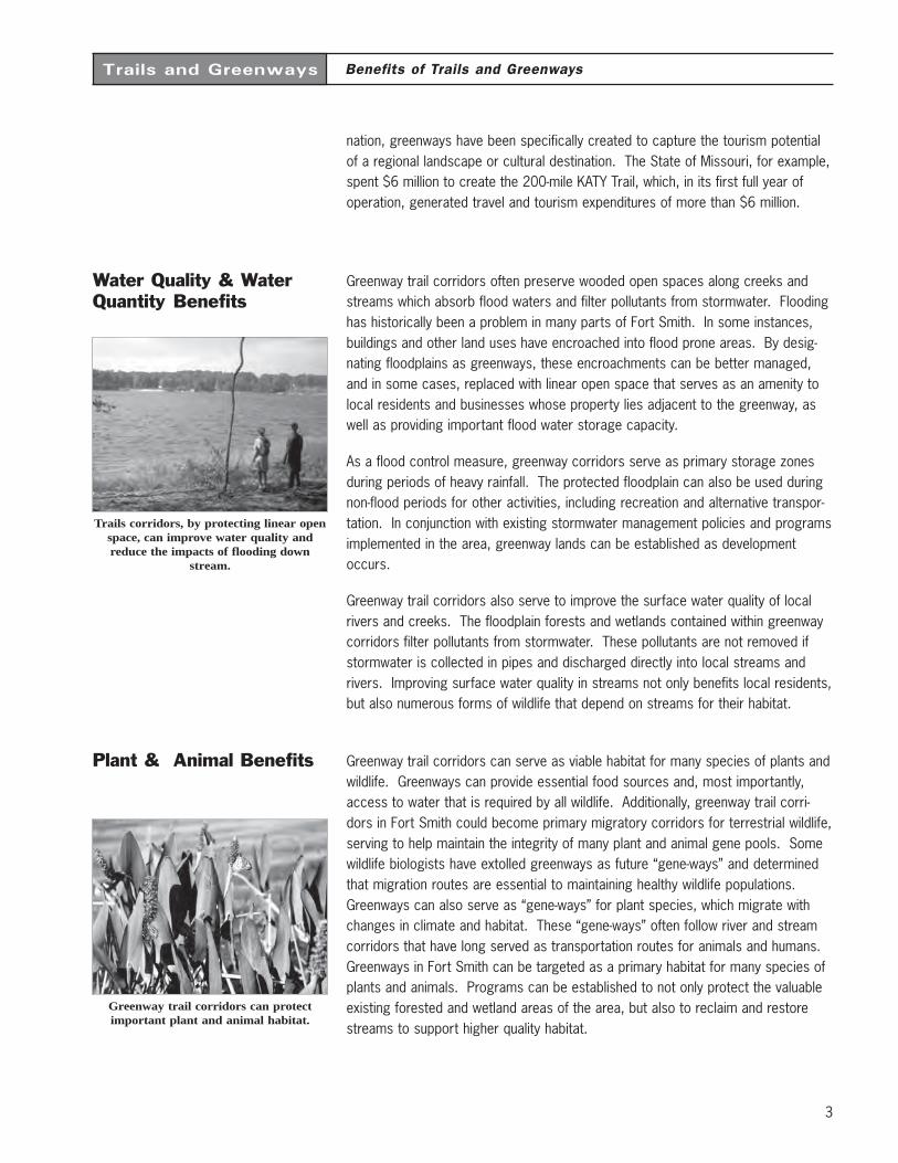
Air Quality Benefits Trails as alternative transportation along greenway corridors could serve to reducetraffic congestion, helping to improve local air quality. Since the majority ofautomobile trips are less than two miles in length, offering viable, alternativetransportation choices through a trail/greenway system would encourage peopleto bicycle and walk more often, especially on short trips, thereby reducing trafficcongestion and automobile emissions. Although Fort Smith is able to meet airquality standards at present, the region could have problems with high ozone levelsat some point in the future. The development of alternative transportation facilitieswill help ensure the continuation of “attainment” status by improving air quality.
Health & RecreationBenefits
Trails and greenways encourage more people to walk or bike to short distancedestinations, which improves the health of residents. Studies have shown that aslittle as 30 minutes a day of moderate-intensity exercise (such as bicycling,walking, in-line skating or cross-country skiing) can significantly improve a person’smental and physical health and prevent certain diseases. Providing opportunitiesfor participation in these outdoor activities, close to where people live and work, isan important component of promoting healthy lifestyles for residents of Fort Smith.
In 1987, the President’s Commission on Americans Outdoors released a reportthat profiled the modern pursuit of leisure and defined the current quality of life formany Americans. Limited access to outdoor resources was cited as a growingproblem throughout the nation. The Commission recommended that a nationalsystem of greenways could provide all Americans with access to linear open spaceresources.
Economic Benefits Trails and greenways offer numerous economic benefits to Fort Smith, includinghigher property values, increased tourism and recreation related revenues, andcost savings for public services. Trails and greenways have been shown to raisethe value of immediately adjacent properties by as much as 5 to 20 percent.Many home buyers and corporations are seeking real estate that provides directaccess to public and private trail and greenway systems. Trails and greenways areviewed as amenities by residential, commercial and office park developers who, inturn, are realizing higher rental values and profits. Additionally, greenways in theFort Smith area can also save local tax dollars by utilizing resource-based strate-gies for managing community stormwater and hazard mitigation, thus placing intoproductive use landscapes that would not normally be developable in a conven-tional manner.
The development of trails along greenways could work to enhance the tourismindustry in Fort Smith. Tourism is currently ranked as the number one economicforce in the world. In several states, regional areas, and localities throughout the
Trails provide a place for family outingsas well as personal fitness training.
Trails often serve to increase propertyvalues for adjacent land owners.
Ozone Alert for Tulsa County July 15,1998
3
Trails and Greenways
nation, greenways have been specifically created to capture the tourism potentialof a regional landscape or cultural destination. The State of Missouri, for example,spent $6 million to create the 200-mile KATY Trail, which, in its first full year ofoperation, generated travel and tourism expenditures of more than $6 million.
Water Quality & WaterQuantity Benefits
Greenway trail corridors often preserve wooded open spaces along creeks andstreams which absorb flood waters and filter pollutants from stormwater. Floodinghas historically been a problem in many parts of Fort Smith. In some instances,buildings and other land uses have encroached into flood prone areas. By desig-nating floodplains as greenways, these encroachments can be better managed,and in some cases, replaced with linear open space that serves as an amenity tolocal residents and businesses whose property lies adjacent to the greenway, aswell as providing important flood water storage capacity.
As a flood control measure, greenway corridors serve as primary storage zonesduring periods of heavy rainfall. The protected floodplain can also be used duringnon-flood periods for other activities, including recreation and alternative transpor-tation. In conjunction with existing stormwater management policies and programsimplemented in the area, greenway lands can be established as developmentoccurs.
Greenway trail corridors also serve to improve the surface water quality of localrivers and creeks. The floodplain forests and wetlands contained within greenwaycorridors filter pollutants from stormwater. These pollutants are not removed ifstormwater is collected in pipes and discharged directly into local streams andrivers. Improving surface water quality in streams not only benefits local residents,but also numerous forms of wildlife that depend on streams for their habitat.
Plant & Animal Benefits Greenway trail corridors can serve as viable habitat for many species of plants andwildlife. Greenways can provide essential food sources and, most importantly,access to water that is required by all wildlife. Additionally, greenway trail corri-dors in Fort Smith could become primary migratory corridors for terrestrial wildlife,serving to help maintain the integrity of many plant and animal gene pools. Somewildlife biologists have extolled greenways as future “gene-ways” and determinedthat migration routes are essential to maintaining healthy wildlife populations.Greenways can also serve as “gene-ways” for plant species, which migrate withchanges in climate and habitat. These “gene-ways” often follow river and streamcorridors that have long served as transportation routes for animals and humans.Greenways in Fort Smith can be targeted as a primary habitat for many species ofplants and animals. Programs can be established to not only protect the valuableexisting forested and wetland areas of the area, but also to reclaim and restorestreams to support higher quality habitat.
Benefits of Trails and Greenways
Trails corridors, by protecting linear openspace, can improve water quality andreduce the impacts of flooding down
stream.
Greenway trail corridors can protectimportant plant and animal habitat.
4
Trails and Greenways
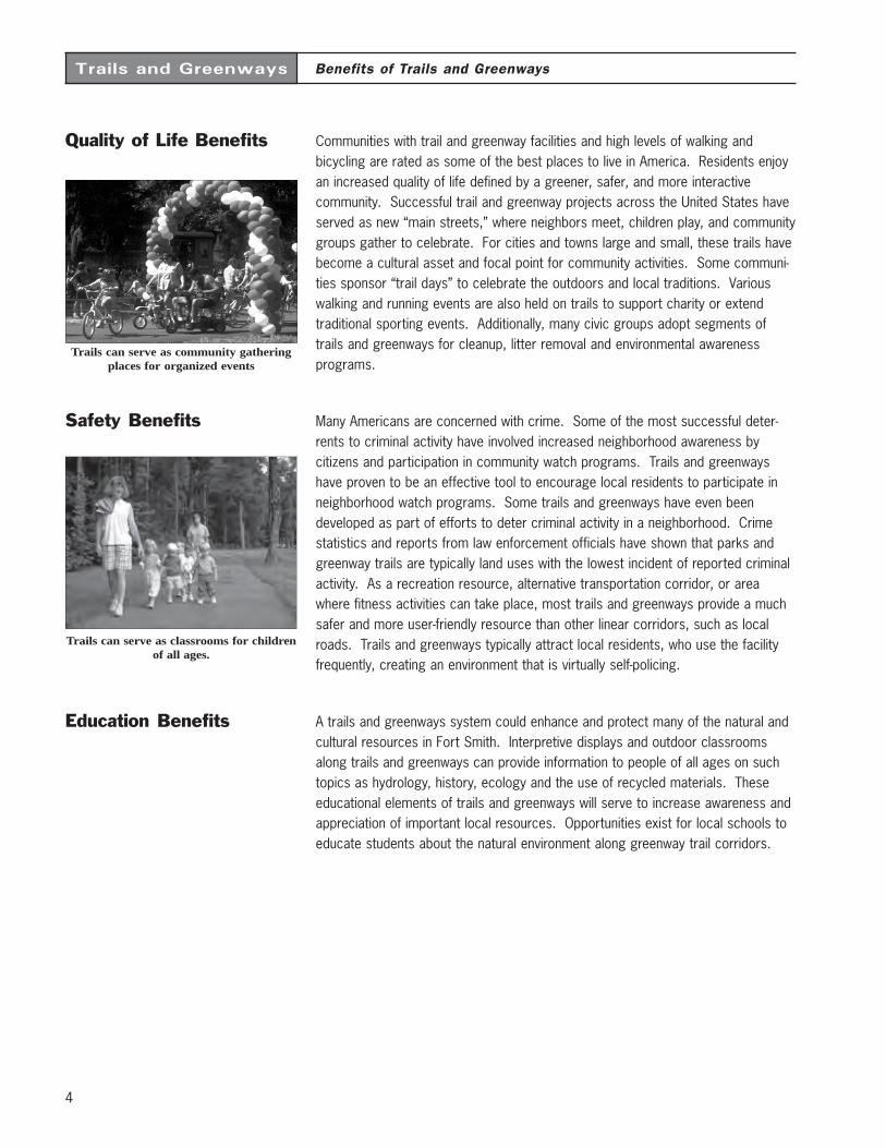
Quality of Life Benefits Communities with trail and greenway facilities and high levels of walking andbicycling are rated as some of the best places to live in America. Residents enjoyan increased quality of life defined by a greener, safer, and more interactivecommunity. Successful trail and greenway projects across the United States haveserved as new “main streets,” where neighbors meet, children play, and communitygroups gather to celebrate. For cities and towns large and small, these trails havebecome a cultural asset and focal point for community activities. Some communi-ties sponsor “trail days” to celebrate the outdoors and local traditions. Variouswalking and running events are also held on trails to support charity or extendtraditional sporting events. Additionally, many civic groups adopt segments oftrails and greenways for cleanup, litter removal and environmental awarenessprograms.
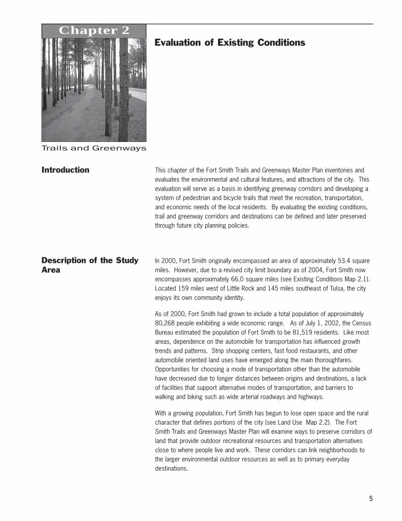
Safety Benefits Many Americans are concerned with crime. Some of the most successful deter-rents to criminal activity have involved increased neighborhood awareness bycitizens and participation in community watch programs. Trails and greenwayshave proven to be an effective tool to encourage local residents to participate inneighborhood watch programs. Some trails and greenways have even beendeveloped as part of efforts to deter criminal activity in a neighborhood. Crimestatistics and reports from law enforcement officials have shown that parks andgreenway trails are typically land uses with the lowest incident of reported criminalactivity. As a recreation resource, alternative transportation corridor, or areawhere fitness activities can take place, most trails and greenways provide a muchsafer and more user-friendly resource than other linear corridors, such as localroads. Trails and greenways typically attract local residents, who use the facilityfrequently, creating an environment that is virtually self-policing.
Education Benefits A trails and greenways system could enhance and protect many of the natural andcultural resources in Fort Smith. Interpretive displays and outdoor classroomsalong trails and greenways can provide information to people of all ages on suchtopics as hydrology, history, ecology and the use of recycled materials. Theseeducational elements of trails and greenways will serve to increase awareness andappreciation of important local resources. Opportunities exist for local schools toeducate students about the natural environment along greenway trail corridors.
Benefits of Trails and Greenways
Trails can serve as community gatheringplaces for organized events
Trails can serve as classrooms for childrenof all ages.
Trails and Greenways
5
Chapter 2
5
Evaluation of Existing Conditions
Introduction This chapter of the Fort Smith Trails and Greenways Master Plan inventories andevaluates the environmental and cultural features, and attractions of the city. Thisevaluation will serve as a basis in identifying greenway corridors and developing asystem of pedestrian and bicycle trails that meet the recreation, transportation,and economic needs of the local residents. By evaluating the existing conditions,trail and greenway corridors and destinations can be defined and later preservedthrough future city planning policies.
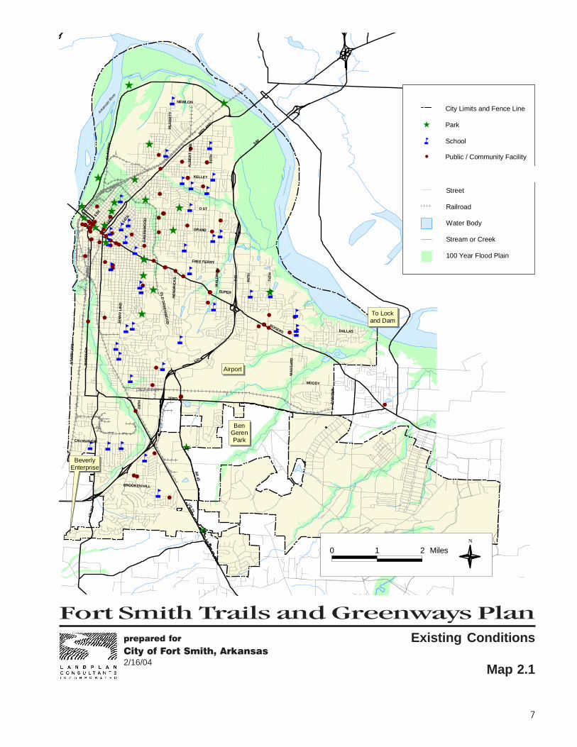
Description of the StudyArea
In 2000, Fort Smith originally encompassed an area of approximately 53.4 squaremiles. However, due to a revised city limit boundary as of 2004, Fort Smith nowencompasses approximately 66.0 square miles (see Existing Conditions Map 2.1).Located 159 miles west of Little Rock and 145 miles southeast of Tulsa, the cityenjoys its own community identity.
As of 2000, Fort Smith had grown to include a total population of approximately80,268 people exhibiting a wide economic range. As of July 1, 2002, the CensusBureau estimated the population of Fort Smith to be 81,519 residents. Like mostareas, dependence on the automobile for transportation has influenced growthtrends and patterns. Strip shopping centers, fast food restaurants, and otherautomobile oriented land uses have emerged along the main thoroughfares.Opportunities for choosing a mode of transportation other than the automobilehave decreased due to longer distances between origins and destinations, a lackof facilities that support alternative modes of transportation, and barriers towalking and biking such as wide arterial roadways and highways.
With a growing population, Fort Smith has begun to lose open space and the ruralcharacter that defines portions of the city (see Land Use Map 2.2). The FortSmith Trails and Greenways Master Plan will examine ways to preserve corridors ofland that provide outdoor recreational resources and transportation alternativesclose to where people live and work. These corridors can link neighborhoods tothe larger environmental outdoor resources as well as to primary everydaydestinations.
Trails and Greenways
6
Evaluation of Existing Conditions
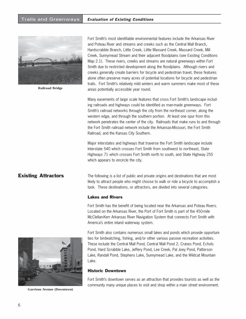
Fort Smith’s most identifiable environmental features include the Arkansas Riverand Poteau River and streams and creeks such as the Central Mall Branch,Hardscrabble Branch, Little Creek, Little Massard Creek, Massard Creek, MillCreek, Sunnymead Stream and their adjacent floodplains (see Existing ConditionsMap 2.1). These rivers, creeks and streams are natural greenways within FortSmith due to restricted development along the floodplains. Although rivers andcreeks generally create barriers for bicycle and pedestrian travel, these featuresalone often preserve many acres of potential locations for bicycle and pedestriantrails. Fort Smith’s relatively mild winters and warm summers make most of theseareas potentially accessible year round.
Many easements of large scale features that cross Fort Smith’s landscape includ-ing railroads and highways could be identified as man-made greenways. FortSmith’s railroad networks through the city from the northeast corner, along thewestern edge, and through the southern portion. At least one spur from thisnetwork penetrates the center of the city. Railroads that make runs to and throughthe Fort Smith railroad network include the Arkansas-Missouri, the Fort SmithRailroad, and the Kansas City Southern.
Major interstates and highways that traverse the Fort Smith landscape includeInterstate 540 which crosses Fort Smith from southwest to northeast, StateHighways 71 which crosses Fort Smith north to south, and State Highway 255which appears to encircle the city.
Existing Attractors The following is a list of public and private origins and destinations that are mostlikely to attract people who might choose to walk or ride a bicycle to accomplish atask. These destinations, or attractors, are divided into several categories.
Lakes and Rivers
Fort Smith has the benefit of being located near the Arkansas and Poteau Rivers.Located on the Arkansas River, the Port of Fort Smith is part of the 450-mileMcClellan-Kerr Arkansas River Navigation System that connects Fort Smith withAmerica’s entire inland waterway system.
Fort Smith also contains numerous small lakes and ponds which provide opportuni-ties for birdwatching, fishing, and/or other various passive recreation activities.These include the Central Mall Pond, Central Mall Pond 2, Cranes Pond, EcholsPond, Hard Scrabble Lake, Jeffery Pond, Lee Creek, Pal Joey Pond, PattersonLake, Randall Pond, Stephens Lake, Sunnymead Lake, and the Wildcat MountainLake.
Historic Downtown
Fort Smith’s downtown serves as an attraction that provides tourists as well as thecommunity many unique places to visit and shop within a main street environment.
Garrison Avenue (Downtown)
Railroad Bridge
Fort Smith Trails and Greenways Planprepared for
City of Fort Smith, Arkansas2/16/04
7
Existing Conditions
Map 2.1
#
#
#
##
#
#
#
#
#
#
#
##
#
#
#
#
#
#
###
#
#
#
#
#
#
##
##
#
#
#
#
#
##
#
#
##########
#
#
#
##
#
#
###
#
#
#
#
##
####
####
#
#
#
##
#
#
#
##########################
#
##
#
#
#
#
#
åå
å
åå
å
å
å
å
å
åå
å
å
å
åå
å
åååå å
å
å
åå
å
å
å
å
åå
åå
å å å
å
å
Ê
Ê
Ê
Ê
Ê
Ê
Ê
Ê
Ê
Ê
Ê
Ê
Ê
Ê
Ê
ÊÊ
Ê
Ê
Ê
Ê
Ê
Ê
MU
S SE
T T
NEWLON
MID
LAND
CLA
YTO
N
ALB
ER
T P
IKE
50T
HO ST
KELLEY
GRAND
5TH
10TH 14TH
GR
EE N
WO
OD
J EN
NY
LIN
D
OL
D G
REE
NW
OO
D
WH
EE
LER
STA
TE L
INE
ZERO
HE
ND
RI C
KS
28T
H
CAVANAUGH
BROOKEN HILL
AR
253
US 71
AR
4 5MOODY
PA
INTE
RDALLAS
MA
SS
AR
D
ROGERS
540
74T
H
6 6TH
EUPER
540
WA
LD
RO
N
FREE FERRY
540
Arkan
sas R
iver
BeverlyEnterprise
Airport
To Lockand Dam
BenGerenPark
0 1 2 MilesN
City Limits and Fence Line
ParkÊ
Schoolå
Existing Trail
Street
Railroad
Water Body
Stream or Creek
100 Year Flood Plain
# Public / Community Facility

Trails and Greenways
9
Evaluation of Existing Conditions
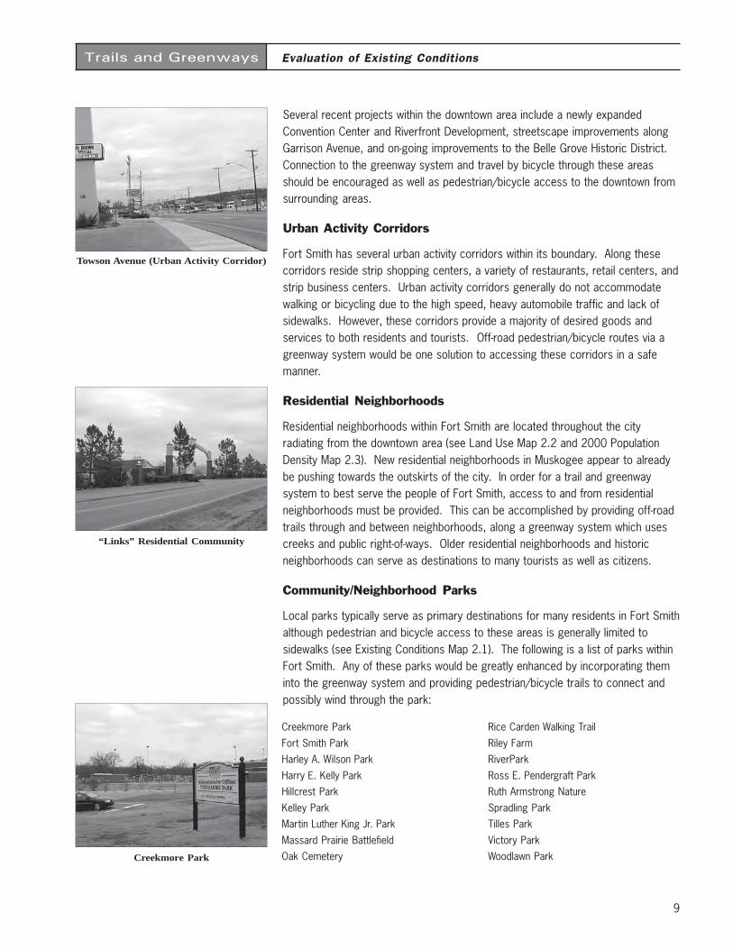
Several recent projects within the downtown area include a newly expandedConvention Center and Riverfront Development, streetscape improvements alongGarrison Avenue, and on-going improvements to the Belle Grove Historic District.Connection to the greenway system and travel by bicycle through these areasshould be encouraged as well as pedestrian/bicycle access to the downtown fromsurrounding areas.
Urban Activity Corridors
Fort Smith has several urban activity corridors within its boundary. Along thesecorridors reside strip shopping centers, a variety of restaurants, retail centers, andstrip business centers. Urban activity corridors generally do not accommodatewalking or bicycling due to the high speed, heavy automobile traffic and lack ofsidewalks. However, these corridors provide a majority of desired goods andservices to both residents and tourists. Off-road pedestrian/bicycle routes via agreenway system would be one solution to accessing these corridors in a safemanner.
Residential Neighborhoods
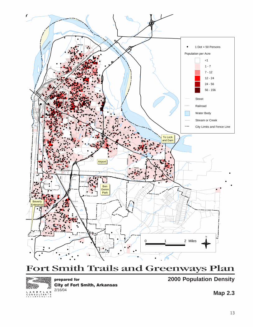
Residential neighborhoods within Fort Smith are located throughout the cityradiating from the downtown area (see Land Use Map 2.2 and 2000 PopulationDensity Map 2.3). New residential neighborhoods in Muskogee appear to alreadybe pushing towards the outskirts of the city. In order for a trail and greenwaysystem to best serve the people of Fort Smith, access to and from residentialneighborhoods must be provided. This can be accomplished by providing off-roadtrails through and between neighborhoods, along a greenway system which usescreeks and public right-of-ways. Older residential neighborhoods and historicneighborhoods can serve as destinations to many tourists as well as citizens.
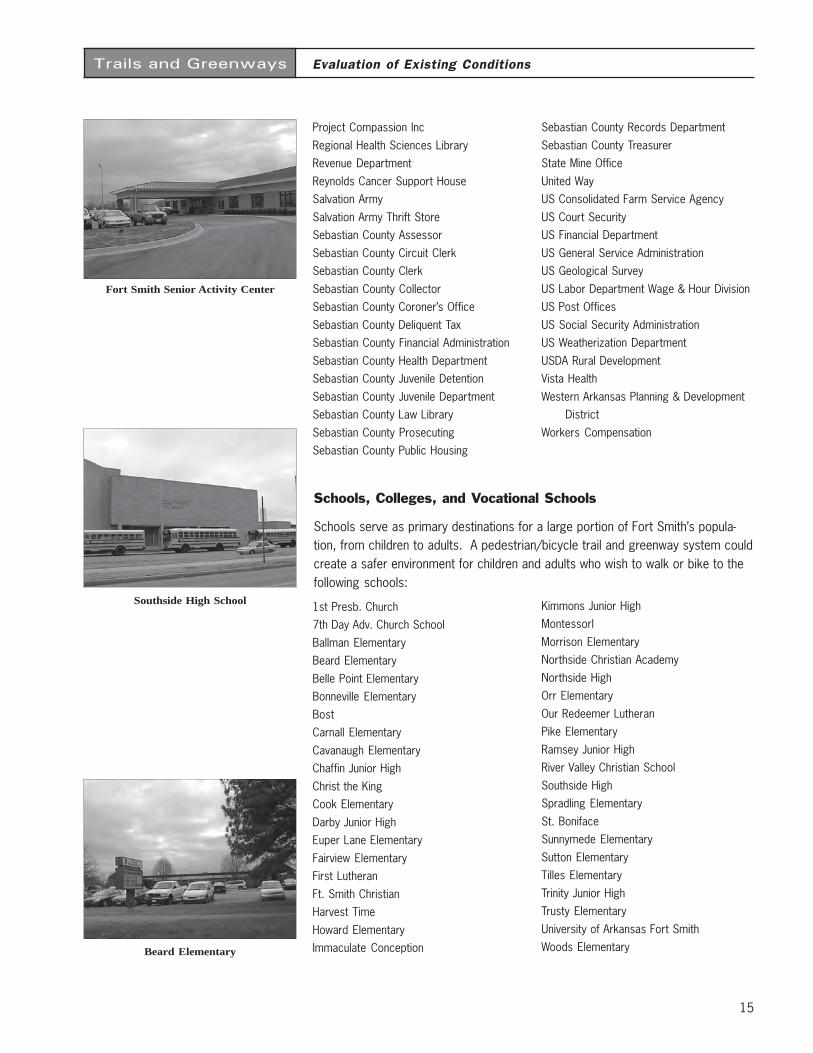
Community/Neighborhood Parks
Local parks typically serve as primary destinations for many residents in Fort Smithalthough pedestrian and bicycle access to these areas is generally limited tosidewalks (see Existing Conditions Map 2.1). The following is a list of parks withinFort Smith. Any of these parks would be greatly enhanced by incorporating theminto the greenway system and providing pedestrian/bicycle trails to connect andpossibly wind through the park:
1100 North 7th Park
700 Garrison ParkAnniversary Rose Garden
Carol Ann Cross ParkCisterna Park
Creekmore Park
Fort Smith ParkHarley A. Wilson Park
Harry E. Kelly ParkHillcrest Park
Kelley ParkMartin Luther King Jr. Park
Massard Prairie BattlefieldOak Cemetery
Rice Carden Walking Trail
Riley FarmRiverPark
Ross E. Pendergraft ParkRuth Armstrong Nature
Spradling ParkTilles Park
Victory ParkWoodlawn Park
Towson Avenue (Urban Activity Corridor)
“Links” Residential Community
Creekmore Park
Trails and Greenways
10
Evaluation of Existing Conditions
Other Public/Private Facilities, Special Use Areas, andAttractions
There are many public buildings and facilities and special use areas in Fort Smith.They are scattered throughout the area and are currently accessed primarily byautomobile. Making connections to the pedestrian/bicycle and greenway systemwill provide residents and tourists with an alternative way of accessing the follow-ing facilities:
Abilities Unlimited
Abundant Life CounselingAction Now Inc
American Red CrossArc For The River Valley
Area Agency On AgingArkansas Department-Human Services
Arkansas Valley Habitat For HumanityBaker Senior Citizens Center
Behavioral Science ClinicBoy Scouts Of America
Briarwood Head Start CenterCancer Support Foundation
Solution-Focused CounselingChildren & Family Services Division
Children’s Emergency ShelterCircuit Clerk-Child Support
City of BonanzaCity of Fort Smith
City of Fort Smith SanitationClearinghouse Community Service
Community Mission IncComprehensive Juvenile Services
Counseling Center-Fort SmithCreekmore Park Center
Crisis Center For WomenDarby Foundation
Day Care LicensingDevelopmental Disabilities
Driver Service OfficeEmergency Services
Employment Security DepartmentEnvironmental Quality Department
Family Service AssociationField Audit Office
Fort Smith Animal Control
Fort Smith Board Of DirectorsFort Smith Building Department
Fort Smith City AdministratorFort Smith City Clerk
Fort Smith Collection LicenseFort Smith Community Development
Fort Smith Convention CenterFort Smith Customer Service
Fort Smith EngineeringFort Smith Finance Department
Fort Smith National HistoricFort Smith Operations Division
Fort Smith Personnel DepartmentFort Smith Planning
Fort Smith Public LibrariesFort Smith Transportation Department
Fort Smith Water & SewerGame & Fish Commission
Gateway HouseHabitat For Humanity
Hagemeier Family CounselHarbor House
Head Start Child & Family ServicesHealth Point Pho
Human Services DepartmentLife Counseling Services
March of DimesMid Town Senior Citizens Center
Mine Inspection DivisionNorthwest Arkansas Food Bank
Oil & Gas CommissionPollution Control & Ecology
Pregnancy Help CenterProfessional Counseling Services
County Courthouse
River Front Amphitheater
Fort Smith Police Station

Fort Smith Trails and Greenways Planprepared for
City of Fort Smith, Arkansas2/16/04
11
MU
S SE
T T
NEWLON
MID
LAND
CLA
YTO
N
ALB
ER
T P
IKE
50T
HO ST
KELLEY
GRAND
5TH
10TH 14TH
GR
EE N
WO
OD
J EN
NY
LIN
D
OL
D G
REE
NW
OO
D
WH
EE
LER
STA
TE L
INE
ZERO
HE
ND
RI C
KS
28T
H
CAVANAUGH
BROOKEN HILL
AR
253
US 71
AR
4 5MOODY
PA
INTE
RDALLAS
MA
SS
AR
D
ROGERS
540
74T
H
6 6TH
EUPER
540
WA
LD
RO
N
FREE FERRY
540
Arkan
sas R
iver
BeverlyEnterprise
Airport
To Lockand Dam
BenGerenPark
0 1 2 MilesN
Land Use
Map 2.2
City Limits and Fence Line
Street
Railroad
Water Body
Stream or Creek
100 Year Flood Plain
Air strip
Commercial
Multi-family
Industrial
Manufacturing
Office
Open space
Public
Single-family
Vacant

Fort Smith Trails and Greenways Planprepared for
City of Fort Smith, Arkansas2/16/04
13
#
#
#
##
###### ##
## ###
#
# ##
#
## #
##
#
####
####
###
###
#
##
# #
### #
####
##
#### ###
#
#####
# # ## # #
###### # # #
#
#####
#
#
#
##
###
# ##
#
#
#
#
#
##
##
# #
#
#
#
#
###
#
#
###
##
#
#
#
#
#
#
# #
###
##
#
#
#
####
###
##
#
####
#
####
# #
###
#
#
##
#
#
# #
#
##
##
##
# #
#
#
###
###
###
#
# #
####
##
##
#
####
##
##
#
#
#
###
#
#
#######
#
##
### ##
###
##
##
##
##
#
##
##
#
##
##
####
## #
##
###
## ####
####
####
#
##
#
##
##
###
##
###
##
#
##
#
###
#
###
##
##
####
#
###
#
#
#
#
###
###
## #
#
###
##
#####
###
###
#
####
#
#
##
######
# #
##
###
#
#
####
#
####
#
#
####
#
## ######
##
# ##
##
###
#
#
#
###
# # #
#
#
#####
#
###
#
#
##
#
#
#
##
#
#####
#### #
#
#
#
#
# ##
#
#
#
#
##
##
##
####
#
##
#
###
##
##
#
##
##
###
##
##
#
#
#
#
#
#
#
#
#
####
##
#
#
##
#
#
##
###
#
#
##
###
##
##
#####
#
#
#
# #
###
#
#
# # ##
#
###
#
###
# # ###
##
#
#
#
#
####
####
# ##
###
##
#
#
#
##
##
## #
##
#
##
###
##
###
###
#
#
#
##
#
#
#
###
##
###
#
#
#
### #
##
#
###
####
#
##
#
#
# # ###
#
#
##
###
###
####
## ###
####
########
#
####### #
####
##
####
###
###
####
##
####
#
#
## #
#####
##
#
####
#######
## ## #####
##
#
##
#
#
#
##
#####
##
## #
##
# ##
##
#
#
#
# #
####
##
###
#
####
##
###
####
##
#
#
##
#
##
# #
###
####
###
##
#
#
######
#
## #
##
###
#
#
#
#
#
#
###
#
##
# ###
# ##
#
#
##
#
#
##
##
###
#
#
#
#
#
##
##
# #
##
###
##
#
#
#
##
#
#
#
##
#
##
##
###
# #
##
###
#
#
#
#
##
#
##
#
#
##
##
####
##
#
#
#
#
#
##
##
#
#
#
#
###
#
##
##
#
# #
#
#
#
#
#
##
##
#
##
##
##
### #
#
#
##
#
#
#
#
#
#
#
#
#
###
#
# #
#
##
##
#
##
#
##
#
#
#
#
#
##
#
#
#
##
#
#
##
#
##
# ####
#
#
#
## ####
#
#
#
#
## #
#
#
#
###
#
#
#
##
####
##
###
###
##
#
##
#
#
#
#
#
#
#
#
#
#
#
#
##
#
## #
##
###
#
###
######
#
##
# #
##
####
###
##
#
#
#
#
#
#
#
#
##
#
#
#
#
#
##
##
##
#
#
# ##
#
##
#
#
#
#
##
##
##
#
#
#
##
#
#
##
#
#
#
#
#
##
# #
##
##
#
#
#
###
##
#
##
##
##
#
#
##
#
#
###
##
#
#
###
#
#
##
##
#
##
#
#
#
#
#
#
#
#
#
#
#
#
#
## #
##
##
#
#
#
###
#
#
#
#
##
##
#
#
#
##
#
#
##
#
#
##
#
#
##
#
####
#
#
#
#
##
##
#
#
#
###
#
#
##
#
#
#
#
##
###
#
#
##
##
#
#
#
###
#
#
##
## #
# #
#
##
##
##
#
##
#
#
##
#
#
####
#
#
#
##
#
#
#
##
#
#
#
#
##
#
#
##
#
#
#
##
#
#
###
## ####
#
#
#
#
##
#
#
###
#
##
#
#
#
#
##
#
###
##
#
#
#
#
#
#
#
#
##
##
##
##
#
##
###
#
#
#
#
##
##
###
#
##
#
#
### ##
#
#
#
#
##
#
#
##
#
###
# ##
## #
####
##
#
#
##
###
#
##
###
## #
##
#
## #
#
# ##
## #
##
#
#
#
#
##
#
##
#
#
##
#
##
#
##
#
##
#
#
##
##
###
###
### #
#
##
##
#
##
#
## #
##
#
#
##
#
#
#
##
##
#
##
#
#
# #
##
#
#
#
#
#
###
#
#
#
#
#
##
#
#
#
#
##
##
#
#
#
##
#
#
#
# #
#
###
#
###
##
# #
#
#
#
##
# ##
##
#
##
##
##
#
# ##
# #
#
##
#
#
#
#
MU
SS
ET
T
NEWLON
MID
LAND
CLA
YTO
N
AL
BE
RT
PIK
E
50T
HO ST
KELLEY
GRAND
5TH
10TH 14TH
GR
EE
NW
OO
D
JE
NN
Y L
IND
OL
D G
RE
EN
WO
OD
WH
EE
LER
ST
AT
E L
INE
ZERO
HE
ND
RIC
KS
28T
H
CAVANAUGH
BROOKEN HILL
AR
253
US
71
AR
45MOODY
PA
INT
ER
DALLAS
MA
SS
AR
D
ROGERS
540
74T
H
66T
H
EUPER
540
WA
LD
RO
N
FREE FERRY
540
Arkan
sas R
iver
BeverlyEnterprise
Airport
To Lockand Dam
BenGerenPark
0 1 2 MilesN
2000 Population Density
Map 2.3
City Limits and Fence Line
Street
Railroad
Water Body
Stream or Creek
<1
1 - 7
7 - 12
12 - 24
24 - 56
# 1 Dot = 50 Persons
Population per Acre
56 - 156

Trails and Greenways
15
Evaluation of Existing Conditions
Project Compassion Inc
Regional Health Sciences LibraryRevenue Department
Reynolds Cancer Support HouseSalvation Army
Salvation Army Thrift StoreSebastian County Assessor
Sebastian County Circuit ClerkSebastian County Clerk
Sebastian County CollectorSebastian County Coroner’s Office
Sebastian County Deliquent TaxSebastian County Financial Administration
Sebastian County Health DepartmentSebastian County Juvenile Detention
Sebastian County Juvenile DepartmentSebastian County Law Library
Sebastian County ProsecutingSebastian County Public Housing
Sebastian County Records Department
Sebastian County TreasurerState Mine Office
United WayUS Consolidated Farm Service Agency
US Court SecurityUS Financial Department
US General Service AdministrationUS Geological Survey
US Labor Department Wage & Hour DivisionUS Post Offices
US Social Security AdministrationUS Weatherization Department
USDA Rural DevelopmentVista Health
Western Arkansas Planning & DevelopmentDistrict
Workers Compensation
1st Presb. Church7th Day Adv. Church School
Ballman ElementaryBeard Elementary
Belle Point ElementaryBonneville Elementary
BostCarnall Elementary
Cavanaugh ElementaryChaffin Junior High
Christ the KingCook Elementary
Darby Junior HighEuper Lane Elementary
Fairview ElementaryFirst Lutheran
Ft. Smith ChristianHarvest Time
Howard ElementaryImmaculate Conception
Kimmons Junior HighMontessorl
Morrison ElementaryNorthside Christian Academy
Northside HighOrr Elementary
Our Redeemer LutheranPike Elementary
Ramsey Junior HighRiver Valley Christian School
Southside HighSpradling Elementary
St. BonifaceSunnymede Elementary
Sutton ElementaryTilles Elementary
Trinity Junior HighTrusty Elementary
University of Arkansas Fort SmithWoods Elementary
Schools, Colleges, and Vocational Schools
Schools serve as primary destinations for a large portion of Fort Smith’s popula-tion, from children to adults. A pedestrian/bicycle trail and greenway system couldcreate a safer environment for children and adults who wish to walk or bike to thefollowing schools:
Fort Smith Senior Activity Center
Southside High School
Beard Elementary
Trails and Greenways
16
Evaluation of Existing Conditions
Shopping Centers
Shopping centers in Fort Smith are generally oriented towards the automobile.Large parking lots with little or no space for walking or for storing a bike deterwalking or bicycling to the facilities. These places serve as major destinations formany people. Providing pedestrian/bicycle facilities via a greenway system mightencourage the customer who would like to walk or bike to Fort Smith shoppingcenters. Below is a partial list of locations:
Downtown Fort Smith
Central MallPhoenix Village Mall
Eastpointe Shopping Center
Brooken Hill Shopping Center
Hospitals and Medical Centers
Many hospitals and medical centers provide little or no pedestrian/bicycle accessto the facilities. Medical workers and patients could benefit from the developmentof an adjacent trail and greenway system for exercise and transportation tohospitals and medical centers:
Harbor View Mercy HospitalVista Health Fort Smith
Sparks Health System
St Edward Mercy Medical CenterCooper Clinic
Major Employers
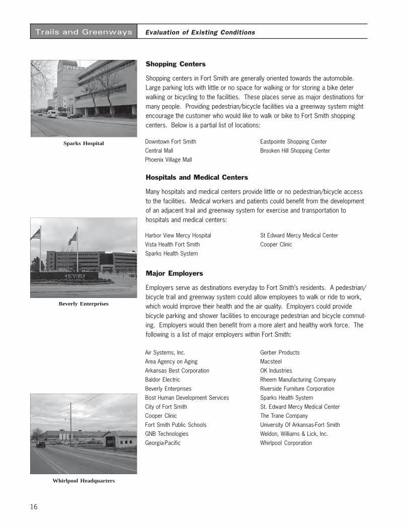
Employers serve as destinations everyday to Fort Smith’s residents. A pedestrian/bicycle trail and greenway system could allow employees to walk or ride to work,which would improve their health and the air quality. Employers could providebicycle parking and shower facilities to encourage pedestrian and bicycle commut-ing. Employers would then benefit from a more alert and healthy work force. Thefollowing is a list of major employers within Fort Smith:
Air Systems, Inc.Area Agency on Aging
Arkansas Best CorporationBaldor Electric
Beverly EnterprisesBost Human Development Services
City of Fort SmithCooper Clinic
Fort Smith Public SchoolsGNB Technologies
Georgia-Pacific
Gerber ProductsMacsteel
OK IndustriesRheem Manufacturing Company
Riverside Furniture CorporationSparks Health System
St. Edward Mercy Medical CenterThe Trane Company
University Of Arkansas-Fort SmithWeldon, Williams & Lick, Inc.
Whirlpool Corporation
Sparks Hospital
Beverly Enterprises
Whirlpool Headquarters
Trails and Greenways
17
Evaluation of Existing Conditions
Transportation System With the improvement and addition of existing and new roadways, the opportunityexists to preserve greenways and include bicycle and pedestrian facilities withinthe rights of way from the preliminary phase. By implementing them into thedesign and construction of the roadways, the bicycle and pedestrian facilities andgreenways will become an integrated amenity rather than an after thought and maybe constructed at a significantly lower cost.
Pipeline Systems Since access to pipelines must be maintained at all times, the easements aretypically not developable for general construction. However, it is possible that insome cases, if a public use easement could be obtained, these corridors might beincorporated into the greenway system and used for bicycle/pedestrian trails.
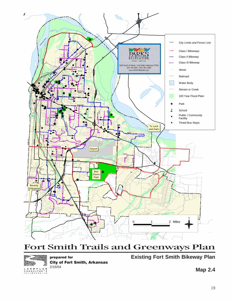
Existing Trails and BicycleFacilities
Currently, the existing Fort Smith Bikeway System (on-street routes) aims toconnect users to parks, libraries, schools and universities, and to transit systembus stops along signed roadways (See Fort Smith Bikeway Map 2.4). By connect-ing the bikeway to a greenway system and network of off-road multiuse trails, theentire bike and trail system will be able to serve a greater number of users with adiverse range skills.
Existing Creekmore Park Walking Trail

Fort Smith Trails and Greenways Planprepared for
City of Fort Smith, Arkansas2/16/04
19
Existing Fort Smith Bikeway Plan
Map 2.4
$
$
$
$
$
$
$
$
$
$
$
$
$
$$
$
$$
$
åå
å
åå
å
å
å
å
å
åå
å
å
å
åå
å
åååå å
å
å
åå
å
å
å
å
åå
åå
å å å
å
å
Ê
Ê
Ê
ÊÊ
ÊÊ
Ê
ÊÊÊÊ
Ê
ÊÊÊ ÊÊ
ÊÊ
Ê
Ê Ê
Ê
Ê
Ê
Ê
Ê
Ê
#
#
#
##
#
#
#
#
#
#
#
##
#
#
#
#
#
#
###
#
#
#
#
#
#
##
##
#
#
#
#
#
##
#
#
##########
#
#
#
##
#
#
###
#
#
#
#
##
####
####
#
#
#
##
#
#
#
##########################
#
##
#
#
#
#
#
MU
SS
ETT
NEWLON
MID
LAND
CLA
YT
ON
AL
BE
RT
PIK
E
50T
HO ST
KELLEY
GRAND
5TH
10TH
14TH
GR
EE
NW
OO
D
JE
NN
Y L
IND
OL
D G
RE
EN
WO
OD
WH
EE
LER
ST
AT
E L
INE
ZERO
HE
ND
RIC
KS
28T
H
CAVANAUGH
BROOKEN HILL
AR
253 U
S 71
AR
45MOODY
PA
INT
ER
DALLAS
MA
SS
AR
D
ROGERS
540
74T
H
66T
H
EUPER
540
WA
LD
RO
N
FREE FERRY
540
Arkan
sas R
iver
BeverlyEnterprise
Airport
To Lockand Dam
BenGerenPark
0 1 2 MilesN
City Limits and Fence Line
Class I Bikeways
Class II Bikeway
Class III Bikeway
ParkÊ
Schoolå
#Public / Community Facility
Timed Bus Stops$
Street
Railroad
Water Body
Stream or Creek
100 Year Flood Plain

21
Trails and Greenways
Chapter 3
Introduction The following is the vision statement crafted for Fort Smith as an overall guide todeveloping the proposed trail and greenway system. Goals which support thisvision, and a series of objectives that would be implemented to achieve each goal,are also presented. The vision, goals and objectives were publicly discussed andrefined to reflect the needs and desires of local residents. This was accomplishedthrough a public workshop which took place on November 6, 2003. More than 30local residents attended this meeting in Fort Smith.
Vision Fort Smith’s trail and greenway system will aim to preserve natural and man-madeenvironmental resources as well as provide safe and convenient facilities forwalkers, joggers, bicyclists, in-line skaters, and wheelchair users. It will connectresidential areas to significant outdoor recreation areas such as area lakes, parksand schools. The system will offer citizens an enhanced alternative to automobiletravel, providing routes to popular destinations, including employment centers,retail establishments, tourist attractions, medical facilities, universities andschools. Since trails and greenways promote nonpolluting forms of transportation,the system will improve air quality and reduce congestion in the area. Greenwaycorridors will also improve water quality and reduce the impacts of flooding bypreserving floodplain lands and streamside buffers. The local economy will alsobenefit from trail and greenway development through increased tourism revenues,property values and business attraction. In all, the Fort Smith Trails andGreenways System will make the region a cleaner, greener and better place to live,work and play for generations to come.
Goals & Objectives The following goals and objectives serve to support the vision statement. Goalcategories are representative of the benefits outlined in the previous chapter.Goals are not listed in order of priority.
Vision, Goals & Objectives
22
Trails and Greenways
Safety
Goal: Trails and greenways will be designed and managed so as to maximizesafety and security of users.
Objectives:
· Minimize use conflicts· Make trail wide enough to accommodate multiple uses· Light appropriate trails for use after dark, especially winter· Provide a hard surface trail· Provide good visual access to trails, especially at night for security purposes· Encourage users to carry cell phones in case of emergency
Recreation/Fitness
Goal: Trail and greenway corridors will improve opportunities for safe, close-to-home recreation in Fort Smith.
Objectives:
· Provide trail head parking· Provide drinking fountains· Provide distance markers on the trail· Provide benches, bike racks and other amenities· Increase citizen wellness by encouraging more exercise
Maintenance & Management
Goal: Trails and greenways in Fort Smith will be properly managed and main-tained to increase user safety and enhance the quality of facilities.
Objectives:
· Provide consistent maintenance throughout the entire trail and greenwaysystem
· Encourage "adopt a trail" by local organizations to reduce the city's mainte-nance expense
· Define which city entity(s) will be maintaining the trails and greenways· Find sources of funding for proper maintenance of the trail and greenway
system
Vision, Goals & Objectives
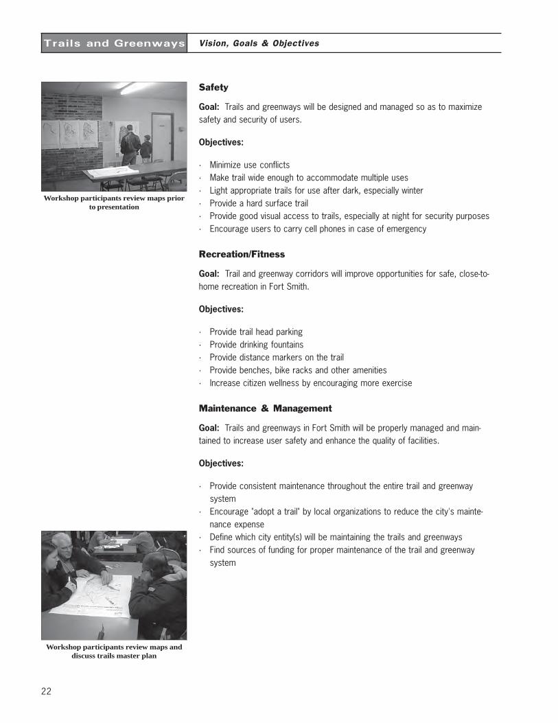
Workshop participants review maps priorto presentation
Workshop participants review maps anddiscuss trails master plan
23
Trails and Greenways
Economic
Goal: Trails and greenways in Fort Smith will improve the economic health of thearea by increasing property values and potentially providing tourism revenue.
Objectives:
· Educate public about the business opportunities by increasing the quality of lifein Ft. Smith through trails and greenways
· Seek outside funding sources for construction of the trails· Connect to retail and commercial facilities· Build trails to attract desirable development· Construct trails at Fort Chaffee to guide development· Reduce cost in health insurance as citizens become more fit
Education
Goal: Trail and greenway corridors will highlight and enhance significant historicaland natural resources in the area. Trail users and potential supporters will bemade aware of the trail and greenway system and its rules and benefits.
Objectives:
· Educate users about trail etiquette· Educate drivers on share the road bicycle facilities· Educate public that bicycles still have right to road once trails are built· Educate public about natural resources and history in the Fort Smith area· Educate public about the benefit of trails for public support· Educate public about wetlands and greenways· Educate public about the Arkansas River and navigation system/lock and dam
Transportation
Goal: Trail and greenway corridors will provide more opportunities for alternativetransportation facilities for residents and visitors to the City of Fort Smith.
Objectives:
· Connect to the Fort Smith Bikeway System· Provide opportunities for commuting to work by trail· Connect to schools· Connect to parks· Connect to employment centers/businesses· Connect to Fort Chaffee· Provide wheelchair access· Provide connections to transit system· Connect to libraries· Link to community facilities
Vision, Goals & Objectives
24
Trails and Greenways
Environment
Goal: Greenway trail corridors will enhance the local environment by improv-ing air and water quality, conserving floodplain ecosystems, restoring land-scapes and protecting wildlife habitat.
Objectives:
· Improve the visual quality of the city through the planting of native trees andother indigenous plant materials
· Improve air quality and reduce noise levels by promoting non-motorizedforms of transportation
· Align trails to minimize the impact on the environment· Promote the preservation establishment of greenbelt areas to reduce
erosion and improve water quality· Promote environmental awareness through the Adopt-A-Trail program· Protect environmentally sensitive lands to support plant and animal habitat
Vision, Goals & Objectives
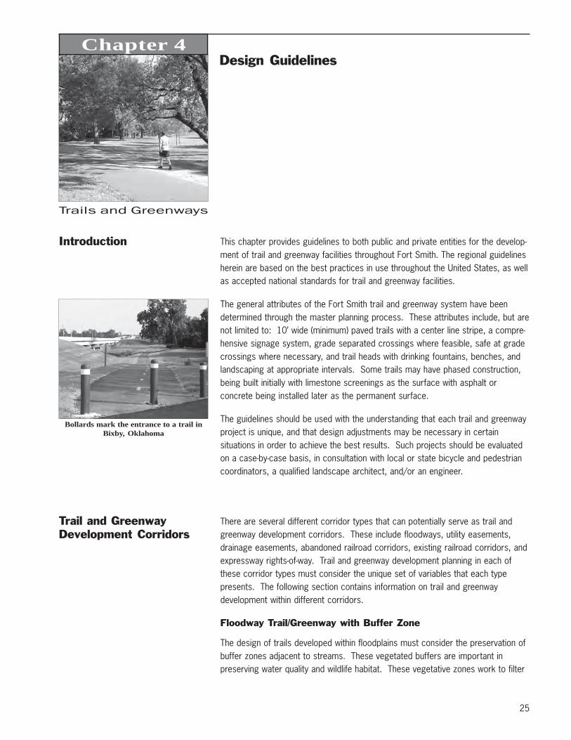
25
Trails and Greenways
Introduction This chapter provides guidelines to both public and private entities for the develop-ment of trail and greenway facilities throughout Fort Smith. The regional guidelinesherein are based on the best practices in use throughout the United States, as wellas accepted national standards for trail and greenway facilities.
The general attributes of the Fort Smith trail and greenway system have beendetermined through the master planning process. These attributes include, but arenot limited to: 10’ wide (minimum) paved trails with a center line stripe, a compre-hensive signage system, grade separated crossings where feasible, safe at gradecrossings where necessary, and trail heads with drinking fountains, benches, andlandscaping at appropriate intervals. Some trails may have phased construction,being built initially with limestone screenings as the surface with asphalt orconcrete being installed later as the permanent surface.
The guidelines should be used with the understanding that each trail and greenwayproject is unique, and that design adjustments may be necessary in certainsituations in order to achieve the best results. Such projects should be evaluatedon a case-by-case basis, in consultation with local or state bicycle and pedestriancoordinators, a qualified landscape architect, and/or an engineer.
Trail and GreenwayDevelopment Corridors
There are several different corridor types that can potentially serve as trail andgreenway development corridors. These include floodways, utility easements,drainage easements, abandoned railroad corridors, existing railroad corridors, andexpressway rights-of-way. Trail and greenway development planning in each ofthese corridor types must consider the unique set of variables that each typepresents. The following section contains information on trail and greenwaydevelopment within different corridors.
Floodway Trail/Greenway with Buffer Zone
The design of trails developed within floodplains must consider the preservation ofbuffer zones adjacent to streams. These vegetated buffers are important inpreserving water quality and wildlife habitat. These vegetative zones work to filter
Chapter 4Design Guidelines
Bollards mark the entrance to a trail inBixby, Oklahoma
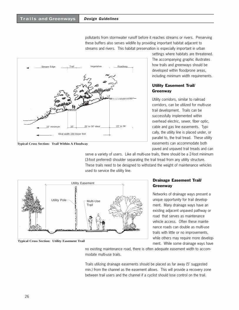
26
Design GuidelinesTra i l s and Greenways
pollutants from stormwater runoff before it reaches streams or rivers. Preservingthese buffers also serves wildlife by providing important habitat adjacent tostreams and rivers. This habitat preservation is especially important in urban
settings where habitats are threatened.The accompanying graphic illustrateshow trails and greenways should bedeveloped within floodprone areas,including minimum width requirements.
Utility Easement Trail/Greenway
Utility corridors, similar to railroadcorridors, can be utilized for multi-usetrail development. Trails can besuccessfully implemented withinoverhead electric, sewer, fiber optic,cable and gas line easements. Typi-cally, the utility line is placed under, orparallel to, the trail tread. These utilityeasements can accommodate bothpaved and unpaved trail treads and can
serve a variety of users. Like all multi-use trails, there should be a 2-foot minimum(3-foot preferred) shoulder separating the trail tread from any utility structure.These trails need to be designed to withstand the weight of maintenance vehiclesused to service the utility line.
Drainage Easement Trail/Greenway
Networks of drainage ways present aunique opportunity for trail develop-ment. Many drainage ways have anexisting adjacent unpaved pathway orroad that serves as maintenancevehicle access. Often these mainte-nance roads can double as multi-usetrails with little or no improvements,while others may require more develop-ment. While some drainage ways have
no existing maintenance road, there is often adequate easement width to accom-modate multi-use trails.
Trails utilizing drainage easements should be placed as far away (5’ suggestedmin.) from the channel as the easement allows. This will provide a recovery zonebetween trail users and the channel if a cyclist should lose control on the trail.
Typical Cross Section: Utility Easement Trail
Utility Easement
Utility Pole Multi-UseTrail
Typical Cross Section: Trail Within A Floodway
Stream Edge Trail Vegetative Roadway
22’ to 36’20’ to 30’ ideal
Ideal width 150 linear feet
10’10’ minimum
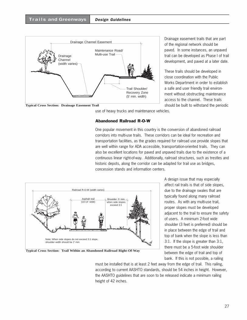
27
Design GuidelinesTra i l s and Greenways
Drainage easement trails that are partof the regional network should bepaved. In some instances, an unpavedtrail can be developed as Phase I of traildevelopment, and paved at a later date.
These trails should be developed inclose coordination with the PublicWorks Department in order to establisha safe and user friendly trail environ-ment without obstructing maintenanceaccess to the channel. These trailsshould be built to withstand the periodic
use of heavy trucks and maintenance vehicles.
Abandoned Railroad R-O-W
One popular movement in this country is the conversion of abandoned railroadcorridors into multi-use trails. These corridors can be ideal for recreation andtransportation facilities, as the grades required for railroad use provide slopes thatare well within range for ADA accessible, transportation-oriented trails. They canalso be excellent locations for paved and unpaved trails due to the existence of acontinuous linear right-of-way. Additionally, railroad structures, such as trestles andhistoric depots, along the corridor can be adapted for trail use as bridges,concession stands and information centers.
A design issue that may especiallyaffect rail trails is that of side slopes,due to the drainage swales that aretypically found along many railroadroutes. As with any multi-use trail,proper slopes must be developedadjacent to the trail to ensure the safetyof users. A minimum 2-foot wideshoulder (3 feet is preferred) should bein place between the edge of trail andtop of bank when the slope is less than3:1. If the slope is greater than 3:1,there must be a 5-foot wide shoulderbetween the edge of trail and top ofbank. If this is not possible, a railing
must be installed that is at least 2 feet away from the edge of trail. This railing,according to current AASHTO standards, should be 54 inches in height. However,the AASHTO guidelines that are soon to be released indicate a minimum railingheight of 42 inches.
Typical Cross Section: Drainage Easement Trail
Drainage Channel Easement
Maintenance Road/Multi-use TrailDrainage
Channel(width varies)
Trail Shoulder/Recovery Zone(5’ min. width)
Typical Cross Section: Trail Within an Abandoned Railroad Right-Of-Way
Railroad R-O-W (width varies)
Shoulder: 5’ min.when side slopes
exceed 3:1
Asphalt trail(10-14’ wide)
Note: When side slopes do not exceed 3:1 slope,shoulder width should be 2’ min.
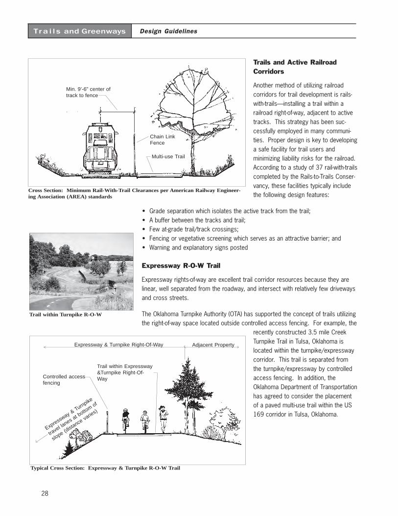
28
Design GuidelinesTra i l s and Greenways
Controlled accessfencing
Expressway & Turnpike Right-Of-Way Adjacent Property
Expressway & Turnpike
travel la
nes at botto
m of
slope (distance varie
s)
Trail within Expressway&Turnpike Right-Of-Way
Typical Cross Section: Expressway & Turnpike R-O-W Trail
Trails and Active RailroadCorridors
Another method of utilizing railroadcorridors for trail development is rails-with-trails—installing a trail within arailroad right-of-way, adjacent to activetracks. This strategy has been suc-cessfully employed in many communi-ties. Proper design is key to developinga safe facility for trail users andminimizing liability risks for the railroad.According to a study of 37 rail-with-trailscompleted by the Rails-to-Trails Conser-vancy, these facilities typically includethe following design features:
• Grade separation which isolates the active track from the trail;• A buffer between the tracks and trail;• Few at-grade trail/track crossings;• Fencing or vegetative screening which serves as an attractive barrier; and• Warning and explanatory signs posted
Expressway R-O-W Trail
Expressway rights-of-way are excellent trail corridor resources because they arelinear, well separated from the roadway, and intersect with relatively few drivewaysand cross streets.
The Oklahoma Turnpike Authority (OTA) has supported the concept of trails utilizingthe right-of-way space located outside controlled access fencing. For example, the
recently constructed 3.5 mile CreekTurnpike Trail in Tulsa, Oklahoma islocated within the turnpike/expresswaycorridor. This trail is separated fromthe turnpike/expressway by controlledaccess fencing. In addition, theOklahoma Department of Transportationhas agreed to consider the placementof a paved multi-use trail within the US169 corridor in Tulsa, Oklahoma.
Min. 9’-6” center oftrack to fence
Cross Section: Minimum Rail-With-Trail Clearances per American Railway Engineer-ing Association (AREA) standards
Chain LinkFence
Multi-use Trail
Trail within Turnpike R-O-W
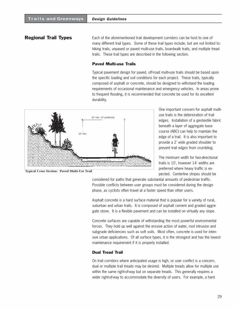
29
Design GuidelinesTra i l s and Greenways
Regional Trail Types Each of the aforementioned trail development corridors can be host to one ofmany different trail types. Some of these trail types include, but are not limited to:hiking trails, unpaved or paved multi-use trails, boardwalk trails, and multiple treadtrails. These trail types are described in the following section.
Paved Multi-use Trails
Typical pavement design for paved, off-road multi-use trails should be based uponthe specific loading and soil conditions for each project. These trails, typicallycomposed of asphalt or concrete, should be designed to withstand the loadingrequirements of occasional maintenance and emergency vehicles. In areas proneto frequent flooding, it is recommended that concrete be used for its excellentdurability.
One important concern for asphalt multi-use trails is the deterioration of trailedges. Installation of a geotextile fabricbeneath a layer of aggregate basecourse (ABC) can help to maintain theedge of a trail. It is also important toprovide a 2' wide graded shoulder toprevent trail edges from crumbling.
The minimum width for two-directionaltrails is 10', however 14' widths arepreferred where heavy traffic is ex-pected. Centerline stripes should be
considered for paths that generate substantial amounts of pedestrian traffic.Possible conflicts between user groups must be considered during the designphase, as cyclists often travel at a faster speed than other users.
Asphalt concrete is a hard surface material that is popular for a variety of rural,suburban and urban trails. It is composed of asphalt cement and graded aggre-gate stone. It is a flexible pavement and can be installed on virtually any slope.
Concrete surfaces are capable of withstanding the most powerful environmentalforces. They hold up well against the erosive action of water, root intrusion andsubgrade deficiencies such as soft soils. Most often, concrete is used for inten-sive urban applications. Of all surface types, it is the strongest and has the lowestmaintenance requirement if it is properly installed.
Dual Tread Trail
On trail corridors where anticipated usage is high, or user conflict is a concern,dual or multiple trail treads may be desired. Multiple treads allow for multiple usewithin the same right-of-way but on separate treads. This generally requires awider right-of-way to accommodate the diversity of users. For example, a hard
Typical Cross Section: Paved Multi-Use Trail
10’ min, 14’ preferred
10’ min.
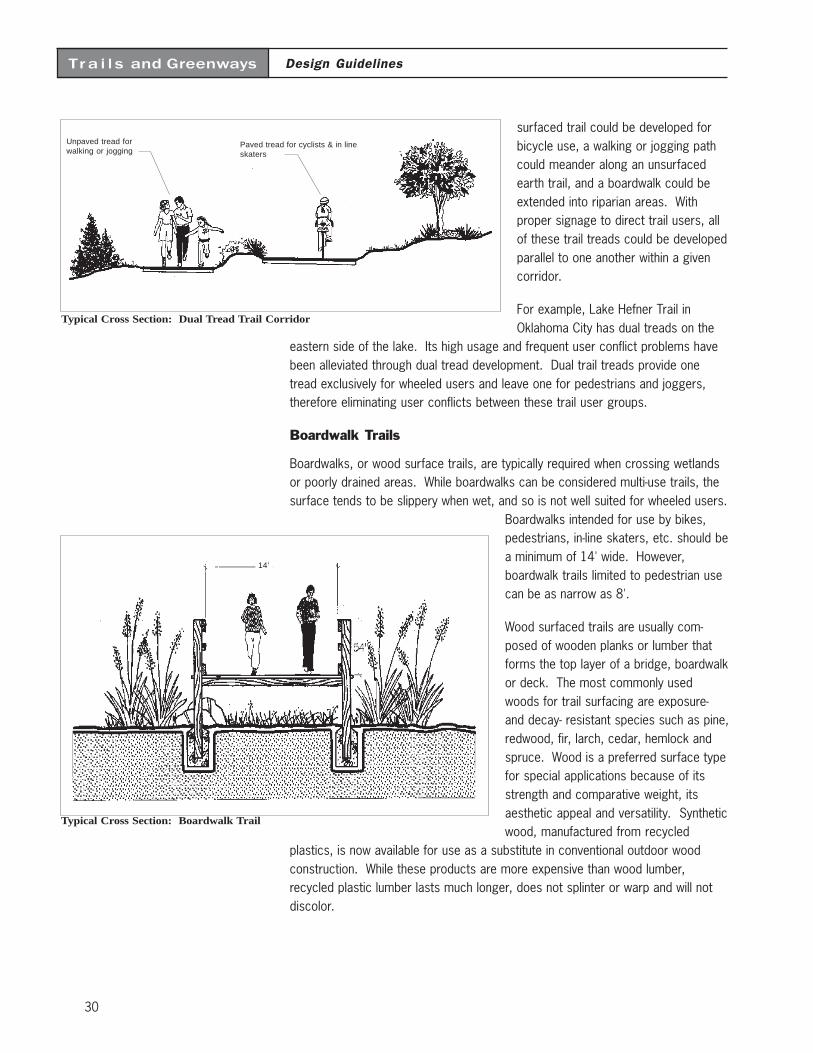
30
Design GuidelinesTra i l s and Greenways
surfaced trail could be developed forbicycle use, a walking or jogging pathcould meander along an unsurfacedearth trail, and a boardwalk could beextended into riparian areas. Withproper signage to direct trail users, allof these trail treads could be developedparallel to one another within a givencorridor.
For example, Lake Hefner Trail inOklahoma City has dual treads on the
eastern side of the lake. Its high usage and frequent user conflict problems havebeen alleviated through dual tread development. Dual trail treads provide onetread exclusively for wheeled users and leave one for pedestrians and joggers,therefore eliminating user conflicts between these trail user groups.
Boardwalk Trails
Boardwalks, or wood surface trails, are typically required when crossing wetlandsor poorly drained areas. While boardwalks can be considered multi-use trails, thesurface tends to be slippery when wet, and so is not well suited for wheeled users.
Boardwalks intended for use by bikes,pedestrians, in-line skaters, etc. should bea minimum of 14' wide. However,boardwalk trails limited to pedestrian usecan be as narrow as 8'.
Wood surfaced trails are usually com-posed of wooden planks or lumber thatforms the top layer of a bridge, boardwalkor deck. The most commonly usedwoods for trail surfacing are exposure-and decay- resistant species such as pine,redwood, fir, larch, cedar, hemlock andspruce. Wood is a preferred surface typefor special applications because of itsstrength and comparative weight, itsaesthetic appeal and versatility. Syntheticwood, manufactured from recycled
plastics, is now available for use as a substitute in conventional outdoor woodconstruction. While these products are more expensive than wood lumber,recycled plastic lumber lasts much longer, does not splinter or warp and will notdiscolor.
Unpaved tread forwalking or jogging
Paved tread for cyclists & in lineskaters
Typical Cross Section: Dual Tread Trail Corridor
Typical Cross Section: Boardwalk Trail
14’
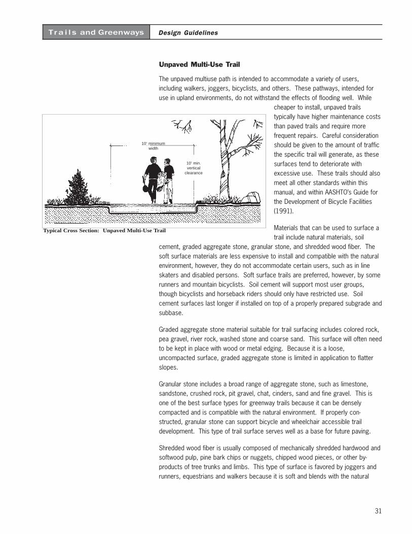
31
Design GuidelinesTra i l s and Greenways
Unpaved Multi-Use Trail
The unpaved multiuse path is intended to accommodate a variety of users,including walkers, joggers, bicyclists, and others. These pathways, intended foruse in upland environments, do not withstand the effects of flooding well. While
cheaper to install, unpaved trailstypically have higher maintenance coststhan paved trails and require morefrequent repairs. Careful considerationshould be given to the amount of trafficthe specific trail will generate, as thesesurfaces tend to deteriorate withexcessive use. These trails should alsomeet all other standards within thismanual, and within AASHTO’s Guide forthe Development of Bicycle Facilities(1991).
Materials that can be used to surface atrail include natural materials, soil
cement, graded aggregate stone, granular stone, and shredded wood fiber. Thesoft surface materials are less expensive to install and compatible with the naturalenvironment, however, they do not accommodate certain users, such as in lineskaters and disabled persons. Soft surface trails are preferred, however, by somerunners and mountain bicyclists. Soil cement will support most user groups,though bicyclists and horseback riders should only have restricted use. Soilcement surfaces last longer if installed on top of a properly prepared subgrade andsubbase.
Graded aggregate stone material suitable for trail surfacing includes colored rock,pea gravel, river rock, washed stone and coarse sand. This surface will often needto be kept in place with wood or metal edging. Because it is a loose,uncompacted surface, graded aggregate stone is limited in application to flatterslopes.
Granular stone includes a broad range of aggregate stone, such as limestone,sandstone, crushed rock, pit gravel, chat, cinders, sand and fine gravel. This isone of the best surface types for greenway trails because it can be denselycompacted and is compatible with the natural environment. If properly con-structed, granular stone can support bicycle and wheelchair accessible traildevelopment. This type of trail surface serves well as a base for future paving.
Shredded wood fiber is usually composed of mechanically shredded hardwood andsoftwood pulp, pine bark chips or nuggets, chipped wood pieces, or other by-products of tree trunks and limbs. This type of surface is favored by joggers andrunners, equestrians and walkers because it is soft and blends with the natural
Typical Cross Section: Unpaved Multi-Use Trail
10’ minimumwidth
10’ min.vertical
clearance
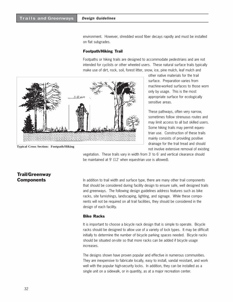
32
Design GuidelinesTra i l s and Greenways
environment. However, shredded wood fiber decays rapidly and must be installedon flat subgrades.
Footpath/Hiking Trail
Footpaths or hiking trails are designed to accommodate pedestrians and are notintended for cyclists or other wheeled users. These natural surface trails typicallymake use of dirt, rock, soil, forest litter, snow, ice, pine mulch, leaf mulch and
other native materials for the trailsurface. Preparation varies frommachine-worked surfaces to those wornonly by usage. This is the mostappropriate surface for ecologicallysensitive areas.
These pathways, often very narrow,sometimes follow strenuous routes andmay limit access to all but skilled users.Some hiking trails may permit eques-trian use. Construction of these trailsmainly consists of providing positivedrainage for the trail tread and shouldnot involve extensive removal of existing
vegetation. These trails vary in width from 3' to 6' and vertical clearance shouldbe maintained at 9' (12' when equestrian use is allowed).
Trail/GreenwayComponents In addition to trail width and surface type, there are many other trail components
that should be considered during facility design to ensure safe, well designed trailsand greenways. The following design guidelines address features such as bikeracks, site furnishings, landscaping, lighting, and signage. While these compo-nents will not be required on all trail facilities, they should be considered in thedesign of each facility.
Bike Racks
It is important to choose a bicycle rack design that is simple to operate. Bicycleracks should be designed to allow use of a variety of lock types. It may be difficultinitially to determine the number of bicycle parking spaces needed. Bicycle racksshould be situated on-site so that more racks can be added if bicycle usageincreases.
The designs shown have proven popular and effective in numerous communities.They are inexpensive to fabricate locally, easy to install, vandal resistant, and workwell with the popular high-security locks. In addition, they can be installed as asingle unit on a sidewalk, or in quantity, as at a major recreation center.
Typical Cross Section: Footpath/Hiking
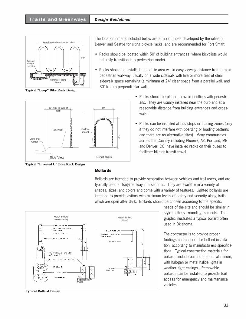
33
Design GuidelinesTra i l s and Greenways
The location criteria included below are a mix of those developed by the cities ofDenver and Seattle for siting bicycle racks, and are recommended for Fort Smith:
• Racks should be located within 50' of building entrances (where bicyclists wouldnaturally transition into pedestrian mode).
• Racks should be installed in a public area within easy viewing distance from a mainpedestrian walkway, usually on a wide sidewalk with five or more feet of clearsidewalk space remaining (a minimum of 24" clear space from a parallel wall, and30" from a perpendicular wall).
• Racks should be placed to avoid conflicts with pedestri-ans. They are usually installed near the curb and at areasonable distance from building entrances and cross-walks.
• Racks can be installed at bus stops or loading zones (onlyif they do not interfere with boarding or loading patternsand there are no alternative sites). Many communitiesacross the Country including Phoenix, AZ, Portland, MEand Denver, CO, have installed racks on their buses tofacilitate bike-on-transit travel.
Bollards
Bollards are intended to provide separation between vehicles and trail users, and aretypically used at trail/roadway intersections. They are available in a variety ofshapes, sizes, and colors and come with a variety of features. Lighted bollards areintended to provide visitors with minimum levels of safety and security along trailswhich are open after dark. Bollards should be chosen according to the specific
needs of the site and should be similar instyle to the surrounding elements. Thegraphic illustrates a typical bollard oftenused in Oklahoma.
The contractor is to provide properfootings and anchors for bollard installa-tion, according to manufacturers specifica-tions. Typical construction materials forbollards include painted steel or aluminum,with halogen or metal halide lights inweather tight casings. Removablebollards can be installed to provide trailaccess for emergency and maintenancevehicles.
Typical “Loop” Bike Rack Design
Concrete FootingMount
Length varies based on # of bikes
3’-0”
OptionalFlangeMount
Typical “Inverted U” Bike Rack Design
Curb andGutter
Sidewalk
36” min. to face ofcurb
Surfacemount
36”
18”
Side View Front View
Typical Bollard Design
Metal Bollard(fixed)
Metal Bollard(removable)
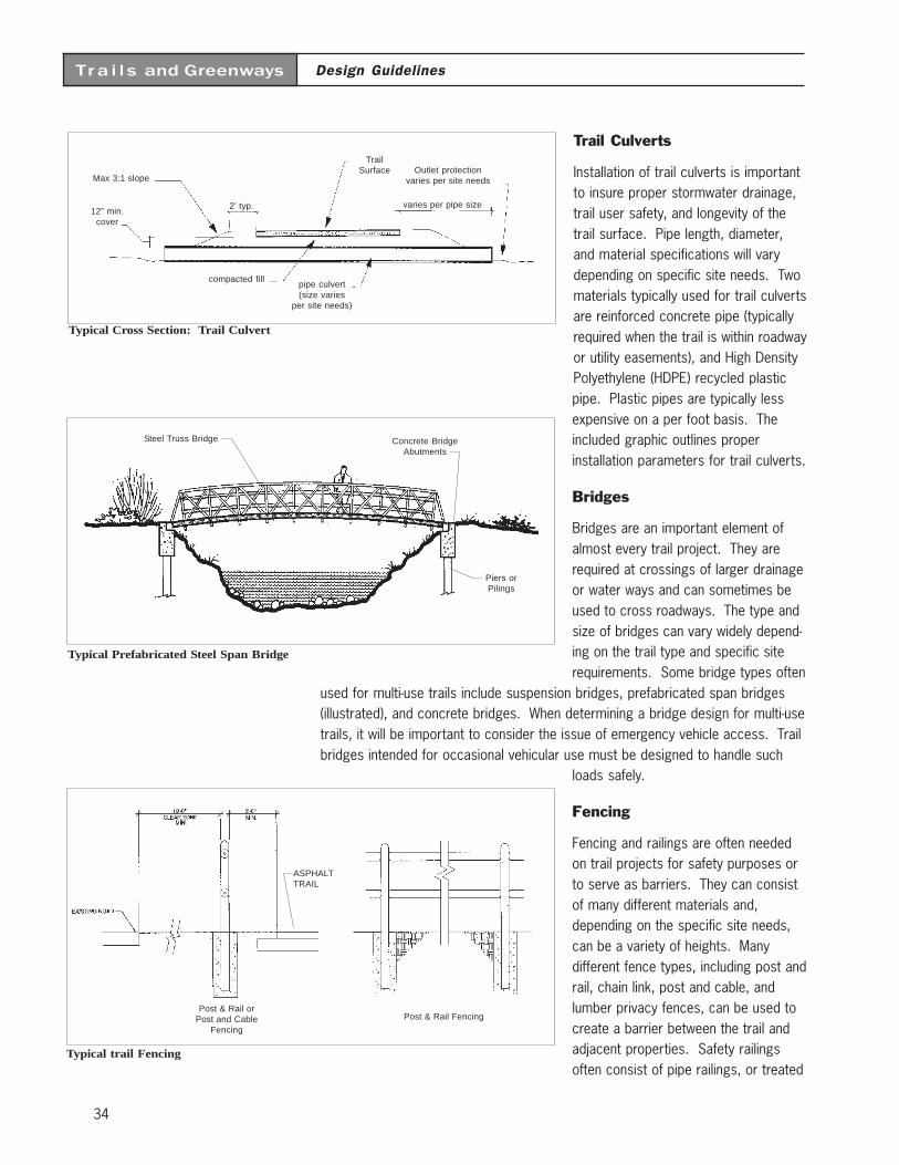
34
Design GuidelinesTra i l s and Greenways
Trail Culverts
Installation of trail culverts is importantto insure proper stormwater drainage,trail user safety, and longevity of thetrail surface. Pipe length, diameter,and material specifications will varydepending on specific site needs. Twomaterials typically used for trail culvertsare reinforced concrete pipe (typicallyrequired when the trail is within roadwayor utility easements), and High DensityPolyethylene (HDPE) recycled plasticpipe. Plastic pipes are typically lessexpensive on a per foot basis. Theincluded graphic outlines properinstallation parameters for trail culverts.
Bridges
Bridges are an important element ofalmost every trail project. They arerequired at crossings of larger drainageor water ways and can sometimes beused to cross roadways. The type andsize of bridges can vary widely depend-ing on the trail type and specific siterequirements. Some bridge types often
used for multi-use trails include suspension bridges, prefabricated span bridges(illustrated), and concrete bridges. When determining a bridge design for multi-usetrails, it will be important to consider the issue of emergency vehicle access. Trailbridges intended for occasional vehicular use must be designed to handle such
loads safely.
Fencing
Fencing and railings are often neededon trail projects for safety purposes orto serve as barriers. They can consistof many different materials and,depending on the specific site needs,can be a variety of heights. Manydifferent fence types, including post andrail, chain link, post and cable, andlumber privacy fences, can be used tocreate a barrier between the trail andadjacent properties. Safety railingsoften consist of pipe railings, or treated
Typical Cross Section: Trail Culvert
TrailSurface Outlet protection
varies per site needs
varies per pipe size2’ typ.
Max 3:1 slope
12” min.cover
compacted fillpipe culvert(size varies
per site needs)
Typical Prefabricated Steel Span Bridge
Steel Truss Bridge Concrete BridgeAbutments
Piers orPilings
ASPHALTTRAIL
Post & Rail orPost and Cable
Fencing
Post & Rail Fencing
Typical trail Fencing
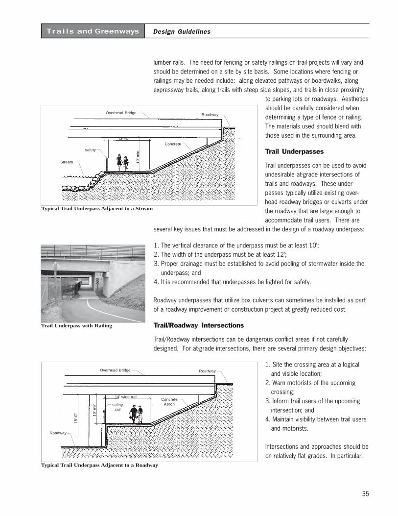
35
Design GuidelinesTra i l s and Greenways
lumber rails. The need for fencing or safety railings on trail projects will vary andshould be determined on a site by site basis. Some locations where fencing orrailings may be needed include: along elevated pathways or boardwalks, alongexpressway trails, along trails with steep side slopes, and trails in close proximity
to parking lots or roadways. Aestheticsshould be carefully considered whendetermining a type of fence or railing.The materials used should blend withthose used in the surrounding area.
Trail Underpasses
Trail underpasses can be used to avoidundesirable at-grade intersections oftrails and roadways. These under-passes typically utilize existing over-head roadway bridges or culverts underthe roadway that are large enough toaccommodate trail users. There are
several key issues that must be addressed in the design of a roadway underpass:
1. The vertical clearance of the underpass must be at least 10’;2. The width of the underpass must be at least 12’;3. Proper drainage must be established to avoid pooling of stormwater inside the
underpass; and4. It is recommended that underpasses be lighted for safety.
Roadway underpasses that utilize box culverts can sometimes be installed as partof a roadway improvement or construction project at greatly reduced cost.
Trail/Roadway Intersections
Trail/Roadway intersections can be dangerous conflict areas if not carefullydesigned. For at-grade intersections, there are several primary design objectives:
1. Site the crossing area at a logicaland visible location;
2. Warn motorists of the upcomingcrossing;
3. Inform trail users of the upcomingintersection; and
4. Maintain visibility between trail usersand motorists.
Intersections and approaches should beon relatively flat grades. In particular,
Trail Underpass with Railing
Overhead Bridge
14’ wide trail
10’ m
in.
18’-
0”
ConcreteApron
Roadway
safetyrail
Roadway
Typical Trail Underpass Adjacent to a Roadway
Overhead Bridge
14’ trail10
’ min
.
Concrete
Roadway
safety
Stream
Typical Trail Underpass Adjacent to a Stream
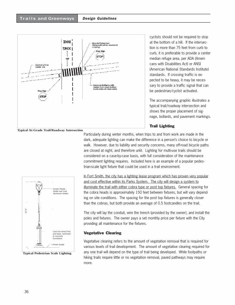
36
Design GuidelinesTra i l s and Greenways
cyclists should not be required to stopat the bottom of a hill. If the intersec-tion is more than 75 feet from curb tocurb, it is preferable to provide a centermedian refuge area, per ADA (Ameri-cans with Disabilities Act) or ANSI(American National Standards Institute)standards. If crossing traffic is ex-pected to be heavy, it may be neces-sary to provide a traffic signal that canbe pedestrian/cyclist activated.
The accompanying graphic illustrates atypical trail/roadway intersection andshows the proper placement of sig-nage, bollards, and pavement markings.
Trail Lighting
Particularly during winter months, when trips to and from work are made in thedark, adequate lighting can make the difference in a person’s choice to bicycle orwalk. However, due to liability and security concerns, many off-road bicycle pathsare closed at night, and therefore unlit. Lighting for multi-use trails should beconsidered on a case-by-case basis, with full consideration of the maintenancecommitment lighting requires. Included here is an example of a popular pedes-trian-scale light fixture that could be used in a trail environment.
In Fort Smith, the city has a lighting lease program which has proven very popularand cost effective within its Parks System. The city will design a system toilluminate the trail with either cobra type or post top fixtures. General spacing forthe cobra heads is approximately 150 feet between fixtures, but will vary depend-ing on site conditions. The spacing for the post top fixtures is generally closerthan the cobras, but both provide an average of 0.5 footcandles on the trail.
The city will lay the conduit, wire the trench (provided by the owner), and install thepoles and fixtures. The owner pays a set monthly price per fixture with the Cityproviding all maintenance for the fixtures.
Vegetative Clearing
Vegetative clearing refers to the amount of vegetation removal that is required forvarious levels of trail development. The amount of vegetative clearing required forany one trail will depend on the type of trail being developed. While footpaths orhiking trails require little or no vegetation removal, paved pathways may requiremore.
Typical Pedestrian Scale Lighting
14’-
0”
Acrylic PlasticGlobe and CastAluminum Holder
Cast Iron lamp Postand base, anchoredto concretefoundation
Finish Grade
Typical At-Grade Trail/Roadway Intersection
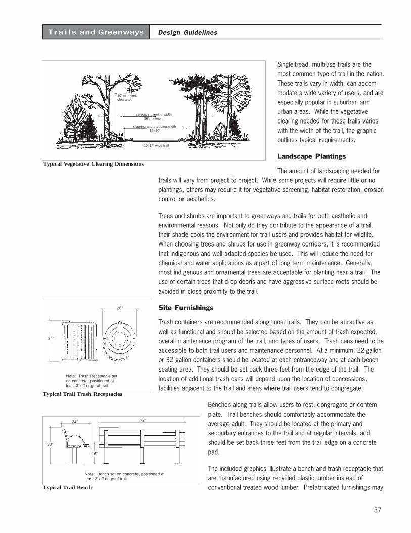
37
Design GuidelinesTra i l s and Greenways
Single-tread, multi-use trails are themost common type of trail in the nation.These trails vary in width, can accom-modate a wide variety of users, and areespecially popular in suburban andurban areas. While the vegetativeclearing needed for these trails varieswith the width of the trail, the graphicoutlines typical requirements.
Landscape Plantings
The amount of landscaping needed fortrails will vary from project to project. While some projects will require little or noplantings, others may require it for vegetative screening, habitat restoration, erosioncontrol or aesthetics.
Trees and shrubs are important to greenways and trails for both aesthetic andenvironmental reasons. Not only do they contribute to the appearance of a trail,their shade cools the environment for trail users and provides habitat for wildlife.When choosing trees and shrubs for use in greenway corridors, it is recommendedthat indigenous and well adapted species be used. This will reduce the need forchemical and water applications as a part of long term maintenance. Generally,most indigenous and ornamental trees are acceptable for planting near a trail. Theuse of certain trees that drop debris and have aggressive surface roots should beavoided in close proximity to the trail.
Site Furnishings
Trash containers are recommended along most trails. They can be attractive aswell as functional and should be selected based on the amount of trash expected,overall maintenance program of the trail, and types of users. Trash cans need to beaccessible to both trail users and maintenance personnel. At a minimum, 22-gallonor 32 gallon containers should be located at each entranceway and at each benchseating area. They should be set back three feet from the edge of the trail. Thelocation of additional trash cans will depend upon the location of concessions,facilities adjacent to the trail and areas where trail users tend to congregate.
Benches along trails allow users to rest, congregate or contem-plate. Trail benches should comfortably accommodate theaverage adult. They should be located at the primary andsecondary entrances to the trail and at regular intervals, andshould be set back three feet from the trail edge on a concretepad.
The included graphics illustrate a bench and trash receptacle thatare manufactured using recycled plastic lumber instead ofconventional treated wood lumber. Prefabricated furnishings may
Typical Vegetative Clearing Dimensions
10’ min. vert.clearance
selective thinning width26’ minimum
clearing and grubbing width16’-20’
10’-14’ wide trail
Typical Trail Bench
72”24”
30”
16”
Note: Bench set on concrete, positioned atleast 3’ off edge of trail
Typical Trail Trash Receptacles
26”
34”
Note: Trash Receptacle seton concrete, positioned atleast 3’ off edge of trail
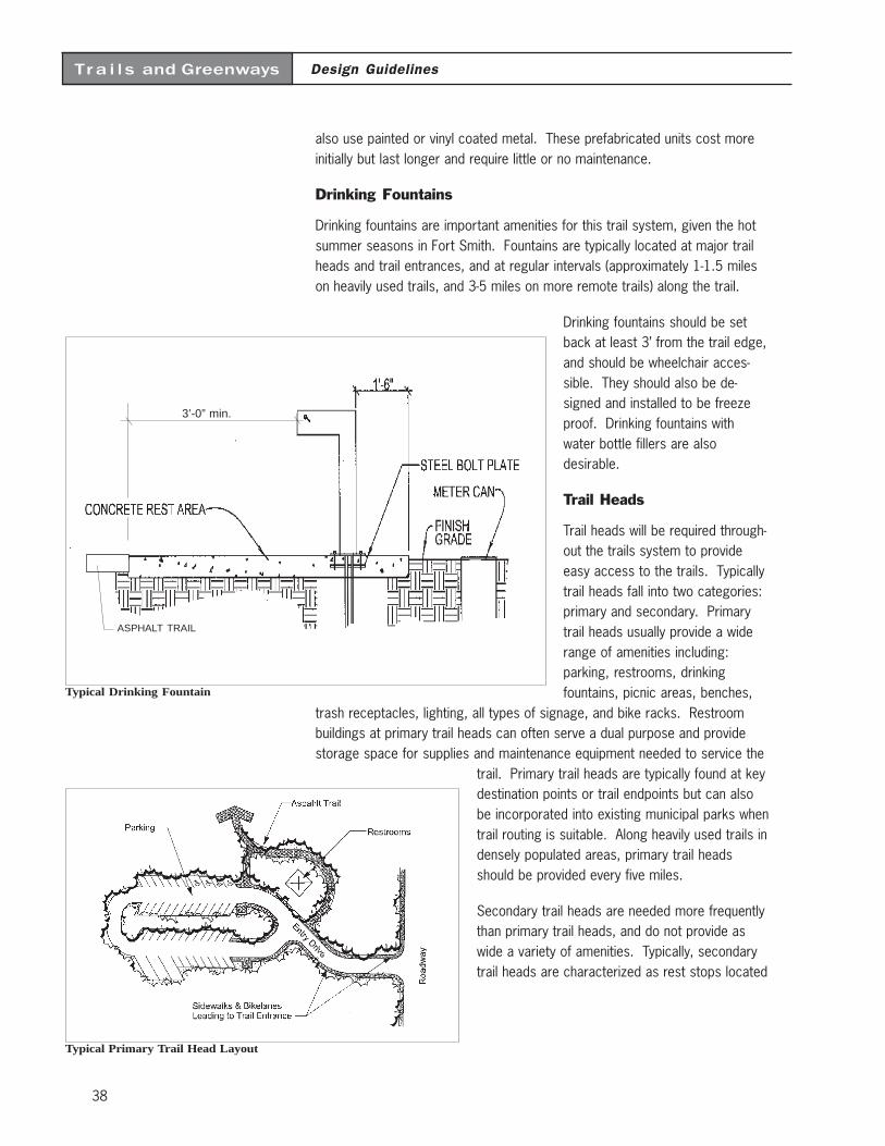
38
Design GuidelinesTra i l s and Greenways
also use painted or vinyl coated metal. These prefabricated units cost moreinitially but last longer and require little or no maintenance.
Drinking Fountains
Drinking fountains are important amenities for this trail system, given the hotsummer seasons in Fort Smith. Fountains are typically located at major trailheads and trail entrances, and at regular intervals (approximately 1-1.5 mileson heavily used trails, and 3-5 miles on more remote trails) along the trail.
Drinking fountains should be setback at least 3’ from the trail edge,and should be wheelchair acces-sible. They should also be de-signed and installed to be freezeproof. Drinking fountains withwater bottle fillers are alsodesirable.
Trail Heads
Trail heads will be required through-out the trails system to provideeasy access to the trails. Typicallytrail heads fall into two categories:primary and secondary. Primarytrail heads usually provide a widerange of amenities including:parking, restrooms, drinkingfountains, picnic areas, benches,
trash receptacles, lighting, all types of signage, and bike racks. Restroombuildings at primary trail heads can often serve a dual purpose and providestorage space for supplies and maintenance equipment needed to service the
trail. Primary trail heads are typically found at keydestination points or trail endpoints but can alsobe incorporated into existing municipal parks whentrail routing is suitable. Along heavily used trails indensely populated areas, primary trail headsshould be provided every five miles.
Secondary trail heads are needed more frequentlythan primary trail heads, and do not provide aswide a variety of amenities. Typically, secondarytrail heads are characterized as rest stops located
Typical Primary Trail Head Layout
Typical Drinking Fountain
ASPHALT TRAIL
3’-0” min.
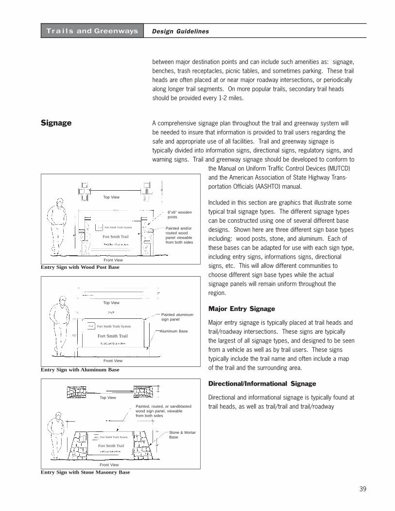
39
Design GuidelinesTra i l s and Greenways
between major destination points and can include such amenities as: signage,benches, trash receptacles, picnic tables, and sometimes parking. These trailheads are often placed at or near major roadway intersections, or periodicallyalong longer trail segments. On more popular trails, secondary trail headsshould be provided every 1-2 miles.
Signage A comprehensive signage plan throughout the trail and greenway system willbe needed to insure that information is provided to trail users regarding thesafe and appropriate use of all facilities. Trail and greenway signage istypically divided into information signs, directional signs, regulatory signs, andwarning signs. Trail and greenway signage should be developed to conform to
the Manual on Uniform Traffic Control Devices (MUTCD)and the American Association of State Highway Trans-portation Officials (AASHTO) manual.
Included in this section are graphics that illustrate sometypical trail signage types. The different signage typescan be constructed using one of several different basedesigns. Shown here are three different sign base typesincluding: wood posts, stone, and aluminum. Each ofthese bases can be adapted for use with each sign type,including entry signs, informations signs, directionalsigns, etc. This will allow different communities tochoose different sign base types while the actualsignage panels will remain uniform throughout theregion.
Major Entry Signage
Major entry signage is typically placed at trail heads andtrail/roadway intersections. These signs are typicallythe largest of all signage types, and designed to be seenfrom a vehicle as well as by trail users. These signstypically include the trail name and often include a mapof the trail and the surrounding area.
Directional/Informational Signage
Directional and informational signage is typically found attrail heads, as well as trail/trail and trail/roadway
Entry Sign with Stone Masonry Base
Front View
Top View
Stone & MortarBase
Painted, routed, or sandblastedwood sign panel, viewablefrom both sides
Fort Smith Trails System
Fort Smith Trail
Entry Sign with Aluminum Base
Top View
Front View
Painted aluminumsign panel
Aluminum BaseFort Smith Trails System
Fort Smith Trail
Entry Sign with Wood Post Base
Top View
Front View
6”x6” woodenposts
Painted and/orrouted woodpanel viewablefrom both sides
Fort Smith Trails System
Fort Smith Trail
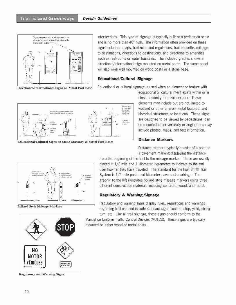
40
Design GuidelinesTra i l s and Greenways
intersections. This type of signage is typically built at a pedestrian scaleand is no more than 40” high. The information often provided on thesesigns includes: maps, trail rules and regulations, trail etiquette, mileageto destinations, directions to destinations, and directions to amenitiessuch as restrooms or water fountains. The included graphic shows adirectional/informational sign mounted on metal posts. The same panelwill also work well mounted on wood posts or a stone base.
Educational/Cultural Signage
Educational or cultural signage is used when an element or feature witheducational or cultural merit exists within or inclose proximity to a trail corridor. Theseelements may include but are not limited towetland or other environmental features, andhistorical structures or locations. These signsare designed to be viewed by pedestrians, canbe mounted either vertically or angled, and mayinclude photos, maps, and text information.
Distance Markers
Distance markers typically consist of a post ora pavement marking displaying the distance
from the beginning of the trail to the mileage marker. These are usuallyplaced in 1/2 mile and 1 kilometer increments to indicate to the trailuser how far they have traveled. The standard for the Fort Smith TrailSystem is 1/2 mile posts and kilometer pavement markings. Thegraphic to the left illustrates bollard style mileage markers using threedifferent construction materials including concrete, wood, and metal.
Regulatory & Warning Signage
Regulatory and warning signs display rules, regulations and warningsregarding trail use and include standard signs such as stop, yield, sharpturn, etc. Like all trail signage, these signs should conform to the
Manual on Uniform Traffic Control Devices (MUTCD). These signs are typicallymounted on either wood or metal posts.
Regulatory and Warning Signs
SLIPPERYWHEN WET
Educational/Cultural Signs on Stone Masonry & Metal Post Bases
Painted aluminum or embeddedfiberglass Interpretive sign panel
Stone &Mortarbase
Woodsupports
Painted alum.or embeddedfiberglassInterpretivesign panel
Paintedaluminumposts
Bollard Style Mileage Markers
Cut stone orconcrete bollard/mileage marker
Wood Bollardwith Aluminummileage marker
PaintedAluminumBollard
Directional/Informational Signs on Metal Post Base
Sign panels can be either wood oraluminum and should be viewablefrom both sides
Fort SmithTrails
Fort SmithTrails
41
Design GuidelinesTra i l s and Greenways
Additional GuidelineSources
Facility design is a broad topic that covers many issues. This chapter providesguidelines for design development, and is not a substitute for standards. For morein-depth information and design development standards, the following publicationsshould be consulted:
Greenways: A Guide to Planning, Design and Development. Published by IslandPress, 1993. Authors: Charles A. Flink and Robert Searns
Trails for the Twenty-First Century. Published by Island Press, 1993. Edited byKaren-Lee Ryan, Rails-to-Trails Conservancy
Guide to the Development of Bicycle Facilities. Updated in 1991 by the AmericanAssociation of State Highway Transportation Officials (AASHTO). Available fromFHWA or AASHTO.
Manual on Uniform Traffic Control Devices (MUTCD). Published by the U. S.Department of Transportation, Washington, DC
Mountain Bike Trails: Techniques for Design, Construction and Maintenance.Published by Bike-Centennial, Missoula, MT
Construction and Maintenance of Horse Trails. Published by Arkansas State Parks
Universal Access to Outdoor Recreation: A Design Guide. Published by PLAE, Inc.,Berkeley, CA, 1993
In all cases, the recommended guidelines in this report meet or exceed nationalstandards. Should these national standards be revised in the future and result indiscrepancies with this chapter, the national standards should prevail for all designdecisions.

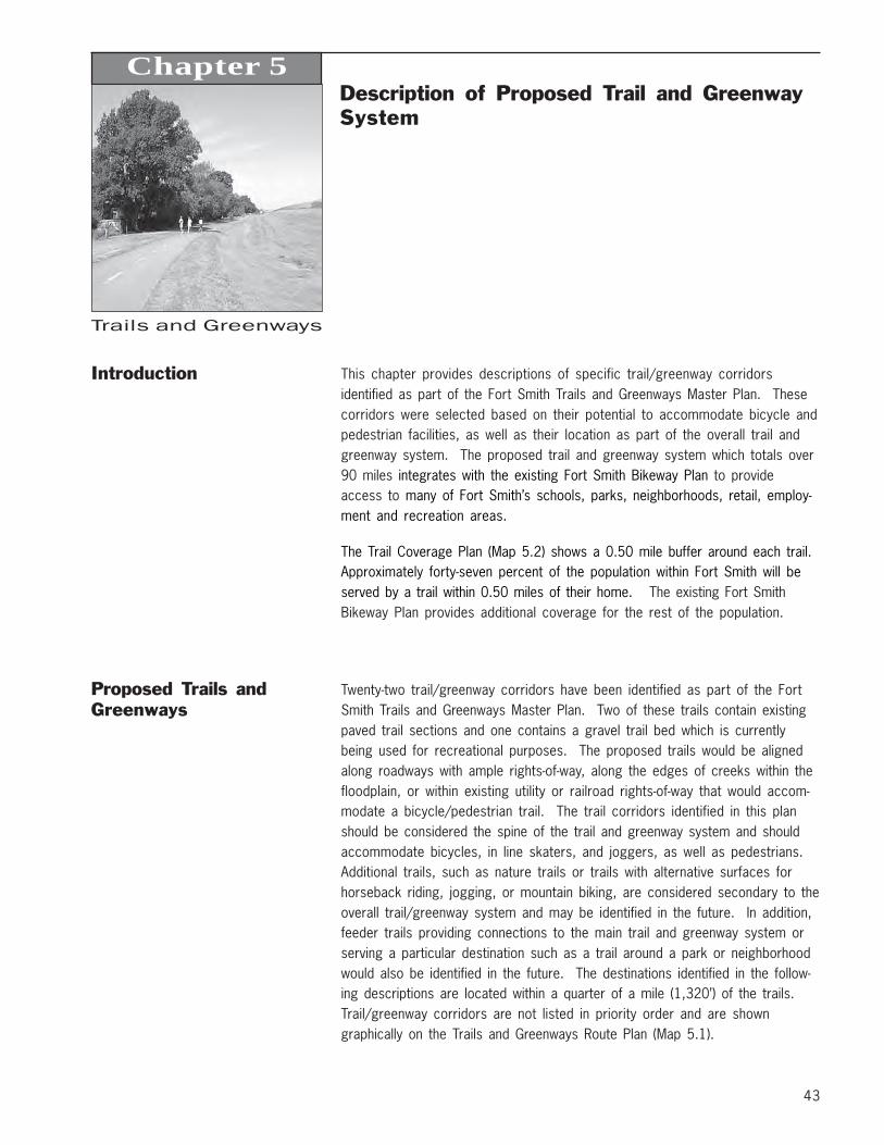
43
Trails and Greenways
Description of Proposed Trail and GreenwaySystem
Chapter 5
Introduction This chapter provides descriptions of specific trail/greenway corridorsidentified as part of the Fort Smith Trails and Greenways Master Plan. Thesecorridors were selected based on their potential to accommodate bicycle andpedestrian facilities, as well as their location as part of the overall trail andgreenway system. The proposed trail and greenway system which totals over90 miles integrates with the existing Fort Smith Bikeway Plan to provideaccess to many of Fort Smith’s schools, parks, neighborhoods, retail, employ-ment and recreation areas.
The Trail Coverage Plan (Map 5.2) shows a 0.50 mile buffer around each trail.Approximately forty-seven percent of the population within Fort Smith will beserved by a trail within 0.50 miles of their home. The existing Fort SmithBikeway Plan provides additional coverage for the rest of the population.
Proposed Trails andGreenways
Twenty-two trail/greenway corridors have been identified as part of the FortSmith Trails and Greenways Master Plan. Two of these trails contain existingpaved trail sections and one contains a gravel trail bed which is currentlybeing used for recreational purposes. The proposed trails would be alignedalong roadways with ample rights-of-way, along the edges of creeks within thefloodplain, or within existing utility or railroad rights-of-way that would accom-modate a bicycle/pedestrian trail. The trail corridors identified in this planshould be considered the spine of the trail and greenway system and shouldaccommodate bicycles, in line skaters, and joggers, as well as pedestrians.Additional trails, such as nature trails or trails with alternative surfaces forhorseback riding, jogging, or mountain biking, are considered secondary to theoverall trail/greenway system and may be identified in the future. In addition,feeder trails providing connections to the main trail and greenway system orserving a particular destination such as a trail around a park or neighborhoodwould also be identified in the future. The destinations identified in the follow-ing descriptions are located within a quarter of a mile (1,320’) of the trails.Trail/greenway corridors are not listed in priority order and are showngraphically on the Trails and Greenways Route Plan (Map 5.1).
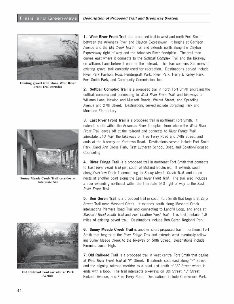
44
Trails and Greenways
1. West River Front Trail is a proposed trail in west and north Fort Smithbetween the Arkansas River and Clayton Expressway. It begins at GarrisonAvenue and the Mill Creek North Trail and extends north along the ClaytonExpressway right of way and the Arkansas River floodplain. The trail thencurves east where it connects to the Softball Complex Trail and the bikewayon Williams Lane before it ends at the railroad. This trail contains 2.5 miles ofexisting gravel trail currently used for recreation. Destinations served includeRiver Park Pavilion, Ross Pendergraft Park, River Park, Harry E Kelley Park,Fort Smith Park, and Community Commission, Inc.
2. Softball Complex Trail is a proposed trail in north Fort Smith encircling thesoftball complex and connecting to West River Front Trail, and bikeways onWilliams Lane, Newlon and Mussett Roads, Walnut Street, and SpradlingAvenue and 27th Street. Destinations served include Spradling Park andMorrison Elementary.
3. East River Front Trail is a proposed trail in northeast Fort Smith. Itextends south within the Arkansas River floodplain from where the West RiverFront Trail leaves off at the railroad and connects to River Fringe Trail,Interstate 540 Trail, the bikeways on Free Ferry Road and 74th Street, andands at the bikeway on Yorktown Road. Destinations served include Fort SmithPark, Carol Ann Cross Park, First Lutheran School, Bost, and Solution-FocusedCounseling.
4. River Fringe Trail is a proposed trail in northeast Fort Smith that connectsto East River Front Trail just south of Midland Boulevard. It extends southalong Overflow Ditch 1 connecting to Sunny Meade Creek Trail, and recon-nects at another point along the East River Front Trail. The trail also includesa spur extending northeast within the Interstate 540 right of way to the EastRiver Front Trail.
5. Ben Geren Trail is a proposed trail in south Fort Smith that begins at ZeroStreet Trail near Massard Creek. It extends south along Massard Creekintersecting Planters Road Trail and connecting to Landfill Loop, and ends atMassard Road South Trail and Fort Chaffee West Trail. This trail contains 1.8miles of existing paved trail. Destinations include Ben Geren Regional Park.
6. Sunny Meade Creek Trail is another short proposed trail in northwest FortSmith that begins at the River Fringe Trail and extends west eventually follow-ing Sunny Meade Creek to the bikeway on 50th Street. Destinations includeKimmins Junior High.
7. Old Railroad Trail is a proposed trail in west central Fort Smith that beginsat West River Front Trail at “P” Street. It extends southeast along “P” Streetand the aligning railroad corridor to a point just south of “S” Street where itends with a loop. The trail intersects bikeways on 8th Street, “L” Street,Kinkead Avenue, and Free Ferry Road. Destinations include Creekmore Park,
Description of Proposed Trail and Greenway System
Old Railroad Trail corridor at ParkAvenue
Sunny Meade Creek Trail corridor atInterstate 540
Existing gravel trail along West RiverFront Trail corridor

Fort Smith Trails and Greenways Planprepared for
City of Fort Smith, Arkansas5/10/04
45
Trails and Greenways Route Plan
Map 5.1
$
$
$
$
$
$
$
$
$
$
$
$
$
$$
$
$$
$
åå
å
åå
å
å
å
å
å
åå
å
å
å
åå
å
åååå å
å
å
åå
å
å
å
å
åå
åå
å å å
å
å
Ê
Ê
Ê
ÊÊ
ÊÊ
Ê
ÊÊÊÊ
Ê
ÊÊÊ ÊÊ
ÊÊ
Ê
Ê Ê
Ê
Ê
Ê
Ê
Ê
Ê
#
#
#
##
#
#
#
#
#
#
#
##
#
#
#
#
#
#
###
#
#
#
#
#
#
##
##
#
#
#
#
#
##
#
#
##########
#
#
#
##
#
#
###
#
#
#
#
##
####
####
#
#
#
##
#
#
#
##########################
#
##
#
#
#
#
#
BeverlyEnterprise
MU
SS
ETT
NEWLON
MID
LAND
CLA
YT
ON
AL
BE
RT
PIK
E
50T
H
O ST
KELLEY
GRAND
5TH
10TH
14TH
GR
EE
NW
OO
D
JE
NN
Y L
IND
OL
D G
RE
EN
WO
OD
WH
EE
LER
ST
AT
E L
INE
ZERO
HE
ND
RIC
KS
28T
H
CAVANAUGH
BROOKEN HILL
AR
253 U
S 71
AR
45
MOODY
PA
INT
ER
DALLAS
MA
SS
AR
D
ROGERS
540
74T
H
66T
H
EUPER
540
WA
LD
RO
N
FREE FERRY
540
Arkan
sas R
iver
Airport
To Lockand Dam
BenGerenPark
"!19
"!19
"!17
"!20
"!18
"!21
"!22
"!19
"!17
"!15"!16
"!14
"!13
"!12"!11"!10
"!9
"!8
"!6
"!7
"!5
"!4
"!3
"!3"!2"!1
0 1 2 MilesN
City Limits and Fence Line
Proposed Trail Corridor* (Includes Class I Bikeways)
Class II Bikeway
Class III Bikeway
Street
Railroad
Water Body
Stream or Creek
100 Year Flood Plain
Historic Butterfield Trail Route
ParkÊ
Schoolå
#Public / Community Facility
Timed Bus Stops$
Existing Portions of Trail
ID Trail NameLength (Miles)
1 West River Front Trail * 6.432 Softball Complex Trail 5.003 East River Front Trail 7.374 River Fringe Trail 3.415 Ben Geren Trail 2.416 Sunny Meade Creek Trail 1.017 Old Railroad Trail 4.168 Mill Creek North Trail * 5.539 Mill Creek South Trail 2.0710 Old Greenwood Trail * 3.8211 Zero Street Trail * 3.8212 Massard Road North Trail * 1.6813 Massard Greenway North Trail 2.8914 Massard Road South Trail 2.8315 South Trail 3.7216 Highway 253 Trail 1.6017 Planters Road Trail 2.0018 Landfill Loop 4.7119 Fort Chaffee West Trail 7.2520 Fort Chaffee East Trail 6.5421 Chaffee Ridge Trail 1.6022 I-49 Trail 7.74
87.59Total Trail Length (Miles)

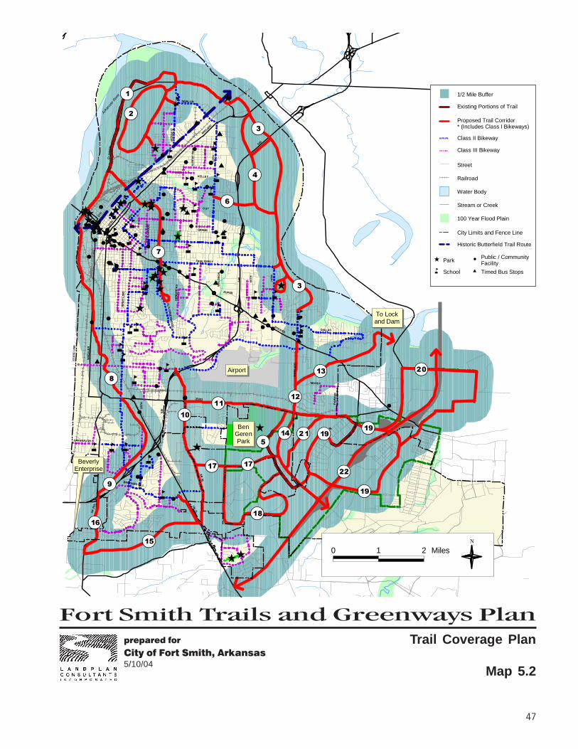
Fort Smith Trails and Greenways Planprepared for
City of Fort Smith, Arkansas5/10/04
47
$
$
$
$
$
$
$
$
$
$
$
$
$
$$
$
$$
$
åå
å
åå
å
å
å
å
å
åå
å
å
å
åå
å
åååå å
å
å
åå
å
å
å
å
åå
åå
å å å
å
å
Ê
Ê
Ê
ÊÊ
ÊÊ
Ê
ÊÊÊÊ
Ê
ÊÊÊ ÊÊ
ÊÊ
Ê
Ê Ê
Ê
Ê
Ê
Ê
Ê
Ê
#
#
#
##
#
#
#
#
#
#
#
##
#
#
#
#
#
#
###
#
#
#
#
#
#
##
##
#
#
#
#
#
##
#
#
##########
#
#
#
##
#
#
###
#
#
#
#
##
####
####
#
#
#
##
#
#
#
##########################
#
##
#
#
#
#
#
BeverlyEnterprise
MU
SS
ETT
NEWLON
MID
LAND
CLA
YT
ON
AL
BE
RT
PIK
E
50T
H
O ST
KELLEY
GRAND
5TH
10TH
14TH
GR
EE
NW
OO
D
JE
NN
Y L
IND
OL
D G
RE
EN
WO
OD
WH
EE
LER
ST
AT
E L
INE
ZERO
HE
ND
RIC
KS
28T
H
CAVANAUGH
BROOKEN HILL
AR
253 U
S 71
AR
45
MOODY
PA
INT
ER
DALLAS
MA
SS
AR
D
ROGERS
540
74T
H
66T
H
EUPER
540
WA
LD
RO
N
FREE FERRY
540
Arkan
sas R
iver
Airport
To Lockand Dam
BenGerenPark
"!19
"!19
"!17
"!20
"!18
"!21
"!22
"!19
"!17
"!15"!16
"!14
"!13
"!12"!11"!10
"!9
"!8
"!6
"!7
"!5
"!4
"!3
"!3"!2"!1
0 1 2 MilesN
Trail Coverage Plan
Map 5.2
1/2 Mile Buffer
City Limits and Fence Line
Proposed Trail Corridor* (Includes Class I Bikeways)
Class II Bikeway
Class III Bikeway
Street
Railroad
Water Body
Stream or Creek
100 Year Flood Plain
Historic Butterfield Trail Route
ParkÊ
Schoolå
#Public / Community Facility
Timed Bus Stops$
Existing Portions of Trail

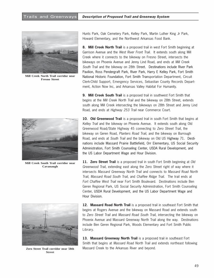
49
Trails and Greenways
Hunts Park, Oak Cemetery Park, Kelley Park, Martin Luther King Jr Park,Howard Elementary, and the Northwest Arkansas Food Bank.
8. Mill Creek North Trail is a proposed trail in west Fort Smith beginning atGarrison Avenue and the West River Front Trail. It extends south along MillCreek where it connects to the bikeway on Fresno Street, intersects thebikeways on Phoenix Avenue and Jenny Lind Road, and ends at Mill CreekSouth Trail and the bikeway on 28th Street. Destinations include River ParkPavilion, Ross Pendergraft Park, River Park, Harry E Kelley Park, Fort SmithNational Historic Foundation, Fort Smith Transportation Department, CircuitClerk-Child Support, Emergency Services, Sebastian County Records Depart-ment, Action Now Inc, and Arkansas Valley Habitat For Humanity.
9. Mill Creek South Trail is a proposed trail in southwest Fort Smith thatbegins at the Mill Creek North Trail and the bikeway on 28th Street, extendssouth along Mill Creek intersecting the bikeways on 28th Street and Jenny LindRoad, and ends at Highway 253 Trail near Commerce Court.
10. Old Greenwood Trail is a proposed trail in south Fort Smith that begins atKelley Trail and the bikeway on Phoenix Avenue. It extends south along OldGreenwood Road/State Highway 45 connecting to Zero Street Trail, thebikeway on Geren Road, Planters Road Trail, and the bikeway on BurroughRoad, and ends at South Trail and the bikeway on Old US Highway 71. Desti-nations include Massard Prairie Battlefield, Orr Elementary, US Social SecurityAdministration, Fort Smith Counseling Center, USDA Rural Development, andthe US Labor Department Wage and Hour Division.
11. Zero Street Trail is a proposed trail in south Fort Smith beginning at OldGreenwood Trail, extending east along the Zero Street right of way where itintersects Massard Greenway North Trail and connects to Massard Road NorthTrail, Massard Road South Trail, and Chaffee Ridge Trail. The trail ends atFort Chaffee West Trail near Fort Smith Boulevard. Destinations include BenGeren Regional Park, US Social Security Administration, Fort Smith CounselingCenter, USDA Rural Development, and the US Labor Department Wage andHour Division.
12. Massard Road North Trail is a proposed trail in southeast Fort Smith thatbegins at Rogers Avenue and the bikeway on Massard Road and extends southto Zero Street Trail and Massard Road South Trail, intersecting the bikeway onPhoenix Avenue and Massard Greenway North Trail along the way. Destinationsinclude Ben Geren Regional Park, Woods Elementary and Fort Smith PublicLibrary.
13. Massard Greenway North Trail is a proposed trail in southeast FortSmith that begins at Massard Road North Trail and extends northeast followingMassard Creek to the Arkansas River and beyond.
Description of Proposed Trail and Greenway System
Zero Street Trail corridor near 58thStreet
Mill Creek South Trail corridor nearCavanaugh
Mill Creek North Trail corridor nearFresno Street
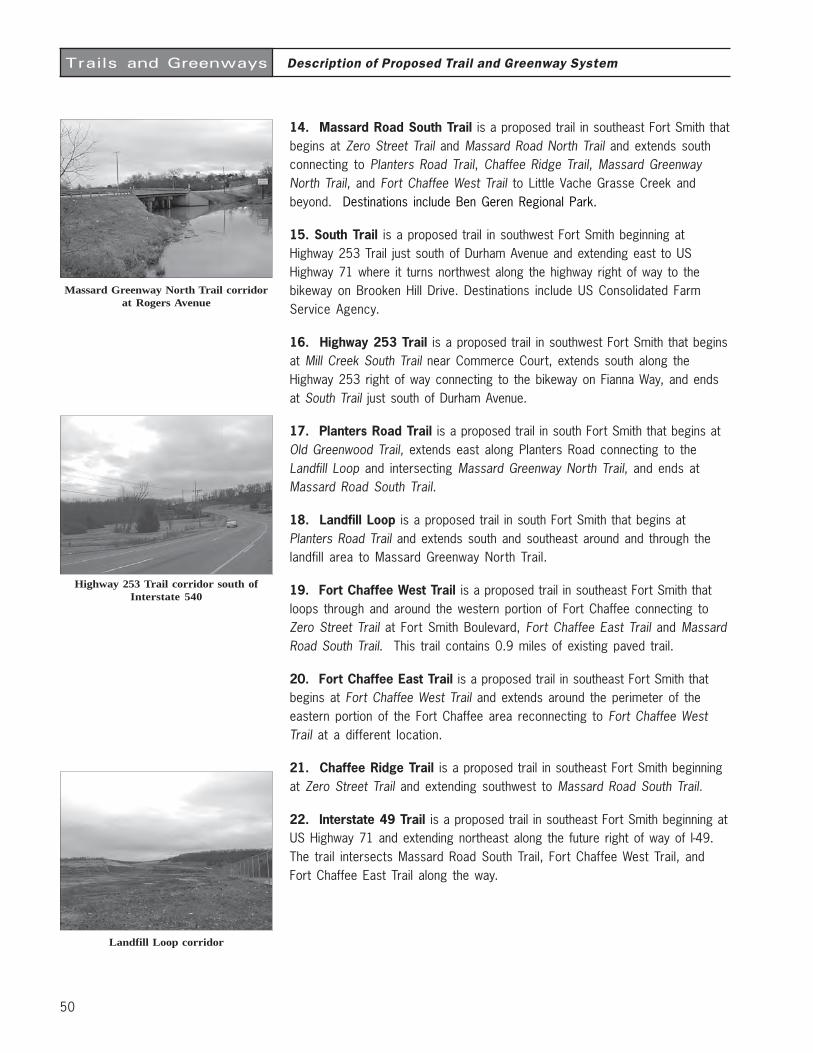
50
Trails and Greenways
14. Massard Road South Trail is a proposed trail in southeast Fort Smith thatbegins at Zero Street Trail and Massard Road North Trail and extends southconnecting to Planters Road Trail, Chaffee Ridge Trail, Massard GreenwayNorth Trail, and Fort Chaffee West Trail to Little Vache Grasse Creek andbeyond. Destinations include Ben Geren Regional Park.
15. South Trail is a proposed trail in southwest Fort Smith beginning atHighway 253 Trail just south of Durham Avenue and extending east to USHighway 71 where it turns northwest along the highway right of way to thebikeway on Brooken Hill Drive. Destinations include US Consolidated FarmService Agency.
16. Highway 253 Trail is a proposed trail in southwest Fort Smith that beginsat Mill Creek South Trail near Commerce Court, extends south along theHighway 253 right of way connecting to the bikeway on Fianna Way, and endsat South Trail just south of Durham Avenue.
17. Planters Road Trail is a proposed trail in south Fort Smith that begins atOld Greenwood Trail, extends east along Planters Road connecting to theLandfill Loop and intersecting Massard Greenway North Trail, and ends atMassard Road South Trail.
18. Landfill Loop is a proposed trail in south Fort Smith that begins atPlanters Road Trail and extends south and southeast around and through thelandfill area to Massard Greenway North Trail.
19. Fort Chaffee West Trail is a proposed trail in southeast Fort Smith thatloops through and around the western portion of Fort Chaffee connecting toZero Street Trail at Fort Smith Boulevard, Fort Chaffee East Trail and MassardRoad South Trail. This trail contains 0.9 miles of existing paved trail.
20. Fort Chaffee East Trail is a proposed trail in southeast Fort Smith thatbegins at Fort Chaffee West Trail and extends around the perimeter of theeastern portion of the Fort Chaffee area reconnecting to Fort Chaffee WestTrail at a different location.
21. Chaffee Ridge Trail is a proposed trail in southeast Fort Smith beginningat Zero Street Trail and extending southwest to Massard Road South Trail.
22. Interstate 49 Trail is a proposed trail in southeast Fort Smith beginning atUS Highway 71 and extending northeast along the future right of way of I-49.The trail intersects Massard Road South Trail, Fort Chaffee West Trail, andFort Chaffee East Trail along the way.
Description of Proposed Trail and Greenway System
Massard Greenway North Trail corridorat Rogers Avenue
Highway 253 Trail corridor south ofInterstate 540
Landfill Loop corridor
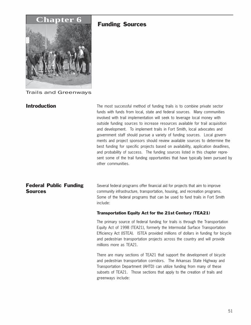
51
Trails and Greenways
Chapter 6Funding Sources
Introduction The most successful method of funding trails is to combine private sectorfunds with funds from local, state and federal sources. Many communitiesinvolved with trail implementation will seek to leverage local money withoutside funding sources to increase resources available for trail acquisitionand development. To implement trails in Fort Smith, local advocates andgovernment staff should pursue a variety of funding sources. Local govern-ments and project sponsors should review available sources to determine thebest funding for specific projects based on availability, application deadlines,and probability of success. The funding sources listed in this chapter repre-sent some of the trail funding opportunities that have typically been pursued byother communities.
Federal Public FundingSources
Several federal programs offer financial aid for projects that aim to improvecommunity infrastructure, transportation, housing, and recreation programs.Some of the federal programs that can be used to fund trails in Fort Smithinclude:
Transportation Equity Act for the 21st Century (TEA21)
The primary source of federal funding for trails is through the TransportationEquity Act of 1998 (TEA21), formerly the Intermodal Surface TransportationEfficiency Act (ISTEA). ISTEA provided millions of dollars in funding for bicycleand pedestrian transportation projects across the country and will providemillions more as TEA21.
There are many sections of TEA21 that support the development of bicycleand pedestrian transportation corridors. The Arkansas State Highway andTransportation Department (AHTD) can utilize funding from many of thesesubsets of TEA21. Those sections that apply to the creation of trails andgreenways include:
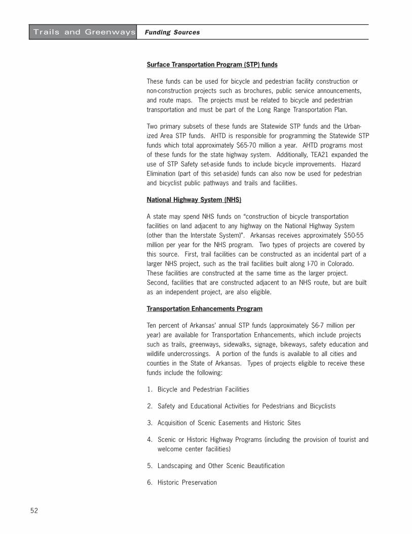
52
Funding SourcesTrails and Greenways
Surface Transportation Program (STP) funds
These funds can be used for bicycle and pedestrian facility construction ornon-construction projects such as brochures, public service announcements,and route maps. The projects must be related to bicycle and pedestriantransportation and must be part of the Long Range Transportation Plan.
Two primary subsets of these funds are Statewide STP funds and the Urban-ized Area STP funds. AHTD is responsible for programming the Statewide STPfunds which total approximately $65-70 million a year. AHTD programs mostof these funds for the state highway system. Additionally, TEA21 expanded theuse of STP Safety set-aside funds to include bicycle improvements. HazardElimination (part of this set-aside) funds can also now be used for pedestrianand bicyclist public pathways and trails and facilities.
National Highway System (NHS)
A state may spend NHS funds on “construction of bicycle transportationfacilities on land adjacent to any highway on the National Highway System(other than the Interstate System)”. Arkansas receives approximately $50-55million per year for the NHS program. Two types of projects are covered bythis source. First, trail facilities can be constructed as an incidental part of alarger NHS project, such as the trail facilities built along I-70 in Colorado.These facilities are constructed at the same time as the larger project.Second, facilities that are constructed adjacent to an NHS route, but are builtas an independent project, are also eligible.
Transportation Enhancements Program
Ten percent of Arkansas’ annual STP funds (approximately $6-7 million peryear) are available for Transportation Enhancements, which include projectssuch as trails, greenways, sidewalks, signage, bikeways, safety education andwildlife undercrossings. A portion of the funds is available to all cities andcounties in the State of Arkansas. Types of projects eligible to receive thesefunds include the following:
1. Bicycle and Pedestrian Facilities
2. Safety and Educational Activities for Pedestrians and Bicyclists
3. Acquisition of Scenic Easements and Historic Sites
4. Scenic or Historic Highway Programs (including the provision of tourist andwelcome center facilities)
5. Landscaping and Other Scenic Beautification
6. Historic Preservation
53
Funding SourcesTrails and Greenways
7. Rehabilitation and Operation of Historic Transportation Buildings, Struc-tures, or Facilities (including historic railroad facilities and canals)
8. Preservation of Abandoned Railway Corridors (including the conversion anduse thereof for pedestrian and bicycle trails)
9. Control and Removal of Outdoor Advertising
10. Archeological Planning and Research
11. Environmental Mitigation to Address Water Pollution Due to Highway Runoffor to Reduce Vehiclecaused Wildlife Mortality While Maintaining HabitatConnectivity
12. Establishment of Transportation Museums
Application deadlines are typically set biannually (every two years) by AHTD.Currently, AHTD is waiting on TEA21 reauthorization from congress. The nextround of applications are anticipated to be accepted in 2005 or 2006. Con-tact Scott Bennet at (501) 569-2201 for more information.
National Recreational Trails Fund Act (NRTFA)
A component of ISTEA and TEA21, the NRTFA is a funding source to assist withthe development of non-motorized and motorized trails. The Act uses funds paidinto the Highway Trust Fund from fees on non-highway recreation fuel used by off-road vehicles and camping equipment. This money can be spent on the acquisi-tion of easements and fee simple title to property, trail development, constructionand maintenance.
Through state agencies, “Symms Act” grants are available to private andpublic sector organizations. NRTFA projects are 80 percent federally funded,and grant recipients must provide a 20 percent match. Federal agencyproject sponsors or other federal programs may provide additional federalshare up to 95 percent. Local matches can be in the form of donations ofservices, materials or land. Projects funded must be consistent with theStatewide Comprehensive Outdoor Recreation Plan. (See Arkansas Recre-ational Trails Fund Program under “state funding sources” later in the chapter.)
Congestion Mitigation and Air Quality Improvement Program (CMAQ)
The CMAQ program was created to reduce traffic congestion and improve airquality. Funds are available to communities designated as “non-attainment” areasfor air quality, meaning the air is more polluted than federal standards allow.Funds are also available to “maintenance” areas, former non-attainment areasthat are now in compliance. Funds are distributed to states based on popula-tion and the severity of air quality problems. A 20 percent local match isrequired. AHTD receives approximately $5-6 million per year of CMAQ fundsfrom the Federal Highway Administration.
54
Funding SourcesTrails and Greenways
Community Development Block Grant Program
The U.S. Department of Housing and Urban Development (HUD) offers financialgrants to communities for neighborhood revitalization, economic development, andimprovements to community facilities and services, especially in low andmoderate-income areas. Approximately $22 million per year is appropriatedto the Arkansas State Program for which cities and counties compete forfunding.
Land and Water Conservation Fund (LWCF) Grants
This federal funding source was established in 1965 to provide park andrecreation opportunities to residents throughout the United States. Money forthe fund comes from the sale or lease of nonrenewable resources, primarilyfederal offshore oil and gas leases and surplus federal land sales. LWCF fundsare used by federal agencies to acquire additions to National Parks, Forests,and Wildlife Refuges. In the past, Congress has also appropriated LWCFmoneys for so-called “state-side” projects. These “state-side” LWCF grantscan be used by communities to acquire and build a variety of park andrecreation facilities, including trails and greenways. Projects funded must beconsistent with the Statewide Comprehensive Outdoor Recreation Plan(SCORP).
“State-side” LWCF funds are annually distributed by the National Park Servicethrough the Arkansas Department of Parks and Tourism’s Outdoor RecreationGrants Program (501-682-1523). Communities must match LWCF grants with 50percent of the local project costs through in-kind services or cash. Allprojects funded by LWCF grants must be used exclusively for recreationpurposes, in perpetuity. Funding for this program has not been available forseveral years, although funds could be allocated in the future.
Watershed Protection and Flood Prevention(Small Watersheds) Grants
The USDA Natural Resource Conservation Service (NRCS) provides funding tostate and local agencies or nonprofit organizations authorized to carry out,maintain and operate watershed improvements involving less than 250,000acres. The NRCS provides financial and technical assistance to eligibleprojects to improve watershed protection, flood prevention, sedimentationcontrol, public water-based fish and wildlife enhancements, and recreationplanning. The NRCS requires a 50 percent local match for public recreation,and fish and wildlife projects. For more information, contact Kalven Trice at(501) 301-3100.
55
Funding SourcesTrails and Greenways
Urban and Community Forestry Assistance Program
The USDA provides small grants of up to $10,000 to communities for thepurchase of trees to plant along city streets and for trails and parks. Toqualify for this program, a community must pledge to develop a street treeinventory; a municipal tree ordinance; a tree commission, committee ordepartment; and an urban forestry-management plan. Contact Doug Akin at(501) 296-1865 for more information.
State Public FundingSources
The State of Arkansas has two primary sources of trail funding. Both theTEA21 and Recreational Trails Fund Program are funded through federalinitiatives, but distributed by the State of Arkansas.
Arkansas State Highway and Transportation Department
See TEA21 text above.
Arkansas Recreational Trails Fund Program
The Arkansas Recreational Trails Fund Program was created to expandmoneys funded by the National Recreational Trails Fund Act (NRTFA). This actwas part of TEA21 (see above text).
The NRTFA is a state administered federal aid program managed through theFederal Highway Administration in consultation with the Department of the Interior.Half of the funds available to states are allocated equally among eligible states.The other half of the funds are allocated in proportion to the amount of non-highway recreational fuel use in each eligible state. The state can grant thesefunds (approximately $500,000 per year) to both private and public sectororganizations. In Arkansas, NRTFA projects are 80 percent federally funded,and grant recipients must provide a 20 percent match. Projects funded mustbe consistent with the Statewide Comprehensive Outdoor Recreation Plan(SCORP). For more information, contact Steve Weston, Transportation StudyCoordinator with the Arkansas State Highway and Transportation Departmentat (501) 569-2020.
Local Sources of PublicFunding
Many local governments have obtained funding for trail projects through localinitiatives. Public support for projects is essential to the success of local publicfunding sources. Therefore, information on the benefits of a proposed trailsystem should be distributed prior to implementing such initiatives.
56
Funding SourcesTrails and Greenways
Local Sales Taxes
Local sales taxes have been a successful means of raising funds for a varietyof capital improvement projects in cities across the country. In the City ofTulsa, every five years, voters decide whether to renew the 3rd penny salestax which generates more than $60 million per year. In 1996, Tulsa votersapproved the most recent sales tax extension, which included $2.4 million fortrail development to the year 2001. Other cities across the country haveimplemented similar programs.
Impact Fees
Impact fees are monetary one-time charges levied by a local government onnew development. Unlike required dedications, impact fees can be applied tofinance greenway facilities located outside the boundary of development Thepurpose of impact fees is not to raise general revenue, but to ensure thatadequate capital facilities will be provided to serve and protect the public.They can be levied through the subdivision or building permit process.
Bond Referendums
Communities across the country have successfully placed propositions on localballots to support trail development. In 1989 the City of Tulsa issued $600,000of G. O. bond funds which were used as a match for ISTEA funds. Thisresulted in more than $2.5 million for the design and construction of trails inTulsa. The Charlotte-Mecklenburg County, NC, area passed four consecutivereferendums that generated more than $3 million for greenways. GuilfordCounty, NC also passed a referendum that appropriated $1.6 million fordevelopment of the Bicentennial Trail. Since bond funding relies on the supportof the voting population, an aggressive education and awareness program willneed to be implemented prior to any referendum vote.
Local Capital Improvements Program
Some local governments have initiated a yearly appropriation for greenwayand trail development in the capital improvements program. In Raleigh, NC,greenways continue to be built and maintained, year after year, due to adedicated source of annual funding, that has ranged from $100,000 to$500,000, administered through the Parks and Recreation Department.
Park Land Dedication Funds
Park land dedication funds could be used to secure land for trail building orgreenway preservation. The Fayetteville Park Land Dedication Ordinance,adopted in 1981, was developed as a way to fund park land to Fayettevillecitizens as the population increases. The concept behind the Park LandDedication Ordinance is to require developers to make a reasonable dedica-tion of land for public park facilities, or to make an equivalent monetarydedication in lieu of land for all new residential developments.
57
Funding SourcesTrails and Greenways
Utility Franchise Fees
Cities in Arkansas can collect a percentage of fees collected by local utilitycompanies in return for their use of utility line corridors that are owned by theCity. Street rights-of-way are good examples of a corridor used by manyutilities to place their service overhead or underground. For example, the Cityof Fayetteville currently collects fees from local utilities at varying percentageamounts. Collecting and/or increasing franchise fees to the maximum allowedby state is one more avenue of increased funding opportunities for trailimprovements.
Additional Local Funding Ideas
The American Trails website, www.americantrails.org lists many additionalsolutions and creative ideas for funding trail projects used by cities across thecountry.
Local Private FundingSources
Many communities have solicited trail funding from a variety of privatesources, including corporations and other conservation-minded benefactors.As a general rule, local businesses and individuals will have a greater interestin and will be more likely to fund local projects. These local sources shouldbe approached first, before seeking funds outside the community.
Local Businesses
Local industries and private businesses may agree to provide support fordevelopment of trails in Fort Smith through:
• donations of cash for a specific trail segment or trail head facility;
• donations of services by corporations to reduce the cost of trail implemen-tation, including equipment and labor to construct and install elements of atrail;
• reductions in the cost of materials purchased from local businesses whichsupport trail implementation and can supply essential products for facilitydevelopment.
This method of raising funds requires a great deal of staff coordination. Oneexample of a successful endeavor of this type is the Swift Creek RecycledGreenway in Cary, NC. A total of $40,000 in donated construction materialsand labor made this trail an award-winning demonstration project. (Somematerials used in the “recycled trail” were considered waste materials bylocal industries!)
58
Funding SourcesTrails and Greenways
Trail Sponsors
A sponsorship program for trail amenities allows for smaller donations to bereceived both from individuals and businesses. The program must be well plannedand organized, with design standards and associated costs established foreach amenity. Project elements which may be funded can include waysideexhibits, benches, trash receptacles, entry signage, and picnic areas. Usually,plaques recognizing the individual contributors are placed on the constructedamenities or at a prominent entry point to the trail.
Volunteer Work
Community volunteers may help with trail construction, as well as fund raising.Potential sources of volunteer labor in Fort Smith could include high school orcollege students, user groups (running, walking and cycling clubs), localhistorical groups, neighborhood associations, local churches, conservationgroups, school groups, local civic clubs such as Kiwanis, Rotary and LionsClubs, and United Way Day of Caring.
A good example of a volunteer greenway program is Cheyenne, Wyoming,which generated an impressive amount of community support and volunteerwork. The program has the unusual problem of having to insist that volunteerswait to begin landscaping trails until construction is completed. A manual forgreenway volunteers was developed in 1994 to guide and regulate volunteerwork. The manual includes a description of appropriate volunteer efforts,request forms, waiver and release forms, and a completion form (volunteersare asked to summarize their accomplishments). Written guidelines are alsoprovided for volunteer work in 100-year floodplains.
To better organize volunteer activity, Cheyenne developed an “Adopt-a-Spot”program. Participants who adopt a segment of trail are responsible for periodictrash pick-up, but can also install landscaping, prune trail-side vegetation, developwildlife enhancement projects, and install site amenities. All improvementsmust be consistent with the Greenway Development Plan and must be ap-proved by the local Greenway Coordinator. Adopt-a-Spot volunteers areallowed to display their names on a small sign along the adopted section oftrail.
“Buy-a-Foot” Programs
“Buy-a-Foot” programs have been successful in raising funds and awarenessfor trail projects across the country. Under local initiatives, citizens areencouraged to purchase one linear foot of the trail by donating the cost ofconstruction. An excellent example of a successful endeavor is the High PointGreenway “Buy-a-Foot” campaign, in which linear greenway “feet” were sold ata cost of $25 per foot. Those who donated were given a greenway T-shirt anda certificate. This project provided an estimated $5,000 in funds.
59
Funding SourcesTrails and Greenways
Foundations Communities can leverage public and other private dollars with grants fromfoundations. The following is a parital listing of foundations which have thepotential to fund trail and greenway projects.
American Greenways DuPont Awards
The Conservation Fund’s American Greenways Program has teamed with theDuPont Corporation and the National Geographic Society to award small grants($250 to $2,000) to stimulate the planning, design and development of green-ways. These grants can be used for activities such as mapping, conductingecological assessments, surveying land, holding conferences, developingbrochures, producing interpretive displays, incorporating land trusts, buildingtrails, and other creative projects. Grants cannot be used for academicresearch, institutional support, lobbying or political activities. For moreinformation, contact the Conservation Fund at (703) 525-6300.
REI Environmental Grants
REI (Recreational Equipment Incorporated) awards grants to organizations inprotecting and enhancing natural resources for outdoor recreation. Grants of up to$2,000 are available through this program and can be used for:
1. Preservation of wildlands and open space;
2. Advocacy-oriented education for the general public on conservation issues;
3. Building the membership base of a conservation organization;
4. Direct citizen action (lobbying) campaigns for public land and waterrecreation issues; and
5. Projects that serve to organize a trails constituency or enhance theeffectiveness of a trail organization’s work as an advocate.
Grants cannot be used for trail construction and maintenance. For moreinformation, call REI’s Grantline at (253) 395-7100.
Trust for Public Land
The Trust for Public Land is a nonprofit organization that works nationwide toconserve land for people. Founded in 1972, TPL specializes in conservation realestate, applying its expertise in negotiations, finance, and law to protect land forpublic use. Usually TPL steps in to negotiate the purchase of real estate and holdsthe land until a public agency can acquire it. Working this way, TPL has helped toprotect more than 1,400 special places nationwide for parks, greenways, recre-ation areas, historic landmarks, forests, watersheds, and wilderness. Contactthe TPL National Office at (415) 495-4014 for more information.
60
Funding SourcesTrails and Greenways
Henry M. Jackson Foundation
The foundation seeks to support innovative land use and metropolitan growthmanagement programs that have a national or multi-state impact and fosterthe development of sound public policy in this field. The foundation aims tosupport efforts that promote a balance between environmental protection andeconomic development, facilitate effective and informed leadership andstrategies to limit sprawl, and illuminate the intersection of land use withrelated quality of life issues. Specifically, the foundation strives to informpolicymakers at the local, state and national levels through case studies,research reports and guidebooks; convene stakeholders to develop long-termstrategies that integrate the preservation of open space, economic develop-ment, energy needs, transportation options, community revitalization andspecies protection; and increase awareness of and access to informationabout growth. Contact Ms. Lara Iglitzin, Executive Director at (206) 682-8565.
The Kodak American Greenways Awards Program
The Kodak American Greenways Awards Program, a partnership project of theEastman Kodak Company, the Conservation Fund and the National GeographicSociety, provides small grants to stimulate the planning and design of green-ways in communities throughout America. The organization is interested infunding activities such as mapping, eco-logical assessments, surveying,conferences and design activities; developing brochures, interpretativedisplays, audio-visual productions or public opinion surveys; hiring consultants;incorporating land trusts; and/or building footbridges, planning bike paths orother creative projects. Contact the American Greenways Program Coordina-tor at (703) 525-6300.
Bikes Belong
Bikes Belong Coalition is sponsored by members of the American BicycleIndustry. The grant program is a national discretionary program with a smallbudget, to help communities build TEA-21-funded projects. They like to fundhigh-profile projects and like regional coalitions. An application must besupported by the local bicycle dealers (letters of support should be attached).Bikes Belong also offers advice and information on how to get more people onbikes. Government and non-profit agencies are eligible and no match isrequired. The maximum amount for a grant proposal is $10,000. Applicationsmay be submitted at any time and are reviewed as they are received. ContactTim Baldwin at (617) 426-9222.
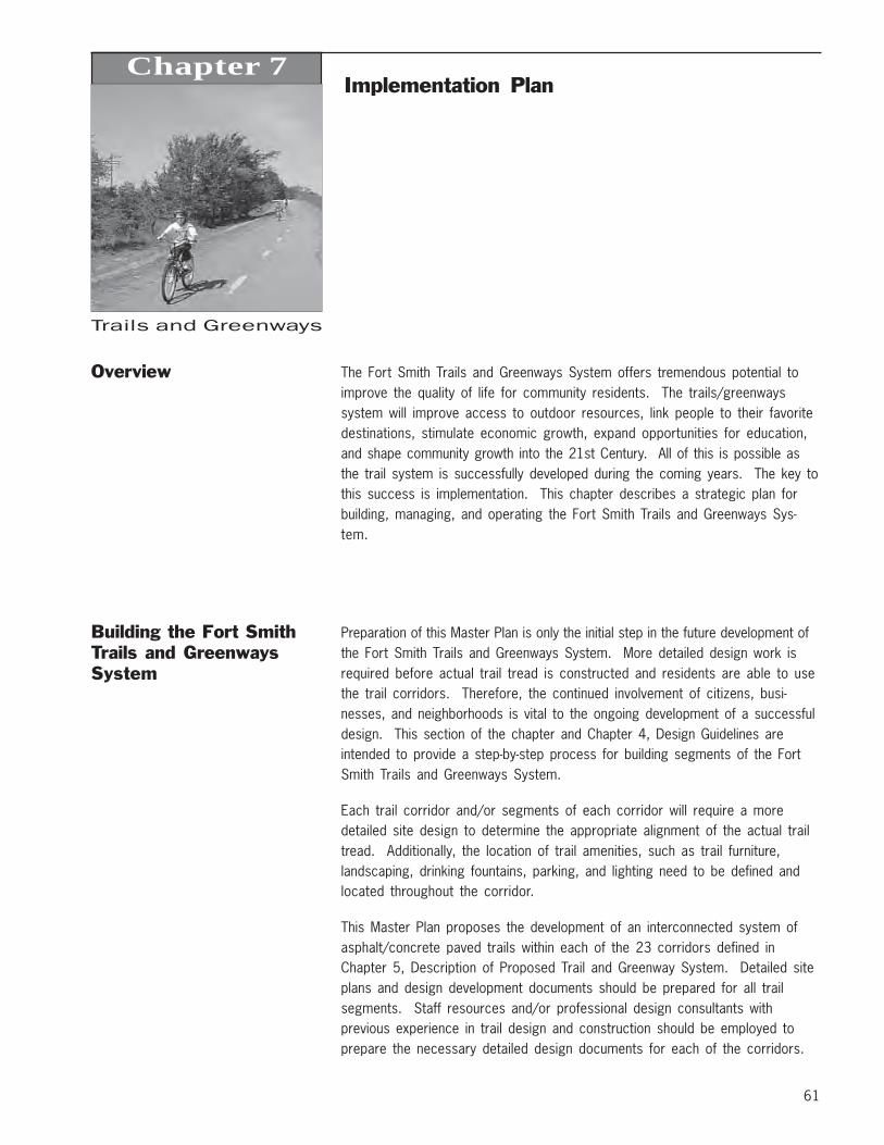
61
Trails and Greenways
Chapter 7Implementation Plan
Overview The Fort Smith Trails and Greenways System offers tremendous potential toimprove the quality of life for community residents. The trails/greenwayssystem will improve access to outdoor resources, link people to their favoritedestinations, stimulate economic growth, expand opportunities for education,and shape community growth into the 21st Century. All of this is possible asthe trail system is successfully developed during the coming years. The key tothis success is implementation. This chapter describes a strategic plan forbuilding, managing, and operating the Fort Smith Trails and Greenways Sys-tem.
Building the Fort SmithTrails and GreenwaysSystem
Preparation of this Master Plan is only the initial step in the future development ofthe Fort Smith Trails and Greenways System. More detailed design work isrequired before actual trail tread is constructed and residents are able to usethe trail corridors. Therefore, the continued involvement of citizens, busi-nesses, and neighborhoods is vital to the ongoing development of a successfuldesign. This section of the chapter and Chapter 4, Design Guidelines areintended to provide a step-by-step process for building segments of the FortSmith Trails and Greenways System.
Each trail corridor and/or segments of each corridor will require a moredetailed site design to determine the appropriate alignment of the actual trailtread. Additionally, the location of trail amenities, such as trail furniture,landscaping, drinking fountains, parking, and lighting need to be defined andlocated throughout the corridor.
This Master Plan proposes the development of an interconnected system ofasphalt/concrete paved trails within each of the 23 corridors defined inChapter 5, Description of Proposed Trail and Greenway System. Detailed siteplans and design development documents should be prepared for all trailsegments. Staff resources and/or professional design consultants withprevious experience in trail design and construction should be employed toprepare the necessary detailed design documents for each of the corridors.
62
Implementation PlanTrails and Greenways
Phasing Strategy for theFort Smith Trails andGreenways System
With limited trail resources and almost 89 miles of proposed multiuse trails, itis important to determine a logical order for the implementation of the trails.In an effort to evaluate each corridor objectively, criteria were developed toassist in determining the order of multiuse trail development for the next 10 to15 years. The consultant worked closely with the Fort Smith Trails andGreenways Master Plan Steering Committee to identify and utilize the mostcritical evaluation factors for future development of corridors. The SteeringCommittee devoted a substantial amount of time and effort toward the devel-opment of these criteria and reached a consensus regarding the relativeimportance of each. The following section defines the terminology utilized inthe evaluation of the proposed corridors.
Right of Way Availability: the availability of rights of way or easements toconstruct trails is a critical cost and timing factor. If rights of way or ease-ments cannot be secured voluntarily to construct a trail within a corridor, thetrail cannot be built unless rights can be purchased. Purchasing rights of waycan be very expensive and in many cases can make constructing a trail costprohibitive. Corridors which have necessary rights of way in the public domainhave the highest ranking.
Recreation/Destinations Served: trails which connect major parks andrecreation destinations can offer the public a safe opportunity to access thesefacilities and they can serve as trail heads. The higher the number of parksand recreation destinations served by a trail corridor the higher the ranking.
Timeliness and Opportunity: in some instances the trail corridors identifiedare the same corridors in which other public improvements will be or havebeen built, such as a street, highway, expressway, turnpike, waterline, ordrainage channel, etc. In cases where a trail can be constructed in conjunc-tion with these types of projects, the trail construction will be expedited andgreat costs savings can result. In some cases, if a trail is not designed inconjunction with the public improvement, it can be very difficult and expensiveto try to construct a trail at a later date. Corridors in which future publicimprovements are funded or planned receive higher ranking than thosecorridors without such public improvements.
Total Population Served: one of the best indicators of how many people willutilize the trail is the number of people living in close proximity to the trailalong its entire length. For this evaluation the population within one-quartermile of the trail corridor was used.
Average Population Served: Another method of looking at the potentialnumber of trail users is the average population served per mile of trail. Again,the population within one-quarter mile of the trail corridor was used. Shortertrails within densely populated areas rank highest.
e
63
Implementation PlanTrails and Greenways
Schools Served: trails which connect schools offer the communities a safeopportunity for children to walk or ride their bikes and can serve as logicaltrail heads. The higher the number of schools served by a trail corridor thehigher the ranking.
Connectivity: trails which provide a connection to existing trail and bikeroutes and have the potential for higher utilization by trail users will providegreater benefit to the community. The more connections made the higher theranking.
Near Term Phase: is used to describe those corridors for which the designcan be started within two years and constructed within a period of 5 years.Most trails in this category have high scores in the first three evaluationcriteria.
Mid Term Phase: is used to describe those corridors for which design cancommence within the next five years and constructed within 10 years.
Long Term Phase: is used to describe those corridors for which design cancommence within the next 10 years and constructed within 15 years.
Trail Phasing With almost 89 miles of proposed trails within Fort Smith, the first question isinevitably, “Which trail gets built first?” The following “Trail Phasing EvaluationMatrix” applies the above criteria to each of the 18 proposed trail corridors.Each corridor is objectively compared to all other corridors with the resultingranking order established for all trails. The various phases described in thefollowing matrix are meant to provide a relative time frame only and are notabsolute. The process of implementing trails within the city will be dynamic,and as opportunities arise and conditions change corridors may be developedin a different order than indicated in the phasing matrix (see also Trail PhasingMap 7.1).

64
Implementation PlanTrails and Greenways
Trail Phasing Evaluation Matrix
RANK ID NAME
PO
RT
ION
EX
IST
ING
OR
FU
ND
ED
RO
W A
VA
ILA
BIL
ITY
RE
CR
EA
TIO
N D
ES
TIN
AT
ION
S
CO
RE
TIM
EL
INE
SS
AN
D O
PP
OR
TU
NIT
Y
AV
E. P
OP
. PE
R M
ILE
SC
OR
E
TO
TA
L P
OP
. SC
OR
E
TO
TA
L S
CH
OO
L S
CO
RE
CO
NN
EC
TIV
ITY
TOTAL SCORE
PHASE
1 7 Old Railroad Trail 0 18 22 12 14 12 0 10 88 Near Term
2 1 West River Front Trail * 24 18 17 16 4 3 0 6 87
3 12 Massard Road North Trail * 12 24 5.5 16 10.5 6 0 4 78
4 19 Fort Chaffee West Trail 24 24 0 0 3.5 3 0 6 61
5 5 Ben Geren Trail 24 24 6 0 0 3 0 2 596 8 Mill Creek North Trail * 0 18 17 0 7 9 0 8 59
7 9 Mill Creek South Trail 0 18 0 0 14 9 0 6 47 Mid Term
8 11 Zero Street Trail * 0 24 5.5 0 7 6 0 2 45
9 10 Old Greenwood Trail * 0 24 0 0 4 3 0 8 39
10 14 Massard Road South Trail 0 24 5.5 0 3.5 3 0 2 38
11 3 East River Front Trail 0 0 11 0 7 9 7 4 38
12 20 Fort Chaffee East Trail 0 24 0 0 7 6 0 0 37
13 16 Highway 253 Trail 0 24 0 0 7 3 0 2 36
14 18 Landfill Loop 0 24 0 0 3.5 3 0 4 3515 2 Softball Complex Trail 0 6 6 0 7 6 4 6 34
16 21 Chaffee Ridge Trail 0 24 0 0 3.5 3 0 0 31 Long Term
17 6 Sunny Meade Creek Trail 0 0 0 0 14 6 0 2 2218 13 Massard Greenway North Trail 0 0 0 0 10.5 9 0 0 2019 15 South Trail 0 0 0 0 7 6 0 2 1520 17 Planters Road Trail 0 0 0 0 3.5 3 0 2 921 4 River Fringe Trail 0 0 0 0 4 3 0 0 722 22 I-49 Trail 0 0 0 0 3.5 3 0 0 7
Estimated Costs forFacility Development
The consultant has prepared cost estimates for all of the corridors definedwithin this Master Plan. The cost estimates are general in nature and arebased on national industry or State of Arkansas averages. A listing of theindustry averages that were used to determine “low” or “high” estimates areprovided on the following pages. The purpose of these cost estimates is toprovide general guidance for the purpose of budgeting and developing trailsegments. The estimates are reliable to the extent that a general expectationcan be derived from their use. Specific site development factors unique toeach corridor will influence final design development costs. More detailedcosts should be developed as a part of corridor specific conceptual plans.Final construction cost estimates should be based on final design plans.
Fort Smith Trails and Greenways Planprepared for
City of Fort Smith, Arkansas5/26/04
65
$
$
$
$
$
$
$
$
$
$
$
$
$
$$
$
$$
$
åå
å
åå
å
å
å
å
å
åå
å
å
å
åå
å
åååå å
å
å
åå
å
å
å
å
åå
åå
å å å
å
å
Ê
Ê
Ê
ÊÊ
ÊÊ
Ê
ÊÊÊÊ
Ê
ÊÊÊ ÊÊ
ÊÊ
Ê
Ê Ê
Ê
Ê
Ê
Ê
Ê
Ê
#
#
#
##
#
#
#
#
#
#
#
##
#
#
#
#
#
#
###
#
#
#
#
#
#
##
##
#
#
#
#
#
##
#
#
##########
#
#
#
##
#
#
###
#
#
#
#
##
####
####
#
#
#
##
#
#
#
##########################
#
##
#
#
#
#
#
BeverlyEnterprise
MU
SS
ETT
NEWLON
MID
LAND
CLA
YT
ON
AL
BE
RT
PIK
E
50T
H
O ST
KELLEY
GRAND
5TH
10TH
14TH
GR
EE
NW
OO
D
JE
NN
Y L
IND
OL
D G
RE
EN
WO
OD
WH
EE
LER
ST
AT
E L
INE
ZERO
HE
ND
RIC
KS
28T
H
CAVANAUGH
BROOKEN HILL
AR
253 U
S 71
AR
45
MOODY
PA
INT
ER
DALLAS
MA
SS
AR
D
ROGERS
540
74T
H
66T
H
EUPER
540
WA
LD
RO
N
FREE FERRY
540
Arkan
sas R
iver
Airport
To Lockand Dam
BenGerenPark
"!1
"!2
"!3
"!3
"!4
"!5
"!7
"!6
"!8
"!9
"!10"!11
"!12
"!13
"!14
"!16
"!15
"!17
"!19
"!22
"!21
"!18
"!20
"!17
"!19
"!19
0 1 2 MilesN
Trail Phasing Plan
Map 7.1
City Limits and Fence Line
Proposed Trail (10+ Years)
Class II Bikeway
Class III Bikeway
ParkÊ
Schoolå
#Public / Community Facility
Timed Bus Stops$
Street
Railroad
Water Body
Stream or Creek
100 Year Flood Plain
Historic Butterfield Trail Route
Proposed Trail (5-10 Years)
Proposed Trail (0-5 Years)
Existing Portions of Trail
ID Trail NameLength (Miles)
1 West River Front Trail * 6.432 Softball Complex Trail 5.003 East River Front Trail 7.374 River Fringe Trail 3.415 Ben Geren Trail 2.416 Sunny Meade Creek Trail 1.017 Old Railroad Trail 4.168 Mill Creek North Trail * 5.539 Mill Creek South Trail 2.0710 Old Greenwood Trail * 3.8211 Zero Street Trail * 3.8212 Massard Road North Trail * 1.6813 Massard Greenway North Trail 2.8914 Massard Road South Trail 2.8315 South Trail 3.7216 Highway 253 Trail 1.6017 Planters Road Trail 2.0018 Landfill Loop 4.7119 Fort Chaffee West Trail 7.2520 Fort Chaffee East Trail 6.5421 Chaffee Ridge Trail 1.6022 I-49 Trail 7.74
87.59Total Trail Length (Miles)

67
Implementation PlanTrails and Greenways
Typical Costs for Off-Road Trail Facilities
Preliminary construction cost budgets are provided in tabular form on pages64 and 65 of this Chapter for the Near-Term, Mid-Term and Long-Term trail andlinkage projects. The unit costs defined below and on the following pages areprovided for budgeting purposes only. Adjustments will have to be made tothese costs on a project-by-project basis to compensate for changes in unitprice trends over time.
Category/Description of Facility Unit Unit Costs
Trail Treads6-foot Bare Earth Hike/Mtn. Bike Trail linear feet $5.008-foot Bare Earth Equestrian Trail linear feet $7.508-foot Woodchip Pedestrian Trail linear feet $10.0010-foot Soil-Cement Trail linear feet $12.0010-foot Aggregate/Stone Trail linear feet $15.0010-foot Asphalt Multi-Purpose Trail linear feet $35.0010-foot Concrete Multi-Purpose Trail linear feet $45.0010-foot Wood Deck/Boardwalk Trail linear feet $250.00
SignageInformation Signs each $1,000.00Direction Signs each $200.00Warning Signs each $200.00Mile/Kilometer Markers each $250.00
Furniture/FurnishingsBenches each $600.00Trash Receptacles each $400.00Removable Bollards each $600.00Bicycle Racks each $500.00Fencing (Board-on-Board) linear feet $20.00Gates each $750.00Emergency Phones each $1,000.00Drinking Fountains each $2,500.00Restrooms each $60-90,000.00Landscaping per mile $25,000.00
Parking Lots Unit Gravel Lot* Asphalt Lot10 cars each $7,500.00 $14,000.0020 cars each $15,000.00 $28,000.0040 cars each $30,000.00 $56,000.00
*Gravel lots are prohibited in some jurisdictions
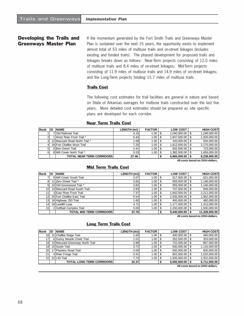
68
Implementation PlanTrails and Greenways
Developing the Trails andGreenways Master Plan
If the momentum generated by the Fort Smith Trails and Greenways MasterPlan is sustained over the next 15 years, the opportunity exists to implementalmost total of 53 miles of multiuse trails and on-street linkages (includesexisting and funded trails). The phased development for proposed trails andlinkages breaks down as follows: Near-Term projects consisting of 12.0 milesof multiuse trails and 8.4 miles of on-street linkages; Mid-Term projectsconsisting of 11.9 miles of multiuse trails and 14.9 miles of on-street linkages;and the Long-Term projects totaling 15.7 miles of multiuse trails.
Trails Cost
The following cost estimates for trail facilities are general in nature and basedon State of Arkansas averages for multiuse trails constructed over the last fiveyears. More detailed cost estimates should be prepared as site specificplans are developed for each corridor.
Mid Term Trails Cost
Near Term Trails CostRank ID NAME LENGTH (mi) FACTOR LOW COST HIGH COST
1 7 Old Railroad Trail 4.16 1.00 1,040,000.00$ 1,248,000.00$ 2 1 West River Front Trail * 6.43 1.00 1,607,500.00$ 1,929,000.00$ 3 12 Massard Road North Trail * 1.68 1.00 420,000.00$ 504,000.00$ 4 19 Fort Chaffee West Trail 7.25 1.00 1,812,500.00$ 2,175,000.00$ 5 5 Ben Geren Trail 2.41 1.00 602,500.00$ 723,000.00$ 6 8 Mill Creek North Trail * 5.53 1.00 1,382,500.00$ 1,659,000.00$
TOTAL NEAR TERM CORRIDORS 27.46 6,865,000.00$ 8,238,000.00$ All costs based on 2004 dollars.
Rank ID NAME LENGTH (mi) FACTOR LOW COST HIGH COST7 9 Mill Creek South Trail 2.07 1.00 517,500.00$ 621,000.00$ 8 11 Zero Street Trail * 3.82 1.00 955,000.00$ 1,146,000.00$ 9 10 Old Greenwood Trail * 3.82 1.00 955,000.00$ 1,146,000.00$
10 14 Massard Road South Trail 2.83 1.00 707,500.00$ 849,000.00$ 11 3 East River Front Trail 7.37 1.00 1,842,500.00$ 2,211,000.00$ 12 20 Fort Chaffee East Trail 6.54 1.00 1,635,000.00$ 1,962,000.00$ 13 16 Highway 253 Trail 1.60 1.00 400,000.00$ 480,000.00$ 14 18 Landfill Loop 4.71 1.00 1,177,500.00$ 1,413,000.00$ 15 2 Softball Complex Trail 5.00 1.00 1,250,000.00$ 1,500,000.00$
TOTAL MID TERM CORRIDORS 37.76 9,440,000.00$ 11,328,000.00$ All costs based on 2004 dollars.
Long Term Trails Cost
Rank ID NAME LENGTH (mi) FACTOR LOW COST HIGH COST16 21 Chaffee Ridge Trail 1.60 1.00 400,000.00$ 480,000.00$ 17 6 Sunny Meade Creek Trail 1.01 1.00 252,500.00$ 303,000.00$ 18 13 Massard Greenway North Trail 2.89 1.00 722,500.00$ 867,000.00$ 19 15 South Trail 3.72 1.00 930,000.00$ 1,116,000.00$ 20 17 Planters Road Trail 2.00 1.00 500,000.00$ 600,000.00$ 21 4 River Fringe Trail 3.41 1.00 852,500.00$ 1,023,000.00$ 22 22 I-49 Trail 7.74 1.00 1,935,000.00$ 2,322,000.00$
TOTAL LONG TERM CORRIDORS 22.37 5,592,500.00$ 6,711,000.00$ All costs based on 2004 dollars.
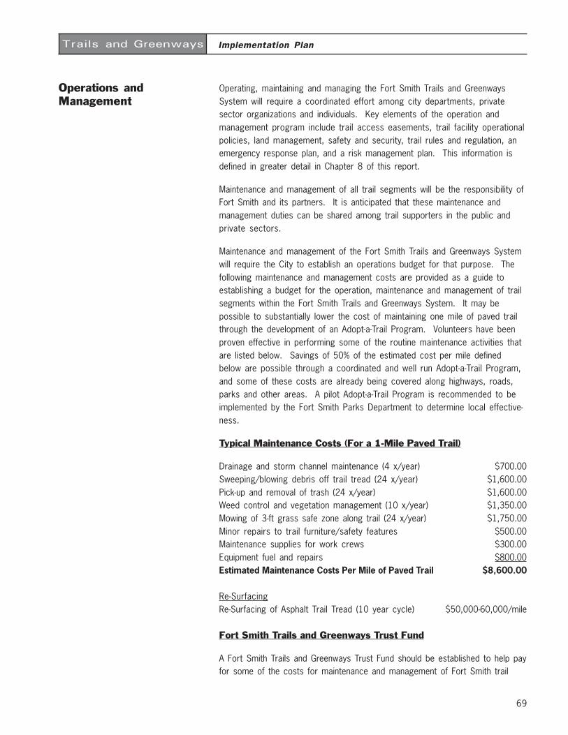
69
Implementation PlanTrails and Greenways
Operations andManagement
Operating, maintaining and managing the Fort Smith Trails and GreenwaysSystem will require a coordinated effort among city departments, privatesector organizations and individuals. Key elements of the operation andmanagement program include trail access easements, trail facility operationalpolicies, land management, safety and security, trail rules and regulation, anemergency response plan, and a risk management plan. This information isdefined in greater detail in Chapter 8 of this report.
Maintenance and management of all trail segments will be the responsibility ofFort Smith and its partners. It is anticipated that these maintenance andmanagement duties can be shared among trail supporters in the public andprivate sectors.
Maintenance and management of the Fort Smith Trails and Greenways Systemwill require the City to establish an operations budget for that purpose. Thefollowing maintenance and management costs are provided as a guide toestablishing a budget for the operation, maintenance and management of trailsegments within the Fort Smith Trails and Greenways System. It may bepossible to substantially lower the cost of maintaining one mile of paved trailthrough the development of an Adopt-a-Trail Program. Volunteers have beenproven effective in performing some of the routine maintenance activities thatare listed below. Savings of 50% of the estimated cost per mile definedbelow are possible through a coordinated and well run Adopt-a-Trail Program,and some of these costs are already being covered along highways, roads,parks and other areas. A pilot Adopt-a-Trail Program is recommended to beimplemented by the Fort Smith Parks Department to determine local effective-ness.
Typical Maintenance Costs (For a 1-Mile Paved Trail)
Drainage and storm channel maintenance (4 x/year) $700.00Sweeping/blowing debris off trail tread (24 x/year) $1,600.00Pick-up and removal of trash (24 x/year) $1,600.00Weed control and vegetation management (10 x/year) $1,350.00Mowing of 3-ft grass safe zone along trail (24 x/year) $1,750.00Minor repairs to trail furniture/safety features $500.00Maintenance supplies for work crews $300.00Equipment fuel and repairs $800.00Estimated Maintenance Costs Per Mile of Paved Trail $8,600.00
Re-SurfacingRe-Surfacing of Asphalt Trail Tread (10 year cycle) $50,000-60,000/mile
Fort Smith Trails and Greenways Trust Fund
A Fort Smith Trails and Greenways Trust Fund should be established to help payfor some of the costs for maintenance and management of Fort Smith trail
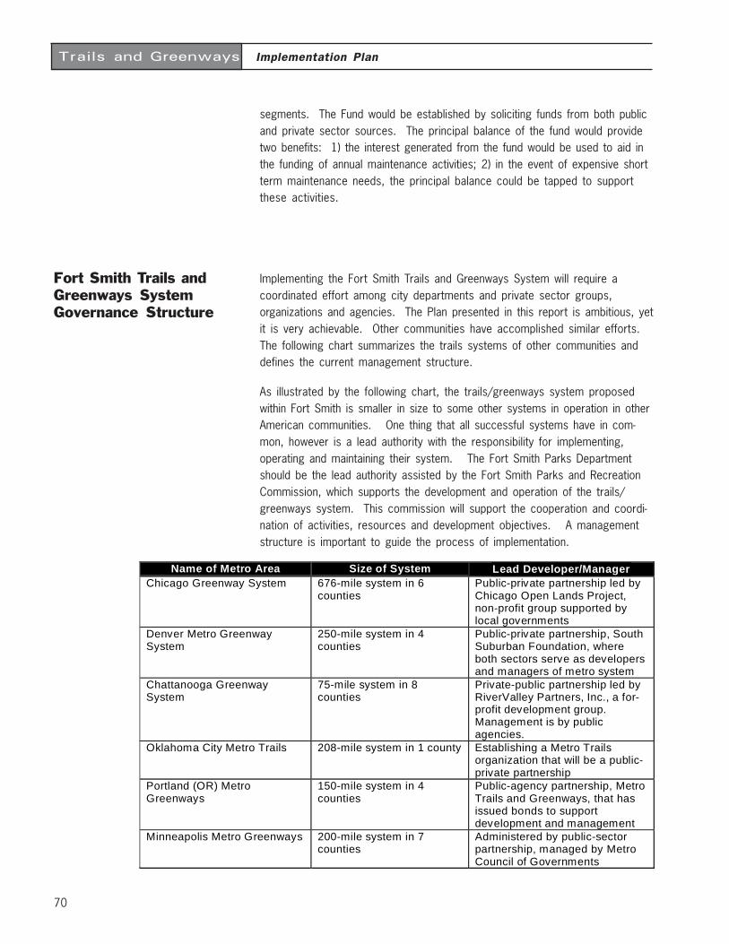
70
Implementation PlanTrails and Greenways
segments. The Fund would be established by soliciting funds from both publicand private sector sources. The principal balance of the fund would providetwo benefits: 1) the interest generated from the fund would be used to aid inthe funding of annual maintenance activities; 2) in the event of expensive shortterm maintenance needs, the principal balance could be tapped to supportthese activities.
Fort Smith Trails andGreenways SystemGovernance Structure
Implementing the Fort Smith Trails and Greenways System will require acoordinated effort among city departments and private sector groups,organizations and agencies. The Plan presented in this report is ambitious, yetit is very achievable. Other communities have accomplished similar efforts.The following chart summarizes the trails systems of other communities anddefines the current management structure.
As illustrated by the following chart, the trails/greenways system proposedwithin Fort Smith is smaller in size to some other systems in operation in otherAmerican communities. One thing that all successful systems have in com-mon, however is a lead authority with the responsibility for implementing,operating and maintaining their system. The Fort Smith Parks Departmentshould be the lead authority assisted by the Fort Smith Parks and RecreationCommission, which supports the development and operation of the trails/greenways system. This commission will support the cooperation and coordi-nation of activities, resources and development objectives. A managementstructure is important to guide the process of implementation.
Name of Metro Area Size of System Lead Developer/ManagerChicago Greenway System 676-mile system in 6
countiesPublic-private partnership led byChicago Open Lands Project,non-profit group supported bylocal governments
Denver Metro GreenwaySystem
250-mile system in 4counties
Public-private partnership, SouthSuburban Foundation, whereboth sectors serve as developersand managers of metro system
Chattanooga GreenwaySystem
75-mile system in 8counties
Private-public partnership led byRiverValley Partners, Inc., a for-profit development group.Management is by publicagencies.
Oklahoma City Metro Trails 208-mile system in 1 county Establishing a Metro Trailsorganization that will be a public-private partnership
Portland (OR) MetroGreenways
150-mile system in 4counties
Public-agency partnership, MetroTrails and Greenways, that hasissued bonds to supportdevelopment and management
Minneapolis Metro Greenways 200-mile system in 7counties
Administered by public-sectorpartnership, managed by MetroCouncil of Governments
71
Implementation PlanTrails and Greenways
Public PrivatePartnerships
The Fort Smith Trails and Greenways System will require the services of thelocal agency and non-governmental staff in order to be successful. However,in order to successfully keep pace with the multitude of development, opera-tion and management requirements of this trail system, the private sector willbe called upon to share the burden and participate in the development andstewardship of the trails/greenways system where appropriate. The followingare some suggestions for how the City and the private sector can assist withthe implementation of the Fort Smith Trails and Greenways System.
Role of the City
Fort Smith should assist with the detailed planning, design and development ofthe Fort Smith trails/greenways system. The Parks Department should assistthe Fort Smith Parks and Recreation Commission with the staffing and opera-tions during its term of existence. The Parks Department can also assist theadvisory board with information, coordination, communication, implementationand management services. The City can take on the responsibility for com-pleting detailed design development plans for individual segments of the trailsystem and can review detailed design plans prepared by private developersfor compliance to the approved design guidelines. They can also implementmanagement plans for each trail segment, in partnership with private sectorgroups. The City should make applications for funding in accordance with therecommendations defined in Chapter Six of this Plan and aggressively pursuelocal, public, foundation and federal funding sources including the Enhance-ment Program.
Role of the Private Sector
The private sector has a vital role to play in the design, development, manage-ment, operations and maintenance of the Fort Smith Trails and GreenwaysSystem. The private sector includes developers, businesses, merchants,corporations, civic organizations and individuals. The private sector has awealth of resources to offer toward the implementation of the Fort Smith Trailsand Greenways System and will be the primary beneficiaries of a successfullydeveloped and managed system. The following defines three specific privatesector roles, and then suggests generic roles that other organizations andgroups might have in the development of the Fort Smith Trails and GreenwaysSystem.
Private developers should be required to construct the trails and linkagesidentified on the Trails and Greenways Route Map when a segment is withintheir proposed development. The trail design should be in conformance withthe design guidelines iterated in Chapter 4 of this report to ensure a consistentlevel of service is maintained throughout the system. The responsibility ofoperations and maintenance should be negotiated on a case by case basis,

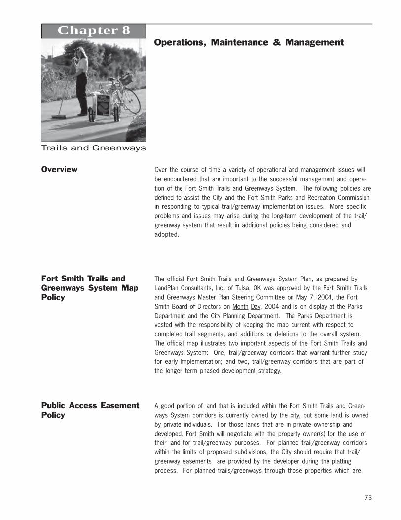
73
Trails and Greenways
Chapter 8Operations, Maintenance & Management
Overview Over the course of time a variety of operational and management issues willbe encountered that are important to the successful management and opera-tion of the Fort Smith Trails and Greenways System. The following policies aredefined to assist the City and the Fort Smith Parks and Recreation Commissionin responding to typical trail/greenway implementation issues. More specificproblems and issues may arise during the long-term development of the trail/greenway system that result in additional policies being considered andadopted.
Fort Smith Trails andGreenways System MapPolicy
The official Fort Smith Trails and Greenways System Plan, as prepared byLandPlan Consultants, Inc. of Tulsa, OK was approved by the Fort Smith Trailsand Greenways Master Plan Steering Committee on May 7, 2004, the FortSmith Board of Directors on Month Day, 2004 and is on display at the ParksDepartment and the City Planning Department. The Parks Department isvested with the responsibility of keeping the map current with respect tocompleted trail segments, and additions or deletions to the overall system.The official map illustrates two important aspects of the Fort Smith Trails andGreenways System: One, trail/greenway corridors that warrant further studyfor early implementation; and two, trail/greenway corridors that are part ofthe longer term phased development strategy.
Public Access EasementPolicy
A good portion of land that is included within the Fort Smith Trails and Green-ways System corridors is currently owned by the city, but some land is ownedby private individuals. For those lands that are in private ownership anddeveloped, Fort Smith will negotiate with the property owner(s) for the use oftheir land for trail/greenway purposes. For planned trail/greenway corridorswithin the limits of proposed subdivisions, the City should require that trail/greenway easements are provided by the developer during the plattingprocess. For planned trails/greenways through those properties which are
74
Operations, Maintenance & ManagementTrails and Greenways
platted and currently undeveloped, the City will require a public accesseasement as a part of the site plan review process. The City of Fort Smith orcertain non-profit organizations can accept donation of public access ease-ments for the Fort Smith Trails and Greenways System that is contained withinthe corridors defined on the official Trails and Greenways System Map inaccordance with existing policies and codes pertaining to the acquisition ofparkland, transportation corridors and land for water and wastewater facili-ties. The City should consider requiring public access provisions in all neweasements.
Private Construction ofTrails Policy
Construction of planned trails within all new development should be considered theresponsibility of the developer. In the same way that a developer is required toconstruct utilities to his site, he should be responsible for the construction of thetrails through his development which are a part of the Fort Smith Trails andGreenways System. The developer should be required to conform to traildesign standards as iterated in Chapter 4 “Design Guidelines”.
Right of Public Accessand Use of Trail/Greenway Lands Policy
All access and use is governed by existing local city policies and shall also begoverned by the Fort Smith Trail/Greenway Policy. The use of all trails/greenways is limited to non-motorized uses (except maintenance vehicles),including hiking, bicycling, running, jogging, wheelchair use, skateboarding,rollerblading, mountain biking, and other uses that are determined to becompatible with Fort Smith Trails and Greenways.
Trail Naming Policy The majority of trails within the Fort Smith Trails and Greenways System will benamed for the significant natural or cultural features that are found within thetrail/greenway corridor. Trails can be named in accordance with the trailnaming policy.
Fencing and VegetativeScreening Policy
The City should work with landowners on an individual basis to determine iffencing and screening is required and appropriate. The City may agree tofund the installation of a fence or vegetative screen, however, it shall be theresponsibility of the adjacent property owner to maintain the fence or vegeta-tive screen in perpetuity, including the full replacement of such fence orscreen in the event of failure or deterioration due to any circumstances.
75
Operations, Maintenance & ManagementTrails and Greenways
Adopt-a-Trail ProgramPolicy
An Adopt-a-Trail Program should be established by the Fort Smith Parks andRecreation Commission to encourage community groups, families, businesses,school groups, civic clubs and other organizations to join in managing the FortSmith Trails and Greenways System. The Fort Smith Parks and RecreationCommission will need to work closely with the Parks Department to ensure thatall Adopt-a-Trail Program groups manage and maintain trails/greenways in amanner that is consistent with other land use objectives. The Fort Smith Parksand Recreation Commission should develop written agreements for eachAdopt-a-Trail entity and keep a current record of this agreement on file withthe City. Adopt-a-Trail entities will be assigned a specific section of the FortSmith Trails and Greenways System, defined by location or milepost. Theactivities of each organization shall be monitored by the City. Agreements formanagement can be amended or terminated at any time by either party, giving30 days written notice.
Management Agreements Management Agreements should be established between the City and privateorganizations wishing to assist with the management of designated segments ofthe Fort Smith Trails and Greenways System. The objective of these agree-ments is to define areas of management that are compatible with existing landmanagement activities, especially where the Fort Smith Trails and GreenwaysSystem intersects with public or private properties and/or rights-of-way.Management agreements spell out specific duties, responsibilities and activi-ties of the City and any public or private organization that wishes to assist theCity with management activities. They can be amended or terminated at anytime by either party, giving 30 days written notice.
Cross AccessAgreements Policy
The City can use cross access agreements to permit private landowners that haveproperty on both sides of a trail/greenway corridor access to and use of atrail/greenway corridor to facilitate operation and land use activities. Adja-cent landowners generally have the right to use the access at any time.However, access cannot block the right-of-way for trail/greenway users otherthan for temporary measures such as permitting livestock to cross, or trans-porting equipment. Adjacent landowners are responsible for acts or omis-sions which would cause injury to a third party using the trail/greenway. If alandowner must move products, materials, livestock or equipment across thetrail/greenway on a regular basis, appropriate signage will be installed towarn users of the trail/greenway to yield for such activities.
Crossing of abandoned or active rail lines, utility corridors and/or roads andhighways will require the execution of agreements with companies, local, state orfederal agencies and organizations that own the rights-of-way. These cross-ings must provide clearly controlled, recognized, and defined intersections inwhich the user will be warned of the location. In accordance with the Ameri-
76
Operations, Maintenance & ManagementTrails and Greenways
can Association of State Highway Transportation Officials (AASHTO) and theManual on Uniform Traffic Control Devices (MUTCD), the crossing will besigned with appropriate regulatory, warning and information signs.
Land Management Trail/greenway facilities should be maintained in a manner that promotes safeuse. All trail/greenway facilities shall be managed by the Fort Smith ParksDepartment. Trail heads, points of public access, rest areas and otheractivity areas should be maintained in a clean and usable condition at alltimes. The primary concern regarding maintenance should always be publicsafety. Trail/Greenway maintenance should include the removal of debris,trash, litter, obnoxious and unsafe man-made structures, and other foreignmatter so as to be safe for public use. Removal of native vegetation shouldbe done with discretion, removal of exotic species should be accomplished ina systematic and thorough manner. The objective in controlling the growth ofvegetation should be to maintain clear and open lines of sight along the edgeof the trail, and eliminate potential hazards that could occur due to naturalgrowth, severe weather or other unacceptable conditions.
All trail surfaces should be maintained in a safe and usable manner at alltimes. Rough edges, severe bumps or depression, cracked or uneven pave-ment, gullies, rills and washed out treads shall be repaired immediately.Volunteer vegetation occurring in the tread of the trail should be removed insuch a manner so that the trail surface is maintained as a continuous, even andclean surface. The Parks Department shall strive to minimize the number ofareas where ponding water occurs, however they cannot be held liable forpublic use through areas of casual or ponded water.
Property owned or used by the City for the Fort Smith Trails and GreenwaysSystem should be maintained in a condition that promotes safety and securityfor trail/greenway users and adjacent property owners. To the extent pos-sible, the property should also be maintained in a manner that enables thetrail/greenway corridor to fulfill multiple functions (i.e. passive recreation,alternative transportation, stormwater management and habitat for wildlife).Vegetation within each trail/greenway corridor should be managed to promotesafety, serve as wildlife habitat, buffer public trail/greenway use from adja-cent private property (where applicable), protect water quality, and preservethe unique aesthetic values of the natural landscape. To promote safe use ofthe trail/greenway system, all vegetation should be clear cut to a minimumdistance of three (3) feet from each edge of a trail. Selective clearing ofvegetation should be conducted within a zone that is defined as being betweenthree (3) to ten (10) feet from each edge of a trail. At any point along a trail, auser should have a clear, unobstructed view, along the centerline of a trail,300 feet ahead and behind his/her position. The only exception to this policyshould be where terrain or curves in a trail serve as the limiting factor. TheCity or its designated agents shall be responsible for the cutting and removal
77
Operations, Maintenance & ManagementTrails and Greenways
of vegetation. Removal of vegetation by an individual or entity other than theCity or its designees should be deemed unlawful and subject to fines and/orprosecution.
Safety and Security Safety is a duty and obligation of all public facilities. In order to provide astandard of care that offers reasonable and ordinary safety measure, the Cityshould develop and implement a Safety and Security Program for all segmentsof the Fort Smith Trails and Greenways System. This program should consistof well defined safety and security policies: the identification of trail/greenwaymanagement, law enforcement, emergency and fire protection agencies; theproper posting, notification and education of the trail/greenway user policies;and a system that offers timely response to the public for issues or problemsthat are related to safety and security. Safety and security of the Fort SmithTrails and Greenways System will need to be coordinated with local lawenforcement officials, local neighborhood watch associations, and Adopt-a-Trail organizations.
Important components of the safety and security program should include:
1) Work with law enforcement agencies in the City to establish a Fort SmithTrails/Greenways Safety and Security Committee that can meet regularlyto discuss management of the trail/greenway system.
2) Prepare a Trail/Greenway Safety Manual and distribute this to manage-ment agencies and post it at all major trail heads.
3) Post User Rules and Regulations at all public access points to the trail/greenway.
4) Work with the management agencies to develop Trail/Greenway Emer-gency Procedures.
5) Prepare a Safety Checklist for the trail/greenway system, and utilize itmonthly during field inspection of trail/greenway facilities.
6) Prepare a Trail/Greenway User Response Form for complaints andcompliments and provide copies at all trail heads.
7) Work with management agencies to develop a system for accident reportinganalysis.
8) Conduct a regular Maintenance and Inspection Program, and share theresults of these investigations with all management agencies.
9) Institute a Site Design and Facility Development Review Panel, made up ofcity departments so that all design development recommendations can bereviewed prior to installation.
10) Coordinate other Public Information Programs that provide informationabout trail/greenway events and activities in which city residents canparticipate.
11) Conduct an ongoing evaluation of trail/greenway program objectives. Itwould be best to have this evaluation conducted by Fort Smith Parks andRecreation Commission and local trail/greenway user groups.
78
Operations, Maintenance & ManagementTrails and Greenways
Trail/Greenway Rules andOperation Regulations
The Fort Smith Trails and Greenways System will be open 365 days a year toany person wishing to use the facility for transportation or recreation purposes— subject to the terms of the Fort Smith Trail/Greenway Ordinance thatgoverns all use. No organization shall be permitted to use any portion of theFort Smith Trails and Greenways System for a commercial purpose unlesswritten permission has been obtained from the Parks Department The Cityshould always discourage the general public from using any segment of a trailthat is under construction. Trail segments shall not be considered officiallyopened for public use until such time as a formal dedication ceremony andofficial opening has been completed. Individuals who use trail segments thatare under construction, without written permission from the City shall bedeemed in violation of this access and use policy and treated as a trespasser.
The Fort Smith Trails and Greenways System shall be operated like all otherparks within the local jurisdiction, open for public use from sunrise to sunset,365 days a year, except as specifically designated. Individuals who are foundto be using unlighted facilities after dusk and before dawn should be deemedin violation of these hours of operation and treated as trespassers. Wheretrails are lighted for nighttime use, the rules established within the Trail/Greenway Ordinance shall govern permitted uses and activities.
Trail/Greenway Ordinance Multiuse conflict is a national problem for community and regional trail/greenway systems. Typically, conflicts are caused by overuse of a trail/greenway, however, other factors may be problematic including poorlydesigned and engineered trail alignments, inappropriate user behavior, orinadequate facility capacity. The most effective conflict resolution plan is awell conceived safety program that provides the individual user with a Code ofConduct for the trail/greenway, sometimes called a Trail/Greenway Ordi-nance. Several communities across the United States have adopted progres-sive trail/greenway ordinances to govern public use and keep trails/green-ways safe for all users. The following Rules and Regulations shall be imple-mented for the Fort Smith Trails and Greenways System. These rules shouldbe displayed both on brochures and information signs throughout the Trails andGreenways System.
1) Be Courteous: All Trail/Greenway users, including bicyclist, joggers,walkers, wheelchairs, skateboarders and skaters, should be respectful ofother users regardless of their mode of travel, speed, or level of skill.Do not feed or harass animals; this can be dangerous for you and otherusers. Respect the privacy of adjacent landowners!
2) Keep Right: Always stay to the right as you use the Trail, or stay in thelane that has been designated for your user group. The exception to thisrule occurs when you need to pass another user.
79
Operations, Maintenance & ManagementTrails and Greenways
3) Pass on the Left: Pass others going in your direction on their left. Lookahead and behind to make sure that your lane is clear before you pull outand around the other user. Pass with ample separation. Do not moveback to the right until you have safely gained distance and speed on theother user. Faster traffic should always yield to slower on-coming traffic.
4) Give Audible Signal When Passing: All users should give a clear warningsignal before passing. This signal may be produced by voice, bell or softhorn. Voice signals might include “Passing on your left!” or “Cyclist on yourleft!” Always be courteous when providing the audible signal - profanity isunwarranted and unappreciated.
5) Be Predictable: Travel in a consistent and predictable manner. Always lookbehind before changing position on the Trail, regardless of your mode oftravel.
6) Control Your Bicycle: Lack of attention, even for a second, can causedisaster - always stay alert! Maintain a safe and legal speed at all times.
7) Do Not Block the Trail: When in a group, including your pets, use no morethan half the trail, so as not to block the flow of other users. If your group isapproached by users from both directions, form a single line or stop andmove to the far right edge of the Trail to allow safe passage by these users.
8) Yield when Entering or Crossing Trails: When entering or crossing the Trail atuncontrolled intersection, yield to traffic already using the other trail.
9) The Use of Lights: (where permitted) When using the Trail/Greenway afterdawn or before dusk be equipped with proper light. Cyclists should havea white light that is visible from five hundred feet to the front, and a redor amber light that is visible from five hundred feet to the rear. OtherTrail/Greenway users should use white lights (bright flashlights) visible twohundred fifty feet to the front, and wear light or reflective clothing.
10) Do not Use this Trail Under the Influence of Alcohol or Drugs: It is illegalto use this Trail if you have consumed alcohol in excess of the statutorylimits, or if you have consumed illegal drugs. Persons who use a pre-scribed medication should check with their doctor or pharmacist toensure that it will not impair their ability to safely operate a bicycle orother wheeled vehicle.
11) Clean-up Your Litter: Please keep this Trail/Greenway clean and neat forother users to enjoy. Do not leave glass, paper, cans or any other debrison or near the Trail/Greenway. Pack out what you bring in - and remem-ber to always recycle your trash.
12) Be a responsible pet owner: Please clean up after your pets.13) Keep Pets on Leashes: All pets must be kept on secure and tethered
leashes. Keep pets off of adjacent private property. Failure to do so willresult in a fine.
14) Prohibition on Camp Fires: Fires, for any purpose, are prohibited withinthe Trails and Greenways System. Any person caught lighting a fire forany purpose will be prosecuted to the fullest extent of the law.
80
Operations, Maintenance & ManagementTrails and Greenways
Emergency ResponsePlan
In order to effectively patrol the Fort Smith Trails and Greenways System andrespond to the potential for fire, floods and other natural or human-causeddisasters, Fort Smith will adopt a trails emergency response plan. This plandefines a cooperative law enforcement strategy for the trail based on ser-vices required and those that are typically provided by police, sheriff, fire andEMS agencies. Specifically, all trails shall be provided with an addresssystem that denotes specific locations along the length of a trail corridor. Asite plan that illustrates points of access to each trail corridor shall beproduced and kept on file. Each trail shall be designed to permit access forlaw enforcement, fire and EMS agencies and vehicles that are not in excess of6.5 tons gross vehicle weight.
The emergency response plan shall also define the agencies that shouldrespond to 911 calls, and provide easy to understand routing plans andaccess points for emergency vehicles. Local hospitals should be notified ofthese routes so that they may also be familiar with the size and scope of theproject. The entire Trails and Greenways System shall be designed anddeveloped to support a minimum gross vehicle weight of 6.5 tons.
Risk Management Plan The purpose of a Risk Management Plan is to increase safety for the users ofthe Fort Smith Trails and Greenways System and reduce the potential foraccidents to occur within the system or on lands adjacent to the system.While it is impossible to guarantee that all risk will be eliminated by thecompletion of a Risk Management Plan, implementation of a plan is in fact acritical step that is necessary to reduce liability and improve safety. A RiskManagement Plan establishes a methodology for trail management that isbased on current tort liability and case law in the United States related to thedevelopment, operation and management of public use trail lands and facili-ties.
The ultimate responsibility for managing the Fort Smith Trails and GreenwaysSystem, as defined within this Plan, rests with Fort Smith. Fort Smith isconsidered the Risk Management Coordinator for the trail/greenway system.A Risk Management Plan has as its major goals:
1) Risk Identification: determining where risk (threat to safety or potentialloss) exists within the corridor.
2) Risk Evaluation: conducting appropriate examination of areas defined asa risk and determining the factors that contribute to risk.
3) Risk Treatment: defining and implementing an appropriate solution to thearea of risk in accordance with one of the four options:a) risk avoidance--prohibiting use of a risk area.b) risk reduction--limit use of area and repair risk area immediately.c) risk retention--obtain waivers from all potential users of the risk area.d) risk transfer--transfer risk area (property) to an agency better suited to
manage the area.
81
Operations, Maintenance & ManagementTrails and Greenways
The following sixteen step plan should be considered for implementation byFort Smith in establishing Risk Management Plans for the Fort Smith Trails andGreenways System.
1) Develop a policy statement about risk management2) Conduct a needs assessment of Fort Smith as an organization.3) Determine goals and objectives for risk management - what is acceptable
and not acceptable management levels.4) Develop specifications for site and facility development.5) Establish a clear and concise program for risk management.6) Define supervision and responsibility for risk management.7) Define appropriate rules and regulations that govern the use of the trail/
greenway system.8) Conduct routine/systematic inspections and investigations of the trail/
greenway system.9) Develop an accident reporting and analysis system.10) Establish procedures for handling emergencies.11) Develop appropriate releases, waivers and agreements for use and manage-
ment.12) Identify best methods for insuring against risk.13) Develop a comprehensive in-service training program for employees of
Fort Smith.14) Implement a public relations program that can effectively describe the risk
management program and activities.15) Conduct periodic reviews of the Risk Management Plan by outside agents to
ensure that the plan is up to date.16) Maintain good legal and insurance representation.
Risk Management The design, development, management, and operation of the Fort Smith Trailsand Greenways System must be carefully and accurately executed in order toprovide a resource that protects the health and welfare of the public. Harmmay occur when a facility has been underdesigned to handle its intendedvolume of use, when management of the facility is poor, or when accidentsoccur. To reduce the possibility and exposure to harm, the City should have inoperation the following measures prior to opening the first segment of thetrail:
1) a thorough Maintenance Program that provides the appropriate duty orlevel of care to greenway users;
2) a Risk Management Plan that appropriately covers all aspects of thetrail/greenway system, and as necessary adjacent landowners.
Fort Smith should exercise reasonable care in the design and construction ofall trail/greenway facilities to reduce hazardous, public nuisance and lifethreatening situations. Recreational Use Statutes in Arkansas serve to reduce
82
Operations, Maintenance & ManagementTrails and Greenways
the exposure to liability that adjacent landowners might expect to realize fromthe proximity of the trail/greenway to private property. In fact, it is verydifficult to find any case law in the United States where an adjacent propertyowner has been sued because a trail/greenway user strayed onto the adjacentprivate property and fell victim to an accident that was caused by the adja-cent landowner. Some landowners have claimed that their insurance rateswould go up because of the presence of a trail abutting their property. Onceagain, there is no case history among insurance companies to support thisclaim — provided the landowner has not gone out of their way to create anattractive nuisance and lure trail users onto their property.
It is also important that the City not charge a fee to use any portion of the FortSmith Trails and Greenways System facility, because typically this may impactthe way in which the recreational use statutes in Arkansas apply to the use ofthe system. A voluntary donation applied to the trail/greenway system, willgenerally not affect the recreational use statute.