iucn evaluations of nominations of natural and...
TRANSCRIPT

IUCN World Heritage Evaluations 2019IUCN Evaluations of nominations of natural and mixed properties to the World Heritage List
WHC/19/43.COM/INF.8B2
IUCn rePort for tHe WorlD HerItaGe CoMMIttee, 43rD sessIon, BakU, azerBaIjan, 30 jUne-10 jUlY 2019

Cover photo: Vatnajökull National Park - dynamic nature of fire and ice, Iceland © IUCN / Bastian Bertzky

IUCN Evaluations of Nominations of Natural and
Mixed Properties to the World Heritage List Table of Contents Executive summary table Alphabetical index, IUCN field evaluators, IUCN Red List of threatened species Introduction A. Natural Properties Page n° A1. New Nominations of Natural Properties
Asia / Pacific China – Migratory Bird Sanctuaries along the Coast of Yellow Sea – Bohai-Gulf of China (Phase I) 3 Iran (Islamic Republic of) – Hyrcanian Forests 17 Europe / North America France – French Austral Lands and Seas 29 Iceland – Vatnajökull National Park - dynamic nature of fire and ice 41 Monaco / Italy / France – Alpi del Mediterraneo – Alpes de la Méditerranée 53 Turkey – Kızılırmak Delta Wetland and Bird Sanctuary 65
A2. Referred Nominations of Natural Properties
Asia / Pacific Thailand – Kaeng Krachan Forest Complex See document WHC/19/43.COM/INF.8B2.ADD
A3. Minor Boundary Modifications of Natural Properties
Europe / North America Denmark – Ilulissat Icefjord See document WHC/19/43.COM/INF.8B2.ADD Latin America / Caribbean Brazil – Cerrado Protected Areas: Chapada dos Veadeiros and Emas National Parks See document WHC/19/43.COM/INF.8B2.ADD
B. Mixed Properties Page n° B1. New Nominations of Mixed Properties
Europe / North America Albania – Natural and Cultural Heritage of the Ohrid region (extension of “Natural and Cultural Heritage of the Ohrid region”, the Republic of North Macedonia) 77 Latin America / Caribbean Brazil – Paraty Culture and Biodiversity 87

C. Cultural Properties Page n° C1. New Nominations of Cultural Landscapes
Asia / Pacific Australia – Budj Bim Cultural Landscape 101 Europe / North America Canada – Writing-on-Stone / Áísínai’pi 105 Spain – Risco Caido and the Sacred mountains of Gran Canaria Cultural Landscape 109 Spain – Priorat-Montsant-Siurana, mosaïque méditerranéenne, paysage culturel agricole 113
Latin America / Caribbean Jamaica – Sunken City of Port Royal – A Relict and Continuing Cultural Landscape 117
DISCLAIMER The designation of geographical entities in this book, and the presentation of the material, do not imply the expression of any opinion whatsoever on the part of IUCN concerning the legal status of any country, territory, or area, or of its authorities, or concerning the delimitation of its frontiers or boundaries.

EXECUTIVE SUMMARY TABLE OF IUCN EVALUATIONS TO THE WORLD HERITAGE COMMITTEE
OUTSTANDING UNIVERSAL VALUE
State Party
Name of the property
(ID number)
Meets one or more natural criteria
Meets conditions of integrity
Meets protection and management requirements
Furth
er m
ission
requ
ired
IUCN
Rec
omm
enda
tion
Note
Crite
rion (
vii)
Crite
rion (
viii)
Crite
rion (
ix)
Crite
rion (
x)
Integ
rity
Boun
darie
s
Thre
ats
addr
esse
d
Justi
ficati
on
of se
rial
appr
oach
Prot
ectio
n sta
tus
Man
agem
ent
Buffe
r zon
e /
Prot
ectio
n in
surro
undin
g ar
rea
Paragraphs of the Operational Guidelines for the
Implementation of the World Heritage Convention
77 77 77 77
78, 87-95 99-102 78, 98 137
78, 132.4
78, 108-118, 132.4, 135
103-107
China
Migratory Bird Sanctuaries along the Coast of Yellow Sea-Bohai, Gulf of China
(Phase I) (1606)
part part
no no no yes
no no part yes D
Iran (Islamic Republic of)
Hyrcanian Forests
(1584)
yes part
yes yes yes yes
yes yes yes no I
France
French Austral Lands
and Seas (1603)
yes yes yes
yes yes yes yes
yes yes _ no I
Iceland
Vatnajökull National
Park - dynamic nature of fire and ice
(1604)
yes
part part part _
part yes _ no part I
Monaco / Italy / / France
Alpi del Mediterraneo –
Alpes de la Méditerranée
(1598)
no
no no part no
no no part no N

OUTSTANDING UNIVERSAL VALUE
State Party
Name of the property
(ID number)
Meets one or more natural criteria
Meets conditions of integrity
Meets protection and management requirements
Furth
er m
ission
requ
ired
IUCN
Rec
omm
enda
tion
Note
Crite
rion (
vii)
Crite
rion (
viii)
Crite
rion (
ix)
Crite
rion (
x)
Integ
rity
Boun
darie
s
Thre
ats
addr
esse
d
Justi
ficati
on
of se
rial
appr
oach
Prot
ectio
n sta
tus
Man
agem
ent
Buffe
r zon
e /
Prot
ectio
n in
surro
undin
g ar
rea
Paragraphs of the Operational Guidelines for the
Implementation of the World Heritage Convention
77 77 77 77
78, 87-95 99-102 78, 98 137
78, 132.4
78, 108-118, 132.4, 135
103-107
Turkey
Kızılırmak Delta
Wetland and Bird Sanctuary
(1601)
no no no no no no no part no N
Albania
Natural and Cultural
Heritage of the Ohrid region (99 Quater)
Extension Mixed site
yes
yes yes no
yes no part no I
Brazil
Paraty Culture and
Biodiversity (1308 Rev)
Mixed side
no yes
yes yes part yes
yes yes part no I
Italy Sila Forests Ecosystems
(1547) Withdrawn
KEYS yes met I inscribe / approve part partially met N non inscribe / approve no not met R refer not applicable D defer

ALPHABETICAL INDEX State Party ID No. Property Page Albania 99 Quater Natural and Cultural Heritage of the Ohrid region 77 Brazil 1308 Rev Paraty Culture and Biodiversity 87
China 1606 Migratory Bird Sanctuaries along the Coast of Yellow Sea-Bohai, Gulf of China (Phase I) 3
France 1603 French Austral Lands and Seas 29 Iceland 1604 Vatnajökull National Park - dynamic nature of fire and ice 41 Iran (Islamic Republic of) 1584 Hyrcanian Forests 17
Monaco / Italy / France 1598 Alpi del Mediterraneo – Alpes de la Méditerranée 53
Turkey 1601 Kızılırmak Delta Wetland and Bird Sanctuary 65 IUCN FIELD EVALUATORS Site Name Natural and Cultural Heritage of the Ohrid region Brent A. Mitchell Paraty Culture and Biodiversity Doris Cordero Migratory Bird Sanctuaries along the Coast of Yellow Sea-Bohai, Gulf of China (Phase I) Sonali Ghosh and Tilman Jaeger
French Austral Lands and Seas Wendy Strahm and Anjara Saloma Alpi del Mediterraneo – Alpes de la Méditerranée Josephine Langley and José Brilha Vatnajökull National Park - dynamic nature of fire and ice Bastian Bertzky and Dan Tormey Hyrcanian Forests Susanna Lindeman and Hervé Lethier Kızılırmak Delta Wetland and Bird Sanctuary Naomi Doak It should be noted that the IUCN field evaluators are part of a broader evaluation approach detailed in the introduction of this report. THE IUCN RED LIST OF THREATENED SPECIES Throughout the report we have indicated the conservation status of each species as recorded in the IUCN Red List of Threatened Species at the time of the evaluation; for more information please visit http://www.iucnredlist.org. Keys to abbreviations: CR: Critically Endangered EN: Endangered VU: Vulnerable NT: Near threatened LC: Least Concern NE: Not Evaluated


IUCN Evaluation Report – May 2019 i
THE WORLD HERITAGE CONVENTION IUCN TECHNICAL EVALUATION REPORT OF WORLD HERITAGE NOMINATIONS
MAY 2019
1. INTRODUCTION This technical evaluation report of natural and mixed properties nominated for inclusion on the World Heritage List has been conducted by the World Heritage Programme of IUCN (International Union for Conservation of Nature). The World Heritage Programme co-ordinates IUCN’s input to the World Heritage Convention in close cooperation with the IUCN Global Protected Areas Programme (GPAP) and other units of IUCN both at headquarters and in the regions. It also works particularly closely with IUCN’s World Commission on Protected Areas (WCPA), the world’s leading expert network of protected area managers and specialists, with the IUCN Species Survival Commission (SSC) and other IUCN Commissions, as well as the many members and partners of IUCN. IUCN’s evaluations are conducted according to the Operational Guidelines for the Implementation of the World Heritage Convention that the World Heritage Committee has agreed, and which are the essential framework for the application of the evaluation process. This framework was updated and revised in 2015, and a revised process documented in Annex 6 of the Operational Guidelines, following discussion by the World Heritage Committee. In carrying out its function under the World Heritage Convention, IUCN has been guided by four principles: (i) ensuring the highest standards of quality control,
institutional memory and consistency in relation to technical evaluation, monitoring and other associated activities;
(ii) increasing the use of specialist networks of IUCN,
especially WCPA, but also other relevant IUCN Commissions and specialist partner networks;
(iii) working in support of the UNESCO World
Heritage Centre and States Parties to examine how IUCN can creatively and effectively support the World Heritage Convention and individual properties as “flagships” for conservation; and
(iv) increasing the level of effective partnership
between IUCN and the World Heritage Centre, ICOMOS and ICCROM.
Members of the expert network of WCPA carry out the majority of technical evaluation missions, supported by other specialists where appropriate. The WCPA network now totals more than 2000 members, protected area managers and specialists from over 140 countries. In addition, the World Heritage Programme calls on relevant experts from IUCN’s
other five Commissions (Species Survival, Environmental Law, Education and Communication, Ecosystem Management, and Environmental, Economic and Social Policy); from international earth science unions, non-governmental organizations and scientific contacts in universities and other international agencies. This highlights the considerable “added value” from investing in the use of the extensive networks of IUCN and partner institutions. These networks allow for the increasing involvement of regional natural heritage experts and broaden the capacity of IUCN with regard to its work under the World Heritage Convention. Reports from field missions and comments from a large number of external reviewers are comprehensively examined by the IUCN World Heritage Panel, as key inputs to each evaluation. The IUCN World Heritage Programme prepares the final technical evaluation reports, which are presented in this document, and represent the corporate position of IUCN on World Heritage evaluations. IUCN has also placed emphasis on providing input and support to ICOMOS in relation to those cultural landscapes which have important natural values. IUCN has continued to extend its cooperation with ICOMOS, including coordination in relation to the evaluation of mixed sites and cultural landscapes. IUCN and ICOMOS have also enhanced the coordination of their panel processes as requested by the World Heritage Committee. This cooperation was reported at the 40th Session of the World Heritage Committee, and will be discussed under Item 9B this year, where IUCN and ICOMOS exchanged and coordinated their advice to the Committee, as also noted in the relevant specific reports. IUCN has endeavoured wherever possible to work in the spirit of the Upstream Process, as will be debated in the relevant items on the Committee’s agenda. 2. EVALUATION PROCESS In carrying out the technical evaluation of nominations, IUCN is guided by the Operational Guidelines, specifically Annex 6, which spells out the evaluation process. The evaluation process is carried out over the period of one year, from the receipt of nominations at IUCN in March and the submission of the IUCN evaluation report to the World Heritage Centre in April / May of the following year. The process involves the following steps:

ii IUCN Evaluation Report – May 2019
1. External Review. The nomination is sent to independent experts knowledgeable about the property or its natural values, including members of WCPA, other IUCN specialist Commissions and scientific networks or NGOs working in the region. IUCN received over 90 external reviews in relation to the properties examined in 2018 / 2019.
2. Field Mission. Missions involving one, or
wherever possible two or more IUCN experts, evaluate the nominated property on the ground and discuss the nomination with the relevant national and local authorities, local communities, NGOs and other stakeholders. IUCN endeavours, where possible, to ensure mission experts have knowledge and experience in the relevant region. Missions usually take place between July and October. In the case of mixed properties and certain cultural landscapes, missions are jointly implemented with ICOMOS.
3. IUCN World Heritage Panel Review. The Panel
intensively reviews the nomination dossiers, field mission reports, comments from external reviewers and other relevant reference material, and provides its technical advice to IUCN on recommendations for each nomination. A final report is prepared and forwarded to the World Heritage Centre in April / May for distribution to the members of the World Heritage Committee.
4. Comparative Analysis. IUCN commissions UN
Environment WCMC to carry out a global comparative analysis for all properties nominated under the biodiversity criteria (ix) and (x) to a standard and publicly available IUCN / WCMC methodology. Following inscription, datasheets are compiled with WCMC.
5. Communities. IUCN has enhanced its evaluation
processes through the implementation of a series of measures to evaluate stakeholder and rights holder engagement during the nomination process (see below for further details).
6. Final Recommendations. IUCN presents, with
the support of images and maps, the results and recommendations of its evaluation process to the World Heritage Committee at its annual session in June or July, and responds to any questions. The World Heritage Committee makes the final decision on whether or not to inscribe the property on the World Heritage List.
It should be noted that IUCN has increasingly sought, over many years, to develop and maintain a dialogue with the State Party throughout the evaluation process to allow the State Party every opportunity to supply all the necessary information and to clarify any questions or issues that may arise. IUCN is available to respond to questions at any time, however, there are three occasions on which IUCN may formally request further information from the State Party. These are:
• Before the field mission. IUCN sends the State Party, usually directly to the person organizing the mission in the host country, a briefing on the mission, in many cases raising specific questions and issues that should be discussed during the mission. This allows the State Party to prepare properly in advance;
• Directly after the field mission. Based on
discussions during the field mission, IUCN may send an official letter requesting supplementary information before the IUCN World Heritage Panel meets in December, to ensure that the Panel has all the information necessary to make a recommendation on the nomination; and
• After the first meeting of the IUCN World
Heritage Panel (December). IUCN continues its practice of ongoing communication with the nominating State/s Party/ies following its Panel meeting. In line with changes to Annex 6 of the Operational Guidelines, this communication now comprises an interim report to the Parties on the status of the evaluation, sent by the end of January. If the Panel finds that some questions are still unanswered, or further issues need to be clarified, this letter may request supplementary information by a specific deadline. That deadline must be adhered to strictly in order to allow IUCN to complete its evaluation. In view of the importance of the requests for supplementary information, IUCN seeks to complete these letters at least one month before the requested deadline of 31st January, and in the present cycle all but one nomination where the IUCN Panel had questions, these were sent before the end of December 2018. It should be noted that in a number of cases, the Panel may not have additional questions, but nevertheless dialogue is invited in all cases. It is expected that supplementary information will be in response to specific questions or issues and should not include completely revised nominations or substantial amounts of new information. It should be emphasized that whilst exchanges between evaluators and the States Parties during the mission may provide valuable feedback, they do not substitute for the formal requests for supplementary information outlined above. IUCN has continued to promote additional dialogue with States Parties on the conclusion of its panel process, to allow for discussion of issues that have been identified and to allow more time to prepare discussions at the World Heritage Committee. This has involved face to face meetings in Paris, and in IUCN’s offices in Switzerland, and conference calls via Skype or dial-in conferences.
In the technical evaluation of nominated properties, global biogeographic classification systems, such as Udvardy’s biogeographic provinces, and the Terrestrial Ecoregion of the World (similarly, freshwater and marine ecoregions of the world in respective environments), are used to identify and assess

IUCN Evaluation Report – May 2019 iii
comparable properties at the global level. These methods make comparisons of natural properties more objective and provide a practical means of assessing similarity and contrasts at the global level. At the same time, World Heritage properties are expected to contain special features, habitats and faunistic or floristic peculiarities that can also be compared on a broader biome basis. It is stressed that these systems are used as a basis for comparison only and do not imply that World Heritage properties are to be selected based on these systems alone. In addition, global conservation priority-setting schemes such as Key Biodiversity Areas (http://www.keybiodiversityareas.org/home), including Important Bird Areas, Alliance for Zero Extinction sites, and systems such as WWF’s Global 200 Priority Ecoregions, Conservation International’s Biodiversity Hotspots and High Biodiversity Wilderness Areas, Birdlife International’s Endemic Bird Areas, and IUCN/WWF Centres of Plant Diversity, provide useful guidance. IUCN in partnership with UN Environment WCMC continues to explore the use of new comparative analyses. The decisive principle is that World Heritage properties are only exceptional areas of Outstanding Universal Value. The evaluation process is also aided by the publication of a series of reference volumes and thematic studies. In early 2012, a resource manual on the preparation of World Heritage nominations was published under joint lead authorship of IUCN and ICOMOS, and has provided further details on best practices, including the key resources that are available to support nominations. IUCN’s range of thematic studies and key references that advise priorities on the World Heritage List are available at the following web address: https://www.iucn.org/theme/world-heritage/resources. IUCN members adopted a specific resolution on these matters at the IUCN World Conservation Congress in 2012, which remains current, and this resolution (WCC-2012-Res-047-EN Implementation of the United Nations Declaration on the Rights of Indigenous Peoples in the context of the UNESCO World Heritage Convention) is available at the following address: https://portals.iucn.org/congress/assembly/motions. IUCN has continued to implement a range of improved practices within its evaluation process in response to these reviews and reflections, which are focused on the inclusion of a specific section headed “Communities” within each evaluation report, to ensure transparency and consistency of IUCN’s advice to the World Heritage Committee on this important issue. These measures include a standard screening form for all evaluation missions, additional consultation with networks specialised in this field, and an expert advisor in the membership of the IUCN World Heritage Panel. In 2013, IUCN updated its format for field evaluation reports to include specific questions on communities and to clarify a range of questions and expectations on feedback from evaluators to ensure consistency of reports from field missions. This material is all publicly available at the following web address:
https://www.iucn.org/theme/world-heritage/our-work/advisor-world-heritage/nominations. IUCN has also been actively supporting processes under the mandate of the Ad Hoc Working Group (Decsion 42 COM 12A) which seek to reform the nomination processes within the frame of the World Heritage Convention and Operational Guidelines. IUCN welcomes this constructive dialogue to evolve the working methods of the Convention and considers the work of the Ad Hoc Working Group provides a good model for possible continued dialogue towards effective new procedures for the evaluation process. IUCN has also actively contributed to the expert Reflection meeting on reforming the World Heritage Nomination Process, held in Tunis, 23-25 January 2019. IUCN notes that reform of the evaluation process is constrained fundamentally by the current calendar, and that many of the expectations of States Parties regarding increases in dialogue and transparency require more time to be provided for the evaluation, especially for nominations that are found to not meet requirements of the Operational Guidelines. Given the interlinkages between various processes, IUCN considers it essential that a fully integrated package of reforms is agreed as a central priority, and continued reflection on options and additional resources will be required to enable it to be effective, equitable to States Parties, and appropriate in supporting a balanced and representative World Heritage List. 3. THE IUCN WORLD HERITAGE PANEL Purpose: The Panel advises IUCN on its work on World Heritage, particularly in relation to the evaluation of World Heritage nominations. The Panel normally meets face to face once a year for a week in December. Depending on the progress made with evaluations, and the requirement for follow up action, a second meeting or conference call the following March may be required. Additionally, the Panel operates by email and/or conference call, as required. Functions: A core role of the Panel is to provide a technical peer review process for the consideration of nominations, leading to the formal adoption of advice to IUCN on the recommendations it should make to the World Heritage Committee. In doing this, the Panel critically examines each available nomination document, the field mission report, the UN Environment WCMC Comparative Analysis, comments from external reviewers and other material. This material is then used to help prepare IUCN’s advice, including IUCN recommendations relating to inscription under specified criteria, to the World Heritage Committee (and, in the case of some cultural landscapes, advice to ICOMOS). The Panel may also advise IUCN on other matters concerning World Heritage, including the State of Conservation of World Heritage properties and on policy matters relating to the Convention. Though it takes account of the policy context of IUCN’s work under the Convention, its primary role is to deliver independent, high quality
iv IUCN Evaluation Report – May 2019
scientific and technical advice to IUCN, which has the final responsibility for corporate recommendations made to the World Heritage Committee. Panel members agree to a code of conduct, which ensures ethical behaviour and avoids any conflict of interest. Membership: Membership of the Panel is at the invitation of the IUCN Director General (or Deputy Director General under delegated authority) through the Director of the World Heritage Programme. The members of the Panel comprise IUCN staff with responsibility for IUCN’s World Heritage work, other relevant IUCN staff, Commission members and external experts selected for their high level of experience with the World Heritage Convention. The membership of the Panel comprises: • The Director, IUCN World Heritage Programme
(Chair – non-voting) • At least one and a maximum of two staff of the
IUCN Global Protected Areas Programme • One Senior Advisor appointed by the IUCN
Director General or delegate to advise the organisation on World Heritage
• The IUCN World Commission on Protected Areas (WCPA) Vice Chair for World Heritage
• A representative of the IUCN Species Survival Commission (SSC) appointed on recommendation of the Chair, SSC
• Up to seven technical advisors, invited by IUCN and serving in a personal capacity, with recognised leading expertise and knowledge relevant to IUCN’s work on World Heritage, including particular thematic and/or regional perspectives
• As of 2017 / 2018 one position for a specialist in geological heritage, appointed by IUCN following consultation with the International Union of Geological Sciences (IUGS) and the UNESCO Earth Sciences has been introduced.
In the course of 2016, and as previously agreed following the recommendation of the Committee’s Ad Hoc Working Group, IUCN introduced a fixed term for Panel members (four years renewable once) and an internal application process, open to IUCN Commission members and IUCN members, to fill vacancies for technical advisors when they arise. The Panel’s preparations and its meetings are facilitated through the work of the World Heritage Evaluations and Operations Officer. Information on the members of the IUCN World Heritage Panel, together with its Terms of Reference (TOR) and the formats for IUCN documentation related to the evaluation process is posted online at the following link: https://www.iucn.org/theme/world-heritage/our-work/advisor-world-heritage/iucn-world-heritage-panel. A senior manager in IUCN (currently the IUCN Global Director, Biodiversity Conservation) is delegated by the Director General to provide oversight at senior level on World Heritage, including with the responsibility to ensure that the Panel functions within its TOR and mandate. This senior manager is not a member of the Panel, but is briefed during the Panel meeting on the Panel’s conclusions. The Panel meeting may also be
attended by other IUCN staff, Commission members (including the WCPA Chair) and external experts for specific items at the invitation of the Chair. 4. EVALUATION REPORTS Each technical evaluation report presents a concise summary of the nominated property, a comparison with other similar properties, a review of protection, management and integrity issues and concludes with the assessment of the applicability of the criteria and a clear recommendation to the World Heritage Committee. IUCN also submits separately to the World Heritage Centre its recommendation in the form of a draft decision, and a draft Statement of Outstanding Universal Value for all properties it recommends for inscription. In addition, IUCN carries out field missions and/or external reviews for cultural landscapes containing important natural values, and provides its comments to ICOMOS. This report contains a short summary of these comments on each cultural landscape nomination reviewed. 5. NOMINATIONS EXAMINED IN 2018 / 2019 Nomination dossiers and minor boundary modifications examined by IUCN in the 2018 / 2019 cycle included: • 7 natural property nominations; • 2 mixed property nomination, where a joint
mission was undertaken with ICOMOS, including 1 extension;
• 1 referred nomination; • 5 cultural landscape nominations (all new
nominations); all 5 were commented on by IUCN based on internal and external desktop reviews;
• 2 minor boundary modifications. 6. COLLABORATION WITH INTERNATIONAL EARTH SCIENCE UNIONS IUCN implements its consideration of earth science values within the World Heritage Convention through a global thematic study on Geological Heritage published in 2005. In addition, collaboration agreements with IUGS and the International Association of Geomorphologists (IAG) focus on strengthening the evaluation process by providing access to the global networks of earth scientists coordinated through IUGS and IAG. IUCN would like to record its gratitude to IUGS and IAG for their willingness to provide support to IUCN in fulfilling its advisory role to the World Heritage Convention. 7. RECOMMENDATIONS TO THE WORLD HERITAGE COMMITTEE In the 2018 / 2019 cycle, IUCN has sought to ensure that States Parties have the opportunity to provide all the necessary information on their nominated properties through the process outlined in section 2 above. As per the provisions of the Operational

IUCN Evaluation Report – May 2019 v
Guidelines, and Decision 30 COM 13 of the World Heritage Committee (Vilnius, 2006), IUCN has not taken into consideration or included any information submitted by States Parties after 28 February 2019, as evidenced by the postmark. IUCN has previously noted a number of points for improvement in the evaluation process, and especially to clarify the timelines involved. 8. ACKNOWLEDGEMENTS As in previous years, this report is a group product to which a large number of people have contributed.
Acknowledgements for advice received are due to the external evaluators and reviewers, many of them from IUCN’s members, Commissions and Networks, and numerous IUCN staff at Headquarters and in IUCN’s Regional and Country Offices. Many others contributed inputs during field missions. This support is acknowledged with deep gratitude.

vi IUCN Evaluation Report – May 2019
Figure 1: IUCN Evaluation Process

A. NATURAL PROPERTIES A1. NEW NOMINATIONS OF NATURAL PROPERTIES


ASIA / PACIFIC
MIGRATORY BIRD SANCTUARIES ALONG THE COAST OF YELLOW SEA-BOHAI GULF OF CHINA (PHASE I) CHINA
Spoon-billed Sandpiper (Calidris pygmaea) habitat, Tiaozini © IUCN / Sonali Ghosh

China – Migratory Bird Sanctuaries along the Coast of Yellow Sea-Bohai Gulf of China (Phase I)
IUCN Evaluation Report – May 2019 5
WORLD HERITAGE NOMINATION – IUCN TECHNICAL EVALUATION
MIGRATORY BIRD SANCTUARIES ALONG THE COAST OF YELLOW SEA-BOHAI-GULF OF CHINA (PHASE I) (CHINA) – ID N° 1606
IUCN RECOMMENDATION TO WORLD HERITAGE COMMITTEE: To defer the nominated property under natural criteria. Key paragraphs of Operational Guidelines: Paragraph 77: Nominated property has potential to meet World Heritage criteria. Paragraph 78: Nominated property does not currently meet integrity, protection and management requirements. 1. DOCUMENTATION a) Date nomination received by IUCN: 25 March 2018. b) Additional information officially requested from and provided by the State Party: Following the IUCN World Heritage Panel a progress report was sent to the State Party on 20 December 2018. This letter advised on the status of the evaluation process and sought responses/clarifications on a range of issues including the assessment of the relative significance of the values represented in the nominated property in relation to the value of the potential 14 components remaining to be nominated in the future; the status, plans and timelines which are anticipated for nominating the remaining components of the series; and the commitment of the State Party to include Tiaozini as part of this Phase I nomination. IUCN met with representatives from the nominated property on 14 February 2019 in order to engage in a dialogue on the nomination and clarify requests for additional information. The State Party submitted additional information on 22 February 2019. c) Additional literature consulted: Various sources, including: Crockford, N.J., Millington, S. & Provencher, J. (2018). Challenges and opportunities for transboundary conservation of migratory birds in the East Asian Australasian Flyway. Conservation Biology 32(3):740-743; He, Z., Xu, S., Shen, W., Long, R. & Yang, H. (2016). Overview of the development of the Chinese Jiangsu coastal wind-power industry cluster. Renewable and Sustainable Energy Reviews 57:59–71; Li, J., Wang, Y. & Zhang, R. (2007). Influence of seawall line choice on tide lock drainage in tidal flat inning. Cangdongpian Inning Area on the west part of Tiaozini Sand as a case study. Marine Science Bulletin 9(1):55-65; Liu, Y., Li, M., Zhou, M., Yang, K. & Mao, L. (2013). Quantitative analysis of the waterline method for topographical mapping of tidal flats: A case study in the Dongsha Sandbank, China. Remote Sensing 5(11):6138-6158; MacKinnon, J., Verkuil, Y.I. & Murray, N. (2012). IUCN situation analysis on East and Southeast Asian intertidal habitats, with particular reference to the Yellow Sea (including the Bohai Sea). Occasional Paper No 47 of the IUCN Species Survival
Commission; Melville, D.S., Chen, Y. & Ma, Z. (2016). Shorebirds along the Yellow Sea coast of China face an uncertain future - a review of threats. Emu-Austral Ornithology 116(2):100-110; Menxiu, T., Lin, Z., Li, J., Zöckler, C. & Clark, N.A. (2012). The critical importance of the Rudong mudflats, Jiangsu Province, China in the annual cycle of the Spoon-billed Sandpiper Calidris pygmeus. Wader Study Group Bulletin 119(3):208-212; Murray, N.J., Ma, Z. & Fuller, R.A. (2015). Tidal flats of the Yellow Sea: A review of ecosystem status and anthropogenic threats. Austral Ecology 40:472-481; Paulson Institute (2016). Blueprint of Coastal Wetland Conservation and Management in China. Institute of Geographic Sciences and Natural Resources Research, CAS; Peng, H-B. et al. (2017). The intertidal wetlands of southern Jiangsu Province, China – globally important for Spoon-billed Sandpipers and other threatened waterbirds, but facing multiple serious threats. Bird Conservation International 27:305-322; Piersma, T. et al. (2017). Loss of habitat leads to loss of birds: reflections on the Jiangsu, China, coastal development plans. Wader Study 124(2):93-98; Rogers, D.I. et al. (2010). Red Knots (Calidris canutus piersmai and C. c. rogersi) depend on a small threatened staging area in Bohai Bay, China. Emu-Austral Ornithology 110(4):307-315; Studds, C.E. et al. (2017). Rapid population decline in migratory shorebirds relying on Yellow Sea tidal mudflats as stopover sites. Nature Communications 8:14895. d) Consultations: 11 desk reviews received. The mission met with a wide range of stakeholders including State Party representatives ranging from central to local governmental levels, academia, NGOs, and local community representatives. Additional consultations were held with selected international experts. e) Field Visit: Sonali Ghosh and Tilman Jaeger, 14-19 October 2018 f) Date of IUCN approval of this report: May 2019 2. SUMMARY OF NATURAL VALUES
China – Migratory Bird Sanctuaries along the Coast of Yellow Sea-Bohai Gulf of China (Phase I)
6 IUCN Evaluation Report – May 2019
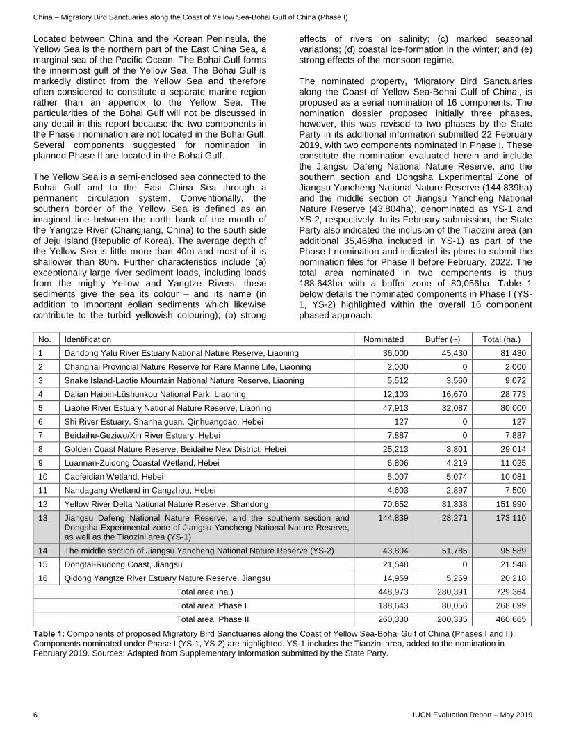
Located between China and the Korean Peninsula, the Yellow Sea is the northern part of the East China Sea, a marginal sea of the Pacific Ocean. The Bohai Gulf forms the innermost gulf of the Yellow Sea. The Bohai Gulf is markedly distinct from the Yellow Sea and therefore often considered to constitute a separate marine region rather than an appendix to the Yellow Sea. The particularities of the Bohai Gulf will not be discussed in any detail in this report because the two components in the Phase I nomination are not located in the Bohai Gulf. Several components suggested for nomination in planned Phase II are located in the Bohai Gulf. The Yellow Sea is a semi-enclosed sea connected to the Bohai Gulf and to the East China Sea through a permanent circulation system. Conventionally, the southern border of the Yellow Sea is defined as an imagined line between the north bank of the mouth of the Yangtze River (Changjiang, China) to the south side of Jeju Island (Republic of Korea). The average depth of the Yellow Sea is little more than 40m and most of it is shallower than 80m. Further characteristics include (a) exceptionally large river sediment loads, including loads from the mighty Yellow and Yangtze Rivers; these sediments give the sea its colour – and its name (in addition to important eolian sediments which likewise contribute to the turbid yellowish colouring); (b) strong
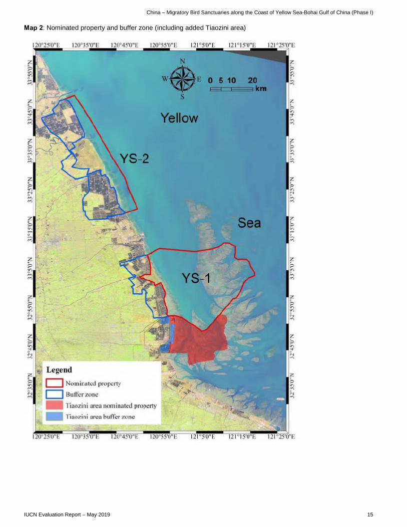
effects of rivers on salinity; (c) marked seasonal variations; (d) coastal ice-formation in the winter; and (e) strong effects of the monsoon regime. The nominated property, ‘Migratory Bird Sanctuaries along the Coast of Yellow Sea-Bohai Gulf of China’, is proposed as a serial nomination of 16 components. The nomination dossier proposed initially three phases, however, this was revised to two phases by the State Party in its additional information submitted 22 February 2019, with two components nominated in Phase I. These constitute the nomination evaluated herein and include the Jiangsu Dafeng National Nature Reserve, and the southern section and Dongsha Experimental Zone of Jiangsu Yancheng National Nature Reserve (144,839ha) and the middle section of Jiangsu Yancheng National Nature Reserve (43,804ha), denominated as YS-1 and YS-2, respectively. In its February submission, the State Party also indicated the inclusion of the Tiaozini area (an additional 35,469ha included in YS-1) as part of the Phase I nomination and indicated its plans to submit the nomination files for Phase II before February, 2022. The total area nominated in two components is thus 188,643ha with a buffer zone of 80,056ha. Table 1 below details the nominated components in Phase I (YS-1, YS-2) highlighted within the overall 16 component phased approach.
No. Identification Nominated Buffer (~) Total (ha.) 1 Dandong Yalu River Estuary National Nature Reserve, Liaoning 36,000 45,430 81,430 2 Changhai Provincial Nature Reserve for Rare Marine Life, Liaoning 2,000 0 2,000 3 Snake Island-Laotie Mountain National Nature Reserve, Liaoning 5,512 3,560 9,072 4 Dalian Haibin-Lüshunkou National Park, Liaoning 12,103 16,670 28,773 5 Liaohe River Estuary National Nature Reserve, Liaoning 47,913 32,087 80,000 6 Shi River Estuary, Shanhaiguan, Qinhuangdao, Hebei 127 0 127 7 Beidaihe-Geziwo/Xin River Estuary, Hebei 7,887 0 7,887 8 Golden Coast Nature Reserve, Beidaihe New District, Hebei 25,213 3,801 29,014 9 Luannan-Zuidong Coastal Wetland, Hebei 6,806 4,219 11,025 10 Caofeidian Wetland, Hebei 5,007 5,074 10,081 11 Nandagang Wetland in Cangzhou, Hebei 4,603 2,897 7,500 12 Yellow River Delta National Nature Reserve, Shandong 70,652 81,338 151,990 13 Jiangsu Dafeng National Nature Reserve, and the southern section and
Dongsha Experimental zone of Jiangsu Yancheng National Nature Reserve, as well as the Tiaozini area (YS-1)
144,839 28,271 173,110
14 The middle section of Jiangsu Yancheng National Nature Reserve (YS-2) 43,804 51,785 95,589 15 Dongtai-Rudong Coast, Jiangsu 21,548 0 21,548 16 Qidong Yangtze River Estuary Nature Reserve, Jiangsu 14,959 5,259 20,218 Total area (ha.) 448,973 280,391 729,364 Total area, Phase I 188,643 80,056 268,699 Total area, Phase II 260,330 200,335 460,665
Table 1: Components of proposed Migratory Bird Sanctuaries along the Coast of Yellow Sea-Bohai Gulf of China (Phases I and II). Components nominated under Phase I (YS-1, YS-2) are highlighted. YS-1 includes the Tiaozini area, added to the nomination in February 2019. Sources: Adapted from Supplementary Information submitted by the State Party.

China – Migratory Bird Sanctuaries along the Coast of Yellow Sea-Bohai Gulf of China (Phase I)
IUCN Evaluation Report – May 2019 7
The current nomination of two components (denominated as YS-1 and YS-2) is a modest representation of a vast and complex overall system. The State Party has made a significant decision to expand YS-1 to include well-documented habitats of critical importance for bird conservation, namely the Tiaozini area adjacent to and just of south of YS-1 and likewise located in Jiangsu Province. The Yellow Sea (and the Bohai Gulf) boasts enormous tidal mudflats due to the combination of shallow water depth, gentle slopes, wide tidal range, marine currents and the above-mentioned large river systems permanently discharging vast amounts of sediments (Yellow River, Yangtze River, Yalu River, Liao River, Luan River, Hai River etc.). The intertidal mudflat system is often referred to as the world’s largest. The boundaries of YS-1 are mainly determined according to the typical vegetation zones in this area, as well as the marine and terrestrial habitat types, such as intertidal mudflats and radial sand ridges. The main part of this area is within the range of Jiangsu Dafeng National Nature Reserve and Jiangsu Yancheng National Nature Reserve. In terms of naturalness and intactness, the nominated areas are challenged due to the enormous pressures on the system. The overall ecosystem has lost much of its integrity due to the massive transformation, and partial destruction, of much of the coast of the Yellow Sea. The nominated areas continue to underpin the viability of the central hub of one of the world’s most important and arguably the world’s most fragile flyway, however, it is clear that larger areas and phased regional serial expansion would increase the integrity, as would coastal restoration efforts. The intertidal mudflats, marshes and shallow waters are exceptionally productive and provide spawning and nursery habitat for many fish and crustacean species, and as such are critically important for local livelihoods, including coastal and off-shore fisheries. They are also home to a high diversity of species from phytoplankton to marine mammals. The nomination dossier documents the use of the nominated property by 680 species of vertebrates, including 415 species of birds, 26 species of mammals, 9 species of amphibians, 14 species of reptiles, 216 species of fish, as well as 165 species of zoobenthos. Large aggregations of birds depend on the coast as a stop-over, moulting, staging, wintering, foraging or breeding grounds. The intertidal mudflats, in particular, attract a high diversity and enormous numbers of resident and migratory birds. The global importance of the wider area is illustrated in the designation of several Ramsar sites (Shuangtai Estuary, Dalian National Spotted Seal Nature Reserve, Shandong Yellow River Delta Wetland, Chongming Dongtan Nature Reserve / Shanghai, Dafeng National Nature Reserve, Shanghai Yangtze Estuarine Wetland Nature Reserve for Chinese Sturgeon), some of which fully or partially overlap with components of both proposed phases.
From a global conservation perspective, probably the most striking and visible conservation value of the intertidal and coastal systems is their major importance as an irreplaceable hub of the East Asia-Australasia Flyway (EAAF) (even though these depend on, and cannot be separated from, countless other features of the coastal-marine system and linked river systems). A wealth of literature leaves no doubt that the Yellow Sea and the Bohai Gulf play an indispensable role in the EAAF, a flyway linking bird populations of at least 21 countries. The literature similarly leaves no doubt that the EAAF is among the most threatened worldwide and boasts the largest number of Endangered and, in some cases, Critically Endangered species. The property supports seventeen IUCN Red List species: one Critically Endangered (Spoon-billed Sandpiper, Eurynorhynchus pygmeus); five Endangered (Black-faced Spoonbill, Platalea minor; Oriental Stork, Ciconia boyciana; Red-crowned Crane, Grus japonensis; Nordmann's Greenshank, Tringa guttifer; Great Knot, Calidris tenuirostris); five Vulnerable (Chinese Eegret, Egretta eulophotes; Dalmatian Pelican, Pelecanus crispus; Swan Goose, Anser cygnoides; Relict Gull, Larus relictus, Saunder's Gull, Larus saundersi) and several Near Threatened (Red Knot, Calidris canutus; Asian Dowitcher, Limnodromus semipalmatus; Black-tailed Godwit, Limosa limosa; Eurasian Curlew, Numenius arquata; Bar-tailed Godwit, Limosa lapponica; Reed Parrotbill (Paradoxornis heudei); Curlew Sandpiper, Calidris ferruginea; Greater Sand Plover, Charadrius leschenaultia; Lesser Sand Plover, Charadrius mongolus; Ruddy Turnstone, Arenaria interpres). According to the literature and expert input, three species in particular are believed to depend on the nominated areas, and areas adjacent to them, for their survival. These are Spoon-billed Sandpiper, Nordmann's Greenshank, Great Knot and the Far Eastern Curlew (Numenius madagascariensis). The Critically Endangered Chinese Crested-Tern (Thalasseus bernsteini) likewise critically depends on the coastal-marine system. While the status of the latter species does not appear to depend on the currently nominated area, Phase II components would add a layer of protection to key habitat needed to prevent imminent extinction of this species in the wild. The two nominated Phase I components are among the largest in the proposed overall serial property and have consistently emerged as key areas in several priority-setting exercises (e.g. Bai et al. 2015; Bamford et al. 2008; MacKinnon et al. 2012; Menxiu et al. 2012; Paulson Institute, 2016; Peng et al. 2017; Xia et al. 2017). 3. COMPARISONS WITH OTHER AREAS The nomination dossier highlights comparison with other coastal natural World Heritage properties or candidate

China – Migratory Bird Sanctuaries along the Coast of Yellow Sea-Bohai Gulf of China (Phase I)
8 IUCN Evaluation Report – May 2019
sites along the EAAF. It is argued that at present the Yellow Sea ecoregion does not have any coastal natural World Heritage properties and that the nomination would thus contribute to filling a gap. Comparison with inland World Heritage properties or candidate sites along the EAAF and featuring wetlands are likewise presented. The nominated property is compared to the Wadden Sea, a World Heritage property sharing several similarities. Comparable to the Yellow Sea, the Wadden Sea, shared by three countries (Denmark, Germany and the Netherlands), is likewise a large intertidal ecosystem. Both areas are critically important, integral parts of major bird migration flyways under high and multiple development pressures. The case for the nominated property’s OUV overwhelmingly emphasizes the importance of the region within a major flyway (key stopovers, wintering areas and breeding grounds, etc.). The particularities of the regional coastal-marine ecosystem are highlighted which set it apart from other seemingly similar coastal-marine areas, including the Wadden Sea. IUCN, in collaboration with UN Environment WCMC, has undertaken additional comparative analysis. With respect to criterion (ix), the nominated property is found in the largest intertidal wetland in the world, which is one of the most biologically diverse. It is located in the Yellow Sea Saline Meadow terrestrial ecoregion and the Yellow Sea marine ecoregion, which are not yet represented on the World Heritage List. It is also found in a marine priority ecoregion (Yellow Sea), which by contrast is already well represented. The site is found in the middle section of the EAAF, which is of global importance for migratory bird species. The Yancheng Wetlands, which are part of the property, are considered by several international conservation organisations as the most important migratory bird habitat along the Bohai Gulf-Yellow Sea coast, supporting a high number of migratory species, including threatened species that use the site for wintering, breeding or stop-overs on the EAAF. For example, the EAAF Partnership has ranked Jiangsu Yancheng National Nature Reserves (YS-2) as being among the top three of 1,030 key wetlands assessed in terms of bird species diversity. The nominated property is not found in a biogeographical unit that has been mentioned as a gap on the World Heritage List and does not overlap with any protected area considered to be amongst the most irreplaceable. However, it overlaps with Yangcheng Nature Reserve, which is also an IBA, and considered globally significant. The additional IUCN and WCMC analysis concludes quite clearly that the biodiversity that characterises this region is of global significance, based on spatial analysis and literature review, especially with regard to criterion (x). The globally significant values of the intertidal mudflats, marshes and shallow waters of the overall
Yellow Sea (and the Bohai Gulf) are well established through the body of scientific literature which exists for this part of the EAAF. These ecosystems and habitats are therefore critical to the viability of one of the planet’s most important bird migratory pathways. 4. INTEGRITY, PROTECTION AND MANAGEMENT 4.1. Protection The Phase I components are all state-owned and fully protected by law. Recent policy changes are supportive of coastal conservation viz “Ecological Red Lines” which the nomination notes have been designated by the Government of China, constituting a major part in the 35% natural coastline that the government has proposed to retain. Resource use and, in the coastal areas, access are severely restricted. Some fishing and harvesting rights are allocated to local resource users in shallow near-shore waters, including mudflats. It appears that most tourism is physically separated from the actual protected areas and is limited to visitor centres and a fenced area for breeding of the Milu Deer (Elaphurus davidianus, EX), a culturally important species subject to efforts to eventually re-establish this species in the wild. YS-1 and YS-2 have the protection status of National Nature Reserves (with the exception of the Tiaozini area). In addition, all public facilities and infrastructure are publicly owned and the control of natural resources is similarly publicly administered. Many national and provincial laws and regulations protect the nominated property. These include the Constitution of the People's Republic of China, the Environmental Protection Law, the Forest Law, the Marine Environment Protection Law and the Regulations on Nature Reserves, Regulations of Jiangsu Province on Wetland Protection and Tourism, etc. The Tiaozini area, a significant area of 35,469ha recently included in YS-1, comprises several different wetland parks and reserves, all protected by wetland regulations of 2013 and destined to become consolidated into Yancheng National Nature Reserve. IUCN notes, in the case of Tiaozini, this would effectively reverse an earlier excision from this protected area which enabled the land reclamation to take place. After the adjustment, there are five existing protected areas located in the current Phase I nomination which are Jiangsu Dafeng National Nature Reserve, Jiangsu Yancheng National Nature Reserve, Jiangsu Yancheng Tiaozini Municipal Wetland Park, Jiangsu Dongtai Gaoni Wetland Nature Reserve Plots and Jiangsu Dongtai Tiaozini Wetland Nature Reserve Plots. The State Party has confirmed in its supplementary information that all reclamations in the area have been halted.

China – Migratory Bird Sanctuaries along the Coast of Yellow Sea-Bohai Gulf of China (Phase I)
IUCN Evaluation Report – May 2019 9
IUCN notes significant concerns regarding system level coordination and management which are elaborated under sections 4.3 (Management) and 5.1 (Serial property considerations) and which call into question how a fully phased serial property would be adequately protected. IUCN considers that the protection status of the nominated property does not meet the requirements of the Operational Guidelines. 4.2 Boundaries The size and diversity of the YS-1 and YS-2 nominated component areas, when compared to the scale and diversity of the overall Yellow Sea ecosystem, is limited given the complexity of this system. It is not clear that the boundaries of these two components can and do incorporate all the attributes contributing to OUV, especially for migratory species. The two components of the nominated property include clear boundaries for adequate protection of birds when they are on-site. However, the nomination of Phase I has not demonstrated that the overall site configuration passes the tests of completeness and how this configuration provides for habitat linkage and supports ecological function. For example, more consideration of the linkages between the supratidal coast and the intertidal system would be desirable. Furthermore, a better understanding is needed of the resilience of the property to environmental stresses and threats, given the intense pressures for land reclamation and development on this coastline. The State Party provided additional information on the components proposed to complete this serial property. However, IUCN understands that precise boundaries for the full suite of components are still being finalized and details of these were therefore not provided in the dossier. IUCN, considers that this level of detail is required for a serial site nomination in order to critically assess OUV, in particular the complementarity and co-dependence of component attributes. Buffer zones have been clearly demarcated on the coast side of the two component parts of the nominated property. The buffer zones are under the protection of Yancheng National Nature Reserve and Jiangsu Dafeng National Nature Reserve. These areas are managed according to the regulations of National Nature Reserves. However, buffer zones do not exist for the eastern (marine) side of either of the components. The rationale for the lack of these buffer zones being that access is limited to boats due to sea currents. IUCN concludes that the boundaries, as currently designed, have not yet made the case as to completeness in terms of attributes contributing to OUV or how this configuration will ensure viable habitat linkages and ecosystem function. Furthermore, how ecological connectivity will be supported, so as to ensure
the property is resilient to stresses and threats, has not been proven. IUCN considers that the boundaries of the nominated property do not meet the requirements of the Operational Guidelines. 4.3 Management The nominated property is subject to a comprehensive array of planning instruments applying to provincial and municipal level development plans, and marine- terrestrial-, and individual protected areas. The planning documents that support governance and management in the nominated property include 5-year economic and social development plans at municipal and provincial levels; a biodiversity conservation strategy; an integrated water resources plan; and several ecological red line protected plans at provincial level. The nominated component areas have prepared a 'Master Plan of Yancheng National Nature Reserve (2008-2020)'; a 'Yancheng Wetland National Reserve Five Years Construction Management Plan in Jiangsu (2012-2017)'; and a 'Master Plan of Jiangsu Dafeng National Nature Reserve (2013-2022)'. The World Heritage Application and Management Office was established in the Yancheng Municipal People's Government to coordinate the nomination. On-site management continues with the management authorities of the two National Nature Reserves, wherein a unit responsible for the nomination has been established. According to the dossier, it is foreseen that in case of an inscription the nomination unit will be converted into a heritage management organization. Law enforcement is reported as effective on land and sea. There are 185 full-time staff in the nominated property (85 in Jiangsu Dafeng National Nature Reserve, and 100 in Jiangsu Yancheng National Nature Reserve, with an additional 15 staff in the Tiaozini wetland management office) in charge of patrol, law enforcement, research, monitoring, tourism and education. Important and ongoing research has been undertaken in the nominated areas in collaboration with academic institutions on a wide range of relevant topics, including impact assessment of ecological service functions of wetlands, research and prediction of sedimentation and coastline variations in Jiangsu. Monitoring takes place with leading roles for numerous academic institutions from within China and internationally. The EAAF Partnership provides an effective umbrella structure to support coordinated research and monitoring. Monitoring stations are well equipped with boats, vehicles including SUV and motorcycles, unmanned aerial vehicles, telescopes, GPS, law enforcement recorders, radar stations etc. The daily monitoring of selected mammal and bird species utilises the latest technology.

China – Migratory Bird Sanctuaries along the Coast of Yellow Sea-Bohai Gulf of China (Phase I)
10 IUCN Evaluation Report – May 2019
Financial investment by the authorities is increasing year by year, according to data in the dossier (see Table 2).
Year Jiangsu Yancheng NNR
Jiangsu Dafeng NNR Total
2012 5,415,900
(ca.800,523) 703,300
(ca.104,000) 6,119,200
(ca.904,700)
2013 5,776,110
(ca.853,800) 893,300
(ca.132,000) 6,669,400
(ca.985,800)
2014 6,167,800
(ca.911,700) 2,022,400
(ca.298,900) 8,190,200
(ca.1,210,600)
2015 6,428,500
(ca.950,300) 2,085,300
(ca.308,300) 8,513,800
(ca.1,258,600)
2016 6,845,400
(ca.1,258,600) 2,294,000
(ca.339,100) 9,139,400
(ca.1,351,000)
Table 2: Provincial funding by unit per year in RMB Yuan (USD). Source: nomination dossier Management of components YS-1 and YS-2 should not be considered in isolation. The efforts to better conserve, manage and restore the conservation values of the Yellow Sea and Bohai Gulf, particularly for migratory species, has obvious dimensions for transboundary and interregional cooperation. The dossier does not discuss transboundary management, nor coordination among Phase I and Phase II properties, which will be crucial to coordinate and harmonise management across the full serial property. What is needed is a more comprehensive approach at the system level bridging jurisdictions and sectors so as to eventually develop a functional protected area network within the Chinese jurisdiction with a vision of an eventual trans-national approach. Both the coordination within China and the international coordination are in its infancy and thus insufficient. IUCN considers that the management of the nominated property does not meet the requirements of the Operational Guidelines. 4.4 Community A potential World Heritage inscription would likely not result in any change in existing community participation and rights. Access to natural resources is already restricted as a function of the nature reserves and would not change were the site to be inscribed. The field evaluation mission was unable to detect tangible evidence of a meaningful role of local communities in decision-making. This view is backed up by references such as the GEF/ADB Management Effectiveness Evaluation Tracking Tool for China’s Wetland Protection System which concludes that local communities residing nearby identified a priority for increased consultation related to nature reserve management particularly involving crop damage and impacts on fisheries (geese on rice, herons, cormorants impacting fisheries etc.). Efforts should be directed to improving the engagement
of local people in decision making to foster a sense of stewardship of the nominated property. 4.5 Threats The nominated area has been strongly affected, directly and indirectly, by past and ongoing development both on land and in the sea. Recent policy shifts, advocacy, scientific evidence and international cooperation give rise to hope that the area’s global importance can be maintained and eventually even be consolidated. However, much of the challenge must be understood and framed as a restoration effort. The dramatic transformation of the Chinese part of the coast of the Yellow Sea and the Bohai Gulf over the last decades is likely to be among the most drastic examples of rapid coastal transformation anywhere in the world. A 2012 IUCN resolution states that the region is subject to an “unprecedentedly rapid rate of conversion of intertidal wetlands to other forms of land use in the EAAF (faster than the rate of tropical forest loss), thus generating an urgent need for specific research and cooperation for the restoration and management of these habitats”. The literature consistently singles out habitat loss due to large-scale land reclamation, i.e. conversion of coastal, shallow sea and intertidal areas to claim land for human use, in particular industrial projects, farming, aquaculture, industry, leisure and wind power development. The IUCN-facilitated Working Group for the Conservation of the Yellow/West Sea Intertidal and Associated Coastal Wetlands estimates that two-thirds of intertidal wetlands in the Yellow Sea have been lost in the past 50 years. This is in line with several comprehensive studies. Onshore and offshore wind power development is ubiquitous. The area is characterised by heavy marine traffic from and to major ports, creating some of the busiest sea routes in the world. The literature provides evidence of unsustainable fishing levels in the nominated area. Overharvesting of invertebrates (including within designated nature reserves) has resulted in major declines of some species. It is not known whether the harvesting of intertidal benthos is significantly affecting shorebirds. The Bohai Gulf in turn, anticipated in a Phase II extension, is known to contain major oil and gas reserves, and is subject to offshore production. The complete transformation of all major rivers (sediment loads, water quality and quantity, flow regimes etc.) is a major factor in altering the natural systems of the nominated property and its context. Invasive alien species include a cordgrass species, Spartina alterniflora, which originates from the Atlantic coast of North America. Following its deliberate introduction to China, the grass is now dominating large parts of the remaining marshes along the Yellow Sea coast. Climate change is a concern along the coast that in many ways may affect both the ecoregion and the complex EAAF.
China – Migratory Bird Sanctuaries along the Coast of Yellow Sea-Bohai Gulf of China (Phase I)
IUCN Evaluation Report – May 2019 11
In conclusion, IUCN considers that the property as nominated does not satisfy the conditions of integrity given that: With respect to criterion (ix) the nominated property is compromised due to upstream dams that have changed the course of the rivers. The diminished volume of sediments reaching the coast, land reclamation (and erosion), ports and infrastructure for development projects, and artificial wetlands and channels found in the buffer zone are all indications of the large modification of the natural processes. The boundaries and size of the components of the present Phase I nomination draw into question the capacity of the sites to allow long-term functioning of healthy ecological and biological processes. Concerning criterion (x), the combination of the small representation of the overall system (intertidal zone of the Yellow Sea) including the exclusion of other key habitats in the Jiangsu Province frequented by important and threatened intertidal waterbird species) and other non-intertidal or mudflat habitats, like natural marshes and wetlands, and the profound anthropogenic changes (land reclamation for infrastructure development) and threats (included climate change and invasive alien species) call the applicability into question. In the two components, many of the key habitats (marshlands and wetlands) for these bird species are not natural. The use by migratory birds of artificial marshes, intertidal areas, and wetlands increase the complexity of understanding if the site meets the integrity requirements. More consideration of the linkages between the supratidal coast and the intertidal system would be important. In addition, there is no connectivity between the two nominated components. Both areas were formerly part of one much larger protected area. In the nomination dossier, the two components are separated, in part because of the Dafeng Port Economic Area. Given the very high level of anthropogenic modification and pressures to radial sand ridges, and the very limited representation of the scale and diversity of the large system in the nomination (Phase I), the integrity can be considered marginal from an ecosystem perspective, but possibly acceptable from the narrow perspective of critical importance for bird migration. IUCN concludes that this can only be fully evaluated through the nomination of a single revised serial property which includes the full range of the components in order to reflect the natural wealth and diversity of the ecoregion. 5. ADDITIONAL COMMENTS 5.1 Consideration in relation to serial properties a) What is the justification for the serial approach? A serial approach is proposed in China due to the dispersed natural distribution and the anthropogenic fragmentation of the mudflats and other coastal
ecosystems. The intertidal system no longer exists as an uninterrupted system. A serial approach is the only practical option to protect critical natural habitat and functions across what is one integrated ecosystem. IUCN notes that the inclusion of all proposed phased components is considered necessary to fully justify the serial approach. b) Are the separate component parts of the nominated property functionally linked in relation to the requirements of the Operational Guidelines? The two nominated components of Phase I are directly linked in many ways. They were previously part of one much larger protected area. However, they are presented as two components due in part to the Dafeng Port and Marine Economic Development Zone between them. The nomination dossier is limited to Phase I so does not provide sufficient detail about the Phase II components to make a determination of functional linkages, nor to fully evaluate OUV. c) Is there an effective overall management framework for all the component parts of the nominated property? From a transboundary ecosystem perspective, the efforts to coherently manage the shared conservation values are in their infancy. Phase I involves only two components, both of which are under the same provincial and local jurisdictions. However, the full complement of an eventually much larger number of components will completely change the complexity and require coordination among numerous jurisdictions and institutions. As the nomination covers only Phase I at this stage, governance structures and management plans for all the component parts are not described. IUCN considers that given the clear intention to create a larger more complex serial site, the identification of clear mechanisms to ensure effective governance, coordination and integration will be a critical follow up need. 6. APPLICATION OF CRITERIA Migratory Bird Sanctuaries along the Coast of Yellow Sea-Bohai, Gulf of China (Phase I) has been nominated under natural criteria (ix) and (x). Criterion (ix): Ecosystems/communities and ecological/biological processes The dynamics of the intertidal mudflat system are impressive. Enormous amounts of river sediment discharge have been interacting for millennia with the ocean current to form intertidal mudflats and unique radial sand ridges. Many of the mudflat areas serving as bird foraging and resting areas are formed by sediments from the Tibetan Plateau thousands of kilometres away. The large-scale phenomenon is undoubtedly a globally outstanding example of a coastline and intertidal mudflat ecosystem with extraordinary wetland ecosystems that

China – Migratory Bird Sanctuaries along the Coast of Yellow Sea-Bohai Gulf of China (Phase I)
12 IUCN Evaluation Report – May 2019
have resulted from longstanding hydrological and geo-tectonic processes dating back to the Pleistocene. The two components of the property nominated as Phase I are located in a region where the river and marine ecosystems interact. These two components represent the typical characteristics of the coastal and marine ecosystems and their changes in landscape pattern, and highlight the evolution of their plant communities against the background of the exceptionally dynamic changes in the coastal landscape. At the same time, given that only a relatively small area of the overall Chinese system is currently being nominated, it is less than clear that it can per se be considered as an adequate representation at the process level. The combination of three factors—the small representation of the overall system at this stage, the profound anthropogenic changes that have already occurred, and the scale of pressures for further human uses—call the applicability of this criterion into question. However, a complete nomination of all components, together with documentation of and unambiguous commitment to ongoing and planned restoration, would have the potential to meet criterion (ix). IUCN considers that the property as currently nominated does not meet this criterion, however, a single revised nomination of the full range of the components of the proposed series as a whole has the potential to meet criterion (ix). Criterion (x): Biodiversity and threatened species The nomination dossier documents the use of the nominated property by 680 species of vertebrates, including 415 species of birds, 26 species of mammals, 9 species of amphibians, 14 species of reptiles, 216 species of fish, as well as 165 species of zoobenthos. The globally significant values of the full serial nomination relate to intertidal habitats that are part of the key stopover sites, wintering grounds or breeding grounds for some of the world’s most threatened bird species. The YS-1 component of the nomination is important for the critically endangered Spoon-billed Sandpiper, with only hundreds of individuals left in the world. Experts consulted link the very survival of the species to the fate of the nominated area, where almost the entire global population of the species roosts, feeds and molts in spring and autumn. According to supplementary information provided by the State Party, 80% of the population of the charismatic and culturally revered Red-crowned Crane winter in the nominated property. Nearly 20% has been found to winter in Shandong Yellow River Delta National Nature Reserve, proposed for Phase II. Furthermore, the EAAF Partnership has ranked Jiangsu Yancheng National Nature Reserves (YS-2) as being among the top three of 1,030 key wetlands assessed in terms of bird species diversity. Other noteworthy birds for which the nominated areas are critically important include Nordmann's Greenshank, the Great Knot, the
Far Eastern Curlew and the Reed Parrotbill (Paradoxornis heudei). However, while the nomination documents species occurrence at some of the component sites, little comparative population data is provided for the components proposed within the eventual full serial property. There is no doubt the intertidal zones of the Yellow Sea-Bohai Gulf are of global importance, especially for the congregation of many species of migratory birds that use the EAAF. However, significant uncertainty remains on what proportion of some of these populations are being hosted by components of Phase I compared to those of Phase II. For example, the Critically Endangered Chinese Crested-Tern depends on a different part of the coastline for its survival, which is far from the areas nominated under the current Phase I, and would benefit from a possible future nomination. The main question is whether the currently nominated areas are a sufficiently meaningful and viable representation of the much larger ecosystem. Thus, IUCN concludes that a complete nomination of all components, together with unambiguous commitment to and clear documentation of ongoing and planned restoration, would have the potential to meet criterion (x). IUCN considers that the property as currently nominated does not meet this criterion, however, a single revised nomination of the full range of the components of the proposed series as a whole has the potential to meet criterion (x). 7. RECOMMENDATIONS IUCN recommends that the World Heritage Committee adopt the following draft decision: The World Heritage Committee, 1. Having examined Documents WHC/19/43.COM/8B and WHC/19/43.COM/INF.8B2; 2. Defers the nomination of the Migratory Bird Sanctuaries along the Coast of Yellow Sea-Bohai Gulf of China (Phase I) (China) in order to allow the State Party to: a) Prepare a more comprehensive and detailed
overview and analysis of priority conservation areas in the Yellow Sea and Bohai Gulf, building upon the existing nomination and planned phases, fully taking into account ecosystem and habitat diversity of the coastal system, proposed boundaries, values (including species occurrence, abundance and conservation status), threats, integrity, protection and management;
b) Include in a single revised nomination the full range of the components of the proposed series as a whole, in order to reflect the natural wealth and diversity of the ecoregion and to meet integrity requirements;

China – Migratory Bird Sanctuaries along the Coast of Yellow Sea-Bohai Gulf of China (Phase I)
IUCN Evaluation Report – May 2019 13
c) Confirm, with appropriate support from peer-reviewed literature, the specific presence of the attributes of Outstanding Universal Value within the boundaries of the nominated property, including the presence and size of populations of any endemic and threatened species, and of globally significant migratory bird species;
d) Clearly demonstrate that the integrity of all natural attributes contributing to the stated Outstanding Universal Value can be conserved within each of the component parts of the series, and include a map indicating which areas of the nominated property are in a natural state, and which have been, or are being, restored;
e) Ensure that there are no unacceptable negative effects of development on the attributes of conservation significance in each of the components of the nominated property, including any negative effects of wind turbines, pollution (including noise pollution), land reclamation and infrastructure development; and
f) Provide evidence of more effective planning for the increasing tourism demand, including the development of appropriately scaled and low impact tourism in the nominated property.
3. Notes with appreciation the confirmed commitment demonstrated by the State Party and local authorities to protecting the Tiaozini area of the Yellow Sea, as an integral part of the proposed World Heritage nomination; 4. Strongly encourages the State Party to coordinate its plans for nominations with other State Parties in the EAAF, in relation to the potential for future transboundary serial nominations, and/or extensions, that more fully reflect the habitat needs and patterns of use of migratory birds across the wider Yellow Sea region.

China – Migratory Bird Sanctuaries along the Coast of Yellow Sea-Bohai Gulf of China (Phase I)
14 IUCN Evaluation Report – May 2019
Map 1: Location of the nominated property and the proposed 16 components of phased final nomination.
China – Migratory Bird Sanctuaries along the Coast of Yellow Sea-Bohai Gulf of China (Phase I)
IUCN Evaluation Report – May 2019 15
Map 2: Nominated property and buffer zone (including added Tiaozini area)


ASIA / PACIFIC
HYRCANIAN FORESTS ISLAMIC REPUBLIC OF IRAN
Landscape in Abr component – © IUCN / Hervé Lethier


Islamic Republic of Iran – Hyrcanian Forests
IUCN Evaluation Report – May 2019 19
WORLD HERITAGE NOMINATION – IUCN TECHNICAL EVALUATION
HYRCANIAN FORESTS (ISLAMIC REPUBLIC OF IRAN) – ID N° 1584
IUCN RECOMMENDATION TO WORLD HERITAGE COMMITTEE: To inscribe the property under natural criterion (ix). Key paragraphs of Operational Guidelines: Paragraph 77: Nominated property meets World Heritage criteria. Paragraph 78: Nominated property meets integrity, protection and management requirements. Background note: The Committee’s attention is drawn to Decision 30 COM 8B.24 on the nomination of the Hirkan Forests of Azerbaijan, Azerbaijan under, then, criterion (iv). In its decision the Committee deferred the nomination to allow the State Party to consider options for renominating the property as part of a transnational serial property with other Hirkanian forest areas in Iran. 1. DOCUMENTATION a) Date nomination received by IUCN: 25 March 2018. b) Additional information officially requested from and provided by the State Parties: Following the IUCN World Heritage Panel a progress report was sent to the State Party on 20 December 2018. This letter advised on the status of the evaluation process and sought responses/clarifications on a range of issues including the need to clarify the legal protection status of each one of the different component parts of the nominated property; to confirm which species are recorded inside the component parts of the nominated property; to provide clear maps indicating the current road network in or near the existing components, as well as maps indicating planned infrastructure; to confirm the status, plans and timeline to close the highway in the buffer zone between components 1 and 2 in Golestan National Park; to confirm the State Party’s commitment to complete an Environmental Impact Assessment for the upgrading of the road outside the nominated property, around the outer border of Golestan, which will replace the current highway; and to confirm the plans and timeline to develop a comprehensive plan for sustainable tourism in Golestan National Park. The State Party submitted additional information on 28 February 2019. c) Additional literature consulted: Various sources, including: Akhani, H., Djamali, M., Ghorbanalizadeh, A. & Ramezani, E. (2010). Plant biodiversity of Hyrcanian relict forests, N Iran: an overview of the flora, vegetation, palaeoecology and conservation. Pakistan Journal of Botany, 42 (Special Issue):231-258; BirdLife International. (2018). BirdLife Data Zone. Available at: http://datazone.birdlife.org/site/factsheet/ lisar-protected-area-iba-iran-islamic-republic-of (accessed in October 2018); Borhani., A. et al. (2010). ‘Diversity and distribution of macro fungi associated with beech forests of Northern Iran (case study Mazandaran Province)’, World Applied Sciences Journal. IDOSI, 11(2):151–158; CEPF (2018a). Caucasus - Species | CEPF. Available at:
https://www.cepf.net/our-work/biodiversity-hotspots/ caucasus/species (accessed in October 2018); CEPF (2018b). Irano-Anatolian | CEPF. Available at: https://www.cepf.net/our-work/biodiversity-hotspots/ irano-anatolian (accessed in October 2018); Ghoddousi A. et al. (2017). The decline of ungulate populations in Iranian protected areas calls for urgent action against poaching. Oryx:1-8; IUCN (2006). Technical Evaluation, Hirkan Forests of Azerbaijan (Azerbaijan) – ID No. 1212; Pour, M.J., Mohadjer, M.R., Etemad, V. & Zobeiri, M. (2012). Effects of grazing on natural regeneration of tree and herb species of Kheyroud forest in northern Iran, Journal of Forestry Research, 23(2):299−304; Müller, J. et al. (2005). Urwald relict species - Saproxylic beetles indicating structural qualities and habitat tradition. Waldökologie Online, 2:106-113; Naqinezhad, A., Moradi, H. & Zarezadeh, S. (2011). Plant diversity of Hyrcanian forests, N Iran, toward a vegetation classification; Sanei, A. & Zakaria, M. (2011). Distribution pattern of the Persian leopard (Panthera pardus saxicolor) in Iran. Asia Life Sciences (Suppl. 7):7-18; Scharnweber, T., Rietschel, M. & Manthey M. (2007). Degradation stages of the Hyrcanian forests in southern Azerbaijan, Archiv für Naturschutz und Landschaftsforschung, Institute of Botany und Landscape Ecology, Greifswald University; Schmitt, C.B., et al. (2009). Global Ecological Forest Classification and Forest Protected Area Gap Analysis Analyses and recommendations in view of the 10% target for forest protection under the Convention on Biological Diversity (CBD). Available at: https://www.cbd.int/forest/doc/forest-gap-analysis_ 2009_2nd ed.pdf (accessed in October 2018); Siadati, S. et al. (2010). Botanical diversity of Hyrcanian forests: a case study of a transect in the Kheyrud protected lowland mountain forests in northern Iran. 18:1-18; Sperber, G. (1999). Forstliche Reiseeindrücke aus dem Iran – Begegnung mit der Wiege unserer Wälder. In: Suda, M. et al.: Waldökosysteme und Schalenwild. Ökologischer Jagdverein, 92-135; Tohidifar, M. et al. (2016). Biodiversity of the Hyrcanian Forests. A synthesis report; Zarandian, A. et al. (2016). Anthropogenic Decline of Ecosystem Services Threatens the Integrity

Islamic Republic of Iran – Hyrcanian Forests
20 IUCN Evaluation Report – May 2019
of the Unique Hyrcanian (Caspian) Forests in Northern Iran. Forests, 7:51; Zare, H. et al. (2011). Eighteen mosses from the Hyrcanian forest region new to Iran. Journal of Bryology 33(1):62-65. d) Consultations: 9 desk reviews received. The mission met with a wide range of officials and stakeholders national and regional authorities, local municipalities and the civil society. Extensive consultation occurred with over 30 national, regional and local organizations and stakeholders; national, regional and local representatives from the 3 authorities responsible of the management of the site (Cultural Heritage, Handicrafts, and Tourism Organization/ICHHTO, Forests, Range and Watershed Management Organization/FRWO and Iranian Department of Environment (DoE); site managers of each of the nominated property’s 15 components; and local community representatives (Afratakteh, Partekoola, Rashi and Soost), as well as many villagers and local NGOs.
e) Field Visit: Susanna Lindeman and Hervé Lethier, 22-30 October 2018 f) Date of IUCN approval of this report: April 2019 2. SUMMARY OF NATURAL VALUES The nominated property is situated in the Caspian Hyrcanian mixed forests ecoregion (hereinafter referred to as the Hyrcanian Region), stretching 850 km along the southern coast of the Caspian Sea. This ecoregion belongs to the ecoregion complex Caucasus-Anatolian-Hyrcanian Temperate Forests, considered globally significant within WWF’s Global 200 priority ecoregions system. The Hyrcanian Forests form a green arc of forest, separated from the Caucasus to the west and from semi-desert areas to the east: a unique forested massif that extends from south-eastern Azerbaijan eastwards to the Golestan Province, in Iran. The Hyrcanian Region also includes non-forested rangelands above the timberline, as well as formerly forested lowland areas. The narrow coastal plains along the Caspian Sea are heavily degraded and almost entirely converted into cultivated lands, however, the forest ecosystems have so far been preserved at higher altitudes on both slopes of the Tallish and the Alborz Mountains. The nominated site is a serial site with 15 components (see Table 1), situated throughout the Hyrcanian Region from the northwest to east of Iran and covering two main ecotones from east to west and from low elevation to subalpine meadows. Totally, around 7% of the remaining Hyrcanian Forests in Iran (1,850,000 ha), has been included in the nomination. The components have been selected meticulously and they represent examples of the various stages and features of the Hyrcanian Forest ecosystems. One component (Kojoor, No. 10) is located on the coastal plain and includes a unique lowland forest ecosystem (swamp-forests). All other components are in higher altitudes, up to the treeline and sometimes include on their margins, subalpine and alpine ecosystems. A
considerable part of the site is inaccessible steep terrain, a fact supported by figures in the dossier claiming 51% of the site to be mountainous and 41% to be hilly. All components are surrounded by buffer zones and six of them (Nos. 1,2,3,4,8 and 9) are configured into 3 clusters with adjoining buffer zones.
Nr Component Core area (ha)
Buffer zone (ha)
1 Golestan (North) 17 873,2 64 300,8 2 Golestan (South) 10 658,1 3 Abr (East) 6 672,5 23 323,4 4 Abr (West) 10 991,1 5 Jahan Nama 11 339,7 26 862,8 6 Boola 17 516,5 12 344,2 7 Alimestan 394,3 846,0 8 Vaz (East) 2 218,2 3 720,2 9 Vaz (West) 4 692,4 10 Kojoor 14 891,8 9 628,5 11 ChaharBagh 6 886,4 2 663,8 12 Khoshk-e-Daran 214,5 39,1 13 Siahroud-e-Roudbar 11 197,4 15 897,4 14 Gasht Roudkhan 10 541,1 16 015,4 15 Lisar 3 397,6 1 487,4 Total area (ha) 129 484,7 177 128,8
Table 1: Nominated property components and buffer zone areas. The nominated property contains Arcto-Tertiary relicts from broad-leaved forests that 25-50 million years ago covered most parts of the Northern Temperate Zone. These huge forest areas retreated during Quaternary glaciations and later during milder climate, expanded and spread out from this refugia. It is considered as an origin for European broad-leaved forests and, due to this isolation, hosts many relict, endangered, regional and local endemic flora species giving the site and the whole Hyrcanian Region in general, important natural features and very high ecological values. The floristic biodiversity of the Hyrcanian Region is on a global level remarkable with over 3,200 vascular plants documented; about 44% of known vascular plants in Iran occurs in the Hyrcanian Region which covers only 7% of Iran’s territory, emphasizing the exceptional importance of this region for the protection of biodiversity. Approximately 280 taxa are endemic and sub-endemic for the Hyrcanian Region and about 500 plant species are Iranian endemics. A total of 80 native tree species have been documented here. Apart from this continuous forested belt shared between 3 provinces (Gilan, Mazandaran and Golestan), there are some smaller forests ecosystem rich in Hyrcanian species remaining in Azerbaijan and a few patches only with scrub forests in Turkmenistan. However, most ecological characteristics from this ecoregion are represented in the nominated property. Due of the extent of the forested ecosystems, the population size for many forest birds and mammals of the Hyrcanian Region is significant on national, regional and global scales. To date, 58 mammal

Islamic Republic of Iran – Hyrcanian Forests
IUCN Evaluation Report – May 2019 21
species and 180 birds typical for broadleaved temperate forests have been recorded in the Hyrcanian Region. Persian leopard (Panthera pardus saxicolor EN) and the wild goat (Capra aegagrus VU) are the most threatened and iconic mammals included on the IUCN Red List. Birds like the Steppe Eagle (Aquila nipalensis EN), European Turtle Dove (Streptopelia turtur VU), Eastern Imperial Eagle (Aquila heliaca VU), European Roller (Coracias garrulus LC) and Semicollared Flycatcher (Ficedula semitorquata NT) amongst many other species inscribed on the IUCN Red List, as well as the near-endemic Caspian Tit (Poecile hyrcanus LC) have also been observed in the region. 3. COMPARISONS WITH OTHER AREAS The nomination dossier included a comparative analysis which only partially justified the globally significant values of the nominated property. This analysis did not adequately provide data and arguments for the selection of the 15 components within the Hyrcanian ecoregion, a weakness due to gaps in the species data available for the property itself when compared to the wider Hyrcanian Region. Additional information provided by the State Party offered a convincing rationale for component selection based on forest type diversity and additional evidence was given of species records within the different components. However, IUCN considers this data is still not fully conclusive due to species data not being available in a detailed and comprehensive format. Additional spatial analysis and literature review undertaken by IUCN concludes clearly that the biodiversity that characterises the nominated property is of global significance. The nominated property overlaps with two terrestrial biodiversity hotspots (Caucasus and Irano-Anatolian) which are not well represented on the World Heritage List, with only one existing property within each; it is also found in a terrestrial priority ecoregion (Caucasus-Anatolian-Hyrcanian Temperate Forests), where only one site is found, and in the Hyrcanian Forests Centre of Plant Diversity which is not yet represented on the World Heritage List and has been identified as a gap. Furthermore the nominated property is situated in the terrestrial ecoregions (Caspian Hyrcanian Mixed Forests and Elburz Range Forest Steppe) which are also not currently represented on the World Heritage List. The Hyrcanian Forests overlaps with a protected area listed amongst the top 0.8% most irreplaceable in the world for the conservation of mammal, bird and amphibian species, and the top 0.9% in terms of threatened species. The Hyrcanian Forests hosts globally important examples of relic tree species and a high level of plant endemism. It contains a high proportion of species found in the two biodiversity hotspots where it is located. It has a high level of plant diversity compared to existing World Heritage forest sites found in the same biome. Notable mammal species include the globally threatened Persian leopard and Wild Goat. The site also overlaps with the Lisar Protected Area IBA.
With regards to criterion (ix) and, although it is nominated only for the Iranian part, the property does cover most environmental features and ecological values of the whole Hyrcanian Region. The most important and key environmental processes illustrating the genesis of those forests (e.g. succession, evolution, speciation) are still present and functioning at the site level. Although the components are separated from each other, there are still strong ecological connections between all components at the Hyrcanian forest region level (with an exception for the Khoshk-e-Daran component No. 12, which is an isolated swamp forest). This allows most species to roam across the whole forested massif. With regards to criterion (x), the components still include irreplaceable habitat refuge areas of Arcto-Tertiary forest elements in West Eurasia, which are key for the in-situ conservation of a great number of relic and endemic species of plants and animals of invaluable scientific and ecological importance. However, the effective presence of those species in the various components should in several cases be clarified by the State Party. The nominated property has potential to meet criterion (x) but there is a need to detail which species are found in which component of the nominated property to better understand the rationale for the inclusion of the existing 15 components under this criterion. 4. INTEGRITY, PROTECTION AND MANAGEMENT 4.1. Protection The State Party provided additional information outlining the legal protection of the nominated property as a whole given that the boundaries of the components do not align with legally protected areas. This confirmed that every component is strictly protected by national legislation (Nature Conservation and/or Forest Acts), wherever it is inside or partially outside existing protected areas. Public access and utilization of the area is legally regulated in all components; logging, grazing, hunting, vehicle traffic and most other uses and activities that may potentially impact the property are forbidden or strictly regulated. However, there is a strong need for a more strict and operational enforcement of the existing regulations as the nominated property shows evidence of past and current impacts from uses such as seasonal grazing and wood collecting which are, in theory, strictly forbidden. The State Party is encouraged to work collaboratively with local people to sustainably regulate grazing activities and seasonal/permanent settlements within all component parts, and minimize discernible negative impacts from grazing within the buffer zones. Consideration should be given to removing current seasonal grazing and logging settlements, from all components, within a reasonable time, and to manage those located in the buffer zones so as the relevant uses and activities neither degrade further, directly and indirectly, the site’s integrity or threaten values. Priority should be given to Siaroudh-e-Roundbar (13), Gasht Roudkan

Islamic Republic of Iran – Hyrcanian Forests
22 IUCN Evaluation Report – May 2019
(14) and Kojoor (10) components, where anthropogenic pressure seems to be the highest. All components are functionally linked through the shared evolutionary history of the Caspian Hyrcanian Mixed Forest ecoregion and most have good ecological connectivity through the almost continuous forest belt in the whole Hyrcanian forest region, Khoshk-e-Daran (12), being the only one isolated as a result of human settlements and agriculture, but important to retain in the nominated priority due to it protecting a very rare type of remnant ecosystem contributing to illustrate the high diversity of the Hyrcanian Forest. Species overlaps occur between the components which also complement each other with different species composition, depending on variations in climate, geology, soil type and elevation. IUCN considers that the protection status of the nominated property meets the requirements of the Operational Guidelines. 4.2 Boundaries The components’ boundaries and those of their buffer zones, are clearly defined on maps; in general, they use natural features such as rivers, ridges, ecotones. They exclude larger settlements and most degraded ecosystems and include the main ecotones and transition zones that contribute to the nominated property’s biodiversity interest, allow the natural evolution of the ecosystems and enhance resilience to climate change. In one case, Khoshk-e-Daran, the boundaries look rather artificial but the establishment of a larger component and/or buffer zone would be challenging, the surrounding lands being privately owned; since this swamp-forest remnant seemed to be in good ecological condition, implementing a sustainable agricultural management and monitoring program, at the watershed level, would be a more feasible and wise solution The site’s components overlap sometimes only partially the existing protected areas and their boundaries do not follow always those of these legally protected areas. The State Party indicated to the mission and intention to take the opportunity of the inscription on, the World Heritage List to improve the existing protected area boundaries so as to better include key values. IUCN recommends changes to the protected area boundaries to align with the property should it be inscribed. In all cases, the State Party should be urged to mark clearly the component’s boundaries on the ground. IUCN considers that the boundaries of the nominated property meet the requirements of the Operational Guidelines. 4.3 Management The management of the property’s components is under the responsibility of three national agencies, the Iranian Forests, Range, Watershed and Management Organization (FRWO), Department of Environment (DoE) and the Cultural Heritage, Handicrafts and
Tourism Organization (ICHHTO). The cooperation between these organizations is functioning well and the management structure and system established at the component’s level, appears to be satisfactory and meeting acceptable standards. A coordination mechanism has also been established across the whole serial property involving the three responsible institutions who have been engaged at all stages of the nomination process. This mechanism should guarantee full comprehensive management of the site in the future, based on a common view and funding. The mission were informed that each component already has a management plan; but was not able to check these plans and the status of each is unclear and when they will need to be updated. However, the whole management system as presented in the nomination dossier may be considered as satisfactory and meeting World Heritage requirements. A “master management plan” for the whole property is being prepared jointly by the responsible management institutions, in cooperation with Ministries, universities and NGOs. This management framework will be supervised by a National Steering Committee. The process and timetable for preparing this master management plan still needs to be clarified. It is important to note that the organizations mentioned above are also responsible for land-use and planning in the whole Hyrcanian Forest Region and they are very well aware of the importance of managing the whole region in a sustainable manner. An overall management plan “for sustainable development of rural areas” is already in place, targeting all villages in the Hyrcanian Region and reportedly adequately funded. Additional funding is promised by the State Party to be prioritized for the nominated property should it be inscribed on the World Heritage List. In the future, the State Party should target this funding toward village areas around the property components and to activities that address the main issues identified above, grazing, logging, traffic on roads, as well as sustainable tourism development, that might potentially threaten the site. For the future, the State Party should also be recommended to develop a monitoring program focused on the attributes of Outstanding Universal Value. It should also be urged to develop urgently, fund and implement a sustainable grazing management program/mechanism for the whole Hyrcanian forest region, with clear commitments to enforce regulations within the components and to minimize its potential impacts in buffer zones so as to sustain the site’s OUV. It should also be urged to complete the “Hyrcanian forest tourism plan” currently in progress; a substantive chapter of this plan should be dedicated to the Golestan National Park which is a key component of the nominated site for tourism. In addition a land use planning program should be developed around the Khoshk-e-Daran component, at the watershed level, fully compatible with the preservation of the ecological values and natural

Islamic Republic of Iran – Hyrcanian Forests
IUCN Evaluation Report – May 2019 23
processes of this component. The highway crossing the Golestan National Park is also recommend to be closed within 3 years, according to the planned timeline, and an EIA should be completed for up-grading the existing road outside this component, to replace the current highway. IUCN considers that the management of the nominated property meets the requirements of the Operational Guidelines. 4.4 Community The ethnicity of the population living in the buffer zones or nearby or, seasonally, within some components is not presented in the nomination dossier nor is there information provided on the consultation process with the local stakeholders. However, since the national organizations responsible for the nomination also have responsibility for regional and local level services, it looks evident, and was especially observed by the mission, that all levels of stakeholders have been involved in the process, including municipalities and local NGOs. The mission met with local community representatives (Afratakteh, Partekoola, Rashi and Soost), as well as many villagers and did not detect any opposition or misunderstanding regarding the nomination, although it is likely that the level of awareness regarding what World heritage means is limited. Similarly no evidence of rights violations were reported or observed by the field mission. The government started to relocate settlements and livestock from the Hyrcanian mountain range and forests to the central plain in the 1990s. It is understood that this involved a limited number of people and the mission did not detect any concerns from local people during the field visit. It is important to note that this earlier relocation was not undertaken due to the World Heritage nomination but as a response of the State Party to reduce human pressure on forests and to enhance a more sustainable development in the whole mountain area. Several reforms have also been implemented such as providing villages with gas, to make the rural population less dependent on fire wood and other natural forest resources. The impacts on local people caused by wildlife (wolf, bear and leopard) are also compensated by an insurance system which appears to be functioning well. 4.5 Threats The forest areas nominated are the remnants of very diverse types of forest ecosystems which characterize the whole Hyrcanian broadleaf forest however have been widely degraded over time in the region and are currently under high and growing pressure. This Hyrcanian Forest is more and more fragmented. The 15 components selected and which are strictly protected are the mostly difficult to access and have been selected as the best and sometimes unique existing samples of this relict forest. Whilst the integrity of some components or parts of them may have
suffered from past use impacts are considered reversible, thanks to the forest resilience and to more recent decisions taken by the State Party to reduce human pressure on the forest. Overall the nominated property’s value has not been compromised and the natural processes remain functional. Similarly, no key species characteristic from the region, is known to have disappeared irreparably, to date, because of these degradations. In summary, the main potential threats identified for the Hyrcanian Forests include unsustainable grazing within the components and overgrazing in their buffer zones; illegal logging and deadwood collection; an unregulated access system with vehicle traffic on forest roads; poaching; and unsustainable tourism. Climate change may also be noted as a potential threat, for example, through changes in precipitation and cloud cover patterns. In conclusion, IUCN considers that the integrity, protection and management status of the nominated property meets the requirements of the Operational Guidelines, however, law enforcement within the site’s components should be improved drastically, especially regarding the collection of forest products and grazing activities. All asphalted and unsealed roads should also be closed physically at the entrance of each component, and vehicle traffic on those roads should be strictly limited to the site’s management and research activities, as well as in case of emergency. 5. ADDITIONAL COMMENTS 5.1 Consideration in relation to serial properties a) What is the justification for the serial approach? A serial approach is necessary to relate all the story of the Hyrcanian broadleaf forest which spreads over around one thousand kilometers from the border of Azerbaijan to the west, to the eastern limit of Iran. This is the only way to tell the story of this very wide forest mountain range and its ecotones, from semi-desertic areas to swamp forests and from sea level to the upper limit of the treeline. This serial approach is also desirable to illustrate all environmental processes which drive evolutionary processes temporally and spatially. The components selected encompass the widest array of ecosystems and species habitats illustrating the main biodiversity features and assets that can be met in the whole Hyrcanian Forest. A serial approach is thus fully justified and consistent with past World Heritage Committee decisions (Decision 30 COM 8B.24). IUCN recommends that a finite serial site for the Hyrcanian Forest be created through future extension to other areas located in Azerbaijan. b) Are the separate component parts of the nominated property functionally linked in relation to the requirements of the Operational Guidelines? As stated above, all components - except Khoshk-e-Daran - may be considered as ecologically interconnected. The key ecosystems and their distribution are still widely spread over the whole forest
Islamic Republic of Iran – Hyrcanian Forests
24 IUCN Evaluation Report – May 2019
range and represented in the nominated serial property. Thus, the ecological processes which underpin the claims under criterion (ix) are still working, however, these processes could be improved with enhanced and coordinated protection and management. c) Is there an effective overall management framework for all the component parts of the nominated property? As noted above, a Master Management Plan for the whole property is in preparation. Furthermore, the management of the nominated property will be supervised by a National Steering Committee with members from all reasonable management institutions, Ministries and UNESCO’s National Delegation in Iran. 6. APPLICATION OF CRITERIA The Hyrcanian Forests have been nominated under natural criteria (ix) and (x). Criterion (ix): Ecosystems/communities and ecological/biological processes The nominated property represents a remarkable series of sites conserving the natural forest ecosystems of the Hyrcanian Region. Its component parts contain exceptional broad-leaved forests with a history dating back 25 - 50 million years ago, when such forests covered most parts of the Northern Temperate region. These huge ancient forest areas retreated during Quaternary glaciations and later, during milder climate periods, expanded again from these refugia. The nominated property covers most environmental features and ecological values of the Hyrcanian Region and represents the most important and key environmental processes illustrating the genesis of those forests, including succession, evolution and speciation. The floristic biodiversity of the Hyrcanian region is remarkable at the global level with over 3,200 vascular plants documented. Due to its isolation, the nominated property hosts many relict, endangered, and regionally and locally endemic plant species, contributing to the ecological significance of the property, and the Hyrcanian Region in general. Approximately 280 taxa are endemic and sub-endemic for the Hyrcanian Region and about 500 plant species are Iranian endemics. The ecosystems of the nominated property support populations of many forest birds and mammals of the Hyrcanian Region which are significant on national, regional and global scales. To date, 180 species of birds typical of broadleaved temperate forests have been recorded in the Hyrcanian Region including Steppe Eagle, European Turtle Dove, Eastern Imperial Eagle, European Roller, Semicollared Flycatcher and Caspian Tit. Some 58 mammal species have been recorded across the region, including the iconic Persian Leopard and the threatened wild goat. IUCN considers that the nominated property meets this criterion.
Criterion (x): Biodiversity and threatened species The Hyrcanian Region is a typical Arcto-Tertiary relict area with a high diversity of plant species, many of them threatened and/or endemic including species such as Zelkova carpinifolia, Parrotia persica and Pterocarya fraxinifolia amongst many others. The importance of the wider region for fauna is also very strong and well documented. The presence of Persian Leopard is of the highest importance; this leopard population is considered as the source population of this species and the larger Hyrcanian forested massif is the only area worldwide where a population of that species can be seen as viable according to the IUCN criteria. Several components host amongst the highest densities of the Persian Leopard and play a key role for its long-term viability; this is also the case for several other species. However, species data remains patchy and inconclusive as to the occurrence of these species within the nominated property as configured. IUCN therefore concludes that whilst the wider Hyrcanian Region has demonstrable global habitat significance it is not possible to conclude that property meets criterion (x) at this time. IUCN considers that the nominated property has the potential to meet this criterion; however, further information and data are needed to clarify which species are or are not present in each component and strengthen the case under this criterion. 7. RECOMMENDATIONS IUCN recommends that the World Heritage Committee adopts the following draft decision: The World Heritage Committee, 1. Having examined Documents WHC/19/43.COM/8B and WHC/19/43.COM/INF.8B2; 2. Recalling Decision 30 COM 8B.24; 3. Inscribes the Hyrcanian Forests (Islamic Republic of Iran) on the World Heritage List on the basis of criterion (ix); 4. Adopts the following Statement of Outstanding Universal Value: Brief synthesis The Hyrcanian Forests form a green arc of forest, separated from the Caucasus to the west and from semi-desert areas to the east: a unique forested massif that extends from south-eastern Azerbaijan eastwards to the Golestan Province, in Iran. The Hyrcanian Forests World Heritage property is situated in Iran, within the Caspian Hyrcanian mixed forests ecoregion. It stretches 850 km along the southern coast of the Caspian Sea and covers around 7 % of the remaining Hyrcanian forests in Iran. The property is a serial site with 15 component parts shared across three Provinces (Gilan, Mazandaran
Islamic Republic of Iran – Hyrcanian Forests
IUCN Evaluation Report – May 2019 25
and Golestan) and represents examples of the various stages and features of Hyrcanian forest ecosystems. Most of the ecological characteristics which characterize the Caspian Hyrcanian mixed forests are represented in the property. A considerable part of the property is in inaccessible steep terrain. The property contains exceptional and ancient broad-leaved forests which were formerly much more extensive however, retreated during periods of glaciation and later expanded under milder climatic conditions. Due to this isolation, the property hosts many relict, endangered, and regionally and locally endemic species of flora, contributing to the high ecological value of the property and the Hyrcanian region in general. Criteria Criterion (ix) The property represents a remarkable series of sites conserving the natural forest ecosystems of the Hyrcanian Region. Its component parts contain exceptional broad-leaved forests with a history dating back 25 - 50 million years ago, when such forests covered most parts of the Northern Temperate region. These huge ancient forest areas retreated during Quaternary glaciations and later, during milder climate periods, expanded again from these refugia. The property covers most environmental features and ecological values of the Hyrcanian Region and represents the most important and key environmental processes illustrating the genesis of those forests, including succession, evolution and speciation. The floristic biodiversity of the Hyrcanian region is remarkable at the global level with over 3,200 vascular plants documented. Due to its isolation, the property hosts many relict, endangered, and regionally and locally endemic plant species, contributing to the ecological significance of the property, and the Hyrcanian Region in general. Approximately 280 taxa are endemic and sub-endemic for the Hyrcanian Region and about 500 plant species are Iranian endemics. The ecosystems of the property support populations of many forest birds and mammals of the Hyrcanian Region which are significant on national, regional and global scales. To date, 180 species of birds typical of broadleaved temperate forests have been recorded in the Hyrcanian Region including Steppe Eagle, European Turtle Dove, Eastern Imperial Eagle, European Roller, Semicollared Flycatcher and Caspian Tit. Some 58 mammal species have been recorded across the region, including the iconic Persian Leopard and the threatened wild goat. Integrity The component parts of the property are functionally linked through the shared evolutionary history of the Caspian Hyrcanian mixed forest ecoregion and most have good ecological connectivity through the almost continuous forest belt in the whole Hyrcanian forest region. Khoshk-e-Daran, is the only component that is isolated, however it still benefits from a high level of intactness and contributes to the overall value of the series. Each component part contributes distinctively
to the property’s Outstanding Universal Value and the components together sustain the long-term viability of the key species and ecosystems represented across the Hyrcanian region, as well as the evolutionary processes which continue to shape these forests over time. Several component parts have suffered in the past from lack of legal protection, and continue to be negatively impacted to some extent by seasonal grazing and wood collection. The sustainable management of these uses is a critical issue for the long-term preservation of the site’s integrity and it will require strong ongoing attention by the State Party. Protection and management requirements All component parts of the property are state owned and strictly protected by national legislation. In the case of protected areas through the Nature Conservation Law and for areas outside of the protected areas by Iran’s Heritage Law. It will be important to align the boundaries of the existing protected areas to those of the property following inscription on the World heritage List so as to harmonize and streamline the management and protection regime across the site as a whole. The management of the property’s components is under the responsibility of three national agencies, the Iranian Forests, Range, Watershed and Management Organization (FRWO), Department of Environment (DoE) and the Cultural Heritage, Handicrafts and Tourism Organization (ICHHTO). A National Steering Committee is in place to ensure coordination across the series as a whole. This mechanism will need to be maintained in order to guarantee comprehensive management of the site into the future, based on a common vision and supported by adequate funding. Each component part has a management plan however, a “Master Management Plan” for the whole property is also a long term requirement. The national and component specific plans should be maintained, developed and updated regularly together by the responsible management institutions, in cooperation with ministries, universities and NGOs. Public access and use of the area is legally regulated and logging, grazing, hunting and most other uses that may potentially impact the property are strictly prohibited within all component parts. Vehicle access and other uses and activities that may potentially impact the property are also either forbidden or strictly regulated. However, enforcement of access and use regulations is not always effective and requires strengthening. Particular attention is required to maintain and enhance where possible, ecological connectivity between components and to ensure effective regulation of seasonal grazing and wood collection. 5. Takes note of the potential for this property to also meet criterion (x), and recommends the State Party undertake significant further work to complete species inventories and confirm species composition and population conservation status within each of the components, and to consider submitting a

Islamic Republic of Iran – Hyrcanian Forests
26 IUCN Evaluation Report – May 2019
renomination of the property if the further studies confirm the relevant values are sufficient to meet criterion (x). 6. Requests the State Party to align the boundaries of the existing protected areas to those of the World Heritage property in the near future in order to harmonize and streamline the management and protection regime across the site as a whole. 7. Also requests the State Party to adopt fully the Master Management Plan for the property as a whole by 2022, and to assure adequate funding is provided, and that comprehensive and detailed measures are in place to: a) Foster collaborative and participatory approaches
to managing the property which respect rights, traditional practices and customs;
b) Work collaboratively with local people to sustainably regulate grazing activities and seasonal/permanent settlements within all component parts, and minimize discernible negative impacts from grazing within the buffer zones;
c) Develop a comprehensive plan on sustainable
tourism for the property as a whole, especially in the Golestan National Park, including options to improve access as a means to develop ecologically sustainable tourism;
d) Rationalize the forest road access system within all components to strictly limit vehicular access to site management activities, research and emergency responses.
8. Further requests the State Party to prepare an Environmental Impact Assessment (EIA), consistent with the guidance of the IUCN Advice Note on World Heritage Environmental Assessment, on the proposed upgrading of the existing road in the Golestan National Park with a view to replacing the existing highway, and to provide a copy of this EIA for review by the World Heritage Centre and IUCN on completion, and prior to any decision to proceed with road upgrading. 9. Encourages the States Parties of Iran and Azerbaijan to consider options for further serial and transboundary extension of the property to include other areas in Azerbaijan of internationally significant conservation value, taking into account World Heritage Committee Decision 30COM 8B.24.

Islamic Republic of Iran – Hyrcanian Forests
IUCN Evaluation Report – May 2019 27
Map 1: Location of the nominated property
Map 2: Nominated property and buffer zone


EUROPE / NORTH AMERICA
FRENCH AUSTRAL LANDS AND SEAS FRANCE
Southern Rockhopper (Eudyptes chrysocome) on Crozet Island © IUCN / Wendy Strahm


France – French Austral Lands and Seas
IUCN Evaluation Report – May 2019 31
WORLD HERITAGE NOMINATION – IUCN TECHNICAL EVALUATION
FRENCH AUSTRAL LANDS AND SEAS (FRANCE) – ID N° 1603
IUCN RECOMMENDATION TO WORLD HERITAGE COMMITTEE: To inscribe the property under natural criteria. Key paragraphs of Operational Guidelines: Paragraph 77: Nominated property meets World Heritage criteria. Paragraph 78: Nominated property meets integrity, protection and management requirements. 1. DOCUMENTATION a) Date nomination received by IUCN: March 2018 b) Additional information officially requested from and provided by the State Party: Following the IUCN World Heritage Panel a progress report was sent to the State Party on 20 December 2018. This letter advised on the status of the evaluation process and sought responses/clarifications on a number of matters related to tourism planning and management; alien invasive species status and management; status of King Penguin populations; and clarifications regarding the area of the nominated property. A formal response from the State Party to the issues raised in the progress report was received in February 2019. c) Additional literature consulted: Various sources, including: Chapuis, J.-L. & Arnaud, B.G. (1995). Restauration d’îles de l’archipel de Kerguelen par éradication du lapin (Oryctolagus cuniculus) : méthode d’intervention appliquée à l’île Verte. Rev. Ecol. (Terre Vie), 50:377-390; Chapuis, J.L., Frenot, Y. & Lebouvier, M. (2002). Une gamme d’îles de référence, un atout majeur pour l’évaluation de programmes de restauration dans l’archipel de Kerguelen. Rev. Ecol. (Terre Vie, supplément), 9:121-130; Chapuis, J.L., Frenot, V. & Lebouvier, M. (2004). Recovery of native plant communities after eradication of rabbits from the subantarctic Kerguelen Islands, and influence of climate change. Biological Conservation, 117:167–179; Chapuis, J.L., Le Roux, V., Asseline, J., Lefèvre, L. & Kerleau, F. (2001). Eradication of rabbits (Oryctolagus cuniculus) by poisoning on three islands of the subantarctic Kerguelen 15 Archipelago. Wildlife Research, 28:323–331; Hureau, J.C. (2011). Marine Research on the Kerguelen Plateau: from early scientific expeditions to current surveys under the CCAMLR objectives. The Kerguelen Plateau: marine ecosystem and fisheries. 5-13; TAFF (2017). Amélioration des connaissances sur le rat noir à Kerguelen. In: Bilan d’activités 2016 de la réserve naturelle des Terres australes françaises. Terres australes et antarctiques françaises, 39; TAFF (2017). Etat des lieux initial flore/oiseaux/mammifères introduits : prérequis à l’élimination des rongeurs des îlots Colbeck, Kerguelen. In: Bilan d’activités 2016 de la réserve naturelle des Terres australes françaises. Terres australes et antarctiques françaises. 41; Tixier, P., Gasco, N., Duhamel, G. & Guinet, C. (2016). Depredation of Patagonian toothfish (Dissostichus eleginoides) by two sympatrically occurring killer whale (Orcinus orca) ecotypes: Insights on the behavior of
the rarely observed type D killer whales. Marine Mammal Science, 32(3):983-1003; Weimerskirch, H., Le Bouard, F., Ryan, P.G. & Bost, C.A. (2018). Massive decline of the world’s largest king penguin colony at Ile aux Cochons, Crozet. Antarctic Science, 30(4):236-242. d) Consultations: 7 desk reviews received. The mission met with the Prefect and Secretary-General of the French Austral and Antarctic Territories (TAAF), Reserve Director and Head of Environment for TAAF, Three District heads for each island cluster, licensed commercial fishing boat operators, Captain of the navy frigate patrolling the economic fishing zone, President and members of Scientific and Management Committees for reserve, Director of the French Polar Institute and over 100 scientists, military personnel and reserve staff working and living for up to a year in the nominated property and 11 tourists on ship. IUCN notes this evaluation involved an exceptional month long mission voyage, and wishes to record its thanks to the evaluators for their exceptional commitment to this mission, as well as the Captain and crew of the Marion Dufresne and all involved in the evaluation. e) Field Visit: Wendy Strahm, Anjara Saloma, 30 October – 30 November 2018 f) Date of IUCN approval of this report: April 2019 2. SUMMARY OF NATURAL VALUES The French Austral Lands and Seas (Terres et mers australes françaises), a serial property covering a vast 67,297,900 ha, is composed of a collection of extremely isolated volcanic islands of diverse size and history located in two biogeographic zones, situated between 37°-50°S. The Crozet Archipelago, consisting of five main islands, and the glaciated and highly dissected Kerguelen, which consists of the main island plus more than 60 small islands, are situated in the sub-Antarctic zone. The islands of Amsterdam and St Paul are in the cool-temperate zone. Table 1 details the three serial components of nominated property including terrestrial and marine areas.

France – French Austral Lands and Seas
32 IUCN Evaluation Report – May 2019
Terrestrial (ha) Marine (ha) Total (ha) Crozet Archipelago
34,800 25,543,600 25,578,400
Ile de la Possession
~14,907
Ile de l’Est ~12,580 Ilôts des Apôtres
~259
Ile aux Cochons
~6,682
Ile des Pingouins
~335
Kerguelen Islands
726,000 38,982,000 39,708,000
Amsterdam and St Paul Islands
6,000 2,004,500 2,010,500
Total (ha): 766,900 66,530,100 67,297,900 Table 1: The three serial components of the nominated property The islands house many areas of stunning natural beauty including steep eroded cliffs with many geological features including the emblematic “Arch of Kerguelen”, dramatic glacial fjords and mountains, and volcanic calderas. The abrupt cliffs, on which huge colonies of albatrosses breed, the shores with impressive colonies of penguins and seals, large flocks of small petrels and prions congregating in white clouds over the sea, and the massive, pristine sphagnum bogs dotted with nests of the rarest albatross in the world are truly superlative and of global significance. In addition, the nominated property includes some islands on which people have never set foot, making them some of the last untouched wilderness of the planet. Due to the extreme isolation of these islands, their position between the polar and subtropical convergence, and exceptionally low human impact, the sea is particularly rich in pelagic species, providing rich trophic resources for seabirds and mammals, which congregate in their thousands on the islands. The large size of the nominated property and wide bathymetric range allows ecological processes to continue naturally (not taking into account human-induced climate change). This has produced an important richness of marine species, including an endemic subspecies of dolphin in the region. While the flora, due to distance from any continent and climate, is depauperate, eight of the 36 species of higher plants native to the islands are endemic. At least four species of birds are endemic, plus three other species endemic at a regional level. Similarly, a number of invertebrates are endemic and present interesting adaptations to extreme wind conditions and the absence of predators: some species of moth and flies have lost all or most of their wings. For such isolated islands, these evolutionary adaptations to extreme conditions are outstanding examples at a global level. The nominated property protects one of, if not the greatest global concentrations of seabirds with more than 50 million birds, including the largest population of King Penguins (Aptenodytes patagonicus, LC) and Yellow-nosed Albatrosses (Thalassarche carteri, EN) in the world. Threatened and endemic species include Eaton’s Pintail (Anas eatoni, VU), MacGillivray's Prion
(Pachyptila macgillivrayi, EN) and the emblematic Amsterdam Albatross (Diomedea amsterdamensis, EN). Eight species of albatross, of which six are considered globally threatened, and six species of penguin, of which three are considered globally threatened, breed in the nominated property. In addition, the nominated property hosts the second largest population of Elephant Seal (Mirounga leonine, LC) and the third largest population of Antarctic Fur Seal (Arctocephalus gazelle, LC) in the world. In terms of biodiversity and conservation importance for threatened species, the nominated property is clearly of global significance. One third of the nature reserve area (both marine and terrestrial) is highly protected (IUCN protected area Categories Ia and Ib), with some islands, such as the Apôtres and Ile des Pingouins of Crozet and the Ile de l’Ouest, Nuageuses and Leygues Islands of Kerguelen, essentially pristine. The remaining terrestrial portion of the nominated property falls under IUCN Category IV, and the remaining marine area under Category VI. 3. COMPARISONS WITH OTHER AREAS In addition to the excellent comparative information in the nomination, UN Environment-WCMC and IUCN investigated further the basis for application of the biodiversity criteria. In relation to criterion (ix), the nominated property does not overlap with any broad scale global conservation priority, however, it is found in three marine ecoregions which are not yet represented on the World Heritage List, and its (small) terrestrial area is found in a terrestrial ecoregion, which is currently only represented by one site. It is representative of the unique biodiversity found in Southern territories. In particular, the Crozet and Kerguelen Islands host one of the most diverse and abundant population of seabirds of the Southern Ocean, including globally important populations of penguins, albatross and petrels. In terms of criterion (x), in addition to containing one of the highest concentrations and diversity of seabirds in the world, the site also has a very rich diversity of marine mammals, which includes significant populations of elephant seal and subantarctic fur seal. Compared to other existing sub-Antarctic sites, the nominated property shows a high level of bird and mammal diversity. The world’s largest rookery of King Penguins is found within the nominated property. The The French Austral Lands and Seas also hosts several threatened species, including the Northern rockhopper penguin (Eudyptes moseleyi, EN), macaroni penguin (Eudyptes chrysolophus, VU) and various albatross species (including the only site where the Endangered Amsterdam Albatross breeds) and other seabirds (including 80% of the world population of Salvin’s Prion (Pachyptila salvini, LC)). Finally, the nominated property comprises one Alliance for Zero Extinction (AZE) site and overlaps with as many as 17 International Bird Areas.

France – French Austral Lands and Seas
IUCN Evaluation Report – May 2019 33
The nominated property is not found in a biogeographical unit which has been mentioned as a gap on the World Heritage List and does not overlap with any protected area considered to be amongst the most irreplaceable. However, in 1992, the IUCN Working Group on the Application of the World Heritage Convention to Islands in the Southern Ocean recommended to consider the Kerguelen and Crozet islands for inscription on the World Heritage List, and in 1992 a World Heritage Paper Series also identified the nominated site as having the potential to meet World Heritage criteria. In terms of criterion (vii), whilst the comparative framework is not able to be quantitative, it is clear that the large size, pristine nature and remarkable congregations of wildlife of the nominated property make a compelling case. In summary, IUCN has no doubt that the nominated property makes an extremely strong case to meet all three of the criteria under which it has been nominated. 4. INTEGRITY, PROTECTION AND MANAGEMENT 4.1. Protection The entire property is legally well-protected, starting with the legal decree creating the national nature reserve in 2006 and its extension in 2016. Zoning is excellent with clear designation of a third of the nominated property designated under integral protection (IUCN Categories Ia and Ib) and strong protection of the remaining areas. The addition of reserve control over the entire Exclusive Economic Zone (EEZ) surrounding the reserve established in 2017 provides an effective buffer zone. The nominated property adheres to all international conventions supporting protection of its biodiversity: CITES (Convention on International Trade in Endangered Species of Flora and Fauna), CMS (Convention on Migratory Species), CCAMLR (Convention on the Conservation of Antarctic Marine Living Resources), ACP (Agreement on the Conservation of Albatrosses and Petrels), IWC (International Whaling Commission) and Ramsar Convention (of which the original nature reserve designated in 2006 is a Ramsar site). A specific French Action Plan for the conservation of the Amsterdam Albatross was launched in 2010 with 20 concrete activities aimed at protecting this species. The entire property is State-owned. IUCN considers that the protection status of the nominated property meets the requirements of the Operational Guidelines. 4.2 Boundaries The islands, covering a land area of about 770,000 ha, plus 1,570,000 ha of maritime territory, were designated as a national nature reserve in 2006 and are managed by the TAAF (French Austral and Antarctic Territories). The addition of larger marine areas around the islands in 2016 increased the size of
the reserve to 67,297,900 ha, placing it among the ten largest marine protected areas in the world. In addition, a prefectural designation of March 2017 provided additional protection to the entire EEZ surrounding the reserves, acting as a de facto buffer zone covering 98,211,900 ha. While this buffer zone was not explicitly included as part of the nomination, all of the EEZ that does not fall within the reserve still has protected status and should be considered as the de facto buffer zone for the nominated property, as it effectively enhances protection of the three serial components. To the southeast of Kerguelen the French EEZ borders with the Australian EEZ surrounding Heard Island, a World Heritage property under strict protection. Fishing within these EEZ are covered by the CCAMLR (Convention on the Conservation of Antarctic Marine Living Resources), with a quota adjusted each year to ensure sustainability. The nominated property thus includes all elements necessary to express its Outstanding Universal Value, and its large size (being the largest marine protected area yet to be nominated for World Heritage) ensures the complete representation of the features and processes that convey the nominated property’s significance. IUCN considers that the boundaries of the nominated property meet the requirements of the Operational Guidelines. 4.3 Management The nominated property has an excellent management plan, with the first produced for 2011-2015 and extended until 2016. The results were rigorously evaluated by the reserve staff, the Scientific Committee and the other services of the TAAF, and contributed to the development of a second management plan, which was approved after public consultation in 2018 for a ten-year period of 2018-2027. The long-term objectives as well as operational objectives and planned activities are detailed and sound. The nominated property was recognized as one of the first additions to the IUCN Green List for Protected Areas in 2018, which is a reflection of the quality of its governance, design, effective management and conservation results. Both the terrestrial and marine areas are zoned, with a third of the area completely off-limits for any human visit without special prefectural permission. For example, apart from Ile de la Possession (which has the base), no one is allowed to visit the islands in the Crozet Archipelago. The last visits to Ile aux Cochons were undertaken in 1974 and 1982, although a new expedition is being planned to study why the King Penguin colony on this island has declined, a population reduction observed by satellite imagery. Similarly, parts of the marine protected area are completely off-limits to fishing. Governance is excellent, with a strong management authority guided by a consultative committee,

France – French Austral Lands and Seas
34 IUCN Evaluation Report – May 2019
composed of 22 members (representatives of civil and military administrations, scientists and people with good experience of the area, and representatives from the fishing industry as well as the Prefect of la Réunion. This committee advises on the functioning, management and application of measures laid out by the law in order to ensure the conservation, protection and improvement of the reserve. This is supplemented by a scientific committee who advise on species management, ethical questions and which scientific studies should be allowed within the reserve. The main stakeholders in the reserve are scientists and fishing operators. Conflicts can arise with decisions on fishing as well as decisions on what scientific studies are required/allowed for the positive functioning of the reserve. The fishing quota is decided upon by the management authority in collaboration with the National Museum of Natural History in Paris, which has historically managed the fisheries in the region. Final authority lies with the Prefect of the TAAF who takes responsibility for the implementation of all agreed decisions. The TAAF is a large and growing organisation responsible for all aspects outlined in the management plan. TAAF personnel number (in equivalent full-time positions) 75 staff for the headquarters at St Pierre in La Réunion and an office in Paris, including 17 military personnel, which assure the management and administration (finances and logistics) of the reserve. In the reserve itself, 89 TAAF staff are deployed of which 11 are based on the fishing boats to control the fisheries. In addition, there are about 23 staff employed by the nature reserve (RNN) with appropriate qualifications in ecology or biology, and a number possessing doctorates. Specialists include botanists, biologists (birds and marine mammals, invasive species). One fulltime biosecurity officer is employed with plans to hire a second, as prevention of alien species introduction is considered a priority. The reserve is well-staffed with a relatively young and motivated team, and appears well-equipped to face the challenges of conserving the nominated property, as it exists now, and improving it in the near future. The TAAF as a whole appears to have a very healthy and sustainable budget, amounting to around €26 million/year, with about €10million raised from operating the Marion Dufresne, which supplies the military/scientific bases, and €10million from fishing rights. About 15% of its total budget comes from the State (Ministry of Overseas Territories and Ministry of Ecology) for managing the nature reserve and for protecting the TAAF environment. The TAAF can also receive funds from the European Commission (tapping into funds reserved for developing overseas territories, not available to mainland Europe) as well as private sector partnerships and individual donors. A substantial amount of funding is also raised by its philately service. While State funding has fluctuated in the past, the TAAF is not fully dependent on this and the reserve appears to be adequately funded with good long-term prospects and a strong dynamic to continue fund-raising for activities outlined in the Management Plan.
IUCN considers that the management of the nominated property meets the requirements of the Operational Guidelines. 4.4 Community There are no indigenous communities or permanent residents on these islands. 4.5 Threats The islands are uninhabited after several brief historical attempts at colonisation. Today there exist three small scientific/military bases: one on the Ile de la Possession at Crozet, the second and largest on the main island of Kerguelen, and a third small base on Amsterdam. Less than 350 people visit the islands annually, with around 170 military personnel/scientists/nature reserve rangers living on these bases and some scattered cabins year-round. Great effort is being made to reduce the impact of the three bases on the landscape and environment, the results of which is evident. However, the bases are small and their impact slight when compared with the size of the uninhabited area. A maximum of 50 tourists land on the islands for just a few days. Day trips by visiting ships’ crew (around 125 people/year) are also occasionally made. Considerable effort is being made to reduce the size (which is already small) and environmental impact of the bases on the reserve, as well as improve biosecurity aspects for everyone landing on the nominated property. IUCN sought, and received further reassurances regarding the approach to tourism in the nominated property, which are noted in the supplementary information submitted by the State Party. Past damage caused by whale, penguin and seal hunting in the 19th and up to the beginning of the 20th century, as well as lobster fishing around Amsterdam, is now largely restored. Amsterdam also suffered from a number of fires which decimated the belt of the only tree species on the island (Phylica arborea), reducing it to a small patch of 5 ha. However, tree replantation projects are restoring parts of this forest and in time should be remediated, particularly if the ambitious project to eradicate Norwegian rats, mice and cats from the island succeed (see below). While there are still some islands in the nominated property that have remained free of alien invasive species, a number of invasives have been introduced to large areas of the nominated property. Principal invasive species include black and Norwegian rats, mice, rabbits and cats, and to a lesser extent reindeer on parts of Kerguelen. Trout on Kerguelen have also been introduced, with unknown impact on the ecosystem. Some invertebrate introductions have had negative impact on native invertebrates, particularly those that have evolved into wingless forms due to absence of predation. A number of introduced plants, such as dandelions and a few grasses, have become invasive. Introduced pathogens, such as avian cholera, are suspected to be the cause of the decline of some populations, such as the Yellow-nosed Albatross.

France – French Austral Lands and Seas
IUCN Evaluation Report – May 2019 35
The nominated property has made impressive progress in reducing the impact of alien species, including the total eradication of cows, sheep, mouflon and chickens from the islands where they were introduced. Operations to eradicate or control rats, rabbits and cats have been successfully undertaken on a number of islands, with the biggest success being the eradication of black rats and rabbits from Ile Saint-Paul in 1997 (although unfortunately mice were not eradicated). A very ambitious plan to eradicate Norway rats, cats and mice from Amsterdam is in preparation. These efforts are highly creditable and need to be sustained and expanded in the future management of the nominated property. The massive abundance of marine mammals and seabirds in the nominated property is largely due to geography, as the Crozet Archipelago (along with relatively nearby Marion and Prince Edward Islands) and Kerguelen Islands are situated on two of the largest marine plateaus in the Indian Ocean. Hence, there are rich fisheries in the zones surrounding the islands, based on two highly profitable species: the Patagonian Toothfish (Dissostichus eleginoides) and lobster (Jasus polensis). The commercial fisheries operating in both the reserve, as well as the rest of the EEZ, and are strictly controlled. There are seven long-line toothfish fishing boats and one lobster fishing boat operating under a strict quota with a reserve observer working on each fishing boat, who records the catch, ensures that the fishing boats are causing no harm to seabirds and marine mammals, and undertakes scientific studies. While commercial fishing within part of the protected area might seem, at first review, incompatible with conservation goals, the impact of this carefully controlled fishery aimed at one species has been demonstrated to be sustainable. The toothfish fishery received Marine Stewardship Council (MSC) certification for Kerguelen in 2013 and Crozet in 2017. Substantial fees received from the commercial fishing boats provide a notable percentage of the operational budget for the reserve. The prefectural order placing the entire EEZ under protection (which includes that already inside the reserve plus the rest of the 200km area surrounding the islands) provides an effective buffer zone to the nominated property, and is adequately patrolled using satellite technology, two naval vessels, two patrol ships, the “Astrolabe” which services the Antarctic base, as well as the legal fishing ships. There has been no illegal fishing in the area for many years thanks to this system, with the last incident occurring in Crozet in 2013. In addition, the Australian EEZ surrounding Heard Island borders on the EEZ surrounding Kerguelen, and the TAAF collaborates with Australia to effectively protect the whole of the Kerguelen-Heard plateau. The management of fisheries in the French EEZ (not allowing trawling and instituting strict regulations on long-line fishing) has had a very positive effect of virtually eliminating the previously very high seabird mortality, although its impact on marine mammals is more difficult to quantify. Efforts to reduce depredation
behaviours among killer whales (Orcinus orca, DD) and sperm whales (Physeter microcephalus, VU) are being undertaken although not yet demonstrated, and remain a threat for marine mammals. Climate change impacts both marine and terrestrial species. Temperature variation may impact reproductive success of birds and marine mammals (i.e. need to go further for feeding), and is one hypothesis for a recent reported steep decline of the King Penguin population on Ile aux Cochons, as well as the Northern Rockhopper Penguin on Amsterdam. The State Party has provided further information on these issues in its supplementary information. Change in ocean acidity is also predicted to impact marine life. For terrestrial species, changes in temperature and humidity may favour introduced species over native. These issues are all essential for attention in the monitoring of the nominated property, and strategies will need to be devised, to the extent possible, as impacts become clear. Information on impacts due to climate change should also be shared as part of the tracking the effectiveness of international efforts to tackle global climate change, since ultimately the threats to the nominated property require ambitious implementation of global targets to tackle this issue. In conclusion, IUCN considers that the integrity, protection and management of the nominated property meet the requirements of the Operational Guidelines. 5. ADDITIONAL COMMENTS 5.1 Justification of serial approach When IUCN evaluates a serial World Heritage nomination it asks the following three questions: a) What is the justification for the serial approach? Despite being situated in two different biogeographic regions (Crozet and Kerguelen in the Subantarctic and Amsterdam-Saint Paul in the cool-temperate region), the biodiversity and ecological attributes of these three components are very similar (an exceptional concentration of marine diversity including seabirds and marine mammals). The serial approach is the only way to express the Outstanding Universal Value of this area, given the large expanse of deep ocean separating these unique “specks of land” and their surrounding seas. Each component contributes in a substantial, scientific, readily defined and discernible way, which can be easily understood and communicated. b) Are the separate component parts of the nominated property functionally linked in relation to the requirements of the Operational Guidelines? The three components are functionally linked in their conservation goals, within the same region and State Party, and fall under the same management authority. There is a solid mechanism for ensuring the coordinated management of the separate component parts. The nominated property relates to the Heard and McDonald Islands, which form part of the Kerguelen plateau and share a number of biodiversity

France – French Austral Lands and Seas
36 IUCN Evaluation Report – May 2019
attributes, but are inscribed on a different basis and managed under a separate regime to the nominated property. c) Is there an effective overall management framework for all the component parts of the nominated property? Yes as the management plan covers all of the component parts under the same authority. 5.2 Associated cultural values There are some significant historical values of the nominated property, such as the remnants of the whaling, sealing and lobster-fishing communities that are disappearing rapidly, due to the extreme weather conditions. The TAAF are undertaking archaeological and cultural studies on how best to preserve this history, including options to preserve evidence ex situ. 6. APPLICATION OF CRITERIA The nomination of the French Austral Lands and Seas has been nominated under natural criteria (vii), (ix) and (x). Criterion (vii): Superlative natural phenomena or natural beauty or aesthetic importance The French Austral Lands and Seas, with their pristine natural heritage, are one of the last wilderness areas on the planet. They feature a unique concentration of marine birds and mammals in the sub-Antarctic region, with enormous colonies where an abundance of species, sounds, colours and scents blend harmoniously. A few examples are the world’s largest colony of King Penguins on Île aux Cochons in Crozet Archipelago, the world’s biggest colony of Yellow-nosed Albatross on the sheer cliffs of Entrecasteaux on Amsterdam Island, and the second largest population of Elephant Seals in the world on Courbet Peninsula in Kerguelen. Grandiose volcanic landscapes teeming with life reinforce the exceptional character of the nominated property. These territories stimulate the imagination and are a source of inspiration to anyone. IUCN considers that the nominated property meets this criterion. Criterion (ix): Ecosystems/communities and ecological/biological processes The French Austral Lands and Seas lie at the convergence of three ocean fronts and have large continental shelves. This makes them extremely productive areas in the midst of a relatively poor ocean, allowing the development of a rich and diverse food web. The nominated property is vast and includes one of the largest marine protected areas in the world. Because of this, it features a high representation of the biodiversity of the Southern Ocean and the ecological processes that occur in it. It protects all the key areas to support the life cycles of species in the territory, thus ensuring the maintenance of high concentrations of
marine birds and mammals. The importance of these primary productive areas and their role in the regulation of the carbon cycle make an essential contribution to the health of oceans. These remote islands, which lie thousands of kilometres away from any continent and are protected from the impact of human activities, are true showcases of biological evolution and therefore unique models to monitor global changes. IUCN considers that the nominated property meets this criterion. Criterion (x): Biodiversity and threatened species The French Austral Lands and Seas are an exceptional site for the conservation of the world’s birds. They are home to over 50 million birds of up to 47 species. Close to half of the global population of 16 of these species breeds on these islands. For example, they feature the largest population of King Penguin and Yellow-nosed Albatross in the world, as well as eight endemic species such as the Amsterdam Albatross, a flagship species and one of the world’s rarest birds. They also host large populations of Pinnipeds, including the second largest colony of Southern Elephant Seals and the third largest colony of sub-Antarctic Fur Seals in the world, and also cetaceans such as Commerson’s Dolphin, an endemic subspecies occurring in Kerguelen. The species richness and diversity of the French Austral Lands and Seas, which is unique in the Southern Ocean, gives the nominated property an Outstanding Universal Value. IUCN considers that the nominated property meets this criterion. 7. RECOMMENDATIONS IUCN recommends that the World Heritage Committee adopts the following draft decision: 1. Having examined Documents WHC/19/43.COM/8B and WHC/19/43.COM/INF.8B2; 2. Inscribes French Austral Lands and Seas (France) on the World Heritage List under natural criteria (vii), (ix) and (x); 3. Adopts the following Statement of Outstanding Universal Value: Brief synthesis Located between the 37th and 50th parallels south, the French Austral Lands and Seas comprise the largest of the rare emerged lands of the southern Indian Ocean, including Crozet Archipelago, the Kerguelen Islands and Saint-Paul and Amsterdam Islands. Because of their oceanographic and geomorphological features, their waters are extremely productive and form the basis of a rich and diverse food web. This
France – French Austral Lands and Seas
IUCN Evaluation Report – May 2019 37
‘oasis’ in the middle of the Southern Sea supports one of the world’s highest concentrations and diversities of marine birds and mammals. The grandiose volcanic landscapes that harbour this wild and abundant nature give this site its exceptional character. Because of its huge size – more than 672 000 km2 –, this site contains a high representation of the biodiversity of the Southern Ocean and protects the ecological processes that are essential for these species to thrive. For this reason, the territory plays a key role in the health of oceans worldwide, particularly in the regulation of the carbon cycle. As a result of their great distance from centres of human activities, the French Austral Lands and Seas are very well preserved showcases of biological evolution and therefore unique areas for scientific research, particularly for long-term monitoring of populations of marine birds and mammals and for the study of the effects of global change. Aware of this exceptional heritage, the authority of the French Austral Lands and Seas, through the nature reserve and with the commitment of the scientific community, has adopted a proven and recognized management system to ensure its preservation for future generations. Criteria Criterion (vii) The French Austral Lands and Seas, with their pristine natural heritage, are one of the last wilderness areas on the planet. They feature a unique concentration of marine birds and mammals in the sub-Antarctic region, with enormous colonies where an abundance of species, sounds, colours and scents blend harmoniously. A few examples are the world’s largest colony of King Penguins on Île aux Cochons in Crozet Archipelago, the world’s biggest colony of Yellow-nosed Albatross on the sheer cliffs of Entrecasteaux on Amsterdam Island, and the second largest population of Elephant Seals in the world on Courbet Peninsula in Kerguelen. Grandiose volcanic landscapes teeming with life reinforce the exceptional character of the property. These territories stimulate the imagination and are a source of inspiration to anyone. Criterion (ix) The French Austral Lands and Seas lie at the convergence of three ocean fronts and have large continental shelves. This makes them extremely productive areas in the midst of a relatively poor ocean, allowing the development of a rich and diverse food web. The property is vast and includes one of the largest marine protected areas in the world. Because of this, it features a high representation of the biodiversity of the Southern Ocean and the ecological processes that occur in it. It protects all the key areas to support the life cycles of species in the territory, thus ensuring the maintenance of high concentrations of marine birds and mammals. The importance of these primary productive areas and their role in the regulation of the
carbon cycle make an essential contribution to the health of oceans. These remote islands, which lie thousands of kilometres away from any continent and are protected from the impact of human activities, are true showcases of biological evolution and therefore unique models to monitor global changes. Criterion (x) The French Austral Lands and Seas are an exceptional site for the conservation of the world’s birds. They are home to over 50 million birds of up to 47 species. Close to half of the global population of 16 of these species breeds on these islands. For example, they feature the largest population of King Penguin and Yellow-nosed Albatross in the world, as well as eight endemic species such as the Amsterdam Albatross, a flagship species and one of the world’s rarest birds. They also host large populations of Pinnipeds, including the second largest colony of Southern Elephant Seals and the third largest colony of sub-Antarctic Fur Seals in the world, and also cetaceans such as Commerson’s Dolphin, an endemic subspecies occurring in Kerguelen. The species richness and diversity of the French Austral Lands and Seas, which is unique in the Southern Ocean, gives the property an Outstanding Universal Value. Integrity The ecosystems of the French Austral Lands and Seas, which are uninhabited and thus protected from the direct impact of human activities, feature large populations of native species in quasi-intact habitats, as well as complex and undisturbed ecological processes. The site is huge – it is one of the largest marine protected areas in the world with over 672 000 km2 – and covers all the functional areas that are essential for species’ life cycles, thus ensuring the maintenance of their richness and diversity in the long term. The integrity of the property is ensured by a high ecological connectivity and a common management system. The National Nature Reserve of the French Austral Lands and Seas, which is in charge of protecting the site, implements effective actions to address threats such as alien species, fisheries and global change, but also restoration activities such as the planting of Phylica arborea (on Amsterdam Island) and the dismantling of old structures. No development of human activities has been planned in the medium term. Protection and management requirements The property adheres to all international conventions supporting protection of its biodiversity: CITES (Convention on International Trade in Endangered Species of Flora and Fauna), CMS (Convention on Migratory Species), CCAMLR (Convention on the Conservation of Antarctic Marine Living Resources), ACP (Agreement on the Conservation of Albatrosses and Petrels), IWC (International Whaling Commission)

France – French Austral Lands and Seas
38 IUCN Evaluation Report – May 2019
and Ramsar (of which the original nature reserve designated in 2006 is a Ramsar site). The French Austral Lands and Seas were designated as a national nature reserve in 2006 and enlarged in 2016 to cover more than 672 000 km². They have the highest level of protection that exists under French regulations. Since March 2017, the regulatory framework and the governance of the nature reserve also apply to the entire EEZ (exclusive economic zone), that is, over 1.66 million km². Human activities are strictly prohibited in almost a third of the site and regulated in the rest of the area through obligatory impact assessment and the agreement of the site manager. In addition, all the species of marine birds and mammals are strictly protected by French law and international conventions. The TAAF Authority, which manages the nature reserve along with its management and scientific boards, implements a proven and recognized management system based on a ten-year management plan setting out the objectives. The threats are effectively managed, notably by measures to regulate introduced species and limiting the environmental impacts of fisheries. The management model can be adapted to global change thanks to the close relationship between science and management,
achieved through historic partnerships with scientific laboratories, namely the French “Institut Polaire Paul Emile Victor” (IPEV). 4. Commends the State Party on its effective management of tourism activities related to the property and requests the State Party to continue careful monitoring of visitor numbers, tourism operations and access to ensure there is no increase in use that would jeopardize the fragile ecosystems and habitats of the property 5. Further requests the State Party to continue programmes to control the impacts of alien invasive species on the property and to ensure strict biosecurity measures are in place to mitigate the potential of further introductions, or the spread, of alien invasive species. 6. Also requests the State Party to maintain, and strengthen if necessary, the measures which are in place to strictly regulate commercial fishing within the Exclusive Economic Zone (EEZ) which have resulted in no illegal fishing incidents being reported since 2013, and to sustain the resourcing levels needed to underpin these measures.
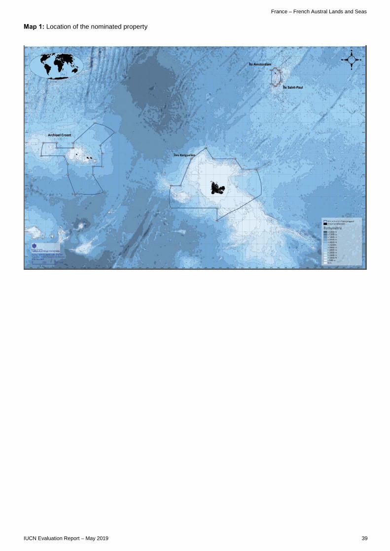
France – French Austral Lands and Seas
IUCN Evaluation Report – May 2019 39
Map 1: Location of the nominated property

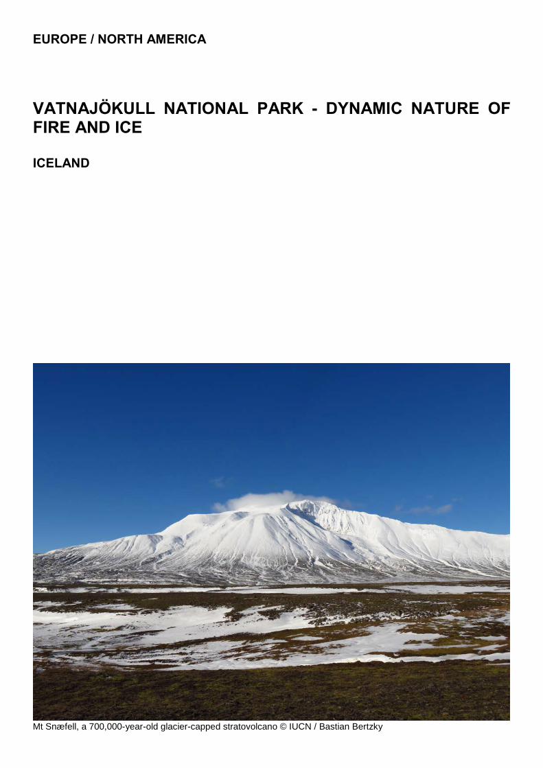
EUROPE / NORTH AMERICA
VATNAJÖKULL NATIONAL PARK - DYNAMIC NATURE OF FIRE AND ICE ICELAND
Mt Snæfell, a 700,000-year-old glacier-capped stratovolcano © IUCN / Bastian Bertzky


Iceland – Vatnajökull National Park
IUCN Evaluation Report – May 2019 43
WORLD HERITAGE NOMINATION – IUCN TECHNICAL EVALUATION
VATNAJÖKULL NATIONAL PARK: DYNAMIC NATURE OF FIRE AND ICE (ICELAND) – ID N° 1604
IUCN RECOMMENDATION TO WORLD HERITAGE COMMITTEE: To inscribe the nominated property under natural criterion (viii). Key paragraphs of Operational Guidelines: Paragraph 77: Nominated property meets World Heritage criteria. Paragraph 78: Nominated property meets integrity, and protection and management requirements. It is noted that one part of the nominated property is proposed for referral, as it does not yet fully meet protection and management requirements.
1. DOCUMENTATION a) Date nomination received by IUCN: March 2018 b) Additional information officially requested from and provided by the State Party: Following the IUCN World Heritage Panel a progress report was sent to the State Party on 20 December 2018. This letter advised on the status of the evaluation process and sought responses/clarifications on a range of issues including in relation to legal protection of parts of the nominated property; the status of community consultation; and road building materials sourced in the nominated property. A formal response from the State Party to the issues raised in the progress report was received on 27 February 2019. c) Additional literature consulted: Various sources, including: Dingwall, P.R., Weighell, T. & Badman, T. (2005). Geological World Heritage: A Global Framework. IUCN, Gland, Switzerland; Guttormsson, H. (2011), Vatnajökull National Park: A Guidebook. Vinir Vatnajökuls; Hannesdottir, H. & Baldursson, S. (2016), Melting Glaciers: a Natural Laboratory to Study Climate Change. Vatnajokulspjodgardur, Iceland; Iceland Magazine (2018), Preparations for a new National Park in Central Highlands get underway. Iceland Magazine, 24 January 2018, URL: https://icelandmag.is/article/preparations-a-new-national-park-central-highlands-get-underway; Petursson, J.G., Thorvardardottir, G. & Crofts, R. (2016), Developing Iceland’s protected areas: Taking stock and looking ahead. Parks 22.1:13-24; Thordarson, T. & Höskuldsson, A. (2014) Iceland. 2nd Edition, Classic Geology in Europe (Book 3), Dunedin Academic Press; Wood, C. (2009) World Heritage Volcanoes. IUCN, Gland, Switzerland. d) Consultations: 16 desk reviews received. The mission met with the Ministers of Education, Science and Culture, and of Environment and Natural Resources and their staff; scientific experts involved in the preparation of the nomination; representatives of the Icelandic Institute of Natural History, University of Iceland and Cultural Heritage Agency of Iceland; and also with members of the Governing Board for the management of Vatnajökull National Park (VNP); and
with each of the four Regional Committees responsible for regional park management, together with the Park Manager and staff. The mission also met members of the local government municipalities adjacent to the park, tourism and outdoor users and environmental stakeholder groups, commercial operators and individual guides in the park and one of the two private landowners with property within the boundary of Vatnajökull National Park. e) Field Visit: Bastian Bertzky and Dan Tormey, 23 September to 1 October 2018. f) Date of IUCN approval of this report: April 2019 2. SUMMARY OF NATURAL VALUES The nomination of Vatnajökull National Park: dynamic nature of fire and ice (VNP), encompasses 1,448,200 ha, approximately 14% of the territory of Iceland, and includes no buffer zones. More than 85% of the nominated property is classified as wilderness according to national legislation, and most of the nominated property qualifies for IUCN Category II protected area status. The nominated property is an iconic volcanic terrain and includes the entire range of currently active mid-ocean rift features, including large rift systems with historically important eruptions (such as the 1784 Laki fissure flow that led to several years of no summer and famine conditions worldwide). It includes the world’s largest and best expressed subglacial volcanic landforms (tindar ridges and tuya peaks) and rootless vents of all known types. Since the rift also includes a major mantle plume, there is the development of large central-vent volcanoes that include the entire magma series from basalt to rhyolite - more than six such central volcanoes are included in the nomination, including the largest, Bárðarbunga, over the plume itself, and the most famous, Askja, which is free of snow much of the year. The nominated property also includes some of the best exposed subvolcanic features on earth; as one goes east from the current centres of volcanic activity, one proceeds deeper into the volcanic plumbing system. Feeder dykes, cone

Iceland – Vatnajökull National Park
44 IUCN Evaluation Report – May 2019
sheets, sills, and mixing of basaltic magma with rhyolitic magma are all preserved in stunning clarity at numerous well-studied centres. The nominated property also includes the roots of volcanic systems: the reservoirs of magma that were transported through the feeder systems to the volcanoes. These shallow-level magma intrusions are very rare around the world, and the nominated property contains more than five such intrusions, many of them well studied and central to our understanding of the subvolcanic plumbing and storage system. From a volcanic perspective, the nominated property certainly contains the best exposed products of historic magmatism, all the way down to the subvolcanic magma chambers, that represents a divergent plate margin setting. There is little to no vegetation on these outstanding examples rendering the values immediately visible. From the perspective of glaciers, Vatnajökull is the largest glacier in Europe and one of the largest in the world. Unlike many of the world’s glaciers, Vatnajökull is not a remnant of the great Pleistocene ice sheets that began their retreat 10,000 years ago. Rather, it is a young glacier formed approximately 2,500 years ago, which is highly sensitive to climatic conditions and is an outstanding natural laboratory for studying the effects of the current global warming trends on glacial extent. Iceland prepared information documenting Vatnajökull glacier as a natural laboratory for the Paris Climate Summit in 2016, further elevating the importance of this glacier to our understanding of the interplay between climate and glacial extent. The nomination is subtitled “dynamic nature of fire and ice” and this is represented in the relationship between the heat of the central volcanoes and fissures that underlie (or during some eruptions also overlie) the Vatnajökull ice cap. This interaction takes many forms, but the largest and most dramatic is the jökulhlaup: a sudden flood of water caused by breaching the edge of a glacier during an eruption. Jökulhlaups are a recurring phenomenon in Iceland and are rare in any other part of the world. Over several days, up to ten times the flow of the Amazon is released during such events, leading to distinctive sedimentary landforms including broad sand plains, braided river systems, seen in the south of the nominated property, and deeply incised canyons, seen in the north. The Gjálp eruption and associated massive jökulhlaup in 1996 was the best studied event of its type in the world. The globally significant values of VNP relate to the coexistence and active interaction of a divergent tectonic plate boundary, a mantle plume and a large ice cap. The outstanding values represented are dynamic, currently active, and at times devastating processes. The attributes of the nominated property (be it a specific volcano, mountain peak, or even Vatnajökull itself) are not immune to change or even complete erasure. However, the dynamic nature of these processes are part of the value of the nominated property and the area will continue as a natural laboratory of the glaciovolcanic processes so evident today. 3. COMPARISONS WITH OTHER AREAS
Vatnajökull National Park has been nominated solely under criterion (viii), and the nominated property includes outstanding examples of several of the themes recognised as guiding the consideration of geoheritage nominations: volcanism, glaciers, fluvial systems, tectonics, and mountains. The global comparative analysis presented in the nomination is of good quality, although ideally should have considered a broader range of rift environments, and should have included a greater use of quantitative comparison. For volcanism, the site was considered in the IUCN 2009 Volcano Thematic Report, and IUCN notes that it will also be recognised as of potential Outstanding Universal Value (OUV) in the revision of this report, which is in press. The former report’s classification was based on volcanic landforms, and noted that the important subglacial eruption landforms of Iceland were unrepresented and constituted a significant gap on the World Heritage List. The revision will be based on plate tectonic setting, and in that respect mid-ocean ridges are also significant yet unrepresented. The nominated property is an iconic volcanic terrain: together with Hawaii, the Andes, and the island arcs of the southwest Pacific (Indonesia), Iceland is central to global scientific understanding of how earth processes work. The nominated property contains the world’s best exposed mid-ocean ridge volcanic system that is not under water, with some of history’s most notable and well-studied eruptions. As noted above, the broader geological evidence is highly diverse and well exposed, including the full range of active volcanic features for this plate tectonic setting, preserved in a largely unvegetated state, contributing to spectacularly clear exposures. As already noted, Vatnajökull is the largest glacier in Europe, and as a relatively young glacier, it is exceptionally sensitive to climate change; it is truly a natural laboratory for the response of glaciers to changing climate, both historically and in the present day. The interaction of volcanic features and glacial features is very clear, dramatic, educational, and found nowhere else in this full range of expression. Iceland’s tentative list does include three additional properties that may be nominated under criterion (viii): Þingvellir National Park, already inscribed as a cultural property in 2004; Mývatn and Laxá near the Dettifoss area of VNP; and the Torfajökull Volcanic System near the Laki area of VNP. VNP compares favourably to these properties, which could in time be considered for nomination, or as serial extensions of the present nominated property. Thus, given the documentation in the nomination and the recognition of VNP in published reports for the World Heritage Committee, and the scope of features included in the nomination, there is a clear case to support inscription under criterion (viii). 4. INTEGRITY, PROTECTION AND MANAGEMENT

Iceland – Vatnajökull National Park
IUCN Evaluation Report – May 2019 45
4.1. Protection Around 97% of the nominated property is protected by the Act on Vatnajökull National Park No. 60/2007 and Regulation No. 608/2008 (with subsequent amendments). In addition, there are two nature reserves included, Herðubreiðarlindir and Lónsöræfi, which are independent protected areas established respectively in 1974 and 1977 according to the Nature Conservation Act No. 47/1991 in force at the time. Other important legislation for the protection and management of the nominated property include the later Nature Conservation Act No. 60/2013, the Cultural Heritage Act No. 80/2012, the Planning Act No. 123/2010, the Public Land Act No. 58/1998 and Act No. 48/2011 on the Master Plan for Nature Protection and Energy Utilisation. Overall, this legal framework is adequate to protect the values represented. However, there is one exception to the adequacy of the legal protection: the IUCN mission noted, and supplementary information confirms, that the Jökulsá á Fjöllum river corridor connecting the northern portion of the nominated property to the main Vatnajökull portion is only partly protected by law. Iceland has confirmed that the Minister for the Environment and Natural Resources will officially enact the protection of the whole river from hydropower development after a public consultation. Iceland has stated that this process is in progress and should be resolved by May 2019. IUCN therefore notes that, whilst this matter might be resolved by the time of the World Heritage Committee, on the operating date for the evaluation of 28 February 2019, this matter is not yet addressed in relation to the requirements of the Convention. Thus, that part of the nomination cannot be recommended for inscription in the present report. IUCN considers that the protection status of the nominated property meets the requirements of the Operational Guidelines, with the exception of the Jökulsá á Fjöllum river corridor, which does not yet meet these requirements. 4.2 Boundaries The nominated property covers a very large area as described above. The proposed boundaries are adequate to include all of the values that support OUV. However, there are specific concerns regarding the proposed boundaries of the northern part of the nominated property (north of the Herðubreiðarlindir Nature Reserve). The issues were raised by IUCN noting that the information provided by Iceland on 29 November 2018 stated that the private landowners along the Jökulsá á Fjöllum River had not been approached or consulted in relation to the nomination process, but that the Ministry for the Environment and Natural Resources intended to address this point and consult with the landowners. Iceland provided further supplementary information that addresses the question of protective ownership or control over the corridor connecting the northern and southern portions of the nominated property, and IUCN notes two issues:
a) Private landowner consultations along the corridor of Jökulsá á Fjöllum itself, including areas around Mt. Herðubreið adjacent to the Herðubreiðarlindir Nature Reserve: This corridor connects the northern and southern portions of the nominated property, but at present there is not continuous state ownership or control over this corridor (see section 4.1 above). However, there is an ongoing consultation process. The State Party states that the timeline for this process is uncertain, but of high priority. It is not entirely clear from Iceland’s response whether or not there are privately owned lands included within the nominated area of the river corridor for which there has been no consultation, and/or there could be objections from the owners. b) Inclusion of the Natural Monument of Selfoss, Dettifoss, and Hafragilsfoss into the nominated property: This was discussed during the field mission as an option to improve the boundaries of the nominated property in the Dettifoss area, and Iceland has confirmed that they commenced the consultation, landowners are interested, and it is hoped to complete consultation in early May 2019. IUCN is of the view that the northern portion should not yet be included in the nomination, and to avoid an inappropriate serial configuration of the nominated property, at the present time only the southern portion up to and including the Herðubreiðarlindir Nature Reserve could be recommended for inscription. The delay in considering these areas (which could be considered via either the referral process, or a minor boundary modification in due course) relates to the former Jökulsárgljúfur National Park and some smaller areas along the narrow river corridor. The precise delimitation of the nominated property resulting is clear, but the area will need to be reconfirmed by the World Heritage Centre with the State Party. IUCN estimates that the area removed from immediate inscription is less than 2% of the total area of the nominated property, whose area would remain at over 1,400,000 ha. The State Party has indicated some plans that could lead to the eventual expansion of the boundaries of the national park and World Heritage site, including the planned acquisition and inclusion of the large sand plain to the south (Skeiðarársandur), which is currently in private landownership. Moreover, the Government of Iceland has recently launched a process to consider the establishment of a much larger “Central Highlands National Park”, which would probably include VNP as a core area. Although Iceland may choose to seek to expand the boundaries of the World Heritage Site to include future acquisitions, this is not essential to adequately protect the full range of values that is already included in the current nomination. There is no buffer zone proposed. Given the vast size of the nominated property, the particular resilient nature of the OUV, and the existing protection in the nominated property’s surroundings through the Nature Conservation Act, the Public Land Act and the Master Plan for Nature Protection and Energy Utilisation, IUCN agrees that the designation of a buffer zone is

Iceland – Vatnajökull National Park
46 IUCN Evaluation Report – May 2019
not essential for this property, provided these wider measures continue to be effective. IUCN considers that the boundaries of the nominated property meet the requirements of the Operational Guidelines; however, in view that ongoing consultations are not completed in the Jökulsá á Fjöllum river corridor, this area of the nomination, and the area to its north, does not appear to be appropriate for inclusion in an inscription at the present time. 4.3 Management The government agency Vatnajökull National Park (Vatnajökulsþjóðgarður) is the primary state agency responsible for implementing the park legislation, and operates under the aegis of the Ministry for the Environment and Natural Resources. The park has a governing board and a central park manager based in the Ministry in Reykjavik. In each of the four administrative park regions, there are also one or two regional park managers and a regional advisory committee, involving local authorities and stakeholder groups. The four chairs of the regional advisory committee are also members of the VNP Board. VNP has been managed under a comprehensive Management Plan for ten years. The plan achieves a high level of local input and decision making, coupled with legal protections against over development. The field mission noted that areas incorporated into the park boundary since 2013 have not yet been fully integrated into the overall Management Plan. The overall management organisation and capacity of the VNP agency is adequate and effective. VNP has 16 permanent staff, including one overall park manager based in Reykjavik, five regional managers (two in the north and one each in the west, south and east), assistant regional managers, and some permanent rangers. Each year, the park also hires 60-70 temporary staff to work as rangers, service staff at visitor centres, or as general workers. The nominated property depends upon this additional staffing to operate in an optimal way. This was also confirmed during the mission, as all regional park managers reported a need for some additional staff resources, including field staff for certain areas and times of the year, and especially some centralised administrative support to help with tasks such as human resources, accounting, outreach and education. The nomination also includes a clear and adequate framework for monitoring the state of conservation of the nominated property, including a set of useful indicators covering the fields of geology, geological hazards, biota and tourism. This includes, for example, continuous monitoring of the risk of volcanic eruptions, earthquakes and jökulhlaups, as well as continuous monitoring of visitor numbers and distribution, trail erosion, ‘wear and tear’ on visitor facilities and the presence of waste. According to the Ministry for the Environment and Natural Resources, specific management effectiveness evaluations have not yet been
implemented in VNP (or any other protected areas in Iceland), but this should be considered in the future. Overall, the nominated property has an adequate budget to cover essential staff and operations, and this budget seems to be reasonably secure. VNP is funded through two main sources: approximately 70% of its annual budget comes from the central government and the other 30% is self-generated income from camping/parking fees and sales of food and merchandise in the park’s visitor centres. The government funding is divided into resources for the day-to-day operation of the park and investments into infrastructure developments. Significant, but fluctuating, support has also come from the government controlled Tourist Site Protection Fund and the non-profit organisation Friends of Vatnajökull. The total budget of VNP has almost tripled since its establishment in 2008; however, since 2014, investments into infrastructure developments have stagnated while salaries continue to increase. In 2016, the total budget amounted to 559 million ISK, including 313 million ISK for salaries. There is a general expectation that the new Nature Conservation Agency that is proposed to be established in Iceland could potentially provide additional support to VNP – especially some centralised administrative support to help with tasks such as human resources, accounting, outreach and education. IUCN considers that the management of the nominated property meets the requirements of the Operational Guidelines. 4.4 Community There is strong general evidence of community engagement in, and support for VNP and its World Heritage nomination. The mission heard impressive and unanimous support in all quarters for the management plan, recognition that local input to decision making is critical to successful management of the park and support for the designation as World Heritage to preserve values for future generations. As already discussed, there is a particular issue regarding ongoing landowner consultations in areas in the northern part of the nomination (see section 4.2). Two small areas in the south of VNP are privately owned grazing areas in the mountains. In both cases, the nominated property does not include the farmhouses and guesthouses, but only some summer grazing areas in the mountain hinterland of the farms. The mission was able to meet one of these owners and were informed that there is support from both of them for the park and the nomination. The overall governance arrangements are effective and highly participatory. Through the VNP Board and the regional advisory committees there is a high degree of stakeholder involvement, including from local authorities and various stakeholder groups such as environmental conservation associations, and outdoor and travel associations. The locally based

Iceland – Vatnajökull National Park
IUCN Evaluation Report – May 2019 47
regional park managers, assistant park managers and rangers work directly with the local communities and stakeholders in the day-to-day management of the park. Nonetheless, conflicts and disputes over certain management decisions occasionally arise evidenced by some complaints heard during the mission. Most of these concern the use and area restrictions that affect some of the traditional user groups (hunting, four-wheel drive clubs). More generally, the need to strengthen communication between the central park management and the four regions, eight municipalities and various stakeholder groups was noted. Some stakeholders also requested more clarity and transparency with regard to the decision-making, and these improvements should be a priority for site managers. 4.5 Threats More than 95% of the nominated area has a very high level of integrity due to its remoteness. The nomination addresses expectations of increased levels of tourism. As Iceland has become more of a transatlantic transport hub and encouraged stay-overs, tourism has increased dramatically. Specifically, Vatnajökull National Park has had much increased tourism since its designation, but most of this has been concentrated in a relatively small number of easily accessible tourism hotspots on the southern and northern fringe of the park (notably Jökulsárlón, Skaftafell and Dettifoss). While inscription on the World Heritage List may increase visitor numbers, if managed correctly, it could lead to a change in the nature of that tourism. Visitor stays could increase, and visitors seeking ecotourism or a more immersive experience than simply a day trip from Reykjavik or Akureyri, or a bus trip around the island could be attracted. The measures needed to achieve this positive change (enhanced education /outreach /communication, more support at a national level, increased awareness of the ecotourism market among municipalities) are clear to the Icelandic authorities, and were in part the motivation for this nomination. The Minister for Education, Science and Culture, the Minister for Environment and Natural Resources, and the member of the Alþingi (Parliament), whose constituency includes the south and east of the park, made clear the intention that inscription would be seen as a milestone event to elevate the educational and communication efforts for VNP, and strengthen the quality of the tourism offer. Visitor management is and will remain one of the key challenges for the park, but mostly in and around the known tourism hotspots. It is therefore a matter of urgency to put in place, as planned, adequate visitor facilities and management in the Jökulsárlón and Dettifoss areas. The need to implement an anticipated certification scheme for commercial operators and guides operating in VNP is also noted. There are two areas of gravel extraction for road maintenance within the nominated property: one near Jökulsárlón in the southern part of the park and one along the paved road (Dettifoss to Ásbyrgi) that is under construction through the northern part of the park from the Ring Road. Once the road upgrade is
completed, the affected areas should be restored. IUCN notes that such gravel extraction should remain limited to the minimum necessary, and be exclusively in relation to the maintenance of roads within the nominated property. No conversion of these areas into sources of commercial export of material would be acceptable. Furthermore, additional road construction should not be permitted, unless there is an exceptional justification and full prior impact assessment. There are limited areas where off-road driving occurs and can locally degrade the visitor experience. Off-road driving of this type is not legal anywhere in Iceland, but can occur either due to ignorance or visitors acting illegally. Park management typically cites off-road driving as the most persistent threat to the park, and has several active management means to address this; however, some additional measures (e.g. clearer road/track demarcation, additional signage, information materials and campaigns) could be taken to discourage off-road driving. Just northeast of the main park area lies the Hálslón Reservoir. Following the construction of three dams between 2003 and 2006, the reservoir began to fill in late 2006, and has since stored water for the Kárahnjúkar Hydropower Plant that produces energy for the Fjarðaál aluminium smelter 75 km to the east in Reyðarfjörður. The dams, power plant and aluminium smelter are all well outside the nominated property; however, the uppermost parts of the Hálslón Reservoir water body extend slightly into the nominated property. The nominated property and its surroundings face potential threats from further hydropower development. There appears to be continued interest in further development, as Iceland has outstanding hydroelectric power siting attributes. However, legal protections are in place to prevent such development (e.g. through the Master Plan for Nature Protection and Energy Utilisation and other legislation), and at present both the state and local communities are sensitive to the topic and appear to be primarily against further hydroelectric development. Ongoing traditional use (such as sheep grazing, hunting, fishing, egg collecting, mushroom and berry picking) does not pose any significant threat to the values for which the property is being nominated, and is being addressed in the management plan and regulated by VNP in consultation with stakeholders, rights holders and property owners in the area. Similarly, neither the local presence of non-native tree species nor the spread of some invasive species (mainly Nootka lupine (Lupinus nootkatensis)) threatens the core values of the nomination, although such introductions do warrant management attention. Climate change will clearly play a key role in the future of the nominated property, and is already evident in the ongoing and rapid retreat of Vatnajökull’s many outlet glaciers, potentially leading to the complete loss of the Vatnajökull ice cap and hence the interaction of fire and ice. However, as noted in the nomination, this process may take centuries and provides an important natural laboratory for studying the glacial,
Iceland – Vatnajökull National Park
48 IUCN Evaluation Report – May 2019
glaciovolcanic and ecological dynamics in response to climate change. This is reflected in the nomination’s focus on processes. Furthermore, given the iconic means by which World Heritage Sites provide examples of the impacts of climate change, and the need for ambitious action to tackle it, the nominated property will also add significantly to the role of the Convention in underpinning global action on climate change. In conclusion, IUCN considers that the integrity, protection and management of the nominated property meet the requirements of the Operational Guidelines, noting the reservations in relation to the northern part of the nomination referred to above, which do not meet fully the protection requirements at the present time. 5. ADDITIONAL COMMENTS 5.1 Associated cultural and other nature conservation values Although nominated for criterion (viii) alone, the nomination document also notes a strong cultural element (both historic sites of significance to Icelandic people, and the overall importance of living in a dynamic island, with persistent and frequent volcanism and glacial floods, to the development of the Icelandic psyche). It also recognises regionally important biological attributes (illustrating arctic ecosystems and species), and aesthetic beauty (many areas with stunning views). IUCN notes this as an example of good practice in any nomination, in recognising the other significant values. These other significant values should be recognised and remain a focus for the conservation of the nominated property, as they support the exceptional nature of VNP. 6. APPLICATION OF CRITERIA Vatnajökull National Park has been nominated under natural criterion (viii). Criterion (viii): Earth history and the record of life The coexistence and ongoing interaction of an active oceanic rift on land, a mantle plume, the atmosphere and an ice cap, which has varied in size and extent over the past 2.8 million years, make the nominated property unique in a global context. Earth system interactions are constantly building and reshaping the property, creating remarkably diverse landscapes and a wide variety of tectonic, volcanic and glaciovolcanic features. Especially interesting and unique in this regard are the basaltic lava shields (Iceland shields), volcanic fissures and cone rows, vast flood lavas, and features of ice dominant glaciovolcanism, such as tuyas and tindar. Interestingly, the well exposed volcanic features of the nominated property have been used as analogues for similar features on the planet Mars. Geothermal heat and subglacial eruptions produce meltwater and jökulhlaups that maintain globally unique sandur plains, to the north and south of the Vatnajökull ice cap, as well as rapidly evolving canyons. In addition, the nominated property contains
a dynamic array of glacial- and geomorphological features, created by expanding or retreating glaciers responding to changes in climate. These features can be easily accessed and explored at the snouts of Vatnajökull’s many outlet glaciers and their forelands, especially in the southern lowlands, making the nominated property a flagship glacial research location. IUCN considers that the nominated property meets this criterion. 7. RECOMMENDATIONS IUCN recommends that the World Heritage Committee adopts the following draft decision: 1. Having examined Documents WHC/19/43.COM/8B and WHC/19/43.COM/INF.8B2; 2. Inscribes Vatnajökull National Park - dynamic nature of fire and ice (Iceland) under natural criterion (viii), including the area of the nominated property up to and including Herðubreiðarlindir Nature Reserve (thus not including at this stage the Jökulsá á Fjöllum river corridor and the northern Dettifoss - Ásbyrgi part of Vatnajökull National Park); 3. Refers back to the State Party the elements of the nominated property situated to the north of the Herðubreiðarlindir Nature Reserve, in the Jökulsá á Fjöllum river corridor and the northern Dettifoss - Ásbyrgi part of Vatnajökull National Park, in order to allow the State Party to complete consultations with landowners in these areas, and ensure appropriate protection measures are put in place, and recommends that these areas be added to the inscribed property, once the protection and consultation issues have been resolved. 4. Adopts the following Statement of Outstanding Universal Value: Brief synthesis The property, totalling over 1,400,000 ha, comprises the whole of Vatnajökull National Park, plus two contiguous protected areas. At its heart lies the c.780,000 ha Vatnajökull ice cap in southeast Iceland. Iceland includes the only part of the actively spreading Mid-Atlantic Ridge exposed above sea level, with the tectonic plates on either side moving apart by some 19 mm each year. This movement is accommodated in rift zones, two of which, the Eastern and Northern Volcanic Zones, pass through the property. Underneath their intersection is a mantle plume, providing a generous source of magma. The property contains ten central volcanoes, eight of which are subglacial. Two of the latter are among the four most active in Iceland. Most of the property’s bedrock is basaltic, the oldest being erupted some 10 million years ago and the most recent in 2015. Outside of the ice cap, the terrain varies from extensive, flat lava flows to mountains, including tuyas and tindar (ridges) of brown hyaloclastites, erupted in fissure eruptions

Iceland – Vatnajökull National Park
IUCN Evaluation Report – May 2019 49
beneath ice age glaciers. The latter occur nowhere else in the world in such numbers. The property comprises an entire system where magma and the lithosphere are incessantly interacting with the cryosphere, hydrosphere and atmosphere to create extremely dynamic and diverse geological processes and landforms that are currently underrepresented or not found on the World Heritage List. It was here that the phrase “Fire and Ice” was coined. The Vatnajökull ice cap reached its greatest extent by the end of the 18th century and has on average been retreating since then. Recently, its retreat has accelerated in response to global warming, making the property a prime locality for exploring the impacts of climate change on glaciers and the landforms left behind when they retreat. The volcanic zones of the property hold endemic groundwater fauna that has survived the ice age and single-celled organisms prosper in the inhospitable environment of subglacial lakes that may replicate conditions on early Earth and the icy satellites of Jupiter and Saturn. Criteria Criterion (viii) The coexistence and ongoing interaction of an active oceanic rift on land, a mantle plume, the atmosphere and an ice cap, which has varied in size and extent over the past 2.8 million years, make the property unique in a global context. Earth system interactions are constantly building and reshaping the property, creating remarkably diverse landscapes and a wide variety of tectonic, volcanic and glaciovolcanic features. Especially interesting and unique in this regard are the basaltic lava shields (Iceland shields), volcanic fissures and cone rows, vast flood lavas, and features of ice dominant glaciovolcanism, such as tuyas and tindar. Interestingly, the well exposed volcanic features of the property have been used as analogues for similar features on the planet Mars. Geothermal heat and subglacial eruptions produce meltwater and jökulhlaups that maintain globally unique sandur plains, to the north and south of the Vatnajökull ice cap, as well as rapidly evolving canyons. In addition, the property contains a dynamic array of glacial- and geomorphological features, created by expanding or retreating glaciers responding to changes in climate. These features can be easily accessed and explored at the snouts of Vatnajökull’s many outlet glaciers and their forelands, especially in the southern lowlands, making the property a flagship glacial research location. Integrity The property covers over 25% of the central highlands of Iceland and extends onto lowland areas to the south to cover a total of approximately 12% of the country. Most of the property corresponds to an IUCN Category II protected area. Its integrity is reflected in the inclusion of entire and intact landscape and geophysical units, minimal human use and intervention, and scientific interest in the property. The site contains the entire Vatnajökull ice cap, with all its subsidiary glaciers as they stood in 1998. It spans some 200 km of divergent plate boundary and
encompasses ten central volcanoes and large parts of the accompanying fissure swarms and subsidiary landforms. The area is largely intact and remote from habituated areas with some 85% of the property classified as wilderness. An intense international scientific interest in the property is evidenced by at least 281 scientific peer reviewed papers, published over the last decade, on various aspects of plate tectonics, volcanism, glaciovolcanism, glaciology, glacial geomorphology and ecology. There has been no destructive human development within the property’s boundaries. A few historic farms exist, but today only a few park employees live there on a year-round basis. Requirements for protection and management The large majority of the property is protected by the Act on Vatnajökull National Park No. 60/2007 and Regulation No. 608/2008 (with subsequent amendments), whilst Herðubreiðarlindir and Lónsöræfi Nature Reserves are protected according to the Nature Conservation Act No. 47/1991. A range of other important national legislation is in place to ensure protection. Most of the land adjacent to the property is subject to the law on public land, where any invasive use requires approval by the Prime Minister’s Office. The government agency Vatnajökull National Park (Vatnajökulsþjóðgarður) is the primary state agency responsible for implementing the park legislation, and is an effective organization, supported at all levels by the Icelandic government, local municipalities and businesses. There is mature governance in place together with experienced staff responsible for management employed on a long-term basis, including a strong complement of permanent and temporary staff. There is a comprehensive Management Strategy and action plan in place, that have achieved a notably high level of local input to decision making, and which are subject to regular review and updating. Areas added to the national park since 2013 are progressively integrated into management arrangements. An effective long-term monitoring system is in place, using space- and ground-based observations, for improved evaluation of seismo-tectonic movements and volcanic hazards as well as for glacial flow and fluctuations and key aspects of the property’s biota. The property has an adequate and secure budget to cover essential staff and operations, with the principal financial support from the central government and up to 30%, which is generated from its own income. Significant other support has also come from the government controlled Tourist Site Protection Fund and the non-profit organisation Friends of Vatnajökull. There is a need to sustain and further increase resourcing to ensure the management needs of the property are fully met. Risk management is a major issue in this highly dynamic setting where natural hazards are common. Other essential management issues include preventing wear and tear of nature at popular visitor destinations within the property, resolving visitor use conflicts, and

Iceland – Vatnajökull National Park
50 IUCN Evaluation Report – May 2019
addressing occasional illegal activities in the property when they arise. There is a need to develop and maintain adequate facilities for educating, managing and guiding the ever-increasing numbers of visitors, which were approaching one million in 2017, ensuring that any such provision is designed, assessed and implemented in a manner that ensures the protection of the property’s conservation significance. There is also a need to continue to work with local communities, organizations and businesses around the park to maintain their involvement and help them benefit from the park. 5. Recommends the State Party address the following needs to maintain and strengthen the protection and management of the property: a) Complete, in a timely manner, the current revision
of the management plan for Vatnajökull National Park, ensuring it integrates fully all areas included in the property;
b) Seek to complete integration of the Herðubreiðarlindir and Lónsöræfi Nature Reserves into Vatnajökull National Park in order to facilitate cohesive management of the whole property;
c) Make available additional staff resources,
including both field staff and administrative support, to ensure the effective protection and management of the property, in view of the recent areas that were added to Vatnajökull National Park, and the recorded rapid recent increase in visitation to the property;
d) Put in place adequate visitor facilities in the heavily visited areas around the Jökulsárlón Lagoon in the south of the property, and also at the Dettifoss Waterfall to the north of the property;
e) Adopt and implement effective certification for commercial operators and guides operating in the property; and
f) Take additional measures to discourage illegal off-road driving by visitors, and to rehabilitate any areas affected adversely by these and other visitor uses.
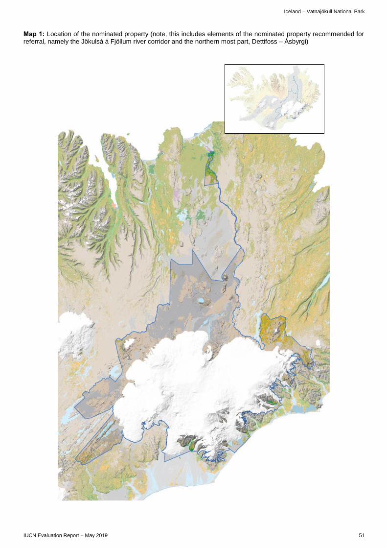
Iceland – Vatnajökull National Park
IUCN Evaluation Report – May 2019 51
Map 1: Location of the nominated property (note, this includes elements of the nominated property recommended for referral, namely the Jökulsá á Fjöllum river corridor and the northern most part, Dettifoss – Ásbyrgi)


EUROPE / NORTH AMERICA
ALPI DEL MEDITERRANEO – ALPES DE LA MÉDITERRANÉE MONACO / ITALY / FRANCE
Landscape in component Argentera – Mercantour © IUCN / Josephine Langley


Monaco / Italy / France – Alpi del Mediterraneo - Alpes de la Méditerranée
IUCN Evaluation Report – May 2019 55
WORLD HERITAGE NOMINATION – IUCN TECHNICAL EVALUATION
ALPI DEL MEDITERRANEO – ALPES DE LA MÉDITERRANÉE (MONACO / ITALY / FRANCE) – ID N° 1598
IUCN RECOMMENDATION TO WORLD HERITAGE COMMITTEE: Not to inscribe the property under natural criterion (viii). Key paragraphs of Operational Guidelines: Paragraph 77: Nominated property does not meet World Heritage criteria. Paragraph 78: Nominated property does not meet integrity, protection and management requirements. 1. DOCUMENTATION a) Date nomination received by IUCN: Original nomination received on 25 March 2018. b) Additional information officially requested from and provided by the States Parties: Following the IUCN World Heritage Panel a progress report was sent to the States Parties on 20 December 2018. The letter advised the States Parties of a number of matters that would be the subject of further research within IUCN including the basis for the claim of Outstanding Universal Value (OUV), assessing the fundamental questions regarding the approach to Global Comparative Analysis and justification for criterion (viii). IUCN also noted a particular focus of consideration would be on the relationship of the present nomination to previous nominations to the World Heritage List, and also the previous international consultations that had been undertaken regarding World Heritage in the Alpine region. Further, IUCN indicated it would research comparisons regarding the application of the serial approach, the choice and design of component parts and legal protection and management capacity specific to geological heritage. Although no additional information had been requested, the States Parties submitted additional information on 23 February 2019 making substantive changes to the nomination. In this information the States Parties proposed a revision of the boundaries of the nominated property and its buffer zones, new information on the protection of some of the nominated component parts, the plans for a future trilateral management of the nominated property, as well as additional input regarding the articulation and justification for OUV. c) Additional literature consulted: Various sources, including: Charte du Parc National Mercantour, Workshop report “International Expert Meeting: Natural World Heritage in the Alpine region” (http://www.alpconv.org/en/organization/ groups/past/WGUNESCO/Documents/20111221A5_ResultsofBernWorkshoponPotentialworldNaturalHeritageAlps_draft.pdf); Rosenbaum, G. & Lister, G.S. (2002). Reconstruction of the evolution of the Alpine-Himalayan orogen - an introduction. Journal of the Virtual Explorer, 8:1-2; Bouma, A.H. (1962).
Sedimentology of some Flysh deposits: A graphic approach to facies interpretation, Elsevier; Whitmeyer, S.J., Fichter, L.S. & Pyle, E.J. (2007). New directions in Wilson Cycle concepts: Supercontinent and Tectonic Rock Cycles. Geosphere, v.3, no.6:511–526; Egli, D. & Mancktelow, D. (2013). The structural history of the Mont Blanc massif with regard to models for its recent exhumation. Swiss Journal of Geoscience; Trewin, N. (2002). The Geology of Scotland, The Geological Society of London. d) Consultations: 12 desk reviews received. The mission met with a wide range of stakeholders including representatives of the ministries, regional and local governments, representatives of the European Grouping of Territorial Cooperation (EGTC), Alpi Maritime Mercantour, staff of the National Parc Mercantour the Parco Alpi Marittime, and the various local protected areas, including local guides, tourism sector representatives, academics and NGOs. e) Field Visit: Josephine Langley and Jose Brilha, 13-21 September 2018 f) Date of IUCN approval of this report: May 2019 2. SUMMARY OF NATURAL VALUES The nominated property, Mediterranean Alps - Alpes de la Méditerrannée is located in France, Italy and Monaco. Whilst the name selected for the nomination is very broad the scope of the nomination is limited to a restricted area, and to only geological values. The nominated property covers a total of 200,504ha, and is nominated as a serial site comprising eight individual component parts (of which four are transboundary) stretching from the Mediterranean Alps down to the Mediterranean Sea. 59% of the nominated property is terrestrial, while 41% is marine - covering both territorial waters and areas in the Exclusive Economic Zone (EEZ). The States Parties provided additional information which modified the boundaries of the nominated areas and buffer zones (see section 4.2 below). Table 1 provides details on the nominated property’s configuration following the submission of additional information.

Monaco / Italy / France – Alpi del Mediterraneo - Alpes de la Méditerranée
56 IUCN Evaluation Report – May 2019
Component part Location Nominated area (ha)
Buffer zone (ha)
(1) Argentera - Mercantour
Region Provence- Alpes-Cote d'Azur; Region Piemonte (France/Italy) 90,727 49,558
(2) Daluis Region Provence- Alpes-Cote d'Azur (France) 1,035 1,937 (3) Marguareis - Toraggio
Region Provence- Alpes-Cote d'Azur; Region Piemonte, Région Liguria (France/Italy) 19,077 12,872
(4) Peira - Cava Region Provence- Alpes-Cote d'Azur (France) 478 1,108
(5) Ours - Grammondo Region Provence- Alpes-Cote d'Azur;, Région Liguria (France/Italy) 5,433 2,890
(6) Cap Ferrat - Canyon de la Roya Territorial waters (France/Italy/Monaco) 82,886 18
(7) La Grande Corniche Region Provence- Alpes-Cote d'Azur (France) 690 329 (8) Peille Region Provence- Alpes-Cote d'Azur (France) 179 218 TOTAL 200,505 68,930
Table 1: Component parts constituting the nominated property
In France, the nominated component parts are located in the region of Provence-Alpes-Côte d'Azur (Departments of the Alpes-Maritimes and Alpes-de-Haute-Provence). They also include seaward extensions from the Department of the Alpes-Maritimes into territorial waters and part of the French Exclusive Economic Zone (EEZ). In Italy, the nominated component parts are located in the regions of Piedmont and Liguria, in the provinces of Cuneo and Imperia. The nominated property extends into the Italian territorial waters (Imperia Province). In the Principality of Monaco, the nominated property is entirely within a marine area. The nominated property is located at the junction between the western Mediterranean and the Italian Peninsula, where the southern end of the Alpine Arc is in contact with the Mediterranean and in continuity with the Apennines. The nominated property encompasses an altitudinal difference of more than 5,000m reaching from a maximum altitude of 3,297m above sea level (Argentera massif) down to 2,500m below sea level in the marine areas including the seabed. The property is nominated under criterion (viii) on the basis of its global tectonic values. The main geological setting relates to the occurrence of tectonic and petrological evidence within the nominated property that proves the activity of three successive geodynamic cycles (Wilson Cycles) during the last 320 million years: the Variscan Cycle, the Alpine Cycle and the Apennine-Mediterranean Cycle. Within the cycles, key events are represented including rifting, inversion, subduction, collision, erosion and marine processes. Evidence of these events is found in the attributes, which are documented in the eight component parts. The Variscan Cycle covers the period 400 to 290Ma. In Southern Europe, the key geological events that occurred during this Paleozoic cycle were subduction (400–375Ma), collision that produced the Variscan mountain chain (375–320Ma) and the erosion of this chain (320–290Ma). Key geological features serving to represent these events are found in component part “Argentera – Mercantour” (CP1) and include eclogites for subduction, granites and migmatites for collision, and Upper Carboniferous sediments for the erosion and consequent destruction of the Variscan chain. This
cycle and series of geological events is of global significance to earth scientists, however, evidence of this is also found in other areas, e.g. Iberian Peninsula or Caledonia. After the destruction of the Variscan chain, the Permian rifting occurred leading to the break-up of the Pangea supercontinent. The Permian-Triassic transition (290–250Ma) is represented by red sandstone and conglomerates overlapped by dolomitic limestone, mainly found in the component parts “Daluis” (CP2) and “Marguareis – Toraggio” (CP3). The Alpine Cycle covers the period 230–28Ma. The key geological events that occurred were rifting (230–100Ma), subduction (100–50Ma), and collision that created the Alpine mountain chain (45–28Ma). Key geological features serving to represent these events include marl and gypsum dolomitic limestone for the rifting, found in component parts 3 and 5 (“Ours-Grammondo”); flysch for the subduction, found in component parts 1 and 3, and black flysch and specific families of tectonic structures for the collision, found in component parts 1, 3, 4 (“Peira-Cava”) and 5. Finally, the Apennine-Mediterranean Cycle covers the period from 28Ma to the present. The key geological processes are subduction (volcanic rocks in component part “Cap Ferrat - Canyon de la Roya“ (component part 6) and tectonic structures in component part 1), opening of the Mediterranean basin (represented by fault systems in component part 6) and inversion originating from the closure of the Mediterranean (as shown by the active fault systems in component parts 7 and 8). To gain a complete understanding of the main geological setting of the property it is necessary to consider the influence of the so-called Messinian salinity crisis. A sudden decrease of the sea level in the Mediterranean Sea during 5.50–5.33Ma, caused strong erosion that shaped the geomorphological features that are today easy to identify, such as the submarine canyon of “La Roya” (component part 6) and the deep valley of the Daluis Gorge seen at Point Sublime (component part 2).
Monaco / Italy / France – Alpi del Mediterraneo - Alpes de la Méditerranée
IUCN Evaluation Report – May 2019 57
In the additional information the States Parties provided an overview table on the specific geological sites included in the nominated property. This overview references all these geological features to the different main themes of the nomination and specifies the attributes represented by the sites. Fifteen of the geological sites across the component parts are presented in an illustrative way providing a picture and a textual scientific description. IUCN notes that attributes presenting all three tectonic cycles are included in the different component parts, however, the three cycles are not equally well represented, given the long time span covered by these geodynamic events and the fact that the third cycle is a still an on-going process. The nominated property lies in an area with notable floristic values of regional significance due to the diversity of soils, the existence of microclimatic conditions, as well as the special biogeographic location. These areas are home to more than 2,700 vascular plant species, accounting for 53% of the Alpine flora and include 105 endemic taxa. The area is also part of one of the Global 200 WWF priority ecoregions. The marine component part (6) is home to several species included in the Annexes of the EU Flora Fauna-Habitat Directive, including two species of cetaceans - the Harbour Porpoise (Phocoena phocoena, VU) and the Bottle-nose Dolphin (Tursiops truncatus, LC). 3. COMPARISONS WITH OTHER AREAS The global comparative analysis within the nomination dossier compares the nominated property to five properties already inscribed on the World Heritage List (Gros Morne National Park (Canada), Macquarie Island (Australia), Three Parallel Rivers of Yunnan Protected Areas (China), Swiss Tectonic Arena Sardona (Switzerland), and China Danxia (China)). The additional information adds a reference to the Chaîne des Puys - Limagne fault tectonic arena (France), inscribed for its tectonic values in 2018. However, the global comparative analysis mentions only that this property contains “continental rift and associated volcanism” as tectonic values. None of the nomination documents for the inscribed properties mentioned above, including in particular the extensive comparisons that were done in relation to the Chaîne des Puys - Limagne fault tectonic arena nomination, following two referrals by the Committee, references the nominated property with regards to providing significant comparable tectonic features. Comparison is also made to other sites in the western Mediterranean; to collision chains (focused on mountains bordering marine areas including Lorentz National Park and the Caucasus); to other alpine sites (inscribed or on tentative lists); and to other peri-Mediterranean sites. IUCN notes that the additional information provides conclusions in a very synthetic form, making it difficult to assess the global comparative analysis as a whole. A general weakness in the comparative analysis provided in the nomination, as well as the additional information received, is also a
lack of analysis at the level of the specific geological sites to link these as attributes of the claimed elements of OUV. A full and adequate description of geomorphology, mineralogy (or metamorphism) or on-going active tectonic processes, linked to the justification, is lacking. The global comparative analysis suggests that the nominated property is the best example in the world showing: an active collision chain crosscut by a recent oceanic basin; the evidence of three successive geodynamic cycles; high lithological and structural diversity; and a long period of geodynamic activity. For the first of these aspects, whilst the claim is of scientific interest, and appears atypical relative to expectations of the operation of the Wilson Cycle, IUCN considers that this is too specialised a claim to be the basis of establishing OUV, and it is also a feature that is not confined to the nominated property. The global comparative analysis, as well as many desk reviews, point out that on a regional level, the characteristics of having three orogens are not restricted to the nominated property, but are present in many other places in the Alps. Corsica contains similar geological features as the western Alps and also presents three superimposed geodynamic Wilson Cycles (Variscan, Alpine and Apennine) connected to the opening of an ocean. The same is valid for the Calabrian Arc having Variscan, Alpine and Apennine orogens and an extension in the Tyrrhenian Sea. The global comparative analysis notes that the land-sea interface is clearer and steeper in the case of the Mediterranean Alps - Alpes de la Méditerranée and the knowledge of underwater morphologies and tectonic structures is much more developed in the case of the nominated property. There is not sufficient information to verify the claim regarding comparisons globally, and there are a range of other tectonic settings where sites that are not included on the World Heritage List would need to be considered. However, and more fundamentally, it is also not apparent to IUCN that the fact of an area containing multiple orogenies is a sound basis for OUV, since, again, this tends to introduce a level of specialism and narrowness in the justification that does not match the goals of the Convention for a short list of the most outstanding properties. Furthermore, it is also notable that the World Heritage Committee has already recognised two sites for tectonic values associated with the structural history of the Alps and its surrounding region – viz the Swiss Tectonic Arena Sardona, and the Chaîne des Puys - Limagne fault tectonic arena. IUCN is of the view that a further specialised and tectonic listing in the same region is not justified. The argument regarding high lithological and structural diversity is underpinned in the nomination dossier by tables that list the main types of processes and geological/tectonic features and an overview showing the representation of the attributes in the eight component parts. It is, however, difficult to prove the exceptional value of the nominated property in comparison to others on this basis, given the high

Monaco / Italy / France – Alpi del Mediterraneo - Alpes de la Méditerranée
58 IUCN Evaluation Report – May 2019
lithological and structural diversity that is typical in many orogenic belts. Regarding the argument made that the nominated property covers a long period of geodynamic activity, this is not considered unique nor exceptional, as there are many orogens in the world that have even longer periods of processes than the Alps. Several examples were referenced by reviewers as exhibiting longer geological periods for example the Mont Blanc region, which has Late Proterozoic rocks (1000-540Ma). For the Caledonides, the Moine rocks are also older and have Archean (Lewisian) rocks in and under the frontal thrusts, which would extend the time over more than several billion years. These also have ocean opening related Paleogene volcanism and sediments, which would extend the timescale over more than three billion years. In terms of regional comparison, IUCN notes that the nominated property did not feature as a priority for geological values in a recent study conducted in the framework of the Alpine Convention’s working group on World Heritage. Whilst this study noted some merits of the Mercantour-Alpi Marittime transboundary protected area in terms of possible biological values, it did not consider this site to be a priority under criterion (viii). Several reviewers further note weaknesses in that the conceptual basis of the nomination has not been subject to international review in terms of its validity. Furthermore, that alternatives to seek international recognition were not explored, it seems, prior to proceeding with the nomination. Weaknesses in international peer review are also noted, as well as in referencing claims, and in the systematic approach needed in comparative analysis. This is particularly relevant in relation to the diversity of geological processes and disciplines the nomination seeks to represent. IUCN notes in particular that the extensive comparisons undertaken by France in relation to the Chaîne des Puys - Limagne fault tectonic arena were not in this case undertaken with respect to this nomination. In summary, and based on the above analysis, IUCN evaluated the proposed OUV of the nominated property on the basis of the information provided and came to the conclusion that none of the four aspects noted above of the claimed OUV present a convincing basis to support the application of criterion (viii). It is notable that there is not convincing evidence of support for the nomination at the international level, nor has a recent regional analysis identified it as a priority for the application of criterion (viii) in the Alps. 4. INTEGRITY, PROTECTION AND MANAGEMENT 4.1. Protection The protection status of the nominated component parts is highly complex and varies considerably, ranging from the French National Park Mercantour (IUCN Protected Area Category II), to the Alpi Marittime Natural Park in Italy (IUCN Category IV), to
sites under the European NATURA 2000 designation (also IUCN Category IV), as well as different local, regional and international designations. Almost all the protected areas included within the nominated property have been established for the preservation of biological values only, so do not provide protection measures specific to geoheritage. Overlapping layers of protection (national, regional, international) exist for all component parts. Two component parts of the nominated property (4 and 8) do not yet have national protection status. The marine component of the nomination, “Cap Ferrat - Canyon de la Roya“, is protected by two NATURA 2000 sites called “Zone spéciale de conservation” (ZSC), which in essence provide limited protection for geology (as they are directed to the habitats and species of EU Community interest). The PELAGOS sanctuary within the marine component provides protection for marine mammal species and their habitats, but has no relevance for the protection of geoheritage. The dossier claims that UNCLOS provides protection for the seabed, however, this Convention does not specifically encompass geoheritage values and, as an international agreement, it must be implemented through national measures to provide adequate protection for the marine environment. The additional information indicated that in France the process for establishing national legal protection status for individual geological sites (“arrêts prefectoral de protection de géotope”, APPG) is under way and 19 APPG are planned for the component parts 3-8, including four APPG for the component parts 4 and 8 where no protection status existed before. This is welcome, however, the additional information does not allow an adequate evaluation as no information on the size and exact location of the areas to be covered by the APPG is provided. In Italy, the protection of geoheritage is said to be embedded in the management plans of the parks and a geological cadastre (catalogue usually based on a map) is under preparation, however, no details are provided. The nomination dossier also does not clarify the protection status afforded within the buffer zones of the nominated property. The nominated property contains a range of legal land tenures. These include privately owned land (individuals or private companies), public land (state, region, municipality, or commune) and commons. 8.5% of the territorial area of the nominated property and 32% of the buffer zone are private property. The dossier notes that these areas are located at the margins of the nominated property, however, does not provide a map showing their location. The overlap of various different levels of protected area presents a major challenge for the overall management of the site. As noted above the majority of the existing protected areas have been established for the protection of biological values (this is especially the case for sites protected under the European Birds or Habitats Directive) and these protected areas are not considered to provide adequate protection tailored

Monaco / Italy / France – Alpi del Mediterraneo - Alpes de la Méditerranée
IUCN Evaluation Report – May 2019 59
to a natural World Heritage property nominated for its geological values. In conclusion, the existing protection regime is relevant to a multi-use landscape, but it does not appear to be specific and comprehensive enough to guarantee the protection of geoheritage values within the nominated property. IUCN considers that the protection status of the nominated property does not meet the requirements of the Operational Guidelines. 4.2 Boundaries The boundaries of the nominated property encompass eight individual component parts. Properties proposed under criterion (viii) should contain all or most of the key interrelated and interdependent elements in their natural relationships. The map provided in the nomination, as well as the table provided in the additional nomination, clearly indicate that many of the attributes, which are claimed to contribute to OUV, are not fully inside the component parts. There are elements in the buffer zone and overlapping both the nominated areas and buffer zone, as well as areas located completely outside the nominated area and the buffer zones. The table in the additional nomination indicates that some 22 (ca. 10%) of the identified geological sites are located completely in the buffer zone. As there is no accurate map identifying the detailed attributes and where they are exactly located, the adequacy of the boundaries is not demonstrated. IUCN also notes that the inclusion of the submarine part of the “Cap Ferrat - Canyon de la Roya” component part (6) is not sufficiently well justified and would have benefitted from a clearer demonstration of the linkages with tectonic structures, lithological diversity and geomorphological features at different scales. Furthermore, the nominated area does not contain the areas representing the coastal transition between the landward and seaward component parts. The States Parties submitted additional information, which proposed a small boundary adjustment to extend component 8. In addition, the buffer zones were enlarged for component parts 4, 6, 7 and 8 with the most significant change being to increase the area of the buffer zone of component 4, creating a buffer zone which envelopes components 4 and 5. Buffer zones for components 6, 7 and 8 have undergone minor increases in area and in some cases buffer zones have been created where there were none before. The field mission noted that a specific feature potentially relevant to convey OUV is located outside the boundaries – an active fault feature located near Peille. The additional information provided by the States Parties has adjusted the boundaries in this area, however, it is not clear whether this area covers the respective feature. The additional information provides a revised map for the component part “Peille” including a revised boundary for the component part; however, no rationale for this revision is provided nor does the additional information describe the added area. IUCN also considers that the unsolicited introduction of boundary modifications that have not been part of a prior discussion in the evaluation
process is highly problematic in terms of the accepted processes of the Convention. IUCN questions whether all component parts would be needed to display the attributes: the alpine collision is well presented in component parts 1, 4, and 5, but it is not clear if these three components have similar or different geological attributes. Furthermore, features representing alpine rifting are well represented in component part 3. It is therefore not well argued why component part 5 has been included in the series, as component part 5 also displays alpine rifting and thus its values might be considered redundant. Given the conclusion that the overall claim is not convincing, these are somewhat secondary matters (since reconfiguring the nomination would not in IUCN’s view solve the issue of justifying the criteria), however, these problems are further evidence of the problematic nature of the nomination as submitted. Buffer zones have been designated for the majority of the component parts, however, the components 4, 6 and 8 only partially have buffer zones, with the buffer zone of “Cap Ferrat - Canyon de la Roya” being extremely limited given the large size of the component part. The revised buffer zones proposed in the additional information connect the proposed component parts 4 and 5. IUCN notes that the nomination dossier does not provide any explanation for the missing buffer zones, nor does it provide a description on how the buffer zones have been selected and designed. A comprehensive description of the legal protection status and management for the other buffer zones is missing in the nomination dossier. Whilst for the Argentera-Mercantour component part (1) the buffer zone seems to be largely covered by the two protected areas, it has to be noted that the buffer zone for the French part of the component part 1 differs from the “zone d’adhesion” of the National Park. In summary, the nomination does not comprise an adequate approach to the selection of the boundaries of the component parts and the inclusion of the various attributes into the nominated property. Nor is the function, protection status and management regime of the buffer zones as a whole evident. IUCN considers that the boundaries of the nominated property do not meet the requirements of the Operational Guidelines. 4.3 Management The nominated property’s serial configuration with protected areas with different management categories requires a joint management system. The nomination proposes a complex trilateral management system with an overall management structure consisting of the so-called Conference of the Territories (including the international agreements RAMOGE and PELAGOS), an Executive Council, a Secretariat (established under the European Grouping of Territorial Cooperation, EGTC), a scientific and technical Committee, and a Club of Ambassadors and Maecenas. The implementation of actions is to be carried out by

Monaco / Italy / France – Alpi del Mediterraneo - Alpes de la Méditerranée
60 IUCN Evaluation Report – May 2019
organisations on the ground and consultative organisations (e.g. research institutions, foundations, economic and touristic stakeholders). This structure is highly complex, and it is not yet fully in place as the trilateral cooperation has so far been limited to the preparation of the nomination. Very good transboundary cooperation on the protected area level exists for the Alpi Marittime Nature Park (Italy) and Mercantour National Park (France) in the framework of a transboundary protected area (supported by an EGTC). Another transboundary protected area is in the process of being established (“Reserve transfrontalière de Tête d'Alpe”) between France and Italy. The nomination states that the three States Parties envisage setting up the EGTC for the eight component parts once the nomination is successful. For the transition phase until the EGTC can be established, a trilateral agreement is foreseen. However, the dossier does not provide any content of the foreseen EGTC nor the agreement, making it difficult to judge its adequacy in the evaluation process. Individual management plans exist for the EGTC Alpi Marittime-Mercantour, the PELAGOS area, the regional parks in Italy, as well as for the different NATURA 2000 sites and geological reserve. However, none of the component parts is currently explicitly managed for geoheritage conservation with the exception of the geological reserve. A joint Action Plan for the nominated property is foreseen, but has not yet been elaborated: whilst the nomination describes the planned process, it mentions only overarching issues such as sustainable development, cultural education and tourism/economy without providing any details. The additional information from the States Parties provided an overview on the status of geoheritage management in the eight component parts relating to different planning documents. The formally established protected areas at national and regional level have assigned management staff. IUCN notes that there are no staff dedicated to the management of the geological values in most of the different component parts. The levels of human and financial resources are considered adequate for the larger protected areas (national parks and nature parks), but resources are insufficient for the other component parts, and some components have no fixed permanent budget. The overlap of designations with different management and protection regimes is complex and potentially confusing. The fact that a number of protected areas are only partly included in the nominated property adds to the management challenges. The management of a transnational serial property of this size and complexity with a range of different protected area authorities in place, with varying mandates, capacities and resourcing levels would require a high level of coordination and cooperation. The nomination is not convincing regarding how this cooperation will be established and maintained through the different levels of management and on the ground. IUCN considers that the management of the nominated property does not meet the requirements of
the Operational Guidelines neither for the individual component parts nor for a serial transnational property as a whole. 4.4 Community The area has a long history of human presence: as a strategic location, humans have always occupied the Mediterranean Alps. Since prehistoric times, humans have inhabited these areas, as evidenced by the Balzi Rossi Cave in Grimaldi and the thousands of rock carvings in the Vallée des Merveilles. Today, around 220,000 inhabitants live close to the protected areas included in the nomination, however, only 26 people inhabit the nominated area itself. The area has also always been subject to human (traditional) use and the mountain pastures are still used by pastoral activities. Within the national and regional parks these activities are regulated in the respective management plans. The nominated property is also used for apiculture, hunting and forestry activities. Coastal fisheries account for around 1,200 fishermen in the Liguria and Provence-Alpes-Côte d’Azur regions. The nomination indicates strong support by local communities and the mission saw evidence of a high level of involvement of a wide range of stakeholders. The Charter of the French National Park Mercantour foresees extensive participation of communities and individuals to achieve the management objectives of the park. Notwithstanding, the overall support of stakeholders to the nomination, stakeholder involvement in the management of geological values and the property as a whole is not fully explained in the nomination. 4.5 Threats The landscape of the nominated property is, and has been, managed by people for more than 5,000 years and the nominated property contains a series of traces from former human use. Sites like the Vallée des Merveilles (France) provide testimony of human use since the Bronze Age. Today the coastal areas of the nominated property are heavily impacted by human activities, whilst the alpine part of the nominated property also shows many traces of recent human use. The nominated property encompasses five hydropower dams with another six within its buffer zone and these compromise the overall naturalness and integrity of the site. The nominated property also contains approximately 100km of tarmacked roads, and also includes a thermal bath, several villages, pastoral infrastructure and mountain huts. The dossier states that these do not affect the geological integrity of the site, however this assumption is not elaborated upon. The nomination dossier includes an overview of factors impacting the nominated property, but remains imprecise on the level of impact on the geological values. Current and potential threats identified include erosion and landslides which may potentially impact the visibility of the geological values, vegetation cover (as most of the nominated property is protected for biodiversity values, the intensification of the vegetation cover could be a conflict of conservation objectives in

Monaco / Italy / France – Alpi del Mediterraneo - Alpes de la Méditerranée
IUCN Evaluation Report – May 2019 61
relation to the exposure of geological values). Climate change is also an issue: the hydro-geological vulnerability of the region is high and increasing global warming enhances this vulnerability. The proximity of the nominated property to one of the most heavily visited coastal areas of the world and already highly developed, may lead to an increase of tourism inside the nominated areas. Mining and construction are forbidden in all parts of the nominated property and the nomination dossier states that the already existing infrastructure will not have any negative influence on the geological values. In conclusion, IUCN notes that threats to the nominated property have been identified to be diverse although with limited impact to date. The overview provided in the additional information on various impact factors and how planning procedures deal with these factors is comprehensive. In the longer term, the management of the existing protected areas would need to be adapted to the geological values to deal with these potential threats and to closely monitor impacts. The system of management plans, institutions and different protected areas is complex and the dossier does not convincingly demonstrate how site management will deal with current and potential threats in the long-term. In conclusion, IUCN considers that the integrity, protection and management of the nominated property do not meet the requirements of the Operational Guidelines. 5. ADDITIONAL COMMENTS 5.1 Consideration in relation to serial properties a) What is the justification for the serial approach? The proposed OUV of the nominated property is based on the evidence of a sequence of several major geodynamic events (Variscan Cycle; Permian-Trias Transition; Alpine Cycle; Apennine-Mediterranean Cycle). The nomination claims that the eight components present geological evidence that represent these major geodynamic events. In principle, IUCN considers it can be appropriate that sites representing plate tectonics and crustal dynamics are put forward using a serial approach. However, in this specific case the judgement that there is not a demonstrated case for criterion (viii) means a serial approach cannot be justified. b) Are the separate component parts of the nominated property functionally linked in relation to the requirements of the Operational Guidelines? As the separate component parts display geological outcrops/evidence of various Wilson Cycles, which have taken place and continue to do so within the same region, only the component parts that relate to the same Wilson Cycle have a clear functional geological linkage.
c) Is there an effective overall management framework for all the component parts of the nominated property? The nomination dossier proposes a complex overall management framework for the component parts. This framework has been set up for the nomination only and so there is no evidence of the effectiveness of this framework in the longer term. The focus of the management framework is also currently directed toward landscape and biodiversity values rather than geoheritage values. This complex transnational serial nomination would unquestionably bring significant management coordination challenges, and as noted above is not considered effective as proposed. 5.2. Significant changes to nomination IUCN notes that, whilst it had not requested any additional information during the evaluation process, the nominating States Parties submitted extensive additional documentation, including revised boundaries and revised buffer zones, new information on protection and management, and revised arguments and synthesis to articulate OUV. Whilst this is at the discretion of nominating States Parties, IUCN considers that introducing fundamental and spontaneous change in a nomination in this way makes it extremely difficult to undertake an evaluation. Such changes also illustrate a lack of coherence in a nomination, as they pertain to matters that should be considered before submission, according to the provisions of the Operational Guidelines. 6. APPLICATION OF CRITERIA Alpi del Mediterraneo - Alpes de la Méditerranée has been nominated under natural criteria (viii). Criterion (viii): Earth’s history and geological features Whilst the eight component parts included in the Mediterranean Alps - Alpes de la Méditerranée display a number of geological features representing three different tectonic cycles, the nomination does not demonstrate that this provides the basis for OUV, nor that the property is the only or one of the best areas in the world exhibiting such values. The nominated property is well known at national and regional levels principally for its biological values, which have been protected by the nominating States Parties largely through national and regional parks or under a trilateral agreement protecting marine mammals. The geological values are of scientific interest, but have not been identified internationally or regionally as warranting recognition on the World Heritage List under criterion (viii), and the tectonic values of the Alps and surrounding area are already well represented on the World Heritage List through existing sites. IUCN considers that the nominated property does not meet this criterion. 7. RECOMMENDATIONS

Monaco / Italy / France – Alpi del Mediterraneo - Alpes de la Méditerranée
62 IUCN Evaluation Report – May 2019
IUCN recommends that the World Heritage Committee adopts the following draft decision: 1. Having examined Documents WHC/19/43.COM/8B and WHC/19/43.COM/INF.8B2; 2. Decides not to inscribe Alpi del Mediterraneo - Alpes de la Méditerranée (Monaco / Italy / France) on the World Heritage List; 3. Acknowledges with appreciation the efforts of the States Parties to enhance international cooperation for the protection of the geological values of the Mediterranean Alps region.

Monaco / Italy / France – Alpi del Mediterraneo - Alpes de la Méditerranée
IUCN Evaluation Report – May 2019 63
Map 1: Location of the nominated property and buffer zone

EUROPE / NORTH AMERICA
KIZILIRMAK DELTA WETLAND AND BIRD SANCTUARY TURKEY Withdrawn

B. MIXED PROPERTIES B1. NEW NOMINATIONS OF MIXED PROPERTIES


EUROPE / NORTH AMERICA
NATURAL AND CULTURAL HERITAGE OF THE OHRID REGION (Extension of the “Natural and Cultural Heritage of the Ohrid region”, the Republic of North Macedonia) ALBANIA
View on Lake Ohrid from the village of Lin © IUCN / Brent A. Mitchell

Albania – Natural and Cultural Heritage of the Ohrid region
IUCN Evaluation Report – May 2019 79
WORLD HERITAGE NOMINATION – IUCN TECHNICAL EVALUATION
NATURAL AND CULTURAL HERITAGE OF THE OHRID REGION (ALBANIA, EXTENSION OF PROPERTY IN NORTH MACEDONIA) – ID N° 99 quater
IUCN RECOMMENDATION TO WORLD HERITAGE COMMITTEE: To approve the extension of the property under natural criteria. Key paragraphs of Operational Guidelines: Paragraph 77: Nominated extension meets World Heritage criteria. Paragraph 78: Nominated extension meets integrity and protection requirements, whilst management requirements are not met and may be addressed via the State of Conservation process of the existing inscribed property. Background note: The nomination is an extension to the Natural and Cultural Heritage of the Ohrid region in the North Macedonia areas of the Lake and its watershed, which was inscribed on the World Heritage List in 1979. The nominated extension was selected by the Committee as a pilot for the application of the upstream process, and has been the beneficiary of extensive technical support related to World Heritage nominations, following Decisions of the World Heritage Committee 34 COM 12 and 35 COM 12, and the subsequent reports on the upstream process. The inscribed property in North Macedonia has been the subject of many Committee decisions. Most recently, 40 COM 7B.68 considers the possibility of inscribing the property to the List of World Heritage in Danger. Decision 41 COM 7B.34 “Encourages the States Parties of Albania and of the Former Yugoslav Republic of Macedonia [now North Macedonia], with the support of the World Heritage Centre and the Advisory Bodies, to continue to cooperate in the framework of the Upstream Process towards the preparation of a transboundary extension of the property to include the Albanian part of Lake Ohrid, in order to strengthen the protection of the OUV of the property, including its conditions of integrity.” 1. DOCUMENTATION a) Date nomination received by IUCN: March 2018 b) Additional information officially requested from and provided by the State Party: Following the IUCN World Heritage Panel a progress report was sent to the State Party on 20 December 2018. This letter advised on the status of the evaluation process and sought responses/clarifications on a range of issues. A formal response from the State Party to the issues raised in the progress report was received on 28 February 2019. c) Additional literature consulted: Various sources, including: Bode, A., Zoga, P., Xhulaj, & D., Xhulaj, S. (2010). Mining Residues Around Lake Ohrid. Journal of Mining and Metallurgy, 46A(1):23–31; Civil Engineering Consultants Group. (2018). Rehabilitation of the Lake Ohrid shore and greenery along the segment Lin – Pogradec, Technical Report; Erg, B. & De Marco, L. (2012). Lake Ohrid Scoping Mission Report. IUCN and ICOMOS; GIZ. (2017). Fish and Fisheries: Lake Ohrid. Conservation and Sustainable Use of Biodiversity at Lakes Prespa, Ohrid and Shkodra / Skadar (CSBL); GIZ. (2017). SInitial Characterisation of Lakes Prespa, Ohrid and Shkodra / Skadar. Conservation and Sustainable Use of Biodiversity at Lakes Prespa, Ohrid and Shkodra / Skadar (CSBL); GIZ. (2017). Shorezone Functionality. Conservation and Sustainable Use of Biodiversity at Lakes Prespa, Ohrid and Shkodra / Skadar (CSBL); Hauffe, T. et al. (2011). Spatially explicit analysis of gastropod biodiversity in ancient Lake Ohrid. Biogeosciences, 8:175–188; Instituto Superiore sui
Sistemi Territoriali per l’Innovazione. (2017). Strategic Planning for Destination Development in Tushemisht and Drilon (Albania): Ecotourism development and management plan. Albanian-American Development Foundation contract, 392-107; Kostoski, G., Albrecht, C., Trajanovski, S. & Wilkie, T. (2010). A freshwater biodiversity hotspot under pressure – assessing threats and identifying conservation needs for ancient Lake Ohrid. Biogeosciences, 7:3999–4015; Lorenschat., J. et al. (2104). Recent anthropogenic impact in ancient Lake Ohrid (Macedonia / Albania): a palaeolimnological approach. J Paleolimnol 52:139–154; Malaj, E., Rousseau, D.P.L., Du Laing, G. & Lends, P.N.L. (2012). Near-shore distribution of heavy metals in the Albanian part of Lake Ohrid. Environ Monit Assess 184:1823–1839; Mali, S., Novevska, V. & Lokoska, L. (2009). Will the Functioning of the Wastewater Treatment Garanty [sic] Improvement in the Albanian Side of Lake Ohrid? J. Int. Environmental Application & Science, Vol.4(3):299-303; Mankolli, H., Aceska, N. & Petrovska, S. (2010). The Study of Floristic Diversity in the Lake Ohrid Ecosystem. Balwois, Ohrid, Republic of Macedonia; Matzinger, A., Spirkovski, Z., Patceva, S. & Wüest, A. (2006). Sensitivity of Ancient Lake Ohrid to Local Anthropogenic Impacts and Global Warming. J. Great Lakes Res. 32:158–179; Matzinger, A., Veljanoska-Sarafiloska, E., Jorganoski, J. & Naumoski, T. (2004). Lake Ohrid – A Unique Ecosystem Endangered By Eutrophication? Balwois, Ohrid, FYROM. Biotechnol. & Biotechnol. Eq. 21/2009/SE; Sulollari, M. (2016). Natural Hazards in the Albanian Area of Lake Ohrid. Annals of Valahia University of Targoviste. Geographical Series 16(2):87-93; Talevski, T. (2008).

Albania – Natural and Cultural Heritage of the Ohrid region
80 IUCN Evaluation Report – May 2019
Distribution of Some Representatives of Emergent Vegetation in Lake Ohrid. Balwois - Ohrid, Republic of Macedonia; Talevski, T. et al. (2009). Anthropogenic Influence on Biodiversity of Icthyofauna and Macrophyte Vegetation from Lake Ohrid and Lake Skadar. J. Int. Environmental Application and Science 4(3):317-324; Talevski, T. et al. (2009). Biodiversity of the Ichtyyofauna from Lake Prespa, Lake Ohrid and Lake Skadar; Trajanovska, S., Talevska, M., Imeri, A. & Schneider, S.C. (2014). Assessment of littoral eutrophication in Lake Ohrid by submerged macrophytes. Biologia 69/6:756—764; Wagner, B. et al. (2009). A 40,000-year record of environmental change from ancient Lake Ohrid (Albania and Macedonia) J Paleolimnol 41:407–430; Wagner, B. & Wilke, T. (2011). Evolutionary and geological history of the Balkan lakes Ohrid and Prespa. Biogeosciences, 8:995–998; World Heritage Centre / ICOMOS / IUCN. (2017). Report of the joint World Heritage Centre / ICOMOS / IUCN Reactive Monitoring mission to the World Heritage property Natural and Cultural Heritage of the Ohrid region (the former Yugoslav Republic of Macedonia), 9-14 April 2017, WHC.17/41.COM. d) Consultations: 6 desk reviews received. The mission met with Ministry officials, local authorities, one NGO, several private businesses, academic/technical experts engaged in preparing the dossier and two officials from North Macedonia. e) Field Visit: Brent Mitchell and Cynthia Dunning (ICOMOS), 24-28 September 2018 f) Date of IUCN approval of this report: April 2019 2. SUMMARY OF NATURAL VALUES The nomination is a proposed extension of the inscribed mixed site in Northern Macedonia and is exclusively located in the territory of the State Party of Albania. The existing property has an area of 83,350 ha, with no buffer zone. The extension is an area of 11,378.60 ha with a buffer zone of 15,944.4 ha. The distinctive nature conservation values of Lake Ohrid are already established via the long-standing inscription of the property noted above. The values include the lake’s history dating from pre-glacial times, its geographic isolation and uninterrupted biological activity. Lake Ohrid provides a unique refuge for numerous endemic and relict freshwater species of flora and fauna. Its oligotrophic waters are a particular feature that underpin its ecology, and support over 200 endemic species with high levels of endemism for benthic species in particular, including algae, diatoms, turbellarian flatworms, snails, crustaceans and 17 endemic species of fish. The natural birdlife of the Lake also contributes significantly to its conservation value. Most of the area in the extension is aquatic, representing approximately 1/3 of the total surface of the Lake. The nominated component also includes the Lin Peninsula, a small terrestrial area in the extreme northern section of the nomination included for its
cultural attributes, and a highly limited area around one of the springs. The buffer zone is all included in an IUCN Category V protected landscape. 3. COMPARISONS WITH OTHER AREAS The nomination contains an adequate comparative analysis, and the values of the property reflect the evaluation procedures at the early date of the property’s inscription on the World Heritage List. As an extension of an existing property, and given the established and obvious arguments for the inclusion of the whole of the Lake on the World Heritage List on integrity grounds, which have been accepted repeatedly in the upstream process and which are consistent with past Committee decisions, there is no need to demonstrate further comparisons with other areas on a global basis. 4. INTEGRITY, PROTECTION AND MANAGEMENT 4.1. Protection On paper, sufficient legal protections and management frameworks are in place on the Albanian side of the Lake to provide for the necessary protection. These are detailed in the dossier, with a list of relevant legislation provided on page 14 of the Supplement, Annex 1. The entire nominated extension and buffer zone lies within the Pogradec Terrestrial/Aquatic Protected Landscape (PPL), legally established in 1999. In 2014 the Ohrid and Prespa watersheds in Albania and North Macedonia were declared a transboundary biosphere reserve. Most of the nominated extension is a water body owned by the State Party. Of the minimal terrestrial area (Lin Peninsula, a small border area to its north, and Drilon Springs), most of the land is privately owned. In the buffer zone tenure is a mixture of predominantly state, and some private, ownership. IUCN considers that the protection status of the nominated property meets the requirements of the Operational Guidelines. 4.2 Boundaries The nominated extension differs strikingly from the existing inscribed area in being much more restricted in the approach to boundary-setting. Generally, the watershed area in Albania is proposed to be in the buffer zone, whereas on the North Macedonia side the watershed has been substantively included in the inscribed property and the existing property has no buffer zone. The lake component represents approximately 95% of the total area of the extension. The buffer zone includes the Albanian portion of the watershed. The Lake receives water from the higher elevation Lake Prespa, with protected areas connecting the two lakes. Lake Prespa water plays an important role in the hydrological recharge of Lake
Albania – Natural and Cultural Heritage of the Ohrid region
IUCN Evaluation Report – May 2019 81
Ohrid, and thus the values of the World Heritage Site do relate to the management also of Prespa. This difference in approach to boundaries between the extension and the existing property is understood to reflect a difference in the significance of cultural attributes in Albania. This matter has been considered in depth during the upstream process. Provided freshwater and ecosystem conservation measures in the buffer zone are effective, this approach to boundaries is acceptable. IUCN considers that the boundaries of the nominated property meet the requirements of the Operational Guidelines. 4.3 Management The Pogradec Protected Landscape does not have an office in Pogradec, but is administered out of the Regional Administration for Protected Areas (RAPA) in Korçë. This office also administers Prespa National Park, as well as some smaller sites outside the Ohrid-Prespa watersheds. Most of the decision-making for the inhabited areas is devolved to the Municipality of Pogradec. The 2016 Local Plan includes extensive plans for development of the coastal zone. The Mayor is to chair the management committee. Major developments are subject to review by national ministries. It is significant to note that an order to remove over 700 “illegal” buildings from the lakeshore came directly from the Prime Minister, according to ministry officials. The dossier presents a long list of national and local agencies with jurisdiction in the protected landscape area. The protected landscape area has a sound management plan, aided by years of external assistance. The two States Parties have signed several agreements for management and protection of the Lake (e.g., the 2003 Law on Protection of Transboundary Lakes). Despite that on paper, the necessary management arrangements are in place, in practice many of these do not appear to be functional. There is not a culture of collaboration between the different authorities, either within Albania, or in terms of transboundary management, nor between the bodies responsible for nature conservation and cultural heritage. A common comment during the field evaluation was that the nomination had been positive in requiring these agencies to work together, but there is clearly an issue in terms of sustaining collaboration. For example, the Management Committee for the Pogradec Protected Landscape, established in April 2015, has never met. The (transboundary) Lake Ohrid Watershed Committee was authorized in 2005, but is not functioning; its 2008 Strategic Action Plan has not been implemented. The lack of enforcement of land use restrictions was obvious during the mission, and illegal activities such as firewood harvest and reedbed clearance were witnessed by the mission, whilst other shortcomings were noted by persons met by the mission.
The financial plan included in the dossier (Annex 4) is aspirational, with no information as to current funding commitments. One positive development in terms of financing is the Prespa Ohrid Nature Trust (PONT), which is a transboundary conservation trust fund that has established long-term financing, and is used to attract co-financing for important conservation activities. This is managed jointly by government agencies and NGOs, and provides the resources for activities such as monitoring of Brown bears (Ursus arctos). PONT has recently received the prestigious Pathfinder Award, supported by UNDP, IUCN and partners Whilst the lack of adequately functioning management would be the basis for deferral if this was a new nomination, IUCN is of the view that, in the situation of the proposed extension of an existing property, these shortcomings could best be addressed via the ongoing State of Conservation process. IUCN considers that the management of the nominated property does not fully meet the requirements of the Operational Guidelines. 4.4 Community The field mission was not afforded the opportunity to meet individually with representatives of nongovernmental organizations, and had one brief exchange with NGOs, in a larger meeting with local municipal officials in Pogradec. Civil society engagement in the process does not appear to be well developed. One specific issue regards the Management Committee for the Pogradec Protected Landscape. According to the World Heritage Supplement to the Management Plan for Pogradec Protected Landscape: “Management Committee meetings are closed. The chair [the Mayor of Pogradec] may invite stakeholders as appropriate.” To allow for full stakeholder involvement and independent monitoring, IUCN considers that these meetings should be open. Transboundary management meetings should also be open to the public. 4.5 Threats The property has suffered from both development and neglect. Until recently planning has frequently been damaging or ineffective, such as in the case of later uncontrolled tourism infrastructure development. Water quality is the most significant nature conservation issue, and has suffered due to untreated sewerage and agricultural activities contributing to the eutrophication which is in progress. The highly endemic biodiversity and natural beauty of the Lake is particularly vulnerable to changes in water quality. The Lake is still in an oligotrophic state, but mean total phosphorus concentration has risen to 4.5 mg/m3. The mission witnessed agricultural run-off in streams that was clearly visible from fields that were once wetlands.

Albania – Natural and Cultural Heritage of the Ohrid region
82 IUCN Evaluation Report – May 2019
Water quality monitoring is limited on the Albanian side, and a monitoring laboratory visited by the mission has been closed due to budget cuts. The Macedonian Institute of Hydrobiology based at the city of Ohrid conducts some sampling in Albanian waters, but this is limited. The current administration has taken recent steps to remediate some of the damage done. A sewage treatment plant, supported by international funding, has been installed to serve the city of Pogradec. Over 700 illegal structures constructed along the lakeshore, including some hotels, have been demolished. The road along the lakeshore has been improved and, where possible, set a bit further back from the water’s edge. A hatchery for non-native trout (Oncorhynchus mykiss) has operated at Drilon Springs. There have been no known releases into the Lake, but the mission was not able to confirm that this private facility has ceased operations. The highest priority need to improve integrity, is to further extend sewage treatment around the Lake. For the Albanian State Party this means installation of smaller sewage treatment plants outside of Pogradec and/or individual septic systems at households and businesses. A second priority is to monitor and control agricultural run-off, which may also be contributing to the rise in nutrient levels. A range of other issues remain of significant concern exist, including: • Water temperature – Many species in the Lake
will be negatively impacted by increase in water temperature due to climate change. This threat is largely beyond the control of site managers.
• Tourism – The mission heard that visitation to the Lake is already at capacity in the summer season. Tourism strategies (including those developed during the upstream process) and recent infrastructure developments have sought to a) encourage small-scale tourist enterprises, b) develop recreational opportunities beyond Pogradec (chiefly hiking and cycling trails), c) spread tourism along the coast, and d) expand the tourist season. However, it is not clear if these strategies will work as envisioned, or whether the net result will be to increase visitation at the Lake in high season noting that this is only 6-8 weeks in duration.
• General development – “The 2016 Local Plan of Pogradec Municipality includes extensive plans for physical development of the coastal zone and hinterland,” according to the Supplement. The population of Pogradec has tripled in the past 25 years. A new phenomenon of second-home development is also on the rise.
• Littoral habitat destruction – Littoral habitats have been destroyed or disrupted by development along the shoreline. Such development has been halted for now, and as noted, illegal construction has been removed. The municipality of Pogradec has instituted a new planning mechanism that, if implemented appropriately, should reduce such destruction in future.
• Increased motor vehicle traffic – Improvements to the road leading to Pogradec were nearing completion at the time of the mission. All indications are that the State Party intends to increase visitation to the area, which is almost entirely by motor vehicle.
• Over-fishing – Fishing, primarily for endemic trout and eel species, is poorly regulated and monitored. The number of licensed fishers has doubled in the last decade, and harvest is almost certainly unsustainable, despite the successful operation of hatcheries in both countries.
• Landscape disruption – The entire lakeshore is cut off from the land base by roads, with the single exception of a small area on the border north of the Lin Peninsula. Fortunately, outside Pogradec many buildings on the lakeshore side of the roads have been removed. In the absence of planning, Pogradec has many recent buildings of 8-12 stories near the Lake, a visual barrier between the water and its landscape.
• Timber harvesting – Almost all heating in the area is with wood, and a “significant amount is harvested illegally.” Demand will increase with development of the area, and left unchecked, unsustainable timber harvesting will lead to erosion and siltation of the lake.
• Solid waste – The shoreline is cluttered with debris throughout much of its length.
In conclusion, IUCN considers that the nominated extension meets integrity and protection requirements, whilst management requirements are not met and may be addressed via the State of Conservation process of the existing inscribed property. 5. ADDITIONAL COMMENTS 5.1 Serious conservation challenges for the existing property Whilst not the subject of the present evaluation, IUCN notes that many of these matters are also issues in North Macedonia, and are in the most part of a transboundary nature. IUCN further notes that the existing property is the subject of ongoing State of Conservation concern, and will be considered under item 7B of the Committee’s agenda, including a recommendation to inscribe the existing property on the List of World Heritage in Danger. IUCN thus notes that in the event of the approval of the extension, the Committee may also need to consider the inclusion of both the North Macedonian property, and the proposed extension, on the List of World Heritage in Danger. These matters also require understanding of the position of the evaluation of ICOMOS, and thus will be part of the harmonised decision presented to the World Heritage Committee. 5.2 Interaction of nature and culture Contemporary interactions of natural and cultural values are minimal. The lakeshore pile dwellings could be threatened by a drop in water level in the lake, exposing them to rot, but currently water quantity is not

Albania – Natural and Cultural Heritage of the Ohrid region
IUCN Evaluation Report – May 2019 83
threatened. Management of the Lake is now organized on a new model of governance. There is little discernable connection between the natural values of the property and cultural approaches to management. This points further to the need for greater collaboration between the responsible agencies for nature conservation and cultural heritage in the future of the nominated property. 6. APPLICATION OF CRITERIA The Natural and Cultural Heritage of Ohrid region, located in North Macedonia, has been nominated for extension within Albania under natural criteria (vii), as well as under cultural criteria that will be evaluated by ICOMOS. Criterion (vii): Superlative natural phenomena or natural beauty or aesthetic importance The distinctive nature conservation values of Lake Ohrid, with a history dating from pre-glacial times, represent a superlative natural phenomenon. As a result of its geographic isolation and uninterrupted biological activity, Lake Ohrid provides a unique refuge for numerous endemic and relict freshwater species of flora and fauna. Its oligotrophic waters contain over 200 endemic species with high levels of endemism for benthic species in particular, including algae, diatoms, turbellarian flatworms, snails, crustaceans and 17 endemic species of fish. The natural birdlife of the Lake also contributes significantly to its conservation value. In terms of the extension into Albania, this is clearly justified in relation to natural criteria, as it results in the inclusion of the whole of Lake Ohrid on the World Heritage List. This justification has also been repeatedly noted in the course of the application of the upstream process. IUCN considers that the nominated property meets this criterion. 7. RECOMMENDATIONS IUCN recommends the following elements of a draft decision, in relation to evaluation of the extension concerning criterion (vii), noting that this will be harmonised as appropriate with the recommendations of ICOMOS regarding their evaluation of this mixed site extension under criteria (i), (iii) and (iv), and that a harmonised decision will be included in the working document WHC/19/43.COM/8B: The World Heritage Committee, 1. Having examined Documents WHC/19/43.COM/8B and WHC/19/43.COM/INF.8B2; 2. Approves the extension of Natural and Cultural Heritage of the Ohrid region (Albania) on the World Heritage List under criterion (vii);
3. Adopts the following amendments to the Statement of Outstanding Universal Value for the existing property: Brief synthesis The Lake Ohrid region, a mixed World Heritage property covering c. 94,729 ha, was first inscribed for its nature conservation values in 1979 and for its cultural heritage values a year later. These inscriptions related to the part of the lake located in North Macedonia. The property was extended to include the rest of Lake Ohrid, located in Albania, in 2019. Lake Ohrid is a superlative natural phenomenon, providing refuge for numerous endemic and relict freshwater species of flora and fauna dating from the tertiary period. As a deep and ancient lake of tectonic origin, Lake Ohrid has existed continuously for approximately two to three million years. Its oligotrophic waters conserve over 200 species of plants and animals unique to the lake, including algae, turbellarian flatworms, snails, crustaceans and 17 endemic species of fish including two species of trout, as well as a rich birdlife. The convergence of globally significant nature conservation values with the quality and diversity of its cultural material and spiritual heritage makes this region truly unique. Criteria Criterion (vii) The distinctive nature conservation values of Lake Ohrid, with a history dating from pre-glacial times, represent a superlative natural phenomenon. As a result of its geographic isolation and uninterrupted biological activity, Lake Ohrid provides a unique refuge for numerous endemic and relict freshwater species of flora and fauna. Its oligotrophic waters contain over 200 endemic species with high levels of endemism for benthic species in particular, including algae, diatoms, turbellarian flatworms, snails, crustaceans and 17 endemic species of fish. The natural birdlife of the Lake also contributes significantly to its conservation value. Integrity Following the initial listing of the North Macedonian part of Lake Ohrid, and the extension in 2019 of the property to include the Albanian part of Lake Ohrid, the property encompasses all of the features that convey the property’s Outstanding Universal Value in relation to natural and cultural criteria. Main threats to the integrity of the property include uncoordinated urban development, increasing population, inadequate treatment of wastewater and solid waste, and tourism pressure, as well as a number of other issues. In addition, pollution from increased traffic influences the quality of the water, which leads to the depletion of natural resources. The highly endemic biodiversity and natural beauty of the Lake are particularly vulnerable to changes in water quality, and there is alarming evidence of a growth in nutrients threatening the oligotrophic ecology of the Lake. This
Albania – Natural and Cultural Heritage of the Ohrid region
84 IUCN Evaluation Report – May 2019
oligotrophic state is the basis for its nature conservation value, and action to tackle this threat must be a priority. The integrity of the property suffered to some extent as several houses built at the end of 19th century were demolished in order to exhibit the excavated remains of the Roman Theatre. The overall coherence of the property, and particularly the relationship between urban buildings and the landscape, is vulnerable to the lack of adequate control of new development. Protection and management requirements The Natural and Cultural Heritage of the Ohrid region has several layers of legal protection in both States Parties. In the North Macedonian part of the property, the protection of cultural heritage is regulated by the Law on Cultural Heritage Protection (Official Gazette of RM No. 20/04, 115/07), by-laws and a law declaring the old city core of Ohrid as a cultural heritage of particular importance (Official Gazette of RM No. 47/11). The protection of natural heritage is regulated by the Law on Nature Protection (Official Gazette of RM No. 67/2004, 14/2006 and 84/2007), including within and outside of protected areas. There is also the Law on Managing the World Cultural and Natural Heritage of the Ohrid region (Official Gazette of RM No. 75/10). Legal instruments need to be kept updated and implemented to protect the property. In Albania the entire area of the property and its buffer zone lie within the Pogradec Terrestrial/Aquatic Protected Landscape (PPL), legally established in 1999. The States Parties have also signed several agreements for management and protection of the Lake, for instance the 2003 Law on Protection of Transboundary Lakes. The property is managed and protected through a range of relevant management documents, and an effective overall management plan is a clear long-term requirement. The “Physical Plan of the Republic of Macedonia” [sic] of 2004 provides the most comprehensive long-term and integrated document for land management, providing a vision for the purpose, protection, organization and landscape of the country and how to manage it. In Albania the management plan for the PPL is of a high technical quality. These plans need to be maintained, implemented and updated regularly, and deficiencies have been noted in the general implementation of urban and protected area planning regulations and plans in both States Parties, which need to be addressed in full. The North Macedonian part of the property is managed by two ministries (the Ministry of Culture and the Ministry of Environment), via three municipalities (Ohrid, Struga and Debrca), although the municipalities legally do not have the authority to protect cultural and natural heritage. The Institute for Protection of Monuments of Culture and Museums in Ohrid has the authority to protect cultural heritage, and the Natural History Museum in Struga is responsible for protecting movable heritage. The Galichica National Park is authorized to manage natural heritage within the park as a whole, and part of the cultural heritage located within the territory of the Park. The
Institute for Hydrobiology in Ohrid is responsible for the continuous monitoring of the Lake Ohrid ecosystem, the research and care for Lake Ohrid’s flora and fauna, as well as the management of the fish hatchery, also to enrich the Lake’s fish stocks. In Albania the management responsibilities rest with a number of agencies, with the National Agency for Protected Areas having a central responsibility in relation to nature conservation matters. Integrated management of natural and cultural heritage through a joint coordinating body and joint management planning are urgently needed to ensure that the values of the property are conserved. Given the vulnerabilities of the property related to the development and impacts of tourism, the management requirements for the property need strengthening and new cooperation mechanisms and management practices must be put into place. This may include re-evaluating the existing protected areas, and ensuring adequate financial and human resources for management as well as effective management planning and proper law enforcement. Whilst transboundary management mechanisms are set up on paper, these need to be actively and fully operational, on an ongoing basis, in order to ensure the transboundary cooperation required to secure the long-term future for Lake Ohrid. Adequate budgets also need to be provided, beyond the aspirations set out in the management documents for the property. The complexity of Lake Ohrid’s shared natural and cultural heritage requires innovative governance models able to deal with a multitude of management objectives in the broader transboundary Lake Ohrid region. As a mixed, transboundary site, cooperation between the cultural and natural sectors is essential, and the capacities of site management must be equitably strengthened in order to effectively protect both the cultural and natural values of the property, and ensure coordination among many different agencies and levels of government, both within and between the two countries. Effective integration and implementation of planning processes at various levels, cross-sectorial cooperation, community participation and transboundary conservation are all preconditions for the successful long-term management of Lake Ohrid. A range of serious protection and management issues require strong and effective action by the States Parties, acting jointly for the whole of the property as well as within each of their territories. These include the urgent need to protect the water quality of the Lake and therefore maintain its oligotrophic ecological function; to tackle tourism and associated legal and illegal development and the impacts of development on habitats and species throughout the property, including on the lake shores. Resource extraction also needs to be effectively regulated, and enforced, including in relation to fisheries and timber harvesting; and action is required to protect against the introduction of alien invasive species. There is also evidence of climate change impacting the property, such as through the warming of the lake, which

Albania – Natural and Cultural Heritage of the Ohrid region
IUCN Evaluation Report – May 2019 85
requires international attention as such issues cannot be tackled at the local level. 4. Notes with the utmost concern that the protection and management issues facing Lake Ohrid are assessed as providing a basis for considering the property for inscription on the List of World Heritage in Danger. 5. Requests the States Parties of Albania and North Macedonia to accord the highest priority to extending the treatment of sewage around the Lake, through installation and effective operation of sewage treatment plants beyond the newly commissioned facility at Pogradec, and through monitoring and control of agricultural run-off into the lake.
6. Further requests both States Parties to take urgent action to ensure that the transboundary management bodies identified for the coordinated management of the property are fully established, functioning and adequately resourced, and to take action to ensure that agencies at all levels are engaged and responsive to the need to coordinate protection measures. 7. Notes with appreciation the commitment of the States Parties to the nomination of the present extension, including their engagement with the Upstream Process of the Committee to promote the extension of the original nomination, with the proactive technical support of the World Heritage Centre and the Advisory Bodies.

Albania – Natural and Cultural Heritage of the Ohrid region
86 IUCN Evaluation Report – May 2019
Map 1: Location of the nominated property
Map 2: Nominated property and buffer zone
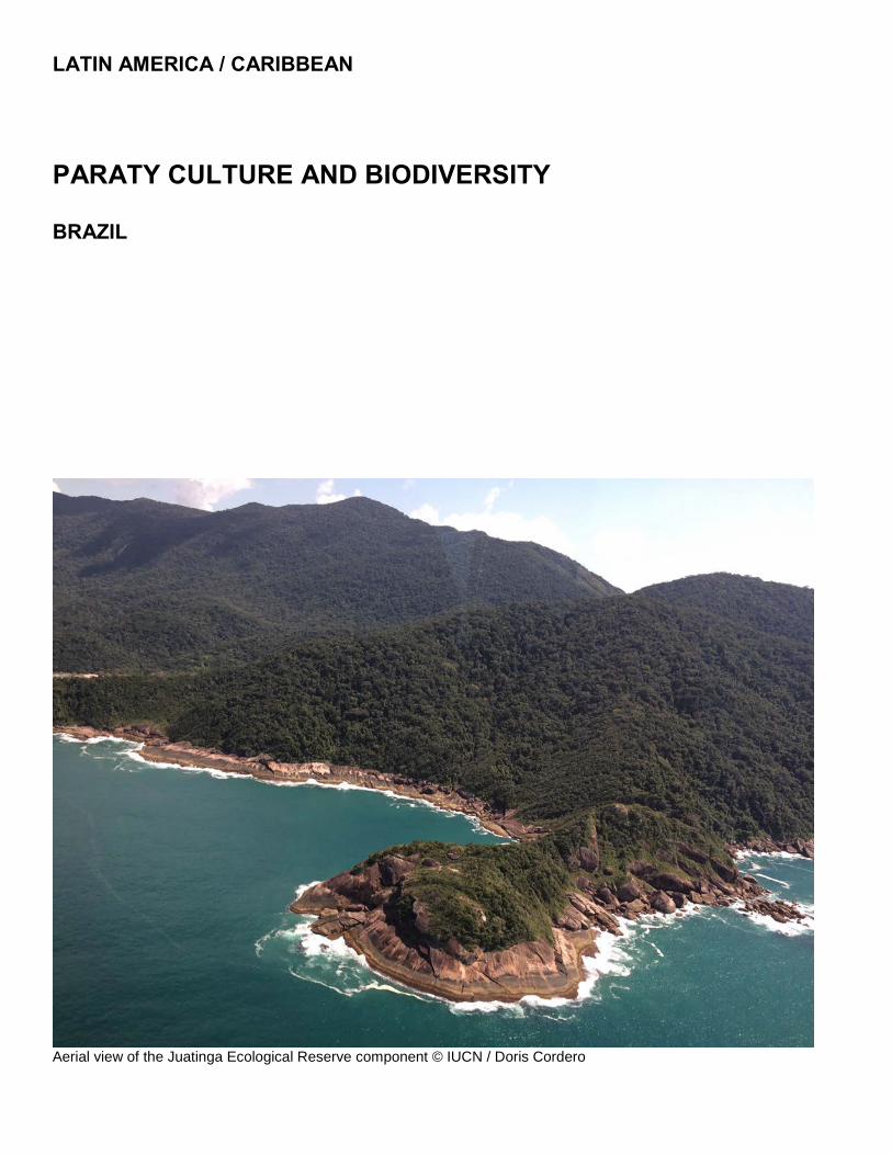
LATIN AMERICA / CARIBBEAN
PARATY CULTURE AND BIODIVERSITY BRAZIL
Aerial view of the Juatinga Ecological Reserve component © IUCN / Doris Cordero


Brazil – Paraty Culture and Biodiversity
IUCN Evaluation Report – May 2019 89
WORLD HERITAGE NOMINATION – IUCN TECHNICAL EVALUATION
PARATY CULTURE AND BIODIVERSITY (BRAZIL) – ID N° 1308 Rev
IUCN RECOMMENDATION TO WORLD HERITAGE COMMITTEE: To inscribe the property under natural criterion (x). Key paragraphs of Operational Guidelines: Paragraph 77: Nominated property meets World Heritage criterion. Paragraph 78: Nominated property meets integrity, protection and management requirements. Background note: Paraty was nominated under cultural criteria (ii), (iv) and (v) and as a cultural landscape in 2009. The nomination of Gold Route in Paraty and its landscape (Brazil) was deferred by the Committee (Decision 33 COM 8B.37), to allow the State Party to revise the property’s dimensions and consider renominating Paraty as a mixed property, highlighting its exceptional natural and cultural values. 1. DOCUMENTATION a) Date nomination received by IUCN: 25 March 2018. b) Additional information officially requested from and provided by the State Parties: Following the joint IUCN-ICOMOS field mission, a letter requesting supplementary information was sent on 17 October 2018. Information was sought on boundaries, notably the rationale for placing some elements in the nominated area and others in the buffer zone; and the rationale for nominating certain components and not others. A response was received by IUCN on 14 November 2018. Following the IUCN World Heritage Panel a joint progress report was sent by IUCN and ICOMOS to the State Party on 20 December 2018. This letter advised on the status of the evaluation process and IUCN sought responses/clarifications on a range of issues including further information on the selection of component parts; the specific plans and the committed implementation activities in the buffer zone to ensure connectivity is maintained and improved for mobile species and ecosystems between the different components; further details on threats such as those from the nuclear energy facilities in and adjacent to the buffer zone, threats from pollution and oil spill risks, as well as growing pressure from tourism, and consideration of climate change impacts; the plans to revise and strengthen the joint management plan, and the means that are being put in place to ensure implementation; and further details about the local communities, both in terms of involvement of the local and indigenous communities in the nomination and the management of the nominated property, and the ways the processes of nomination and inscription on the World Heritage List will proactively acknowledge and benefit the local and indigenous communities. The State Parties submitted additional information on 28 February 2019. c) Additional literature consulted: Various sources, including: CEPF. (2011). Ecosystem Profile. Atlantic
Forest Biodiversity Hotspot. Critical Ecosystem Partnership Fund (CEPF); Conti, B., & Irving, M. (2014). Desafios para o ecoturismo no Parque Nacional da Serra da Bocaina: o caso da Vila de Trindade (Paraty, RJ). Revista Brasileira De Ecoturismo (RBEcotur), 7(3); Fidelis Bahia, N.C., Seixas, C.S., Araujo, L.G., Farinaci, J.S. & Chamy, S. (2013). Implementation of a National Park over the traditional land of the Trindade community in Paraty, Brazil. 46-51, In Magro, T.C., Rodrigues, L.M., Silva Filho, D.F., Polizel, J.L., Leahy, J., Eds. 2013.Protected Areas and Place Making; J agger, T. (2013). World Heritage Nomination of Paraty and the surrounding Landscape and Seascape. Technical Recommendations from a Natural Heritage Perspective. Consultancy Report. d) Consultations: 9 desk reviews received. The field evaluation mission met with a wide range of stakeholders including federal, state and municipal authorities, traditional communities, and civil society organizations. Extensive consultation was held with the managing agencies for components of the nominated property: the Chico Mendes Institute for Biodiversity Conservation (ICMBio) and the Rio de Janeiro State Environment Institute (INEA). e) Field Visit: Doris Cordero (IUCN) and Luis Maria Calvo (ICOMOS), 9-11 September 2018 f) Date of IUCN approval of this report: April 2019 2. SUMMARY OF NATURAL VALUES Paraty Culture and Biodiversity (hereafter “Paraty”) is a mixed serial property located in the Serro do Mar region of Brazil, along the southern tip of the State of Rio de Janeiro, and the northern coast of the State of São Paulo. It is comprised of five components: the Serra da Bocaina National Park (the main reference point of the nominated property and the largest component); Ilha Grande State Park; Praia do Sul Biological Reserve; the Environmental Protection Area of Cairuçu; and the

Brazil – Paraty Culture and Biodiversity
90 IUCN Evaluation Report – May 2019
Paraty Historic Centre. Following the field mission, the State Party advised on various boundary adjustments to the nominated property including a decision to propose the larger Environmental Protection Area of Cairuçu instead of the originally nominated Juatinga Ecological Reserve, noting the latter is enclosed within the former larger area. The nominated property now covers a total area of 204,634 ha with a buffer zone of 258,921 ha. Table 1 below details the configuration of the nominated property across the component areas.
ID # Component Area (ha)
1 Serra da Bocaina National Park 130,900
2 Ilha Grande State Park 12,052
3 Praia do Sul Biological Reserve 3,502
4 Environmental Protection Area of Cairuçu 26,652
5a Paraty Historic Center 46
5b Morro da Vila Velha 13
Total Area 204,634
Buffer Zone 258,921
Property plus Buffer Zone 463,555
Table 1: Component parts constituting the nominated property, Paraty Culture and Biodiversity
The nominated property corresponds to a centre of endemism in the Atlantic Forest hotspot, one of the five most threatened biodiversity hotspots on the planet. It houses one of the areas of greatest biological diversity for this hotspot and may thus be considered a ‘hotspot within a hotspot.’ The nomination dossier highlights the context of the property and the relatively higher forest cover in this region: “The Atlantic Forest, the first colonized region in Brazil, underwent a continuous elimination of forest and it is estimated that today, only between 11% and 16% of the original forest cover remain... Among the 2,481 cities which have all of their territories in the Atlantic Forest, Angra dos Reis, Paraty and Ubatuba [main municipalities in the property of the proposed World Heritage Site] are among the 20 with the highest forest coverage... The three cities have forest and associated ecosystems coverage in 80%, 78% and 85% of their territories, respectively, which, for biome standards, are exceptional.”
Paraty’s geography, evolution and history has resulted in a unique diversity of landscapes from sea level to about 2,000 metres in elevation. Diversity and endemism are high, for example, more than 500 endemic species of vascular plants have been recorded. The occurrence of 36 species of rare plants is also notable, 29 of which are endemic to the nominated property, according to more than 170 scientists from 55 institutions in Brazil. The nominated property features approximately 45% of all the Atlantic Forest’s avifauna species with records of 450 species, a high biodiversity related in part to the
altitudinal gradients. Two Endemic Bird Areas are also found here, supporting 124 endemic bird species (57% of the total endemic bird species within the hotspot). Within the nominated property are a remarkable 11 Key Biodiversity Areas (KBAs) related to terrestrial vertebrates, rare freshwater fish and rare plants. The ‘Ilha Grande’ Alliance for Zero Extinction site (AZE) is found within the nominated property, triggered by the presence of the Black-hooded Antwren (Formicivora erythronotos, EN), an endangered bird species. According to the Critical Ecosystem Partnership Fund (CEPF), the group of protected areas located in the Serra do Mar, including the Serra da Bocaina National Park, is one of the most extensive protected area complexes covering the remaining Atlantic Forest, harbouring an extremely high concentration of endemic and endangered species. Paraty is home to an impressive array of fauna including many globally threatened species such as Jaguar (Panthera onca, NT), White-lipped Peccary (Tayassu pecari, VU), and several primate species such as Tufted Capuchin (Cebus apella nigritus, NT), Brown Howler Monkey (Alouatta fusca, LC) and Southern Muriqui (Brachyteles arachnoides, EN). All of these wider ranging species are threatened by habitat loss and degradation, particularly as a result of the conversion of land use or presence of extractive industries. Jaguars and White-lipped Peccary are poached for their pelts and other parts, but are also killed in retribution for livestock losses in ranching and other agricultural areas. White-lipped Peccary are hunted as food and it is important to note that there is a KBA for White-lipped Peccary found within the proposed boundaries of Paraty. Primates are generally sensitive to all forms of human disturbance. The presence of these species alongside panthers, ocelots, birds of prey and other key bird species is an indicator of the ecological health of the proposed site. The inclusion within the nominated property of the Environmental Protection Area of Cairuçu results in the property now including several traditional communities (indigenous, quilombola and caiçara) whose cultural expressions and traditional ways of life based on a balanced and respectful relationship with the surrounding natural environment are an important attribute contributing to the claimed Outstanding Universal Value (OUV) of the mixed property. 3. COMPARISONS WITH OTHER AREAS For natural values the dossier provides a comparison of the nominated property in relation to six inscribed mixed World Heritage sites in Latin America and the Caribbean (The Historic Sanctuary of Machu Picchu, Peru; Río Abiseo National Park, Peru; Tikal National Park (Guatemala); Ancient Maya City and Protected Tropical Forests of Calakmul, Mexico; Chiribiquete National Park – “The Maloca of the Jaguar”, Colombia; and Blue and

Brazil – Paraty Culture and Biodiversity
IUCN Evaluation Report – May 2019 91
John Crow Mountains, Jamaica). The nomination’s comparative analysis is concise yet convincing in concluding that Paraty compares favourably with other properties on the World Heritage List and in the Atlantic Forest in terms of its global biodiversity significance. IUCN and UN Environment-WCMC have conducted further global comparative analysis using spatial overlays and additional literature review. This concludes that the biodiversity that characterises the nominated property is of global significance. Brazil has seven existing natural World Heritage sites: Central Amazon Conservation Complex ((ix)(x)); Pantanal Conservation Area ((vii)(ix)(x)); Brazilian Atlantic Islands: Fernando de Noronha and Atol das Rocas Reserves ((vii)(ix)(x)); and Cerrado Protected Areas: Chapada dos Veadeiros and Emas National Parks ((ix)(x)), plus three within the Atlantic Forest: Discovery Coast Atlantic Forest Reserves ((ix)(x)); Iguaçu National Park ((vii)(x)); and Atlantic Forest South-East Reserves ((vii)(ix)(x)). The proposed Paraty Culture and Biodiversity features a biological diversity and uniqueness equal to or greater than these three latter sites already inscribed in the Atlantic Forest, as well as the other 45 World Heritage Sites (either natural or mixed) in tropical or subtropical areas with similar characteristics world-wide. The nominated property is found in the Udvardy Province (Serro do Mar Udvardy Province) represented by only two other World Heritage sites, and no Tentative List sites. The terrestrial ecoregions that the nominated property represents are currently covered by only one World Heritage site, and no Tentative List sites. The nominated property is located in one of five leading biodiversity hotspots (the Atlantic Forest hotspot), known for its high richness in endemic species. It encompasses a Global 200 priority ecoregion (Atlantic Forests). Although the most diverse terrestrial ecoregions are found in the Western Arc Forests in the Amazon Basin, the Atlantic Forests ecoregion of Brazil (along with the Choco -Darie n ecoregion of north-western South America; Sumatra, and Peninsular Malaysia and northern Borneo forest ecoregions), is a close rival. Paraty also encompasses two Endemic Bird Areas (Atlantic Forest Lowlands, and Atlantic Forest Mountains), and a Centre of Plant Diversity (Mountain Ridges of Rio de Janeiro). Whilst the hotspot, priority ecoregion, and endemic bird areas are shared across a handful of existing World Heritage Sites and Tentative List sites, the Mountain Ridges of Rio de Janeiro Centre of Plant Diversity is unique to the nominated property, and is not yet represented on the WH List or Tentative List. The nominated property reports high species diversity, with similar, and in some cases higher levels of species diversity reported than other comparable World Heritage sites. It has the highest recorded number of mammal species (150), and bird species (450) when compared with natural World Heritage sites in the Atlantic Forest biodiversity hotspot.
The nominated property is similarly high in endemism. The section of the Atlantic Forest covered by the nominated property represents the greatest richness of endemism for vascular plants. The nominated property also features about 57% (124) of the total of endemic birds of this hotspot. Furthermore, according to WCMC and IUCN global gap analyses, the “Atlantic Forest Southeast Reserves / Serra do Mar Cluster” is one of the 78 most irreplaceable protected areas in the world, and the study made a recommendation to consider this as a good candidate serial World Heritage property. 4. INTEGRITY, PROTECTION AND MANAGEMENT 4.1. Protection Most of the components of the nominated property have the highest level of protection possible under Brazilian law. Serra da Bocaina National Park and the Environmental Protection Area of Cairuçu are managed by the federal Chico Mendes Institute for Biodiversity Conservation (ICMBio) while the llha Grande State Park and Praia do Sul Biological Reserve are managed by the Rio de Janeiro State Environment Institute (INEA). They all have a strict preservation category. Despite the high level of protection of the components of the nominated property, there is a need to improve integration and management decisions among the governmental agencies at municipal, state and federal level with jurisdictions in the nominated property. The integrity, which is key to the OUV of Paraty, lies in the integration of the five components and the integration of the cultural, natural and traditional use of the complex. This will need a more elaborated overarching management plan that addresses all the components of the site and their integration. Nine of the protected areas that comprise the nominated property and its buffer zone, are integrated into the Ensemble of Protected Areas of Serra da Bocaina, which is a cohesive management unit that includes other protected areas such as Guarani Indigenous Lands and Quilombo Territories. Its Advisory Council meets periodically to discuss various conservation issues and integrated actions, as well as dialogues with the traditional communities of Caiçaras and Quilombolas. From the marine perspective, as the bay itself is included only within the buffer zone, it is critical that the recommendations made under the “Integrated Management Project of the Ecosystem of the Ilha Grande Bay” (BIG) are followed, and that engagement in the strategies related to this project continue such that management frameworks adequately protect the ecosystem health of the bay itself. IUCN considers that the protection status of the nominated property meets the requirements of the Operational Guidelines.

Brazil – Paraty Culture and Biodiversity
92 IUCN Evaluation Report – May 2019
4.2 Boundaries The Paraty mixed and serial nomination includes five components of which four are protected areas that belong to the National System of Protected Areas (SNUC) covering 99,97% of the proposed site. Serra da Bocaina National Park and the Environmental Protection Area of Cairuçu are managed by ICMBio, the federal agency of the Brazilian Ministry of the Environment for Protected Areas. The llha Grande State Park, Praia do Sul Biological Reserve and Juatinga Ecological Reserve (within the Environmental Protection Area of Cairuçu) are managed by the Rio de Janeiro Sate Environment Institute (INEA). They all have a strict preservation category. The Cairuçu Environmental Protection Area includes Juatinga Ecological Reserve, but 63% (16,692 ha) is managed for sustainable use. Serra da Bocaina National Park is one of the largest protected areas in the Atlantic Forest, with highly conserved ecosystems and ecosystem services, due to its topography and difficult access. Ilha Grande State Park and its buffer zone connects the inland Atlantic Forest with the island ecosystems, including mangroves and a mosaic of primary and secondary forest. Praia do Sul Biological Reserve contains important Atlantic Forest and coastal vegetation with little human intervention. The nominated property components’ boundaries coincide with the four protected areas boundaries, plus the Paraty Historical Centre, presenting an adequate size to conserve ecosystems and habitats that host the most diverse Atlantic Forest flora and fauna. Additional information provided by the State Party regarding the property boundaries and ecological connectivity between components parts, provides a detailed explanation of the institutional and legal framework that supports a series of specific plans and actions in the buffer zone to ensure connectivity. Nevertheless, it is clear that the protected areas that comprises the 258,921 ha buffer zone, are crucial to the connectivity between the property components. It is important to note that much of the coastal area and all marine areas of the Bay are not included in the nominated property, but are listed as buffer zones. Integrity of natural values in the nominated property is demonstrated by the presence of species that require large, intact swaths of habitat, such as the jaguars, cougars, white-lipped peccary, and primate species found at this site The five components and their combined size, including the buffer zones, are adequate to ensure integrity, but the connectivity between them must be preserved and enhanced to maintain the functionality of the overall site. Any loss of connectivity and/or reduction of functional size of any part of the site would be damaging to its integrity. IUCN considers that the boundaries of the nominated property meet the requirements of the Operational Guidelines.
4.3 Management A Paraty Site Management Plan was developed by a participatory process led by ICMBio and the National Institute of Historic and Artistic Heritage (IPHAN). The Management Plan aims to preserve and enhance the site, establishing strategies and guidelines for the coordination of activities with the participation of public and private actors including traditional communities. There is an issue to better harmonize the many protected area and environmental protection area management plans that overlap around the nominated property to establish a more effective overarching management framework for the serial components and buffer zone. The Paraty Site Management Committee, whose presidency will be held by ICMBio and IPHAN on a rotating basis, will have an Executive Committee comprising the two federal agencies, municipal governments, São Paolo State Government (Fundação Florestal), Rio de Janeiro State Government (INEA and INEPAC) and nongovernmental organizations. The Management Committee will also have an Advisory Council composed mostly of civil society organizations. While the nomination dossier includes a table of human resources for the components of the nominated property it does not provide sufficient detail to fully assess staffing. However, levels appear low given the threats, challenges and complexity of the area. Regarding staffing skill levels, most civil servants belonging to IPHAN, ICMBio, INEA and other federal and state government institutions hold technical and graduate level degrees. Protected areas established by federal, state and municipal governments have their own annual budget, as well as external resources from environmental compensation, local partnerships and cooperation projects. International cooperation projects can contribute to guaranteeing the financing of research, training, protection and conservation actions. IUCN considers that the management of the nominated property meets the requirements of the Operational Guidelines. 4.4 Community Serra da Bocaina National Park, the largest component of the nominated property, was established in 1971 partly on traditional lands. The strict protection status of this area prohibits traditional uses. In contrast, the recent expansion of component 4 to include all of the Cairuçu Environmental Protected Area adds over 16,000 ha designated for sustainable use by self-identified quilombos, caiçaras and indigenous peoples. The area’s objectives are focused on the conservation of natural ecosystems, species, beautiful landscapes and hydrological systems and on the integration of these

Brazil – Paraty Culture and Biodiversity
IUCN Evaluation Report – May 2019 93
landscape components with human communities. Therefore, Paraty Site structures will need to accommodate adequate and appropriate participation of these communities in management decision-making. 4.5 Threats The original 1.4 million square kilometres of the Atlantic Forest region has been reduced to 7.3% of its original forest cover. The problem is exacerbated by the fact that the Atlantic Forest region is home to approximately 70% of Brazil’s 169 million people, mainly in the megacities of São Paulo and Rio de Janeiro in the Serra do Mar Corridor. Paraty is located between these two cities, which are among the 50 largest cities in the world. The nominated property has suffered pressure since the opening in the 1970s of the BR 101 highway that connects Rio de Janeiro with São Paulo, and concomitant real estate speculation and predatory tourism has advanced and put pressure on traditional communities. The Almirante Álvaro Alberto Nuclear Centre (CNAAA) is one of the most important ventures in the area, comprised by a complex of nuclear plants. Located at the margins of Highway BR-101 in Angra dos Reis, CNAAA came into operation in 1982. The nuclear complex houses two plants in operation (Angra I and Angra II) with a total power of 2,007 MW. The Angra 3 plant is under construction until 2026. The Petrobrás Port Terminal (TEBIG) was built in 1977 to receive large ships focused on oil imports. Sea pollution caused by ships and other vessels, and the proliferation of exotic invasive species, threaten the marine biotic communities. Maritime traffic in the Ilha Grande Bay region is high, with oil tankers, platforms, cargo ships, tugboats and support ships circulating in the bay region, especially in the municipality of Angra dos Reis, located in the north end of the site. Ranching is cited as a valuable socio-cultural asset. Ranching can have significant environmental impacts even at a small scale, particularly in sensitive environments. Human-wildlife conflict related to ranching may result in the mortality of keystone predators like jaguars and cougars. It is critical that any ranching operations are managed sustainably and with the conservation of these species in mind. Ranching can also negatively affect the watershed and coastal health of the proposed site. Care should be taken to ensure that water quality is preserved and that intensive practices and further land clearing are avoided, even within the buffer zone. The protection strategies of the Atlantic Forest should also take into account increasing climatic instability, with an elevation in the incidence of extreme events. The conclusions of the first National Assessment Report of the Brazilian Panel of Climate Change (PBMC) on the natural and productive landscape of the Atlantic Forest and the studies on the consequences of climate change
on the native species of this hotspot, indicate a complex scenario by the end of this century, including the potential for impacts of sea level rise and more frequent and severe storm events. There may also be periods of drought that could negatively affect biodiversity and microhabitats within the proposed area. Current estimates indicate that the annual flow of tourism in the Municipality of Paraty varies from 250,000 to 300,000 tourists, being the fourth most visited municipality in the country by foreign tourists. Another major tourist attraction is Ilha Grande State Park; recent data estimates that the island receives about 400,000 visitors per year. According to TurisAngra studies, the flow of tourist ships that sail to Ilha Grande Bay every year involves around 100 vessels, and an estimated 200,000 transatlantic passengers. Challenges include the management of wastewater and sewage to ensure the water quality of the Ilha Grande Bay is not compromised. Plans are underway to upgrade sewerage systems in light of increased tourism, and further mitigate impacts of insufficiently treated wastewater. The nomination dossier describe the presence of 35 species of amphibians, of which 18 are endemic to the proposed site. The frogs of Brazil, as with most tropical countries, are threatened by the presence of the chytrid fungus. This fungus has decimated populations of frogs and continues to cause local, and possibly also species-level extinctions. Any analysis of biological richness, diversity, and conservation should include a statement on the presence or absence of chytrid, and there should be a strategic monitoring protocol in place. If chytrid is found, relevant parties should collaborate with amphibian conservation entities working in Brazil, particularly to provide additional support for the protection of the endemic amphibian species. In conclusion, IUCN considers that the integrity, protection and management of the nominated property meet the requirements of the Operational Guidelines. 5. ADDITIONAL COMMENTS 5.1 Consideration in relation to serial properties a) What is the justification for the serial approach? The justification of the serial approach is based on the fact that the five site components are not a contiguous area, but all contain exceptional cultural and biological values that create a unique landscape. Specifically, the four protected areas contain a variety of Atlantic Forest habitats and ecosystems, including ombrophylous forest, high-altitude grasslands, mangrove marshes and sandbanks that range between 2,000 m and sea level, which cannot be represented by a single site. Two of the four natural components in the original nomination are contiguous; Praia do Sul Biological Reserve and Ilha Grande State Park constitute most of the land area of the dominant island in the bay. The

Brazil – Paraty Culture and Biodiversity
94 IUCN Evaluation Report – May 2019
recent revision of the boundaries to expand component 4 to include all of the Cairuçu Environmental Protection Area rounds out the inclusion of the sites overarching feature, the natural amphitheatre, as component 4 is now contiguous with the largest component, the Serra de Bocaina National Park. Only the historic centre of Paraty does not have a common boundary among the components. All areas between the components—coastal areas and waters of Ilha Grande Bay—are included in the buffer zone. b) Are the separate component parts of the nominated property functionally linked in relation to the requirements of the Operational Guidelines? The serial site components of the nominated property are functionally linked in ways that maintain ecosystem processes and allow species to move through the landscape. However, more linkages of lower elevation slopes to the coast would be advantageous, especially source-to-the-sea watercourses. The Paraty Historic Centre is nestled between the Serra da Bocaina National Park and the coastline, all surrounded by Atlantic Forest and the waters of the Ilha Grande Bay. c) Is there an effective overall management framework for all the component parts of the nominated property? The Paraty Site Management Plan calls for a management committee. “The federal and state bodies responsible for managing the areas that make up the proposed Site will comprise the Local Executive Committee together with representatives of city halls and civil society organizations. The presidency will be held by IPHAN and ICMBio’s representatives, alternately“. The Management Plan outlines goals, results, indicators, sources of verification and assumptions for all the serial site components and buffer zone, linking the protected areas management plans. Implementation of the plan will be the key to managing the serial site as a coherent whole, especially the articulation of existing plans for each of the constituent components. There is a need to improve the overarching management framework for the nominated property so as to better integrate management decisions among the governmental agencies at municipal, state and federal level, involved in the property. 6. APPLICATION OF CRITERIA Paraty Culture and Biodiversity has been nominated under natural criteria (vii) and (x), as well as under cultural criteria (ii), (v) and (vi) which will be evaluated by ICOMOS. Criterion (vii): Superlative natural phenomena or natural beauty or aesthetic importance The nomination dossier does not make a case for superlative natural phenomena. However, it does present a justification for natural beauty or aesthetic
importance based on the dramatic and contrasting juxtaposition between mountain scenery blanketed with Atlantic Forest plunging into the sea and the diversity of coastal ecosystems. IUCN acknowledges the impressiveness of this land and seascape, however, notes that most of the coastline and all marine areas are excluded from the nominated area boundaries; they are included only in the buffer zone. Thus, the property within the boundaries does not present the complete picture described in the justification. In addition, the visual integrity is limited by the visible past forest loss and degradation in the lower elevations of all forests (where coffee was grown in the past; high-value timber was historically removed throughout the nominated area). Furthermore, the presence of large scale development in the region such as the Almirante Álvaro Alberto Nuclear Centre (CNAAA) and the Petrobrás Port Terminal (TEBIG) are considered to detract from the naturalness and aesthetic of the nominated property. IUCN considers that on balance the nominated property has not made a convincing case to meet criterion (vii) when compared with other similar properties in the Atlantic Forest region. IUCN considers that the nominated property does not meet this criterion. Criterion (x): Biodiversity and threatened species The nominated property is located in the Atlantic Forest hotspot, one of five leading global biodiversity hotspots and the site is known for its high richness in endemic species. The remarkably high biodiversity of this area is due to a unique diversity of landscapes with a set of high mountains and strong altitudinal variation, and ecosystems that occupy areas from sea level to about 2,000 metres in elevation. The nominated property is noteworthy for the occurrence of at least 11 Key Biodiversity Areas (KBAs). This section of the Atlantic Forest represents the greatest richness of endemism for vascular plants within the hotspot with some 36 species of rare plants, 29 of which are endemic to the site. Among the rare plants of the site are species of herbaceous plants, epiphytes, shrubs and trees, which occupy specific habitats of forest environments and sandbanks, as well as along watercourses. With records of 450 species, birds represent 60% of the endangered species of vertebrate fauna identified for the nominated property. The nominated property is home to 45% of all the Atlantic Forest’s avifauna including 57% of the total of endemic bird species for the hotspot. The nominated property boasts impressive species richness across almost all taxa: 125 species of anurans (frogs and toads) have been recorded representing 34% of the species known from the Atlantic Forest and some 27 species of reptile are known from the site. 150 species of mammals are found within the nominated property including several globally significant primates such as the Southern Muriqui, which is considered a flagship species for the site. The larger components of the nominated property are also important for large range species such as jaguar, cougar, white-lipped peccary and primate species. The nominated property also supports a

Brazil – Paraty Culture and Biodiversity
IUCN Evaluation Report – May 2019 95
similarly high diversity of marine biodiversity and endemism. IUCN considers that the nominated property meets this criterion. 7. RECOMMENDATIONS IUCN recommends that the World Heritage Committee adopts the following draft decision, noting that this will be harmonised as appropriate with the recommendations of ICOMOS regarding their evaluation of this mixed site nomination under the cultural criterion and included in the working document WHC/19/43.COM/8B: The World Heritage Committee, 1. Having examined Documents WHC/19/43.COM/8B and WHC/19/43.COM/INF.8B2; 2. Inscribes Paraty Culture and Biodiversity (Brazil) on the World Heritage List under criterion (x); 3. Takes note of the following Statement of Outstanding Universal Value: Brief Synthesis The property, Paraty Culture and Biodiversity, is a serial property comprising five component parts, including four protected areas: Serra da Bocaina National Park; Juatinga Ecological Reserve (including the larger Environmental Protected Area of Cairuçu); Ilha Grande State Park; and Praia do Sul Biological Reserve, plus the historic centre of the municipality of Paraty. The 204,634 ha property is nestled in the majestic Serra do Mar, known locally as Serra da Bocaina, which demarcates the landscape of the region due to its rugged relief reaching over 2,000 m altitude. The property and its buffer zone present a natural amphitheatre of Atlantic Rainforest dropping down to Ilha Grande Bay. The two protected areas, Praia do Sul Biological Reserve and Ilha Grande State Park, also cover most of the largest island within the Bay, and the property’s buffer zone includes many small islands, beaches, and coves. The forest formations exhibit four distinct classifications according to altitude. This property represents the greatest concentration of endemism for vascular plants within the Atlantic Forest biodiversity hotspot, and also features 57% of the total of endemic bird species of this hotspot. The property’s systems of fluvial sedimentation supports stands of mangrove and resting, which are found on the coastal plains and function as important ecosystems for the transition between terrestrial and marine environments. The forests, mangroves, restinga, reefs and islands of the property shelter hundreds of mammals, amphibians, reptiles and birds, many endemic to the Atlantic Rainforest and threatened with extinction.
The geographical conditions of the area, a coastal plain abundant in food and natural shelter surrounded by the sea and mountains covered by forests, has allowed the occupation and transformation of the area by people in a unique way, first by the indigenous peoples and later by the Europeans, who chose it for being a safe refuge for ships and for being the main point of entry into the interior of the continent. The property is also home to traditional Quilombolas, Guaranis and Caiçaras communities that maintain the way of life and the production system of their ancestors, as well as most of their relationships, rites and festivals. Criteria Criterion (x) Paraty Culture and Biodiversity World Heritage property is located in the Atlantic Forest hotspot, one of five leading global biodiversity hotspots and the property is known for its high richness in endemic species. The remarkably high biodiversity of this area is due to a unique diversity of landscapes with a set of high mountains and strong altitudinal variation, and ecosystems that occupy areas from sea level to about 2,000 metres in elevation. The property is noteworthy for the occurrence of at least 11 Key Biodiversity Areas (KBAs). This section of the Atlantic Forest represents the greatest richness of endemism for vascular plants within the hotspot with some 36 species of rare plants, 29 of which are endemic to the site. Among the rare plants of the site are species of herbaceous plants, epiphytes, shrubs and trees, which occupy specific habitats of forest environments and sandbanks, as well as along watercourses. With records of 450 species, birds represent 60% of the endangered species of vertebrate fauna identified for the property. Paraty Culture and Biodiversity World Heritage property is home to 45% of all the Atlantic Forest’s avifauna including 57% of the total of endemic bird species for the hotspot. The property boasts impressive species richness across almost all taxa: 125 species of anurans (frogs and toads) have been recorded representing 34% of the species known from the Atlantic Forest and some 27 species of reptile are known from the site. 150 species of mammals are found within the property including several globally significant primates such as the Southern Muriqui, which is considered a flagship species for the site. The larger components of the property are also important for large range species such as jaguar, cougar, white-lipped peccary and primate species. The property also supports a similarly high diversity of marine biodiversity and endemism. Statement of Integrity The property coincides with areas of high forest cover within the formerly extensive Atlantic Forest, with most of the site included in protected areas of the National System of Nature Protected Areas (SNUC), contributing to the maintenance of the environmental integrity of the landscape. The integrity of this landscape is evidenced by the presence of species that require large, intact

Brazil – Paraty Culture and Biodiversity
96 IUCN Evaluation Report – May 2019
swaths of habitat. Further studies on the estimated population of jaguars within the inscribed area, as well as information on their movements would provide confirmation of the ecological integrity of the property. From the marine perspective, as the bay itself is included within the buffer zone, it is critical that the strategies and recommendations made under the “Integrated Management Project of the Ecosystem of the Ilha Grande Bay” (BIG) are effectively implemented to adequately protect the ecosystem health of Ilha Grande Bay itself. The five combined component areas and their overall size, including the buffer zone are adequate to ensure integrity, but the connectivity between them must be preserved to maintain ecological functionality across the overall size. Any loss of connectivity and / or reduction of functional size of any part of the site would be damaging to its integrity. The management of the buffer zone is hence critical to the overall health of the property’s values. In the southern portion of the site, in the overlap between the Serra do Mar State Park in São Paulo State and the Bocaina National Park, is the only location on the Atlantic Coast where the full altitudinal gradient between the coastline and the top of the mountain range is totally included within protected areas. Ilha Grande Bay demonstrates one of the highest levels of connectivity between the forest ecosystems of the Atlantic Forest and coastal shore ecosystems, contributing to the representation and preservation of its natural attributes. Protection and Management All of the components of the serial property are protected by municipal, state and federal legislation. Serra da Bocaina National Park is managed by ICMBio, the federal agency of the Brazilian Ministry of the Environment for Protected Areas. The Ilha Grande State Park, Praia do Sul Biological Reserve and Juatinga Ecological Reserve are managed by the Rio de Janeiro Sate Environment Institute (INEA). The Paraty Historical Centre has been protected by the National Historic and Artistic Heritage Institute (IPHAN) since in 1958. ICMBio, INEA and the Ministry of Environment, as well as IPHAN and the Ministry of Culture provide adequate long-term institutional protection and management to the property’s components and buffer zone. All protected areas have their own annual budget to ensure the implementation of research, training, protection and conservation actions. Individual components of the serial property have management plans, however, the integrity of the property lies in the integration of the five components and the integration of the cultural, natural and traditional use of the complex. This will need an overarching management framework that address all the components of the site and ensures coordinated and harmonized management.
A challenge facing the property relates to developing a better understanding of the ecosystem and social aspects of human use within the property and buffer zone including traditional fishing practices and ranching to ensure they are ecologically, socially and economically sustainable. Tourism and surrounding development pressures stem from the property’s location between the two major cities of São Paolo and Rio De Janeiro. It is therefore important to assess the benefits and impacts of increasing tourism pressure on the property, especially in areas of ecological and cultural sensitivity. The context of the property is important to understand and manage given the presence of nuclear energy facilities in one portion of the buffer zone, as well as existing impacts from the oil industry. The threats of thermal pollution, chemical pollution, impacts from vessel traffic, and more are very serious and could compromise much of the aesthetic and ecological value of the coastal sections of the proposed site. Effective planning and response mechanisms are therefore critical to have in place. Finally, an important dimension relates to engaging with local communities within and surrounding the property. Ongoing and enhanced efforts will be needed to build stronger participatory approaches that empower local communities in the management of the site and in generating and sharing benefits in a way that respects rights and improves social and economic sustainability in the region. 4. Expresses its appreciation to the State Party for its decision to add the wider Cairuçu Environmental Protected Area to the property, thereby including the entire natural amphitheatre of the Ilha Grande Bay; 5. Recommends that the State Party undertake the following actions to strengthen the conservation of the property: a) Harmonize the many protected area and
environmental protection area management plans that overlap around the property to establish an overarching management framework that address all the components of the site and ensures coordinated and harmonized management.
b) Strengthen participatory governance mechanisms to enshrine the principles of free prior and informed consent and empower local communities in management and benefit generation and sharing as a contribution to improved social and economic sustainability in the region
c) Ensure the maintenance of ecological connectivity between the property’s component parts with particular attention on the regulation and management of buffer zone uses and practices.
d) Ensure effective monitoring of tourism use and impacts to forecast and plan for increasing tourism pressure on the property, especially in areas of ecological and cultural sensitivity

Brazil – Paraty Culture and Biodiversity
IUCN Evaluation Report – May 2019 97
e) Finalize and implement plans to upgrade sewerage systems in light of increased tourism, and further mitigate impacts of insufficiently treated wastewater;
6. Encourages the State Party to consider the progressive addition of further suitable lower altitude forest areas to the inscribed property in order to further improve the representation of ecosystems and habitats across the property’s altitude gradient.
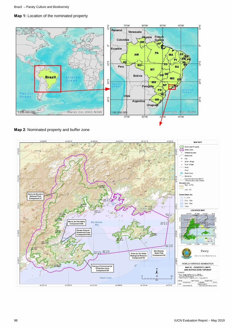
Brazil – Paraty Culture and Biodiversity
98 IUCN Evaluation Report – May 2019
Map 1: Location of the nominated property
Map 2: Nominated property and buffer zone
C. CULTURAL PROPERTIES C1. NEW NOMINATIONS OF CULTURAL PROPERTIES


ASIA / PACIFIC
BUDJ BIM CULTURAL LANDSCAPE AUSTRALIA


Australia – Budj Bim Cultural Landscape
IUCN Evaluation Report – May 2019 103
WORLD HERITAGE NOMINATION – IUCN COMMENTS TO ICOMOS
BUDJ BIM CULTURAL LANDSCAPE (AUSTRALIA)
IUCN considered this cultural landscape property based on a desk review of the nomination and the contributions of four external desk reviewers not associated with the nomination to provide inputs to ICOMOS on the natural components of this property. The external desk reviews were also shared directly with ICOMOS to contribute to their detailed reflections on this nomination. The evaluation of the nomination for the World Heritage Committee will be finalised by ICOMOS. The nomination is a serial site of three component parts, situated in the south-eastern part of mainland Australia and within the State of Victoria, making up a total of 9,935 ha. The nomination is extremely well prepared, and clearly outlines the basis for the interaction of people with nature, centred on aquacultural practices of the Gunditjmara, who have stewarded their country for Kooyang (Short-finned Eel, Anguilla australis), through practices documented for more than 6,600 years in the nominated property, but extending back potentially thousands of years further. The aquaculture takes place in natural and modified water systems that follow the Budj Bim lava flow, from an eruption dated to 39,000 years ago. The nomination is prepared in the name of the Gunditjmara traditional owners, and the Windi Mara Aboriginal Corporation who have worked on the nomination for 15 years. The native title rights of Gundjitmara were recognised by federal court in 2007. The nomination documents clearly the natural attributes of the nominated property, and the values that it represents draw on both a geological event (the lava flow) and the biological diversity of the landscape. The nomination terms the area an eco-cultural landscape, to reflect that the term “biocultural” is not sufficiently broad to capture the relationship of people and country that is the foundation of the nomination. This, in itself, is an example of the way in which including indigenous peoples in the work of the World Heritage Convention leads towards new and better understandings of how diverse landscape approaches can be recognised and supportive as a basis for potential Outstanding Universal Value. The nomination is included in areas that are recognised for the conservation of nature at national level. The area largely overlaps with the Budj Bim National Park (formerly Mount Eccles National Park) category II: https://www.protectedplanet.net/24767, the central component of Budj Bim Cultural Landscape overlaps with Kurtonitj, category VI: https://www.protectedplanet.net/555548635 and the southern component of Budj Bim Cultural Landscape largely overlaps with Tyrendarra, category VI: https://www.protectedplanet.net/357414. The Budj Bim Cultural Landscape is wholly within the Country of the Gunditjmara and is subject to the traditional and customary rights and obligations of the Gunditjmara Traditional Owners (recognised by the Native Title Act 1993 and Aboriginal Heritage Act 2006). The nomination makes reference to both nature conservation values, noting that the moderately to highly intact indigenous vegetation of the areas is assessed as of conservation significance, and there are species, such as a bat and some birds that are threatened at national level. The nomination also notes conservation issues, such as those from invasive rabbit, fox, cat, deer and pig, and invasive plants. There is not a complete species list presented in the nomination. IUCN notes that there appears to be effective protection and management of the property in place, according to the nomination. The content of reviewers’ comments is substantially positive regarding the nomination. Some issues noted that ICOMOS may wish to consider are:
a) Minor issues with management of kangaroo and koala, and interaction with visitors could be clarified. b) Notable recent work has been done by the Ramsar Convention regarding traditional and indigenous
knowledge and wetland management, which could be referred to, and might also provide some further comparable sites to consider.
c) Tourism expectations should be clarified, together with intended management measures. d) The quality of the nomination could be taken as an example for other indigenous-led World Heritage efforts,
including the degree to which it also represents both a manifestation of indigenous cultural heritage that undermines stereotypes, and represents how the recovery of rights can lead to cultural healing, ownership, and recovery of economic independence.


EUROPE / NORTH AMERICA
WRITING-ON-STONE / ÁÍSÍNAI’PI CANADA

Canada – Writing-on-Stone / Áísínai’pi
IUCN Evaluation Report – May 2019 107
WORLD HERITAGE NOMINATION – IUCN COMMENTS TO ICOMOS
WRITING-ON-STONE / ÁÍSÍNAI’PI (CANADA)
IUCN considered this cultural landscape property based on a desk review of the nomination and the contribution of one external desk reviewer not associated with the nomination to provide inputs to ICOMOS on the natural components of this property. The external desk review was also shared directly with ICOMOS to contribute to their detailed reflections on this nomination. The evaluation of the nomination for the World Heritage Committee will be finalised by ICOMOS. The nominated property is a serial nomination consisting of three components, referenced as Áísínai’pi, Haffner Coulee, and Poverty Rock, located in Alberta, Canada. The total nominated area is of 1,106 ha with a buffer zone of 1,047 ha. This nomination overlaps with an area of nature conservation significance. According to the nomination all three components of the nominated property are wholly encompassed within the boundaries of Writing-on-Stone Provincial Park (IUCN category II), which was first designated in 1957 (extended in 1962, 1964, 1968 and 1992). The area is designated under Alberta’s Provincial Parks Act (RSA 2000, c. P-35). A portion of the nominated property is also designated as a Provincial Historic Resource under the Historical Resources Act (RSA 2000, c. H-9) (Map 10). The Áísínai’pi component of the nominated property and associated buffer zone are also designated as a National Historic Site of Canada. The greatest concentration of rock art in the nominated property is found on the main rock art cliff in the Archaeological Preserve (within the Áísínai’pi component). In 1981, the level of legal protection was increased when most of the Archaeological Preserve was declared a Provincial Historic Resource". The nomination reports nature conservation values, including as “protected habitat for a wide range of prairie wildlife species, including a high concentration of rare plants and a number of species at risk.” The description of the nominated property mentions geology and post-glacial morphology, and a short description of habitat diversity and mention of some species of cultural importance. No overall species list is included, nor is there mention of threatened species. The review IUCN received noted, amongst issues, concerns regarding the impacts of a nearby rodeo ground, which has reportedly led to damaging incidents affecting the nominated property in the past. The appropriateness of the location of this facility is questioned, and IUCN considers this matter should be considered further by ICOMOS through its evaluation and review process.


EUROPE / NORTH AMERICA
RISCO CAIDO AND THE SACRED MOUNTAINS OF GRAN CANARIA CULTURAL LANDSCAPE SPAIN


Spain – Risco Caido and the Sacred mountains of Gran Canaria Cultural Landscape
IUCN Evaluation Report – May 2019 111
WORLD HERITAGE NOMINATION – IUCN COMMENTS TO ICOMOS
RISCO CAIDO AND THE SACRED MOUNTAINS OF GRAN CANARIA CULTURAL LANDSCAPE (SPAIN)
IUCN considered this cultural landscape property based on a desk review of the nomination and the comments of two external desk reviewers to provide inputs to ICOMOS on the natural components of this property. The external desk review was also shared directly with ICOMOS to contribute to their detailed reflections on this nomination. The evaluation of the nomination for the World Heritage Committee will be finalised by ICOMOS. The nominated property is in the mountainous heart of Gran Canaria Island, in the Autonomous Community of the Canary Islands, Spain. The core area encompasses 9,425 ha and the surrounding buffer zone 8,557 ha. With the exception of the Risco Caído and Barranco Hondo de Abajo area, practically all of the proposed cultural landscape and buffer zone is included in at least one, or more, of the different protected categories of the Canary Island Network for Protected Areas (Red de Espacios Naturales de Canarias). The area in question is protected under four different types of protection: Rural Park, Natural Monument, Nature Reserve and Protected Landscape (see p. 425 of the nomination). The areas of overlap with protected natural areas include:
a) Over 2/3 of the site overlaps with the El Nublo II (rural park); category not assigned on Protected Planet, but correspond to categories V and VI according to the nomination text.
b) The northern area of the proposed property, including the buffer zone, overlaps with the Tamadaba (natural park/nature reserve); category V according to Protected Planet, but category II according to the nomination text (p.428).
c) A small part in the extreme south-west and the buffer zone overlaps with Roque Nublo (natural monument); category III.
d) A part of the buffer zone in the south overlaps with Inagua (Strict Nature Reserve/Reserva Natural Integral) (called Ojeda; Inagua y Pajonales on Protected Planet); category not assigned according to Protected Planet, but according to nomination text declared a Strict Nature Reserve (Reserva Natural Integral) corresponding to category I.
e) An area in the northern part of the proposed cultural landscape that only impacts on the buffer zone, overlaps with Las Cumbres (Cultural landscape/protected landscape); category V.
The nomination notes that, in terms of environmental and scenic protection, practically the entire proposed property is listed as an integral part of the Canary Island Network of Protected Natural Areas. Most of the area is listed as a Special Area of Conservation (SAC) as part of the European Natura 2000 Network. Almost all of the nominated area is also included in the Gran Canaria Biosphere Reserve, declared in 2005 by UNESCO, however the boundaries of the nomination are conceived in a different configuration to the buffer zone. The nominated property has also been certified as a Starlight Reserve and Destination, an initiative that seeks to protect dark skies, and is supported by UNESCO. The nomination includes a description of biodiversity values, and suggests reduced human pressure is supporting a more favourable conservation status for the area. The nomination reports 163 taxa endemic to the Canary Islands are represented (130 species, and 33 subspecies), and that at least 28 taxa are threatened. The areas of Tamadaba and Ojeda are both classified as Key Biodiversity Areas, notably for conservation of the Gran Canaria Blue Chaffinch Fringilla teydea polatzeki, a bird classified as globally endangered (EN) in the IUCN Red List of Threatened Species. This species has received attention through on-site conservation projects, including with EU funding. As recreational activities are noted as one threat to this species, it will be important to ensure that any changes in visitation resulting from possible World Heritage listing are actively managed to avoid areas important for its conservation.


EUROPE / NORTH AMERICA
PRIORAT-MONTSANT-SIURANA, MOSAÏQUE MÉDITERRANÉENNE, PAYSAGE CULTUREL AGRICOLE SPAIN

Spain – Priorat-Montsant-Siurana, mosaïque méditerranéenne, paysage culturel agricole
IUCN Evaluation Report – May 2019 115
WORLD HERITAGE NOMINATION – IUCN COMMENTS TO ICOMOS
PRIORAT-MONTSANT-SIURANA, MOSAÏQUE MEDITERRANEENNE, PAYSAGE CULTUREL AGRICOLE (SPAIN)
IUCN considered this cultural landscape property based on a desk review of the nomination and the comments of one external desk reviewer to provide inputs to ICOMOS on the natural components of this property. The external desk review was also shared directly with ICOMOS to contribute to their detailed reflections on this nomination. The evaluation of the nomination for the World Heritage Committee will be finalised by ICOMOS. The nominated property lays in Catalonia, in the north-east of Spain, and includes a core area of 51,562.56 ha and a buffer zone of 64,058.74 ha. The nomination notes that the area is covered by six Protected Areas (PA), which together are stated to cover slightly more than half (52,2%) of the nominated property. In relation to areas included in the IUCN/WCMC World Database on Protected Areas, noted areas of overlap include:
a) 25% of the north-western parts of the property overlaps with the Serra de Montsant-Pas de l'Ase PA, category not assigned (but defined as Parc Naturel in the nomination text);
b) In the south a smaller part of the property (c. 10%) overlaps with the Serra de Llaberia PA, category V; c) In the east a smaller part of the property (c. 10%) overlaps with the Muntanyes de Prades PA, category V; d) The property encompasses almost all of the Riu Siurana i planes del Priorat Special Protection Area (covering
c. 10% in the centre of the property), category not assigned; e) A very small part of the property in the east overlaps with the small Serres de Pradell-l`Argentera PA,
category V. The nomination notes that the profusion of protected natural areas provide also for the protection of areas surrounding the nominated property, and also note coverage of areas under the European Natural 2000 network, and in the Terres de l’Ebre Biosphere Reserve, declared by UNESCO in 2013. It would be relevant for ICOMOS, perhaps with the assistance of UNESCO World Heritage Centre, to consult with the UNESCO Science Sector regarding information about the biosphere reserve classification and information that is available about it. The majority of the property lies within the Montsant and Prades mountains Key Biodiversity Area (KBA), and an important area for resident raptors. A smaller part in the south overlaps with the Cardó, Tivissa and Llabería mountains KBA, an important site for breeding raptors and species characteristic of Mediterranean habitats. The nomination includes substantial descriptive material and detailed information regarding the biodiversity and wider nature conservation values of the area, including noting the presence of some species endemic to this region, such as the large cricket, Pantel’s Saddle Bush-cricket (Lluciapomaresius panteli) – assessed as data deficient in the IUCN Red List in 2015, and reportedly subject to threats including from agriculture and fragmentation of land, and the plant, Delphinium bolosii. There is limited specific information provided regarding specific biodiversity conservation measures, and the relationship of the biodiversity values to traditional landscape management practices. Nor are there projections for change in the landscape, including in relation to climatic factors.


LATIN AMERICA / CARIBBEAN
SUNKEN CITY OF PORT ROYAL – A RELICT AND CONTINUING CULTURAL LANDSCAPE JAMAICA


Jamaica – Sunken City of Port Royal – A Relict and Continuing Cultural Landscape
IUCN Evaluation Report – May 2019 119
WORLD HERITAGE NOMINATION – IUCN COMMENTS TO ICOMOS
SUNKEN CITY OF PORT ROYAL – A RELICT AND CONTINUING CULTURAL LANDSCAPE (JAMAICA)
IUCN considered this cultural landscape property based on a desk review of the nomination and the comments of two external desk reviewers to provide inputs to ICOMOS on the natural components of this property. The external desk review was also shared directly with ICOMOS to contribute to their detailed reflections on this nomination. The evaluation of the nomination for the World Heritage Committee will be finalised by ICOMOS. The nominated property of the City of Port Royal covers an area of 36.40 hectares; the nomination constitutes, for the most part, the 20.6 hectares (51 acres) boundary delimitation of the pre 1692 Naval Port City of Port Royal. A buffer zone covers 572.30 hectares. The nominated property is covered by nature conservation designations recorded in the IUCN/WCMC World Database of Protected Areas (WDPA), including as follows: a) The whole property is encompassed within the Palisadoes Protected Area (category not reported): b) The underwater part of the property (numerous submerged ruins of houses, forts, warehouses, shipwrecks and markets) and the buffer zone are also encompassed within the Palisadoes - Port Royal Ramsar site, category not reported. The nomination enumerates species in this component that are identified as threatened in the IUCN Red List of Threatened Species, including two critically endangered (CR) corals (Elkhorn Coral and Staghorn Coral), the critically endangered Hawksbill Turtle, the endangered (EN) Green Turtle, and Near Threatened (NT) Slender Seahorse (Hippocampus reidi). Species lists are set out in the "Final Draft Palisadoes-Port Royal Protected Area Management Plan 2015-2020” and there are tables of threatened species, and protected species provided. The nomination also notes that the Convention of International Trade of Endangered Species (CITIES) was entered into force in June 1997 and seeks to prohibit the exploitation and unsustainable trade of endangered species such as the American Crocodile (Crocodylus acutus) that is found in the buffer zone. This is a species that is widely distributed and assessed as vulnerable (VU). Kingston Harbour (Palisadoes) and Port Royal Cays is also listed as a Key Biodiversity Area, although details are not currently available on the World Database of KBAs on the conservation values of this area. East of the property is the Bull Bay KBA. The nomination also describes the geology and geomorphology of the nominated area, with limited mentions of barrier reefs and cays (islands). There is also a very brief description of costal vegetation and birds. IUCN therefore notes the importance of the ICOMOS evaluation ensuring measures to maintain and strengthen the conservation of globally significant species within the nominated property. Additional issues raised by reviewers include:
a) Analysis of the results achieved via international recognition as a Ramsar Site would be valuable, and it is recommended that ICOMOS seek information from the Ramsar secretariat (and possibly the Ramsar Culture network).
b) The interactions between nature and culture that create a cultural landscape are no clearly explained. c) The rationale for boundaries and buffer zones needs clarification and is not immediately clear from the
nomination. d) Questions on the quality of consultation with communities are raised, and should be clarified, including what
impacts on communities might result from World Heritage listing. e) It would be valuable to ensure any impacts of World Heritage on land prices, which has been an issue in past
nominations in the Caribbean, have been anticipated in the nomination.


InternatIonal UnIon for ConservatIon of natUre
WORLD HEADQUARTERSRue Mauverney 28 1196 Gland, Switzerland Tel +41 22 999 0000Fax +41 22 999 0002www.iucn.org