investment projects catalogue of the ... of serbia municipality of negotin investment projects...
TRANSCRIPT
Republic of Serbia
Municipality of Negotin
INVESTMENT PROJECTS CATALOGUE OF THE MUNICIPALITY OF NETOGIN
-SUMMARY-
Creation of the Study is a part of the activities covered in the project realisation: Improvement of Property Management in Municipalities of Negotin and Kladovo Financed by the Delegation of the European Union to the Republic of Serbia: cris 2013/336-777
"This document was financially supported by the European Union. The content of this document is the sole responsibility of the Municipality of Negotin and under no circumstances can be considered as a reflection of the position of the European Union."
Study prepared by:
www.idsolutions.co.rs
January 2015
- CONTENT -
1. INTRODUCTION.......................................................................................................................... 4
PPP Models in the Comparative Practice ............................................................................ 5
Potentials for Local Self-Government Investment.............................................................. 6
2. Development Investment Projects of the Municipality of Negotin .................... 7 2.1. Industrial Zone Negotin – Storage Zone ....................................................................... 8
2.2. Industrial Zone with the Port Terminal in Prahovo .................................................... 13
2.3. Negotinske pivnice (Rajac, Rogljevo and Štubik)...................................................... 17
2.4. Danube Riviera – The Danube Pearl .......................................................................... 25
2.5. Tourist Centre – Stevanske livade ............................................................................. 31

4
1. INTRODUCTION
The Catalogue of investment projects and sites at which the investment realisation is
possible in order to activate public property, represents a publication with the intention to attract attention of potential investors and inform them on basic preconditions regarding the potential investment.
The publication is intended for a wide range of interested subjects and its structure is adjusted to everyday work of local self-government authorities as well as other subjects of local development. The structure of each proposed investment site/project is as follows:
- Development model for public property management - Competition Plan - Marketing Plan – defining of actions necessary for investment promotion - Action Plan – Implementation plan
In accordance with the defined terms of reference and dynamics, a number of formal communications has been initiated with the local self-government in Negotin in order to get a better insight into the issue context (general and local) which is to be the subject of the Catalogue. Based on the mentioned communication, the following documents have been analysed:
Law on Public-Private Partnership and Concession (“Official Gazette of RS”, No.. 88/2011);
General Regulation Plan for the settlement of Negotin – 2011
Spatial Plan of the municipality of Negotin – 2011
Capital Investment Plan of the municipality of Negotin 2012-2016
Sustainable Development Strategy of the municipality of Negotin for the period 2012 – 2021
Guide for Investors in the municipality of Negotin – KLER Negotin
Guide for Investors– catalogue of free sites in the municipality of Negotin – KLER Negotin
Review of construction land by number of plots and purposes in selected cadastral municipalities of the municipality of Negotin
In cases when the real inflow of Greenfield investments in Serbia is reduced due to the global economic crisis on one hand, and hardly available and expensive capital on the other, the local self-governments in Serbia need alternatives in funding of both development economic and infrastructural – social projects.
Local self-governments have financed their development programs and projects in various ways: through public debt, financing from real revenues at the level of the current budget year, lately by issuing municipal bonds and the least through creation of public-private partnerships (PPP).
PPP realization practice is not new for the realization of both investment and non-investment projects in Serbia. In the past, significant projects were realized by giving concessions when due to social and political order more transparent ways of partnerships between private and public sector could not have been realized.
Lately, especially for the needs of construction of infrastructure and equipment of construction land, various cooperation models of public and private sector have been established in order to have a win-win situation and improve the level of community development in general. However, the lack of transparency of the mentioned relations and the exclusion of the public from the negotiation process, have opened the question of validity of “informal” cooperation models of the two sectors.
Accordingly, the Law on Public-Private Partnership and Concession (“Official Gazette of RS”, No. 88/2011) was created and adopted, based on which the cooperation models, key subjects and the role of regulatory bodies for the mentioned process were defined.

5
In order to activate public property for the needs of economic and general social growth of the Municipality, we will present below a brief summary of the Law on PPP and Concession as a key model of activation of the mentioned resources. We consider that the mentioned model for the relevant global, regional and local economic situations is the best foundation for launching the flywheel of economic development of the municipality of Negotin and activation of local public property as an underutilized resource so far.
PPP Models in the Comparative Practice
The developed market economies have been using the PPP as an efficient and effective way of management in providing public services and construction of infrastructure in various areas for years. The importance of this form of partnership in the EU member states has been great since it contributes to the improvement of quality of buildings, decreases the total expenditure of maintenance of those buildings, and unburdens the increasing debt of the state towards investors.
Different PPP models have been noticed in the comparative practice, out of which the most significant are the so called BOT; BOO and PFI models.
BOT (Build Operate Transfer); BOT is a concession model, and is characterised by a direct relation existing between the private partner and the end service user. The private partner provides direct service to the end users instead of the public partner, though under his “control”. In this case, the state is only a controller and regulator, while the private partner charges his services from the user. Other characteristic of this form a compensation for the concessionaire. The concessionaire usually receives the compensation by charging it from the end service users. Also, the contract can envisage that the amount can be co-financed by the public partner, that is, the state. The contract closely defines the rights and responsibilities of the contracted parties, as well as the time period for which the contract was concluded. The time period is usually up to 25 years. After the expiry of the contract, the facility is transferred the ownership of the public sector.
BOO (Build Operate Own); Unlike BOT, the model is characterised by the fact that the private partner is not obliged to transfer the ownership over the goods to the public sector. The public sector can earn the goods by purchasing them after the expiry of the contract period in the value which the goods have after the calculation of depreciation.
PFI (Private Finance Initiative); PFI is a model by which the private partner uses his own resources for designing, construction, maintenance and management of the building for the public partner and at the same time guarantees the quality, usability and availability. According to this model the compensation to the private partner is not compensation (payment) by the end user, but regular payment by the public partner. The public partner pays the compensation for the lease in the form of annual or monthly annuity. This payment can be fixed or be calculated in relation to the provided services to the users or the manner of facility use. The partners conclude a contract envisaging that the private partner provides also the service to the end user, which is to be additionally paid by the end user.
6
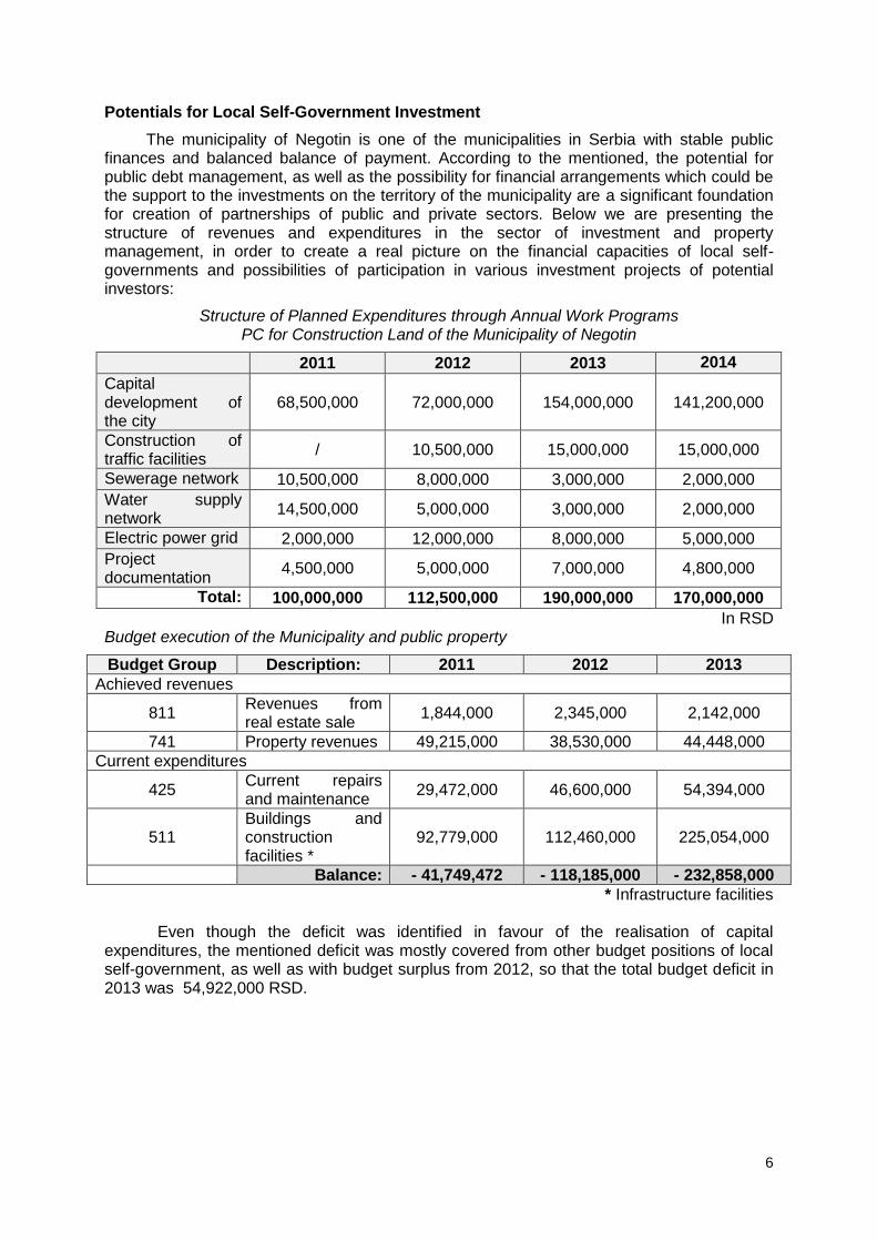
Potentials for Local Self-Government Investment
The municipality of Negotin is one of the municipalities in Serbia with stable public finances and balanced balance of payment. According to the mentioned, the potential for public debt management, as well as the possibility for financial arrangements which could be the support to the investments on the territory of the municipality are a significant foundation for creation of partnerships of public and private sectors. Below we are presenting the structure of revenues and expenditures in the sector of investment and property management, in order to create a real picture on the financial capacities of local self-governments and possibilities of participation in various investment projects of potential investors:
Structure of Planned Expenditures through Annual Work Programs PC for Construction Land of the Municipality of Negotin
2011 2012 2013 2014
Capital development of the city
68,500,000 72,000,000 154,000,000 141,200,000
Construction of traffic facilities
/ 10,500,000 15,000,000 15,000,000
Sewerage network 10,500,000 8,000,000 3,000,000 2,000,000
Water supply network
14,500,000 5,000,000 3,000,000 2,000,000
Electric power grid 2,000,000 12,000,000 8,000,000 5,000,000
Project documentation
4,500,000 5,000,000 7,000,000 4,800,000
Total: 100,000,000 112,500,000 190,000,000 170,000,000
In RSD Budget execution of the Municipality and public property
Budget Group Description: 2011 2012 2013
Achieved revenues
811 Revenues from real estate sale
1,844,000 2,345,000 2,142,000
741 Property revenues 49,215,000 38,530,000 44,448,000
Current expenditures
425 Current repairs and maintenance
29,472,000 46,600,000 54,394,000
511 Buildings and construction facilities *
92,779,000 112,460,000 225,054,000
Balance: - 41,749,472 - 118,185,000 - 232,858,000
* Infrastructure facilities
Even though the deficit was identified in favour of the realisation of capital expenditures, the mentioned deficit was mostly covered from other budget positions of local self-government, as well as with budget surplus from 2012, so that the total budget deficit in 2013 was 54,922,000 RSD.
7
2. Development Investment Projects of the Municipality of Negotin
After the analysis of the basic development documents of the municipality of Negotin, as well as the consultations with the Local Economic Development Office of the municipality of Negotin, a list of 5 capital development projects/sites was made, which realization would significantly raise the level of general social and economic development. Their selection and prioritization was realized on the basis of the following criteria:
1. value (quality) achieved by the project realisation:
Logics of chronological project realisation (in line with the realisation of other conditional projects)
Synergetic effect the project realisation has in the economic field
Sinergetic effect the project realisation has in the total social and economic development and environmental protection
2. realisation period (time necessary for the project realisation):
Short-term projects (realisation within 1 year)
Medium-term projects (realisation from 1 to 3 years)
Long-term projects (realisation from 3 to 6 and more years)
3. estimated financial value of the project realisation:
Projects of low value (up to 1mil.€)
Projects of medium value (up to 10 mil. €)
Projects of high value (over 10 mil. €)
4. number of direct and indirect users of the project realisation results:
Population of one part of the settlement in the Municipality
Population of one settlement in the Municipality
Total population of the Municipality
Population of a wide region
In accordance with the realized methodology, the following list of development investment projects of the municipality of Negotin was created, which realisation could significantly activate certain segments of public property:
1. Industrial Zone Negotin 2. Industrial Zone with the Port Terminal in Prahovo 3. Negotinske pivnice (Rajac, Rogljevo and Štubik) 4. Danube Riviera – The Danube Pearl 5. Tourist Centre – Stevanske livade

8
2.1. Industrial Zone Negotin – Storage Zone Position
The industrial zone of the municipality of Negotin is located in the North-West of the city, approximately 2 km away from the city centre. There is a railway connection between it and the port of Prahovo which is 11.3 km away, and there is the customs office as well. The border crossing Mokranje (Bulgaria) is 14.1 km away, and the border crossing Kusjak (Romania) is 10.3 km away. Plan and Legal Framework
- General regulation plan for the settlement Negotn - Off. Gaz. Of the municipality of Negotin no.7/2012.
- Feasibility Study for the establishment of the industrial zone - Ruling on construction land – Off.Gaz. of the municipality of Negotin no.29/2012
Purpose of the area and infrastructural equipment
Type and purpose of the area which can be constructed are as follows: - business, - production, - storage, - service and - utility.
Plot occupancy Index – for a complex of the area larger than 1ha max.40%, and for a complex of the area smaller than 1ha max. 60%. The total area of the zone is 23.4ha, and free for sale or free lease is 13.32ha. The zone is not constructed and there is not communally developed with partial constructed water supply and sewerage systems.
Ownership structure and geodetic parameters
- 100% - Owned by the Republic of Serbia, used the municipality of Negotin – PC for construction land
- On the area of 195,000 m2 there are 41 plots of the area of 600 to 10,000 m2

9
Review of Ownership Parameters for Selected Plots in the Industrial Zone
Data on plot
Direction / street Polje Crepana Crepana
Plot number 4245 4900 4806
Plot sub number 1 9 0
Area 3249 3028 4863
Type of land Other construction land owned by the state
Other construction land owned by the state
Other construction land owned by the state
Immovable sheet number
11350 11346 11346
Plan number 37 64 64
Data on plot part
Part number 1 1 1
Culture First class arable land Other artificially
created barren land
First class arable land
Right holders of the plot – name
Municipality of Negotin Municipality of Negotin
Municipality of Negotin
Right type Property Property Property
Property form Public property Public property Public property
Right scope Full right Full right Full right
Share 1 / 1 1 / 1 1 / 1
Data on plot
Direction / street 9. brigade Crepana Crepana
Plot number 4900 4900 4900
Plot sub number 1 7 8
Area 165397 3479 3906
Type of land Other construction land owned by the state
Other construction land owned by the state
Other construction land owned by the state
Immovable sheet number
11346 11346 11346
Plan number 38 64 64
Data on plot part
Part number 1 1 1
Culture Land under the building part
Other artificially created barren land
Other artificially created barren land
Right holders of the plot – name
Municipality of Negotin Municipality of Negotin
Municipality of Negotin
Right type Property Property Property
Property form Public property Public property Public property
Right scope Full right Full right Full right
Share 1 / 1 1 / 1 1 / 1

10
Data on plot
Direction / street Crepana Crepana Crepana
Plot number 4900 4900 4900
Plot sub number 12 28 30
Area 2240 3592 15094
Type of land
Other construction land owned by the state
Other construction land owned by the state
Other construction land owned by the state
Immovable sheet number
11346 11346 11346
Plan number 64 64 64
Data on plot part
Part number 1 1 1
Culture
Other artificially created barren land
Other artificially created barren land
Other artificially created barren land
Right holders of the plot – name
Municipality of Negotin Municipality of Negotin
Municipality of Negotin
Right type Property Property Property
Property form Public property Public property Public property
Right scope Full right Full right Full right
Share 1 / 1 1 / 1 1 / 1
Subsidies
As a kind of leasing relief the municipality has envisaged that the initial amount, if it cannot be determined by the competent body, will be determined as 1% of the market price of construction land sale. The lease of construction land in public ownership can be paid in total or in instalments. The lessee who pays the lease in instalments, the rent is harmonised with the index of rise in consumer price according to the data of the competent body. In case of one-time payment of the rent there is a discount of 30%. The sale price of the construction land in public ownership is paid once in total, however, the municipal council can decide on other manners of payment with the obligation of the holder to submit the guarantee defined by the municipal council. In case of one-time payment, the sale price is discounted by 30%. The amount of the fee for development of the construction land included in the regulation plan is one dinar per square meter. The municipality has envisaged the exemption of the investors from the obligation to pay the service fee if, in the process of obtaining of the permit for construction of business facility for production activity, he provides evidence that after the construction and launching of the business facility he will employ 10 or more workers. Development model for property management Limitations
- Incomplete infrastructural equipment - Incomplete plan documentation - Bad visibility of investment potentials
Objectives
- Improvement of visibility of investment potentials - Finding a strategic partner and definition of cooperation model (concession and PPP) - Completion of plan and project technical documentation
11
- Completion of infrastructural equipment of the working zone
Competition Plan
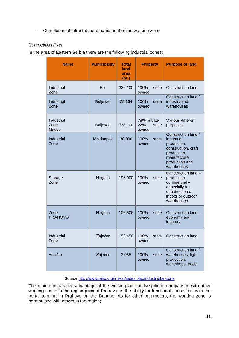
In the area of Eastern Serbia there are the following industrial zones:
Name
Municipality
Total land area (m
2)
Property
Purpose of land
Industrial Zone
Bor
326,100
100% state owned
Construction land
Industrial Zone
Boljevac
29,164
100% state owned
Construction land / industry and warehouses
Industrial Zone Mirovo
Boljevac
738,100
78% private 22% state owned
Various different purposes
Industrial Zone
Majdanpek
30,000
100% state owned
Construction land / industrial production, construction, craft production, manufacture production and warehouses
Storage Zone
Negotin
195,000
100% state owned
Construction land – production commercial – especially for construction of indoor or outdoor warehouses
Zone PRAHOVO
Negotin
106,506
100% state owned
Construction land – economy and industry
Industrial Zone
Zaječar
152,450
100% state owned
Construction land
Vesište
Zaječar
3,955
100% state owned
Construction land / warehouses, light production, workshops, trade
Source:http://www.raris.org/invest/index.php/industrijske-zone
The main comparative advantage of the working zone in Negotin in comparison with other working zones in the region (except Prahovo) is the ability for functional connection with the portal terminal in Prahovo on the Danube. As for other parameters, the working zone is harmonised with others in the region;

12
According to the development possibilities of various activities in the area of the working zone, as well as the regional competition of the neighbouring municipalities, the creation of the feasibility study has been justified for the following organisational models:
- Industrial park - Improved business zone - Creation of small economy clusters
In accordance with the fact that one of the key complementary advantages of the working zone is the possibility of connection with the port terminal in Prahovo, the development of the working zone in Negotin and Prahovo, due to the proximity, is possible to be treated as a complementary intermodal system (road, railway and water transport). The mentioned level of transport availability and proximity of the border with two neighbouring countries (Romania and Bulgaria) cannot be ascribed to other working zones in the Eastern Serbian region. Marketing Pan
- Definition of the investors category the adequate “teasers” are to be directed to - Creation of promotional material and catalogues of the sites in the working zone with
proposals of potential projects with the highest level of impact on the local community (labour-intensive activities and activities with necessary wide cooperation)
- Establishment of contacts with investors who might have already realised the activities in the area of Eastern Serbia – learning from good practice
Planned activities – Action Plan
o.no. Activities 2015 2016 2017
1
Reorganisation of PC for construction filed of the municipality of Negotin and introduction of the sector for research and development and marketing and trade
X
2 Development of the construction land lease/sale model
X
3 Creation of working zone detailed regulation plan
X
4 Amendments to the Capital Investment Plan and updating of development priorities of public property management
X
5
Creation of medium-term plan and program of development of construction land in line with the Capital Investment Plan and program budget of the Municipality at annual level
X
6 Infrastructural equipment of a working zone – the most attractive location
X X X
7
Creation of Medium-term marketing plan and Promotion plan for concrete investors categories with the focus on the working zone
X
8
Creation of annual marketing plan of the municipality of Negotin with the plan of activities and promotion of concrete investment projects
X X X
9
Creation of specialised presentations describing concrete investment possibilities in the working zone for special economic sectors
X X X

13
2.2. Industrial Zone with the Port Terminal in Prahovo Position
The Port „Prahovo“ is located on the right bank of the Danube (r.km 861), at the 4km downstream from HP „Djerdap II“ and represent a port of the pool type, with the ability of treating 7 vessels at the same time. j The working zone is located next to the bank of the Danube, near the Prahovo Port, within C.M. Prahovo, which belongs to the municipality of Negotin. In includes and near it there are: Eliksir Prahovo – Company of chemical products, Jugopetrol – installations, Prahovo Port and River Shipping Krajina.
Company of chemical products Prahovo
Source: http://www.invest.negotin.rs/privreda.htm
Plan and Legal Framework
- Spatial Plan of the municipality of Negotin – Off. Gazette of the municipality of Negotin no.16/2011.
- Plan of detailed regulation of the chemical industry in Prahovo – Off. Gazette of the municipality of Negotin no. 22/2014
- Ruling on construction land – Off. Gazette of the municipality of Negotin no.29/2012 Purpose of the area and infrastructural equipment
The mentioned area represents an industrial – port center with significant regional and international development potential. The working zone is infrastructurally equipped. The connection of certain locations within the working zone with the existing infrastructural network is necessary. Plan of fetailed regulation envisages the organisation of the working zone in the following units: Unit I – Industrial complex
Zone I – Existing industrial complex I 1 – Production part of the industrial complex I 2 – Part of the industrial complex without production functions I 3 – Expansion of the production part of the industrial complex I 4 – Possible new construction in the industrial complex
Zone II – Storage of phosphogypsum
Unit II – Surface for public purpose PR – Public roads PG – Public greenery (greenery within the public area)
Location of new industrial plants is allowed near the Danube, using large amounts of water for technological needs and having huge amounts of waste water, under the condition that by using the state-of-art production technology, through recycling, their wate waters are purified to the level of being released into the river of I quality class.
The port "Prahovo" includes the following: custom services and road connection with the hinterland; operational bank 560m of length (out of which the vertical operational bank length is 320m and half-vertical 240m); equipment and mechanisation for reloading of bulk cargo
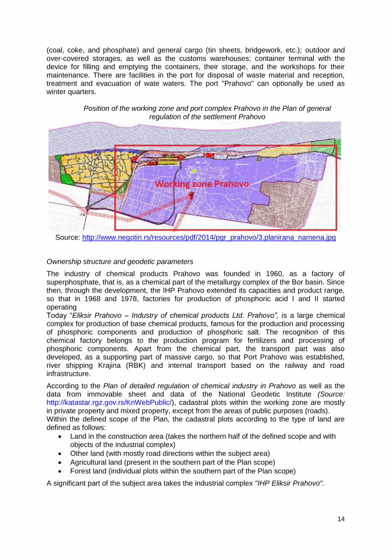
14
(coal, coke, and phosphate) and general cargo (tin sheets, bridgework, etc.); outdoor and over-covered storages, as well as the customs warehouses; container terminal with the device for filling and emptying the containers, their storage, and the workshops for their maintenance. There are facilities in the port for disposal of waste material and reception, treatment and evacuation of wate waters. The port "Prahovo" can optionally be used as winter quarters.
Position of the working zone and port complex Prahovo in the Plan of general
regulation of the settlement Prahovo
Source: http://www.negotin.rs/resources/pdf/2014/pgr_prahovo/3.planirana_namena.jpg
Ownership structure and geodetic parameters
The industry of chemical products Prahovo was founded in 1960, as a factory of superphosphate, that is, as a chemical part of the metallurgy complex of the Bor basin. Since then, through the development, the IHP Prahovo extended its capacities and product range, so that in 1968 and 1978, factories for production of phosphoric acid I and II started operating Today “Eliksir Prahovo – Industry of chemical products Ltd. Prahovo”, is a large chemical complex for production of base chemical products, famous for the production and processing of phosphoric components and production of phosphoric salt. The recognition of this chemical factory belongs to the production program for fertilizers and processing of phosphoric components. Apart from the chemical part, the transport part was also developed, as a supporting part of massive cargo, so that Port Prahovo was established, river shipping Krajina (RBK) and internal transport based on the railway and road infrastructure.
According to the Plan of detailed regulation of chemical industry in Prahovo as well as the data from immovable sheet and data of the National Geodetic Institute (Source: http://katastar.rgz.gov.rs/KnWebPublic/), cadastral plots within the working zone are mostly in private property and mixed property, except from the areas of public purposes (roads). Within the defined scope of the Plan, the cadastral plots according to the type of land are defined as follows:
Land in the construction area (takes the northern half of the defined scope and with objects of the industrial complex)
Other land (with mostly road directions within the subject area)
Agricultural land (present in the southern part of the Plan scope)
Forest land (individual plots within the southern part of the Plan scope)
A significant part of the subject area takes the industrial complex "IHP Eliksir Prahovo".

15
The Spatial Plan of the municipality of Negotin envisages the development and expansion of the industrial zone. Subsidies
The municipality has planned the exemption of the investors from the obligation to pay compensation for services if he provides evidence, in the process of obtaining the location permit for construction of business facilities for the production purposes, that after the construction and launching the production in the business facility employ 10 or more workers. Developmental models for property management
Limitations - Necessity of creation of urbanism projects for a bigger number of sites for
construction within the working zone - Bad visibility of investment potentials - Neglected areas for the function of disposal of pyrite burns as well as the function of
river port Prahovo which need to be re-cultivated and remediated.
Objectives - Improvement of visibility of investment potentials - Finding the strategic partners for investment in the port terminals and potentials of
expending - Infrastructural equipment of the best sites which could be offered to potential
investors
Competition Plan
Main comparative advantage of the working zone in Prahovo compared to other working zones in the region is the possibility of functional connection with port terminals in Prahovo on the Danube. Apart from the mentioned, the identity creation of the industrial around the IHK Eliksir Prahovo is also considered as a positive component of the site. Within the Draft Spatial Plan of the Area of Special Purpose for International Water Route E-80-Dunav (pan-European corridor VII) the port Prahovo a.d. ''Krajina'' is mentioned as one of 9 ports on the Danube in Serbia which are of international importance and which terminals should meet technical and operational requirements according to the AGTC agreement.
Source: www.elixirprahovo.rs
The port Prahovo is connected by roads and railway lines. The reloading and loading of all bulk cargo and other solid cargo is performed here. It has 6 crane lifts and loading crane,

16
arranged at 610 m of the operational bank, out of which 320 m of vertical bank. The crane lift capacity is 80 t/per catch in total, and the largest is of 40 t/per catch. At the moment, there are 4 cranes operating and 1 loading lift. The largest capacities were around 1.5 mil. tons of goods/per year, out of which 60% is phosphate for IHP. The port also has its storage and infrastructure. The port Prahovo also has8 ships with the supporting loading area. It has 4 tugboats (pushers) of the total strength of 5236 kW and tugboats of the total strength of 2500KW, and one passenger boat for port services of 125kW. For the purpose of further development of the port "Prahovo" as an intermodal centre, regarding the container, transit, export-import and internal transport, HUCKE PACK and Ro/Ro transport, apart from the terminals for bulk cargo, it is necessary to develop also the terminals for general cargo and terminal for liquid cargo for the needs of oil industry. Port „Prahovo“ has a great importance for a wider area of the municipality of Negotin, since it represents an export – import port for central Serbia, AP of Kosovo and Metohija and FYR of Macedonia. Having in mind its regional significance and ability for quantitative use of three types of transport, there is a need for the registration of free customs zone in Prahovo. The mentioned level of transport accessibility and proximity of the border of two neighbouring countries (Romania and Bulgaria) other working zones in the region of the Eastern Serbia do not have. Marketing Plan
- Definition of investor categories towards which the adequate “teaser” will be sent - Creation of promotional material and catalogues of sites in the working zone
(especially for the development of activities which are technologically and functionally related to the operational processes of other investors in the working zone especially from the chemical complex)
- Establishment of contact with investors who have already realised their activities in Serbia in the chemical complex and have experience with ports and cargo port terminals – learning from good practice
Planned activities – Action Plan
o.no. Activities 2015 2016 2017
1
Reorganisation of JP for construction land of the municipality of Negotin and introduction of the sector for research and development and marketing and sale
X
2
Amendments to the capital investments plan and updating of projects of importance for development port terminals and working zone
X
3
Creation of medium-term plan and program of development of construction land in line with the Capital Investment Plan and program budget of the Municipality at annual level
X
4
Creation of Medium-term marketing plan and annual plan for concrete investors categories with the focus on the complementary activity of the chemical industry
X X X
5
Establishment of communication with the railways of Serbia and lobbying for modernisation of the railway line Prahovo – Negotin – Zaječar - Niš
X X X

17
2.3. Negotinske pivnice (Rajac, Rogljevo and Štubik)* Part of the material taken from the presentation by Tourist Organisation of the Municipality of Negotin
Position
Growing the vine in Krajina has mostly preserved the traditional way of growing vineyards, pruning, processing and producing wine. Grapes processing and storage of wine is done in special rooms – facilities which are called wine cellars (pimnice). They were built out of stone, mostly hewn stone, timber or bondruk, with thick walls, often 60 cm. Wine cellars are not being built anymore and in many villages many complexes of wine cellars have disappeared, the only preserved ones are in Rajac, Rogljevo, Smedovo, Štubik and Bratuljevo. The hosts have given their effort to reconstruct some of them into modern functional rooms, keeping the specificity of the premises. Those premises are offered to tourists and in wine cellars they can taste and buy the wine. Wine cellars in the village of Rajac are near the village, on the hill next to the Timok River. They represent a single architectural complex of wine cellars which dates back from the period of mid-18 to 20th century. The complex is consisted of 160 wine cellars around the central square with the fountain. The buildings were made of hewn stone and timbers, and are covered with clay tiles. The cellars are partially in the ground so that the temperature of the wine will vary only a little during the year, and on the first floor there are the rooms for accommodation during the picking and treatment of wine.
Rajačke pivnice
http://www.rajackepivnice.com
Wine cellars in the village Rogljevo represent a complex of about 140 wine cellars. Most of them were built in 19th century, though it is considered that they, as well as other wine cellars, date back to 18th century. As other wine cellars areas, they were consisted of winding streets with the central square with the holy tree and covered well as a cultural and election place. The wine cellars of the village Štubik are at about 5 km away from Negotin, and about 15 km away from the village. There used to be over 300, and now there are about thirty of them preserved. There were built as one floor wooden houses with a porch, or as two floor houses with cellars. Plan and Legal Basis
In accordance with the Spatial Plan of the municipality of Negotin (“Official Gazette of the municipality of Negotin”, No. 16/2011), the settlements of Rogljevac and Rajac will further develop through the construction of relevant urban settlement plan, while the rules of
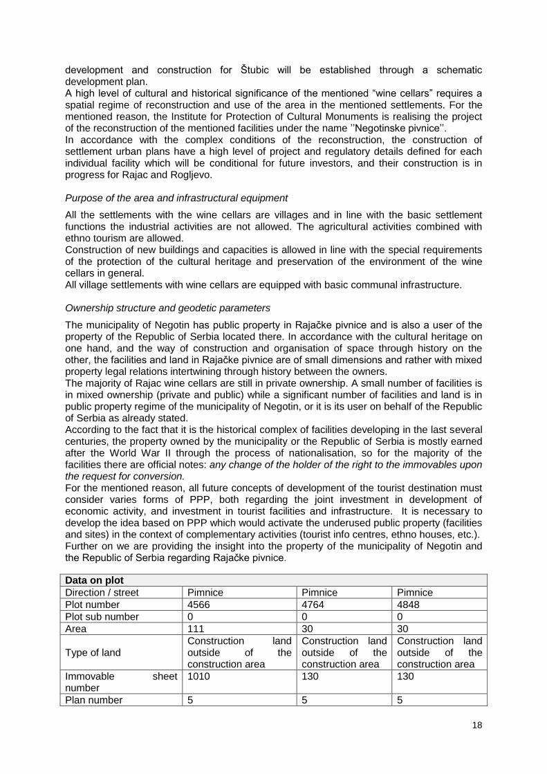
18
development and construction for Štubic will be established through a schematic development plan. A high level of cultural and historical significance of the mentioned “wine cellars” requires a spatial regime of reconstruction and use of the area in the mentioned settlements. For the mentioned reason, the Institute for Protection of Cultural Monuments is realising the project of the reconstruction of the mentioned facilities under the name ’’Negotinske pivnice’’. In accordance with the complex conditions of the reconstruction, the construction of settlement urban plans have a high level of project and regulatory details defined for each individual facility which will be conditional for future investors, and their construction is in progress for Rajac and Rogljevo. Purpose of the area and infrastructural equipment
All the settlements with the wine cellars are villages and in line with the basic settlement functions the industrial activities are not allowed. The agricultural activities combined with ethno tourism are allowed. Construction of new buildings and capacities is allowed in line with the special requirements of the protection of the cultural heritage and preservation of the environment of the wine cellars in general. All village settlements with wine cellars are equipped with basic communal infrastructure. Ownership structure and geodetic parameters
The municipality of Negotin has public property in Rajačke pivnice and is also a user of the property of the Republic of Serbia located there. In accordance with the cultural heritage on one hand, and the way of construction and organisation of space through history on the other, the facilities and land in Rajačke pivnice are of small dimensions and rather with mixed property legal relations intertwining through history between the owners. The majority of Rajac wine cellars are still in private ownership. A small number of facilities is in mixed ownership (private and public) while a significant number of facilities and land is in public property regime of the municipality of Negotin, or it is its user on behalf of the Republic of Serbia as already stated. According to the fact that it is the historical complex of facilities developing in the last several centuries, the property owned by the municipality or the Republic of Serbia is mostly earned after the World War II through the process of nationalisation, so for the majority of the facilities there are official notes: any change of the holder of the right to the immovables upon the request for conversion. For the mentioned reason, all future concepts of development of the tourist destination must consider varies forms of PPP, both regarding the joint investment in development of economic activity, and investment in tourist facilities and infrastructure. It is necessary to develop the idea based on PPP which would activate the underused public property (facilities and sites) in the context of complementary activities (tourist info centres, ethno houses, etc.). Further on we are providing the insight into the property of the municipality of Negotin and the Republic of Serbia regarding Rajačke pivnice.
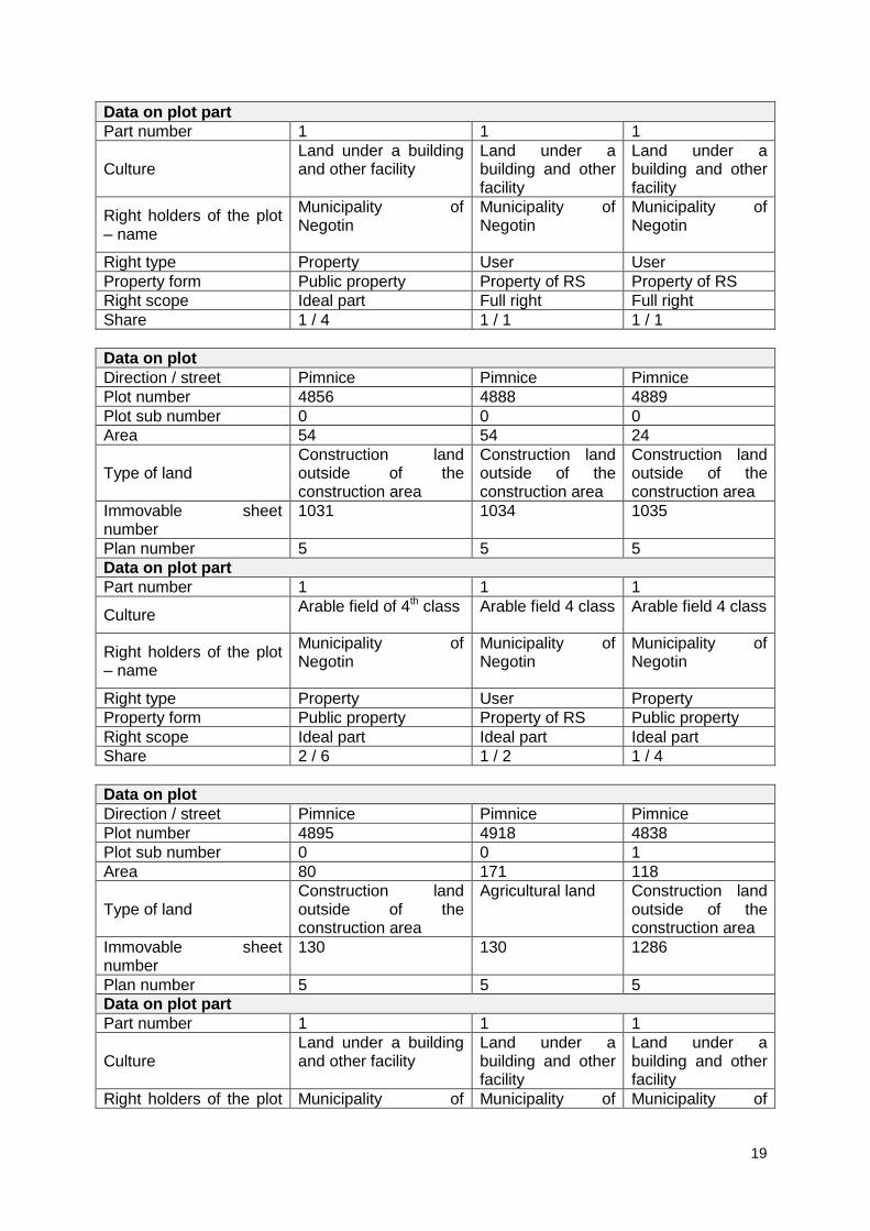
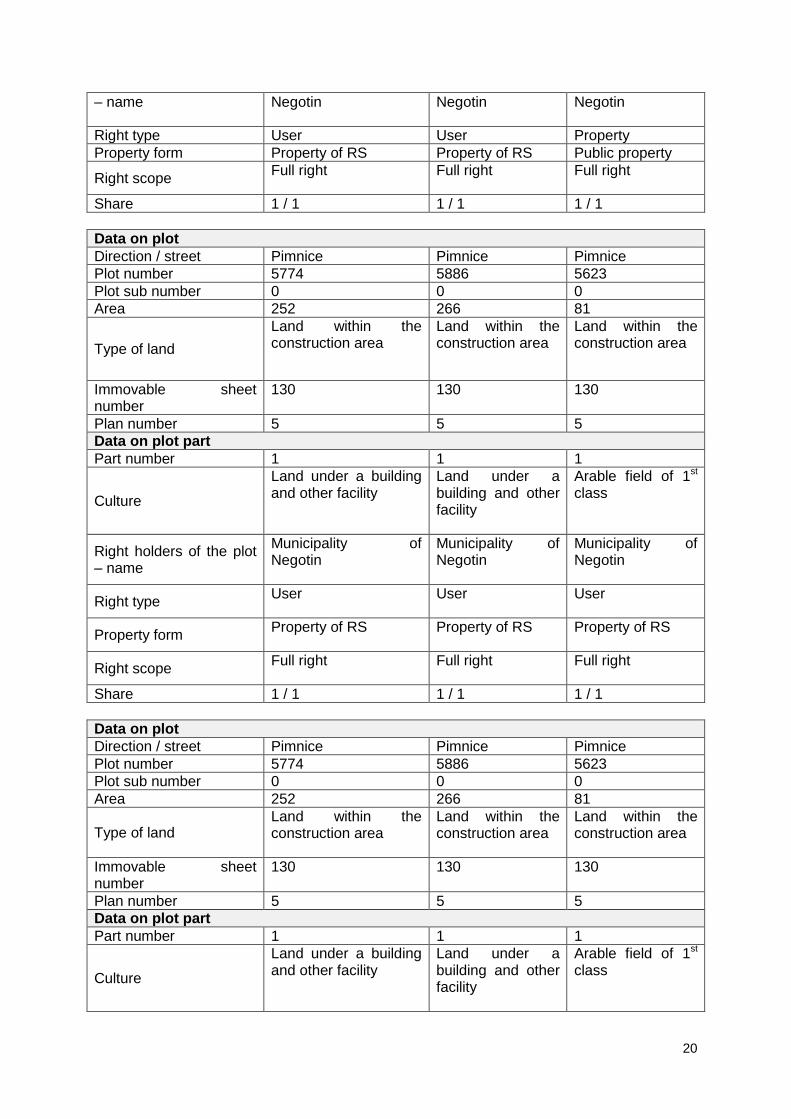
Data on plot
Direction / street Pimnice Pimnice Pimnice
Plot number 4566 4764 4848
Plot sub number 0 0 0
Area 111 30 30
Type of land Construction land outside of the construction area
Construction land outside of the construction area
Construction land outside of the construction area
Immovable sheet number
1010 130 130
Plan number 5 5 5
19
Data on plot part
Part number 1 1 1
Culture Land under a building and other facility
Land under a building and other facility
Land under a building and other facility
Right holders of the plot – name
Municipality of Negotin
Municipality of Negotin
Municipality of Negotin
Right type Property User User
Property form Public property Property of RS Property of RS
Right scope Ideal part Full right Full right
Share 1 / 4 1 / 1 1 / 1
Data on plot
Direction / street Pimnice Pimnice Pimnice
Plot number 4856 4888 4889
Plot sub number 0 0 0
Area 54 54 24
Type of land Construction land outside of the construction area
Construction land outside of the construction area
Construction land outside of the construction area
Immovable sheet number
1031 1034 1035
Plan number 5 5 5
Data on plot part
Part number 1 1 1
Culture Arable field of 4th class Arable field 4 class Arable field 4 class
Right holders of the plot – name
Municipality of Negotin
Municipality of Negotin
Municipality of Negotin
Right type Property User Property
Property form Public property Property of RS Public property
Right scope Ideal part Ideal part Ideal part
Share 2 / 6 1 / 2 1 / 4
Data on plot
Direction / street Pimnice Pimnice Pimnice
Plot number 4895 4918 4838
Plot sub number 0 0 1
Area 80 171 118
Type of land Construction land outside of the construction area
Agricultural land Construction land outside of the construction area
Immovable sheet number
130 130 1286
Plan number 5 5 5
Data on plot part
Part number 1 1 1
Culture Land under a building and other facility
Land under a building and other facility
Land under a building and other facility
Right holders of the plot Municipality of Municipality of Municipality of
20
– name Negotin Negotin Negotin
Right type User User Property
Property form Property of RS Property of RS Public property
Right scope Full right Full right Full right
Share 1 / 1 1 / 1 1 / 1
Data on plot
Direction / street Pimnice Pimnice Pimnice
Plot number 5774 5886 5623
Plot sub number 0 0 0
Area 252 266 81
Type of land
Land within the construction area
Land within the construction area
Land within the construction area
Immovable sheet number
130 130 130
Plan number 5 5 5
Data on plot part
Part number 1 1 1
Culture
Land under a building and other facility
Land under a building and other facility
Arable field of 1st class
Right holders of the plot – name
Municipality of Negotin
Municipality of Negotin
Municipality of Negotin
Right type User User User
Property form Property of RS Property of RS Property of RS
Right scope Full right Full right Full right
Share 1 / 1 1 / 1 1 / 1
Data on plot
Direction / street Pimnice Pimnice Pimnice
Plot number 5774 5886 5623
Plot sub number 0 0 0
Area 252 266 81
Type of land Land within the construction area
Land within the construction area
Land within the construction area
Immovable sheet number
130 130 130
Plan number 5 5 5
Data on plot part
Part number 1 1 1
Culture
Land under a building and other facility
Land under a building and other facility
Arable field of 1st class

21
Right holders of the plot – name
Municipality of Negotin
Municipality of Negotin
Municipality of Negotin
Right type User User User
Property form Property of RS Property of RS Property of RS
Right scope Full right Full right Full right
Share 1 / 1 1 / 1 1 / 1
Data on plot
Direction / street Pimnice Pimnice Pimnice
Plot number 5774 5886 5623
Plot sub number 0 0 0
Area 252 266 81
Type of land Land within the construction area
Land within the construction area
Land within the construction area
Immovable sheet number
130 130 130
Plan number 5 5 5
Data on plot part
Part number 1 1 1
Culture
Land under a building and other facility
Land under a building and other facility
Arable field of 1st class
Right holders of the plot – name
Municipality of Negotin
Municipality of Negotin
Municipality of Negotin
Right type User User User
Property form Property of RS Property of RS Property of RS
Right scope Full right Full right Full right
Share 1 / 1 1 / 1 1 / 1
Data on plot
Direction / street Pimnice Pimnice Village
Plot number 5679 5777 5903
Plot sub number 0 0 0
Area 1052 99 1721
Type of land Land within the construction area
Land within the construction area
Land within the construction area
Immovable sheet number
1286 130 130
Plan number 5 5 5
Data on plot part
Part number 1 1 1
Culture Arable field of 1st class Forest of 1st class Arable field of 2nd
class
22
Right holders of the plot – name
Municipality of Negotin
Municipality of Negotin
Municipality of Negotin
Right type Property user User
Property form Public property Property of RS Property of RS
Right scope Full right Full right Full right
Share 1 / 1 1 / 1 1 / 1
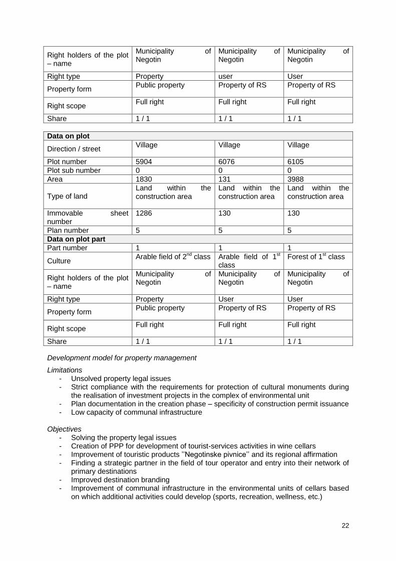
Data on plot
Direction / street Village Village Village
Plot number 5904 6076 6105
Plot sub number 0 0 0
Area 1830 131 3988
Type of land Land within the construction area
Land within the construction area
Land within the construction area
Immovable sheet number
1286 130 130
Plan number 5 5 5
Data on plot part
Part number 1 1 1
Culture Arable field of 2nd class Arable field of 1st
class Forest of 1st class
Right holders of the plot – name
Municipality of Negotin
Municipality of Negotin
Municipality of Negotin
Right type Property User User
Property form Public property Property of RS Property of RS
Right scope Full right Full right Full right
Share 1 / 1 1 / 1 1 / 1
Development model for property management
Limitations - Unsolved property legal issues - Strict compliance with the requirements for protection of cultural monuments during
the realisation of investment projects in the complex of environmental unit - Plan documentation in the creation phase – specificity of construction permit issuance - Low capacity of communal infrastructure
Objectives
- Solving the property legal issues - Creation of PPP for development of tourist-services activities in wine cellars - Improvement of touristic products ’’Negotinske pivnice’’ and its regional affirmation - Finding a strategic partner in the field of tour operator and entry into their network of
primary destinations - Improved destination branding - Improvement of communal infrastructure in the environmental units of cellars based
on which additional activities could develop (sports, recreation, wellness, etc.)
23
Competition Plan
Negotinske pivnice (Rajac, Štubik and Rogljevo) represent an architectural-environmental rarity of Eastern Serbia, and accordingly, the best preserved are in the village of Rajac are under the protection of the Republic. As rarely preserved environmental unit the mentioned wine cellars do not have direct competition of similar content in the area of the wide region, however, the authenticity in the region of Eastern Serbia is not sufficiently affirmed and used. Even though over 15000 people visit Rajačke pivnice annually, there are no additional activities not accommodation capacities which could increase the revenues generated from the mentioned tourist visits. Also, the condition of the communal infrastructure is not good and it is necessary to have significant interventions especially in the area of sewerage and water supply systems. According to the mentioned, it can certainly be said that Rajačke pivnice (as the best preserved and in the touristic context with best perspective in the municipality of Negotin) can strengthen their role in the tourist offer of Eastern Serbia with necessary interventions of both the infrastructure and branding and better market position. Some of the activities which need to be taken in order to improve the existing situation are the following:
Infrastructural equipment with communal infrastructure (sewerage, water supply systems, road infrastructure)
Rajačke pivnice branding (creation of brand) – protection of the geographical origin
Creation of tourist signalisation
Construction of accommodation capacities and facilities with complementary functions (sport, recreation, wellness, hunting tourism, agro-tourism, business and congress tourism, cycle-tourism) as well as other “service” facilities which would make the stay more fulfilled
Marketing Plan
According to the spatial dimensions of Rajačke pivnice (physically – architectural and urban), its further development and activities directed towards the attraction of investors are necessary to be set towards two directions:
Towards potential investor community
Towards local population, entrepreneurs and SME
In both cases it is necessary to have the Master plan which will properly determine the size of projects, their spatial plan and dynamics of potential investment both in communal infrastructure and touristic facilities. On the other hand, Rajačke pivnice exist and are operational in the current state. Due to the mentioned, the activities which would further increase the number of visitors and the revenues generated from tourism are necessary. Some of the activities which should be realised in the future period are the following:
Branding, creation of brands as well as the protection of the geographical origin of the products (wine) from the area of Rajačke pivnice
Improvement of communication with touristic operators and establishment of specific thematic wine routes in the Negotin area
Improvement of the touristic signalisation
Connection with the destinations in the area of Eastern Serbia and creation of touristic offer which would fully affirm the specificity of pivnice
Creation of promotional material
24
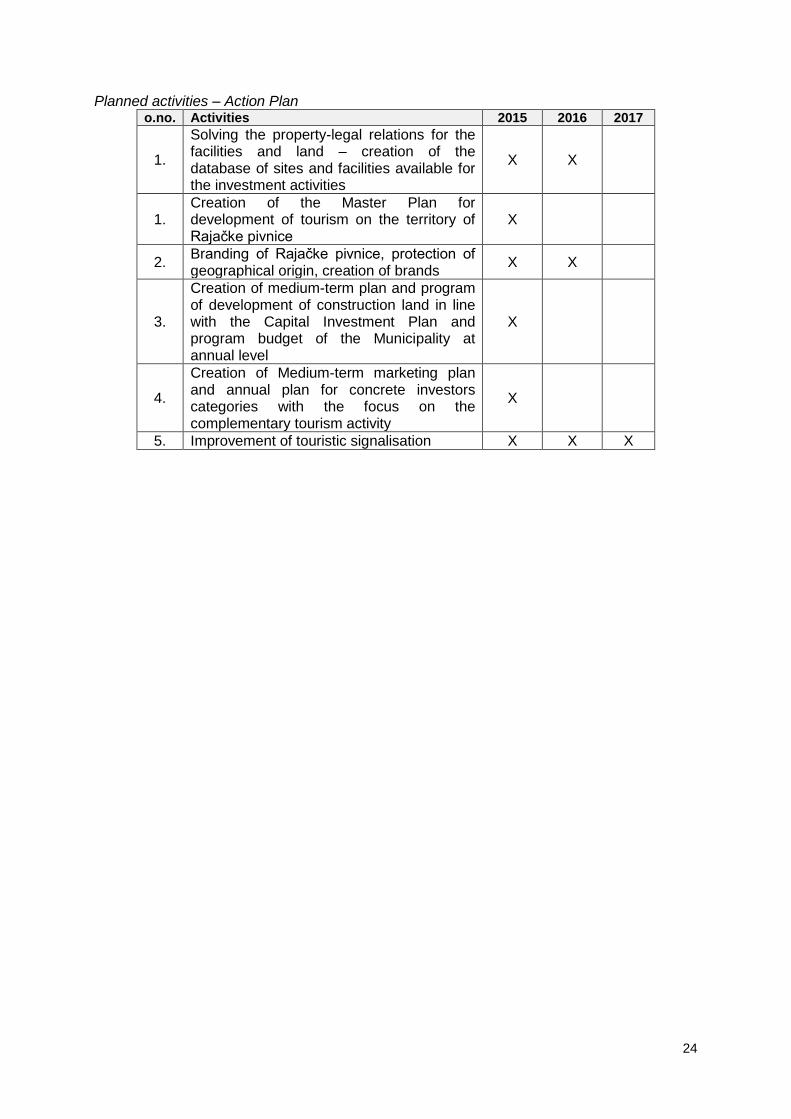
Planned activities – Action Plan
o.no. Activities 2015 2016 2017
1.
Solving the property-legal relations for the facilities and land – creation of the database of sites and facilities available for the investment activities
X X
1. Creation of the Master Plan for development of tourism on the territory of Rajačke pivnice
X
2. Branding of Rajačke pivnice, protection of geographical origin, creation of brands
X X
3.
Creation of medium-term plan and program of development of construction land in line with the Capital Investment Plan and program budget of the Municipality at annual level
X
4.
Creation of Medium-term marketing plan and annual plan for concrete investors categories with the focus on the complementary tourism activity
X
5. Improvement of touristic signalisation X X X
25
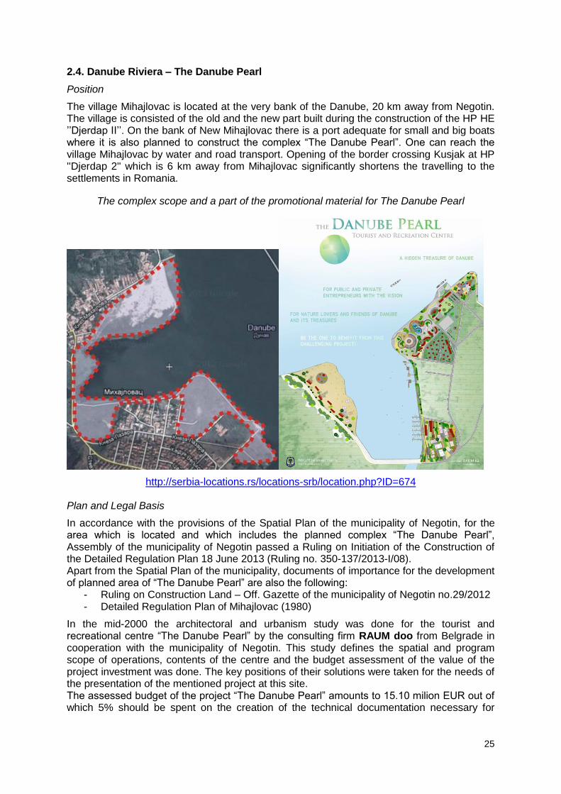
2.4. Danube Riviera – The Danube Pearl
Position
The village Mihajlovac is located at the very bank of the Danube, 20 km away from Negotin. The village is consisted of the old and the new part built during the construction of the HP HE ’’Djerdap II’’. On the bank of New Mihajlovac there is a port adequate for small and big boats where it is also planned to construct the complex “The Danube Pearl”. One can reach the village Mihajlovac by water and road transport. Opening of the border crossing Kusjak at HP ''Djerdap 2'' which is 6 km away from Mihajlovac significantly shortens the travelling to the settlements in Romania.
The complex scope and a part of the promotional material for The Danube Pearl
http://serbia-locations.rs/locations-srb/location.php?ID=674 Plan and Legal Basis
In accordance with the provisions of the Spatial Plan of the municipality of Negotin, for the area which is located and which includes the planned complex “The Danube Pearl”, Assembly of the municipality of Negotin passed a Ruling on Initiation of the Construction of the Detailed Regulation Plan 18 June 2013 (Ruling no. 350-137/2013-I/08). Apart from the Spatial Plan of the municipality, documents of importance for the development of planned area of “The Danube Pearl” are also the following:
- Ruling on Construction Land – Off. Gazette of the municipality of Negotin no.29/2012 - Detailed Regulation Plan of Mihajlovac (1980)
In the mid-2000 the architectoral and urbanism study was done for the tourist and recreational centre “The Danube Pearl” by the consulting firm RAUM doo from Belgrade in cooperation with the municipality of Negotin. This study defines the spatial and program scope of operations, contents of the centre and the budget assessment of the value of the project investment was done. The key positions of their solutions were taken for the needs of the presentation of the mentioned project at this site. The assessed budget of the project “The Danube Pearl” amounts to 15.10 milion EUR out of which 5% should be spent on the creation of the technical documentation necessary for

26
construction of the tourist and recreational centre “The Danube Pearl” next to local community of Mihajlovac, the municipality of Negotin. Purpose of the area and infrastructural equipment
The project “The Danube Pearl” envisages the construction of tourist – recreational complex on the bank near the existing pier. The planned area of this complex is 5,61ha and envisages the construction of a hotel with 60 beds, with the area of 1200m2, a restaurant with 50 seats and the area of 150 m2, car camp for about 100 vehicles with the area of 1.00 ha, House of hunting, fishing and navigation 150 m2. Sports courts are planned for the area of 3.00 ha and the structure would be in line with the proposal of the future investor.
For this investment there is entire infrastructure necessary for the access to the future complex:
Municipal road 6,5 m wide Electricity connection 110 KV. Water supply and sewerage network connection Phone connection
The main emphasis in composing the draft project is on the establishment of tourist – recreational offer and activities of the related capacities for guest (tourists) who arrive using the water traffic, that is, travelling by boats which would dock in the already constructed port dock, but also for those who would use the Djerdap road under construction along with the right bank of the Danube, that is, road traffic from Negotin, Bor, Majdanpek and Zaječar.
While creating the urban solution a great attention was paid to the utilisation of the existing infrastructure (street, road networks and parking lots) as well as already started embankment of the part of the bank for the purpose of building of the city beach opposite of the foreland, requiring further equipment with relevant capacities, primarily showers, toilets, locker rooms, and small guest facilities and shops of swimming and sport equipment.
The base and frontal point of the urban area is on the very foreland where tourist ships dock, from where the guests are directed towards the newly formed tourist capacities such as the catering facilities with national restaurants, wine houses, beer houses, tourist agencies for future arrangements for the area. All activities are organised along the open pedestrian zone which is on one side bordered by the mentioned facilities, while on the other there are open park area overlooking the Danube and the neighbouring bank of Romania.
Opposite the other side of the port on the south-eastern side of the foreland, an ethno village is planned to be built where tourists could meet the cultural heritage of eastern Serbia and where music festivals, folklore and theatre manifestations on the outdoor stage. In the ethno village, it is also planned to construct a steeple-tower-light house on the bank which would illuminate and be a signal of the tourist centre day and night. In the same manner, the ethno village is planned to revive the old crafts for manufactured products of applied art, souvenirs and utilitarian products.
In the back of these two facilities, it is planned to build tourist flats and small detached houses in the traditional style, that is, in the authentic architecture, for longer stay of tourists. Property structure and geodetic parameters
The area of the wide complex is around 45ha. It is the unconstructed and communally developed land which 70% are owned by the municipality of Negotin, and 30% by HP Djerdap (the ownership transfer to the municipality of Negotin is in progress). The most important sites in public property which represent the potential for the development of the mentioned project are as follows:
Data on plot
Direction / street Vlačeđe La porta La porta
Plot number 5058 5538 5539
Plot sub number 0 0 0

27
Area 453 44 566
Type of land Agricultural land Agricultural land Other land
Immovable sheet number
1060 1060 1060
Plan number 13 13 13
Data on plot part
Part number 1 1 1
Culture Arable field of 3rd class Pasture of 3rd
class
Other artificially created barren land
Right holders of the plot – name
HP Đerdap doo HP Đerdap doo HP Đerdap doo
Right type Right to use Right to use Right to use
Property form Property of RS Property of RS Property of RS
Right scope Full right Full right Full right
Share 1 / 1 1 / 1 1 / 1
Data on plot
Direction / street Village La porta La porta
Plot number 5545 5564 5566
Plot sub number 0 16 24
Area 608 30 11
Type of land Agricultural land Agricultural land Forest land
Immovable sheet number
1060 1060 1060
Plan number 13 13 13
Data on plot part
Part number 1 1 1
Culture Arable field of 2nd class Arable field of 2nd
class Forest of 3rd class
Right holders of the plot – name
HP Đerdap doo HP Đerdap doo HP Đerdap doo
Right type Right to use Right to use Right to use
Property form Property of RS Property of RS Property of RS
Right scope Full right Full right Full right
Share 1 / 1 1 / 1 1 / 1
Data on plot
Direction / street La porta Vlačeđe Vlačeđe
Plot number 5567 9384 9390
Plot sub number 0 0 0
Area 141 14243 30521
Type of land Agricultural land Other land Other land
Immovable sheet number
1060 1060 1060
Plan number 13 13 13
28
Data on plot part
Part number 1 1 1
Culture
Arable land of 3rd class Other artificially created barren land
Other artificially created barren land
Right holders of the plot – name
HP Đerdap doo HP Đerdap doo HP Đerdap doo
Right type Right to use Right to use Right to use
Property form Property of RS Property of RS Property of RS
Right scope Full right Full right Full right
Share 1 / 1 1 / 1 1 / 1
Data on plot
Direction / street Reu Reu Vlačeđe
Plot number 9403 9421 9423
Plot sub number 0 0 0
Area 806 1932 11501
Type of land Other land Other land Other land
Immovable sheet number
1060 1060 1060
Plan number 13 13 13
Data on plot part
Part number 1 1 1
Culture
Other artificially created barren land
Other artificially created barren land
Other artificially created barren land
Right holders of the plot – name
HP Đerdap doo HP Đerdap doo HP Đerdap doo
Right type Right to use Right to use Right to use
Property form Property of RS Property of RS Property of RS
Right scope Full right Full right Full right
Share 1 / 1 1 / 1 1 / 1
Data on plot
Direction / street Vlačeđe Vlačeđe Vlačeđe
Plot number 9426 9427 9428
Plot sub number 0 0 0
Area 40224 2278 31141
Type of land Agricultural land Other land Public construction
land
Immovable sheet number
1059 1059 1059
Plan number 13 13 13
Data on plot part
Part number 1 1 1
Culture Land under a building Other artificially Other artificially

29
and other facility created barren land
created barren land
Right holders of the plot – name
Municipality of Negotin Municipality of Negotin
Municipality of Negotin
Right type User User User
Property form Property of RS Property of RS Property of RS
Right scope Full right Full right Full right
Share 1 / 1 1 / 1 1 / 1
Data on plot
Direction / street Vlačeđe Rau
Plot number 9429 9434
Plot sub number 0 0
Area 3847 56124
Type of land Public construction land
Public construction land
Immovable sheet number
1059 1059
Plan number 13 13
Data on plot part
Part number 1 1
Culture
Land under a building and other facility
Land under a building and other facility
Right holders of the plot – name
Municipality of Negotin
Municipality of Negotin
Right type User User
Property form Property of RS Property of RS
Right scope Full right Full right
Share 1 / 1 1 / 1
Development model for property management
Limitations - Plan documentation in the phase of creation – specificity of construction permit
issuance - Procedure of the immovables ownership transfer from HP Djerdap to the local self-
government is in progress - The right over the water area and facilities for the purpose of sailing are under direct
jurisdiction of the bodies of the Republic of Serbia (they are not related to the local self-government).
- Incomplete communal infrastructure - Low capacities of the communal infrastructure
Objectives - Solving the property-legal issues

30
- Completion and adoption of the Detailed Regulation Plan for “The Danube Pearl” - Finding the strategic partner (or consortium) for the realisation of the investment - Complete communal equipment of the site - Branding of the site in cooperation with the strategic partner
Competition Plan
During one season, the Danube flow in our country is used by over 500 passenger boats towards the Black Sea which make beaks at attractive sites of the banks and places where they can be offered fun, rest, and sightseeing and with certain tourist offer. In Serbia there is a number of marines and piers with related infrastructure and facilities and services of different quality, but the influence that the mentioned facilities have on the entire socio-economic development (except in Novi Sad and Belgrade) is considered insignificant.
The Spatial Plan of the area of specific purpose of the international water traffic E-80 Danube (Pan-European corridor 7), DRAFT from February 2013, defined the planned sited for marines in the sector of the Danube and the banks of the municipalities of Negotin and Kladovo:
35. Tekija ’’Đerdap East’’ r.km.956.6 36. Kladovo – r.km 934 37. Brza Palanka – r.km 883 38. MIhajlovac – r.km 872 39. Radujevac – r.km 852
On the flow length of 104 km there are 5 planned marines. According to the fact that the development of the mentioned sites is based primarily on the navigation tourism and relevant sports and recreational and tourist activities, the mentioned sites are mutually very competitive, and it is necessary to design the strategy in order to reduce the level of competitiveness between them, i.e. to achieve equal (maximum) effect in use of each individual site.
In accordance with the stated, the primary task which is necessary to be performed (and which is mostly realised by the consulting firm RAUM) is to define the specific environmental and architectural units as well as purposes which would point out “The Danube Pearl”, i.e. the marine in Mihajlovac from the others. In this segment it can be said that the site has an advantage compared to other sites, and thus it is necessary to find the strategic partner in the next period, harmonise the investment requirements with the existing concept and continue further development of the site. Marketing Plan
The site of “The Danube Pearl” represents a potential for the development of investments in the sector of navigation, sports and recreation. According to the mentioned, the realisation steps in the next period should be the following:
- Definition of investors categories towards which the adequate ‘’teasers” will be directed (hotel chains with similar facilities and offers, company franchising, etc.).
- Creation of the feasibility study with basic financial parameters; especially taking into account the financial scenarios and the investment payback point
- Establishment of contacts with investors who have already realised similar investments in the Danube area, especially on the Romanian and Bulgarian side
- Creation of multimedia material for promotion of the exiting development concept and their wider affirmation and publication

31
Planned activities – Action Plan
o.no. Activities 2015 2016 2017
1
Reorganisation of PC for construction filed of the municipality of Negotin and introduction of the sector for research and development and marketing and trade
X
2. Solving the property-legal relations for the facilities and land – ownership transfer from the HP Đerdap to the municipality of Negotin
X X X
3. Completion of the detailed regulation plan “The Danube Pearl”
X X
4. Creation of the feasibility study with financial scenarios per realisation phase
X
5.
Creation of medium-term plan and program of development of construction land in line with the Capital Investment Plan and program budget of the Municipality at annual level
X
6. Communal equipment with infrastructure X X
2.5. Tourist Centre – Stevanske livade
Position
Preserved nature and ability to combine different elements of tourist offer (especially in the field of sports and recreation) are particularly interesting for the site “Stevanske livade” on the Deli Jovan Mountain. The site is about 30 km to the west of Negotin and is located at the altitude of 480m in the village of Sikole. Plan and Legal Basis
According to the fact that Stevanske livade are located outside of the construction region of the settlement of Sikole, the construction in the subject area is defined by the Spatial Plan of the municipality of Negotin – Off. Gazette of the municipality of Negotin no.16/2011. Purpose of the area and infrastructural equipment
According to the Spatial Plan of the municipality of Negotin, Stevanske livade with the subject complex planned for construction is located on the forest land and in line with the mentioned purpose it is necessary to define the development concept which would adjust to the system of protection and sustainable use of the natural resources. In the context of the activation of the resources of public property for the needs of local development, the site of Stevanske livade fully represents an example of neglected resource which activation would significantly improve the activation of other complementary capacities as well. The infrastructure became unusable doe to the lack of maintenance and it is necessary to perform the communal equipping again.

32
Purpose of the area on the site of Stevanske livade – reference map 3: tourism and area protection
Source: Spatial Plan of the municipality of Negotin, Of.Gazette of the municipality of Negotin
16/2011 Legend:
Area of environment of good quality
Area of environment of very good quality
Area of environment of very good quality – protected natural goods
Sport center / courts
Existing accommodation capacities
Hunting
Cottage settlement
Resort
Info point
Cultural marks
Potential tourist settlement / centres
Miroč Mountain tourist zone
33
Property structure and geodetic parameters
The complex area with the existing facilities is about 8.2 ha. The real estate intended for the development of potential investors’’ projects which are planned for the complex Stevanske livade is provided below:
Data on plot
Direction / street Bele vode Bele vode
Plot number 3901 3904
Plot sub number 0 0
Area 2558 6514
Type of land Agricultural land Agricultural land
Immovable sheet number
1070 1070
Plan number 11 11
Data on plot part
Part number 1 1
Culture Pasture of 6th class Pasture of 6th class
Right holders of the plot – name
Municipality of Negotin
Municipality of Negotin
Right type User User
Property form Property of RS Property of RS
Right scope Full right Full right
Share 1 / 1 1 / 1
Data on plot
Direction / street Bele vode
Plot number 3905
Plot sub number 0
Area 7368 92
Type of land Agricultural land Cultural building
Immovable sheet number
1070
Plan number 11
Data on plot part
Part number 1
Culture Land under a building and other facility
Right holders of the plot – name
Municipality of Negotin
Right type User
Property form Property of RS
Right scope Full right
Share 1 / 1
Data on plot
Direction / street Bele vode Bele vode Bele vode
Plot number 3914 3917 3917
Plot sub number 0 0 0
Area 12229 485 59258
Type of land Agricultural land Agricultural land Agricultural land
Immovable sheet number
1070 1070 1070
34
Plan number 11 11 11
Data on plot part
Part number 1 1 2
Culture Pasture of 6th class Land under a
building and other facility
Meadow of 6th class
Right holders of the plot – name
Municipality of Negotin Municipality of Negotin
Municipality of Negotin
Right type User User User
Property form Property of RS Property of RS Property of RS
Right scope Full right Full right Full right
Share 1 / 1 1 / 1 1 / 1
Data on plot
Direction / street Bele vode
Plot number 3919
Plot sub number 0
Area 646
Type of land Construction land outside of the construction area
Immovable sheet number
1070
Plan number 11
Data on plot part
Part number 1
Culture Land under a building and other facility
Right holders of the plot – name
Municipality of Negotin
Right type User
Property form Property of RS
Right scope Full right
Share 1 / 1
Development model for property management Limitations
- The creation of urbanism plan is necessary; if there are new purposes introduced it is necessary to amend the Spatial Plan of the municipality of Negotin
- Bad communal infrastructure
Objectives - Creation of touristic products; creation of feasibility study - Positioning of the development capacity on the market of investment projects - Finding the strategic partner (or consortium) for investment realisation - Communal equipment of the site

35
Competition Plan
Improvement of the tourist offer of the municipality of Negotin would be achieved by the realisation of the recreational and sports capacities in Stevanske livade through the reconstruction of the resort facility and construction of sports court. It is of special importance to mention that the mentioned resort facility would represent the only touristic and sport-recreational facility in the municipality of Negotin and thus its affirmation would have both local and regional significance. The activities and capacities planned for the site, in line with the previous initiatives of the local self-government, would be the following:
Construction of sport courts (handball, basketball and volleyball courts)
Construction of tennis courts
Construction of the complex of children playgrounds with the nature school
Reconstruction of the existing facilities for accommodation and stay of pupils
Reconstruction of the Memorial home
According to the fact that in the wide area of eastern Serbia there are already affirmed spa centres (Gamzigrad, Brestovačka banja, Sokobanja), Stevanske livade should create their competitiveness on specific services and accommodation concept in the nature, which the mentioned spa centres cannot have in a similar way. The primary step in the development of the tourist destination of Stevanske livade would be the development of the tourist concept and its market valorisation on the territory of eastern Serbia. Marketing Plan
- Inventiveness of the tourist offers (material base for tourism development) - Creation of tourist products (complementary to other tourist offers of the municipality
of Negotin) and their strategic promotion - Definition of investor categories towards which the adequate ‘’teasers’’ will be
directed (chains of hotels with similar facilities and offers, company franchising, etc.) - Creation of the feasibility study with basic financial parameters; especially the
financial scenarios and investment payback point - Creation of multimedia material for promotion of the development concept and their
wide affirmation and publication
Planned activities – Action Plan
o.no. Activities 2015 2016 2017
1. Creation of Marketing Plan and feasibility study X
2.
Creation of medium-term plan and program of development of construction land in line with the Capital Investment Plan and program budget of the Municipality at annual level
X
3.
Creation of Medium-term marketing plan and annual plan for concrete investors categories with the focus on the complementary tourism activity
X
4. Improvement of tourist signalisation X X X
* * *