introduction sentinel-1 - esa · sentinel-1 the radar mission for gmes operational land and sea...
TRANSCRIPT

Sentinel-1
The ESA Sentinels will be the first series of
loperational satellites to meet the Earthobservation needs of the European Union-
ESA Global Monitoring for Environment andSecurity (GMES) programme. Existing andplanned space assets will be complemented bynew developments from ESA. The first isSentinel-1, a pair of synthetic aperture radar(SAR) imaging satellites.
IntroductionESA is developing the Sentinel-1 Euro-pean Radar Observatory, a polar-orbiting satellite for operational SARapplications. The constellation of twoC-band radar satellites will providecontinuous all-weather day/night imageryfor user services, especially thoseidentified in ESA’s GMES serviceelements programme and on projectsfunded by the European Union (EU)Framework Programmes. Three priori-ties (‘fast-track services’) have beenidentified by EU user working groups:marine core services; land monitoring;and emergency services. These include:
– monitoring sea-ice zones and theArctic;
Evert Attema, Piere Bargellini, Peter Edwards,Guido Levrini, Svein Lokas, Ludwig Moeller,Betlem Rosich-Tell, Patrizia Secchi, RamonTorres, Malcolm Davidson & Paul SnoeijDirectorate of Earth Observation Programmes,ESTEC, Noordwijk, The Netherlands
esa bulletin 131 - august 2007 11
Sentinel-1
The Radar Mission for GMES
Operational Land and Sea Services Envisat radar image of the Solent between the Isle ofWight and Portsmouth, UK. Resolution is 30 m. At thetime, in June 2005, Britain’s navy was gathering for afleet review
Attema 8/1/07 4:51 PM Page 10

Sentinel-1
The ESA Sentinels will be the first series of
loperational satellites to meet the Earthobservation needs of the European Union-
ESA Global Monitoring for Environment andSecurity (GMES) programme. Existing andplanned space assets will be complemented bynew developments from ESA. The first isSentinel-1, a pair of synthetic aperture radar(SAR) imaging satellites.
IntroductionESA is developing the Sentinel-1 Euro-pean Radar Observatory, a polar-orbiting satellite for operational SARapplications. The constellation of twoC-band radar satellites will providecontinuous all-weather day/night imageryfor user services, especially thoseidentified in ESA’s GMES serviceelements programme and on projectsfunded by the European Union (EU)Framework Programmes. Three priori-ties (‘fast-track services’) have beenidentified by EU user working groups:marine core services; land monitoring;and emergency services. These include:
– monitoring sea-ice zones and theArctic;
Evert Attema, Piere Bargellini, Peter Edwards,Guido Levrini, Svein Lokas, Ludwig Moeller,Betlem Rosich-Tell, Patrizia Secchi, RamonTorres, Malcolm Davidson & Paul SnoeijDirectorate of Earth Observation Programmes,ESTEC, Noordwijk, The Netherlands
esa bulletin 131 - august 2007 11
Sentinel-1
The Radar Mission for GMES
Operational Land and Sea Services Envisat radar image of the Solent between the Isle ofWight and Portsmouth, UK. Resolution is 30 m. At thetime, in June 2005, Britain’s navy was gathering for afleet review
Attema 8/1/07 4:51 PM Page 10
– surveillance of the marine environment;– monitoring land movements; – mapping land surfaces: forest, water
and soil, agriculture;– mapping for humanitarian aid in crisis
situations.
The first satellite is expected to belaunched in 2011 aboard a Soyuz fromKourou.
ESA’s SAR HeritageA first glimpse of the potential ofimaging radar from space was providedby the short-lived but successful USSeasat satellite in 1978. ESA’s ownprogramme to develop advanced micro-wave radar instruments culminated withthe launches of ERS-1 (17 July 1991)and ERS-2 (20 April 1995). Remark-ably, ERS-2 is still operating.
ERS demonstrated for the first timethe feasibility of flying reliable, stableand powerful radar imaging systems inspace. The dependability and all-weather capability of the instrumentsalso provided a foundation for develop-ing and exploiting radar images for awide variety of applications. While theinitial objectives for ERS-1 at launchwere predominantly oceanographic,other applications were consideredduring the project’s preparation. TheESA Remote Sensing Advisory Groupin 1974, for example, emphasisedcommercial applications such asagriculture, land-use mapping, waterresources, overseas aid and mapping ofmineral resources in its advice on ERSobjectives.
The rigorous design of the ERS SARhardware – emphasising instrumentstability in combination with accurateand well-calibrated data products –created new opportunities for scientificdiscovery, revolutionised many Earthscience disciplines and laid thefoundations for commercial applica-tions.
For example, ‘SAR interferometry’,which can track land shifts of only a fewmillimetres, was developed mainly usingERS data and is now commonly used inEarth sciences and commercial applica-
and sea-ice monitoring require dailyrevisits (mostly at northern latitudes)and delivery of data within an hour ofacquisition. In contrast, land servicesinvolving interferometry and coverclassification require global coverageevery 2 weeks at most and consistentdatasets.
tions. The potential of space radarsviewing the same scene only a short timeapart was demonstrated in 1995 and1996 during the ERS ‘tandem mission’,when the orbits of ERS-1 and ERS-2were carefully matched but with a 1-daygap.
An important milestone was thelaunch of the Advanced SAR (ASAR)on Envisat on 28 February 2002. Thisensured the continuation of C-banddata and added enhanced capabilitiessuch as wide swaths and dualpolarisation, features that have sincerapidly been integrated into andexploited by many applications. Thearchive of radar data since 1991 isextremely valuable for science andapplications, providing a consistent setof data spanning 16 years.
Service Reliability: A New ChallengeThe operational requirements present anew challenge for spaceborne radar.Unlike its ERS and Envisat experimen-tal predecessors, which supply data tousers on a best-effort basis, operationalsatellites like Sentinel-1 must satisfy userrequirements and supply information in
a reliable fashion. The data provideraccepts legal responsibility for deliveringthe information. Acquisition failuresowing to conflicting requests from users(such as requesting different instrumentmodes at the same time and place)cannot be tolerated.
Sentinel-1 will work largely in aprogrammed conflict-free mannerimaging all landmasses, coastal zonesand shipping routes globally, andcovering the oceans with imagettes. Thisway, the reliability demanded byoperational services is achieved and aconsistent long-term data archive isbuilt for applications based on longtime-series.
Sentinel-1 revisit frequency and coverageare dramatically improved with respectto ERS and Envisat. The orbits of thetwo-satellite constellation repeat every6 days, and conflict-free operationsallow every single data-take to beexploited. The effective revisit andcoverage performance could be furtherimproved by access to Canada’s plannedSAR constellation.
User needs at both high and medium
What GMES Users WantData products from ESA’s successfulERS-1, ERS-2 and Envisat missionsform the basis for many of the pilotGMES services. Sentinel-1 mustmaintain these quality levels in terms ofspatial resolution, sensitivity, accuracy,polarisation and wavelength. Feedbackfrom users indicate unambiguously thatthe crucial requirements for operationalsustainable services are continuity ofdata, frequent revisits, geographicalcoverage and timeliness.
Compared to the current satellites inorbit, substantial improvements of dataprovision in terms of revisit frequency,coverage, timeliness and reliability ofservice are required. As an example,services encompassing ship and oil-spilldetection, wind speed measurements
Earth Observation
esa bulletin 131 - august 2007esa bulletin 131 - august 2007 www.esa.intwww.esa.int 1312
The flooded Elbe River in Germany, demonstrating the value of ‘dual-polarisation’ radar coverage for land-cover classification. Envisat transmits and detects radar waves polarised in the horizontal andvertical directions, yielding more extensive information than could a single polarisation on the ground surface reflecting them. Sentinel-1 will exploit this feature
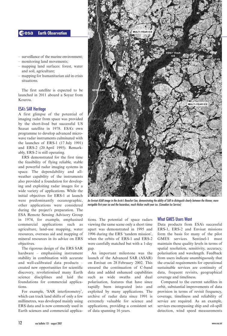
An Envisat ASAR image in the Arctic’s Beaufort Sea, demonstrating the ability of SAR to distinguish clearly between the thinner, morenavigable first-year ice and the hazardous, much thicker multi-year ice. (Canadian Ice Service)
Radar Interferometry: How it Works
If light travels paths of different lengths, the
observed brightness is either increased or
reduced depending on the wavelength
(colour) and the path length difference.
This ‘constructive’ and ‘destructive’
interference shows up nicely as beautiful
rainbow-like patterns when sunlight reflects
off a thin film of oil (far right).
Radar waves can be made to behave in the same way when they
are bounced off the Earth. If the satellite comes back another time in
exactly the same orbit and the surface has not moved, adding the
two measurements gives a brighter image because of constructive
interference. However, if parts of the surface have shifted between
observations, the destructive interference could dim areas of the
combined images.
So combining two radar images from before and after an
earthquake, for example, generates rainbow-like patterns from which
surface movement can be determined to within typically 1 mm/year.
Attema 8/1/07 4:51 PM Page 12

– surveillance of the marine environment;– monitoring land movements; – mapping land surfaces: forest, water
and soil, agriculture;– mapping for humanitarian aid in crisis
situations.
The first satellite is expected to belaunched in 2011 aboard a Soyuz fromKourou.
ESA’s SAR HeritageA first glimpse of the potential ofimaging radar from space was providedby the short-lived but successful USSeasat satellite in 1978. ESA’s ownprogramme to develop advanced micro-wave radar instruments culminated withthe launches of ERS-1 (17 July 1991)and ERS-2 (20 April 1995). Remark-ably, ERS-2 is still operating.
ERS demonstrated for the first timethe feasibility of flying reliable, stableand powerful radar imaging systems inspace. The dependability and all-weather capability of the instrumentsalso provided a foundation for develop-ing and exploiting radar images for awide variety of applications. While theinitial objectives for ERS-1 at launchwere predominantly oceanographic,other applications were consideredduring the project’s preparation. TheESA Remote Sensing Advisory Groupin 1974, for example, emphasisedcommercial applications such asagriculture, land-use mapping, waterresources, overseas aid and mapping ofmineral resources in its advice on ERSobjectives.
The rigorous design of the ERS SARhardware – emphasising instrumentstability in combination with accurateand well-calibrated data products –created new opportunities for scientificdiscovery, revolutionised many Earthscience disciplines and laid thefoundations for commercial applica-tions.
For example, ‘SAR interferometry’,which can track land shifts of only a fewmillimetres, was developed mainly usingERS data and is now commonly used inEarth sciences and commercial applica-
and sea-ice monitoring require dailyrevisits (mostly at northern latitudes)and delivery of data within an hour ofacquisition. In contrast, land servicesinvolving interferometry and coverclassification require global coverageevery 2 weeks at most and consistentdatasets.
tions. The potential of space radarsviewing the same scene only a short timeapart was demonstrated in 1995 and1996 during the ERS ‘tandem mission’,when the orbits of ERS-1 and ERS-2were carefully matched but with a 1-daygap.
An important milestone was thelaunch of the Advanced SAR (ASAR)on Envisat on 28 February 2002. Thisensured the continuation of C-banddata and added enhanced capabilitiessuch as wide swaths and dualpolarisation, features that have sincerapidly been integrated into andexploited by many applications. Thearchive of radar data since 1991 isextremely valuable for science andapplications, providing a consistent setof data spanning 16 years.
Service Reliability: A New ChallengeThe operational requirements present anew challenge for spaceborne radar.Unlike its ERS and Envisat experimen-tal predecessors, which supply data tousers on a best-effort basis, operationalsatellites like Sentinel-1 must satisfy userrequirements and supply information in
a reliable fashion. The data provideraccepts legal responsibility for deliveringthe information. Acquisition failuresowing to conflicting requests from users(such as requesting different instrumentmodes at the same time and place)cannot be tolerated.
Sentinel-1 will work largely in aprogrammed conflict-free mannerimaging all landmasses, coastal zonesand shipping routes globally, andcovering the oceans with imagettes. Thisway, the reliability demanded byoperational services is achieved and aconsistent long-term data archive isbuilt for applications based on longtime-series.
Sentinel-1 revisit frequency and coverageare dramatically improved with respectto ERS and Envisat. The orbits of thetwo-satellite constellation repeat every6 days, and conflict-free operationsallow every single data-take to beexploited. The effective revisit andcoverage performance could be furtherimproved by access to Canada’s plannedSAR constellation.
User needs at both high and medium
What GMES Users WantData products from ESA’s successfulERS-1, ERS-2 and Envisat missionsform the basis for many of the pilotGMES services. Sentinel-1 mustmaintain these quality levels in terms ofspatial resolution, sensitivity, accuracy,polarisation and wavelength. Feedbackfrom users indicate unambiguously thatthe crucial requirements for operationalsustainable services are continuity ofdata, frequent revisits, geographicalcoverage and timeliness.
Compared to the current satellites inorbit, substantial improvements of dataprovision in terms of revisit frequency,coverage, timeliness and reliability ofservice are required. As an example,services encompassing ship and oil-spilldetection, wind speed measurements
Earth Observation
esa bulletin 131 - august 2007esa bulletin 131 - august 2007 www.esa.intwww.esa.int 1312
The flooded Elbe River in Germany, demonstrating the value of ‘dual-polarisation’ radar coverage for land-cover classification. Envisat transmits and detects radar waves polarised in the horizontal andvertical directions, yielding more extensive information than could a single polarisation on the ground surface reflecting them. Sentinel-1 will exploit this feature
An Envisat ASAR image in the Arctic’s Beaufort Sea, demonstrating the ability of SAR to distinguish clearly between the thinner, morenavigable first-year ice and the hazardous, much thicker multi-year ice. (Canadian Ice Service)
Radar Interferometry: How it Works
If light travels paths of different lengths, the
observed brightness is either increased or
reduced depending on the wavelength
(colour) and the path length difference.
This ‘constructive’ and ‘destructive’
interference shows up nicely as beautiful
rainbow-like patterns when sunlight reflects
off a thin film of oil (far right).
Radar waves can be made to behave in the same way when they
are bounced off the Earth. If the satellite comes back another time in
exactly the same orbit and the surface has not moved, adding the
two measurements gives a brighter image because of constructive
interference. However, if parts of the surface have shifted between
observations, the destructive interference could dim areas of the
combined images.
So combining two radar images from before and after an
earthquake, for example, generates rainbow-like patterns from which
surface movement can be determined to within typically 1 mm/year.
Attema 8/1/07 4:51 PM Page 12

resolution have meant so far that SARsystems include different operationalmodes that either optimise the spatialresolution (at the expense of the swathwidth, hence the coverage) or the swathwidth (at the expense of the resolution).GMES will provide access to very high-resolution SAR national missions(Germany’s TerraSAR-X and Italy’sCosmo-SkyMed), so Sentinel-1 isdesigned to address medium-resolutionapplications with its main mode: a wideswath (250 km) and medium resolution(5 x 20 m).
Products for Marine Core ServicesSAR is the primary source of data forinformation on the oceans and theArctic environment. The problems ofaccess to the open oceans and the harshArctic often make radar, with its abilityfor observations in all weather and dayor night, the only reliable informationsource. Typical products for the ice andsnow services include monitoringglaciers and snow, icebergs, sea ice (floeedge) and the near-shore ice complex.
For determining the direction, wave-length and (extreme) heights of waveson the open oceans, SAR imagettes arebeing used in near-realtime inconjunction with global ocean wavemodels. The extensive wave modearchive built up by ERS and Envisat is acritical resource for analysing regionalwave climate and extreme wave events.
ERS-1/2 tandem mission.During the ERS tandemphase, data pairs werecollected on successivedays.
Classifying land coveris not the only importantapplication of SAR toland monitoring. Sincei n t e r f e r o m e t r i c radar can detect surfacemovements to within afew millimetres per year,it is now an establishedtechnique to monitor theeffects of landslides,earthquakes and man-made activities such asbuilding construction,tunnelling, water ornatural gas extraction,and mining.
Products for Emergency ServicesIts all-weather day/night capability makesspace-borne radar the ideal workhorsefor providing information before, duringand after emergencies. Sentinel-1’s two-satellite constellation will routinely revisitall sites within 3 days at the equator andimproving with latitude. In addition, anoptional emergency procedure couldaccelerate access.
Agreements with other satelliteoperators will make daily access or evenbetter a realistic assumption. Thisexcellent revisit performance is feasibleeven while maintaining a spatialresolution of 5 x 20 m. In order toobserve finer detail, regional coverage bysatellites with higher spatial resolution(radar and/or optical) will be required.
Sentinel-1 will build a multi-temporalglobal interferometric image archive thatcan be called on in emergency situations.
SAR is also the primary source ofinformation on oil spills, such assurveillance and drift forecasting, and onship detection for fisheries and security.
Products for Land Monitoring ServicesSAR data are not always the primarysource for basic land-cover classification(forest, agricultural crops, urban areas,etc.) if multi-channel optical imagerywith high spatial resolution is available.However, SAR is commonly used as acomplementary or alternative datasource under adverse atmosphericconditions such as cloud cover.
The contribution made by SAR tobasic land-cover classification wasgreatly increased by the ‘dual polarisa-tion’ mode introduced by Envisat’sASAR. Because the reflective propertiesof a surface depend on the polarisationof the incoming signal, the use of morethan one type of polarisation providesvaluable extra information. This hasbecome a favourite for land classifica-tion. For this reason, Sentinel-1 isdesigned to exploit the full capabilitiesofferred by dual polarisation.
A dramatic improvement is expectedfrom the more frequent revisits to thesame area by Sentinel-1. This featureenhances time-series by adding close todaily sampling. Combined with itsinterferometric capability, Sentinel-1will routinely offer products that wereonly available experimentally from the
Earth Observation
esa bulletin 131 - august 2007esa bulletin 131 - august 2007 www.esa.intwww.esa.int 1514
Sentinel-1
Revisiting a scene only a day later allows interferometry todistinguish between water bodies, forest, urban areas andagriculture. In this single ERS-1/ERS-2 image pair overThe Netherlands, colours are assigned so that generally treesappear green, water appears blue and agricultural fields appearorange
Oil from a wrecked tanker had already reached the northwest coast of Spain whenEnvisat acquired this radar image on 17 November 2002
Map of the flooding in the Timis region of Romania in May 2005, based on Envisat ASAR Narrow Swath and SPOT-5 data. (Image processing and map creation by DLR; SPOT © CNES 2005, distributed bySpot Image ENVISAT ASAR © ESA 2005)
Monitoring long-term surface vertical movements by interferometric SAR near Amsterdam, TheNetherlands, 1993–2000. Red indicates sinking faster than 5 mm per year (Courtesy TerrafirmaProject)
Detection by interferometric space radar of structural damage. The green spots show littlemovement, while the damage is highlighted in blue
ROMANIA - Timis Region Floodings, Spring 2005
Attema 8/1/07 4:51 PM Page 14

– Extra-wide Swath Mode, 400 kmswath and 25 x 100 m spatial resolution(3-looks);
– Wave Mode, low data rate and 5 x 20 mspatial resolution. Sampled images of20 x 20 km at 100 km intervals alongthe orbit.
Data deliveryWith its continuous and conflict-freeoperations, Sentinel-1 will provide ahigh level of service reliability with near-realtime delivery of data within an hourafter reception by the ground station,and with data delivery from archivewithin 24 hours.
PolarisationSentinel-1 has selectable single polarisa-tion (VV or HH) for the Wave Modeand selectable dual polarisation (VV+VH or HH+HV) for all other modes.
Radiometric resolutionFor the end-user of SAR imagery, theradiometric resolution is a criticalparameter becasue it defines the typicalimage noise in radar images caused bythermal noise and speckle. Image noise
be finalised during the project’s initialphase. The satellite is based on thePRIMA (Piattaforma Italiana MultiApplicativa) bus, with a mission-specificpayload module. Experience gainedfrom Canada’s Radarsat-2 and Italy’sCosmo-SkyMed projects, which also usePRIMA, will benefit Sentinel-1.
The design is driven by the payloadrequirements, with particular implica-tions for data transmission and orbitcontrol. The SAR data volume needsrelatively large onboard storagecapacity, and a downlink rate about sixtimes that of Envisat. The X-bandsubsystem design has not yet beenselected, requiring further analysis.
defines how well different surfaces, suchas ice types, agricultural crops and soilmoisture levels, can be classified. Withits extra-wide swath, Sentinel-1 offers30% improvement with respect toEnvisat, while the interferometric wideswath offers a further improvement by afactor of three.
Ground segment and operationsOnce in orbit, Sentinel-1 will beoperated from two centres. ESA’sfacilities in Darmstadt, Germany willcommand the satellite, while missionexploitation will be from Frascati, Italy,including the planning of the SARacquisitions, the processing of theacquired data and the provision of theresulting products to the users. However,the ground segment design and opera-tions concept allow operations to behanded over – partially or fully – toother operating entities in the future.
The satellite operations and missionexploitation present new challenges: thespacecraft needs to work within a tightorbital tube only 100 m in diameter, andmust comply with GMES securityrequirements for command and control.Its operations will be largely automatedduring normal operations but emerg-ency requests have to be accommodatedat short notice.
Exploitation plans need to facilitatesystematic acquisition, reception, pro-cessing, archiving and provision of largeamounts of data to the users. The SARinstrument will be operated in conflict-free sensing modes as much as possible.The ground system must be able tohandle data flows from the satelliteexceeding 1 Terabyte (1012 bytes) per dayand to provide large data volumes withinan hour of reception on the ground.
The operations concept allows thesatellite to operate autonomously andcost-effectively with a 4-day mission planstored onboard, thus allowing automatedoperations over weekends. At the sametime, it is possible to insert individualemergency requests up to 3 hours beforethe planned update of the mission plan tothe satellite. This allows considerableshortening of the response time of
Sentinel-1 compared to its predecessors. An extensive ground segment is
required, with several ground stationsreceiving instrument data at 600 Mbit/s,with cumulative processing capacitiesabove 500 GHz, archiving requirementsexceeding 10 Pentabytes (1015 bytes), andwith data dissemination exceeding currentsystems by an order of magnitude.
In order to fully satisfy the GMESservice requirements, the ground segmentmust include coordinated mission plan-ning and data exchange with othermissions contributing to GMES. Itneeds to guarantee a Quality of Serviceto the user in line with the operationalnature of GMES, ensuring that the dataproducts are accurate, complete andprovided on time.
ConclusionsThe Sentinel-1 constellation is acompletely new approach to SAR missiondesign by ESA in direct response to theoperational needs for SAR data expressedunder the EU-ESA GMES programme.The mission ensures continuity of C-bandSAR data and builds on ESA’s heritageand experience with the ERS and Envisatinstruments, notably maintaining keycharacteristics such as stability andaccurate well-calibrated data products. Atthe same time, mission parameters havebeen vastly improved to meet major userrequirements collected and analysedthrough EU Fast Track and ESA GMESService Element activities, especially inareas such as reliability, revisit time,geographical coverage and rapid datadissemination. As a result, the Sentinel-1pair is expected to provide near-dailycoverage over Europe and Canada,independent of weather with delivery ofradar data within an hour of acquisition –vast improvements over the existing SARsystems.
In addition to responding directly tothe current needs of GMES, the designof the Sentinel-1 mission is expected to enable the development of newapplications and meet the evolving needs of GMES, such as in the area ofclimate change and associatedmonitoring. e
Likewise, the Sentinel-1 requirementsfor operational interferometry placestringent requirements on attitudeaccuracy, attitude and orbit knowledge,and data-take timing accuracy.
Operational modesSentinel-1 has four standard operationalmodes, designed for interoperabilitywith other systems:
– Strip Map Mode, 80 km swath and5 x 5 m spatial resolution;
– Interferometric Wide Swath Mode,250 km swath, 5 x 20 m spatial resolu-tion and burst synchronisation forinterferometry;
Earth Observation
esa bulletin 131 - august 2007esa bulletin 131 - august 2007 www.esa.intwww.esa.int 1716
Sentinel-1
Sentinel-1 Satellite Characteristics
Lifetime: 7 years (consumables 12 years)Launcher: Soyuz from Kourou (baseline),
Zenith-2 (backup)Orbit: near-polar Sun-synchronous
693 km; 12-day repeat cycle; 175 revsper cycle
Mean Local Solar Time: 18:00 atascending node
Orbital period: 98.6 minutesAttitude stabilisation: 3-axis Attitude accuracy: 0.01 deg (each axis)Orbit knowledge: 10 m (each axis,
3-sigma) using GPSOperating autonomy: 96 hoursLaunch mass: 2300 kg (including 130 kg
monopropellant fuel)Size (stowed): 3900 x 2600 x 2500 mmSolar array average power: 4800 W (end-
of-life); battery capacity: >300 AhSpacecraft availability: 0.998Science data storage capacity: 900 Gb
(end-of-life)S-band TT&C data rates: 4 kbit/s
telecommand; 16/128/512 kbit/stelemetry (programmable)
X-band science data rate: 600 Mbit/s
For example, interferometric pairs willmap the effects of earthquakes.
Even with the highly restrictedcoverage of today, C-band SAR is anestablished source of information inemergencies such as flooding and oilspills.
The Sentinel-1 System The Sentinel-1 satellites are being builtby an industrial consortium headed byThales Alenia Space Italy as PrimeContractor, with Astrium Germanyresponsible for the ‘C-SAR’ payload,incorporating the central radarelectronics subsystem developed byAstrium UK. The industrial set-up will
Average revisit time (in days) across the world for the Sentinel-1 constellation oftwo satellites in 12-day repeat orbits with 250 km swath widths. The blue aroundthe equator reflects the 3-day revisit period, improving towards the poles
Attema 8/1/07 4:51 PM Page 16